
Santa Clara County Unincorporated
City Zoning Code
City Zoning Code
ARTICLE 1
- GENERAL PROVISIONS
CHAPTER 1.30. - DEFINITIONS: GENERAL TERMS[2]
Editor's note— Ord. No. NS-1200.317, § 16, adopted June 8, 2004, renumbered former Ch. 6.10, §§ 6.10.010—6.10.030 as Ch. 1.30, §§ 1.30.010—1.30.030 and amended said provisions. See also the Code Comparative Table.
§ 1.10.010. - Adoption and reference.
This ordinance shall be known and cited as the Zoning Ordinance of the County of Santa Clara. All references to the Zoning Ordinance shall refer to this ordinance and amendments thereto.
§ 1.10.020. - Function.
The Zoning Ordinance divides the unincorporated territory of the County into geographical districts designated as zoning districts. Groups of these districts are designated as zoning for rural uses, resource conservation, open space and environmental protection, while the remainder are designated as zoning districts for urban uses. The Zoning Ordinance establishes regulations limiting the use of land and structures, the location, height and bulk of structures, the open space about buildings and principal uses, and provides for such other measures that will accomplish the purposes of the Zoning Ordinance and the General Plan.
§ 1.10.030. - Purpose.
The Zoning Ordinance is adopted to promote and protect the public health, safety, peace, comfort, convenience and general welfare, and for the following more particularly specified purposes:
A.
To implement the General Plan and to guide and manage the future growth of the unincorporated areas within the County of Santa Clara in accordance with that plan, as described in the goals and objectives of the General Plan;
B.
To regulate land use and development in a manner that will encourage and support the beneficial use and orderly development of lands within the County;
C.
To minimize adverse effects on the public resulting from the inappropriate creation, location, use or design of building sites, buildings, land uses, parking areas, or other forms of land development by providing appropriate standards for development;
D.
To protect and enhance the significant natural, historic, archeological and scenic resources within the County as identified by the County General Plan; and
E.
To assist the public in identifying and understanding regulations affecting the development and use of land.
§ 1.20.010. - Organization of regulations.
A.
Articles and chapters. The zoning ordinance is organized into five articles. Each article contains two or more chapters.
B.
Article 1: General Provisions. Article 1 contains introductory information setting forth the purpose of the zoning ordinance, and is also a guide to using the zoning ordinance. It also contains definitions of general terms used throughout the ordinance.
C.
Article 2: Base Districts. Article 2 contains the primary regulations for each zoning district. The first chapter, Chapter 2.10, defines the use classifications that are referenced throughout Article 2 and elsewhere in the zoning ordinance, and the remaining four chapters comprise the base district regulations. Article 2 is the customary starting point for determining the fundamental zoning provisions that apply within a district or to a particular parcel of land within the unincorporated portion of the County.
1.
The official zoning maps maintained in the planning office divide all territory in the unincorporated portion of the County into zoning districts. Article 2 distributes these zoning districts (base districts) within four general categories-Rural, Urban Residential, Commercial and Industrial, and Special Purpose-each the subject of a separate chapter, as follows.
a.
Rural Base Districts (Chapter 2.20);
b.
Urban Residential Base Districts (Chapter 2.30);
c.
Commercial and Industrial Base Districts (Chapter 2.40); and
d.
Special Purpose Base Districts (Chapter 2.50).
2.
Chapters 2.20 through 2.50 provide several types of information:
a.
They indicate the uses allowed in each base district-these uses are described in Chapter 2.10: Definitions: Use Classifications;
b.
They contain the property development standards, such as minimum lot size, maximum height of buildings, and minimum setbacks;
c.
They may include additional provisions that apply to particular uses or zoning districts; and
d.
They may refer the reader to another part of the zoning ordinance, such as to the chapter on parking and loading.
D.
Article 3: Combining Districts. Article 3 contains the regulations for each combining zoning district, which augment or in some cases supersede the regulations of a base district with which it is combined. After consulting Article 2 to determine the basic regulations applying to a district or a particular parcel of land, the user of the zoning ordinance should also determine if a combining district applies to the parcel. In case of conflict, the provisions of the combining districts prevail.
E.
Article 4: Supplemental Standards and Regulations. Article 4 contains standards and regulations that are in addition to those found in Articles 2 and 3 for particular uses and types of development:
1.
Chapter 4.10 contains supplemental regulations for specific uses. The "Supplemental Regulations" column in the tables showing allowed uses in Chapters 2.20, 2.30, 2.40, and 2.50 direct the user to specific sections in Chapter 4.10.
2.
Chapter 4.20 contains supplemental standards for specific types of development. The user should read through the list of sections on the first page of Chapter 4.20 to see if any of the topics apply.
3.
The other chapters in Article 4 each deal with a specific standards issue, including parking and loading, signs, and nonconformities.
F.
Article 5: Procedures and Administration. Article 5 describes the procedures for the various types of permits and other approvals required by the zoning ordinance. It also describes the procedures for amending and enforcing the zoning ordinance.
(Ord. No. NS-1200.317, § 18, 6-8-04)
§ 1.20.020. - Interpretation of terms.
The following terms are to be interpreted as indicated below.
A.
Definitions. Definitions of certain terms used in this zoning ordinance are found in Chapter 1.30. Definitions of use classifications are found in Chapter 2.10.
B.
Tense. All words used in the present tense shall include the future tense, unless the context indicates otherwise.
C.
Number. All words in the plural number shall include the singular number and all words in the singular number shall include the plural number, unless the context indicates otherwise.
D.
Shall. The word "shall" is mandatory and not discretionary.
E.
County. The word "County" (uppercase) as used herein shall refer to the County of Santa Clara, a political subdivision of the State of California. The word "county" (lowercase) as used herein shall, depending on the specific context in which it is used, mean either (a) the geographical territory comprising all unincorporated portions of Santa Clara County, (b) the entire geographical territory of Santa Clara County, including its incorporated cities, or (c) any other referenced county.
F.
General Plan. The term "General Plan" as used herein shall mean the Santa Clara County General Plan, unless otherwise expressly stipulated.
G.
Ordinance Code. The term "Ordinance Code" as used herein shall mean the Ordinance Code of the County of Santa Clara.
H.
Zoning Ordinance. The term "Zoning Ordinance" as used herein shall mean Appendix I, Zoning, of the Ordinance Code of the County of Santa Clara, which is also cited as the Zoning Ordinance of the County of Santa Clara.
I.
Board of Supervisors. The term "Board of Supervisors" shall mean the Board of Supervisors of the County of Santa Clara.
J.
Planning Commission. The term "Planning Commission" shall mean the Planning Commission of the County of Santa Clara.
K.
Director. The terms "Director" and "Planning Director" as used herein shall each mean the Director of the County of Santa Clara Department of Planning and Development, or authorized designee, unless otherwise expressly stipulated.
L.
Zoning Administrator. The term "Zoning Administrator" as used herein shall mean the Zoning Administrator of the County of Santa Clara.
M.
Planning Office. The term "Planning Office" as used herein shall mean the Planning Office of the County of Santa Clara.
N.
Boundaries. The words "county boundary" shall mean the exterior boundary of the County of Santa Clara or the boundary of any incorporated municipality within the county, or both.
O.
Articles, Chapters, and Sections. References to articles, chapters, and sections (also referenced with the symbol "§") apply to articles, chapters, and sections of this zoning ordinance, unless otherwise indicated.
P.
Subsections. References to subsections apply to a subsection of the section in which the term is mentioned, or the lower order subsection of a higher order subsection, unless otherwise indicated.
Q.
Historical Heritage Coordinator. The term "Historical Heritage Coordinator" as used herein shall mean the Historical Heritage Coordinator of the County of Santa Clara, who serves as staff to the Historical Heritage Commission.
(Ord. No. NS-1200.317, § 19, 6-8-04; Ord. No. NS-1200.349, § 1, 4-7-15; Ord. No. NS-1200.359, § 1, 12-6-16)
§ 1.20.030. - Precision of numbers/rounding.
Unless a particular provision specifies otherwise, the following rules shall apply with respect to the precision of numbers used in this ordinance for measurement and calculation.
A.
Lot area measurement. Where lot area criteria are specified in numbers of acres, those numbers shall assume the precision of two (2) decimal places, whether or not they are expressly written out. This includes criteria applicable to subdivision and development density, as well as lot-area thresholds for specific uses or development standards. A 2.5-acre lot-area threshold shall therefore convey the same numerical precision as 2.50 acres. When a calculation results in a third (or more) significant digit to the right of a decimal, standard mathematical practices shall be employed for rounding (i.e., the decimal numbers 2.490 through 2.494 would round down to 2.49, and 2.495 through 2.499 round up to 2.50).
Where regulations specify area in numbers of square feet, measurement and calculation shall round to the nearest whole square foot. A 20,000-square-foot minimum lot size requirement would therefore not allow the creation of a 19,999-square-foot lot. Lots smaller than one gross acre shall be measured in square feet.
B.
Linear measurement. Linear measurement for setbacks, height, building separation, lot dimensions, and similar zoning standards shall normally be measured in feet. Fractions of feet shall be converted to inches and any necessary rounding shall be done to the nearest whole inch using standard rounding practices (i.e., 1.4 inches would round down to (one) inch and 1.5 inches would round up to two inches). Thus, where a 30-foot setback is required, 29 feet 11 inches does not satisfy that setback.
C.
Time measurement. Terms used to measure time shall be applied as calendar-based time units. The term "day" shall refer to a calendar day, such that a stipulated 90-day period shall end at 11:59 p.m. on the 90th day following the action precipitating the deadline. A six-month period that begins April 20 of a given year ends at 11:59 p.m. on October 19 of the same year.
When referencing a filing deadline, a stipulated time limitation shall end at the close of business hours on the final day of the term. Should a filing deadline end on a day when the planning office is closed for business, the first business day that follows that day will be considered the final day to meet the filing deadline.
(Ord. No. NS-1200.327, § 1, 2-9-10)
§ 1.20.040. - Interpretation of regulations.
The following provisions govern the interpretation of the Zoning Ordinance.
A.
Zoning Administrator. The Zoning Administrator shall have authority to decide any question involving the interpretation or application of any provisions of the Zoning Ordinance. Any interpretation and application of the provisions of the Zoning Ordinance shall consider all relevant "purpose" language, shall ensure consistency with the General Plan and shall assure protection of the public health, safety, comfort, convenience and general welfare (for interpretations of permitted uses, see Section 2.10.020).
B.
Planning Commission. The Planning Commission shall also be authorized to interpret any provisions of the Zoning Ordinance that may apply to any matter under the Commission's consideration. It may also consider any interpretation request introduced by the secretary of the Planning Commission, or any Zoning Administrator interpretation that is being contested through the appeal process.
C.
Impact on other public provisions and private agreements. Except as specifically herein provided, the Zoning Ordinance does not interfere with or abrogate or annul any easement, covenant or other agreement between parties; provided, however, that in cases in which the Zoning Ordinance imposes a greater restriction upon the erection, construction, establishment, moving, alteration or enlargement of buildings or the use of any such building or land, than is imposed or required by such existing provisions of law, ordinance, rules, regulations, permits, easements, covenants or agreements, then the provisions of this ordinance shall control.
D.
Other laws. There are many other laws, regulations, and ordinances that apply to land use, development, and construction activities. The provisions of this Zoning Ordinance are intended to be in addition to and not in conflict with these other laws, regulations, and ordinances. If any provision of this Zoning Ordinance conflicts with any duly adopted and valid statutes of the federal government or the State of California, the federal and state statutes shall take precedence.
§ 1.20.050. - Zoning district boundaries.
The following provisions address the designation and interpretation of the boundaries of zoning districts.
A.
Designation. The precise location of the boundaries of zoning districts shall be designated on the official zoning maps or by legal description as adopted by the Board of Supervisors, which maps and legal descriptions are incorporated by reference into this Zoning Ordinance.
B.
Uncertainties. Where uncertainty exists as to the boundaries of any zoning district, the following rules shall apply:
1.
Where such boundaries are indicated as approximately following street and right-of-way lines, the centerlines of the streets or rights-of-way shall be construed to be such boundaries;
2.
Where such boundaries are indicated as approximately following lot lines, the lot lines shall be construed to be such boundaries;
3.
Where a district boundary divides portions of a single lot, the location of the boundary, unless it is indicated by dimensions shown upon the zoning map, shall be determined by the use of the scale appearing on the zoning map; and
4.
In case further uncertainty exists, the Zoning Administrator shall determine the location of boundaries.
§ 1.20.060. - Zoning maps.
Maps used to describe the boundaries of the zoning districts shall be in the form of a set of paper prints, and they shall be attached to and incorporated by reference in the ordinance creating or amending the zoning district boundaries. Certified reproductions of the official maps and the digital or computer data files of County zoning maps from which such maps are produced shall be accepted by all County departments and agencies as official copies of the zoning map, when certified by the County Planning Office.
§ 1.20.070. - Compliance.
The following provisions govern compliance with the zoning ordinance.
A.
General. No person shall use or allow the use of any land, building, or structure except in strict compliance with the provisions of this zoning ordinance, including the conditions of any permit issued pursuant to this zoning ordinance.
B.
County and Local Agency Land Uses and Development. The following rules govern the application of the zoning ordinance to County and Local Agency land uses and development in unincorporated county:
1.
County. Land uses and development on lands owned or leased by the County or any district for which the Board of Supervisors acts as the governing body of the district shall be exempt from the zoning ordinance unless the Board expressly subjects the land use or development on a specific parcel or parcels to the zoning ordinance.
2.
Local Agency. Any land use or development of a Local Agency, as defined in section 53090(a) of the Government Code except a Local Agency subject to § 1.20.070(B)(1), that constitutes outdoor recreation and is compatible with the natural environment including, but not limited to, passive parks, open space preserves, ranger outposts, trails and trail heads and related parking, public restrooms, signage, kiosks, and information booths, shall be exempt from the zoning ordinance. The Board of Supervisors may exercise its discretion to exempt any other land use or development of a Local Agency from the zoning ordinance.
(Ord. No. NS-1200.377, § 1, 4-6-21)
§ 1.30.010. - Purpose.
The purpose of this chapter, Definitions: General Terms, is to provide definitions for terms that have meanings specific to the interpretation of this zoning ordinance.
(Ord. No. NS-1200.317, § 16, 6-8-04)
§ 1.30.020. - Applicability.
A.
Use of definitions. The definitions in this chapter shall be used in interpreting the zoning ordinance unless it is apparent from the context that a different meaning is intended.
B.
Definitions of uses. Uses are defined in Chapter 2.10: Definitions: Use Classifications.
C.
Interpretations. The interpretation of language and certain commonly used terms is found at Section 1.20.020.
D.
Other definitions. Definitions specifically related to signs are located in Section 4.40.050. Definitions specifically related to adult uses are included in the "Adult Uses" use classification in Section 2.10.040.
(Ord. No. NS-1200.317, § 16, 6-8-04)
§ 1.30.030. - Definitions of terms.
Accessory structure: A structure or building that is auxiliary and subordinate to the main structure or building on a lot, except as otherwise provided herein. Any building that is incidental to the conduct of any agricultural use shall be considered to be an agricultural accessory building. For purposes of this zoning ordinance, no building designed, intended or used for dwelling purposes shall be considered to be an accessory structure.
Accessory use: A use related to, but auxiliary and subordinate to the primary use on a lot.
Agriculture-serving use: A use that supports the agricultural industry including but not limited to shipping and trucking operations, manufacturing and sales of farm and nursery equipment and supplies, large animal hospitals, and other service providers catering specifically to the agriculture industry.
Alley: Any public thoroughfare, not exceeding 30 feet in width, for the use of pedestrians or vehicles, or both, that affords only a secondary means of access to abutting property.
Animal, large: Animals characterized by their relative size to other animals and including but not limited to horses, cattle, bison and donkeys. Variants of species (e.g. miniature horses) may be reclassified as medium or small animals at the discretion of the zoning administrator.
Animal, medium: Animals characterized by their relative size to other animals and including but not limited to sheep, goats, pigs, ostriches, emus, llamas and alpacas.
Animal, small: Animals characterized by their relative size to other animals and including but not limited to chickens, ducks, geese, turkeys, pheasants, mink and rabbits.
Architectural value: Representing one or more periods or styles of architecture typical of one or more eras in the history of the county.
Attic: The unconditioned part of a building immediately below the roof situated wholly within the roof framing (see "story, half" for conditioned "attic" space).
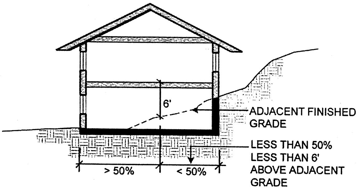
Basement: That portion of a building that is partially or entirely below grade, that is so situated where both of the following apply:
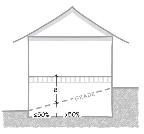
Fig. 1.30-1 Basement Threshold
1.
The finish floor level immediately above such under-floor space shall not be more than six feet above grade for more than 50 percent of the under-floor area; except that on lots where the "-n 1 " combining designation applies, a basement threshold of four feet (instead of six feet) shall apply (see § 3.40.030). Window wells, as defined and required for egress by the California Building Code (CBC) and California Residential Code (CRC), shall be limited to ten percent above the minimum dimensions required by the CBC and CRC.
2.
The finish floor level above such under-floor space shall not be more than 12 feet above grade at any point.
For the purpose of this definition, "grade" shall be final grade at the building's perimeter, and shall be projected through the subject basement space when appropriate.
Bay window: A window or series of windows jutting out from the wall of a building and forming an alcove within.
Boarding house: Any residential building used for the renting of rooms or providing of table board, or both, for three to six persons over the age of 16 years who are not related by blood or marriage to the resident-operator thereof.
Breezeway: A covered passageway open on two or more sides, joining two or more detached buildings.
Building: Any structure having a roof supported by columns or walls, or both, and intended for the shelter, housing or enclosure of any person, animal or personal property. When any portion of a structure is completely separated from every other portion of the structure by a masonry division or firewall without any window, door or other opening and the masonry division or firewall extends from the ground to the upper surface of the roof at every point, such portion shall be deemed to be a separate building.
Building envelope: The three-dimensional space within which a building or structure may be built, as defined by setbacks and height regulations. Building envelopes may also be delineated for portions of lots on an approved subdivision map, cluster subdivision approval, or conditions of the subdivision or other land use approval. In such cases, the line segments delineating the building envelope shall function as setback lines for residences, and may confine the location of certain other buildings or structures if so stated on the approved map, or as a condition of subdivision approval that more specifically defines the purposes of the building envelope.
Building footprint: That portion of a property vertically below the maximum extensions of the enclosed structure(s) thereon, including covered decks, uncovered decks over 30 inches above grade, and carports, but excluding roof projections of two and one-half feet or less.
Building, main: A building or buildings in which the lot's principal use is conducted.
Centerline: The centerline of a street as established by the County Surveyor of the County or by the city engineer of any city within the county or by the California Department of Transportation. If no such center line has been established, the center line of a street shall be a line midway between the side lines of the right-of-way thereof; provided, however, that if only a part-width right-of-way exists for any portion of any street, the center line for such part-width portion shall be determined by prolonging the center lines on each side of such part-width portion parallel to the side lines of such part-width portion. If the foregoing method of establishing the centerline is not feasible, the zoning administrator shall designate the centerline.
Development area: That portion of a property within which buildings, accessory structures, and associated improvements are proposed and delineated on site plans or subdivision maps in accordance with applicable policies of the general plan or the zoning ordinance. Associated improvements include, but not are not limited to driveways, parking areas, turnarounds, septic systems, patios, pools and recreational facilities.
Dwelling purposes: The use of a building for human habitation, which is designed, intended or used for sleeping, cooking, eating, and sanitation.
Dwelling unit: A building or portion thereof that is designed, intended or used for dwelling purposes for one family, as defined in this section.
Family: One or more persons occupying a premises and living as a single, nonprofit household, as distinguished from a group occupying a hotel, club, fraternity or sorority house. A family shall be deemed to include necessary domestic help.
Fee access corridor: That portion of a flag lot used for access that is owned in fee simple.
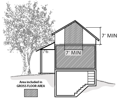
Fig. 1.30-2 Gross Floor Area
Floor area, gross: The sum of the gross horizontal areas of the several floors of a building, as measured from the rough exterior faces of the exterior walls, or (if applicable) from the centerline of a common wall between two attached buildings. "Floor area, gross" also includes the total area of any attached garage, and includes any carport, porch or similar attached structure or feature that is both: (a) covered, and (b) greater than 50 percent enclosed by perimeter walls. It includes the horizontal area of an interior stairway at each of the two or more stories to which the stairway provides access. Any attic space that has a minimum clearance of seven feet in each of three dimensions for at least 70 contiguous square feet shall be included. Basement space that has a minimum clearance of seven feet in each of three dimensions for at least 70 contiguous square feet shall be included in floor area when determining:
(a)
Required nonresidential parking spaces as stipulated in § 4.30.040;
(b)
Floor area limitations applicable to accessory dwelling units;
(c)
Cumulative floor area that may be subject to building site approval (Ordinance Code Division C12, Chapter II); and
(d)
Floor area that may be subject to regulations of the Department of Environmental Health, County Fire Marshal, or other government department or agency.
Where the vertical distance between any floor and the ceiling above exceeds 15 feet, floor area shall be counted twice.
Except where the provisions of § 3.40.030 apply, basements shall be excluded when calculating residential floor area or floor area ratio where provisions are intended to either: (a) stipulate maximum building size; or (b) categorize a project under the provisions of § 3.20.030, § 5.50.050 or § 5.50.060 for procedural purposes.
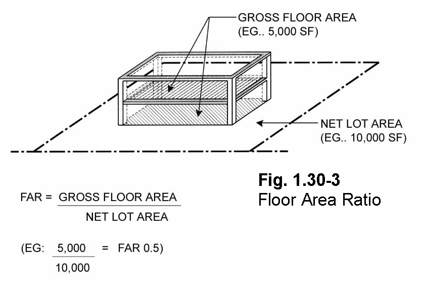
Floor-area ratio (FAR): Determined by dividing the gross floor area of a specified building(s) on a lot by the net lot area; provided, however, that on flag lots, all portions of fee access corridors which are less than 25 feet in width shall be excluded from floor area calculations.
Future width line: A line representing the maximum planned width of a right-of-way, as shown on maps included in any officially adopted report or ordinance. This includes the 1971 Ruth and Going Future Width Line Study.
Group living quarters: A group of structures, or a single structure such as a boarding house or dormitory, consisting of either individual or shared facilities for living, sleeping, eating, cooking, and sanitation.
Guest room: A room within a dwelling which is intended, arranged or designed to be occupied or which is occupied by one or more guests, but in which there are no cooking facilities.
Hedge: Plants that are cultivated to result in a dense linear form that functions as a fence, wall or barrier.
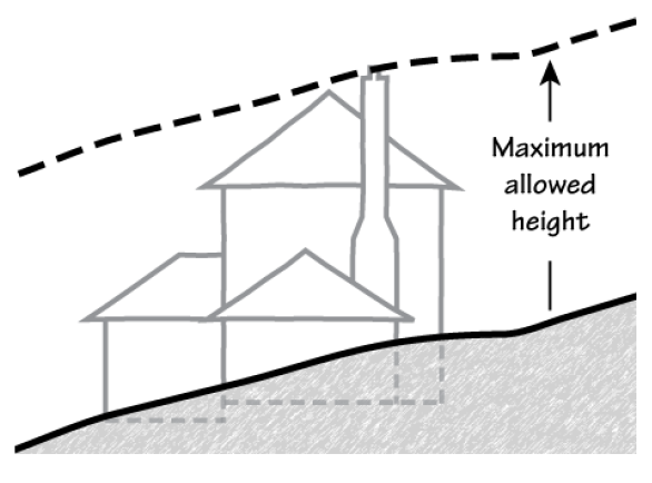
Fig. 1.30-4a Building Height
Height: The dimension measured by the vertical distance from the final grade to the top of a building or structure. On sloping lots or lots with irregular topography, height shall be measured vertically upward from a hypothetical surface representing the final grade as projected through the structure site (see Figure 1.30-4b for measurement details).
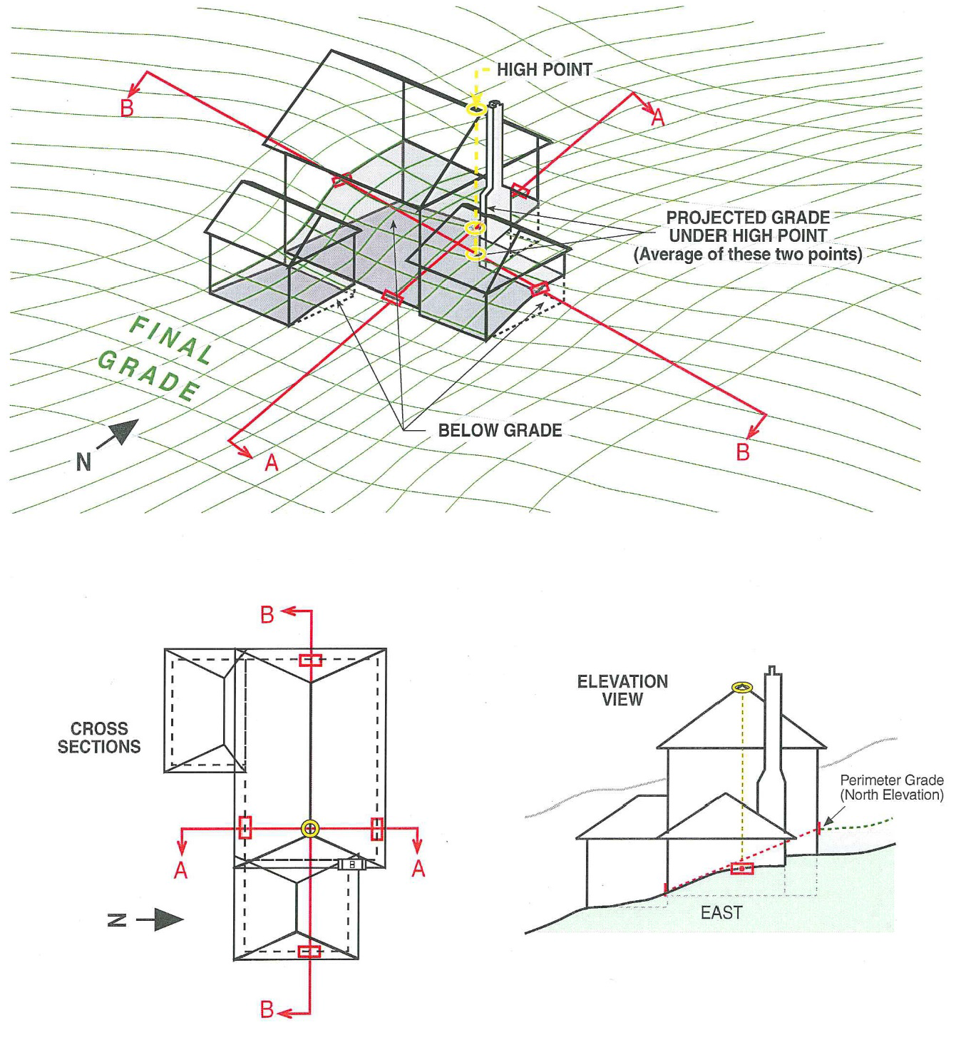
Fig. 1.30-4b Height Measurement (irregular topography)
Legal-nonconforming use, lot, or structure: A use, lot, building or structure that was lawful when brought into existence, but does not comply with the currently effective use provisions, permitting requirements or development standards of this zoning ordinance. See Chapter 4.50.
Livestock: Domestic animals kept on a farm or ranch and raised for sale and profit.
Lot: A fundamental unit of land that may be lawfully sold as a separate parcel in conformance with the applicable lot-legality provisions of Division C12 of the County Ordinance Code and the applicable subdivision and lot-legality provisions of state law.
Lot area, gross: The area specified as gross lot area on a recorded parcel map, tract map or record of survey. Also, the total area of any lot whose deed contains a legal description that includes land underlying public or private rights-of-way as fee-title portions of the lot.
Lot area, net: The net area of a lot specified as such on a recorded parcel map, tract map or record of survey, or the total land area of any lot exclusive of land underlying public or private rights-of-way.
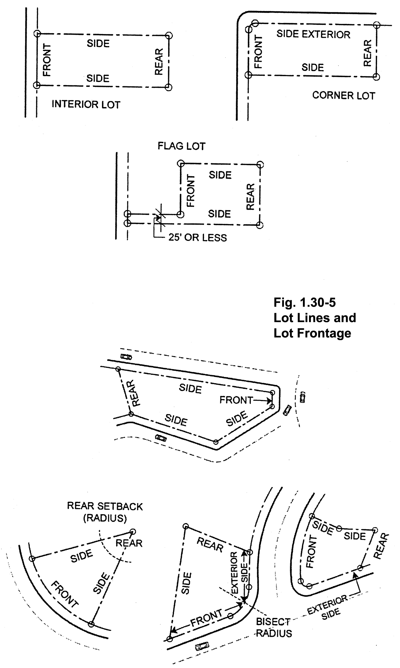
Fig. 1.30-5 Classification of Lots
Lot, corner: A lot situated at the intersection of two or more streets, or bounded on two or more adjacent sides by street lines. If the interior angle of the intersecting street lines is 135 degrees or wider, the lot shall not be deemed a corner lot.
Lot coverage: The footprint of all buildings and structures over 30 inches in height. Covered patios, carports, arbors, and similar structures are counted in lot coverage. Eaves are excluded provided they do not project more than two and one-half feet.
Lot depth: The average distance from the front property line (or edge of right-of-way) to the rear line measured in the general direction of the side lines of the lot.
Lot frontage: The boundary of a dedicated public or private road right-of-way as it fronts along a lot. To determine the front lot line for setback purposes, see "lot lines."
Lot, flag: A lot, generally located to the rear of another lot, whose frontage to a street is provided by a fee access corridor, or whose access is provided by an easement through the parcel with actual frontage along such street. [See Fig. 1.30-5]
Lot, interior: A lot with street frontage and whose side lot lines are the side lot lines of adjacent lots that front on the same street. [See Fig. 1.30-5]
Lot, key: The first lot to the rear of a corner lot, the front line of which is a continuation of the side line of the corner lot, exclusive of the width of any alley, and fronting on the street which intersects or intercepts the street on which the corner lot fronts. [See Fig. 1.30-5]
Lot lines: The lines bounding a lot as defined herein, with the following specific classifications and criteria for determining setbacks. For purposes of this definition, "street" shall mean "right-of-way," as defined herein.
1.
The front lot line is normally the line that abuts a street.
2.
The front lot line of a corner lot is normally the shorter line (representing the narrower lot dimension) of the two lines abutting a street. If a corner lot's overall depth-to-width dimensions are more strongly representative of the lot's orientation such that an alternate frontage determination would yield a larger building envelope, the right-of-way line that corresponds to the lot width (longer line in that case) shall be deemed the front lot line for setback purposes. In the case of a curved corner, a determination may be made by the zoning administrator that an appropriately situated point along that curve shall demarcate the front lot line from the exterior side lot line.
3.
The front lot line of a flag lot shall be based on the lesser dimension (width/length) of the main portion of the lot (portion that excludes access corridor). The line abutting the interior terminus of the access corridor that corresponds to that lesser lot dimension shall be deemed the front lot line. When a fee access corridor exceeds 25 feet in width, the front lot line shall be the street frontage at the access corridor. For a variable-width access corridor the front lot line shall be considered the width line at the point at which the access corridor exceeds 25 feet.
4.
The side lot line is the line that intersects the front lot line, the rear lot line, and any other side lot line.
5.
The side exterior lot line of a corner lot is the (generally) longer of the two lines abutting a street (see Paragraph 2 above).
6.
The rear lot line is generally the line that is most distant and opposite the front lot line. On a triangular lot or other lot where no logical rear lot line exists, the rear setback may be taken as a radius from the point of intersection of side lines most distant and opposite the front lot line. Multiple line segments that logically fit the intent of this definition may also be considered rear lot lines.
Where the above provisions are inadequate to address an unusually configured lot, the zoning administrator shall classify the lot lines on that lot. The determination shall consider in the following order of importance: (a) the general depth-to-width orientation of the lot and the establishment of a practical and reasonable building envelope, (b) the orientation of the lot and orientation of the determined building envelope as it would most harmoniously concur with development and/or building envelopes on the adjacent lots, (c) the existing development on the subject lot and the degree to which it may conform to more than one possible determination, and (d) other factors specific to the lot that would affect the practicality and reasonableness of a determined building envelope. See § 4.20.020 for additional lot-line and setback criteria for accessory buildings on lots with unusual configurations.
Manufactured home: A factory-built single-family structure as defined in Section 19971 of the California Health and Safety Code or a manufactured home as defined in Section 18007 of the California Health and Safety Code. Mobile homes, which are structures transportable in one or more sections, designed to be used as a residential dwelling unit and not having wheels or axles permanently attached to their body or frame, are considered manufactured homes if they are built in conformance with the National Manufactured Housing Construction and Safety Standards Act of 1974 (42 USC Section 5401) and located on a foundation system pursuant to Section 18551 of the California Health and Safety Code. Manufactured homes or mobile homes do not include recreational vehicles, or commercial coaches, as defined in Section 19971 of the California Health and Safety Code.
Marginal agricultural lands: Lands that may be considered unsuitable for agricultural use because of proximity to incompatible non-agricultural uses, inadequate water availability; or marginal soil type such as Class III or poorer.
Mine, idle: A mining operation that is curtailed for one (1) or more year(s) by more than 90 percent of the operation's previous maximum annual mineral production, with the intent to resume those surface mining operations at a future date.
Mobile home: See "manufactured home."
Movable tiny home: A structure on wheels used for dwelling purposes that provides complete independent living facilities for one or more persons and is located on the same lot as the primary dwelling (single-family or multifamily) to which it is an accessory use. It includes permanent provisions for living, sleeping, eating, cooking, and sanitation on the same parcel as the primary dwelling to which it is accessory. It complies with all State of California requirements, is constructed in compliance with American National Standards Institute (ANSI) 119.5 standard, cannot move under its own power, is licensed and registered with the California Department of Motor Vehicles, is no larger than allowed by state law for movement on public highways, and has at least 100 square feet of enclosed space (see §§ 2.10.020 and 4.10.015).
Nonconforming use, lot, or structure: The term "nonconforming" shall mean legal-nonconforming. See "legal-nonconforming use, lot or structure."
Official plan line: A line representing the maximum planned width of a right-of-way, including future right-of-way, as defined in Section C12-700 of the County Ordinance Code.
Open land historic: The unimproved or undeveloped portion of the land on which the historic buildings or structures exist and which is essential to the integrity of the historical site or place.
Open space land: Any parcel(s) or portion of a parcel that is essentially unimproved and devoted to an open space use. This term includes land(s) designated for permanent open space preservation as shown on a recorded subdivision map, approved site plan, or other development plan, and which may be the subject of an easement or other permanent conveyance of development rights restricting the use and development potential of the open space in accordance with applicable general plan policies, zoning regulations, mitigations, or conditions of approval.
Person: Any individual, firm, association, corporation, organization or partnership, or any city, county, district or state, or any public entity or department or agency thereof.
Public water supply: Water service furnished by a public utility, a county water company or district, a municipal water company or district, a community service district or other public water district.
Reclamation: The combined process of land treatment that minimizes water degradation, air pollution, damage to aquatic or wildlife habitat, flooding, erosion, and other adverse effects from surface mining uses so that mined lands are reclaimed to a usable condition which is readily adaptable for alternate land uses and pose no danger to public health or safety. The process may extend to affected lands surrounding mined lands, and may require backfilling, grading, re-soiling, re-vegetation, soil compaction, stabilization, or other measures.
Reclamation plan: A plan providing for reclamation of lands upon which surface mining operations either have been or will be conducted.
Registered historic cultural resource: A registered historic cultural resource is any building, site, structure, object, or district which is registered in the National Register of Historic Places, California Historical Landmarks Program, California Register of Historical Resources, California Points of Historical Interest Program, or formally designated as such by a resolution of the Santa Clara County Board of Supervisors.
Right-of-way: The total (improved and unimproved) area of land within the bounds of a dedicated public or private road. Also includes any ingress-egress easement that provides the right to pass over one property to access another.
Riparian: That area within and adjacent to waterways, water bodies and areas with special underground wetness characteristics which support a special type or lush condition of vegetation not found in the general area.
Sanitary sewers: Sanitary sewers shall mean those sewer systems operated and maintained by a county, a municipality, or a sanitary sewer district.
Sanitation facilities: Sanitation facilities shall mean a toilet, sink, and bathing facilities (tub or shower) serving a dwelling unit that comply with all requirements of state law and the Ordinance Code.
Setback: The horizontal separation required between lot lines (and/or rights-of-way, see below), and the nearest point of a building or structure, including below-grade walls. The setback line shall be deemed to mean a line parallel to the lot line separated by the required setback distance.
The measurement shall be taken from the rough exterior building walls (structural wall components; excluding trim, exterior siding, stucco or other such finishing materials), or other vertical structural components, to the nearest lot line, exclusive of those architectural features listed in § 4.20.110 as exempt. Setbacks shall also be taken from the edge of any right-of-way that abuts or passes through the subject lot. In situations where the property line lies within the right-of-way, the setback shall be taken from the edge of such right-of-way. However, if an official plan line or future width line has been established for the abutting right-of-way, setback measurement shall be taken from such official plan line or future width line.
Story: That portion of a building included between the upper surface of any floor and the upper surface of the floor above, except that the topmost story shall be that portion of a building included between the upper surface of the topmost floor and the ceiling or roof above.
An attic, regardless of its interior dimensions, shall not be considered a story provided it remains unconditioned space, is accessible by nothing more substantial than a pull-down stairway or ladder, and contains no dormers with the exception of minimal vent features.
A basement shall not be considered a story.
Determination of a building's number of stories shall be based on qualifying floor area being situated directly above other qualifying floor area.
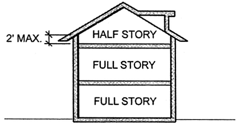
Fig. 1.30-7 Half Story
Story, half: A portion of a building within a hip, gable or similar sloping roof containing space that meets the dimensional criteria for habitable space (70 square feet or larger with a minimum seven feet clearance in each of three dimensions), but is limited such that the wall plates on at least two opposite exterior (vertical) walls, which constitute at least 50 percent of the perimeter wall area at that floor level, are not more than two feet above rough floor level.
Structural alterations: Any change in the supporting members of a building, such as bearing walls, foundation, roof, columns, beams or girders.
Structure: Anything constructed or erected, the use of which requires location on the ground or attachment to something having location on the ground. The term "structure" includes "building."
Urban service area: Land within the sphere of influence of a particular city, which is served by urban facilities, utilities and services, or which is proposed to be served by urban facilities, utilities and services through a city-adopted capital improvement program. In addition to being regulated by the County zoning ordinance, unincorporated land within a city's urban service area is subject to the land use policies of that city's general plan. The urban service area boundary shall be established by the Santa Clara County Local Agency Formation Commission in accordance with the applicable provisions of Sections 56300, 56301 and 56425 of the California Government Code.
Use: The purpose for which land or premises or a building thereon is designed, arranged or intended or for which it is or may be occupied or maintained. When used as a verb, standard dictionary definitions of "use" shall apply.
Watercourse: A running stream fed from permanent or natural sources, including rivers, creeks, runs and rivulets. There must be a stream, usually flowing in a particular direction (though it need not flow continuously) in a definite channel, having a bed or banks and usually discharging into some stream or body of water.
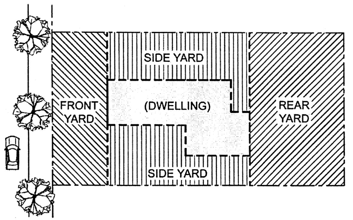
Yard: An open space, adjacent to a dwelling or other main building, that is generally unoccupied and unobstructed from the ground upward, except as otherwise provided in Chapter 4.20. The following are types of yards:
1.
The front yard extends across the full width of the lot lying between the front lot line and the nearest line of the dwelling.
2.
The side yard lies between the side lot line and the side wall(s) of the dwelling and extends from the front yard to the rear yard.
3.
The rear yard extends across the full width of the lot lying between the rear lot line and the nearest line of the primary dwelling.
(Ord. No. NS-1200.317, § 16, 6-8-04; Ord. No. NS-1200.318, § 1, 3-28-06; Ord. No. 1200.320, § 4, 8-29-06; Ord. No. NS-1200.323, § 1, 1-29-08; Ord. No. NS-1200.327, § 2, 2-9-10; Ord. No. NS-1200.330, § 1, 9-28-10; Ord. No. NS-1200.337, § 1, 12-18-12; Ord. No. NS-1200.367, § 2, 6-19-18; Ord. No. NS-1200.371, § 1, 3-10-20; Ord. No. NS-1200.375(10.20.2020), § 1, 10-20-20)
Editor's note— Section 3 of Ord. No. NS-1200.330 allows for an effective date of November 1, 2010, and states: "This ordinance shall not apply to discretionary land-use applications that include house plans (floor plans and elevations) that have been deemed complete or approved prior to November 1, 2010, nor to projects for which a building permit application has been accepted by the Building Inspection Office prior to November 1, 2010.