
Santa Clara County Unincorporated
City Zoning Code
City Zoning Code
ARTICLE 3
- COMBINING DISTRICTS
CHAPTER 3.50. - "-h" HISTORIC PRESERVATION COMBINING DISTRICTS[5]
Cross reference— Historical heritage commission, § A6-60 et seq.
§ 3.10.010. - Purpose.
The purpose of lot-size and setbacks combining districts is to establish more specific standards for lot creation and development than those of the base districts, in order to implement the policies of the applicable general plan land use designation and provide standards which are appropriate for the surrounding neighborhood and the natural setting. Lot-size and setbacks combining districts specify the minimum area for lot creation and setback requirements, which supersede the lot area and setback requirements specified for the base zoning district. The lot-size and setbacks combining districts include two types of districts, standard lot-size and setbacks districts, which specify a given minimum lot area in acres or square feet, and slope-density districts, in which the minimum lot size is determined by a formula based on the average slope of the property.
§ 3.10.020. - Applicability.
Properties in a lot-size and setbacks combining district are subject to the regulations of the applicable base zoning district, except that the lot area and setback provisions specified in this chapter shall prevail. A numeric designator as indicated in Tables 3.10-1 and 3.10-2 is added to the base zoning designator for properties to which a lot-size combining district is applied.
§ 3.10.030. - Standard lot size and setbacks combining districts.
The following table lists the standard lot size and setbacks combining districts and sets forth the minimum lot area and setbacks for each:
TABLE 3.10-1. STANDARD LOT SIZE DISTRICTS: LOT AREA AND SETBACKS
NOTES:
1.
Minimum lot sizes are expressed in net square feet and gross acres.
2.
On corner lots, the minimum setback for the exterior side yard in "-6", "-8" and "-10" combining districts shall be ten feet.
The provisions of Section 4.20.110, Setback exceptions, when applicable, shall supersede the side and rear yard setbacks provided in this table.
§ 3.10.040. - Slope-density combining districts.
A.
Lot area calculation. Slope-density combining districts regulate density of development by means of provisions that determine the maximum number of lots and dwelling units permitted through subdivision based on the average slope of the lot. The following table lists the slope-density combining districts, along with the corresponding formulas for calculating land area per dwelling (density), the lot area ranges, and minimum parcel size requirements.
TABLE 3.10-2. SLOPE-DENSITY DISTRICTS AND FORMULAS
NOTES:
1.
The variable "S" represents the average slope of the entire property that is the subject of the application. Average slope is determined according to the formula S = (0.00229 × IL)/A, where
I is the contour interval in feet;
L is the combined length of contour lines in scale feet;
A is the gross area in acres of the subject lot or area of land; and,
S is the average slope expressed as a percentage.
The maximum number of lots or dwelling units allowed is determined by dividing the gross land area by the minimum land area per dwelling unit and rounding down to the nearest whole number.
2.
Where the average slope of the parcel is less than ten percent, the land area per dwelling unit shall be equal to the lesser value in the lot area range. Where the average slope of the parcel is greater than 50 percent, the land area per dwelling unit shall be equal to the upper value of the lot area range.
3.
Minimum parcel size requirements are expressed in gross acres and may be waived through the approval of a cluster permit issued in conformance with applicable General Plan policies and the cluster permit procedures of Chapter 5.45 of this ordinance. Such reductions of minimum parcel size for cluster development may be based on consideration of availability of services, site suitability, and ability to conform to applicable standards and conditions of development.
4.
Permanent dedication of open space and development rights shall be provided as necessary and appropriate to ensure that the maximum density of development (total number of lots) does not exceed that which is permitted by the applicable slope-density formula and the applicable General Plan land use designation.
B.
Cluster development. Regulations for cluster development procedures are provided in Chapter 5.45, Cluster Development.
C.
Setbacks. Setbacks from all property lines or right-of-ways shall be 30 feet, unless the provisions of Section 4.20.110, Setback Exceptions, apply.
§ 3.20.010. - Purpose.
The purpose of the -d Design Review combining districts is to designate certain visually and environmentally sensitive areas as requiring design review, with the intention of mitigating adverse visual impacts of development and encouraging quality design.
§ 3.20.020. - Applicability.
The regulations set forth in this chapter shall apply as indicated, and shall supersede any conflicting regulations of the base zoning district. A designator "-d" is added to the base zoning designator for properties to which these combining districts apply. Where adopted area-specific policies and criteria are meant to be implemented through the design review procedure, the "-d" designator shall be accompanied by a numerical subscript (e.g.: -d 1 , -d 2 , etc.).
§ 3.20.030. - Design review required.
Development within areas zoned "-d" shall be subject to the provisions of Chapter 5.50: Design Review.
§ 3.20.040. - -d District (Santa Clara Valley Viewshed).
The -d 1 combining district is intended to conserve the scenic attributes of those hillside lands most immediately visible from the valley floor. It is intended to minimize the visual impacts of structures and grading on the natural topography and landscape, using a combination of supplemental development standards, design guidelines, design review, and use of process incentives for smaller and less visible projects.
A.
Project Classifications: Development standards and procedures shall utilize a tiered regulatory structure based primarily on building size, as follows:
1.
Tier 1: A building or structure where gross floor area (see § 1.30.030) is 5,000 square feet or less. Additions to an existing primary dwelling resulting in total floor area of 5,000 square feet or less after the addition shall also be reviewed as Tier 1 or applicable exemption.
a.
Administrative review. Except for projects ineligible on the basis of subsection c. or d. below, a building or structure classified as Tier 1 shall be subject to administrative design review approval with no public hearing required (see § 5.50.060), the review of which shall focus on the project's compliance with color standards, and any other Tier 1-applicable standards of this section.
b.
Color; light reflectivity value (LRV). The provisions of subsection B shall apply to Tier 1 projects.
c.
Retaining walls requiring a public hearing. Except where subsection G, exemption for sites not visible, applies, Tier 1 projects shall not be eligible for administrative design review approval when the project involves retaining walls with elevations exceeding five vertical feet that extend more than 80 horizontal feet.
d.
Other circumstances requiring a public hearing. When an exception is proposed to deviate from the massing or retaining wall standards of subsections C or D, design review shall be required.
2.
Tier 2: A building or structure where gross floor area (see § 1.30.030) of is between 5,001 square feet and 12,500 square feet. Additions to an existing building resulting in total floor area of 12,500 square feet or less after the addition shall be reviewed as Tier 2 or per applicable exemptions or administrative design review approval of § 5.50.050 and 5.50.060.
a.
Design review required. A building or structure classified under Tier 2 shall be subject to design review, per chapter 5.50, and will not be eligible for a discretionary exemption or administrative design review approval except when subsection G, exemption for sites not visible, applies.
b.
Siting. A Tier 2 category building should, to the extent possible and practical, be sited where natural topography, or a combination of topography and existing vegetation, provide at least a fundamental and sufficient measure of visibility mitigation.
c.
Story poles. Story poles shall be required of all new buildings subject to Tier 2 design review. Story poles shall be fully erected, per the story poles standards established by the planning office, and shall be approved by the Zoning Administrator at least seven full days prior to any scheduled hearing, including continued hearings and appeal hearings. Story poles shall, at a minimum, remain in place until the close of the public hearing.
3.
Tier 3: A building or structure where gross floor area (see § 1.30.030) exceeds 12,500 square feet.
a.
Design review required. A building or structure classified under Tier 3 shall be subject to design review, per chapter 5.50, and will not be eligible for a discretionary exemption or administrative design review approval except when subsection G, exemption for sites not visible, applies. The Planning Commission shall be the approving authority for all Tier 3 design review applications.
b.
Low-visibility siting. Tier 3 review is intended to ensure that very large buildings are sensitively sited and designed such that they do not result in viewshed impacts greater than what might result from a sensitively designed Tier 2 or Tier 1 building. A Tier 3 category building must be sited in an area of the subject property where natural topography, or a combination of topography and existing vegetation, provide at least a fundamental and sufficient measure of visibility mitigation.
c.
Story poles. Story poles shall be required of all new buildings subject to Tier 3 design review. Story poles shall be fully erected, per the story poles standards established by the planning office, and shall be approved by the Zoning Administrator at least seven full days prior to any scheduled hearing, including continued hearings and appeal hearings. Story poles shall, at a minimum, remain in place until the close of the public hearing.
B.
Color; light reflectivity value (LRV). The light reflectivity value (LRV) of exterior surfaces shall not exceed 45. The Zoning Administrator may additionally specify subdued chroma (color saturation) when warranted for a structure deemed to have high visibility and contrast against the site's background. The Zoning Administrator may waive this LRV requirement for minimal trim or other minor architectural features. LRV restrictions may be waived entirely when subsection G, exemption for sites not visible, applies.
C.
Building form and massing. Buildings not deemed exempt under subsection G shall be designed following the massing guidelines within the adopted Design Review Guidelines. In addition, the following specific limitations on wall dimensions shall apply to all Tier 1, Tier 2 and Tier 3 projects not deemed exempt under subsection G:
1.
Maximum horizontal length of a continuous wall plane shall be 80 feet.
2.
Maximum height of a wall plane, including foundation and other continuous components, shall be 24 feet, with the following exceptions: (a) Any architectural component where façade dimension does not exceed 18 horizontal feet, or (b) multiple such components (18 horizontal feet maximum) where combined horizontal dimension does not exceed 25 percent of the total horizontal dimension of the façade. This limitation may be varied through the design review process for wall planes not facing the valley floor or otherwise having demonstrably low visibility.
3.
Portions of a wall plane must be offset by at least five horizontal feet to be deemed discontinuous for the purposes of this provision.
Massing restrictions may be waived when subsection G, exemption for sites not visible, applies.
D.
Retaining walls. Retaining walls visible from the valley floor shall not exceed ten feet in height as measured from grade at face to top of wall. Multiple "stepped" retaining walls whose total height exceeds ten feet must each be offset by at least six horizontal feet. Visible walls shall be colored and textured to complement the background land and vegetation, per the adopted design review guidelines.
E.
Ridgeline development. The ridgeline protection policies of the general plan growth and development chapter shall be applied to any project situated on or adjacent to a ridgeline.
F.
Design review guidelines. All projects subject to design review shall comply with applicable provisions of the adopted design review guidelines document.
G.
Exemption for sites not visible. Any project where buildings or structures would be situated on portions of a lot outside of the visible viewshed area (based on GIS visibility analysis) shall be eligible for a discretionary exemption or administrative design review approval (see § 5.50.060). Additional visibility analysis tools and methods may be utilized by staff to further evaluate the potential visibility of a project proposed on such a site. The exemption may not be approved for Tier 3 projects if it is determined that any portion of the proposed building would be visible from the valley floor.
H.
Ongoing compliance. All conditions of approval established through the design review procedure shall be the ongoing obligation of the property owners, including future property owners. A "Notice of Design Review Approval and Conditions" shall be recorded with the Office of the Clerk-Recorder in accordance with recording requirements, to ensure that present and future property owners are aware of the conditions and their obligation to uphold them.
I.
Rebuilding. A building in the -d 1 district may be rebuilt in the same location as the original structure (regardless of visibility) if it is destroyed by earthquake, fire or other casualty event, provided the following provisions are met:
1.
The original building was lawfully constructed with all appropriate county permits required at the time of construction.
2.
The floor area of the replacement building does not exceed the legally established (permitted, if applicable) floor area of the original structure.
3.
The application for a building permit to construct the new building is filed within two years of the date of the casualty event. The Director shall be authorized to extend this deadline when warranted by special circumstances.
4.
A replacement building designed according to the approved building plans for the original building shall be exempt from the massing standards of subsection C. Where original building plans cannot be produced, massing standards shall apply.
5.
The replacement building shall be subject to an administrative design review approval (see § 5.50.060), which shall focus on the project's compliance with color standards, and any other Tier 1 applicable standards of this section.
A replacement building that is sited in a different location than the original, or is larger in floor area, or both, shall be subject to the applicable design review procedures and requirements of this section.
(Ord. No. NS-1200.320, § 1, 8-29-06; Ord. No. NS-1200.336, § 1, 12-18-12; Ord. No. NS-1200.349, § 5, 4-7-15; Ord. No. NS-1200.355, § 3, 4-26-16)
§ 3.20.050. - -d District (Milpitas Hillsides).
The purpose of establishing the -d 2 zoning district is to maintain the predominantly natural appearance of the Milpitas hillside areas to which the -d 2 zoning district is applied. In furtherance of that objective, the following supplementary development standards shall apply to structures, including new construction and exterior modifications/additions to existing structures, on properties zoned -d 2 . In addition, the provisions contained within the adopted design review guidelines shall be appropriately applied as part of the design review process.
A.
Maximum house size. For lots that are less than ten acres, the gross floor area of dwellings shall not exceed 6,000 square feet. For lots that are ten acres or greater, gross floor area of dwellings shall not exceed 8,000 square feet.
B.
Height. The maximum height of dwellings shall be 27 feet and two stories. The maximum height of accessory structures shall be in accordance with § 4.20.020, except that in no case shall the height of any accessory building or structure exceed 27 feet.
C.
Color. The light reflectivity value (LRV) of the exterior surfaces of any structure shall not exceed 45. The Zoning Administrator may additionally specify subdued chroma (color saturation) when warranted for a structure deemed to have high visibility and contrast against the site's background. The Zoning Administrator may waive this light reflectivity requirement for minimal trim or other minor architectural features.
D.
Crestline area development restrictions. Placement and height of any proposed structure may be restricted to ensure that no structure protrudes above the perceived crestline, as delineated on the official City of Milpitas zoning map. To ensure that proposed structures, whether east or west of the crestline, do not protrude above the crestline, story poles, line-of-sight analyses, or other visualization methods may be required for each project subject to design review. Story poles shall be the preferred means of evaluating potential impacts to the crestline and the basis for necessary determinations that the structures do not protrude above the perceived crestline.
E.
Story poles. Story poles shall be required of all new buildings subject to a design review hearing. Story poles shall be fully erected, per the County's story poles standards, and approved by the Zoning Administrator at least seven days prior to the scheduled hearing.
(Ord. No. NS-1200.320, § 3, 8-29-06; Ord. No. NS-1200.336, § 2, 12-18-12)
§ 3.30.010. - Purpose.
The purpose of the -sr Scenic Roads combining district is to protect the visual character of scenic roads in Santa Clara County through special development and sign regulations. The -sr combining district applies to all designated scenic roads in unincorporated Santa Clara County.
§ 3.30.020. - Applicability.
The regulations set forth in this chapter shall apply as indicated, and shall supersede any conflicting regulations of the base zoning district. A designator "-sr" is added to the base zoning designator for properties to which this combining district applies.
§ 3.30.030. - Setbacks and design review.
A.
Requirement for design review. On scenic roads other than US 101, any structure, including signs, that is located within 100 feet of the right-of-way of a designated scenic roadway shall be subject to design review, as described in Chapter 5.50 of this Zoning Ordinance. Structures in the -sr combining district that are not within 100 feet of a scenic roadway do not require design review, except as otherwise required in the base district or other combining districts applied to the subject property.
B.
Design review exemptions. Buildings within 100 feet of a scenic road shall not be eligible for design review exemptions. Additions to existing buildings within 100 feet of a scenic road may be eligible for design review exemption provided no part of the addition is nearer to the scenic road right-of-way line than the nearest part of the existing building. Structures (non-buildings), such as fences, decks and retaining walls, that otherwise meet the criteria for exemption from design review as provided in Chapter 5.50 shall be eligible for exemption.
C.
US 101 scenic setbacks. No building or structure, including signs, may be located within 100 feet of the right-of-way of US 101, with the exception of fences. Fences may be permitted subject to the applicable design review provisions of Chapter 5.50.
(Ord. No. NS-1200.327, § 11, 2-9-10)
§ 3.30.040. - Signs.
Signs within the -sr combining district shall be subject to the following regulations, except where other more restrictive provisions apply through a base or other combining district:
A.
Number. One on-site advertising sign may be located on any lot in the -sr combining district. One additional sign may be placed on a lot regarding the sale, lease or rental of all or a portion of the property. The following exceptions are permitted:
1.
Signs associated with uses classified as Agricultural Sales and Wineries, subject to all applicable provisions of § 4.10.110.
2.
Temporary on-site identification and off-site directional signs to seasonal sales establishments are exempt from the provisions of this section and are subject to the requirements of § 4.40.110.
B.
Size. Signs are subject to the following size limitations:
1.
Signs associated with uses classified as Agricultural Sales and Wineries, shall be subject to the sign area limitations provided in subsection 4.40.110(B)(2).
2.
With the exception of properties within 1,000 feet of the right-of-way of US 101, and signs associated with uses classified as Agricultrual Sales and Wineries, signs are limited to 16 square feet in area.
3.
On all properties or portions of properties within 1,000 feet of the right-of-way of US 101, signs are limited to 50 square feet in area and 20 feet in height from the ground to the uppermost point on the sign. Signs up to 100 square feet in area may be permitted with a special permit.
C.
Design. All signs and parts of signs shall remain stationary. All illumination for signs shall remain stationary and constant in intensity and color.
§ 3.30.050. - Scenic roads inventory.
Alamitos Road
Aldercroft Heights Road (from Alma Bridge Road to Wrights Station Road)
Alma Bridge Road
Almaden Road (San Jose city boundary to Alamitos Road)
Bear Creek Road
Black Road
Bloomfield Avenue
Bohlman Road
Bowden Avenue
Calaveras Road
Cañada Road
Casa Loma Road
Congress Springs Road (SR 9) (from Saratoga city boundary to Santa Cruz County boundary)
Coyote Reservoir Road
Croy Road (from Watsonville Road to the boundary of Uvas Canyon County Park)
Del Puerto Road
Dunne Avenue (from Dunne Avenue Bridge to Henry Coe State Park)
Edmundson Avenue (from Oak Glen Avenue to Sunnyside Avenue)
Felter Road (from Calaveras Road to Sierra Road)
Gilroy Hot Springs Road
Gist Road
Hecker Pass Highway (SR 152) (from Gilroy city boundary to Santa Cruz County boundary)
Hicks Road
Highway 17 (SR 17) (from Los Gatos city boundary to Santa Cruz County boundary)
Highway 156 (SR 156)
Highway 280 (US 280) (from Page Mill Road to San Mateo County boundary)
Idylwild Road
Jameson Road
Junipero Serra Boulevard
Kennedy Road (from Los Gatos city boundary to Shannon Road)
Llagas Road
Loma Prieta Road (from its northerly intersection with Summit Road to its southerly intersection with Summit Road)
McKean Road
Metcalf Road
Mines Road
Montebello Road (from Stevens Canyon Road to Palo Alto city boundary)
Montevina Road
Moody Road
Mountain Charlie Road
Mt. Eden Road
Mt. Hamilton Road (from Springview Lane to easterly terminus at San Antonio Valley Road)
Mt. Madonna Road
Oak Glen Avenue (from Uvas Road to Sycamore Avenue)
Old Santa Cruz Highway
Pacheco Pass Highway (SR 152) (from Cañada Road to Merced County boundary)
Page Mill Road
Quimby Road (from Murillo Avenue to Mt. Hamilton Road)
Redwood Retreat Road (from Watsonville Road to Mt. Madonna Road)
Roop Road
San Antonio Valley Road
San Felipe Road (from Delta Road to Metcalf Road)
Sanborn Road
Santa Teresa Boulevard (existing and future, which includes Coolidge Avenue, DeWitt Avenue, Hale Avenue, Murphy Lane, Sunnyside Avenue)
Saratoga-Los Gatos Road (SR 9)
Shannon Road (from Los Gatos city boundary to Hicks Road)
Sierra Road
Silver Creek Road
Skyline Boulevard (SR 35) (from SR 17 to San Mateo County boundary)
Soda Springs Road
Stevens Canyon Road
Summit Road (SR 35) (from SR 17 to Mt. Madonna County Park)
Sycamore Avenue (from Oak Glen Avenue to Santa Teresa Boulevard/Sunnyside Avenue)
Uvas Road
Watsonville Road (from Sunnyside Avenue to Hecker Pass Highway)
Willow Springs Road
(Ord. No. NS-1200.323, § 4, 1-29-08; Ord. No. NS-1200.355, § 4, 4-26-16)
§ 3.40.010. - Purpose.
The purpose of the -n Neighborhood Preservation combining districts is to provide neighborhood-specific development standards for certain urban unincorporated areas (unincorporated lands within a city's urban service area). Where necessary and appropriate, they augment the base zoning district regulations to better address a particular area's historic development patterns and characteristics, significant and problematic discrepancies between the standards of the County and the adjoining city, and unique area-specific development issues. More fundamentally, they are intended to provide effective, practical and appropriate development standards to maintain and improve the quality of residential neighborhoods. These districts are also intended to implement the policies of the Santa Clara County General Plan regarding development within, and the annexation of, urban unincorporated areas.
§ 3.40.020. - Applicability.
The area-specific regulations and criteria set forth in this chapter shall apply as indicated by the designator "-n" added to the base zoning designation (e.g.: -n 1 , -n 2 , -n 3 , etc.) and shall supersede any conflicting regulations of the applicable base zoning district.
§ 3.40.030. - "-n " district (Los Altos).
To minimize the differences between the development standards of the County and those of the adjoining City of Los Altos, and to encourage residential development that better complements the character of existing development, the following regulations shall apply to residential development in zoning districts that contain the -n 1 designator.
A.
Floor Area.
1.
Except where the provisions of subsection C below are applicable, the following floor area limitations shall apply.
a.
Lots of 10,000 square feet (net) or less: a floor area ratio not to exceed 0.35; and
b.
Lots larger than 10,000 square feet (net): 3,500 square feet of floor area, plus one additional square foot of floor area per ten square feet of lot area over 10,000 square feet, to a maximum total floor area of 5,700 square feet.
2.
For the purposes of this section, floor area shall include:
a.
The gross floor area (defined in Section 1.30.030) of dwellings;
b.
A cumulative total of 800 square feet for all accessory dwelling units on a lot shall not count toward floor area;
c.
Up to 800 square feet for a unit constructed using the Urban Primary Unit use classification (defined in § 2.10.030) shall not count toward floor area;
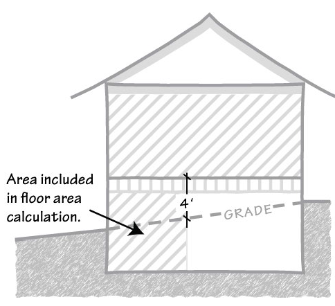
Fig. 3.40-1 Basement Floor Area
d.
Any exposed portions of basements where finish floor level immediately above is more than four feet above grade (see Fig. 3.40-1). Window wells, as defined and required for egress by the California Building Code (CBC) or California Residential Code (CRC), shall be limited to ten percent above the minimum dimensions required by the CBC and CRC; and
e.
All accessory buildings on any lot where the cumulative area of accessory buildings exceeds 500 square feet.
3.
Floor area calculations shall be noted on building permit site plans. These computations must be calculated, verified, signed and stamped by a registered civil engineer, a licensed land surveyor, or a licensed architect.
B.
Height of Dwellings. The maximum height of dwellings shall be 27 feet.
C.
Special Development Standards for Underlying Lots.
1.
For the purposes of this subsection, "underlying lot" means any lot that meets all of the following criteria:
a.
Was contiguous to a lot under common ownership as of May 5, 1998;
b.
Was not separately developed and not approved as a single building site as of May 5, 1998; and
c.
Does not meet the minimum lot size of the applicable zoning district.
This definition shall also apply to lots resulting from the lot line adjustment of underlying lots, unless the resulting lot(s) meet(s) or exceed(s) the minimum size required by the zoning district. For the purposes of this provision, the term "lot line adjustment" includes adjustments that result in fewer lots than the original configuration.
2.
Development of any individual underlying lot shall conform to the following special requirements:
a.
Floor area ratio shall not exceed 0.25, except that any underlying lot larger than 16,660 square feet shall be subject to the standard floor area ratio formula of subsection A.1.b of this section.
b.
Design review shall be required for any two-story house proposed. The review shall emphasize general neighborhood compatibility and impacts on adjacent properties.
c.
Accessory buildings 500 square feet or smaller that would not be included in floor area calculations per subsection 3.40.030(A)(2)(c) shall only be excluded from floor area calculations if they are designed and used as garage or storage buildings exclusively. Such exempt buildings shall not contain integral heating, ventilation or air conditioning systems, and shall not include bathrooms.
(Ord. No. NS-1200.318, § 5, 3-28-06; Ord. No. NS-1200.323, § 5, 1-29-08; Ord. No. NS-1200.330, § 2, 9-28-10; Ord. No. NS-1200.367, § 6, 6-19-18; Ord. No. NS-1200.371, § 7, 3-10-20; Ord. No. NS-1200.383, § 5, 1-24-23)
Editor's note— Section 3 of Ord. No. NS-1200.330 allows for an effective date of November 1, 2010, and states: "This ordinance shall not apply to discretionary land-use applications that include house plans (floor plans and elevations) that have been deemed complete or approved prior to November 1, 2010, not to projects for which a building permit application has been accepted by the Building Inspection Office prior to November 1, 2010.
§ 3.40.040. - -n district (Burbank).
In recognition of the eclectic and historical character of housing within the central Burbank area, the following specific standards and requirements shall apply to all dwellings in zoning districts that contain the "-n 2 " combining designation.
A.
Front Yard Setbacks. Front yard setbacks shall be 20 feet.
B.
Floor Area Ratio. Floor area ratio (FAR) shall not exceed 0.50. Floor area ratio calculations must be noted on building permit site plans. These computations must be verified, stamped and signed by either a licensed architect, registered civil engineer, or licensed land surveyor. A cumulative total of 800 square feet for all accessory dwelling units on a lot shall not count toward floor area. For lots upon which a unit is developed pursuant to the Urban Primary Unit use classification (defined in § 2.10.030), 800 square feet shall not count toward floor area.
(Ord. No. NS-1200.327, § 12, 2-9-10; Ord. No. NS-1200.371, § 8, 3-10-20; Ord. No. NS-1200.383, § 6, 1-24-23)
§ 3.40.050. - -n district (Stanford University: Upper San Juan).
In recognition of the unique character of the Stanford University: Upper San Juan neighborhood, the purpose of this combining district is to preserve the physical characteristics of the Upper San Juan neighborhood, including, but not limited to, large lots, irregular street patterns, and mature landscaping, and to encourage residential development that is consistent with the character of existing development. The following standards shall apply to residential development in zoning districts that contain the -n 3 designator.
A.
Front Yard Setbacks. Front yard setbacks shall be 30 feet (see "setback" definition in 1.30.030).
B.
Maximum Lot Coverage.
1.
Single-Family development shall not exceed 20 percent lot coverage (see "lot coverage" definition in Section 1.30.030).
2.
Two-Family and Multi-Family development shall not exceed 35 percent lot coverage.
3.
Accessory dwelling units, as defined in Section 2.10.030 and developed pursuant to Section 4.10.015, and/or housing developed pursuant to Section 65852.21 of the California Government Code are exempt from the above lot coverage standards.
C.
Minimum Lot Frontage.
1.
For all lots created pursuant to the Subdivision Ordinance in Chapter 1 of Division C12 of the County Code and the Subdivision Map Act, a minimum lot frontage length (front lot line) of 100 feet per lot shall be required.
2.
Notwithstanding the minimum lot frontage in Section 3.40.050(C)(1), if the lot frontage of lots created pursuant to Section 66411.7 of the California Government Code are less than 100 feet, one of the following standards shall apply:
a.
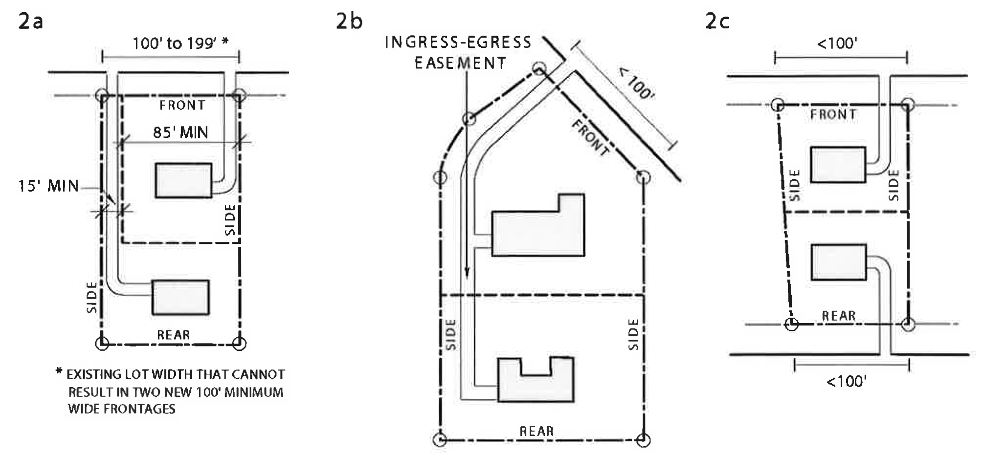
For a subdivision with one lot configured as a flag lot, the minimum street frontage of the front lot abutting the street shall be at least 85 feet. The width of the fee access corridor or easement to the flag lot shall not be less than 15 feet and not more than 20 feet. See Figure 3.40.050-2a.
b.
For a subdivision where the street frontage of the lot before the subdivision is less than 100 feet, the subdivision shall provide an ingress-egress easement of not less than 15 feet and not more than 20 feet and there shall be one driveway shared by the two lots created. See Figure 3.40.050-2b.
c.
For an existing lot with front and rear access to streets and where the subdivision creates lots with street frontage on both streets, the existing lot frontage width can be maintained. See Figure 3.40.050-2c.
D.
Driveways. Location of driveways for a two-lot subdivision shall be placed adjacent to the original lot line to minimize removal of existing landscaping.
E.
Parking Requirements. A minimum of one parking space shall be provided per unit for Two-Family and Multi-Family residences. No covered parking space is required. This parking space requirement supersedes the parking space requirement for Two-Family and Multi-Family residences in Section 4.30.030 "Parking Spaces Required -Residential Uses" Table 4.30-1 and Section 4.30.070(A)(9).
F.
Lot coverage—Nonconforming buildings and structures. All lot coverage-nonconforming buildings and structures existing before July 1, 2022, may be enlarged to increase the total lot coverage area by no more than 250 feet so long as the enlargement complies with all other development standards of Section 3.40.050.
G.
Lot coverage-Nonconforming Dwelling: Casualty Reconstruction. Where a single-family or two-family dwelling with nonconforming lot coverage is involuntarily damaged or destroyed by earthquake, fire, flood, or other casualty event, reconstruction shall not require conformance to currently applicable lot coverage, provided all of the following apply:
1.
The lot coverage-nonconforming portion of the original dwelling was constructed with applicable building permits required at the time of construction or was constructed at a time that predates building permit requirements.
2.
The floor area of the proposed reconstructed dwelling is not more than 250 square feet larger than the legally constructed floor area of the original dwelling.
3.
Any lot coverage-nonconforming deck or balcony, covered or uncovered, within the original building footprint may only be replaced with a like deck or balcony.
H.
Other nonconforming conditions. For all other nonconforming conditions refer to Chapter 4.50 of the Zoning Ordinance.
(Ord. No. NS-1200.382, § 1, 5-24-22)
§ 3.40.070. - "-n " district (Cambrian Park).
In order to create conforming setbacks in existing and future residential lots, maintain consistent neighborhood pattern within a portion of Cambrian Park as the minimum lot size increases, and preserve the existing neighborhood character of the large residential lots within the Cambrian Park area, the following specific setback requirements shall apply to all dwellings in zoning districts that contain the "-n 5 " combining designation.
A.
Front yard setbacks. Front yard setbacks shall be 25 feet (see "setback" definition in Section 1.30.030).
B.
Side yard setbacks. Side yard setbacks shall be eight feet, except for corner lots, where the minimum setback for the exterior side yard shall be ten feet.
(Ord. No. NS-1200.318, § 6, 3-28-06)
§ 3.50.010. - Purpose.
The "-h" combining zoning district is intended to provide for the preservation of historic sites, historic structures, buildings of architectural significance, and other natural and human-made heritage resources which are included in the National Register of Historic Places, or which are otherwise designated as a registered cultural heritage resource (see Section 1.30.030: Definitions of Terms). Historic Preservation zoning districts may also be utilized to protect and conserve sites and areas which are of special character, architectural value, or aesthetic interest, if such areas contain at least one registered historic place or resource. Such heritage resources deserve special consideration for preservation and enhancement due to the contribution they make to our collective understanding of the historic development and cultural heritage of the county, region, state, or nation.
(Ord. No. NS-1200.318, § 7, 3-28-06; Ord. No. NS-1200.367, § 7, 6-19-18)
§ 3.50.020. - Applicability.
The provisions of Sections 3.50.010 through 3.50.080 of this article apply to all "-h" Historic Preservation combining zoning districts. Provisions of 3.50.090 and above apply only to the historic district specified.
Each application of a Historic Preservation combining zoning district to an area shall be indicated by the designator "-h" added to the base zoning district designation, and each shall be numbered in order of application (e.g.: "-h 1 ," "-h 2 ," "-h 3 ," etc.). The policies, standards, and criteria of this chapter shall prevail over any conflicting regulations of the applicable base zoning district.
§ 3.50.030. - Design review requirements.
A.
Design review. Unless otherwise indicated by the provisions of a historic zoning district, design review approval shall be secured as set forth in Chapter 5.50 of this Zoning Ordinance for the following:
1.
Construction of any new building or structure in any "-h" combining zoning district, except as provided in subsection B, below.
2.
Any exterior modification or construction which would alter the external appearance of a building or structure within an "-h" combining zoning district, except as provided in subsection B, below.
B.
Design review exemptions. The following exemptions are applicable to "-h" properties and supersede the exemptions specified in Sections 5.50.050 and 5.50.060.
1.
For properties, buildings and structures which are not individually designated or registered as historic resources, the following exemptions shall be allowed:
a.
Statutory exemptions: The following types of structures are minor in character and are in all cases exempt from the design review process:
i.
Detached accessory buildings that are exempt from the building permit requirement on the basis of size and are not within any easement or right-of-way;
ii.
Any accessory building or structure whose combined above-ground dimensions (maximum length + maximum width + maximum height) do not exceed 16 feet;
iii.
Decks whose floor surface is 30 inches or less above final grade;
iv.
Fences three feet or less in height;
v.
Grade-level pavement for which grading performed prior to paving does not require a grading permit;
vi.
Retaining walls that are not subject to a grading permit;
vii.
Solar (photovoltaic) panels; and
viii.
Swimming pools.
b.
Discretionary exemptions: The following types of structures may, at the discretion of the zoning administrator, be considered minor and exempt from the design review process:
i.
Additions of 500 square feet or less in floor area to a dwelling;
ii.
Detached accessory buildings of 500 square feet or less in area;
iii.
Decks whose floor surface is over 30 inches in height above grade;
iv.
Fences in "-d" combining districts or along designated scenic roads which conform to the provisions of this ordinance regulating fence height; and
v.
Other minor construction similar in scale to the above categories and having low potential for visual impact.
2.
For properties, buildings and structures which are individually designated or registered as historic resources, the following exemptions shall be allowed:
a.
Statutory exemptions: The following types of structures are minor in character and are in all cases exempt from the design review process:
i.
Detached accessory buildings that are exempt from the building permit requirement on the basis of size and are not within any easement or right-of-way;
ii.
Any accessory building or structure whose combined above-ground dimensions (maximum length + maximum width + maximum height) do not exceed 16 feet;
iii.
Decks whose floor surface is 30 inches or less above final grade;
iv.
Fences three feet or less in height;
v.
Grade-level pavement for which grading performed prior to paving does not require a grading permit;
vi.
Retaining walls that are not subject to a grading permit;
vii.
Solar (photovoltaic) panels; and
viii.
Swimming pools.
b.
Discretionary exemptions: Properties, buildings, and structures which are individually designated or registered as historic resources are not eligible for discretionary exemptions from design review.
C.
Additional findings. Design review approval is contingent upon the following findings:
1.
Substantial conformance with applicable provisions of the design review guidelines, adopted by the Board of Supervisors.
2.
Conformance or consistency with any special regulations, standards, policies, or criteria specific to the particular "-h" district.
3.
Where a historically designated structure or resource is involved, the historic character of the subject structure is preserved.
(Ord. No. NS-1200.323, § 6, 1-29-08; Ord. No. NS-1200.332, § 5, 11-22-11; Ord. No. NS-1200.359, § 7, 12-6-16)
§ 3.50.040. - Historical Heritage Commission referral.
Applications for design review or architecture and site approval (excluding applications for administrative approvals or discretionary exemptions) shall be referred to the Santa Clara County Historical Heritage Commission for review and recommendation prior to the public hearing on the application, unless otherwise specified by the provisions of the specific historic zoning district. For applications on property located within the -h 1 District, the Historical Heritage Commission shall hold a public hearing in accordance with the public notice requirements of Section 5.20.110.
If the Historical Heritage Commission does not provide a response within 60 days following the date of referral, the lack of any response shall be deemed evidence of no opposition to approval.
(Ord. No. NS-1200.349, § 6, 4-7-15)
§ 3.50.050. - Special use regulations and findings.
The following special use regulations and considerations shall apply within each "-h" zoning district:
A.
Conformance with goals, policies, or standards. Prior to the approval of an application for any discretionary land use approval within an "-h" combining district, the approving authority must find that the establishment and conduct of the proposed use is consistent with the intent of the "-h" zoning district and with any adopted goals, policies, regulations, or standards for the district.
B.
Relationship of "-h" district regulations to those of the base district. Special regulations governing allowable uses, if adopted and included within the text of an Historic Preservation zoning district, shall supersede any other use regulations of the applicable base zoning district or any other related provision of the Zoning Ordinance concerning allowable uses. If no special use regulations are established, the regulations of the base zoning district shall apply.
C.
Elimination of incompatible outdoor uses and outdoor advertising signs. The Planning Commission may determine that specific pre-existing outdoor activities or outdoor advertising signs are incompatible with the goals, plans, policies, or standards of the "-h" district within which they are located. Such a determination may be made by means of a duly noticed public hearing, in which substantial evidence has been presented that specific outdoor uses, activities, or advertising signs are clearly in conflict with the purpose, plans, policies, or standards of the "-h" district. If such a determination is made, the owner of the land on which the outdoor use or advertising sign is located shall within the time period specified by the Planning Commission either modify, remove, or cease the outdoor use or sign in question as directed so that it is in conformance with the goals, plans and policies of the "-h" district. Such a determination may be appealed to the Board of Supervisors in accordance with Chapter 5.30.
§ 3.50.060. - Special development standards and procedures.
A.
Adoption of special regulations and standards. Upon the adoption of any "-h" combining zoning district, the Board of Supervisors may define specific development standards or regulations which are to apply to all lands included within an "-h" district, consistent with the intent, goals, objectives, and policies established for each district. Such standards may include, but shall not be limited to, building height, form, mass, materials, setbacks, infrastructure, parking and loading area requirements, and signs. If adopted, such standards shall be based on evidence of the historical and architectural aspects of the district which are typical or characteristic of that district, and shall be included within the zoning regulations of the "-h" district ordinance.
B.
Relationship of "-h" district regulations to those of base district. Special development regulations and standards of the "-h" district, once adopted, shall supersede any conflicting or incompatible regulations or standards of the applicable base zoning district. Where no such standards specific to the Historic Preservation zoning district are established, the standards of the applicable base zoning district shall apply.
§ 3.50.070. - Demolition or removal procedures.
A.
Board approval required for demolition or removal. No permit for the demolition or removal of a building or other structure which is a formally designated or registered cultural heritage resource shall be issued until an approval is granted by the Board of Supervisors, pursuant to the applicable procedures and regulations of the Santa Clara County Ordinance Code.
B.
Demolition procedures and regulations. The demolition permit restrictions, in Section C1-91 of the County Ordinance Code shall apply to the proposed demolition or removal of any individually registered historic building or structure. These provisions govern the procedures by which an application may be made and obtained for the demolition or removal of a building or structure, including provisions for referral to the Historical Heritage Commission for review and recommendations, the specified time period during which alternatives to demolition may be explored, and the requirement for a public hearing before the Board of Supervisors for an ultimate determination regarding the application.
§ 3.50.080. - Adoption of "-h" districts.
The following procedures shall be followed in the establishment of "-h" districts in addition to the general procedures set forth in Chapter 5.75 regarding amendments to the Zoning Ordinance:
A.
Eligibility for inclusion within an "-h" district. Each area for which an "-h" district is established must contain at least one site, building, or structure which is a "registered historic cultural resource" (see Definitions). The "-h" district may include, in addition to any registered historic cultural resource, such additional area as is deemed necessary for the protection of the environment of the registered historic cultural resource against the intrusion of incompatible land uses and development.
B.
Information to be provided prior to enactment of "-h" districts. Planning Office staff and the staff of the Historical Heritage Commission shall provide in a report the information and evaluation which will serve as the basis for any proposal to establish a "-h" combining zoning district. The following exhibits and information shall be included in the required report:
1.
Explanation, with adequate supporting documentation, of the reasons that an "-h" district should be established for the subject area.
2.
A description of the entire area to be included within the boundaries of the "-h" district. Such description is to include text, maps and photographs, property addresses and assessor's parcel numbers, and is to accurately describe existing land uses, condition of structures, architectural styles, circulation patterns, environmental features, and such other topics considered relevant.
3.
A description of each registered historic resource, structure, or place within the proposed "-h" district, including descriptive text, maps, photographs of each place or structure, and identification numbers or codes used to record its entry in the applicable register or inventory.
4.
Recommended guidelines, standards, policies, and restrictions to be included in the regulations for each "-h" district pertaining to the preservation or future development of each registered historic structure or place, including, but not limited to: allowable future land uses; building bulk, style and location; vehicular and pedestrian circulation patterns.
5.
Any additional guidelines, restrictions, or policies intended to pertain to properties within the proposed "-h" district other than those which are designated or registered historic cultural resources.
6.
A report from the Historical Heritage Commission which reviews the aforementioned report information and reports their recommendations.
7.
A recommendation from the staff of the County Planning Office and the Historical Heritage Commission, regarding the establishment of the proposed Historic Preservation district and the specific recommended wording for the proposed ordinance, to facilitate implementation of the ordinance and to ensure clarity and consistency with other historic districts and other provisions of the Zoning Ordinance. The report may also include any recommended implementation measures deemed necessary to further the goals and objectives of the proposed "-h" district.
§ 3.50.090. - "-h " district (New Almaden).
A.
Purpose. The purpose of the "-h 1 " combining district is to preserve the New Almaden National Historic Landmark District, one of 120 such places in California and only one of five in Santa Clara County recognized as being of such national historical significance. It was listed in the National Register of Historic Places in October 15, 1966, listing #66000236.
The boundaries of the "-h 1 " historic preservation zoning district for New Almaden coincide with the boundaries of the National Historic Landmark District described by the National Register listing. The majority of the land area within the National Historic Landmark District is contained within the Almaden Quicksilver County Park, a regional park maintained by the Santa Clara County Parks and Recreation Department. Also included within this historic preservation zoning district are privately owned properties, the primary uses of which are residential.
For purposes of this ordinance, individually designated historic buildings and structures in the "-h 1 " district are identified within either Priority List 1 or 2, including the Casa Grande (see subsection D, below). These structures and properties contribute significantly to the New Almaden National Historic Landmark District. All are located within what is defined within this ordinance as the Central Community Area (Sub-area A) along Almaden and Bertram Roads.
B.
Use Regulations. Uses within the "-h 1 " district shall be limited to the following:
1.
Uses permitted as a matter of right include:
a.
Residence - Single-Family, including Residential Accessory Structures and Uses.
b.
Agriculture, limited to uses permitted as a matter of right in the applicable base zoning district.
c.
Community Care - Limited.
d.
Home Occupations [Criteria/Findings, see § 4.10.180].
e.
Accessory dwelling units [Criteria/Findings, see § 4.10.015].
2.
Uses permitted subject to the issuance of a special permit include:
a.
Reserved.
b.
Home Occupation - Expanded [Criteria/Findings, see § 4.10.180].
c.
Residential Accessory Structures and Uses, with more than two internal plumbing fixtures, such as pool houses [Criteria/Findings, see § 4.20.020(I)]. This does not apply to accessory dwelling units.
d.
Historic Structure - Use Conversion, as defined in Section 2.10.040, Non-Residential Use Classifications. Such uses may be established within any registered historic structure, provided that the approving authority makes all of the following findings:
i.
The use is consistent with the intent of the "-h 1 " zoning district.
ii.
The use is consistent with the historical and architectural character of the community.
iii.
The use conforms with the provisions of Section 4.10.170, Supplemental Use Regulations.
iv.
The use conforms with any applicable supplemental use regulations of Chapter 4.10 concerning the particular use.
3.
Uses permitted subject to the issuance of architecture and site approval (ASA) include:
a.
Utilities - Minor, as defined in Section 2.10.040.
4.
Uses permitted subject to the issuance of a use permit and architecture and site approval (ASA) include:
a.
Nonprofit Institutions, such as community meeting facilities and other institutional uses serving the New Almaden community.
b.
Utilities - Major, as defined in Section 2.10.040.
C.
Special Development Standards
1.
Front Setbacks for Almaden Road Priority List 1 Properties. For individually designated historic structures along Almaden Road identified in Priority List 1, historic building placements relative to the road right-of-way shall be maintained. Front setback requirements for such properties along Almaden Road may be adjusted without a variance if deemed by the zoning administrator to be in the interest of historic preservation and not in violation of the integrity of the zoning district.
2.
Minor adjustments to minimum yard and setback requirements. Yard and setback requirements may be varied by the zoning administrator through the design review or ASA procedure if necessary, appropriate, and consistent with the intent of the historic zoning district. This provision is intended to allow for limited variation from standards without requiring a variance.
3.
Height. Maximum building height shall be 35 feet, with no more than two stories allowed. The provisions of subsection 4.20.020(E) shall apply to accessory buildings and structures.
D.
Designated Historic Structures of the New Almaden Historical Area. As a National Historic Landmark District, the historic heritage and character of the early community of New Almaden are considered to be of great importance to the residents, the county, the state and the nation. To help preserve the historic character and value of New Almaden, the existing historic structures are prioritized in terms of their significance for preservation. [Note: The "1880 Map#" refers to the "1880 Mining Company Rental Map" on file with the County Planning Office, which depicts the locations of structures within the main community area existing at that time].
1.
Priority List No. 1. The following properties are the designated as Priority List No. 1 historical structures:
Table 3.50-1 PRIORITY LIST 1
2.
Preservation of Priority List No. 1 structures.
a.
Owners of the properties in Priority List No. 1 are especially encouraged to preserve and maintain these original structures of the Hacienda of New Almaden.
b.
The Casa Grande was the original residence of the mining company superintendent, and it has special historic and building significance. Therefore, it is required that any plans for interior or exterior remodeling, renovation and restoration be submitted to the County Historical Heritage Commission for review and recommendation.
3.
Priority List No. 2. The following are the designated Priority List No. 2 historical structures:
Table 3.50-2 PRIORITY LIST 2
4.
Preservation of Priority List No. 2 structures. The structures in Priority List No. 2 are also important from a historical standpoint, even though they were moved from their original sites or were built at a later date, and they should be maintained in such a manner as to preserve their historical integrity and compatibility with Priority List No. 1 properties.
E.
Form, Materials, and Color Standards. The following standards shall apply to all structures on properties on Priority Lists No. 1 and 2. Adherence is mandatory unless acceptable substitutes are approved as indicated in the provisions below.
For other properties not on either Priority List located within the "-h 1 "district, these detailed standards are advisory. Certain features, materials, forms or approximations thereof may be required of a project by means of design review or ASA approval or conditions, as appropriate. Property owners are encouraged to incorporate these design features and materials standards into their construction plans as much as possible and appropriate to ensure the compatibility of new construction with the general historic character of the district. Substantial conformance with these standards is required for properties in the immediate vicinity of Priority List 1 and 2 properties, defined as the Central Community Area ("Sub-area A"), to ensure architectural compatibility with individually designated historic properties. (Refer to subsection F for further explanation of the Central Community Area).
1.
Exterior materials:
a.
Board and batten.
b.
Ship lap.
c.
Wood siding (narrow "New England" style).
d.
Adobe sun-dried blocks, bituminous treated (the adobe may have a plaster coat).
e.
Reclaimed used red fired brick, or the early fire brick (Scottish).
2.
Roofing materials: Wood shingles or shakes, fire retardant; constructed to comply with Uniform Building Code standards for Class "A" roofing for properties within designated "Hazardous Fire Areas" as referenced in the County Fire Code, Division B7 of the County Ordinance Code.
3.
Exceptions to general exterior and roofing materials: Other materials may be used provided they will closely resemble the materials specified above. Samples of the proposed substitute materials shall be submitted by the applicant to the County with the initial design review or other application for the project, to be examined for compliance and approval by the zoning administrator or other approval authority.
4.
Roof form: Gable or sloping shed roof.
5.
Foundation: New foundations may be of concrete construction providing one of the following is a part of the construction:
a.
Added pigment in the concrete for resemblance to a soft red brick or earthen tan adobe.
b.
A colored or painted plaster coating.
c.
A board sheeting exterior veneer applied over the concrete.
6.
Garages: Garages may be attached or detached and shall be constructed of materials listed and decorated as stated in these standards.
7.
Fencing: New and replacement fencing shall be built of wood similar to the early wood fencing, or other historically compatible design and materials. Fences and hedges shall otherwise conform with provisions of Section 4.20.050.
8.
Painting and decorating: New construction paint colors should be compatible with those that were used during the mid-to-late 1800s in this location. In general, color preferences from the time period were those from the natural color range, with emphasis on subdued, muted earth tones. Examples include, but are not limited to, grays, dark barn red, browns and tans.
9.
Window form: Window forms were generally multi-light, such as two over two, and they should be rectangular rather than round or arched.
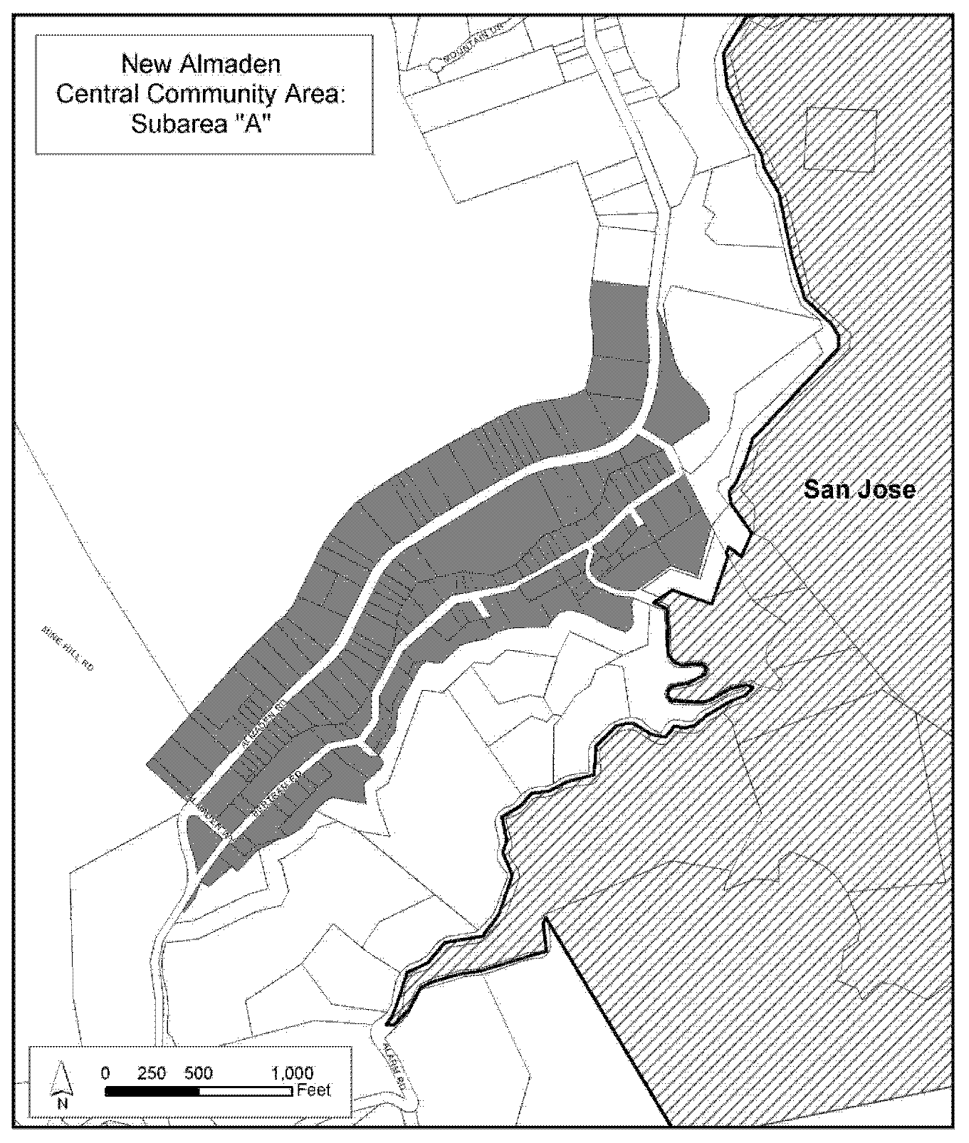
Fig. 3.50-1
F.
General Requirements for Construction on Properties not on Priority Lists 1 or 2.
1.
Historic compatibility requirements in the Central Community Area ("Sub-area A"). Within the designated central community area, delineated herein by the map entitled "New Almaden Historical Area—Sub-area A: Central Community Area," new structures and modifications to existing structures on properties not within Priority List 1 or 2 shall be designed to ensure that their appearance is as compatible and complementary as possible with that of individually designated historic buildings and structures on Priority Lists 1 and 2.
2.
Historic compatibility requirements for all other properties. Elsewhere within the "-h 1 " district, outside the Central Community Area, new structures and modifications to existing structures should be designed for general compatibility with the historic character of the district. General adherence to the building form and material standards required for individually designated or registered historic structures is advised and encouraged, but complete conformance is not required. Comparable contemporary building forms and materials which generally approximate or resemble historic building form and materials are acceptable.
3.
Hillside development review in the New Almaden combining district.
a.
Hillside development within the "-h 1 " historic zoning district—particularly proposed structures located on or near ridges or any hillside location of visual prominence—shall comply with the applicable provisions of the design review guidelines (or ASA guidelines) intended to ensure compatibility of development with the natural setting and to minimize visual impacts of development when viewed from the valley floor areas, scenic roads, and adjacent parklands.
b.
Where necessary and appropriate, the zoning administrator is authorized to limit building height, size, massing, color, reflectivity, and location in order to minimize the potential obtrusiveness or incompatibility of a proposed structure with its surroundings.
G.
Future Road and Street Development Policy.
1.
Roadway development or improvements to existing roadways, including related infrastructure, should be consistent with the intent of this ordinance to preserve the historical character of the community, while also balancing the possible need for changes to ensure public health and safety. This policy particularly applies along the section of Almaden Road where it enters the "-h 1 " district on the north (nearest San Jose) and extending to the south where it crosses Alamitos Creek.
2.
For Almaden Road within the "-h 1 " zoning district, it is recommended that the present road section should be adequately maintained, and any new road drainage infrastructure should be designed and constructed to be compatible with the historic character of the district.
H.
Sidewalks. For new construction along the section of Almaden Road where there are existing sidewalks, sidewalks shall be of the same width and located similarly to the existing walk. New sidewalks shall be either red brick or concrete with red-brown pigment added to resemble the color of the native soil in the area. Existing red brick walks shall be left in place, maintained in good repair, and not paved over. Otherwise, provision of sidewalks shall not be required.
I.
Road and Street Signing and Lighting.
1.
Street name signs and lettering should be rustic in nature. Materials may be either weathered wood or materials that simulate weathered wood in appearance. Sign lettering should be similar to the period and may be painted or routed in wood, provided that signage and lettering meet current standards for legibility and visibility at night. Two-way and four-way street name signs should be mounted on wood posts in a manner that is clearly visible and legible to motorists.
2.
Street lighting fixtures should be a traditional lantern type with standards that are of a dark brown, rust or black color.
J.
Signs. Signs shall be regulated in accordance with the provisions of Chapter 4.40 of this zoning ordinance.
K.
Tree, Shrub, and Landscaping Conservation.
1.
The general conservation of existing trees and shrubs is strongly encouraged, subject to considerations of general public health and safety, particularly relating to fire safety and protection and to any tree or vegetation which poses a physical safety hazard.
2.
Trees and shrubs having a main trunk or stem measuring six inches in diameter or greater 18.8 inches in circumference), at a height of four and one-half feet above ground, are protected trees, subject to the relevant provisions of the County's "Tree Preservation and Removal Ordinance," Division C16 of the County Ordinance Code. Except as otherwise provided in Division C16, Tree Preservation and Removal, an administrative permit or encroachment permit shall be required for the removal of any tree of such dimensions or greater within the "-h 1 " New Almaden Historic Preservation zoning district.
3.
For development proposals subject to design review or other discretionary land use or development approval, the following provisions shall apply:
a.
Approval of a development application may be conditioned by the zoning administrator to retain the maximum number of trees and shrubs possible while still enabling the appropriate establishment of the allowed use and necessary site improvements.
b.
Special emphasis shall be given to preservation of mature native trees and shrubs and to those which provide mitigation for potential adverse visual impacts of development.
c.
Applications for design review or other discretionary land use approval on lots of one acre or less shall include plans showing all existing trees six inches in diameter at a height of four and one-half feet above ground, with a keyed listing of the species and diameter of such trees. Photographs of the trees and shrubs on the site shall be provided. For lots greater than one acre, plans shall indicate trees of these same dimensions and shrubs or hedges which are located in the proposed development area or which may be potentially affected by the development proposal, as well as any heritage trees located anywhere on the subject parcel.
d.
No healthy trees six inches in diameter or greater measured four and one-half feet above ground or significant hedges or shrubs shall be removed until after the effective date of a discretionary permit approval and then only as authorized by approved plans. All reasonable care shall be taken in grading, trenching, site preparation, and other construction operations to protect those trees, hedges, and shrubs required or identified to be retained.
e.
Trees and shrubs selected for new plantings and landscaping treatments should be native species typical of the hills and riparian areas specific to this district. Examples include the California sycamore, California oaks (primarily black oak, blue oak, coast live oak, and valley oak), California bay, and toyon. Non-native tree and shrub species, if used, should be typical of those used during the period of historical significance of the district. Some of the decorative species introduced during this period (1825 to 1875) include Moss roses and heritage variety roses, Italian cypress, lilacs and buddleia (shrubs and trees of the logania family commonly grown for their blossoms). All landscaping should blend with the general appearance of the riparian areas and surrounding hills as much as possible.
L.
Weed and Rubbish Abatement. The County Fire Marshal classifies the New Almaden Historical Area as a high fire hazard zone. As a part of the "-h 1 " district standards, County Fire Code provisions concerning hazardous vegetation removal shall be complied with in all respects.
(Ord. No. NS-1200.360, § 5, 5-23-17; Ord. No. NS-1200.371, § 9, 3-10-20)
§ 3.50.100. - "-h " district (D'Artenay Ranch).
A.
Purpose. The "-h 2 " Historic Preservation zoning district contains remnants of what was once a concentrated Portuguese ranching settlement in the eastern foothills of Santa Clara County. The site contains several original wood-framed buildings, which include a small barn, milking shed, and small farmhouse, exemplary of the small family farms of the area dating from the late 1800s to the early 1900s. The purpose of the "-h 2 " zoning district is to preserve this example of a Portuguese homestead for its importance to the cultural heritage of the County.
B.
Use regulations.
1.
Permitted uses allowed by matter of right in the "-h 2 " district are limited to the individual existing structures of the property listed below:
a.
Residence—Single-Family, and garage.
b.
Wood frame barn.
c.
Wood frame board and batten structure (original family dwelling).
d.
Orchard.
2.
Educational use. The use of the property for educational purposes should be encouraged.
C.
Preservation of structures and special development standards.
1.
The historic heritage and ethnic cultural land use of the property is of importance to the residents, the County, the State, and the nation; therefore, the visual character of the exteriors of the existing structures should be maintained.
2.
Plans for remodeling, new construction, or additions shall incorporate existing exterior materials and architectural styles.
3.
Paint colors shall be compatible with the original colors of the paints used on the existing historic structures.
4.
Fencing and other physical features pertaining to or proposed for the district shall be compatible to those used during the period of 1890—1920.
5.
Nothing in the standards, design criteria, and policies shall be construed to prevent the construction of public improvements in the district, including but not limited to those required by existing deferred improvement agreements.
D.
Landscaping conservation.
1.
Existing trees, shrubs, and plantings should be maintained in good condition.
2.
Trees that have died or been removed shall be replaced with the same or similar variety in sizes feasible and available in commercial nursery container stock.
§ 3.50.110. - Reserved.
Editor's note— Ord. No. NS-1200.325, § 1, adopted April 21, 2009, repealed § 3.50.110, which pertained to "-h 3 " district (Sakai Ranch). See also the Code Comparative Table.
§ 3.60.010. - Purpose.
The purpose of the "-bw" Bay Wetlands combining district is to preserve the wetlands of San Francisco Bay that lie within the jurisdiction of Santa Clara County, while providing for appropriate recreational, educational, resource extraction, and open space uses. This chapter implements the Baylands General Plan land use designation.
§ 3.60.020. - Applicability.
The uses permitted by this chapter shall supersede those permitted by the base district, such that only those uses specifically designated within this chapter shall be permitted on land to which the "-bw" designation applies.
§ 3.60.030. - Uses permitted subject to use permit.
A.
Salt extraction, and extraction of other minerals or chemicals from seawater.
B.
Educational facilities, directly related to and necessarily located within the natural resources of the area.
C.
Boat marinas, and boat maintenance facilities.
D.
Water-related recreational clubs, and other commercial recreation exceeding the scope of activities referred to in Subsection 3.60.030.B.
E.
Hatcheries, fish farming, cultivation and harvesting of crustacea and similar forms of aquaculture.
§ 3.60.040. - General finding.
Uses necessitating the construction of dikes, groins, causeways or other bay fill shall be prohibited except where it can be demonstrated that it is desirable from an ecological standpoint to improve the baylands' natural environment.
§ 3.70.010. - Purpose.
The Monterey Highway Use Permit Area consists of specifically designated properties with access to and frontage on Monterey Road from Metcalf Road south to the County boundary, excluding the urban service areas of the cities of San Jose, Morgan Hill, and Gilroy, and also excluding lands within the San Martin Commercial and Industrial Use Permit Areas. A zoning map designation of "-mh" is combined with the base zoning district for the properties to which this district applies.
While the predominant land uses in the rural unincorporated areas of South County are agricultural and related uses, the County recognizes that there are along Monterey Road, within the areas having land use designations of "Agriculture" and "Rural Residential," established, non-agricultural uses of a commercial nature serving the South County community. It shall be the policy of the County that such uses may continue to operate within the "A, Exclusive Agriculture" and "RR, Rural Residential" zoning districts, so that the needs of the South County may be so served, provided that such uses have been documented or established as legal uses in conformance with the provisions of this district and the special area policies of the County's land use element for the Monterey Highway Use Permit Area.
It is the purpose of this district that certain legally established land uses may continue as allowable uses, may be renewed and expanded as needed, or may be changed to another use which is less intensive than the original use, subject to the issuance of a use permit and architecture and site approval and based on the findings and criteria established for this district. Through these provisions, the owners of the subject properties shall be encouraged to maintain and improve the general conditions of their properties, provide ongoing services of benefit to the community, upgrade uses and site improvements to meet current County standards and requirements for public health, safety, and welfare, and potentially enhance the resources and visual character of the Monterey Highway corridor.
§ 3.70.020. - Applicability.
A.
Monterey Highway Use Permit Area eligibility list. The document entitled "Monterey Highway Use Permit Area Eligibility List—Final Status of Uses, January 3, 1986" shall serve as the basis for the applicability of these provisions to specified uses and properties within the overall boundaries of this district. A copy of this document is maintained within the records of the Planning Office, File #1971-00-00-84GP.
B.
Specifically eligible parcels—Original legal uses. Legally established uses in existence as of January 1, 1985, as documented within the "Eligibility List" and specified in Table 3.70-1 below may be renewed, expanded, or changed to another use of a similar or more restrictive nature through the issuance of a use permit and architecture and site approval (ASA), if all of the following additional findings are made by the approving authority:
1.
The use is essential or desirable to the public convenience or welfare of the South County community.
2.
The use will not cause a significant adverse impact upon the environment.
3.
The use will not be detrimental to public health, safety and the general welfare.
4.
The use is compatible with the surrounding area.
5.
The use will be upgraded to and can meet the current requirements and standards of all applicable regulating agencies and ordinances.
6.
The use will improve such conditions as traffic safety, water quality and drainage, working conditions for on-site workers, and the visual quality of the environment.
TABLE 3.70-1. LEGAL USES AS OF JANUARY 1, 1985
C.
Additional eligible parcels granted legal status through use permit. In addition to those uses specified in Table 3.70-1, those listed in Table 3.70-2 shall also be eligible to be renewed, expanded, or changed to another use of a similar or more restrictive nature through the issuance of a use permit and architecture and site approval (ASA), subject to the additional findings of subsection 3.70.020.B. These uses include those for which a use permit application was made in accordance with the December 31, 1985, application filing deadline of the original provisions of the Monterey Highway Use Permit Area, and for which a use permit was subsequently approved. The file number pertaining to each such approval is indicated in the table below.
TABLE 3.70-2. USES WITH APPROVED USE PERMIT PURSUANT TO 1985 FILING ALLOWANCE
D.
Off-site advertising signs. The provisions of this zoning district do not apply to off-site advertising signs.
E.
Auto sales and storage. By amendment to the general plan in December 15, 1987, File #3210-87GP, auto storage and sales uses located on abandoned auto-related land use sites fronting Monterey Road between Kirby and Madrone Avenues (APN 725-02-033, 10950 Monterey Road) may be approved through the issuance of a use permit and architecture and site approval (ASA) if it is found that the use conforms with the additional findings set forth in subsection 3.70.020.B., and it does not include auto dismantling.
(Ord. No. NS-1200.332, § 6, 11-22-11)
§ 3.75.010. - Purpose.
The purpose of the -os Housing Opportunity Sites combining district is to facilitate the production of housing units affordable to all levels of household income on housing opportunity sites identified in the Housing Element of the County General Plan (Housing Element). Except where otherwise provided in this chapter, development on parcels with the -os designator is restricted to multi-family housing and limited mixed-use residential development in furtherance of the Housing Element, as updated periodically, and in compliance with applicable state laws.
The -os combining district specifies standards for development, which supersede the lot area and development standards specified for the base zoning district. The -os combining district consists of parcels, or designated portions of parcels, listed in the housing sites inventory of the Housing Element and may be amended to accommodate future Housing Element updates or otherwise include sites determined to be appropriate for this designation. Any of the requirements or prohibitions set forth in this Chapter may be superseded by a development agreement approved by the Board of Supervisors pursuant to § 5.20.230.
This section and all other provisions of the zoning ordinance and Ordinance Code are intended to be consistent with, and shall be interpreted in a manner consistent with, state housing laws, as those laws may be amended periodically. If any provisions of the Zoning Ordinance or Ordinance Code are in conflict with state law, then those provisions shall be void to the extent of the conflict and state law shall apply.
(Ord. No. NS-1200.384, § 11, 12-12-23; Ord. No. NS-1200.387, § 1, 11-5-24)
§ 3.75.020. - Applicability.
The regulations set forth in this chapter shall apply as indicated and shall supersede any conflicting regulations of the base zoning district. Alternate standards may only be applied through a variance, pursuant to chapter 5.70, or development agreement approved by the Board of Supervisors, pursuant to § 5.20.230. The designator -os is added to the base zoning designation for properties to which this combining district applies.
The County has evaluated parcels in the unincorporated County to determine locations best suited for multi-family housing development and to facilitate the production of new units to meet the County's obligations under the Regional Housing Needs Allocation (RHNA). Parcels included in the "Housing Opportunity Sites Inventory" in the adopted Housing Element shall serve as the basis for the applicability of these provisions to specified parcels or portions thereof. Such parcels are delineated below in Table 3.75-1.
All development on parcels with the -os designator shall provide the minimum number of affordable units assigned in Table 3.75-1 in compliance with all provisions of this chapter, which shall count toward the development's fulfillment of the requirements of the inclusionary housing ordinance in § 4.20.130.
At the property owner's request, the County Board of Supervisors in its discretion may approve one or more alternative means of compliance with Table 3.75-1, including but not limited to financial contributions (e.g., grants), land dedication, off-site construction, acquisition and rehabilitation of existing structures, or a reduction in affordable housing unit counts by income category, provided the Board of Supervisors finds, based on a preponderance of the evidence in the record, that the alternative means requested by the property owner meets all of the following requirements:
(i)
The alternative means shall actually result in the development, in unincorporated Santa Clara County, of the minimum number of affordable units by income category listed for the relevant parcel(s) in Table 3.75-1, or as determined pursuant to an affordable housing nexus study pursuant to (ii);
(ii)
If a reduced affordable housing unit count (in total or by income category) is proposed, the unit count shall be supported by an affordable housing nexus study prepared for the proposed development that complies with the criteria for affordable housing nexus studies established by the Planning Office and approved by the Board of Supervisors. In addition, for residential development within the Stanford University Community Plan area to count toward the Linkage Policy in the Community Plan, the nexus study shall be based on all development proposed by Stanford University pursuant to a Stanford General Use Permit application and shall include analysis of all Stanford students, faculty, and other workers, at all income levels;
(iii)
The development of all affordable housing units shall be located within or contiguous to moderate, high, or highest resource areas as defined by the most recently adopted opportunity maps published by the California Tax Credit Allocation Committee (TCAC) and California Department of Housing and Community Development (HCD);
(iv)
The development of all affordable housing units shall be located within an urban service area and have adequate access to water and sewer; and
(v)
No final building permits shall be issued for any market-rate housing units or other development on the parcel(s) with the -os designator until final building permits have been issued for all of the affordable housing units to be constructed.
To better align development in the City of San José's urban service area (USA) with the City's development standards, the County has categorized parcels in the USA as Transit Residential (TR), Urban Residential (UR), or Urban Village (UV), which roughly correlate to the City of San José's Zoning Ordinance. Sites within the Stanford University Community Plan area are categorized as SCP. These categories have applicable development standards delineated in § 3.75.030.
NOTES:
1.
The definition of each level of affordability is determined by the State and represent a percentage of the average median income for the area, based on family size.
2.
The -os designator applies to limited portions of the APNs identified for site numbers 1, 2, 22, 23, and 24, as shown on the official County Zoning Maps. If a parcel listed in Table 3.75-1 is subdivided or otherwise modified (e.g., lot line adjustment, lot merger), the County will apportion the required number of units to the successor APN(s).
3.
The minimum density requirement only applies to sites with very low- and low-income affordability requirements in Table 3.75-1.
4.
Eligible parcels that are annexed by a city before the County has issued a building permit shall be subject to the annexing city's land use jurisdiction.
(Ord. No. NS-1200.384, § 11, 12-12-23; Ord. No. NS-1200.387, § 1, 11-5-24)
§ 3.75.030. - Development standards.
Development on parcels with the -os designator is subject to all requirements of this section. The development standards in this section may be modified pursuant to a development agreement approved by the Board of Supervisors pursuant to § 5.20.230.
A.
The following table lists the minimum lot area, maximum building height, and applicable setbacks for each category of parcels as identified in Table 3.75-1:
NOTES:
1.
For the TR, UR, and UV parcels, the minimum lot size shall be as provided in the applicable city's general plan designation for the particular parcel. The County may modify the minimum lot size in the context of a development application to facilitate the production of housing units.
2.
Maximum heights are expressed in feet above the natural grade of the property; there is no maximum number of stories.
3.
Height, setback, and minimum lot size requirements, if any, for sites on Stanford University Campus are determined by the Stanford University Community Plan and the General Use Permit.
B.
Parcels with the -os designator are exempt from any development standards of the base zoning district, including, but not limited to, FAR and lot coverage requirements.
C.
The minimum required density shall be as required by Government Code § 65583.2(h), specifically, 20 units per acre for all sites listed in Table 3.75-1 that are required to accommodate housing for very low- and low-income households.
D.
Affordable units in the development project shall have the same bedroom and bathroom count ratio as the market rate units, be equitably distributed within the project, have the same type or quality of appliances, fixtures, and finishes, and have equal access to shared amenities in the development.
E.
Exterior walls adjoining a street or public right-of-way shall not have a continuous wall plane of more than 100 feet horizontally unless visually broken up by a minimum of a three-foot deep offset façade (recession or protrusion) or architectural feature, on either 50 percent of all floors or alternating floors, to create architectural variation.
F.
Front and main entrances of each building shall be offset from the building façade by a minimum depth of three feet to clearly designate building entrances and provide additional wall plane variation.
G.
All buildings shall provide either a patio or balcony for each unit, or commonly accessible open space(s) (including courtyards, parklets, playgrounds, usable landscaped areas, rooftop common areas, and sport courts) consisting of a minimum of ten percent of the lot size.
H.
All projects shall include either in-unit or on-site laundry for each residential building.
I.
All units shall be provided a separate secured storage space or cabinet on a private patio/balcony or on a designated building floor, including a parking garage level, unless a private garage is provided for each unit.
J.
Bicycle storage shall be provided on-site, no less than one storage space per four residential units.
K.
Guest parking and short-term drop-off/delivery parking shall be provided on site, no less than one space of each type for projects over 25 units, and an additional one space of each type per 600 residential units, unless prohibited by state law.
L.
Development projects are restricted to multi-family housing and limited mixed-use residential development, and may include other ground floor uses, which shall be limited to on-site parking, Retail, Restaurants and Bars, Banks, Health Clubs, Medical Clinics, Personal Services, or community benefit uses such as libraries and government offices providing services to the public. Mixed-use residential development projects on the SCP sites may also include any additional development or use as permitted by the Stanford University Community Plan and General Use Permit, as amended from time to time. For sites with Very Low-Income and Low-Income units in Table 3.75-1, any development projects including nonresidential uses shall comply with all requirements in Government Code § 65583.2(h), including that 100 percent residential use is allowed and residential use shall occupy a minimum of 50 percent of the total floor area of a mixed-use project.
M.
Projects in the TR, UR, and UV development categories may include Retail, Restaurants and Bars, or shared gathering space on the rooftop level.
(Ord. No. NS-1200.384, § 11, 12-12-23; Ord. No. NS-1200.387, § 1, 11-5-24)
§ 3.75.040. - Streamlined project review and approval.
Development on parcels with the -os designator is restricted to multi-family housing and limited mixed-use residential development and is subject to approval by ministerial, nondiscretionary planning clearance, pursuant to § 5.20.240, if all of the following conditions and other requirements in this chapter are met.
A.
The project meets one of the following criteria:
1.
All of the project's dwelling units are rental units and a minimum of ten percent of the total number of units (before calculating any density bonus) are subject to enforceable restrictions requiring those units to be occupied only by households making at or below 50 percent of the area median income.
2.
All of the project's dwelling units are for-sale units and a minimum of ten percent of the total number of units (before calculating any density bonus) are subject to enforceable restrictions requiring those units to be occupied only by households making at or below 80 percent of the area median income.
3.
At least 20 percent of the project's total number of rental and for-sale dwelling units (before calculating any density bonus) are subject to enforceable restrictions requiring those units to be occupied only by lower-income households as defined in Health and Safety Code section 50079.5, or will be provided at rents or sales prices affordable to such lower-income households, as supported by substantial evidence provided at the time of application and would count toward the County's Regional Housing Needs Allocation pursuant to written confirmation from the California Department of Housing and Community Development.
B.
The project conforms to all objective County standards for private driveways, design for parking and loading areas, and access to public rights-of-way.
C.
The proposed site development meets all objective development standards adopted by the Board of Supervisors.
D.
Installation and continued maintenance of proposed landscaping complies with the County's Sustainable Landscape Ordinance as detailed in Division B33 of the Ordinance Code.
E.
The project conforms to all stormwater management requirements of the applicable regional water control board.
F.
The project conforms to all applicable provisions of the Zoning Ordinance and building and fire codes.
G.
The project would not produce noise levels exceeding what is allowed in the Noise Ordinance as detailed in Sections B11-150 through B11-158 of the Ordinance Code.
Multi-family residential or limited mixed-use residential development projects that meet the criteria of this section shall only be denied if the Building Official makes site-specific written findings that a significant adverse impact to public health, safety, or the environment would be created by the project, and there is either no feasible way to satisfactorily mitigate or avoid the impact or the applicant does not agree to mitigate or avoid the impact.
This section incorporates by reference any applicable state laws that may require streamlined project review and approval for housing opportunity sites identified in a jurisdiction's housing element, including, but not limited to, those in the Housing Element Law, Government Code § 65580 et seq.
(Ord. No. NS-1200.384, § 11, 12-12-23; Ord. No. NS-1200.387, § 1, 11-5-24)
§ 3.75.050 - Discretionary project review and approval.
Projects that do not meet the criteria for ministerial streamlined approval in § 3.75.040 are subject to approval through the architectural and site approval and/or use permit processes, pursuant to Chapters 5.40 and 5.50, respectively.
(Ord. No. NS-1200.387, § 1, 11-5-24)
Editor's note— Ord. No. NS-1200.387, § 1, adopted November 5, 2024, renumbered § 3.75.050 as § 3.75.060 and enacted a new § 3.75.050 as set out herein. The historical notation has been retained with the amended provisions for reference purposes.
§ 3.75.060. - Community notification.
Upon receipt and initial processing of any application for development on a parcel in the -os combining district, the County shall mail notices to all property owners of any parcel located within 1,000 feet of the boundaries of the subject property.
(Ord. No. NS-1200.384, § 11, 12-12-23; Ord. No. NS-1200.387, § 1, 11-5-24)
Note— See the editor's note to § 3.75.050.
§ 3.80.010. - Purpose.
The purpose of the "-ps" Public Services and Supportive Housing combining district is to accommodate, in appropriate locations, emergency shelters, transitional housing, supportive housing and agricultural employee housing. This district applies to government owned lands and implements housing policies provided in the General Plan Housing Element for special needs housing.
§ 3.80.020. - Applicability.
The regulations in this chapter shall apply to lands to which the "-ps" combining district applies. The uses permitted by this chapter shall be allowed in addition to those permitted by the base district.
§ 3.80.030. - Emergency shelters.
Small-scale emergency shelters, and large-scale emergency shelters having a client capacity of 15 through 140 individuals, meeting all criteria of Section 4.10.115, shall be allowed by right. Shelters with larger capacity, or shelters otherwise not meeting the criteria of Section 4.10.115, may be allowed with a use permit.
§ 3.80.040. - Transitional and supportive housing.
Transitional and supportive housing facilities meeting all criteria of Section 4.10.090, Community Care, and the following additional criteria, shall be allowed by right.
A.
Capacity: Total capacity shall not exceed 140 clients.
B.
Emergency Shelter Component: For facilities with a total capacity of 40 or more clients, at least 20 client beds shall be dedicated for emergency shelter use.
C.
State Licensing: Facilities must comply with applicable licensing requirements of the California Department of Social Services, or any other state agency.
Facilities with larger capacity, or facilities otherwise not meeting the criteria of this section, may be allowed with a use permit.
§ 3.80.050. - Agricultural employee housing: Large-scale permanent.
Large-scale agricultural employee housing facilities meeting all criteria of § 4.10.040, and the following additional criteria, shall be allowed by right.
A.
Capacity: Total capacity shall not exceed 140 occupants.
B.
Emergency Shelter Component: For facilities with a total capacity of 40 or more occupants, at least 20 beds shall be made available for emergency shelter use during seasonal periods where the absence of agricultrual employees results in vacancies of agricultural employee beds.
Facilities with larger capacity, or facilities otherwise not meeting the criteria of this section, may be allowed with a use permit.
(Ord. No. NS-1200.345, § 8, 6-10-14; Ord. No. NS-1200.375(10.20.2020), § 5, 10-20-20)
§ 3.90.010. - Purpose.
The purpose of the -sm San Martin Use Permit Areas combining district is to allow for non-residential uses and development within the defined boundaries of the San Martin Commercial Use Permit Area and the San Martin Industrial Use Permit Area, consistent with the applicable policies of the Land Use Chapter of the General Plan for the San Martin Planning Area.
Within the San Martin Commercial Use Permit Area as established and defined by the General Plan and as depicted herein, the -sm combining zone permits commercial uses that are not otherwise allowed by the provisions of the applicable base zoning district, in order to achieve the purposes of the General Plan.
Within the San Martin Industrial Use Permit Area as established and defined by the General Plan and as depicted herein, the -sm combining zone permits light industrial uses that are not otherwise permitted by the applicable base zoning district, in order to achieve the purposes of the General Plan.
§ 3.90.020. - Applicability.
The area-specific provisions established in this chapter shall apply as indicated by the designator "-sm" added to the base zoning designation and shall supersede any conflicting use regulations of the applicable base zoning district.
§ 3.90.030. - Commercial use permit area.
The provisions of this section shall apply to lands within the San Martin Commercial Use Permit Area as established and defined in the Land Use Chapter of the General Plan and as shown herein on Figure 3.90-1.
A.
Allowable Uses and Permitting Requirements. Within the San Martin Commercial Use Permit Area, new or significantly expanded commercial uses not otherwise provided for in the applicable base zoning district may be allowed, subject to obtaining a use permit and architecture and site approval. Commercial uses mean any non-residential use defined in Section 2.10.040 having the parenthetical classification of Commercial that is not already a permissible use in the base zoning district, except that Billboards, Entertainment—Seasonal Outdoor, Hotels and Motels, and Laundries—Industrial, as defined in Section 2.10.040, are prohibited.
B.
Use Intensity. Newly proposed or expanded commercial uses within the Commercial Use Permit area shall be evaluated through the use permit and architecture and site approval processes for their appropriate size, scale and intensity to qualify as a local-serving use, pursuant to the provisions of General Plan Policy R-LU 127 and Section 2.20.090, except for properties in the Commercial Use Permit Area east of Murphy Avenue and adjacent to the San Martin Avenue/Highway 101 freeway interchange, on which uses shall not be limited to those defined as local-serving in terms of size, scale and intensity.
C.
Other Criteria. Newly proposed or expanded commercial uses within the Commercial Use Permit area shall comply with all applicable General Plan policies, including but not limited to policies R-LU 124 through R-LU 131.
§ 3.90.040. - Industrial use permit area.
The provisions of this section shall apply to lands within the San Martin Industrial Use Permit Area as established and defined in the Land Use Chapter of the General Plan and as shown herein on Figure 3.90-2.
A.
Allowable Uses and Permitting Requirements. Within the San Martin Industrial Use Permit Area, new or significantly expanded light industrial uses not otherwise provided for in the applicable base zoning district may be allowed, subject to obtaining a use permit and architecture and site approval. Industrial uses mean any non-residential use defined in Section 2.10.040 having the parenthetical classification of Industrial that is not already a permissible use in the base zoning district, except that Butcheries, Laundries-Industrial, Manufacturing/Industry-Intensive, Petroleum Products Distribution, and Recycling Facilities, as defined in Section 2.10.040, shall be prohibited.
B.
Use Intensity. Newly proposed light industrial uses within the Industrial Use Permit area shall be evaluated through the use permit and architecture and site approval processes for potential impacts to adjacent properties and the community. Where necessary, additional setbacks and buffer areas may be required to minimize potential impacts from industrial uses and provide sufficient separation between any use of land or buildings associated with the industrial use and any adjoining parcel.
C.
Other Criteria. Newly proposed or expanded industrial uses within the Commercial Use Permit area shall also comply with all applicable General Plan policies, including but not limited to policies R-LU 120 through R-LU 123.
§ 3.90.050. - San Martin Integrated Design Plan.
All new uses established pursuant to the provisions of the -sm combining zoning district shall conform to the requirements of the San Martin Integrated Design Plan and Guidelines.
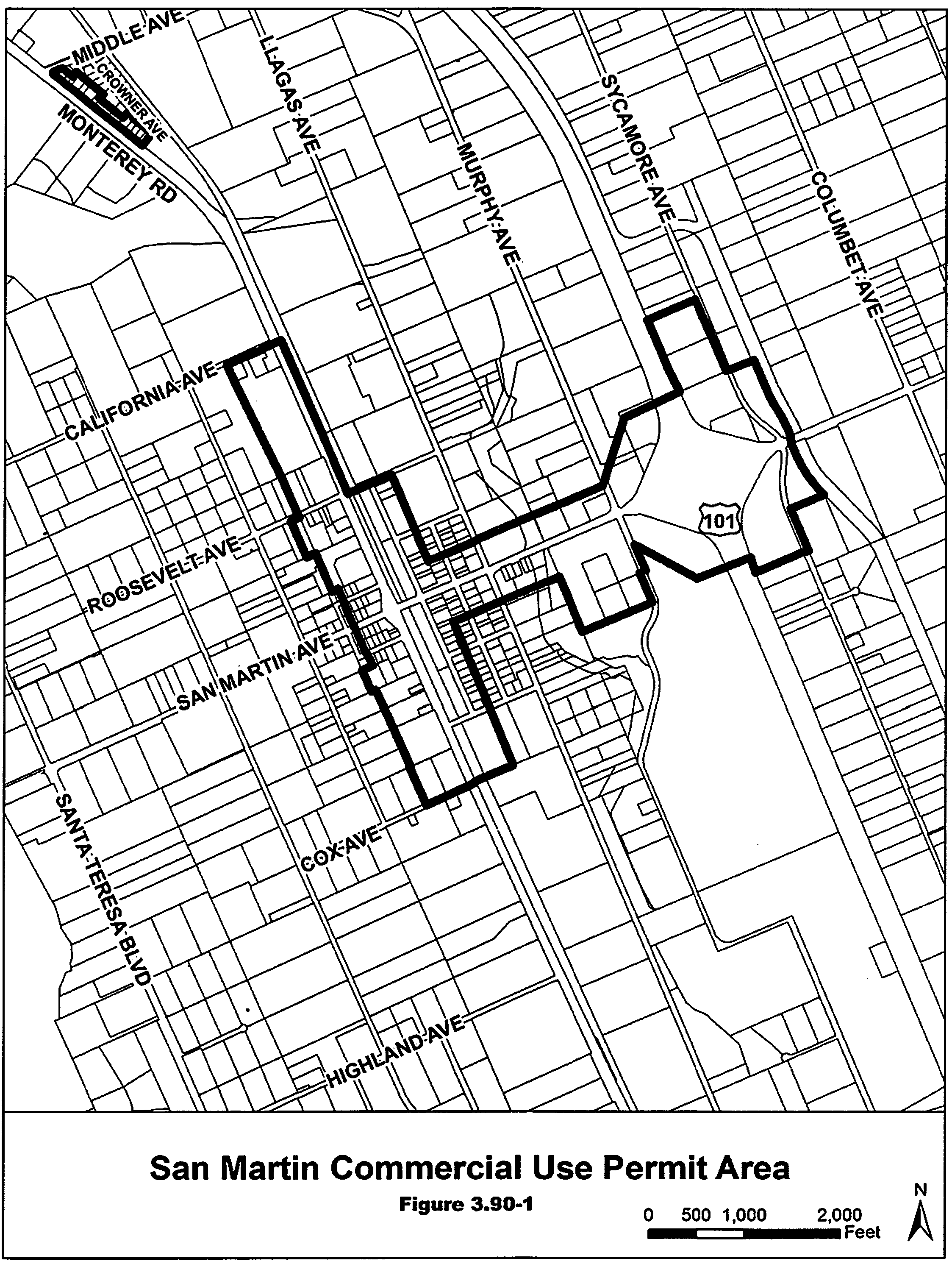
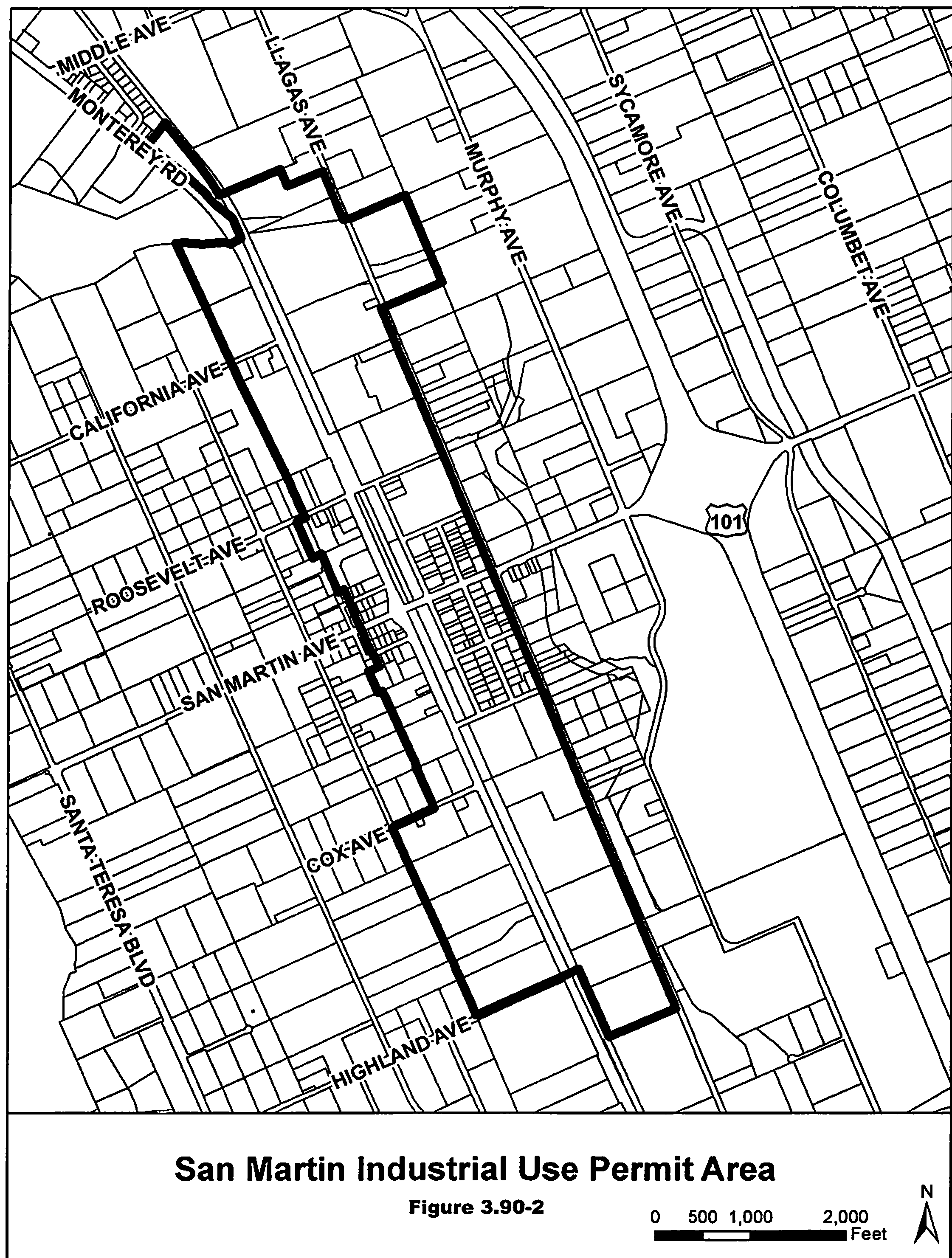
§ 3.95.010. - Purpose.
In accordance with California Public Resources Code section 35186(b), Coyote Valley, the area between the cities of San Jose and Morgan Hill, is an area of statewide significance. As acknowledged by the State Legislature, Coyote Valley is a unique landscape providing agricultural, wildlife, recreational, climate, and other natural infrastructure benefits.
The purpose of the "-cv" Coyote Valley Climate Resilience combining district is to protect this agricultural greenbelt area as a means of increasing regional climate resilience. The predominantly agricultural lands of Coyote Valley are unique in their combination of natural characteristics, which are well-suited to providing ecological and public benefits, including flood attenuation as a result of sustaining wetland health, maintaining water supply as a result of protecting groundwater recharge potential, and carbon sequestration made available from natural and working lands.
The "-cv" combining district is intended to minimize the impacts of new development through supplemental development standards and use requirements, in order to preserve Coyote Valley as a greenbelt area intended for long-term agricultural uses and climate resilience.
(Ord. No. NS-1200.379, § 1, 12-14-21)
§ 3.95.020. - Applicability.
The area-specific provisions established in this chapter shall apply to the properties depicted on Figure 3.95-1, which shall have the designator "-cv" added to the base zoning designation and shall supersede any conflicting use regulations of the applicable base zoning district.
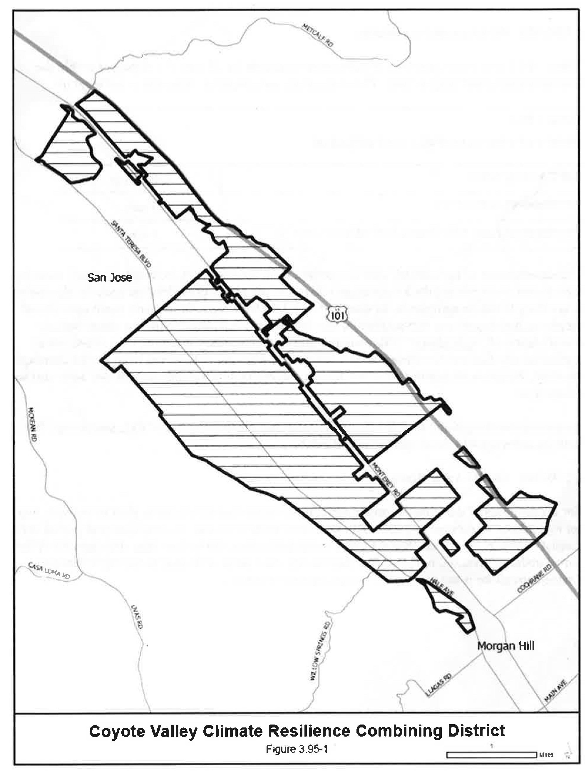
(Ord. No. NS-1200.379, § 1, 12-14-21)
§ 3.95.030. - Development Standards.
Table 3.95-1 establishes property development standards for all new development within the Coyote Valley combining district. These standards are applied as maximums per legal lot.
The development of agricultural uses are exempt from the above lot coverage standard, meaning they do not count toward the lot coverage maximum per parcel provided that such development is ancillary to onsite agriculture, as specified in § 3.95.040. Agricultural uses mean agricultural employee housing or any non-residential use defined in § 2.10.040 having the parenthetical classification of "agricultural" following the title of each primary use type. Uses classified as Agriculturally Related Entertainment & Commercial Uses are not exempt from the lot coverage standard. Parcels with onsite agriculture have a maximum development area of two acres instead of one acre.
Accessory dwelling units, as defined in § 2.10.030 and pursuant to § 4.10.015, are exempt from both lot coverage and development area standards.
(Ord. No. NS-1200.379, § 1, 12-14-21)
§ 3.95.040. - Onsite Agriculture.
For the purposes of this chapter, onsite agriculture means that the property shall be actively used for agriculture, as defined in § 2.10.040, in at least three years out of every five-year period and consist of either:
(a)
No less than six acres under cultivation;
(b)
No less than 60 percent of the parcel under cultivation; or
(c)
No less than 24 acres dedicated to raising livestock. Onsite agriculture is not required to be commercial in nature.
(Ord. No. NS-1200.379, § 1, 12-14-21)
§ 3.95.050. - New Residences Ancillary to Onsite Agriculture.
On parcels over five acres, development of a new single-family residence shall be permitted only as ancillary to onsite agriculture, as defined in § 3.95.040. An alteration to an existing legally established single-family residence requires onsite agriculture only if the alteration is classified as a rebuild, pursuant to Section C1-22 of the Ordinance Code. Development of a new accessory dwelling unit, as defined in § 2.10.030 and pursuant to § 4.10.015, does not require onsite agriculture.
A notice shall be recorded pursuant to § 5.20.125 stating that such residence shall be used only ancillary to onsite agriculture as defined in this section. A property owner shall also provide written disclosure of all such conditions and requirements before any sale, lease, or financing of the property.
(Ord. No. NS-1200.379, § 1, 12-14-21)