
Santa Clara County Unincorporated
City Zoning Code
City Zoning Code
ARTICLE 5
- PROCEDURES AND ADMINISTRATION
CHAPTER 5.45 - CLUSTER DEVELOPMENT PLAN[7]
Editor's note—Sec. 1 of Ord. No. NS-1200.338, adopted Sept. 10, 2013, amended Ch. 5.45 in its entirety to read as herein set out. Former Ch. 5.45 pertained to Cluster Permits, and derived from Ord. No. NS-1200.312, adopted June 13, 2003; and Ord. No. NS-1200.323, adopted Jan. 29, 2008.
CHAPTER 5.55.- LOT LINE ADJUSTMENT[8]
Editor's note— Ord. No. NS-1203.112, § 1, adopted June 24, 2003, repealed former Ch. 5.55, §§ 5.55.010—5.55.080, and enacted provisions designated as a new Ch. 5.55 to read as herein set out. Prior to inclusion of said ordinance, Ch. 5.55 pertained to similar subject matter. See also the Code Comparative Table.
§ 5.10.010.- Purpose.
This chapter identifies the decision-making bodies for the various types of land use permits regulated under the Zoning Ordinance, and describes the composition and authority of the various review bodies. It provides a consolidated reference point for understanding the roles of decision-makers in the development process. Permits not cited in Table 5.10-1 are described in Title C of the County Ordinance Code.
§ 5.10.020. - Review authority.
Table 5.10-1 presents the decision-making bodies for new and modified land use permits and approvals authorized under this zoning ordinance.
TABLE 5.10-1. REVIEW AUTHORITY
BS: Board of Supervisors; PC: Planning Commission; ZA: Zoning Administrator; DIR: Director or Official Designee
* ZA if Minor Subdivision/Cluster Development Plan; PC if Major Subdivision/Cluster Development Plan
(Ord. No. NS-1200.319, § 15, 3-28-06; Ord. No. NS-1200.359, § 17, 12-6-16)
§ 5.10.030. - Planning Director.
The Planning Director is responsible for overseeing the work of the Department of Planning and Development. The Planning Director also designates the Planning Commission Secretary, Land Development Coordinator, ASA Secretary, and Zoning Administrator. Any decisions made by the Planning Office staff that are not listed in Table 5.10-1 may be appealed to the Planning Director.
(Ord. No. NS-1200.349, § 10, 4-7-15)
§ 5.10.040. - Planning Commission Secretary.
The Planning Commission Secretary is the Planning Office staff person, designated by the Planning Director, who schedules Commission meetings, processes all Commission paperwork, maintains official minutes and other Commission records, prepares and forwards any Commission recommendations to the Board of Supervisors, and forwards any appeals of Commission actions to the Board of Supervisors.
§ 5.10.050. - Zoning Administrator.
The Zoning Administrator is the planning office staff member designated by the Planning Director to be responsible for certain administrative and discretionary permits or approvals as specified in the Zoning Ordinance or County Ordinance Code.
(Ord. No. NS-1200.359, § 18, 12-6-16)
Editor's note— Sec. 18, of Ord. No. NS-1200.359, adopted Dec. 6, 2016, amended § 5.10.050 in its entirety to read as herein set out. Said provisions included herein previously were codified as § 5.10.060.
§ 5.10.060. - Concurrent land use permits.
When a proposed land use is concurrently subject to more than one discretionary land use permit or approval, the review processes may be combined and the highest approval authority for any of the approvals sought shall be designated as the sole approval authority.
(Ord. No. NS-1200.359, § 19, 12-6-16)
Editor's note— Sec. 19, of Ord. No. NS-1200.359, adopted Dec. 6, 2016, amended § 5.10.060 in its entirety to read as herein set out. Said provisions included herein previously were codified as § 5.10.070. Sec. 20 of said ordinance deleted § 5.10.070.
§ 5.20.010.- Purpose.
This chapter sets forth the process for obtaining discretionary planning permits and planning clearances in unincorporated areas in Santa Clara County. It applies to all permits regulated through subsequent sections of this zoning ordinance. The procedures described in this chapter also apply to other types of land development permits regulated through the County Ordinance Code, including but not limited to building site approval, subdivisions, grading permits, lot mergers, and administrative permits.
The following sections are organized to represent a step-by-step description of the land development permit application and decision-making process.
§ 5.20.020. - Pre-application meeting.
Certain types of permits require pre-application meetings. Pre-application meetings are held to identify issues of concern related to an application, to review preliminary plans for compliance with County ordinances and standards and to determine an application's adequacy for submittal. The pre-application meeting also informs the applicant of the specific decision-making process for the application. The pre-application meeting is informational and intended to provide guidance to the applicant. The meeting does not result in any official recommendation or final decision with respect to an application.
§ 5.20.030. - Application and fees.
All applications for land use permits or other approvals, exemptions, modifications, extensions, renewals and appeals shall be filed with the planning office. All applications not initiated by the County shall be accompanied by a filing fee in an amount established by the Board of Supervisors. The County will not process any application until all fees are paid in full; provided, however, that where the application fee is an initial fee plus an hourly rate, the initial fee shall be submitted with the application and work on the application shall be suspended if at any time the paid fees are exhausted.
Applications shall be signed by the owner of the property that is the subject of the application, or by persons having the owner's lawful power of attorney to file the application; or in the case of an appeal, the appellant. Applications involving more than one lot must be signed by property owners of each of the involved lots.
(Ord. No. NS-1200.317, § 11, 6-8-04)
§ 5.20.040. - Application for discretionary exemption.
An applicant may apply for a discretionary exemption from the applicable permit if the Zoning Ordinance provides for such discretionary exemption and if the proposed land use is eligible for one of the exemptions described for the applicable permit in subsequent chapters. The Zoning Administrator or other appropriate decision-making authority shall evaluate the application for exemption. If the application for exemption is granted, no public hearing will be required, and any required building permits may be issued based on this exemption. Where the application for discretionary exemption is denied, the normal permit procedure will be followed.
§ 5.20.050. - Environmental assessment.
All proposed land uses requiring discretionary permits are subject to the requirements of the California Environmental Quality Act (CEQA) unless they are included in a category of projects which the State has determined are not likely to have a significant impact on the environment. Other projects may also be exempt from CEQA as determined on a case-by-case basis. Determination as to whether a project is subject to or exempt from CEQA will be made during completeness review.
If a project is subject to CEQA, an environmental assessment (EA), undertaken by or under contract to the Planning Office at the applicant's expense, will be prepared to determine the impact of the project on the surrounding environment. Once a project has been found to require an EA:
A.
A hearing date will not be set or noticed until the EA has been completed, except where the hearing is for the purpose of determining whether the project should be denied without completing the EA; and
B.
A decision to approve the permit cannot be made until the EA has been has been approved or certified as specified under state law. Approval of the EA and the final decision on the project can be made at the same hearing.
§ 5.20.060. - City general plan conformance.
On property located within a city's urban service area, city general plan conformance shall be required of uses permitted by the following permitting procedures: subdivision, lot line adjustment, use permit and zone change. General plan conformance is also required for multi-family housing and mixed-use residential projects on parcels that do not have the -os designator. An official document from the city affirming general plan conformance must accompany all such permit applications.
Development on the lands of Stanford University shall be exempt from this requirement, per the intergovernmental protocol agreement adopted jointly by the County of Santa Clara, Stanford University, and the City of Palo Alto.
(Ord. No. NS-1200.384, § 13, 12-12-23)
§ 5.20.070. - Properties subject to annexation.
A.
Applicability. Except as provided in subsection B, below, no application for architecture and site approval, subdivision, use permit, zone change, or for any permit for construction of a building for habitation, or for commercial or industrial use on a vacant parcel, shall be accepted for filing for any parcel of land within a city's urban service area and which is:
1.
Contiguous to the city; or
2.
Separated from the city by the width of a public street or highway; or
3.
Located within territory entirely surrounded by one (1) or more cities and adjoining a portion of a public street or highway which is no more than three hundred (300) feet in length connecting the parcel to territory within the city; unless a petition or resolution initiating annexation of the parcel to such city has been filed with the appropriate local, agency and denied, or unless the city council or its planning director has, in writing, waived the provisions of this section. In the event the parcel is located within territory which has been placed under the County's jurisdiction pursuant to California Government Code Section 35004, the landowner shall be required to file a petition with the Santa Clara County Local Agency Formation Commission (LAFCO) to detach the parcel from the city to which the parcel has previously been annexed and to annex the parcel to the city again.
B.
Exceptions. This section shall not prevent the filing of any application for any or all of the following:
1.
Alterations of or additions to a single-family residence, construction of accessory structures and accessory dwelling units.
2.
Reconstruction (within two (2) years) of any structure destroyed by fire, flood or other casualty beyond the control of the property owner;
3.
Replacement of a structure because of condemnation proceedings;
4.
Development on the lands of Stanford University, per the intergovernmental protocol agreement adopted jointly by the County of Santa Clara, Stanford University, and the City of Palo Alto.
5.
Minor alterations of or additions to existing duplexes, multifamily dwellings, commercial or industrial structures where number of units is not being increased. Exemption includes construction of minor accessory structures and site improvements such as parking areas.
6.
The addition of an Urban Primary Unit on a qualifying lot.
7.
Multifamily housing or limited mixed-use residential development in the -os combining district.
For the purpose of subsection (B)(5) above, "minor" shall mean changes which do not substantially alter or significantly intensify the existing primary land use. Where this is not clear as it may apply to a specific proposal, a determination shall be made mutually by the planning directors or their designees of the County and the affected city within ten (10) days of the applicant's written request for a determination. Upon their failure to agree, the matter shall be referred to the members of the Santa Clara County Local Agency Formation Commission (LAFCO), which shall henceforth constitute the County reviewing body. The determination of LAFCO shall be final.
A corresponding annexation provision applicable to building site approval may be found in Section C1-52 of the County Ordinance Code.
(Ord. No. NS-1200.367, § 15, 6-19-18; Ord. No. NS-1200.371, § 16, 3-10-20; Ord. No. NS-1200.383, § 12, 1-24-23; Ord. No. NS-1200.384, § 14, 12-12-23)
§ 5.20.080. - Determination of application completeness.
All applications submitted to the Planning Office will be initially processed to determine their completeness. This processing generally occurs during a 30-day period, and includes review by a variety of individuals and agencies to identify whether additional information is needed to fully process the application through the final decision.
A.
Notification of applicant. Within 30 days after the application is submitted, the applicant shall be informed in writing either that the application is complete and acceptable for processing, or that the application is incomplete and that additional information, as specified in the letter, must be provided.
B.
Resubmittal of materials. If an application has been deemed incomplete, the requested materials must be submitted within six months. Within 30 days of a resubmittal, the applicant shall be informed in writing either that the application is complete and acceptable for processing, or that the application is incomplete and that additional information, as specified in the letter, must be provided.
If the requested materials have not been submitted within six months of the date of the incomplete letter, an additional fee is required to continue processing the application. If the required materials have not been submitted within one year of the incomplete letter, the application will be deemed abandoned, and the application fees will not be refunded.
C.
Appeal of incompleteness determination. An applicant may appeal an incompleteness determination to the Planning Commission in accordance with the procedures in Chapter 5.30. The Planning Commission shall render a decision on the appeal within 60 days after the appeal is filed.
D.
Additional information for environmental review. After an application has been deemed complete, the Planning Office may require the submittal of additional information to determine the environmental impacts of the project or to assess feasible alternatives or mitigation measures for such impacts as required by the California Environmental Quality Act.
The time limits in this section may be extended upon mutual written agreement of the applicant and the Planning Director.
§ 5.20.090. - Modification or withdrawal of permit application.
An application may be modified by the applicant at any time prior to approval. Any prior finding of application completeness may be voided by submittal of a request for modification or withdrawal. Depending on the type and substance of the modification, the modified application may be distributed again for completeness review as provided in Section 5.20.080 and may require payment of a supplemental application fee.
An application may be withdrawn by the applicant at any time. The withdrawal shall be without prejudice to the application. Any resubmittal of the application shall be accompanied by the required filing fee.
§ 5.20.110. - Public notification.
The required public notice of the hearing shall be provided at least ten days prior to the scheduled hearing, in accordance with all applicable state laws. The notice shall include the date, time and place of the hearing, the identity of the hearing body or officer, a general explanation of the matter to be considered, and a general description (text or diagram) of the property location. Notice is required through one or more of the following means.
A.
Mailing or delivery. Unless otherwise provided in this section, notice shall be mailed or delivered to the following individuals and agencies:
1.
The applicant, at the address shown on the application, and all owners of the subject property(s) at their addresses as shown on the most current property tax roll of Santa Clara County;
2.
Any person who has filed a written request for notice on the particular application with either the Planning Office or Clerk of the Board of Supervisors;
3.
Local agencies expected to provide utilities, roads, schools or other essential services, where their ability to provide such services may be significantly affected; and
4.
The owners of all real property located within 300 feet of the subject property boundaries at their addresses as shown on the most current property tax roll of Santa Clara County, or of a neighboring county. If there are fewer than 24 properties within 300 feet, the notification radius shall be extended to include the 24 closest properties.
B.
Publication. In addition to the mailing requirements in subsection A, above, notice shall be published in a newspaper of general circulation at least ten days prior to the public hearing. Where the combined number of agencies and individuals described in subsections A1, A3 and A4 is greater than 1,000, the County may publish the notice in a newspaper of general circulation instead of sending individual notices.
C.
Continued hearing. If a noticed public hearing is continued to a date certain by the decision-making body, no additional notice is required to be mailed to previous recipients of such notice. The decision-making body shall continue or recontinue any hearing to any subsequent meeting in accordance with California Government Code Section 54955 and Section 54955.1.
D.
Additional notice and early notification. The County may, in its discretion, provide additional notice beyond that specified in this section. The applicant may be required to provide additional early notification and public outreach in accordance with the most recently adopted Early Public Notification and Outreach Policy for Development Projects.
Failure to comply with the notice requirements in this section, in whole or in part, shall not invalidate any action taken on the matter.
(Ord. No. NS-1200.332, § 12, 11-22-11; Ord. No. NS-1200.341, § 1, 12-10-13)
§ 5.20.120. - Conditions of approval.
Development conditions of approval are established by the approving authority based on recommendations from the Planning Office and other agencies consulted on the application. An approval may include reasonable conditions that are commensurate with the nature and magnitude of the project, and should relate to the purpose of the applicable permitting process. Conditions shall be intended to accomplish the following:
A.
Avoid or mitigate adverse impacts,
B.
Preserve the integrity and character of the zoning district,
C.
Implement General Plan policies and other adopted programs and policies related to land development and public infrastructure, and
D.
Promote basic health, safety and welfare.
Conditions shall be completed according to the time requirements specified in the approval.
§ 5.20.125. - Recordation of notice.
A notice of the permit and conditions of approval authorized under this zoning ordinance shall be recorded with the Office of the Clerk-Recorder in accordance with recording requirements when required by the conditions of approval. If such permit is modified or revoked, a notice of modification or revocation shall be recorded with the Office of the Clerk-Recorder.
(Ord. No. NS-1200.349, § 11, 4-7-15)
§ 5.20.130. - Action on application.
The decision-making body shall take action on the application in accordance with the time requirements provided in California Government Code § 65950 unless extended by mutual written agreement of the applicant and the decision making body.
§ 5.20.140. - Denial due to existing violation.
The decision-making body may deny an application for any permit or approval if there is a recorded notice of violation for any zoning, grading, building code, housing code, or other land use violation on the property that is the subject of the application. For purposes of this section, a violation is an existing violation until a notice of expungement or compliance agreement is recorded.
§ 5.20.150. - Notice of approval or denial.
Upon the approval, conditional approval, or denial of an application or appeal, the Planning Office shall prepare and deliver to the applicant, property owner and appellant a formal written notice of the action. The notice shall contain a statement of conditions applicable to the permit or other approval. The decision shall not become final until the specified appeal period has elapsed without an appeal having been filed.
§ 5.20.160. - Acceptance of conditions of approval.
If, after all appeals have been exhausted and the final decision making body has issued a permit or other approval, any applicant(s) or property owner(s) who objects to any conditions or mitigation measures imposed on the permit or approval shall file an objection with the Planning Office no later than the 15th calendar day after the decision is rendered. The failure to file an objection within this time constitutes acceptance of and agreement to all of the conditions of approval and mitigation measures. The filing of an objection shall void the approval in its entirety.
If application of this section would conflict with or be preempted by state law, state law shall govern, but only with respect to the specific issues of conflict, and this section shall remain in effect for all other issues.
§ 5.20.170. - Time limitations for establishment of use or structure.
Establishment of a use or approved structure must occur within four (4) years of the effective date of the original permit approval, with the exception of use permits. In the case of a use authorized by a use permit, establishment of the use must occur within five (5) years of the effective date of approval, or within such other term of approval as may be specified by the approving body. The approval term may be lengthened to match the approval term of a concurrent, related land use application (e.g. use permit) on the subject property.
A use or structure shall be considered established when any of the following apply:
A.
All required construction permits have been obtained, grading work and structural foundations are completed and substantial progress has been made on the above-grade construction;
B.
A certificate of occupancy has been issued and bonds guaranteeing site improvements have been released; or
C.
A use not requiring any building permits is operating in compliance with all conditions of approval.
(Ord. No. NS-1200.317, § 12, 6-8-04; Ord. No. NS-1200.319, § 16, 3-28-06; Ord. No. NS-1200.349, § 12, 4-7-15)
§ 5.20.180. - Extension of time to establish use.
When a permittee requests additional time within which to establish a use beyond the time limit provided in Section 5.20.170, one extension of time may be granted, if requested in writing prior to the expiration date of the permit, accompanied by an application form, explanation of the circumstances necessitating the extension request, and the appropriate filing fee established by the Board of Supervisors. An extension of time shall be for no more than two years, to commence upon expiration date of the initial permit approval.
The decision regarding an extension of time shall be made by the decision-making authority as provided in Section 5.20.010. Any such decision may be appealed pursuant to the provisions of Chapter 5.30, Appeals.
(Ord. No. NS-1200.323, § 11, 1-29-08; Ord. No. NS-1200.337, § 10, 12-18-12)
§ 5.20.190. - Permit renewal of a time-limited permit.
Requests for permit renewals of a time-limited permit must be made in writing prior to the expiration date of the permit sought to be renewed, and must be accompanied by an application form and the required filing fee. Permit renewal requests shall be processed in the same manner as the original application, and the approval authority shall be the same as if the application was for a new permit. Upon application for renewal, the expiration of the permit shall be stayed until a formal action has been taken on the extension request, but in no event for more than two years. If permit renewal is granted, the new approval term shall be established by the approval authority, in its discretion, and shall begin immediately after the original expiration date
(Ord. No. NS-1200.323, § 12, 1-29-08)
§ 5.20.200. - Modification of permit approval.
Modification of an approved permit may be initiated by filing an application with the Planning Office accompanied by the appropriate filing fee and documentation. Such modification may involve a change of use, alteration of approved structure, change in configuration of site improvements, or modification or deletion of any condition(s) of approval. Modifications are classified as either minor or major based generally on their significance, consequences, and the amount of additional processing and review required.
A.
Minor modification. A modification is considered minor when all of the following circumstances apply:
1.
It does not involve substantive changes to the approved site plan;
2.
It does not significantly change the nature of the approved use;
3.
It does not intensify the approved use; and
4.
It would not result in any new or substantially greater environmental effects than the originally approved project.
Minor modifications may be subject to a new public hearing at the discretion of the Planning Director or his or her designee. The Planning Director shall also determine whether a particular modification qualifies as minor, based on the above criteria.
B.
Major modification. A modification shall be considered major if any of the following circumstances apply:
1.
It involves substantive changes to the approved site plan;
2.
It significantly changes the nature of the approved use;
3.
It results in intensification of the approved use; or
4.
It may result in new or substantially greater environmental impacts than the originally approved project.
Major modifications shall be subject to a new public hearing if a public hearing was required for the original approval.
§ 5.20.210. - Revocation or modification of permits.
On its own motion, or at the direction of the planning director or Board of Supervisors, the Planning Commission may hold a hearing to revoke or modify any discretionary land use permit or approval granted pursuant to this zoning ordinance. No formal application is required for the hearing.
A.
Findings. The Planning Commission may revoke or modify any active land use permit on the basis of evidence and testimony in the administrative record, including evidence submitted at the hearing, if it finds any of the following:
1.
The permit was obtained by fraud;
2.
The permit conditions, including the permitted use of the property and any mitigation measures included as part of an approved mitigation monitoring or reporting program, have been or are being violated;
3.
A public health or safety nuisance has been created by the exercise of the permit, or by changed circumstances from when the permit was approved; or
4.
An inadvertent error or omission made in establishing the original conditions requires modifications or additions to the permit conditions.
B.
Revocation, modification, or reaffirmation of permit. If the Planning Commission makes one or more of the above findings it may revoke the permit, change conditions or add new conditions as necessary to correct problems or violations relating to the use. The commission may also modify conditions or add new conditions to preserve the integrity and character of the zoning district or to secure the general purposes of the zoning ordinance and the general plan.
If the Planning Commission does not make any of the above findings, it shall reaffirm the permit.
C.
Notification. Upon the revocation, modification or reaffirmation of any land use permit, the planning office shall prepare and deliver to the permittee and the property owner a formal written notice of the Planning Commission's action. If the permit is revoked, the notice shall contain a statement directing the permittee and property owner to immediately cease the formerly authorized use, and shall further inform them that failure to cease the use shall be subject to enforcement and penalties as set forth in Chapter 5.80, Enforcement.
D.
Appeal. A decision to revoke, modify or reaffirm any land use permit or approval may be appealed to the appropriate appeal authority, in accordance with the appeal procedure of Chapter 5.30.
(Ord. No. NS-1200.349, § 13, 4-7-15)
§ 5.20.220. - Exemption required for parcels created by gift deed.
The purpose of this requirement is to regulate the use and development of parcels created by gift deed outside County planning and development regulations for subdivisions. For certain parcels created by gift deed that do not conform with the minimum lot size of the zoning district in which they are located, an exemption from the Subdivision Ordinance and the minimum lot size of the zoning district must be secured prior to the granting of any permit or other land use approval or entitlement, pursuant to Sections C12-240—C12-242 of the County Ordinance Code. The provisions of this section apply to parcels created by gift deed that were recorded on or between February 4, 1986, and noon of March 22, 1988, that are below the minimum lot size of the zoning district, and which have not obtained a building exemption or conditional certificate of compliance.
A.
Concurrent application for exemption required. No permit or other land use approval or entitlement shall be granted unless a concurrent application for exemption is submitted and approved. The Planning Commission shall be the granting authority for such exemption, as set forth in Section C12-242 of the County Ordinance Code, Article 7, Gift Deeds.
B.
Findings. The findings necessary for the granting of an exemption shall be as set forth in Section C12-242 of the County Ordinance Code, Subsection 4b, Subparagraphs 1—6.
C.
Conditions. The Commission may include such additional conditions and requirements as it deems reasonable and necessary to ensure conformity of development with the intent of the zoning district, applicable goals and policies of the General Plan, and any other applicable development regulations.
§ 5.20.230. - Development agreements.
A.
Purpose. This section establishes procedures and requirements for the review and approval of development agreements in compliance with the provisions of Government Code sections 65864 through 65869.5. The County finds and declares the use of development agreements is beneficial to the public, in that:
1.
Development agreements increase certainty in the approval of development projects, thereby preventing the waste of resources, reducing the cost of development to the consumer, and encouraging investment in and commitment to comprehensive planning.
2.
Development agreements provide assurance to the applicant for a development project that upon approval of the project, the applicant may proceed with the project in accordance with existing policies, rules and regulations, and subject to specified conditions of approval, thereby strengthening the public planning process and reducing economic costs of development.
3.
Development agreements enable the County to plan for and obtain necessary public improvements, including, but not limited to, streets, sewage, transportation, water, school, and utility facilities.
B.
Applicability. Only a person who has legal or equitable interest in the subject property which is the subject of the development agreement (or his or her authorized agent), may submit an application for a development agreement.
C.
Review process. A public hearing on an application for a development agreement must be held by the Planning Commission and the Board of Supervisors. Notice of intention to consider the adoption of a development agreement must be given as provided in Government Code §§ 65090 and 65091.
The designated approving authority for development agreements is the Board of Supervisors. The Board of Supervisors may approve a development agreement only by ordinance in accordance with the requirements of this section.
D.
Findings. A development agreement shall not be approved by the Board of Supervisors unless the Board finds that the development agreement is consistent with the General Plan, any applicable specific plan, and Zoning Ordinance.
E.
Amendment and cancellation of agreement. Any party to the agreement may propose an amendment to or cancellation in whole or in part of the development agreement, the procedure for which is the same as the procedure described in subsection (C) of this section. Notice of the proposal to amend or cancel any portion of the development agreement shall be given as provided for in Government Code §§ 65090 and 65091.
F.
Recordation. Within ten days after the County enters into the development agreement or any amendment thereof, the Clerk of the Board shall cause the agreement or amendment to be recorded with the County Clerk-Recorder. The Clerk of the Board shall be the official custodian of the development agreement file. Said file shall include an executed copy of the agreement and the originals of all exhibits, reports of periodic review, amendments, and/or cancellations to the development agreement.
E.
Periodic review. The Director of the Department of Planning and Development must, at least every 12 months as provided by Government Code § 65865.1, review the development agreement and provide a written report to the Board of Supervisors. The burden of proof is on the applicant to provide necessary information verifying good faith compliance with the terms of the development agreement. The applicant shall also bear the cost of such review in accordance with the fee established by a Board of Supervisors resolution. If the Director finds that any aspect of the development project is not in good faith compliance with the terms of the development agreement, the Planning Director may schedule the matter before the appropriate reviewing authority for review for possible amendment or termination.
§ 5.20.240. - Planning clearance.
Certain types of uses in unincorporated areas of Santa Clara County require an administrative planning clearance. A planning clearance is a ministerial, nondiscretionary process for uses that require adherence to the Zoning Ordinance but for which no discretionary permit is required. Uses allowed with a planning clearance require that an applicant verify and provide sufficient evidence to establish that the proposed use adheres to the Zoning Ordinance.
In such cases where a use allowed with a planning clearance requires compliance with specific development standards, the planning clearance shall include certain conditions of approval to ensure compliance with all development standards for the use. A planning clearance shall be issued prior to the issuance of any building permit or other approval required by the Ordinance Code.
The Planning Office is responsible for evaluating applications for planning clearance. There is no appeal of a planning clearance.
§ 5.30.010.- Purpose.
Appeals provide an opportunity for the reconsideration of land use decisions in a public hearing. Appeals may be filed by anyone dissatisfied with a discretionary land use decision.
§ 5.30.020. - Time limit for filing appeals, content of application.
An appeal application accompanied by the applicable fee must be filed prior to the close of business on the 15th calendar day after the decision of the granting authority. The application shall clearly identify the appellant(s) and all grounds for the appeal.
§ 5.30.030. - Separate filing of appeals.
Each appeal application submitted shall require a separate application and fee.
§ 5.30.040. - Administrative appeal.
An administrative appeal is an appeal filed by the Planning Director within 20 calendar days after any decision of the Planning Commission. The Planning Director shall attempt to notify the Planning Commissioners prior to such an appeal. There is no fee for an administrative appeal.
§ 5.30.050. - Scope of review.
Regardless of the basis for appeal, the appeal authority's scope of review is de novo, and it may consider the entire scope of the application under consideration, including the proceedings and conclusions of the original decision-maker. All maps, records, papers and files concerning the application which constitute the record in the action being appealed shall be transmitted to the appeal authority.
§ 5.30.060. - Powers of appeal authority.
Appeal authorities for the various types of land use permits are indicated in Table 5.10-1. The appeal authority may approve, conditionally approve, or deny the application which is the subject of the appeal. Decisions regarding appeals remain subject to all applicable findings for the permit or use in question.
§ 5.30.070. - Withdrawal of appellant.
An appellant may request that an appeal application be withdrawn by submitting a written statement to the Planning Office prior to the scheduled hearing date. If more than one appellant joined in a single appeal application, the application will not be considered withdrawn unless all appellants on the particular application consent to the withdrawal.
A withdrawal of an appeal does not entitle the withdrawing appellant to a refund of the appeal fee.
§ 5.40.010.- Purpose.
Architecture and site approval (ASA) is required as specified in the Zoning Ordinance and Sections C12-350.1 through C12-350.7 of the County Ordinance Code. ASA is typically required in conjunction with commercial, institutional, office, industrial or multiple family residential uses. The purpose of ASA is to maintain the character and integrity of zoning districts by promoting quality development in harmony with the surrounding area, through consideration of all aspects of site configuration and design, and to generally promote the public health, safety and welfare. The procedure commonly augments the use permit process by providing a means for establishing detailed conditions on proposed developments.
§ 5.40.020. - Applicability.
The following actions require ASA:
A.
Establishment or modification of a use in a zoning district requiring ASA.
B.
Establishment or modification of a use in conjunction with a use permit approval, unless the Planning Commission expressly determines when granting the use permit that the purpose of this chapter is fulfilled by the conditions of the use permit.
C.
New or major changes in signs for a legally established use.
D.
Single building site approval on slopes 30 percent or greater in certain zoning districts.
E.
Establishment or modification of a use in -h Historic Preservation Combining Districts where specified in the applicable zoning district.
F.
Any other circumstance where ASA is the entitlement specified in the Zoning Ordinance or County Ordinance Code.
§ 5.40.030. - Approval authority.
Proposed land uses and development will be reviewed and acted upon by the Zoning Administrator except where the proposed land use is concurrently subject to more than one discretionary land use approval or the procedures in Section 5.10.060 apply.
§ 5.40.040. - Findings.
ASA may be granted if the Zoning Administrator makes all of the following findings:
A.
Adequate traffic safety, on-site circulation, parking and loading areas, and insignificant effect of the development on traffic movement in the area;
B.
Appearance of proposed site development and structures, including signs, will not be detrimental to the character of the surrounding neighborhood or zoning district;
C.
Appearance and continued maintenance of proposed landscaping will not be detrimental to the character of the surrounding neighborhood or zoning district;
D.
No significant, unmitigated adverse public health, safety and environmental effects of proposed development;
E.
No adverse effect of the development on flood control, storm drainage, and surface water drainage;
F.
Adequate existing and proposed fire protection improvements to serve the development;
G.
No significant increase in noise levels;
H.
Conformance with zoning standards, unless such standards are expressly eligible for modification by the Zoning Administrator as specified in the Zoning Ordinance;
I.
Conformance with the general plan and any applicable area or specific plan, or, where applicable, city general plan conformance for property located within a city's urban service area; and
J.
Substantial conformance with the adopted "Guidelines for Architecture and Site Approval" and any other applicable guidelines adopted by the County.
§ 5.40.050. - Administrative review for minor projects.
An ASA administrative review and approval for minor projects may be authorized by the Zoning Administrator subject to Zoning Administrator's discretion. The following categories of projects may qualify for an administrative review and approval:
A.
Projects involving a minor expansion/modification of an existing use or building where all of the following criteria are satisfied:
1.
Involve a net increase of existing building area of no more than 2,000 square feet, cumulative at any one time, including additions to existing buildings or new separate buildings, including accessory buildings;
2.
Involve new building construction less than or equal to 35 feet in height;
3.
Require no environmental assessment;
4.
Create a demand for less than six additional vehicular parking spaces;
5.
Require no tree removal (defined as a designated heritage tree or a tree with diameter of 12 inches or greater at four and one-half feet above the ground);
6.
Require no significant site improvements to support the proposed development; and
7.
Are consistent with the land uses permitted in the zoning district or by an existing use permit and/or ASA.
B.
Projects defined under the Wireless Telecommunications Facilities - Collocation/Modification - Major use classification.
C.
Change from one authorized use to a different allowable use under the same or another use classification as defined in Chapter 2.10, provided that:
1.
All conditions of approval applicable to the authorized use have been fulfilled and maintained;
2.
The new use is substantially consistent with the conditions and standards applicable to the previously authorized use, and may be approved with limited changes to the conditions; and
3.
The new use can be accommodated with minimal structural or external changes to existing buildings, conditions, and no substantial changes to existing site improvements.
D.
Modification to or replacement of an existing approved sign, not including any existing support structure, for which the size, appearance, and general message/content area is substantially the same as the existing sign, as determined by the Zoning Administrator.
(Ord. No. NS-1200.319, § 17, 3-28-06; Ord. No. NS-1200.337, § 11, 12-18-12; Ord. No. NS-1200.349, § 14, 4-7-15; Ord. No. NS-1200.359, § 24, 12-6-16; Ord. No. NS-1200.366, § 7, 5-1-18)
§ 5.40.060. - Reserved.
Editor's note— Sec. 16 of Ord. No. NS-1200.367, adopted June 19, 2018, repealed § 5.40.060, Los Gates Hillside Specific Plan Area, as adopted by the original Zoning Ordinance.
§ 5.40.070. - Cessation of use and termination of permit.
Except where expressly specified within the conditions of approval, if a use operating under an architecture and site approval permit ceases for a period of 12 consecutive months, the architecture and site approval permit shall be deemed abandoned and shall automatically terminate.
(Ord. No. NS-1200.319, § 19, 3-28-06)
§ 5.40.080. - Common procedures.
Refer to Chapter 5.20 for procedures common to all land use processes, including architecture and site approval. Such procedures include, among others, application, modifications, environmental assessment, public hearing and notification, appeals, notice of approval or denial, limitation of time for establishing the use, life of a permit, revocation and modification of permits, and renewal of permits.
(Ord. No. NS-1200.319, § 18, 3-28-06)
§ 5.45.010.- Purpose.
The purpose of a cluster development plan is to provide for flexibility in the location of parcels and dwelling units within a subdivision, by means of reductions in minimum lot size, choice of lot configurations within the land area to be subdivided, and placement limitations on residences and accessory buildings by means of designated building envelopes. An application for a cluster development plan shall be processed in conjunction and concurrently with an application for subdivision.
The goals of cluster subdivision are to implement applicable policies of the general plan, to promote efficiency of access through the design and location of roads and driveways, and to reduce the overall amount and extent of grading and physical infrastructure improvements required for residential development. A cluster subdivision is furthermore intended to preserve open space, conserve natural resources and features of the land, and to avoid or mitigate potential adverse environmental impacts. Clustering of development within a subdivision does not permit an increase in maximum allowable density of residential development as specified by the general plan and/or zoning ordinance, except in accordance with the provisions for a density bonus set forth in the Zoning Ordinance and state law.
(Ord. No. NS-1200.338, § 1, 9-10-13; Ord. No. NS-1200.359, § 25, 12-6-16)
§ 5.45.020. - Applicability.
Cluster development plans may be allowed in the urban residential zoning districts of R1, R1E, RHS, and R1S, and in the rural base zoning districts of HS and RR, as defined in the general plan.
(Ord. No. NS-1200.338, § 1, 9-10-13; Ord. No. NS-1200.359, § 26, 12-6-16)
§ 5.45.030. - Approval authority.
The Zoning Administrator shall be the approval authority for cluster development plans associated with minor subdivisions. The Planning Commission shall be the approval authority for cluster development plans associated with major subdivisions.
(Ord. No. NS-1200.338, § 1, 9-10-13; Ord. No. NS-1200.359, § 26, 12-6-16)
§ 5.45.040. - Cluster development plan procedures.
In addition to those procedures common to all land use applications as specified within the zoning ordinance, the following provisions shall apply to cluster development plan applications.
A.
Pre-application meeting. A pre-application meeting shall be required for any proposed cluster development plan and subdivision application. The application submittal shall consist of a development plan for a cluster development, in addition to any submittal requirements contained within the Santa Clara County Subdivision Ordinance.
1.
Content. The content of a pre-application cluster development plan shall include a map drawn to scale of the proposed development, north arrow, perimeter boundary line, unusual or noteworthy topographic features, water bodies, water courses and drainage swales, proposed street layouts and other circulation features such as trails and pathways, proposed parcel configuration(s) and building envelopes, designated development areas and areas designated for open space dedication, and any other spatial information pertinent to the proposal and necessary for the review of the pre-application.
Tabular summary information shall also be provided for all areas of existing and proposed street rights-of-way and easements, gross and net lot size for each lot, including open space parcels, the amount and percentage of all designated development areas and of all designated open space areas, for consistency with the general plan, and the overall density of development, including slope density calculations if applicable.
2.
Review process. The review process for a cluster development plan pre-application submittal shall coincide with the pre-application for the subdivision application. Review and analysis shall focus primarily on whether the preliminary development plan substantially conforms with the applicable goals, strategies, policies, and standards of the general plan and zoning ordinance, in conjunction with appropriate review of the applicable standards and requirements of the Subdivision Ordinance. The review shall be conducted in accord with Section 5.20.020 of Chapter 5.20, Common Procedures, and a summary letter including all comments and information provided at the pre-application meeting shall be provided to the applicant following the pre-application meeting.
B.
Cluster Development Plan and Subdivision Map. Following the pre-application meeting, an application submittal for a cluster development plan and subdivision map shall be submitted for review. Such submittal is based upon comments and direction that were provided during the subdivision pre-application meeting. The applications shall be subject to all applicable processing requirements as described in Chapter 5.20 Common Procedures and those of the Subdivision Ordinance.
1.
Content. The content of a cluster development plan and subdivision map shall be as described for the preliminary cluster development plan and subdivision proposal submitted for the pre-application review, with the inclusion of all content required of a subdivision map by the Subdivision Ordinance and (state) Subdivision Map Act.
2.
Review process. The review process shall be in accordance with the provisions of Chapter 5.20, Common Procedures and applicable provisions of the Subdivision Ordinance. If the proposed cluster development plan and subdivision application differ substantially from the proposals evaluated through the pre-application process, a new pre-application submittal and fees may be required.
C.
Grading approval requirements. If a grading approval is required in conjunction with a cluster development plan and subdivision application, the grading application shall be reviewed concurrently with the application for a cluster development plan and subdivision. The grading approval and final grading permit prepared in accordance with the County Grading Ordinance shall not be issued or made effective until the cluster development plan and subdivision have been approved by the decision-making authority.
(Ord. No. NS-1200.338, § 1, 9-10-13; Ord. No. NS-1200.359, § 28, 12-6-16)
§ 5.45.050. - Cluster development plan standards and requirements.
A.
Residential density. The cluster development plan shall conform with the applicable goals, policies, and requirements of the general plan, in particular the allowable densities of the applicable land use designation, and with the purposes of the Zoning Ordinance. The proposed density of development (total number of dwelling units or lots) shall not exceed and may be reduced from the maximum density allowed under the applicable general plan land use designation and zoning district, unless the application includes additional dwelling units allowed in accordance with the density bonus regulations as provided in Section 4.20.030. Cluster development plans within a city's urban service area shall conform to the density permitted by the applicable city's general plan.
B.
General residential development standards. The general development standards of the applicable base and combining zoning districts shall apply, including parking, unless the required minimum lot size, yard and setback requirements, lot coverage limitations, if any, or other similar development standards are modified through the cluster development plan in accordance with any applicable governing policies of the general plan and the provisions of this chapter.
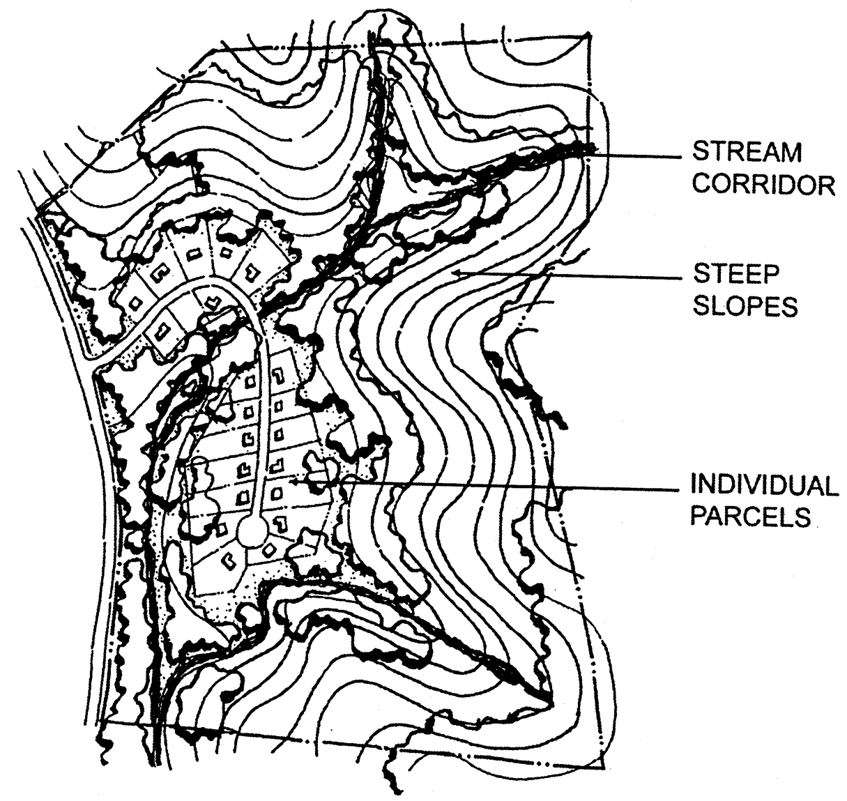
Figure 5.45-1
C.
Parcel configuration. The configuration of lots intended for residential development shall conform with the purposes of this ordinance and with any applicable goals and policies of the general plan. The location of such lots shall be based upon the consideration and balancing of such factors as topography and efficiency of access, preservation of viable and useable open space, need for secondary access, geologic hazards and constraints, suitability of development sites for sanitary waste water treatment and disposal, visual impacts, and conservation of natural resources and landscape features, among other factors which may be pertinent to the subject parcel.
D.
Open space preservation. Open space preservation as part of a cluster development plan subdivision shall conform with the specific provisions of the applicable general plan land use designation and zoning district. In general, the following provisions shall apply:
1.
Permanent dedication of open space. In order to ensure that open space preserved through the cluster development plan will be permanent, dedication of development rights to the County of Santa Clara shall be required through recorded open space easements. Dedication of such development rights may also be made to more than one public agency, such as the Santa Clara County Open Space Authority or Midpeninsula Regional Open Space District, in conjunction with the County, if such agency is a willing participant. Open space easements shall regulate the future use of the open space, and, where necessary and appropriate to preserve the natural resources of the area or to effectuate required environmental mitigations or conditions of approval, shall specify the land owner's and management and maintenance obligations.
2.
Urban clusters. In cluster developments within urban service areas, the amount of open space shall be adequate for the recreational needs and leisure use of the residents of the cluster development. Such open space shall be held in public ownership or in common private ownership by the owners of the lots or units within the cluster development. Landscaping shall be required as appropriate within any disturbed areas or within those areas adjacent to public streets. Additional internal landscaping requirements may be imposed as necessary and appropriate.
3.
Rural clusters. In rural cluster developments, permanently preserved open space shall be privately owned and maintained unless ownership is conveyed to a public agency willing and able to accept ownership and management responsibilities.
4.
Nonresidential clusters. On the lands of Stanford University, clustering of lands zoned OS/F for nonresidential development shall be allowed provided the creation of new parcels serves to facilitate uses provided for under the OS/F regulations in Chapter 2.50.
"Development area," for the purposes of this provision, shall include all land proposed for structures, roads, parking areas, associated landscaping and other types of development.
A cluster development plan is required for the division of land into lots of less than 160 acres. A cluster arrangement of structures shall achieve economy of land use and efficiency of access, while avoiding or minimizing impact to the natural environment to the extent feasible. Defined development areas shall include no more than ten percent of the total land area subject to the land division, with at least 90 percent of the remaining land area preserved in permanent open space by means of dedication of development rights which prevents future subdivision of such lands. Such open space area is not required to be contiguous to the development area but must be located within the Open Space/Field Research district. This dedicated open space shall be located in a medium-high or high visibility zone as determined through use of the OS/F viewshed analysis (§ 2.50.040(B)), or an area of environmental significance, as determined by the County.
Cluster development plans may be arranged in more than one cluster provided that the multiple cluster arrangement achieves economy of land use and efficiency of access intended by this ordinance and the applicable provisions of the Stanford Community Plan land use designation.
5.
Configuration of open space. To the maximum extent possible, balancing the various goals and objectives of the general plan and zoning ordinance for public health, safety, and welfare, the configuration of open space shall incorporate those noteworthy and most valuable natural features of the land, such as rock outcroppings, historic or archeological sites, significant stands of mature trees, and riparian areas. Furthermore, the open space shall be generally configured as large, contiguous areas capable of serving the various purposes of such open space, including, but not limited to, recreation and trails, agriculture, viewshed protection, and habitat preservation and wildlife corridors. The configuration of open space shall be reasonably based on the appropriate consideration of access requirements and standards, geologic hazards, and other forms of development constraints which may be present.
E.
Circulation and roads. Vehicular circulation shall conform with the County's applicable road development standards. In hillside areas with significant slopes, road and driveway locations and designs shall minimize the need for grading and earthwork to the maximum extent possible, in accordance with the provisions of the County Grading Ordinance (Division C12-400 et seq. of County Ordinance Code). Adequate non-vehicular circulation, including trails, paths, sidewalks, and equestrian paths shall also be provided as appropriate to the urban or rural setting, and in accordance with any adopted plans and design guidelines.
(Ord. No. NS-1200.338, § 1, 9-10-13; Ord. No. NS-1200.359, § 29, 12-6-16)
§ 5.45.055. - Findings.
The following findings are required for the approval of a cluster development plan in association with a subdivision application, in addition to applicable findings of the Subdivision Ordinance:
A.
The cluster development and subdivision conform with the goals, strategies, and policies of the general plan, particularly in regard to allowable density of development, open space and natural resource conservation, and avoidance or mitigation of potential adverse environmental impacts, including visual/aesthetic impacts in hillside areas.
B.
The cluster development plan and subdivision are consistent with the purposes and applicable provisions of the zoning ordinance, and such modifications to development standards as may be included in the proposed cluster development plan are deemed reasonable and appropriate to secure the purposes of this chapter.
C.
The cluster development plan and subdivision promote efficiency of access through the appropriate design and location of roads and driveways, including all necessary and appurtenant facilities, such as turnouts, turnarounds, parking areas, and other circulation components, such as trails, pathways, and walkways.
D.
The cluster development plan and subdivision minimize the overall amount and extent of grading and terrain alteration, consistent with applicable general plan policies, grading approval considerations, and findings, and achieves optimal efficiency in regard to the physical infrastructure improvements required for residential development, including retaining walls.
E.
The cluster development plan and subdivision achieve substantial conformance with any applicable development guidelines adopted by the County, are consistent with any adopted specific plans, and further the goals and objectives of any subject matter-specific plans, such as, but not limited to, the Habitat Conservation Plan.
§ 5.45.060. - Modification of cluster development plan following approval.
A cluster development plan and subdivision approval may be modified after approval and prior to the recordation of the applicable subdivision map according to the procedures set forth in Section 5.20.200, Modification of Plan Approval and applicable provisions of the Subdivision Ordinance.
Subsequent to the recordation the subdivision map, minor modifications to the approved building envelopes or other features delineated on the approved cluster development plan may be considered for the purpose of facilitating the development of a residence or residential accessory structures and uses, subject to an ASA Administrative Review for Minor Projects approval. The minor modification shall not affect or alter spatial features or information contained on the recorded subdivision map, or modify the terms of the prior subdivision approval, including conditions thereof. A minor modification may be approved by the Zoning Administrator if it is consistent with the subdivision approval, applicable general plan policies, the zoning ordinance, and County ordinance code requirements, provided that (a) it is deemed necessary and appropriate to achieving a demonstrably superior development outcome, and (b) that it better ensures compliance with the purposes of this chapter and any other applicable County development regulations and standards.
(Ord. No. NS-1200.338, § 1, 9-10-13; Ord. No. NS-1200.359, § 31, 12-6-16)
§ 5.50.010.- Purpose.
The purpose of design review is to encourage quality design and to mitigate potential adverse visual impacts of development. The procedure most commonly provides for review and conditioning to assure quality residential development in areas deemed visually sensitive.
§ 5.50.020. - Applicability.
The design review procedure shall be required:
A.
For development in any "-d" combining zoning district or "-h" combining zoning district;
B.
For development within 100 feet of designated scenic roads on lots to which the "-sr" combining district applies;
C.
As a condition of approval of certain land development applications where necessary and appropriate to address specific design or visual impact issues or to implement certain mitigation measures established by the environmental review process; or
D.
When mandated by the zoning ordinance for certain land uses.
§ 5.50.030. - Approval authority.
The Zoning Administrator shall be the approval authority for design review applications, except where otherwise expressly specified.
(Ord. No. NS-1200.320, § 5, 8-29-06)
§ 5.50.040. - Scope of review.
Design Review shall include consideration of, but shall not be limited to the following:
A.
Mitigation of any adverse visual impacts from proposed structures, grading, vegetation removal and landscaping;
B.
Compatibility with the natural environment;
C.
Conformance with the "Design Review Guidelines," adopted by the Board of Supervisors;
D.
Compatibility with the neighborhood and adjacent development;
E.
Compliance with applicable zoning district regulations; and
F.
Conformance with the general plan, any applicable specific plan, or any other applicable guidelines adopted by the Board of Supervisors or Planning Commission.
(Ord. No. NS-1200.336, § 3, 12-18-12)
§ 5.50.050. - Exemptions.
The following types of buildings and structures are deemed minor in character and are exempt from design review, except where any superseding "-d 1 " provisions (§ 3.20.040), -sr provisions (§ 3.30.030) or "-h 1 " provisions (§ 3.50.030) apply.
A.
Additions to existing buildings or structures where new floor area does not exceed 1,000 square feet;
B.
Detached accessory buildings, and structures 1,000 square feet or less in floor area;
C.
Accessory dwelling units;
D.
Decks whose floor surface is 30 inches or less above final grade, and grade-level pavement for which grading performed prior to paving does not require a grading permit;
E.
Any decks (regardless of height), carports, arbors, or other similar structures attached to a building that are 1,000 square feet or less in floor area;
F.
Fences three feet or less in height;
G.
Open fences, having a composition (solid components vs open "gap" components) where not more than 25 percent of the surface area is solid when viewed from a position perpendicular to the fence; and that meet the applicable fence height requirements of Section 4.20.050;
H.
Retaining walls that are not subject to a grading permit;
I.
Solar energy conversion systems accessory to a principal structure or use;
J.
Swimming pools;
K.
Small wind energy systems, private antennas, and similar structures;
L.
Up to 5,000-gallon capacity water tank(s);
M.
Urban Primary Units as allowed in § 4.10.387; and
N.
Single-family residences on parcels created from an urban lot split pursuant to Ordinance Code Section C12-44 that are 800 square feet or less.
The cumulative construction of multiple exempt projects on a lot may, at the discretion of the Zoning Administrator, be subject to design review, based upon the characteristics and visibility of the property, the potential visual impact of the buildings or structures, and any other relevant considerations as defined in § 5.50.040, Scope of Review.
(Ord. No. NS-1200.320, § 6, 8-29-06; Ord. No. NS-1200.323, § 14, 1-29-08; Ord. No. NS-1200.327, § 19, 2-9-10; Ord. No. NS-1200.329, § 3, 9-28-10; Ord. No. NS-1200.336, § 4, 12-18-12; Ord. No. NS-1200.367, § 18, 6-19-18; Ord. No. NS-1200.371, § 17, 3-10-20; Ord. No. NS-1200.383, § 13, 1-24-23)
§ 5.50.060. - Administrative approvals and discretionary exemptions.
The following types of buildings and structures may, at the discretion of the Zoning Administrator, be considered minor and eligible for design review administrative approval or a discretionary exemption from the design review process, except where any superseding "-d 1 " provisions (§ 3.20.040), "-sr" provisions (§ 3.30.030) or "-h 1 " provisions (§ 3.50.030) apply. An administrative design review approval shall be granted without a public hearing, based on applicable standards and guidelines for design review. Except for buildings or structures qualifying as Tier 1 and "Sites Not Visible" pursuant to subsection E below, the Zoning Administrator's decision to grant either administrative approval or discretionary exemption will be based upon the characteristics and visibility of the property, the potential visual impact of the buildings or structures, and any other relevant considerations as defined in § 5.50.040, Scope of Review.
A.
Additions to existing buildings and structures, including attached carports, arbors, and similar unenclosed structures, where new floor area is between 1,001 and 2,000 square feet;
B.
Detached buildings, and structures with floor area between 1,001 and 2,000 square feet;
C.
Accessory dwelling units;
D.
Decks that exceed 1,000 square feet in area;
E.
Fences in "-d" combining districts or along designated scenic roads listed in § 3.30.050 which conform to the provisions of this ordinance regulating fence height (excluding certain "open" fences, see subsection 5.50.050(F)), and fence enclosures for tennis courts or other outdoor sports courts that exceed applicable fence height requirements of § 4.20.050 in any zoning district that are setback from property lines, easements, and rights-of-way a distance equal to their height;
F.
Projects in "-d 1 " zoning districts meeting the criteria specified in Section 3.20.040 for "Tier 1" and "Sites Not Visible", regardless of any conflicting standards within this section;
G.
Other minor construction similar in scale to the above categories and having low potential for visual impact, including retaining walls, except where subsection 3.20.040 applies;
H.
Urban Primary Unit as allowed in § 4.10.387; and
I.
Single-family residences on parcels created from an urban lot split pursuant to Ordinance Code Section C12-44 that are 800 square feet or less.
(Ord. No. NS-1200.320, § 7, 8-29-06; Ord. No. NS-1200.323, § 15, 1-29-08; Ord. No. NS-1200.327, § 20, 2-9-10; Ord. No. NS-1200.336, § 4, 12-18-12; Ord. No. NS-1200.371, § 18, 3-10-20; Ord. No. NS-1200.383, § 14, 1-24-23)
§ 5.50.070. - Los Gatos Hillside Specific Plan Area.
For projects within the Los Gatos Hillside Specific Plan Area, when a landscape plan is required as a condition of approval, an irrigation and maintenance plan shall be included, and a separate maintenance agreement may be required by the County, per Section 4.4(5), Landscaping, of the adopted Los Gatos Hillside Specific Plan.
(Ord. No. NS-1200.317, § 14, 6-8-04)
§ 5.50.080. - Common procedures.
Refer to Chapter 5.20 for procedures common to all land use processes, including design review. Such procedures include, among others, application, modifications, environmental assessment, public hearing and notification, appeals, notice of approval or denial, limitation of time for establishing the use, life of a permit, and renewal of permits.
(Ord. No. NS-1200.317, § 15, 6-8-04)
Sec. 5.55.010.- Purpose.
Lot line adjustments are intended to provide practical flexibility for minor alteration of existing parcels and/or improved lot design. The lot line adjustment procedure authorizes property line(s) between four or fewer existing adjoining legal parcels to be altered so long as no additional parcels are created and all other state and local requirements are met.
(Ord. No. NS-1203.112, § 1, 6-24-03)
Sec. 5.55.020. - Approval authority.
Except as otherwise provided in this chapter, the planning director is the decision-making authority for lot line adjustments.
(Ord. No. NS-1203.112, § 1, 6-24-03; Ord. No. NS-1200.337, § 12, 12-18-12; Ord. No. NS-1200.349, § 15, 4-7-15)
Sec. 5.55.030. - Scope of review.
The approving authority must determine that a lot line adjustment application conforms to all of the following before approving an application:
A.
State law, including, but not limited to, the Subdivision Map Act, Government Code Section 66410 et seq. and the Williamson Act, Government Code Section 51200 et seq.;
B.
The County general plan;
C.
The criteria and findings in this chapter;
D.
All applicable zoning ordinance provisions; and
E.
All applicable building regulations, including, but not limited to those in Title B, Division B11 (Health and Sanitation), and Title C, Division C3 (Buildings).
If such a determination cannot be made, the lot line adjustment application must be denied.
(Ord. No. NS-1203.112, § 1, 6-24-03)
Sec. 5.55.040. - General plan and zoning requirements and criteria.
The requirements and criteria in this section apply to the determination of whether a proposed lot line adjustment complies with the minimum lot size and development density requirements of the general plan and zoning ordinance. This section does not contain a complete list of general plan and zoning ordinance requirements that may apply to lot line adjustments.
A.
All lots resulting from a lot line adjustment must comply with the general plan and zoning ordinance. The general plan will prevail if there is any need to harmonize general plan and zoning designations for the subject lots.
B.
A "substandard lot" is defined for purposes of this chapter as a lot that does not meet the minimum lot size requirements of the general plan and zoning designations applicable to the property.
C.
If any lot resulting from the proposed lot line adjustment would be substandard, the lot line adjustment may only be approved if the lot line adjustment would not cause or contribute to an increase in allowable density beyond that required by the general plan designation or that which existed when the lot line adjustment application was deemed complete. Lot line adjustments involving substandard lots that fall into one or more of the following categories are presumed not to cause or contribute to an increase in allowable density and may be approved if the approving authority makes all of the required findings under at least one of the following categories.
1.
Category 1 - No Increase in Number of Developable Parcels.
a.
No substandard parcel may be reduced in area by more than 20,000 square feet or ten percent of its original lot area, whichever is less.
b.
Each adjusted lot must retain at least 90 percent of the real property included in the parcel prior to the proposed lot line adjustment.
c.
The lot line adjustment would not result in any additional developable parcels or a greater allowable density than existed prior to the lot line adjustment. In determining if a parcel is developable, the parcel must meet at least one of the following criteria:
(i)
Contain a legal dwelling or other legal building or structure constructed pursuant to and in compliance with a validly issued Building Site Approval, Architecture and Site Approval (ASA) or Use Permit;
(ii)
Be subject to a valid, unexpired Building Site Approval, ASA, or Use Permit for the parcel, including a grading approval, if one is required. The owner must demonstrate ability to comply with all conditions of approval and County requirements and standards, including the issuance of the project clearance form from the County Office of Development Services; or
(iii)
Be a whole lot on a numbered tract map (recorded on or after February 3, 1931) or a whole lot on a parcel map issued pursuant to a legal subdivision, and also be an approved building site.
2.
Category 2 - Accommodation for Existing Legal Structures.
a.
The approving authority finds that the proposed lot line adjustment involves only two parcels and its sole purpose is to accommodate the following types of improvements that were legally constructed by or on behalf of a property owner on an adjoining parcel:
(i)
A dwelling, building, structure or sewage disposal system that was constructed before any permits were required by the County for such improvement; or
(ii)
A dwelling, building, structure or sewage disposal system for which all legally required County permits or agricultural exemption pursuant to section C3-8.3 of the Ordinance Code were issued prior to construction and the improvements were constructed in compliance with all approved plans and permits.
b.
The following types of improvements do not provide sufficient basis to qualify under this category:
(i)
Buildings or structures that are exempt from permit requirements under the County Building Code when the lot line adjustment application is filed; or
(ii)
A fence.
3.
Category 3 - Environmental Impact Avoidance. The sole purpose of the lot line adjustment is to reduce or avoid significant environmental impacts such as geologic hazards or disturbance of important viewshed, riparian or habitat areas. Where this criterion is the basis for approval, the Planning Commission must hold a public hearing on the application and make all of the following findings before approving the proposed lot line adjustment:
a.
The lot line adjustment would not result in any additional developable parcels or a greater allowable density than existed prior to the lot line adjustment. In determining if a parcel is developable, the parcel must meet at least one of the following criteria when the application is filed:
(i)
Contain a legal dwelling or other legal building or structure constructed pursuant to and in compliance with a validly issued building site approval, architecture and site approval (ASA) or use permit;
(ii)
Be subject to a valid, unexpired building site approval, ASA, or use permit for the parcel, including a grading approval, if one is required. The owner must demonstrate ability to comply with all conditions of approval and County requirements and standards, including the issuance of the project clearance form from the County Office of Development Services; or
(iii)
Be a whole lot on a numbered tract map (recorded on or after February 3, 1931) or a whole lot on a parcel map issued pursuant to a legal subdivision, and also be an approved building site.
b.
The lot line adjustment would result in parcels that would be environmentally superior and better implement the general plan policies as compared to the current lot configuration.
c.
The proposed lot design and configuration would optimize general plan conformance and environmental protection and best mitigate environmental impacts in conformance with the general plan.
(Ord. No. NS-1203.112, § 1, 6-24-03)
Sec. 5.55.050. - Additional requirements for all lot line adjustments.
Notwithstanding any other provision in this chapter, all lot line adjustments must comply with all of the following requirements:
A.
No lot line adjustment may be approved where it would cause any parcel that currently meets the minimum lot size specified in the general plan and zoning ordinance to become a substandard lot.
B.
No substandard lot may be decreased in size to enable the subdivision of otherwise unsubdividable parcels (i.e., a substandard lot may not be reduced in size to add land to another lot to facilitate subdivision of the lot being increased in size).
C.
Lots zoned "A" (exclusive agriculture) may not be reduced in size unless it can be demonstrated that the reconfiguration will not adversely affect continued and/or future use of agriculturally viable land either on or adjacent to the lots for which the adjustment is proposed.
D.
This provision is intended to prevent serial lot line adjustments of more than 4 lots, which would violate the intent of the Subdivision Map Act's four-lot limit on lot line adjustments:
1.
The total number of lots involved in a proposed lot line adjustment plus all lots that have been adjusted within the five years preceding the proposed lot line adjustment application that are under common ownership or control and that adjoin any of the lots involved in the proposed lot line adjustment may not exceed four.
2.
No lot that has previously been adjusted may be part of a subsequent lot line adjustment if it would result in more than four adjoining lots being adjusted within a five-year time period.
(Ord. No. NS-1203.112, § 1, 6-24-03)
Sec. 5.55.060. - Lot line adjustments involving land subject to land conservation contracts (Williamson Act).
A.
Any land subject to a land conservation contract pursuant to the Williamson Act, Government Code Section 51200 et seq. ("contracted land" for the purposes of this chapter) must comply with all applicable State and County requirements for such lands in addition to any other requirements for lot line adjustments.
B.
To ensure compliance with all State and County requirements related to the Williamson Act, a proposed lot line adjustment involving any contracted land must meet all of the following additional requirements:
1.
After the lot line adjustment, all parcels containing contracted lands will be large enough to sustain their agricultural use, as defined in Government Code Section 51222;
2.
The lot line adjustment would not compromise the long-term commercial agricultural productivity of any contracted land;
3.
The lot line adjustment is not likely to result in the removal of adjacent contracted land from commercial agricultural use by, for example, increasing the population density in the vicinity; and
4.
The lot line adjustment would not increase the developability of any contracted land or result in a greater number of developable parcels on contracted land than existed prior to the lot line adjustment.
C.
Proposed lot line adjustments between parcel(s) containing contracted land and parcel(s) containing land that is not contracted land will not be approved unless all resulting lots containing contracted land will be large enough to sustain commercial agricultural use as defined in Government Code Section 51222. To meet this requirement, the County and the property owner may mutually agree to rescind existing land conservation contract(s) and simultaneously enter into new land conservation contract(s) if all of the following requirements are met:
1.
The new contract(s) enforceably restrict the adjusted boundaries of the new parcel(s) for an initial term of at least as long as the unexpired term of the rescinded contract(s), but in no case for less than ten years;
2.
There is no net decrease in the total amount of acreage of contracted land;
3.
At least 90 percent of the land that formerly was contracted land would remain contracted land.
(Ord. No. NS-1203.112, § 1, 6-24-03)
Sec. 5.55.070. - Lot configuration.
A.
Lot design. To the extent practical, reconfigured lots should be as simple as possible in their description and configuration, should logically relate to the site characteristics, and should comply with the lot design provisions of the County Subdivision Ordinance [Section C12-21].
B.
Building setbacks. When property subject to a lot line adjustment contains existing structures, all resulting lots shall be designed such that all existing structures would comply with all current setbacks specified in the zoning ordinance for the district in which the property is located.
C.
Infrastructure and easement relocation. The applicant may be required to obtain permission from easement holders and relocate existing utilities, infrastructure and/or easements.
D.
Record of survey. No record of survey shall be required for a lot line adjustment unless required by California Business and Professions Code Section 8762.
E.
Cluster reconfiguration. For the reconfiguration of any lots created pursuant to a cluster permit, a new or modified cluster permit must be obtained in accordance with Chapter 5.45 before any action will be taken on the lot line adjustment application.
(Ord. No. NS-1203.112, § 1, 6-24-03)
Sec. 5.55.080. - Special procedures.
A.
Pre-application meeting. A pre-application meeting is required for each lot line adjustment. The applicant shall schedule a meeting with staff to discuss the proposal prior to submitting the lot line adjustment application. Refer to Chapter 5.20, Common Procedures.
B.
Environmental assessment. Lot line adjustments may require an environmental assessment depending on the circumstances of the specific project.
(Ord. No. NS-1203.112, § 1, 6-24-03)
Sec. 5.55.090. - Time limitations.
A.
A lot line adjustment approval shall be valid for a period of one year from the effective approval date. This time limitation supersedes the time limitation for establishment of a use or structure specified in Section 5.20.110. During this one-year period, the lot line adjustment certificate of compliance (or parcel map, if applicable) and the appropriate deeds revising the lot configurations must be recorded.
B.
Upon written application submitted prior to expiration of the time limitation, one extension of time to complete the activities specified in subsection (A) may be granted by the planning director. Any extension that is granted shall be for no more than one additional year, to commence upon expiration of the initial time period. Payment of the prescribed fee in an amount established by the Board of Supervisors for an extension of time must accompany the application.
(Ord. No. NS-1203.112, § 1, 6-24-03; Ord. No. NS-1200.337, § 13, 12-18-12; Ord. No. NS-1200.349, § 16, 4-7-15)
§ 5.55.100. - Lot merger.
Provisions for the merger of contiguous lots are contained in Section C12-229 of the Ordinance Code.
(Ord. No. NS-1200.318, § 21, 3-28-06)
Sec. 5.55.110. - Common procedures.
Refer to Chapter 5.20 for procedures common to all land use processes, including lot line adjustments. Such procedures include among others, application, modifications, environmental assessment, public hearing and notification, notice of approval or denial, limitation of time for establishing the use, life of a permit, revocation and modification of permits, and renewal of permits.
(Ord. No. NS-1203.112, § 1, 6-24-03; Ord. No. NS-1200.318, § 20, 3-28-06)
§ 5.60.010.- Purpose.
The special permit is required where specified in the Zoning Ordinance to establish and conduct certain uses presumed to be generally appropriate and compatible within a zoning district, but whose intensity, impacts, or other characteristics require discretionary review to ensure that projects meet all applicable standards and findings for the use at the designated location. Uses that require a special permit are considered generally lesser in intensity and impacts than those that require a use permit.
§ 5.60.020. - Approval authority.
The Zoning Administrator shall hear and decide special permit applications.
§ 5.60.030. - Findings.
A special permit may be granted if the Zoning Administrator makes all of the following findings:
A.
The proposed use conforms with the general plan, with the zoning ordinance, and with all standards applicable to the proposed use that have been adopted by the Planning Commission or Board of Supervisors;
B.
The site is adequate for the proposed use, including but not limited to being of adequate size and shape to accommodate all facilities and development features to integrate the use into the surrounding area and to provide any necessary or appropriate buffers between the use and the surrounding area;
C.
The proposed use will not be detrimental to the public health, safety, or general welfare. In this respect the Zoning Administrator shall further find, without limitation, that:
1.
Adequate off-street parking, loading and unloading areas (if applicable) and compliant access for individuals with disabilities will be provided;
2.
Appropriately designed site access will be provided, including safe and adequate access for fire and emergency vehicles (including secondary access where deemed necessary by the fire marshal);
3.
The use will not adversely affect water quality. Adequate wastewater treatment, disposal and sanitation facilities will be provided and will satisfy all applicable local, state and federal requirements;
4.
The use will not be detrimental to the adjacent area because of excessive noise, odor, dust or bright lights;
5.
The use will not substantially worsen traffic congestion affecting the surrounding area;
6.
Erosion will be adequately controlled; and
7.
Adequate storm drainage management exists or will be provided and will comply with all applicable local, state and federal requirements.
If all of the above findings cannot be made, the application shall be denied.
§ 5.60.040. - Common procedures.
Refer to Chapter 5.20 for procedures common to all land use processes, including special permits. Such procedures include, among others, application, modifications, environmental assessment, public hearing and notification, appeals, notice of approval or denial, limitation of time for establishing the use, life of a permit, revocation and modification of permits, and renewal of permits.
§ 5.65.010.- Purpose.
A use permit is required where specified in the Zoning Ordinance to establish and conduct certain uses deemed to be generally appropriate and potentially compatible with a zoning district, but for which the intensity, impacts, or other characteristics typically have a significant bearing on whether a use should be approved at a specific location and under what conditions it may be established and conducted. Such uses typically are of greater intensity and have more potential for off-site and adverse environmental impacts than those uses subject to other land use permits.
The use permit procedure, standard findings, and public hearing requirements set forth in this chapter are necessary to ensure that the proposed use is compatible with its surroundings, satisfies all standards and conditional requirements appropriate for the use, and is consistent with the intent of the zoning district, the general purposes of the Zoning Ordinance, and any other applicable plans and policies, including the General Plan.
§ 5.65.020. - Approval authority.
The Planning Commission shall hear and decide all use permit applications except where the proposed land use is concurrently subject to more than one discretionary land use approval and the procedures in Section 5.10.070 are invoked.
§ 5.65.030. - Findings.
The Planning Commission may grant a use permit if it is able to make all of the following findings:
A.
The proposed use conforms with the general plan, with the zoning ordinance, and with all other standards and guidelines applicable to the proposed use that have been adopted by the Planning Commission or Board of Supervisors;
B.
The site is adequate for the proposed use, including but not limited to being of adequate size and shape to accommodate all facilities and development features to integrate the use into the surrounding area and to provide any necessary or appropriate buffers between the use and the surrounding area;
C.
The proposed use, by its nature, scale, intensity or design, will not impair the integrity and character of the zoning district or neighborhood, and will not be significantly detrimental to any important and distinctive features of the site's natural setting;
D.
The proposed use will not be detrimental to the public health, safety or general welfare. In this respect the Planning Commission shall further find, without limitation, that:
1.
Adequate off-street parking, loading and unloading areas (if applicable), and compliant access for individuals with disabilities will be provided;
2.
Appropriately designed site access will be provided, including safe and adequate access for fire and emergency vehicles (including secondary access where deemed necessary by the fire marshal);
3.
The use will not adversely affect water quality. Adequate wastewater treatment, disposal and sanitation facilities will be provided and will satisfy all applicable local, state and federal requirements;
4.
The use will not be detrimental to the adjacent area because of excessive noise, odor, dust or bright lights;
5.
The use will not substantially worsen traffic congestion affecting the surrounding area;
6.
Erosion will be adequately controlled; and
7.
Adequate storm drainage management exists or will be provided and will comply with all applicable local, state and federal requirements.
§ 5.65.040. - Renewal of permit for established use.
An established use permit which has been conditioned to expire on a specific date may be renewed upon submittal of a written application filed prior to expiration or revocation of the permit, accompanied by the required application fee. Renewal of the permit requires action by the Planning Commission at a public hearing.
In reviewing a renewal application, the Planning Commission shall consider whether all conditions and mitigation measures imposed on the use are being met, whether the use is in conformance with all applicable County land use and permit requirements, and whether there are any substantial changes in circumstances, intensification of use by the permittee, or a greater degree of control by the County is needed. Such circumstances may warrant modification of the permit as part of the renewal process.
Based on information presented, the approval authority may:
A.
Establish a new time limitation through the approval of the use permit renewal application;
B.
Impose additional or modified conditions of approval to address changes in project circumstances;
C.
Waive any time limitation;
D.
Extend the permit to a date certain and direct the permittee to file for a new permit should he or she wish to continue the use beyond that date;
E.
Suspend action on the renewal application and order the use to cease until the permittee has complied with all conditions.
F.
Deny the renewal application, which terminates the permit.
§ 5.65.050. - Cessation of use/termination of permit.
If a use established pursuant to a valid use permit with no condition imposing a time limit or expiration date ceases for a period of 12 consecutive months, the use permit shall be deemed automatically revoked.
§ 5.65.060. - Pre-application meeting.
A formal pre-application meeting between the applicant and staff shall be held prior to submittal of an application for either a new use permit or major modification of an approved use permit. It is not required for a renewal or minor modification of a use permit. Refer to § 5.20.020.
(Ord. No. NS-1200.318, § 23, 3-28-06)
§ 5.65.070. - Common procedures.
Refer to Chapter 5.20 for procedures common to all land use processes, including use permits. Such procedures include, among others, application, modifications, environmental assessment, public hearing and notification, appeals, notice of approval or denial, limitation of time for establishing the use, life of a permit, revocation and modification of permits, and renewal of permits.
(Ord. No. NS-1200.318, § 22, 3-28-06)
§ 5.70.010.- Purpose.
The purpose of the variance procedure is to enable discretionary relief from the development standards of the Zoning Ordinance where it can be clearly determined that, due to unique circumstances, enforcement of the applicable standards would preclude reasonable use and development of the subject lot. "Unique circumstances" that warrant variance approval must be both substantial and detrimental, and must relate to tangible characteristics of the lot, per the findings of Section 5.70.020 below. As such, an approved variance should logically and reasonably remedy a specific hardship that may result from a lot's unique circumstances.
The applicability of the variance procedure is limited to development standards exclusively. A variance may not authorize a use or activity that is not otherwise provided for by the applicable zoning regulations.
§ 5.70.020. - Findings.
A variance may not be granted unless both of the following findings can be made:
A.
Because of special circumstances applicable to the subject property, including size, shape, topography, location or surroundings, the strict application of the Zoning Ordinance deprives such property of privileges enjoyed by other properties in the vicinity and under identical zoning classification; and
B.
The grant of the variance does not constitute a grant of special privileges inconsistent with the limitations upon other properties in the vicinity and the zoning district in which the subject property is located.
These findings are consistent with the variance provisions of California Government Code § 65906.
§ 5.70.030. - Approval authority.
The Zoning Administrator shall hear and decide variance applications. Variances shall be decided at a public hearing, except as specified in Section 5.70.040 below.
§ 5.70.040. - Parking variance.
For new single-family residential or two-family residential uses, or accessory dwelling units, the standard variance procedure and findings may be employed to allow a reduction in the number of required spaces, and/or the requirement for covered parking. Other uses necessitating a reduction in the number of required spaces shall be subject to § 4.30.100, Parking Exception.
(Ord. No. NS-1200.323, § 17, 1-29-08; Ord. No. NS-1200.371, § 19, 3-10-20)
Editor's note— Former § 5.70.050.
§ 5.70.050. - Scope of variance approval.
Variances shall be limited to that specific portion of the building that is being exempted from compliance with the applicable standard (e.g. setback) in accordance with the required findings. The granting of a variance does not alter the standard or its applicability to other development on the subject lot.
(Ord. No. NS-1200.323, § 18, 1-29-08)
Editor's note— Former § 5.70.060.
§ 5.70.060. - Statement of findings.
In addition to notice of approval or denial as discussed in Section 5.20.130, the Zoning Administrator must also prepare a formal statement that substantiates the basis for variance approval. This statement must analytically demonstrate the link between the specific circumstances of the property and the required findings.
(Ord. No. NS-1200.323, § 19, 1-29-08)
Editor's note— Former § 5.70.070.
§ 5.70.065. - Pre-application meeting.
A formal pre-application meeting between the applicant and staff shall be required prior to submittal of an application for a variance.
§ 5.70.070. - Common procedures.
Refer to Chapter 5.20 for procedures common to all land use processes, including variances. Such procedures include among others; application, modifications, environmental assessment, public hearing and notification, appeals, and notice of approval or denial.
(Ord. No. NS-1200.323, § 20, 1-29-08)
Editor's note— Former § 5.70.080.
§ 5.75.010.- Purpose.
This chapter is intended to provide a procedure for changing either the text of the Zoning Ordinance or the zoning designation applicable to particular property by amending the official zoning map displaying the land area to which the text applies.
§ 5.75.020. - Approval authority.
The Board of Supervisors shall be the approval authority for zoning amendments. The Planning Commission shall make a formal written recommendation regarding a zoning amendment proposal prior to the Board hearing in compliance with California Government Code § 65855.
§ 5.75.030. - Initiation of amendment.
A zoning amendment application may be initiated by the County or by a private party.
§ 5.75.040. - Findings.
The proposed zoning amendment must be consistent with state law, the general purposes of the Zoning Ordinance and the General Plan, and the land use designations in the General Plan.
§ 5.75.050. - Waiver for pending applications.
To the extent allowed by law, the Planning Director, or his or her designee, shall have discretionary authority to exempt (entirely or in part) pending applications from newly enacted provisions of the Zoning Ordinance. For the purposes of this section, "pending" applications shall be limited to land use applications that have been deemed complete and building permit applications that substantially meet submittal requirements but have not yet been finally approved when the newly enacted provisions take effect, and approved uses that are currently subject to specified time limitations for development.
§ 5.75.060. - Common procedures.
Refer to Chapter 5.20 for procedures common to all land use processes, including amending the Zoning Ordinance. Such procedures include, among others, application, modifications, environmental assessment, public hearing and notification, appeals, and notice of approval or denial.
§ 5.80.010.- Purpose.
This chapter defines the situations considered to be violations of the Zoning Ordinance and describes the County's processes for identifying and addressing such violations.
§ 5.80.020. - Conformance with law.
Any land use permit, license or final subdivision approval issued in conflict with the provisions of any County ordinance or state law or as a result of the fraud or willful misrepresentation by the applicant or applicant's agent shall be invalid.
§ 5.80.030. - Public nuisance.
It shall be considered unlawful and a public nuisance for any of the following to occur contrary to the provisions of the Zoning Ordinance:
A.
Construction, modification, moving, or maintenance of a building or structure; or
B.
Conducting, operating, allowing or maintaining any land use, building or premises.
The County may, upon discovery of a public nuisance, seek to abate the nuisance pursuant to Chapter III of Division A1 of Title A of the Ordinance Code or any other method allowed by law or equity.
(Ord. No. NS-1100.93, § 1, 6-7-05)
§ 5.80.040. - Enforcement.
Pursuant to Section 836.5 of the California Penal Code, the County zoning enforcement officers are authorized to enforce the provisions of this ordinance and to issue citations for violation thereof. There shall be no civil liability on the part of, and no cause of action shall arise against, any zoning enforcement officer acting pursuant to this section and within the scope of his or her authority.
§ 5.80.050. - Inspection and right of entry.
Zoning enforcement officers are authorized to make such inspections as may be necessary to enforce County ordinances.
Whenever a zoning enforcement officer has reasonable cause to believe a violation of any County ordinance exists in or on a premises, the investigator shall ask permission of the occupant, or the owner or custodian thereof if the premises are unoccupied, for permission to inspect the premises. If permission is denied, the zoning enforcement officer shall obtain an inspection warrant. Entry shall not be secured by a grant of authority beyond that otherwise allowed by law.
§ 5.80.060. - Liability of Zoning Enforcement Officers.
Zoning enforcement officers, acting in good faith and without malice in the discharge of their duties, shall not be personally liable for any damage resulting from any act or omission in the discharge of their duties. Any legal action taken against a zoning enforcement officer because of any act or omission occurring during the course and scope of their enforcement activities shall be defended by legal counsel provided by the County until final termination of such proceedings.
§ 5.80.070. - Notice of zoning violation.
Whenever a zoning enforcement officer has knowledge of a violation of this Zoning Ordinance, he or she may provide a notice of intent to record a notice of zoning violation to the owner of the property upon which the violation is located. Notice shall be provided to the property owner and, if applicable, the permittee by mail at the address shown on the latest assessment roll or at any other address of the owner known to the zoning enforcement officer. The notice shall state that within 30 days of the date of the notice, the property owner or permittee may request a meeting with the zoning enforcement officer to present evidence that a violation does not exist.
If, within 30 days of the date of the notice, the property owner or permittee does not request a meeting and the violation has not been corrected, or if, after considering the evidence presented by the property owner or permittee at the meeting, the zoning enforcement officer determines that a zoning violation in fact exists, the zoning enforcement officer may record a notice of zoning violation affecting the property in the County Recorder's office.
§ 5.80.080. - Notice of expungement.
At the request of any affected property owner, and upon full payment of any fee for the recordation of the notice of zoning violation, the zoning enforcement officers shall issue a notice of expungement of zoning violation upon proof to the zoning enforcement officers that the noticed violation has been remedied. The notice of expungement may be recorded by the property owner at his or her expense.
§ 5.80.090. - Process to legalize use, land use violation fee.
A zoning violation may be remedied by removal of the unpermitted use or by obtaining the appropriate permit(s) to validate the use or structure that is in violation of the Zoning Ordinance and completing all work specified in the permit(s) in compliance with all conditions and requirements associated with the permit(s). Upon application for the permit to remedy the zoning violation, in addition to the usual application fee, there shall be due and payable a land use violation fee, as established by resolution of the Board of Supervisors, to recover associated enforcement costs, including, but not limited to costs of inspection and preparation and recordation of the notice of zoning violation. A notice of expungement of zoning violation shall not be recorded without the full payment of the land use violation fee.
§ 5.80.100. - Criminal penalties and civil remedies.
A.
Criminal penalties (infraction). Any person, entity, organization, firm or corporation (whether as principal, agent, employee or otherwise) who has violated or is violating any provision of the Zoning Ordinance shall be guilty of an infraction, unless the Office of the District Attorney determines that the violation is more properly charged as a misdemeanor based on the severity of the violation or the violator's previous violation of this Zoning Ordinance or any other law or ordinance related to the use, development or condition of any real property. Except as otherwise provided, a violator shall be guilty of a separate offense for each and every day or portion of a day during which any violation is committed, continued or permitted by such person, and shall be punishable accordingly. Infractions are punishable as provided by Government Code section 25132. Misdemeanors are punishable by imprisonment in the County jail not exceeding one year or by a fine not exceeding $1,000.00 per offense, or by both.
B.
Civil remedies. In addition to or in lieu of the criminal penalties assessed pursuant to subsection A, the Office of the County Counsel or Office of the District Attorney may file a civil action against any person, entity, organization, firm or corporation (whether as principal, agent, employee or otherwise) who has violated or is violating any provision of the Zoning Ordinance.
1.
In addition to any injunctive or equitable relief that the court in its discretion deems warranted, the civil penalties assessed shall include all of the following:
a.
The penalties provided in California Government Code section 25132 to the extent those penalties have not been imposed pursuant to a criminal proceeding;
b.
The full amount needed to repair any damages caused by the violations;
c.
The full amount needed to make restitution to any agencies, persons or entities for damages sustained or costs incurred, including, but not limited to attorneys' fees, as a result of the violations; and
d.
The full amount needed to reimburse the County for any enforcement costs related to the violations.
2.
To the extent required by Government Code section 25845, in a nuisance abatement action the prevailing party may recover attorneys' fees; however, an award of attorneys' fees against the County shall not exceed the amount of attorneys' fees incurred by the County in the action.
(Ord. No. NS-1100.93, § 2, 6-7-05; Ord. No. NS-1100.100, § 1, 6-19-07)
§ 5.80.110. - Reserved.
Editor's note— Ord. No. NS-1100.93, § 3, adopted June 7, 2005, repealed App. I, § 5.80.110, which pertained to criminal penalties/misdemeanors. See also the Code Comparative Table.