
Santa Fe City Zoning Code
ARTICLE 14
5 - OVERLAY ZONING DISTRICTS
14-5.1 - GENERAL PURPOSE; RELATIONSHIP TO GENERAL USE ZONING DISTRICTS
(Ord. No. 2011-37 § 5)
(A)
The overlay zoning districts of this article are intended to apply in combination with the underlying zoning districts of Article 14-4 to impose regulations and standards in addition to those required by the underlying districts. When the requirements of an overlay district are in conflict with those of the underlying district or those of another overlay district, the more restrictive limitation or requirement controls as provided for in Section 14-1.7. The following overlay districts are created:
(1)
historic (H) districts;
(2)
archaeological review districts;
(3)
arts and crafts district;
(4)
highway corridor protection (HCP) districts;
(5)
escarpment overlay districts;
(6)
PUD planned unit development district;
(7)
residential suite hotel/motel (RS) district;
(8)
ecological resource protection (ERP) district; and
(9)
neighborhood conservation overlay (NCO) districts.
(B)
Any rezoning requirements set forth in this article are in addition to the requirements set forth in Section 14-3.5, which apply to all rezonings.
14-5.2 - HISTORIC DISTRICTS
(A)
General Provisions
(1)
General Purpose
In order to promote the economic, cultural, and general welfare of the people of the city and to ensure the harmonious, orderly and efficient growth and development of the city, it is deemed essential by the governing body that the qualities relating to the history of Santa Fe, and a harmonious outward appearance, which preserve property values and attract tourists and residents alike, be preserved, some of these qualities being:
(a)
The continued existence and preservation of historical areas and buildings;
(b)
The continued construction of buildings in the historic styles; and
(c)
A general harmony as to style, form, color, height, proportion, texture and material between buildings of historic design and those of more modern design.
(2)
Application to State of New Mexico and any of Its agencies, political subdivisions or instrumentalities. (Ord. No. 2009-46 § 1; Ord. No. 2010-24 § 1)
Pursuant to Sections 3-22-1 through 3-22-6 NMSA 1978, it is the intent of the City of Santa Fe that the provisions of this section shall apply to the State of New Mexico and any of its agencies, political subdivisions or instrumentalities, as well as to any other entity or activity in the historic districts or to landmarks located outside historic districts. The provisions of Section 3-22-6 NMSA 1978 shall apply to state capital outlay projects in historic districts or to landmarks located outside the historic districts as provided in Subsection 14-5.2(M) concerning the design, construction, alteration, including additions to or demolition of the exterior features of statebuildings. The provisions of Subsection 14-5.2(N) shall apply to county and Santa Fe public schools capital outlay projects concerning the design, construction, alteration, including additions to or demolition of the exterior features of county and Santa Fe public schools buildings in historic districts or to landmarks located outside the historic districts.
(3)
Boundaries
The boundaries for the historic district are as shown on the map attached hereto and incorporated herein to the historic district ordinance, and as shown on the official map, located in the city planning and land use department. (Ord. No. 2007-45 § 30; Ord. #2020-22, § 16)
Editor's Note: Historic district map adopted by Ordinance No. 1982-62, as amended, is shown on the official zoning map.
(4)
Design of Buildings
Full responsibility for the design and development of structures is left to the applicant; however, the file of previously approved applications shall be made available to the applicant.
(5)
Zoning District Regulations
The property in an historic district shall be subject to the requirements, uses, and other regulations of the zoning district of which the property is a part, except for height as regulated in Subsection 14-5.2(D).
(6)
Nonconforming Structures
Any building in the historic district not meeting the standards for architectural style set forth in this section, unless given special approval by the board for architectural or historic interest or unless individually entered in the state register of cultural properties or in the national register of historic places or designated as significant on either register, shall be considered nonconforming. Except for repairs and maintenance required by law, no nonconforming building may be added to or altered in any way unless the proposed addition or alteration will bring the whole to a degree of conformity acceptable to the board. Structures other than buildings, including signs, not conforming to the architectural style or sign standards set forth in this section shall be considered nonconforming. No alteration or repair may be made of any such structure other than its removal. No nonconforming structure in the historic district, which has been damaged by fire, explosion, act of God or the public enemy to the extent of more than fifty percent of its value, exclusive of basement or cellar, shall be restored except in conformity with the requirements of this section.
(7)
Electric Facilities. (Ord. No. 2008-54 § 4)
The review of electric facilities in the historic districts shall be limited as set forth in Section 14-6.2(F)(10).
(B)
Minimum Maintenance Requirements
(Ord. No. 2009-13 § 4)
All buildings and structures in the historic district over which the board has jurisdiction to determine whether a demolition permit should be approved or denied and all landmarkstructures over which the governing body has such jurisdiction shall be preserved against decay and deterioration and free from certain structural defects in the following manner, by the owner thereof or such other person or persons who may have the legal custody and control thereof. The owner or other person having legal custody and control thereof shall repair such building or structure if it is found to have any of the following defects:
(1)
Those which have parts thereof which are so attached that they may fall and injure members of the public or property;
(2)
Deteriorated or inadequate foundation;
(3)
Defective or deteriorated flooring or floor supports or flooring for floor supports of insufficient size to carry imposed loads with safety;
(4)
Members of walls, partitions or other vertical supports that split, lean, list or buckle due to defective material or deterioration;
(5)
Members of walls, partitions or other vertical supports that are of insufficient size to carry imposed loads with safety;
(6)
Members of ceilings, roofs, ceiling and roof supports or other horizontal members which sag, split or buckle due to defective material or deterioration;
(7)
Members of ceilings, roofs, ceiling and roof supports or other horizontal members that are of insufficient size to carry imposed loads with safety;
(8)
Fireplaces or chimneys which list, bulge or settle due to defective material or deterioration;
(9)
Fireplaces or chimneys which are of insufficient size or strength to carry imposed loads with safety;
(10)
Deteriorated, crumbling or loose plaster;
(11)
Deteriorated or ineffective waterproofing of exterior walls, roofs, foundations or floors, including broken windows or doors;
(12)
Defective or lack of weather protection for exterior wall covering, including lack of paint, or weathering due to lack of paint or other protective covering; or
(13)
Any fault or default in the building or structure that renders the same structurally unsafe or not properly watertight.
(C)
Regulation of Significant and Contributing Structures in the Historic Districts
(Ord. No. 2004-26)
(1)
Purpose and Intent
It is intended that:
(a)
Each structure to be recognized as a physical record of its time, place, and use. Changes that create a false sense of historical development, such as the addition of conjectural features or architectural elements from other buildings, shall not be undertaken;
(b)
Changes to structures that have acquired historic significance in their own right shall be retained and preserved, recognizing that most structures change over time;
(c)
Distinctive features, finishes, and construction techniques or examples of craftsmanship that characterize a structure be preserved; and
(d)
New additions and related or adjacent new construction be undertaken in such a manner that if removed in the future, the original form and integrity of the historic property and its environment would be unimpaired.
(2)
Designation of Significant, Contributing, or Noncontributing Status within Historic Districts
(a)
Status Designation
Structures within historic districts may be designated a status of "significant," "contributing," or "noncontributing" based upon the definitions of these terms in Article 14-12. Staff shall maintain a record as to the current status of structures located in the Historic Districts.
(b)
Board Authority to Review Status Designation
(i)
The Board is authorized to change the status of a structure or to designate a status for a structure with no status designated.
(ii)
A change in status or the designation of a status shall be based upon an evaluation of data provided through survey or other relevant sources of information and the definitions of "significant," "contributing," or "noncontributing."
(c)
Initiation of Review of Status Designation
The Board may review the status designation in response to the following:
(i)
An application for construction or demolition as set forth in Section 14-5.2 as follows:
A.
Prior to the application being placed on a board agenda or prior to issuance of a buildingpermit, if Board approval is not required, staff shall determine whether or not the board should review the status of the structure. Staff's determination shall be made within thirty days of submittal of the application. If staff's determination is not completed within the thirty days, the application shall be forwarded to the board. Review by the board as to the structure's status shall be made at the earliest practicable date. The board or staff (as applicable) may consider the application immediately following the determination of status. The application shall be reviewed based upon the status of the structure following the determination of status.
B.
Prior to action by the board on the application, the board itself may decide to review the status of the structure. The board's determination as to the status shall be made within forty-five days of the decision of the board to review the status. The board or staff (as applicable) may consider the application immediately following the determination of the status. The application shall be reviewed based upon the status of the structure following the determination of status.
(ii)
A request from the propertyowner; or
(iii)
A request initiated by the city. Staff shall notify the propertyowner prior to initiating the request.
(d)
Notice of Board's Review of Status
(i)
Staff shall mail notice, certified mail return receipt requested, to the propertyowner of the subject property no less than fifteen days prior to the board's review of a change in or designation of status.
(ii)
In addition, staff shall mail notice, certified mail return receipt requested, to all propertyowners within one hundred (100) feet of the subject property no less than fifteen days prior to the board's review of a change in or designation of status if the review may result in the lowering of the structure's status.
(iii)
With the consent of the propertyowner, the city shall have posted on the property a poster obtained from the planning land use department. Otherwise, the city shall post the poster on the nearest place available to the city. Such poster shall be securely posted, prominently displayed, visible from a public street, at least fourteen days prior to the scheduled board hearing. The posting shall indicate the nature of the application, identification of the property affected and the time, date and place of the hearing. The poster shall be removed within thirty days of final action. Failure to do so may result in the city removing the sign at the applicant's expense. A civil fee of fifty dollars ($50.00) will be charged. (Ord. No. 2005-31 § 4; Ord. No. 2007-45 § 30; Ord. No. 2020-22§ 16)
(e)
Appeals (Ord. No. 2009-42 § 16)
Decisions made by the historic districts review board may be appealed to the governing body as set forth in Section 14-3.17.
(f)
Restoration of Status
If a propertyowner makes changes to a structure without the proper city approvals which result in the lowering of the structure's status, staff or the board may require the propertyowner to restore the structure such that its former status is restored.
(g)
Report to the governing body
Staff shall report annually, beginning in August 2005, all decisions made by the board regarding a structure's status.
(3)
Review by Historic Board Required
(a)
Except where this chapter provides for review by staff, the historic districts review board shall review all applications for new construction, alteration, or demolition in the historic districts, and of landmarkstructures throughout the city, based on the standards set forth in this Section 14-5.2. (Ord. No. 2002-37 § 23)
(b)
The historic board may approve an application for alteration or for new construction on the condition that changes relating to exterior appearance recommended by it be made in the proposed work. In such case, no permit shall be issued until new exhibits, satisfactory to the board have been submitted.
(c)
No permits shall be issued until the time for appeal to the governing body has expired. (Ord. No. 2009-42 § 17)
(4)
Compliance with General and Specific Design Standards Required
All development located within the historic districts and subject to this Section 14-5.2 shall comply with all applicable general development standards set forth in Subsection 14-5.2(D), as well as any applicable specific development standards set forth in Subsections 14-5.2(E) through (I).
(5)
Exceptions
Staff shall determine if an exception to this section is required. The historic board may grant or deny an exception to the regulations set forth in this section provided that such exception does not exceed the underlying zoning.
(a)
Height
If the applicant requests approval of a height in the historic district that exceeds the underlying zoning district requirement, the applicant shall first receive an exception to this Section 14-5.2. If approved by the historic board, the applicant shall proceed to the board of adjustment or other applicable city body for consideration of the proposed variance.
(b)
Design Standards and Signage
The board is the city administrative board reviewing and granting or denying requests for exceptions from standards set forth in Subsections14-5.2(D)(1—8, 10, 11) and 14-5.2(E) through (I) for construction or alterations within the historic districts, and in 14-8.10(H), for signs in historic districts. When requesting exceptions, the applicant shall use the procedures for public notice and hearing set forth in Section 14-3.1(H), Notice Requirements, unless the applicant also requests a variance to the underlying zoning. In such a case the applicant for the H ordinance exception shall not be required to publish a legal ad in the local newspaper. Exceptions are project specific and do not apply to the subject property in perpetuity. In order to approve an exception, the board shall make findings of fact that the applicant conclusively demonstrated that requested exceptions comply with all the criteria listed as follows: (Ord. No. 2023-27 § 1)
(i)
Do not damage the character of the district;
(ii)
Are required to prevent a hardship to the applicant or an injury to the public welfare; and
(iii)
Strengthen the unique heterogeneous character of the City by providing a full range of design options to ensure that residents can continue to reside within the historic districts.
(c)
Height, Pitch, Scale, Massing, and Floor Stepbacks
The board is the city administrative board reviewing and granting or denying requests for exceptions from regulations set forth in Subsection 14-5.2(D)(9). When requesting exceptions the applicant shall use the procedures for public notice and hearing set forth in Section 14-3.6(B)(3), unless the applicant also requests a variance to the underlying zoning. In such a case the applicant for the H ordinance exception shall not be required to publish a legal ad in the local newspaper. Exceptions are project specific and do not apply to the subject property in perpetuity. The board may grant exceptions and impose conditions thereon to Subsection 14-5.2(D)(9) for height of structures within the historic districts as specified in Subsection 14-5.2(D)(9)(a). In order to approve an exception, the board shall make findings of fact that the applicant conclusively demonstrated that requested exceptions comply with all the criteria listed as follows: (Ord. No. 2023-27 § 1)
(i)
Do not damage the character of the streetscape;
(ii)
Prevent a hardship to the applicant or an injury to the public welfare;
(iii)
Strengthen the unique heterogeneous character of the city by providing a full range of design options to ensure that residents can continue to reside within the historic districts;
(iv)
Are due to special conditions and circumstances which are peculiar to the land or structure involved and which are not applicable to other lands or structures in the related streetscape;
(v)
Are due to special conditions and circumstances which are not a result of the actions of the applicant; and
(vi)
Provide the least negative impact with respect to the purpose of this section as set forth in Subsection 14-5.2(A)(1).
(D)
General Design Standards for All H Districts
In any review of proposed additions or alterations to structures that have been declared significant or contributing in any historic district or a landmark in any part of the city, the following standards shall be met:
(1)
General
(a)
The status of a significant, contributing, or landmark structure shall be retained and preserved. If a proposed alteration will cause a structure to lose its significant, contributing, or landmark status, the application shall be denied. The removal of historic materials or alteration of architectural features and spaces that embody the status shall be prohibited.
(b)
If a proposed alteration or new construction will cause an adjacent structure to lose its significant, contributing, or landmark status, the application may be denied.
(2)
Additions
(a)
Additions shall have similar materials, architectural treatments and styles, features, and details as the existing structure, but shall not duplicate those of the existing structure in a manner that will make the addition indistinguishable from the existing structure.
(b)
Additions to buildings that meet the standards of Subsection 14-5.2(E) shall continue to meet those standards set forth in Subsection 14-5.2(E) in addition to the standards set forth in this section.
(c)
Additions are not permitted to primary façades.
(d)
Additions are not permitted to the side of the existing footprint unless the addition is set back a minimum of ten (10) feet from the primary facade. The addition shall not exceed fifty percent of the square footage of the existing footprint, and shall not exceed fifty percent of the existing dimension of the primary facade. To the extent architecturally practicable, new additions shall be attached to any existing noncontributing portion of structures instead of attaching them to the significant or contributing portion.
(e)
The height of additions:
(i)
For significant and landmarkstructures shall be a minimum of six (6) inches less than the parapet or equivalent roof-feature of the existing adjacent connecting facade.
(ii)
For contributing structures shall be no more than one additional story higher than the existing structure. To the extent architecturally practicable, two story additions shall be set to the rear or the side rear of the structure. When an additional story is to be placed upon an existing contributing structure, that footprint may be no greater than fifty percent of the footprint of the existing structure, subject to the provisions of Subsection A(1) above. For the purposes of this paragraph, an additional story shall not exceed twelve (12) feet from the existing rooftop to the highest point of that story.
(3)
Remodeling to Increase Height; Rooftop Appurtenances
(a)
For remodeling of existing significant and landmarkstructures, no increase in height of the structures is permitted. (For standards relating to additions to existing structures, see paragraph (2) above.)
(b)
For significant and landmarkstructures, publicly visible roof top appurtenances, including but not limited to solar collectors, clerestories, decks, or mechanical equipment, shall not be added nor shall the parapet be raised to conceal the rooftop appurtenances. For contributing buildings solar collectors, clerestories, decks, or mechanical equipment if publicly visible shall not be added.
(4)
Porches and Portals
Existing porches or portals shall not be enclosed.
(5)
Windows, Doors, and Other Architectural Features
(a)
For all facades of significant and landmarkstructures and for the primary facades of contributing structures:
(i)
Historic windows shall be repaired or restored wherever possible. Historic windows that cannot be repaired or restored shall be duplicated in the size, style, and material of the original. Thermal double pane glass may be used. No opening shall be widened or narrowed.
(ii)
No new opening shall be made where one presently does not exist unless historic documentation supports its prior existence.
(iii)
No existing opening shall be closed.
(b)
For all façades of significant, contributing and landmarkstructures, architectural features, finishes, and details other than doors and windows, shall be repaired rather than replaced. In the event replacement is necessary, the use of new material may be approved. The new material shall match the material being replaced in composition, design, color, texture, and other visual qualities. Replacement or duplication of missing features shall be substantiated by documentation, physical or pictorial evidence.
(6)
Roofs
The existing roof styles and materials shall be maintained or replaced in kind if necessary. The addition of dormers or other roof features should only be considered when they are an existing or historical feature of the structure.
(7)
Surface Cleaning
The surface cleaning of structures, when undertaken, shall employ the gentlest means possible. Chemical or physical treatment, such as sandblasting, that causes damage to historic materials, is not permitted.
(8)
Archaeological Resources
Discovery of archaeological resources made during the historic districts review process shall be referred to the archaeological review committee.
(9)
Height, Pitch, Scale, Massing and Floor Stepbacks
The height, pitch, scale, and massing of any structure in an historic district, as defined in this section, shall be limited as provided for in this section, unless further restricted within this chapter.
(a)
Applicability
The following sections identify specific areas and specific projects subject to this section. Planning and land use department staff shall determine whether or not properties are included within this section. (Ord. No. 2007-45 § 30; Ord. #2020-22, § 16)
(i)
Specific Areas
A.
The authority to limit the height of any structure, as provided in this section, shall apply within the downtown and eastside, Don Gaspar, historic transition, and westside-guadalupe historic districts.
B.
It shall also apply in the historic review district as specified herein. This authority shall apply to the northern and eastern portion of the historic review district as illustrated on the referenced map attached hereto,* and located in the city's planning and land use department. Inclusive under this authority are all properties accessed from Canyon Road, Camino Militar, Apodaca Hill, Camino Ribera, Camino Cabra, Camino Santander, Camino San Acacio, Camino del Monte Sol, Camino Rancheros, Camino Ranchitos, Garcia Street, Old Santa Fe Trail (to the Arroyo de los Chamisos crossing), and Old Pecos Trail (to the southern boundary of the historic review district) as they continue out of the downtown and eastside historic district and terminate in the historic review district. This authority shall also apply to all properties accessed from public rights-of-way that are located east of the western boundary of the historic review district and north of the southern boundary of the historic review district to the intersection of Camino Corrales and Fort Union Drive. (Ord. No. 2007-45 § 30; Ord. #2020-22, § 16)
Editor's Note: The map referenced herein adopted by Ordinance No. 1983-69, as amended, is shown on the official zoning map.
C.
This authority shall also apply to properties accessed from Camino Lejo, Mt. Carmel Road, and east to the intersection of Camino de Cruz Blanca and Camino de Cruz Blanca Norte, inclusive of Camino de Cruz Blanca and Camino de Cruz Blanca Norte, and exclusive of properties east of the intersection of Camino de Cruz Blanca and Camino de Cruz Blanca Norte.
D.
This limitation of applicability shall not affect the authority of the Board with respect to significant or contributing structures as provided in Subsections 14-5.2(F), (G), and (H).
(ii)
Project Types
Planning and land use department staff shall determine the applicability of this section to individual projects and the applicable streetscape as follows: (Ord. No. 2007-45 § 30; Ord. #2020-22, § 16)
A.
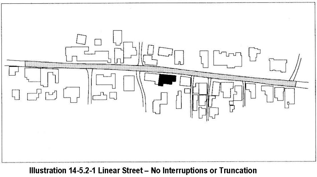
If the project location is sited on a street which extends linearly with no interruptions or truncations, the streetscape shall include buildings, yardwalls, and fences on both sides of the street on which the proposed building, yardwall, or fence is to be located, for a distance of six hundred (600) feet measured from the midpoint of the street facing façade(s) of the proposed building, yardwall, or fence in both directions parallel to the street centerline. See Illustration 14-5.2-1, "Linear Street - No Interruptions or Truncations."
B.
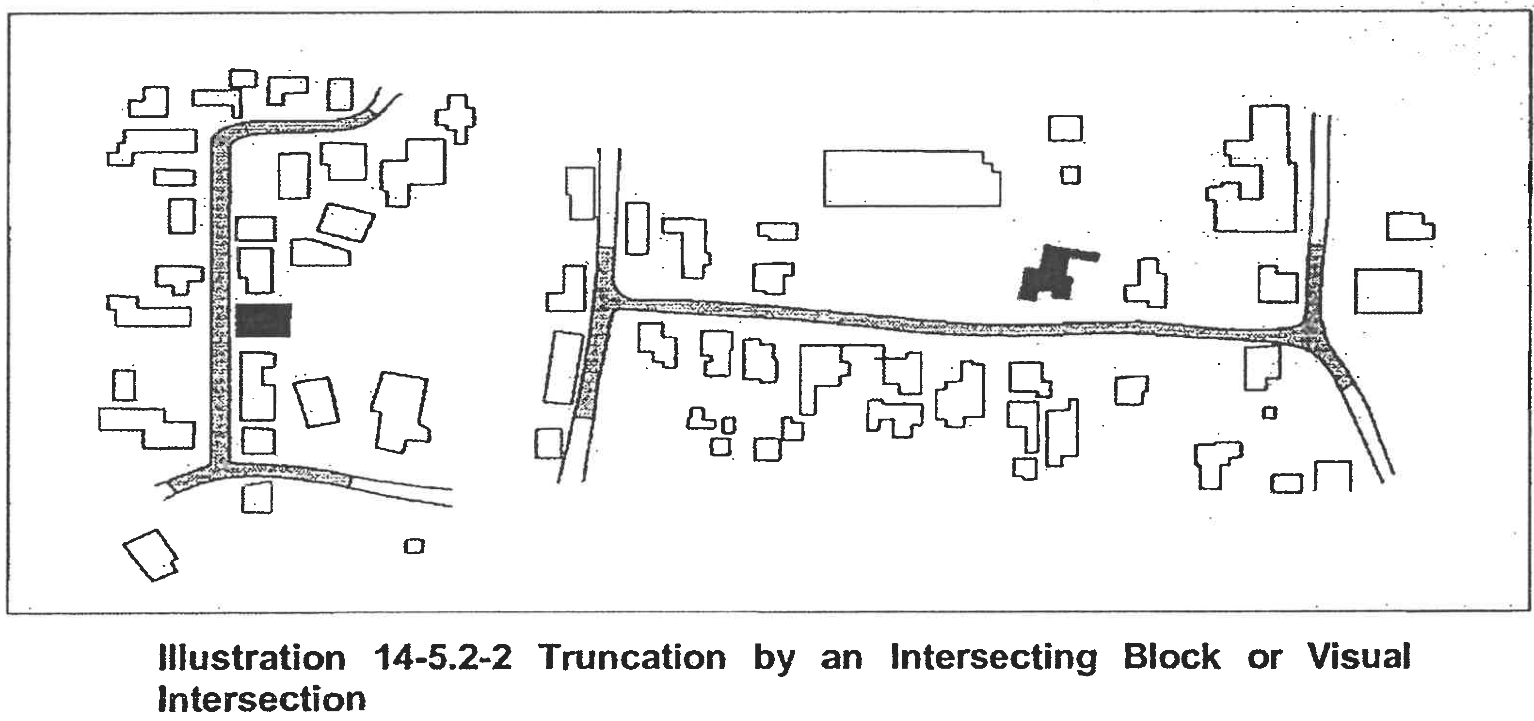
If the streetscape is truncated by an intersecting block or a visual intrusion (such as a curve or turn in the streetscape) before the six hundred (600) feet is measured, the streetscape shall include all buildings, yardwalls, or fences up to and including those which front the intersection or intrusion. See Illustration 14-5.2-2, "Truncation by an Intersecting Block or Visual Intrusion."
C.
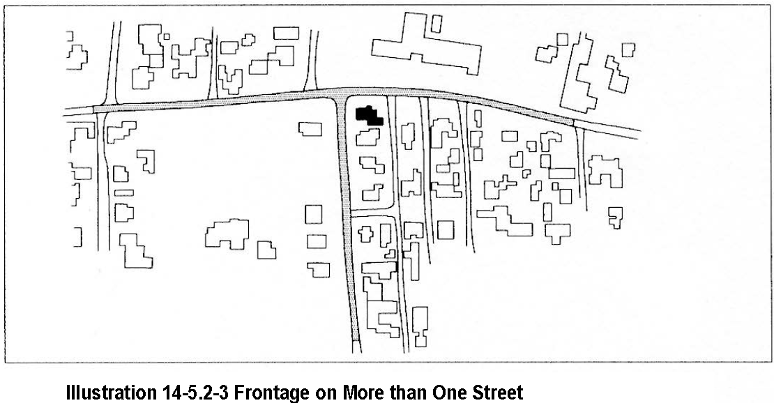
If the proposed building, yardwall, or fence fronts more than one street, the streetscape on each street frontage as determined in Subsection (ii)A above shall be considered. See Illustration 14-5.2-3, "Frontage on More than One Street." (Ord. No. 2002-37 § 24)
D.
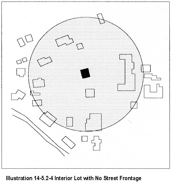
When the proposed building, yard wall or fence is located on a lot with no frontage on rights-of-way, the streetscape is defined by measuring a distance of three (300) feet in all directions beginning from the mid-point of the facade which contains the principal entrance of the building. The height of a proposed yardwall or fence shall not exceed the height of the tallest yardwall or fence within this streetscape. See Illustration 14-5.2-4, "Interior Lot with No Street Frontage."
E.
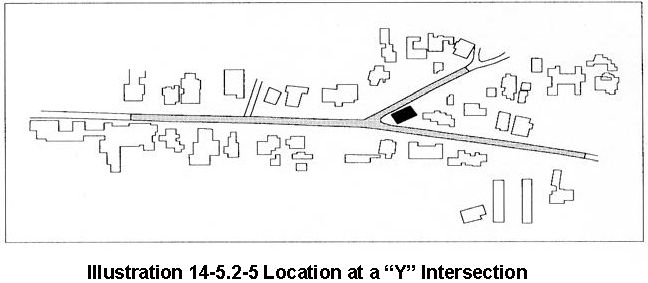
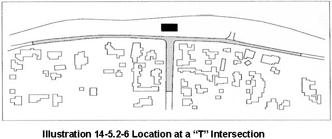
When the proposed building, yardwall or fence faces a T- or a Y-intersection, the streetscape shall include buildings, yardwalls, and fences as defined in Subsection (ii)(A) above and buildings, yardwalls, and fences on both sides of the street creating the leg of the "T" or the arm of the "Y" for a distance of three hundred (300) feet parallel to the street centerline. See Illustrations 14-5.2-5, "Location at a "Y" Intersection," and 14-5.2-6, "Location at a "T" Intersection." (Ord. No. 2002-37 § 25)
F.
When the proposed building, yardwall, or fence is located in a streetscape that includes no buildings, yardwalls, or fences, the height of the proposed building shall not exceed sixteen (16) feet. Yardwalls and fences in this streetscape shall not exceed five (5) feet in height.
(b)
Streetscape Standards
(i)
Streetscapes shall not extend beyond the outer boundaries of the historic districts.
(ii)
When determining streetscape, the following structure types shall be excluded: institutional, buildings originally constructed to house a hotel, residential multiple unit, buildings with non-historic multiple stories, non-historic pitched roof, auxiliary outbuildings such as sheds, existing structures approved by way of a variance or exception, and yardwalls and fences whose height is inconsistent with the predominant height of yardwalls and fences on an applicable streetscape.
(iii)
When determining an applicable streetscape, vacant lots or parcels shall not be included in the calculation for allowable height.
(iv)
In certain cases, the board may consider the standard deviation of heights in addition to the average heights within an applicable streetscape.
(v)
If a portion of a structure falls within the measurement of an applicable streetscape, such structure shall be considered as part of the applicable streetscape.
(vi)
If the determined allowable height of a proposed residentialbuilding or addition does not meet the minimum construction standards related to height set forth in the uniform building code, then the uniform building code shall prevail.
(c)
Height
(i)
Official map of building heights in the historic districts - procedures.
A.
The historic districts review board shall recommend the adoption of an official map reflecting building heights in the historic districts to the governing body. This map shall be used for the purpose of regulating building height in the historic districts. The map shall be adopted at a public hearing of the governing body, which hearing shall be advertised in a local newspaper no less than fifteen days prior to the hearing. All affected propertyowners and owners of lots or of land within one hundred (100) feet, excluding public right-of-way, of the property affected shall be notified of the public hearing by first class mail, mailed at least fifteen days prior to the public hearing. The official map shall be adopted by the governing body by ordinance.
B.
The official map of building heights in the historic districts may be amended from time to time. This historic districts review board shall make recommendations to the governing body for the amendment of the official map, at a public hearing. Such hearing shall be advertised in a local newspaper no less than fifteen days prior to the hearing.
C.
The governing body shall hold a public hearing on any amendments to the official map. The official map, inclusive of amendments, is hereby adopted by reference and incorporated as if set out herein. Such public hearing shall be advertised in a local newspaper no less than fifteen days prior to the hearing. All affected propertyowners and owners of lots or of land within one hundred (100) feet, excluding public right-of-way, of the property affected shall be notified of the public hearing by first class mail, mailed at fifteen days prior to the public hearing.
D.
The official map is available in the city planning office and is accessible at all reasonable times for inspection.
(ii)
In exercising its authority under this section, the board shall limit the height of structures as set forth in this section. Heights of existing structures shall be as set forth on the official map of building heights in the historic districts.
A.
If a proposed building has a parapet, the façade shall not be in excess of two (2) feet of the average of the height of the façades in the streetscape.
B.
If the proposed building has a pitched roof, the ridge height of the proposed building shall not be in excess of two (2) feet of the average of the ridge height of the pitched roofs in the streetscape.
C.
Yardwalls and fences shall be limited to a height that does not exceed the average of the height of other yardwalls and fences in the streetscape.
D.
Pursuant to Section 14-7.4(C), the height of any other structure shall be limited to the allowable building height within the applicable streetscape, as defined in this section. (Ord. No. 2002-37 § 26)
E.
The height and dimension of signage are as set forth in Section 14-8.10(H).
F.
The board may increase the allowable height for proposed buildings and additions located on a sloping site where the difference in the natural grade along the structure's foundation exceeds two (2) feet. In no case shall the height of a façade exceed four (4) feet above the allowable height of the applicable streetscape measured from natural or finished grade, whichever is more restrictive. This increase in height shall be constructed only in the form of building stepbacks from the street.
(iii)
In historic districts, height shall be the vertical distance measured between the highest part of a structure and the existing grade or finished grade, whichever is more restrictive, at the midpoint of the street facing facade, excluding rooftop appurtenances, the increased height of walls or fences over pedestrian and vehicular openings, and gates (either in opened or closed position). For structures which do not have street frontage, height shall be determined by the facade which contains the tallest vertical distance measured between the highest part of a structure and the existing grade or finished grade, whichever is more restrictive. The height of walls and fences is measured from the street-facing side of the wall or fence. (Ord. No. 2002-37 § 27)
(d)
Pitch
If the determined streetscape includes over fifty percent buildings with pitched roofs, the proposed building may have a pitched roof. A pitched roof is defined as a gable, shed, or hipped roof. The pitch of the roof shall match the predominant pitch extant in the streetscape.
(e)
Scale
The height of a proposed building or addition, its façade length, and its roof form and pitch shall appear to be in proportion to the height, façade length, and roof form and pitch of buildings in the applicable streetscape, or the building on which the addition is proposed.
(f)
Massing and Floor Stepbacks
The Board may require that upper floor levels be stepped back, to carry out the intent of this section; provided that the board in making such determinations shall take into account whether the height of the proposed building, yardwall, fence, or proposed stepback of upper floor levels is in harmony with the massing of the applicable streetscape and preservation of the historic and characteristic visual qualities of the streetscape. The Board shall also require that the publicly visible façades of the structure be in conformance with Subsections 14-5.2(E) through (H), and in meeting those requirements, may require that different floor levels be stepped back.
(10)
Signs; Murals
Signapplications and required submittals shall be reviewed by the planning and land use department. Approval or disapproval shall be indicated by the division on the application for the buildingpermit and on each of the required submittals. If a proposed mural does not meet the criteria in the historic ordinance, an exception is required. (Ord. No. 2007-45 § 30; Ord. No. 2020-22§ 16; Ord. No. 2023-27 § 1)
(11)
Walk Areas
The Board shall recommend to the governing body appropriate streets or portions of streets within the historic district to be set aside for walk areas. The governing body may set aside the areas recommended; provided, that three-fourths of the propertyowners adjoining the street or portion of street affected have given consent thereto. Such walk areas shall be closed to vehicular traffic, and any improvements made by the city in the public right-of-way within the walk area shall be for pedestrian purposes. No walk area shall be set aside unless there is adequate space available conveniently related to the area for parking of cars of those who will make use of the area. The board's recommendation to the governing body shall include a statement of the available parking space.
(E)
Downtown and Eastside Design Standards
The governing body recognizes that a style of architecture has evolved within the city from the year 1600 to the present characterized by construction with adobe, hereafter called "old Santa Fe style", and that another style has evolved, hereafter called "recent Santa Fe style", which is a development from, and an elaboration of the old Santa Fe style, with different materials and frequently with added decorations.
(1)
Old Santa Fe Style
Old Santa Fe style, characterized by construction with adobe, is defined as including the so-called "pueblo" or "pueblo-Spanish" or "Spanish-Indian" and "territorial" styles and is more specifically described as follows:
(a)
With rare exception, buildings are of one story, few have three stories, and the characteristic effect is that the buildings are long and low. Roofs are flat with a slight slope and surrounded on at least three sides by a firewall of the same color and material as the walls or of brick. Roofs are never carried out beyond the line of the walls except to cover an enclosed portal or porch formed by setting back a portion of the wall or to form an exterior portal, the outer edge of the roof being supported by wooden columns. Two-story construction is more common in the territorial than in other sub-styles, and is preferably accompanied by a balcony at the level of the floor of the second story. Façades are flat, varied by inset portales, exterior portales, projecting vigas or roof beams, canales or water-spouts, flanking buttresses and wooden lintels, architraves and cornices, which, as well as doors, are frequently carved and the carving may be picked out with bright colors. Arches are almost never used except for nonfunctional arches, often slightly ogive, over gateways in freestanding walls;
(b)
All exterior walls of a building are painted alike. The colors range from a light earth color to a dark earth color. The exception to this rule is the protected space under portales, or in church-derived designs, inset panels in a wall under the roof, in which case the roof overhangs the panel. These spaces may be painted white or a contrasting color, or have mural decorations;
(c)
Solid wall space is always greater in any façade than window and door space combined. Single panes of glass larger than thirty (30) inches in any dimension are not permissible except as otherwise provided in this section;
(d)
The rule as to flat roofs shall not be construed to prevent the construction of skylights or installation of air conditioning devices, or any other necessary roof structures, but such structures other than chimneys, flues, vents and aerials, shall be so placed as to be concealed by the firewall from the view of anyone standing in the street on which the building fronts;
(e)
True old Santa Fe style buildings are made of adobe with mud plaster finish. Construction with masonry blocks, bricks, or other materials with which the adobe effect can be simulated is permissible; provided, that the exterior walls are not less than eight (8) inches thick and that geometrically straight façade lines are avoided. Mud plaster or hard plaster simulating adobe, laid on smoothly, is required; and
(f)
It is characteristic of old Santa Fe style commercial buildings to place a portal so that it covers the entire sidewalk, the columns being set at the curb line.
(2)
Recent Santa Fe Style
Recent Santa Fe style intends to achieve harmony with historic buildings by retention of a similarity of materials, color, proportion, and general detail. The dominating effect is to be that of adobe construction, prescribed as follows:
(a)
No building shall be over two stories in height in any façade unless the façade shall include projecting or recessed portales, setbacks or other design elements;
(b)
The combined door and window area in any publicly visible façade shall not exceed forty percent of the total area of the façade except for doors or windows located under a portal. No door or window in a publicly visible façade shall be located nearer than three (3) feet from the corner of the façade;
(c)
No cantilevers shall be permitted except over projecting vigas, beams, or wood corbels, or as part of the roof treatment described below;
(d)
No less than eighty percent of the surface area of any publicly visible façade shall be adobe finish, or stucco simulating adobe finish. The balance of the publicly visible façade, except as above, may be of natural stone, wood, brick, tile, terra cotta, or other material, subject to approval as hereinafter provided for buildingpermits;
(e)
The publicly visible façade of any building and of any adjoining walls shall, except as otherwise provided, be of one color, which color shall simulate a light earth or dark earth color, matte or dull finish and of relatively smooth texture. Façade surfaces under portales may be of contrasting or complimentary colors. Windows, doors and portals on publicly visible portions of the building and walls shall be of one of the old Santa Fe styles; except that buildings with portals may have larger plate glass areas for windows under portals only. Deep window recesses are characteristic; and
(f)
Flat roofs shall have not more than thirty (30) inches overhang.
(F)
Historic Review District
(1)
Applicability
(a)
The division shall review and approve or deny all applications for new construction, exterior alteration, and demolition of structures in the historic review district in accordance with the standards set forth in this section.
(b)
The historic districts review board shall review and approve or deny new construction of commercial, residential multi-unit, public structures, and those structures requiring the Board's review as specified in Subsection 14-5.2(D)(9)(a). Approval, disapproval, or referral shall be indicated by the division on the application for the buildingpermit and on each of the required submittals, all of which shall be signed by the division staff assigned to the review.
(2)
District Standards
(a)
The following structural standards shall be complied with whenever exterior features of buildings and other structures subject to public view from any public street, way, or other public place are erected, altered, or demolished:
(i)
Slump block, stucco, or stone shall be used as exterior wall materials. Wood and other materials may be used for details. Aluminum siding, metal panels, mirrored glass, and unstuccoed masonry units or unstuccoed cement shall not be used as exterior wall materials; and
(ii)
The color of stuccoed buildings shall predominantly be brown, tan, or local earth tones. This does not include chocolate brown colors or white except dull or matte off-white (yeso). Surfaces of stone shall be in the natural color. Entries and portals may be emphasized by the use of white or other colors or materials. Painting of buildings with bold repetitive patterns, or using buildings as signs is prohibited.
(b)
It is intended that buildings be designed to be "wall dominated". "Wall dominated" means that the building's geometry is more defined by walls than by roofs. Buildings with flat, gabled, shed, and hipped roofs can be designed as "wall dominated" solutions and are allowed. However, gabled, shed and hipped roofs are only allowed if sufficient evidence is provided by the applicant showing that there are pitched roofs extant before December 12, 1983 (date of enactment) within the related streetscape, as viewed when standing in the public street in front of the site. The height of the roof above the wall shall be no greater than the height of the walls. Folded plate, hyperbolic, mansard, or red tile roofs are not allowed. Roofs in local earth tones are preferred.
(c)
The use of solar and other energy collecting and conserving strategies is encouraged. The use of large glazed areas on south-facing walls for trombe walls or other solar collectors, direct gain, or other collecting purposes is allowed. When in view from any public street, way, or other public place, solar equipment shall be screened as follows:
(i)
Raising the parapet;
(ii)
Setting back from the edge of the roof;
(iii)
Framing the collector with wood;
(iv)
In pitched roofs, by integrating the collector into the pitch;
(v)
In ground solar collectors by a wall or vegetation;
(vi)
In wall collectors or greenhouses, by enclosing by end or other walls;
(vii)
Other means that screen the collector or integrate it into the overall structure. Non-glare materials shall be used in solar collectors.
(d)
Roof-mounted mechanical, electrical and telephone equipment and other obtrusive structures shall be architecturally screened with opaque materials by raising the parapet, boxing in the equipment or other appropriate means. The equipment shall be of a low profile to minimize the screening problem.
(e)
No cantilever or long apparently unsupported openings are allowed except over the projecting vigas, beams, or wood corbels or as part of the roof. The use of arches is discouraged except in freestanding walls.
(f)
In order to emulate traditional Santa Fe architecture and construction traditions, it is intended that structures be designed to appear essentially as structures with massive walls which are defined as being built or appearing to be built of adobe construction, wall thickness appearing massive in relation to wall height, and where applicable, the depths of windows, doors and entry opening showing the massiveness of the structure. Solid wall space shall be greater in any façade than window or door space combined. Exceptions are allowed for south facing walls for solar equipment as provided in Subsection (F)(2)(c) of this section and under portales. The mass elements that make up the building composition shall appear as single blocks. Buildings with ground coverage of over twenty thousand 20,000 square feet and over one story shall be designed to appear more as an aggregation of smaller "building blocks" rather than a single large box or block. (Ord. No. 2002-37 § 28)
(g)
Walls and fences visible from the street shall be built of brick, adobe, rock, masonry, wood, coyote fencing, wrought iron, slump block, or similar materials. Walls of unstuccoed concrete block or unstuccoed concrete, chain link, metal wire, or similar materials are prohibited, except where the wall or fence is not visible from the street.
(h)
When parking spaces are required for commercial or multi-family residentialbuildings, they shall be placed to the rear or side of the building. When parking areas are visible from the street, they shall be screened from view by walls, fences, vegetation, planters, earth berms, or other means.
(G)
Historic Transition District
(1)
Purpose
(a)
In order to promote the economic, cultural and general welfare of the people of the city and to ensure the harmonious, orderly, and efficient growth and development of the city, it is deemed essential by the governing body that the qualities relating to the history of Santa Fe, and a harmonious outward appearance, which preserves property values and attracts tourists and residents alike, be preserved, some of the qualities being:
(i)
The continued existence and preservation of historic areas and buildings;
(ii)
The continued construction of buildings in the historic styles; and
(iii)
A general harmony as to style, form, color, proportion, texture, and material between buildings of historic design and those of more modern design.
(b)
The governing body hereby establishes a process for review of style, form, color, proportion, texture, and materials as part of the buildingpermit process in the historic transition district.
(2)
Applicability
Submittals of required elevations and plans and approval of these submittals by the planning and land use department are required before a buildingpermit is given for construction, renovation, or exterior remodeling of any exterior feature of a building or structure subject to public view from any public street, way, or other public place. Demolition shall not require prior approval by the planning and land use department. (Ord. No. 2007-45 § 30; Ord. #2020-22, § 16)
(3)
District Standards
Compliance with the following structural standards shall occur whenever those exterior features of buildings and other structures subject to public view from any public street, way, or other public place are erected or altered:
(a)
Architectural Style
(i)
Materials
It is intended that exterior wall materials express a monolithic and massive appearance. Stucco, brick, slump block, and stone are allowed. Materials such as aluminum siding, metal panels, mirrored glass, and unstuccoed masonry units or cement are not allowed. Wood siding is not allowed for an entire wall;
(ii)
Color
The color of stuccoed buildings shall predominantly be in brown, tans, or local earth tones. This does not include chocolate brown colors or white except dull or matte off-white (yeso). Surfaces of stone or brick shall be in the natural color. Entries and portals may be emphasized by the use of white or other colors or materials. Painting of buildings with bold repetitive patterns, or using buildings as signs is prohibited;
(iii)
Roof Form, Slope and Shape
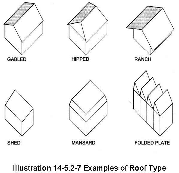
It is intended that buildings be designed to be "wall dominated". "Wall dominated" means that the building's geometry is more defined by walls than by roofs. Buildings with flat, gabled, shed, and hipped roofs can be designed as "wall dominated" solutions and are allowed. The height of the
roof above the wall shall be no greater than the height of the walls. Folded plate roofs, hyperbolic, mansard, or red tile roofs are not allowed. Roofs
in local earth tone colors are preferred. See Illustration 14-5.2-7, "Examples of
Roof Types";
(iv)
Solar Equipment
A.
It is intended that the use of solar and other energy collecting and conserving strategies be encouraged. The use of large glazed areas on south facing walls for collectors, trombe walls, greenhouses, garden rooms, direct gain, or other collecting purposes is allowed. Solar equipment shall be screened as follows:
1.
raising the parapet;
2.
setting back from the edge of the roof;
3.
framing the collector with wood;
4.
in the case of pitched roofs, by integrating the collector into the pitch;
5.
in case of ground solar collectors by a wall or vegetation;
6.
in the case of wall collectors or greenhouses, by enclosing by end or other walls;
7.
other means that screen the collector or integrate it into the overall structure. Non-glare materials shall be used in solar collectors.
B.
Roof-mounted equipment: roof-mounted mechanical, electrical and telephone equipment and other obtrusive structures shall be architecturally screened with opaque materials, for example, by raising the parapet, and shall be of a low profile to minimize the screening problem;
C.
Cantilevers, arches: no cantilever or long apparently unsupported openings are allowed except over the projecting vigas, beams, or wood corbels or as part of the roof. The use of arches is discouraged except in free standing walls;
(b)
Size, Mass and Shape
(i)
In order to emulate traditional Santa Fe architecture and construction traditions, it is intended that structures be designed to appear essentially as structures with massive walls. Structures with massive walls are defined as being built or appearing to be built of adobe construction, wall thickness appearing massive in relation to wall height, and where applicable, the depths of windows, doors and entry openings showing, the massiveness of the structures. Solid wall space shall be greater in any façade than window or door space combined. Exceptions are allowed for south facing walls for solar equipment as provided in Subsection (G)(3)(a)(iv) of this section, and under portales; (Ord. No. 2002-37 § 29)
(ii)
The mass elements which make up the building composition shall appear as single blocks;
(iii)
Buildings with ground coverage of over twenty thousand (20,000) square feet and over one story shall be designed to appear more as an aggregation of smaller "building blocks" rather than a single large box or block. A human scale shall be achieved near ground level on large commercial, multi-family residential and public buildings and along street façades and entryways through the use of such scale elements as windows, doors, columns, and beams. Human scale means the entrances, windows, doors, columns, and beams on large buildings are in proportion to the people using the building. For example, a ten-foot high entrance cover is in proportion to a person using it. A thirty (30) foot high colonnade is not;
(c)
Walls and Fences
Walls and fences visible from the street shall be built of brick, adobe, rock, masonry, wood, coyote fencing, wrought iron, slump block, or similar materials. Walls of unstuccoed concrete block or unstuccoed concrete, chain link, metal wire, or similar materials are prohibited, except where the wall or fence is not visible from the street;
(d)
Remodeling and Alteration
Persons requesting approval for buildingpermits for remodeling or alteration of nonconforming structures shall not be required to bring the total structure into conformance with the standards for the historic transition area. However, the portion of the building that is remodeled or altered shall conform to those standards. Remodeling of structures of architectural and historic interest or individually entered on the state register of cultural properties or national register of historic places or designated as significant on either register shall be related to and compatible with the structure. "Related to and compatible with" means existing together with unity and coherence.
(4)
Final Review
(a)
All applicants for final review shall submit:
(i)
Three copies of four building elevations drawn to scale. Elevations shall be drawn with sufficient detail to show the architectural design of the structures, including proposed exterior finish materials, textures and colors;
(ii)
Three copies of a dimensioned plan drawn to scale which shows building location and configuration in relation to other site improvements, including but not limited to parking lots and utilities.
(b)
The planning and land use department shall make a determination of whether the plans and elevations are in compliance with the requirements of this section within five working days from the date of the application to the city. If the submitted information is inadequate, the division may postpone action until a date agreed upon by the division and the applicant. (Ord. No. 2007-45 § 30; Ord. #2020-22, § 16)
(c)
Final approval, disapproval, or conditional approval shall be noted on the face of the application and signed by a representative of the planning and land use department. If conditional approval is given, the list of conditions shall be attached to the application. If the application is disapproved, the sections of the historic transition district with which the application did not comply shall be noted on the application. (Ord. No. 2007-45 § 30; Ord. #2020-22, § 16)
(d)
No approval by the planning and land use department shall be required for repairs that do not in any way alter any exterior feature in view from any public street, way, or public place, or for repainting it the same color. (Ord. No. 2007-45 § 30; Ord. #2020-22, § 16)
(5)
Property Use and Zoning District
The property in the historic transition district may be used for any use permitted in the zoning district of which the property in question is a part. The property in the historic transition district shall be subject to the requirements, uses, height, and other regulations of the zoning district of which the property is a part.
(H)
Don Gaspar Area Historic District
(1)
District Standards
Compliance with the following structural standards shall occur wherever those exterior features of buildings and other structures subject to public view from any public street, way, or other public place are erected, altered, or demolished:
(a)
Slump block, stucco, brick, stone, or wood shall be used as exterior wall materials. Aluminum siding, metal panels, mirrored glass and unstuccoed concrete block or unstuccoed concrete shall not be used as exterior wall materials. The painting of buildings with a color that causes arresting or spectacular effects or with bold repetitive patterns, or using building as signs is prohibited. Murals, however, are permitted and may be referred to the city arts board for an advisory recommendation.
(b)
Roof forms including but not limited to flat, gabled, shed, and hipped roofs are allowed. Folded plate or hyperbolic roofs are not allowed.
(c)
The use of solar and other energy collecting and conserving strategies is encouraged. The use of large glazed areas on south facing walls for trombe walls or other solar collectors, greenhouses, garden rooms, direct gain, or other energy collecting purposes is allowed. When in view from any public street, way, or other public place, solar equipment shall be screened by the following methods:
(i)
raising the parapet;
(ii)
setting back from the edge of the roof;
(iii)
framing the collector with wood;
(iv)
in the case of pitched roofs, by integrating the collector into the pitch;
(v)
in case of ground solar collectors by a wall or vegetation;
(vi)
in the case of wall collectors by enclosing by end or other walls;
(vii)
other means that screen the collector or integrate it into the overall structure. Non-glare materials shall be used in solar collectors.
(d)
Mechanical, electrical, telephone equipment, microwave satellite receiving dishes, and other obtrusive equipment shall be architecturally screened by opaque materials by raising the parapet, framing in the equipment, or other appropriate means. The equipment shall be of a low profile to minimize the screening problems.
(e)
Walls and fences shall be of brick, adobe, masonry, rock, wood, coyote fencing, or similar materials. Wrought iron fences and slump block walls are allowed. Walls of unstuccoed concrete, chain-link, metal wire, or similar materials are prohibited, except where the wall or fence is not in view from any public street, way, or other public place.
(f)
Greenhouses. Attached greenhouses that front on the street shall give the appearance of being integrated into the structure of the building or of being a substantive addition rather than having a lean-to-effect. The use of corrugated fiberglass or rolled plastic for the external surface of attached or freestanding greenhouses that front on the street is prohibited. Greenhouses with slanting sides shall be bracketed at the ends and the greenhouses made from enclosed porches or portales shall maintain the shape of the porch or portal.
(g)
For residential uses, paving with asphalt or parking is not allowed in the front yard except in the sidewalk or driveway.
(h)
For commercial uses zoned C-1 front yards are required to be landscaped, and no required front yard shall be used for off-street parking.
(i)
As a condition of any rezoning all applicants shall provide evidence of sufficient off street parking and an intent to maintain the architectural integrity of the existing building or to conform to the architectural style of the district if constructing a building on a vacant lot.
(2)
Walls; Fences; Solar Collectors; Administration
Applications for erection, alteration, or destruction of walls, fences, and solar collectors and required submittals shall be reviewed by the planning and land use department. Approval, disapproval, or referral shall be indicated by the division on the application for the buildingpermit and on each of the required submittals, all of which shall be signed by the division staff assigned to the review. The division shall report approvals, disapprovals, or referrals to the board at its next regular meeting as an informational item. (Ord. No. 2007-45 § 30; Ord. #2020-22, § 16)
(I)
Westside-Guadalupe Historic District
(1)
District Standards
Compliance with the following structural standards shall occur whenever those exterior features of buildings and other structures subject to public view from any public street, way, or other public place are erected, altered, or demolished:
(a)
Slump block, stucco, brick, or stone, shall be used as exterior wall materials. Wood and other materials may be used for details. Aluminum siding, metal panels, mirrored glass, and unstuccoed concrete block or unstuccoed concrete shall not be used as exterior wall materials;
(b)
The color of stuccoed buildings shall predominantly be in browns, tans, local earth tones and soft pastels. Surfaces of stone or brick shall be in the natural color. Entryways, and portales or porches may be emphasized by the use of white or other colors. Painting of buildings with a color that causes arresting or spectacular effects or with bold repetitive patterns or using buildings as signs is prohibited. Murals, however, are permitted and may be referred to the city arts board for an advisory recommendation;
(c)
Roof form, slope, and shape. It is intended that buildings be designed to be "wall dominated". "Wall dominated" means that the building's geometry is more defined by walls than by roofs. Buildings with flat, gabled, shed, or hipped roofs can be designed as "wall dominated" solutions and are allowed. The height of the roof above the wall shall be no greater than the height of the wall. Folded plate, hyperbolic or mansard roofs are not allowed;
(d)
The use of solar and other energy collecting and conserving strategies is encouraged. The use of large glazed areas on south facing walls for trombe walls or other solar collectors, direct gain, or other energy collecting purposes is allowed. When in view from any public street, way, or other public place, solar equipment shall be screened as follows:
(i)
raising the parapet;
(ii)
setting back from the edge of the roof;
(iii)
framing the collector with wood;
(iv)
in the case of pitched roofs, by integrating the collector into the pitch;
(v)
in the case of ground solar collectors by a wall or vegetation;
(vi)
in the case of wall collectors, by enclosing by end or other walls;
(vii)
other means that screen the collector or integrate it into the overall structure. Non-glare materials shall be used in solar collectors.
(e)
Mechanical, electrical, telephone equipment, microwave satellite receiving dishes, and other obtrusive equipment shall be architecturally screened with opaque materials by raising the parapet, boxing in the equipment, or other appropriate means. The equipment shall be of a low profile to minimize the screening problems;
(f)
Walls and fences shall be of brick, adobe, masonry, rock, wood, coyote fencing, or similar materials. Wrought iron fences and slump block walls are allowed. Walls of unstuccoed concrete block, unstuccoed concrete, chain-link, metal wire, or similar materials are prohibited, except where the wall or fence is not in the street frontage;
(g)
(h)
Attached greenhouses that front on the street shall give the appearance of being integrated into the structure of the building or of being a substantive addition rather than having a lean-to effect. The use of corrugated fiberglass or rolled plastic for the external surface of attached or freestanding greenhouses that front on the street is prohibited. Greenhouses with slanting sides shall be bracketed at the ends and that greenhouses made from enclosed porches or portales maintain the shape of the porch or portal;
(i)
Porches and portales are encouraged;
(j)
When parking spaces are required for commercial or multi-family residentialbuildings, they shall be placed to the rear or side of the building.
(2)
Walls; Fences; Solar Collectors; Administration
Applications for erection, alteration, or demolition of walls, fences, and solar collectors and required submittals shall be reviewed by the planning and land use department. Approval, disapproval or referral shall be indicated by the division on the application for the building permit and on each of the required submittals, all of which shall be signed by the division staff assigned to the review. The division shall report approvals, disapprovals, and referrals to the board at its next regular meeting as an informational item. (Ord. No. 2007-45 § 30; Ord. #2020-22, § 16)
(J)
Creation of Historic Districts
The governing body may, of its own motion, on recommendation of the historic districts review board, or in response to petition, designate an area as an historic district. Historic districts shall be areas of historical, architectural, cultural, or special aesthetic interest. Historic districts so classified will be designated for zoning purposes by the existing zone designations at the time of the adoption of this section, plus the suffix "H." The procedure for establishment of an historic district shall be that prescribed for other rezonings, but also shall comply with this section.
(1)
Application
Any
petition for designation of a historic district shall be accompanied by an application and supporting materials as specified in the user's guide, and also any other information as requested by the historic board.
(2)
Preliminary Review and Hearing
(a)
In any matter subject to its review, the historic board, upon request of the applicant, shall provide a preliminary review. Application for preliminary review shall be accompanied by two copies of the design development drawings or photographs. The Board shall provide an informal determination of whether the drawings and photographs are in compliance with the applicable standards.
(b)
Preliminary approval or disapproval shall be indicated on each copy of the design development drawings or photographs and signed by the chair of the board. If disapproved, the board shall give the reasons for disapproval on each copy of the required submittals. One marked copy shall be retained by the board. The other copy, similarly marked, shall be returned to the applicant. Preliminary approval is not a substitute for final review approval. Any subsequent changes to the design development drawings prior to final review shall be consistent with the preliminary approval.
(c)
The historic board shall act at its next regular meeting upon those preliminary applicants that have been filed seven or more days in advance of that meeting. Notice of the time and place of the preliminary review shall be given to the applicant in writing by the planning and land use department. (Ord. No. 2007-45 § 30; Ord. #2020-22, § 16)
(3)
Final Review and Hearings
(a)
No exterior feature or part of an exterior feature of a structure which is subject to view from any public street may be erected, demolished, or have its appearance changed until the application and required submittals have been approved by the historic board, as part of the building permit process in accordance with standards set forth in this section.
(b)
The historic districts review board shall act upon the final application at its next regular meeting, unless the application is made less than seven days before a regular meeting, in which case the question may be held over until the next meeting. If the exhibits are inadequate, the historic districts review board may postpone action until a date agreed upon by the historic districts review board and the applicant. Recommended final approval, disapproval, or conditional approval shall be noted on the face of the application and signed by the chair of the historic districts review board, or, in the chair's absence, by the acting chair. If conditional approval is given, the list of conditions shall be attached to the application. If the application is disapproved, the chair of the historic districts review board shall state on the application the sections of H district regulations with which the application did not comply. If the application is disapproved for failure to provide required information, the chair shall state on building permit for work within an historic district may be issued without approval of the historic districts review board endorsed thereon, except after appeal, as provided in §14-3.17. (Ord. No. 2002-37 § 30; Ord. No. 2009-42 § 18)
(c)
All applications for review by the board shall be accompanied by three copies of plans and exterior building elevations drawn to scale, with sufficient detail to show the architectural design of structures, including proposed exterior finish materials, textures, colors, and the plot plan or site layout, including a general location of the existing adjacent improvements. The plans and elevations shall also show all improvements affecting appearance such as walls, fences, signs, lights, fixtures, steps and other appurtenant elements. Applications for new construction or demolition shall be accompanied by clear photographs showing contiguous property.
(d)
Applications and exhibits shall be kept available for public inspection. For new construction, a clear photograph of the structure, as completed, shall be taken by the city to be included in the planning and land use department's historic area new construction archives. (Ord. No. 2007-45 § 30; Ord. #2020-22, § 16)
(e)
No approval by the historic board shall be required for repairs that do not in any way alter the exterior appearance of a structure, or for repainting it in the same color, unless the board has previously notified the owner in writing that the existing color of the structure is objectionable, in which case approval by the board shall be obtained for any repainting.
(f)
The historic board shall judge any proposed alteration or new structure for harmony with adjacent buildings, preservation of historical and characteristic qualities, and conformity to the standards for architectural style set forth in this section.
(K)
Historic Compounds
(Ord. No. 2003-18 § 1)
(1)
Purpose and Intent
It is intended that:
(a)
Historic compounds shall be recognized as historic places and that the identifiable historic, physical, and spatial elements comprising them shall be preserved.
(b)
Character defining architectural, landscaping, spatial features and contexts in an historic compound shall be preserved.
(c)
The buildings, structures, landscaping, and open spaces comprising a compound change over time. Changes to a compound may have acquired historic significance and, if so, shall be retained and preserved.
(d)
Additions to existing buildings and new construction and landscaping in an historic compound shall be undertaken in such a manner that, if removed in the future, the historic form and integrity of the historic compound would be unimpaired.
(2)
Identification of Historic Compounds
(a)
In reviewing applications for compliance with Section 14-5.2, staff shall evaluate whether the subject property is located in an historic compound. If a compound is listed on the historic compound register, this shall constitute identification as an historic compound. In other circumstances, identification of an historic compound shall be accompanied by a written analysis and justification as to why the compound is historic. Historic compounds shall be comprised of a group of at least three buildings that are historically, physically, and/or spatially related. In order for a compound to be considered historic, at least fifty percent of the buildings in the compound shall be designated contributing, significant or landmark. Designation of all buildings, structures, and objects in a compound shall be reviewed upon application. Four general types of historic compounds are found in Santa Fe, the family, the rental, the placita and the commercial.
(3)
Board Review of Existing Conditions Assessments and Historic Compound Plans
(a)
For any proposed substantive change to an historic compound, the propertyowner or representative shall submit an existing conditions assessment for review and approval by the board.
(b)
For compounds that have one owner, the board may also require a proposed historic compound plan for review and approval. If an historic compound plan is required, a permit for substantive change in the historic compound shall not be issued until final review and approval of the document by the board.
(c)
An existing conditions assessment and/or historic compound plan shall not be reviewed until all exhibits, as specified by city policy, have been submitted.
(d)
Review of the existing conditions assessment and historic compound plan by the board shall include the historic, physical, and spatial character including scale and development pattern of the historic compound.
(4)
Standards for the Rehabilitation, Demolition, Additions and New Construction in Historic Compounds
(a)
General
(i)
If proposed changes will significantly alter the historic, physical, or spatial character of the historic compound as a whole, the application shall be denied.
(ii)
If the proposed changes will result in a resource located in the historic compound to lose its contributing, significant or landmark status, the application shall be denied.
(b)
Rehabilitations of Contributing, Significant, and Landmark Resources
In rehabilitating contributing, significant, and landmark resources, the standards as set out in Subsection 14-5.2(D) shall be met.
(c)
Additions
Additions to contributing, significant, or landmark buildings or structures shall meet the standards as set forth in Subsection 14-5.2(D)(2).
(d)
Height
(i)
Additions to contributing, significant, or landmark buildings shall be a minimum of six inches lower than the parapet or ridge of the historic building. Additions to contributing, significant or landmark structures other than buildings shall be a minimum of six (6) inches lower than the highest point of the historic structure. This requirement shall supersede Subsection 14-5.2(D)(2)(e).
(ii)
In addition to the height requirements set forth in Subsection 14-5.2(K)(4)(d)(i), new buildings shall be at least six (6) inches lower than the calculated average height of all contributing, significant or landmark buildings in the historic compound.
(iii)
New walls, fences, or gates shall not exceed the average height of existing walls, fences, or gates in the historic compound. No wall or fence that significantly changes the spatial character of the historic compound shall be constructed.
(e)
New Free-Standing Construction and Landscaping
(i)
New buildings shall not exceed in size the average historic footprint of all contributing, significant or landmark buildings in the historic compound.
(ii)
The total footprint of new free-standing building construction approved under this ordinance shall not exceed fifty percent of the combined historic footprint of contributing, significant or landmark buildings.
(iii)
New construction shall use similar materials, building forms and stylistic elements as found in the historic compound.
(iv)
New construction shall be visually distinct from, but compatible with, contributing, significant, or landmark architecture in the historic compound.
(v)
New construction shall not damage, block, or obscure historic, physical, or spatial character defining features of the historic compound including but not limited to courtyards, roads, paths, walls, fountains, curbing, and vegetation.
(vi)
The location of new construction shall be considered so that its physical relationship to other buildings is similar to the spatial relationships of existing contributing, significant, or landmark buildings in the historic compound.
(vii)
Addition of a new object shall not be considered new construction.
(f)
Demolitions
(i)
Any demolition in an historic compound shall be reviewed as per Section 14-3.14.
(ii)
The effect(s) of the demolition on the character of the historic compound as a whole shall be taken into consideration when reviewing the application.
(5)
Survey, Recommendation, Approval of Historic Compound Register and Effective Date
(a)
A survey of the historic districts shall be completed to determine a list of eligible historic compounds.
(b)
The historic districts review board shall make a recommendation to the governing body as to which properties shall be registered as historic compounds.
(c)
The governing body shall approve the historic compound register after conducting a public hearing. Notice of the public hearing shall be given to the owner of record of each property considered for the historic compound register by certified mail, return receipt requested, no less than fifteen days prior to the hearing.
(d)
Subsection 14-5.2(K) shall become effective thirty days after the approval of the historic compound register by the governing body.
(L)
Landmarks
(Added Ord. No. 2004-26 §2)
(1)
Official Map of LandmarkStructures-Procedures
The historic districts review board shall recommend to the governing body an official map designating the status of structures for the purpose of regulation of landmarkstructures.
(a)
The map shall be adopted at a public hearing of the governing body, which hearing shall be advertised in a local newspaper no less than fifteen days prior to the hearing. All affected propertyowners and owners of lots or of land within one hundred (100) feet, excluding public right-of-way, of the property affected shall be notified of the public hearing by certified mail, return receipt requested, mailed at least fifteen days prior to the public hearing.
(b)
The historic districts review board shall make recommendations to the governing body for the amendment of the official map, at a public hearing. Such hearing shall be advertised in a local newspaper no less than fifteen days prior to the hearing. All affected propertyowners shall be notified of the public hearing by certified mail, return receipt requested, mailed at least fifteen days prior to the public hearing. With the consent of the propertyowner, the city shall have posted on the property a poster obtained from the planning and land use department. Otherwise, the city shall post the poster on the nearest place available to the city. Such poster shall be securely posted, prominently displayed, visible from a public street, at least fourteen days prior to the scheduled Board hearing. The posting shall indicate the nature of the application, identification of the property affected and the time, date and place of the hearing. The poster shall be removed within thirty days of final action. Failure to do so may result in the city removing the sign at the applicant's expense. A civil fee of fifty dollars ($50.00) will be charged. (Ord. No. 2005-31 § 5)
(c)
The governing body shall hold a public hearing on a recommendation by the historic districts review board for an official map. Any official map shall be adopted by the governing body by ordinance.
(d)
The official map of landmarkstructures, with referenced property addresses, is amended from time to time. The same is hereby adopted by reference and incorporated as if set out herein. The original referenced map is available in the city planning office and is accessible at all reasonable times for inspection. (Ord. No. 2001-38 § 2)
(M)
State Capital Outlay Projects
(Ord. No. 2009-46 § 2)
(1)
Purpose
(a)
Recognizing the fragility of the city's historic heritage, the purpose of Subsection 14-5.2(M) is to activate the procedure established in Section 3-22-6 NMSA 1978 under which the city and the state will collaborate in good faith and work jointly to preserve and protect the historic districts of Santa Fe as well as contributing, significant and landmarkstructures.
(b)
State capital outlay projects in historic districts shall be carried out pursuant to the procedures set forth in Section 3-22-6 NMSA 1978 and Subsection (2) below and in a manner that is harmonious and generally compatible with the design standards set forth in Subsection (3) below. These procedures and standards apply to new structures and additions to and alterations and demolition of existing buildings.
(2)
Procedures
(a)
Before commencing with the design phase of a capital outlay project, the state and the historic districts review board shall consult as to the appropriate design standards and how those design standards would impact costs and the operation or manner in which the project will ultimately be expected to function. The historic districts review board shall work collaboratively with the state to arrive at compatibility of the project with the design standards, considering reasonable costs and preserving essential functionality. The state shall also make every reasonable effort to obtain input from members of identifiable community groups involved in historic preservation in Santa Fe before commencing the design phase.
(b)
After the design phase and before soliciting a bid or proposal for design-build or lease-purchase for a capital overlay project, the state shall submit the plans to the historic districts review board for review and comment. The historic districts review board in conjunction with the state shall conduct a public meeting to receive public input. Notice of the public meeting shall be given to any identifiable community groups involved in historic preservation in Santa Fe.
(c)
Within sixty days after the public meeting the historic districts review board, any identifiable historic preservation community group or any other interested party shall communicate recommendations and comments in writing to the state. The state shall consult with the historic districts review board or other entity to resolve any issues raised. If at the end of the sixty-day period unresolved issues remain, the city may within five days after the end of the period, notify the state that the issues remain unresolved and these issues shall be finally determined as set forth in Section 3-22-6(G) NMSA 1978, provided that if notice is not timely given, the state may, after incorporating those provisions to which the state and the city have agreed, proceed with the project.
(d)
The state shall not take any irrevocable action on the capital project in reliance on the plans until the procedures set forth in Section 3-22-6 NMSA 1978 have been followed.
(3)
Design Standards
(a)
General Standards
A state capital outlay project shall be designed appropriate to the seat of government and with the intent of achieving harmony with existing buildings by the use of similar materials, color, proportion, and general details to the existing buildings in the applicable streetscape. The applicable streetscape shall be determined as set forth in Subsections 14-5.2(D)(9)(a)(ii) A., B., C., D., and E. A new structure or proposed alteration or addition shall not cause an adjacent contributing, significant or landmark structure to lose its status. Alterations and additions shall be in character with the style, detail and massing of the existing building. The dominating effect is to be that of adobe construction as follows:
(i)
Roofs
Roofs, generally, shall be flat with a slight slope and surrounded by a parapet of the same color and material as the walls or of brick. Roofs shall generally not be carried out beyond the line of the walls except to cover an enclosed portal or porch formed by setting back a portion of the wall or to form an exterior portal, the outer edge of the roof being supported by columns, posts or other vertical supports. No cantilevers shall be permitted except over projecting vigas, beams, or wood corbels, or as part of the roof treatment not to exceed an overhang of thirty (30) inches. The restriction as to flat roofs shall not be construed to prevent the construction of skylights or installation of air-conditioning devices, or any other necessary roof structures, but such structures other than chimneys, flues, vents and aerials, shall be so placed as to be concealed by the parapet from any public way.
(ii)
Walls and Windows
The combined door and window area in any publicly visible facade generally shall not exceed forty percent of the total area of the facade except for doors or windows located under a portal. No door or window in a publicly visible façade shall be located nearer than three (3) feet from the corner of the facade except in circumstances where the unique purpose of the space may warrant special design considerations. Windows, doors and portales on publicly visible portions of the building and walls shall be of one of the old Santa Fe styles. Glass and window trim shall be nonreflective. Windows shall be similar in proportion to the fenestration pattern in the streetscape. Deep window recesses are characteristic.
(iii)
Finishes
Construction shall be with materials with which the adobe effect can be simulated provided that the exterior walls are not less than eight (8) inches thick. Mud plaster, hard plaster or other materials simulating adobe, laid on smoothly, is required. No less than eighty percent of the non-fenestration surface area of any publicly visible façade shall be adobe finish, stucco or other material simulating adobe finish. The balance of the publicly visible facade may be of natural stone, wood, brick, tile, terra cotta, or other material. Materials shall convey a sense of substance and permanence.
(iv)
Colors
The publicly visible facade of any building and of any adjoining walls generally shall be of one color but no more than three colors and simulate a light earth or dark earth color, matte or dull finish and of relatively smooth texture. However, facade surfaces under portals or inset panels in a wall under a roof overhangs, in church-derived designs, may be painted white or be of contrasting or complimentary colors or have mural decorations.
(v)
Other Features
Facades shall be flat, varied by inset portals, exterior portales, projecting vigas or roof beams, canales or water-spouts, flanking buttresses and wooden lintels, architraves and cornices. Depending upon the existing streetscape and if permitted otherwise in this chapter, a portal may cover the entire sidewalk with the columns set at the curbline.
(vi)
Height
The height shall be limited to the average height of institutional buildings as measured within the applicable streetscape. When determining an applicable streetscape, vacant lots or parcels shall not be included in the calculation for allowable height. If no institutional buildings are included in the streetscape, the maximum height shall not exceed the average height of existing buildings in the streetscape. The planning and land use department staff shall determine the applicable streetscape as set forth in Subsections 14-5.2(D)(9)(a)(ii) A., B., C., D., and E. Height shall be measured as set forth in Subsection 14-5.2(D)(9)(c)(iii). Heights of existing structures shall be as set forth on the official map of building heights. If the height of an existing building is not given, the state shall submit a statement from a NM licensed surveyor of the actual height. No building facade shall be over two stories in height unless the façade includes projecting or recessed portales, balconies, setbacks or other design elements. (Ord. #2020-22, § 16)
(b)
Contributing, Significant and Landmark Buildings
State capital outlay projects that involve contributing, significant or landmarkstructures shall be undertaken in such a manner as to preserve the status of the structure and in accordance with the standards for alterations or additions to contributing, significant or landmark buildings as set forth in Section 14-5.2. Historic materials and architectural features and spaces that embody the status shall be preserved. A proposed alteration or addition shall not cause the structure to lose its status.
(4)
Demolition of Historic and Landmark Structures; Minimum Maintenance Requirements
(a)
A request for demolition of an historic or landmark structure shall include the report required in Section 14-3.14(C) and follow the standards set forth in Section 14-3.14(G). If there is a disagreement as to demolition, the procedures set forth in Section 3-22-6(G) NMSA 1978 shall be followed.
(b)
The minimum maintenance requirements for historic or landmarkstructures set forth in Subsection 14-5.2(B) shall be met.
(N)
County and Santa Fe Public Schools Capital Outlay Projects
(Ord. No. 2010-24 §2)
(1)
Purpose
(a)
Recognizing the fragility of the city's historic heritage, the purpose of Subsection 14-5.2(N) is to establish a procedure under which the city, the county and Santa Fe Public Schools will collaborate in good faith and work jointly to preserve and protect the historic districts of Santa Fe as well as contributing, significant and landmark structures.
Preserving and protecting the historic districts as well as contributing, significant and land mark structures promotes economic welfare, preserves property values and attracts businesses and tourists thus benefiting the entire Santa Fe community including the city, the county and Santa Fe public schools. By establishing up front procedures to ensure cooperation between the city and the county and the public schools, unnecessary costs and delays for capital outlay projects will be avoided. Specific design requirements that acknowledge necessary building functions and budgets will result in harmonious yet responsive public projects.
(b)
County and Santa Fe public schools capital outlay projects in historic districts or involving landmarks located outside historic districts shall be carried out pursuant to the procedures set forth Subsection (2) below and in a manner that is harmonious and generally compatible with the design standards set forth in Subsection (3) below. These procedures and standards apply to new structures and additions to and alterations and demolition of existing buildings.
(2)
Procedures
(a)
Before commencing with the design phase of a capital outlay project, the county or the Santa Fe public schools shall consult with the historic districts review board as to the appropriate design standards and how those design standards would impact costs and the operation or manner in which the project will ultimately be expected to function. The historic districts review board shall work collaboratively with the county or the Santa Fe public schools to arrive at compatibility of the project with the design standards, considering reasonable costs and preserving essential functionality. The county or the Santa Fe public schools shall also make every reasonable effort to obtain input from members of identifiable community groups involved in historic preservation in Santa Fe before commencing the design phase.
(b)
After the design phase and before soliciting a bid or proposal for design-build or lease-purchase for a capital outlay project, the county or the Santa Fe public schools shall submit the plans to the historic districts review board for review. The historic districts review board shall conduct a public meeting to receive public input. Notice of the public meeting shall be given to any identifiable community groups involved in historic preservation in Santa Fe.
(c)
Within sixty days after the public meeting the historic districts review board, any identifiable historic preservation community group or any other interested party shall communicate recommendations and comments in writing to the county or the Santa Fe public schools. The county or the Santa Fe public schools shall resolve any issues raised and submit the project to the historic districts review board for final approval.
(3)
Design Standards
(a)
General Standards
A county or Santa Fe public schools capital outlay project shall be designed appropriate for the public use and with the intent of achieving harmony with existing buildings by the use of similar materials, color, proportion, and general details to the existing buildings in the applicable streetscape. The applicable streetscape shall be determined as set forth in Subsections 14-5.2(D)(9)(a)(ii) A., B., C., D., and E. A new structure or proposed alteration or addition shall not cause an adjacent contributing, significant or landmark structure to lose its status. Alterations and additions shall be in character with the style, detail and massing of the existing building. The dominating effect is to be that of adobe construction as follows:
(i)
Roofs
Roofs, generally, shall be flat with a slight slope and surrounded by a parapet of the same color and material as the walls or of brick. Roofs shall generally not be carried out beyond the line of the walls except to cover an enclosed portal or porch formed by setting back a portion of the wall or to form an exterior portal, the outer edge of the roof being supported by columns, posts or other vertical supports. No cantilevers shall be permitted except over projecting vigas, beams, or wood corbels, or as part of the roof treatment not to exceed an overhang of thirty (30) inches. The restriction as to flat roofs shall not be construed to prevent the construction of skylights or installation of air conditioning devices, or any other necessary roof structures, but such structures other than chimneys, flues, vents and aerials, shall be so placed as to be concealed by the parapet from any public way.
(ii)
Walls and Windows
The combined door and window area in any publicly visible façade generally shall not exceed forty percent of the total area of the façade except for doors or windows located under a portal. No door or window in a publicly visible façade shall be located nearer than three (3) feet from the corner of the façade except in circumstances where the unique purpose of the space may warrant special design considerations. Windows, doors and portales on publicly visible portions of the building and walls shall be of one of the old Santa Fe styles. Glass and window trim shall be nonreflective. Windows shall be similar in proportion to the fenestration pattern in the streetscape. Deep window recesses are characteristic.
(iii)
Finishes
Construction shall be with materials with which the adobe effect can be simulated provided that the exterior walls are not less than eight (8) inches thick. Mud plaster, hard plaster or other materials simulating adobe, laid on smoothly, is required. No less than eighty percent of the non-fenestration surface area of any publicly visible façade shall be adobe finish, stucco or other material simulating adobe finish. The balance of the publicly visible façade may be of natural stone, wood, brick, tile, terra cotta, or other material. Materials shall convey a sense of substance and permanence.
(iv)
Colors
The publicly visible façade of any building and of any adjoining walls generally shall be of one color but no more than three colors and simulate a light earth or dark earth color, matte or dull finish and of relatively smooth texture. However, façade surfaces under portales or inset panels in a wall under a roof overhangs, in church-derived designs, may be painted white or be of contrasting or complimentary colors or have mural decorations.
(v)
Other Features
Facades shall be flat, varied by inset portals, exterior portales, projecting vigas or roof beams, canales or water-spouts, flanking buttresses and wooden lintels, architraves and cornices. Depending upon the existing streetscape and if permitted otherwise in this chapter, a portal may cover the entire sidewalk with the columns set at the curb line.
(vi)
Height
The height shall be limited to the average height of institutional buildings as measured within the applicable streetscape. When determining an applicable streetscape, vacant lots or parcels shall not be included in the calculation for allowable height. If no institutional buildings are included in the streetscape, the maximum height shall not exceed the average height of existing buildings in the streetscape. The land use department staff shall determine the applicable streetscape as set forth in Subsections 14-5.2(D)(9)(a)(ii) A., B., C., D., and E. Height shall be measured as set forth in Subsection 14-5.2(D)(9)(c)(iii). Heights of existing structures shall be as set forth on the official map of building heights. If the height of an existing building is not given, the county or Santa Fe public schools shall submit a statement from a New Mexico licensed surveyor of the actual height. No building façade shall be over two stories in height unless the façade includes projecting or recessed portales, balconies, setbacks or other design elements.
(b)
Contributing, Significant and Landmark Buildings
County or Santa Fe public schools capital outlay projects that involve contributing, significant or landmarkstructures shall be undertaken in such a manner as to preserve the status of the structure and in accordance with the standards for alterations or additions to contributing, significant or landmark buildings as set forth in Section 14-5.2. Historic materials and architectural features and spaces that embody the status shall be preserved. A proposed alteration or addition shall not cause the structure to lose its status.
(4)
Demolition of Historic and LandmarkStructures; Minimum Maintenance Requirements
(a)
A request for demolition of an historic or landmark structure shall comply with the provisions of Section 14-3.14.
(b)
The minimum maintenance requirements for historic or landmark structures set forth in Subsection 14-5.2(B) shall be met.
14-5.3 - ARCHAEOLOGICAL REVIEW DISTRICTS
(Ord. No. 2011-37 § 6)
(A)
Purpose
To promote the economic, cultural and general welfare of the people of Santa Fe, the governing body deems it essential that the qualities relating to the unique cultural traditions, prehistory and history of Santa Fe, which attract tourists and residents alike, be preserved by establishing three archaeological review districts. The purpose of these districts is to:
(1)
recognize the value of archaeological resources from all periods of history and prehistory, including prehistoric Native American settlements, Spanish colonization and settlement and settlement and developments under Mexican and American governments;
(2)
provide the means for identifying archaeological sites by requiring surveys and test excavations, depending on the district, through the development review and construction permit process;
(3)
provide the means by which archaeological sites may be evaluated for their potential contribution to cultural, educational, historic, economic and scientific concerns;
(4)
establish a procedure for treatment of archaeological resources on private and public land, thereby mitigating the information loss from the sometimes unavoidable destruction of archaeological resources and providing for the treatment of those resources that can be preserved; and
(5)
provide methods for the emergency treatment of archaeological resources found through unexpected discovery.
(B)
Application to State and Its Agencies, Political Subdivisions or Instrumentalities
Pursuant to Sections 3-22-1 through 3-22-6 NMSA 1978 (Historic Districts and Landmarks), the provisions of this section apply to the state and its agencies, political subdivisions and instrumentalities, as well as to any other entity or activity in the archaeological review districts.
(C)
Establishment of Districts; Boundaries
(1)
Districts Established
Three archaeological review districts are established, to be known as the historic downtown, the river and trails and the suburban archaeological review districts.
(2)
Boundaries
The boundaries of the historic downtown, the river and trail and the suburban archaeological review districts are as shown on the official zoning map. The boundaries are determined by the following criteria:
(a)
Historic Downtown Archaeological Review District
The center of Santa Fe since 1610 and occupied by Native Americans prior to that time, land within the historic downtown archaeological review district has a high potential of containing significantcultural remains and is part of the historic core of Santa Fe;
(b)
River and Trails Archaeological Review District
An area of prehistoric Native American occupation, settled by early Spanish colonists, and being primary transportation routes important to the settlement of Santa Fe, the river and trails archaeological review district has a high potential of containing significantcultural remains and is part of the Santa Fe river floodplain, escarpment, or ridges above the escarpment, and land adjacent to those areas, and contains historic trails such as Santa Fe Trail, Galisteo Road and Agua Fria;
(c)
Suburban Archaeological Review District
Land within the suburban archaeological review district has a moderate potential of containing significantcultural remains and is not a part of the historic downtown or river and trails archaeological review districts.
(3)
Map Revisions
The archaeological review districts may be revised upon a recommendation of the archaeological review committee as approved by the governing body. In revising the district boundaries the committee shall follow the criteria set forth in Subsection 14-5.3(C)(2).
(D)
Archaeological Clearance Permit Required
An archaeological clearance permit is required for certain types of development activity within the archaeological review districts, as described in Section 14-3.13. (Ord. No. 2014-31 § 9)
14-5.4 - ARTS AND CRAFTS DISTRICT
(Ord. No. 2011-37 § 6)
(A)
Purpose and Intent
It is the intent of the arts and crafts (AC) district to allow arts and crafts and other related commercial uses in eligible underlying districts. Within this overlay district, residential and limited office and retail commercial uses are intermixed with small arts and crafts shops, studios and galleries where the goods traded are custom-produced in small quantities and are often one of a kind; where the arts or crafts are taught to small numbers of people; or where small numbers of persons are engaged in arts and crafts activities.
(B)
Land Eligible
An AC district may overlay any residential district or any portion of a residential district.
(C)
Uses
The allowed principal uses, accessory uses, and special exceptions of the AC district are the same as the underlying zoning district with the addition of those uses specified in the corresponding column in Table 14-6.1-1 (Permitted Uses).
(D)
Standards
The development and design standards within the AC district are the same as the underlying zoning district; however no more than three thousand (3,000) square feet of the gross floor area of any building may be used for nonresidential purposes.
14-5.5 - HIGHWAY CORRIDOR PROTECTION DISTRICTS
(Ord. No. 2011-37 § 6)
(A)
SCHC South Central Highway Corridor Protection District
(1)
Purpose and Intent
Because openness, quiet and continuity adjoining the highway corridors in the south central section of the city is considered a special asset that should be retained as the area develops, it is the intent of the SCHC district to:
(a)
establish a clear sense of visual openness and continuity of development, as seen from major highway entrances to Santa Fe;
(b)
protect the openness and continuity of the existing landscape by retaining and planting native and other drought-tolerant, low maintenance trees, shrubs and groundcovers;
(c)
ensure that landscaping provides an appropriate and attractive visual buffer, compatible with neighborhood landscaping character; conserves water by use of storm water collection and drip irrigation systems; and screens transformers and loading areas or outdoor storage;
(d)
encourage the use of architectural style and scale that is representative of Santa Fe; and
(e)
preserve clean air and a sense of quiet and reduce the potential negative impacts of noise, air pollution, lights, movement of cars, activities on site or other nuisances on adjoining properties.
(2)
Boundaries
(a)
The SCHC district encompasses the land within six hundred feet of the edge of the right-of-way on both sides of the following streets designated as special review districts in the general plan and shown on the official zoning map in the south central section of Santa Fe: St. Michael's Drive; Old Pecos Trail; St. Francis Drive; Rodeo Road; and Interstate 25 and its frontage roads.
(b)
persons with property divided by the SCHC district boundary are required to comply with the SCHC district standards only for that segment of the property within the boundary. In cases where the rear lot line depth exceeds the six hundred (600) foot boundary, propertyowners have the right to petition the governing body in the form of a rezoning application at any time for inclusion of the remainder of their property in the SCHC district.
(3)
Uses
The uses allowed in this district are the same as those allowed in the underlying district.
(4)
Standards
The standards applicable to development within the SCHC district are the same as the underlying zoning district and, in addition, any new development in the SCHC district shall comply with this paragraph.
(a)
Development and Design Standards
(i)
Density -
The density for residentialdevelopment shall be the same as in the underlying district, but in no case shall it exceed a maximum density of twenty-one units per acre;
(ii)
Height
The maximum height of structures shall be twenty-five (25) feet, not including a parapet;
(iii)
Setback or yard
The minimum buildingsetback or yard from the edge of the right-of-way shall be fifty (50) feet except that the minimum building setback from Old Pecos
Trail between I-25 and St. Michael's Drive shall be seventy-five (75) feet; and
(Ord. No. 2012-11 § 10)
(iv)
Floor area ratio
The maximum floor area ratio for office uses allowed in the district is:
(Ord. No. 2012-11 § 11)
(b)
Landscaping Standards
(i)
existing landscaping — to the greatest extent possible, existing natural landscaping shall not be disturbed within twenty-five feet of the property line that adjoins the streetright-of-way. This area shall be labeled as open spacesetback. No structures or parking are allowed in this setback;
(ii)
plant material — plant material shall be provided in the open spacesetback where that area has been disturbed and shall be provided for surrounding buildings and parking areas at a minimum width of five (5) feet.
(iii)
parking and loading area screening — If parking is provided in the required front yard, it shall be effectively screened by earth berms or landscaping that shall be at least four (4) feet above parking lotgrade. Loading areas shall be screened and located on side or rear yards;
(iv)
arroyos/floodplains — In order to preserve natural landscaping on the banks of the arroyos, an undisturbed setback of ten feet shall be retained next to the major arroyos where one percent chance flood events have been recorded;
(v)
open space — for any nonresidential permitted use, a minimum of thirty-five percent of the lot and for any residential permitted use, a minimum of fifty percent of the lot shall be open space; and
(vi)
outdoor storage — outdoor storage shall not be allowed.
(c)
Additional standards
When nonresidential uses abut R-1 through R-7 residentialdensities:
(i)
all of the structures for the nonresidential uses shall be set back fifty (50) feet from the residentialproperty line and a twenty-five (25) foot landscape buffer meeting the standards set forth in Subsection 14-5.5(A)(4)(b) shall be located between the residential and nonresidential uses; or
(ii)
all of the structures for the nonresidential uses shall have a twenty-five (25) foot landscape buffer meeting the standards set forth in Subsection 14-5.5(A)(4)(b) and a masonry wall or a fence as approved by the land use director located between the residential and nonresidential uses.
(B)
CRHC Cerrillos Road Highway Corridor Protection District
(1)
Purpose and Intent
Cerrillos Road is one of Santa Fe's busiest thoroughfares, one of Santa Fe's primary entranceways, and one of the community's major commercial strips. For these reasons, it is the purpose and intent of the CRHC district to assure that Cerrillos Road:
(a)
accommodates, in a safe and efficient manner, both through and local traffic;
(b)
provides for a visually attractive and aesthetically appropriate introduction to Santa Fe;
(c)
allows for clear identification of, and easy access to, all commercial and institutional establishments;
(d)
provides for a gradual transition between the rural character of the county and the urban character of the city; and
(e)
accentuates, to the greatest extent possible, architecture and landscaping rather than parking lots and commercial signage.
(2)
Boundaries
The CRHC district begins at the intersection of Cerrillos Road and St. Francis Drive and extends southwest along Cerrillos road to the southern city limits. The provisions of this section apply to all legal lots of record that directly abut Cerrillos Road right-of-way. The CRHC district is further subdivided into the following four zones:
(a)
CRHC Zone One, St. Francis Drive to St. Michael's Drive;
(b)
CRHC Zone Two, St. Michael's Drive to Calle del Cielo;
(c)
CRHC Zone Three, Calle del Cielo to Airport Road; and
(d)
CRHC Zone Four, Airport Road to the southern city limits.
(3)
Uses
The uses permitted in the CRHC district are the same as those permitted in the underlying district.
(4)
Standards
The standards in the CRHC district are the same as those in the underlying district with the addition of the following standards that apply to all new development and not, unless otherwise indicated, to existing buildings and structures:
(a)
Development and Design Standards
(i)
Lot Depth
No new legal lots of record may be created abutting Cerrillos Road right-of-way having depth of less than seventy-five (75) feet in CRHC zone one, one hundred twenty-five (125) feet in CRHC zone two, one hundred seventy-five (175) feet in CRHC zone three and two hundred twenty-five (225) feet in CRHC zone four;
(ii)
Height
The maximum height of structures in the CRHC district shall be that allowed in the underlying district, but in no case shall the height of any portion of a building exceed forty-five (45) feet or exceed the distance which that portion of the building is set back from the property line abutting Cerrillos Road right-of-way;
(iii)
Setbacks and Yards
The minimum buildingsetback or yard, as measured from any property line abutting Cerrillos Road right-of-way, shall be fifteen (15) feet in CRHC zone one, twenty-five (25) feet in CRHC zone two, thirty-five (35) feet in CRHC zone three and forty-five (45) feet in CRHC zone four or twenty percent of a lot's depth, whichever is less. Setback requirements for other front yards shall be one-half the depth required for front yards in the underlying zoning district; and
(iv)
Lot Coverage
The maximum lot coverage by buildings and structures in the CRHC district shall be that allowed by the underlying zoning district, but in no case greater than sixty percent. The areas of all buildings and structures, both existing and new, shall be included in the calculation of maximum lot coverage.
(b)
Landscaping Standards
(i)
Frontage Landscaping
There shall be a frontage landscaping strip within the front property line abutting and parallel to Cerrillos Road right-of-way with a minimum depth of ten (10) feet in CRHC zone one, fifteen (15) feet in CRHC zone two, twenty (20) feet in CRHC zone three and twenty-five (25) feet in CRHC zone four. Where an adjacent lot in the same CRHC zone has a frontage landscaping strip of greater depth, the required frontage landscaping strip depth of the property at issue shall match the adjacent lot's frontagelandscaping strip depth. In no case, however, shall the required frontage landscaping strip depth exceed fifteen (15) feet in CRHC zone one, twenty-five (25) feet in CRHC zone two, thirty-five (35) feet in CRHC zone three and forty-five (45) feet in CRHC zone four, nor shall it exceed twenty percent of a lot's depth; and
(ii)
Screening
Any new loading docks, storage facilities or trash disposal areas located in the CRHC district shall either be located at the rear of the property or be entirely screened from public view by an opaque wall or fence of no less than six (6) feet in height.
(C)
Airport Road Overlay District
(Ord. No. 2013-1 § 2)
(1)
Purpose and Intent
The purpose and intent of the Airport Road Overlay District is to:
(a)
Establish an attractive, street-oriented character on this multi-use corridor to encourage development and redevelopment on Airport Road;
(b)
Create a unique sense of place and identity for this major arterial that serves the southwest part of the city;
(c)
Promote a healthy and safe environment through the development of walkable neighborhoods, less dependence on the automobile, street-oriented building design; and the reduction of crime, nuisances, and public health harms associated with alcohol sales and advertising;
(d)
Incentivize certain uses that are absent or deficient on Airport Road.
(Ord. #2017-24, § 1)
(2)
Boundaries
The Airport Road Overlay District begins at the intersection of Airport Road and NM 599 and extends east along Airport Road to the intersection of Airport Road and Cerrillos Road. The provisions of this Section apply to all legal lots of record that directly abut the Airport Road right-of-way.
(3)
Applicability
(a)
The provisions of this subsection do not apply to single family dwellings and detached multiple-family dwellings except as provided in Subsections 14-5.5(C)(5)(k) and 14-5.5(C)(7)(e).
(b)
Additions to or remodeling of existing buildings shall comply with the provisions of this subsection to the extent practical or feasible as determined by the land use director.
(Ord. #2018-21, § 1)
(4)
Standards
(a)
Unless otherwise specified, permitted uses and development standards within the Airport Road Overlay District shall conform to the requirements of the underlying zoning district of a property.
(b)
The land use director may permit alternate means of compliance with the provisions of this subsection as provided in Section 14-2.11(C).
(c)
In the event of conflicts between the requirements of this subsection and platted buildingsetbacks or existing easements, the requirements of this subsection shall apply.
(5)
Site Design, Circulation and Parking
(a)
New buildings or additions to existing buildings shall be oriented so that their primary façades face Airport Road or to integral courtyards that shall face Airport Road.
(b)
No more than one single-loaded row of parking is permitted adjacent to Airport Road.
(c)
Perimeter screening of parking lots shall be in accordance with Section 14-8.4(I)(2) except that screening walls, hedges or berms shall not exceed four (4) feet at maturity and shall be provided with openings adjacent to the Airport Road right-of-way to allow multiple points of pedestrian access to Airport Road.
(d)
Sidewalks adjacent to Airport Road shall be provided in accordance with Section 14-9.2.
(e)
Direct vehicular access to Airport Road shall be prohibited where feasible as determined by the land use director in consultation with the public works director.
(f)
New buildings shall have accessible pedestrian connections to Airport Road.
(g)
Loading docks shall be located at the side or rear of buildings and shall be fully screened so that the loading dock is not visible from Airport Road. The screening shall be integrated with the building architecture, materials and construction.
(h)
Vehicular access between and among adjacent lots shall be provided where feasible as determined by the land use director.
(i)
Electrical transformers and water system backflow preventer cabinets shall be screened from view of public roadways and sidewalks by walled enclosures or landscape screening. Water system backflow preventer cabinets and wall-mounted utility boxes shall be painted the same color as the closest building on site.
(j)
New development of the following categories of use, as defined in Table 14-6.1-1, shall be set back a minimum of one hundred (100) feet from the Airport Road right-of-way and shall be separated from the Airport Road right-of-way by development not containing these uses:
(i)
Electrical substations or switching substations
(ii)
Sexually Oriented Businesses
(iii)
Storage
(iv)
Telecommunications towers, but not tower alternatives
(v)
Vehicles and Equipment
(vi)
Industrial
(vii)
Outdoor Storage
(viii)
Warehouse and Freight Movement
(k)
The following provisions shall apply to new development of single family dwellings and detached multiple-family dwellings on lots adjacent to the Airport Road right-of-way:
(i)
Buildings shall be set back a minimum of twenty (20) feet from the Airport Road right-of-way.
(ii)
A six (6) foot high, color-coated, masonry wall shall be constructed along the entire length of the common property line at the Airport Road right-of-way.
(Ord. #2017-24, § 2; Ord. #2018-21, § 2)
(6)
Architecture
In addition to requirements found in Section 14-8.7 SFCC 1987, Architectural Design Review, the following provisions shall apply:
(a)
The primary entrance to any new building shall be visible from Airport Road.
(b)
The finished floor elevation of the primary entrance to any new building shall not be three (3) feet higher or lower than the elevation of the adjacent sidewalk within the Airport Road right-of-way.
(c)
Lot configuration permitting, the longest façade of all new buildings shall be aligned with Airport Road.
(d)
No garage doors shall face Airport Road.
(e)
The square footage of retail buildingfaçades that face Airport Road or any abutting street shall be comprised of between thirty percent and sixty percent double pane windows. Storefront glazing systems may be used to meet this requirement and shall not exceed fifty percent of the façade.
(f)
A façade exceeding one hundred (100) feet, measured horizontally, shall incorporate wall plane projections or recesses of at least twenty-four (24) inches in depth encompassing at least fifty percent of the façade length.
(g)
A façade exceeding one hundred (100) feet, measured horizontally, shall be of at least two different colors or materials with each color or material applied to an entire projection or recess.
(h)
Except when covered by a portal or other permanent shade structure, windows shall be recessed a minimum of eight (8) inches.
(i)
With the exception of buildings constructed for industrial uses in I-1 and 1-2 zoning districts, no portion of any buildingwall facing Airport Road or any street shall extend more than twenty (20) feet, measured horizontally, without openings. Doors, windows or display windows shall be considered openings.
(j)
Rooftop equipment shall be fully screened so that the equipment is not visible from the public right-of-way. The screening shall be integrated with the building architecture, materials and construction. Rooftop solar equipment shall be screened to the extent that the screening does not impair the performance of the solar equipment.
(k)
Drive-through and drive-in facilities shall be located to the rear of buildings.
(l)
Enclosures required for trash receptacles and compactors shall be: (Ord. No. 2013-17 § 1)
(i)
located to the rear of buildings; and
(ii)
sized to include commercial recycling space sufficient to accommodate the commercial recycling generated by a development.
(7)
Landscaping Standards
In addition to requirements found in Section 14-8.4 SFCC 1987, Landscape and Site Design, the following provisions shall apply:
(a)
On-site storm water detention or retention facilities:
(i)
shall be integrated with the required landscaping on the site;
(ii)
when located adjacent to the Airport Road right-of-way, shall not be wider than ten (10) feet measured perpendicular to the Airport Road right-of-way; and
(iii)
shall not create a physical barrier to pedestrian access from the Airport Road right-of-way to the site.
(b)
Street trees shall be planted at a minimum of twenty (20) feet on-center adjacent to the Airport Road property line. Street trees shall be two and one half (2½) inches minimum caliper at time of planting and a minimum mature height of thirty (30) feet. The location and minimum mature height of street trees may be adjusted where conflicts with overhead utility lines exist.
(c)
A minimum of thirty percent of required plant material shall be evergreen.
(d)
The area between the Airport Road curb and the Airport Road sidewalk adjacent to the development site shall be landscaped as part of the required landscaping of the development site.
(e)
The following provisions shall apply to new development of single-family dwellings and detached multiple-family dwellings on lots adjacent to the Airport Road right-of-way:
(i)
The twenty (20) foot setback area between buildings and the Airport Road right-of-way shall be planted with trees in accordance with Subsection 14-5.5(C)(7)(b). Trees shall be maintained and replaced when necessary by the property owner.
(Ord. #2018-21, § 3)
(8)
Signage
In addition to the requirements found in Section 14-8.10 SFCC 1987, Signs, the following provisions shall apply:
(a)
Pole-mounted signs are prohibited.
(b)
Monument signs shall not exceed eight (8) feet in height.
(c)
Signs shall be setback a minimum of ten (10) feet from any public right-of-way.
(d)
Wall or building-mounted signs shall not extend above the roofline or parapet.
(e)
Roof-mounted signs are prohibited.
(9)
Site Furnishings
(a)
A minimum of one bench per five thousand (5000) gross square feet of building is required on the site and shall be located adjacent to the Airport Road sidewalk, or to the primary building entrance, or to a public or private amenity provided by the development.
(b)
At least one bench per development shall be shaded by a tree or a shade structure.
(c)
Where multiple benches are required, a trash receptacle shall be provided adjacent to one of the benches.
(d)
All site furnishings on a development site, including bicycle racks, benches, trash receptacles and light fixtures shall be of a coordinated design style and color.
(10)
Outdoor Lighting
In addition to compliance with Section 14-8.9 SFCC 1987, Outdoor Lighting, the following provisions apply:
(a)
Pole-mounted lights shall not exceed twenty feet in height.
(b)
Lamps of building-mounted light fixtures shall not be placed more than twelve (12) feet above the exterior grade at the perimeter of the building.
(11)
Incentives
(a)
Fee Incentives
Development of the following uses are exempt from the payment of construction permit fees, plan review fees, and development review fees as set by Resolution of the governing body, as may be amended from time to time, and are exempt from the payment of impact fees in accordance with Subsection 14-8.14(D):
(i)
Grocery stores;
(ii)
Farmer's markets;
(iii)
Medical practitioners including physicians, dentists, chiropractors, alternative medicine providers and clinics;
(iv)
Schools, day-care centers for youth or adults, youth centers; and
(v)
Recreational facilities including martial arts studios, dance studios, gymnasiums, fitness centers, aquatic centers, sports centers and miniature golf courses; and
(vi)
Restaurants without drive-through or drive-up service, including bakeries, coffee shops, and other shops selling food for on-site or take-away consumption, provided that food and beverage services constitute the primary use of the establishment.
(b)
Public Art; Active Play Opportunities
Applicants for a permit for new construction, redevelopment or additions who provide public art or active play opportunities accessible to the public shall have their total construction permit fees reduced in an amount equal to the cost of the public art or active play amenity provided.
(c)
Community Gardens and Orchards
Applicants for a permit for new construction, redevelopment or additions to a multi-family housing development who provide a community garden or orchard space for use of the residents of the development shall have their total construction permit fees reduced in an amount equal to the cost of the community garden provided.
(d)
Review
This subsection 14-5.5(C)(11) shall be reviewed by the governing body five (5) years after the date of its adoption.
(Ord. #2017-24, § 3)
(12)
Alcoholic Beverage Sales Activities
In addition to the provisions of Chapter IV SFCC 1987, Alcoholic Beverages, the following provisions apply:
(a)
New alcoholic beverage sales activities established after January 26, 2013 are prohibited in the following locations:
(i)
Within five hundred (500) feet of an existing alcoholic beverage sales activity; and
(ii)
Within five hundred (500) feet of any of the following:
A.
An accredited public or private elementary, middle, or high school;
B.
A public park, playground or recreational area;
C.
A nonprofit youth facility;
D.
A place of religious assembly;
E.
A hospital;
F.
An alcohol or other drug abuse recovery or treatment facility; or
G.
A county social service office.
For the purposes of this subsection, all measurements taken in order to determine the location of new alcoholic beverage sales activity shall be the shortest straight-line distance from the property line of the alcoholic beverage sales activity to the property line of any of the above locations or other alcoholic beverage sales activities.
(iii)
A location where the new alcoholic beverage sales activity would lead to the grouping of more than four alcoholic beverage sales activities within a five hundred (500) foot radius from the new alcoholic beverage sales activity.
(b)
New alcoholic beverage sales activities established after January 26, 2013, where alcoholic beverages are sold in unbroken packages for offsite consumption and not for resale off the licensed premises and where alcoholic beverage sales comprise less than sixty percent of total sales of a business shall comply with the following regulations:
(i)
All alcoholic beverages shall be consolidated in an alcoholic beverage display area located within a clearly designated and marked area of the licensed premises. No alcoholic beverages may be displayed or stored outside the designated alcoholic beverage display area; and
A.
Signs saying: "ALCOHOLIC BEVERAGE SALES AREA — NO ONE UNDER 21 UNLESS ACCOMPANIED BY PARENT, LEGAL GUARDIAN OR ADULT SPOUSE" shall be conspicuously posted around the boundaries of the alcoholic beverage display area;
B.
An employee of the alcoholic beverage licensee who is at least twenty-one years of age and has a valid State of New Mexico alcohol server permit shall be responsible for the overall supervision of both the receiving and sale of alcoholic beverages, including supervision of the alcoholic beverage display area. For purposes of this subsection, "supervision" means the ability to observe who enters and leaves the alcoholic beverage display area and means actively checking identification of those who may be under the age of twenty-one years who attempt to enter the alcoholic beverage display area. The alcoholic beverage licensee shall designate employees within the licensed premises to serve in this capacity as part of their job description and shall ensure that such a designated employee is on duty on the licensed premises during alcoholic beverage sales hours; and
C.
Small displays of chips, snacks, or similar items may be displayed for sale in the alcoholic beverage display area so long as those items are also available in other parts of the licensed premises outside the alcoholic beverage display area. Except for such small displays, displays of food or other merchandise that would require customers to enter the alcoholic beverage display area for food or other merchandise are not permitted; or
(ii)
Alternatively, alcoholic beverages shall be stored and displayed in such a manner that only the alcoholic beverage licensee's employees have access to the alcoholic beverages, and the alcoholic beverage licensee's employees shall deliver the alcoholic beverages to customers only at the point of sale; and
(iii)
The floor plan of the licensed premises shall be submitted to the land use director for review and approval. The land use director has the authority to require changes to the floor plan.
A.
The floor plan shall show the area where the alcoholic beverages are displayed within the licensed premises or show that only the alcoholic beverage licensee's employees have access to the alcoholic beverages.
B.
The alcoholic beverage licensee shall notify the land use director at least seven business days prior to making any changes to the alcoholic beverage display area of the floor plan.
(c)
Except for paragraph (iv), below, all alcoholic beverage sales activities shall comply with the following provisions after January 26, 2013: (Ord. No. 2013-17 § 2)
(i)
No more than thirty-three percent of the square footage of the windows and clear doors of an alcoholic beverage retail outlet may bear advertising or signs of any sort, and all advertising and signage shall be placed and maintained in a manner that ensures that law enforcement personnel have a clear and unobstructed view of the interior of the premises, including the area in which the cash registers are maintained, from the exterior public sidewalk or entrance to the premises. This requirement does not apply to premises where there are no windows, or where existing windows are located at a height that precludes a view of the interior of the premises by a person standing outside the premises.
(ii)
Outdoor advertising of alcoholic beverages, including permanent or temporary signs visible from outside a building, is prohibited within five hundred (500) feet of any of the following:
A.
A public or private elementary, middle, or high school;
B.
A public park, playground or recreational area;
C.
A nonprofit youth facility;
D.
A place of religious assembly;
E.
A hospital;
F.
An alcohol or other drug abuse recovery or treatment facility; or
G.
A county social service office.
The provisions of this Subsection 14-5.5(C)(12)(c)(ii) do not apply to building-mounted signs legally permitted prior to January 26, 2013.
(iii)
A restaurant with a beer and wine license may post outside its building but only on the property occupied by the restaurant, a copy of its menu, including beer and wine offered and their prices, in type no larger than any menu posted or provided to patrons inside the restaurant.
(iv)
Unless contained in packages of four or more, as delivered by the distributor, single serving containers of alcoholic beverages, in sizes of eight ounces or less, shall not be sold or offered for sale. The provisions of this Subsection 14 5.5(C)(12)(c)(iv) shall be effective May 26, 2013.
(D)
Midtown Local Innovation Corridor (Midtown LINC) Overlay District
(Ord. No. 2016-39 § 1)
(1)
Purpose and Intent
The purpose and intent of the Midtown Local Innovation Corridor (LINC) Overlay District is to:
(a)
Strengthen and animate the built environment and the business and population links within the demographic and geographic center of the city between the existing employment centers of the Midtown Planned Unit Development (previously the campus of the Santa Fe University of Art and Design and the College of Santa Fe) and surrounding uses to the west and the Christus St. Vincent Regional Medical Center and related medical uses to the east;
(b)
Incentivize multi-family residential development, complementary non-residential uses, and an enlivened, street-oriented pedestrian environment by freeing development capacity of existing under-developed land and buildings for these targeted uses, while allowing existing uses to continue as redevelopment occurs;
(c)
Allow for innovative development and redevelopment of the district while providing buffering between the district and existing residential development outside of the district by the application of amended land development regulations and fees and by establishing conditions precedent for future infrastructure enhancements and the application of other redevelopment and financing tools;
(d)
Promote a more healthy, safe, and enjoyable environment within the city's midtown area through the enhancement of pedestrian and bicycle accessibility and safety, landscaping and other street-related amenities and the eventual reduction of traffic speeds and provision of on-street parking, bicycle lanes, and improved crosswalks; and
(e)
Provide flexibility in sign design and location so as to maintain effective communication, business identification and wayfinding for existing buildings whose visibility may be reduced by new development.
(2)
Boundaries
The Midtown LINC Overlay District includes land in the vicinity of the St. Michael's Drive right-of-way from the eastern edge of the Cerrillos Road right-of-way to the western edge of the St. Francis Drive right-of-way, and additional land in the vicinity of the Midtown Planned Unit Development as shown on the Midtown LINC Overlay District Map.
Editor's Note: The Midtown LINC Overlay District Map can be found as Exhibit E, in the Appendix of Chapter 14, Land Development.
(3)
Applicability
(a)
The provisions of this Subsection 14-5.5(D) apply to all land within the boundaries of the Midtown LINC Overlay District and shall supersede the provisions that apply to any other overlay district(s) that overlap in whole or in part with the Midtown LINC Overlay District, including, but not limited to, the South Central Highway Corridor Protection District as set forth in Subsection 14-5.5(A).
(b)
New development shall comply with the provisions of this subsection.
(c)
Alterations to existing structures shall comply with the provisions of this subsection to the extent practical or feasible as determined by the land use director.
(4)
Permitted Uses; Qualifying Projects
(a)
Permitted and Prohibited Uses.
Permitted uses and structures within the Midtown LINC Overlay District are the same as those permitted in underlying zoning districts except as provided in Table 14-5.5-2 or as permitted for qualifying projects as defined in this subsection.
(b)
Qualifying Projects.
As used in this Subsection 14-5.5(D):
(i)
Qualifying project means a new development within the Midtown LINC Overlay District that complies with the requirements of this Subsection 14-5.5(D) and that is either a qualifying residential project or a qualifying non-residential project as defined in this subsection.
(ii)
Qualifying residential project means a new development that: (a) is composed solely of new multiple-family dwellings, or (b) results in a development that is a mix of primarily new multiple-family dwellings and any lesser amount and combination of the eligible non-residential uses listed in Table 14-5.5-3 as measured by gross floor area.
(iii)
Qualifying non-residential project means a new development that is composed of a new building or buildings, or of alterations to an existing building or buildings, for the eligible uses identified in Table 14-5.5-3.
(iv)
Development projects not meeting the definitions of this Subsection 14-5.5(D)(4)(b) are permitted as provided in Subsection 14-5.5(D) but are not qualifying projects.
(v)
The land use director may adopt submittal requirements and review policies in accordance with Subsection 14-2.11(B) as necessary to verify that qualifying projects meet the requirements of this Subsection 14-5.5(D).
(5)
General Standards
(a)
Unless otherwise specified in this Subsection 14-5.5(D), permitted uses and development standards within the Midtown LINC shall conform to the requirements of the underlying zoning district of a property.
(b)
The land use director may permit alternate means of compliance with the provisions of this subsection as provided in Subsection 14-2.11(C).
(c)
In the event of conflicts between the requirements of this Subsection 14-5.5(D) and the requirements of underlying zoning districts, platted buildingsetbacks or existing easements, the requirements of this subsection shall apply.
(6)
Building Envelope Standards and Measurements
(7)
Site Design, Circulation and Parking
(a)
New buildings or additions to existing buildings shall be oriented so that their primary façades face St. Michael's Drive, Cerrillos Road, or other street frontages as applicable.
(b)
Perimeter screening of parking areas shall be in accordance with Subsection 14-8.4(I)(2) except that screening walls, hedges or berms shall not exceed four feet at maturity and shall be provided with multiple openings adjacent to street frontages to maximize of pedestrian permeability between street sidewalks and parking areas.
(c)
Sidewalks along the street frontages of St. Michael's Drive and Cerrillos Road shall be provided in accordance with Section 14-9.2(E), Sidewalks, and shall be a minimum of fifteen (15) feet wide. Where existing sidewalks are widened to meet this requirement, the widening shall occur on the building side of the existing sidewalk.
(d)
Vehicular access shall be from the side or rear of the lot to the extent possible.
(e)
Vehicular access between and among adjacent lots shall be provided where possible.
(f)
New buildings shall have accessible pedestrian connections to St. Michael's Drive or Cerrillos Road as applicable. Building entrances shall have the same general elevation as the street frontage sidewalks adjacent to the entrance. Site grading shall not result in the need for steps or ramps from the street frontage sidewalk to the building. Visual and physical barriers to building entrances shall be minimized.
(g)
Sidewalks and other pedestrian pathways connecting buildings to the street and to parking areas shall be a minimum of six (6) feet wide and shall be clearly defined.
(h)
Loading docks shall be located at the side or rear of buildings and shall be fully screened so that the loading dock is not visible from St. Michael's Drive or Cerrillos Road as applicable. The screening shall be integrated with the building architecture, materials and construction.
(i)
Electrical transformers and trash enclosures shall be located at the side or rear of buildings and shall be screened from view of public roadways and sidewalks by walled enclosures or landscape screening. Wall-mounted utility boxes shall be painted the same color as the nearest building on site.
(j)
Water system backflow preventers shall be located inside buildings. Where it is not feasible to locate a water system backflow preventer inside a building, the backflow preventer shall be located at the side or rear of buildings and shall be screened from view of adjacent public roadways and sidewalks by walled enclosures or landscape screening.
(k)
The amount of off-street bicycle parking required by Subsection 14-8.6(E) shall be increased by twenty-five (25) percent.
(8)
Architecture
In addition to the requirements of Section 14-8.7, Architectural Design Review, the following provisions shall apply:
(a)
Lot configuration and available street frontage permitting, the longest façade of all new buildings on lots abutting St. Michael's Drive or Cerrillos Road shall be aligned parallel with the street frontage of St. Michael's Drive or Cerrillos Road as applicable.
(b)
The primary entrance to any new building on a lot abutting St. Michael's Drive or Cerrillos Road shall be visible from St. Michael's Drive or Cerrillos Road as applicable.
(c)
Buildingwalls along street frontages shall not extend more than twenty feet, measured horizontally, without openings. Doors, windows or display windows shall be considered openings.
(d)
Doors intended for vehicular access to buildings on lots abutting St. Michael's Drive or Cerrillos Road shall not face St. Michael's Drive or Cerrillos Road as applicable.
(e)
Except as noted in this subsection, rooftop equipment shall be fully screened so that the equipment is not visible from the adjacent public rights-of-way. Screening shall be integrated with the associated building's architecture, materials and construction. Screening of renewable energy generating equipment (such as solar photovoltaic panels and wind turbines) mounted on buildings is not required; however such equipment shall be incorporated into the architectural design of a building to the extent possible.
(9)
Landscaping Standards
In addition to the requirements found in Section 14-8.4, Landscape and Site Design, the following provisions shall apply:
(a)
On-site storm water detention or retention facilities shall be located underground unless constructed as part of parks or open space, or unless constructed as part of an active water harvesting system, in which case the active water harvesting system shall be incorporated into the architectural design of a building to the extent possible.
(b)
Qualifying residential projects shall provide a minimum five (5) foot wide landscaped area around the base of exterior buildingwalls, except for qualifying residential projects within the Midtown Planned Unit Development, which do not have a required minimum landscaped area.
(c)
Street trees shall be planted at a maximum spacing of thirty (30) feet on-center along the street frontages of development sites on St. Michael's Drive or Cerrillos Road as applicable. Existing street trees within the above areas may be counted toward this requirement. Street trees shall have a minimum four (4) inch caliper at time of planting and shall have a minimum mature height of twenty-five (25) feet. The required spacing of street trees may be adjusted to allow for the clustering of trees as part of a development's landscape design as determined by the land use director. The location and minimum mature height of street trees may be adjusted where conflicts exist with overhead or underground utility lines, wall- or building-mounted signage, site visibility triangles, crosswalks, bus stops, or on-street parking spaces.
(d)
A minimum of thirty (30) percent of required plant material shall be evergreen.
(e)
Areas of the parkway that are located along the street frontages of development sites, and that are not developed with sidewalks as required by Subsection 14-5.5(D)(7)(c), shall be landscaped as part of the required landscaping of a development.
(f)
Qualifying non-residential projects and other non-residential development adjacent to existing residentialdevelopment located outside of the Midtown LINC Overlay District shall provide a continuous landscaped buffer strip of not less than fifteen (15) feet where abutting the existing residentialdevelopment. Plant material in the landscaped buffer strip shall conform to the requirements for open space provided in Subsection 14-8.4(H).
(10)
Signage
In addition to the requirements found in Section 14-8.10, Signs, the following provisions shall apply:
(a)
Pole-mounted signs are prohibited.
(b)
Monument signs shall not exceed four feet in height.
(c)
Signs shall be setback a minimum of fifteen (15) feet from any public right-of-way unless wall- or building-mounted signs or directional signs.
(d)
Wall- or building-mounted signs shall not extend above the roofline or parapet.
(e)
Roof-mounted signs are prohibited.
(f)
The provisions of Subsection 14-8.10(B)(4), Maximum Number of Colors and Lettering Styles, do not apply within the Midtown LINC Overlay District.
(g)
The provisions of Subsection 14-8.10(B)(5)(d) do not apply to signs mounted on the buildingwalls of qualifying projects within the Midtown LINC Overlay District.
(h)
Wall signs associated with a qualifying project within the Midtown LINC Overlay District and whose sign faces are mounted perpendicular to a buildingwall may extend up to five (5) feet from the wall, including signs that project over a front property line, providing that such a sign shall not impede or endanger pedestrian or vehicular traffic.
(11)
Site Furnishings
(a)
A minimum of one bench per ten thousand (10,000) gross square feet of ground-floor building area is required on the site and shall be located adjacent to the street frontage of the development, or to the primary building entrance, or within a public or private amenity provided by the development.
(b)
At least one bench per development shall be shaded by a tree or a shade structure.
(c)
Where multiple benches are required, a trash receptacle shall be provided adjacent to one of the benches.
(d)
All site furnishings on a development site, including bicycle racks required by Subsection 14-8.6(E), benches, trash receptacles and light fixtures shall be of a coordinated design style and color.
(12)
Outdoor Lighting
In addition to compliance with Section 14-8.9, Outdoor Lighting, the following provisions apply:
(a)
Pole-mounted lights shall not exceed twenty (20) feet in height and shall not be placed within buffer strips as required by Subsection 14-5.5(D)(9)(f).
(b)
Lamps of building-mounted light fixtures shall not be placed more than twelve (12) feet above the exterior grade at the perimeter of a building unless the outdoor lighting is part of the illumination of a wall-mounted sign in accordance with Subsection 14-5.5(D)(10)(g).
(13)
Additional Requirements for Qualifying Projects
In addition to the requirements of this Subsection 14-5.5(D), qualifying projects shall comply with the following requirements:
(a)
Qualifying projects shall utilize a detailed alternative development water budget ("Option B" water budget) in accordance with Subsection 14-8.13(B)(2)(b) and applicable adopted administrative procedures.
(b)
Qualifying projects shall utilize the following water-saving fixtures, appliances, and systems where applicable, throughout all new construction:
(i)
Waterless urinals;
(ii)
Dual-flush, high-efficiency toilets (HETs) (rated 1.28 gallons or less per flush);
(iii)
EPA WaterSense ® certified showerheads (or equivalent fixtures rated at 2.0 gallons per minute or less);
(iv)
ENERGY STAR ® compliant clothes washers;
(v)
Active water harvesting systems.
(c)
The land use director shall not issue a construction permit for a qualifying project until a restrictive covenant is recorded by the owner of the development at the office of the county clerk that requires that the development will contain no uses that do not meet the requirements for a qualifying project for a period of at least ten (10) years from the completion of the project's construction. The covenant shall be in a form approved by the land use director and the city attorney and shall be notarized prior to recordation. The covenant shall be considered part of a development plan approved pursuant to Subsection 14-3.8(B)(9). The land use director shall maintain copies of recorded covenants pursuant to the provisions of this subsection.
(14)
Fee Incentives for Qualifying Projects
The following fee incentives apply to qualifying projects within the Midtown LINC Overlay District:
(a)
Construction Permit Fees; Plan Review Fees
Qualifying projects are exempt from the payment of construction permit fees and plan review fees as set by Resolution of the governing body, as may be amended from time to time.
(b)
Development Review Fees
Qualifying projects are exempt from the payment of development review fees as set by Resolution of the governing body, as may be amended from time to time.
(c)
Development Water Budget Fees
Qualifying projects shall obtain water to meet approved development water budgets through the water rights transfer program or through the water conservation credit program or through a combination of both, and at the reduced rate specified in Subsection 14-8.13(E).
(d)
Impact Fees
Qualifying projects are exempt from the payment of impact fees in accordance with Subsection 14-8.14(D).
(e)
Wastewater Utility Expansion Charge (UEC)
The wastewater utility expansion charge (UEC) is waived for qualifying projects in accordance with Article 22-6.6, Exhibit A, Section 7.
(f)
Water Utility Expansion Charge (UEC)
Qualifying projects are exempt from the payment of the water utility expansion charge (UEC) in accordance with Article 25-4.2, Exhibit B, Rate Schedule 8.
(15)
Review
This Subsection 14-5.5(D) shall be reviewed by the governing body three (3) years after the date of its adoption.
(Ord. No. 2019-19, §§ 1, 2; Ord. No. 2022-19, § 1)
14-5.6 - ESCARPMENT OVERLAY DISTRICT
(A)
Purpose and Intent
(1)
The escarpment overlay district is established in order to:
(a)
Promote the economic, cultural, and general welfare of the people of the city;
(b)
Ensure the harmonious, orderly, and efficient growth and development of the city;
(c)
Conserve the value of buildings and land;
(d)
Encourage the most appropriate use of land; and
(e)
Preserve the natural environment and the distinctive and historic ridgetop and foothills area environment as a visual asset for the benefit of the community and to maintain and encourage the sense of the city as a small community.
(f)
Reduce the risk to life and health of residents in the escarpment by reducing wildfire risk; and
(g)
Encourage the conservation of water, especially for maintaining landscaping materials.
(Ord. No. 2004-43 §1)
(2)
In order to further the purposes underlying the creation of the Escarpment Overlay District, this section:
(a)
Prohibits development in the ridgetop subdistrict of the escarpment overlay district, other than driveway access and utility alignments, for lots created after February 26, 1992, as provided hereinafter;
(b)
Regulates the permissible color, architectural style, size, and height of structures;
(c)
Regulates the permissible artificial exterior lighting for structures, streets and drives;
(d)
Regulates the permissible locations for placement of all utilities and driveway access;
(e)
Establishes criteria for landscaping, grading, and revegetation; and
(f)
Regulates such other matters as are appropriate to preserve the environment of the
escarpment overlay district.
(Ord. No. 2006-55 § 2)
(3)
Intent:
(a)
Preservation of the city's aesthetic beauty and natural environment is essential to protect the general welfare of the people of the city, to promote tourism and the economic welfare of the city, and to protect the cultural and historic setting of the city;
(b)
Development is highly visible on or about the ridgetop areas of the foothills for great distances and detracts from the overall beauty of the natural environment and adversely impacts the aesthetics of the mountain and foothill vistas as seen from the city;
(c)
Land within the escarpment overlay district is environmentally sensitive due to the presence of steep slopes, erosion problems, drainage problems and other environmental attributes;
(d)
The interest and welfare of the people of the city is to prohibit development on ridgetop areas of the foothills to the extent possible as allowed by law; and
(e)
The interest and welfare of the people of the city is to restrict development in the escarpment overlay district to preserve the aesthetic beauty and natural environment of the ridgetop areas of the foothills and to protect the mountain views and scenic vistas from the city to the extent possible.
(B)
District Boundaries
(Ord. No. 2006-55 § 4)
(1)
The boundaries of the escarpment overlay district, as well as the boundaries of the ridgetop and foothills subdistricts and the location of the viewline, are established and shown on the city's official escarpment overlay district map, which shall be maintained and provided in a digital format superseding the escarpment overlay district maps adopted by Ord. 1992-9.
(2)
The official escarpment overlay map shall be located and secured in the planning and land use department. The planning and land use department in conjunction with the GIS division shall be responsible for tracking and maintaining all official escarpment overlay changes to the map and shall be the final authority of reference as to the current escarpment overlay status of lands, buildings and other structures in the city. (Ord. No. 2007-45 § 30; Ord. #2020-22, § 16)
(3)
Except as set forth in Subsection (4) below, amendments to the escarpment overlay map shall be made by the governing body following the procedures as set forth for rezoning in this chapter. The official map shall be changed to reflect such action of the governing body within thirty days.
(4)
Nonsubstantive changes to the official escarpment overlay map may be made by the planning and land use department in conjunction with the GIS division as follows: (Ord. No. 2007-45 § 30; Ord. #2020-22, § 16)
(a)
Nonsubstantive changes to the official escarpment overlay map are changes that affect the appearance, style, color, or graphic presentation of the map. Examples of such changes include, but are not limited to: revising the style, format, or layout of the map in order to enhance clarity; adding explanatory text or labels; and correcting spelling or grammar. In addition, nonsubstantive changes shall also include corrections based on oversight or error, for the purpose of identifying official actions that are not reflected or are incorrectly reflected on the official escarpment overlay map.
(b)
Such corrections shall be administratively approved in writing by the planning and land use department director and the geographic Information systems manager. The planning and land use department director may make nonsubstantive changes to the official escarpment overlay map at any time. The director may submit a nonsubstantive change to the governing body for their approval if the director desires the advice and consent of that body. Nonsubstantive changes submitted to the governing body for review do not require a public hearing, public notification, or action by the planning commission. (Ord. No. 2007-45 § 30; Ord. #2020-22, § 16)
(C)
Development and Permit Approval; Required Submittals
(Ord. No. 2006-55 § 5)
(1)
No approval of any subdivision, resubdivision, planned unitdevelopment, cluster development, multiple family dwellings, or any other type of development shall be granted for land situated in whole or in part in the escarpment overlay district unless all of the applicable requirements of this section are satisfied.
(2)
Each parcel of land proposed for subdivision or resubdivision, which is located in whole or in part in the escarpment overlay district, shall be shown on a plat meeting all other requirements of this chapter. The plat shall also:
(a)
Show the location of the escarpment overlay district, the ridgetop subdistrict, the foothills subdistrict and the viewline;
(b)
Show the location of all buildable sites located within the escarpment overlay district in compliance with Subsections (D) and (E) below;
(c)
Include a landscape plan to demonstrate compliance with Subsection (G) below;
(d)
Include natural topography, storm drainage, grading, and erosion control plans to demonstrate compliance with Subsection (H) below; and
(e)
Show the location of all streets, drives, easements, utility lines, and such other information as is necessary to demonstrate compliance with the applicable paragraphs set forth in Section 14-5.6.
(3)
Each proposed planned unitdevelopment, cluster development, multiple family dwellings, or any other type of development, which is located in whole or in part in the escarpment overlay district, shall be shown on one or more plans which meet all other applicable requirements of this chapter. The plan(s) shall also:
(a)
Show the location of the escarpment overlay district, the ridgetop subdistrict, the foothills subdistrict and the viewline;
(b)
Include a site plan which shows the location of all buildable sites located within the escarpment overlay district in compliance with Subsections (D) and (E) below;
(c)
Include a landscaping plan to demonstrate compliance with Subsection (G) below;
(d)
Include natural topography, storm drainage, grading, and erosion control plans to demonstrate compliance with Subsection (H) below; and
(e)
Show the location of all streets, drives, easements, utility lines, and such other information as is necessary to demonstrate compliance with the applicable paragraphs set forth in Section 14-5.6.
(4)
A gradingpermit or buildingpermit for a single-family dwelling, or any development or other activity requiring either a gradingpermit or building permit, shall be issued for land situated in whole or in part in the escarpment overlay district only upon compliance by the applicant with all of the relevant requirements of this section and this chapter including but not limited to requirements of the underlying zone, and any conditions on development previously imposed by the city. No gradingpermit or buildingpermit shall be issued unless the gradingpermit or buildingpermitapplication is accompanied by a plan, which may incorporate by reference approved plans previously submitted to the city in connection with any subdivision, resubdivision, planned unitdevelopment, cluster, or other development approval, and which sets forth or incorporates by reference the following information:
(a)
The location on the lot of the escarpment overlay district, the ridgetop subdistrict, the foothills subdistrict and the viewline;
(b)
The location of all buildable sites located within the escarpment overlay district in compliance with Subsections (D) and (E) below;
(c)
A site plan, floor plan and exterior building elevations for development on the lot to demonstrate compliance with Subsection (F) below;
(d)
A landscaping plan for development on the lot to demonstrate compliance with Subsection (G) below;
(e)
Natural topography, storm drainage, grading, and erosion control plans for development on the lot to demonstrate compliance with Subsection (H) below; and
(f)
The location on and adjacent to the lot of all streets, drives, easements, utility lines, and such other information as is necessary to demonstrate compliance with the applicable paragraphs set forth in Section 14-5.6.
(5)
If a gradingpermit or buildingpermit is sought for the purpose of remodeling or extending an existing structure lying in whole or in part within the escarpment overlay district, a buildingpermit shall be required and will be issued only upon compliance with this section. Any remodeling or extensions of the roofline or footprint shall be located and designed to comply with this section. All other requirements of this section, including, but not limited to, the location of the extension and criteria governing height, architecture, landscaping, terrain management, and utilities, shall be applicable to such remodeling or extension.
(D)
Location of Structures; Buildable Site
(Ord. No. 2006-55 § 6)
(1)
For all lots subdivided or resubdivided on or before February 26, 1992, all structures shall be located within the foothills subdistrict unless the only buildable site is located within the ridgetop subdistrict. For all lots subdivided or resubdivided after February 26, 1992, development in the ridgetop subdistrict of the escarpment overlay district, other than driveway access and utilities, is prohibited.
(2)
All structures or parts of a structure shall be located inside the approved buildable site as shown on the approved plat. If no buildable site is indicated on the approved plat, the buildable site shall be approved by staff at time of buildingpermit. Modifications to the buildable site shown on the plat can be made by staff at time of buildingpermit. In all cases the buildable site shall comply with the following:
(a)
Subsection (D)(1) above; and
(b)
The definition of buildable site as set forth in Article 14-12 of this chapter.
(3)
Structures shall be sited as far from the viewline as possible unless staff approves an alternate siting meeting the following criteria:
(a)
The alternate siting shall be located within the approved buildable site as set forth in Subsection (2) above.
(b)
In no case shall a structure's alternate siting be permitted in the ridgetop subdistrict for a lot subdivided or resubdivided after February 26, 1992.
(c)
For lots subdivided or resubdivided on or before February 26, 1992, with a buildable site in the foothills subdistrict, the structure shall be designed and built as far from the viewline as possible in the foothills district. However, staff may upon request of an applicant:
(i)
Approve an alternate siting in the foothills subdistrict if such siting of the structure will decrease the visual impact beyond that which would exist if the structure were to be sited in the foothills district as far from the viewline as possible; or
(ii)
Approve an alternate siting in the ridgetop district if such siting of the structure will decrease the visual impact beyond that which would exist if the structure were to be sited in the foothills district as far from the viewline as possible.
(d)
For a lot subdivided or resubdivided on or before February 26,1992, without a buildable site outside the ridgetop subdistrict, the alternate siting may be approved if such siting of the structure will decrease the visual impact of the structure beyond that which would exist if the structure were to be sited as far from the viewline as possible.
(e)
For lots subdivided or resubdivided after February 26, 1992, the structure shall be designed and built as far from the viewline as possible in the foothills subdistrict. An alternate siting in the foothills subdistrict may be approved if such siting of the structure will decrease the visual impact beyond that which would exist if the structure were to be sited as far from the viewline as possible.
(f)
In determining the visual impact, staff shall consider the following in accordance with the administrative procedures adopted by Resolution No. 2006-113 as may be amended by the governing body:
(i)
the public interest is protected and the modification does not nullify the intent or purpose of this chapter;
(ii)
existing topography;
(iii)
effect on existing vegetation;
(iv)
location of existing infrastructure;
(v)
proposed site improvements; and
(vi)
any other change that would protect the public interest, reduce the visual impact and further the objectives of this section.
(4)
Siting of all structures within the escarpment overlay district shall be approved by the city staff. No building or gradingpermit shall be granted until approval for siting of the structures has been granted by the city staff.
(a)
A preapplication meeting with city staff is required for a buildingpermit, gradingpermit, driveway cut or any other type of development, for any property that is located entirely or partially within the escarpment overlay district. The applicant shall indicate on a buildable site diagram all areas of the lot meeting the definition of buildable site as defined in Article 14-12. If the applicant is requesting an alternate location as set forth in Subsection (D)(3) above, the applicant shall submit all documentation necessary to evaluate the request. At that time, proper siting for the proposed activity will be determined and escarpment overlay district regulations will be reviewed.
(b)
A buildingpermitapplication submittal form will be issued by city staff once all of the prerequisites for the escarpment overlay district buildingpermitapplication are reviewed. This form shall be attached to all sets of the building or gradingpermit submittal. Issuance of this form does not imply preapproval of the buildingpermitapplication.
(5)
For any development requiring a permit in the escarpment overlay district, the property shall be posted by the applicant with a public notice poster obtained from city staff. Such poster shall be prominently displayed, visible from a public street, and securely placed on the property from the time that an application for a permit is submitted to the issuance of the permit. The poster shall indicate the nature of the request, identify the applicant, the property affected and the phone number for the city staff contact. The public may review the application for permit in the planning and land use department. The poster shall be removed when the buildingpermit is posted. Failure to do so may result in the city removing the sign at the applicant's expense. A civil fee of fifty dollars ($50.00) will be charged. (Ord. No. 2007-45 § 30; Ord. #2020-22, § 16)
(E)
Subdivision or Resubdivision of Land; Multi-Family Dwellings
(Ord. No. 2006-55 § 7)
(1)
No land located in whole or in part in the escarpment overlay district shall be subdivided or resubdivided, nor shall a subdivision or resubdivisionplat be approved for such land, if any lot fails to have at least one buildable site on the lot, in compliance with terrain and stormwater management requirements set forth in Section 14-8.2, located entirely outside the ridgetop subdistrict. The purpose of this requirement is to assure that each lot located in whole or in part in the escarpment overlay district contains at least one buildable site located outside the ridgetop subdistrict. To the extent this prohibition increases minimum lot size or decreases density beyond that which is authorized by the underlying zone for a parcel of land, then this section shall operate as a further limitation on the minimum lot size and allowable density. This paragraph applies to lots subdivided or resubdivided after February 26, 1992.
(2)
In order to minimize, to the extent possible, the further density and minimum lot size restrictions caused by operation of Subsection (1) above, development alternatives such as planned unitdevelopments and cluster developments which site structures in the foothill subdistrict or outside the escarpment overlay district are encouraged.
(F)
Architectural and Site Standards
(1)
All new structures or extensions of existing structures located or erected in the escarpment overlay district shall be in compliance with this section. As required by Subsection (C) above, drawings shall be submitted of all exterior elevations of all structures showing building materials, colors, length, and heights; a minimum of two cross sections from the highest point of natural grade or finished grade whichever is more restrictive showing how the existing and proposed contours relate to the building and the plans required pursuant to Subsection (H) below; a site plan; and a floor plan all showing compliance with the standards of this section. All floor plans, elevations, and cross section shall be drawn to a minimum scale of one-eighth (1/8) inch equals one (1) foot. (Ord. No. 2002-37 § 35)
(2)
The colors of all structures shall be the browns and tans of local earth tones within fifty (50) feet of the area immediately adjacent to the proposed structures or darker, as approved by the planning and land use department. In no case shall the structures be cream or white except as specifically authorized herein. Stone surfaces shall be left in their natural state. Entries, portals, and trim may be emphasized by the use of white, off-white, yeso or other similar accent colors. Structures painted or stuccoed with bold repetitive patterns or structures used as signs are prohibited. (Ord. No. 2004-43 § 2; Ord. No. 2007-45 § 30; Ord. #2020-22, § 16)
(3)
Only clerestories and flat roofs shall be permitted in the escarpment overlay district except that shed roofs are allowed for portals. Metal roofs shall be of a nonreflective, nonglossy material that is muted in color and matches the earth tones or darker or vegetation colors characteristic of the site, as approved by the planning and land use department. Red, yellow, blue, white, black, purple, orange and related colors are prohibited for roofs. All exterior window treatments exclusive of window trim shall comply with restrictions stated above for roof colors. All exterior glazing shall be nonmirrored with a reflectance of less than forty percent. (Ord. No. 2004-43 § 3; Ord. No. 2007-45 § 30; Ord. #2020-22, § 16)
(4)
In the ridgetop subdistrict the highest point of any structure shall not exceed a maximum height of fourteen (14) feet above each and every point of measurement along the structure perimeter. This measurement shall be from the undisturbed natural grade of the land at the perimeter, or from the finished grade at the perimeter, whichever is more restrictive in height. The highest point on the structure includes the top of parapets and clerestories, except that chimneys may exceed the maximum height by not more than three (3) feet above the immediately adjacent roof. Adding fill dirt to the natural grade in order to increase the height of the ridgetop is prohibited.
(5)
The maximum height of any structure in the foothills subdistrict shall be determined by the more restrictive of the following calculations:
(a)
The highest point on the structure shall not exceed a maximum height of fourteen (14) feet above the highest natural grade at the perimeter of the structure.
(b)
The highest point on the structure shall not exceed a maximum height of twenty (20) feet above each and every point of measurement along the structure perimeter. This measurement shall be from the undisturbed natural grade of the land at the perimeter, or from the finished grade at the perimeter, whichever is more restrictive in height.
(c)
The highest point on the structure includes the tops of parapets and clerestories, except that chimneys may exceed the maximum height by not more than three (3) feet above the immediately adjacent roof. Adding fill dirt to the natural grade in order to increase the height is prohibited.
(6)
For all structures, twenty (20) feet in height in a single plane. No façade shall be more than fifty (50) feet in length in a single plane. All façades with offsets of less than four (4) feet in depth are defined to be in a single plane.
(7)
Cantilevers of greater than three (3) horizontal feet in depth are prohibited.
(8)
Cantilevered decks of greater than three (3) horizontal feet in depth are prohibited. Decks greater than three (3) horizontal feet in depth and more than five (5) feet above grade whether cantilevered or supported are prohibited. Decks over roofs of structures and their flat portals shall be permitted provided that the decks do not exceed the maximum height limit set forth in Subsections (4) and (5) above.
(9)
Exterior lighting shall not directly illuminate the surfaces of structures (excluding entries, garages and portals), or landscaping. The light source of any exterior indirect lighting shall be less than three (3) feet in height (excluding entries, garages and portals). (Ord. No. 2006-55 § 9)
(10)
The maximum disturbed area by all dwellings, accessorybuildings, structures, graded land, and the placement of any impervious surfaces shall not exceed forty percent of the gross area of the lot. Landscaping that does not require grading and stormwater retention or water harvesting areas, whether graded or not, shall not be included as a disturbed area. (Ord. No. 2006-55 § 8)
(G)
Landscaping
(Ord. No. 2004-43 § 4; Ord. No. 2006-55 § 10)
(1)
Landscape plans as required by Subsection (C) above shall be submitted by the applicant showing compliance with the provisions of this section. When planting is proposed within a public roadway right-of-way, landscape plans shall be stamped by a licensed landscape architect or architect. The landscaping plan shall meet the standards set forth in Section 14-8.4. If the applicant requested an alternate location as set forth in Subsection (D)(3) above and the alternate location was approved based upon existing vegetation, the landscape plan shall include such vegetation. (Ord. No. 2002-37 § 36)
(2)
Except as set forth in Subsection (3) below, all cut and fill slopes and retaining walls more than four (4) feet high and with a backfill and/or retained slope of 3:1 or steeper shall have screening vegetation planted and maintained at the base of the slope and those with a grade less steep than 3:1 shall have screening vegetation planted and maintained on the face of the entire cut or fill slope as follows:
(a)
Screening vegetation shall be planted and maintained in addition to revegetation materials required in Section 14-8.2(F), and shall be selected from a city-approved list of appropriate tree species. No vegetation is required for exposed structured rock surfaces in the natural occurring location.
(b)
All evergreen trees shall be a minimum of six (6) feet high at the time of planting. Deciduous trees shall be a minimum of two (2) inch caliper at the time of planting and shall also be tall enough such that the foliage provides the desired screening effect at the time of planting. All vegetation shall be planted and maintained at a density commensurate with the adjacent existing natural landscape up to a maximum of sixty basal area as approved by the city. The density may be further reduced when deemed necessary to reduce wildfire risk. The commensurate density shall be determined by an inventory of existing natural trees and shrubs of four (4) feet or greater in height in a fifty (50) by fifty (50) foot square within the cut or fill area prior to excavation. An inventory of the existing natural trees and shrubs within the cut and fill area shall be shown on the landscape plan. (Ord. No. 2008-13 § 1)
(c)
Existing trees over six (6) feet high and located within six (6) feet of the base of the cut and fill slope may be counted toward fulfilling the number of trees required for screening.
(d)
Cut slopes with a slope or retaining wall closer than six (6) feet from the edge of a road or driveway may be screened with a trellis supporting planted vegetation or some other similar means which creates a natural screened effect.
(3)
For public or private roads and driveways having individual cut and fill slopes and retaining walls over four (4) feet high and combined roadway cut and fill slopes with a height of at least eight (8) feet, but not more than twelve (12) feet, landscape screening as set forth in Subsection (2) above, is required for the fill slopes only. If combined slopes are greater than twelve (12) feet, then the cut and fill slopes shall be screened individually as set forth in Subsection (2). (Ord. No. 2002-37 § 37)
(4)
For public or private roads and driveways within the ridgetop subdistrict revegetation shall meet or exceed the preconstruction vegetation density outside the road bed. Subsections (2)(a) through (2)(d) of this section shall apply. Alignment of the driveway will be in accordance with Subsection 14-5.6(J).
(a)
All disturbed areas shall be reseeded and maintained at approximate original ground cover by the owner of the property to the approximate original height.
(b)
All graded areas shall be regarded to approximate the original terrain conditions and revegetated with a similar type and density of vegetation commensurate with the adjacent existing natural landscape up to a maximum of sixty basal area as approved by the city, which shall include but not limited to planting of trees with a minimum height of six (6) feet for evergreen and two (2) inch caliper for deciduous, as described in Subsection (G)(2)(b) above, and reseeding to approximate the original ground cover. The density may be further reduced when deemed necessary to reduce wildfire risk; and (Ord. No. 2008-13 § 2)
(5)
Slopes screened from view from any adjacent public street, way, or place by buildings, walls, or fences are exempt from the provisions of Subsections (2) and (3).
(6)
At least twenty-five percent of structurescreening trees shall be evergreen. The remaining screening vegetation shall be deciduous trees that provide the desired screening effect year-round. All structurescreening trees shall leave exposed no more than fifty percent of the structure from the highest point on the structure to the top of the tree at the time of planting.
(7)
There shall be one tree, existing or planted meeting minimum height and size requirements, for every fifteen (15) linear feet of horizontal wall of each structure which shall be located no closer than five (5) feet and no further than thirty (30) feet from such wall. Escarpment screening trees shall not exceed sixty basal area. (Ord. No. 2008-13 § 3)
(8)
No retaining walls in the Escarpment Overlay District shall be greater than six (6) feet in height. When retainage greater than six (6) feet is required, retaining walls shall be set back a minimum of six (6) horizontal feet from face of wall to face of wall. Setback area grading shall not exceed a one percent cross slope and all walls shall be screened in accordance with Subsection (2) above.
(9)
The landscaping requirements set forth in this paragraph shall be in addition to all other landscaping requirements in this section.
(10)
All landscaping shall comply with the standards of Section 14-8.4.
(11)
All vegetation indicated on the landscape plan, existing or proposed, for the purposes of screening or stabilization required by Section 14-5.6 shall be maintained or replaced if necessary.
(12)
Permitted Trees
(Ord. No. 2004-43 § 6)
(a)
The city-approved list of appropriate tree species for the escarpment overlay district will be maintained by the planning and land use department, permit and development review division. The list will be updated periodically by city staff. (Ord. No. 2007-45 § 30; Ord. #2020-22, § 16)
(b)
Applicants who have been issued a buildingpermit prior to September 29, 2004, but have not yet completed the landscaping required by the permit or who have completed the landscaping but whose piñon trees have died prior to September 29, 2004, may substitute one or more tree species from the city's approved plant list for the piñon on their approved landscaping plan and will be considered to be in compliance with the permit. The substitutions shall meet all requirements of Subsection 14-5.6(G).
(13)
Plantings should be consistent with wildlife safety guidelines recommended by the city's fire department. (Ord. No. 2008-13 § 4)
(H)
Terrain Management
As required by Subsection (C) above, natural topography, storm drainage, grading and erosion control plans shall be submitted by the applicant showing compliance with the terrain management requirements of Section 14-8.2.
(I)
Utilities
(1)
All new and replacement water, gas, electric, telephone, television, and all other utilities, including both main and service lines which service developments within the escarpment district, shall be placed underground within or adjacent to roads. Utilities shall be located in the following priority:
(a)
within a dedicated public road right-of-way;
(b)
within an easement of sufficient width to provide ingress and egress for maintenance purposes that is adjacent to a dedicated public right-of-way; or
(c)
within a private road right-of-way.
(2)
Water service mains may be located outside road rights-of-way if required by change in water-pressure zone.
(3)
Sewer lines outside road rights-of-way for both public and private use shall be located to minimize tree removal, to prioritize multiple-service lines in a common trench over single service mains to reduce the number of maintenance roads; and to prioritize gravity flow over lift stations. Public sewer line easements outside road rights-of-way are permitted when required by the city utility. All disturbed easements outside the road rights-of-way shall be reseeded and maintained at approximate original ground cover by the owner of the property to the approximate original height.
(4)
All utilities shall be installed and maintained in accordance with the prevailing standards and practices of the city utility or other companies providing such services.
(5)
Lots which abut existing easements, private road rights-of-way or public rights-of-way where supply lines and service connections have heretofore been installed may be supplied with service from those lines, but new service connections from such utilities shall be installed in accordance with the requirements of this section. In the case of existing utilities, if a road widening, an extension of service, or other similar condition occurs as a result of a subdivision or other new development and necessitates the replacement or relocation of such utilities, such replacement or relocation shall be located, installed, and maintained in accordance with the above Subsections (1) through (4) of this section, and paid for by the applicant;
(6)
The location of water, gas and sewer lines, and relocation of three phase 12.5 KV electric feeder lines, in a manner different from the requirements of this section is permissible if the applicant provides plans and reports certified by a licensed engineer showing the need to locate utilities in a manner different from the requirements of this section in order to protect the public health or safety.
(7)
For service lines outside a right-of-way in or adjacent to a road, the placement of utilities shall be designed to lessen the visual impact, as follows:
(a)
The utility alignments shall be carefully routed to avoid locations perpendicular to the horizons;
(b)
All graded and trenched areas shall be regraded to approximate the original terrain conditions and revegetated with a similar type and density of vegetation commensurate with the adjacent existing natural landscape up to a maximum of sixty basal area as approved by the city, which shall include but not be limited to planting of trees and large shrubs with a minimum height of six (6) feet and reseeding to approximate the original ground cover. The density may be further reduced when deemed necessary to reduce wildfire risk; and (Ord. No. 2004-43 § 5; Ord. No. 2008-13 § 5)
(c)
All revegetation shall be maintained.
(8)
Any utility apparatus (telephone junction boxes, gas pressure valving, satellite dishes, etc.) three (3) feet or higher from finished grade (excluding utility poles), and all above ground water tanks, shall be screened year-round from the adjacent public street, way, or place. The screening to be utilized shall be shown on the landscape plan.
(9)
All street lighting in the district shall be "cut-off luminaires" with a maximum pole height of twenty-eight (28) feet.
(10)
Water tanks are only permitted in the ridgetop subdistrict if they are placed below natural ground level. Water tanks located within the foothills subdistricts shall comply with the regulations of Sections 14-8.1 and 14-8.2. Access or service roads shall comply with landscape standards in Subsection (G) above.
(J)
Driveways/Access Alignments
(Ord. No. 2006-55 § 11)
All driveway/access alignments within the ridgetop subdistrict of the escarpment overlay district, shall be located in the following priority:
(1)
within a dedicated public road right-of-way;
(2)
within a private road right-of-way;
(3)
carefully routed to avoid locations perpendicular to the horizons; and
(4)
located to minimize tree removal.
(K)
Variances
(Ord. No. 2006-55 § 12)
(1)
Where the planning commission finds that extraordinary hardship may result from strict compliance with these regulations, it may vary the regulations so that substantial justice may be done and the public interest secured; provided that such variation shall not have the effect of nullifying the intent and purpose of these regulations.
(2)
In granting variances or modifications, the planning commission may require such conditions as will, in its judgment, assure substantially the objectives of the standards or requirements so varied or modified.
(L)
Effective Date
(Ord. No. 2006-55 § 13)
Amendments to the escarpment overlay district as set forth in ordinance no. 2006-55 adopted September 13, 2006 shall become effective immediately and apply to buildingpermitsapplications submitted after such date. However, if the design of the structure has been preapproved by the planning and land use department for compliance with the escarpment overlay district requirements and an application for the design of the structure has been submitted for approval to a city board or commission prior to adoption of said ordinance, a buildingpermit may be approved in compliance with the escarpment overlay district requirements in effect prior to said Ordinance. (Ord. No. 2007-45 § 30; Ord. #2020-22, § 16)
(Ord. No. 2001-38 §2)
14-5.7 - PUD PLANNED UNIT DEVELOPMENT DISTRICT
(Ord. No. 2011-37 § 7)
(A)
Purpose and Intent
(1)
This section is intended to allow the creation of planned districts, each conceived as a unit of cohesive development and integrated uses in either a single development operation or a planned series of development operations that may take place over a period of several years. It is also intended to allow and encourage innovative site planning and design to ensure that each planned unit development compatibly integrates with development on adjoining properties and creates an attractive, healthful, sustainable and stable environment for living and working that is superior to the development attainable under existing zoning regulations.
(2)
It is further intended that PUD regulations in this section and throughout Chapter 14 accomplish the purposes of land use regulation to the same degree that existing zoning regulations do in cases where planning and development are not on a unified basis.
(B)
Land Eligible
A PUD district may overlay any zoning district or any portion of a zoning district as long as it is consistent with existing plans for streets, utilities, parks, and other uses and structures.
(C)
Rezoning Requirements
(1)
An application for PUD rezoning shall be accompanied by a preliminary development plan and other related documents reasonably necessary to determine compliance with Chapter 14 as may be required by the land use director.
(2)
At the time an application for PUD rezoning is filed, the applicant may submit a proposed final development plan and request that the requirement for a preliminary development plan be waived. The planning commission and the governing body may approve or deny the request to waive the preliminary development plan as part of their review of the PUD rezoning application.
(D)
Uses
Permitted, special use permit and prohibited uses within the PUD are the same as in the underlying zoning district.
(E)
Standards
(1)
The development, design and landscaping standards permitted in the PUD may vary from the standards of the underlying district, provided that findings of fact are made that such variation:
(a)
meets the PUD purpose and intent set forth in Subsection 14-5.7(A) by creating a unified development that is superior to what would otherwise be attainable,
(b)
is appropriate in relation to the overall development, and
(c)
minimizes the impact on surrounding properties.
(2)
The density of population and intensity of land use allowed by the underlying zoning district shall be the overall density and intensity in the PUD. As long as the overall PUD density and intensity remain unchanged, the density and intensity of different local sites within the PUD may vary;
(3)
Examples of the development, design and landscaping standards variable in the PUD include lot size, housing type, housing configuration, yards/setbacks, height, lot coverage, distance between buildings, terrain management and mountainous and difficult terrain. Where no variation of a development, design or landscaping standard has been approved, the development, design or landscaping standard at issue shall be the same as in the underlying district.
14-5.8 - RS RESIDENTIAL SUITE HOTEL/MOTEL OVERLAY DISTRICT
(Ord. No. 2011-37 § 7)
(A)
Purpose and Intent
It is the intent of the RS residential suite hotel/motel overlay district to provide a means whereby a residential suite hotel or motel may be approved for development in an SC-1 or SC-2 district and to provide criteria for development of such residential suite hotels and motels in conjunction with the planned shopping centers in SC-1 and SC-2 districts.
(B)
Permitted Principal Uses and Structures
Property in an RS district shall be used for a residential suite hotel or motel or for any other use permitted in the SC zoning applicable to the property.
(C)
Development Standards
(1)
All buildings shall be set back no less than thirty (30) feet from an adjoining residential district.
(2)
The minimum open space requirement in RS districts is twenty-five (25) percent of the total lot area.
(3)
Maximum height of all structures in an RS district is thirty-five (35) feet unless otherwise restricted by Chapter 14.
(D)
Supplemental Zoning Designation
Any land that is zoned SC-1 and SC-2 is eligible for supplemental zoning designation as an RS overlay district through a rezoning action on a case-by-case basis pursuant to the procedures set forth in Section 14-3.5 (Rezoning). Application for RS overlay district designation shall be accompanied by a development plan.
14-5.9 - ER ECOLOGICAL RESOURCE PROTECTION OVERLAY DISTRICT
(Ord. No. 2011-37 § 7)
(A)
Purpose and Intent
The ecological resource protection overlay district is established to:
(1)
protect the ecological resources of Santa Fe;
(2)
provide trail access to city-owned open spaces for the enjoyment and recreation of all Santa Fe citizens;
(3)
ensure, maintain and enhance water quality and quantity into the future by protecting groundwater recharge rates;
(4)
protect the quantity and contiguity of wildlife habitat;
(5)
ensure protection from noise pollution caused by high speed, limited access highways and other land use operations; and
(6)
provide a way to comply with federal regulations, including the clean water act and the endangered species act.
(B)
Land Eligible
Land eligible for rezoning to ER include:
(1)
the areas shown on the general plan future land use map designated as open space;
(2)
areas within a one percent chance eventfloodplain;
(3)
other important natural drainage areas and wildlife habitat;
(4)
other areas identified by a resolution of the governing body as meeting the purpose and intent of this section.
(C)
Uses
The allowed principal and accessory uses in the ER district are those consistent with the following:
(1)
development of hike/bike/equestrian trails and limited, passive recreation activities;
(2)
ecological resource restoration designed to increase the natural and beneficial function of the affected area, including increasing wildlife habitat, increasing the contiguity of wildlife habitat, increasing the variety and number of native plant species, increasing aquifer recharge rate, controlling erosion, flood management or increasing water quality;
(3)
crossings required to meet community transportation goals, especially where the intent is to provide safety in terms of fire and police department access. The crossings shall be designed to have minimum impact on the ecological resource;
(4)
City park maintenance facilities and activities; and
(5)
other public uses that are deemed necessary by the planning commission to provide for the health, safety and welfare of the community.
(D)
Standards
(1)
development, including earth moving activities, shall meet all relevant code requirements; and
(2)
development in existence at the time of rezoning to ER is exempt from these regulations.
14-5.10 - NEIGHBORHOOD CONSERVATION OVERLAY DISTRICTS
(Ord. No. 2011-37 § 7)
(A)
General Provisions
(1)
Purpose
To protect the health, safety and general welfare of the residents of Santa Fe, it is deemed by the governing body that neighbors be allowed to conserve their neighborhoods by collectively identifying their neighborhood's distinctive characteristics, including: streetscape, architectural features, density, lot coverage, setbacks, height and some property uses. The neighborhood conservation overlay districts are a means to propose conservation of the substantive physical character of the neighborhoods and are not intended to be used as a tool simply to resist minor changes in neighborhood character. By proposing establishment of these overlay districts and tailoring the regulations to the attributes of the built environment that make the neighborhood distinctive, neighborhoods will have a tool to proactively affect new development and promote better harmony between new and existing structures.
(2)
Underlying Zoning District Requirements
Property within a neighborhood conservation overlay district shall be subject to the requirements of the underlying zoning district, except for more specific requirements that are adopted for the applicable neighborhood conservation overlay district.
(3)
Additional Overlay Zoning District Requirements
If a neighborhood conservation overlay district is contained within one or more other zoning overlay districts, the most restrictive set of requirements shall prevail. A neighborhood conservation overlay district shall not be included in the boundary of another neighborhood conservation overlay district. (Ord. No. 2012-11 § 12)
(4)
Nonconforming Structures and Uses
A structure or use located in a neighborhood conservation overlay district not meeting the requirements for the applicable neighborhood conservation overlay district shall be considered legal nonconforming and shall comply with Article 14-10 (Nonconformities).
(5)
Variances
Requests for a variance from the requirements of a neighborhood conservation overlay district shall be heard by the board of adjustment as set forth in Section 14-3.16. Variances from maximum allowable density or permitted land uses established by a neighborhood conservation district are prohibited and shall be considered amendments to the neighborhood conservation overlay district and shall be adopted by ordinance.
(6)
Appeals
A person who is aggrieved by a staff decision regarding neighborhood conservation overlay district requirements may appeal that decision to the board of adjustment as set forth in Section 14-3.17.
(B)
Creation of Neighborhood Conservation Overlay Districts
(1)
Except as set forth in Subsection 14-5.10(C), prior to the creation of a specific neighborhood conservation overlay district, a neighborhood plan recommending the creation of the neighborhood conservation overlay district as one of the plan's implementation policies shall be adopted as a general plan amendment as set forth in Section 14-3.2.
(2)
The creation of a specific neighborhood conservation overlay district shall follow the procedures set forth in Section 14-3.1(H)(1)(e) for a city-initiated rezoning.
(3)
After a neighborhood conservation overlay district is officially created, amendments to the boundaries or the requirements shall also follow the provisions outlined in this section.
(C)
Creation of Neighborhood Conservation Overlay Districts Alternative
The procedures set forth in this subsection apply only when Section 14-3.2(E)(3)(e)(iv) occurs and a neighborhood plan is not prepared. For the purpose of calculating the percentages required in this subsection, each parcel is entitled to a single vote no matter how many persons or entities might own the parcel.
(1)
Petition
A neighborhood may petition the city to develop a neighborhood conservation overlay district. The petition shall contain a description of the proposed boundaries of the neighborhood conservation overlay district and the signatures of fifty-one percent of the propertyowners of record in that area. The city may request proof of ownership.
(2)
Inventory
An inventory of characteristics that are proposed to be regulated within the proposed neighborhood conservation overlay district shall be completed by the neighborhood with assistance from city staff. The characteristics may include some or all of those characteristics described in Subsection 14-5.10(D)(2).
(3)
Public Meetings
(a)
Upon verification of the petition by the land use director, department staff shall hold at least two public meetings at which the proposed neighborhood conservation overlay district boundaries and requirements shall be discussed and developed. The meetings shall be coordinated with city staff and held at a reasonable time and place to maximize public attendance.
(b)
Notice for each public meeting shall follow the notice requirements for early neighborhood notification as set forth in Section 14-3.1(H). In addition to the postal notification, persons required to be notified of the public meetings may request an email notification from the city on the same day that postal notification is mailed for second or subsequent public meetings. In the event that the proposed boundaries are enlarged, notice shall be given to those additional propertyowners and physical addressees as if for the first scheduled meeting.
(4)
Neighborhood Ballot
(a)
When the land use director has determined that forty percent of the propertyowners of record within the proposed boundaries in attendance or represented by written proxy at the public meeting agree to the final proposed requirements governing the proposed neighborhood conservation overlay district, the land use director shall mail a ballot by regular mail to all propertyowners of record within those boundaries. The ballot shall ask for a single affirmative or negative vote for the proposed requirements. The city shall include a stamped envelope addressed to the land use director for returning ballots.
(b)
If within thirty days of mailing the ballot, the city receives an affirmative vote of the proposed requirements by sixty-seven percent of the propertyowners within the proposed boundaries, the proposed neighborhood conservation overlay district requirements shall be deemed to be approved by the neighborhood. The land use director may extend the thirty days for an additional fifteen days due to unforeseen circumstances.
(c)
If the proposed requirements are not voted on in the affirmative by sixty-seven percent of the propertyowners, a like or similar petition shall not be submitted within twelve months from the date of verification by the city that the proposed neighborhood conservation overlay district has failed to receive the required affirmative vote.
(5)
After the proposed neighborhood conservation overlay district requirements have been approved by the neighborhood, the procedures set forth in Section 14-3.5 with notice as set forth in Section 14-3.1(H) shall be followed as for a city-initiated rezoning. After a neighborhood conservation overlay district is officially created, amendments to the boundaries or the requirements shall also follow the provisions outlined in this subsection.
(D)
Neighborhood Conservation Overlay Districts Requirements
(1)
At a minimum, a neighborhood conservation overlay district shall include all residentially zoned property within an area no fewer than two city blocks or four blockfaces unless the land use director determines that the blocks are unusually long or short or that the neighborhood characteristics are significantly different within the blocks.
(2)
Neighborhood conservation overlay districts may regulate the following:
(a)
building design, including scale, mass and distinctive architectural characteristics such as front porches, height or roof styles;
(b)
streetscape, including lot frontage, fences, walls, parking, lighting and landscaping;
(c)
density except density bonuses as allowed in Section 14-8.11(G)(1) (SFHP Density Bounus);
(d)
lot coverage;
(e)
(f)
building height; and
(g)
property use except as set forth in Subsection 14-5.10(D)(3).
(3)
Neighborhood conservation overlay districts shall not restrict the following:
(a)
citywide policies and priorities;
(b)
dwelling units marketed to or occupied by any certain income such as any residential units covered by the Santa Fe Homes Program;
(c)
home occupations as set forth in Section 14-6.3(D)(2);
(d)
group or foster homes;
(e)
day care facilities;
(f)
public or private schools for elementary, middle or senior high students;
(g)
religious institutions; or
(h)
other uses determined by the land use director as necessary for the health and safety of the neighborhood.
(4)
Requirements shall be measurable, definitive and uniform and enforceable by the land use director through the approval procedures set forth in Chapter 14 and the issuance of a construction permit. A neighborhood conservation overlay district shall not apply to a specific application required under Chapter 14 that has been submitted to the land use director prior to the date of adoption of a neighborhood conservation overlay district. If a subsequent but separate application for the same property is submitted after the date of adoption of the neighborhood conservation overlay district, the requirements shall apply. It is not the intent of the neighborhood conservation overlay districts to enforce private covenants.
14-5.11 - West Santa Fe River Corridor Overlay Zoning District.
(A)
Purpose and Intent
Because openness, visual integrity, scale and harmony are vital assets in implementing the West Santa Fe River Corridor Master Plan, it is the intent of the West Santa Fe River Corridor Overlay Zoning District to:
(1)
Maintain a clear sense of visual openness along the river corridor and promote its restoration, in part, by minimizing the negative impacts of adjoining land development;
(2)
Regulate land development, including site and building design, so that new development reflects the scale of the surrounding neighborhoods while meeting city development standards.
(B)
Boundaries
The West Santa Fe River Corridor Overlay Zoning District includes lands bounded by West Alameda Street to the north, La Joya Road to the east, Agua Fria Street to the south and the Agua Fria Traditional Historic Village/city of Santa Fe corporate limit boundary to the west.
(C)
Building Height
Maximum building height shall not exceed twenty-eight (28) feet within the West Santa Fe River Corridor Overlay Zoning District, as defined in "Measurement of Maximum Height," 14-7.1(C)(1):
(D)
Building Setback from Street
Minimum setbacks from the street for new developments and new subdivisions. In the case of residential development, setback applies when proposing a minimum of two (2) lots or two (2) housing units. Nothing in this provision is intended to make any existing structure non-conforming.
(1)
Agua Fria Street: Thirty (30) feet, or twenty percent (20%) of lot depth, whichever is less, from the Agua Fria Street frontage property line.
(2)
West Alameda Street: Fifty (50) feet from the West Alameda Street frontage property line.
(E)
Building Setback from Santa Fe River
A minimum of fifteen (15) feet from whichever one of the following is the most restrictive:
(1)
River Greenway Boundary, or
(2)
100-year Floodplain Boundary (FEMA), or
(3)
City code setback measurement for streams and watercourses, [14-8.2 (D)(4)(e)(i)].
(F)
Minimum Frontage Width for Development along West Alameda Street
Minimum street frontage width of two hundred and fifty (250) feet along West Alameda Street is required for any subdivision, unless approved by the traffic engineer.
(G)
Common Area Open Space
In lieu of park dedication to the city, residential subdivisions or developments with a density of five (5) dwellings per acre or greater, or a minimum of twenty-five (25) total housing units or lots, shall have a minimum of ten (10) percent of the total land area of the proposed subdivision or development reserved as common area open space. [See also Land Development Code, "Residential Common Open Space Standards," 14-7.5(B)].
(Ord. #2017-25, § 1)