
Santa Fe City Zoning Code
ARTICLE 14
9 - INFRASTRUCTURE DESIGN, IMPROVEMENT AND DEDICATION STANDARDS
(Ord. No. 2011-37 § 12)
14-9.1 - GENERAL PURPOSE AND APPLICABILITY
(A)
Purpose
The provisions of this article are intended to:
(1)
ensure that improvements to cityinfrastructure that are necessary to directly serve specific new development projects are coordinated with the occurrence of that development;
(2)
ensure that infrastructure is constructed in accordance with applicable provisions of Chapter 14;
(3)
ensure that infrastructure is constructed in a manner that is consistent with applicable provisions of adopted policies, including the general plan; and
(4)
coordinate the provision of infrastructure that directly serves specific new development projects with the provision of facilities needed to remedy existing deficiencies and with the provision of facilities that are subject to impact fees as provided in Section 14-8.14.
(B)
Applicability
All developments approved pursuant to the provisions of Chapter 14 must dedicate land and easements and must construct, or provide funding for the city to construct, the public and quasi-public infrastructure improvements required by Chapter 14 to address effects on existing and new infrastructure that serves the new development, including:
(1)
fire hydrants, fire lanes, emergency access roads and access gates as required by Chapter 12 SFCC 1987 (Fire Prevention and Protection);
(2)
streets, curbs, gutters, sidewalks, signing, striping, traffic control devices and street lighting consistent with the standards in this article and Chapter 23 SFCC 1987 (Streets, Sidewalks and Public Places);
(3)
grading and retaining walls within the right-of-way and adjacent to the right-of-way;
(4)
fences, walls and landscaping required for screening facilities from public view as required by Articles 14-7 (Building Envelope and Open Space Standards and Measurements) and 14-8 (Development and Design Standards);
(5)
solid waste enclosures required by Section 21-4 SFCC 1987 (Refuse Collection);
(6)
landscaping, irrigation and other improvements to common open space required by Articles 14-7 and 14-8;
(7)
drainage or other facilities necessary to comply with Sections 14-8.2 (Terrain and Stormwater Management) and 14-8.3 (Flood Regulations) and Chapter 13 SFCC 1987 (Stormwater Utility);
(8)
connections to and extensions of sewer mains as provided in Chapter 22 SFCC 1987 (Sewers);
(9)
connections to and extensions of water mains as provided in Chapter 25 SFCC 1987 (Water);
(10)
parks, trails and other facilities required by Section 14-8.15 (Dedication and Development of Land for Parks, Open Space, Trails and Recreational Facilities);
(11)
other required utilities, including natural gas and electricity; and
(12)
other improvements determined to be necessary in accordance with written policies of the land use director.
14-9.2 - STREET IMPROVEMENT AND DESIGN STANDARDS
(A)
Street Network
(1)
The arrangement, character, extent, grade and location of all streets shall conform to the general plan and shall be considered in their relationship to existing and planned streets, to topographic conditions and to public convenience and safety.
(2)
Major streets shall be constructed, extended and widened in accordance with the general plan and the metropolitan transportation plan.
(3)
Local streets shall be constructed, extended and widened in accordance with the general plan and to accommodate the orderly development of the types and intensities of development shown on the future land use map.
(4)
The arrangement of streets in a development shall:
(a)
provide for the continuation or appropriate projection of existing streets in surrounding areas; or
(b)
conform to a plan for the neighborhood approved by the planning commission to meet a particular situation where topographic or other conditions make continuance of or conformance to existing streets impracticable.
(5)
All new streets shall be public, except as otherwise provided in Subsection 14-9.2(C)(8), or when the Planning Commission determines that there would be no public purpose served or significant benefit provided to abutting properties by provision of a public rather than a private street. (Ord. No. 2014-31 § 44)
(B)
Street Types-Design Criteria
(1)
New public and private streets shall be constructed according to projected average daily traffic as shown in the street types-design criteria chart and Illustration 14-9.2-1, Street Types Design Criteria. The design criteria are intended to recognize that streets:
(a)
function as a critical urban design component of the neighborhoods they serve;
(b)
together with sidewalks and trails, must safely meet the transportation needs of all users, including pedestrians of all ability levels, bicyclists, motorists and transit users;
(c)
provide needed parking in many neighborhoods;
(d)
serve as corridors for utilities and storm drainage.
(Ord. No. 2012-11 § 27; Ord. No. 2014-31 § 45)
Table 14-9.2-1: Design Criteria for Street Types
(Ord. No. 2013-16 § 59)
Illustration 14-9.2-1: Street Types Design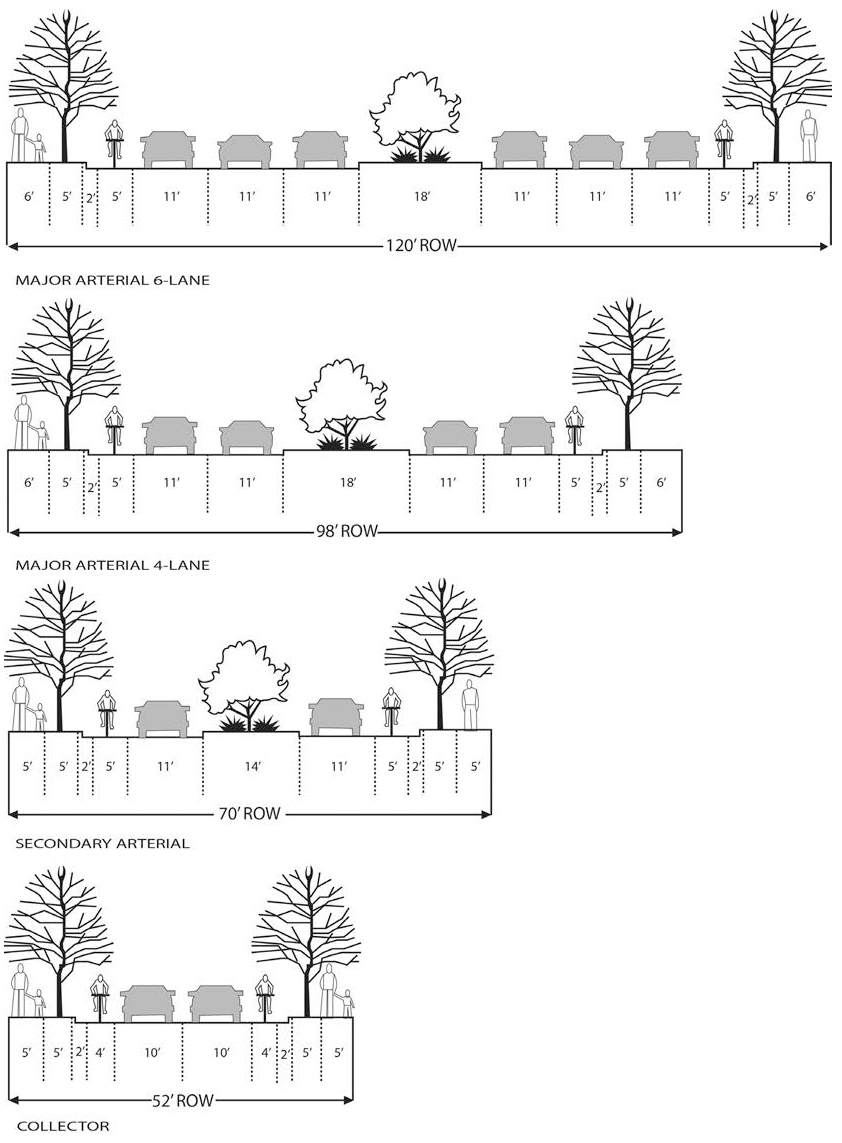
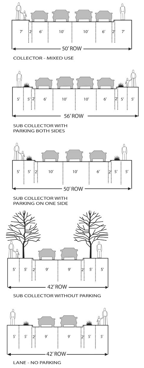
(2)
The collector mixed use street type is to be constructed in conjunction with the development of neighborhood centers and is designed to function like many of the streets near the plaza.
(3)
To better achieve the intent of this Section 14-9.2, the planning commission, or in the case of summary plats and resubdivisions, the land use director, or in the case of citystreet projects, the governing body, may consider and approve innovative street designs that are not included among the street types and street sections shown or described in this Section 14-9.2 that provide adequate pedestrian and bicycle facilities, as well as necessary transit facilities.
(4)
New development on an existing public street that does not meet the width or other applicable standards in Table 14-9.2-1 and that cannot be improved to meet those standards may exceed the average daily traffic or dwelling unit access standards in Table 14-9.2-1 without a variance.
(C)
Street Design Engineering Standards
(1)
Public and private streets and lot access driveways shall be designed and constructed in accordance with the provisions of this chapter; Chapter 12 SFCC (Fire Prevention and Protection) and any engineering standards adopted pursuant to this chapter.
(2)
Where no specific standard has been adopted, streets shall be designed in accordance with applicable standards adopted by national engineering organizations such as the American Association of State Highway and Transportation Officials and the Institute of Transportation Engineers.
(3)
Where no specific standard has been adopted, construction must comply with the current edition of the "New Mexico Department of Transportation Standard Specifications for Road and Bridge Construction."
(4)
A private street built and subsequently proposed to be dedicated to the city must meet all applicable public street standards set forth in this Section 14-9.2.
(5)
The city shall not maintain private streets.
(6)
Following are specific construction and engineering standards:
(a)
each street shall terminate in a cul-de-sac or other approved turnaround, except where the planning commission or land use director requires a street to be stubbed out at a property boundary in anticipation of future extension;
(b)
property lines at street intersections shall be rounded with a radius of ten feet, or a greater radius when necessary to allow the construction of a curb having a desirable radius. Sidewalks may not be curtailed at street corners to less than normal width. The planning commission may allow comparable cutoffs or chords in place of rounded corners;
(c)
new streets shall be dedicated and improved to the full width for which they are planned, except where a land use board or the governing body determines that an interim width or level of improvements provides safe and adequate service as part of an enforceable plan for the phased completion of the improvements;
(d)
when a tract to be developed borders an existing street having a right-of-way width insufficient to conform to the minimum width standards required by these regulations, the necessary additional right-of-way shall be platted and dedicated in such a way to make the resulting street conform;
(e)
street names shall not duplicate or be so similar as to be confusing with existing street names. Where a proposed street is to be a continuation of an existing named street, the proposed street shall have the name of the existing street. Street names must be approved by the planning commission;
(f)
curbs at intersections shall be designed with a minimum radius of twenty-five (25) feet. The planning commission may approve a smaller radius;
(g)
in areas zoned for residentialdevelopment, planting strips are required between the edge of pavement and the edge of the required sidewalks. Planting strips must have a width of not less than five (5) feet;
(h)
the planning commission may approve street access to adjoining property, requiring proposed streets to be extended by dedication to the boundary of that property. Such streets shall be improved in the same manner as prescribed for other streets in the development; and
(i)
street grades shall not exceed the following, with allowances for vertical curves:
(i)
major and secondary arterial streets or highways, six percent;
(ii)
collector and subcollector streets, ten percent;
(iii)
lanes, fifteen percent except when a lesser grade is required by the fire marshal pursuant to fire apparatus access road standards; and
(iv)
no street grade shall be less than one-half of one percent.
(7)
All new streets must be paved; provided, however, that the planning commission may approve gravel surfaces for roadways classified as private lanes or shared private driveways if it finds, based on substantial evidence, that:
(a)
vegetation or topographical maps or other evidence shows that dust from the roadways will not be a problem for residents living next to the roadway;
(b)
the gravel lane is an important consideration in the area's streetscape or in the overall project design; and
(c)
the gravel lane will not cause erosion or sediment problems or those problems will be eliminated by the use of accepted engineering methods.
(8)
Specific construction and engineering standards, lot access driveways and streets classified as lanes and certain subcollectors: (Ord. No. 2013-16 § 56)
(a)
streets classified as "lanes" shall be laid out so that use by through traffic is minimized;
(b)
lot access driveways shall be private. Streets classified as "lanes" or "subcollectors" may be constructed as private streets;
(c)
lot access driveways and private streets classified as "lanes" or "subcollectors" may be approved for access to newly created lots where the planning commission determines that no public street is needed to provide access to the property being subdivided or to surrounding properties, based on existing and planned future uses of the properties.
(d)
a roadway classified as a lane must meet the following standards:
(i)
paved lanes; and
(ii)
unpaved lanes that are approved for construction with gravel surfacing as provided in Subsection (B)(7) above
A.
twenty-two (22) feet driving surface width;
B.
eight (8) feet shoulder and drainage on each side;
C.
six (6) inch crushed gravel base course surfacing material; and
D.
thirty-eight (38) feet total right of way or access easement.
(e)
A lot access driveway that is required to provide emergency vehicle access pursuant to Chapter XII SFCC (Fire Prevention and Protection) must meet the standards of that chapter. Otherwise, a lot access driveway must have an all-weather driving surface at least ten (10) feet in width, must be no steeper than fifteen percent grade, or as required by the fire marshal and must accommodate drainage and utility facilities and easements.
(D)
Access and Traffic Calming
(1)
Where a development abuts or contains an existing or proposed arterial street, a land use board may require marginal access for collector or local streets, reverse frontage with screen planting or walls contained in a non-access reservation along the rear property line, lots with rear service alleys or such other treatment as may be necessary for adequate protection of residentialproperties and to afford separation of through and local traffic.
(2)
Where a development borders on or contains a railroad right-of-way or limited access highway right-of-way, a land use board may require a street approximately parallel to and on each side or on either side of such right-of-way, at a distance suitable for the appropriate use of the intervening land for park or recreational purposes when such purposes are appropriate in the relevant area. Such distances also shall be determined with due regard for the requirements of approach grades and future grade separations.
(3)
At least one through street that traverses the entire developed area shall be provided for each one thousand (1,000) feet of developed area. (Ord. No. 2012-11 § 26)
(4)
At least two connections to the existing road network points shall be provided for every ten acres of development. (Ord. No. 2012-11 § 26)
(5)
Where a trail network exists or is planned, access to the trail network must be provided every five hundred (500) feet, where feasible. (Ord. No. 2012-11 § 26)
(6)
Reserve strips controlling access to streets are prohibited unless the city controls the reserve strip under conditions approved by the planning commission.
(7)
Traffic calming measures are allowed in new developments and specific measures may be required by the planning commission to ensure traffic safety in new neighborhoods.
(8)
Cul-de-sacs and other dead-end streets, both public and private, may be constructed only if topography, lot configuration, previous development patterns or other natural or built features prevent continuation of the street.
(E)
Sidewalks
(Ord. No. 2013-16 § 57)
(1)
If a subdivision plat or development plan approval is required, curb, gutter and sidewalk locations shall be dedicated when the subdivision plat or development plan is recorded and constructed in accordance with applicable standards as part of the subdivision or development plan infrastructure.
(2)
If a subdivision plat or development plan is not required, curbs, gutter and sidewalks shall be constructed in accordance with applicable standards and dedicated to the city prior to issuance of a certificate of occupancy for:
(a)
construction of a new principalbuilding;
(b)
all additions over five hundred (500) square feet gross floor area;
(c)
remodeling or renovations over five (500) hundred square feet gross floor area for multiple-familyresidential and nonresidentialpermits; and
(3)
sidewalk construction is not required to exceed twenty percent of the value of the other construction covered by the permit for additions and remodeling.
(4)
Sidewalks shall be located in a cityright-of-way or, if adequate right-of-way is not available, sidewalks shall be located in a public access easement dedicated to the city on an approved plat. The sidewalk shall be consistent with the street standards of Subsection 14-9.2(C) and located along each street frontage immediately adjacent to the development.
(5)
New sidewalks, drive pads and curb ramps required pursuant to Subsection 14-9.2(E)(1) or (2) must comply with the Americans with Disabilities Act Accessibility Guidelines (ADAAG) and with New Mexico department of transportation pedestrian access details (NMDOTPAD) and must be constructed of concrete, meeting standards approved by the city or alternative materials approved by the land use director. New sidewalks constructed pursuant to Subsection 14-9.2(E)(1) must be free of any structures, signs, landscaping, above ground utility elements or other items that prevent free passage along the sidewalk. New sidewalks constructed pursuant to Subsection 14-9.2(E)(2) must be free of any structures, signs, landscaping, above ground utility elements or other items that result from the new construction and that prevent free passage along the sidewalk.
(6)
Replacement of existing sidewalks is not required if they are in good condition and substantially in compliance with ADAAG. Existing sidewalks shall be free of any structures, signs, landscaping, above ground utility elements or other items that prevent free passage along the sidewalk. However, in the situations described in Subsection 14-9.2 (E)(1) and (E)(2), the land use director may allow the sidewalk barrier to remain or approve an alternate sidewalk alignment creating free passage if the removal of the sidewalk barrier is deemed not feasible.
(7)
A new sidewalk that connects to an existing sidewalk shall be the wider of:
(a)
the width of the existing sidewalk;
(b)
the required minimum width set forth in Table 14-9.2-1;
(c)
the NMDOTPAD as may be amended by the city; or
(d)
the minimum width required by ADAAG.
(8)
A curb/access ramp meeting NMDOTPAD and city standards shall be constructed where two paved streets with curb, gutter and sidewalk intersect.
(9)
Drive pads shall comply with NMDOTPAD and any citystreet standard details.
(10)
If there is no curb or gutter, an alternative pedestrian route may be approved as part of a subdivision plat or development plan. The alternative pedestrian route shall comply with ADAAG. Consideration shall be given to future maintenance, the surrounding uses, density and the location and type of the street.
(11)
Colored concrete shall be required in the city's historic districts according to the color palette approved by the historic districts review board available from the city historic preservation division. Alternative materials may also be required by the historic districts review board. In addition, the city reserves the right to specify sidewalk color or alternative materials in other sections of the city as may be appropriate.
(12)
Construction of sidewalks shall comply with Section 23-3 SFCC 1987 (Construction and Maintenance of Curbs, Gutters and Sidewalks).
(F)
Pedestrian Crosswalks
Pedestrian crosswalks shall be included in the design of each signalized intersection and at any other street crossing locations required by the land use director and they must meet engineering standards adopted by the city. Crosswalks must connect sidewalks and must have sidewalk wheelchair ramps on each side of the street. Crosswalks shall be installed at the time of intersection construction.
(G)
Curbs and Gutters
(1)
All new streets must have curbs and gutters that meet city standards, except for roadways classified as lanes or shared private driveways if the planning commission finds, based on substantial evidence, that the following conditions are met:
(a)
absence of curbs and gutters will not contribute to the deterioration of the pavement edge, particularly on streets where on-street parking is allowed;
(b)
curbs and gutters are not necessary to channel stormwater, as shown by a site-specific drainage and stormwater control plan analysis or other means; and
(c)
curbs and gutters are not necessary to confine driveway access to specific locations and to maintain the appearance of the streetscape.
(2)
Colored concrete is required in the historic districts according to the color palette approved by the historic districts review board available from the city historic preservation division.
(H)
Maintenance of Public Parkways
Maintenance of the public parkway, generally comprised of the sidewalk setback and the sidewalk itself, is the responsibility of the person owning or in charge or control of the lot or property contiguous to the parkway, exclusive of controlled access arterials. Maintenance shall be to eliminate public nuisances and ensure pedestrian and vehicular safety and visibility, and shall include the eradication of weeds and the trimming of trees and shrubs. Maintenance shall comply with Sections 10.3 SFCC 1987 (Weeds) and 23-3 SFCC 1987 (Construction and Maintenance of Curbs, Gutters and Sidewalks).
(I)
Alleys
Alleys shall comply with the following provisions:
(1)
the right-of-way width of an alley shall not be less than twenty (20) feet;
(2)
alley intersections and sharp changes in alignment are not allowed and, where necessary, corners shall be cut off sufficiently to allow safe vehicular movement; and
(3)
dead-end alleys are not allowed.
(J)
Easements
(1)
Easements across lots or centered on rear or side lot lines shall be provided for utilities if the planning commission or the city engineer finds that they are necessary for adequate and necessary utility service to the subdivision or surrounding areas. Such easements shall be at least ten (10) feet wide and may be located over a lot line so that there is a five (5) foot easement on each lot; and
(2)
Where a subdivision is traversed by a watercourse, drainageway, channel or stream, the owner shall provide a stormwater drainage easement or right-of-way conforming substantially with the lines of the watercourse, drainageway, channel or stream and of such width and construction the planning commission finds is adequate for the purpose. Parallel streets or parkways may be required by the planning commission in connection with the drainage easement or right-of-way.
(3)
Easements required by this Section 14-9.2 shall not interfere with other easements or uses of the property on which the easement exists.
(K)
Utilities, Storm Drainage and Street Improvements
(Ord. No. 2013-16 § 58)
Utilities, storm drainage facilities and street improvements shall be provided as follows.
(1)
Standards and Specifications:
(a)
connection to city water service except as provided in Section 25-1.10 SFCC 1987 (Regulations for the Drilling of New Domestic Water Wells);
(b)
connection to city sewer services except as provided in Section 22- 3.1 SFCC 1987 (Sewers — Connection to the Public System);
(c)
approval of storm sewer system and other drainage improvement plans by the city engineer;
(d)
approval of grading and centerline gradients by the city engineer;
(e)
approval of major and secondary arterial street cross-section by the city engineer; provided, however, that the cost of improvement to the developer shall not exceed that which is required for improving a collector street.
(f)
installation of street name signs of a material and design approved by the governing body at all street intersections;
(g)
approval of complete street lighting facilities by the city engineer; and
(h)
landscaping as required by Section 14-8.4 (Landscape and Site Design).
(2)
Design Details, Construction Standards and Specifications
Design details, construction standards and specifications for utilities and storm drainage shall conform to standard details and specifications adopted by the governing body.
(L)
Landscaping
Landscaping plans shall be submitted for all roadway medians and all parkway strips. Landscaping plans shall include proposed location, size and type of vegetation or xeriscaping, including street trees, shrubs, ground cover or other proposed ground treatment in conformance with the city'slandscaping regulations. Location of proposed landscaping shall meet sight distance and other safety criteria as determined by the land use director. Landscaping plans shall show any irrigation system necessary to maintain the roadway landscaping. The final approved landscaping plans shall be implemented at the developer's cost as part of road construction and all materials shall be maintained and guaranteed by the developer for a minimum of one year or until established. Landscaping plans should comply with Resolution 2010-66, Landscape Design Guidelines for Medians and Planting Strips, as amended.
(M)
Bikeways
Bikeways shall:
(1)
be provided on each side of the street on collectors except collector mixed-use, secondary arterials and major arterials, unless a street is approved as a one way in which case a bikeway shall be placed to the right of the driving lane;
(2)
be located between the driving lane and the curb and gutter or between the driving lane and right turn lane;
(3)
be separated from the driving lane by a solid white stripe or other appropriate pavement marking or traffic separation device approved by the city; and
(4)
have a pavement width that conforms to the criteria set out in the street types-design criteria chart.
(Ord. No. 2019-27 § 13)
14-9.3 - BLOCK AND LOT AND DESIGN STANDARDS
(A)
Blocks
(1)
The lengths, widths and shapes of blocks shall be determined with due regard to:
(a)
provision of adequate building sites suitable to the special needs of the type of use contemplated;
(b)
zoning requirements as to lot sizes and dimensions;
(c)
need for convenient access, circulation, control and safety of street traffic;
(d)
opportunities and limitations of topography; and
(e)
special design standards and guidelines, including the standards provided in Section 14-5.5 (Highway Corridor Protection Districts) and applicable policies of the general plan.
(2)
Blocks shall be wide enough to allow for two rows of lots, except that a single row of lots is allowed where such lots abut an arterial street, limited access highway, drainage course, railroad right-of-way, a single row of lots in an abutting subdivision or a different zoning district; to overcome specific disadvantages of topography or location; or in similar situations.
(3)
Where restrictions on access to an adjoining road are required for all or part of the block, those restrictions shall be noted on the plat.
(4)
A landscaping easement or screen wall shall be provided where appropriate.
(5)
Pedestrian crosswalks shall not be permitted, except where the planning commission finds that they are essential to provide circulation or access to schools, parks, playgrounds, shopping areas, transportation and other public facilities and, if required, their location and width shall be as the planning commission requires to serve these purposes.
(B)
Lots
(1)
Depth, width, area and shape of sites or lots shall be adequate, as determined by the planning commission, to allow development in accordance with the applicable standards of Chapter 14, including the provisions of this article for the district in which the subdivision is located.
(2)
Each lot shall be provided with access by means of a public street, private street or private driveway in accordance with the requirements of Subsection 14-9.2(B) (Street Types - Design Criteria).
(3)
Side lot lines shall be substantially at right angles to straight streetright-of-way lines and radial to curved streetright-of-way lines.
(4)
Through lots are prohibited, except as provided in Subsection 14-9.3(A)(2).
14-9.4 - UTILITY AND STORM DRAINAGE IMPROVEMENT AND DESIGN STANDARDS
[RESERVED]
14-9.5 - INFRASTRUCTURE DEDICATION, COMPLETION AND GUARANTEES
(A)
Dedication of Rights of Way and Easements
(Ord. No. 2013-16 § 60)
(1)
On-site and off-site rights of way and easements required for public and quasi-public infrastructure shall be dedicated before or concurrently with recording a subdivision plat or filing a development plan or issuance of a construction permit for any development for which no development plan or subdivision plat is required.
(2)
All quasi-public infrastructure and land designated for ownership in undivided interest, such as private roads and drainage facilities and common open space, must be dedicated to and perpetually maintained by an owners' association or similar legal entity. An article of incorporation and bylaws for the owners' association along with a declaration of restrictions and covenants must be submitted for review and approval by the city attorney.
(B)
Infrastructure Completion or Agreement to Construct Improvements Required The developer must complete public improvements and quasi-public improvements required for any development in accordance with plans approved by the city and must pass inspection prior to commencing other aspects of the development, or the developer must enter into an agreement with the city to construct improvements as described in Subsection 14-9.5(C). If the developer seeks to construct public improvements and quasi-public improvements without entering into an agreement to construct, the developer must first submit a financial guarantee based on an engineer's estimate for the cost of site restoration plus ten percent (10%) of the construction valuation, which shall be held until the end of the twelve-month warranty period. The infrastructure must be completed or the agreement to construct improvements must be executed prior to the earliest of the following:
(1)
recording the plat for development that requires a subdivision plat other than a plat for a family transfer subdivision, a summary procedure lot split or a resubdivision;
(2)
recording or filing in city archives an approved development plan;
(3)
issuance of a construction permit for any construction other than the infrastructure, for development for which a plat for an inheritance or for a family transfer subdivision, a summary procedure lot split or a resubdivision is required; and
(4)
issuance of a construction permit for any construction other than the infrastructure, for development for which no subdivision plat or development plan is required.
(Ord. #2020-23, § 7)
(C)
Agreement to Construct Improvements, Financial Guarantee
(1)
The agreement to construct improvements must be executed by the developer according to infrastructure completion policies approved by the land use director.
(2)
The agreement to construct improvements establishes the sequence of permitting, construction, completion and acceptance of infrastructure relative to the permitting, construction, completion and occupancy of buildings and other development activities, consistent with the requirements of Chapter 14 and applicable provisions of other chapters of the Santa Fe City Code and consistent with cityinfrastructure completion policies, including requirements for:
(a)
partial completion of infrastructure prior to issuance of a construction permit for a building; and
(b)
substantial completion of the infrastructure prior to issuance of a certificate of occupancy.
(3)
The agreement to construct improvements shall include a financial guarantee in a form acceptable to the land use director for the construction cost of the infrastructure as estimated according to Subsection 14-9.5(G). If the financial guarantee uses an out-of-state financial institution, an additional contingency fee is required to reflect potential costs of possible out-of-state legal action.
(4)
All required improvements shall be completed within two years after construction begins, unless a longer time period is approved by a land use board or by the land use director for a project that is to be constructed in phases.
(5)
The developer may request a reduction in the amount of the financial guarantee when specific improvements are completed. To qualify for a financial guarantee reduction:
(a)
the improvements must be completed according to approved plans and inspected by the land use director; and
(b)
a written request for the reduction must be made using Form AIA G702 or approved equivalent format and certified by the architect or professional engineer of record.
(D)
Completion and Warranty Period Financial Guarantee
(Ord. No. 2013-16 § 61)
(1)
All infrastructure improvements shall be completed in accordance with the requirements of city regulations and approvals, and the land use director must inspect and accept all work.
(2)
The developer shall warranty the infrastructure improvements for a period of at least one year after acceptance and must repair or replace defects at no cost to the city during the warranty period. The land use director may extend the warranty period when necessary to insure that actual or potential defects are corrected.
(3)
During the warranty period, the developer shall maintain on file with the city a construction financial guarantee in an amount equal to ten percent of the cost estimate in Subsection 14-9.5(G) and it shall remain in effect until the required infrastructure has passed a final warranty inspection by the land use director. If there is no agreement to construct improvements, a separate financial guarantee for the warranty period consistent with cityinfrastructure completion policies shall be provided.
(E)
Use of Funds by City
If the required improvements are not completed in accordance with the agreement to construct improvements or the required repairs are not completed satisfactorily within the warranty period, the city may use the financial guarantee funds in any manner and in any combination it deems necessary to complete or repair the required improvements. This provision does not relieve the applicant of the obligation to complete the improvements or repairs according to the schedule in the agreement, using other funds.
(F)
Refund
If all conditions of this Section 14-9.5 have been met, including acceptance of improvements, and the warranty period has passed, the city shall refund all money not called for within thirty days of a written request from the applicant.
(G)
Construction Cost Estimate
A construction cost estimate, prepared by a professional engineer or other qualified person approved by the land use director shall be provided for all public or quasi-public improvements that are required as a condition of approval or that will be maintained by the city, unless such improvements are built out prior to plat recordation. Required improvements include those described in Section 14-9.2 (Street Improvement and Design Standards) and as listed in the cityinfrastructure completion policies. The construction cost estimate is the basis for the financial guarantees required by Subsections 14-9.5(C) and (D). The estimate and guarantees must include a ten percent contingency; provided that a five percent contingency is acceptable for nonprofit housing and economic development organizations approved by the community services department.
14-9.6 - STANDARDS FOR INHERITANCE OR FAMILY TRANSFER SUBDIVISIONS
(A)
Installation of Improvements
Any improvements required to be constructed on inheritance or family transfer subdivisions are only required to be completed at the time a construction permit is issued on any lot contained in the subdivision, and not at the time of plat approval or recordation. A financial guarantee is not required at the time of plat recordation. If an inheritance or family transfer subdivision will result in the creation of only one additional lot and will not have public sewer or water available, the applicant will be required to provide proof of appropriate well and septic assurances from the State of New Mexico prior to approval of the subdivision.
(B)
Density and District Regulations
Except as otherwise specifically provided in the Land Development Code, inheritance and family transfer subdivisions are required to meet the standards for use, density, building placement, height, open space, parking and other items set forth in the district regulations. Densities for newly annexed areas must conform to the density range provisions set forth in the general plan.
(Ord. #2021-13, § 4)