
Santa Fe City Zoning Code
ARTICLE 14
7 - BUILDING ENVELOPE AND OPEN SPACE STANDARDS AND MEASUREMENTS
(Ord. No. 2011-37 § 9)
14-7.1 - GENERAL RULES OF MEASUREMENT AND EXCEPTIONS
(A)
General Requirements
(1)
Applicability of Other Standards
In addition to the standards in this Section 14-7.1, development may be subject to standards in other portions of Chapter 14, including those in Articles 14-5 (Overlay Zoning Districts), 14-6 (Permitted Uses and Use Regulations) and 14-8 (Development and Design Standards).
(2)
General Standard for Measurements
Measurement of the standards in Chapter 14 shall be made as accurately as possible with measurement methods and technology that are commonly used in the construction industry. Where measurements are subject to specific standards contained elsewhere in Chapter 14 or are adopted by state or other regulatory agencies, those standards shall be met.
(3)
Responsibility for Compliance
Each person engaged in the development of property, and the owner of property that has been developed or that is under development, shall comply with the applicable standards of Chapter 14 and provide documentation of compliance to the land use director as necessary to verify compliance.
(B)
Dimensional Calculations
(Ord. No. 2013-16 § 36; Ord. No. 2014-31 § 17)
(1)
Net Lot Area
For lots smaller than one acre, the minimum required net lot area for residential subdivisions excludes any portion of the lot devoted to public and private streets and driveway easements such as lot access driveways and fire access roads. For single-family residential subdivisions, portions of the lot devoted to common open space or other facilities intended to serve primarily the residents of other lots are also excluded.
(2)
Lot Depth
The depth is measured between the front and rear lot lines, perpendicular to the front lot line. In the case of irregularly shaped lots, the depth shall be the average of all such measurements along the front lot line.
(3)
Reserved
(4)
Lot Coverage
Lot coverage is the percentage of the total projected area on the ground of structures in relation to the lot area.
(a)
The types and portions of structures listed in Subsection 14-7.1(D)(2) are excluded from the area covered by structures.
(b)
Eaves and similar roof projections within two (2) feet of the wall of a building are excluded from the area covered by structures.
(c)
For residentialdevelopment, the portion of the lot occupied by easements for private roads and lot access driveways is excluded from the lot area.
(d)
For single-family residentialdevelopment on lots smaller than one acre, the portion of the lot occupied by common open space, fire access roads or other facilities intended to serve primarily the residents of other lots are also excluded from the lot area.
(5)
Structure Perimeter
Structure perimeter is measured by the projected area of the structure on the ground, including all appurtenances such as eaves, bay windows, awnings and cantilevered decks.
(6)
Slope Measurement
Slopes are measured at contour intervals of five (5) feet or less. The slope percent is the relation of vertical rise from or to contour lines calculated as follows:
(H-L) x 100/D
where H equals the highest elevation of the portion of the tract measured; L equals the lowest elevation on the portion of the tract measured; and D equals the horizontal distance between H and L.
(7)
Building Frontage
As used in Section 14-8.10 (Signs), building frontage is the horizontal distance across the front of a building as near to ground level as possible. In cases where this test is indeterminate or cannot be applied, for example, where there is a diagonal corner entrance or where two or more sides of a building have entrances of equal importance and carry approximately equal amounts of pedestrian traffic, the land use director shall select the building frontage on the basis of the interior layout of the building, traffic on adjacent streets or other indicators available.
(8)
Floor Area Ratio
The gross floor area of all buildings on a lot, including covered parking structures but not roof deck parking, divided by the lot area; for example: twenty thousand (20,000) square feet of gross floor area on a ten thousand (10,000) square foot lot is a floor area ratio of 2.0:1.
(C)
General Height Standards
The general height limits contained in this article do not apply to structures for which specific standards are provided elsewhere in Chapter 14, including Section 14-8.5 (Walls and Fences). In addition to the maximum height limits and height calculation methods contained in this article, structures may be subject to height limits and calculation methods in Article 14-5 (Overlay Zoning Districts) or elsewhere in Chapter 14. Unless there is a specific provision to the contrary, the most restrictive height limit is applied as provided in Section 14-1.7 (Conflicting Provisions).
(1)
Measurement of Maximum Height
No point on a structure shall be higher than the most restrictive of the following calculations:
(a)
the maximum height specified in the tables of development standards in Sections 14-7.2, 14-7.3 and 14-7.4, measured from the average of the highest point and the lowest point of the finished grade at the perimeter of the structure; or
(Ord. No. 2012-11 § 19)
(b)
the maximum height specified plus four (4) feet, measured from the finished grade at the closest point on the perimeter of the structure; and
(c)
step-back regulations for maximum heights relative to distances from property lines that apply in certain districts as set forth in the tables of dimensional standards.
(2)
Height of Building Attachments
Except as further restricted by Section 14-5.2 (Historic Districts), the height limitations set out in Chapter 14 may be exceeded for chimneys, antennas, ventilators, elevator housings or other non-freestanding structures placed on and anchored to the roof of a building and not intended for human occupancy, by up to four (4) feet for residentialstructures and eight (8) feet for mixed use and nonresidentialstructures.
(3)
Telecommunication Facilities
When referring to a tower or other telecommunications structure, height is the distance measured from the finished grade to the highest point on the tower, antenna or other structure, including the base pad and any antenna.
(D)
Required Yards
(1)
No structure shall occupy a required yard except as provided in this Subsection 14-7.1(D) or elsewhere in Chapter 14.
(2)
The following types of structures may occupy required yards if they comply with applicable height, setback and other regulations in Chapter 14 and elsewhere in the Santa Fe City Code, including Chapters 7 (Building and Housing), 12 (Fire Prevention and Protection) and 23 (Streets, Sidewalks and Public Places) SFCC 1987.
(a)
walls and fences;
(b)
decks, planters, driveways, walkways, stairways, uncovered porches and similar structures less than thirty inches above grade;
(c)
above-ground and underground facilities of public and private utilities to the extent provided in Sections 14-6.2(E) (Telecommunication Facilities), (F) (Electric Facilities), and (G) (Underground Electric, Telecommunications and Cable Utility Lines).
(d)
above-ground and underground transformers, equipment enclosures or vaults and similar facilities of public or private utilities when located and screened as provided on an approved subdivision plat, development plan or as approved by the land use director;
(e)
underground pipes, wires and conduits such as service laterals that provide utility service to the property on which they are located or that interconnect permitted structures and equipment on the property;
(f)
above-ground wires such as service drops that are necessary to connect permitted structures to existing overhead utility distribution facilities; and
(g)
eaves or other roof projections may extend into required yards a distance of two (2) feet or less.
(3)
Minimum street yards may be reduced to match the average existing yards of the street within one hundred fifty (150) feet of the property.
(4)
Yard requirements on corner lots are:
(a)
at least one street yard shall be of the size required in the district for street yards;
(b)
other street yards on the lot shall have no less than half the depth generally required for street yards in the district; provided, however, that the street yard shall not be less than seven (7) feet; and
(c)
this Subsection 14-7.1(D)(4) does not apply to the BCD.
(E)
Separate Regulations for Properties in Escarpment Overlay District
Properties in the escarpment overlay district are subject to the slope calculations, lot disturbance limitations and other regulations set forth in Section 14-5.6 (Escarpment Overlay District).
(F)
Visibility at Driveways and Yards
(1)
Adequate Visibility; Waiver
The provisions of this Subsection 14-7.1(F) may be waived by the public works director upon a determination that adequate visibility exists consistent with the standards adopted by the American Association of State Highway and Transportation Officials (AASHTO). This Section 14-7.1 is not intended to limit the authority of the public works director to impose stricter requirements pursuant to the authority provided in Chapter 23 SFCC 1987 (Streets, Sidewalks and Public Places).
(2)
Visibility at Driveways
(Ord. No. 2014-31 § 18)
At driveways that provide access to a public or private street, no parking lot, fence, wall or other structure, hedge or planting that will obstruct drivers' views of traffic shall be erected, placed or maintained within a triangular area on either side of the driveway as follows:
(a)
for driveways serving nonresidential uses on all streets and roads and driveways serving residential uses on arterial and collector roads, the required visibility triangles for each driveway are determined by the public works director based on AASHTO standards;
(b)
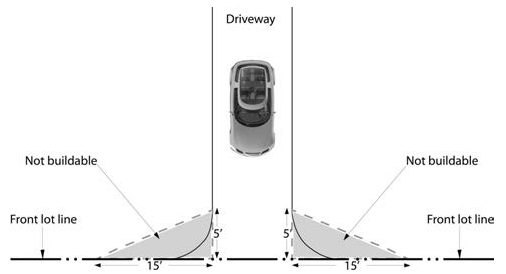
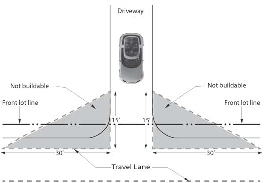
for driveways serving residential uses on streets and roads classified as subcollectors or lanes, obstructions between a height of three (3) feet and six (6) feet are prohibited within the required visibility triangles as determined by the more restrictive of:
(i)
measurements of five (5) feet along the edge of the driveway and fifteen (15) feet along the streetproperty line; and
(ii)
measurements of fifteen (15) feet back from the nearest travel lane along the edge of the driveway and thirty (30) feet along the travel lane. See Illustration 14-7.1-1.
Illustration 14-7.1-1 Visibility at Driveways on Lanes and Subcollectors
(3)
Visibility at Intersections
(Ord. No. 2014-31 § 19)
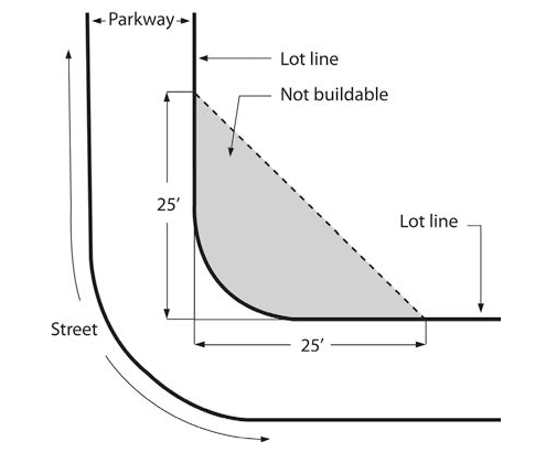
On any corner lot, no fence, wall, hedge or other planting or structure that will obstruct drivers' views of traffic shall be erected, placed or maintained within the triangular area as follows:
(a)
For intersections on streets and roads classified as arterials and collectors, the required visibility triangles for each intersection are determined by the public works director based on AASHTO standards.
(b)
For ninety degree intersections on streets and roads classified as subcollectors or lanes, obstructions between a height of three (3) feet and six (6) feet are prohibited within the required visibility triangles formed by the right-of-way lines at points that are twenty-five (25) feet from the intersection of the right-of-way lines. On any corner lot of other than ninety degrees or on corner lots with grade variations, the visibility requirement shall be adjusted by the public works director based on AASHTO standards to ensure public safety. See Illustration 14-7.1-2.
Illustration 14-7.1-2 Visibility at Intersections
(4)
Street Setback for Garage or Carport
(Ord. No. 2014-31 § 20)
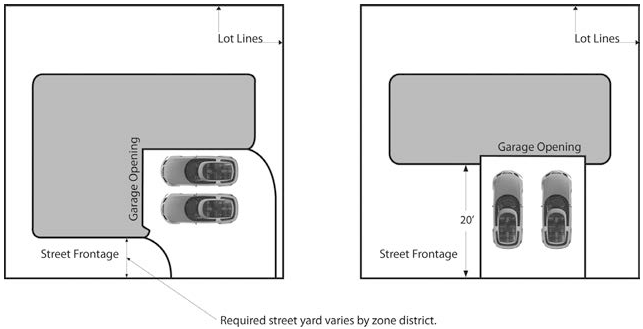
(a)
A garage or carport with a vehicle entry facing the street shall be set back at least twenty (20) feet from the streetproperty line as shown on Illustration 14-7.1-3, except as provided in Subsection (4)(b). This Subsection 14-7.1(F)(4) applies to public and private streets including lot access driveways, but does not apply to alleys.
(b)
A carport with a vehicle entry facing the street may be constructed in accordance with the minimum street yard requirements applicable to principal structures for the district within which it is located, provided that:
(i)
the carport is set back at least seven (7) feet from the street property line; and
(ii)
the carport is fully open on three or more sides and is constructed of materials and an architectural style that is the same as, or compatible with, the principaldwelling unit; and
(iii)
use of the carport is restricted to temporary parking of currently-registered, operable passenger automobiles, light trucks or motorcycles for the non-commercial use of the residents; and
(iv)
storage of any material other than the personal motor vehicles described in Subsection (4)(b)(ii) is prohibited.
Illustration 14-7.1-3 Street Setback for Garage or Carport
14-7.2 - RESIDENTIAL DISTRICTS
(A)
Table of Dimensional Standards
The standards set forth in Table 14-7.2-1 apply to all principal and accessorystructures unless otherwise provided in Chapter 14.
(Ord. No. 2012-11 § 20)
Table 14-7.2-1: Table of Dimensional Standards for Residential Districts
(Ord. No. 2013-16 §§ 37-40; Ord. No. 2014-31 § 21)
(B)
Calculation of Allowable Dwelling Units
Prior to any development approval, the maximum allowable number of dwelling units shall be calculated for the site as a whole as follows:
(1)
determine the total number of acres in the site to two decimal places, as certified by a professional land surveyor or professional engineer; and
(2)
determine the total flood way acres in the site to two decimal places, as certified by a professional land surveyor or professional engineer; and
(3)
subtract the sum of the flood way acres calculated in Subsection 14-7.2(B)(2) from the total number of acres of the site calculated in Subsection 14-7.2(B)(1);
(4)
multiply the remaining acres by the applicable gross density factor of the district as shown in Table 14-7.2-1;
(5)
for a parcel, any portion of which lies in the area labeled as mountainous and difficult terrain on Exhibit "I" following Chapter 14 and where twenty-five percent or more of the parcel has a natural slope greater than twenty percent, multiply the result calculated in Subsection 14-7.2(B)(4) by 0.75;
(6)
if the result is other than a whole number, the number shall be rounded down to the nearest whole number except as set forth in Subsections 14-7.2(B)(7) or (8). This is the allowable number of dwelling units for the site;
(7)
if the calculation is for a family transfer subdivision as set forth in Subsection 14-3.7(F)(2)(b) and the result in Subsection 14-7.2(B)(6) is other than a whole number, the number may be rounded up if it is five-tenths or more except that the number will be rounded down if neither public sewer nor water is provided;
(8)
if the result in Subsection 14-7.2(B)(6) is other than a whole number, the number may be rounded up if it is five-tenths or more; provided that the additional unit resulting from the rounding up meets the requirements of Santa Fe Homes Program (SFHP) set forth in Section 26-1 SFCC 1987 (Santa Fe Homes Program) or is a low-priced dwelling unit meeting the requirements set forth in Section 26-2.3 SFCC 1987 (Requirements for Low-Priced Dwelling Units);
(9)
SFHPdevelopment incentives pursuant to Section 14-8.11(G) may increase the maximum number of dwelling units allowed on any site; however, if a development plan has been approved, in no case shall more dwelling units be constructed than described on the approved development plan.
(10)
The minimum net lot area requirement for single-family dwellings shall be as established in Subsection 14-7.1(B)(1), Table 14-7.2-1 and Subsection 14-7.2(C); however, the number of dwelling units, and the number of lots occupied by single-family dwellings in a residential subdivision shall not exceed the number provided by this Subsection 14-7.2(B). (Ord. No. 2014-31 § 22)
(11)
The allowable number of dwelling units shall not be exceeded for the site as a whole, regardless of subdivisions or lot splits. In the event of subdivision, including lot split, the allowed number of dwelling units shall be allocated among all resulting parcels so that no parcel exceeds the allowable number of units for that parcel calculated separately and the total number of units on all parcels shall not exceed that of the original site as a whole. A note shall be placed on the plat or development plan prior to recording the first and each subsequent subdivision or lot split that prohibits a further increase in the number of dwelling units for each portion of the site unless approved by the governing body as a rezoning action or other action authorized by Chapter 14.
(C)
Lot Area Averaging in Single-Family Subdivisions
(Ord. No. 2014-31 § 23)
(1)
It is intended that the common open space required in single-family subdivisions where the lot area has been reduced from that of a conventional subdivision be a compensation to occupants for reduced lot area. It is further intended that common open space be usable and be provided for occupants outside of the lot but within the subdivision.
(2)
The minimum lot area requirement for single-familystructures is specified in Table 14-7.2-1; however the lot area may be reduced to a minimum of two thousand (2,000) square feet if common open space is provided equal to the sum of lot area reductions within the subdivision.
(D)
Minimum Yard Requirements
(Ord. No. 2014-31 § 24)
Minimum yard requirements in the R-10, R-12, R-21 and R-29 districts shall be established by an approved development plan or as set forth in this Subsection 14-7.2(D).
(1)
To facilitate creative and responsive housing types in medium to high densitydevelopments, an applicant may request approval of a development plan establishing minimum required yards different than the default required yards required by Subsection 14-7.2(D)(2). The required yards shall be based upon their relationship to the overall development and its purpose and their relationship to surrounding properties.
(2)
If minimum required yards are not established by an approved development plan as set forth in this Subsection 14-7.2(D), the minimum required yard shall be:
(a)
with the exception of detached utility sheds which must be located as set forth in Section 14-6.3(B)(2)(a), the minimum street yard shall be ten (10) feet for multiple-familybuildings containing six or more dwelling units, and seven (7) feet for all other buildings. The distance between a garage or carport facing the street and the front property line shall be as provided in Section 14-7.1(F)(4); and
(b)
except as otherwise provided in Table 14-7.2-1 Notes 13 and 14, the other required yards shall be a minimum of five (5) feet subject to the stepback requirements of Section 14-7.1(C)(1)(c) General Height Standards and Table 14-7.2-1 Note 6. For all structures other than multiple-familybuildings containing six or more dwelling units, zero-foot other yards are allowed with the concurrence of adjoining propertyowners as provided in Table 14-7.2 Note 5.
(3)
Other permissible structures have the same required yards as those set forth in this Subsection 14-7.2(D) unless otherwise specified
(E)
Increase in Maximum Height in R-21 and R-29 Districts
(1)
A height up to thirty-six (36) feet in R-21 and R-29 districts may be approved provided that the request is part of a development plan or special use permit requiring approval by a land use board or the governing body.
(2)
In evaluating the proposed height, the following factors shall be considered:
(a)
if the future land use designation shown on the general plan is high densityresidential;
(b)
the need for the increased height; however, financial gain or loss shall not be the sole determining factor;
(c)
if the height is needed to make the proposed development more affordable, what level of affordability will be provided and how that affordability will be guaranteed long term;
(d)
heights of existing buildings in the vicinity; and
(e)
impacts of the increased height upon the neighborhood and the community so that the increased height does not significantly interfere with the enjoyment of other land in the vicinity and is consistent with the spirit of Chapter 14 and in the general public's interest.
(3)
In approving the proposed height, the planning commission or board of adjustment may establish such conditions as the commission or board deems appropriate.
(4)
This Subsection 14-7.2(E) does not supersede height restrictions established within a historic district or other overlay district.
(F)
Increase in Maximum Density in R-12, R-21 and R-29 Districts
(Ord. No. 2013-16 § 41)
(1)
Residentialdensity up to twelve dwelling units per acre in an R-12 district; up to twenty-one dwelling units per acre in an R-21 district; and up to twenty-nine dwelling units per acre in an R-29 district may be approved provided that the proposed density is part of a development plan or special use permit requiring approval by a land use board or the governing body.
(2)
In evaluating the proposed density, the following factors shall be considered:
(a)
if the future land use designation shown on the general plan is high densityresidential;
(b)
the need for the increased density; however, financial gain or loss shall not be the sole determining factor;
(c)
if the increased density is needed to make the proposed development more affordable, what level of affordability will be provided and how that affordability will be guaranteed long term;
(d)
densities of existing developments in the vicinity; and
(e)
impacts of the increased density on the neighborhood and the community so that the increased density does not significantly interfere with the enjoyment of other land in the vicinity and is consistent with the spirit of Chapter 14 and in the general public's interest.
(3)
In approving the proposed density, the planning commission or board of adjustment may establish such conditions as the commission or board deems appropriate.
(4)
The provisions of this Subsection 14-7.2(F) do not apply to construction or modification of an individual single-family dwelling and related accessory structures on a legal lot of record.
(G)
Increase in Maximum Density in RR District
In the RR district, if public sewer and water are provided, the maximum gross density may be increased to three dwelling units per acre if forty percent of the site remains undeveloped and is dedicated to a homeowners' association or other private entity as common open space accessible to the residents of the development. The land to remain undeveloped is also intended to serve as a buffer to adjoining property and to protect natural features and may be counted toward the common open space requirements set forth in Table 14-7.2-1 and Section 14-7.5(B). As an alternative, and on approval of the city as to its suitability, all or part of the designated open space may be dedicated to the city as park or open space accessible to the public. Land dedicated to the city may be counted toward the park and open space requirements set forth in Section 14-8.15 (Dedication and Development of Land for Parks, Open Space, Trails and Recreation Facilities).
(H)
Maximum Nonresidential Use Area in RAC District.
(Ord. No. 2014-31 § 25)
Not more than three thousand (3,000) square feet of the gross floor area of a building shall be devoted to nonresidential uses that are not also permitted uses or special use permit uses in the R-21 district.
(I)
Mobile Home Park Standards
(Ord. No. 2012-37 § 5)
(1)
Applicability
The provisions of this Subsection 14-7.2(I) apply to mobile home parks in existence prior to December 10, 2012 (effective date of this Ordinance No. 2012-37).
(2)
General Site Standards
(a)
Qualifying open space shall be provided as required for development in the R-7 district as provided in Subsection 14-7.5(C).
(b)
The mobile home park site shall be graded to ensure proper drainage.
(c)
The mobile home park shall provide spaces that are well defined and delineated. Minimum lot size per mobile home unit shall be four thousand (4,000) square feet.
(d)
Each mobile home space shall provide a mobile home stand of concrete footing adequate to support a mobile home. The stand and space shall be graded to provide adequate storm drainage away from the mobile home.
(e)
A maximum of seven mobile home spaces per acre shall be allowed in any mobile home park.
(f)
There shall be at least a twenty (20) foot clearance between mobile homes. No mobile home shall be located closer than ten (10) feet to any building or to any property line. accessorystructures such as decks and stairways may be attached to the mobile home to which they provide access, but shall be separated from other buildings and structures by ten (10) feet.
(g)
Each mobile home space shall be provided with two off-street parking spaces, which shall be paved or covered with crushed stone or other suitable material. No on-street parking shall be allowed.
(h)
Walkways not less than thirty-six (36) inches in width shall be provided from all mobile home spaces to all service buildings.
(i)
All driveways and walkways within the mobile home park shall be hard-surfaced and well lighted.
(j)
All private subcollector, lane and place streets within the mobile home park shall have a minimum pavement width of twenty-four (24) feet. Private collector streets within the mobile home park shall have a minimum pavement width of thirty (30) feet. All public streets shall comply with the right-of-way requirements and subdivision design standards set forth in Article 14-9 SFCC 1987 (Infrastructure Design, Improvement and Dedication Standards) except as specified in this Section 14-7.2.
(k)
The perimeter of the mobile home park shall be landscaped and fenced. Landscaping shall consist of deciduous canopy trees spaced no more than twenty (20) feet apart, having a minimum two (2) inch caliper at the time of planting. Fencing shall consist of either a six (6) foot tall solid wall or fence constructed of opaque materials.
(l)
All mobile home parksigns shall conform to the requirements of Section 14-8.10 (Signs).
(3)
Service Buildings
(a)
If provided, service buildings that house sanitation facilities shall be permanent structures complying with all applicable ordinances and statutes regulating buildings, electrical installations and plumbing and sanitation systems.
(b)
Service buildings shall be:
(i)
well-lighted at all times of the day and night;
(ii)
well-ventilated with screened openings;
(iii)
constructed of moisture-proof material, which may be painted woodwork, that allows for repeated cleaning and washing;
(iv)
maintained at a temperature of at least sixty-eight degrees Fahrenheit during the period from October 1 to May 1; and
(v)
have floors of water-impervious material.
(c)
All service buildings and the grounds of the mobile home park shall be maintained in a clean, sightly condition and kept free of any condition that menaces the health of any occupant or the public or constitutes a nuisance.
(4)
Solid Waste Containers
Solid waste containers shall be provided, maintained and emptied in accordance with applicable regulations and as approved of the Solid Waste Division.
(5)
Fire Protection
Every mobile home park shall be equipped at all times with fire extinguishing equipment in good working order, of such type, size and number and so located within the mobile home park as to satisfy applicable reasonable regulations of the fire department.
(6)
Supervision
An attendant or caretaker shall be in charge at all times to keep the mobile home park, its facilities and equipment in a clean, orderly and sanitary condition. The attendant or caretaker shall be answerable, with the permittee, for violations of any provision of this Section 14-7.2 to which the permittee is subject.
(7)
Manufactured Homes in Mobile Home Parks
Manufactured homes are permitted in mobile home parks in existence prior to December 10, 2012 (effective date of this Ordinance No. 2012-37).
(Ord. #2021-13, §§ 2, 3)
14-7.3 - NONRESIDENTIAL AND MIXED-USE DISTRICTS
(A)
Table of Dimensional Standards
(Ord. No. 2013-16 § 42; Ord. No. 2014-31 § 26)
The standards set forth in this table apply to all principal and accessorystructures unless otherwise provided in Chapter 14.
(B)
Additional Regulations
(1)
MU District Standards
(a)
Architectural Step-Backs
Third floors shall have a step-back (balcony or roof area) of a minimum of five (5) feet from all the building'sfaçades at the ground level.
(b)
Separation of Uses
Where
any of the following uses exist on an adjoining site, group living or household living uses shall be separated from the following uses by a minimum distance of fifty (50) feet:
(i)
a drive-through use or facility, including gas stations, car washes, restaurants and banks;
(ii)
animal hospitals or clinics with external overnight boarding;
(iii)
child day care facilities with more than thirty children;
(Ord. No. 2012-11 § 21)
(iv)
outdoor storage of material;
(v)
restaurants and bars operating between the hours of 10:00 p.m. and 7:00 a.m.;
(vi)
liquor stores;
(vii)
(viii)
any land use that the planning commission determines will produce environmental impacts, processes or products that are incompatible with residential uses, and that is noted on the approved master plan or development plan.
(c)
Building Tenant Space
No single commercial tenant space shall exceed a total of twenty thousand (20,000) square feet.
(d)
Residential Uses
(i)
Residential uses shall consist of at least forty percent of the development's total floor area if located adjacent to residentially zoned districts. If not, residential uses shall consist of at least twenty percent of the development's total floor area. The master plan, plat and development plan shall show this residential/commercial mix.
(ii)
Buildings of twenty-five (25) feet or less in height shall not exceed a maximum of twelve (12) dwelling units per acre and buildings of between twenty-five (25) feet and thirty-five (35) feet or less in height shall not exceed fourteen (14) dwelling units per acre.
(iii)
Each dwelling unit shall be provided with a minimum of two hundred fifty (250) square feet of qualifyingprivateor common open space.
(2)
Property Formerly Zoned Industrial Park
Any property previously zoned industrial park with master plan approval on or before the date of adoption of the BIP zoning district shall be governed by and subject to the approved master plan. Where a conflict exists between the approved master plan and the requirements of this Section 14-7.3, the more lenient standard shall prevail.
14-7.4 - BUSINESS-CAPITOL DISTRICT
(A)
Table of Dimensional Requirements for Townscape Subdistricts
14-7.4(A)-1 Table of Dimensional Requirements for Townscape DistrictsNote 1
(B)
Additional Regulations
(1)
Standards for Entire District
(a)
Baseline Land-Use Intensity
For the BCD in general, the baseline floor area ratio shall be 2.0:1, except for the Plaza/San Francisco, Alameda, redevelopment and Loretto subdistricts, where the baseline floor area ratio shall be 2.5:1; provided, however, that a baseline floor area ratio of 2.5:1 shall not be allowed if it is judged to be incompatible with an adjacent neighborhood or townscape subdistrict. Areas within a structure, the ceiling of which are below average finished grade, and at-grade parking areas, do not count toward the allowable floor area.
(b)
Land-Use Intensity Credits:
(i)
a land-use intensity credit of up to fifty percent of all floor area in residential use may be granted in conjunction with approval of a master plan, development plan or special use permit, provided that no floor area ratio shall exceed 3.0:1. The additional floor area granted may be used for any permitted use. Floor area granted as a credit is not eligible for any additional credit. Floor area of parking structures above-grade count toward gross floor area except for the floor area of roof deck parking. Subsurface areas and at-grade parking areas do not count toward the allowable floor area;
(ii)
the final floor area ratio of a project, including land-use intensity credits, shall be limited by infrastructure capacity and townscape standards, where applicable; and
(iii)
calculation of the floor area ratio shall include existing structures on a legal lot of record where development is proposed.
(c)
Drive-in or Drive-through Facilities
Drive-in or drive-through facilities are permitted as principal or accessory uses and structures in the Rosario Boulevard/Northwest Paseo de Peralta, Sandoval/Montezuma and Cerrillos Road Subdistricts, where traffic generated by the use will not substantially interfere with existing vehicular and pedestrian traffic. Drive-in or drive-through facilities are prohibited in the other subdistricts of the BCD.
(2)
Standards for Redevelopment Subdistricts
(Ord. No. 2013-16 § 43)
(a)
Land-use Intensity:
(i)
transfer of allowed floor area, including land use intensity credits, within a property or between contiguous properties with a single ownership and within a project is allowed; and
(ii)
public benefit uses shall not count against the allowable floor area for a parcel.
(iii)
The maximum baseline floor area ratio permitted is 2.5:1 unless provided otherwise in the master plan or at the time of rezoning pursuant to Section 14-4.3(E)(4)(b)(ii).
(b)
Maximum Height of Buildings
The maximum building height permitted in a redevelopment subdistrict shall not exceed sixty-five (65) feet; provided, however, that the maximum height shall be compatible with the character of adjacent subdistricts and the surrounding neighborhood.
(c)
Additional Standards
Additional standards for redevelopment subdistricts are located in the subdistrict master plan. Development in a redevelopment subdistrict shall comply with the master plan. If no master plan has been approved for a portion of a redevelopment subdistrict, development must conform to the standards of the adjacent or nearest BCD subdistrict.
(3)
Design Objectives for Individual Townscape Subdistricts
The best existing qualities of the individual townscape subdistricts should be preserved, while encouraging diversity of design in the individual townscape subdistricts. New development should be harmonious with the specific physical characteristics and development and design objectives listed below:
(a)
Alameda Street Subdistrict:
(i)
allow more intensive development because of the lack of historical or well-defined townscape characteristics;
(ii)
strengthen continuity of block forms;
(iii)
strengthen the built edge of street sections and extend features of the Plaza streetscape to this district;
(iv)
improve the sense of enclosure to pedestrian spaces;
(v)
separate vehicles and pedestrians;
(vi)
emphasize the river park by allowing relatively dense buildings north of the Alameda in contrast to the park;
(vii)
recognize the importance of the river as an urban design feature; and
(viii)
provide some natural landscape on the north side of the Alameda to reflect the natural landscape of the Santa Fe river park.
(b)
Barrio de Analco Subdistrict:
(i)
maintain narrow streets and closely spaced small buildings;
(ii)
avoid the widening of existing streets;
(iii)
maintain the historic character and residential scale of buildings; and
(iv)
maintain and encourage enclosed courtyards.
(c)
Cerrillos Road Subdistrict:
(i)
recognize this area as one undergoing renewal;
(ii)
encourage the redevelopment of large parcels;
(iii)
provide flexible and permissive standards to encourage redevelopment and imaginative design;
(iv)
develop this area as an entranceway to the downtown with consideration for safety due to high traffic volume;
(v)
discourage massive, block-shaped buildings; and
(vi)
encourage the concept of this area as a gateway to downtown Santa Fe.
(d)
Don Gaspar Subdistrict:
Maintain the small scale and residential character and streetscape.
(e)
East Marcy/East Palace Subdistrict:
(i)
maintain the continuity of blockfaces, including street trees and yards;
(ii)
retain the residential scale of the area by limiting building heights and requiring yards;
(iii)
encourage low walls that are compatible with the characteristic open yards; and
(iv)
encourage a sense of openness.
(f)
Loretto Subdistrict:
In recognition of City Council Resolution 1971-3, the design and development standards in the Loretto subdistrict:
(i)
encourage the continued redevelopment of this subdistrict; and
(ii)
provide for architectural harmony within the subdistrict and with adjoining subdistricts.
(g)
Marcy Street Subdistrict:
(i)
maintain street trees and stands of trees as dominant elements in the subdistrict;
(ii)
maintain avenue features, such as broad streets, planting strips, street trees and wide sidewalks;
(iii)
maintain a sense of openness to provide occasional view of the mountains;
(iv)
separate pedestrians from vehicles using planting strips and street trees while providing an enclosed space; and
(v)
maintain the relationship between the height and mass of trees and the height and scale of buildings.
(h)
McKenzie Street Subdistrict:
(i)
maintain the residential scale;
(ii)
maintain yards, with or without fences; and
(iii)
maintain separation of individual structures.
(i)
Old Santa Fe Trail Subdistrict:
(i)
maintain the small scale quality of buildings and streets;
(ii)
maintain the existing width of the old Santa Fe Trail;
(iii)
maintain the scale of buildings; and
(iv)
encourage compliance by the state in design of future development.
(j)
Plaza/San Francisco Subdistrict:
(i)
maintain narrow streets and continuous streetfaçades;
(ii)
encourage additional portals for pedestrian use and provide continuity of building mass;
(iii)
limit building height to heights characteristic of existing buildings;
(iv)
encourage high walls to separate open or vacant areas from the public right of way and provide continuity of streetfaçade;
(v)
except for Plaza and Cathedral areas, confine landscaping to interior patios or walled courtyards; and
(vi)
emphasize verticality of façades on San Francisco Street.
(k)
Rosario Boulevard/NW Paseo de Peralta Subdistrict:
(i)
recognize the area as one in the process of change;
(ii)
facilitate the redevelopment of large parcels within single ownership;
(iii)
provide flexible standards that encourage redevelopment and diversity of design;
(iv)
emphasize the strategic position of this area as a gateway into downtown Santa Fe; and
(v)
provide standards that minimize the impact or height and bulk of structures on the entryways to the downtown.
(l)
Sandoval/Montezuma Subdistrict:
(i)
recognize that the area is in transition;
(ii)
encourage adaptive reuse of existing buildings on Guadalupe Street and existing bungalows on west Manhattan, Read, Garfield, Montezuma and Aztec Streets;
(iii)
maintain and strengthen the continuity of the existing streetfaçade on the east side of Guadalupe Street;
(iv)
encourage access from side streets;
(v)
discourage additional curb cuts on main streets; and
(vi)
encourage redevelopment of under-used property along Sandoval Street and Cerrillos Road.
(m)
State Capitol Subdistrict:
(i)
retain the open "campus" quality of this area as a contrast to surrounding developed areas;
(ii)
recognize the area as complementary to the Santa Fe river park; and
(iii)
maintain intensive landscape treatment.
(n)
Westside Subdistrict:
Maintain the small scale and residential character and streetscape.
14-7.5 - OPEN SPACE STANDARDS
(Ord. No. 2014-31 § 27)
(A)
General Provisions
Open space shall be provided that meets the minimum standards of this Section 14-7.5, Section 14-8.4(H) Open Space Planting Requirements and other applicable requirements of Chapter 14. All required open space shall meet the following standards:
(1)
Open space consists of areas that are landscaped or that preserve natural vegetation, and may include outdoor facilities for passive or active recreation.
(2)
Open space does not include streets, driveways, parking or loading areas, fire apparatus access roads and turnarounds, storage areas or buildings.
(3)
Residential open space must be provided for each unit in the total amount specified in Table 14-7.2-1. common or private open space may be provided in any combination that meets applicable standards. Private open space provided in excess of the minimum requirement for a unit may not be used to reduce the open space for any other unit.
(B)
Residential Common Open Space Standards
(1)
The intent of common open space is to provide useable outdoor space for residents of developments, promote compact urban form, screen and buffer conflicting zoning categories and, in general, enhance the quality of the urban environment. Where appropriate, open space should contribute to the preservation of Santa Fe's natural features, especially hillsides and arroyos. Consideration shall be given to providing wildlife habitat, especially by providing open space along arroyos, stream corridors and linkages to other habitat areas. To the greatest extent possible, connections shall be provided to public open space and the urban trail system and bicycle paths or in such a way that a future connection is facilitated. The most appropriate use or uses for outdoor space shall be proposed and assessed on a case-by-case basis and may include active or passive use.
(2)
A minimum of fifty percent of common open space shall be useable space for active or passive recreation or pedestrian ways that include interior sidewalks and patios. The land use director, a land use board or the governing body may require tot lots or other play areas and equipment, walking paths, benches and lighting.
(3)
Common open space may include areas used for retention or detention of stormwater provided that all other applicable standards are met.
(4)
Common open space shall be no less than fifteen (15) feet in any dimension and no less than five hundred (500) square feet per segment.
(5)
Common open space shall be dedicated to a homeowners' association or owned and maintained by the owner of rental housing developments. If dedicated to a homeowners' association, there shall be covenants running with the land restricting the use of common open space to that use and prohibiting subdivision or separation of ownership of the common open space. The restriction shall be noted on the development plan or final plat.
(6)
Accessorydwelling units are required to provide the same amount of private open space as other dwellings in the district; however, private open space for the accessorydwelling unit may be connected to private open space for the principal dwelling unit, and up to fifty percent of the private open space required for the accessory dwelling unit may be the same private open space provided for the principaldwelling unit.
(C)
Residential Private Open Space Standards
The intent of private open space is to ensure easily available access to the outdoors in medium- to high-densitydevelopments, and to provide for a sufficient sense of privacy. Requirements for private open space are as follows:
(1)
the maximum lot coverage may be increased in accordance with Table 14-7.2-1 if open space for each dwelling unit is provided as follows:
(a)
for lots in R-1, R-2, R-3, R-4, R-5, R-6, R-7, R-7I, R-8, R-9, RC-5 and RC-8 districts, an amount not less than fifty percent of the total gross floor area of that dwelling unit; and
(b)
for lots in R-10, R-12, R-21 and R-29 districts, an amount not less than thirty percent of the total gross floor area of that dwelling unit.
(c)
The open space provided to meet the requirements of Subsections (1)(a) and (1)(b) above may be counted toward meeting the open space requirement in Table 14-7.2-1 for multi-family dwelling units.
(2)
balconies, roof decks or roofed areas such as porches or portals may be included as all or part of the required private open space;
(3)
private open space does not include stormwater ponding areas;
(4)
the minimum dimension for required private open space located on the ground shall not be less than twelve (12) feet, and not less than four (4) feet and forty (40) square feet for balconies, roof decks or other private open space that is not located on the ground;
(5)
finished grade for required private open space shall have a slope no greater than one (1) vertical foot in ten (10) horizontal feet; and
(6)
accessory dwelling units shall also be required to meet the private open space criteria in this Subsection 14-7.5(C); provided, however, that private open space for the accessory dwelling unit does not have to be physically separated from the private open space for the principaldwelling unit, and up to fifty percent of the private open space required for the accessory dwelling unit may be the same private open space provided for the dwelling unit; and
(7)
there are no planting requirements for private open space.
(8)
Private open space must be adjacent to and directly accessible from the unit for which it is provided.
(D)
Nonresidential and Mixed Use Open Space Standards
(1)
Open space shall be provided in nonresidential and mixed usedevelopments to promote environmental health; foster a sense of openness; provide light and air; preserve existing vegetation or provide new vegetation to help oxygenate the air; provide shade; help control stormwater runoff and erosion; and improve ground water quality.
(2)
Nonresidentialopen space shall be planted and linkage provided to public open space, following the same requirements as for residentialcommon open space in Subsection 14-7.5(B).
(3)
Planting requirements are the same as for residentialopen space and may be combined with other landscape requirements, including those for street tree planting and parking lots.
(4)
The minimum dimension for nonresidentialopen space shall be ten (10) feet and cover a minimum of three hundred (300) square feet, unless the area is a component of interior parking landscape and meets the requirements for open space credits for water harvesting described in this Subsection 14-7.5(D)(6).
(5)
The percentage of required open space shall be calculated on the basis of total lot area, and shall be no less than twenty-five percent unless the conditions described in Subsection 14-7.5(D)(6) are met; then the required open space may be reduced by a maximum of ten percent of the total lot size. More restrictive requirements for individual zoning districts apply.
(6)
To encourage an increase in permeable surface area, to reduce stormwater runoff and erosion, to increase infiltration, and to encourage water conservation and water harvesting, the required open space may be reduced as follows:
(a)
The open space requirement for development that incorporates a passive water harvesting concept that is a primary component of stormwater management is twenty (20) percent of the total lot area. The open space requirement for development that incorporates an active water harvesting and distribution system that is a primary component of stormwater management and that is a component of outdoor irrigation or suitably treated for indoor use is fifteen (15) percent of the total lot area. The credits shall be earned through the application of engineering calculations that are submitted as a part of the landscape plan and the terrain management regulations provided in Section 14-8.2 Terrain and Stormwater Management. The calculations shall show the percentage of water harvested and the estimated water conserved based on the required water budget provided in Section 14-8.4(E) Water Harvesting and Irrigation Standards; and
(b)
the open space reduction shall not result in an increase in parking area.
(7)
An applicant for a construction permit shall not be required to lose existing parking spaces or other previously developed area in order to fulfill the open space requirement, but may not increase the intensity of a use or create an addition that would result in a decrease in open space below the minimum required, unless existing impervious surfaces are retrofitted for stormwater management as described in Section 14-8.4 Landscape and Site Design.
(8)
Additional Requirements in BIP, MU and C-2 Districts
(a)
BIP districts
(i)
To encourage pedestrian amenities and preservation of existing vegetation, open space shall be provided at a minimum of forty percent of the total master plan area.
(ii)
As an incentive for providing commonly shared site amenities, and as may be appropriate to more urban development, the planning commission may grant double the square footage of site amenities to be counted toward the open space requirement. Site amenities shall be accessible, and include the following examples: 1) interior trail systems; 2) small plazas; 3) fountains; 4) children's play areas; and 5) public art. In no case shall the amount of open space be less than twenty-five percent of the total master plan area.
(b)
MU districts
A common, landscaped open area with seating shall be provided with a minimum size of five hundred (500) square feet per acre of development. The area shall be open to the sky and be suitably lighted and be designed to encourage social interaction.
(c)
C-2 District
Open space is required for each ground-floor dwelling unit at a minimum of two hundred fifty (250) square feet. Dwelling units located above the ground floor are not required to provide open space.
(9)
Any residentialopen space provided in a mixed residential and nonresidentialdevelopment may be credited toward the total MU or nonresidentialopen space requirement.