
Scottsdale City Zoning Code
ARTICLE VI
- SUPPLEMENTARY DISTRICTS
Sec. 6.100.- (HP) Historic Property. [10]
Editor's note— Ord. No. 3242, § 7, adopted July 13, 1999, repealed §§ 6.100—6.108 in their entirety. Subsequently said ordinance added §§ 6.100—6.125 which pertained to similar subject matter.
Sec. 6.111.- Purposes.
The (HP) Historic Property zoning overlay district is intended to protect and enhance the cultural, historical, social or archaeological heritage of the City of Scottsdale. The HP District encourages the retention of historic resources by keeping them in active use in their original appearance, setting, and placement. More specifically, the purposes of these historic preservation regulations are to:
A.
Protect, enhance and preserve improvements and landscape features of historic resources which represent distinctive elements of the city's cultural, educational, social, economic, political, architectural and archaeological history;
B.
Safeguard the city's historic, aesthetic and cultural heritage, and encourage cultural heritage tourism at appropriate historic and archaeological sites;
C.
Foster civic pride in the accomplishments of the past and promote public awareness of the rich heritage of Scottsdale from all periods of history and prehistory;
D.
Retain and enhance historic resources and those properties which contribute to the character of an Historic Property District, and encourage their adaptation for current use;
E.
Assure that alterations of existing structures are compatible with the original structure and character of an historic resource;
F.
Assure new construction and subdivision of lots in an Historic Property District are compatible with the character of the District;
G.
Encourage the restoration of historic resources, and protect and enhance property values through the restoration, preservation and promotion of historic resources.
(Ord. No. 3242, § 7, 7-13-99)
Sec. 6.112.- Definitions.
In addition to the definitions found in section 3.100 of the Zoning Ordinance, and where there is a conflict between definitions, the following definitions apply to section 6.100 of the Zoning Ordinance:
Alter or remodel shall mean any architectural, structural, landscaping, electrical, or mechanical change to an historic resource that requires a building permit.
Building shall mean a structure created to shelter any form of human activity, such as a house, barn, church, hotel, or similar structure. The term "building" may refer to an historically related complex such as a courthouse and jail, or a house and barn.
District shall mean a geographically definable area, urban or rural, possessing a significant concentration, linkage, or continuity of sites, buildings, structures, or objects united by past events or aesthetically by plan or physical development. A district may contain areas that are geographically separated but linked by association or history.
Historic property or historic resource means any prehistoric or historic district, site, building, structure, object, or landmark included in, or eligible for inclusion on, the National Register of Historic Places, the Arizona Register of Historic Places, or the Scottsdale Historic Register, including artifacts, records, and material remains related to such property or resource. The term includes archaeological resources.
Institution means a nonprofit corporation or a nonprofit establishment for public use.
Landmark shall mean an historic resource that the City Council designates as possessing exceptional significance.
Object shall mean a material thing of functional, aesthetic, cultural, historical or scientific value that may be, by nature or design, movable yet related to a specific setting or environment. This term may include landscape features.
Site shall mean the location of a significant event, a prehistoric or historic occupation or activity, or a building or structure, whether standing, ruined, or vanished, where the location itself maintains historical or archeological value regardless of the value of any existing structure. A site may encompass more than one lot or parcel.
Structure shall mean any piece of work constructed or erected by humans, and made up of interdependent and interrelated parts in a definite pattern.
(Ord. No. 3242, § 7, 7-13-99; Ord. No. 4143, § 1(Res. No. 9678, Exh. A, § 124), 5-6-14)
Sec. 6.113.- Criteria.
A.
Historic Resource. To be eligible for designation as an historic resource and placement on the Scottsdale Historic Register, a district, site, building, structure, or object must be located in Scottsdale and have special historical significance in United States, Arizona or Scottsdale history, architecture, archaeology, engineering, or culture. Fifty (50) years of age is a general estimate of the time necessary for achieving historical significance, but resources younger than fifty (50) years are eligible for designation as an historic property and placement on the Scottsdale Historic Register in appropriate cases. Historical significance is present in buildings, districts, structures, sites, and objects that possess integrity of location, design, setting, materials, workmanship, feeling, and association, and:
1.
That are associated with events that have made a significant contribution to the broad patterns of our history; or
2.
That are associated with the lives of persons significant in our past; or
3.
That embody the distinctive characteristics of a type, period, or method of construction, or that represent the work of a master, or that possess high artistic values, or that represent a significant and distinguishable whole whose components may lack individual distinction; or
4.
That have yielded, or may be likely to yield, information important in prehistory or history; and
5.
That in addition to having retained their integrity of location, design, setting, materials, workmanship, feeling, and association, possess physical features necessary to convey that significance and are significant within the historic context of the Scottsdale geographic area and chronological periods known to have been associated with the occupation and settlement of Scottsdale by people from all involved cultures.
B.
Landmarks. To be eligible for designation as a Landmark, a district, site, building, structure or object must meet all the criteria for designation as an historic resource and placement on the Scottsdale Historic Register, and in addition must possess exceptional significance in United States, Arizona or Scottsdale history, archaeology, architecture, engineering, or culture, as determined by the City Council. Such exceptional significance is present in those historic resources which:
1.
Contain outstanding or extraordinary examples of an architectural style; and/or
2.
Contain or are associated with a major historic event or activity; and/or
3.
Are associated with the lives of historically significant persons; and/or
4.
Embody distinctive characteristics of a type, period, or method of construction; and/or
5.
Represent the work of a master; and/or
6.
Contain important, intact archaeological resources; and/or
7.
Are of unique visual quality and identification; and/or
8.
Are of general historic or cultural recognition by the community.
(Ord. No. 3242, § 7, 7-13-99; Ord. No. 4143, § 1(Res. No. 9678, Exh. A, § 125), 5-6-14)
Sec. 6.114.- Existing HP exemption.
Properties that were zoned HP Historic Property under the old HP zoning standards, last amended by Ordinance No. 2830, shall be exempt from the new HP District ordinance standards for a period of one (1) year from the effective date of Ordinance No. 3242. This exemption shall only apply to properties zoned HP prior to the effective date of the new HP District standards.
A.
The properties zoned HP prior to the new standards shall continue to follow all the old HP Historic Property district standards during the one (1) year exemption period.
B.
At the end of the one (1) year exemption period, all of the HP District standards in Ordinance No. 3242 shall apply to the exempt properties zoned HP under the old standards, provided that the HP District has not been removed by an ordinance adopted by City Council during the exemption period.
(Ord. No. 3242, § 7, 7-13-99)
Sec. 6.115.- Use regulations and property development standards.
A.
Uses permitted. Any use permitted in the underlying zone.
B.
Uses permitted by conditional use permit. Any use permitted by conditional use permit in the underlying zone.
C.
Property development standards. The development standards of the underlying zone shall apply in addition to the development requirements imposed by this section on Historic Property.
(Ord. No. 3242, § 7, 7-13-99)
Sec. 6.116.- Off-street parking.
The provisions of article IX shall apply.
(Ord. No. 3242, § 7, 7-13-99)
Sec. 6.117.- Signs.
The sign provisions of article VIII shall apply.
(Ord. No. 3242, § 7, 7-13-99)
Sec. 6.118.- Additional procedures for designating property HP District.
An application to designate property as historic is a request for overlay zoning on the property by applying the (HP) Historic Property zoning overlay district to the subject area. All rezoning notice and public hearing requirements of state law and Article I of the Zoning Ordinance must be followed for any HP District rezoning in addition to the requirements of this section. The additional procedures for designating property historic and for placement of the property on the Scottsdale Historic Register are as follows:
A.
Upon receipt of the proper forms, and, where required, payment of the application fee, the Historic Preservation Officer shall publish notice in a newspaper of general circulation in the City that an application has been filed and will be considered by the Historic Preservation Commission at a public hearing at a specified date, time and place, at which time the community shall be given the opportunity to be heard. This public hearing notice shall be published not less than fifteen (15) days before the hearing and shall describe the location of the property and the nature of the application being considered.
B.
The Historic Preservation Officer or designee shall conduct a preliminary study of the application and make a recommendation in the Historic Designation Report to the Historic Preservation Commission.
C.
The Historic Preservation Commission shall review the application and the Historic Designation Report, and recommend to the Planning Commission and City Council approval or denial of the application.
D.
At its public hearing on the request to place HP District overlay zoning on the property, the Planning Commission shall consider the application for HP District designation, the Historic Designation Report, and the recommendation of the Historic Preservation Commission. Notice of the hearing and posting the property shall be in accordance with the law applicable to a zoning map amendment.
E.
After the Planning Commission has held a public hearing on the proposed zoning district map amendment and makes its recommendation, the City Council shall hold a public hearing. The City shall notify the applicant(s) and owner(s) of record of the proposed designated property of the date, time, and place of the public hearing, and shall provide notice of the public hearing in accordance with the law applicable to a zoning map amendment.
F.
The City Council shall approve, approve with modifications, or deny the request for HP District designation and rezoning, and any associated Historic Preservation Plan. In the event further proceedings are deemed necessary, the City Council may remand the application to the Planning Commission and/or the Historic Preservation Commission. The property owners may file a legal protest in accordance with Section 1.706 of the Zoning Ordinance of the City of Scottsdale.
G.
If the City Council approves the HP District designation the Historic Preservation Officer shall record the designation in the Scottsdale Historic Register.
H.
Designation of an Historic Property District shall be followed by City Council adoption of a supplemental zoning map adding the suffix "HP" to the zoning classification of the property.
I.
The following apply to designation of an historic resource as a Landmark:
1.
Scottsdale Landmark designation can occur for a property already within an HP District zoning overlay or in conjunction with HP District designation.
2.
As part of the recommendation to City Council for Landmark designation, the Historic Preservation Commission and/or the Planning Commission shall adopt findings documenting the uniqueness and exceptional significance of the subject historic resource.
(Ord. No. 3242, § 7, 7-13-99; Ord. No. 4143, § 1(Res. No. 9678, Exh. A, § 126), 5-6-14)
Sec. 6.119.- Historic Preservation Plan
A.
Before or within a reasonable time, as determined by the Historic Preservation Officer, following City Council approval of the HP District designation for an historic resource, the property owner and the Historic Preservation Officer shall prepare an Historic Preservation Plan. Such a plan shall:
1.
Identify the geographical location of the HP District, and
2.
Specify the objectives concerning the development or preservation of buildings, sites, objects, structures and landmarks within the HP District, and
3.
Formulate a program for public action including the provision of public facilities and the regulation of private development and demolition necessary to realize these objectives, and
4.
Describe any plans for public access and visitation of the property, including any planned participation in a cultural heritage tourism program, and
5.
Set forth standards necessary to preserve and maintain the historical character of the historic resource. These standards shall include design guidelines that shall apply only to the exterior features of the historic resource.
a.
Each Historic Preservation Plan shall include a general set of standards, reflecting the overall character of the HP District, which shall be used by the Historic Preservation Commission and the Historic Preservation Office to review applications for the certificates required within the HP District.
b.
When the HP District involves single-family residences, the Historic Preservation Plan may include a development agreement and/or a preservation easement.
c.
Upon approval by the City Council, an Historic Preservation Plan may include a specific set of design guidelines that modify the standards set in the underlying zoning district. If any of these provisions are to be contained in design guidelines for an HP District, the guidelines shall be approved according to the procedures for establishing HP Districts, including the public hearing processes before the Planning Commission and the City Council. In the alternative, this specific set of guidelines may be made part of the ordinance establishing the District and placing overlay HP District zoning on the property.
B.
The Historic Preservation Plan is subject to approval by the Historic Preservation Commission, which may approve or modify the plan proposed by the applicant or the Historic Preservation Officer. The plan approved by the Commission is final unless within twenty (20) days of the date of the approval either the City Council initiates review of the plan or the property owner appeals the Historic Preservation Plan to the City Council. The property owner shall file an appeal with the City Clerk and shall include in the appeal request a brief statement of the grounds of the appeal and the relief requested.
C.
The City Council shall have the right and prerogative to initiate its own review of any Historic Preservation Plan approved by the Historic Preservation Commission. Such a review must be initiated within twenty (20) days of the Historic Preservation Commission's approval of the Historic Preservation Plan. Notice of such Council-initiated review of any plan approved by the Historic Preservation Commission shall be given to the property owner and the Historic Preservation Officer by the City Clerk within ten (10) days after the Council votes to initiate a review of the Plan.
D.
The City Clerk shall schedule the appeal for a City Council agenda not more than forty (40) or less than fifteen (15) days following submittal of the appeal. The City Council at its meeting shall uphold, modify, or remand for further consideration the plan approved by the Commission. The decision of the City Council shall be final.
(Ord. No. 3242, § 7, 7-13-99; Ord. No. 3920, § 1(Exh. § 52), 11-9-10; Ord. No. 4143, § 1(Res. No. 9678, Exh. A, § 127), 5-6-14)
Sec. 6.121.- Alteration of historic resources; approvals required.
A.
No building, permanent sign, or other structure in an HP District shall be erected, demolished, moved, restored, rehabilitated, reconstructed, altered, or changed in exterior appearance, nor shall any historic resource be altered, moved, remodeled, demolished, enlarged or extended contrary to the Historic Preservation Plan for the HP District or historic resource until plans for such activities have been submitted to and approved by the Historic Preservation Officer or the Historic Preservation Commission, and the City has issued a Certificate of No Effect, a Certificate of Appropriateness, or a Certificate of Demolition Approval for the subject property. This requirement is in addition to any other permit or approval required by law.
B.
Failure to comply with a stipulation, standard, or plan made a part of any of these approvals shall constitute a violation of section 6.100 of the Zoning Ordinance. An approved plan shall be binding upon the property owner. No permit shall be issued for any building or structure not in compliance with the plan, except that temporary facilities shall be permitted in conjunction with construction. No structure or other element specified on the Historic Preservation Plan shall be eliminated, or altered or provided in another manner, unless an amendment is approved in conjunction with the procedures for original approval.
C.
Maintenance of the historic resource pursuant to the Historic Preservation Plan is required. Ordinary maintenance or repair of any structure in the HP District that does not alter or modify the historic character of the structure will not require a Certificate of No Effect or a Certificate of Appropriateness.
(Ord. No. 3242, § 7, 7-13-99; Ord. No. 4143, § 1(Res. No. 9678, Exh. A, § 128), 5-6-14)
Sec. 6.122.- Review process on applications requiring a Certificate of No Effect or a Certificate of Appropriateness.
A.
When a building permit or other permit is sought from the City to alter, remodel, move, build, or otherwise develop or landscape property or archaeological sites in an HP District, issuance of the permit shall be deferred until after a Certificate of No Effect or a Certificate of Appropriateness is obtained from the Historic Preservation Commission.
B.
In the event work requiring a Certificate of Appropriateness or a Certificate of No Effect is being performed without such a Certificate, the Historic Preservation Officer or other city inspector shall contact the person performing the work and ask that all work cease. If work continues, the Historic Preservation Officer shall ask that a Stop Work Order be issued by the Building Official. In the event work is being performed that is not in accordance with a Certificate of Appropriateness issued by the Historic Preservation Commission, the Historic Preservation Officer shall ask that a Stop Work Order be issued by the Building Official. The City may seek an injunction to enforce a Stop Work Order.
C.
The Zoning Administrator shall refer requests for permits for property located within an HP District to the Historic Preservation Officer.
D.
The Historic Preservation Officer or designee shall issue a Certificate of No Effect within seven (7) days after receipt of an application if:
1.
It is determined the proposed work is minor and clearly within the adopted Historic Preservation Plan, and
2.
Any modifications to the proposed work requested by the Historic Preservation Officer are agreed to by the property owner, and
3.
The proposed work will not diminish, eliminate, or adversely affect the historic character of the subject property or the HP District.
E.
A Certificate of No Effect shall expire and become null and void two (2) years from the date of issuance unless construction work is started within that time.
F.
If a Certificate of No Effect is not issued, a Certificate of Appropriateness from the Historic Preservation Commission shall be required.
G.
The review and decision on a Certificate of Appropriateness shall be conducted in the following manner:
1.
In cases where Development Review Board approval is necessary in addition to a Certificate of Appropriateness, the Historic Preservation Officer and the Zoning Administrator shall confer to decide whether the historic aspects or the development review aspects dominate the proposed development, and shall decide whether it is more appropriate for the Historic Preservation Commission or the Development Review Board to consider the proposal. If the case is presented to the Historic Preservation Commission only, the Commission shall have the power to grant or deny Development Review Approval in addition to its ruling on the Certificate of Appropriateness.
2.
In all cases to be heard by the Historic Preservation Commission, the Historic Preservation Officer shall review the application for a Certificate of Appropriateness and shall schedule a public hearing before the Commission within thirty (30) days of the filing of an application for a development permit. Notice of the application shall be posted on the property at least ten (10) days before the date set for the public hearing before the Historic Preservation Commission. The Historic Preservation Commission shall review the application in light of the standard set forth below and the evidence presented at the hearing, and shall either grant or deny the Certificate of Appropriateness, grant it with stipulations, or issue a Certificate of No Effect.
3.
The standard for evaluating a Certificate of Appropriateness is consistent with the Historic Preservation Plan for the resource.
4.
The property owner may appeal the Historic Preservation Commission's decision in writing to the City Council within twenty (20) days of the Commission's decision.
5.
The City Council shall have the right to initiate its own review of any decision of the Historic Preservation Commission by a majority vote of the City Council made within twenty (20) days of the Commission's decision.
6.
The City Clerk shall schedule the appeal for a City Council agenda not more than forty (40) or less than fifteen (15) days following submittal of the appeal. Notice of the hearing shall be mailed by first class mail to the property owner at least fifteen (15) days prior to the hearing and shall be posted on the property at least fifteen (15) days prior to the hearing.
7.
In the event the initial hearing on an appeal to the City Council is not held within one hundred twenty (120) days of the date the permit application was filed, the Certificate of Appropriateness shall be deemed approved.
8.
The City Council may uphold, reverse, or modify the decision of the Historic Preservation Commission.
9.
The property owner, applicant, or any person aggrieved by the decision of City Council on a Certificate of No Effect or a Certificate of Appropriateness may appeal the City Council decision by filing a special action in Superior Court within thirty (30) days of that decision.
10.
No change shall be made in the approved plans of the project after issuance of a Certificate of No Effect or a Certificate of Appropriateness without resubmitting the plans for the project to the Historic Preservation Officer and approval of the change in the same manner as provided above.
11.
A Certificate of Appropriateness shall expire and become null and void two (2) years from the date of issuance unless construction work is started within that time.
H.
If a Certificate of No Effect or a Certificate of Appropriateness is issued, the property owner shall proceed with any Development Review Board application required by the Zoning Ordinance.
(Ord. No. 3242, § 7, 7-13-99; Ord. No. 3920, § 1(Exh. §§ 53—55), 11-9-10; Ord. No. 4143, § 1(Res. No. 9678, Exh. A, §§ 129—131), 5-6-14)
Sec. 6.123.- Demolition of historic resources.
A.
No demolition permit shall be issued by the City to move or demolish all or any part of a building, structure, object or Landmark in an HP District without a Certificate of Demolition Approval. Requests for a Certificate of Demolition Approval shall be considered in the following manner:
1.
Applications for a Certificate of Demolition Approval shall be filed with or referred to the Historic Preservation Officer. If the property owner is using economic hardship to justify the demolition, an application for a Certificate of Economic Hardship shall be filed with the application for a Certificate of Demolition Approval. The Historic Preservation Commission may establish criteria, for certain types of structures or actions, authorizing the Historic Preservation Officer to staff approve an application for a Certificate of Demolition Approval and to waive a public hearing.
2.
A certificate of Demolition Approval shall be issued if the Building Official has determined that the structure, building or object is an imminent hazard to public safety and that repairs would be impractical.
3.
The Historic Preservation Officer shall review the application for a Certificate of Demolition Approval and, if applicable, a Certificate for Economic Hardship, and shall schedule a public hearing before the Historic Preservation Commission within thirty (30) days of the application(s). Notice of the hearing shall be posted on the property at least ten (10) days before the hearing. Notice of the hearing shall be mailed by first class mail to the property owner at least ten (10) days prior to the hearing.
4.
The Historic Preservation Commission shall conduct a public hearing and shall make a determination whether a Certificate of Demolition Approval should be approved and a demolition permit should be issued. The criteria used to make this determination shall be:
a.
The structure, building, or object is of no historic or architectural value or significance and does not contribute to the historic value of the resource; or
b.
Loss of the structure, building or object would not adversely affect the integrity of the HP District or the historic, architectural, or aesthetic relationship to adjacent properties, and its demolition is inconsequential to historic preservation needs of the area; or
c.
The Commission has determined that a Certificate of Economic Hardship should be granted for the historic resource based upon the property owner clearly demonstrating this hardship.
5.
A Certificate of Demolition Approval may be conditioned on stipulations that provide for rights of access to the property for the City or its designee for purposes of documentation or for agreed upon removal of artifacts. Additionally, the Historic Preservation Commission may stipulate that the property owner supplement the approved Historic Preservation Plan for the historic resource with additional documentation prior to approval of demolition.
B.
The decision of the Historic Preservation Commission to grant or deny demolition approval shall be final unless the property owner appeals in writing within twenty (20) days of the decision, or a majority of the City Council initiates its own review of the decision within twenty (20) days of that decision.
C.
The City Clerk shall schedule any such appeal for a City Council agenda, not more than forty (40) or less than fifteen (15) days following submittal of the appeal. Notice of the hearing shall be mailed by first class mail to the property owner at least fifteen (15) days prior to the hearing and shall be posted on the property at least fifteen (15) days prior to the hearing. The City Council shall review the application in light of economic hardship, the subject property's lack of historic or architectural value and significance, alone or as part of an HP District, and the evidence presented at the hearing. The City Council shall either grant, grant with conditions, or deny the Certificate of Demolition Approval.
D.
In the event the initial hearing on an appeal to the City Council is not held within one hundred twenty (120) days of the date the appeal was filed, the application for a Certificate of Demolition Approval shall be deemed approved.
E.
If an application for a Certificate of Demolition Approval of any historic resource is denied, no Certificate of Demolition Approval or demolition permit shall be issued for a period of one year from the date on which the Historic Preservation Commission denied the application.
F.
Upon denial of a Certificate of Demolition Approval by the Historic Preservation Commission, the Historic Preservation Officer shall contact the property owner to determine what available assistance might be feasible to place the property into productive use. If a feasible rehabilitation or use is not found for the property the Historic Preservation Officer and Historic Preservation Commission shall investigate with the property owner methods of private or public acquisition of the property.
G.
For properties designated Landmarks, the restraint of demolition is presumptively a minimum of two (2) years from the date on which the application was denied by the Historic Preservation Commission. Review upon request by the property owner may be made after one year. Procedures shall be as follows: one year after the denial of a demolition approval, if no feasible use or ownership is found for the Landmark, the property owner may request that the Historic Preservation Commission issue a waiver of all or a part of the balance of the restraint of demolition
H.
If a Certificate of Demolition Approval is granted on any basis other than that of an imminent hazard to public safety or economic hardship, or is denied and the restraint of demolition under the above provisions has expired, the Historic Preservation Officer shall not issue a Certificate of Demolition Approval and the Building Official shall not issue a demolition permit until a Replacement/Reuse Plan for the property has been filed with the Historic Preservation Officer. The plan may be filed at any time following denial of the application for a Certificate of Demolition Approval and shall be in compliance with existing zoning, the General Plan, and any adopted Neighborhood or Character Area Plan, and the Historic Preservation Plan applicable to the property. Vacant land or non-use shall not be considered responsive to this requirement.
1.
The requirement for filing a Replacement/Reuse Plan shall be waived by the Historic Preservation Officer if, following demolition, no historic feature will remain in the HP District and upon a finding that such a requirement is unnecessary to assure compatibility with other resources designated historic in the vicinity.
2.
The Historic Preservation Officer shall make a decision on a request for a waiver of the Replacement/Reuse Plan requirement within thirty (30) days of receipt of the request.
3.
The property owner may appeal the decision of the Historic Preservation Officer within twenty (20) days of the action. The Historic Preservation Commission shall conduct a public hearing on the appeal. Notice of the hearing shall be posted on the property at least fifteen (15) days prior to the hearing.
4.
The Commission's decision shall be final unless appealed by the property owner in writing within twenty (20) days following the hearing. If a waiver is approved, the Commission shall, upon demolition or removal of the structure, building, or object, initiate an application to remove the HP District designation from the property.
I.
Any new development on the property shall be in conformance with the replacement/reuse Plan submitted in conjunction with the Certificate of Demolition Approval. Any changes from the plan shall require a Certificate of Appropriateness.
J.
A Certificate of Demolition Approval shall expire and become null and void one (1) year from the date of issuance unless demolition is started within that time.
(Ord. No. 3242, § 7, 7-13-99; Ord. No. 4143, § 1(Res. No. 9678, Exh. A, § 132), 5-6-14)
Sec. 6.124.- Stay of demolition pending consideration of application for designation.
A.
No demolition permit shall be issued by the City for a resource that is located within an area of an application for HP District between such time as the application is filed with the City and the time action is taken on the application by the City Council, unless a Certificate of Demolition Approval is issued by the Historic Preservation Commission or the City Council.
B.
The following procedures are hereby established for the review of proposed demolition of property which is part of or located in areas where an application for HP District designation is pending:
1.
All property owner requests for a demolition permit for property that is part of a pending application for HP District designation will be referred to the Historic Preservation Officer. The Historic Preservation Officer shall inform the property owner that they must apply for a Certificate of Demolition Approval. The Historic Preservation Commission may establish criteria, for certain types of structures or actions, authorizing the Historic Preservation Officer to staff approve an application for a Certificate of Demolition Approval and to waive a public hearing.
2.
The Historic Preservation Officer shall review the application for a Certificate of Demolition Approval and shall schedule a public hearing of the Historic Preservation Commission within sixty (60) days following the filing of the Certificate of Demolition Approval application. Notice of the hearing shall be posted on the property at least thirty (30) days before the hearing. Notice of the hearing shall be mailed by first class mail to the property owner at least fifteen (15) days prior to the hearing.
3.
At the public hearing, the Commission shall issue a Certificate of Demolition Approval only if the property owner demonstrates:
a.
That the building, structure or addition is of minimal historic significance because of its location, condition, modifications, or other factors, and its demolition is inconsequential to the historic preservation needs of the area; or
b.
That the denial of a Certificate of Demolition Approval and a demolition permit will result in an economic hardship to the property owner as discussed in a section 6.135; or
c.
That the building has been determined by the Building Official to be an imminent hazard to the public safety and that repairs would be impractical.
4.
The Commission's decision shall be final unless appealed by the property owner in writing within twenty (20) days following the decision. The City Council may initiate its own review of a decision of the Historic Preservation Commission to grant or deny demolition approval by a majority vote of the City Council made within twenty (20) days following the decision. If appealed the City Clerk shall schedule the appeal for a City Council agenda, not more than forty (40) or less than fifteen (15) days following submittal of the appeal. Notice of the hearing shall be mailed by first class mail to the property owner and at least fifteen (15) days prior to the hearing and shall be posted on the property at least fifteen (15) days prior to the hearing.
C.
In the event a Certificate of Demolition Approval is denied, no permit for demolition shall be issued for one (1) year from the date of the Historic Preservation Commission's initial hearing on the subject property, except if HP District zoning has not been placed on the property at the expiration of the one (1) year from the date the application was filed, the Historic Preservation Officer shall issue a Certificate of Demolition Approval for the subject property.
D.
At the time of adoption of HP District zoning, the temporary restraint of demolition and any stays of demolition in effect shall expire. Demolition approvals at that time shall be regulated by section 6.123 pertaining specifically to the process of demolition approval in an HP District.
E.
A Certificate of Demolition Approval may be conditioned on stipulations that provide for rights of access to the property for the purposes of documentation or for agreed upon removal of artifacts. Additionally the Historic Preservation Officer may stipulate that the property owner provide an approved Historic Designation Report of the structure including photographs and other relevant information to the Historic Preservation Commission prior to approval of demolition.
F.
A Certificate of Demolition Approval shall expire and become null and void one (1) year from the date of issuance unless demolition is started within that time.
(Ord. No. 3242, § 7, 7-13-99; Ord. No. 4143, § 1(Res. No. 9678, Exh. A, §§ 133, 134), 5-6-14)
Sec. 6.125.- Certificate of economic hardship.
A.
Separate standards for obtaining a Certificate of Economic Hardship are established for investment or income producing and non-income producing properties:
1.
Economic hardship for a non-income producing property shall be found when the property owner demonstrates that the property has no beneficial use as a single-family dwelling or an institution in its present condition or if rehabilitated.
2.
Economic hardship for an income producing property shall be found when the property owner demonstrates that a reasonable rate of return cannot be obtained from the resource if it retains its historic features, buildings, or structures in either its present condition or if it is rehabilitated.
B.
Property owners seeking a Certificate of Economic Hardship must provide sufficient information, as determined by the Historic Preservation Officer, to support the application for the Certificate. Demonstration of an economic hardship shall not be based on or include any of the following circumstances:
1.
Willful or negligent acts by the property owner;
2.
Purchase of the property for substantially more than market value;
3.
Failure to perform normal maintenance and repairs;
4.
Failure to diligently solicit and retain tenants;
5.
Failure to provide normal tenant improvements.
C.
The Commission may require a property owner who has received a recommendation for a Certificate of Economic Hardship to complete the following prior to being granted a Certificate of Demolition Approval:
1.
Documentation of the sites, buildings, structures, or objects which are intended to be demolished.
2.
Preparation of a salvage strategy for reuse of the building materials deemed valuable by the Historic Preservation Commission for other preservation and restoration activities.
D.
A Certificate of Demolition Approval may be conditioned on stipulations that provide for rights of access to the property for the purposes of documentation or for agreed upon removal of artifacts.
E.
A Certificate of Demolition approval shall expire and become null and void one (1) year from the date of issuance unless demolition is started within that time.
(Ord. No. 3242, § 7, 7-13-99; Ord. No. 4143, § 1(Res. No. 9678, Exh. A, §§ 135—137), 5-6-14)
Sec. 6.130.- Enforcement. [11]
Editor's note— The following penalty provisions apply to any violation of the provisions of §§ 6.100—6.133 of the Zoning Ordinance.
Sec. 6.131.- Classification of penalty.
(A)
Any person, firm, corporation, partnership, or association whether as principal, owner, agent, tenant, or otherwise who violates, disobeys, omits, or refuses to comply with, or who resists the enforcement of any of the provisions of section 6.100, (HP) Historic Property, is subject to a civil sanction.
(B)
A second or subsequent violation of any of the provisions of section 6.100, (HP) Historic Property, within a two-year period following a finding of responsible to a civil violation of section 6.100 shall be charged as a Class One misdemeanor offense.
(C)
Each day any violation of any provision of section 6.100, (HP) Historic Property, or the failure to perform any act or duty required by section 6.100 continues shall constitute a separate violation.
(Ord. No. 3242, § 8, 7-13-99)
Sec. 6.132.- Penalties.
(A)
Upon a finding of responsible to a civil violation, the court shall impose a civil sanction not to exceed one thousand dollars ($1,000.00), nor less than a fine of two hundred fifty dollars ($250.00). Each day any violation of any provision of section 6.100, (HP) Historic Property, or the failure to perform any act or duty required by Section 6.100 continues shall constitute a separate violation.
(B)
Upon a conviction of a misdemeanor the court may impose a sentence in accordance with section 1-8(a) of the Scottsdale Revised Code and State law for class one misdemeanors.
(C)
Additional penalties for violation of any section or other part of section 6.100, (HP) Historic Property:
(1)
Any person who constructs, reconstructs, alters, restores, renovates, relocates, stabilizes, repairs or demolishes any historic or archaeological resource or landmark in violation of any section of this ordinance shall be required to restore the resource or landmark to its appearance or setting prior to the violation. Any action to enforce this provision shall be brought by the City of Scottsdale. This civil remedy shall be in addition to, and not in lieu of, any criminal prosecution and penalty.
(2)
If construction, reconstruction, alteration, restoration, renovation, relocation, or stabilization of an archaeological or historic resource or landmark located in an HP District, or on publicly-owned land, or on a public right-of-way occurs without a Certificate of No Effect, a Certificate of Demolition Approval, or a Certificate of Appropriateness, then the Scottsdale business license of the company, individual, principal owner, or its or his successor in interest initiating (such as the developer or property owner) such construction, reconstruction, alteration, restoration, renovation, relocation, or stabilization shall be revoked for a period of three (3) years.
(3)
If demolition of an archaeological or historic resource or landmark located in an HP District, or located on publicly-owned property, or on a public right-of-way occurs without a permit or a Certificate of Demolition Approval, then any permits on subject property will be denied for a period of three (3) years. In addition, the property owner shall not be entitled to a permit allowing any curb cuts on the subject property for a period of three (3) years from and after the date of such demolition.
(Ord. No. 3242, § 8, 7-13-99; Ord. No. 4143, § 1(Res. No. 9678, Exh. A, § 138), 5-6-14)
Sec. 6.133.- Enforcement actions.
The provisions of Sections 1.1400 through 1.1412 of the Zoning Ordinance of the City of Scottsdale apply to actions to enforce Section 6.100, (HP) Historic Property.
(Ord. No. 3242, § 8, 7-13-99)
Sec. 6.200.- Planned Residential Development (PRD).
(Ord. No. 4005, § 1(Res. No. 8947, Exh. A, § 161), 4-3-12)
Sec. 6.201.- Purpose.
The purpose of the planned residential development district is to encourage imaginative and innovative planning of residential neighborhoods to encourage the preservation of open space and significant natural features, to offer a wide variety of dwelling unit types, to permit greater flexibility in design of residential neighborhoods, and to enable development of parcels of property that would be difficult to develop under conventional zoning and subdivision regulations.
Sec. 6.202.- Definition.
A planned residential development is a residential development improved in accordance with an overall project plan and is characterized by the following: The density regulations of the zone in which the planned residential development is located are applied to the total area of the planned residential development rather than separately to individual lots.
Sec. 6.203.- Maximum property size.
No planned residential development (PRD) shall be established on any parcel in excess of three hundred twenty (320) acres.
Sec. 6.204.- Application requirements.
A.
The zoning district map amendment application for the PRD District shall be accompanied by a Development Plan as provided in Article VII.
B.
The PRD District shall be developed in conformance with the approved Development Plan and Development Master Plans as provided in Article VII.
(Ord. No. 4005, § 1(Res. No. 8947, Exh. A, §§ 162, 163), 4-3-12; Ord. No. 4048, § 1(Res. No. 9223, § 1(Exh. A, § 14), 11-14-12)
Sec. 6.205.- Design criteria and development standards.
A.
Design criteria. The planned residential development shall observe the following design criteria:
1.
The overall plan shall be comprehensive, embracing the land, buildings, landscape and their interrelationships and shall conform in all respects to all adopted plans of all governmental agencies for the area in which the proposed development is located.
2.
The plan shall provide open space, circulation, off-street parking, and pertinent amenities. Buildings, structures and facilities in the parcel shall be well integrated, oriented and related to the topographic and natural landscape features of the site.
3.
The proposed development shall be compatible with existing and planned land use, and with circulation patterns on adjoining properties. It shall not constitute a disruptive element to the neighborhood and community.
4.
The internal street system shall not be a dominant feature in the overall design, rather it should be designed for the efficient and safe flow of vehicles without creating a disruptive influence on the activity and function of any common areas and facilities.
5.
Common areas and recreation areas shall be so located so as to be readily accessible to the occupants of the dwelling units and shall be well related to any common open spaces provided.
6.
Architectural harmony within the development and within the neighborhood and community shall be obtained so far as practicable.
(Ord. No. 4005, § 1(Res. No. 8947, Exh. A, § 164), 4-3-12)
Sec. 6.206.- Property development standards.
A.
All land uses in a PRD district shall conform to the allowable uses of the underlying zoning district. Modification of the underlying district's development standards may be allowed as provided in the modification procedure below.
B.
All structures or buildings except detached single-family residences shall have development review approval as outlined in article I, section 1.900 hereof prior to being built or remodeled upon land in the PRD district.
C.
Any use requiring a conditional use permit in the underlying zoning district shall obtain approval as outlined in article I, section 1.400 unless the use is indicated on the development plan, then only development review approval is required as outlined in article I, section 1.900.
D.
All provisions of the zoning ordinance shall apply to development in the PRD district except as specifically permitted in this section, 6.206.
E.
All structures built within a planned residential district shall, as a requirement for a building permit, indicate on the structural plans the manner in which all mechanical equipment is to be screened.
(Ord. No. 3225, § 1, 5-4-99)
Sec. 6.207.- Property development standards modification procedure.
The application shall be accompanied by written terminology and graphic material, and will illustrate the conditions that the modified standards will produce, so as to enable the Planning Commission and the City Council to make the determination that the modification will produce a living environment, landscape quality and life-style superior to that produced by the existing standards.
Sec. 6.208.- Maximum density requirements.
A.
A PRD District development shall have a maximum density as follows:
The density of a PRD District development may be increased from the base density as allowed by the following criteria. However, in no case shall the density of a PRD District exceed the four (4) factor density of the underlying zone.
Upon finding that one (1) or more of the above criteria is exceeded to an extraordinary degree the City Council may approve a density increase greater than that specified in any single criteria but in no case to exceed a combined total of four (4) factors.
(Ord. No. 1922, § 1, 11-4-86; Ord. No. 2293, § 1, 5-15-90; Ord. No. 2492, § 1, 9-1-92; Ord. No. 2631, § 1, 1-18-94; Ord. No. 2830, § 1, 10-17-95; Ord. No. 4005, § 1(Res. No. 8947, Exh. A, § 165), 4-3-12)
Sec. 6.209.- Open space requirements.
The amount and location of private outdoor living space and common open space shall be determined by the development plan with approval by the City Council.
(Ord. No. 4005, § 1(Res. No. 8947, Exh. A, § 166), 4-3-12)
Sec. 6.210.- Building height.
1.
Building height shall not exceed thirty (30) feet.
2.
Buildings shall not exceed one (1) story within fifty (50) feet of an R-1 district boundary line where:
I.
There exists on an adjacent lot a one-story residence, or
II.
There are zoning restrictions which limit adjacent undeveloped lots to one-story residences.
(Ord. No. 2313, § 1, 8-21-90)
Sec. 6.211.- Parking requirements.
A.
Parking shall be provided for:
1.
Efficiency and one-bedroom dwelling units shall provide a minimum of one (1) on-site resident parking space plus one (1) off-street guest parking space.
2.
Dwelling units with two (2) bedrooms shall provide a minimum of two (2) on-site resident parking spaces plus one (1) off-street guest parking space.
3.
Dwelling units with three (3) or more bedrooms shall provide a minimum of two (2) on-site resident parking spaces plus two (2) off-street guest parking spaces.
B.
The required on-site resident parking shall be covered parking.
C.
Adequate parking facilities for recreational vehicles shall be provided.
Sec. 6.212.- Findings required.
Before approval or modified approval of an application for a proposed PRD district, the Planning Commission and City Council must find:
A.
That the development proposed is in substantial harmony with the General Plan of the City of Scottsdale, and can be coordinated with existing and planned development of surrounding areas.
B.
That the streets and thoroughfares proposed are suitable and adequate to serve the proposed uses and the anticipated traffic which will be generated thereby.
C.
The Planning Commission and City Council shall further find that the facts submitted with the application and presented at the hearing will establish beyond a reasonable doubt that the planned residential development will constitute a residential environment of sustained desirability and stability that it will be in harmony with the character of the surrounding area; and that the sites proposed for public facilities such as schools, playgrounds and parks, are adequate to serve the anticipated population.
D.
Reserved.
(Ord. No. 2830, § 1, 10-17-95; Ord. No. 3920, § 1(Exh. § 56), 11-9-10)
Sec. 6.213.- Perimeter setback requirements.
1.
Where a planned residential development (PRD) project abuts an R-1, MH, or R-4 district, the buildings on the (PRD) shall be set back from the perimeter property line a distance at least as much as the required rear yard or perimeter setback of the adjacent district.
2.
Where a planned residential development (PRD) project abuts an R-1, MH or R-4 district where perimeter walls are specifically approved or required to be set back from the common perimeter property line, perimeter walls on the PRD development shall provide equal or greater setbacks.
(Ord. No. 2313, § 1, 8-21-90)
Sec. 6.301.- Purpose.
The parking P-1 district is intended to provide necessary off-street parking in appropriate locations for nonresidential uses. It is further intended that the development of such P-1 district be accomplished according to an approved plan so that such vehicle parking may be compatible with adjacent or nearby uses.
Sec. 6.302.- Reserved.
Editor's note— Ord. No. 4164, § 1(Res. No. 9857, § 1, Exh. A, § 41), adopted Aug. 25, 2014, repealed § 6.302 which pertained to approvals required and derived from Ord. No. 3225, § 1, adopted May 4, 1999.
Sec. 6.303.- Use regulations.
A.
Permitted uses. Buildings, structures, or premises shall be used and buildings and structures shall hereafter be erected, altered, or enlarged only for the following uses:
1.
Any use shown as permitted in Table 11.201.A., subject to the limitations as listed.
B.
Uses permitted by conditional use permit.
1.
Any use shown as permitted by conditional use permit in Table 11.201.A., subject to the limitations as listed, and any additional conditional use permit criteria.
(Ord. No. 3980, § 1(Res. 8895, § 1, Exh. A, § 38), 12-6-11; Ord. No. 4404, § 1(Res. No. 11515, § 1(Exh. A, § 2)), 6-25-19)
Sec. 6.304.- Property development standards.
A.
The provisions of article IX shall apply, unless otherwise approved by the Development Review Board.
B.
There shall be a masonry wall or landscape screen on any property lines that are adjacent to any residential district. Height is to be determined by Development Review Board approval.
(Ord. No. 2736, § 1, 3-7-95)
Sec. 6.305.- Signs.
The provisions of article VIII shall apply.
Sec. 6.401.- Purpose.
The intent of this district is to provide off-street parking.
(Ord. No. 3142, § 1, 5-19-98)
Sec. 6.402.- Reserved.
Editor's note— Ord. No. 4164, § 1(Res. No. 9857, § 1, Exh. A, § 42), adopted Aug. 25, 2014, repealed § 6.402 which pertained to approvals required and derived from Ord. No. 2736, § 1, adopted March 7, 1995, and Ord. No 3142, § 1, adopted May 19, 1998.
Sec. 6.403.- Use regulations.
A.
Permitted uses. Buildings, structures, or premises shall be used and buildings and structures shall hereafter be erected, altered, or enlarged only for the following uses:
1.
Any use shown as permitted in Table 11.201.A., subject to the limitations as listed.
B.
Uses permitted by conditional use permit.
1.
Any use shown as permitted by conditional use permit in Table 11.201.A., subject to the limitations as listed, and any additional conditional use permit criteria.
(Ord. No. 3142, § 1, 5-19-98; Ord. No. 3980, § 1(Res. 8895, § 1, Exh. A, § 40), 12-6-11; Ord. No. 3987, § 1(Res. No. 8948, § 1(Exh. A, § 19), 11-14-12; Ord. No. 4404, § 1(Res. No. 11515, § 1(Exh. A, § 2)), 6-25-19)
Sec. 6.404.- Property development standards.
A.
Building height maximum (excluding rooftop appurtenances): thirty-six (36) feet.
B.
Landscaping shall be provided as determined by Development Review Board approval.
(Ord. No. 3142, § 1, 5-19-98; Ord. No. 3987, § 1(Res. No. 8948, § 1(Exh. A, § 20), 11-14-12)
Sec. 6.405.- Signs.
The provisions of article VIII shall apply.
Sec. 6.500.- Parking P-3 District.
P-3 is an overlay district which shall be used in conjunction with land zoned C-2 (Central Business District), C-3 (Highway Commercial District), or as provided in Section 6.500.A.
A.
In the Old Town Area, any property that is currently zoned with the P-3 Overlay may request a zoning district map amendment to the Downtown District and P-3 Overlay provided that the total area of the property that has P-3 Overlay zoning will not be expanded.
(Ord. No. 3142, § 1, 5-19-98; Ord. No. 3896, § 1(Exh. § 3), 6-8-10; Ord. No. 4143, § 1(Res. No. 9678, Exh. A, § 139), 5-6-14; Ord. No. 4629, § 1(Res. No. 13058, § 1(Exh. A, § 7)), 2-20-24)
Sec. 6.501.- Purpose.
The intent of this district is to provide parking credits to create a mixture of common uses vital to an urban setting.
(Ord. No. 2736, § 1, 3-7-95; Ord. No. 3142, § 1, 5-19-98)
Sec. 6.502.- Reserved.
Editor's note— Ord. No. 4164, § 1(Res. No. 9857, § 1, Exh. A, § 43), adopted Aug. 25, 2014, repealed § 6.502 which pertained to approvals required and derived from Ord. No. 2736, § 1, adopted March 7, 1995, and Ord. No 3142, § 1, adopted May 19, 1998.
Sec. 6.503.- Use regulations.
A.
Permitted uses. Buildings, structures or premises shall be used and buildings, structures, and lots shall hereafter be erected, altered or enlarged only for the following uses:
1.
Any use shown as permitted in the underlying C-2, C-3, or D districts, subject to the limitations as listed.
B.
Uses permitted by conditional use permit.
1.
Any use shown as permitted by conditional use permit in the underlying C-2, C-3, or D districts, subject to the limitations as listed, and any additional conditional use permit criteria.
(Ord. No. 2736, § 1, 3-7-95; Ord. No. 3142, § 1, 5-19-98; Ord. No. 3896, § 1(Exh. § 4), 6-8-10; Ord. No. 4404, § 1(Res. No. 11515, § 1(Exh. A, § 2)), 6-25-19)
Sec. 6.504.- Property development standards.
The property development standards of the attached district shall apply to all land and buildings in the P-3 district, except in the D district, and as provided below:
A.
Floor area ratio. Is limited to one (1) multiplied by the net lot area of the portion of the parcel zoned P-3.
B.
Building height. No building shall exceed eighteen (18) feet in height within one hundred (100) feet of any single-family residential district.
C.
Setbacks. Requirements in the attached district providing for setbacks from adjacent residential districts shall not apply when a P-1 or P-2 district lies between the residential district and the P-3 district.
(Ord. No. 3879, § 1(Exh. § 24), 3-2-10; Ord. No. 3896, § 1(Exh. § 4), 6-8-10; Ord. No. 4404, § 1(Res. No. 11515, § 1(Exh. A, § 2)), 6-25-19)
Sec. 6.505.- Parking regulations (P-3).
The provisions of article IX shall apply except that a parking credit shall be granted to the attached property at the following rates for the following uses, subject to all other regulations of this Zoning Ordinance:
A.
Credit. Parking shall be credited to P-3 zoned areas at a rate of one (1) space per three hundred (300) square feet of the net lot area zoned P-3.
B.
Additional required parking. All development proposals and/or changes in use to a use with a parking requirement in excess of one (1) space per three hundred (300) square feet of gross floor area shall provide a parking study that identifies how all parking in excess of any credits will be provided consistent with article IX.
(Ord. No. 2736, § 1, 3-7-95; Ord. No. 3142, § 1, 5-19-98; Ord. No. 4143, § 1(Res. No. 9678, Exh. A, § 140), 5-6-14)
Sec. 6.506.- Signs.
The provisions of article VIII shall apply.
Sec. 6.601.- Purpose.
It is intended that this overlay zone encourage a reduction in parking requirements for large scale developments, provided that application of the provisions of this Zoning Ordinance will not result in adverse traffic and parking impacts upon the site or the community. The procedure set forth in article I, section 1.300, et seq., shall be followed when applying this zone to any commercial zone provided in this Zoning Ordinance.
(Ord. No. 1900, § 1, 7-15-86; Ord. No. 2736, § 1, 3-7-95; Ord. No. 3225, § 1, 5-4-99; Ord. No. 4143, § 1(Res. No. 9678, Exh. A, § 141), 5-6-14)
Sec. 6.602.- Reserved.
Editor's note— Ord. No. 4164, § 1(Res. No. 9857, § 1, Exh. A, § 44), adopted Aug. 25, 2014, repealed § 6.602 which pertained to approvals required and derived from Ord. No. 1900, § 1, adopted July 15, 1986; Ord. No. 2736, § 1, adopted March 7, 1995, and Ord. No 3225, § 1, adopted May 4, 1999.
Sec. 6.603.- Use regulations.
Permitted uses. Buildings, structures, or premises shall be used and building and structures shall hereafter be erected, altered or enlarged only as provided in the underlying district, and in addition thereto all parking facilities shall be provided by means of a multi-level structure of an underground facility.
(Ord. No. 1900, § 1, 7-15-86)
Sec. 6.604.- Property development standards.
The property development standards of the underlying district shall apply to all land and buildings in the P-4 district, and in addition thereto applications for the provisions of this district shall include:
A.
Traffic impact study including, but not limited to, analysis of:
1.
Trip generation.
2.
Trip distribution.
3.
Access and egress via all transportation modes serving the site.
4.
Parking design including proposed bicycle parking facilities.
5.
Internal circulation including conflicts with other modes of transportation.
6.
Capacity analysis.
7.
Effect on roadway system.
8.
Proximity to hospitals and fire stations and other emergency centers.
9.
Proposed solutions.
B.
Site plan. A complete site plan, pursuant to the requirements of site plan review.
C.
Representative floor plan. A representative floor plan indicating that the projected development has a floor area of over fifty thousand (50,000) square feet.
(Ord. No. 1900, § 1, 7-15-86; Ord. No. 2736, § 1, 3-7-95)
Sec. 6.605.- Parking regulations.
The general provisions of article IX relating to parking and loading regulations shall apply to the P-4 district, but any specific provision relating to the parking area required by article IX shall be subordinate to the requirements approved as part of the P-4 overlay.
(Ord. No. 1900, § 1, 7-15-86)
Sec. 6.700.- Conservation Open Space (COS).
(Ord. No. 4005, § 1(Res. No. 8947, Exh. A, § 167), 4-3-12)
Sec. 6.701.- Purpose.
The purpose of the conservation open space (COS) district is to protect and conserve significant natural and visual resources in the city, and to promote the public health, safety, and welfare by providing land use controls for those areas set aside for open spaces. In general, land proposed to be rezoned COS contains environmental conditions that are constraints to development, but these conditions are assets to the community if left undisturbed. Specifically, COS is intended to:
A.
Conserve significant natural features and open spaces, such as major rock outcrops and boulder fields, major ridges and peaks, mountains, prime wash habitats, and valuable vegetation specimens.
B.
Conserve the character of the natural desert and provide opportunities for hiking, horseback riding, bicycling, and desert tours in a natural setting.
C.
Assure the continued existence of adequate wildlife habitat and foster the free movement of wildlife within the district.
D.
Promote a continued economic benefit to the region by protecting natural open space areas for the visual and recreational enjoyment of residents and visitors.
E.
Provide a mechanism for recognizing and protecting private and public lands that have been designated for conservation by the property owner.
(Ord. No. 2275, § 1, 1-16-90; Ord. No. 4005, § 1(Res. No. 8947, Exh. A, § 168), 4-3-12; Ord. No. 4143, § 1(Res. No. 9678, Exh. A, § 142), 5-6-14)
Sec. 6.702.- General provisions.
A.
Establishment of district. The conservation open space (COS) district is hereby established as shown on the official zoning district map and shall be designated on this map as "COS."
B.
Applicability.
1.
General Applicability. The COS district is intended to be applied to property at the request of the property owner. The request may accompany a rezoning of additional land included in the same application, or it may be an independent application to rezone an entire parcel COS. The City may also initiate a COS rezoning.
2.
Applicability to Hillside District. Land previously rezoned as hillside conservation (HC) area, and identified as permanent open space, may be zoned conservation open space. The property owner or the City may initiate a COS rezoning.
3.
Dedications and Donations. The COS district may be applied by the City to land that is preserved for public use by an easement, or is dedicated and/or donated to the City or other entity, for the purpose of keeping the land as permanent natural open space.
C.
Application requirements.
1.
Include information to demonstrate that the property is suitable for conservation.
2.
Identify and locate on a map any permitted or conditional uses proposed for the property.
3.
Identify and locate on a map any easements or dedications for the property, including trail easements.
4.
Demonstrate to the satisfaction of the City, that the entire property shall be permanently maintained as a natural open space through easements, donation, or dedication to the City or other entity, and shall be contained entirely within common tracts that are not crossed by individual property lines. If the property is owned by a homeowners association, the property shall be maintained through a common maintenance agreement.
D.
Fee waiver. If the dedication, and/or donation of land for COS designation is to the City, and the City accepts the gift, the donor shall not be charged any fee by the City for rezoning the property conservation open space (COS).
(Ord. No. 2275, § 1, 1-16-90; Ord. No. 3920, § 1(Exh. § 57), 11-9-10)
Sec. 6.703.- Use regulations.
A.
Permitted uses. The primary use of the COS district shall be as permanent natural open space. Permitted uses include:
1.
Unpaved trails or paths for the use of pedestrians, bicycles, and horses.
2.
Archaeological or historic site.
3.
Wireless communications facilities; Types 1, 2, and 3 (allowed only when fully concealed on water tanks, City facilities/buildings, and alternative concealment structures), subject to the requirements of sections 1.906, 3.100, and 7.200. Facilities shall be located on the periphery of the district and shall only use existing access drives.
B.
Conditional uses.
1.
Paved trails or paths excluding use by motorized vehicles.
2.
Access driveways and parking areas for uses including, but not limited to, equestrian trail nodes, hiking trailheads, picnic areas, or scenic lookouts.
3.
Grazing livestock on a commercial basis, including fencing.
4.
Permanent drainage facilities that have been revegetated to be consistent with the surrounding natural vegetation.
5.
Wireless communications facilities; Type 4 (allowed only on water tanks, City facilities/buildings, utility poles and towers, and alternative concealment structures), subject to the requirements of Sections 1.400, 3.100, and 7.200. Facilities shall be located on the periphery of the district and shall only use existing access drives.
C.
Use permit criteria. In addition to the findings required by section 1.401, the following shall be considered in determining the appropriateness of a conditional use:
1.
The conditional use is consistent with the purposes of COS, section 6.701.
2.
The conditional use is compatible with the conservation of natural open space within the COS area, and the disturbed land area is minimized.
3.
The conditional use provides an opportunity for people to enjoy the natural beauty of the area through outdoor recreational activities, while restricting access to the majority of the COS area.
4.
Access to a COS area is designed to have limited visual impacts on any surrounding land that is developed or planned for development.
(Ord. No. 2275, § 1, 1-16-90; Ord. No. 3225, § 1, 5-4-99; Ord. No. 3493, § 1, 3-4-03; Ord. No. 3920, § 1(Exh. § 58), 11-9-10)
Sec. 6.704.- COS District development standards.
A.
In order to fulfill the purposes of the COS District, all of the land that is not used for a permitted or conditional use in accordance with Section 6.703. shall be natural area open space.
B.
The construction envelope for any permitted or conditional use shall be clearly identified and protected during construction by methods and techniques approved by the City.
C.
Revegetated areas.
1.
Whenever a portion of the property is disturbed by the construction of a permitted or conditional use, the disturbed area shall be revegetated around the improvements to restore a natural desert character. The location of areas to be restored to a natural appearance and the revegetation techniques used shall be subject to City approval.
2.
If a portion of the land proposed for the COS District has been cleared of vegetation, the disturbed area shall be restored to a natural appearance through revegetation and regrading subject to City approval.
3.
Underground utility corridors and drainage improvements not located in the construction envelopes shall be included in the revegetated open space.
D.
The minimum width of property zoned COS District shall be forty (40) feet and the minimum contiguous area for the COS District is four thousand (4,000) square feet.
E.
Setbacks.
1.
None required for permitted uses.
2.
Conditional Uses. Setbacks may be required for a conditional use at the time of site plan approval if it is determined by the City that setbacks are consistent with the purposes of the COS District in Section 6.701 and the use permit criteria in Section 6.703.
(Ord. No. 2275, § 1, 1-16-90; Ord. No. 3920, § 1(Exh. §§ 59, 60), 11-9-10; Ord. No. 4005, § 1(Res. No. 8947, Exh. A, §§ 169, 170), 4-3-12)
Sec. 6.705.- Off-street parking.
The provisions of article IX shall apply. The number of parking spaces required for recreational use areas shall be based upon the anticipated use of the area at the time the conditional use is approved.
(Ord. No. 2275, § 1, 1-16-90)
Sec. 6.706.- Signs.
The provisions of article VIII shall apply.
(Ord. No. 2275, § 1, 1-16-90)
Sec. 6.800.- Special Campus (SC).
(Ord. No. 4005, § 1(Res. No. 8947, Exh. A, § 171), 4-3-12)
Sec. 6.801.- Purpose.
Recognizing the importance of unique land uses in a campus setting to Scottsdale's economy and quality of life it is the purpose of the special campus district to provide for quality development; to encourage imaginative, innovative site planning and to balance the protection of the environment with the provision of unique land uses such as, but not limited to, cultural, educational, medical, health-care, solar, communications, biotechnical, and recreational uses.
(Ord. No. 2588, § 1, 9-21-93; Ord. No. 4143, § 1(Res. No. 9678, Exh. A, § 143), 5-6-14)
Sec. 6.802.- Reserved.
Editor's note— Ord. No. 4164, § 1(Res. No. 9857, § 1, Exh. A, § 45), adopted Aug. 25, 2014, repealed § 6.802 which pertained to approvals required and derived from Ord. No. 12588, § 1, adopted Sept. 21, 1993, and Ord. No 3225, § 1, adopted May 4, 1999.
Sec. 6.803.- Use regulations.
Building structures or premises shall be used and buildings and structures shall hereinafter be erected, altered or enlarged only for the uses set forth in this section. Unless otherwise restricted by the approvals required herein, permitted uses shall include uses as defined below.
A.
Permitted uses. The primary permitted uses shall include the following:
1.
Cultural facilities.
a.
Museums. Facilities which display, store, restore, research, and educate in connection with collections of artwork, prehistoric and historic artifacts, relics, etc.
b.
Performing and fine arts facilities. Facilities used for theaters for live and cinematic performance, training and rehearsal in performing and audio/visual arts, and recording studios, and/or facilities, including historic art complexes which include collaborative studios and galleries used for the creation, display and sale of fine art work including but not limited to paintings, sculpture and limited edition print work.
c.
Regional, scientific, historical, cultural and environmental interpretive centers. Facilities which provide education, research, and archives regarding regional historic or prehistoric themes, regional natural history themes, or scientific themes, along with entertainment features integrated with the aforementioned.
d.
Community buildings and recreational facilities not publicly owned.
2.
Educational and research facilities.
a.
Colleges and universities. Facilities which provide accredited post-high school degrees, including extensions and/or branches of existing campuses.
b.
Fine arts and advanced technical art school. Facilities which provide post-high school education and training for fields such as fine arts or advanced technical arts such as electronics, computer science, and aeronautics.
c.
Research institutes. Facilities which conduct basic and applied research in specific scientific or technological fields, including, but not limited to, solar, communications, high-technology, and biotechnology, also included educational services, research archives, and proto-type production and testing.
d.
Educational service, elementary and secondary school, subject to the following standards.
i.
No outdoor speaker system or bells.
ii.
Circulation plan shall show minimal vehicular conflicts around the student drop-off area, parking, access driveways, pedestrian, and bicycle paths on site.
iii.
There shall be a fifty (50) foot setback from the property line of any R-1 district for any outdoor activity areas/playgrounds, unless the R-1 district is occupied by a school.
3.
Medical facilities.
a.
Medical care facilities. Multiple function and integrated group practice clinics and similar service organizations which provide diagnostic services and extensive medical treatment such as, but not limited to, surgical, chemical, therapeutic activities along with support hospitals or major multiple service hospital with any of the following support facilities: continuous nursing care; specialty care practice, including but not limited to trauma care; medical schools and associated dormitories; medical appliance sales; medical laboratories; pharmaceutical sales, etc., where there is special emphasis on episodic care and/or specialized care which is demonstrated as being regional or international in its client base.
b.
Medical research facilities. Facilities for carrying on investigation in the natural or physical sciences, or engineering and development as an extension of investigation with the objective or creating end products in the bio-medical field of industry including pilot plant operation.
4.
Other special facilities.
a.
Convention, conference or exhibition centers. Facilities including large volume halls and rooms for conducting convention meetings, conferences and/or major exhibitions.
b.
Movie studios.
c.
Residential health care facility.
i.
Specialized residential health care facilities: The number of beds shall not exceed eighty (80) per acre of gross lot area.
ii.
Minimal residential health care facilities: The number of units shall not exceed forty (40) dwelling units per acre of gross lot area.
B.
Ancillary uses. The application for a Special Campus (SC) District zoning district map amendment shall include a statement of justification and a description of the nature and type of the proposed ancillary uses for the file. Ancillary uses shall be those uses which are needed to support the complete functioning of the primary uses listed above. The City shall keep on file for each special campus zoning district map amendment a list of those ancillary uses approved for the campus. The Zoning Administrator may at anytime determine that uses can be included by virtue of being analogous to those already permitted or listed.
1.
Minor campus (SCMn). Those specialty retail, office, hotel, production and storage uses which are internal to or essential to the function of the primary use. Also residential uses necessary for employees, guests or students directly associated with the primary use, or municipal uses.
2.
Major campuses (SCMj). Those specialty retail, service, office, warehousing and wholesale, transportation, light manufacturing, travel accommodation uses which are essential to and/or complementary of the primary uses. Also residential uses necessary for clients, employees, guests or students directly associated with the primary use. Those commercial uses set forth in Section 5.1403 that are ancillary to and supportive of the primary use and/or uses, or municipal uses.
C.
Uses permitted by a conditional use permit.
1.
Marijuana use, where the primary campus use is a hospital or medical establishment.
2.
Wireless communications facilities; Types 1, 2, 3, and 4 (except new monopoles or towers), subject to the requirements of Sections 1.400., 3.100., and 7.200. Facilities shall be located along a major or minor arterial street.
(Ord. No. 2588, § 1, 9-21-93; Ord. No. 3493, § 1, 3-4-03; Ord. No. 3920, § 1(Exh. § 61), 11-9-10; Ord. No. 3923, § 1(Exh. § 6), 1-25-11; Ord. No. 3982, § 1(Res. No. 8902, Exh. A, § 6), 1-10-12; Ord. No. 4143, § 1(Res. No. 9678, Exh. A, §§ 144, 145), 5-6-14; Ord. No. 4288, § 1(Res. No. 10650, § 1, Exh. A), 11-14-16; Ord. No. 4503, § 1(Res. No. 12191, § 1, Exh. 1), 6-8-21; Ord. No. 4506, § 1(Exh. A), 6-22-21)
Sec. 6.804.- General standards and incentives.
A.
A minor campus district shall occupy less than forty (40) gross acres. The minimum width and depth shall be four hundred (400) feet.
A major campus district shall occupy forty (40) gross acres or more. The minimum width and depth shall be eight hundred (800) feet.
Contiguous parcels, not including right-of-way, of lesser size or dimension may be added to an established special campus district subject to the approval of the City Council.
B.
Except as otherwise permitted in section 6.804.C., or in section 7.100 et seq., the maximum building height shall be thirty-eight (38) feet above the natural grade.
C.
Where the city determines that the unique operating or structural characteristics of buildings, structures or other facilities located within the SC District justifies a height greater than that normally allowed within this SC District, the City Council may approve the greater height as a part of the development plan, either as an absolute figure or by means of formulas and performance criteria. Any building height greater than thirty-eight (38) feet shall be subject to the following general criteria:
1.
These building heights shall be permitted only on those portions of the site not affected by the transition areas as specified in Section 6.805.C.2.a. and b.
2.
The maximum building height shall be stepped back from the edge of the transition area at one (1) foot of vertical dimension for every three (3) feet of horizontal dimension as measured from the base height of thirty-eight (38) feet.
3.
For each five (5) feet of building height greater than thirty-eight (38) feet the open space requirement shall be increased by one (1) percent above what is required herein in Section 6.805.B.
D.
Floor area ratio is limited to six-tenths (0.6) of the net lot area except as modified herein.
E.
The City Council may approve as part of the development plan guidelines, including formulas, performance criteria, and/or incentives, which, in order to achieve specified community goals, provide means for the additional height as identified in section 6.804.C. above and/or additional floor area greater than that specified in section 6.804.D. above. Such flexibility shall be based upon considerations such as but not limited to: underground parking, preservation of historic sites on or off-site, preservation of conservation areas on or off-site for which no density transfer has been previously received from either on or off-site, special public improvements above what is normally required for the development, or major contributions to public arts or public recreation facilities.
F.
To the extent that the adoption of a special campus overlay district shall conflict with the regulations, requirements, stipulations or standards of other provisions within the Zoning Ordinance, the more permissive shall apply, unless otherwise specified herein.
(Ord. No. 2588, § 1, 9-21-93; Ord. No. 2895, § 1, 3-19-96; Ord. No. 2996, § 1, 3-4-97; Ord. No. 3879, § 1(Exh. § 25), 3-2-10; Ord. No. 4005, § 1(Res. No. 8947, Exh. A, § 172), 4-3-12; Ord. No. 4143, § 1(Res. No. 9678, Exh. A, § 146), 5-6-14)
Sec. 6.805.- Development Plan.
The zoning district map amendment application for the SC District shall be accompanied by a Development Plan as provided in Article VII.
(Ord. No. 2588, § 1, 9-21-93; Ord. No. 2895, § 1, 3-19-96; Ord. No. 2996, § 1, 3-4-97; Ord. No. 3225, § 1, 5-4-99; Ord. No. 3920, § 1(Exh. §§ 62—68), 11-9-10; Ord. No. 4005, § 1(Res. No. 8947, Exh. A, §§ 173—175), 4-3-12; Ord. No. 4048, § 1(Res. No. 9223, § 1(Exh. A, § 15), 11-14-12)
Sec. 6.806.- Performance standards.
A.
Open space plan.
1.
Performance. The open space included in a SC District shall be equal to or greater than that typically required for comparable uses and locations as required for building heights up to 38 feet or the Environmentally Sensitive Lands ESL District. The open space plan shall incorporate open spaces identified on the General Plan such as scenic corridors, vista corridors, major buffers, etc., and may be coordinated with open spaces identified by plat, site plan approval or the General Plan on adjacent parcels. In no case shall the total open space, excluding parking lot landscaping, be less than 0.20 multiplied by the gross land area of the SC District.
B.
Transition area plan.
1.
Performance. Transition areas shall be provided on the SC District development which maintain sensitivity to the specific characteristics and features of adjacent environment and neighborhood conditions.
2.
Standards. The following specific standards provide guidelines for appropriate transition areas along the perimeter of a SC District development. Alternate standards may be approved by the City Council.
a.
Transition areas shall begin at the perimeter property line if the SC District abuts another zoning district or is adjacent to a local street or minor collector street. If the SC District is adjacent to a major collector, arterial, parkway or larger street the transition area shall begin at the centerline of the street.
b.
The development standards for Transition areas shall be as shown in the following Table 6.806.A.
Table Notes:
(1) Adjacent zoning districts include:
I.
Single-family Residential R1-190, Single-family Residential R1-130, Single-family Residential R1-70, Conservation Open Space COS;
II.
Single-family Residential R1-43, Single-family Residential R1-35, Single-family Residential R1-18, Open Space OS;
III.
Single-family Residential R1-10, Single-family Residential R1-7, Single-family Residential R1-5, Two-family Residential R-2, Townhouse Residential R-4, Resort/Townhouse Residential R-4R, Manufactured Home M-H;
IV.
Medium Density Residential R-3, Multiple-family Residential R-5, Service Residential S-R, Neighborhood Commercial C-1, Planned Neighborhood Center PNC, Planned Convenience Center PCoC, Downtown D - Type 1; and
V.
Central Business C-2, Highway Commercial C-3, General Commercial C-4, Planned Community Center PCC, Industrial Park I-1, Light Employment I-G, Commercial Office C-O.
No transition area is required adjacent to the following zoning districts: Central Business C-2, Planned Regional Center PRC, Western Theme Park WP, Planned Commerce Park PCP, Special Campus SC, Downtown D - Type 2, Downtown D - Type 2.5 and Downtown D - Type 3.
If the General Plan proposes an adjacent land use that is more intense than the existing land use, the applicable development standards shall be those shown in Table 6.806.A., Transitions, for the more intense land use.
(2) These standards may be modified by the City Council if the SC District is applied to an existing facility in order to accommodate previously determined transitions for the site.
(3) As measured from a height of twenty (20) feet at the building setback.
c.
Transition areas along streets. In order to maintain consistent streetscapes the following shall be provided adjacent to the street right-of-way. These shall have precedence over related standards included in Section 6.806 C.2.b.
3.
Plan elements. The transition area plan shall include a description of the transition area being proposed/used, the location of the transition zone, any setback and height limits and the location of the adjacent land use categories as defined herein.
C.
Parking plan.
1.
Performance. The parking provided in a SC District shall provide sufficient numbers and types of parking spaces in locations with the appropriate proximity to serve the various uses identified on the Development Plan. Adequate on-site parking shall be provided during each phase of the development of the site. No parking generated by the uses included in the Development Plan shall occur on unimproved land, public streets, properties not included within the Development Plan or major access driveways. Parking shall not result in increased downstream flood flows.
D.
Circulation plan.
1.
Performance. The development of a special campus shall provide sufficient internal and external circulation to assure safe and uncongested access into, through and out of the site. The improvement of the circulation facilities shall be concurrent with the traffic demands created by the development.
E.
Drainage plan.
1.
Performance. The development shall provide drainage facilities which protect the site and adjacent sites from excessive storm flows and associated erosion and sedimentation. The drainage solution shall protect, where reasonable, the location, character and vegetation of major natural drainage courses.
F.
Special impact plan.
1.
Performance. The development of the special campus shall not result in any substantial (as determined by the City Council at the time of approval) lighting, dust or noise pollution impacts on adjacent existing uses or planned uses.
G.
Environmental design plan and design guidelines.
1.
Performance. All signage and graphics used on the site shall be designed in a consistent and compatible manner. The size and locations of signage shall be limited to that which is necessary to notify the public of the individual uses, establishments and buildings, as well as directional signage needed to guide and serve the public and service traffic. The size, text and location of signs shall not exceed the normal limitations for signs in other comparable districts, subject to the City Council approval of additional signage. The landscaping of the development shall provide a well-screened setting which includes the timely maturity of plant materials, strong consideration for water conservation, compatibility with the City's streetscape and character plans, and considers the functional needs of the different uses and facilities included in the development. The development shall provide an architectural character which embodies an overall campus theme to the various uses and facilities; includes wherever reasonable a distinctly southwestern palette of styles and materials; reflects the City's character plan; and is compatible with neighboring development themes and character.
(Ord. No. 2588, § 1, 9-21-93; Ord. No. 2895, § 1, 3-19-96; Ord. No. 2996, § 1, 3-4-97; Ord. No. 3225, § 1, 5-4-99; Ord. No. 3920, § 1(Exh. §§ 62—68), 11-9-10; Ord. No. 4005, § 1(Res. No. 8947, Exh. A, §§ 173—175), 4-3-12; Ord. No. 4048, § 1(Res. No. 9223, § 1(Exh. A, § 15), 11-14-12; Ord. No. 4629, § 1(Res. No. 13058, § 1(Exh. A, § 7)), 2-20-24)
Sec. 6.900.- Open Space (OS).
(Ord. No. 4005, § 1(Res. No. 8947, Exh. A, § 176), 4-3-12)
Sec. 6.901.- Purpose.
This district is intended to provide for land uses in areas generally subject to periodic inundation. It is further intended to provide for land uses in areas which have been set aside to serve recreational functions or to provide open space areas.
Sec. 6.902.- Reserved.
Editor's note— Ord. No. 4164, § 1(Res. No. 9857, § 1, Exh. A, § 46), adopted Aug. 25, 2014, repealed § 6.902 which pertained to approvals required and derived from Ord. No 3225, § 1, adopted May 4, 1999.
Sec. 6.903.- Use regulations.
The uses allowed in the O-S District are those recreational uses which are primarily open space and landscape areas and which are designed so as to present no hazard to life or property when located in areas subject to periodic inundation.
A.
Permitted uses.
1.
Wireless communications facilities; building mounted, located on sixty-nine (69) kilovolt, or above, electrical utility poles, or as a joint use with ball field lights within a park; types 1, 2, AND 3, subject to the requirements of Sections 1.906, 3.100 and 7.200.
B.
Uses permitted by conditional use permit.
1.
Golf course (excluding miniature golf or commercial driving range).
1.5.
Golf training center.
2.
Municipal uses.
3.
Park.
3.1.
Wireless communications facilities; building mounted, located on sixty-nine (69) kilovolt, or above, electrical utility poles, or as a joint use with ball field lights within a park; Type 4, subject to requirements of sections 1.400, 3.100 and 7.200.
4.
Parking, attended (when required by an abutting use and excluding overnight parking).
5.
Picnic grounds.
6.
Playgrounds.
7.
Tennis court or club.
(Ord. No. 1923, § 1, 12-16-86; Ord. No. 2430, § 1, 1-21-92; Ord. No. 3048, § 2, 10-7-97; Ord. No. 3103, § 1, 1-6-98; Ord. No. 3493, § 1, 3-4-03; Ord. No. 4005, § 1(Res. No. 8947, Exh. A, § 177), 4-3-12)
Editor's note— The arabic numbers for uses in paragraph A above were not present in Ord. No. 1917. As they were present prior to enactment of Ord. No. 1917, the arabic numbers have been editorially supplied.
Sec. 6.904.- Property development standards.
The following property development standards shall apply to all land or buildings in the O-S zoning district.
A.
Lot width. The minimum width of property zoned O-S shall be two hundred (200) feet.
B.
Building height. No building shall exceed twenty-four (24) feet in height except as otherwise provided in article VII.
C.
Yards.
1.
A yard of not less than thirty (30) feet shall be maintained between all buildings and all adjacent residential districts.
2.
All buildings shall maintain a setback of not less than twenty-five (25) feet from all streets.
D.
Walls, fences and required screening.
1.
All parking areas shall be screened from all public streets by three-foot wall or solid landscaping three (3) feet in height. This requirement shall not apply when such a wall or landscaping would impede the flow of floodwater.
2.
All mechanical structures and appurtenances shall be screened as approved by the Development Review Board.
3.
The design of perimeter walls or fences shall be approved by the Development Review Board.
4.
All storage and refuse areas shall be screened as determined by Development Review Board approval.
5.
Other requirements and exceptions as specified in article VII.
(Ord. No. 2818, § 1, 10-17-95)
Sec. 6.905.- Off-street parking.
The provisions of article IX shall apply.
Sec. 6.906.- Signs.
The provisions of article VIII shall apply.
Sec. 6.907.- Lighting.
The provisions of section 7.600 shall apply.
(Ord. No. 3225, § 1, 5-4-99)
Sec. 6.1000.- Foothills Overlay (F-O).
(Ord. No. 4005, § 1(Res. No. 8947, Exh. A, § 178), 4-3-12)
Sec. 6.1001.- Purpose.
The F-O District provides a means to recognize and further preserve the rural desert character in the low density lands that are generally not within subdivisions to which the F-O District has been applied by defining additional standards that help to define the area's unique character. These standards are intended to result in minimum visual impact for buildings and other improvements and to further the related purposes of the Environmentally Sensitive Lands ESL District that relate to preservation of the desert and blending the form of buildings into the desert environment.
Specifically, these regulations are intended to:
A.
Conserve the character of the natural desert.
B.
Minimize the impacts of development by controlling the location, intensity, pattern, design, construction techniques, and materials of development and construction.
C.
Retain the visual character of the natural desert to the greatest extent feasible by regulating building mass location, colors, and materials; grading location, design and treatment; and landscaping.
D.
Maintain significant open spaces which provide view corridors and buffers, protect landmarks and prime wash habitats, and maintain the city's unique desert setting.
E.
Protect environmentally sensitive lands, while also recognizing the reasonable expectations of property owners.
F.
Encourage innovative planning, design and construction techniques for development in environmentally sensitive areas.
(Ord. No. 3367, § 1, 2-6-01; Ord. No. 4005, § 1(Res. No. 8947, Exh. A, § 179), 4-3-12)
Sec. 6.1002.- Applicability.
The foothills overlay (F-O) district may be overlaid upon the following zoning districts: R1-43, R1-70, R1-130, R1-190 and COS, HC and OS and may be combined with the ESL and HD overlay districts.
(Ord. No. 3367, § 1, 2-6-01)
Sec. 6.1003.- Use regulations.
A.
Permitted uses. Any use permitted in the underlying zoning district.
B.
Uses permitted by conditional use permit. Any use permitted by conditional use permit in the underlying zoning district.
(Ord. No. 3367, § 1, 2-6-01)
Sec. 6.1004.- Property development standards.
The property development standards of the underlying district shall apply except as modified below.
A.
Building height:
1.
Buildings in general: No building shall exceed twenty-four (24) feet in height, except as otherwise provided in this section.
2.
Institutional buildings: Public, semipublic or public service buildings, institutions, or schools, when permitted in a district, may be erected to a height not exceeding forty (40) feet, provided that the buildings are set back from each property line at least twenty-five (25) feet for each one (1) foot of additional building height above twenty-four (24) feet and provided that the building meets all yards and setbacks provided herein and within the underlying district. If the parcel of such a use or building is less than ten (10) gross acres in size the maximum building height shall be twenty-four (24) feet.
B.
Walls, fences and hedges:
1.
Walls, fences, or hedges up to six (6) feet in height are allowed on the property line and within the parcel except within a required front yard. The use of undulating walls that follow the land form are highly encouraged.
2.
Walls, fences or hedges taller than three (3) feet in height shall not be placed within a required front yard.
3.
The maximum portion of a parcel that may be enclosed by walls, fences and hedges taller than three (3) feet in height but not taller than six (6) feet in height, except as provided in section 6.1004b, in which case walls of up to eight (8) feet in height may be built, shall be as follows:
Parcel size: Maximum enclosure area by walls and building (including the area of any accessory building).
4.
Exceptions:
a.
No wall, fence or hedge may be placed in a location that separates a Natural Area Open Space (NAOS) from an abutting street right-of-way or road/access easement or an abutting Natural Area Open Space (NAOS).
b.
Walls, fences or hedges up to eight (8) feet tall may be placed within a required rear or side yard along collector or larger street as classified in the Transportation Master Plan, provided that the wall is set back a minimum of fifty (50) feet and a maximum of one hundred (100) feet from the right-of-way. If a street is designated in the General Plan as a scenic corridor, the walls, fences or hedges shall be set back a minimum of one hundred twenty-five (125) feet and a maximum of one hundred seventy-five (175) feet from the right-of-way.
c.
A corral fence not exceeding six (6) feet in height shall be permitted on the property line or within any yard, except that no corral fence may be placed within ten (10) feet of a street right-of-way or a dedicated public trail easement or pathway easement. Areas enclosed by a corral fence are not subject to the provisions of Section 6.1004.B.3.
C.
Accessory buildings and structures:
1.
The minimum setback for an accessory building or structure from the rear or side property line shall be:
Exception: This provision shall not apply to an Accessory Dwelling Unit.
2.
The minimum distance between an accessory building or structure and the main residence or guest house on an abutting lot shall be:
Exception: This provision shall not apply to an Accessory Dwelling Unit.
3.
The minimum distance between an accessory building or structure and any other building on the same parcel when the accessory building or structure is located within the required rear yard or within twenty (20) feet of a side property line in the R1-43 district or within thirty (30) feet of a side property line in the R1-70, R1-130 or R1-190 districts shall be:
Note: This provision shall also apply to an Accessory Dwelling Unit.
4.
The minimum distance between accessory buildings or structures on the same parcel that are located within the portion of the property excluding the required front, required side or required rear yards or between more than one (1) main building on the same parcel shall be:
Note: This provision shall also apply to an Accessory Dwelling Unit.
5.
No accessory building or structure may be placed closer to the front property line than the main building if the main building is located at or within the following distance of the property line:
Note: This provision shall also apply to an Accessory Dwelling Unit.
Note: The provisions of Sec. 6.1004.C.5. only apply to the shorter street frontage of corner lots or lots with multiple street frontages.
6.
The total maximum area under roof of all accessory buildings or structures on any one (1) parcel shall be:
Exception: This provision shall not apply to an Accessory Dwelling Unit.
7.
The maximum size of any single accessory building or structure shall be:
Exception: This provision shall not apply to an Accessory Dwelling Unit.
8.
Large building setbacks: The minimum setback from the property line for any accessory building or structure of six thousand (6,000) square feet (under roof) or more shall be:
Setback by Building Size/Lot Size
* NA: This size building is not physically possible or allowed (see section 7 above).
Exception: This provision shall not apply to a Accessory Dwelling Unit.
D.
Outdoor lighting:
1.
All outdoor lighting below three (3) feet in height shall be shielded. All outdoor lighting above three (3) feet in height shall be full cutoff fixtures and directed downward.
2.
Outdoor lighting height maximum: sixteen (16) feet.
3.
Exemption: Security lights that do not stay on more than fifteen (15) minutes do not require shields or full cutoff fixtures.
E.
Sensitive building design and integration:
1.
Reflective building materials are prohibited.
2.
No paint colors shall be used which have a light reflective value (LRV) greater than forty (40) percent.
3.
Exterior paint and material colors shall not exceed a value of six (6) as indicated in the Munsell Book of Color.
4.
Plant materials that are not indigenous to the area shall not exceed twenty (20) feet in height and shall be limited to yards enclosed by walls or solid fences that are a minimum of three (3) feet in height. A list of indigenous plants is available from the City. Outdoor community recreation facilities shall be allowed turf as specified in Section 6.1004.E.5.
5.
Turf shall be limited to enclosed areas not visible off-site from lower elevations. Outdoor recreation facilities, including parks and golf courses, shall be exempt from this standard.
6.
Any parking or staging areas located on any parcel shall be screened from the street and from neighboring properties by low undulating walls and/or berms.
F.
Special exceptions for unique conditions. Where there are substantial existing improvements to a property at the time the foothills overlay (FO) is applied to the property and/or there are significant areas of natural features occurring on the property, the property owner may seek relief from the standards contained within the foothills overlay (FO) using the following procedures and standards:
1.
Substantial existing improvements shall include a main residence in combination with other structures and improvements such as guest houses, detached garages, barns, studios, tennis courts, hotwalkers, arenas, etc., that occupy at least thirty-five (35) percent of the net lot of the property at the time that the foothills overlay (FO) is applied to the property.
2.
Significant areas of natural features may include large boulders or boulder clusters; ridges, small hills and mountains with slopes generally exceeding fifteen (15) percent and with a vertical dimension of at least fifteen (15) feet; or large washes with a unobstructed bottom width of at least ten (10) feet or a calculated 100-year storm flow of at least two hundred fifty (250) cubic feet-per-second (C.F.S.) that in aggregate occupy at least twenty-five (25) percent of the net lot area of the property or occupy a location on the property that interferes with the application of the standards contained within the foothills overlay (FO).
3.
It shall be the responsibility of the applicant to demonstrate that either or both of the conditions described above apply to the property.
4.
Development review process: The Development Review Board may approve a reduction in the standards contained in the foothills overlay (FO) ordinance of up to but not exceeding twenty-five (25) percent of the standard and not exceeding the standards contained in the applicable underlying zoning district. The Development Review Board may approve such reductions if it has determined that the applicant has demonstrated that the results of the proposal meet the stated purposes of the foothills overlay (FO) and the environmentally sensitive lands overlay (ESLO) and that such reductions are consistent with the character and structure of uses that occur on adjacent properties.
5.
Public hearing process: The city council may approve a reduction of the standards contained in the Foothills Overlay (FO) exceeding twenty-five (25) percent if it has determined that the applicant has demonstrated that the proposal meets the stated purposes of the Foothills Overlay (FO) and the Environmentally Sensitive Lands Overlay (ESLO) and that the results of the proposed reductions are consistent in character and structure with uses on properties within one thousand (1,000) feet of the property.
(Ord. No. 3367, § 1, 2-6-01; Ord. No. 3920, § 1(Exh. §§ 69, 70), 11-9-10; Ord. No. 4163, § 1(2), 8-25-14; Ord. No. 4652, § 1(Res. No. 13255, § 1(Exh. A, § 5)), 11-25-24)
Sec. 6.1010.- Environmentally Sensitive Lands (ESL).
(Ord. No. 4005, § 1(Res. No. 8947, Exh. A, § 180), 4-3-12)
Sec. 6.1011.- Purpose.
The purpose of the ESL District is to identify and protect environmentally sensitive lands in the city and to promote the public health, safety and welfare by providing appropriate and reasonable controls for the development of such lands. Specifically, the ESL District is intended to:
A.
Protect people and property from hazardous conditions characteristic of environmentally sensitive lands and their development. Such hazards include rockfalls, rolling boulders, other unstable slopes, flooding, flood-related mud slides, subsidence, erosion, and sedimentation.
B.
Protect and preserve significant natural and visual resources. Such resources include, but are not limited to, major boulder outcrops and large boulders, major ridges and peaks, prime wildlife habitat and corridors, unique vegetation specimens, significant washes, and significant riparian habitats.
C.
Protect renewable and nonrenewable resources such as water quality, air quality, soils, and natural vegetation from incompatible land uses.
D.
Minimize the costs of providing public services and facilities in ESL District areas such as streets, water, sewer, emergency services, sanitation services, parks, and recreation. Costs associated with the design and development of infrastructure in environmentally sensitive areas can be higher than costs in other areas of the city due to the unique and fragile nature of such lands.
_____
E.
Conserve the character of the natural desert. Guide the location and distribution of meaningful on-lot and common tract open space and protect sensitive environmental features to sustain the unique desert character found in ESL District areas.
Figure 6.1011.A.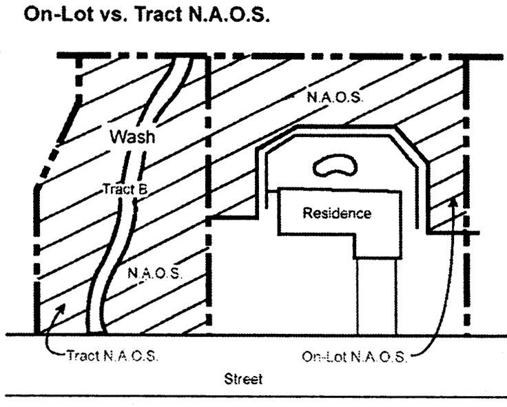
_____
F.
Recognize and conserve the economic, educational, recreational, historic, archaeological, and other cultural assets of the environment that provide amenities and services for residents and visitors.
G.
Assure that decisions regarding development in environmentally sensitive areas are based on complete and accurate information about the environmental conditions including drainage features and probable development impacts.
H.
Minimize the impacts of development by controlling the location, intensity, pattern, design, construction techniques, and materials of development and construction.
I.
Retain the visual character of the natural landscape to the greatest extent feasible by regulating building mass, location, colors, and materials; grading location, design and treatment; and landscaping design and materials.
J.
Maintain significant open spaces which provide view corridors, buffers, protect landmarks and large boulders, and prime wash habitats, by preserving these features in their natural state to maintain the city's unique desert setting.
K.
Protect environmentally sensitive lands, while also recognizing the legitimate expectations of property owners and the city's overall economic goals.
L.
Encourage innovative planning, design, and construction techniques for development in environmentally sensitive areas.
(Ord. No. 2305, 1, 2-19-91; Ord. No. 3395, § 1, 12-11-01; Ord. No. 3501, § 1, 4-1-03; Ord. No. 3540, § 1(Exh. 1), 4-20-04; Ord. No. 4005, § 1(Res. No. 8947, Exh. A, § 181), 4-3-12; Ord. No. 4143, § 1(Res. No. 9678, Exh. A, § 147), 5-6-14)
Sec. 6.1021.- Applicable districts and conditions.
All underlying zoning districts, to which the ESL overlay zoning district applies, shall be identified with the suffix "ESL". To accomplish the purposes in Section 6.1010, the City may apply the ESL district to lands that contain one (1) or more of the following environmental conditions:
A.
Land slopes of fifteen (15) percent or greater.
B.
Unstable slopes, which exhibit one (1) or more of the following conditions:
1.
Boulder collapse
2.
Boulder rolling
3.
Rockfalls
4.
Slope collapse
5.
Talus slopes
C.
Special features, as described in the definitions (Section 3.100) and the Protected Peaks and Ridges Map:
1.
Boulder features
2.
Natural landmarks, including archaeological sites
3.
Protected peaks
4.
Protected ridges
D.
Watercourses:
1.
Major watercourses
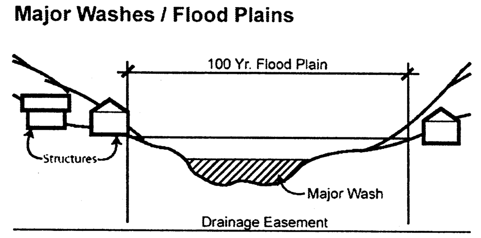
2.
Minor watercourses
E.
Exposed/shallow bedrock
F.
Undisturbed native vegetation
G.
Wildlife habitat
H.
Landform classes as indicated on the ESLO Landforms and Protected Peaks and Ridges Maps:
1.
Lower desert landform
2.
Upper desert landform
3.
Hillside landform
(Ord. No. 3395, § 1, 12-11-01; Ord. No. 3501, § 1, 4-1-03)
Sec. 6.1022.- Exemptions and exceptions.
A.
The ESL regulations shall apply to all public or private development projects within the ESL district, except as provided in Sections 6.1022B. and 6.1023, exemptions. In the event of a conflict between the ESL regulations and any other provision of the Zoning Ordinance, the ESL regulations shall prevail.
B.
New construction shall comply with the requirements of this Ordinance except for development approved prior to May 21, 2004 as shown on the ESLO exemptions schedule below:
ESLO EXEMPTIONS SCHEDULE - SPECIFIC DEVELOPMENT STANDARD (2)
Notes:
1) Masterplan Development is: At least eighty (80) acres in area, and a) contains at least two (2) zoning districts, and/or b) contains at least two (2) phases.
2) Development Agreements control when they are in conflict with Zoning Ordinance standards.
C.
Development exempted by Section 6.1022.B shall comply with the standards and processes applicable to the development at the date of such approval. New applications for exempted properties are strongly encouraged to follow as closely as feasible the most recent ESL standards.
D.
Hardship/exemption provisions—Upon an application by a property owner claiming that the application of an ESL amendment causes hardship, City Council may allow a property to develop under a previously adopted requirement of ESL, upon findings that:
1.
A substantial hardship is demonstrated that would significantly reduce the ability to use a parcel(s),
2.
The exception will be consistent with the intent and purpose of the Environmentally Sensitive Lands Ordinance, and
3.
The application of the new ESL standards would not achieve significant benefit for the protection of the environment and the community.
(Ord. No. 3395, § 1, 12-11-01; Ord. No. 3540, § 1(Exh. 1), 4-20-04; Ord. No. 4143, § 1(Res. No. 9678, Exh. A, § § 148, 149), 5-6-14)
Sec. 6.1023.- Hillside district exemptions.
The ESL regulations shall not apply to a development project, which was the subject of a pending application as of February 19, 1991, or development approvals under the provisions of the former hillside district, Section 6.800 through 6.810. For the purposes of this Section, "development approval" means rezoning, use permit, subdivision plat, master plan, Development Review Board, variance or building permit approval.
A.
Applicability of hillside district regulations. Exempt development projects shall be developed under the hillside district regulations and development standards in effect when the development project was approved, including rezoning stipulations.
B.
Application of ESL regulations to exempt development projects. The property owner of a development project exempt under this Section may elect to develop under the ESL regulations. The election must be communicated in writing to the Zoning Administrator before application is made for further development approval following the effective date of ESLO (February 19, 1991).
C.
If the effect of an election to develop under the ESL regulations is to alter the densities or land uses approved under the hillside district, or changes the size or configuration of any hillside conservation (HC) zoned area, the election is conditioned upon City Council approval of a rezoning pursuant to the provisions of sections 1.300 and 6.1090.
D.
If the property owner of an exempt development project elects to apply the ESL regulations to only a portion of the development project, the property owner must demonstrate that those portions of the project developed or to be developed under hillside district regulations meet all requirements of those regulations, including the preservation of hillside conservation areas through easement or dedication.
(Ord. No. 2305, § 1, 2-19-91; Ord. No. 3225, § 1, 5-4-99; Ord. No. 3395, § 1, 12-11-01; Ord. No. 4143, § 1(Res. No. 9678, Exh. A, §§ 150, 151), 5-6-14)
Sec. 6.1024.- Special exceptions from the ESL regulations.
A.
Special exceptions from the ESL regulations may be approved by the Zoning Administrator in the following circumstances:
1.
Nonbuildable parcel. If the application of the ESL regulations to a parcel, which was a legally constituted lot on which development would have been permitted prior to the adoption date of ESLO (February 19, 1991), would prevent the development of at least one (1) single-family dwelling, the parcel may be developed with one (1) single-family dwelling pursuant to the grant of a special exception, provided that such development otherwise conforms to the ESL regulations as closely as reasonably possible.
2.
Nonhillside district development project approvals. Modifications to development project approvals, or subsequent development approvals for development projects approved under nonhillside district zoning classifications prior to the effective date of ESLO (February 19, 1991) are subject to the ESL regulations. However, it is the intent of these regulations that such development project be brought into compliance with the ESL regulations as closely as reasonably possible without creating undue hardship on the property owner.
B.
Special Exception Submittal Requirements. In addition to the submittal requirements described in section 6.1090, applications for special exceptions from the ESL regulations authorized in this section shall include the following:
1.
Documentation of existing development approvals for the development site and the special exception eligibility of the parcel.
2.
Environmental mapping necessary to identify the ESL regulation(s) from which the special exception is requested.
3.
A development plan showing the approved land uses and the areas that will be affected by the proposed special exception.
4.
A report describing the proposed exceptions from the ESL regulations and describing the rationale for the exceptions.
(Ord. No. 2305, § 1, 2-19-91; Ord. No. 3395, § 1, 12-11-01; Ord. No. 4143, § 1(Res. No. 9678, Exh. A, § 152), 5-6-14)
Sec. 6.1031.- Rezonings and use permits in Hillside Landform.
When reviewing the compatibility of rezoning and use permit applications in the Hillside Landform on land with slopes between fifteen (15) and twenty-five (25) percent that is not a severely constrained area, the following shall be considered:
A.
Grading and other site preparations are within the limits established by the Development Design Guidelines for Environmentally Sensitive Lands, and whether essential grading complements the natural land forms.
B.
Vehicular and pedestrian circulation conforms to the Development Design Guidelines for Environmentally Sensitive Lands, and is within the emergency standards acceptable for fire truck use.
C.
Views to development from viewpoints have been analyzed, and whether satisfactory methods will be used for revegetation, plant protection/salvage, minimization of cuts and fills, and blending of structures with the site in terms of building mass and color hue, value, and chroma (from the Munsell Book of Color).
D.
Human lives and property are protected from unstable slopes, flooding, and other safety hazards.
E.
The placement, grouping, scale, and shaping of structures complements the natural landscape.
F.
Large, graded bare areas are fully revegetated.
(Ord. No. 3395, § 1, 12-11-01; Ord. No. 3920, § 1(Exh. § 71), 11-9-10; Ord. No. 4005, § 1(Res. No. 8947, Exh. A, § 182), 4-3-12; Ord. No. 4143, § 1(Res. No. 9678, Exh. A, § 153), 5-6-14)
Sec. 6.1032.- Plats.
All applications for preliminary plats in the ESL Overlay District shall be reviewed for compliance with the ESL provisions and subject to Development Review Board approval.
(Ord. No. 3395, § 1, 12-11-01; Ord. No. 4164, § 1(Res. No. 9857, § 1, Exh. A, § 47), 8-25-14)
Sec. 6.1033.- Individual Single-Family Applications in the Hillside Landform.
Single-family homes that are not part of a subdivision plat and proposed within the Hillside Landform shall be reviewed for compliance with specified site design criteria intended to promote public safety and shall be subject to Development Review Board approval. (See Section 6.1070(C)).
(Ord. No. 3395, § 1, 12-11-01; Ord. No. 4164, § 1(Res. No. 9857, § 1, Exh. A, § 48), 8-25-14)
Sec. 6.1034.- Master Development Plan Applications.
A.
When a master development plan is required, a rezoning shall not be approved without the concurrent approval by the City Council of the site development, conceptual circulation, and conceptual phasing master plans, and conceptual open space master plan for the entire area to be rezoned.
B.
No on-site or off-site development for any phase of a master development plan shall begin until the circulation, phasing, parking, drainage, water, and wastewater master plans have been approved by the City, and the environmental design concept master plan has been approved by the Development Review Board.
1.
The master plans shall be provided for the entire development project unless it can be demonstrated to the City that the master plan can be prepared for one (1) or more discreet phases that can stand alone independent of the entire project.
C.
Approvals for individual buildings shall not be granted until the master development plan, including all the required parts of the plan, has been approved.
D.
Modifications to approved master development plans.
1.
Major changes to the permitted uses, density or gross floor area described in a site development master plan or to other master plans approved as part of a rezoning, use permit or City Council approved amended development standards must be reviewed and approved by the City Council subject to the notice and hearing provisions of Article I. In general, major changes are those that affect more than ten (10) percent of either the land or gross building square footage. A change may be major due to the impacts of the proposed changes, even where less than ten (10) percent of land or intensity is affected.
The transfer of units between parcels as provided in an approved master-planned development zoning case is not a major change.
2.
Minor changes to the site development plan and all other master plans, consistent in scope and intent with the originally approved plans, may be approved by the Zoning Administrator. In general, minor changes affect less than ten (10) percent of either the land area or gross building square footage.
(Ord. No. 2305, § 1, 2-19-91; Ord. No. 3225, § 1, 5-4-99; Ord. No. 3395, § 1, 12-11-01; Ord. No. 3920, § 1(Exh. § 72), 11-9-10)
Sec. 6.1035.- Site Preparation Limitations.
No person shall grade, clear, grub, remove plants or conduct any other form of construction or site preparation upon a property until any applicable Natural Area Open Space (NAOS) plan has been approved:
A.
By the Development Review Board as part of a case or preliminary plat, or by City staff as part of building or other applicable plans, and
B.
Appropriate permits have been issued.
(Ord. No. 3702, § 1, 2-20-07; Ord. No. 3920, § 1(Exh. § 73), 11-9-10)
Sec. 6.1040.- ESL Use Restrictions.
Land uses shall be those permitted in the underlying zoning district except as follows:
Land uses in the hillside landform areas with land slopes over twenty-five (25) percent, special features or unstable slopes are restricted to the following, provided that uses must also be permitted by the underlying zoning: residential uses including resort units and related streets and utilities; the activities identified in the Conservation Open Space (COS) district; (section 6.703 of the Zoning Ordinance) and golf tees. Ancillary resort uses, such as restaurants, meeting rooms or parking areas for more than five (5) cars are not permitted.
(Ord. No. 2305, § 1, 2-19-91; Ord. No. 3395, § 1, 12-11-01)
Sec. 6.1050.- Intensity of Development.
The ESL Landforms and Protected Peaks and Ridges Maps shall be used, unless otherwise exempted by Section 6.1022B or 6.1023.
The intensity of development in the lower desert and upper desert landforms shall be determined by the underlying zoning district, and shall not exceed the maximum as provided in Table B, Section 6.1081. Where the NAOS density incentive or cluster option is used, Table B shall serve as the "base" intensity on the parcel.
_____
The intensity of development in the hillside landform shall be determined as follows:
A.
The base and maximum intensities of development in the hillside landform on slopes less than twenty-five (25) percent, on exposed/shallow bedrock, or in major or minor watercourses, shall be as follows:
_____
1.
The underlying zoning must permit the base intensities and uses.
2.
Intensities above the base level up to the maximum intensity may be approved by the City Council after notice and hearing as provided in Section 1.600 and 1.700, and upon a finding that the proposed intensity meets the guidelines set forth in Section 6.1031.
3.
Resort hotel/casita units are limited to resort hotel guest rooms or casitas that do not have individual driveway access to each unit. Parking areas for more than five (5) cars, restaurants, meeting rooms, and other ancillary uses must be located on land that is not a severely constrained area.
B.
Except when modified as provided in subparagraph (E) of this section, the maximum permitted intensity on land in the hillside landform with slopes from twenty-five (25) to thirty-five (35) percent or boulder features, shall be one (1) dwelling or resort unit per twenty (20) acres ( 1/20 or .05 d.u./ac.). Ancillary resort uses, such as restaurants, are not permitted.
1.
After recommendation by the Planning Commission, intensities up to a maximum intensity of one (1) dwelling or resort unit per five (5) acres (1/5 or .2 d.u./ac.) may be approved by the City Council, upon finding that the land proposed for the increased intensity is not visible from viewpoints, and that the proposed intensity is compatible with the considerations listed in Section 6.1031. In making its determination, the City Council shall consider the following factors:
a.
Visibility and viewpoints of the proposed developments from scenic corridors, collector and arterial streets.
b.
The impact of the development on the environmental conditions listed in Section 6.1021.
C.
Except when modified as provided in subparagraph E. of this section, the maximum permitted intensity on land in the hillside landform with slopes over thirty-five (35) percent or on unstable slopes shall be one (1) dwelling or resort unit per forty (40) acres ( 1/40 or .025 d.u./ac.). Ancillary resort uses, such as restaurants, are not permitted.
D.
General guidelines.
1.
If a lot encompasses two (2) slope categories the intensity limit is determined by reference to the slope category of the land on which the majority of the construction envelope is located. The purpose of this provision is to provide flexibility in lot configuration.
E.
The City Council may grant a special exception from the maximum intensities allowed by subparagraphs B. and C. of this section for parcels which meet the following requirements:
1.
Qualifications. Only parcels, which meet the following qualifications, are eligible for development as a special exception under the provisions of this subparagraph E.:
a.
The parcel consists of at least nine (9) acres, at least eighty (80) percent of which are severely constrained areas.
b.
On February 19, 1991, the parcel was a legally constituted lot on which development would have been permitted under the terms of the ordinance in effect at the time the lot was created or was annexed to the city.
c.
No density transfer is proposed.
d.
The area which will be disturbed by the proposed development is less than twenty (20) percent of the development site area.
e.
More than eighty (80) percent of the development site area will be preserved as natural area open space (NAOS).
2.
Findings. Higher intensities may be granted pursuant to the special exception permitted by this subparagraph only where the Council finds that:
a.
The maximum intensities otherwise permitted by this ordinance would create a substantial disincentive to develop the site with a desirable and appropriate use and/or intensity, and the requested change is the minimum required in order to remove excessive constraints on the development of the site.
b.
The requested intensity will not create increased health or safety hazards to people or property resulting from unstable slopes or other environmental hazards.
c.
Units will be placed at lower elevations or at other locations on the property selected to reduce the grading which will be required to access the structures.
d.
Visibility of development from viewpoints as defined in Section 3.100 is limited.
3.
Procedure.
a.
Before the City Council hears an application for special exception, the Development Review Board shall review the plans to ensure that any development proposed for unstable slopes, special features or other environmental conditions, is appropriate to these conditions, and preserves them to the maximum extent possible.
b.
Applications for exceptions under this section shall include the submittals set forth in Section 6.1090 of this Ordinance, and shall be subject to notice and hearing as provided in Sections 1.600 and 1.700.
_____
F.
The permitted development intensity in the hillside landform shall be calculated as follows:
1.
Determine the location of each environmental condition referenced in section 6.1050A., B., and C. If more than one (1) condition is present on the same land area that which imposes the greatest restriction shall determine the intensity for development on that land area.
2.
Determine the amount of land in acres impacted by each environmental condition.
3.
Multiply the total acreage impacted by each environmental condition by the intensity permitted by section 6.1050A. through C. for that condition.
4.
On parcels of twenty (20) or more gross acres, the permitted intensity for small areas of twenty thousand (20,000) square feet or less which have environmental conditions different than those of the surrounding area, shall be determined by the intensity permitted on the surrounding area. If a small area abuts both a lower and a higher intensity area, the small area shall be divided equally between the two (2) intensities.
(Ord. No. 2305, § 1, 2-19-91; Ord. No. 3225, § 1, 5-4-99; Ord. No. 3395, § 1, 12-11-01; Ord. No. 3501, § 1, 4-1-03; Ord. No. 4143, § 1(Res. No. 9678, Exh. A, §§ 154, 155), 5-6-14)
_____
Sec. 6.1060.- Open Space Requirements.
A.
Natural Area Open Space (NAOS) requirements. A percentage of the acreage containing natural desert shall be set aside as NAOS.
1.
Characteristics of NAOS. NAOS should:
a.
Preserve sensitive environmental conditions;
b.
Retain and protect meaningful desert open space that due to its size, function, visibility, accessibility, or strategic location is a community amenity or resource;
c.
Maintain visual amenities;
d.
Mitigate hazards; and
e.
Promote the public health, safety and welfare.
2.
Amount of NAOS. The minimum percentage of NAOS based on slope and landform category is provided in Table 6.1060.A.
NAOS requirements are determined by Table 6.1060.A., indicating slope and landform which corresponds to the location of other environmental conditions such as unstable slopes, undisturbed desert vegetation, boulder features, and watercourses. Where these provisions conflict with the minimum NAOS dimensions described in Section 6.1060.F., the more restrictive provisions of Section 6.1060.F. shall take precedence.
_____
Table 6.1060.A.
Minimum Percentage NAOS Based on Slope and Landform Category
3.
Permanent maintenance of NAOS. The entire NAOS area shall be permanently maintained as NAOS through easements, donation or dedication to the City and/or conservancy, land trust or similar organization that has goals and purposes consistent with permanently maintaining NAOS and can demonstrate its ability to maintain the NAOS to the satisfaction of the City.
4.
If NAOS is located on individual lots (on-lot NAOS), the property owner shall be responsible for maintenance. (See Section 6.1100 for detailed information regarding maintenance of NAOS.)
5.
Common-tract NAOS locations and boundaries, including precise acreage, shall be shown on the subdivision plat and/or map of dedication.
6.
On-lot NAOS locations: In applications where NAOS is provided on individual lots, approximate boundaries and precise acreage of the proposed NAOS shall be shown on and conform to an exhibit approved by the City prior to or concurrent with filing a final subdivision plat and/or map of dedication.
Figure 6.1060.A.
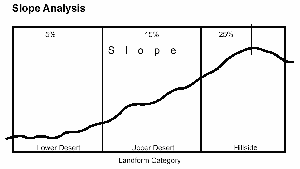
Slope Analysis
_____
7.
Until recordation of a document showing the City approved NAOS location, all land within a project is considered potential NAOS and shall be left in its natural topographic and vegetative condition.
B.
NAOS reduction. NAOS requirements may be reduced as provided herein. The minimum NAOS after reductions, for the gross lot area of the development project and for each development site or parcel shall be fifteen (15) percent in lower desert, twenty (20) percent in upper desert, and forty (40) percent in hillside landforms.
1.
Proportional reduction in NAOS for Conservation Open Space COS and Hillside Conservation HC areas. A property owner is entitled to reduce the required NAOS by calculating the percentage of the total parcel that is zoned Conservation Open Space (COS) and Hillside Conservation (HC) areas, and reducing the NAOS requirement for the remainder of the property by this same percentage.
2.
Reduction for regional drainage facility. Where a development site contains areas dedicated for regional stormwater management pursuant to approved city regional drainage and flood control plans developed by the city, having a design flow of two thousand (2,000) cfs or more and providing drainage for one (1) square mile (one (1) section) or more, the NAOS requirement shall be reduced as follows:
a.
The NAOS requirement shall be reduced one (1) square foot for each revegetated one (1) square foot of the regional drainage facility (1:1).
b.
The NAOS requirement shall be reduced one (1) square foot for each two (2) square feet of turf or similar improvements for recreational areas within the regional drainage facility (1:2). The reduction for improved areas shall not exceed fifty (50) percent of the original NAOS requirement.
Figure 6.1060.B.
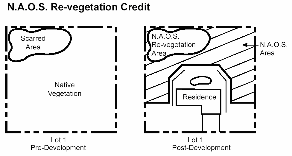
3.
Reduction for revegetation. On land stripped of natural vegetation or scarred prior to January 1, 1990, the NAOS requirement for the parcel shall be reduced by two (2) square feet for every one (1) square foot of revegetated NAOS (2:1). This provision cannot be used to increase the maximum revegetated NAOS above the thirty (30) percent maximum referenced in Section 6.1060D.2.
4.
Reduction for designated historical or archaeological site. Land designated as a permanently protected historical or archaeological site, approved by the city, shall be used to reduce the required NAOS by two (2) square feet for each one (1) square foot of approved site (2:1).
5.
Lower desert landform with minimal slopes and limited environmental conditions. Sites within the lower desert landform having slopes of zero (0) percent—five (5) percent, may reduce the required amount of NAOS to fifteen (15) percent if the applicant can demonstrate to the satisfaction of the Zoning Administrator that the property contains no boulder features, no minor or major watercourses and contains undisturbed native plant densities* with less than ten (10) trees/cacti per acre. Where these provisions conflict with the minimum NAOS dimensions described in Section 6.1060.F., the more restrictive provisions of Section 6.1060.F. shall take precedence.
*Native plants include the specific species defined in Article V, Protection Of Native Plants, Section 46-105 through 46-120 of the Scottsdale Revised Code.
C.
Density Incentive for increases in NAOS.
1.
A density incentive bonus up to twenty (20) percent of the density otherwise allowed under Table 6.1081.A., Base Intensity by Zoning District, may be granted if more NAOS is provided than is required in Section 6.1060.A. of this Zoning Ordinance. The bonus shall be subject to approval by the City Council after notice and hearing as provided in Sections 1.600. and 1.700., and providing further that the following criteria are met:
a.
The bonus applies only in the Single-family Residential R1-43, Single-family Residential R1-70, Single-family Residential R1-130, and Single-family Residential R1-190 Districts.
b.
The incentive must be calculated using the base NAOS standards for the development project, and cannot be used in combination with any reductions in NAOS.
c.
The additional NAOS must be undeveloped natural area and cannot include revegetated areas.
d.
The additional NAOS must respond to site conditions and the surrounding context to maximize connections with existing or planned open space on adjoining properties including the McDowell Sonoran Preserve. The locations of this additional NAOS shall be along major watercourses, along the frontage of collector or larger streets, along the boundary of the McDowell Sonoran Preserve or on slopes of twenty-five (25) percent or steeper.
e.
The additional NAOS shall be provided in common area tracts and shall not be provided on an individual single-family lot.
2.
The increase in density is calculated by multiplying the percent of gross land area of the parcel to be provided as additional NAOS, times the base density as established in Table 6.1081.A.
D.
Types of NAOS. The NAOS requirement may be satisfied by two (2) types of open space: undeveloped natural areas and revegetated areas.
1.
Undeveloped natural areas. Undeveloped natural areas shall constitute a minimum of seventy (70) percent of the required NAOS. This minimum applies to both "on-lot" and "common tract" NAOS.
a.
Infill planting. When native plants in a designated undeveloped natural area are significantly less dense than under natural conditions because of disturbance to the land, the density and number of species of native plants may be increased to approximate the natural conditions of the surrounding area.
b.
Infill planting areas shall count as undeveloped natural area for NAOS if approved by the City.
2.
Revegetated areas. Revegetated areas shall qualify as NAOS, but shall not constitute more than thirty (30) percent of the required NAOS. These provisions cannot be used in conjunction with those contained in Section 6.1060.B.3. to increase the maximum percentage of revegetated NAOS above thirty (30) percent. Revegetated areas shall meet following requirements:
a.
Planting programs for revegetated areas may include transplanted and seeded methods of application and shall include a list of proposed plant species and quantities. (See Section 6.1091.A.1.k.)
b.
Planting programs shall be consistent with the slope aspect of the surrounding natural vegetation, and shall be consistent with the species and density of surrounding vegetation and adjacent natural desert.
c.
All materials, design and construction techniques for revegetation shall be subject to City approval.
d.
Incorporate boulders and salvaged surface material to match and blend with surrounding desert character.
e.
Provide a temporary watering program.
f.
In those cases where previously scarred or cleared areas are to be restored, the plant species and density shall be determined by matching the existing natural vegetation on similar terrain in the vicinity.
g.
The design and installation of revegetation shall help to minimize the downstream transport of sedimentation.
E.
Improved open space. When the required open space of the underlying zoning district exceeds the NAOS requirements imposed by the ESL District standards, the balance of the required open space may be either improved open space or NAOS. Improved open space includes landscape areas, turf areas, parks, golf courses and other recreation areas excluding any associated buildings.
F.
Distribution of NAOS.
1.
NAOS dimensions.
a.
The minimum contiguous area for NAOS is four thousand (4,000) square feet.
b.
The minimum horizontal dimension for NAOS areas is thirty (30) feet, except that the minimum horizontal dimension for NAOS located along roadsides will be twenty (20) feet.
c.
Where the minimum finished lot size is twenty-two thousand (22,000) square feet or less, NAOS shall be placed in common tracts, or on other lots within the same subdivision unless the minor application is approved with NAOS placement in contiguous areas on adjacent lots. See Section 6.1070.A. for on-lot NAOS design standards and Section 6.1090. for on-lot NAOS submittal requirements.
2.
Modification of NAOS dimensions. The minimum NAOS dimensions set forth above may be modified as a minor application, subject to the following criteria:
a.
The NAOS location standards set forth in paragraph 3. are met.
b.
Reductions in dimensions will maintain NAOS areas that are easily recognizable and that will not result in maintenance problems due to their proposed locations.
c.
Adjacent land uses, such as streets, will not negatively impact the viability of vegetation or other features of the land to be preserved.
Figure 6.1060.C.
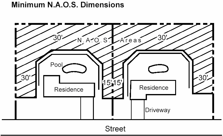
3.
NAOS selection and location. The location of NAOS on a site plan or preliminary plat shall emphasize the following, however, in no event shall the provisions of this section require greater area of NAOS dedication than currently required by Section 6.1060.A., B. and C. of this Zoning Ordinance:
a.
Preservation of natural watercourses. The need for unimpeded wildlife access and movement within and between NAOS areas is an important criteria. Therefore, minor and major watercourses, vista corridors and scenic corridors, particularly where located adjacent to the McDowell Sonoran Preserve, shall be given key consideration as riparian habitats associated with major and minor watercourses.
b.
Continuity of open space within the development project and with adjacent developments or with the McDowell Sonoran Preserve.
c.
Continuity of "on-lot" open spaces on adjoining lots.
d.
Preservation of the most significant features and vegetation, including rock outcroppings, and significant concentrations of native vegetation in relation to the surrounding development project.
e.
Distribution throughout the developed area and avoidance of concentration in one (1) location.
f.
Location in areas where a buffer is desirable along the property boundary, or where it is contiguous with NAOS on adjacent property, including property within the McDowell Sonoran Preserve.
g.
Location in areas visible from streets or common areas.
h.
The City has prepared high priority NAOS location maps to provide guidance on the location of NAOS. Each site plan submitted shall demonstrate the best means to achieve the delineations of NAOS areas as depicted on these maps in order to meet City policies.
4.
NAOS distribution within master planned developments. Where a master planned development provides NAOS in excess of the minimum NAOS requirement for specific development sites, such excess NAOS may be credited against NAOS requirements for other development sites on the master plan, provided that the NAOS credits are documented on an open space master plan which identifies excess NAOS by development site and allocates such excess to specific development sites elsewhere on the property.
(Ord. No. 2305, § 1, 2-19-91; Ord. No. 3225, § 1, 5-4-99; Ord. No. 3395, § 1, 12-11-01; Ord. No. 3501, § 1, 4-1-03; Ord. No. 3540, § 1(Exh. 1), 4-20-04; Ord. No. 3702, § 1, 2-20-07; Ord. No. 3827, § 1, 2-10-09; Ord. No. 3920, § 1(Exh. §§ 74—78), 11-9-10; Ord. No. 4005, § 1(Res. No. 8947, Exh. A, §§ 183—187), 4-3-12; Ord. No. 4143, § 1(Res. No. 9678, Exh. A, §§ 156—163), 5-6-14)
Sec. 6.1070.- Design Standards.
A.
General Standards.
1.
Development projects shall employ design techniques which reduce the disruption of the severely constrained areas (SCA) of a parcel defined in Section 6.1081.A.1., reduce the amount of streets and pavement, maximize open space, reduce the length of water and sewer systems, and minimize the restructuring of natural drainage systems.
Figure 6.1070.A.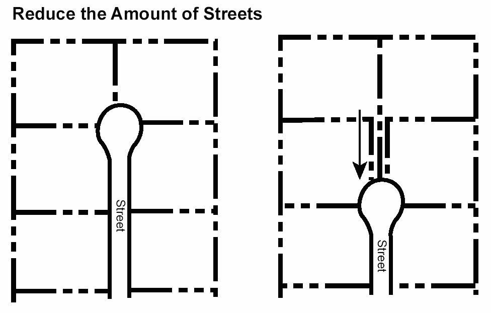
2.
The intensity calculated in Sections 6.1050 and 6.1080 shall be the maximum permitted intensity. A construction envelope that is located in more than one (1) density category in Section 6.1050.B. and C. shall be considered as located in the higher density area if the majority of the floor area or construction envelope area (over fifty (50) percent) is in the less restricted condition and the incursion into a lower intensity area extends less than twenty (20) feet for structures or thirty-five (35) feet for construction envelopes.
Figure 6.1070.B.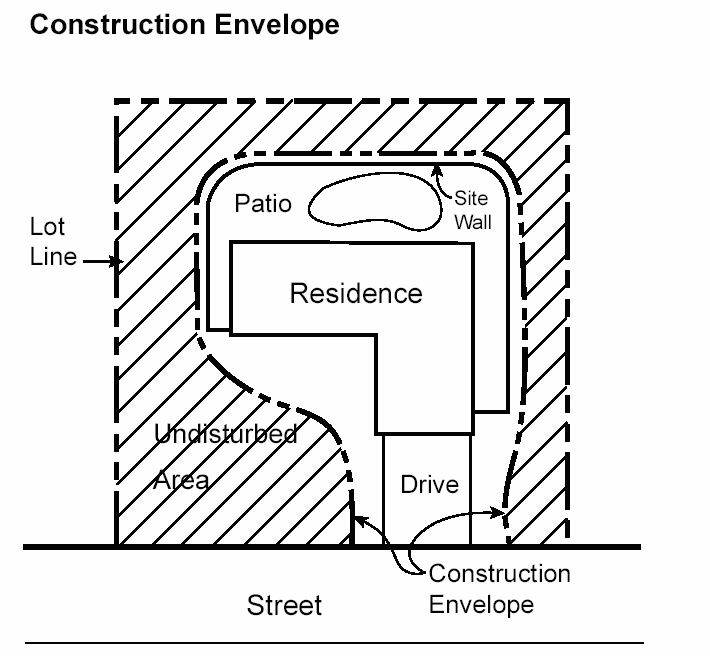
Figure 6.1070.C.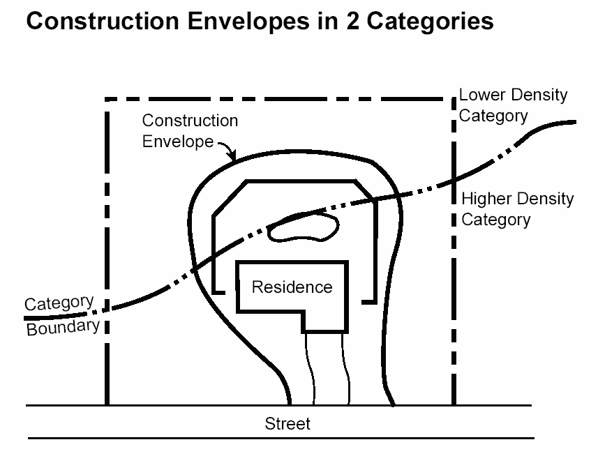
3.
Construction envelopes are required when NAOS is proposed on individual lots.
4.
Underground utility corridors and drainage improvements not located in construction envelopes shall be included in the revegetated areas.
5.
The NAOS shall be clearly identified and protected during building by methods and techniques approved by the City.
6.
On-lot NAOS shall be designed with consideration of the surrounding context to connect with existing or planned open space on adjacent properties so that continuous areas of meaningful open space are formed.
7.
On-lot NAOS shall not be located within the required front yard where the front yard depth is less than forty (40) feet.
B.
Building heights.
1.
The maximum building height is that prescribed by the underlying district except as modified by the following:
a.
The maximum building height in the ESL shall be established by a plane measured vertically above the existing natural terrain elevation prior to grading; as the natural grade rises, the maximum height will rise accordingly. Small areas of rugged terrain inconsistent with this plane will not increase or reduce building height. Small areas are those features with a maximum width of twenty-five (25) feet.
b.
The maximum building height for all buildings in single-family residential (R1) districts including the Foothills Overlay, shall be twenty-four (24) feet unless exempted pursuant to Section 6.1022.
Figure 6.1070.D.
c.
The maximum building height in the hillside landform shall be the height prescribed by the underlying district or thirty (30) feet whichever is lower, except as modified by Section 6.1070.B.1.d. below.
d.
The Development Review Board may permit additional building heights in the hillside landform up to forty (40) feet where the additional height will reduce the visual impact of the structure or site work from established viewpoints, and will reduce the area required for grading, or other land disturbance activities, on sensitive conditions.
C.
Hillside Landform Site Design Criteria: Hillside lands are prone to natural hazards. In order to protect lives and property from disasters resulting from poorly designed hillside development and to mitigate the potential for increased erosion, boulder rolling, rockfalls, and landsliding, the Development Review Board shall review the site plans located within the hillside landform that are not part of a subdivision plat against the following criteria:
1.
All construction shall be set back a minimum of twenty (20) feet from boulder features. The Development Review Board may approve exceptions to these criteria where specific design solutions protect public safety.
Figure 6.1070.E.
2.
Unprotected slopes shall be protected from focused stormwater flows.
3.
All storm runoff shall be directed towards natural channels using best practices for erosion control.
4.
Minimize removal of native vegetation from areas not located in construction envelopes.
5.
Minimize incidental impact from other natural hazards including erosion, subsidence, boulder rolling, rockfalls, flooding, flood related mud slides, unstable slopes and landsliding relating to the site and surrounding property.
D.
Protected Peaks and Ridges.
1.
All building projects shall be set back an average of three hundred (300) feet horizontally and a minimum of two hundred (200) feet from a protected peak or a protected ridge.
Figure 6.1070.F.
2.
The maximum elevation of any structure within four hundred (400) feet horizontally of a protected peak or ridge shall be at least twenty-five (25) feet below the elevation of the nearest point of a protected peak or ridge.
3.
Protected peaks and ridges shall be identified on ESL Protected Peaks and Ridges Maps prepared by the City, and may be revised as follows:
Request for map refinement shall include a visual analysis from viewpoints as defined in Section 3.100, and be subject to subsection E., below.
4.
Protected peaks and ridges on a property shall be shown on final plats at the time of City Council approval.
E.
Revisions of ESL Landform and Protected Peaks and Ridges Maps. Landforms are identified on the ESL Landforms and Protected Peaks and Ridges Maps by the City. The maps may be revised as follows:
1.
Applicants for a specific development project may request a change in all or part of the landform boundaries on the ESL Landforms and Protected Peaks and Ridges Maps prior to or concurrently with a development project application. The applicant shall submit technical data to support the request. If the request represents more than a minor refinement, the requested landform boundary change shall be prepared by an Arizona State registered geologist and shall include a technical analysis to support the requested map revision. The definitions of the three (3) landform areas shall be used by consulting geologists for their analysis of changes in the landform boundaries.
2.
Minor refinements to the ESL Landforms and Protected Peaks and Ridges Maps shall be subject to the approval of the City.
3.
Major revisions of the ESL Landforms and Protected Peaks and Ridges Maps shall be subject to Development Review Board approval. Development Review Board approval shall occur prior to the Planning Commission and City Council public hearings if the request is made concurrently with a submittal for a rezoning or use permit approval.
4.
A property owner may request a revision of the ESL Landforms and Protected Peaks and Ridges Maps on their property independently from a submittal for a specific project. Such submittals shall follow all processes and requirements in Section 6.1070.E.1. and shall be subject to approval of the Development Review Board.
F.
Boulder Features. Development shall not be permitted on or immediately adjacent to boulder features within the ESL District and a setback of twenty (20) feet is required around the boulder feature unless otherwise approved by the Development Review Board. The Development Review Board may permit development on boulder features which meet this definition where the applicant demonstrates that the proposed construction will meet the following criteria:
1.
When a proposed structure will be occupied, the applicant shall submit a technical analysis prepared by an Arizona State registered geologist demonstrating that the boulder feature is stable and does not present a threat to the proposed structure.
2.
The applicant has demonstrated that the proposed construction will blend into the boulder feature so that the boulder feature is still substantially visible from public or private streets, and the structure does not detract significantly from the character of this special feature.
G.
Site and Structure Development Design Standards.
1.
Within the ESL:
a.
Mirrored surfaces or any treatments which change ordinary glass into a mirrored surface are prohibited.
b.
Reflective building materials (other than windows, solar panels, and roofing materials for low slope roofs) including materials with high gloss finishes and bright, untarnished copper, aluminum, galvanized steel or other metallic surfaces, shall be textured or have a matte or non-reflective surface treatment to reduce the reflection of sunlight onto other property.
c.
Materials used for exterior surfaces of all structures (other than solar panels and roofing materials for low slope roofs) shall blend in color, hue, and tone with the surrounding natural desert setting to avoid high contrast.
d.
Surface materials of walls, retaining walls or fences shall be similar to and compatible with those of the adjacent main buildings.
e.
Development design and construction techniques should blend scale, form and visual character into the natural landform and minimize exposed scars.
f.
Exterior lighting should be low scale and directed downward, recessed or shielded so that the light source is not visible from residential development in the area or from a public viewpoint.
g.
No paint colors (other than roofing materials for low slope roofs) shall be used within any landform that have a LRV greater than thirty-five (35) percent.
h.
Exterior paint and material colors (other than roofing materials for low slope roofs) shall not exceed a value of six (6) and a chroma of six (6) as indicated in the Munsell Book of Color.
i.
Plant materials that are not indigenous to the ESL area shall be limited to enclosed yard areas and non-indigenous plants that have the potential of exceeding twenty (20) feet in height are prohibited. A list of indigenous plants is available from the City. Outdoor community recreation facilities, including parks and golf courses shall be allowed turf as specified in Section 6.1070.G.1.j.
j.
Turf shall be limited to enclosed areas not visible offsite from lower elevation. Outdoor recreation facilities, including parks and golf courses, shall be exempt from this standard.
k.
All equipment appurtenant to underground facilities, such as surface mounted utility transformers, pull boxes, pedestal cabinets, service terminals or other similar on-the-ground facilities, shall have an exterior treatment that has a LRV of less than thirty-five (35) percent or otherwise screened from view from the adjoining properties.
l.
It is the intent of this Ordinance to leave washes in place and in natural conditions where practical. When necessary, modifications to natural watercourses and all walls and fences crossing natural watercourses shall be designed in accordance with the standards and policies specified in Chapter 37 (Floodplain and Stormwater Regulation) of the Scottsdale Revised Code, and the Design Standards & Policies Manual. Requests to modify, redirect, or divert watercourses of fifty (50) cfs or greater flow in a one hundred-year event shall include the following:
i.
Justification for the request.
ii.
Plans showing:
(1)
That the application will result in an equal or enhanced quality of open space.
(2)
That any proposed wash modification will include restoration of the watercourse with vegetation of the same type and density removed for the modifications.
(3)
If a wash is being redirected or modified that it enters and exits the site at the historic locations, and that the result will not impact drainage considerations for adjacent properties.
(4)
If a wash is being diverted into a structural solution (e.g. underground pipe), that the change will not impact the drainage conditions on adjacent properties and will not reduce the integrity of any upstream or downstream corridor as meaningful open space.
An application for the modification of a wash mentioned above, may be granted by the Zoning Administrator subject to approval of the design solution for the drainage facilities and subject to the finding that the purpose of this overlay district (Section 6.1011.) has been achieved. However, in no event shall the provisions of this section require greater area of NAOS dedication than currently required by Section 6.1060.A., B. and C. of this Ordinance.
(Ord. No. 2305, § 1, 2-19-91; Ord. No. 3395, § 1, 12-11-01; Ord. No. 3501, § 1, 4-1-03; Ord. No. 3540, § 1(Exh. 1), 4-20-04; Ord. No. 3920, § 1(Exh. §§ 79—81), 11-9-10; Ord. No. 4005, § 1(Res. No. 8947, Exh. A, §§ 188—191), 4-3-12; Ord. No. 4143, § 1(Res. No. 9678, Exh. A, §§ 164, 165), 5-6-14; Ord. No. 4591, § 1(Res. No. 12797, § 1(Exh. A, § 4)), 6-13-23)
Sec. 6.1071.- Design guidelines.
A.
General Guidelines.
1.
Clustering, density transfer, NAOS or CA should be used to protect the most sensitive areas on a plat.
2.
Unless specifically approved by City Council:
a.
NAOS shall not be enclosed by walls that disrupt its continuity with NAOS on adjacent properties;
b.
Walls are prohibited from disrupting the continuity of NAOS corridors and wildlife corridors or habitats located along major and minor watercourses;
c.
Walls shall not enclose or disconnect contiguous NAOS or be permitted to cross washes of fifty (50) cfs greater flow in a one hundred-year event;
d.
Fences shall not block wildlife movement in and through NAOS and/or natural watercourses.
3.
Subdivision walls are prohibited unless as allowed pursuant to the hardship exemption in Section 6.1022.D. When approved, perimeter walls shall be subject to the Development Review Board and shall incorporate the following criteria:
a.
These walls shall incorporate alignments and vertical designs that undulate in a manner that blends with the character of the site's terrain and protects major native plant specimens and boulders;
b.
These walls shall contain ground level openings of at least nine (9) square feet in area with a dimension of three (3) by three (3) feet, and be spaced no more than two hundred (200) feet apart, including openings for drainage ways, in order to allow wildlife movements and passage of localized stormwater flows;
c.
These walls shall be built of materials that blend into the heavy textures and rustic character of the vegetation, boulders and other features of the natural desert setting; and
d.
These walls shall be set back from the perimeter property line a minimum of:
1.
Fifteen (15) feet where the subdivision or master planned development is adjacent to a vacant property;
2.
Fifteen (15) feet or a distance equal to the required side yard for the underlying zoning district, whichever is greater, where the subdivision or master planned development is adjacent to a parcel that has an existing residence, an existing subdivision or the McDowell Sonoran Preserve; or
3.
Zero (0) feet where the subdivision is adjacent to natural area open space (NAOS) or conservation area (CA) tract within the same subdivision or master planned development that the walls are located within.
4.
On single-family residential parcels containing thirty-five thousand (35,000) square feet or larger, individual lot or site walls, where permitted by this Zoning Ordinance, shall be setback a minimum of fifteen (15) feet from a side or rear property line unless the parcel is adjacent to natural area open space (NAOS) or conservation area (CA) within a separate tract as a part of a master planned development or subdivision.
5.
Sensitive site planning that responds to the environmental conditions will frequently lead to smaller average lot sizes, a reduction in disturbed land area, or fewer lots. A development application shall demonstrate that the proposed intensity can be developed on the site in a sensitive manner that is consistent with this Zoning Ordinance, the Development Design Guidelines for Environmentally Sensitive Lands, and other approved City policies and guidelines.
6.
The specific location of a construction envelope shall be shown on the site plan submitted for the permit and shall be clearly fenced or contained during construction of the improvements permitted. Disturbance to sites during construction should be minimized and limited to the portions of the site on which improvement is shown on the approved site plan. All clearing, grading, grubbing etc, may occur only within the approved construction envelopes.
No grading permits shall be issued on lots with Single-family Residential R1-190, Single-family Residential R1-130, Single-family Residential R1-70, Single-family Residential R1-43 or Single-family Residential R1-35 zoning unless they are submitted in conjunction with building plans for on-site structures, except for drainage facilities, driveways or utilities required with the approved subdivision plans to serve the subdivision or adjacent properties.
B.
Guidelines for the McDowell Sonoran Preserve Boundary.
1.
NAOS not in the McDowell Sonoran Preserve boundary should be oriented to maintain habitat and unimpeded wildlife movement to and from the preserve.
2.
Promote continuity of open spaces at the preserve boundary.
3.
Maximize the provision of NAOS at the preserve boundary to create a natural buffer to the preserve.
4.
Any trail development through NAOS areas adjacent to the preserve must be coordinated with the Preserve Trail Plan.
(Ord. No. 3395, § 1, 12-11-01; Ord. No. 3501, § 1, 4-1-03; Ord. No. 3540, § 1(Exh. 1), 4-20-04; Ord. No. 4005, § 1(Res. No. 8947, Exh. A, §§ 192, 193), 4-3-12; Ord. No. 4143, § 1(Res. No. 9678, Exh. A, § 166), 5-6-14)
Sec. 6.1081.- Density transfer.
The density transfer option is intended to provide an incentive to move construction from portions of a parcel with severe environmental constraints to less constrained areas. A density transfer may be approved through the use of amended development standards and the approval processes in Sections 6.1083.A. and B. The benefits of transfer decline as development in the most sensitive areas increases. The use of this option can lead to the preservation of significant areas of environmentally sensitive lands including land slopes over fifteen (15) percent, watercourses, and special features.
A.
Density transfer for Conservation Area (CA).
1.
In order to qualify for the maximum rate of density transfer (1:1) the severely constrained areas (SCA) must be designated CA. The severely constrained areas are those portions of the hillside landform containing or surrounded by any one (1) of the following environmental conditions; provided that for purposes of density transfer only, SCA shall not include areas of ten (10) acres or more which do not contain any of the environmental conditions specified below, even if the area is surrounded by one (1) or more conditions, so long as any development proposed for the surrounded area is not visible from viewpoints established on the City's special features map:
a.
Land slopes over twenty-five (25) percent.
b.
Unstable slopes as listed in Section 6.1021.B.
c.
Special features as listed in Section 6.1021.C.
The rate of transfer for the parcel is reduced in proportion to reductions in the amount of SCA that is designated as CA.
2.
Undisturbed natural areas and land stripped of natural vegetation or scarred prior to January 1, 1990, which has been revegetated may be established as CA as follows:
a.
The entire NAOS area will be permanently maintained as Natural Area Open Space through easements, donation or dedication to the City or other organization. If NAOS is located in a common tract owned by a homeowners association, the property shall be maintained through a common maintenance agreement.
b.
Land designated CA may also be rezoned to the conservation open space (COS) district except that only the unimproved land in the COS district is eligible for density transfer calculations.
c.
The receiving area is the portion of the property that will receive the density transfer. The maximum permitted density in the receiving area is equal to the number of units being transferred from the CA or unimproved COS areas, plus the base intensity for the receiving area from Table 6.1081.A.
3.
Density transfer calculations. The base intensity for the existing zoning shall be determined using Table 6.1081.A. and shall be permitted to be transferred to another area of the parcel as follows:
a.
Determine the acreage of SCA on the gross parcel.
b.
Determine the percent of SCA that is designated CA by dividing the CA acreage by the SCA acreage. This percentage is the rate of density transfer for the parcel. Only the area of NAOS to be designated CA may be included in the calculation of land eligible for density transfer.
c.
Determine the base intensity for the land designated CA by multiplying the CA acreage times the intensity in Table 6.1081.A. for the applicable zoning district. Sensitive lands that are not SCA may also be selected for CA in order to transfer density to less constrained areas.
d.
Determine the number of units eligible for density transfer by multiplying the percent of land designated CA (b. above) times the base intensity for the land designated CA (c. above).
e.
The calculation established in a. through d. above may be summarized by the following formula:
B.
Density transfer bonus for regional drainage. In order to promote regional drainage and flood control, the land area required for regional drainage facilities, as part of an approved City regional drainage and flood control plan developed by the City, may be used for a density transfer as follows:
1.
A one-hundred (100) percent transfer of the intensity permitted under the existing zoning by Table B may be used for a density transfer.
2.
The land area from which the density is transferred must be legally secured through conservation or open space easements or dedication. The land may be designated CA or rezoned to the open space district (OS) where appropriate.
C.
Eligible receiving areas. The portion of the development project that can receive density transfer shall have less sensitive environmental conditions than the CA or COS land from which the density is transferred. Eligible receiving areas are any portions of the development project that do not contain slopes over twenty-five (25) percent, unstable slopes, special features, minor watercourses or major watercourses.
D.
Off-site transfers. Density transfers to noncontiguous parcels may be approved, in order to encourage the transfer of development rights from more sensitive areas to those that are less sensitive. Noncontiguous transfers permit the property owners of less sensitive lands to join in a single application with the property owner of more sensitive areas, and to transfer development potential from the more sensitive to the less sensitive areas without the need for rezoning.
An application to make a noncontiguous transfer must be signed by the property owners of both parcels, and must meet the procedural requirements of this section, and Section 6.1083., and the following criteria:
1.
On February 19, 1991, the parcel was a legally constituted lot on which development would have been permitted under the terms of the Zoning Ordinance in effect at the time the lot was created or was annexed to the City.
2.
At least eighty (80) percent of the parcel from which density will be transferred (the "transfer parcel") must consist of severely constrained areas.
3.
No development will be permitted on the transfer parcel.
4.
The transfer parcel must be permanently secured as CA through easements, donation or dedication to the City or other organization, by a means approved by the City or zoned COS.
5.
The parcel to which density will be transferred (the "receiving parcel") must be located within the ESL in the upper desert or lower desert landform.
6.
No permits will be issued for the receiving parcel, until the transfer parcel has been permanently secured as CA or rezoned COS.
Table 6.1081.A.
Base Intensity by Zoning District*
*These numbers shall be used in calculating the following:
a.
The number of units or intensity to be used in a density transfer.
b.
The maximum number of units for any parcel where a density transfer is not being used.
c.
The "base" intensity on a parcel before the NAOS density incentive is applied.
1.
Residential uses, excluding guest rooms.
2.
Hotels, motels, and resorts.
3.
Nonresidential uses.
(Ord. No. 2305, § 1, 2-19-91; Ord. No. 3395, § 1, 12-11-01; Ord. No. 3920, §§ 1(Exh. § 82, 83), 11-9-10; Ord. No. 4143, § 1(Res. No. 9678, Exh. A, §§ 167—174), 5-6-14)
Sec. 6.1082.- Cluster development option.
The cluster development option is intended to provide an opportunity for more flexibility in platting lots and for site planning under ESL regulations than in the underlying zoning districts. The Development Review Board may approve clustering if the application is in compliance with the standards in Section 6.1083.A. This option allows for increased sensitivity to site conditions and permits the clustering of the development onto less land area so portions of the land remain undisturbed. These standards cannot increase the intensity allowed on a development site. Clustering may enable more efficient land development. The following limitations apply:
A.
The density shall not exceed the applicable density for the parcel. Before this site planning option is applied to a parcel, a determination of density must be approved according to the options and applicable procedures available including:
1.
Using Table B to determine the base intensity under existing zoning.
2.
Using Sections 6.1050B. and C. to determine permitted density.
3.
Using the density transfer procedures to increase the density.
4.
Rezoning the parcel.
B.
The density that has been approved for any parcel may be allocated to any areas of a parcel with a plat or site plan subject to the following limitations:
1.
Development standards may only be modified in compliance with the requirements of Section 6.1083.
2.
The site plan, or plat, must comply with the requirements of Section 7.858, site planning standards and guidelines.
(Ord. No. 2305, § 1, 2-19-91; Ord. No. 3395, § 1, 12-11-01; Ord. No. 4143, § 1(Res. No. 9678, Exh. A, § 175), 5-6-14)
Sec. 6.1083.- Amended development standards.
A.
To encourage sensitivity to site conditions and provide flexibility in site planning, development standards may be amended upon finding that the amended development standards achieve the purposes of the Environmentally Sensitive Lands ordinance in Section 6.1011 better than the existing development standards.
B.
The Development Review Board may approve amended development standards for:
1.
A subdivision, concurrent with a preliminary plat approval;
2.
A land division, concurrent with a building site plan;
3.
Any lot not established through a recorded plat, concurrent with a building site plan; and
4.
Any lot established through a recorded plat before application of the ESL overlay district, concurrent with a building site plan.
C.
The Development Review Board delegates its authority to approve amended development standards for all applications other than subdivisions to the Zoning Administrator. The Zoning Administrator shall sign the building site plan, if approved. The Development Review Board shall hear any appeal of the decision by the Zoning Administrator.
D.
All applications for amended development standards:
1.
Are subject to the application and public hearing requirements of Section 1.900;
2.
Are for existing zoning districts and single-family dwellings only; and
3.
Shall comply with Table A, Base Intensity By Zoning District, in Section 6.1081.
E.
The Development Review Board, or the Zoning Administrator, may approve amended development standards in conformance with the following limitations:
1.
In a subdivision or land division, the minimum lot area may be reduced up to twenty-five (25) percent.
2.
For lots not in a subdivision or land division, the minimum lot area of the underlying zoning district shall not be reduced.
3.
Minimum setbacks and minimum building separations may be reduced up to twenty-five (25) percent.
4.
The minimum setback of a garage or carport that opens towards the street shall be twenty (20) feet from the back of curb, or back of sidewalk, when present.
5.
The minimum side yard or rear yard, where the side yard or rear yard is adjacent to a designated open space tract, may be reduced to five (5) feet.
6.
Setbacks on the perimeter of a subdivision or land division shall be equal to or greater than the setbacks of the underlying zoning on adjacent parcels.
7.
The minimum perimeter wall setback required in Section 6.1071.A.3.d. may be reduced to ten (10) feet.
Figure 6.1083.A.
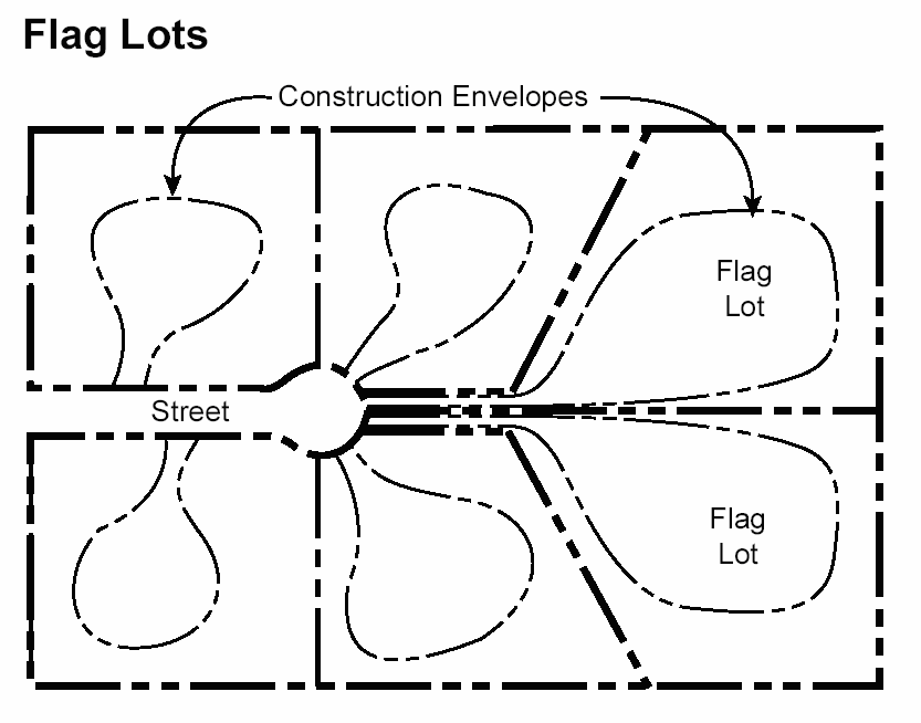
8.
Minimum lot width may be reduced up to twenty-five (25) percent. Flag lots with a minimum lot width of twenty (20) feet may be used if a flag lot design better achieves the purposes of the Environmentally Sensitive Lands Ordinance.
9.
If the underlying zoning is R1-18, R1-10, R1-7 or R1-5, one (1) of the side yard setbacks may be zero (0), if the dwellings are single-family detached homes. The minimum building separation shall be five (5) feet.
10.
The subdivision or land division shall be served by public or private water and sanitary sewer facilities if the minimum lot sizes are less than sixty thousand (60,000) square feet.
11.
Before any permit is issued, the required common open space shall be permanently maintained as natural open space in documents satisfactory to the City.
12.
Planned Residential Development (PRD) shall conform to the design criteria in Section 6.205.
(Ord. No. 2305, § 1, 2-19-91; Ord. No. 3225, § 1, 5-4-99; Ord. No. 3395, § 1, 12-11-01; Ord. No. 3501, § 1, 4-1-03; Ord. No. 3540, § 1(Exh. 1), 4-20-04; Ord. No. 3696, § 1(Exh. 1), 9-26-06; Ord. No. 3920, § 1(Exh. §§ 84, 85), 11-9-10; Ord. No. 4143, § 1(Res. No. 9678, Exh. A, §§ 176—178), 5-6-14)
Sec. 6.1091.- All applications.
A.
In addition to any other information required by the Zoning Ordinance and the Scottsdale Revised Code, applications for development approval under ESL District shall include the following:
1.
Base submittal requirements for all projects:
a.
Location and size of project boundaries, including any phasing plans.
b.
Project description.
c.
A.L.T.A. survey.
d.
Site development plan showing all existing and proposed construction, including density calculations.
e.
Aerial map.
f.
Site plan superimposed on the aerial map.
g.
Topography map (two-foot contours intervals).
h.
Slope analysis superimposed on the topography map with NAOS calculation table.
i.
NAOS analysis plan, including proposed civil improvements and proposed construction envelopes.
j.
Environmental features map, including applicable landforms, protected peaks and ridges, unstable slopes, boulder features, watercourses, vegetation and wildlife habitats, viewsheds, and manmade or fire scarring.
k.
Native plant submittal and revegetation plan and program, including transplanting and/or reseeding methods and the list of plants and density of application.
l.
Geotechnical report for sites with shallow bedrock and/or boulders.
m.
Drainage and grading report and plan.
n.
Archaeology data, reports, and/or plans as required by Chapter 46 of the City Code.
2.
Additional submittal requirements for master planned projects:
a.
Master environmental design concept plan.
b.
Phasing plan.
c.
Circulation plan.
d.
Water and wastewater plan.
3.
Additional submittal requirements for preliminary plat and Development Review Board submittals:
a.
Master environmental design concept plan.
b.
Cuts and fills site plan.
c.
Amended development standard justification report.
d.
Vista/scenic corridors, including cross section details.
e.
Public trail plan.
f.
Landscape plan.
g.
Color and material samples.
h.
Wall plans.
i.
Boulders that exceed six (6) feet in width and six (6) feet in height.
j.
If proposing modification per Section 6.1070.G.1.l., the delineation of natural watercourses of fifty (50) cfs or greater flow in a one hundred-year event.
4.
Additional submittal requirements for single-family residential permits:
a.
Boulders that exceed six (6) feet in width and six (6) feet in height;
b.
If proposing modification per section 6.1070.G.1.l., the delineation of natural watercourses of fifty (50) cfs or greater flow in a one hundred-year event.
5.
Additional submittal requirements for land divisions.
a.
The following information shall be shown on the building site plan:
i.
The location of all yards as required by the underlying zoning district.
ii.
The location of all setbacks for walls and fences as required in Section 6.1071.A.3.d, the underlying zoning district, and the Foothills Overlay FO District, if applicable.
iii.
The location of all proposed drainage easements.
iv.
The setbacks and minimum building separations for adjacent lots and the location of any existing improvements within forty (40) feet of the perimeter of the land division.
v.
The location of any boulder features, rock outcroppings and areas with land slopes exceeding twenty-five (25) percent.
b.
Verification of notice to all property owners of land within fifty (50) feet of the perimeter of the land division, including details of the notification method and the response of the property owners notified.
6.
Additional submittal requirement for lots not in a subdivision or land division. A complete site plan for the main dwelling and all other proposed improvements to the lot.
7.
Modified submittal requirements. The City may require additional information to identify or analyze specific environmental conditions, or may waive submittal requirements determined unnecessary for appropriate review of the project.
(Ord. No. 2305, § 1, 2-19-91; Ord. No. 3225, § 1, 5-4-99; Ord. No. 3395, § 1, 12-11-01; Ord. No. 3501, § 1, 4-1-03; Ord. No. 3540, § 1(Exh. 1), 4-20-04; Ord. No. 3696, § 1(Exh. 1), 9-26-06; Ord. No. 3920, § 1(Exh. § 86), 11-9-10; Ord. No. 4005, § 1(Res. No. 8947, Exh. A, § 194), 4-3-12; Ord. No. 4143, § 1(Res. No. 9678, Exh. A, §§ 179, 180), 5-6-14)
Sec. 6.1092.- Master Development Plan Submittal.
A.
A master development plan shall be submitted where:
1.
The Land Divisions ordinance requires a development master plan.
2.
The underlying zone requires a master development plan, e.g., Section 5.4002, Planned Commerce Park District (PCP), Section 6.204, Planned Residential Development (PRD) or Section 5.2103, Planned Community District (PC);
3.
The Zoning Administrator determines that a master plan is necessary for the orderly development of the project, in accordance with the requirements of this Zoning Ordinance.
(Ord. No. 2305, § 1, 2-19-91; Ord. No. 3225, § 1, 5-4-99; Ord. No. 3395, § 1, 12-11-01; Ord. No. 3920, § 1(Exh. § 87), 11-9-10; Ord. No. 4143, § 1(Res. No. 9678, Exh. A, § 181), 5-6-14)
Sec. 6.1100.- Maintenance and Violations.
A.
Maintenance—Improved areas. The property owner of private property on which grading or other work has been performed pursuant to a grading plan approved under the ESL regulations, shall maintain in perpetuity and repair all graded surfaces and erosion control devices, retaining walls, drainage structures or devices, and planting and ground covers according to specifications established by the City.
B.
Maintenance—Natural Area Open Space (NAOS).
1.
NAOS shall be permanently preserved in its natural condition to be self-sustaining.
2.
The removal of small amounts of man-made trash and debris that may accumulate within NAOS is permitted.
3.
Clearing, pruning, raking, and landscaping within NAOS areas is prohibited except as provided in Subsections 4., 5., and 6. below.
4.
Maintenance of public non-paved trails within NAOS shall be subject to specific approval by the City.
5.
The removal of man-made dumping piles, and specified invasive, non-indigenous plants and weeds within NAOS shall be subject to specific approval by the City.
6.
A defensible space will be permitted to be established and maintained around homes in Wildland/Urban Interface and Intermix areas as defined in Section 3.100. The removal of flash fuels, which include invasive annual grasses, for an area of thirty (30) feet from a habitable structure, to provide for fire safety around dwellings, is permitted, but shall not result in the destruction of native plants* within NAOS.
7.
Dead or dying native plants within NAOS shall be left in place to provide wildlife habitat.
8.
NAOS easements may be released by the Zoning Administrator only to the extent such releases conform to the standards set forth in Section 6.1060.F.
*Native plants include the specific species defined in Article V, Protection of Native Plants, Section 46-105 through 46-120 of the Scottsdale Revised Code.
C.
Violations.
1.
A violation of any provision of the Environmentally Sensitive Lands Ordinance shall be subject to the violation and penalty provisions in Article I of the Zoning Ordinance.
2.
Upon conviction for a violation of any provision of Section 6.1100 or the conditions of a permit issued hereunder, the court shall impose a fee of fifty dollars ($50.00) for a preservation fund, in addition to any other fines or penalties.
3.
Funds obtained from this fee shall be used to supplement the City's preservation efforts through deposit into the Trust for McDowell Mountain Land Acquisition.
4.
In addition to the penalties in Section 1.1402, a property owner or owner's agent who is found in violation of Section 6.1035 shall fully restore the property to its natural topographic and vegetative condition, to the satisfaction of the City. The restoration shall be complete within one hundred twenty (120) days after the finding of violation. Failure to complete restoration within one hundred twenty (120) days is deemed authorization for the City to complete restoration at the expense of the property owner. The cost of the City's restoration shall become a lien against the property. All fees to apply for development approval on the property shall be twice the usual fees for such applications.
(Ord. No. 3395, § 1, 12-11-01; Ord. No. 3702, § 1, 2-20-07; Ord. No. 3920, § 1(Exh. § 88), 11-9-10; Ord. No. 4143, § 1(Res. No. 9678, Exh. A, §§ 182, 183), 5-6-14)
Sec. 6.1110.- Appeals.
The property owner may appeal a decision of the Zoning Administrator to the Development Review Board. The appeal must be in writing, filed with the City within fifteen (15) days of the date on which written notice of the decision was mailed to the property owner, and must state the reasons for appeal, and the relief requested. The Zoning Administrator shall place the appeal on the next available Development Review Board agenda and shall notify the property owner in writing of the time and place at which the Development Review Board will consider the appeal. Decisions of the Development Review Board may be appealed to the City Council as provided in Article I.
(Ord. No. 3395, § 1, 12-11-01; Ord. No. 3501, § 1, 4-1-03; Ord. No. 3920, § 1(Exh. § 89), 11-9-10; Ord. No. 4143, § 1(Res. No. 9678, Exh. A, § 184), 5-6-14)
Sec. 6.1200.- Downtown Overlay (DO).
Editor's note— Ord. No. 3987, § 1(Res. No. 8948, § 1(Exh. A, § 21), adopted November 14, 2012, repealed former §§ 6.1200—6.1209, and enacted provisions designated as new §§ 6.1200—6.1206 to read as herein set out. Prior to inclusion of said ordinance, § 6.1200 et seq. pertain to similar subject matter. See also the Code Comparative Table.
Sec. 6.1201.- Purpose.
A.
This district is to promote the goals and policies of the Old Town Plan and provide increased intensities to revitalize Old Town Area properties. This district encourages urban design forms to accommodate additional dwelling units in mixed-use developments and stimulates sustainable live/work lifestyles within a vital urban environment.
(Ord. No. 3987, § 1(Res. No. 8948, § 1(Exh. A, § 21), 11-14-12; Ord. No. 4629, § 1(Res. No. 13058, § 1(Exh. A, § 8)), 2-20-24)
Sec. 6.1202.- Applicability.
A.
The DO District shall only be applied to property within the Old Town Area.
(Ord. No. 3987, § 1(Res. No. 8948, § 1(Exh. A, § 21), 11-14-12; Ord. No. 4629, § 1(Res. No. 13058, § 1(Exh. A, § 8)), 2-20-24)
Sec. 6.1203.- Reserved.
Editor's note— Ord. No. 4164, § 1(Res. No. 9857, § 1, Exh. A, § 49), adopted Aug. 25, 2014, repealed § 6.1203 which pertained to approval requirements and derived from Ord. No. 3987, § 1(Res. No. 8948, § 1(Exh. A, § 21), adopted Nov. 14, 2012, and Ord. No. 4143, § 1(Res. No. 9678, Exh. A, § 185), adopted May 6, 2014.
Sec. 6.1204.- Use regulations.
A.
The uses allowed are:
1.
Dwelling units; and
2.
The uses as allowed in the underlying zoning district.
B.
Drive-through and drive-in services are not allowed in the Old Town Area.
C.
Temporary buildings, structures and mobile vendors are only allowed on a property as accessory to construction work on the property, and shall be promptly removed upon completion of construction work or the Zoning Administrator's request.
(Ord. No. 3987, § 1(Res. No. 8948, § 1(Exh. A, § 21), 11-14-12; Ord. No. 4117, § 1(Res. No. 9563, Exh. A, § 8), 11-19-13; Ord. No. 4629, § 1(Res. No. 13058, § 1(Exh. A, § 8)), 2-20-24)
Sec. 6.1205.- Property development standards.
A.
If there is a conflict between the development standards of DO District and the development standards of the underlying district, the development standards of the DO District control, except for properties zoned Downtown District as the underlying district.
B.
If there is a conflict between the DO District and Article VII, the DO District controls.
C.
The following property development standards of the Downtown District shall apply to property zoned DO:
1.
Setbacks from public streets, except alleys,
2.
Setbacks from major intersections,
3.
Setbacks from a Single-family Residential District,
4.
Building location,
5.
Private outdoor living space,
6.
Stepbacks,
7.
Exceptions to building location, setback, prevailing setback, and stepback standards, and
8.
Shaded sidewalks.
D.
Maximum first floor area for dwelling units.
1.
Type 1 Area. Maximum thirty five (35) percent of the first floor area.
2.
Type 2 Area, Type 2.5 Area, or Type 3 Area with any commercial district zoning shown on Table 4.100.B. Maximum thirty five (35) percent of the first floor area.
E.
Building height.
1.
The building height maximum (excluding rooftop appurtenances) shall be that of the underlying zoning district, except in the Service Residential S-R district and as allowed in Article VII.
2.
In the S-R District, the building height maximum (excluding rooftop appurtenances) shall be twenty-six (26) feet, and as allowed in Article VII.
3.
Rooftop appurtenances that are parapets or railings (with a maximum inside height of forty-five (45) inches) for a rooftop patio are excluded from the building height maximum.
F.
Density.
1.
Maximum: twenty-three (23) dwelling units per acre of gross lot area.
G.
Gross floor area ratio (GFAR).
1.
Maximum: 1.3.
H.
Open Space.
1.
None required.
I.
Signs.
1.
The provisions of Article VIII. shall apply.
J.
Off-street parking.
1.
The off-street parking provisions of the Downtown District shall apply.
K.
Landscaping.
1.
The provisions of Article X. shall apply.
(Ord. No. 3987, § 1(Res. No. 8948, § 1(Exh. A, § 21), 11-14-12; Ord. No. 4099, § 1(Res. No. 9439, Exh. A, §§ 10, 11), 6-18-13; Ord. No. 4117, § 1(Res. No. 9563, Exh. A, §§ 9—13), 11-19-13; Ord. No. 4355, § 1(Res. No. 11190, § 3, Exh. A), 7-2-18; Ord. No. 4629, § 1(Res. No. 13058, § 1(Exh. A, § 8)), 2-20-24)
Sec. 6.1206.- Property development standards for small parcels.
A.
The provisions for small parcels in the Downtown District shall apply to parcels with a gross lot area less than twenty thousand (20,000) square feet in the DO District.
(Ord. No. 3987, § 1(Res. No. 8948, § 1(Exh. A, § 21), 11-14-12; Ord. No. 4355, § 1(Res. No. 11190, § 3, Exh. A), 7-2-18; Ord. No. 4629, § 1(Res. No. 13058, § 1(Exh. A, § 8)), 2-20-24)
Sec. 6.1301.- Purpose.
A.
The purpose of the PBD Overlay District is to allow for development flexibility in the Old Town Area to assist the City in achieving the Old Town Plan, developing more Old Town Area public amenities, and adding land uses that would further promote the Old Town Area as a twenty-four (24) hour community.
(Ord. No. 3987, § 1(Res. No. 8948, § 1(Exh. A, § 22), 11-14-12; Ord. No. 4629, § 1(Res. No. 13058, § 1(Exh. A, § 8)), 2-20-24)
Sec. 6.1302.- Applicability.
A.
The PBD Overlay District is applicable only to property zoned Downtown District.
(Ord. No. 3987, § 1(Res. No. 8948, § 1(Exh. A, § 22), 11-14-12; Ord. No. 4629, § 1(Res. No. 13058, § 1(Exh. A, § 8)), 2-20-24)
Sec. 6.1303.- District size requirement.
A.
Gross lot area minimum: twenty thousand (20,000) square feet.
B.
Qualifying parcels: For development projects with multiple parcels, such parcels must be contiguous and under single ownership or control to meet the gross lot area minimum. Adjacent right-of-way width and alleys will be considered as contributing to the contiguity of parcels. Parcels with offset boundaries must have a minimum of twenty linear feet of adjacent boundary to be considered as contributing to the contiguity gross lot area minimum size.
(Ord. No. 3987, § 1(Res. No. 8948, § 1(Exh. A, § 22), 11-14-12; Ord. No. 4629, § 1(Res. No. 13058, § 1(Exh. A, § 8)), 2-20-24)
Sec. 6.1303.1.- Development Plan (DP).
A.
A zoning district map amendment application shall be accompanied by a Development Plan as required in Article VII.
(Ord. No. 4099, § 1(Res. No. 9439, Exh. A, § 12), 6-18-13; Ord. No. 4355, § 1(Res. No. 11190, § 4, Exh. A), 7-2-18; Ord. No. 4629, § 1(Res. No. 13058, § 1(Exh. A, § 8)), 2-20-24)
Sec. 6.1304.- PBD Overlay District criteria.
A.
Before the first Planning Commission hearing on a PBD Overlay District application, the Development Review Board shall make a recommendation to the Planning Commission regarding the Development Plan based on the following criteria.
1.
Criteria for a PBD Overlay District application in a Type 1 Area:
a.
The Development Plan shall reflect the goals and policies of the Character & Design Chapter of the Old Town Plan; and
b.
The site development standards and building form shall be in conformance with the Old Town Scottsdale Urban Design & Architectural Guidelines.
2.
Criteria for a PBD Overlay District application in a Type 2 Area or a Type 2.5 Area:
a.
The Development Plan shall reflect the goals and policies of the Character & Design Chapter of the Old Town Plan;
b.
The site development standards and building form shall be in conformance with the Old Town Scottsdale Urban Design & Architectural Guidelines;
c.
The Development Plan shall incorporate standards for development within three hundred fifty (350) feet of the Old Town Boundary that address appropriate transitions in building heights and building massing between the proposed development and the zoning districts abutting or adjacent to the development;
d.
The Development Plan for development is within one hundred (100) feet of a Type 1 Area, as shown on the Old Town Plan Development Types Maps shall address appropriate transitions in building heights, building massing, and landscaping, to create a compatibility between the higher scale Type 2 or Type 2.5 and the lower scale Type 1 Development Types;
e.
The Development Plan shall incorporate standards for development adjacent to public streets that include sidewalks, pedestrian linkages, building forms and architectural features that address human scale and pedestrian orientation; and
f.
The pedestrian circulation shall be accessible and easy to navigate, and incorporate open space and pedestrian linkages to the public pedestrian circulation network.
3.
Criteria for a PBD Overlay District application in the Type 3 Area:
a.
The Development Plan shall reflect the goals and policies of the Character & Design Chapter of the Old Town Plan;
b.
The site development standards and building form shall be in conformance with the Old Town Scottsdale Urban Design & Architectural Guidelines;
c.
The Development Plan shall incorporate standards for development within three hundred fifty (350) feet of the Old Town Boundary that address appropriate transitions in building heights and building massing between the proposed development and the zoning districts abutting or adjacent to the development;
d.
The Development Plan for development is within one hundred (100) feet of a Type 1 Area, as shown on the Old Town Plan Development Types Maps, shall address appropriate transitions in building heights, building massing, and landscaping, to create a compatibility between the higher scale Type 3 and the lower scale Type 1 Development Types;
e.
The Development Plan shall incorporate standards for development adjacent to public streets that include sidewalks, pedestrian linkages, building forms and architectural features that address human scale and pedestrian orientation; and
f.
The pedestrian circulation shall be accessible and easy to navigate, and incorporate open space and pedestrian linkages to the public pedestrian circulation network.
B.
In addition to the criteria used by the City Council to review a zoning district map amendment application, the Planning Commission shall make a recommendation to the City Council, based on the following applicable criteria:
1.
Standard criteria:
a.
The proposed development supports the land use elements of the General Plan and the Old Town Plan.
2.
Criteria to add land uses to Table 5.3004.D., Land Uses for Each Sub-district of the Downtown District:
a.
Each proposed land use helps maintain a balance of land uses in the Old Town Area in accordance with the Old Town Plan.
b.
Each proposed land use is compatible with the adjacent development, and strengthens the mix of land uses and activities in the Old Town Area.
c.
Each proposed land use substantially implements the pedestrian oriented, twenty-four (24) hour downtown community goals of the Old Town Plan.
3.
Criteria to achieve bonus(es):
a.
The proposed Development Plan reflects noteworthy investments to provide public benefits, improve the quality of life in the community, and assist in achieving the goals and policies of the General Plan, Old Town Plan and City objectives, in the vicinity where the development will be located.
C.
The City Council may approve, or approve with stipulations, a development application or portion thereof, if it finds the development application meets the criteria of Subsection B above.
D.
The property owner shall address the criteria in this section.
(Ord. No. 3987, § 1(Res. No. 8948, § 1(Exh. A, § 22), 11-14-12; Ord. No. 4117, § 1(Res. No. 9563, Exh. A, § 14), 11-19-13; Ord. No. 4143, § 1(Res. No. 9678, Exh. A, §§ 186, 187), 5-6-14; Ord. No. 4355, § 1(Res. No. 11190, § 4, Exh. A), 7-2-18; Ord. No. 4629, § 1(Res. No. 13058, § 1(Exh. A, § 8)), 2-20-24)
Sec. 6.1305.- Amendments to the Development Plan.
A.
A property owner in a PBD Overlay District may request an amendment to the Development Plan, if the amendment does not change the property development standards of other properties in the PBD Overlay District.
(Ord. No. 3987, § 1(Res. No. 8948, § 1(Exh. A, § 22), 11-14-12; Ord. No. 4143, § 1(Res. No. 9678, Exh. A, § 188), 5-6-14; Ord. No. 4629, § 1(Res. No. 13058, § 1(Exh. A, § 8)), 2-20-24)
Sec. 6.1306.- Minimum requirements.
A.
Property within a PBD Overlay District shall meet the following requirements, at a minimum:
1.
Compliance with the Cultural Improvements Program requirements.
(Ord. No. 4355, § 1(Res. No. 11190, § 4, Exh. A), 7-2-18; Ord. No. 4591, § 1(Res. No. 12797, § 1(Exh. A, § 5)), 6-13-23; Ord. No. 4629, § 1(Res. No. 13058, § 1(Exh. A, § 8)), 2-20-24)
Sec. 6.1307.- Use regulations.
A.
The applicable underlying Downtown District's sub-district's use regulations shall apply to the PBD Overlay District, except that the City Council may add land uses. A zoning district map amendment's associated Development Plan for a PBD Overlay District shall include any additional land uses. The City Council may impose requirements on additional land uses.
(Ord. No. 3987, § 1(Res. No. 8948, § 1(Exh. A, § 22), 11-14-12; Ord. No. 4629, § 1(Res. No. 13058, § 1(Exh. A, § 8)), 2-20-24)
Sec. 6.1308.- Property development standards.
A.
The property development standards of the PBD Overlay District shall control over the property development standards of the Downtown District.
B.
Density, building height, and gross floor area ratio (GFAR) maximums.
1.
The Development Plan shall identify the density for each property within the PBD Overlay District, but in no instance shall density exceed fifty (50) dwelling units per acre of gross lot area without an approved bonus.
2.
The Development Plan shall identify the building heights for each property within the PBD Overlay District, but in no instance shall building height(s) exceed the building height maximum set forth in Table 6.1308.B. for the applicable Downtown District development type without an approved bonus. The additional height regulations of Article VII. shall not apply.
3.
The Development Plan shall identify the GFAR for each property within the PBD Overlay District, but in no instance shall GFAR exceed 1.4 without an approved bonus.
C.
Private outdoor living space.
1.
All dwelling units shall include private outdoor living space located beside the dwelling unit.
2.
Each private outdoor living space shall be at least six (6) feet deep and sixty (60) square feet in area.
D.
Setbacks.
1.
All buildings shall be set back in accordance with the approved Development Plan, except as required in Section 6.1308.D.2 below.
2.
Old Town Boundary—Additional requirements for property in a Type 2, Type 2.5, or Type 3 Area.
a.
Where the Old Town Boundary abuts a Single-family Residential District or an alley that abuts a Single-family Residential District, the setback shall be ten (10) feet from the Single-family Residential District or the centerline of the alley.
b.
Where the Old Town Boundary does not abut a Single-family Residential District or abuts an alley that does not abut a Single-family Residential District, the setback shall be ten (10) feet from the centerline of the alley.
E.
Stepbacks.
1.
All building stepbacks shall be in accordance with the approved Development Plan, except as required in Subsections 6.1308.E.2., 6.1308.E.3. and 6.1308.E.4. below.
2.
Old Town Boundary—Additional requirements for property in a Type 2, a Type 2.5, or Type 3 Area:
a.
Where the Old Town Boundary abuts a Single-family Residential District or an alley that abuts a Single-family Residential District, the stepback plane shall incline at a ratio of 1:1, beginning fifteen (15) feet above the setback line to forty-five (45) feet; and beginning at forty-five (45) feet, incline at a ratio of 1:3.
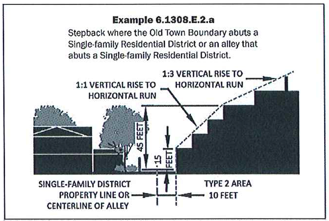
b.
Where the Old Town Boundary abuts a public street (except alleys), the stepback plane shall incline at a ratio of 1:1, beginning thirty (30) feet above the minimum setback from the public street (except alleys) to forty-five (45) feet; and beginning at forty-five (45) feet, incline at a ratio of 1:3.
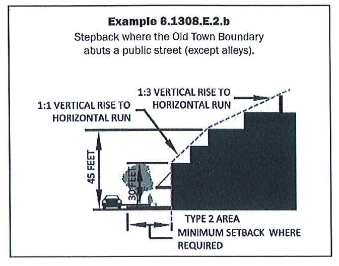
c.
Where the Old Town Boundary does not abut a Single-family Residential District or abuts an alley that does not abut a Single-family Residential District, the stepback plane shall incline at a ratio of 1:1, beginning thirty (30) feet above the setback line from the alley and thirty (30) feet above all other property lines to forty-five (45) feet; and beginning at forty-five (45) feet, incline at a ratio of 1:3.
3.
If there is a conflict at the intersection of the stepback planes, the more gradual slope controls.
F.
Signs.
1.
The provisions of Article VIII shall apply.
G.
Off-street parking.
1.
The provisions of the Downtown District shall apply.
H.
Landscaping.
1.
The provisions of Article X shall apply.
I.
Additional requirements
1.
Building locations and stepbacks, including exceptions to setbacks and stepbacks, shall conform to the Development Plan.
(Ord. No. 3987, § 1(Res. No. 8948, § 1(Exh. A, § 22), 11-14-12; Ord. No. 4241, § 1, 3-29-16; Ord. No. 4355, § 1(Res. No. 11190, § 4, Exh. A), 7-2-18; Ord. No. 4629, § 1(Res. No. 13058, § 1(Exh. A, § 8)), 2-20-24)
Sec. 6.1309.- Cultural Improvements Program requirements.
A.
Property within a PBD Overlay District shall comply with the Cultural Improvements Program, except as provided below.
1.
For property rezoned to the PBD Overlay District before January 1, 2013, the property owner shall provide artwork, or pay an in-lieu fee, equal to at least one percent of the building valuation for the nonresidential floor area. For property rezoned to the PBD Overlay District before January 1, 2013, adding nonresidential floor area after December 31, 2012, the property owner shall provide artwork, or pay an in-lieu fee, equal to at least one percent of the building valuation for the added nonresidential floor area.
2.
For property rezoned to the PBD Overlay District after December 31, 2012, the property owner shall provide artwork, or pay an in-lieu fee, equal to at least one percent of the building valuation for all floor area. For property rezoned to the PBD Overlay District after December 31, 2012, adding floor area after December 31, 2012, the property owner shall provide artwork, or pay an in-lieu fee, equal to at least one percent of the building valuation for the added floor area.
B.
In lieu fees shall be paid into the Downtown Cultural Fund.
C.
Exemptions.
1.
The following are exempt from the Cultural Improvement Program requirement:
a.
Interior tenant improvements.
b.
Residential uses in a PBD Overlay District that was rezoned before January 1, 2013.
c.
Dwellings, single-family and two-family.
d.
Properties zoned Special Campus in which cultural improvement program elements have been included in the Development Plan.
(Ord. No. 3987, § 1(Res. No. 8948, § 1(Exh. A, § 22), 11-14-12; Ord. No. 4143, § 1(Res. No. 9678, Exh. A, § 189), 5-6-14; Ord. No. 4629, § 1(Res. No. 13058, § 1(Exh. A, § 8)), 2-20-24)
Sec. 6.1310.- Bonus provisions.
A.
Applicability.
1.
The City Council may approve bonus development standards for property zoned PBD Overlay upon demonstration of noteworthy investments in sustainable, high-quality urban design and other features that provide public benefits, improve the quality of life in the community, and assist in achieving the goals and policies of the General Plan, Old Town Plan and City objectives.
B.
Types of bonus development standards.
1.
Bonuses may be obtained to increase the maximums set forth above in Section 6.1308. for:
a.
Building height,
b.
Gross Floor Area Ratio, and
c.
Density.
C.
Minimum requirements.
1.
Any property requesting PBD Overlay zoning with bonus development standards shall meet the following requirements, at a minimum:
a.
Provide privately-owned, publicly-accessible open space in compliance with the requirements of 6.1310.C.1.a.i. and 6.1310.C.1.a.ii. below.
i.
For Type 2, Type 2.5, and Type 3 Areas, publicly accessible open space shall be provided within the Development Plan in the quantities set forth in Table 6.1310.C.
ii.
The public open space area(s), and public access to the public open space area(s), shall be provided at or near the ground floor, and determined through a development agreement between the property owner and the City.
D.
Bonus development standards for density, building height, and gross floor area ratio (GFAR).
1.
Bonus density shall not exceed the density set forth in the Development Plan approved by the City Council.
2.
Bonus building height(s) shall not exceed the building height maximums set forth in Tables 6.1310.D.1. and 6.1310.D.2. for the applicable Downtown District development type. The additional height regulations of Article VII. shall not apply.
a.
Properties zoned Planned Block Development Overlay District prior to March 21, 2024. Properties zoned Planned Block Development Overlay District prior to March 21, 2024 may elect to submit a zoning district map amendment and request the existing bonus building height maximums set forth in Table 6.1310.D.1. provided that a completed development application is filed on or before March 21, 2027. Said application must be diligently pursued such that a decision upon the application by the City Council is rendered no later than March 21, 2028. If no decision has been rendered by the City Council by that date, the development application shall be deemed withdrawn and any further development application for such property shall comply with the future bonus building height maximums set forth in Table 6.1310.D.2.
b.
Properties not zoned Planned Block Development Overlay District prior to March 21, 2024. Properties that are not zoned Planned Block Development Overlay District prior to March 21, 2024 may elect to submit a zoning district map amendment request with the future bonus building height maximums set forth in Table 6.1310.D.2. Provided, however, that any development application for a property for a zoning district map amendment change to Planned Block Development Overlay District determined to be administratively complete before September 30, 2024 may elect to submit a zoning district map amendment and request the existing bonus building height maximums set forth in Table 6.1310.D.1. Said application must be diligently pursued such that a decision regarding rezoning by the City Council is rendered no later than March 21, 2027. If no decision has been rendered by the City Council by that date, the development application shall be deemed withdrawn and any further development application for such property shall comply with the future bonus building height maximums set forth in Table 6.1310.D.2.
3.
GFAR shall not exceed the GFAR maximum set forth in Table 6.1310.D.3. for the applicable Downtown District development type.
E.
Bonus development standards procedures.
1.
Any application of bonus development standards, or application for amendment to existing bonus development standards, shall be subject to City Council approval through a zoning district map amendment with a Development Plan and development agreement.
a.
The Development Plan shall include a development project narrative that:
i.
Describes, in addition to other project narrative requirements, the bonus development standards sought, specifying the proposed gross floor area ratio (GFAR), building height and/or density, as applicable, and
ii.
Identifies how the development project will comply with the Cultural Improvements Program requirements and the Special Public Improvements requirements and/or analysis of any other proposed community benefit(s), as applicable, and
iii.
Provides the method and calculations for determining the Total Construction Cost Estimate, as outlined in Section 7.1200, as applicable.
2.
The development agreement shall be in a form satisfactory to the City Attorney and include, but not be limited to, the requirements outlined in Section 7.1200.
F.
Special Public Improvements requirements.
1.
Development projects utilizing Special Public Improvements and/or other community benefit(s) to achieve bonus development standards must comply with the Special Public Improvements requirements as outlined in Section 7.1200.
(Ord. No. 3987, § 1(Res. No. 8948, § 1(Exh. A, § 22), 11-14-12; Ord. No. 4117, § 1(Res. No. 9563, Exh. A, § 15), 11-19-13; Ord. No. 4143, § 1(Res. No. 9678, Exh. A, §§ 190—194), 5-6-14; Ord. No. 4241, §§ 2, 3, 3-29-16; Ord. No. 4355, § 1(Res. No. 11190, § 4, Exh. A), 7-2-18; Ord. No. 4629, § 1(Res. No. 13058, § 1(Exh. A, § 8)), 2-20-24)
Sec. 6.1311.- Reserved.
Editor's note— Ord. No. 4355, § 1(Res. No. 11190, § 4, Exh. A), adopted July 2, 2018, repealed § 6.1311, which pertained to bonus provision regulations and derived from Ord. No. 3987, § 1(Res. No. 8948, § 1(Exh. A, § 22), adopted Nov. 14, 2012; Ord. No. 4117, § 1(Res. No. 9563, Exh. A, § 16), adopted Nov. 19, 2013; Ord. No. 4143, § 1(Res. No. 9678, Exh. A, §§ 195—201), adopted May 6, 2014.
Sec. 6.1401.- Purpose.
A.
The purpose of the PSD District is to provide the opportunity for application of development standards to a property as defined by its perimeter, rather than applying the standards to the individual lots, tracts, and parcels within the boundaries of the perimeter. The PSD District allows the City Council to grant amended development standards for the purposes of sharing development standards between the lots, tracts, and parcels within the boundaries of the District.
(Ord. No. 4244, § 2, 5-17-16)
Sec. 6.1402.- Applicability.
A.
The PSD District may be overlaid upon all commercial and mixed-use districts as specified in Table 4.100.B. and Table 4.100.D., excluding the Downtown (D) District.
(Ord. No. 4244, § 2, 5-17-16; Ord. No. 4333, § 1, 3-6-18)
Sec. 6.1403.- District Size Requirement.
A.
Minimum: Five (5) acres of gross lot area.
(Ord. No. 4244, § 2, 5-17-16)
Sec. 6.1404.- Development Plan.
A.
The Zoning District Map Amendment application shall be accompanied by a Development Plan as required in Article VII.
(Ord. No. 4244, § 2, 5-17-16)
Sec. 6.1405.- Use Regulations.
A.
The applicable underlying zoning district use regulations shall apply to the PSD District.
(Ord. No. 4244, § 2, 5-17-16)
Sec. 6.1406.- PSD District Requirements.
A.
Development standards. The property, as defined by the PSD District perimeter boundary, shall comply with all required development standards of the underlying zoning district(s).
B.
Transfer of development rights.
1.
If the development of the individual lots, parcels, or tracts located within the PSD District will result in transfer of density or other development rights or obligations from one lot, parcel, or tract to another, then the proposed transfer of development rights shall be subject to the following additional requirements:
a.
The City shall be responsible for the issuance and recordation of instruments necessary to sever development rights and obligations from the sending property and to affix development rights and obligations to the receiving property. Such instrument shall be executed by the affected property owners and lienholders, and shall provide for the following:
i.
Approval and consent of any transfer of development rights and obligations by the property owners of both the sending and receiving properties.
ii.
The preservation of the character of the sending property and assurance that the prohibitions against the use and development of the sending property shall bind the landowner(s) and every successor in interest to the landowner(s).
iii.
The severance of transferable development rights and obligations from the sending property and the delayed transfer of development rights and obligations to the receiving property.
iv.
The purchase, sale, exchange or other conveyance of transferable development rights and obligations prior to the rights and obligations being affixed to a receiving property.
b.
The City shall monitor the severance, ownership, assignment and transfer of transferable development rights and obligations. All severance and transfer of development rights not approved by the City before made are void. Each owner has an affirmative duty to inform the City of any change in ownership and assignment of owner rights and obligations.
c.
The City at its option may purchase development rights and hold them for future resale.
d.
The City may enter into an Intergovernmental Agreement with another municipality or county for the transfer of development rights between jurisdictions.
C.
Development agreement and maintenance of shared facilities.
1.
All proposals for the PSD District are subject to City Council approval of a development agreement that specifies:
a.
The identity of the person(s)/entity(ies) owning all parcels within the PSD District, and a requirement that any person or entity owning a parcel will have an affirmative duty to notify the City of a proposed change in ownership.
b.
The designation of a single City contact and property manager who is responsible for complying with and maintaining the shared facilities.
c.
The legal description of the lots, parcels and tracts located within the PSD District.
d.
The establishment of an association to maintain common areas, shared facilities and community-owned property.
e.
A requirement that the association record a Master Declaration of Easements, Covenants, Conditions and Restrictions in the official records of the Maricopa County Recorder identifying how maintenance of the common areas, shared facilities and community-owned property will be maintained, and that the City be notified of such recordation. Each property owner and the Association will be responsible for the content and enforceability of such Declaration. The City will not be a party to, undertake a review of, approve, or disapprove such Declaration.
f.
An indemnification by the property manager and property owners indemnifying and holding the City, its employees, agents and officials harmless from any and all claims including reasonable attorney's fees and costs that may arise from any person(s)/entity(ies) owning any part of the property within a PSD District, which they may bring against the City resulting from the development or from the division of property within a PSD District.
g.
If, at any time, upon or after its creation, the PSD District includes or seeks to include residential condominiums subject to A.R.S. Section 33-1201 et seq., then, for purposes of the PSD District and this zoning ordinance, the term "property owner" shall mean the "unit owners' association" as defined in such statutes, and the Master Declaration of Easements, Covenants, Conditions and Restrictions for the PSD District shall explicitly so provide.
h.
A requirement that the owners of the parcels within the PSD district are jointly and severally responsible for the maintenance of common areas, shared facilities, and community owned property. In no event will the City be bound by private agreements between property owners as to responsibility for such maintenance.
D.
Plat. To establish property boundaries in conformance with the Development Plan, the owner shall submit the application for review in conformance with the City's codes, policies and regulations.
(Ord. No. 4244, § 2, 5-17-16; Ord. No. 4333, § 1, 3-6-18)