
Seminole County Unincorporated
City Zoning Code
City Zoning Code
PART 8
- SPECIAL ZONING DISTRICTS
Sec. 30.8.1.- Description of Special Zoning Districts.
30.8.1.1 Purpose. Special Zoning Districts are intended to address development that incorporates multiple uses or typologies and/or addresses a specific goal in the comprehensive plan requiring the implementation of interrelated standards specific to that development type.
30.8.1.2 Subdivision Standards in Special Zoning Districts. Special Districts may incorporate subdivision standards that are specific to that district. Such standards are intended to facilitate the specific goal of the applicable district and apply only to that district.
(Ord. No. 2024-02, § 7(Exh. B), 1-9-24).
Sec. 30.8.2. - MUCD Mixed Use Corridor District.
30.8.2.1 Intent and Purpose. The Mixed-Use Corridor District is intended to enable and encourage efficient use of land, reduce cost of public infrastructure, and support flexible transportation options, including walking and bicycling, by locating complementary uses in proximity to each other and providing for pedestrian-oriented site development to allow users to travel easily between uses. MUCD allows for a blend of various uses including retail, office, residential, institutional, and limited heavy commercial in a single project and/or in the same building.
30.8.2.2 Applicability.
(a)
Location. The Mixed-Use Corridor District is permitted in the following comprehensive plan categories:
(1)
Identified centers and corridors within the comprehensive plan.
(2)
Areas with the MXD future land use designation.
(b)
Rezoning. Any application for a zoning map amendment to MUCD must be accompanied by a conceptual site plan that includes the following:
(1)
Density and intensity of the proposed development.
(2)
Proposed uses.
(3)
Points of access to existing roadways and neighboring properties including future access points to undeveloped properties.
The submitted conceptual site plan must be evaluated by the Board of County Commissioners and become a condition of approval of the Mixed-Use Corridor District for the subject property.
(c)
Process for Approval of Substantial Change. After rezoning of the subject property, any substantial change to the approval must be evaluated by the Board of County Commissioners through the same review process as the original application. Other changes may be approved by the Development Services Director. The determination of "substantial" change will be made by the Development Services Director based on criteria such as, but not limited to, the following:
(1)
Increase in the overall density/intensity of the proposal.
(2)
The addition of a use requiring a Special Exception.
(3)
Reconfiguration of or addition of points of access to the site such that neighboring residents and/or property owners may be adversely affected.
(4)
Any change potentially creating additional off-site impacts such as traffic, noise, stormwater management, and public facility demand.
(5)
Deviation(s) from standard LDC requirements exceeding ten (10) percent.
(6)
A reduction in transportation connectivity within the site.
(7)
Any change deemed by the Development Services Director to significantly change the nature or intent of the proposal.
(d)
Final Development Plan Required. Subsequent to rezoning, the applicant must submit a final development plan consistent with the development criteria and limitations enacted in the approved zoning and the MUCD standards. This plan must be reviewed and approved by the Development Services Director or designee.
A final development plan must be submitted to the Planning and Development Office containing the following information:
(1)
Proposed uses and their general locations on the site.
(2)
Building elevations.
(3)
Frontage types.
(4)
Location of Active Ground Floor Uses.
(5)
Existing residential uses in proximity to the development.
(6)
Setbacks, building heights, landscaped areas, civic spaces and stormwater management areas.
(7)
Site circulation for motor vehicles, pedestrians, and bicycles.
(8)
Access points to external roadways, sidewalks, and trails.
(9)
Parking lots and structures.
(10)
Boundary survey, tax map reference etc.
(11)
Aerial map showing project context (five hundred (500) to one thousand (1,000) feet around the site).
Subdivided parcels within a mixed-use development will be subject to all development criteria and conditions established in the overall plan. Such plans may not be altered without approval by the Development Services Director.
30.8.2.3 Allowable Uses, Densities, and Intensities. Specific uses proposed must be allowable in MUCD in the Land Use Table 5.2 subject to any applicable conditions in or other provisions of this LDC.
(a)
Permitted Density and Intensity. Density and Intensity are permitted per the applicable Future Land Use District in the Comprehensive Plan. For applications incorporating multiple uses, the net buildable acres for the entire project will be used as the basis for calculating density and for calculating intensity. The site acreage may not be divided for the purposes of calculating density/intensity for different uses.
(b)
Mixed Use Requirements. Except as provided in this Section, all developments in MUCD shall include one or more uses from at least two of the following use categories as defined in Table 5.2:
•
Residential uses
•
Public and civic uses
•
Commercial uses
Except that single use applications are limited to tracts of less than six (6) acres.
Distinct uses or components of an MUCD development must have a unified site design and must not be separated into functionally separate development sites. Separate uses may be located in a single building or multiple buildings and typically make joint use of site amenities and facilities, such as open space, landscaping, parking, and stormwater management.
(c)
Active Ground Floor Uses. Where referenced, "active ground floor uses" means uses (permitted in the District) at least twenty (20) feet in depth adjacent to the public sidewalk that are accessible to the public or used as a common space by building tenants. Examples of such uses include:
(1)
Retail
(2)
Food and beverage
(3)
Indoor recreation
(4)
Galleries
(5)
Lobby and reception areas
(6)
Club rooms with transparent windows
(7)
Live/Work Units
30.8.2.4 Building Height
(a)
At rezoning, the parcel shall be designated as MUCD High Intensity or MUCD Low Intensity, specifying the maximum allowable height. Stories are measured from finished floor to finished ceiling. Ground floor stories shall not exceed sixteen (16) feet in height for residential buildings or twenty-five (25) feet in height for non-residential or mixed-use buildings. Upper stories shall not exceed fourteen (14) feet in height.
(b)
Height Transitions: Building heights shall be limited to Low Intensity within one hundred (100) feet of existing single-family lots.
(c)
Buildings exceeding the specified number of stories must have a ten (10) foot stepback in any wall adjacent to a street. Stepbacks are related to the building elevation facing the street and are a measure of the horizontal distance between a wall at a specified elevation and its position at street level. Heights may also be subject to additional restrictions including transition requirements.
(d)
Maximum story height and required stepbacks shall apply as described in Table 8.2-A.
30.8.2.5 Frontage Types
(a)
For the purposes of defining frontage types and required design elements:
(1)
Major Streets are defined as streets with four (4) or more travel lanes.
(2)
Minor Streets are defined as streets with two (2) travel lanes.
(b)
In order to coordinate and set minimum standards for buildings, sidewalks, and public facing areas, each block face within a proposed development must be assigned a frontage type and comply with the standards associated with the applicable frontage type.
(1)
Type A: Active Frontage. Type A frontage should be applied to areas predominantly consisting of active ground floor uses such as a "main street." These frontages feature generous sidewalks, landscaping, and public amenities such as benches and public trash/recycling receptacles. Type A frontages should have on-street parallel parking. Type A frontage should not be interrupted by driveways.
Figure 8.2-1: Active Frontage Configuration
(2)
Type B: Passive Frontage. Type B frontages are appropriate for blocks with building entrances for a variety of less active uses including office and residential. They typically have on-street parking. They may include some driveways to access parking, loading, or services when access via a Type C Frontage is not feasible or a second entrance is needed.
Figure 8.2-2: Passive Frontage With Parking
Figure 8.2-3: Passive Frontage With Parking on One Side
Figure 8.2-4: Passive Frontage Without Parking
(3)
Type C: Service Frontage. Type C frontages are located adjacent to parking, loading or service areas. Driveways to access parking and loading areas should be located on Type C Frontages whenever feasible. These streets may have angled parking.
Figure 8.2-5: Service Frontage Variations
(4)
Frontages on Major Streets. Frontages on existing public roads that are multi-lane constitute a special condition. Frontages along these corridors should be improved to create an enhanced public realm with defined build-to zones. A wider frontage and enhanced landscaping are needed to provide for separation between people walking from higher speed moving traffic.
Figure 8.2-6: Frontages on Major Street Without Parking
Figure 8.2-7: Frontages on Major Street With Parking
(c)
Building Frontage. All habitable structures must have a primary façade within the maximum setback on a Type A or Type B frontage.
(1)
When a building is adjacent to a Type A and a Type B frontage zone, the Type A zone shall take precedence for placement of the primary facade.
(2)
In limited circumstances a building may front on a Type C frontage if a waiver is granted as part of site plan approval.
a.
On existing streets without parallel parking, the entrance may be located on the secondary frontage of the building accessible via a walkway perpendicular to the public sidewalk.
(3)
Building facades on Type A and Type B frontage zones must have high quality architectural design.
(4)
Each primary façade must have at least one public building entrance except that for facades facing a Major Street without on-street parking, the entrance may be located on mid-block passage perpendicular to and connected with the public sidewalk.
(d)
Building Setbacks/Build-to Zones
(1)
Setbacks from Property Lines. At all project boundaries not abutting streets the following setbacks shall apply.
(2)
Required Setbacks from Streets. To ensure consistent frontage conditions, setbacks are measured from the back of curb. Where the distance between the property line and the curb is greater than the maximum setback, the maximum setback shall be two (2) feet from the property line. All setbacks are subject to the requirement that no structure shall encroach onto the public right-of-way, nor shall any structure encroach into any utility easement without approval by the County.
a.
Build-to zones: Where maximum setbacks apply, the primary façade of the building must be located between the minimum setback and maximum setback. This is the "build-to" zone.
b.
Any existing Minor Street shall be designated as an "A" or "B" street for the purposes of setback requirements.
c.
Setbacks exceeding the maximum are permissible to accommodate landscaped courtyards or outdoor dining areas provided that the additional setback does not extend more than fifty (50) feet in depth or in length.
d.
The following features may extend forward of the minimum setback provided they do not encroach into public right-of-way:
i.
Awnings, canopies, balconies, or other projections that do not obstruct pedestrian movement at street level or impact signalized intersections.
e.
The following features may extend forward of the minimum setback provided they do not encroach into public right-of-way and/or utility easements:
i.
Galleries or colonnades subject to design approval by the Development Services Director. Colonnades with low ceiling heights, narrow pedestrian ways, or columns that are too large or closely spaced limit light, discourage pedestrian movement, and create issues related to Crime Prevention Through Environmental Design (CPTED) by limiting visibility.
(e)
Street and Frontage Design
(1)
All streets and internal driveways intended to satisfy block perimeter requirement must meet the standards described in Table 8.2-B.
(2)
Where referenced, the Sidewalk Clear Zone describes the minimum width of the sidewalk which must be provided as an unobstructed path for pedestrians from ground level to eight (8) feet in height. This area must be clear of stationary or movable objects such as trees, benches, or retail displays.
(3)
Outdoor seating for food and beverage uses is permitted on sidewalks. Dining areas shall not encroach into the Sidewalk Clear Zone.
(4)
Sidewalk furniture is required on "A" frontages and includes those features that are intended to enhance the street's physical character and use by pedestrians, including benches, bus shelters, trash receptacles, planting containers, pedestrian lighting, and kiosks.
Footnotes:
1
The Sidewalk Clear Zone is the minimum width of the sidewalk which must be provided as an unobstructed path for pedestrians from ground level to eight (8) feet in height. This area must be clear of stationary or movable objects such as trees, benches, or retail displays.
2
Sidewalk furniture is required on "A" frontages and includes those features that are intended to enhance the street's physical character and use by pedestrians, including benches, bus shelters, trash receptacles, planting containers, pedestrian lighting, and kiosks.
3
Outdoor seating for food and beverage uses is permitted on sidewalks. Dining areas shall not encroach into the pedestrian clear zone.
(5)
Frontages on Existing Streets
a.
Existing Major Streets:
b.
Existing Minor Streets: Frontages on Minor Streets should be designed to meet the Public Realm Requirements of an A or B frontage unless otherwise approved by the Development Services Director.
30.8.2.6 Site Design Requirements
(a)
Site Design Guidelines. The site should be organized to create an enhanced pedestrian realm and maximize pedestrian access. Buildings should be located close to sidewalks as stipulated by maximum setbacks and other design criteria. When substantial retail or restaurants are planned, they should be organized along type "A" frontages as a main street or facing a civic space such as a square.
Existing or new streets/drives, whether public or private, shall divide the site into blocks. Block perimeters must not exceed two thousand (2,000) feet except where access management criteria for existing County roadways require greater lengths. The block perimeter is measured as the total length of a line enclosing the block along thoroughfare rights-of-way, internal streets, and civic spaces.
(b)
Frontage Assignments. Frontages should be organized to form a rational hierarchy. Highest-quality "A" frontages are intended for areas anticipated to have the highest pedestrian traffic. To the extent feasible, pedestrians should be able to travel between destinations within the site and to existing public sidewalks using A and B frontages.
Facing blocks should be assigned the same frontage type except along major roadways (four or more travel lanes) or facing edge conditions such as civic spaces, natural areas, or water bodies.
Frontages should be coordinated with adjacent development to create a continuous urban pattern.
(c)
Buffering. Perimeter buffers should be provided as described in Chapter 30, Part 14 except that perimeter buffers are not required between MUCD-zoned properties. Staff may waive buffer requirements that are inconsistent with the goal of providing for multimodal connectivity between complementary uses.
30.8.2.7 Circulation and Access
(a)
Internal Circulation. Internal circulation shall prioritize pedestrians, bicycles, and public transit in a safe and convenient manner. Pedestrian walkways and bicycle paths within the development shall link to adjacent external sidewalks, trails, and public roads. All structures shall be directly accessible to foot traffic, with pedestrian walkways connecting public sidewalks and parking areas to building entrances.
If a transit stop is located adjacent to the development, it shall be sheltered. Transit shelters and walkway shelters shall be constructed consistent with transit agency standards for transparency and accessibility.
(b)
Cross Access Easements. New construction should create connectivity with existing and potential development on adjacent parcels.
A system of joint use driveways and cross access easements shall be established wherever feasible along external public roadways, and the building site shall incorporate the following:
(c)
Where provided, frontage lanes should extend along the entire property boundary and provide stub-outs to adjacent properties to provide for driveway separation consistent with access management classification systems and standards.
Figure 8.2-8: Frontage Lane Illustration
(1)
Stub-outs should be constructed to meet the requirement that the abutting properties may be tied in to provide cross access via a service drive.
(2)
A unified access and circulation system plan that includes coordinated or shared parking areas is encouraged wherever feasible.
30.8.2.8 Parking
(a)
Shared parking between uses is permitted consistent with "Reductions for Shared Parking" under Section 30.11.4.
(b)
In all cases, bicycle and motorcycle parking shall be provided consistent with Sections 11.9.
(c)
Variations from parking requirements may be approved by the Development Services Director as part of an Alternative Parking Plan.
(d)
Parking may not be located within any required setback except that a frontage lane may be built parallel to a major street.
(e)
Parking Screening:
(1)
Where surface parking abuts a sidewalk, a streetscreen must be provided.
Figure 8.2-9: Streetscreen Illustration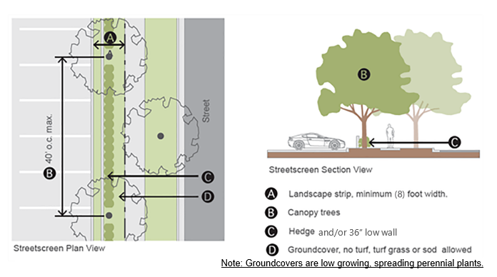
(2)
Streetscreens (as defined below) must include a landscape area between fencing and the property line, a minimum of five (5) feet wide, as illustrated in Figure 8.2-9.
(3)
The landscape area must be composed of groundcover, trees, and hedges.
(4)
Trees are required as follows:
a.
Canopy street trees are required between twenty-five (25) and forty (40) linear feet on-center, alternating with street trees; or
b.
When utilities prohibit canopy trees, understory trees are required every twenty (20) linear feet on-center.
(5)
Streetscreens (as defined below) that are longer than eighty (80) feet require a hedge as follows:
a.
The hedge must be maintained between thirty (30) and forty-two (42) inches tall;
b.
The hedge must be located behind streetscreen trees relative to the property line or inline with trees;
c.
The hedge must be individual shrubs a minimum of seven (7)-gallon plants, not less than thirty (30) inches in height at the time of planting, and spaced no more than thirty (30) inches on-center;
(6)
A wall may be included in a streetscreen which should be between the parking and required landscaping and be between three (3) and four (4) feet high.
(7)
Existing vegetation may be credited towards the required buffer, provided it is supplemented with similar plant material in order to achieve eighty (80) percent opacity within twelve (12) months of planting.
(f)
Parking Garages
(1)
Structured parking garages must comply with the Parking Garage Design Guidelines Part 11.
(2)
Parking structures shall also comply with the following requirements:
a.
Parking structure facades are prohibited on "A" streets.
b.
Frontages of parking structures on "B" streets must incorporate architectural features compatible with the principal structure. Parking spaces on these frontages may not be located on angled ramps.
c.
Portions of parking structures on "B" streets that do not include habitable ground floor uses shall incorporate a streetscreen (cross-reference) except that canopy street trees shall be substituted by understory trees.
d.
Direct pedestrian access from parking garages to each adjacent street shall be provided.
e.
Vehicle entrances to parking structures shall be a maximum of forty-eight (48) feet in width and shall be separated from other vehicle access to and from the structure or other parking structures on the same side of the block by a minimum distance of four hundred (400) feet.
(g)
Loading Zones. Loading zones or spaces shall be provided for all nonresidential uses as provided in Chapter 30, Part 11. However, variations from these requirements may be approved by the Development Services Director as part of an Alternative Parking Plan under Chapter 30, Part 11.
30.8.2.9 Civic Space Requirements
(a)
Civic Space Quantity. Civic spaces meeting the standards in "Civic Space Types and Standards" are required as described in Table 5.2. All civic spaces shall be included int Net Buildable Acreage calculation.
Example calculations:
(b)
Civic Space Types and Standards. To count toward the minimum Civic Space Requirements, a proposed Civic Space must meet be designated with a Civic Space Type and meet the standards for that type.
| Table 8.2-C Civic Space Types | ||
|---|---|---|
| Type | Description | Illustration |
| Park/Green: | A Civic Space available for unstructured recreation. A Green may be spatially defined by landscaping rather than building Frontages. Its landscape shall consist of lawn and trees, naturalistically disposed. | 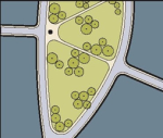 |
| Square: | A Civic Space available for unstructured recreation and Civic purposes. A Square is spatially defined by building Frontages. Its landscape shall consist of paths, lawns and trees, formally disposed. Squares shall be located at the intersection of important Thoroughfares. | 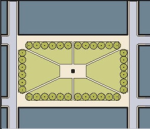 |
| Plaza: | A Civic Space available for Civic purposes and Commercial activities. A Plaza shall be spatially defined by building Frontages. Its landscape consists primarily of pavement. Trees are optional. Plazas should be located at the intersection of important streets. | 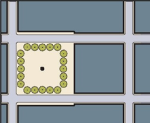 |
| Small Park/Plaza: | A Civic Space designed for passive recreation. |  |
Civic Spaces require detailed landscape design and approval by the Planning Manager. All Civic Spaces must include ADA compliant walkways connected to all abutting sidewalks and building entrances.
Civic Spaces must meet the following standards:
(1)
Civic Spaces must comply with all standards in Table 5.2.
(2)
Civic Spaces must be bordered by a street or drive as required in Table 5.2.
(3)
Minimum landscaping is required in addition to any Public Realm Requirements related to adjacent streets/frontages as described in Table 5.2.
(4)
The amount of required Civic Space that may be met with a single Civic Space type is limited by "Maximum Usage Towards Requirements" described in Table 8.2-D.
30.8.2.10 Building Design Guidelines
(a)
Compatibility. A mixed-use development shall present a consistent and attractive perimeter appearance on all sides. Unfinished and/or unpainted walls shall not be visible from off-site, "A" frontages, or "B" frontages. Supporting facilities, other than those for fire safety and stormwater management, shall also be hidden from view, including but not limited to:
(1)
Vehicle loading zones
(2)
Storage areas for equipment or merchandise
(3)
Mechanical units
(4)
Solid waste receptacles
(5)
Electrical substations and similar facilities
(6)
Restaurant coolers and freezers
(b)
General Appearance. The following components shall be incorporated into all buildings:
(1)
Awnings, canopies, or arcades shall be required over all doors, windows and other transparent elements on "A" streets and on retail uses. The height of the awnings, canopies, or arcades shall be between eight (8) and twelve (12) feet and shall be a minimum of four (4) feet in depth.
(2)
A cornice shall be provided on the side of a building facing a residential use and/or an external public roadway at a minimum of twelve (12) feet above the sidewalk or at a height similar to the cornice on an abutting property, but in no case shall the cornice exceed thirty-five (35) feet.
(3)
Buildings shall incorporate lighting and changes in mass, surface or finish to emphasize their front entrances.
(4)
Buildings shall provide a foundation or base, typically from ground to bottom of the lower windowsills, with changes in volume or material. A clear visual division shall be maintained between the ground level floor and upper floors with either a cornice line or awning from twelve (12) to sixteen (16) feet above ground level, whichever applies to the proposed development. No more than twenty (20) feet of horizontal distance of wall shall be provided without architectural relief for building walls and frontage walls facing the street. All buildings shall use at least three (3) of the following design features along all primary and secondary elevations of the building:
a.
Divisions or breaks in materials chosen from a common palette
b.
Window bays
c.
Separate entrances and entry treatments, porticoes
d.
Variation in roof lines
e.
Awnings
f.
Functional dormers
g.
Gables
h.
Recessed entries
i.
Covered porch entries
j.
Cupolas
(c)
Storefront Character. Each building's storefront or frontispiece shall provide the following architectural features on the front or side building facade:
(1)
Buildings on corner lots shall be located within the build-to zone for both streets unless a civic space is provided. Except that if the corner is the intersection of two Type C Frontages or a Type B and a Type C Frontage this requirement does not apply, Corner building entrances are encouraged, especially where two Type A Frontages intersect.
(2)
Building side walls exposed to a public street shall not exceed blank wall areas of thirty (30) percent or more of the total vertical wall surface, nor exceed twenty (20) linear feet without being interrupted by a change in wall plane (minimum sixteen (16) inches offset), roof plane, or the additions of window(s), balconies, side entries, or other fenestration element.
(3)
Walls must achieve a glazing-to-wall ratio between fifteen (15) percent - thirty-five (35) percent of the whole wall, or each wall segment.
(d)
Windows and Transparency. The following provisions must be met for windows in all non-residential buildings:
(1)
The facades of all buildings with the ground floor facing a street, park, plaza, or residential building must have transparent windows with a glazing-to-wall ratio of fifty (50) percent (minimum) to eighty (80) percent (maximum) of the ground floor wall of each storefront's linear frontage. Mirrored glass, obscured glass and glass block are not permitted. Energy-saving window tinting with a minimum of forty (40) percent light transmittance may be permitted.
(2)
Windows must remain transparent so that the inside of the space is visible from the public way. Full window signs, decals, shelving, blinds, etc. that may obscure views are not permitted. Exception: Product displays (like mannequins displaying clothes for sale).
(3)
Display windows shall be lit at night.
(4)
The sill of any ground floor window shall be no more than two and one-half (2.5) feet above finished floor level; the top of the windows must be no more than seven (7) feet above finished floor level.
(e)
Exterior Lighting on Buildings. Exterior lighting shall be directed at the building itself without illuminating other areas of the site.
(f)
Building Color. Building colors shall be muted colors and earth tones unless otherwise approved by the Development Services Director as a part of the approval process.
(Ord. No. 2024-02, § 7(Exh. B), 1-9-24).
Sec. 30.8.3. - MM Missing Middle District and Alternative Standards.
30.8.3.1 Intent and Purpose. The purpose of the Missing Middle District and Alternative Standards is to encourage a wider range of housing choices in central locations accessible to services. This includes permitting smaller units and more compact site plans to increase affordability without subsidies.
30.8.3.2 Definitions. Missing Middle Housing is defined as residential units meeting any of the following definitions which may be alone or in groupings of multiple typologies:
(a)
Small Lot Single-Family: Single-family homes on small sized lots designed to increase yield while remaining detached. These types often use unconventional lot dimensions and site plans responsive to the specific unit design and layout.
(b)
Cottage Court: A group of small, detached structures arranged around a shared court visible from the street. The shared court replaces the function of a rear yard. Unit entrances should be from the shared court.
(c)
Duplex—Side-by-Side: A detached structure that consists of two (2) dwelling units arranged side-by-side with an entry from the street. This type has the appearance of a small-to-medium single-unit house.
(d)
Duplex—Stacked: A detached structure that consists of two (2) dwelling units arranged one above the other, each with an entry from the street. This type has the appearance of a small-to-medium single-unit house and fits on narrower lots than the side-by-side duplex.
(e)
Townhouse: An attached structure that consists of four (4) to six (6) multi-story dwelling units placed side-by-side. Entries are on the narrow side of the unit and typically face a street or courtyard.
(f)
Triplex—Stacked: A detached structure that consists of three (3) dwelling units typically stacked on top of each other on consecutive floors, with an entry for the ground floor unit and a shared entry for the units above.
(g)
Fourplex—Stacked: A detached structure with four (4) dwelling units, two (2) on the ground floor and two (2) above, with shared or individual entries from the street. This type has the appearance of a medium-sized single-unit house.
(h)
Six-plex: A detached structure that consists of six (6) dwelling units arranged side-by-side and/or stacked, typically with a shared entry from the street.
(i)
Courtyard Building: A medium-sized (1 to 3.5-story) detached structure consisting of multiple side-by-side and/or stacked dwelling units oriented around a courtyard or series of courtyards. Each unit is accessed from the courtyard or a public sidewalk and shared stairs each provide access to up to three (3) units.
(j)
Live-Work: An attached or detached structure consisting of one dwelling unit above or behind a fire-separated flexible ground floor space that can accommodate a range of non-residential uses. The flex space and residential unit typically have separate street entrances.
30.8.3.3 Review of Development Proposals
(a)
Final Development Plan Required. Prior to subdivision or site plan approval, the applicant must submit a final development plan consistent with the development criteria and limitations in the Missing Middle and Alternative standards and any conditions of approval. This plan must be reviewed and approved by the Development Services Director or designee.
(b)
Building Elevations Required. Prior to subdivision or site plan approval, the applicant must submit building elevations for all proposed Missing Middle Housing Typologies for review by the Development Services Director or designee.
30.8.3.4 Applicability
(a)
Missing Middle (MM) standards may be applied in the following conditions:
(1)
MM Zoning District: Where the MM District is applied, typologies within a proposed development or development types are limited by the applicable Future Land Use District as described in Table 8.3-A. A development within the MM Zone may include single-family development consistent with R-1BB standards subject to compliance with Chapter 35.
(2)
PD Zoning District: Missing Middle Housing may be approved as part of a new PD application or a substantial change to an existing PD. Allowable typologies within a PD are limited by the applicable Future Land Use District as described in the Seminole County Comprehensive Plan.
30.8.3.5 Specified Zoning Districts. Missing Middle and Alternative Standards may be used in the zones and under the conditions specified in Table 5.2 with limitations on typology and development type as described.
(a)
Missing Middle Development Types:
(1)
Missing Middle Development: A development in which only Missing Middle Typologies are proposed.
(2)
Mixed Housing Development: A development in which both Missing Middle Typologies and Typologies otherwise permitted in the underlying zone are proposed.
30.8.3.6 Allowable Typologies and Densities
(a)
Typologies are permitted where described in this Section. The net density of a proposed development must be consistent with the applicable Future Land Use District.
30.8.3.7 Site Regulations:
(a)
Missing Middle typologies may be clustered or distributed throughout the project.
(b)
No single Missing Middle typology may exceed five (5) acres of developable land.
(c)
Development includes a connected street grid which is accomplished by meeting the following conditions:
(1)
No portion of the project may be gated.
(2)
Existing or new streets/drives, whether public or private, shall divide the site into blocks. Block perimeters must not exceed two thousand (2,000) feet except where access management criteria for existing County roadways require greater lengths. The block perimeter is measured as the total length of a line enclosing the block along thoroughfare rights-of-way, internal streets, and civic spaces.
(3)
Sidewalks are required on both sides of every street.
(4)
Dead end streets, hammerheads, and culs-de-sac are prohibited except where specifically approved by the Development Services Director when wetlands, water bodies, or infrastructure corridors prevent connections.
(5)
The development must provide connections to all adjoining public streets and trails and existing "stub-outs" on adjacent properties.
(6)
The development must provide "stub-outs" for future connectivity to adjacent vacant lots.
(7)
Pedestrian or vehicular connections to existing commercial uses should be provided where feasible.
(d)
Restrictions near development boundaries:
(1)
Buildings are limited to two stories within one hundred (100) feet of a district boundary with an existing single-family development or single-family residential zone.
(2)
The lowest intensity typologies within the project shall abut boundaries with an existing single-family development or single-family residential zone.
30.8.3.8 Additional Site and Building Requirements:
(a)
Open Space: Where Open Space is required in the applicable zoning district, those standards shall be applied. If Open Space is not otherwise required, the standards below shall apply.
(1)
For lots with greater than eight (8) units and a minimum of two (2) acres, a minimum eight (8) percent of net buildable acreage shall be set aside as Open Space that meets the standards described below.
(2)
Open Space may be provided in multiple locations subject to the following requirements. Each qualifying Open Space must be:
a.
Bordered by streets, stormwater ponds, natural lakes, or commonly accessible pedestrian pathways.
b.
A minimum of .20 contiguous acres.
c.
A minimum of forty (40) feet in width, except that open space areas adjacent to a stormwater pond or natural lake must be a minimum of twenty (20) feet in width from the top of berm to the public right of way or lot line or a dog park.
d.
Open Space shall be proximate to Missing Middle units.
(b)
Street Trees. Street trees are required in Missing Middle Developments and on all streets abutting Missing Middle Typologies in Mixed-Use Developments. Street trees must meet the following standards:
(1)
Be planted an average of forty (40) feet on center on both sides of internal streets and on existing rights of ways adjoining the site.
(2)
Be located in a planting strip or tree well with a minimum width of eight (8) feet. Tree wells or planting strips less than ten (10) feet in width must incorporate a root barrier at the edge of pavement.
(3)
Be selected from the list of approved Canopy Street Trees (30.14.15(j)).
(4)
Meet the standards of Sec. 30.14.16. - General provisions for all landscaped areas.
(c)
Minimum Parking Requirements:
(1)
Two parking spaces are required per unit except that parking for units less than 1000 sq. ft. may be reduced to 1.5 spaces per unit.
(2)
On-street parking is required on streets adjacent to missing middle units.
(3)
Required parking may be located in common areas or on-street provided that such parking is within 150 feet of the unit.
(d)
Building Frontage:
(1)
Buildings not fronting on a street must front on a common open space, a pedestrian pathway or a multi-use trail.
(2)
Buildings not fronting on a street must be part of a common emergency access plan or be adjacent to an alley built to emergency access standards.
(3)
Up to six (6) lots may be accessed by a commonly held easement drive that is non-gated and designed to allow fire access (aka parking court).
30.8.3.9 Missing Middle Dimensional Standards. Designated Missing Middle Units must meet the alternative design and dimensional standards described in this Section and in Table 8.3-B.
(a)
Garages, carports, open or screened porches or breezeways may not be counted toward the Minimum Living Area requirement in Table 8.3-B.
(b)
Duplexes, Cottage Court, and High-Density Single-Family structures may be located on a common lot. Where units are located on a common lot, minimum separation between structures must be ten (10) feet.
(c)
Minimum lot size requirements are not applicable to Missing Middle units.
(Ord. No. 2024-02, § 7(Exh. B), 1-9-24; Ord. No. 2024-21, § 4, 7-23-24).
Sec. 30.8.4. - R-AH Affordable Housing Dwelling District.
30.8.4.1 Description of District. This District is composed of certain lands, water and structures permitting a variety of housing types and densities with modified subdivision standards to promote the development of affordable housing. R-AH developments are situated where they are well serviced by public and commercial services and have convenient access to thoroughfares or collector streets and to employment centers.
30.8.4.2 Uses Permitted
(a)
Single-family detached, duplex, townhouse, triplex, fourplex, six-plex, cottage court, or zero lot line dwelling structures including customary accessory uses.
(b)
Childcare facilities, evening childcare facilities, and free-standing private kindergartens and/or voluntary prekindergarten education programs and group homes.
(c)
Home offices.
(d)
Live/Work units.
30.8.4.3 Minimum Project Size. Applications seeking the R-AH zoning classification shall be for development projects of not less than two five (52) net buildable acres. If the R-AH District is to include a combination of non-residential uses and residential uses, the residential portion of the parcel shall be not less than five (5) net buildable acres and the single-use non-residential portion shall not exceed the greater of two (2) acres or twenty (20) percent of the net buildable acreage of the District.
30.8.4.4 Building Height. In the F-AH District no building or structure may exceed forty (40) feet in height or three stories. Where the proposed buildings vary in height from existing buildings at a District boundary by more than one story, the proposed building must stepback on the third story by ten (1) feet along the façade facing the property boundary.
30.8.4.5 Building Site Area Requirements
(a)
Each single-family detached or zero lot line dwelling structure in the R-AH District shall be located on a lot or parcel of land having a buildable area of not less than three thousand (3,000) square feet and a width of not less than forty (40) feet, measured at the building line.
(b)
Each two (2) family dwelling structure shall be located on a lot or parcel having a buildable area of not less than seven thousand two hundred (7,200) square feet and a width of not less than fifty (50) feet, measured at the building line.
30.8.4.6 Subdivision of Duplex and Townhouse Lots. Lots proposed for duplex, triplex and zero lot line structures may be platted to facilitate separate and distinct ownership provided that:
(a)
Each unit of an attached dwelling unit shall be constructed at the same time and each unit shall be located on a buildable parcel of land having a minimum land area of three thousand (3,000) square feet.
(b)
The common party wall adjoining units shall be constructed, at a minimum, in accordance with Chapter 40 of the Land Development.
30.8.4.7 Yard Regulations.
(a)
The following minimum yards shall be observed unless otherwise approved by the Board of County Commissioners:
(b)
Special Conditions. Street-facing garage doors shall be set back from the property line a minimum of twenty (20) feet.
(c)
District boundary yard setbacks. Rear yard setbacks for lots located at the boundary of the R-AH District shall be no less than twenty (20) feet. For infill conditions where a new unit shares a side lot boundary with existing units or is facing existing units, side and front setbacks shall be the same as the existing unit.
30.8.4.8 Minimum dwelling size. Each dwelling unit in the R-AH District shall have a minimum of 450 square feet of living area not including garages, carports, open or screened porches, or breezeways.
30.8.4.9 Affordability of dwelling units. No less than fifty (50) percent of the dwelling units provided in the R- AH District shall be made available to low and moderate income households. No less than twenty (20) percent of the dwelling units provided shall be made available for lease or purchase by low income households. Where both affordable and market- rate units are provided, the community should be designed as a single mixed-income neighborhood such that housing types are intermixed. There is no special separation of market rate and affordable units. Affordable units should accommodate a mix of household sizes. A proposed development which is more than seventy (70) percent affordable units shall not exceed fifteen (15) acres. The County shall develop procedures and controls to monitor and enforce this provision which may include declarations of covenants in development orders and development permits which run with the land.
30.8.4.10 Submittal requirements.
(a)
Prior to processing an application for R-AH zoning, the County must receive:
(1)
An executed affordability agreement, in a format acceptable to the County, guaranteeing that the specified percentage of dwelling units will be sold or rented at a price that is affordable to households of low and moderate income, a Restricted Use Covenant (RUC) (Section 40.9(h), Seminole County Code of Ordinances); and
(2)
A statement of proposed development order conditions, including a description of the number, type, and cost (purchase price and/or rent) of all dwelling units; and
(3)
A description of any net buildable acres devoted to any proposed nonresidential structures on the development site; and
(4)
A description of proposed buffers along the project's perimeter; and
(5)
A description of any other special design features in addition to those required in the R-AH District.
30.8.4.11 Development Time Limitations. If, within eighteen (18) months of being assigned the R-AH zoning classification, a final plat or site plan has not been approved, the assignment of the R-AH zoning classification shall be reviewed by the Planning and Zoning Commission to determine the continuing appropriateness of the R-AH District zoning classification for the subject property. The Board of County Commissioners shall consider the recommendations of the Planning and Zoning Commission and may rezone the property to a more appropriate zoning classification or shall extend the deadline for final plat or site plan approval. These procedures shall also be followed when such extended deadlines are not met.
30.8.4.12 Streets. The character, width, grade and location of all streets and bridges must conform to the standards of Section 35.62 of this Code and the detailed specifications found in the Seminole County, Florida Public Works Engineering Manual described in Section 5.20(a) of this Code, with the following exceptions permitted for the R-AH single-family dwelling district if consistent with sound engineering practices:
(a)
Subgrade: A compacted subgrade of existing material is permitted on local designated streets. The subgrade must conform to the same standards and inspection requirements as required for stabilized subgrade specified in the Seminole County, Florida Public Works Engineering Manual described in Section 5.20(a) of this Code or a minimum Limerock Bearing Ratio (LBR) rating of 40 must be achieved.
(b)
Wearing surface: The wearing surface for all local and residential streets must have a compacted minimal thickness one and one-fourth (1¼) of an inch. All other wearing surface standards including those for arterials and collectors must meet the requirements of the Seminole County Public Works Engineering Manual described in Section 5.20(a) of this Code.
(c)
Minimum right-of-way (ROW) and pavement widths:
(1)
The following minimum right-of-way and pavement widths may be permitted, provided that the street will not carry more than five hundred (500) daily trips:
(2)
Pavement width must be measured from inside of curb to inside of curb, exclusive of curbs. On-street parking is not permitted on streets with reduced right-of-way and pavement widths of twenty (20) feet. The developer shall furnish easements for sidewalks where required and shall erect signs prohibiting on-street parking as required by the County Traffic Engineer.
(d)
Dead-end streets: Permanent dead-end streets less than three hundred (300) feet in length are permitted to have T-turnarounds. T-turnarounds must have a pavement width of no less than twenty-eight (28) feet.
(e)
Sidewalks: Sidewalks are required as follows:
(1)
A minimum of five (5) feet in width is required for concrete sidewalks on both sides of all streets.
(2)
The County does not require a concrete sidewalk on culs-de-sac, T-turnarounds and dead-end streets less than three hundred (300) feet in length.
(3)
Easements must be provided for all necessary sidewalks, as determined appropriate by the County, and properly documented on the plat as required by Section 35.65 of this Code.
30.8.4.13 Sewer. Sanitary sewers, water design standards and multiple meter boxes must all comply with the standards set forth in the Seminole County Environmental Services Utilities Engineering Manual described in Section 5.20(b) of this Code.
30.8.4.14 Stormwater systems. Stormwater systems must conform to the standards of Section 35.97 of this Code and the detailed specifications found in the Seminole County, Florida Public Works Engineering Manual described in Section 5.20(a) of this Code.
30.8.4.15 Innovative subdivision design. Innovative engineering designs such as Low Impact Development that provide for improved stormwater management, improved structure siting, increased emergency vehicle access or decreased cost of development at the same level of service and quality achievement may be approved on a case-by-case basis. Innovative material composition or size may be approved if it can be shown that adequate quality is maintained.
30.8.4.16 Owners' associations and community associations. One or more condominium associations, cooperative associations, or homeowners' associations as described respectively in Chapters 718, 719 and 720, Florida Statutes (2013), as these statutes may be amended from time to time, must be established in connection with any subdivision approved under this Part. The purposes of any such association include enabling the residents of the subdivision to achieve the maximum benefit from the subdivision, to facilitate the management of the subdivision in the mutual interests of the residents, and to maximize the continuing overall quality of the subdivision.
30.8.4.17 Administration. The following administrative procedures and standards will apply to the R-AH District:
(a)
Effectiveness review: Standards for the R-AH District will be reviewed annually by the program review committee or its successor entity to determine effectiveness in providing affordable housing, and recommend changes, if any, regarding effectiveness relative to housing cost.
(b)
Permit and inspection fees: All development permits and inspection fees may be waived by the Board of County Commissioners for applications meeting the minimum requirements of the R-AH District.
(Ord. No. 2024-02, § 7(Exh. B), 1-9-24).
Sec. 30.8.5. - PD Planned Development.
30.8.5.1 Intent and purpose. The Planned Development (PD) District is intended to promote flexibility and innovation to meet the needs of County residents and businesses by facilitating innovative design solutions and development plans, that may be difficult to achieve under conventional zoning regulations. Planned developments shall promote flexibility and creativity in addressing changing social, economic and market conditions, especially where they are used to implement adopted policies of the Comprehensive Plan.
Examples of development concepts that may be appropriate for PD zoning include, but are not limited to, enhanced protection of natural resource areas, mixed use or transit-oriented development, and infill development or redevelopment. An increase in density or intensity alone shall not be a sufficient justification for seeking an alternative to conventional zoning districts.
Development standards to be applied within a planned development shall be established by the Board of County Commissioners (BCC) at the time of rezoning. Such rezoning shall be conditioned upon a master development plan and a written development order. Specific criteria for the development may address, but are not limited to, compatibility with surrounding land uses, road access, availability and efficient use of utility capacity, coordination with transit, etc. Architectural and other appearance-related design elements should be included as approval conditions where the BCC finds they will support goals, such as economic development, neighborhood compatibility, or aesthetic or environmental enhancement of an area.
General standards of this Code that are not specific to any zoning district, such as parking, stormwater management, lighting, and landscaping, shall apply within a planned development unless variations are approved through a PD master development plan and/or development order.
30.8.5.2 Permitted uses—(PD). Except as stated herein, no use shall be specifically permitted or prohibited within a planned development by requirement of this Part. Uses which are permitted, permitted subject to conditions, or prohibited within an individual planned development shall be noted as such through the master development plan and/or development order. In all cases, allowable uses, including density and intensity limits, shall be consistent with the Comprehensive Plan. Any use requiring licensing or other approval by the State of Florida or the Federal government shall obtain such approval as a condition for inclusion within any planned development.
(a)
Accessory dwelling units within any single-family residential lots in a PD may be administratively approved by the Planning Manager subject to the requirements of Section 30.6.1.3.
30.8.5.3 Review criteria.
(a)
Comprehensive Plan Consistency. In approving a planned development, the Board of County Commissioners shall affirm that the proposed development is consistent with the Comprehensive Plan, and effectively implements any performance criteria that the Plan may provide.
(b)
Greater Benefit and Innovation Criteria. In addition, PD zoning may be approved only when the Board determines that the proposed development cannot be reasonably implemented though existing provisions of this Code, and that a PD would result in greater benefits to the County than development under conventional zoning district regulations. Such greater benefits must include two or more of the following:
(1)
Natural resource preservation.
(2)
Crime Prevention (CPTED).
(3)
Neighborhood/community amenities.
(4)
Provision of affordable or workforce housing.
(5)
Reduction in vehicle miles traveled per household.
(6)
Transit-oriented development.
(7)
Provision of new multimodal connectivity.
(8)
Innovation in water or energy conservation.
(9)
Innovative development types not currently provided within the County but consistent with the goals of the Comprehensive Plan.
(c)
In addition, any proposed development under the PD ordinance must address the following goals:
(1)
Meet or exceed the arbor, tree preservation, and tree planting requirements of this Code on a project-wide basis.
(2)
Minimize transportation impacts through design elements, which may include but are not limited to: multimodal connectivity; electric vehicle charging; infrastructure of pedestrian or bicycle infrastructure exceeding the minimum standards; shared transportation parking or devices; pedestrian-oriented architectural design; accommodation or neighborhood electric vehicles; transportation demand management; or permitting complementary uses.
(d)
The PD application shall include a narrative addressing the following:
(1)
How the proposed development addresses the goals of the Comprehensive Plan.
(2)
Why the proposed development cannot be achieved under an existing conventional or special zoning district.
(3)
How the proposed development provides an innovative approach to land development.
(4)
A description of benefits to the County that cannot be achieved under the existing provisions of this Code.
(e)
Residential PD Design Standards:
(1)
If lot width is less than forty-five (45) feet, homes must be rear loaded, unless otherwise approved by the Board of County Commissioners.
(2)
Front-facing garage doors must be set back a minimum of twenty (20) feet.
(3)
Minimum front and rear setbacks at project boundaries shall be twenty-five (25) feet, or twenty (20) feet for accessory structures not exceeding one story.
(4)
Required setbacks adjacent to existing residential development will increase based on elevation/grade changes between developments and proposed building heights, as determined by the Board of County Commissioners.
(f)
Required Residential Neighborhood Improvements:
(1)
Street trees are required in generous planting strips to provide for the health of the trees. The street trees may count towards required open space. Street trees shall:
a.
Be planted an average of forty (40) feet on center on both sides of internal streets and on existing rights-of-way adjoining the site.
b.
Be in a planting strip or tree well with a minimum width of eight (8) feet. Planting strips less than ten (10) feet in width must include a root barrier.
c.
Be selected from the "Approved Plant Species List: Canopy Trees," except that Laurel Oaks may not be used as street trees.
d.
Meet the standards of Section 30.14.16, General provisions for all landscaped areas.
(2)
Fifty (50) percent of pond frontage must be open to streets or community parks.
a.
Where pond frontage is along a park, a walkway (minimum five (5) feet in width) is required unless adjacent to a street with a sidewalk.
b.
Landscaped areas must comply with the provisions of Section 30.14.16 (General provisions for all landscaped areas) and (Water-efficient landscaping design requirements).
(g)
Common Useable Open Space:
(1)
In addition to the twenty-five (25) percent minimum open space requirements listed in Section 30.8.3.8, commonly accessible open space is required subject to the following standards:
a.
Minimum eight (8) percent of net buildable acreage utilized for open space.
b.
Open Space may be provided in multiple locations however each location must be:
i.
Bordered by streets, stormwater ponds, natural lakes, or commonly accessible pedestrian pathways.
ii.
Not less than 0.25 contiguous acres. Dog parks and tot lots that are a minimum of seventy-five (75) square feet per dwelling unit are also exempt from this requirement and may count towards open space. Dog parks must contain waste disposal receptables and appropriate signage.
iii.
A minimum of forty (40) feet in width. Except that open space areas adjacent to a stormwater pond or natural lake may be a minimum of twenty (20) feet in width from the top of berm to the public right-of-way or lot line.
30.8.5.4 Planned development approval procedure. Approval for a planned development is obtained through a two-step process. The first step is an approval of the master development plan and rezoning of the land by the Board of County Commissioners. The second step consists of final development plan approval by the Development Services Director along with the recording of the developer's commitment agreement.
Prior to formally submitting a request for planned development zoning, the developer is encouraged to meet with appropriate County staff for comments regarding the advisability of undertaking a planned development in the proposed location.
30.8.5.5 Master development plan submittal and review.
(a)
Development Plan Submittal Requirements
(1)
A master development plan shall be submitted concurrently with a PD rezoning application. The submittal requirements listed in this Section may be modified by the Development Services Director as appropriate for a specific application.
(2)
The development requirements for each individual tract or phase within a planned development shall be included as a part of the master development plan.
(3)
The master development plan shall clearly indicate an outer site boundary as well as internal boundaries between proposed tracts, stages, phases, outparcels, etc. The plan shall also indicate common properties within the PD and provide for necessary property owners or management associations to ensure maintenance of such properties.
(4)
The master development plan shall include the items shown on the following table:
(b)
Review Procedure. A planned development application shall be reviewed as follows:
(1)
Prior to initiating a planned development application, a preapplication conference with Planning and Development staff may be required at the discretion of the Development Services Director and/or at the request of the applicant.
(2)
The Development Review Committee shall evaluate the master development plan and PD zoning request regarding its compliance with applicable standards of this Code and the Comprehensive Plan. Following this evaluation, the Planning and Zoning Commission shall hold a public hearing with due public notice, to consider the master development plan and PD rezoning request. The Planning and Zoning Commission shall recommend to the Board of County Commissioners approval, approval with conditions, or denial of the application.
(3)
The Board of County Commissioners shall hold a public hearing with due public notice, and shall approve, approve with conditions, or deny approval of the master development plan and the proposed PD rezoning.
(4)
All conditions of approval imposed by the Board of County Commissioners shall be reflected in the master development plan and/or development order for the planned development.
30.8.5.6 Final development plan.
(a)
Within five (5) years of approval of the master development plan, which time period may be extended by the Planning and Zoning Commission, the applicant shall submit a final development plan meeting the requirements of Section 30.8.5.5(a)(4) and that reflects the requirements of the approved PD development order.
(b)
The Development Review Committee shall evaluate the final development plan regarding its compliance with, the applicable provisions of this Code, the applicable provisions of the Comprehensive Plan, and the approved master development plan and PD development order.
(c)
Following evaluation by the Development Review Committee, the Development Services Director may, upon a finding of consistency with: the applicable provisions of this Code, the County's Comprehensive Plan, and the master development plan and PD development order, approve the final development plan and execute the associated developers commitment agreement. The developer's commitment agreement shall be prepared in a form acceptable to the County Attorney.
30.8.5.7 Plat or site plan approval for each section.
(a)
After approval of the final development plan the applicant shall submit either a preliminary and final plat, according to the procedure outlined in the Subdivision Regulations, or shall submit a site plan, according to Chapter 40, whichever may be applicable, for each phase of the PD development. At the applicant's option, a site plan complying with the technical requirements of Chapter 40 may serve as the final development plan if it contains sufficient information to verify compliance with the master development plan and the PD development order approved by the Board of County Commissioners under Section 30.8.5.4. After review and final approval by the designated officials of either the final subdivision plat or site plan, the developer may request building permits for the approved section.
(b)
If an applicant so elects and pays the fees for both final development plan review and preliminary subdivision plan review, and provides all information necessary for both reviews at the time of application, the final development plan review and the preliminary subdivision plan review may be accomplished simultaneously.
30.8.5.8 PD revisions.
(a)
Any proposed substantial change to an approved PD, including, but not limited to, revisions: affecting the intent and character of the development; affecting land use patterns; affecting phasing that will impact off-site infrastructure; changing the location or dimensions of major streets or access points; adding property to the PD representing a substantial increase in density or intensity; or which involve similar substantial changes, shall be considered major amendments and shall require approval by the Board of County Commissioners A major amendment shall be treated as rezoning from PD to PD, revising the development criteria for the PD zoning, and the associated development order shall be revised or re-issued accordingly.
(b)
Non-substantial changes to an approved planned development shall be considered minor amendments and may be approved by the Development Services Director. Multiple revisions may be proposed which cumulatively cause the Director to deem them a major amendment. Minor amendments shall be accomplished through addendum to the development order and/or a developer's commitment agreement. Minor amendments may include, but are not limited to, the following:
(1)
Additions to structures that do not exceed ten (10) percent of the overall density or intensity approved within the PD. Additions of ten (10) percent or greater may be granted as provided in Section 5.19(b)(1).
(2)
The addition of accessory structures if the location of such structures does not interfere with approved site layout (e.g. circulation, parking, loading, storm water management facilities, open space, landscaping or buffering).
(3)
Additions to parking areas that do not encroach into required buffer areas or otherwise interfere with the approved site layout.
(4)
Additional clearing that does not exceed five thousand (5,000) square feet in area or ten (10) percent of the site. Greater amounts may be approved consistent with Section 5.19(b)(1).
(5)
Adjustment of internal property lines or tract boundaries, setback lines, realignment of internal roads and driveways consistent with the approved site layout and development concepts.
(6)
The removal of property from the PD, provided such removal does not have a substantial impact on the density or intensity of the PD or on elements of the PD such as buffering and open space. Property removed from a PD must be rezoned immediately upon such removal.
(7)
Other amendments that would not be deemed substantial as described in subsection 30.8.5.8(a).
(c)
Property owners within a planned development may not make incremental revisions to an approved development plan that adversely affect existing owners or to avoid classification as a major amendment. Where amendments are allowed under this Section, such amendments must remain compatible with the balance of the project and consistent with the overall concept(s) and greater benefits referenced in Section 30.8.5.3, under which the development was initially approved. Amendment to the PD zoning shall not be pursued to reduce the benefits that justified the original assignment of PD zoning without replacement of an equivalent benefit.
30.8.5.9 Planned development time limitations. If substantial development, as determined by the Development Services Director, has not begun within eight (8) years after approval of the master development plan, the approval of the planned development will be reviewed by the Planning and Zoning Commission to determine the appropriateness of the planned unit development zoning classification for the subject property. The Board of County Commissioners shall consider the recommendations of the Planning and Zoning Commission and may move to rezone the property to a more appropriate zoning classification or shall extend the deadline for the start of construction. If an extended deadline granted by the Board is not met, the foregoing procedures shall reapply.
30.8.5.10 Binding nature of approved development plan. An approved master or final development plan along with any associated conditions of approval shall be binding upon the applicant or any successors in interest in the planned development. Deviations from an approved development plan not in accordance with Section 30.8.5.8 above shall constitute a violation of this Part.
30.8.5.11 Development standards for planned developments. The development standards for planned developments are as follows:
(a)
Relation to Zoning Districts. An approved PD shall be considered to be a separate zoning district in which the master development plan and PD development order, as approved by the Board of County Commissioners, or the Development Services Director as permitted in this Part, establishes the restrictions, regulations, and district description according to which the development shall occur. Upon approval, the official zoning map will be changed to indicate the area as PD and the master development plan and PD development order shall be filed with the Clerk to the Board of County Commissioners and a copy retained within the Planning and Development Division.
Density and Intensity. The density based on net residential acreage permitted in each PD shall be established by the Board of County Commissioners, upon recommendation of the Planning and Zoning Commission. The criteria for establishing the appropriate density includes surrounding density of existing and approved development, adequacy of existing and proposed public facilities and services, conformance with the Comprehensive Plan, and site characteristics. Dwelling units approved in the master development plan for a given tract may be shifted within the PD subject to the approval of the Development Services Director.
Intensity of commercial or industrial uses within a Planned Development shall be measured in terms of Floor Area Ratio (FAR) and shall be consistent with the maximum FAR for the development site established in the Comprehensive Plan. The Board of County Commissioners may approve such development with a lesser intensity in order to achieve compatibility with adjoining uses.
(b)
Phasing
(1)
Where a planned development is to be built in phases, the PD application shall include a proposed phasing plan for the site, including a schedule for completion of all improvements shown on the approved master development plan. Once a phasing plan has been approved, no land may be used and no building may be occupied except in accordance with such plan.
(2)
The purpose of a phasing plan is to ensure that crucial features serving the development are provided as needed and not delayed to the detriment of property owners and other users of the site. Such features may include, but are not limited to, buffers, stormwater retention, road access points and transit shelters. Phase configurations shall be logical and consistent with the purposes of the approved PD master plan. The Board of County Commissioners may stipulate that any or all portions of required landscaping and/or buffering, or other improvements and amenities be provided during the first phase of development, even though some buffer areas, improvements, or amenities or portions thereof lie outside the phase.
(3)
Each phase, at a minimum, must include adequate parking, stormwater management facilities, landscaping, and all other features needed to serve that portion of the development. In order to ensure the efficient implementation of the approved PD master development plan concepts, the Board may require that selected site improvements be constructed at a faster rate than the overall development. These improvements may be related to engineering design, general requirements of this Code, or other provisions of the approved master development plan and may include, but are not limited to parking, stormwater management facilities, erosion control measures, buffering, and supporting retail or other employment uses. Where the applicant agrees to provide off-site improvements, such as traffic signals, turn lanes, and sewer lines, the Board of County Commissioners may require such improvements to be in place upon completion of any phase of the development.
(4)
Where a planned development must achieve a minimum density or intensity due to requirements of the Comprehensive Plan or other considerations, each phase shall individually achieve such density or intensity unless the master development plan or PD development order provide otherwise. Where a PD has been approved as a specific type of development in support of Comprehensive Plan policies (e.g., including but not limited to transit oriented development, mixed use in the MXD future land use), each phase shall substantially advance the approved concepts for the overall development.
(c)
Dimensional, bulk and height restrictions. The location of all proposed building sites shall be as shown on the master development plan subject to the minimum lot sizes, setback lines, lot coverage, maximum/minimum building height, or floor area, specified in the master development plan and/or PD development order, as approved by the Board of County Commissioners.
(d)
Commonly Accessible Open space. Open space area requirements for planned developments shall be provided as indicated below, and unless otherwise stated within the master development plan or PD development order, shall meet the criteria of Section 30.14.2.
(1)
Minimum eight (8) percent of net buildable acres shall be designed as commonly accessible open space, which shall be included as a part of total open space requirements.
(2)
Open Space may be provided in multiple locations however each location must be:
a.
Bordered by streets, stormwater ponds, natural lakes, or commonly accessible pedestrian pathways.
b.
Not less than 0.25 contiguous acres.
c.
A minimum of forty (40) feet in width. Except that open space areas adjacent to a stormwater pond or natural lake may be a minimum of twenty (20) feet in width from the top of berm to the public right-of-way or lot line. Dog parks and tot lots that are a minimum of seventy-five (75) square feet per dwelling unit are also exempt from this requirement and may count towards open space. Dog parks must contain waste disposal receptables and appropriate signage.
(3)
Required sidewalks may be incorporated into the park areas as ADA-compliant pathways subject to Crime Prevention Through Environmental Design (CPTED) design principles (pathways should not be obscured behind hedges, utility structures, or other large objects).
(4)
Stormwater ponds must be amenitized as follows:
a.
Stormwater ponds must be open to the community and not fenced.
b.
Fifty (50) of pond frontage must be open to streets or parks. Where pond frontage is along a park, a walkway (minimum five (5) feet in width) is required unless adjacent to a street with a sidewalk.
c.
Landscaped areas must comply with the provisions of Section 30.14.16 (General provisions for all landscaped areas) and (Water-efficient landscaping design requirements).
(e)
Access and parking
(1)
All streets, thoroughfares, and accessways shall be designed to be consistent with the roadway functional classification system and other policies of the Transportation Element of the Comprehensive Plan.
(2)
Off-street parking shall be provided in accordance with Section 30.11.2 and/or Section 5.19, unless the applicant can demonstrate the appropriateness of alternate standards. Such standards must be enumerated in the development order and approved by the Board of County Commissioners in order to be used within a planned development.
(3)
Pedestrian, bicycle and vehicular traffic circulation systems shall be designed to integrate the proposed development into the surrounding community and to provide safe and convenient access to public use, common use and other community services, facilities and activities located both within the proposed development and beyond the boundaries of the proposed development. Local residential streets shall be designed to discourage travel speeds in excess of the posted speed and to discourage or restrict their use by through traffic.
(4)
Hammerhead turnarounds shall be prohibited.
(f)
Perimeter requirements
(1)
Planned developments shall utilize the buffering standards of Part 14 to maintain compatibility with adjoining properties and uses. However, the Board of County Commissioners may vary these standards as appropriate to meet the unique needs of the proposed PD.
(2)
Increased setbacks from the PD perimeter may also be imposed to maintain compatibility with adjacent existing uses.
30.8.5.12 Control of area following completion
(a)
After completion of a planned development, the use, modification or alteration of any buildings, structures, or land areas within the development shall be in accordance with the approved master development plan and the PD development order. Notwithstanding subsequent platting or other forms of dividing ownership of the planned development, the entire site shall be subject to the approved master development plan and PD development order.
(b)
Amendments to the approved master development plan and/or PD development order shall be in accordance with Section 30.8.5.8.
(Ord. No. 2024-02, § 7(Exh. B), 1-9-24; Ord. No. 2024-21, § 4, 7-23-24).
Sec. 30.8.6. - PLI Public Lands and Institutions District.
30.8.6.1 Zone Description. The PLI Public Lands and Institutions District is intended to include major public lands and major public and quasi-public institutional uses. This classification may only be applied to lands that are owned or controlled by the public.
(Ord. No. 2024-02, § 7(Exh. B), 1-9-24).