
Shaker Heights City Zoning Code
TITLE ONE
Administrative
1210.01 TITLE.
The ordinance codified in this title shall be known, cited and referred to as the "Zoning Ordinance for the City of Shaker Heights, Ohio," the "Shaker Heights Zoning Ordinance," or the "Zoning Ordinance."
1210.02 AUTHORITY.
This code is adopted by the City pursuant to its authority under the Constitution of Ohio and the City of Shaker Heights Charter.
1210.03 PURPOSE AND INTENT.
The Zoning Ordinance codified in this title is adopted:
A. To promote the orderly and beneficial development of the City of Shaker Heights in accordance with City land use policy;
B. To promote the public peace, health, safety, morals, comfort, prosperity and general welfare of the citizens of the City of Shaker Heights;
C. To protect the character and stability of residential, institutional, business and technical areas;
D. To promote and protect the economic viability of citizens and businesses;
E. To minimize congestion in the public streets and to ensure efficient and safe traffic circulation;
F. To provide for orderly growth and development; to afford adequate facilities for the safe, convenient, and efficient means for the traffic circulation of its population; and to safeguard the public against flood damage;
G. To provide adequate open spaces for light, air, and outdoor uses;
H. To preserve and enhance aesthetic and property values throughout the City;
I. To promote development, which meets applicable State and Federal Regulations such as the Americans with Disabilities Act (ADA) or the Clean Air Act;
J. To divide the City of Shaker Heights into districts of such number, shape, and area, and of such different classes, according to the use of land and buildings and the intensity of such use, as may be deemed best suited to carry out the purposes of this Zoning Ordinance;
K. To encourage compatibility between different land uses and to protect the scale and character of existing development from the encroachment of incompatible uses;
L. To regulate and restrict the location and intensity of use of buildings, structures and land for trade, industry, residence, and other uses;
M. To define the powers and duties of administrative officers and decision-making bodies as provided herein; and
N. To establish standards and procedures for the implementation of this Zoning Ordinance.
1210.04 APPLICABILITY.
A. Jurisdiction. This Zoning Ordinance shall apply to all land, uses, buildings and structures within the corporate limits of the City of Shaker Heights.
B. General Applicability. After the effective date of this Zoning Ordinance, no buildings, structures, uses of land, lots of record or zoning lots shall be established, altered, moved, divided or maintained except in accordance with the provisions of this Zoning Ordinance. Existing buildings, structures and uses of land that do not comply with the regulations of this Zoning Ordinance are pursuant to Chapter 1215, Nonconformities.
1210.05 REPEAL OF PREEXISTING CODE.
The Shaker Heights Zoning Code adopted by the City of Shaker Heights as ordinance No. 73-151 on November 26, 1973, and as subsequently amended, together with the Zoning Map which is a part of that Zoning Code, is hereby superseded and amended to read as set forth in this Zoning Ordinance. This Zoning Ordinance shall be so interpreted upon all questions of construction relating to tenure of officers and boards established by the previous Code, to questions of conforming and nonconforming uses and structures, and to questions as to the dates upon which such uses or structures become conforming or nonconforming.
To the extent that this Zoning Ordinance reestablishes a zoning district of the same land use category and with the same district designation and name, this district and its boundaries as indicated on the Zoning Map under the preexisting Zoning Code shall be deemed as continuing until such time as it may be amended pursuant to this Zoning Ordinance.
To the extent that this Zoning Ordinance establishes a zoning district of the same land use category, but different name from that under the preexisting Code, this new district name shall replace the old zoning district name on the Zoning Map, but shall retain its existing boundaries. A zoning district, which is not reestablished by this Code, is hereby repealed as of the effective date of this Zoning Ordinance.
Zoning districts established by this Zoning Ordinance shall become effective upon the adoption of such Zoning Map amendments by the City Council as are necessary to give effect to the new districts.
1210.06 INTERPRETATION.
The provisions of this Zoning Ordinance shall be construed to achieve the purposes for which they are adopted. In interpreting and applying the provisions of this Zoning Ordinance, these provisions shall be held to be the minimum requirements for the promotion of the public peace, health, safety, morals, convenience, comfort, prosperity and general welfare.
It is not intended by this Zoning Ordinance to interfere with or abrogate or annul any easements, covenants, building restrictions or other agreements between parties. However, where this Zoning Ordinance imposes a greater restriction upon the use of buildings or premises or upon the height of buildings, or requires larger open spaces than are imposed or required by other laws, rules, regulations or permits, or by easements, covenants, building restrictions or agreements, the provisions of this Zoning Ordinance shall govern. For the purposes of this Zoning Ordinance, the following additional rules of interpretation shall apply:
A. In the event of a conflict between the text of these provisions and any caption, figure, illustration, table, or map; the text of these provisions shall control; and
B. Word usage shall be governed by the standards of Section 1211.01.
1210.07 TRANSITION RULES.
In determining the applicability of this Zoning Ordinance with respect to the previously applicable zoning regulations, the following rules shall apply:
A. Existing Permitted Uses Rendered as Conditional Uses. When a lot is used for a purpose classified as a permitted use prior to the effective date of this Zoning Ordinance, and such use is classified as a “conditional use” by this Zoning Ordinance, such use shall be deemed a lawful conditional use for the purpose of this Zoning Ordinance.
B. Principal Uses Rendered Nonconforming. When a lot is used for a purpose which was a lawful use before the effective date of this Zoning Ordinance and this Zoning Ordinance, or any amendment thereto, no longer classifies such use as either a permitted use or conditional use in the zoning district in which it is located, such use shall be deemed a legal nonconforming use and shall be regulated pursuant to Chapter 1215, Nonconformities.
C. Principal Buildings, Structures and Lots Rendered Nonconforming. Where any building, structure or lot lawfully existing on the effective date of this Zoning Ordinance does not meet all standards set forth in this Zoning Ordinance, or any amendment thereto, such building, structure, or lot shall be deemed nonconforming and shall be regulated pursuant to Chapter 1215, Nonconformities.
D. Accessory Uses or Structures Rendered Nonconforming. When an accessory use or structure was lawful before the effective date of this Zoning Ordinance or any amendment hereto, but is rendered nonconforming by the provisions of this Zoning Ordinance or any amendment hereto, such accessory use or structure shall be deemed a legal nonconforming accessory structure and shall be regulated pursuant to Chapter 1215, Nonconformities.
E. Previously Approved Site Plans. When a site plan for any structure or lot has been lawfully approved prior to the effective date of this Zoning Ordinance, and construction has begun within one (1) year after the approval and is being diligently pursued to completion, the site plan may be completed in accordance with the plans on the basis of which the permit was issued and may, upon completion, be occupied under a certificate of occupancy for the use originally intended, pursuant to Chapters 1251 and 1252 governing off-street parking and loading.
F. Previously Issued Building Permits. When a building permit for a building or structure has been lawfully issued prior to the effective date of this Zoning Ordinance, and construction has begun within six (6) months of the issuance of such permit and is being diligently pursued to completion, the building or structure may be completed in accordance with the plans on the basis of which the building permit was issued and may, upon completion, be occupied under a certificate of occupancy for the use originally intended, pursuant to Chapters 1251 and 1252 governing off-street parking and loading.
G. Previously Granted Variances. All variances granted prior to the effective date of this Zoning Ordinance shall remain in full force and effect.
1210.08 SEVERABILITY.
If any provision of this Zoning Ordinance is held to be unconstitutional or otherwise invalid by any court of competent jurisdiction, the remaining provisions shall not be invalidated and shall remain in full force and effect.
1210.09 EFFECTIVE DATE. (REPEALED)
1211.01 WORD USAGE.
The following rules of word usage apply to the text of this Zoning Ordinance:
A. The particular shall control the general.
B. In case of any difference of meaning or implication between the text of this Zoning Ordinance and any caption, illustration, summary table, or illustrative table, the text shall control.
C. The word “shall” is always mandatory and not discretionary. The word “may” is permissive.
D. Words used in the present tense shall include the future words used in the singular number shall include the plural, and the plural the singular, unless the context clearly indicates the contrary use of gender specific pronouns is literary and shall be interpreted to include both sexes.
E. A “building” or “structure” includes any part thereof.
F. Unless the context clearly indicates the contrary, where a regulation involves two (2) or more items, conditions, provisions, or events connected by the conjunction “and”, “or”, or “either…or”, the conjunction shall be interpreted as follows:
1. “And” indicates that all of the connected items, conditions, provisions, or events shall apply.
2. “Or” indicates that the connected items, conditions, provisions, or events may apply singly or in any combination.
3. “Either…or” indicates that the connected items, conditions, provisions, or events shall apply singly but not in combination.
4. The word “includes” shall not limit a term to the specified examples, but is intended to extend its meaning to all other instances or circumstances of like kind or character.
1211.02 DEFINITIONS.
Abandonment The discontinuance of a use or use of a building or structure for a period of time as specified herein.
Accessory Structure See "Structure, Accessory."
Accessory Use See "Use, Accessory."
Acre A measure of land area equal to forty-three thousand five hundred sixty (43,560) square feet.
Action Sheet The summary of action taken at meetings of the Board of Zoning Appeals and the City Planning Commission.
Allowable Encroachment Any accessory building or structure, including appurtenances on principal buildings, which is located within a required yard and is permitted under this Zoning Ordinance. Some accessory buildings or structures may be subject to setbacks different from those of the principal building.
Alteration Any change in design, material, color, size, shape, or character to a building or structure.
Amendment Any addition to, deletion from, or change in this Zoning Ordinance, including text and/or map.
Amusement Device Any machine or device which, upon the insertion of a coin, slug, token, plate or disc, may be operated by the public generally by manipulating special equipment whereby a score is established, the object of which is to secure a special number or numbers or a total score, whether a prize is offered or not.
Amusement Establishment Any use or establishment with more than two amusement devices, as defined by the Business Regulation Code.
Animal Hospital Any building or portion thereof designed or used for the care, observation, or treatment of domestic animals.
Antenna Any device designed to transmit or receive wave signals to or from any source whatsoever other than the wireless telecommunication antenna defined in Chapter 1243.
Antenna Tower Any structure designed for the mounting of an antenna other than the wireless telecommunication antenna defined in Chapter 1243.
Apartment See "Dwelling, Multiple-Family."
Apartment Building A multiple-family dwelling in which each individual dwelling unit is provided with an entrance to a common hallway, and shares common entrance to the outdoors.
Appeal A request to review a decision of or interpretation by the Zoning Administrator or other authorized official relative to the administration of this Zoning Ordinance.
Arbor See "Trellis."
Assembly The construction of an object from two (2) or more prefabricated parts. For the purposes of home occupations, the construction of crafts, jewelry, or sewing shall not constitute assembly.
Assembly Hall A building or structure designed and used for rent or hire to conduct conferences, seminars, and other such activities.
Assisted Living Facility The exclusive use of a facility for adults in need of some protective oversight or assistance due to functional limitations, which provides a living arrangement that integrates shelter, food and other supportive services to maintain a resident's functional status.
Automotive Service and Repair Shop The general repair, engine rebuilding or reconditioning of motor vehicles collision service such as body, frame and fender straightening and repair and painting of motor vehicles. Services offered may include the changing of motor oil, installation of tires, batteries and minor accessories, minor automobile repairs, and greasing or washing of individual automobiles.
Automotive Fuel Station Any building or premises used for dispensing or sale of automobile fuels, lubricating oil or grease, tires, batteries, or minor automobile accessories.
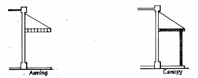
Awning A roof-like shelter of canvas or other material extending over a doorway, from the top of a window, or over a deck, etc., in order to provide protection as from the sun. (See also "Canopy").
Balcony An architectural appurtenance providing usable floor area located above the first floor that is open to the outdoors and either entirely unenclosed or covered only by a roof.
Basement That portion of a building below the first or ground floor level. A basement is not considered a story for the purposes of determining building height.
Block All of the properties fronting on both sides of a street, located between intersecting streets or rights-of-way.
 |
Board The Board of Zoning Appeals of the City of Shaker Heights, Ohio.
Boat A watercraft of any description used or capable of being used as a means of transportation on water except a seaplane, inner tubes, air mattress, or similar devices.
Brew Pub Any establishment having as its principal or predominant use the serving of beer produced on the premises, for consumption on the premises. Sandwiches, light meals and/or full-service meals are available for consumption on the premises but are not the principal or predominant use of the establishment.
Build This term includes the terms establish, construct, erect, assemble, reconstruct, enlarge, alter or develop.
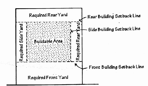
Buildable Area The area of the lot remaining after the minimum open space and/or yard requirements of this Zoning Ordinance have been complied with.
 |
Building Any structure built, used, designed, or intended for the support, shelter, protection, or enclosure of persons, animals, or property of any kind, and which is permanently affixed to the land. When a building is divided into separate parts by unpierced fire or party walls extending continuously from the ground through all stories to and above the roof, each part shall be deemed a separate building.
Building Change Any alteration, demolition, removal or construction to or upon a structure.
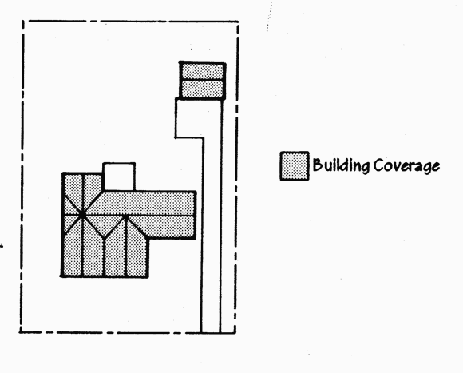
Building Coverage The lot area covered by the principal building(s) and any roof over accessory buildings or structures, measured from the exterior faces of exterior walls, but excluding decks, terraces and other accessory uses which are open to the sky.
 |
Building, Detached A building surrounded by open area on the same lot.
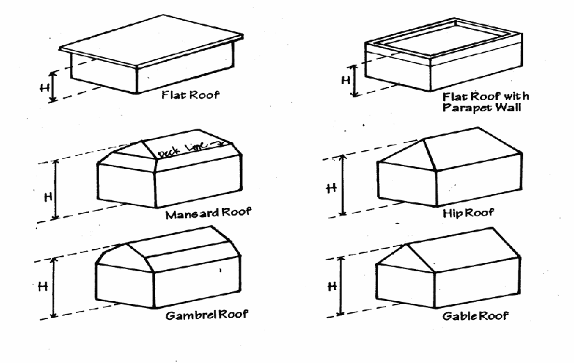
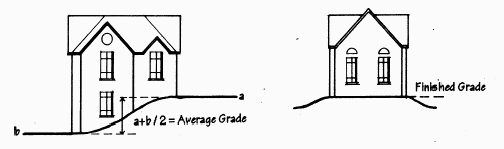
Building Height The vertical distance from the average lot grade at the front of the structure to the highest point of the coping of a flat roof, or to the peak of a gambrel, gable, mansard or hip roof. (See also, "Structure Height").
 |
Building, Principal A building in which is conducted the principal use of the lot on which it is located.
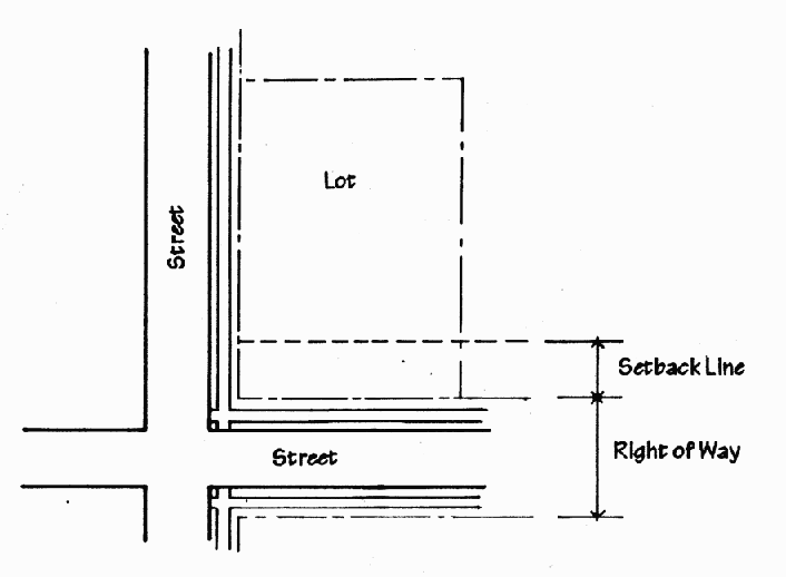
Building Setback Line, Front A line establishing the minimum allowable distance between a street or other right-of-way and any structure as measured from the front property line or right-of-way. (See also "Yard, Required").
Building Setback Line, Side or Rear A line establishing the minimum allowable distance between a property line and any structure as measured from the property line. (See also "Yard, Required.").
Building, Temporary Any building not designed to be permanently located, placed, or affixed to the place where it is located.
Bulk The size and setbacks of the buildings or structures and the location of same with respect to one another, and including:
1. Height and area of buildings.
2. Location of exterior walls in relation to lot lines, streets, or other buildings.
3. All open spaces allocated to buildings.
4. Amount of lot area required for each dwelling unit.
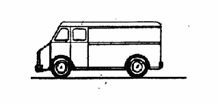
Bus A motor vehicle, other than a commuter van, designed for carrying more than ten (10) persons.
Business An occupation, employment, or enterprise which occupies time, attention, labor and materials, wherein merchandise is exhibited or sold, or where services are offered or provided.
Business Establishment A place of business carrying on operations, the ownership and management of which are separate and distinct from those of any other place of business located on the same zoning lot.
Canopy A roof-like shelter of canvas or other material extending over a doorway, from the top of a window, or over a deck, etc., in order to provide protection as from the sun, and which is carried by a frame which is supported by the ground.
 |
Car Wash A building, or portion thereof, containing facilities for washing one or more automobiles at any one time, using production line methods such as a chain conveyor, blower, steam cleaning device, or other mechanical devices, as defined by the Business Regulation Code or providing space, water, equipment, or soap for the complete or partial cleaning of such automobiles, whether by operator or by customer.
Ceiling The lowest surface of the partition between the floors of a building.
Center Line The mid-point in the width of a public right-of-way as established by recorded plats of survey.
Certificate of Appropriateness A certificate issued by the Landmark Commission indicating that a proposed building or environmental change is in accordance with the provisions of the Zoning Code.
Certificate of Economic Hardship A certificate issued by the Landmark Commission authorizing a proposed building or environmental change after a determination by said Commission that the previous denial of a Certificate of Appropriateness has resulted in an economic hardship.
Certificate Of Occupancy A certificate certifying that the building, as illustrated on approved plans and as constructed, conforms to the provisions of this Zoning Ordinance or is a lawfully existing non-conforming building.
Child Day Care Home, Type A A permanent residence in which child day care is provided for seven (7) to twelve (12) children at one time or a permanent residence of the administrator in which child day care is provided for four (4) to twelve (12) children at one time if four (4) or more children at one time are under two (2) years of age. In counting children for the purposes of this Zoning Ordinance, any children under six (6) years of age who are related to a licensee, administrator, or employee and who are on the premises of the type A home shall be counted.
Child Day Care Home, Type B A permanent residence in which child day care or child day care homes are provided for one (1) to six (6) children at one time and in which no more than three (3) children may be under two (2) years of age at one time. In counting children for the purposes of this Zoning Ordinance, any children under six (6) years of age who are related to the provider and who are on the premises of the type B home shall be counted.
Church See "Places of Worship."
Clinic, Medical Or Dental An organization of specializing physicians or dentists or both, who have their offices in a common building. A clinic shall not include inpatient care.
Commission The City Planning Commission of the City of Shaker Heights, Ohio.
Common Open Space Open space accessible to either the general public or to multiple owners/tenants. Such space is generally maintained by agreement of persons utilizing the space.
Conditional Use See "Use, Conditional."
Construction The erection of new structures and of additions to existing structures.
Convalescent, Nursing or Rest Home An establishment for the care or assisted living of the aged or infirm, or a place of rest for those suffering bodily disorders. Such home does not contain equipment for surgical care or for the treatment of disease or injury.
Cul-De-Sac A short street ending in a turnaround design and intended as a permanent terminus.
Day One calendar day. If a projected day falls on a weekend or holiday, the next following working day or weekday shall fulfill requirements.
Day Care Center, Adult Any place in which day care is provided for adults in need of temporary oversight, and which may include incidental facilities for the preparation and consumption of meals, rest, and recreation.
Day Care Center, Child Any place in which child day-care is provided, with or without compensation, for thirteen (13) or more children at one time or any place that is not the permanent residence of the licensee or administrator in which child day care is provided, with or without compensation, for seven (7) to twelve (12) children at one time. In counting children for the purposes of this Zoning Ordinance, any children under six (6) years of age who are related to a licensee, administrator, or employee and who are on the premises of the center shall be counted. Day care centers located in dwelling units shall not be permitted pursuant to this Zoning Ordinance.
Deck An accessory structure which is constructed directly over and elevated from ground level and which is open to the sky.
Demolition Complete or substantial destruction of any structure.
Density A unit of measurement describing the number of dwelling units per gross acre. The Zoning Ordinance may regulate this by establishing the permitted number of units per acre or the amount of land, measured in square feet or acres, required per individual unit.
Design guideline A standard of appropriate activity to guide building and environmental changes.
Developer Any person seeking to subdivide, build upon or develop land.
Disabled Deficient in the faculties necessary to see, hear, speak, learn or move to one's fullest capacity, due to some physical or mental illness, injury, defect or abnormality.
District A portion of the corporate area of the City, within which certain uniform regulations and requirements, or various combinations thereof, apply under the provisions of this Zoning Ordinance.
Dog Pen or Dog Run A structure constructed to provide shelter or exercise areas for dogs or other pets.
Dormitory A building or part of a building containing a room or rooms forming one or more habitable units which are used or intended to be used by residents primarily for living and sleeping.
Drive-Through Facility A place of business, sales, or service which is laid out and equipped so as to allow its patrons to be served or accommodated while remaining in their automobiles. Drive Through Facilities shall include Automatic Teller Machines but shall exclude Car Washes and Automotive Fuel Stations.
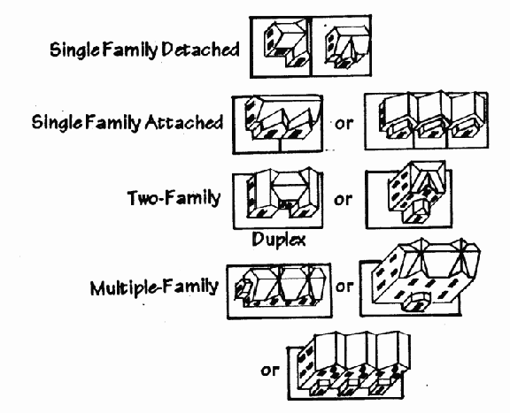
Dwelling A building, or portion thereof designed or used exclusively for residential occupancy, including one-family dwellings, two-family dwellings, and multiple-family dwellings, but not including hotels or motels, camp cars, trailers, or any other vehicle on or off wheels.
Dwelling, Duplex A dwelling consisting of two (2) separate dwelling units joined only by a common fire wall running from the basement to the roof, not having any opening therein, each unit having its own entrance.
Dwelling, Multiple-Family A building, or individual unit thereof, containing three (3) or more dwelling units, and where each unit is provided with an individual entrance to the outdoors or to a common hallway. Multiple-family dwellings may include condominiums, townhouses, apartments, and senior citizen housing as defined herein.
Dwelling, Single-Family Attached One which is joined to another single-family dwelling at one (1) or both sides by party walls.
Dwelling, Single-Family Detached One that is entirely surrounded by open area on the same lot.
Dwelling, Two-Family A building containing two (2) dwelling units, attached either vertically or horizontally. A two-family dwelling includes duplex dwellings.
Dwelling Unit Any room or group of rooms located within a dwelling and forming a single habitable unit with facilities that are used, or intended to be used for living, sleeping, cooking, and eating.
 |
Easement A recorded right or privilege of a person, other than the owner or tenant, to use land for a specific purpose.
Economic Hardship A financial obligation on an owner resulting from the application of the provisions of this Code applicable to designated landmark properties and districts, which when factually detailed and measured by the standards and criteria of this Code is unduly excessive.
Employee A person who, with or without compensation, works for a business or organization on a regular, semi-regular, or recurring basis.
Encroachment An accessory structure or building located within a required yard, or an appendage to a principal building which projects into a required yard. See also "Allowable Encroachment."
Entry, Auxiliary An entryway into a building which is at the rear of the structure or serves as an entryway on the side of the structure which primarily serves a parking lot.
Environmental Change Any physical change made to a site, including but not limited to, fences, retaining walls, signage and major landscaping, excluding minor changes to plant materials. The removal, change or addition of a non-plant landscaping element is considered an environmental change. Individual plant removals, replacements and additions, except significant trees, are not considered an environmental change. However, the removal, replacement or addition of a significant tree or many plants would be considered an environmental change.
Family An individual or two (2) or more persons related by blood, marriage, guardianship, or legal adoption living together as a single housekeeping unit within a dwelling unit, plus no more than one (1) roomer or domestic servant. A family may also consist of not more than three (3) unrelated persons.
Fence A structure that is a barrier and is used as a boundary or means of protection or confinement, which is made of manufactured material, such as but not limited to chain link, wood or stone material.
Final Plat A map of subdivision with accompanying material, intended for final approval and recording, on the basis of which land can be transferred, leased, or encumbered.
Floor Area (For Determining Off-Street Parking and Loading Requirements) The sum of the gross horizontal areas of the several floors of the building.
Floor Area, Interior (For Determining Maximum Area Of A Home Occupation) The sum of the gross horizontal area of the several floors of the dwelling as measured from the inside of the exterior walls. However, interior floor area, for the purpose of regulating home occupations, shall include only the habitable portions of the dwelling and shall exclude unfinished basements and unfinished attics.
Frontage The entire length of the subject property which abuts and is parallel to a public right-of-way as measured along the right-of-way line.
Garage, Single- or Two-Family Residential A detached accessory building or portion of a principal building in which the sole use is storage of the automobiles of the occupants of the premises and other incidental personal possessions. Such garages may accommodate up to four (4) automobiles.
Garage, Multiple-Family Residential A detached accessory building or portion of a principal building in which the sole use is storage of the automobiles of the occupants of the premises and other incidental personal possessions. Such garages may accommodate any number of vehicles, but may be only one (1) level in height.
Grade, Average The mean elevation of the land measured at the setback line between the side lot lines.
Grade, Finished The elevation of the finished surface of the ground adjoining the building after final grading and normal settlement.
 |
Gross Floor Area All the floor area contained within a building or buildings, without exception.
Ground Floor That level of a building which is the first story and is situated above the basement or, if no basement exists, on top of foundation walls.
Hedge A row of shrubs planted to create a visual screen.
Historic Significance The importance of a property to the history, architecture, archaeology, engineering, or culture of the City of Shaker Heights, the State of Ohio, or the United States. A property that is historically significant meets one or more of the criteria in this Code. See Section 1213.10 A.5. of this Zoning Code.
Home Occupation A business use conducted completely within a dwelling unit, carried on by any member of the immediate family residing on the premises, clearly incidental and secondary to the use of the dwelling for residential purposes.
Hospital A medical institution devoted primarily to the maintenance and operation of facilities for the diagnosis, treatment, and care of individuals suffering from illness, disease, injury, deformity or other abnormal physical condition.
Hotel or Motel An establishment which is open to transient guests for remuneration and for periods of time not exceeding thirty (30) days, as opposed to a boarding, rooming or lodging house, and which is commonly known as a hotel in the community in which it is located and which provides customary hotel services such as maid service, furnishing and laundering of linen, telephone and secretarial or desk service, and use and upkeep of furniture.
Infrastructure Public and private utilities, streets and services which are necessary or desirable to support the development of homes and businesses.
Laboratory A place devoted to experimental study such as testing and analyzing. Manufacturing is not to be permitted within this definition.
Landmark Any structure or site which:
1. Has historic significance; and
2. Has been designated as a Landmark pursuant to this Zoning Code.
Landmark District Any area that contains structures and/or sites which:
1. Have historic significance;
2. Cause such area, by reason of such factors, to constitute an identifiable area; and
3. Has been designated as a Landmark District pursuant to this Zoning Code.
Landscaping The aesthetic improvement of property through the installation of plant materials, berming, walls and fences, and other decorative features, composed mostly of green/living vegetation.
Landscape Features Elements used in landscaping, which shall include lawns, gardens, fountains, sidewalks, arbors, trellises, awnings, canopies, flagpoles, balconies, decks, terraces, and hedges.
Landscape Coverage That portion of a lot devoted exclusively to landscaping.
Landscape Buffer A continuous landscaped area designed, maintained and used for screening and separation of districts, lots, or buildings.
Limited Production/Processing Fabrication, assembly, processing, or similar uses which are entirely conducted indoors and are not disruptive of, or incompatible with, other office, retail, or service uses that may be in the same building or complex. Limited production/processing does not include industrial processing from raw materials.
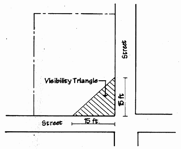
Line of Sight A clear line of vision at an intersection provided by a "visibility triangle" which measures a minimum of fifteen (15) feet per side.
 |
Loading Space An off-street space for temporary parking of delivery and pick-up vehicles.
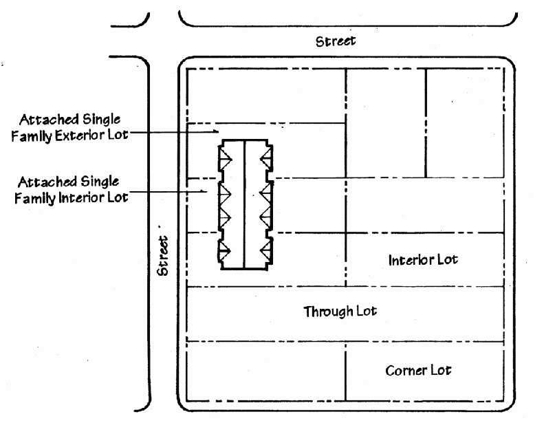
Lot A parcel of land located within a single block and may be either a "lot of record" or a "zoning lot."
Lot, Attached Single-Family Exterior A lot occupied by an attached single-family dwelling which has a common sidewall along only one (1) side lot line.
Lot, Attached Single-Family Interior A lot occupied by an attached single-family dwelling which has common sidewalls along both side lot lines.
Lot, Corner A lot situated at the intersection of two (2) streets, where the angle of intersection between the two streets is no more than one hundred thirty-five (135) degrees.
Lot, Interior A lot other than a corner lot.
Lot, Through A lot having a pair of opposite lot lines along two (2) more or less parallel public streets, and which is not a corner lot. On a "through lot" both street lines shall be deemed front lot lines.
 |
Lot, Zoning A single tract of land located within a single block which (at the time of filing for a building permit) is designated by its owner or developer as a tract to be used, developed, or built upon as a unit, under single ownership or control. Therefore, a "zoning lot; or lots" may or may not coincide with a lot of record.
Lot Area, Gross The area of a horizontal plane bounded by the front, side, and rear lot lines, but not including any area occupied by the waters of a duly recorded lake or river.
Lot Coverage The lot area covered by any structure, enclosed or otherwise.
Lot Depth The mean horizontal distance between the front lot line and the rear lot line of a lot.
Lot Line, Corner Any lot line between the front and rear lot lines which abuts a public street.
Lot Line, Front That boundary of a lot which is along an existing or dedicated public street or, where no public street exists, is along a public right-of-way. On corner lots, the front lot line shall be the lot line faced by the front door.
Lot Line, Side Any lot line between the front and rear lot lines.
Lot Line, Rear That boundary of a lot which is most distant from, and is or is most nearly parallel to, the front lot line.
Lot Width The horizontal distance between the side lot lines of a lot, measured at the building setback line required by this Zoning Ordinance, even if an existing principal building is set back further than required.
Lot Of Record A lot which is part of a subdivision, the plat of which has been recorded in the office of the County Recorder or a parcel of land, the bounds of which have been legally defined and duly recorded in the office of the County Recorder.
Marquee A permanent roof-like structure extending from part of the wall of a building but not supported by the ground and constructed of durable material such as metal or glass.
Mid-rise Office An office building whose height is greater than thirty-five (35) feet but a maximum of one hundred twenty (120) feet or as otherwise limited by the City Council.
Motel See "Hotel or Motel."
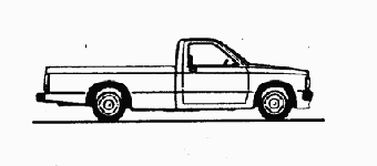
Motor Vehicle, Passenger Any vehicle bearing non-commercial plates designed, built and used primarily for the transport of between one (1) and ten (10) persons.
Motor Vehicle, Non-Passenger Any bus, trailer, truck or recreational vehicle as defined in the Ohio Motor Vehicle Code bearing commercial plates.
Municipal Service Use Publicly owned facilities for the administration of maintenance operations, the storage of maintenance materials, and similar uses.
Neighborhood Organization A group of homeowners who are associated and speak on behalf of other property owners regarding various issues.
Nonconforming Lot A lot, lawfully designed and platted prior to the enactment of this Zoning Ordinance or any amendment hereto, but which does not now conform to the lot area, width, access or other requirements of the district in which such lot is located.
Nonconforming Structure Any structure, lawfully designed and constructed prior to the enactment of this Zoning Ordinance or any amendment hereto, which does not now comply with all of the regulations of this Zoning Ordinance or of any amendment hereto governing bulk for the zoning district in which such structure is located.
Nonconforming Use See "Use, Nonconforming."
Noxious Matter Any matter or material which is capable of causing injury or illness to living organisms, or is capable of causing detrimental effects to the health or the psychological, social, or economic well-being of humans.
Nursing Home See "Convalescent, Nursing or Rest Home."
Occupancy Certificate See "Certificate of Occupancy."
Odorous Matter Any matter or material that yields an odor which is offensive in any way.
Open Area That area of a lot, parcel, or tract that is not covered by a structure.
Open Sales Lot An accessory use involving the selling of merchandise not contained within the enclosed building.
Open Space That portion of a lot or tract intended for recreational use or as landscaping.
Open Space, Permanent Common Parks, playgrounds, landscaped green space (not including schools, community centers or other similar areas in public ownership) or areas covered by an open space easement.
Ordinary Maintenance or Repair Maintenance or repair to correct any decay, deterioration, or damage to an architectural feature and to return the feature to its condition prior to such decay, deterioration, or damage. Maintenance or repair that changes the material or design of an external architectural feature is an alteration as defined above. Repainting a painted surface is ordinary maintenance and neither the act nor the colors are subject to review.
Ornamental Structure A structure which is designed for placement out of doors and whose function is, in part, the beautification of the yard in which it is located. Such structures include gazebos, arbors, trellises and weathervanes.
Outdoor Dining Dining out of doors as an accessory use to an indoor restaurant.
Outdoor Storage The keeping of property in the open area of a lot. For purposes of this definition, the keeping of wood or compost piles will not be considered outdoor storage.
Overhang That portion of a building which horizontally extends beyond the building walls of the first story of such building.
Owner Any person having right of ownership to the land.
Parking, Off-Street A parking space or spaces located entirely off of public right-of-way and set back from such right-of-way as required within this Zoning Ordinance.
Parking, Required The number of parking spaces required for a particular use or uses as required within this Zoning Ordinance.
Parking Space An enclosed or unenclosed surfaced area permanently reserved for the temporary storage of one (1) passenger motor vehicle and appropriately part of a street or connected with a street or alley by a surfaced driveway affording adequate ingress and egress.
Parking Structure A building or portion thereof, usually multi-level, and either above or below grade, designed or used for storing or parking motor vehicles.
Party Wall A wall which is common to but divides contiguous buildings.
Person Any corporation, partnership, group of persons, association, agent, or any other entity subject to this Zoning Ordinance shall be defined as a person.
Personal Service Establishment A business that provides personal services directly to customers at the site of the business. Personal service establishments include, but are not limited to, travel agencies, dry cleaning and laundry drop-off and pick-up stations, tailors, hair stylists, cosmeticians, toning or tanning salons, branch offices of financial institutions, photocopying services, postal substations, package delivery drop-off and pick-up stations, shoe repair shops, interior design studios, and domestic pet grooming and care services.
Places Of Worship Structures and other indoor or outdoor facilities used for public worship and related educational, cultural, and social activities.
Plan The Plan, or any geographical or functional part thereof, as adopted by the City, indicating the general locations recommended for streets, parks, public buildings, and other community development aspects.
Planned Unit Development A parcel of land or contiguous parcels of land of a size sufficient to create its own environment, controlled by a single landowner or by a group of landowners in common agreement as to control, to be developed as a single entity, the environment of which is compatible with adjacent parcels, and the intent of the zoning district or districts in which it is located. Under a planned unit development, the developer may be granted relief from specific land-use regulations and design standards and may be awarded certain premiums in return for assurances of an overall quality of development, including any specific features which will be of exceptional benefit to the community as a whole. A planned unit development is a special type of conditional use.
Preservation The act or process of applying measures necessary to sustain and protect a property's historic attributes.
Property Land, and any structures on the land, identified as a separate lot for purposes of the Zoning Code.
Public Space Permanent common open space which may or may not be green space. Public space may include, but shall not be limited to, plazas, courtyards, atriums, or terraces.
Recreational Facility A building or enclosed structure containing recreational facilities, such as a tennis court, swimming pool and/or gymnasium, and operated by a government agency or as a business.
Recreational Structures Athletic facilities such as swing sets and playing courts for basketball or tennis, but not including swimming pools.
Recreational Vehicle A boat, camping trailer, motor home, mini motor home, travel trailer, truck camper or van camper used primarily for recreational purposes and not used commercially nor owned by a commercial business.
Regulation A rule, restriction or other mandatory provision intended to control, require or prohibit an act.
Rehabilitation The process of returning a property to a state of utility, through repair or alteration, which makes possible an efficient contemporary use while preserving those portions and features of the property which are significant to its historic, architectural, and cultural values.
Removal The relocation of any structure on its site or to another site.
Research Facility A place devoted to experimental study such as testing and analyzing, but not that which includes the use of chemicals or animals or which fails to conform to Section 1260.06, Environmental Performance Standards, of this Zoning Ordinance. Manufacturing is not to be permitted within this definition.
Residential The use of land or buildings for dwelling purposes.
Residential Care Home A dwelling unit shared by four (4) or more unrelated disabled individuals, exclusive of staff, who require assistance and/or supervision and who reside together in a family-type environment as a single housekeeping unit. A Residential care home shall not include a home for persons who are currently addicted to alcohol or narcotic drugs or are criminal offenders serving on work release or probationary programs.
Restaurant, Sit-down A business establishment within which the primary use is prepared food offered for sale and consumption only within the structure on the premises or in a designated and permitted outdoor area.
Restaurant, Carry-out A business establishment within which the primary use is prepared food and beverages, offered for sale in disposable containers and packaged for carryout.
Rest Home See "Convalescent, Nursing or Rest Home."
Right-Of-Way Any sidewalk, street, alley, highway, or other public thoroughfare.
 |
Roadway The portion of the street right-of-way available for vehicular movement. Roadway width shall be measured from back of curb to back of curb.
Roof That portion of a building or structure which encloses such building or structure from the sky.
Roomer A person who renders services, pays rent, or provides other consideration to the resident family for occupancy of one or more rooms within a dwelling unit, but does not occupy a separate dwelling unit.
School, Primary or Secondary An institution primarily engaged in academic instruction for all or part of grades K through 12, and recognized or approved by the State.
School, Specialized Instructional An institution engaged in specialized instructional areas for all ages, such as but not limited to driving, trade, vocational, art, music and dance schools.
Screening A structure erected or vegetation planted for the purpose of concealing from view the area behind it.
Self Storage Facility A primary use of a building or group of buildings, each of which contains individual storage units, with each unit having a separate door and lock and which are leased on an individual basis to residential and business customers for the storage of goods and wares.
Senior Citizen Apartments Apartment buildings, which may be either assisted living facilities or convalescent homes, designed for and occupied by persons age sixty-two (62) and over, which provides living unit accommodations and spaces for common social and recreational activities, and which may include incidental facilities for health and nursing services.
Setback Line See "Building Setback Line, Front" or "Building Setback Line, Side or Rear."
Shelter, Emergency A temporary home for persons seeking relief from emergencies, domestic violence or other dangerous environments.
Shopping Center A group of commercial establishments, planned, developed, and managed as a unit related in location, size and type of shops to the trade area that the unit serves.
Shrubs A planting or growth of multi-stemmed woody plants.
Sign Any display, figure, painting, drawing, placard, poster or other device placed on the ground or on any tree, wall, bush, rock, post, fence, building, structure, playground structure, or thing whatsoever, which is designed, intended, or used to convey a message, advertise, inform, or direct attention to a person, institutions, organization, activity, place, object, or product. The term "placed" as used in this definition shall include erecting, constructing, posting, painting, printing, tacking, nailing, gluing, sticking, carving or other fastening, affixing, or making visible in any manner whatsoever.
Sign, Availability A sign announcing the sale, rental or lease of the lot where the sign is displayed or announcing the sale, rental or lease of one or more structures, or a portion thereof, located on the lot.
Sign, Banner Any cloth, bunting, plastic, paper, or similar material used for advertising or identification purposes attached to any structure.
Sign, Directory A sign listing the names and locations of businesses within a building not having first floor frontage, or a sign displaying announcements which direct attention to a public charitable or religious facility which is located on the lot of said facility.
Sign, Entry A sign located over an entry to a business, such entry neither oriented to nor visible from a public street and intended to allow access to the business from a parking lot or pedestrian way.
Sign, Exempt A sign which, due to its small size or unobtrusive nature, is not regulated by this Zoning Ordinance except pursuant to Section 1250.03.B, Exempt Signs.
Sign, External Illumination Illumination of a sign which is effected by a source of light which is not contained within the sign itself.
Sign Height The vertical distance measured from the base of the sign or from the base of the building to which a sign is attached to the highest point of the sign.
Sign, Identification A sign directing attention to the name of an office, institution, multiple-family building, business, product, service or activity conducted or sold on the lot where the sign is displayed, and classified as to design and structure as an awning, canopy, monument,
projecting, wall, or window sign.
Sign, Illuminated A sign which has characters, letters, designs, or outline illuminated by electric light or luminous tubes as part of the sign proper, or which is illuminated by the reflector method.
Sign, Internal Illumination Illumination of a sign which is effected by a source of light which is contained within the sign itself. Any sign in which light becomes visible by shining through a translucent surface shall be considered a sign in which internal illumination is used.
Sign, Local Sign District An area of special sign controls established pursuant to Section 1250.09 of this Zoning Ordinance.
Sign, Monument A polygonal shaped sign, placed on the ground, whose width above a plinth base is at least as wide as the width (of the top of the sign).
Sign, Neon Tube Illumination Illumination effected by a light source consisting of a neon tube which is bent to form letters, symbols, or other shapes.
Sign, Off-Premises A sign which advertises goods, services, or facilities which are not available on the premises where the sign is located. The foregoing definition includes (but is not limited to) billboards.
Sign, Parking Control A sign which identifies parking lot entry and exit driveways and/or provides traffic flow control information within a parking lot.
Sign, Permanent Any sign except an exempt sign as listed in Section 1250.03 or a temporary sign as listed in Section 1250.04. Such signs are intended to be used indefinitely, or used indefinitely without change in the same state or place, and include identification signs, directory signs, auxiliary entry signs, and parking control signs.
Sign, Pole A sign which is supported by one (1) visible pole which is independent of a building.
Sign, Projecting A sign which is suspended from, or is supported by, a building or wall and which projects more than twelve (12) inches from the face of the building or wall.
Sign, Roof A sign erected or maintained in whole or in part upon or over the roof of a building.
Sign, Secondary A sign intended primarily for viewing by pedestrian traffic, displayed as a window sign or window display, a canopy or awning sign, or a projecting sign.
Sign, Shopping Center Identification A sign listing the name of the shopping center located on the same lot as the sign.
Sign, Surface Area The area within any perimeter enclosing the limits of lettering, emblems or other figures on a sign, together with any material or color forming an integral part of the display or used to differentiate the sign from the background against which it is placed. Structural members bearing no sign copy shall not be included in its surface area. In the case of a multi-faced sign, all sides shall be included in the calculation of surface area. The surface area of signs which are in the form of balls, cylinders or other shapes having a continuous surface shall be equal to one-half (1/2) of the entire area of the surface of the sign.
Sign, Temporary A sign which is intended to be displayed for a limited time only. Such signs include real estate signs, political signs, and construction signs.
Sign, Wall A sign which is placed flat against a wall of a building.
Sign, Window A sign which is affixed to or in contact with, or within six (6) feet of a window or the glass surface of a door, and is visible from the public street.
Sign, Window Display One (1) or more signs in a display window which are incorporated with a display or merchandise or relating to services offered but which are not affixed to any window.
Sign, Window, Permanent A window sign, installed as a secondary sign within six (6) feet of the window, constructed of permanent materials, and which identifies the business or otherwise suggests that the information conveyed is of a permanent character.
Sign, Window, Temporary A sign attached to the window or as a window display which describes one (1) or more products or services and/or the prices of one (1) or more products or services available at the premises at which the sign is displayed and which suggests that the information conveyed is not of a permanent character.
Signable Area An area of the facade of a building or monument sign structure, the boundaries of which shall form a square, a rectangle or a parallelogram, which is free of windows, doors and all major architectural details. Only one (1) signable area may be established for a facade of a building. In no event shall the signable area of a building exceed, in square footage, one-third (1/3) of the square footage of the entire facade of the building. Parapets, pylons and equipment enclosures shall not be designated as signable areas, and rooftop equipment enclosures shall not be considered part of the facade of the building.
Site The location of an event, activity, or structure, whether standing or vanished. A site may have historic significance in its own right.
Specialty Shop A retail shop that sells a narrow range of goods and products and serves a specific clientele or provides a specific product not readily found in other retail establishments.
Storage Structure An accessory structure for private use by the owner or occupant of the lot on which it is located, and intended for the safekeeping of personal property, not including automobiles.
Story That part of a building between the surface of any floor and the surface of the floor next above, and if there is no floor above, then the ceiling above.
Story, Half That portion of a building under a gable, hip, or mansard roof, the wall plates of which on at least two (2) opposite exterior walls are not more than three (3) feet above the floor.
Street, Private A paved area located on private property for the purpose of providing vehicular access to that property.
Street, Public A public way for purposes of vehicular travel, including the entire area within the right-of-way.
Street Width The shortest distance between the lines delineating the right-of-way of a street.
Structural Alteration Any change, other than incidental repairs, which would prolong the life of the supporting members of a building, such as the addition, removal, or alteration of bearing walls, columns, beams, girders, or foundations.
Structure Anything constructed or erected permanently or temporarily on, in or under the ground or attached or connected thereto, including but not limited to arbors, buildings, barriers, bridges, bulkheads, bunkers, chimneys, decks, fences, garages, gazebos, outdoor seating facilities, platforms, playhouses, poles, radio, television and telecommunication antennae, satellite dishes, signs, spas, swimming pools, tanks, tents, towers, trellises, walks, walls and works of art. Structures do not include trailers and other vehicles whether on wheels or other supports.
Structure, Accessory A subordinate building or structure located on the same lot with the principal building, occupied by or devoted to an accessory use, but not to be used for habitation. Where an accessory building is attached to the principal building in a substantial manner, as by a wall or roof, such accessory building shall be considered part of the principal building.
Structure Height See Building Height.
Subdivider Any owner or other person proceeding to subdivide or develop land.
Subdivision The division of land into two (2) or more parcels, the creation of any easement or right-of-way, the establishment of a Planned Unit Development, or any change in the boundary lines of a lot.
Swimming Pool A permanent structure used for recreational swimming or bathing and which is located below ground level, or a temporary above-ground structure used for recreational swimming or bathing, particularly by children, which is no more than two (2) feet in depth and ten (10) feet in diameter.
Temporary Occupancy Occupancy of a dwelling, structure or lot, by a person or persons to perform a particular use for a limited period of time, such as but not limited to overseeing building construction or selling Christmas trees.
Temporary Use See "Use, Temporary."
Terrace A paved or otherwise non-vegetative man-made accessory structure adjoining a building which is relatively level and open to the sky.
Theater Any building or structure designed for the enactment of dramatic performances and/or the showing of motion pictures. For the purposes of this Zoning Ordinance, a dinner theater shall be deemed a "restaurant," and adult theaters are deemed separate and distinct uses.
Townhouse A multiple-family building comprised of attached single-family dwelling units where the units are attached by common fire walls and each unit has at least one (1) separate outside entrance.
Toxic Material Any substance (liquid, solid or gaseous) which by reason of an inherent deleterious property when emitted in any amount is injurious to plants, animals, or human beings.
Trailer A movable or portable unit to be towed on its own chassis.
Tree, Caliper The thickness of trees measured in inches. A caliper measurement shall be measured twelve (12) inches above the soil line, or across the stump if the tree has been severed at less than twelve (12) inches above the soil line.
Tree, Diameter Breast Height The diameter of the trunk or trunks of a tree measured at four and a half (4 ½) feet above mean ground level at the base of the trunk or trunks.
Tree, Hazard A tree that is dead, diseased, dying, or has a structural defect that presents a threat to persons or damage to property.
Trellis A vertical or diagonal lattice structure that is either free-standing or attached to a building for the purpose of growing vines.
Truck A motor vehicle classified as Class 3 or Class 5 by the Federal Highway Administration Vehicle Classification System as follows:
Class 3 All two-axle, four-tire vehicles, other than passenger cars. Included in this classification are pickups, panels, vans and other vehicles such as campers, motor homes, ambulances, hearses, and carry-alls. Other two (2) axle, four (4) tire, single unit vehicles pulling recreational or other light trailers are included in this classification.
 |
Class 5 All vehicles on a single frame including parcel delivery trucks, camping and recreational vehicles, motor homes, etc. having not more than two (2) axles and dual rear wheels.
 |
Use, Accessory An activity conducted within a building or structure, or on the open area of the lot which is:
1. Conducted or located on the same zoning lot as the principal building or use served, except as may be specifically provided elsewhere in this Zoning Ordinance;
2. Clearly incidental to, subordinate in purpose to, and serving the principal use; and
3. Either in the same ownership as the principal use or is clearly operated and maintained solely for the comfort, convenience, necessity, or benefit of the occupants, employees, customers, or visitors of or to the principal use.
Use, Conditional A use, either public or private, which, because of its unique characteristics, cannot be properly classified as a permitted use in a particular district or districts.
Use, Existing Any use of a parcel of land or structure which exists on the effective date of this Zoning Ordinance.
Use, Nonconforming Any use of any land, building, or structure, lawful at the time of the enactment of this Zoning Ordinance, which does not comply with all of the regulations of this Zoning Ordinance or of any amendment hereto governing use of the zoning district in which such use is located.
Use of Similar Nonconformity A use which replaces a nonconforming use of similar intensity. A use is similar in intensity if the least restrictive district in which it is a permitted use is the same as that of the nonconforming use which it is replacing.
Use, Permitted A use which may be lawfully established in a particular district or districts provided it conforms with all requirements, regulations, and standards of such district.
Use, Principal The main use of land or structures as distinguished from a subordinate or accessory use. A "principal use" may be "permitted" or "conditional."
Use, Temporary Any use which is established only for a fixed period of time, with the intent to discontinue such use upon the expiration of such time, and which does not involve the construction or alteration of any permanent structure.
Variance A modification of the provisions of this Zoning Ordinance where a literal enforcement of the Zoning Ordinance would result in practical difficulty or undue hardship.
Vehicle Any device by which person or property may be transported upon a highway or waterway, except those such devices, as defined by the Business Regulation Code, moved by human power.
View Obstruction An obstruction of a line of sight (See "Line of Sight.")
Walkway/Bikeway A way across or within a block for use by pedestrian and bicycle traffic, which shall include but not be limited to sidewalks and crosswalks.
Wall A vertical structure of a linear nature which serves to support, retain, or screen.
Warehousing The safekeeping of property, either for later use or for resale, within enclosed buildings.
Wine Bar Any establishment having as its principal or predominant use the serving of wine for consumption on the premises. Sandwiches, light meals and/or full-service meals are available for consumption on the premises but are not the principal or predominant use of the establishment.
Wholesale Businesses involved in the sale of goods, products, or merchandise stored on the premises to persons who are intermediaries between the producer and the consumer.
Work/Live Unit Space within a commercial building used jointly for commercial and residential purposes where the residential use of the space is secondary or accessory to the primary use of the space as a place of work.
Yard An area on the same zoning lot with a building or structure, unoccupied and unobstructed from its lowest level to the sky, except as otherwise permitted in this Zoning Ordinance. A "yard" is the distance between a building and a lot line.
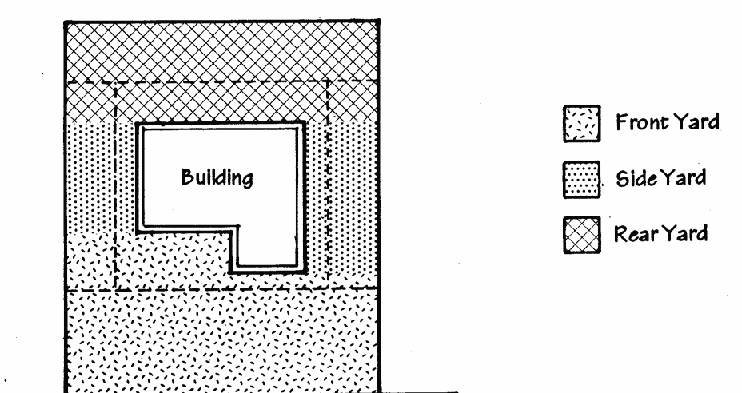 |
Yard, Corner Side A side yard which adjoins a public street, extending from the front face of the building to the rear lot line and from the side face of the building to the side lot line.
Yard, Front A yard extending from the front face of the building to the front lot line along the full width of the lot between the side lot lines.
Yard, Interior Side A side yard which is located immediately adjacent to another zoning lot or to an alley separating such side yard from another zoning lot, extending from the side face of the building to the side lot line between the front and rear yards.
Yard, Rear A yard extending from the rear face of the building to the rear lot line along the full width of the lot between the side lot lines, except that for corner lots the rear yard shall terminate at the corner side yard.
Yard, Required The minimum yard required between a lot line and a building line by the applicable provisions of this Zoning Ordinance.
Zoning Administrator A staff member of the Planning Department who is authorized to hear complaints, make inspections, and take action to enforce the provisions of this Zoning Ordinance. The Zoning Administrator may also accept applications for amendments or variances to the Zoning Ordinance and administrate the related public hearings procedure.
Zoning Enforcement Officer A staff member of the Planning Department who is designated by the Zoning Administrator to hear complaints, make inspections, and take action to enforce the provisions of this Zoning Ordinance.
(Ord. 13-45. Enacted 7-8-13; Ord. 13-114. Enacted 12-16-13.)
1212.01 SUMMARY OF AUTHORITY.
The administrative and decision-making bodies and officials listed below, without limitation upon such authority as each may possess by law, have responsibility for implementing and administering this Zoning Ordinance in the manner described in Chapter 1212, Administrative and Decision-Making Bodies and Officials and Chapter 1213, Permit and Administrative Review Procedures.
1212.02 CITY COUNCIL.
The City Council:
A. Takes such actions as necessary to plan for the future development of the City.
B. Approves or disapproves any application for an amendment to this Zoning Ordinance.
C. Confirms the decision of the City Planning Commission for any application for a conditional use permit, including an application for a planned unit development and a small lot infill development, pursuant to Section 1213.09, Planned Developments Review.
D. Approves or disapproves variances proposing to increase the height of commercial buildings by more than twenty percent (20%) or to decrease the number of off-street parking spaces provided by more than twenty percent (20%).
E. Takes such action to revoke Conditional Use Permits pursuant to the recommendation of the City Planning Commission, if the established conditions for the Conditional Use Permit are violated.
F. Approves or disapproves proposed amendments to any existing land use policies.
G. Takes such other action that may be desirable and necessary to implement the provisions of this Zoning Ordinance.
H. Takes other actions as conferred by the Ohio Constitution, the laws of the State of Ohio, and the Charter of the City of Shaker Heights.
I. Approves or disapproves of improvements to public land.
(Ord. 18-25. Enacted 4-23-18.)
1212.03 BOARD OF ZONING APPEALS AND CITY PLANNING COMMISSION.
A. Powers and Duties
1. Board of Zoning Appeals
The Board of Zoning Appeals shall have the following powers and duties under the provisions of this Zoning Ordinance:
a. To hear and decide appeals from, and to review orders, decisions, or determinations made by the Zoning Administrator.
b. To hear and decide upon applications for variances from the requirements of this Zoning Ordinance pursuant to Section 1213.04, Variance Procedures.
c. To make its special knowledge and expertise available to any official, department, board, or commission of the City, to aid them in the performance of their respective duties relating to zoning and its administration in the City.
d. To hear and decide upon applications to change an existing nonconforming use to a use of similar conformity.
2. City Planning Commission
The City Planning Commission is established and given its authority within the City charter and by ordinance of the City Council. The City Planning Commission shall have the following powers and duties under the provisions of this Zoning Ordinance.
a. To initiate, hear, review, and approve or disapprove applications for amendments to this Zoning Ordinance and Map pursuant to Section 1213.07, Amendments.
c. To review and approve or disapprove site plans as required pursuant to Section 1213.06, Site Plan Review.
d. To prepare and participate in and to make recommendations to the City Council for adopting an official Strategic Plan or similar plans for the City, and from time to time to recommend to the Council such amendments as it may deem appropriate.
e. To aid and assist the City Council and the departments of the City in implementing the City's adopted land use policies and in planning, developing, and completing specific projects.
f. To review and report on any matters referred to it by the City Council.
g. To make its special knowledge and expertise available to any official, department, board, or commission of the City to aid them in the performance of their respective duties relating to the planning and development of the City.
h. To review, hear and make decisions upon applications for the resubdivision of land.
i. To review and make recommendations to the City Council regarding improvements to public land.
j. To hold public hearings upon any of the issues which fall within its authority and jurisdiction to consider.
k. To recommend to the City Council that the Council should revoke Conditional Use Permits if the established conditions for the Conditional Use Permit are violated.
B. Membership, Term and Organization of the City Planning Commission and Board of Zoning Appeals
1. The Board of Zoning Appeals and the City Planning Commission shall consist of the Mayor who is the Chairperson, one (1) member of Council to be selected by the Council, and three (3) electors of the city not holding other municipal office.
2. The three electors are to be appointed by the Mayor and approved by the majority of Council for not more than two (2) consecutive terms of six (6) years each, not including any portion of an unexpired term. Council confirmation is required for appointed members.
3. The present members of the City Planning Commission and Board of Zoning Appeals, other than the Mayor and Councilperson, shall continue to serve until the expiration of their respective terms, and will be subject to a two (2) consecutive full term limitation except that any such member may be appointed for one (1) additional full term. A vacancy occurring during the term of any member of the City Planning Commission or the Board of Zoning Appeals shall be filled for the unexpired term in the manner authorized for an original appointment.
4. A Vice-Chairperson shall be the City Council representative and shall conduct meetings in the absence of the Chairperson.
5. A Secretary shall be appointed who is either the Planning Director or the Director's designee, and who shall be responsible for taking or designating a person to take the minutes of Board of Zoning Appeals and City Planning Commission meetings.
C. Meetings, Hearings and Procedures
1. Regular meetings of the Board of Zoning Appeals and the City Planning Commission may be held at the call of the Chairperson, or when the Zoning Administrator indicates that there is an agenda item to be heard, or as provided by rule of the Board of Zoning Appeals or the City Planning Commission. Special meetings shall be called at the request of the Chairperson or of any three (3) members of the Board or Commission or at the request of the City Council.
2. All meetings and hearings of the City Planning Commission and Board of Zoning Appeals shall be open to the public except for executive sessions which shall be held for such purposes and in such manner as authorized by the City Charter or by ordinance of City Council.
3. The Board of Zoning Appeals or the City Planning Commission may adopt its own rules of procedure, not in conflict with this Zoning Ordinance, as it deems proper and necessary. The adoption, amendment, or revision of such rules shall be by a majority vote of all members of the Board or Commission. Every member of the Board or Commission shall be furnished a copy of such proposed rules and any amendment or revision thereto at least ten (10) days before consideration for adoption. Such rules shall be filed with the Clerk of Council. Any rules so adopted that relate solely to the conduct of the Board or Commission meetings or hearings and that is not mandated by this Zoning Ordinance may be waived by the Chairperson upon good cause being shown.
D. Quorum and Majority Vote Required
1. Three (3) members, which may include the Chairperson of the Board or Commission, shall constitute a quorum to conduct business, provided, however, that two (2) members, including the Chairperson, shall constitute a quorum for the purpose of convening and adjourning a meeting.
2. Three (3) votes of the Board or Commission membership shall be required for rendering a final decision on any matter or proposal, including, for the Board, the forwarding to the City Council of a recommendation on applicable requests per Section 1213.04.F, Variance Procedures, Confirmation of Variance by Council.
E. Conflicts of Interest
No member of the Board of Zoning Appeals or the City Planning Commission shall participate in the hearing or disposition of any matter in which that member has a financial interest as determined by State law or City ordinance.
F. Decisions
Every recommendation or decision of the Board of Zoning Appeals or the City Planning Commission upon an application filed pursuant to Zoning Ordinance shall be summarized in the meeting minutes such minutes shall be deemed to contain Commission's findings-of-fact and reason for action taken shall contain a conclusion or statement separate from the findings of fact setting forth the specific relief granted or relief denied or setting forth the recommendation of the Board of Zoning Appeals and shall expressly set forth any limitations or conditions imposed on any relief granted or recommended or work or use authorized. The Board of Zoning Appeals or the City Planning Commission may take final action on any recommendation or decision pertaining to an application pending before it prior to the preparation of the minutes, but in such event it shall, before taking such action, first state its findings and conclusions as above required at a meeting open to the public. The Board of Zoning Appeals or the City Planning Commission's recommendation or decision of the Board of Zoning Appeals or City Planning Commission shall be deemed made as of the date of the taking of such final action. The minutes incorporating such findings and conclusions shall be presented for approval at the next regular meeting of the Board of Zoning Appeals or the City Planning Commission.
G. Record
The transcript of testimony and other evidence audio or video recording, if any minutes all applications, requests, exhibits, and papers filed in any proceeding before the Board of Zoning Appeals or the City Planning Commission and the decision and report, or records of the Board of Zoning Appeals or the City Planning Commission shall constitute the record.
(Ord. 18-25. Enacted 4-23-18.)
1212.04 LANDMARK COMMISSION.
A. Authority
The Landmark Commission is hereby created pursuant to the enabling authority granted under the Ohio Revised Code and the powers of the City under its Charter. The Landmark Commission has those powers enumerated in this Zoning Code.
B. Purpose and Intent
The purposes of the Landmark Commission are to recommend the designation of landmarks in the City pursuant to the procedures hereinafter described, in order to preserve, protect, and perpetuate buildings, structures, sites, works of art, and other objects having special historical, community or aesthetic interest or value, all for the reasons described in the remainder of this section.
1. To preserve buildings, structures, and sites of historic significance as part of the City’s most important cultural, educational and economic assets.
2. To enhance the visual and aesthetic character, diversity and interest of the City.
3. To insure proper development and utilization of lands and areas within designated Landmarks and Landmark Districts and to encourage complimentary, contemporary design and construction.
4. To foster civic pride in the beauty and notable accomplishments of the past.
5. To protect and enhance the City’s attractions to residents, tourists and visitors, and serve as a support and stimulus to business.
6. To safeguard the heritage of the City by preserving sites and structures which reflect elements of the City’s cultural, social, economic, political, and architectural history.
7. To promote the private and public use of Landmarks and historical areas for the education, prosperity, and general welfare of the City’s residents.
8. To make recommendations to the City Council on policies and ordinances that may encourage preservation of buildings, structures and sites of historic significance.
9. To stabilize and improve property values.
10. To strengthen the economy of the City.
11. To take whatever steps as may be necessary to safeguard the property rights of those owners whose property is declared to be a “Landmark” or is located in an area designated as a “Landmark District”.
C. Powers and Duties
In addition to carrying out the general purposes set forth in Section 1212.04.B, the Landmark Commission shall have the following powers and duties:
1. Recommend the designation of Landmarks and Landmark Districts.
2. Make recommendations to the City Planning Commission and the City Council, as appropriate, on applications for zoning amendments and conditional uses involving historic areas and Landmarks.
3. Conduct a continuing survey of all areas, places, buildings, structures, works of art or similar objects in the City which the Commission, on the basis of information available or presented to it, has reason to believe are or will be eligible for designation as Landmarks.
4. Conduct reviews including design, architecture and site concerns, of proposed changes to Landmark or structures and sites in Landmark Districts.
5. Work for the continuing education of the residents of the City with respect to the historic and architectural heritage of the City and the Landmarks designated under the provisions of this chapter. It shall keep current and public a register of Landmarks.
6. Act as the City’s liaison with individuals and organizations concerned with historic preservation.
7. Accept the services of technical experts and such other persons as may be required to perform its duties.
8. Establish administrative procedures and guidelines.
D. Membership, Term and Organization
1. The Landmark Commission shall consist of seven (7) members. One shall be a member of City Council appointed by the Mayor. The remaining six (6) members shall be citizen members appointed by the Mayor, and shall have the following qualifications: (a) reside in the City of Shaker Heights, (b) have demonstrated an interest, experience or knowledge in history, architecture and related disciplines; and (c) not hold other public office or employment with the City of Shaker Heights or the Shaker Heights Board of Education. As to not more than one (1) of the six (6) citizen members, Council may waive the requirements that such member be a resident of the City and/or hold no other public office with the City or the School Board.
2. Of the six (6) citizen members of the Landmark Commission, one (1) member shall be an architect and two (2) other members shall be preservation-related professionals, including, but not limited to, professionals in the fields of architecture, history, planning, historic preservation, landscape architecture, related fields of law, or real estate, if available.
3. The Council Member of the Landmark Commission shall be appointed annually by the Mayor. All six (6) citizen members of the Landmark Commission shall be appointed to three (3) year terms by the Mayor and shall be confirmed by Council. The terms of the six (6) citizen members shall be staggered so that not more than two (2) members’ terms expire in a given year.
4. In making appointments of citizen members to the Landmark Commission, consideration should be given to having the Landmark Commission membership reflect a variety of points of view, including architectural, historical, planning, historic preservation, landscape architecture, legal and real estate.
5. A vacancy shall be filled for the remainder of the unexpired term in the same manner as regular appointments and confirmations. A vacancy shall be filled within sixty (60) days from the date the vacancy occurs, unless a greater period of time is reasonably necessary, as determined by the Mayor. In the case of temporary absence or disability of any member, a member may be appointed and confirmed in the manner provided above to serve during such temporary absence or disability. Such temporary member shall possess all of the qualifications of a regular member, and shall have the same powers and perform the same duties as a regular member during the terms of his or her appointment.
6. The Mayor and the Planning Director shall serve as ex officio members of the Landmark Commission.
7. The Council member appointed to the Landmark Commission shall serve as the chairperson of the Landmark Commission during the term of his or her appointment.
8. The Mayor shall appoint a City employee to serve as Secretary of the Landmark Commission. The Secretary shall keep, or cause to be kept, a complete record of all meetings of the Landmark Commission and a detailed record of all transactions dealt with by the Landmark Commission. In addition, the Secretary shall perform such other functions as the Landmark Commission may direct.
E. Meetings, Hearings and Procedures
1. The Landmark Commission shall meet once per month or as necessary, but no less than four (4) times per year.
2. The Landmark Commission shall schedule and give public notice of all public hearings pursuant to Section 1213.10, Designating Landmarks and Landmark Districts.
3. The Landmark Commission shall adopt policies and procedures for the conduct of its meetings, the processing of applications and for any other purposes considered necessary for its proper functioning.
F. Quorum and Vote
No business shall be conducted without a quorum at the meeting. A majority of the members of the Landmark Commission constitutes a quorum. All recommendations on designations and other actions of the Commission shall be represented by a vote of the membership. A simple majority of the voting members present at the meeting at which a quorum is present shall be required for any action taken.
G. Conflicts of Interest
No member of the Landmark Commission shall participate in the review of any item of discussion before such Commission if such member has any direct or indirect financial or personal interest in the property or the matter involved in such discussion. Personal, as distinguished from financial interest, includes an interest arising from blood or marriage relationships, or business or political association, as such terms are defined by State of Ohio law and City ordinance.
(Ord. 04-129. Enacted 11-22-04; Ord. 13-114. Enacted 12-16-13.)
1212.05 ARCHITECTURAL BOARD OF REVIEW.
The Architectural Board of Review is established pursuant to Chapter 1309 of the Building Code. Provisions regarding the Architectural Board of Review are located in that ordinance. This section is an excerpt of information from that ordinance. The Architectural Board of Review has the following responsibilities:
A. To protect the value, appearance, and use of property on which buildings are constructed or altered.
B. To maintain a high character of community development, and to ensure the compatibility of new development.
C. To protect the public peace, health, safety, convenience and welfare.
D. To protect real estate within the City from impairment or destruction of value.
E. To regulate the design, use of materials, finish grade lines, dimensions, orientation and location of all main and accessory buildings to be erected, moved, altered, remodeled or repaired.
F. To establish design policies and guidelines.
G. To receive, review and pass upon plans for new development, alterations and additions filed in the Planning Department.
(Ord. 03-67. Enacted 6-9-03; Ord. 13-114. Enacted 12-16-13.)
1212.06 ZONING ADMINISTRATOR.
A. Powers and Duties
The Zoning Administrator shall be charged with the administration of Zoning Ordinance and, in particular, shall have the jurisdiction, authority, and duties described below:
1. To meet with and counsel those persons having an interest in this Zoning Ordinance, other questions of land use, and related City plans and policies.
2. To conduct zoning compliance reviews regarding any permit pertaining to the use of land, buildings or structures.
3. To issue permits for temporary uses requiring administrative approval.
4. To conduct other administrative approvals as provided by this Zoning Ordinance.
5. To review any site plans submitted for such review, and to make decisions or recommendations, as appropriate, to the City Planning Commission on such site plans, pursuant to Section 1213.06, Site Plan Review.
6. To make written interpretations of specific provisions of this Zoning Ordinance pursuant to Section 1213.11, Administrative Interpretations.
7. To approve Certificates of Occupancy which are issued by the Commissioner of Buildings for buildings which meet applicable requirements.
B. Procedures
1. General Authority to Enact Rules and Procedures. The Zoning Administrator, consistent with the express standards, purposes, and intent of this Zoning Ordinance, may promulgate, adopt, and issue such procedural rules, regulations, and forms as are necessary to the effective administration and enforcement of the provisions of this Zoning Ordinance.
2. Staff Assistance to the Board of Zoning Appeals and City Planning Commission. The Zoning Administrator shall make staff and consulting assistance available to the Board of Zoning Appeals and the City Planning Commission. The Zoning Administrator or such person as the Zoning Administrator designates shall in that capacity:
a. Attend the meetings of each such body.
b. Inform each such body with a summary of all relevant facts and information at the Zoning Administrator's disposal with respect to any matter brought before such body.
c. Assist each such body by performing research on matters brought before such body.
d. Perform such other duties as may be assigned to the Zoning Administrator by this Code, the Mayor, the City Council, the City Planning Commission, and the Board of Zoning Appeals.
3. Records. The Zoning Administrator shall maintain:
a. Permanent and current records of this Zoning Ordinance, including all maps, amendments, conditional use and planned development approvals and denials, interpretations, and decisions rendered respectively by the Board of Zoning Appeals, the City Planning Commission and the Zoning Administrator, together with relevant background files and materials.
b. A current file of all notices of violations and revocations of Conditional Use Permits issued by or entrusted to the Zoning Administrator's office for such time as necessary to ensure continuous compliance with the provisions of this Zoning Ordinance.
4. Zoning Text and Map. The Zoning Administrator shall prepare, maintain and have available for reproduction or public sale at a cost established by ordinance of the City Council at least one (1) up-to-date copy of both the Zoning Ordinance text and the Zoning Map, showing all amendments through the most recent meeting of the City Council for which official minutes have been approved.
5. Receipt, Processing, and Referral of Applications. The Zoning Administrator shall receive all applications required to be filed pursuant to this Zoning Ordinance. Upon receipt of any such application, the Zoning Administrator shall see to its processing, including its prompt referral to and retrieval from each official, department, board, or commission of the City or other government agency, with any interest or duty with respect to such application. Whenever the City Planning Commission, the Board of Zoning Appeals, the City Council or the Mayor so request, the Zoning Administrator shall conduct or cause to be conducted such surveys, investigations, and field studies and shall prepare or cause to be prepared such reports, maps, photographs, charts and exhibits as shall be necessary and appropriate to the processing of any application filed pursuant to this Zoning Ordinance.
6. Rendering of Administrative Interpretations. The Zoning Administrator may issue written interpretations of specific provisions of this Zoning Ordinance pursuant to the standards and procedures set forth in Section 1213.11, Administrative Interpretations. Any interpretation of this Zoning Ordinance that may be rendered by the Board of Zoning Appeals, the City Planning Commission or the Zoning Administrator shall be kept on file in the Planning Department.
7. Guarantee of Time Extensions. The Zoning Administrator, upon written request, may for good cause shown and without any notice or hearing grant extensions of any time limit imposed on an applicant or permittee by this Zoning Ordinance or, unless the ordinance or resolution shall expressly provide otherwise, by any ordinance or resolution of any body acting pursuant to this Zoning Ordinance. The total period of time granted by such extension or extensions shall not exceed the length of the original time period, and requests for any further extension may only be granted by the applicable hearing body.
8. Conducting of Inspections and Enforcement. In furtherance of the enforcement of this Zoning Ordinance, the Zoning Enforcement Officer shall undertake such regular and continuing programs of inspection of work approved and under way and of existing structures and uses as may be feasible and proper shall undertake such additional inspections as may be necessary to the performance of his or her duties hereunder shall receive from any person complaints alleging with particularity a violation of this Zoning Ordinance and when appropriate shall cause such investigations and inspections as may be warranted by such complaints. Upon finding the existence of any violation of this Zoning Ordinance, the Zoning Administrator may take all actions necessary and appropriate to abate and redress such violations pursuant to Chapter 1214, Enforcement.
(Ord. 18-25. Enacted 4-23-18.)
1213.01 PUBLIC HEARING PROCEDURES.
A public hearing required to be held by the Board of Zoning Appeals, the City Planning Commission or the City Council pursuant to this Zoning Ordinance shall comply with the following procedures.
A. Setting the Hearing. When the Zoning Administrator determines that an application is complete and that a public hearing is required by this Zoning Ordinance, the Zoning Administrator may consult with the decision-making bodies or officers required to conduct the public hearing and shall select a place and time certain for such hearing, and shall cause the hearing to be scheduled pursuant to the procedures and standards of this Zoning Ordinance.
B. Notice Of Public Hearings. Notice of all public hearings of the Board of Zoning Appeals and the City Planning Commission required under this Zoning Ordinance shall be served in the form established by the Zoning Administrator and pursuant to the following standards. Hearings of the City Council shall be noticed pursuant to standards established by the Council. The costs to process and mail Notice of Hearings for rezonings and ordinance amendments shall be borne by the applicant.
1. General Notification. Notice of an application shall be given as required by the regulations and standards of this Zoning Ordinance, as appropriate.
2. Notification to Neighborhood Organizations. Notification shall be given to any organization requesting such notification in the same manner as the notice is given to the surrounding property owners, as appropriate.
3. Contents of Notice. The notice for any public hearing required pursuant to this Zoning Ordinance shall summarize the application and the date, time and place of the public hearing, and the place where such application may be inspected by the public. The notice shall also advise that interested parties may appear at the public hearing and be heard with respect to the application.
C. Examination and Copying of Application and Other Documents. At any time upon reasonable request, and during normal business hours, any person may examine a copy of and obtain a photocopy of, at a cost established by ordinance of the City Council, any application and materials submitted in support of or in opposition to an application in the offices of the Planning Department.
D. Conduct of Public Hearing.
1. Right of All Persons to Speak. Any person may appear at a public hearing and submit evidence, either individually or as a representative of a person or an organization. Anyone representing a person or an organization shall present evidence of their authority to speak on behalf of the person or organization in regard to the matter under consideration. Each person who appears at a public hearing shall be identified, state an address, and if appearing on behalf of a person or an organization, state the name and mailing address of the person or organization.
2. Hearing of Testimony and Other Evidence. The body conducting the public hearing may establish time limits for the presentation of testimony or other evidence and may exclude testimony or evidence upon finding it to be irrelevant, immaterial or unduly repetitious.
3. Submission of Testimony and Other Evidence. In the event any testimony or other evidence is excluded as irrelevant, immaterial or unduly repetitious, the person offering such testimony or evidence may reduce such testimony or evidence to written form and submit such written testimony or evidence for the record. Such offer shall be made at the public hearing.
4. Continuance of Public Hearing or Meeting. The body conducting the public hearing or meeting may, upon the body’s or officer’s own motion, continue the public hearing or meeting to a fixed date, time and place. In the case of a decision-making body, a majority of the voting members present at the hearing or meeting at which a quorum is present shall be required for a continuance. An applicant shall have the right to request a continuance, which may be granted at the discretion of the body conducting the public hearing upon good cause shown.
E. Withdrawal of Application. An applicant shall have the right to withdraw, in writing, an application at any time prior to the action on the application by the decision-making body.
F. Actions Upon Completing Public Hearings.
1. General. All decision-making bodies and officers shall take action within a reasonable time in consideration of the interests of the citizens of the City of Shaker Heights.
2. Findings. All decisions, except decisions on amendments to the Zoning Map or to the text of this Zoning Ordinance, shall be in the minutes.
G. Record of Public Hearing or Meeting.
1. Recording of Public Hearing. The body conducting the public hearing shall record the public hearing by any appropriate means. A copy of the public hearing record may be acquired upon request to the Zoning Administrator and payment of a fee to cover the cost of duplication of the record.
2. The Record. The minutes, all applications, exhibits and papers submitted in any proceeding before the decision-making body, the Staff Report and the decision of the decision-making body shall constitute the record.
H. Notification of Decision. Notification of the City Council’s decision shall be mailed by the Zoning Administrator to the applicant within five (5) working days of the decision. Such notification shall include the action sheet of the decision. A copy of the decision shall also be made available to the applicant at the offices of the decision-making body, during normal business hours, within a reasonable period of time after the decision.
(Ord. 03-67. Enacted 6-9-03; Ord. 13-114. Enacted 12-16-13.)
(Ord. 03-67. Enacted 6-9-03; Ord. 13-114. Enacted 12-16-13.)
1213.02 APPEALS.
A. Authority. The Board of Zoning Appeals shall hear testimony and other evidence concerning appeals from any final order or decision made by the Zoning Administrator concerning this Zoning Ordinance and render a final decision on such matters.
B. Parties Entitled to Seek Appeals. An appeal may be filed by any person, firm, or corporation, or by any office, department, board, bureau, or commission directly affected by an administrative order, requirement, decision or determination made under this Zoning Ordinance, by the Zoning Administrator, within forty-five (45) days of such order, requirement, decision or determination.
C. Application. An appeal shall be filed in writing on a form provided by the Zoning Administrator. The Zoning Administrator shall forward the appeal to the Board of Zoning Appeals for its consideration. (Ord. 03-67. Enacted 6-9-03.)
D. Public Hearing. The Board of Zoning Appeals shall hold one (1) public hearing in conformance with the requirements of Section 1213.01, Public Hearing Procedures, to review, consider, and approve, approve with conditions, or disapprove an appeal after the following public notification is given by the Zoning Administrator. Notice shall be provided by all of the following methods:
1. Mailing. Notice shall be sent by first class mail a minimum of ten (10) calendar days in advance of the public hearing, to all owners of land within two hundred (200) feet (inclusive of intervening streets and alleys) of the periphery of the land subject to the application whose names and addresses are known by reference to the most recently published ad valorem tax records of the County Appraiser, except that when the land is improved with a condominium, notice shall be given to the condominium association. Notice shall be presumed to have been given when mailed in accordance with these provisions.
2. Legal Notice. Legal notice shall be given by advertisement in a local newspaper of general circulation no less than four (4) days prior to the public hearing.
3. Notification to Organizations. Notification shall be sent by first class mail, a minimum of ten (10) days prior to the public hearing to any organization that requests notice.
(Ord. 04-131. Enacted 11-22-04.)
E. Decision. The Board of Zoning Appeals shall hear testimony and evidence concerning appeals and shall render a final decision on all appeals. Such decision shall become part of the minutes of the Board of Zoning Appeals.
1213.03 ADMINISTRATIVE MODIFICATIONS.
A. Purpose and Intent. Administrative Modifications is a process provided to permit development on property constrained due to lot size, shape, location, access restrictions, or other physical constraints. The nature of the intended development is such that proposed deviations from ordinance standards are minor and no significant detrimental impact will occur.
B. Authority of the Zoning Administrator. In the public interest and when agreed to by the applicant, the Zoning Administrator may consider and render decisions without public hearing on variances involving slight modifications to the provisions of this Zoning Ordinance for the following purposes:
1. Reduction of required lot area, reduction of size of yards, courts, open areas, or landscaped areas by less than ten percent (10%) of the area required by ordinance.
2. Increases in the height of fences or walls by not more than ten percent (10%) of the maximum permitted height, except when such fence or wall is located in the required front yard, in which case the Zoning Administrator shall have no power to modify the standard.
3. Encroachment of principal structures into less than ten percent (10%) of the required area of required side or rear yards which maintain setbacks of no less than fifteen (15) feet to the rear lot line, and five (5) feet to a side lot line.
4. Increases in the height of the accessory structure by no more than ten percent (10%).
5. Allow residential air conditioning condenser units in the side yards at least 15 feet in width if:
a. 10 feet from property line to the neighbor’s house adjacent to the unit location;
b. screened with dense evergreen shrubs;
c. unit noise level rating # 76 decibels;
d. Owner aware of a continuing obligation to meet noise ordinance requirements.
6. Allow residential side yard reduction for a building addition or deck to the primary house if the existing legal side yard setback is maintained with the following restrictions:
a. maximum one story addition length not to exceed 100% of the depth of primary house portion adjacent to the addition;
b. maximum two-story addition depth not to exceed 50% of the depth of the primary house portion adjacent to the addition;
c. no maximum depth for a deck less than 5 feet tall to the top of the railing.
C. Procedure For Review
1. An application shall be filed with the Zoning Administrator.
2. The Zoning Administrator shall have the power to approve, conditionally approve, or deny an application for an Administrative Modification.
3. The Zoning Administrator shall review the application and render a decision within a reasonable time of accepting the application as complete.
D. Standards for Administrative Modifications. The Zoning Administrator shall make such a determination based on the following criteria:
1. There are practical difficulties or unnecessary hardships created by strict application of the Zoning Ordinance due to circumstances applicable to the property.
2. In granting the modification, the spirit of the Zoning Ordinance will be observed, public safety not negatively impacted, and substantial justice done.
3. The modification does not grant special privileges which are not otherwise available to surrounding properties and will not be materially detrimental to the public welfare or to the property of other persons located in the vicinity.
4. The modification does not permit uses which are not otherwise allowed in the zone.
E. Conditions on Administrative Modifications. The Zoning Administrator may impose such conditions as are deemed necessary to protect the public peace, health, safety, and general welfare and assure compliance with the provisions and standards included in this Zoning Ordinance.
F. Appeals. Any aggrieved party may appeal the Zoning Administrator’s decision to the Board of Zoning Appeals pursuant to the procedural rules established for appeals in Section 1213.02, Appeals.
1213.04 VARIANCES.
A. Authority And Purpose. The Board of Zoning Appeals may vary the regulations of this Zoning Ordinance in harmony with its general purpose and intent. Variances shall be granted only in the specific instances, hereinafter set forth, where the hearing authority makes findings in accordance with the standards set forth in this Zoning Ordinance, and further, finds that the strict application of this Zoning Ordinance would result in practical difficulty or undue hardship.
B. Parties Entitled to Seek Variances. An application for a variance may be filed by any person, firm, or corporation, or by any office, department, board, bureau, or commission which has a legal interest in the property in the form of an ownership, a lease, or a purchase agreement for the property for which the variance is requested. If the applicant is a lessor, the written approval, with signature, of the owner shall be required as determined necessary by the Zoning Administrator.
C. Application. An application for a variance shall be filed with the Zoning Administrator. All applications shall be completed and filed no less than seventeen (17) calendar days prior to the scheduled hearing. Such application period may be waived by the Zoning Administrator for good cause shown, according to the schedule developed by the Zoning Administrator. (Ord. 03-67. Enacted 6-9-03.)
D. Public Hearing. The Board of Zoning Appeals shall hold one (1) public hearing in conformance with the requirements of Section 1213.01, Public Hearing Procedures, to review, consider, and approve, approve with conditions, or disapprove an application after the following public notification is given by the Zoning Administrator. Notice shall be provided by all of the following methods:
 |
1. Mailing. Notice shall be sent by first class mail a minimum of ten (10) calendar days in advance of the public hearing, to all owners of land within two hundred (200) feet (inclusive of intervening streets and alleys) of the periphery of the land subject to the application whose names and addresses are known by reference to the most recently published ad valorem tax records of the County Appraiser, except that when the land is improved with a condominium, notice shall be given to the condominium association. Notice shall be presumed to have been given when mailed in accordance with these provisions.
2. Legal Notice. Legal notice shall be given by advertisement in a local newspaper of general circulation no less than four (4) days prior to the public hearing.
3. Notification to Organizations. Notification shall be sent by first class mail a minimum of ten (10) days prior to the public hearing to any organization which requests notice. (Ord. 04-131. Enacted 11-22-04.)
E. Standards for Variances. The regulations of this Zoning Ordinance shall not be varied unless findings based on the evidence are made in each specific case based on the following criteria:
1. Because of the particular physical surroundings, shape, or topographical conditions of the specific property involved, a particular hardship or practical difficulty to the owner would result, as distinguished from a mere inconvenience, if the strict letter of the regulations were to be applied.
2. The conditions upon which an application for a variance is based are unique to the property for which the variance is sought, and are not applicable, generally, to other properties within the same zoning classification.
3. The purpose of the variance is not based upon a financial hardship alone.
4. The alleged practical difficulty or undue hardship is caused by this Zoning Ordinance and has not been created by any person having an interest in the property.
5. The granting of the variance will not be detrimental to the public welfare or injurious to other property or improvements in the neighborhood in which the property is located.
6. The granting of the variance will not alter the essential character of the neighborhood.
F. Limitations on Variances. Limitations on the degree or amount of variance are established below. These limitations shall constitute the maximum variance allowed and shall not be interpreted as the recommended variance.
1. Off-Street Parking and Loading Variances. The same off-street parking facility may be used to satisfy the parking requirements of this Zoning Ordinance for two (2) or more uses, provided that substantial use of such facility by each user does not take place at approximately the same hours of the same days of the week, and provided that the reduction in Off-Street Parking spaces is no greater than forty percent (40%) of the total number required if calculated separately. An independent parking study may be requested for any such requests for variance.
2. Building Height. A variance may be granted to permit greater height where such additional height would more closely harmonize with adjoining development if, in the opinion of the Board of Zoning Appeals, such additional height would result in more appropriate development of the lot and remain consistent with the intent of the Zoning Ordinance.
3. Signs. A variance may be granted for signs in the C1, C2, CM, O, and I Districts to permit design flexibility where, in the opinion of the Board of Zoning Appeals, such signage is necessary for the proper identification of the business to which such signage is accessory and such signage will be suitable and appropriate to the proposed location.
4. Wireless Telecommunication Facility. A variance may be granted per the provisions in Chapter 1243.10 Wireless Telecommunication Facility Regulations.
5. Variances of Use Prohibited. Except as otherwise provided, the Board of Zoning Appeals shall have no power to authorize a variance which would establish a nonconforming use where none previously existed. The Board of Zoning Appeals shall have no power to authorize any use other than permitted in the Zoning Ordinance nor permit any variance which in effect changes the classification of use or usurps the legislative authority of the Council.
G. Confirmation of Variance by City Council. Any variance granted by the Board of Zoning Appeals which results in modification of standards required in this Zoning Ordinance relating to non-residential building height or offstreet parking space requirements by a factor greater than twenty percent (20%) shall require confirmation by ordinance of the City Council prior to the issuance of any building permit.
H. Validity of Variance Time Limit and Extension. Permits authorized by the Board of Zoning Appeals for variances or pursuant to appeals from the regulations of this Zoning Ordinance shall be void one (1) year after the date upon which approval was granted unless any of the following criteria is met:
1. In the case of new construction, work upon the structure shall have begun above the foundation walls.
2. In the case of occupancy of land, the use has commenced.
3. In the case of reconstruction or modifications to a structure, a Certificate of Occupancy has been granted.
4. If the time period is extended by a majority vote of the Board of Zoning Appeals.
5. If the time period is extended by the Zoning Administrator pursuant to Section 1212.06.B.7, Guarantee of Time Extensions.
1213.05 CONDITIONAL USES.
A. Authority. Conditional Use Permits may be granted in accordance with the procedures and standards set out in this Chapter and by approval of the City Planning Commission and confirmation by ordinance duly enacted by the City Council. Conditional use permits may authorize the development of uses listed as conditional in the regulations applicable to the district in which the subject property is located or similar uses as provided by Section 1213.05.D.2.
B. Purpose. Conditional uses are those uses having some special impact or uniqueness that requires a careful review of their location, design, configuration, and special impact to determine, against the fixed standards located in Section 1213.05.H, Standards for Conditional Use Permits, the desirability of permitting their establishment on any given site. They are uses that may or may not be appropriate in a particular location depending on a weighing, in each case, of the public need and benefit against the local impact and effect and such other factors established herein or by the City Planning Commission.
C. Parties Entitled To Seek Conditional Use Permits. An application for a conditional use permit may be filed by any person, firm or corporation, or by any office, department, board, bureau, or commission which has a legal interest in the property in the form of an ownership, a lease, or a purchase agreement for the property for which the conditional use permit is requested. If the applicant is a lessor, the written approval, with signature, of the owner shall be required as determined necessary by the Zoning Administrator.
D. Application for a Conditional Use Permit. An application for a conditional use permit shall be filed with the Zoning Administrator on an official, prescribed form. The application shall be accompanied by the following plans, data or information unless determined otherwise by the Zoning Administrator or designee:
1. A statement in writing by the applicant and adequate evidence showing that the proposed conditional use will conform to the standards set forth in Section 1213.05.H, Standards for Conditional Use Permits. Such information should include, at a minimum, a description of the use, days and hours of operation, number of employees, the scope of activities carried on by the proposed conditional use, and other information as requested by the Zoning Administrator.
2. If the use is not listed as a permitted Conditional Use in the district for which it is requested, a statement in writing explaining how it is similar to a use which is listed as a permitted Conditional Use in the district for which it is requested.
3. A site plan of the proposed use identifying the location of all buildings and structures on the property buildings, structures and pavement within one hundred (100) feet of the property line or within the adjacent property, whichever is less open space points of ingress/egress the location, size and layout of parking property lines, easements and scale, north arrow and date.
4. The existing use and zoning of land within three hundred (300) feet of the subject site.
5 A landscape plan showing all proposed and existing landscaping including berming, buffering and screening.
6. Estimated traffic generation of the proposed use.
7. Floor plans indicating the internal use of structures.
8. Architectural elevations.
9. An exterior lighting plan indicating the location of all lighting fixtures.
10. An accurate legal description of the subject property.
11. Other information, including a narrative description or product information as may be required by the City Planning Commission. Such application shall be forwarded from the Zoning Administrator to the City Planning Commission for review and, if approved, to City Council for confirmation.
E. Public Hearing for a Conditional Use Permit. The City Planning Commission shall hold one (1) public hearing, in accordance with the requirements of Section 1213.01, Public Hearing Procedures, to review, consider, and approve, approve with conditions, or disapprove an application after the following public notification is given by the Zoning Administrator. Notice shall be provided by all of the following methods:
1. Mailing. Notice shall be sent by first class mail a minimum of ten (10) calendar days in advance of the public hearing, to all owners of land within three hundred (300) feet (inclusive of intervening streets and alleys) of the periphery of the land subject to the application whose names and addresses are known by reference to the most recently published ad valorem tax records of the County Appraiser, except that when the land is improved with a condominium, notice shall be given to the condominium association. Notice shall be presumed to have been given when mailed in accordance with these provisions.
2. Legal Notice. Legal notice shall be given by advertisement in a local newspaper of general circulation no less than four (4) days prior to the public hearing.
3. Notification to Organizations. Notification shall be sent by first class mail a minimum of ten (10) days prior to the public hearing to any organization that requests notice.
F. Action by City Planning Commission. After the conclusion of the public hearing, the City Planning Commission shall take action on the application for a conditional use permit and transmit its action to City Council.
1. Approval. The City Planning Commission may approve or approve with conditions the application for a conditional use permit.
2. Denial. The City Planning Commission may deny the application for a conditional use permit. If the City Planning Commission denies the application, the application process ends. Disapproval of the application for a conditional use permit shall include a statement of the reasons for the denial.
If the City Planning Commission approves the application, the Commission shall, within a reasonable time after the conclusion of the public hearing, transmit the application to the City Council for the Council's confirmation.
G. Action by City Council. Within a reasonable time after the receipt of the decision of the City Planning Commission, or its failure to act as above provided, the City Council either shall confirm the decision by ordinance duly adopted with or without modifications or conditions, or refer the application back to the City Planning Commission for further study, or deny the conditional use permit.
H. Standards for Conditional Use Permits. The City Planning Commission or City Council shall make a determination on Conditional Use Permit applications based on the following criteria:
1. Land Use Policy. The proposed use and development will be in keeping with the land use policies established by the City Council.
2. Ordinance Purposes. The proposed use and development will be in harmony with the general and specific purposes for which this Zoning Ordinance was enacted and for which the regulations of the district in question were established.
3. No Nuisance. The proposed use and development will not create any public nuisance by reason of noise, smoke, odors, vibrations, objectionable lights or congestion of traffic.
4. No Undue Adverse Impact. The proposed use and development will not have a substantial or undue adverse impact upon adjacent property, the character of the neighborhood or area, or the public peace, health, safety, and general welfare.
5. No Interference with Surrounding Development. The proposed use and development will be constructed, arranged, and operated so as not to excessively interfere with the use and development of neighboring property in accordance with the applicable district regulations.
6. Adequate Public Facilities. The proposed use and development will be served adequately by essential public facilities and services such as streets, public utilities, drainage structures, police and fire protection, refuse disposal, parks, libraries, and schools, or that the applicant will provide adequately for such services.
7. No Traffic Congestion. The proposed use and development will not cause undue traffic congestion nor draw significant amounts of traffic through residential streets.
8. No Destruction of Significant Features. The proposed use and development will not result in unnecessary destruction, loss, or damage of any natural, scenic, or historic feature of significant importance.
9. Compliance with Standards. The proposed use and development complies with all additional standards imposed on it by the particular provision of this Zoning Ordinance authorizing such use.
I. Conditions on Conditional Use Permits. The City Planning Commission may impose and the City Council may confirm or impose additional conditions and limitations concerning use, construction, character, location, landscaping, screening, and other matters relating to the purposes and objectives of this Zoning Ordinance, upon the premises benefited by a conditional use permit, as may be necessary or appropriate to prevent or minimize adverse effects upon other property and improvements in the vicinity of the subject property or upon public facilities and services. Such conditions shall be expressly set forth in the Zoning Ordinance granting the conditional use or expressly included in such ordinance by reference. Violation of any such condition or limitation shall be a violation of this Zoning Ordinance and shall constitute grounds for revocation of the conditional use permit.
J. Confirmation of Compliance with Conditions. Whenever any conditional use permit granted pursuant to this Chapter is made subject to conditions or limitations to be met by the applicant, the applicant shall, upon meeting such conditions, notify the Zoning Administrator for inspection of compliance. The Zoning Administrator shall determine whether the applicant has met the conditions.
K. Effect of Issuance of a Conditional Use Permit. The granting of a conditional use permit authorizes the property to be used in the manner proposed, but does not alone authorize the establishment or extension of any use nor the development, construction, reconstruction, alteration, or moving of any building or structure without first obtaining any other required permit, including a building permit.
L. Limitations on Conditional Use Permit. Subject to an extension of time authorized by the Zoning Ordinance, no conditional use permit shall be valid for a period longer than one (1) year unless a building permit is issued and construction is actually begun within that period, and is thereafter diligently pursued to completion, or the approved use is commenced within that period. Except when otherwise provided in the Zoning Ordinance granting a conditional use permit, a conditional use permit shall be deemed to relate to, and be for the benefit of the use and the lot in question, rather than the owner or operator of such use or lot.
M. Modifications to Conditional Uses. Any modification or intensification of a conditional use that alters the essential character or operation of the use in a way not intended at the time the conditional use was granted, as evidenced by the record or language of the Zoning Ordinance, shall require a new conditional use permit. The property owner/operator or his authorized representative shall apply for such conditional use permit prior to any modification of the use of property. The Zoning Administrator shall determine whether the proposed modification or intensification represents an alteration in the essential character of the original conditional use as approved. The operator of the conditional use shall provide the Zoning Administrator with all the necessary information related to the conditional use to render this determination. If the Zoning Administrator determines that the proposed modification or intensification will not alter the essential character or operation of the conditional use, a new conditional use permit shall not be required.
N. Validity of Conditional Use Permit Time Limit and Extension. Conditional Use Permits authorized by the City Council shall be void one (1) year after the date upon which approval was granted unless any of the following criteria is met:
1. In the case of new construction, work upon the structure shall have begun above the foundation walls.
2. In the case of occupancy of land, the use has commenced.
3. In the case of reconstruction or modifications to a structure, a Certificate of Occupancy has been granted.
4. If the time period is extended by a majority vote of the City Council.
5. If the time period is extended by the Zoning Administrator pursuant to Section 1212,06.B.7, Guarantee of Time Extensions.
O. Revocation of Conditional Use Permit. A conditional use permit may be revoked if the established conditions for approval are violated. The Zoning Administrator is responsible for advising the City Planning Commission of any violations, and the City Planning Commission may then recommend to the City Council that it revoke the conditional use permit.
(Ord. 13-16. Enacted 5-28-13.)
1213.06 SITE PLAN REVIEW.
A. Purpose. A site plan review of all new construction required by the applicable district regulations and related site and landscape development is required in order to further promote the safe and efficient use of land and to further enhance the value of property in the City. The site plan review process is intended to help ensure that newly developed properties or redeveloped properties are compatible with adjacent development, and that safety, traffic, over-crowding and environmental problems are minimized to the extent possible.
B. Authority.
1. The City Planning Commission is hereby charged with the duty of reviewing site plans and granting site plan approval for all new construction within the City and for Planned Developments as set forth therein. The City Planning Commission may delegate this duty to the Zoning Administrator.
2. The Zoning Administrator is hereby charged with the duty of performing site plan review and granting site plan approval for all modifications.
C. Parties Entitled to Seek Site Plan Review. An application for site plan review may be filed by any person, firm or corporation, or by any office, department, board, bureau, or commission which has a legal interest in the property in the form of an ownership, a lease, or a purchase agreement for the property for which the site review is requested. If the applicant is a lessor, the written approval, with signature, of the owner shall be required as determined necessary by the Zoning Administrator.
D. Procedure for Review.
1. Applications for site plan review shall contain a site plan showing all information required by the Zoning Administrator. Such site plan shall include at a minimum the following:
a. Elevation contours.
b. Existing and proposed easements and rights-of-way on the site or within one hundred (100) feet of its boundaries.
c. Existing and proposed structures.
d. Significant existing and proposed landscaping and paving.
e. Existing and proposed signage.
f. Scale, north arrow, and dimensions.
This plan shall be promptly forwarded by the Zoning Administrator to the appropriate authority as defined herein.
2. If the Zoning Administrator determines the application does not contain sufficient information to enable proper review, the Zoning Administrator may request additional information from the applicant.
3. Upon receiving a completed application on the form provided by the Zoning Administrator, the Zoning Administrator shall schedule the application for review at the appropriate review body's meeting. If the review is within the authority of the City Planning Commission, the Zoning Administrator shall schedule the application at the City Planning Commission's next scheduled meeting. If the review is within the Authority of the Zoning Administrator, then such review shall be scheduled in coordination with the Architectural Board of Review schedule.
4. When the proposed development requires review by the Architectural Board of Review, the site plan review will be approved by the City Planning Commission in the case of new construction and by the Zoning Administrator in the case of modifications.
5. When the proposed development requires review by the City Planning Commission, the site plan shall first be reviewed by the Zoning Administrator.
6. No application for a building permit shall be issued by the City until the site plan is approved by the reviewing authority.
E. Standards for Site Plan Review. The City Planning Commission and staff, when evaluating site plans, may review the following characteristics of the site plan:
1. The relationship of the site plan to adopted land use policies.
2. Parking layout with respect to how well it achieves the following objectives:
a. Minimize dangerous traffic movements.
b. Achieve efficient traffic flow.
c. Provide for the appropriate number of off-street parking spaces, while maintaining City design standards.
d. Provide for the appropriate location and number of driveways.
3. Landscaping, with respect to how well it achieves the following objectives:
a. Maintain existing mature trees and shrubs to the maximum extent practicable.
b. Buffer adjacent incompatible uses.
c. Screen unsightly activities from public view.
d. Break up large expanses of asphalt with plant material.
e. Provide an aesthetically pleasing landscaping design.
f. Provide plant materials and landscaping designs that can withstand the City's climate, and the microclimate on the property.
4. Location of principal structures, accessory uses and structures and free-standing signs as regulated in Chapter 1250, Sign Regulations, so that their location does not impede safe and efficient traffic flow.
5. Compliance with this Chapter and other provisions of the Shaker Heights Codified Ordinances.
6. Other factors deemed necessary by the City Planning Commission or the Zoning Administrator or designee.
7. Any part of a proposed development not used for structures, off-street parking, off-street loading, or accessways shall be landscaped or otherwise improved.
F. Effect of Site Plan Review Approval. A building permit may be issued after the review authority approves a site plan, provided that all other requirements of all other applicable City codes and ordinances relating to the issuance of a building permit are satisfied.
(Ord. 18-25. Enacted 4-23-18.)
1213.07 AMENDMENTS.
A. Authority. This Zoning Ordinance and the Zoning Map may be amended from time to time by ordinance duly enacted by the City Council in accordance with the procedures set forth in this Section.
B. Purpose. The amendment process established by this Section is intended to provide a means for making changes in the text of this Zoning Ordinance and in the Zoning Map. The process is not intended to relieve particular hardships nor to confer special privileges or rights.
C. Parties Entitled To Seek Amendments. An application for an amendment may be filed by the City Council, the City Planning Commission, the Board of Zoning Appeals, the owner of, or any person having a right of ownership in, any property to be affected by a proposed amendment to the Zoning Map, or any resident interested in a proposed amendment to the text of this Zoning Ordinance.
D. Application for an Amendment. An application for an amendment shall be filed with the Zoning Administrator on an official, prescribed form. The application shall be accompanied by the following plans, data or information:
1. A statement in writing by the applicant and adequate evidence showing that the proposed amendment will conform to the standards set forth in Section 1213.07.I, Standards for Amendments, below.
2. Applications for map amendments shall include the following:
a. A locational map of the subject site, identifying the location of all buildings and structures on the property buildings, structures and pavement within one hundred (100) feet of the property line or within the adjacent property, whichever is less the existing use and zoning of land within three hundred (300) feet of the subject site open space; points of ingress/egress; the location, size and layout of parking property lines; easements; and scale, north arrow and date.
b. An accurate legal description of the subject property, which may be waived by the Zoning Administrator.
3. Other information, including a narrative description, as may be required by the City Planning Commission.
Such application shall be forwarded from the Zoning Administrator to the City Planning Commission for their review and action.
(Ord. 03-67. Enacted 6-9-03.)
E. Public Hearing by the City Planning Commission. The City Planning Commission shall hold at least one (1) public hearing, in accordance with the requirements of Section 1213.01, Public Hearing Procedures, after the following public notification is given by the Zoning Administrator. For all applications under this Zoning Code to amend the Zoning Ordinance or the Zoning Map, notice shall be provided by all of the following methods, except that notice to property owners by mail pursuant to sub-section 1 below shall only be provided in the circumstances described in that sub-section:
1. Mailing. Notice shall be sent by first class mail to all owners of land within three hundred (300) feet (inclusive of intervening streets and alleys) of the periphery of the land subject to the application whose names and addresses are known by reference to be the most recently published ad valorem tax records of the County Appraiser, except that when the land is improved with a condominium, notice shall be given to the condominium association. Except that, in circumstances when this provision would require notice by mail to more than one hundred (100) owners, no notice by mail is required except to organizations, and notice by publication shall be provided, as required herein. When notice by mail is required, it shall be sent a minimum of twenty (20) calendar days in advance of the public hearing. Notice shall be presumed to have been given when mailed in accordance with these provisions.
2. Legal Notice. Legal notice shall be given by advertisement in a local newspaper of general circulation twenty (20) days prior to the public hearing.
3. Notification to Organizations. Notification shall be sent by first class mail a minimum of twenty (20) days prior to the public hearing to any organization that requests notice.
The costs of all such notice shall be borne by the applicant.
(Ord. 04-131. Enacted 11-22-04.)
F. Action by City Planning Commission. The City Planning Commission shall, in the public hearing, review and consider the application, and shall, within a reasonable time after the conclusion of the public hearing, transmit to the City Council the application and the City Planning Commission’s recommendation to approve, approve with conditions, or disapprove the application.
(Ord. 03-67. Enacted 6-9-03.)
(Ord. 03-67. Enacted 6-9-03.)
G. Public Hearing by the City Council. The City Council shall hold three (3) meetings, in accordance with the requirements of Section 1213.01, Public Hearing Procedures, after the following public notification is given by the Zoning Administrator. For all applications under this Zoning Code to amend the Zoning Ordinance or the Zoning Map, notice shall be provided by all of the following methods, except that notice to property owners by mail pursuant to sub-section 1 below shall only be provided in the circumstances described in that sub-section:
1. Mailing. Notice shall be sent by first class mail to all owners of land within three hundred (300) feet (inclusive of intervening streets and alleys) of the periphery of the land subject to the application whose names and addresses are known by reference to the most recently published ad valorem tax records of the County Appraiser, except that when the land is improved with a condominium, notice shall be given to the condominium association. Except that, in circumstances when this provision would require notice by mail to more than one hundred (100) owners, no notice by mail is required except to organizations, and notice by publication shall be provided, as required herein. When notice by mail is required, it shall be sent a minimum of twenty (20) calendar days in advance of the public hearing. Notice shall be presumed to have been given when mailed in accordance with these provisions.
2. Legal Notice. Legal notice shall be given by advertisement in a local newspaper of general circulation twenty (20) days prior to the public hearing.
3. Notification to Neighborhood Organizations. Notification shall be sent by first class mail a minimum of twenty (20) days prior to the public hearing to any organization that requests notice.
The costs of all such notice shall be borne by the applicant.
(Ord. 04-131. Enacted 11-22-04.)
H. Action by City Council. Within one hundred (100) days after the receipt of the recommendation of the City Planning Commission, or its failure to act as above provided, the City Council shall hold a first public hearing in accordance with the requirements of Section 1213.01, Public Hearing Procedures, to review and consider the application and the City Planning Commission’s recommendation. The Council may confirm the decision by ordinance duly adopted, with or without modifications or conditions, or refer the application back to the City Planning Commission for further study, or deny the amendment, or continue the public hearing, without action, until a further public hearing may be held. The Council shall hold three (3) meetings on amendments.
I. Standards For Amendments. The wisdom of amending the Zoning Map or the text of this Zoning Ordinance is a matter committed to the sound legislative discretion of the City Council and the City Planning Commission and is not dictated by any set standard. However, in determining whether a proposed amendment should be granted or denied, the City Council or City Planning Commission should be guided by the principle that its power to amend this Zoning Ordinance is not an arbitrary one but one that may be exercised only when the public good demands or requires the amendment to be made. In considering whether that principle is satisfied in any particular case, the City Council or the City Planning Commission should weigh, among other factors, the following factors as they may be relevant to a particular application:
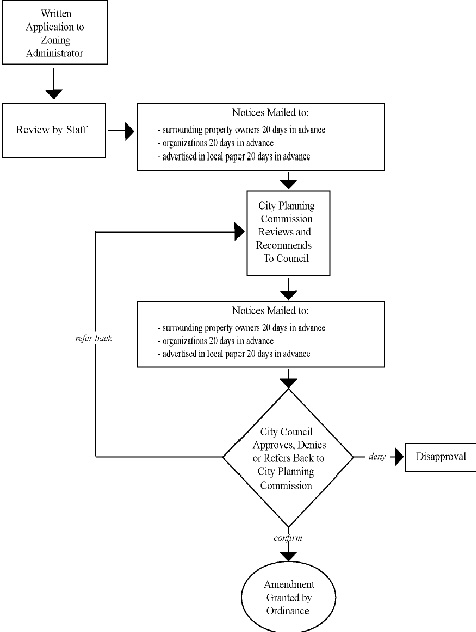 |
1. The consistency of the proposed amendment with the City’s adopted land use policies.
2. The consistency of the proposed amendment with the purposes of this Zoning Ordinance.
3. If a specific parcel of property is the subject of the proposed amendment, then the following factors:
a. The existing uses and zoning classifications for properties in the vicinity of the subject property
b. The trend of development in the vicinity of the subject property, including changes, if any, in such trend since the subject property was placed in its present zoning classification.
c. The extent, if any, to which the value of the subject property is diminished by the existing zoning classification applicable to it.
d. The extent, if any, to which any such diminution in value is offset by an increase in the public peace, health, safety, and welfare.
e. The extent, if any, to which the use and enjoyment of adjacent properties would be affected by the proposed amendment.
f. The extent, if any, to which the value of adjacent properties would be affected by the proposed amendment.
g. The extent, if any, to which the future orderly development of adjacent properties would be affected by the proposed amendment.
h. The suitability of the subject property for uses permitted or permissible under its present zoning classification.
i. The availability of adequate ingress to and egress from the subject property and the extent to which traffic conditions in the immediate vicinity of the subject property would be affected by the proposed amendment.
j. The availability, where relevant, of adequate utilities and essential public services to the subject property to accommodate the uses permitted or permissible under its present zoning classification.
J. Effect of Approval of Amendment.
1. When an amendment to this Zoning Ordinance is approved, such amendment shall be incorporated into the official document or map held at the City offices.
2. When an amendment is made to the text, such change shall be incorporated into the official document according to the numbering system established within the Zoning Ordinance.
3. An annual listing of such amendments to the Zoning Ordinance shall be kept within the official document.
K. Effect of Denial of Amendment. No application for an amendment that has been denied by the City Council shall be resubmitted for a period of one (1) year from the date of the order of denial, except on the grounds of new evidence or proof of change of condition found to be valid by the Zoning Administrator.
1213.08 SUBDIVISION REVIEW.
A. Purpose. The subdivision review procedure is intended to provide for the harmonious development of the City of Shaker Heights, ensuring that the subdivision of land occurs in accordance with the provisions of this Zoning Ordinance and other City policies by requiring the preparation of subdivision plats which meet the development standards herein.
B. Parties Entitled To Seek Subdivisions of Land. An application to subdivide may be filed by any person, firm or corporation, or by any office, department, board, bureau, or commission which has a legal interest in the form of an ownership or a purchase agreement for the property for which the subdivision is requested. Subdivision shall include:
1. Dividing of the land into lots for the purposes of sale.
2. Dedicating a part thereof for streets, alleys, or other public use.
3. Redividing of land previously subdivided.
4. Joining or consolidation of lots previously independent.
5. Changing of the boundaries of any lot or parcel thereof.
C. Application for Preliminary Plat Approval.
1. An application for a subdivision shall be submitted to the Zoning Administrator or designee, on an official, prescribed, form. Such application shall be accompanied by a plat, drawn to a scale of not less than one hundred feet to the inch (1":100’), and containing the following:
a. The location of the subdivision as forming a part of some larger tract or parcel of land referred to in the indexes of the County Recorder.
b. Sufficient information to adequately locate the plat, such as references to existing streets, railroads, and waterways.
c. The description and location of all existing survey monuments.
d. Proof of ownership of the property described in the plat.
e. The boundary lines of the tract to be subdivided, accurate in scale and bearing, and the total approximate area circumscribed thereby.
f. The location, widths, and other dimensions of all existing platted streets and other important features such as railroad lines, watercourses, existing easements, exceptional topography, etc. on and contiguous to the tract to be subdivided.
g. The location, widths, and other dimensions of proposed streets, alleys, easements, lots, and building lines.
h. North point, scale, and date of preparation.
i. Layout, numbers, and dimensions of lots.
j. Building setback lines, showing dimensions.
k. Easements for any and all utilities. Proper continuity for the utilities from block to block shall be maintained.
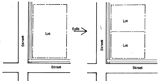 |
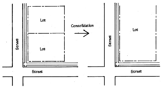 |
l. Name of the applicant.
m. Contours at an interval of two (2) feet and high water levels on all courses.
n. A signature line for the Secretary of the City Planning Commission, labeled “Secretary, City Planning Commission, City of Shaker Heights, Ohio”.
2. The Zoning Administrator or designee shall coordinate a review of this Preliminary Plat to include review by all relevant Departments, and submit written findings to the City Planning Commission.
(Ord. 03-67. Enacted 6-9-03.)
D. Public Hearing. The City Planning Commission shall hold at least one (1) public hearing, in accordance with the requirements of Section 1213.01, Public Hearing Procedures, to review, consider, and approve, approve with conditions, or disapprove the application for after the following public notification is given by the Zoning Administrator. Notice shall be provided by all of the following methods:
1. Mailing. Notice shall be sent by first class mail a minimum of ten (10) calendar days in advance of the public hearing, to all owners of land within two hundred (200) feet (inclusive of intervening streets and alleys) of the periphery of the land subject to the application whose names and addresses are known by reference to the most recently published ad valorem tax records of the County Appraiser, except that when the land is improved with a condominium, notice shall be given to the condominium association. Notice shall be presumed to have been given when mailed in accordance with these provisions.
2. Legal Notice. Legal notice shall be given by advertisement in a local newspaper of general circulation four (4) days prior to the public hearing.
3. Notification to Organizations. Notification shall be given by first class mail a minimum of ten (10) days prior to the public hearing to any organization that requests notice.
(Ord. 04-131. Enacted 11-22-04.)
E. Standards for Reviewing Preliminary Subdivision Plats. Preliminary Subdivision Plats shall be reviewed and approved with respect to the following standards:
1. Block Standards. The lengths, widths, and depths of blocks shall comply with the following standards:
a. Convenient access, circulation, control and safety of street traffic.
b. Minimum lot areas and minimum lot widths established in this Zoning Ordinance.
c. Limitations and opportunities of existing topography and site features.
2. Lot Standards. The design, size, shape and orientation of each lot, which provides for a suitable building site, shall be appropriate to its location and expected use. The following standards shall apply:
a. The lot lines of all lots, so far as practical, shall be at approximately right angles to the fronting street, or approximately radial to the center of the curvature, if the street is curved. Sidelines of each lot shall be approximately radial to the center of the curvature of a cul-de-sac, where applicable.
b. No lot shall be divided by a zoning district boundary line.
c. Corner lots for residential use shall have extra width to permit appropriate building setback from both fronting streets.
d. Through lots, reverse corner lots and flag lots should be avoided.
e. All lots that would require landscape buffers in addition to their setbacks should have extra width to accommodate that buffer.
f. No remnants of property shall be left over after subdividing which do not meet lot requirements or which are not required for utility purposes.
g. Lot lines between adjacent lots should be located at the top of any slope between them.
h. All lots should conform to the requirements of this Zoning Ordinance.
F. Approval/Recording Procedure. After a Preliminary Plat is reviewed and approved by the City Planning Commission, the applicant shall submit a Final Plat to the City which incorporates any changes that the City Planning Commission may have required as a condition of that approval. The Secretary of the Planning Commission shall indicate approval by signing the Final Plat. The signed Final Plat shall be submitted to the County Recorder. The recorded version shall then be submitted to the City of Shaker Heights for its records.
G. Effect of Approval/Recording. Approval of a subdivision authorizes the property to be used in the manner proposed, but does not authorize the establishment or extension of any use nor the development, construction, reconstruction, alteration, or moving of any building or structure without first obtaining any other required permit, including a building permit.
1213.09 PLANNED DEVELOPMENT (PUD and SLID) REVIEW.
A. Purpose. A planned development is a unified project permitted in a Planned Unit Development (PUD) Overlay District or in a Small Lot Infill Development (SLID) Overlay District. In order to determine compliance with the standards in Chapter 1242 or Chapter 1244 as applicable all proposed PUDs and SLIDs shall be reviewed according to the procedures in this section.
B. Pre-Application Meeting
1. Purpose of the Pre-Application Meeting. Prior to filing a formal application for review of a PUD or a SLID, the applicant may choose, or the Zoning Administrator may require the applicant, to meet with the Zoning Administrator to review the general concept of the proposed development, the policies and requirements of the PUD Overlay District or SLID Overlay District as applicable and the procedures for review.
2. Meeting Submission Requirements. The applicant should come to the pre-application meeting prepared to provide the Zoning Administrator with sufficient information regarding the proposal so that the Zoning Administrator can provide helpful feedback to the applicant. At a minimum the applicant shall provide:
a. Conceptual Plan: A scaled drawing of the site, in simple sketch form, showing the proposed location and extent of the land uses, major streets, lots, and other features as they relate to the site.
b. Evidence of control of the property such as lease, option or purchase agreement, or written permission of the property owner(s).
C. Administrative Review. Administrative review of an application for a proposed PUD/SLID is required for the purposes of establishing the basic goals and policies of the proposed planned development and determining the layout, design and other elements of the final plan to be submitted for formal review by the City Planning Commission and City Council.
1. Application. An application for a PUD/SLID shall be filed with the Zoning Administrator on a prescribed form. The application shall be accompanied by payment of the required fee and the proposed development plan, which shall include the following plans, data and information, unless an item is determined by the Zoning Administrator to be inapplicable or unnecessary::
a. Site plans of the PUD/SLID shall be prepared at a scale considered appropriate by the Zoning Administrator, and shall show such designations as all proposed buildings (indicating total square footage and number of dwelling units in each), their yards and their use, common open space, recreation facilities, parking areas, service areas, conceptual landscaping elements and other facilities to indicate the character of the proposed development.
b. Outline of development standards governing the proposed PUD/SLID: Identification of the bulk standards utilized in the proposed PUD/SLID, and an explanation of how the standards comply with the requirements of Chapter 1242 or 1244 as applicable, the underlying zoning district and other applicable regulations of the City.
c. Character: Explanation of the character of the PUD/SLID and the reasons why it has been planned to take advantage of the flexibility of the Overlay District regulations. This item shall include preliminary architectural designs that are representative of the planned development and a specific explanation of how the proposed PUD/SLID meets the objectives of all adopted land use policies which affect the land in question.
d. For sites larger than one acre, preliminary plans indicating compliance with storm water management requirements.
e. Ownership: Statement of present and proposed ownership of all land within the project including the beneficial owners of a land trust.
f. Schedule: Development schedule indicating:
(1) Stages in which the project will be built, with emphasis on area, density, and uses to be developed with each stage.
(2) Anticipated dates for beginning and completion of each stage.
2. Departmental Review. The Zoning Administrator or designee shall coordinate a review of the application and its supporting materials by all relevant Departments.
3. Work Session with City Planning Commission and/or Architectural Board of Review. The applicant may choose to, or the Zoning Administrator may require the applicant to, meet with the City Planning Commission and/or the Architectural Board of Review at a work session(s) to review the proposed PUD/SLID. The purpose of the work session is to provide the opportunity for the City Planning Commission and/or the Architectural Board of Review to review the proposed PUD/SLID development and any recommendations from the Zoning Administrator, and provide the applicant with specific guidance for preparing the Final Plan.
D. Neighborhood Meeting. Once the applicant has received input and guidance from the Staff, City Planning Commission and Architectural Board of Review as applicable, the applicant shall hold a meeting of neighborhood residents for the neighborhood that will be affected by the development at a time, place and by giving notice as approved by the City. The applicant shall present the City with written confirmation that a meeting was held to discuss the plan, and summarizing the results of the meeting.
E. Final Review. Once the applicant has completed the administrative review in Subsection C. and conducted the Neighborhood Organization Meeting in Subsection D., the applicant shall revise the development plan as needed and prepare the more detailed documentation required below for Final Review.
1. Submission Requirements
a. Final Detailed Plans. The Final Detailed Plans shall be prepared by the applicant and submitted to the Zoning Administrator. The purpose of the Final Detailed Plans of the PUD/SLID is to specifically designate the land subdivision into fee-simple lots and common areas, and to designate and limit the specific internal uses of each building, structure, and use of land. Final Detailed Plans and supporting data shall show, in detail and design, the location and internal use of all buildings and the overall development, as well as such additional information as may have been required during administrative review of the development plan. The Final Detailed Plans of the PUD/SLID shall include, but not be limited to:
(1) Legal Description. An accurate legal description and survey of the entire area under development within the PUD/SLID, and including all separate subdivided use areas, including open space.
(2) Preliminary Subdivision Plat. For all SLID projects, and for PUD projects if subdivided lands are included in the PUD, a preliminary subdivision plat of all subdivided lands in the same form and meeting all the requirements of a normal subdivision plat in accordance with Section 1213.08, unless the Planning Commission determines otherwise.
(3) Site Plan. A detailed site plan meeting all the requirements for site plan review in accordance with Section 1213.06, and including the designation of the location of all buildings to be constructed, the designation of the specific internal uses to which each building shall be put, and the designation of the location of all open spaces, streets, sidewalks, and parking areas. The site plan shall include a tabulation on each separate subdivided use area, including land area, number of buildings, number of dwelling units and number of dwelling units per acre.
(4) Street Plan, as applicable. If the PUD/SLID includes a public or private street, a street plan including construction details, showing center line elevations, pavement width and type, curbs, gutters and culverts.
(5) A street numbering designation shall be furnished for each dwelling/building.
(6) Infrastructure Plan. The proposed distribution, location and extent of the components of public and private infrastructure including sanitary sewers, storm drainage, water supply and street lighting.
(7) Landscape Plan. A detailed landscape planting plan for the site including a plant list containing the common and botanical names, sizes at the time of installation and at maturity, and quantities of all plants, permanent signs, site lighting and street fixtures.
(8) Construction Schedule. A written construction schedule for the development which will be made part of the final plan approval.
(9) Traffic Analysis for PUD. If required by the Zoning Administrator or the City Planning Commission, the applicant shall conduct a study of the impact caused by the PUD on the street systems operating in the City and submit a copy of the final report to the Zoning Administrator. The study shall become part of the applicant's Final Detailed Plans.
(10) Additional documentation as deemed appropriate.
b. Proof of Financial Capability to Carry Out the Project. The applicant shall submit evidence of financial capability of an amount to satisfy the Law Director indicating that the applicant has, or has access to, sufficient funds to carry out the project. Evidence may include a letter from the owner describing its financing for the project, specifying the amount and source of the financing, a copy of the loan commitment or loan agreement, and equity financing documents, or a statement from the lender or equity sources indicating the availability of funds.
2. Staff Review. The Zoning Administrator shall review the Final Detailed Plans, prepare a staff report and forward the staff report, final detailed plans and all supporting materials to the City Planning Commission.
3. Architectural Board of Review. Architectural plans shall be reviewed by the Architectural Board of Review and any comments from the Architectural Board of Review shall be transmitted to the City Planning Commission.
4. Public Hearing. The City Planning Commission shall hold a public hearing on each application for PUD/SLID Plan Approval and the Final Detailed Plans in accordance with Section 1213.05E. Public Hearing for a Conditional Use Permit.
5. Action by the City Planning Commission. After the conclusion of the public hearing, the City Planning Commission shall take action on the application and transmit its action to City Council:
a. Approval. The City Planning Commission may approve or approve with conditions the PUD/SLID application and Final Detailed Plans.
b. Denial. The City Planning Commission may deny the application for a PUD/SLID. If the City Planning Commission denies the PUD/SLID application and Final Detailed Plans, the application process ends. Disapproval of the PUD/SLID application and Final Detailed Plans shall include a statement of the reasons for the denial.
6. Action by the City Council. Within a reasonable time after the receipt of the approval of the City Planning Commission the City Council shall:
a. Confirm the decision by ordinance duly adopted with or without modifications or conditions, or
b. Refer the PUD/SLID application and Final Detailed Plans back to the City Planning Commission for further study, or
c. Deny the PUD/SLID application and Final Detailed Plans.
7. Conditions on PUDs/SLIDs. In accordance with Section 1213.05I, the City Planning Commission may impose and City Council may confirm conditions on the PUD as may be deemed necessary.
8. Effect of PUD/SLID Plan Approval. The approval of the application and Final Detailed Plans for the PUD/SLID authorizes the property to be used in the manner proposed, but does not authorize the construction of any building or structure or site work without first obtaining any other required permit including a final plat and building permits.
9. Final Plat Approval. The final subdivision plat for a SLID, and for a PUD if a Preliminary Subdivision Plat was approved as part of the Final Detailed Plans, shall be submitted to the City in accordance with Section 1213.08F.
F. Changes To An Approved PUD/SLID. A PUD/SLID shall be developed only according to the approved Final Detailed Plans and all supporting data. The Final Detailed Plans and supporting data, together with all recorded plats and easements, shall be binding on the applicants, their successors, grantees and assigns and shall limit and control the use of the premises (including the internal use of buildings and structures) and location of structures in the PUD/SLID, as set forth therein.
(Ord. 18-25. Enacted 4-23-18.)
1213.10 DESIGNATING LANDMARKS AND LANDMARK DISTRICTS.
A. DESIGNATION OF LANDMARKS
1. Application for Landmark Designation. The Landmark Commission may apply to City Council to designate a place, building, structure, site, work of art, or similar object in the City as a Landmark, or to designate any grouping of such places or objects, or combination thereof, as a Landmark District, by following the procedures set forth in this Section. The Landmark Commission may act on its own initiative to apply for such designation, or pursuant to a request by an individual or organization.
2. Procedure for Designating Landmark Status. The Landmark Commission may apply for the designation of a place, building, structure, site, work of art, or similar object in the City as a Landmark or Landmark District by adopting a resolution to recommend such designation to City Council. After the Landmark Commission adopts a resolution recommending the designation of a Landmark or Landmark District, it shall follow the procedures set forth below:
a. In order to protect proposed Landmark properties or properties located in a proposed Landmark District during the process for designation, the Landmark Commission may request that City Council adopt a resolution approving the referral, during the pendency of the designation process, of all applications for permits for activity related to a proposed Landmark or in a proposed Landmark District to the Landmark Commission for review. If City Council adopts such a resolution, all such permit applications pending as of the effective date of the resolution and all permit applications submitted after said effective date shall be referred to the Landmark Commission for review, and the Landmark Commission shall have the same powers that would apply if the proposed Landmark or Landmark District were an established Landmark or District. The referral and review of such permits shall continue for twelve months after City Council adopts such a resolution, or until such time as City Council approves or rejects the establishment of the Landmark or District by ordinance, whichever occurs first.
b. The Landmark Commission shall notify the owner or owners of all property included in the proposed designation within ten (10) days of the adoption by the Landmark Commission of a resolution to apply for designation. The notice shall request the owner's comments.
c. The Landmark Commission shall seek the approval of the owner or owners of all property included in the proposed designation. However, approval is not required in order for a property to be designated as a Landmark or as being within a Landmark District.
d. The Landmark Commission shall prepare a report and recommendation as to the property proposed to be designated as a Landmark or as within a Landmark District, including an explanation of the significance of the property or properties in relation to the designation criteria, a description of the property or properties with a list of contributing and non-contributing structures and sites, a history of the property or properties, photographic documentation, and a map or site plan showing the boundaries of the proposed Landmark or District.
e. The Landmark Commission shall submit the report and recommendation to the Planning Commission and secure from said Commission a recommendation with respect to the proposed designation, its opinion as to the effect of the proposed designation upon the surrounding neighborhood, and its opinion and recommendations as to any other planning consideration which may be relevant to the proposed designation, together with its recommendation of approval, rejection, or modification of the proposed designation. Such recommendation shall become part of the official record concerning the proposed designation and shall be submitted by the Landmark Commission along with its report concerning the proposed designation to City Council. The Landmark Commission may make such modifications, changes and alterations concerning the proposed designation as it deems necessary in consideration of the recommendation by the Planning Commission.
f. Within forty-five (45) days after receiving the Planning Commission's recommendation, the Landmark Commission shall schedule a public hearing on the proposed designation.
g. At least fifteen (15) calendar days prior to the date of the hearing, written notice setting forth the date, time, place and purpose of the hearing shall be mailed to the owner(s) or any person(s) having a legal or equitable interest in such property being proposed for designation. The notice shall indicate where the Landmark Commission's designation report is available for review.
h. Notice shall be mailed a minimum of five (5) calendar days and no more than ten (10) calendar days prior to the public hearing to all property owners within three hundred (300) feet of the proposed Landmark or District and to any organization that requests notice.
i. No less than four (4) days prior to the public hearing, the Landmark Commission shall cause a legal notice to be published in a newspaper of general circulation in the City setting forth the nature of the hearing, the property involved, and the date, time and place of the scheduled public hearing.
j. The Landmark Commission shall conduct the public hearing and shall provide a reasonable opportunity for all interested parties to express their opinions under such rules as the Landmark Commission may adopt for the purpose of governing the proceedings of the hearings. Each speaker shall be fully identified as to name, address, and the interests that he or she represents.
k. The Landmark Commission shall make a determination whether to pursue without modification, modify or withdrawn the proposed designation in writing within fifteen (15) days after the hearing and shall notify any owner(s) or any person(s) having a legal or equitable interest in such property, as well as such other interested parties as may request a copy thereof. The Landmark Commission shall transmit its report and recommendations concerning the proposed designation to City Council.
l. City Council may, in its discretion, hold public hearings on any proposed designation. City Council shall, within ninety (90) days after receiving the report and recommendation of the Landmark Commission, either designate the Landmark or Landmark District by ordinance or reject designation by resolution. In making its determination with respect to the proposed designation, City Council shall give due consideration to the findings and recommendations of the Landmark Commission, as well as such views as may have been expressed by persons participating in the hearing before the Landmark Commission, in addition to the recommendation of the Planning Commission.
3. Actions After a Designation. Within seven (7) days after the adoption of an ordinance by City Council approving the designation of a Landmark or Landmark District, the Landmark Commission shall notify the City Building Department of the designation. The Landmark Commission shall also file with the Recorder of Deeds of Cuyahoga County a certified copy of the designating ordinance together with a notice briefly stating the fact of such designation and a summary of the effects such designation will have. The Landmark Commission, further, shall send a copy of such ordinance and notice to the owner(s) and any person having a right of ownership in such property included within a designation.
4. Rescission of a Designation. Notwithstanding any provision of this Section to the contrary, City Council may rescind the designation of any area, place, building, structure, site, work of art or similar object as a Landmark or Landmark District by ordinance upon a finding that the designated Landmark or Landmark District does not meet the designation criteria or to protect the public interest in response to changed circumstances since the designation decision was made. Council may rescind designation after compliance with the same procedures as are required to be followed by Council for a Zoning Code amendment under Section 1213.07, and as set forth herein for designation, including referral for comment and recommendation to the Landmark Commission and Planning Commission, and after a public hearing is held before the Landmark Commission. Council may rescind a designation even if the Landmark or Planning Commission do not recommend such action. Passage of such an ordinance shall relieve the owner of such property from any duties or penalties contained in this chapter.
5. Criteria for Designating a Landmark or a Landmark District. In determining whether or not to adopt a resolution recommending the designation of an area, place, building, structure, site, work of art, or object as a Landmark or Landmark District, the Landmark Commission shall determine whether the proposed Landmark or Landmark District meets one or more of the following criteria:
a. Its character, interest or value as part of the development, heritage or cultural characteristics of the City of Shaker Heights, the State of Ohio, or the United States.
b. Its location as a site of a significant historic event.
c. Its identification with a person or persons who significantly contribute to the culture and development of the City.
d. Its exemplification of the cultural, economic, social or historic heritage of the City.
e. Its portrayal of the environment of a group of people in an era of history.
f. Its embodiment of a distinguishing characteristic of an architectural type, specimen, style or method of construction.
g. Its identification as the work of an architect or master builder whose individual work has influenced the development of the City.
h. Its embodiment of elements of architectural design, detail, materials or craftsmanship that represent a significant architectural innovation.
i. Its relationship to other distinctive areas that are eligible for preservation according to a plan based on history, culture, or architecture.
j. Its unique location or singular physical characteristic representing an established and familiar visual feature of a neighborhood, community or the City.
6. Recording Landmarks and Landmark Districts. The Landmark Commission shall maintain complete records of all properties designated as Landmarks. This designation shall also be noted in the Building Department records of the City.
7. On-Site Identification of Landmarks or Landmark Districts. The Landmark Commission may place or cause to be placed on such Landmark properties a plaque or other type of marker indicating that such property or part thereof has been designated a Landmark or as part of a Landmark District in the City.
B. CERTIFICATES OF APPROPRIATENESS; Approval Required for Any Exterior Building or Environmental Change. No person shall make any environmental or exterior building change in any property which has been designated a Landmark or which is situated in a designated Landmark District without first obtaining a Certificate of Appropriateness from the Landmark Commission. The following procedures shall apply to all alterations, demolitions, removals or constructions of such property in the City:
1. Application for Review of Changes. Any application to the Landmark Commission, Building Department or to the Planning Department, as appropriate, for a permit for or approval of an environmental or exterior building change, including a demolition, must include detailed plans, designs, elevations, specifications and documents relating thereto, as required by the Director of the Department to which the application is submitted. Any such completed application submitted to the Building Department or Planning Department shall be forwarded to the Landmark Commission. The Building Department shall not issue a building or demolition permit for, and the Planning Department shall not give approval of, an environmental or exterior building change until the Landmark Commission has issued a Certificate of Appropriateness. The applicant may file an application directly with the Landmark Commission at the same time that an application for a building permit or approval is filed. The Landmark Commission may charge a reasonable fee, as approved by Council, to review an application.
2. Standards For Review of Applications. When considering an application for a Certificate of Appropriateness, the Landmark Commission shall be guided in its decision by the U.S. Secretary of the Interior's "Standards for Rehabilitation", as found in Title 36 of the Code of Federal Regulations, Part 1208 (formerly 36 CFR Part 67). In addition, the Landmark Commission may adopt more specific design guidelines suited to the historic character of Landmarks and Landmark Districts. In reviewing an application for demolition, the Landmark Commission shall consider the following in addition to the "Standards for Rehabilitation" cited above:
a. The historic significance of the structure individually or as a contributing element in a district.
b. Plans for reuse of the site, which the applicant must submit, including project funding and schedule, and the impact of such plans on the Landmark or Landmark District.
3. Approval of Minor Changes. The Landmark Commission may delegate to its staff the authority to issue Certificates of Appropriateness for specified minor changes. The Landmark Commission shall provide to staff written guidelines for issuing Certificates of Appropriateness under this subsection.
4. Parties Entitled to Apply for Landmark Commission Review of Changes. An application for an environmental or exterior building change may be filed by any person, firm or corporation, or by any office, department, board, bureau, or commission which has a legal interest in the property in the form of an ownership interest, a lease, or a purchase agreement for the property for which the review of changes is requested. If the applicant is a lessor, the written approval, with signature, of the owner shall be required as determined necessary by the department to which the application is submitted.
5. Conditions for Approval for Review of Changes. The Landmark Commission shall grant an application or approve an application with conditions when it finds that the proposed change will not adversely affect any significant historical or aesthetic feature of the property and is appropriate and consistent with the spirit and purposes of this Chapter, any design guidelines adopted by the Landmark Commission, and the U.S. Secretary of the Interior's "Standards for Rehabilitation". Otherwise, the Landmark Commission shall deny the application.
6. Landmark Commission Notice to Building Department. Within ten (10) days of making a determination on an application, the Landmark Commission shall transmit written notices of its decision to the applicant and the Building Department. The notices shall state the reasons for the decision.
7. Denial of Certificate Application. If an application has been denied, the Landmark Commission shall recommend to the applicant changes, if any, that would allow the Landmark Commission to issue a Certificate of Appropriateness. The Landmark Commission shall confer with the applicant in an attempt to resolve any differences as quickly as possible. The applicant may resubmit an amended application that takes into consideration the Landmark Commission's recommendations.
8. Failure of Landmark Commission to Act in a Timely Manner. If no action has been taken by the Landmark Commission on a complete application within sixty (60) days after such complete application has been received by the Landmark Commission, the application shall be deemed granted, unless the time for consideration is extended by mutual agreement.
9. Applicability of Other Ordinances, Rules and Regulations. Nothing contained herein shall eliminate the need for compliance by the owner, occupant or party in control of such property with all other applicable ordinances, rules and regulations of the City.
10. Architectural Board of Review. When an application for a building or environmental change requires review by both the Landmark Commission and the Architectural Board of Review, the Architectural Board of Review will meet jointly with the Landmark Commission. Notwithstanding any other provisions of this Chapter, only architectural design compatible with historical buildings in approved Landmark Districts in the City shall be approved for any new construction by the Architectural Board of Review in Landmark Districts.
C. ECONOMIC HARDSHIP; Application Filed After Denial of Certificate of Appropriateness.
1. Application for certificate of Economic Hardship; Criteria. An applicant who has been denied a Certificate of Appropriateness may, within thirty (30) days of the denial, apply for a Certificate of Economic Hardship. Application shall be made on a form prepared by the Landmark Commission. The Landmark Commission may hold a public hearing on the hardship application. All of the following criteria shall be considered to determine the existence of an economic hardship:
a. Denial of a certificate will result in a substantial reduction in the economic value of the property;
b. Denial of a certificate will result in a substantial economic burden on the applicant because the applicant cannot reasonably maintain the property in its current form;
c. No reasonable alternative exists consistent with the architectural standards and guidelines for the property;
d. The owner has been unable to sell the property; or
e. If the owner is a not-for-profit organization, and it is financially or physically infeasible to achieve its charitable purpose while conforming to the pertinent architectural standards and guidelines.
2. Certificate Process. The Landmark Commission may solicit expert testimony or request that the applicant for a Certificate of Economic Hardship submit evidence concerning property value, cost estimates, income, expenses, and/or any other information that the Landmark Commission deems necessary to determine whether denial of the application constitutes an economic hardship. The level of documentation required may vary as is appropriate to each case. The Applicant may submit any person or proprietary information to the Staff of the City for a confidential review, and such information shall be returned to the Applicant, and a summary or evaluation of the information shall be provided to the Landmark Commission without disclosure of the specific personal or proprietary information.
3. Landmark Commission Action on an Application. The Landmark Commission shall act upon the application for Certificate of Economic Hardship within sixty (60) days after receipt of such an application. If no action has taken by the Landmark Commission within sixty (60) days, the application shall be deemed granted, unless the time is extended by mutual agreement. Upon the denial of an application, the applicant shall be notified by mail.
4. Investigation of Measures to Relieve Hardship. Upon a finding by the Landmark Commission that a denial of the application for building or environmental change results in a hardship, then the application for a Certificate of Appropriateness shall be delayed for a period not to exceed ninety (90) days. During this period the Landmark Commission shall investigate measures to relieve the hardship or otherwise preserve the property, and shall make recommendations to the Mayor or Council as may be appropriate. Such plans and recommendations may include, but are not limited to: a reduction in real property taxes, financial assistance, Building Code modifications, and/or changes in zoning regulations, to the extent such actions may be lawful.
5. Issuance of Certificate. If by the end of this ninety (90) day period, the Landmark Commission has found that without approval of the building or environmental change the hardship cannot be relieved, then the Landmark Commission shall issue a Certificate of Economic Hardship permitting the proposed building or environmental change.
D. EXCEPTIONS, APPEALS, MORATORIUM AND ENFORCEMENT. All work performed pursuant to a Certificate of Appropriateness issued under this Chapter shall conform to any requirements included in the approval of the Certificate. It shall be the duty of the Commissioner of Building, with the assistance from the Department of Planning, to inspect periodically any such work to assure compliance. In the event work is found that is not being performed in accordance with the Certificate of Appropriateness, or upon notification of such fact by the Landmark Commission, the Commissioner of Building shall issue a stop work order and all work shall immediately cease. No further work shall be undertaken on the project as long as a stop work order is in effect.
1. Changes Not Prohibited. Nothing in this Section shall be construed to prevent the ordinary maintenance or repair of any exterior architectural feature of any property which has been designated a Landmark or which is situated in a designated Landmark District that does not involve a change in design, material, color or exterior appearance thereof, nor to prevent any environmental or exterior building change that the Building, Fire, Housing Inspection or Health Departments shall certify in writing is immediately required by the public safety because of an unsafe or dangerous condition. If the Building, Fire, Housing Inspection or Health Department orders an immediate environmental or exterior building change, it shall notify the Landmark Commission of the proposed change. The Landmark Commission shall have the right to seek to have the measure least adverse to the purposes of this Chapter used to make the necessary change.
2. Appeals. An applicant may appeal a final decision of the Landmark Commission on an Application for a Certificate of Appropriateness or Certificate of Economic Hardship within thirty (30) days of the decision, by filing a notice of appeal with the Board of Zoning Appeals. The Board shall hold a hearing on an appeal within forty-five (45) days after receipt of a notice, and shall issue a decision on an appeal within fourteen (14) days after a hearing.
3. Emergency Moratorium. If City Council determines that a proposed exterior building or environmental change will cause irreparable harm to structures or sites located within a designated or potential Landmark or Landmark District, City Council may by resolution declare an emergency moratorium on all work for a period not to exceed six (6) months. During the moratorium period, the City shall investigate ways to remove the threat, including but not limited to negotiation, marketing, or financial assistance. Council may extend the emergency moratorium for an additional period not to exceed six (6) months upon finding that the threat of irreparable harm is still present. Any pending Permit application concerning a structure or site subject to an emergency moratorium may be summarily denied.
4. Power to Seek Injunction. The Landmark Commission or the Mayor may ask the Director of Law to take whatever legal action may be necessary, including the filing of a complaint in injunction and requesting of a temporary restraining order and preliminary injunction, to prevent a proposed exterior building or environmental change that may cause irreparable harm to structures or sites located within a designated or potential Landmark or Landmark District, until City Council has a reasonable opportunity to consider a resolution declaring an emergency moratorium on all work that may have such damaging effect.
5. Violations. Any person who violates or fails to comply with any provision of this Section shall, for each violation or noncompliance, be deemed guilty of a minor misdemeanor and penalized as set forth in Section 2929.28 of the Ohio Revised Code. Each day of violation or failure to comply shall constitute a separate offense.
E. SEVERABILITY. The provisions of this Section shall be deemed severable, and if any such provision shall be held unconstitutional by a court of competent jurisdiction the decision of such court shall not impair any of the remaining provisions.
(Ord. 18-25. Enacted 4-23-18.)
1213.11 ADMINISTRATIVE INTERPRETATIONS.
A. Authority. The Zoning Administrator, subject to the procedures, standards, and limitations of this Chapter, may, in writing, render interpretations, including use interpretations, of the provisions of this Zoning Ordinance and of any rule or regulation issued pursuant to it.
B. Purpose. The interpretation authority established by this Chapter is intended to recognize that the provisions of this Zoning Ordinance, though detailed and extensive, cannot, as a practical matter, address every specific situation to which they may have to be applied. Many such situations can be readily addressed by an administrative interpretation of the specific provisions of this Zoning Ordinance in light of the general and specific purposes for which those provisions have been enacted. Because the interpretation authority established is an administrative rather than a legislative authority, it is not intended to add to or change the essential content of this Zoning Ordinance but is intended only to allow authoritative application of that content to specific cases.
C. Parties Entitled to Seek Interpretations. Applications for interpretations may be filed by any person having a legal interest in property, such as a title, lease, or purchase agreement, in property that gives rise to the need for an interpretation provided that interpretations shall not be sought by any person based solely on hypothetical circumstances or where the interpretation would have no effect other than as an advisory opinion. The Zoning Administrator may elect not to render an interpretation on a matter which, in the Zoning Administrator’s opinion, is based on hypothesis.
D. Procedure.
1. Application. Applications for interpretations of this Zoning Ordinance shall be filed in writing by letter and shall contain information describing the nature of the requested interpretation and written evidence of the applicant’s interest in the property. The Zoning Administrator may request any additional information necessary to make the interpretation.
2. Action on Application. Within a reasonable time following the receipt of a properly completed application for interpretation, the Zoning Administrator shall inform the applicant in writing of his or her interpretation, stating the specific precedent, reasons, and analysis upon which the determination is based.
3. Record. A record of all applications for interpretations shall be kept on file in the office of the Zoning Administrator.
4. Appeal. The Board of Zoning Appeals shall, pursuant to Section 1213.02, Appeals, of this Zoning Ordinance, hear and decide appeals from any order or final decision of the Zoning Administrator acting pursuant to his or her authority and duties under this Zoning Ordinance. Except as expressly provided otherwise, an application for appeal to the Board of Zoning Appeals may be filed not later than forty-five (45) calendar days following the action being appealed.
E. Standards for Use Interpretations. The following standards shall be factors considered by the Zoning Administrator and the City Planning Commission in issuing use interpretations:
1. Any use defined in Chapter 1211, Definitions and Rules of Word Usage, of this Zoning Ordinance shall be interpreted as therein defined.
2. Evidence must demonstrate that the use will comply with the district regulations established for that particular district.
3. A use must be substantially similar to other uses permitted in the particular district and more similar to those uses than to uses permitted or conditionally permitted in a more restrictive district.
4. If the proposed use is most similar to a use permitted only as a conditional use in the district in which it is proposed, then any use interpretation shall require the issuance of a Conditional Use Permit for such use pursuant to Section 1213.05, Conditional Uses.
5. No use interpretation shall permit the establishment of any use that would be inconsistent with the statement of purpose of the district in question.
F. Effect of Favorable Use Interpretations. No use interpretation which finds a particular use to be permitted or specially permitted in a particular district shall authorize the establishment of such use nor the development, construction, reconstruction, alteration, or moving of any building or structure, but shall merely authorize the preparation, filing, and processing of applications for any permits and approvals that may be required by the codes and ordinances of the City including, but not limited to, a building permit, a certificate of occupancy, subdivision approval, and site plan approval.
G. Limitations on Use Interpretations. A use interpretation which finds a particular use to be permitted, or permitted as a conditional use, shall authorize only the use for which it was issued, and that interpretation shall not authorize any allegedly similar use for which a separate use interpretation has not been issued.
1214.01 AUTHORITY.
The Zoning Administrator, Planning Director, Zoning Enforcement Officer or their designees are hereby designated to enforce this Zoning Ordinance. References within this Zoning Ordinance to the Zoning Administrator or designee shall include the Planning Director or the Zoning Enforcement Officer.
(Ord. 03-67. Enacted 6-9-03; Ord. 13-114. Enacted 12-16-13.)
1214.02 COMPLAINTS REGARDING VIOLATIONS.
Whenever the Zoning Administrator has reasonable cause for or receives a complaint alleging a violation of this Zoning Ordinance, or when there are reasonable grounds to believe that a violation exists, he or she shall investigate the complaint and shall take whatever action is warranted in accordance with the provisions of this Chapter.
1214.03 RIGHT OF ENTRY.
The Zoning Administrator or designee may make inspections of all buildings, structures and premises located within the City to determine their compliance with the provisions of this Zoning Ordinance.
A. Such inspection may take place upon reasonable cause, including but not limited to the observations of the Zoning Administrator or designee information brought to the attention of the Zoning Administrator or designee, or any complaint received by the Zoning Administrator or designee pursuant to Section 1214.02, or if such inspection is undertaken as part of a regular inspection program whereby certain areas of the City are being inspected in their entirety.
B. Such inspection shall be made by the Zoning Administrator or his or her designee.
C. Any person making such inspection shall furnish to the owner or occupant of the building, structure or premise to be inspected, sufficient identification and information to enable the owner or occupant to determine that the person is a representative of the City and the purpose of the inspection. The Zoning Administrator or his or her designee may apply to any court of competent jurisdiction for a search warrant or other legal process for the purpose of securing entry to any premises if the owner or occupant shall refuse to grant entry.
1214.04 PROCEDURES UPON DISCOVERY OF VIOLATIONS.
A. If the Zoning Administrator finds that any provision of this Zoning Ordinance is being violated, the Administrator shall send a written notice to the person responsible for such violation indicating the nature of the violation, ordering the action necessary to correct the violation, and specifying a reasonable amount of time for the correction of the violation or the performance of any other act required. Additional written notices may be sent at the Administrator’s discretion.
B. The Administrator’s notice shall be served upon the owner or the owner’s agent or the occupant, as the case may require, provided that such notice shall be deemed to be properly served upon such owner or agent, or upon such occupant, if a copy thereof: 1) is served personally, or 2) is sent to the last known address, or 3) is posted in a conspicuous place in or about the building, structure or premises affected by the action.
C. Notwithstanding the foregoing, in cases when delay would seriously threaten the effective enforcement; of this Zoning Ordinance or pose a danger to the public peace, health, safety, or welfare, the Zoning Administrator may seek enforcement; without prior written notice.
1214.05 PENALTIES AND REMEDIES FOR VIOLATIONS.
A. Violations of the provisions of this Zoning Ordinance or failure to comply with any of its requirements, including violations of any conditions and safeguards established in connection
with approval of a variance, conditional use, site plan review, or development approval, shall constitute a misdemeanor of the first degree.
B. Each day that any violation continues after notification by the Zoning Administrator that such violation exists shall be considered a separate offense.
C. In addition to any other remedies provided by this Zoning Ordinance, or by the laws of the State of Ohio, the Law Director of the City may, upon a violation of this Zoning Ordinance
having been called to his or her attention, institute injunction, mandamus, abatement or any other appropriate action to prevent, enjoin, abate or remove any unlawful construction, reconstruction, alterations, conversion, maintenance or use.
1214.06 REVOCATION OF CONDITIONAL USE PERMITS AND VARIANCES.
A Conditional Use Permit or Variance may be revoked by the Board of Zoning Appeals, or City Planning Commission as appropriate, in accordance with the provisions of this Section, if the recipient of the Conditional Use Permit or the Variance fails to develop or maintain the property in accordance with the plans submitted, the requirements of this Zoning Ordinance, or any additional requirements lawfully imposed as a condition of approval of a conditional use or variance. Before a Conditional Use Permit or Variance can be revoked, the Zoning Administrator shall undertake the following procedures:
A. Notice and Opportunity to Comment. The Zoning Administrator shall cause a written notice of intent to revoke the Conditional Use Permit or Variance to be delivered to the property owner five (5) to ten (10) working days prior to the date of the proposed revocation. The notice of intent to revoke the conditional use or variance shall inform the recipient of the alleged reasons for the revocation and of his or her right to obtain a hearing on the allegations.
B. Hearing. If the property owner desires a hearing, the Zoning Administrator shall schedule a date on the Board of Zoning Appeal’s or City Planning Commission’s agenda to hear the revocation.
C. Decision Rendered. If the revocation was subject to a public hearing, the Board of Zoning Appeals or City Planning Commission shall render a decision upon the proposed revocation within a reasonable time of such hearing. Such decision shall be rendered by written order containing the specific reasons or findings of fact that support the decision.
D. Notification of Decision. The Zoning Administrator shall send such decision within five (5) working days to the holder of the Conditional Use Permit or Variance and any other person previously requesting notification.
E. Evidence. The burden of presenting sufficient evidence to the Zoning Administrator, the Board of Zoning Appeals, or the City Planning Commission to establish the need to revoke the conditional use permit or variance for any of the reasons set forth in this Section shall be upon the party proposing the revocation.
F. Result of Revocation. No person may continue to make use of land or buildings in the manner authorized by any Conditional Use Permit or Variance if it has been revoked in accordance with the provisions of this Section.
G. Records. A record of all written notices of the intent to revoke a Conditional Use Permit or Variance shall be kept on file in the office of the Zoning Administrator and a copy shall be sent to the Building Commissioner.
1215.01 EXISTING NONCONFORMING BUILDINGS AND USES.
Any use of land or building, any design of building, any location of building on the lot and any platted lot which lawfully existed on the effective date of this Zoning Ordinance may be continued even though such use, design or location does not conform to the regulations of this Zoning Ordinance for the district in which such use is located. However, no enlargement or expansion of such nonconforming building or use shall be made, except for two-family units and duplexes to which additions may be made subject to all the other review requirements of this Zoning Ordinance.
1215.02 BUILDINGS UNDER CONSTRUCTION.
No change is required by this Zoning Ordinance in the plans, construction or designated uses of a building which does not conform to the regulations of this Zoning Ordinance for the district in which its premises are located, provided the permit for such building was issued and construction on it was begun before the passage of this Zoning Ordinance and completed within eighteen (18) months of the issuance of such permit in accordance with the plans and descriptions on which said permit was issued. For the purposes of this Zoning Ordinance such construction shall be deemed an existing nonconforming use.
1215.03 CHANGES IN A NONCONFORMING USE.
A. Changes of Use Restricted.
1. Changes to a Less Restricted Use Prohibited. No change of a nonconforming use shall be made to a less restricted use.
2. Changes to a More Restricted Use. A nonconforming use may be changed to any use permitted in this Zoning Ordinance in a more restrictive district provided no structural changes are made. Such use would remain a nonconforming use unless the use is permitted in the district in which it is located.
3. Changes to a Use of Similar Nonconformity. Any change of a nonconforming use to a use of the same degree of nonconformity, as defined in Chapter 1211, Definitions and Rules of Word Usage, shall be made only upon approval of the Board of Zoning Appeals and only if the Board finds that the proposed use is not more injurious to neighborhood property values than the existing use.
B. Changes to a Nonconforming Structure. No significant structural changes shall be made to a nonconforming structure unless it is changed to bring the structure and use into conformity or unless the change is specifically approved by the Board of Zoning Appeals. Such changes, additions and/or improvements shall upgrade the activity and make the resulting development more compatible to the district in which it is located and more compatible with adjacent uses. Such expansion or addition shall require a total Site Plan Review for the entire parcel.
1215.04 ABANDONMENT OF NONCONFORMING USES.
A nonconforming use which has been abandoned shall not be replaced by a nonconforming use.
A. Abandonment of a Nonconforming Use of Land Other than Structures. A nonconforming use of land shall be deemed abandoned when the nonconforming use has been replaced by a conforming use or when the nonconforming use has ceased and has not been resumed for a continuous period of one (1) year.
B. Abandonment of a Nonconforming Use or Structure.
1. Standard. A nonconforming use of structure shall be deemed abandoned when it has been replaced by a conforming use or when the nonconforming use has ceased for a continuous period of one (1) year.
2. Third Floor Occupancy of Two-Family Dwelling. A nonconforming use of a third-floor area in a two-family dwelling shall be conclusively deemed abandoned upon the failure of the owner or agent of such dwelling to file the Annual Registration required by Section 1413.01 of the Housing Code for a continuous period of one (1) year, or upon the discontinuance of the use for a period of one (1) year.
1215.05 RESTORATIONS, ALTERATIONS AND REPAIRS.
A non-conforming structure may be restored regardless of other regulations in this Zoning Ordinance subject to the following limitations enumerated below.
A. Structure Declared Unsafe. The structure has been declared unsafe by the Commissioner of Buildings or other authorized administrative official.
B. Structure Damaged or Destroyed. At least sixty percent (60%) of the structure, according to the determination of the Building Commissioner, has been partly destroyed or removed by whatever cause including Acts of God, with the exception that single-family, two-family and duplex dwellings may be restored for such use in accordance with this Zoning Ordinance without limitation as to cost.
1216.01 ESTABLISHMENT OF ZONING DISTRICTS.
For the purposes of this Zoning Ordinance, the City of Shaker Heights is hereby divided into the following zoning districts.
A. Residential Districts
SF1: Single-Family Residential (15,000 square foot lot)
SF2: Single-Family Residential (8,500 square foot lot)
SF3: Single-Family Residential (5,600 square foot lot)
TF: Two-Family Residential
MF: Multiple-Family Residential
A: Apartment Residential
B. Commercial Districts
O: Office
C1: Commercial, Limited
C2: Commercial, Community
C3: Commercial, General
CM: Commercial, Mixed Use
C. Special Districts
I: Institutional
PR: Park and Recreation
PUD: Planned Unit Development Overlay
SLID: Small Lot Infill Development Overlay
WTFO: Wireless Telecommunications Facilities Overlay
(Ord. 18-25. Enacted 4-23-18.)
1216.02 ZONING MAP.
A. Location and Boundaries. The location and boundaries of the districts established by this Zoning Ordinance are set forth in the Official Zoning Map as amended from time to time, which is incorporated herein and hereby made a part of this Zoning Ordinance. The map shall be published as provided by law as a part of this Zoning Ordinance. The map shall be filed with the office of the Clerk of Council and certified copies shall be made available for public purchase and inspection from the office of the Planning Department during standard business hours.
B. Zoning Map Interpretation.
1. Location of District Boundary Lines. Zoning district boundary lines shall be interpreted to be coterminous with centerlines of streets and railroad rights-of-ways section lines or division of section lines tract or lot lines and such lines extended, unless otherwise indicated.
2. Measuring District Boundary Lines. In areas not subdivided into lots and blocks, wherever a district or portion of a district is indicated as a strip adjacent to and paralleling a street, highway, or railroad, the depth of such strips shall be in accordance with dimensions shown on the maps measured at right angles from the centerline of streets, highways, or railroad rights-of-ways unless otherwise indicated.
(Ord. 03-67. Enacted 6-9-03; Ord. 13-114. Enacted 12-16-13.)
(Ord. 03-67. Enacted 6-9-03; Ord. 13-114. Enacted 12-16-13.)
1216.03 ANNEXED LANDS.
On all land annexed to the City of Shaker Heights after the effective date of this Zoning Ordinance, no construction or modification of land use shall occur until an ordinance designating the zoning classification of such land is duly adopted by the City of Shaker Heights. Within a reasonable time of annexation, the City Planning Commission shall file an application for an amendment to establish the zoning classification of such land. Action shall be taken on such application pursuant to Section 1213.07, Amendments. If no preannexation hearing is held and the Shaker Heights City Council does not approve a zoning amendment to classify such land as provided for in this Zoning Ordinance, such land will be classified as SF1 Single-Family Residential District, until such time as an amendment changing the zoning classification is adopted.