
Shawnee City Zoning Code
DIVISION 2
ZONING DISTRICTS
Sec. 22-180.- Zoning general provisions.
A.
Compliance required. The use, erection, construction, reconstruction, relocation, or alteration of any building, structure, or land shall comply with the regulations of this article for the zoning district in which the building, structure, or land is located.
B.
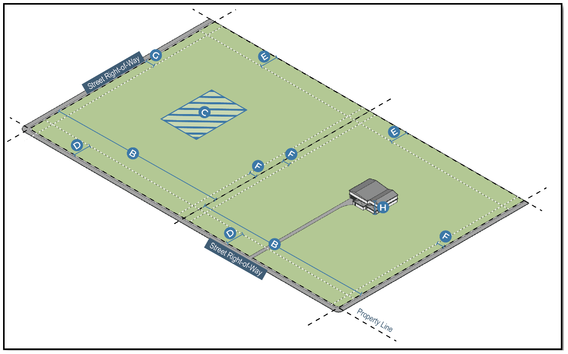
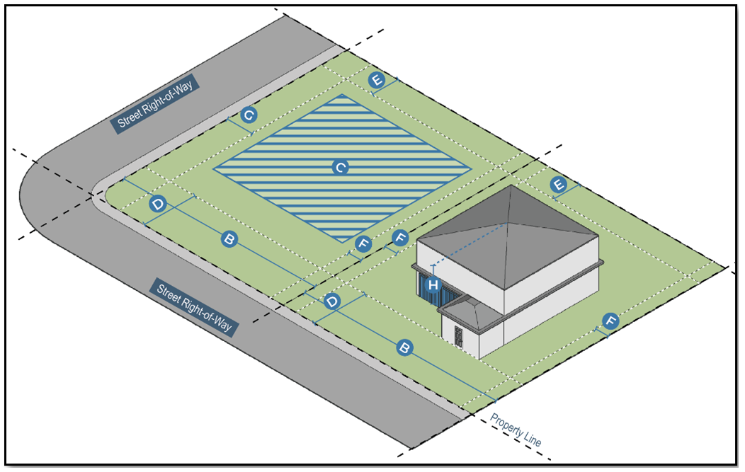
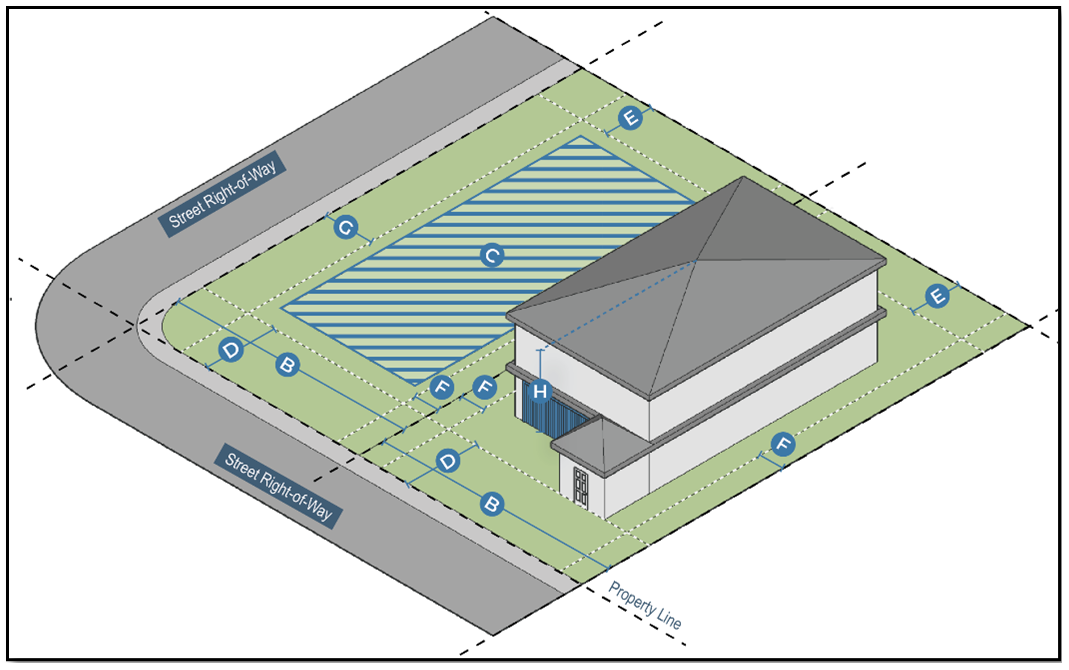
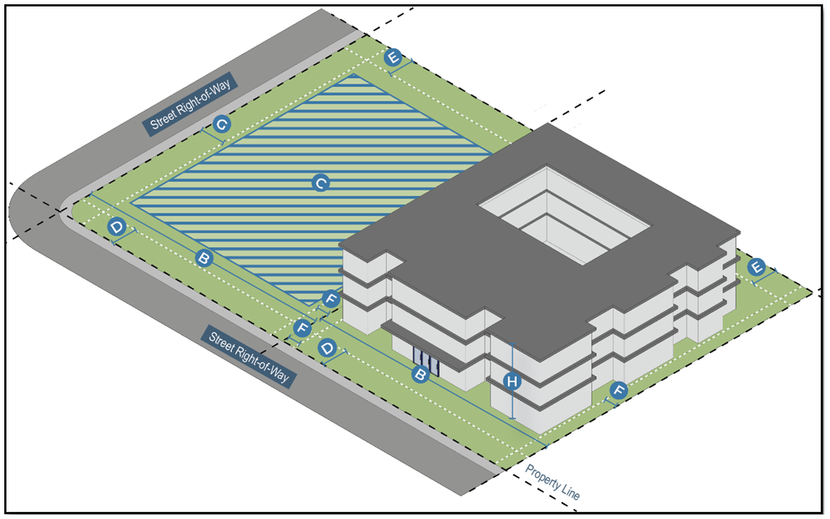
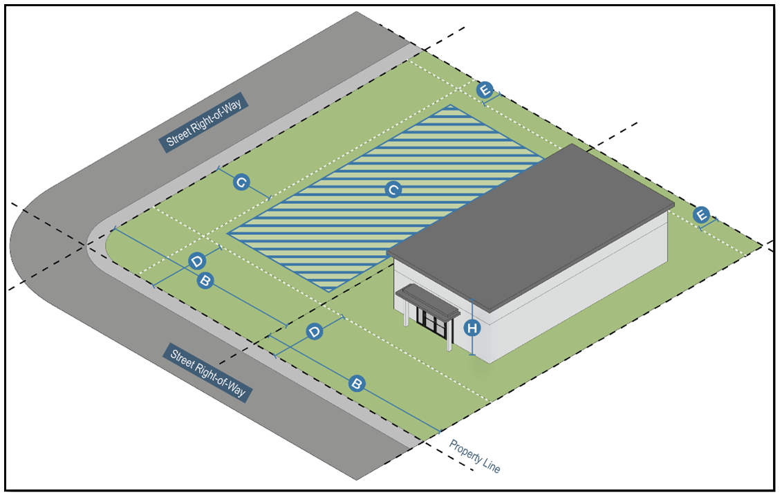
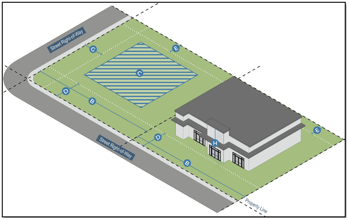
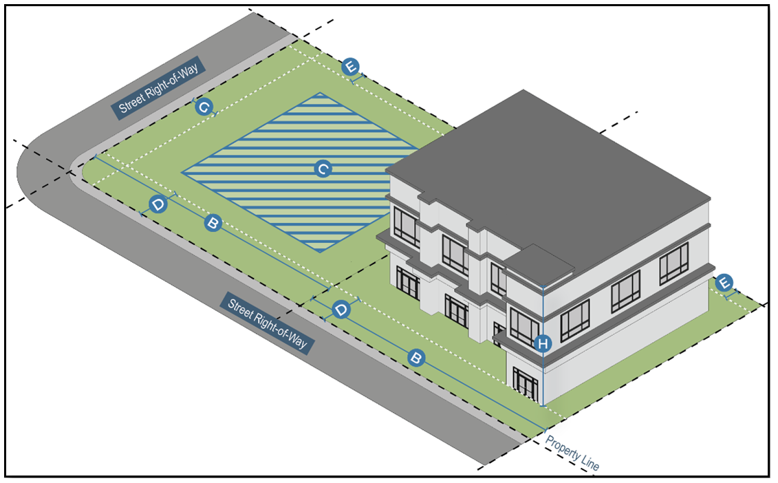
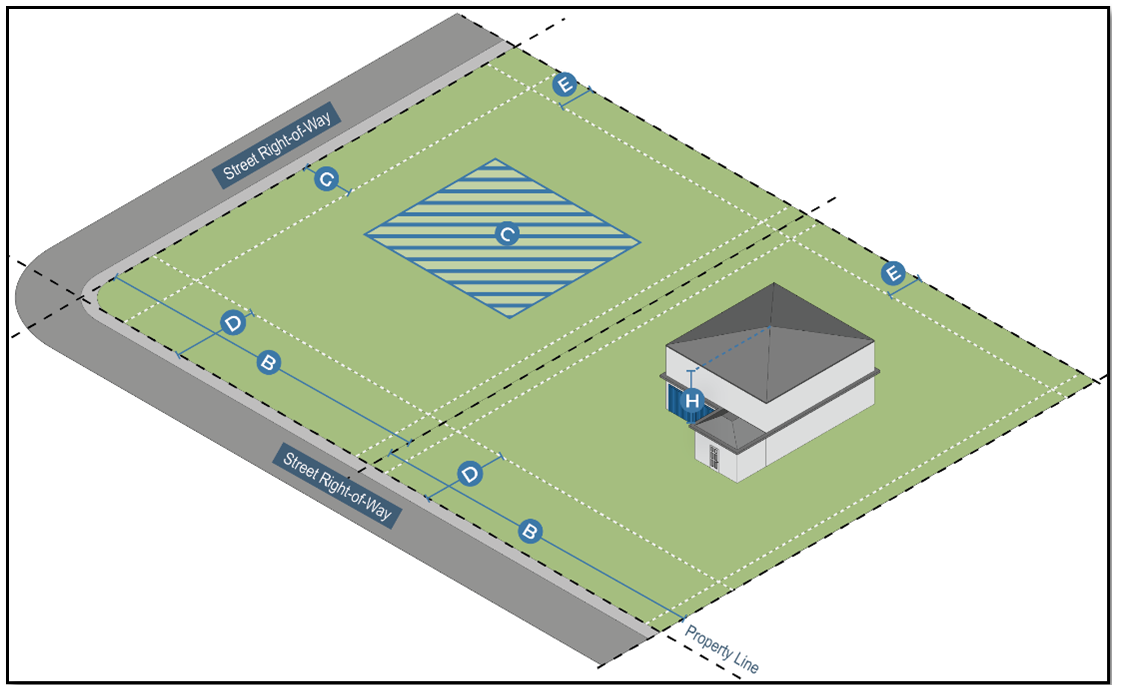
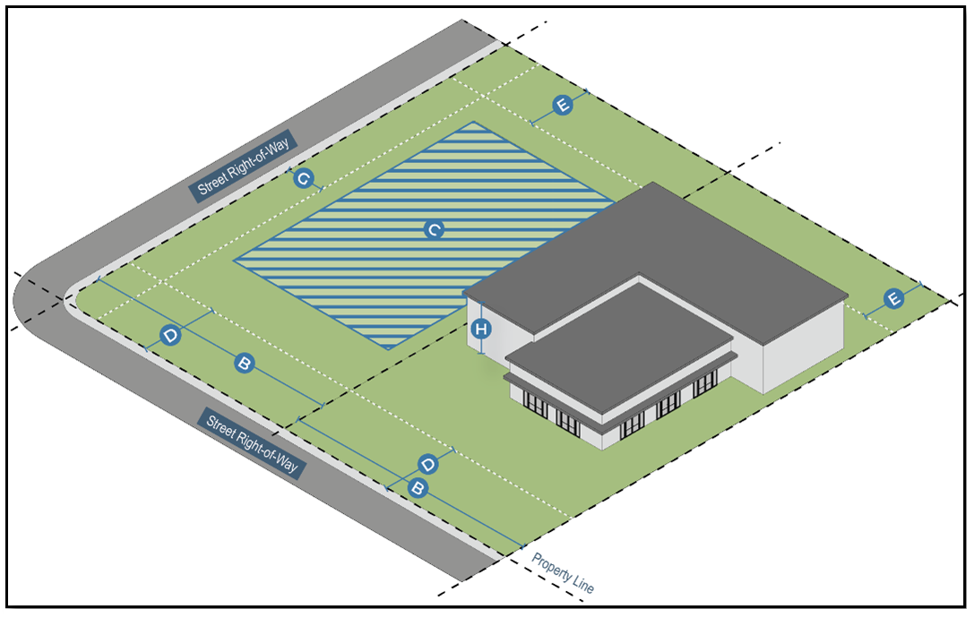
Dimensional standards.Section 22-208 establishes the rules for applying dimensional standards in the zoning districts. These include height, lot area, density, and yard requirements. All buildings, structures, and lots in the zoning district must comply with the dimensional standards established for that district. Nothing in this article authorizes an encroachment within any easements or plat restrictions, unless otherwise specified.
(Ord. No. 2806NS, § 1(Exh. A), 8-19-2024)
Sec. 22-181. - Zoning districts established.
A.
Generally. The city is geographically divided into the following districts, which are established according to Table III.2: Use Table. Each district includes permitted uses and dimensional standards.
B.
Zoning district equivalency. See Table II.1: Zoning Equivalency Table.
Table II.1: Zoning Equivalency Table
(Ord. No. 2806NS, § 1(Exh. A), 8-19-2024)
Sec. 22-182. - Zoning map.
The zoning districts and their boundaries are adopted and established as shown on the Zoning Map of the City of Shawnee, Oklahoma. The zoning map includes all notations, references, data, district boundaries and other associated information, and is adopted as part of this UDC. The zoning map, properly attested, is on file in the office of the city clerk and displayed as a GIS layer on the city's website. The zoning map may be amended as provided in division 2.
(Ord. No. 2806NS, § 1(Exh. A), 8-19-2024)
Sec. 22-183. - Transitional Agriculture (TA) District.
A.
Purpose. The Transitional Agriculture (TA) District preserves large tracts of undeveloped land for agricultural pursuits such as crop production and farming, ranching and raising livestock, wildlife management, and agrarian lifestyle practices. This district protects agricultural areas from the encroachment of urban and suburban development. Additionally, the TA district allows for the extraction of various products such as oil, minerals, rock, and gravel from the earth to prevent sensitive areas from being prematurely developed for urban purposes. This district represents the character and intent of the urban reserve and agriculture/open space future land use categories.
B.
Uses. See Table III.2: Use Table and all applicable regulations in Division 3.
C.
Dimensional standards. Development in the Transitional Agriculture (TA) District shall follow the standards in Table II.2: TA District Dimensional Standards.
Table II.2: TA District Dimensional Standards
D.
Special regulations.
1.
Build-through acreage (BTA) standards.
a.
Intent.
i.
The purpose of these regulations is to provide a mechanism that permits short-term acreage development in portions of Shawnee that will receive urban services within a relatively long-term future. It is intended to allow property owners the opportunity to realize a reasonable return on their property and to accommodate a continuing demand for acreage development in Shawnee, without obstructing future development. It also provides for the eventual transition of the previously developed acreage subdivision to higher densities when the extension of urban services occurs.
ii.
The BTA standards are generally used within the areas identified by the property owner.
b.
Application. All property designated as a BTA shall be required to develop under these regulations.
c.
Development as build-through acreages. All new subdivisions developed under this section shall be developed as build-through acreages, in accordance with the provisions and requirements of this section and the subdivision regulations.
d.
Acreage development.
i.
A BTA development must be a minimum of 40 acres to qualify.
ii.
Landowners developing a BTA development shall set aside 50 percent of the property for future urban development.
iii.
The 50 percent set aside shall have a deed restriction disallowing any further subdivision of the parcel until community water and sewer are provided to the property. Additionally, new construction of any structure on the set aside is prohibited until community water and sewer are provided to the property. However, additions may be allowed onto existing structures within the set aside provided any addition meets the zoning regulation and building code requirements. The remaining 50 percent to be developed into acreages shall be allowed the density permitted of this section.
iv.
A subdivision within the BTA designation shall provide future infrastructure easements as designated by the city's adopted long-range planning policies.
e.
Forms and elements of the development plan within the BTA. All new residential BTA developments must be approved as a legally binding development plan. All applications for preliminary and final plats shall also follow the requirements and procedures established by the subdivision regulations.
(Ord. No. 2806NS, § 1(Exh. A), 8-19-2024)
Sec. 22-184. - Low-Density Residential (R-1) District.
A.
Purpose. The Low-Density Residential (R-1) District is designed to primarily accommodate low-density single-family residential development supported by parks, open space, cultural, and educational amenities. This district represents the character and intent of the large lot residential and low density residential future land use categories.
B.
Uses. See Table III.2: Use Table and all applicable regulations in Division 3.
C.
Dimensional standards. Development in the Low-Density Residential (R-1) District shall follow the standards in Table II.3: R-1 District Dimensional Standards.
Table II.3: R-1 District Dimensional Standards
(Ord. No. 2806NS, § 1(Exh. A), 8-19-2024; Ord. No. 2813NS, § 1, 11-18-2024)
Sec. 22-185. - Medium-Density Residential (R-2) District.
A.
Purpose. The Medium-Density Residential (R-2) District provides for medium-density residential development with a diversified range of housing choices. This district encourages a mix of single-family, two-family, and select multi-family residential uses and incentivizes community amenities to form accessible, walkable, and equitable neighborhoods. This district represents the character and intent of the Medium Density Residential Future Land Use Category, while promoting "missing middle housing" development.
B.
Uses. See Table III.2: Use Table and all applicable regulations in Division 3.
C.
Dimensional standards. Development in the Medium-Density Residential (R-2) District shall follow the standards in Table II.4: R-2 District Dimensional Standards.
Table II.4: R-2 District Dimensional Standards
D.
Special regulations. The minimum lot area for a townhouse lot may be 2,500 square feet.
(Ord. No. 2806NS, § 1(Exh. A), 8-19-2024)
Sec. 22-186. - High-Density Residential (R-3) District.
A.
Purpose. The High-Density Residential (R-3) District provides for high-density residential development, targeting well-designed multi-family uses serving as a transition between medium-density residential development and commercial nodes. This district encourages multi-family uses with site development characteristics that accommodate open space and access to light and air. This district represents the character and intent of the high density residential future land use category and promotes development of the "missing middle housing" concept.
B.
Uses. See Table III.2: Use Table and all applicable regulations in Division 3.
C.
Dimensional Standards. Development in the High-Density Residential (R-3) District shall follow the standards in Table II.5: R-3 District Dimensional Standards.
Table II.5: R-3 District Dimensional Standards
D.
Special regulations.
1.
The maximum density is 40 units per acre.
2.
The maximum density may be increased to 65 units per acre if the proposed development:
a.
Abuts a state or federal designated highway;
b.
Is multiple stories and greater than 30 feet tall;
c.
Has multiple points of ingress and egress along a state- or federal-designated highway; and
d.
Designates 20 percent of the units to be at or below 60 percent area median income (AMI).
(Ord. No. 2806NS, § 1(Exh. A), 8-19-2024)
Sec. 22-187. - Local Commercial (C-1) District.
A.
Purpose. The Local Commercial (C-1) District provides for a range of commercial activities, including the development of small-scale neighborhood offices, low-intensity retail and service businesses, restaurants, and public spaces. This district offers a transition between neighborhoods and intensive commercial areas, providing a critical commercial function that serves nearby residential areas. Development in this district is primarily pedestrian-scaled to help improve vehicular circulation and safely accommodate residents and pedestrians. This district represents the character and intent of the low intensity commercial future land use category.
B.
Uses. See Table III.2: Use Table and all applicable regulations in Division 3.
C.
Dimensional standards. Development in the Local Commercial (C-1) District shall follow the standards in Table II.6: C-1 District Dimensional Standards.
Table II.6: C-1 District Dimensional Standards
D.
Special regulations. Any proposed building greater than 15,000 square feet shall require a conditional use permit.
(Ord. No. 2806NS, § 1(Exh. A), 8-19-2024)
Sec. 22-188. - Regional Commercial (C-2) District.
A.
Purpose. The Regional Commercial (C-2) District provides for medium- to large-scale development of retail, service, entertainment, office, necessary for a regional market. This district primarily facilitates commercial development, like big box and anchor retailers and intensive shopping strip centers, that are automobile-oriented and generate high traffic counts. This district represents the character and intent of the high intensity commercial future land use category.
B.
Uses. See Table III.2: Use Table and all applicable regulations in Division 3.
C.
Dimensional standards. Development in the Regional Commercial (C-2) District shall follow the standards in Table II.7: C-2 District Dimensional Standards.
Table II.7: C-2 District Dimensional Standards
D.
Special regulations. Any proposed building greater than 150,000 square feet shall require a conditional use permit.
(Ord. No. 2806NS, § 1(Exh. A), 8-19-2024)
Sec. 22-189. - Mixed Use (MU) District.
A.
Purpose. The Mixed Use (MU) District provides for medium to high-density residential development comingled with localized medium-to-high-intensity commercial activity for retail, restaurant, and office uses. This district encourages use variety and "missing middle housing" options, emphasizing a cohesive development pattern to achieve housing diversity, accessibility, walkability, and equity. This district represents the character and intent of the comprehensive plan's mixed use and high density residential future land use categories.
B.
Uses. See Table III.2: Use Table and all applicable regulations in Division 3.
C.
Dimensional standards. Development in the Mixed Use (MU) District shall follow the standards in Table II.8: MU District Dimensional Standards.
Table II.8: MU District Dimensional Standards
D.
Special regulations.
1.
Any proposed building greater than 20,000 square feet shall require a conditional use permit.
2.
Any proposed development more than 45 feet in height shall require additional stories to be stepped back at least ten feet per story.
3.
Residential dwelling units are limited to no more than 70 percent of the development's cumulative building square footage within the Mixed Use (MU) District.
4.
No residential unit shall be located on the ground floor unless the unit is in the rear of the building.
(Ord. No. 2806NS, § 1(Exh. A), 8-19-2024)
Sec. 22-190. - Downtown (DT) District.
A.
Purpose. The purposes of the Downtown (DT) District are to:
1.
Establish a regulating plan that classifies all properties within the downtown area into one of three subdistricts (core, edge, and transition) based on historical and regional architectural traditions and development patterns;
2.
Facilitate pedestrian-oriented, mixed-use, urban infill redevelopment, providing shopping, employment, housing, and business and personal services;
3.
Promote an efficient, compact, and walkable development pattern;
4.
Encourage pedestrian activity while reducing reliance on automobiles;
5.
Allow development flexibility in land use and site design;
6.
Effectively regulate downtown and its surrounding areas to create attractive and functional development outcomes as envisioned in the downtown and mixed use future land use categories;
7.
Revitalize the historic downtown and its surrounding areas while preserving Shawnee's history and heritage; and
8.
Enhance the significance of the city's authentic core to residents, tourists and visitors and serve as a support and stimulus to business and industry.
B.
Regulating plan. The regulating plan establishes the development standards for all properties within the downtown area. As such, the following subdistricts are established with the corresponding boundaries.
1.
Core: The Core (DT-C) Subdistrict is intended to preserve and enhance the existing buildings along Main Street and those properties contained within the subdistrict and identified on the zoning map. Development standards in this subdistrict require new buildings and additions to existing buildings to be consistent with the historical form and architectural traditions of the area.
2.
Edge: The Edge (DT-E) Subdistrict is intended to encourage compatible infill and redevelopment of the area immediately surrounding the Core Subdistrict. Development standards in this subdistrict emphasize pedestrian-focused and mixed-use development for those properties within the subdistrict as identified on the zoning map.
3.
Transition: The Transition (DT-T) Subdistrict is intended to provide for a range of select low-intensity commercial development and residential transitions between the Edge Subdistrict and the adjacent neighborhoods to the north, west, and southeast as identified within the subdistrict and shown on the zoning map. Development standards emphasize keeping a smaller scale for residential uses and limiting nonresidential building forms to be compatible with adjacent residential neighborhoods.
C.
Uses. See Table III.2: Use Table and all applicable regulations in Division 3.
D.
Dimensional standards. Development in the Downtown (DT) District shall follow the standards in Table II.9: DT District Dimensional Standards.
Table II.9: DT District Dimensional Standards
E.
Special regulations.
1.
Residential transition standards. In the Edge and Transition Subdistricts, residential transition standards apply to all new building construction and all upper-story additions to existing buildings located adjacent to existing single-family detached residence but shall not apply when an improved public street or railroad right-of-way separates the new building construction from the existing single-family detached residence (See Table II.10: Residential Transition Standards).
Table II.10: Residential Transition Standards
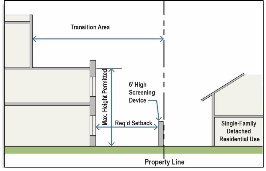
Figure II-1
(Ord. No. 2806NS, § 1(Exh. A), 8-19-2024)
Sec. 22-191. - Twin Lakes (TL) District.
A.
Purpose. The purposes of the Twin Lakes District are to:
1.
Limit commercial development so as to not disrupt wildlife and the character of Shawnee Twin Lakes;
2.
Enhance the significance of Shawnee Twin Lakes to residents, tourists and visitors serving as a catalyst for recreational activities; and
3.
Divide the Twin Lakes District into two subdistricts—Residential (R) and Commercial (C) to effectively regulate Shawnee Twin Lakes and its surrounding areas to create attractive and functional development outcomes as envisioned in the comprehensive plan and Twin Lakes Master Plan.
B.
Uses. See Table III.2: Use Table and all applicable regulations in Division 3.
C.
Dimensional standards. Development in the Twin Lakes (TL) District shall follow the standards in Table II.11: TL District Dimensional Standards.
Table II.11: TL District Dimensional Standards
D.
Special regulations.
1.
Generally. The two subdistricts are intended to provide the preferred development outcomes suggested in the Twin Lakes Master Plan. Table II.12: Twin Lakes Master Plan Subdistrict Conversion indicates how the Twin Lake Master Plan Place Types are to be incorporated into each subdistrict.
Table II.12: Twin Lakes Master Plan Subdistrict Conversion
2.
Lakeside conservation.
a.
No development shall occur in areas identified as lakeside conservation in the Twin Lakes Master Plan except for marinas.
b.
A permit is required to build a marina.
3.
Docks.
a.
Boat/fishing docks may be constructed.
b.
For the purposes of this section, all lease areas are assumed to have the right to use the abutting shoreline to construct a single floating dock.
c.
The city may charge an additional annual fee for dock area leases.
d.
Dimensional standards for docks shall be as set forth in section 16-235.
4.
Lakeshore buffer.
a.
A 25-foot buffer is hereby established landward of the ordinary high water mark on all leased lots for the purpose of watershed protection.
b.
This area shall not be used by the general public, except during an emergency situation.
c.
Within this buffer, leaseholders are encouraged to preserve existing native vegetation.
d.
The area within the lakeshore buffer shall not be fenced.
e.
Docks and other approved structures as per section 16-235 may be located within the buffer area.
f.
Fertilizers and other chemicals shall not be used within the buffer area.
5.
Impervious surface coverage.
a.
The maximum building coverage ratio shall be 20 percent inclusive of all primary and secondary structures.
b.
Total impervious area shall not exceed 30 percent of the lease area.
c.
Runoff from impervious surfaces, such as roof tops and paved driveways, shall be directed to maximize infiltration.
d.
Runoff water shall be maintained in sheet flow (not channelized flow) to the maximum extent practicable.
6.
Hazardous materials.
a.
Hazardous materials including, but not limited to, solvents, oil, fertilizer, gasoline and other materials shall be stored in an enclosed shed, garage or other approved structure.
b.
New accessory structures other than boat docks shall be setback from the OHWM a minimum of 25 feet.
7.
Septic system standards.
a.
Septic tanks shall be installed and inspected in accordance with the standards set forth in sections 16-59 and 16-328.
8.
Erosion control.
a.
All new residential construction shall employ erosion control and utilize best management practices (BMPs) to control erosion and sedimentation during construction.
b.
All exposed soil must be mulched.
c.
A temporary seeding or cover crop must be used on sites where permanent groundcover will not be established until the following year.
d.
A site will not be allowed to remain as bare ground with the intention of planting the following growing season.
e.
Required erosion control best management practices shall be in place prior to all land disturbing activities.
9.
Shared driveways.
a.
Shared driveways may be utilized to prevent unnecessary disturbance of the lakeside area.
b.
Residential lease areas need not front upon a dedicated public street.
10.
Conditional use permit required. The following requires a conditional use permit:
a.
Any proposed building greater than 20,000 square feet.
b.
Any proposed building taller than 45 feet in the C Subdistrict.
c.
Any proposed multi-family development located within 1,000 feet of a lake shoreline.
d.
Any proposed restaurant with drive-thru facilities within 1,000 feet of a lake shoreline and 150 feet of a residential use.
(Ord. No. 2806NS, § 1(Exh. A), 8-19-2024)
Sec. 22-192. - Light Industrial (I-1) District.

A.
Purpose. The Light Industrial (I-1) District provides for manufacturing, employment commercial uses, wholesale businesses, material fabrication, research facilities, and general industrial uses that are clean, quiet, and free of hazardous or objectionable elements such as noise, odor, dust, smoke, or glare. This district provides a transition between heavy industrial uses and other less intensive commercial activity and residential uses. This district represents the character and intent of the Industrial Future Land Use Category.
B.
Uses. See Table III.2: Use Table and all applicable regulations in Division 3.
C.
Dimensional standards. Development in the Light Industrial (I-1) District shall follow the standards in Table II.13: I-1 District Dimensional Standards.
Table II.13: I-1 District Dimensional Standards
D.
Special regulations. Any proposed development more than 35 feet in height shall require a conditional use permit.
(Ord. No. 2806NS, § 1(Exh. A), 8-19-2024)
Sec. 22-193. - Heavy Industrial (I-2) District.
A.
Purpose. The Heavy Industrial (I-2) District provides areas for manufacturing, processing, assembling, storing, testing, and industrial uses that are extensive and intensive in character, and require large sites, open storage and service areas, extensive services and facilities, and access to major transportation networks. Development in this district is sometimes incompatible with less intensive uses because of traffic, noise, vibration, dust, glare, or emissions, which can be intrusive to commercial activity and residential areas. This district represents the character and intent of the industrial future land use category.
B.
Uses. See Table III.2: Use Table and all applicable regulations in Division 3.
C.
Dimensional standards. Development in the Heavy Industrial (I-2) District shall follow the standards in Table II.14: I-2 District Dimensional Standards.
Table II.14: I-2 District Dimensional Standards
D.
Special regulations. Any proposed development more than 45 feet in height shall require a conditional use permit.
(Ord. No. 2806NS, § 1(Exh. A), 8-19-2024)
Sec. 22-194. - Special districts and overlays.
A.
Generally.
1.
Purpose. Special purpose and overlay districts are tools for dealing with unique neighborhoods or settings or for accomplishing specific planning and zoning goals. Special districts are base zoning classifications while overlay districts "over-lay" requirements in addition to those established in the based zoning district.
2.
Establishment. Special districts and overlays may be established, amended, or removed only in accordance with the rezoning procedures of section 22-226.
B.
Planned Unit Development (PUD) District.
1.
Purpose. The Planned Unit Development (PUD) District is an overlay district intended to provide for combining and mixing of uses allowed in various districts with appropriate regulations and to permit flexibility in the use and design of land and buildings in situations where modification of specific provisions of this UDC is not contrary to its intent and purpose or significantly inconsistent with the planning on which it is based and will not be harmful to the community. A Planned Unit Development (PUD) District may be used to permit new and innovative concepts in land utilization. While great flexibility is given to provide special restrictions that will allow development not otherwise permitted, procedures are established to prevent misuse of the increased flexibility.
2.
Uses. Any use specified in a Planned Unit Development (PUD) District shall be permitted in that district. The size, location, appearance, and method of operation may be specified to the extent necessary to ensure compliance with the purposes of this UDC.
3.
Dimensional standards. A Planned Unit Development (PUD) District requires a minimum of five contiguous acres.
4.
Special regulations.
a.
Development standards for each separate Planned Unit Development (PUD) District shall be established in the ordinance granting the Planned Unit Development (PUD) District and may include, but shall not be limited to, uses, density, lot area, lot width, lot depth, yard depths and widths, building height, building elevations, coverage, floor area ratio, parking, access, screening, landscaping, accessory buildings, signs, lighting, management associations, and other requirements as the city commission may deem appropriate.
b.
In the Planned Unit Development (PUD) District, the particular district(s) to which uses specified in the Planned Unit Development (PUD) District are most similar shall be stated in the granting ordinance. All Planned Unit Development (PUD) District applications shall list all requested modifications from the standard requirements established throughout this UDC. The applicant shall include justification associated with each requested modification. Applications without this list will be considered incomplete.
c.
The ordinance granting a Planned Unit Development (PUD) District shall include a purpose and intent statement citing the reason for the Planned Unit Development (PUD) District request.
d.
The Planned Unit Development (PUD) District shall conform to all other sections of the ordinance and this UDC unless specifically exempted in the granting ordinance.
e.
All development within a Planned Unit Development (PUD) District shall meet the site planning procedures in section 22-233.
(Ord. No. 2806NS, § 1(Exh. A), 8-19-2024)