
Shawnee City Zoning Code
DIVISION 5
SUBDIVISION REGULATIONS
Sec. 22-219.- General provisions.
A.
Purpose. The purposes of this article are to:
1.
Protect and provide for the public health, safety, and general welfare of the city.
2.
Ensure new development meets the goals and conforms to the objectives and policies of the city's comprehensive plan.
3.
Provide for orderly growth and land development.
4.
Provide for adequate light, air, and privacy to secure safety from fire, flood, and other danger and to prevent overcrowding of the land and undue congestion of population.
5.
Provide the most beneficial relationship between the uses of land and buildings and the circulation of traffic throughout the city, with particular regard to the avoidance of congestion on the roads and highways, and provide for the proper location and width of roads and building lines.
6.
Establish reasonable standards for subdivisions in order to further the orderly layout and use of land and to ensure proper legal descriptions of subdivided land.
7.
Facilitate the creation of accurate records of the separate interests created and conveyed by the subdivision of land, thereby helping to protect private property rights.
8.
Ensure that public facilities and services are available concurrent with development and will have a sufficient capacity to serve the proposed subdivision.
9.
Provide for open spaces through the most efficient design and layout of the land, including the use of average density in providing for minimum width and area of lots, while preserving the density of development as established in this UDC.
10.
Promote sustainable land development practices.
B.
Applicability. These regulations apply to all subdivision of land located within Shawnee's corporate limits. All subdivisions shall comply with division 2, division 4, and division 5.
(Ord. No. 2806NS, § 1(Exh. A), 8-19-2024)
Sec. 22-220. - Land division types.
A.
Generally.
1.
Land may be subdivided by means of a deed approval, preliminary plat, final plat, replat, or vacating plat, and shall comply with the requirements, regulations, and specifications of this article.
2.
Before any land is subdivided, the owner of the property proposed to be subdivided, shall apply for and secure approval of the proposed subdivision with the procedures established in division 6.
B.
Platting required. Platting or replatting may, in certain cases, be required under the following conditions:
1.
A previously platted lot, tract or parcel or any unplatted lot, tract or parcel is being subdivided into more than two lots, any part of which, when subdivided contains five acres or less in area.
2.
The design of a subdivision is significantly altered by the creation or deletion of lots.
3.
When the dedication of any street is involved.
4.
When the creation of a private street subdivision is involved and the lots are five acres or less in size.
C.
Platting not required. These regulations do not apply to the following:
1.
Land legally subdivided prior to the adoption of this UDC except where provided within these regulations; or
2.
The sale of land by a properly filed deed, including a complete metes and bounds legal description, in tracts of more than five acres in size.
(Ord. No. 2806NS, § 1(Exh. A), 8-19-2024)
Sec. 22-221. - Subdivision design standards and required improvements.
A.
Generally.
1.
Rules and regulations. In addition to the requirements established in these regulations, all subdivision plats shall comply with the following laws, rules, and regulations:
a.
All applicable statutory provisions;
b.
All requirements of this UDC, building and housing codes, floodplain regulations, and all other applicable laws of the appropriate jurisdictions;
c.
The official zoning map;
d.
The special requirements of these regulations and any rules of the health department, state department of environmental quality, and/or appropriate state or substate agencies;
e.
The rules of the Oklahoma Department of Transportation if the subdivision or any lot or portion of a lot abuts a state highway or connecting road;
f.
The standards and regulations adopted by the city engineer and all boards, commissions, agencies, and officials of Shawnee;
g.
The standards and regulations required by the Americans with Disabilities Act (ADA);
h.
The intent and policies of the comprehensive plan and the capital improvements program of the city, including all public facilities as shown by the comprehensive plan, as adopted;
i.
Any subdivisions with controlled access or security gates are prohibited except as provided for private streets in division 5, section 22-221.F.
j.
The State of Oklahoma County Highway System Design Guidelines Manual; and
k.
Any other standards and regulations adopted by the city.
2.
Conformance to guidelines. Plat approval shall be withheld if a subdivision is not in conformity with the above laws, regulations, guidelines, and policies as well as the purposes of these regulations.
3.
Self-imposed restrictions. If the owner places restrictions on any of the land contained in the subdivision greater than those required by this UDC, those restrictions or references to those restrictions shall be required to be indicated on the subdivision plat. Where restrictive covenants are less restrictive than those required by this UDC, the more restrictive regulation shall prevail. All restrictive covenants shall be filed in the office of the county clerk, which directly affects the land being subdivided.
4.
Character of the land. Land that the planning commission finds to be unsuitable for subdivision or development due to flooding, improper drainage, steep slopes, rock formations, adverse earth formations or topography, utility easements, or other features that will reasonably be harmful to the safety, health, and general welfare of the present or future inhabitants of the subdivision and/or its surrounding areas, shall not be subdivided or developed unless adequate methods are formulated by the developer and approved by the planning commission, upon recommendation of the city engineer, to solve the problems created by the unsuitable land conditions. That land shall be set aside for uses that shall not involve any danger to public health, safety, and welfare.
5.
Subdivision name. The proposed name of the subdivision shall not duplicate, or too closely approximate phonetically, the name of any other subdivision within the city or within Pottawatomie County's jurisdiction. The planning commission shall have final authority to designate the name of the subdivision, which shall be determined at time of plat approval.
6.
Monuments. Permanent reference monuments or markers in subdivisions are required as below:
a.
Temporary markers. Temporary markers outlining all streets shall be set and maintained in place, by resetting if necessary, until grading of all streets is completed.
b.
Permanent markers. Permanent markers shall be placed at the following locations:
i.
Each lot corner;
ii.
All subdivision boundaries; and
iii.
The points of beginning and of ending of all curves.
Permanent markers shall be set by a registered land surveyor, licensed as such in the State of Oklahoma.
c.
Benchmarks. Permanent benchmarks shall be set to effectively serve the subdivision by a registered land surveyor, licensed as such in the State of Oklahoma. Those benchmarks shall be based on United States Geological Service (U.S.G.S.) datum.
7.
Street designation. The planning commission and city commission may consider changing existing public streets to private streets or private streets to public streets.
8.
Homeowner's association (HOA) and property owners association (POA). For any subdivision utilizing or incorporating private streets, shared parking, common drives, islands, or medians within street rights-of-way, and/or any other common areas, a homeowner's association (HOA) or property owners association (POA) shall be established and be responsible for maintenance of those easements and common areas.
9.
Plats straddling municipal boundaries. Whenever access to the subdivision is required across land in another local government, the planning commission may request assurance from the city attorney that access is legally established, and from the director that the access street is adequately improved, or that the applicant has fully executed a performance bond of sufficient quantity to assure the construction of the access street. Whenever possible, lot lines shall conform to municipal boundary lines.
B.
Public facilities and services.
1.
Adequate public facilities. No preliminary plat shall be approved unless the planning commission determines that public facilities will be adequate to support and service the area of the proposed subdivision. The applicant shall, at the request of the planning commission, submit sufficient information and data on the proposed subdivision to demonstrate the expected impact on, and use of, public facilities by possible uses of that subdivision. Public facilities and services to be examined for adequacy will include necessary street improvements, drainage, water service, sewerage, capital improvements, and other improvements.
2.
Extension policies. All public improvements and required easements shall be extended through the parcel on which new development is proposed. Roads, water lines, wastewater systems, drainage facilities, and other required public utilities shall be constructed through new development to promote the logical extension of public infrastructure. The city may require the applicant of a subdivision to extend offsite improvements to reach the subdivision or oversize required public facilities to serve anticipated future development as a condition of plat approval.
C.
Lot improvements.
1.
Generally. The size, shape, and orientation of lots must comply with applicable UDC regulations. When lots will not be served by centralized sewer or water service, lot dimensions and area must comply with the requirements of the Oklahoma Department of Environmental Quality.
2.
Lot arrangement. All lot types and arrangements shall comply with this UDC to provide access to buildings on those lots from an approved street, or from a private access drive approved under division 5, section 22-221.F.3., and to avoid any foreseeable natural or manufactured difficulties. See Figure V.1: Lot Types and Arrangements for the various lot types and arrangements.
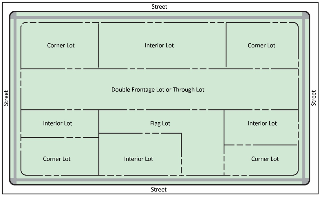
Figure V-1: Lot Types and Arrangements
3.
Lot dimensions/sight triangle. Lot dimensions shall comply with the minimum standards of this UDC. Corner lot lines shall provide a sight distance triangle with legs of 25 feet from the point of intersection of the property lines along both property lines.
4.
Lot drainage. Lot layouts shall provide positive drainage away from all buildings, and individual lot drainage shall reflect the general storm drainage pattern for the area. Drainage design shall comply in all respects with the Engineering Design Manual.
5.
Through lots. Through lots shall be avoided except where necessary, as determined by the city engineer, to provide separation of residential development from traffic arterials or to overcome disadvantages of topography and orientation.
6.
Flag lots.
a.
Generally, flag lots shall not be created during the subdivision process.
b.
The creation of flag lots may be approved only if a flag lot design:
i.
Limits direct access onto an arterial street;
ii.
Provides greater protection of sensitive natural resources areas;
iii.
Hides or conceals utility buildings/substations, or radio, television, or telecommunication towers; or
iv.
Avoids substantial hardship to the subject property owner due to the property's topography or any other condition.
c.
Flag lot conditions may be imposed, including, but not limited to, requirements for shared driveways, maximum flag lot length, minimum street frontage, and minimum flag lot width.
7.
Reserve lots. These regulations recognize that it may occasionally be necessary and in the public interest to create lots designated as reserve areas to be occupied by stormwater detention, common recreation, private rights-of-way, or other similar uses. If declared reserved for those purposes by restrictive covenants or other recorded legal documents approved by the city or Pottawatomie County, reserve areas are exempt from this UDC's lot regulations.
8.
Proximity to railroads and limited access highways. When the area to be subdivided adjoins or contains a railroad right-of-way or limited access highway, lots that back onto that right-of-way shall have appropriate provisions for buffering and access control as required by division 4.
9.
Access.
a.
Every lot shall have frontage on, and access to, a public street or private road meeting right-of-way and improvement standards. Minimum frontage shall be established per division 2.
b.
Lots shall not, in general, derive access exclusively from a highway or major arterial street.
c.
Where driveway access from a highway or arterial street may be necessary for several adjoining lots, the planning commission may require that those lots be served by a combined access drive in order to limit possible traffic hazards on the road.
d.
If a property with frontage along a highway or arterial street is proposed to be subdivided or developed, the planning commission is authorized to restrict access to the respective street and require that a property owner take one or more of the following actions:
i.
Create through lots that back onto the highway or arterial street and front onto and take access from a parallel street, coupled with the installation of a fence, wall, or vegetative visual screen along the highway or major arterial street frontage;
ii.
Provide a frontage road separated from the highway or arterial street;
iii.
Establish deed restrictions or other legally enforceable means of preventing private driveway access to the highway or arterial street;
iv.
Provide a cross-access easement to abutting properties that front on the same highway or arterial street; or
v.
Provide a mutual, reciprocal, non-exclusive easement (mutual access easement) to ensure perpetual access to the subject property.
e.
Driveways shall be designed and arranged to avoid requiring vehicles to back into traffic on highways and arterial streets.
f.
For paving requirements in the right-of-way adjoining any city street, see the Engineering Design Manual.
10.
Access points. Access shall be provided to each subdivision in accordance with the Engineering Design Manual.
a.
Waivers to these access restrictions for subdivisions may be considered by the planning commission if the developer can prove that the property in question cannot comply due to the following conditions:
i.
Property frontage is too narrow; or
ii.
Site topography restrictions.
b.
The planning commission may consider a street stub into undeveloped property with an alternate emergency access easement as part of a subdivision proposal to warrant a waiver of the above access restrictions.
c.
When the first or subsequent phase(s) of a preliminary plat containing 100 or more lots is submitted, the access or entrance street must be designed in accordance with the criteria established in the Engineering Design Manual, if the phases do not connect to an alternate access point.
11.
Platted building lines. Platted building lines contained in an approved final plat that are more restrictive than the setback of the UDC, shall represent the legal setback lines.
D.
Streets.
1.
Generally.
a.
The arrangement, character, extent, width, grade, access to, and location of all streets shall conform to the city comprehensive plan's intent and are considered in their relation to existing and planned streets, to topographical conditions, to public convenience and safety, and in their appropriate relation to the proposed land uses to be served by streets.
b.
No permit shall be issued for any development that does not access a street right-of-way compatible with the requirements of this section, or a private access easement that complies with the minimum width requirements.
c.
A traffic impact analysis study is required for:
i.
Any development proposal greater than 20 acres or any development proposal greater than five lots; and
ii.
Any nonresidential development proposal when the expected traffic generation is:
(A)
Greater than 2,000 vehicle trips per day (tpd).
(B)
Less than 2,000 tpd if the peak hour operation of the development is expected to generate more than 150 vehicle trips per hour (tph).
d.
Any required TIA shall meet the requirements and specifications established in the city's Engineering Design Manual.
e.
Roads shall be graded, improved, and conform to the standards and specifications established in the Engineering Design Manual as required by a grading and improvement plan.
f.
Pavement and utilities shall comply with the following provisions:
i.
Plans for pavement and utilities shall be prepared by a professional engineer and in accordance with the laws of the State of Oklahoma and the ordinances of the city.
ii.
The applicant shall file with the city a surety bond, and in the amount of 110 percent of the estimated construction cost, conditioned that the applicant, as principal, will faithfully install and complete improvements and utilities in the subdivision within a period not to exceed two years, according to the requirements of approved plans, subdivision rules and regulations, and municipal ordinances, regulations and specifications, and will pay all bills for contractors, improvements and utilities. This requirement only applies when infrastructure is not installed at the time of final plat/plan.
iii.
An extension of this period may be allowed by the city commission.
iv.
The professional engineer shall furnish the cost of pavement and utilities to the city engineer who shall approve the estimated costs of paving, storm sewers, and other drainage facilities, if required, in order that the planning commission may determine whether or not the amount of the bond submitted is adequate to ensure the construction of these facilities and to protect the interests of the city and public welfare.
v.
All current policies, inspection fees, and other normal requirements of the city shall apply in full force to ensure the proper construction of the private street.
vi.
In lieu of the provision contained in subsections i.—v. above, the applicant may submit a document prepared by a professional engineer that certifies that all private streets for the development are constructed to the city's standards. The plat or deed shall not be signed and released until certification is received and reviewed by the city.
2.
Street layout.
a.
Topography.
i.
Grades of streets shall conform as closely as possible to the original topography. If possible, all streets shall be arranged to provide building sites at, or above, the grade of the street; otherwise, adequate provisions for drainage must be made. A combination of steep grades and curves shall be avoided. Specific design standards are established in the Engineering Design Manual.
ii.
Collector and local streets shall be designed to conform as much as possible to the topography to:
(A)
Discourage use by through traffic;
(B)
Permit efficient drainage and utility systems; and
(C)
Require the minimum number of streets necessary for convenient and safe access to property.
b.
Integration of existing streets. All streets shall be properly integrated with the existing and proposed system of thoroughfares and dedicated rights-of-way and shall provide for the integration of future streets. If a subdivision abuts or contains an existing or proposed street, the planning commission may require:
i.
Marginal access streets;
ii.
Reverse frontage with screen planting contained in non-access reserve strips along the rear property line;
iii.
Deep lots with rear service alleys, or minimum distances between intersecting driveways and streets, or other treatment necessary for adequate protection of residential properties and to afford separation of through and local traffic;
iv.
Minimum spacing between intersecting driveways onto a street or arterial street to conform to the requirements in the Engineering Design Manual.
c.
Railroad right-of-way. If a subdivision borders on or contains a railroad right-of-way, the planning commission may require a buffer zone between the railroad right-of-way and the residential development to a distance of 300 feet minimum suitable for the appropriate use of the intervening land. These distances consider grade approaches and future grade separations.
d.
Permanently designed dead-end streets.
i.
Permanently designed dead-end streets shall not be longer than 500 feet or serve more than 20 dwelling units.
ii.
Permanently designed dead-end streets shall provide a turn-around at the closed end with an outside roadway diameter of at least 100 feet, and a street property line diameter of at least 120 feet.
iii.
The planning commission may approve a permanently design dead-end street that extends to 1,000 feet after reviewing and considering pedestrian connectivity.
e.
Temporary designed dead-end streets.
i.
Temporary turnarounds must be provided at the end of stub streets that are intended for extension when a subsequent phase of the development is completed or when the abutting property is developed if the stub street is more than 150 feet in length, as measured from the centerline of the intersecting street to the perimeter of the subdivision to which the stub street extends.
ii.
At the time that the temporary dead-end street is extended or connected to another street segment, any existing temporary turnaround must be removed by the property owner responsible for extending the street. If for any reason the stub street is not extended, a permanent turnaround must be constructed by the subject property owner on the abutting site being developed.
iii.
Stub streets must be clearly marked on plats and labeled "Future Street Extension." In addition, developers must post an approved sign in the right-of-way of the stub street indicating that the temporary dead-end street is intended as a "future street extension."
f.
Connections.
i.
The system of streets designated for the subdivision must connect with streets already dedicated in adjacent subdivisions.
ii.
Where adjacent connections are not platted, the general projection of streets in the nearest subdivided tracts must continue to the boundaries of the tract subdivided, so that other property owners may connect.
iii.
Preliminary plats shall be designed to provide interconnection between adjacent tracts, plats and/or parcels.
(A)
There shall be at least one street connecting each quarter section.
(B)
An adjoining subdivision may not tie into an existing stub street for its primary entrance unless landlocked.
(C)
A stub street shall not warrant a wider street than required because of traffic counts for the original tract.
(D)
A property owner shall, if a stub street is required, construct the stub street or grant an easement reserving the minimum right-of-way required for the stub street and any related utilities.
(E)
The property owner must build the return for the proposed stub with a connecting curb across the back and add a note to the plat that identifies this area as a street stub. These streets must be constructed in accordance with the city's adopted standards. All streets, including stub streets, and rights-of-way shall be dedicated to the city.
(F)
The length of the stub street shall not exceed the average length of residential lots in the subdivision or 150 feet, whichever is greater. Street stubs must be constructed simultaneously with the improvements within the final plat. Street stubs shall be constructed to the adjoining property line at time of initial development. The owner is responsible for all costs associated with the construction of that stub street and its associated utilities.
(G)
If a stub street is not required to be connected to the adjacent development on the final plat of that development, then that stub street may be closed and/or vacated as provided by law. The planning commission shall consider physical barriers, land use incompatibilities, proposed amenities that are under private property owners' control (pools, playgrounds, etc.), existing undeveloped landlocked properties, and any potential inappropriate traffic designs to justify a waiver of this requirement.
iv.
Reserve strips of land controlling access to or egress from other property from any street or alley or having the effect of restricting or damaging the adjoining property, are not permitted in any subdivision unless those reserve strips are conveyed to the city in fee simple.
g.
Widening and realignment of existing roads. Where a subdivision borders an existing road not constructed to the city's standards or when the comprehensive plan or udc regulations indicate plans for realignment or widening of a road that would require use of some of the land in the subdivision, the property owner shall dedicate the additional right-of-way from the centerline. Right-of-way shall be dedicated to accommodate full build-out of the designated street classification. Land reserved for any road purposes shall not be counted in satisfying yard or area requirements of the UDC. Land shall be either dedicated to the city in fee simple or as an easement.
3.
Street classification.
a.
Generally. The components of the city's street system are divided into six major classifications with corresponding right-of-way widths. All yards or setbacks abutting a shall be measured from the proposed right-of-way as shown on the city's adopted major street and highway plan and any adopted sidewalk and recreational trails master plan.
b.
Highway. A highway is a limited access, high speed roadway with grade separated interchanges. Highways are of regional significance and the interchanges may have a significant impact on land use due to their desirability as locations for commerce and industry. Highways are generally controlled by the State of Oklahoma with variable width right-of-way dimensions.
c.
Major arterial. A major arterial is a street type that provides for longer, direct trips on relatively straight paths that often connect to highways. This street type is generally controlled by the State of Oklahoma or the city.
d.
Minor arterial. A minor arterial is a street type typically found between major arterials that provides continuous paths to intermediate destinations and alternate routes for longer trips. This street type is generally controlled by the city.
e.
Non-industrial collector. A non-industrial collector is a street type typically found between minor arterials that provide frequent interconnections between neighborhoods. Non-industrial collectors allow local trips that mostly avoid the arterial network. This street type is generally controlled by the city.
f.
Industrial collector. An industrial collector is a collector street that primarily accommodates large vehicular traffic. This street type is generally controlled by the city.
g.
Local. A local street is a street type interconnected within neighborhoods that adjoin other neighborhoods. These streets discourage through traffic and are generally controlled by the city.
4.
Street design.
a.
Generally.
i.
Streets will follow the regulations, allocations, and required standards established in the city's Engineering Design Manual, including regulations for travel lanes, median/turning lanes, pedestrian facilities, and other elements.
ii.
To facilitate flexibility in design while maintaining the safety, health, and welfare of the public, the city engineer may grant administrative modifications to street design if:
(A)
The city engineer certifies that the proposed exception does not conflict with the goals and policies of the comprehensive plan; and
(B)
The applicant demonstrates, through documentation and/or studies, based on generally accepted engineering principles, that exceptions to the standard provided by this section would not pose a threat to health and safety.
iii.
Street and access easement designs shall conform with the latest American Association of State Highway and Transportation Officials publication of "A Policy on Geometric Design of Highways and Streets." A professional engineer registered in the State of Oklahoma shall prepare and sign street design plans. For intersection design purposes, local streets and non-industrial collectors assume passenger vehicles only, arterials (major and minor) will carry single-unit trucks and city transit buses, and all industrial collectors and highways will carry vehicles of WB-50.
iv.
The applicant shall install all utilities, shall construct curbs and gutters, and shall surface roadways to the widths prescribed in these regulations and the Engineering Design Manual. All road pavement, shoulders, drainage improvements and structures, curbs, turnarounds, and sidewalks shall conform to all construction standards and specifications adopted by the planning commission or city commission, this UDC, and Engineering Design Manual.
b.
Intersections.
i.
Intersections at right angles.
(A)
Streets shall intersect at right angles.
(B)
The city engineer may authorize intersection modifications as needed based on topography constraints or other restrictive site conditions.
(C)
An oblique street shall be curved approaching an intersection and shall connect at right angles.
(D)
No more than two streets shall intersect at any one point.
ii.
New intersections along existing streets.
(A)
Proposed new intersections along an existing street shall, wherever practical, coincide with an existing intersection on the opposite side of that street.
(B)
Centerline offsets of less than 150 feet shall not be permitted when intersecting an arterial street, except where the intersected street has separated dual drives without median breaks.
(C)
Centerline offsets of less than 110 feet shall not be permitted when intersecting local or collector streets.
(D)
Where any street intersects a street, its alignment shall be continuous.
(E)
The intersection of streets shall be separated in accordance with the access provisions of this section and the Engineering Design Manual.
iii.
Intersection grade. Intersections shall be designed with the specifications and requirements established in the Engineering Design Manual.
iv.
Intersection visibility. At any street intersection where earth banks or existing vegetation inside any lot corner create a traffic hazard by limiting visibility, the applicant shall cut that ground and/or vegetation (including trees) in connection with the grading of the public right-of-way to the extent deemed necessary to provide an adequate sight distance as established in the Engineering Design Manual.
c.
Driveway spacing. Driveways shall be separated from street intersections by the distance defined in the Engineering Design Manual.
d.
Excess right-of-way. Right-of-way widths in excess of the standards designated in these regulations shall be required whenever additional width is necessary, due to topography, to provide adequate earth slopes. Excess slopes shall be addressed and accommodated by the specifications and requirements established in the Engineering Design Manual or another construction method approved by the city engineer.
e.
Railroads and limited access highways. Railroad rights-of-way and limited access highways that are adjacent to subdivided lands shall be treated as follows:
i.
Generally. Streets parallel to the railroad when intersecting a street that crosses the railroad at grade shall, to the extent practical, be at a distance of at least 150 feet from the street centerline to the railroad right-of-way. Those distances shall be determined with due consideration to the minimum distance required for future separation of grades by means of appropriate approach gradients.
ii.
In residential districts.
(A)
A platted setback line of at least 20 feet in depth, in addition to the required setback, shall be provided adjacent to the railroad right-of-way or limited access highway.
(B)
A six-foot fence shall be erected on all residential lots abutting railroads and limited access highways.
iii.
In nonresidential districts. The nearest street extending parallel or approximately parallel to the railroad shall, wherever practical, be at a sufficient distance there from to ensure suitable lot depth.
f.
Street design criteria. All streets shall comply with the criteria established in the city's Engineering Design Manual.
g.
Streets not identified. For purposes of streets and easements not identified in the city's street system, the following applies:
i.
Streets shall have a 50-foot right-of-way with a 30-foot paving section.
ii.
Access easements intended for primary access to a proposed lot or building are 50 feet wide with a 30-foot paving section.
5.
Blocks and street lengths.
a.
Generally.
i.
Blocks shall have sufficient width to provide for two tiers of lots of appropriate depths. Exceptions to this prescribed block width shall be permitted in blocks for nonresidential development, or blocks adjacent to highways and major arterials, railroads or waterways; provided other applicable provisions of this section are met.
ii.
The lengths, depths, and shapes of blocks shall be appropriate for the locality and type of development contemplated.
(A)
Block lengths in residential areas along local streets shall not exceed 1,500 feet, except where lots side or back onto arterial streets.
(B)
Wherever practical, blocks along arterial streets shall not be less than 500 feet in length.
(C)
Block length shall be measured from property line to property line along the centerline of the block.
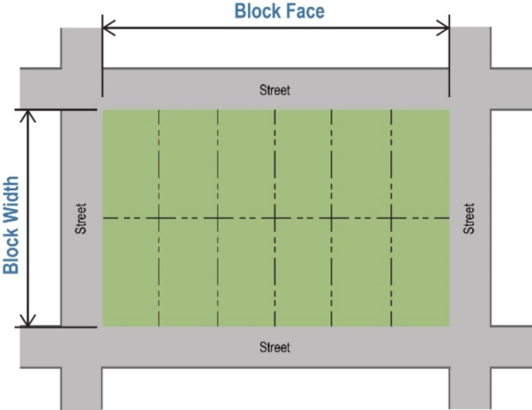
Figure V-2: Block Measurements
iii.
The planning commission may require the reservation of an easement through long blocks exceeding 1,000 feet in length to accommodate utilities, drainage facilities, or pedestrian traffic.
(A)
Pedestrian ways or crosswalks, not less than six feet in width, may be required by the planning commission through the center of a block, if deemed essential to provide circulation or access to schools, playgrounds, shopping centers, transportation, or other community facilities.
(B)
Blocks designed for nonresidential development shall be of a length and width, as determined suitable by the planning commission, and conform to the UDC, and other applicable ordinances.
b.
Exception. The planning commission may approve block lengths that deviate from the typical range if needed to ensure the proper projection of existing major arterials and existing platted blocks.
c.
Street length.
i.
For a typical street segment, street length means the distance following the centerline of the intersecting centerlines of the improved roadway between traffic control devices or culs-de-sac that halt vehicular movement (see Figure V.2: Measuring Street Length). The city engineer may approve a different street length than required by this subsection in industrial districts if the modified street lengths are needed to accommodate safe and efficient truck movements and do not cause a violation of the city's most recently adopted International Fire Code.
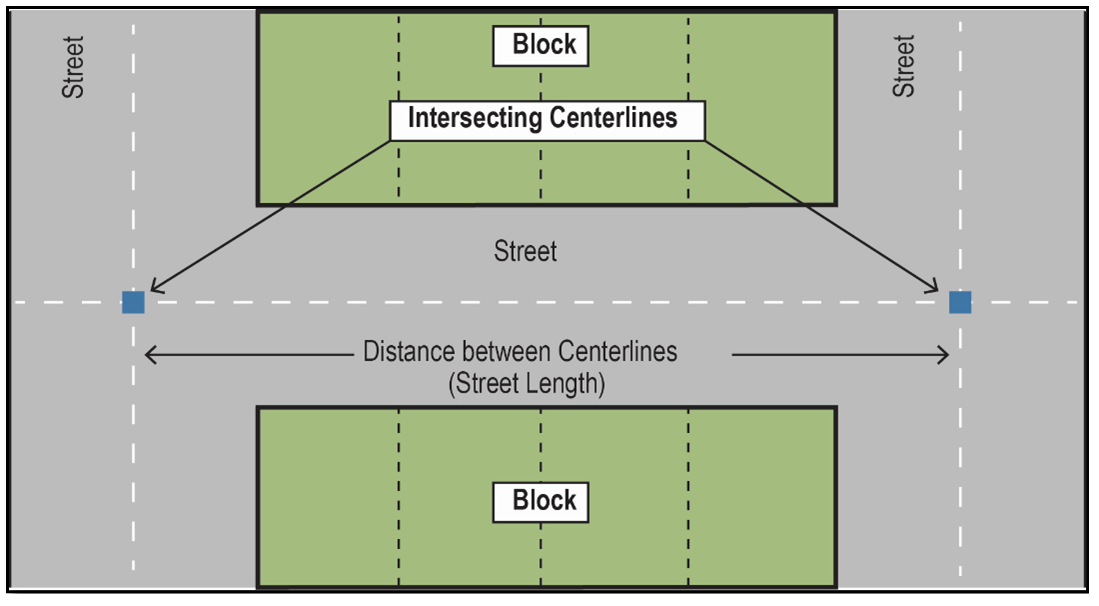
Figure V-3: Measuring Street Length
ii.
An L-shaped (elbow type) intersection is an intersection formed by the roadway centerlines of two different non-continuous street lengths where the interior angle formed by these intersecting street lengths is at least 72 degrees and no greater than 120 degrees (See Figure V-4: L-shaped (elbow type) Intersection). Each leg of an L-shaped (elbow type) intersection is considered a separate street section in determining street length.
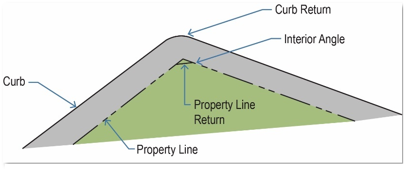
Figure V-4: L-shaped (elbow type) Intersection
iii.
Street segment. A street segment means the section of the street length that results from the placement of traffic calming devices (See Figure V-3: Traffic Calming Devices).
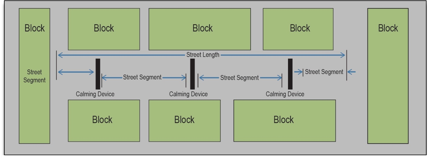
Figure V-5: Traffic Calming Devices
iv.
Maximum continuous street length.
(A)
No continuous street length shall exceed the requirements established in Table V.1: Maximum Street Length unless the following requirements are met.
Table V.1: Maximum Street Length
(B)
A street length may extend if:
(1)
An approved traffic calming device(s) as described in Division 5, section 22-221.D.6.b.ii. and Table V.2: Street Length and Traffic Calming;
(2)
The street intersects an arterial roadway; or
(3)
The street serves as an entrance street to the proposed neighborhood; or
(4)
The street provides an opportunity for traffic to pass from a street of a higher classification to another street link; or
(5)
The street width is at least 40 feet.
v.
School street length. For a new school development, all collector and local streets fronting the school require the placement of approved traffic calming devices, including signs and striping maintaining a street segment length of 200 to 400 feet.
d.
Waivers.
i.
The planning commission may waive block lengths and street lengths if the waiver is requested in writing and incorporates traffic impact mitigation measures into a site plan. This waiver is submitted in conjunction with a preliminary plat/replat application.
ii.
The planning commission may not grant a block length waiver unless traffic impact mitigation measures comply with standards (adopted here as minimum standards) of the latest version of the Institute of Transportation Engineers Manual of Transportation Engineering Studies.
iii.
A block length waiver shall not modify the proper extension of any street.
iv.
A block length waiver shall not compromise safety.
6.
Traffic calming.
a.
Purpose. Long streets, wide street cross sections, and uninterrupted traffic flows can encourage speeding on local streets. Traffic calming is a combination of physical measures that reduce the negative effects of motor vehicle use, alter driver behavior, and improve conditions for non-motorized street users. Traffic calming and street design standards slow traffic while allowing flexibility and design and offering applicants the choice of treatment that works best for the streets in a proposed development. Traffic control devices, notably stop signs and speed limits, are regulatory measures that require enforcement. Traffic calming measures are self-enforcing.
b.
Streets, street length, and traffic calming.
i.
Different street types and varying street lengths require traffic calming devices to help reduce travel speeds, improve safety, and promote walkability.
ii.
If the street segment criteria in division 5, section 22-221.D.5.c.iv. are surpassed, the applicant shall install a traffic calming device(s) including signs and striping, designed, and approved by the city. The applicant shall follow the standards prescribed in Table V.2: Street Length and Traffic Calming. This table allocates traffic calming devices according to different street types and their varying street lengths.
Table V.2: Street Length and Traffic Calming
c.
L-shaped (elbow type) intersections.
i.
These intersections require a traffic calming device if the street length to the center of the intersection, measured from the point where the projection of the center lines for the two street sections intersect, exceeds 600 feet.
ii.
Each leg of an L-shaped (elbow type) intersection is considered a separate street section.
iii.
When required, the traffic calming device(s) must maintain a maximum of 400 feet from the center of the L-shaped (elbow type) intersection.
iv.
Any proposed street section that includes an L-shaped intersection is measured beginning at the center of the intersection.
v.
L-shaped intersections with interior angles less than 72 degrees are not permitted.
vi.
Intersections with interior angles greater than 120 degrees are not considered an L-shape (elbow type).
vii.
Where the interior angle exceeds 120 degrees, a smooth curved roadway design with a minimum radius conforming to the standards for the particular geometric section are used.
viii.
Where two L-shaped (elbow type) intersections are used to determine the street length, street length shall not exceed 1,000 feet.
ix.
A longer street length may be allowed through the placement of an approved traffic calming device(s) at distances described in division 5, section 22-221.D.6.b.ii. and Table V.2: Street Length and Traffic Calming.
d.
Raised platform. If traffic calming is necessary on a roadway adjacent to a school, a raised platform will be used as a crosswalk.
e.
Location from intersections. Required traffic calming devices shall be located at least 150 feet from any intersecting street, cul-de-sac, and L-shaped (elbow type) intersections (except those devices specifically designed for intersections and crosswalks).
f.
Driveway locations. The plat shall clearly identify driveway locations for lots affected by any proposed traffic calming device during the platting process to restrict driveway location to that particular location. The city may also require modification of lots fronting a proposed traffic calming device to minimize impact to these residential lots.
g.
Installation.
i.
When a series of traffic calming devices needs installation, the same type of device(s) may be used for a particular street or area. The exact placement of any required traffic calming device is subject to the city engineer's review and approval.
ii.
The city engineer reviews and approves intersection approaches that require stop sign installation.
7.
Pedestrian facilities zones.
a.
Generally. Pedestrian facilities zones are areas within a street right-of-way that restrict vehicular through-traffic and designates space for pedestrian activities like walking and cycling. Sidewalks are required on both sides of streets within the right-of-way, including culs-de-sac, in conformance with the Americans with Disabilities Act (ADA), Public Right-of-Way Accessibility Guidelines (PROWAG), and the following standards.
b.
Pedestrian facilities zone standards.
i.
Pedestrian facilities zones are required for any development.
ii.
Pedestrian facilities zones include, but are not limited to, sidewalks, street plantings, patios, bollards, lighting, street furniture, on-street parking, bicycle lanes, cycle tracks, and recreational trails.
iii.
Pedestrian facilities zones may include drought-tolerant trees planted on both sides of the street.
iv.
Pedestrian facilities zones shall be well lit by providing lighting along streets. Lighting in pedestrian facilities zones shall meet the requirements established in division 5, section 22-221.D.10.
v.
Pedestrian facilities zones may provide on-street parking, bicycle lanes, sharrows, and cycle tracks per the Engineering Design Manual.
vi.
If on-street parking is allowed, then parking must encompass at least 20 percent of the street length.
vii.
All plats and associated development plans shall show pedestrian facilities zone features.
c.
Sidewalk standards.
i.
Sidewalks are required for all development. They are required as part of the platting improvements for land subdivision in all zoning districts.
ii.
Sidewalks shall be provided along all public and private streets abutting any development or redevelopment and any addition to a nonresidential structure exceeding 1,000 square feet in gross floor area.
iii.
Sidewalks shall be constructed parallel from a curb with at least three feet of space between the sidewalk and curb, except where the continuation of any existing sidewalk on adjacent property requires alternate placement.
iv.
The planning commission may require to facilitate pedestrian access from roads to schools, parks, playgrounds, or other nearby roads, perpetual unobstructed easements at least six feet in width. These easements shall be indicated on the plat.
v.
Sidewalks shall meet the construction requirements and specifications established in the Engineering Design Manual. If those standards do not apply, a sidewalk must provide a minimum width of five feet unless specifically mentioned elsewhere in this section.
vi.
Sidewalks shall be unobstructed.
vii.
Existing sidewalks shall not be removed except for the purpose of replacement.
d.
Fee in lieu of sidewalk improvements.
i.
Where an arterial street is designated for programmed capital improvements and for which the installation of sidewalks would be impractical, the applicant may, with the approval of the city engineer, pay a fee in lieu of sidewalk construction.
(A)
The fee in lieu of sidewalk improvements shall be in an amount established in the city's schedule of fees.
(B)
Fees shall be accepted to the city.
(C)
Fees shall be utilized for the costs and expenses incurred for the construction of the sidewalks at the time the capital improvements are constructed.
(D)
As used in this subsection, the fees are deemed accepted when the city receives the required funds.
ii.
For development that is subject to the fee in lieu of sidewalks, the applicant may, with the approval of the city engineer, install the sidewalks as provided by this section; provided such development shall still be subject to the applicable fee in lieu of provisions.
e.
Crosswalks and other pedestrian ways.
i.
Where sidewalks are provided, pedestrian crosswalks shall be provided at every arterial intersection. Crosswalks shall include painted or textured markings, signage at the crosswalk, and advanced signage to alert traffic of pedestrians.
ii.
Crosswalks, ramp orientation, and driveway cuts shall be as close to perpendicular to the road as possible and shall comply with the Engineering Design Manual to promote safe crossings.
iii.
All public and private walkways, trails, sidewalks, ramps, stairs, or other pedestrian or bicycle access routes shall meet the guidelines of the Americans with Disabilities Act and Oklahoma Department of Transportation (ODOT) Standard Specifications.
f.
Alternative proposals. The planning commission may authorize alternative proposals for pedestrian circulation in certain circumstances. Alternate proposal applications are submitted as part of the preliminary plat.
g.
Exceptions.
i.
Sidewalks are not required on local streets if the smallest lot in a new residential subdivision is more than 10,000 square feet in area.
ii.
Sidewalks are not required in industrial developments exceeding ten acres, where each lot within the development exceeds one acre provided, however, that the sidewalks are required along public streets, industrial collectors and access roads abutting the development if necessary to provide direct pedestrian access from residential neighborhoods to transit, shopping, or neighborhood schools as determined by the planning commission.
iii.
Sidewalks are not required for replats in existing residential subdivisions where the total area being replatted does not exceed 20,000 square feet.
h.
Double frontage lots. If double frontage lots are created for the purpose of separating residential property from arterials and collectors, the shoulder and sidewalk area of the arterial or collector conform to the following standards:
i.
Street tree planting conforms to the provisions established in this article and section 22-211.
ii.
Screening conforms to the provisions established in this article and section 22-212.
iii.
If the city proposes to maintain an unpaved shoulder area, it will consist of a pervious material. The applicant may also provide a low maintenance landscape plan. The proposed plan is subject to the planning commission's approval.
i.
Maintenance of pedestrian facilities. Unless maintenance is provided by and under homeowners' or property owners' covenants, each owner or occupant of any house or other building, and any owner or person entitled to possession of any vacant lot, and any person having charge of any facility or public building shall be responsible for maintaining the pedestrian ways, crosswalks, or sidewalks adjacent to their property. During the winter season, this shall include keeping the sidewalk free of snow or ice and at all other times shall keep the sidewalk in good and safe repair in a clean condition, free from obstructions or encumbrances.
j.
Bicycle facilities and recreational trails.
i.
The city may require the installation of bicycle route signage or other standard signage on street segments that are incorporated into the city.
ii.
The city may substitute extra-width lanes or designated bicycle lanes on street segments in lieu of trails.
iii.
All recreational trails shall comply with ADA and PROWAG requirements. All recreational trails shall be a minimum of eight feet wide to allow for two-way traffic. Recreational trails shall be surfaced as provided in the city's Engineering Design Manual.
iv.
If appropriate, recreational trails within a subdivision may be deemed by the city commission to satisfy part of the requirements of this section for sidewalks or open space for that subdivision.
v.
All streets shall utilize bicycle safe storm sewer inlets. Inlets along defined bicycle lanes on street segments shall be set back one foot behind the back of curb with ten feet of curb transition to each side of the curb inlet throat.
8.
Street medians.
a.
Generally. A street median is a roadway divider that separates opposing travel lanes. Street medians are typically provided for most street types.
b.
Standards. In addition to the requirements in the Engineering Design Manual, the following regulations apply to street medians.
i.
Raised street medians have drought-tolerant trees planted at a one tree per every 50 linear feet ratio. Tree canopies shall not encroach travel lanes.
ii.
Raised street medians provide lighting for vehicular movement. This lighting:
(A)
Uses light fixtures that directs 100 percent of light downwards;
(B)
Uses one light pole attached with either one or two lamps;
(C)
Limits light pole heights to a 20-foot maximum; and
(D)
Spaces light poles between 150 feet to 350 feet.
c.
Street medians with turning lanes. Street medians may have turning lanes. These lanes within street medians may be raised or unraised but have a ten-foot minimum width.
d.
Unraised street medians and turning lanes. Unraised street medians are permitted and may include turning lanes. Those unraised medians that include a turning lane shall have an 11-foot minimum width. No trees or lighting are permitted in unraised street medians.
9.
Pavement.
a.
Generally. Streets must safely service emergency response units, high traffic volumes, and transit vehicles by reliable pavement standards.
b.
Standards. Pavement standards and structure design shall follow the American Association of State Highway and Transportation Officials (AASHTO) Guide for Design of Pavement Structures' latest approved edition. A professional engineer registered in the State of Oklahoma prepares and signs the pavement design report. Pavement design requirements follow the regulations prescribed in the city's Engineering Design Manual.
10.
Street lighting.
a.
Generally.
i.
All new subdivisions (excluding replats of tracts where the standards below have been previously met) shall include street lighting.
ii.
The applicant shall present a plan to install street lighting in conformance with the standards below to the city engineer for approval prior to final plat submittal in conformance to the following standards below.
(A)
Arterial streets = 27,000 Lumens approximately every 300 feet of street length.
(B)
All other streets = 16,000 Lumens approximately every 300 feet of street length.
iii.
In addition to the standards below, additional lighting regulations and specifications from the Engineering Design Manual shall be met.
b.
Standards. Street lighting standards shall meet the following requirements:
The following street lighting standards apply:
i.
Street lights shall follow the spacing requirements established in Table V.3: Street Light Spacing in an alternating pattern.
ii.
All street lights shall have a minimum 20-foot mounting height.
iii.
All street lights shall use light fixtures that directs 100 percent of light downwards.
iv.
All street light poles shall be at least three feet from the street curb.
v.
Street lights shall be installed at all street intersections, at the end of culs-de-sac, and at intermittent spacing necessary as established in Table V.3: Street Light Spacing, to produce a minimum of 0.6 maintained foot candles for arterial and collector streets and 0.4 maintained foot candles for local streets with a uniformity ratio not exceeding 3 to 1.
Table V.3: Street Light Spacing
c.
Variations.
i.
Staff may approve minor variations by 20 feet in positioning of lamp poles due to lot and block configuration.
ii.
On streets that serve as exterior boundaries of the subdivision, the planning commission may allow alternate spacings for lamp poles if the adjacent land can be expected to develop and provide for its alternate half of the street lighting.
E.
Alleys.
1.
Alleys platted in residential or nonresidential developments shall be private, and will not be maintained by the city.
2.
Alleys may be provided in nonresidential districts. The planning commission may waive this requirement where other definite and assured provision is made for service access, such as adequate off-street loading, unloading and parking facilities consistent with and adequate for the uses proposed.
3.
Alley right-of-way serving nonresidential development shall not be less than 30 feet in width, and if provided, shall be paved in accordance with city standards and specifications.
4.
Placing utilities under paved alleys shall be avoided in nonresidential developments that contain utility lines.
5.
Alleys are not required in residential developments, but when provided, shall be paved in accordance with city standards and specifications.
6.
Alley intersections and sharp changes in alignment shall be avoided, but where necessary, corners shall be designed and constructed in such a manner to permit safe and convenient vehicular movement.
7.
When alley intersections are unavoidable, as in "T", "L" or "H" alley configurations, a sight triangle at each intersection corner shall be provided. Corner lines shall be cut with a chord to provide a sight triangle with legs of ten feet from the point of intersection along both alley right-of-way lines. The sight triangle shall be included in the alley easement.
8.
Dead-end alleys shall be avoided, but where unavoidable, shall be provided with adequate turnaround facilities at the dead-end, as determined by the most recently adopted International Fire Code.
F.
Private streets and gated subdivisions.
1.
Generally. Subdivisions with private streets and gated communities shall meet the following requirements:
a.
The developer shall comply with all other ordinances and regulations of the city.
b.
The definition of a "subdivision" and "street," as contained in the subdivision regulations, will apply to all subdivisions or streets, whether public or private.
c.
Property abutting a private roadway must comply with all applicable UDC regulations and other city ordinances and regulations.
d.
All private streets and gated subdivisions shall comply with the standards and specifications established by the city in the Engineering Design Manual.
e.
All applicable building setback lines shall be calculated from the private street easement.
f.
The private street shall not be dedicated to the public, and the city is not obligated to accept any private street.
g.
All plans concerning private roads and gated subdivisions are subject to review and approval by the city engineer.
h.
Pavement and utilities shall comply with the provisions established in division 5, section 22-221.D.1.f.
i.
Prior to approval of a private street, all abutting property owners shall enter into a legal agreement to assure maintenance and apportion of maintenance costs. The agreement shall clearly state that the city is not responsible for maintenance.
j.
Street stubs to serve potential future subdivisions and to improve the overall circulation pattern of the area shall be provided in any location deemed appropriate by the planning commission.
2.
Owner's responsibility. The person or corporation in control of the property is responsible for, and liable for, any violations of this private street requirement. This includes, but is not limited to, the developer, property owner, the homeowners' or property owners' association and its officers, if applicable, or others who may own or exercise control over the property.
3.
Private access drives. Private access drives, which are deemed to be "private streets or roadways", may be utilized to provide access to developments under the following conditions:
a.
Plat designation. Private access drives shall be lots designated as common area/private access drive on plats.
b.
Design and construction. Private access drives shall be designed and constructed to city specifications, which shall include minimum driving lane widths of 20 feet for one-way traffic and 24 feet for two-way traffic.
c.
Notice, maintenance, and accessibility. The provisions for notice, maintenance, and accessibility to public and emergency vehicles that apply to private streets in this section shall apply to private access drives.
d.
Sidewalks. Sidewalks shall be constructed in conjunction with private access drives in accordance with city requirements.
e.
Naming and addressing. Private access drives shall not be named on plats. Lots fronting or taking access from private access drives shall be addressed off the approved street from which the private access drive extends.
f.
Zoning. Private access drives shall not be utilized for access to lots that are zoned for industrial uses, or that are permitted to develop under industrial uses by planned unit development unless the drives are built to industrial collector street standards.
4.
Maintenance of private roads. The city shall not pay for any portion of the cost of constructing or maintaining a private street. The final plat shall include a statement acknowledging that the city is not responsible for construction, operation, maintenance, repair, or acceptance of private roads. Each deed shall state that the street is privately maintained.
5.
Plans and inspections. An applicant for a proposed subdivision with private streets must submit to the city the same construction plans and engineering information required to construct public streets and utilities. Requirements pertaining to inspection and approval of improvements prior to final plat approval shall apply. Fees charged for these services shall also apply. The city may periodically inspect private streets and require repairs necessary to ensure emergency access.
6.
Signs. The entrances to all private roads shall be marked with a sign stating that it is a private street. All private traffic regulatory signs shall conform to the Oklahoma Manual of Uniform Traffic Control Devices.
7.
Location.
a.
Subdivisions greater than 25 acres.
i.
Shall comply with adopted International Fire Code regulations;
ii.
Shall be adjacent to an arterial or collector street unless waived by the planning commission;
iii.
Shall provide at least one access point to the arterial street;
iv.
Shall contain 25 percent useable open space; and
v.
Shall provide at least three of the following amenities:
(A)
Private park;
(B)
Swimming pool;
(C)
Clubhouse;
(D)
Pedestrian walkways;
(E)
Lake;
(F)
Pond;
(G)
Golf course;
(H)
Gazebos;
(I)
Picnic areas;
(J)
Playground equipment;
(K)
Tennis courts; or
(L)
Director approved alternative.
b.
Subdivisions less than 25 acres.
i.
Subdivisions less than 25 acres shall be designed to allow for the continuation of existing interconnected streets in accordance with division 5, section 22-221.D.2.f.iii.
ii.
The proposed development shall not block existing connections.
iii.
The planning commission may, by variance, waive the requirement for the connection.
8.
Gates.
a.
The type of controlled access or security gate for a controlled access subdivision must comply with the following requirements for gate installation:
i.
Single opening.
(A)
Minimum 20-foot clearance width from curb face to curb face for one-way traffic.
(B)
Minimum 24-foot clearance width from curb face to curb face for two-way traffic.
(C)
Minimum 60-foot gate setback from curb line to gate face.
(D)
Drives shall be arranged to provide the ability for a vehicle to turn around without backing into the street.
ii.
Dual openings.
(A)
Minimum 14-foot clearance width from curb face to curb face on both sides of a median.
(B)
Minimum 45-foot obstruction setback from curb line to first obstruction.
(C)
Minimum 60-foot gate setback from curb line to gate face.
(D)
Drives shall be arranged to provide the ability for a vehicle to turn around without backing into the street.
iii.
All gates shall have "Knox" hardware or other hardware approved by the fire marshal's office.
iv.
All gates will remain in the open position (unassisted) until gate device is reset.
v.
Automatic gates shall have a battery backup.
vi.
Permits for fence and gate installations are required by the this Code.
vii.
Each gate installation may have additional requirements specific to that location based on approval of the fire marshal's office.
b.
Setback required. Approach and departure areas on both sides of a gated entrance must provide adequate setbacks and proper alignment to allow free and unimpeded passage of emergency vehicles through the entrance area.
9.
Homeowners' or property owner's association required.
a.
Subdivisions developed with private streets and alleys must have a mandatory homeowners' or property owners' association that includes all property to be served by private streets. The association shall own and be responsible for the maintenance of private streets, common areas, drainage ponds and channels, and other appurtenances.
b.
The association documents must establish a reserve fund for the maintenance of streets and other improvements. The documents shall be filed of record with the Pottawatomie County Clerk's Office prior to the approval of the final plat. Lot deeds must convey membership in the association and provide for the payment of dues and assessments required by the association.
10.
Construction and utilities. Water, sewer, drainage facilities, road lights, and signs placed within the private street and alley lot shall be installed to city standards prior to approval of the final plat.
11.
Visitor entrance design standards.
a.
At least one entrance to a subdivision with private streets shall be equipped for visitor access.
b.
In addition to meeting the above design standards, the visitor entrance shall be equipped with a call or code box located at least 50 feet from the boundary of the subdivision to provide for visitors calling in an automobile queuing.
c.
A knox box meeting the specifications of the adopted International Fire Code shall be provided at the visitor entrance for access assurance for emergency services.
d.
A turnaround space with a minimum outside radius of 30 feet shall be located between any call or code box and the access control device to allow vehicles denied access to safely exit onto public streets in a "head-out" position.
e.
A sign shall be erected next to the edge or such turnaround space to prohibit vehicle parking in such space.
f.
A resident entrance used in combination with a visitor entrance shall comply with the requirements of this subsection.
12.
Resident only entrance design standards.
a.
In addition to [subsection] 11. above, an access control device that requires residents to use a key, card, or code to gain access shall be set back internally a minimum of 50 feet from the boundary of the subdivision to provide for automobile queuing; except that resident entrances equipped with an electronic opener that allows residents to remotely open the access control device and enter the subdivision without having to stop are exempt from this requirement.
b.
A sign shall be erected next to any resident entrance that does not meet the 50-foot setback requirement of this paragraph and does not provide a turnaround space with a minimum outside radius of 30 feet to indicate that it is for resident use only and not for visitors.
G.
Easements and utilities.
1.
The applicant shall dedicate to the public easements to the end that each and every lot within a subdivision shall have access to all available essential public utilities.
2.
Easements shall follow the requirements established Table V.4: Easement Requirements.
Table V.4: Easement Requirements
3.
Private improvements on utility easements shall be avoided; however, when improvements such as fencing, landscaping, driveways, or parking are placed upon utility easements, the property owner shall be responsible for replacement or repair of any improvements when utilities must be repaired or replaced.
4.
Aerial easements and easements of greater width for either extension of main sanitary sewers or other utilities, storm sewers and drainage, or the accommodation of utilities in unique situations such as, but not limited to, lots backing onto unplatted land may be required where it is deemed necessary by the planning commission.
5.
Where a subdivision is traversed by a water course, drainage channel or stream, there shall be provided a right-of-way or easement for drainage, public open space and utility purposes as established in division 5, section 22-221.H.2.
6.
Utility location.
a.
A minimum horizontal distance of ten feet shall be maintained between parallel water and sanitary sewer lines, unless otherwise specified.
b.
The placement of utilities within a 20-foot easement shall be as follows:
i.
The electric line shall be located in the easement six feet north or east of the centerline.
ii.
The communication line shall be located in the easement four feet of the centerline and shall be installed to industry standards.
iii.
The sanitary sewer and water lines shall be located in the easement center line south or west of the centerline if the water line is separated by at least two feet above the sanitary sewer line, and shall generally comply with ODEQ standards and specifications.
iv.
The natural gas line shall be located within the easement six feet south or west of the centerline.
c.
The placement of utilities within 15-foot easements shall be as follows:
i.
The electric line shall be located within the easement three and one-half feet north or east of the centerline.
ii.
The communication line shall be laid located within the easement five and one-half feet of the centerline and shall be installed to industry standards.
iii.
The sanitary sewer and water lines shall be located on the easement centerline if the water line is separated by at least one foot above the sanitary sewer line.
iv.
The gas line shall be located within the easement three and one-half feet south or west of the centerline.
d.
The depth of the utility lines shall be as follows:
i.
Electric lines, communication lines, and natural gas lines shall be laid at a depth in accordance with utility provider standards.
ii.
The water line shall be laid at a minimum depth of four feet.
iii.
The sewer line shall be laid at a depth in accordance with standard engineering practices and ODEQ minimum slope requirements, as approved by the city engineer.
7.
Construction of utilities.
a.
Electrical lines, telephone or television cables, and gas mains shall not be buried in public easements prior to the installation of required water, sewer and stormwater drainage improvements being constructed; provided that in all cases the lines having the greatest depth shall be constructed first.
b.
As an exception, the city engineer may permit the construction of utility tunnels and conduits which meet city criteria and standards prior to the construction of water, sewer or stormwater drainage improvements.
8.
Conflicting easements. When existing private easements may potentially interfere with a proposed public dedication or easement, the subdivision shall be designed to minimize the number and extent that such existing private easements cross public easements.
9.
Reserve strips. The creation of reserve strips shall not be permitted adjacent to undeveloped property in such a manner that it denies access from adjacent property to public utilities. Utility easements shall extend to the exterior boundary of all plats to facilitate the extension of public utilities to adjacent property.
H.
Drainage and storm sewers.
1.
Generally.
a.
Drainage provisions required.
i.
Any site development work involving the disturbance of one or more acres of land shall be subject to the drainage standards prescribed in the Engineering Design Manual. Land disturbance includes grading, excavation, filling, and clearing.
ii.
The planning commission shall not recommend for approval any plat or subdivision that does not make adequate provision for site drainage to preclude the creation or aggravation of flooding or erosion issues (onsite or offsite) as a result of site development.
iii.
The stormwater drainage system shall be separate and independent of any sanitary sewer system.
iv.
Lots shall be laid out to provide positive drainage away from all buildings, and individual lot drainage shall be coordinated with the general storm drainage pattern for the area. Drainage shall be designed to avoid concentration of storm drainage water from each lot to adjacent lots.
v.
Each lot or site within the subdivision shall have access to an approved street that is free of excess stormwater as per the conditions prescribed in the Engineering Design Manual.
vi.
No subdivision shall be approved which would permit building within a regulatory floodway of any stream or watercourse. The planning commission may, when it deems necessary for the health, safety, or welfare of the present and future population, prohibit the subdivision of any property that is encumbered by a designated regulatory floodway of any stream or watercourse. Subdivision of any property that is encumbered by a designated regulatory floodway of any stream or watercourse will only be permitted if the drainage plans meeting the requirements of the Engineering Design Manual are provided. These provisions also shall also apply in cases where a creek, channel, or other identified flow path for stormwater runoff not identified by FEMA as regulatory floodways is present on a property being proposed for subdivision. In no instance, shall these provisions conflict with chapter 14 of this Code.
vii.
No lot or site within a subdivision shall derive sole access to an approved street through a regulatory floodplain unless such access shall be so designed to remain open under base flood conditions.
viii.
Areas subject to inundation under base flood conditions shall be indicated with the minimum floor elevation (at least one foot above the base flood level) of each lot so affected on a certified letter from a qualified engineering professional. This requirement shall comply with chapter 14 of this Code.
b.
Drainage plan required.
i.
A drainage plan shall be submitted with the preliminary plat in compliance with the requirements of the Engineering Design Manual.
ii.
Proposed development shall not create or aggravate flooding or erosion on the property being subdivided or any other property.
c.
Freeboard required. Freeboard requirements shall comply with chapter 14 of this Code.
d.
Capacity required. All subdivisions shall provide the required capacities as established in the Engineering Design Manual.
e.
Accessibility to public storm sewers. Where a public storm sewer is accessible, the applicant shall install storm sewer facilities, or if no outlets are within a reasonable distance, adequate provision shall be made for the disposal of stormwater, subject to the specifications of the city engineer.
f.
Accommodation of upstream drainage areas. All development shall provide a culvert or other drainage facility to accommodate existing upstream conditions.
2.
Dedication of drainage easements.
a.
Generally.
i.
When a subdivision is traversed by a watercourse, drainageway, channel, or stream, there shall be provided a drainage easement or right-of-way conforming substantially to the lines of such watercourse, with width and construction conforming to the Engineering Design Manual. Wherever possible, it is desirable that the drainage be maintained by an open channel.
ii.
In cases where stormwater runoff is conveyed via an underground pipe system not located in the street right-of-way, drainage easements conforming to the requirements of the Engineering Design Manual shall be dedicated and depicted on both the preliminary and final plat documents.
iii.
Drainage easements shall extend from the road to a natural watercourse or to other drainage facilities which the applicant's engineer has demonstrated, by the criteria of the Engineering Design Manual, has the capacity to receive the runoff without creating or aggravating flooding or erosion.
iv.
When a proposed drainage system will carry water across private land outside the subdivision, appropriate drainage rights must be secured by the owner of the property being subdivided and indicated on the plat.
3.
Detention and retention pond design.
a.
Purpose. Storage of stormwater runoff within a stormwater management system is a common method of providing extended detention of stormwater flows for water quality protection and downstream streambank erosion protection, as well as for peak flow attenuation of larger flows for flood protection.
b.
Detention and retention ponds. Detention ponds are designed to drain a runoff volume over a specified period of time, typically 24 hours, and provide for streambank protection. Detention ponds are designed to completely drain after a storm has passed. Retention ponds also serve to drain runoff, but have the added feature of a permanent pool.
c.
Pond standards. When a detention or retention pond is used to accommodate drainage, the following standards shall apply unless otherwise provided by the city engineer.
i.
Drainage easements and features shall be included as a portion of buildable lot(s) and not as a lot by itself unless specifically authorized by the city engineer.
ii.
Ponds shall be built to the capacity to detain the rate of stormwater runoff leaving the development at or below the pre-development peak runoff rate (Q) for all storm events, including the 2-, 10-, 25-, 50-, and 100-year storms.
iii.
Extended detention and release rate.
(A)
Ponds shall provide for the extended detention of stormwater to be released at a peak rate that precludes adverse impact to downstream property, protects water quality, and prevents streambank erosion. Due to the unique nature of each site and design of the ponds, the release rate may vary, as determined by the city engineer.
(B)
Stormwater runoff may be released over 24 hours after a designed storm has passed.
iv.
In addition to showing ponds on the drainage plan, ponds shall be shown on and approved with construction plans.
v.
Pond designs shall include a maintenance plan and bond for the removal of sediment and continued operation of the pond in a clean and sanitary manner.
vi.
In order to accommodate subdivisions that are developed in phases, multiple ponds may be constructed and shall detain the runoff from associated phases and any upstream runoff contributing to the inflow of the pond.
vii.
Ponds shall be built in the first phase of the subdivision and maintained throughout construction of all phases of development that have the potential to contribute stormwater runoff into the pond. Increased runoff rates or the concentration/acceleration of runoff leading to the risk of erosion are prohibited at all points of the site development project.
viii.
In some circumstances, the location of a property being subdivided for development within the drainage basin may make the requirement to provide detention/retention unnecessary. The city engineer has the right to review the engineering basis for such a determination presented by the property owner's engineer and waive the detention/retention requirement if deemed appropriate.
d.
Pond design requirements. All ponds shall meet the design requirements established in the city's Engineering Design Manual.
e.
Method for determining peak flows. The determination of peak flows shall use one of the methods identified in the Engineering Design Manual, or another commonly accepted method as approved by the city engineer.
I.
Conservation easement or setback along waterways.
1.
Purpose. The conservation easement or setback is intended to limit physical disturbance of the land along waterways to prevent erosion and protect water quality.
2.
Applicability.
a.
The conservation easement or setback is required for all development USGS blue line designated rivers and streams.
b.
These requirements apply to zoning and subdivision applications.
3.
Required buffer width.
a.
The following conservation easement or setback shall be provided, measured from the waterway centerline and as designated by the USACE.
i.
Rivers—150 feet;
ii.
Major streams—100 feet; and
iii.
Minor streams—50 feet.
b.
The conservation easement or setback shall be recorded on all plats and site plans.
4.
Development restrictions.
a.
Conservation easement or setback may be used for low-impact activities, such as recreation and entertainment purposes, that do not disturb the natural environment.
b.
Conservation easement or setback shall remain free of construction, development, tree removal, or other alterations except for utility and roadway crossings, parks, and stormwater detention structures. The number of crossings through a conservation easement or setback shall be minimized. Stormwater treatment facilities, agricultural uses, golf courses, septic systems, or wastewater irrigation shall not be located in the conservation easement or setback.
J.
Water facilities.
1.
Generally.
a.
The applicant shall provide a water supply and distribution system capable of meeting water use and fire protection requirements in accordance with this section and other applicable ordinances, standards and regulations.
b.
All water mains installed within a subdivision must extend to the borders of the subdivision as required for future extensions of the collection system, regardless of whether those extensions are required for service within the subdivision.
c.
The location of all water improvements shall be shown on the preliminary plat, and the cost of installing the same shall be borne by the applicant.
d.
Water facilities shall meet the latest specifications issued by AWWA, ASTM, ANSI, and NSF.
e.
Water facilities shall meet the standards and requirements as established by ODEQ.
2.
Water supply for subdivisions.
a.
Generally. Subdivisions within the area designated for development by the comprehensive plan shall satisfy the provisions of this section.
b.
Water distribution system.
i.
The applicant shall, at their expense, provide a water distribution system capable of supplying water to each lot within the subdivision, including water service connections to each lot.
ii.
Where the lot is for other than residential development and the size of the connection cannot, therefore, be readily predetermined, the city engineer shall waive the construction of water service connections to each lot.
iii.
All construction must comply with the city's standards and specifications and must be approved by the city engineer in accordance with current water main policy for all distribution lines, water service connections, and external boundary lines.
iv.
In no instance are dead ends allowed.
v.
Hydraulic analysis shall be provided and follow the requirements as established by ODEQ.
vi.
Air relief valves shall be provided at high points in the system as established by ODEQ.
c.
Public water supply is reasonably accessible.
i.
Where an approved public water supply is reasonably accessible or procurable, the subdivider shall connect with that water supply. For purposes of this section, a public water supply is considered "reasonably accessible" if an existing or funded water main serves any quarter-section in which the subdivision is wholly or partially located or is within one-half mile of any exterior boundary of the subdivision, whichever is the greater distance.
ii.
Water supply is considered "procurable" unless the city or other public agency owning and maintaining the public water system cannot or will not, by reason of statute, ordinance, regulation, or policy, furnish water to the subdivision.
iii.
All water main construction must conform to the city's standards and specifications, ODEQ requirements, and must be approved by the city engineer.
iv.
The planning commission may vary these provisions under special circumstances.
d.
Public water supply is not reasonably accessible.
i.
Where an approved public water supply is not reasonably accessible or procurable, the applicant may provide a private water supply system.
ii.
These systems shall comply with the requirements of the state board of health and ODEQ and shall have sufficient quantity to meet domestic needs and fire protection requirements of the subdivision.
iii.
The system shall be constructed in accordance with city specifications and must be approved by the city engineer.
iv.
The planning commission may vary these provisions under special circumstances.
e.
Water wells.
i.
Water wells serving individual lots shall not satisfy the water facility requirements for subdivisions located within the areas designated for urban development by the comprehensive plan.
ii.
The planning commission may vary these provisions under special circumstances.
f.
Fire hydrants.
i.
Fire hydrants shall be required for all subdivisions and adhere to the latest ODEQ design requirements, Section 252:626-19-3.
ii.
The minimum fire hydrant lead size shall be six inches.
iii.
Fire hydrants shall be located at the prescribed locations as required by the adopted International Fire Code.
K.
Wastewater/sewer facilities.
1.
Generally.
a.
The applicant shall provide a sewage collection and disposal system in accordance with this section, ODEQ standards, and other applicable ordinances, standards and/or regulations.
b.
All laterals and sewer mains installed within a subdivision must extend to the borders of the subdivision as required for future extensions of the collection system, regardless of whether those extensions are required for service within the subdivision.
c.
The location of all wastewater improvements shall be shown on the preliminary plat, and the cost of installing the same shall be borne by the applicant.
2.
Requirements. Subdivisions within the area designated for development by the comprehensive plan shall satisfy the provisions of this section.
a.
Sewage collection system. The applicant shall, at their expense, provide a sewage collection system available to each lot within the subdivision. All such construction must comply with the city's standards and specifications, ODEQ's minimum slope requirements, and must be approved by the city engineer.
b.
Public sewer system is reasonably accessible.
i.
Where an approved public sewer system is reasonably accessible or procurable, the applicant shall connect with that sewer system. For purposes of this section, a public sewer system is considered "reasonably accessible" if an existing or funded sewer main serves the watershed into which the subdivision naturally drains and is within one-half mile of any exterior boundary of the subdivision. In certain instances, any gravity/slopes must be appropriate for connection within one-half mile of any exterior boundary of the subdivision.
ii.
Sewer service is considered "procurable" unless the municipality or other public agency owning and maintaining the public sewer system cannot or will not, by reason of statute, ordinance, regulation, or policy, accept sewage from the subdivision.
c.
Public sewer system is not reasonably accessible.
i.
Where an approved public sewer system is not reasonably accessible or procurable, a septic or on-site sewage facility (OSSF) may be utilized, if that treatment system meets all applicable water quality criteria established by ODEQ and is constructed or installed in accordance with the city's standards and specifications and is approved by the city engineer.
ii.
The applicant shall assume full responsibility for the operation and maintenance of the facility. To satisfy this requirement, the applicant may:
(A)
Secure a binding agreement from the city, other local government, or other public agency for operation and maintenance of the facility; or
(B)
Provide for operation and maintenance of the facility by duly constituted homeowners' association or other entity that, in the judgment of the planning commission, can be reasonably expected to carry out this responsibility.
d.
Septic tanks and on-site sewage facilities (OSSF). Septic tanks and on-site sewage facilities (OSSF) are not approved means of wastewater collection and treatment, unless approved by ODEQ and shall meet the requirements below.
i.
Each lot served by septic tanks and on-site sewage facilities (OSSF) shall conform to standards established by ODEQ (Oklahoma Department of Environmental Quality).
ii.
Each lot shall have approved percolation results by the state health department prior to approval of the final plat;
iii.
Each lot shall contain adequate area for the installation of a minimum of 400 feet of septic tank lateral lines;
iv.
No part of any septic tank, laterals, or on-site sewage facilities (OSSF) shall be located closer than 20 feet to the rear of the building line, and no closer than five feet to any property line.
v.
Alternatively, an aerobic irrigation system may be used but shall comply with industry standards and must be approved by the city engineer.
vi.
In residential subdivisions where septic tanks or on-site sewage facilities (OSSF) are to be installed, the following lot areas shall be required:
(A)
Lots with water wells and septic tanks shall maintain a minimum of two acres per lot.
(B)
Lots only with septic tanks shall maintain a minimum one acre.
(C)
Lots utilizing septic tanks or on-site sewage facilities (OSSF) shall maintain a minimum lot width of 100 feet measured at the required building line.
L.
Stormwater pollution prevention.
1.
Generally. In conjunction with the construction plans, the applicant shall submit a stormwater pollution prevention plan. The purpose of the stormwater pollution prevention plan is to ensure adequate measures are in place to prevent erosion during and after construction.
2.
Design requirements.
a.
Grading, erosion control practices, sediment control practices, and waterway crossings shall be adequate to prevent transportation of sediment from the site to the satisfaction of the city engineer.
b.
Cut and fill slopes shall be no greater than 3:1, except as approved by the city engineer.
c.
Phasing shall be required on all sites disturbing greater than 30 acres, with the size of each phase to be established at plan review and as approved by the city engineer.
d.
Erosion control requirements shall include the following:
i.
Soil stabilization shall be completed within five days of clearing or inactivity in construction.
ii.
If seeding or another vegetative erosion control method is used, it shall become established within two weeks, or the city engineer may require the site to be reseeded or a nonvegetative option employed.
iii.
Special techniques on steep slopes or in drainage ways shall be used to ensure stabilization.
iv.
Soil stockpiles must be stabilized or covered at the end of each workday.
v.
The entire site must be stabilized, using a heavy mulch layer or another method that does not require germination to control erosion, at the close of the construction season.
vi.
Techniques shall be employed to prevent the blowing of dust or sediment from the site.
vii.
Techniques that divert upland runoff past disturbed slopes shall be employed.
e.
Sediment controls requirements shall include:
i.
Settling basins, sediment traps or tanks, and perimeter controls.
ii.
Settling basins that are designed in a manner that allows adaptation to provide long term stormwater management, if required by the city engineer.
iii.
Protection for adjacent properties by the use of a vegetated buffer strip in combination with perimeter controls.
f.
Waterway and watercourse protection requirements shall include:
i.
Review of Section 404 of the Clean Water Act, which regulates dredged or fill material into waters of the United States, including wetlands. If a 404 permit is required, then the applicant must provide the approved permit from the Corps of Engineers prior to receiving a permit.
ii.
A temporary stream crossing installed if a wet watercourse will be crossed regularly during construction.
iii.
Stabilization of the watercourse channel before, during, and after any in-channel work.
iv.
On-site stormwater conveyance channels.
v.
Stabilization adequate to prevent erosion located at the outlets of all pipes and paved channels.
g.
Construction site access requirements shall include:
i.
A temporary access road provided at all sites.
ii.
Other measures required by the city engineer to ensure that sediment is not tracked onto public roads by construction vehicles or washed into storm drains.
M.
Low-impact development (LID). The city supports subdivision designs that incorporate low-impact development best management practices for reducing runoff and mimicking a site's predevelopment hydrology by minimizing disturbed areas and impervious cover and then infiltrating, filtering, storing, evaporating, and detaining stormwater runoff close to its source. Low-impact development practices include measures such as preserving undeveloped open space, biofiltration, reducing impervious cover, and using porous pavement.
N.
Parkland.
1.
Purpose. The purpose of this section is to ensure that new development allocates resources for accessible and useable parks, open space, and recreational facilities proportional to the impact of the development and its contribution to increased demand for such facilities. The city commission adopts this section in furtherance of the goals and recommendations of the comprehensive plan.
2.
Applicability.
a.
This section applies to any development other than those exempted in subsection b. below.
b.
The following development is exempt from the requirements of this section:
i.
Property less than two net acres.
ii.
Property platted prior to the adoption of this UDC.
iii.
Replats of property if no increase in dwelling units will occur.
iv.
Property zoned Transitional Agriculture (TA) District.
v.
Property to be used as a public building or use, a school, or a religious land use.
3.
Dedication requirements.
a.
The city commission may elect to accept parkland dedication or refuse the dedication and require payment in lieu of dedication for any new development.
b.
Development in properties zoned residential must dedicate public parkland at the rate of one acre of parkland per 100 dwelling units or prorated portion thereof as depicted on the approved final plat.
c.
Development of multi-family residential or mixed-use must dedicate parkland at the rate of one acre of parkland per 100 dwelling units or prorated portion thereof based on the number of units approved at the recording of the final plat.
d.
Development exempted from a preliminary plat must dedicate public parkland at the time of final plat. Development with an existing final plat must dedicate public parkland at the time of application for the first building permit.
e.
Any residential or mixed-use development that is required to make payment in lieu of dedication must pay into the park dedication fund a fee of $300.00 per dwelling unit consistent with [subsections] b. and c. above.
f.
Future increases to the number of dwelling units will increase the dedication required in accordance with the rate in place at the time of the amendment unless the previous dedication or payment in lieu made under this section was based upon the highest density allowed for the district rather than number of units.
g.
Unless subject to a development agreement that supersedes this section, nonresidential development must pay into the park dedication fund a fee of $500.00 per acre of development.
4.
Standards for parkland property.
a.
Land dedicated for park, open space, and recreation purposes must, at a minimum, comply with the following area and location standards:
i.
The land must be at least one acre in size. Land may be considered contiguous if it abuts both sides of a street and the separate areas are joined by a marked pedestrian crossing;
ii.
The land must provide a minimum of 200 feet of street frontage;
iii.
The land must have a minimum width of 50 feet;
iv.
The land must be centrally-located to the population of the neighborhood, community, or phase of development it will serve;
v.
The land must be situated to allow convenient pedestrian and bicycle access in addition to facilities for vehicle parking;
vi.
Up to 25 percent of drainage areas or areas with undulating topography or slopes exceeding five percent are acceptable if the areas are to remain in their natural state and will preserve one or more significant features such as creeks, watersheds, viewsheds, native clusters of trees, or habitat for native or migratory species;
vii.
Land subject to inundation by a 100-year flood will not be accepted as parkland for the purposes of satisfying dedication requirements.
b.
Land dedicated must be shown as dedicated on a final plat and be free from any of the following:
i.
Human inhabitants;
ii.
Hazards, including scrap material, junk, vehicles or equipment, above-ground or below-ground environmental contaminants, or holding tanks;
iii.
Encumbrances of any kind, including deed restrictions, liens, or easements, unless they confer to the benefit of the city or will not interfere with use of the property as a park;
iv.
Other undesirable objects or features that may accrue to the liability of the city based upon an inspection the city conducts at its discretion prior to accepting the land for dedication.
c.
Land dedicated must be preserved in its pre-developed state and may not be used for construction activities or storage of materials or equipment during construction of the subdivision or development, unless otherwise specified in a development agreement.
d.
The city commission may, at its sole discretion, modify these standards for land dedication that furthers the city's goals of protecting areas of environmental sensitivity and linking multiple properties outside of the subdivision or development requiring the dedication, or to provide natural area parks or preserves or special use parks where identified in the comprehensive plan.
5.
Required improvements to parkland property.
a.
The following are the minimum designed elements to be included in dedicated parkland and must be reflected on associated construction plans for the subdivision or development at the time of construction plan approval:
i.
Curb and gutter along all streets abutting the boundary of the parkland.
ii.
The same level of utilities provided within the abutting subdivision or development must extend to the boundary of the parkland or as approved by the city engineer (utilities include, but are not limited to, water, wastewater, electricity, and fiber optic communication lines).
iii.
Above-ground survey markers installed at the corners of all property lines.
iv.
Any improvements required under a development agreement, planned unit development, or otherwise agreed to in writing between the developer and the city.
b.
Construction of the improvements must be completed within three years of the city's approval of the first final plat of the subdivision or development.
c.
Where the applicant is to provide improvements within parkland or abutting the parkland, the subdivider or developer must provide financial security consistent with division 5, section 22-222.
6.
Alternatives to parkland dedication.
a.
If suitable land for parkland dedication is not available, the applicant may propose one or more of the following payments in lieu of dedication:
i.
Improvements the applicant pledges to perform or provide in existing city parks;
ii.
Providing private park space or amenities up to 50 percent of the required public parkland dedication, provided that the private park conforms to the following:
(A)
The property is deed restricted for use as a park;
(B)
The property is shown on the final plat as parkland or common area;
(C)
The park is built to the standards of a public park and conforms to the intent of the comprehensive plan; and
(D)
The park is owned and maintained by a homeowners' association.
b.
The city shall determine the amount of the fee at the time of preliminary plat approval, and the applicant must pay all fees before recording a final plat.
c.
The city will reserve the contributed fees for the purpose of land acquisition, construction of improvements associated with parkland, and purchase of equipment to the most direct benefit possible to the residents of the subdivision or development.
(Ord. No. 2806NS, § 1(Exh. A), 8-19-2024)
Sec. 22-222. - Performance guarantees and maintenance.
A.
Purpose. Performance guarantee and security requirements are established to address those circumstances under which an applicant wishes to receive final plat approval and record the approved final plat before installing required infrastructure and public improvements. The provisions help ensure that funding is in place to cover the cost of installing any required improvements that are not installed by the applicant within a reasonable period of time after receiving final plat approval.
B.
Term of agreement. The term of a performance guarantee shall not exceed two years. If the applicant has not completed the required infrastructure and public improvements within the two-year period, the director is authorized to approve one extension of up to six months in duration. Any additional extensions or extensions of a longer duration require approval of the planning commission. Approval authorities/decision-making bodies are authorized to require updated improvement cost estimates and additional security as a condition of any extension granted.
C.
Form and amount of security.
1.
Security must be in the form of an irrevocable letter of credit, cash, or another instrument readily convertible to cash, as approved by the city attorney or district attorney. The performance guarantee and security must be conditioned upon the performance of all work necessary to complete the required infrastructure and improvements.
2.
The estimated total cost of any required infrastructure and improvements that have not been installed by the applicant prior to recording of the approved final plat must be itemized by improvement type and certified by the applicant's registered engineer. Cost estimates must be based on industry norms within Shawnee.
3.
The amount of the performance guarantee must equal at least 110 percent of the estimated total cost of all required infrastructure and improvements that have not been installed by the applicant prior to recording of the approved final plat.
D.
Default and use of security. If the applicant fails to properly install required infrastructure and improvements within the term of the guarantee and any approved extension, the guarantee will be deemed in default. In the case of default, the city is authorized to draw or foreclose upon the security funds to fund completion of the required infrastructure and improvements or to contract for installation of the required infrastructure and improvements. If the cost of completing the required infrastructure and improvements exceeds the security amount, the applicant is liable for all excess costs. Any security funds to be drawn upon or foreclosed will be subject to an administrative fee that reflects the city's actual costs associated with preparing bid documents and preparing and administering a contract for the work to be completed.
E.
Release of security. The security must be released once all the following occur:
1.
The conditions of the performance guarantee have been completed to the satisfaction of all agencies with jurisdiction over the improvements;
2.
Any required maintenance guarantee has been provided per applicable city or county regulations;
3.
A final inspection has been conducted by the city engineer or other qualified professional selected by the city engineer and retained by the applicant;
4.
Written evidence has been submitted that all owners of the infrastructure and improvements have accepted ownership of the improvements;
5.
The applicant has provided as-built or record plans showing monuments, streets, curbs, sidewalks, and all other infrastructure and public improvements as they were installed; and
6.
All required certifications of completion have been provided.
F.
Plat vacation. Vacation of the plat as provided by state statute removes the obligation to construct improvements and constitutes grounds for release of any remaining financial guarantee.
G.
Maintenance guarantees and security.
1.
Maintenance guarantees and financial security must be provided in accordance with applicable city regulations.
2.
Maintenance bonds shall be filed in the following amounts:
a.
Paving, grading, and drainage:
i.
One hundred percent for one year;
ii.
Ten percent for four years.
b.
Water and wastewater/sewer: Ten percent for two years.
H.
Perpetual maintenance of common areas and improvements.
1.
Maintenance obligation for common areas and improvements.
a.
The obligation for perpetual maintenance of any common areas and public or private improvements within a development must be established by the developer and approved by the planning commission. This obligation must be provided for in the plat, or for developments not required to be platted, by a deed restriction or other appropriate document recorded with the county clerk.
b.
If multiple property owners will be responsible for perpetual maintenance and control of common areas and public or private improvements, a property owners association must be established. Each property owner, by acceptance of a deed to a property within the development, will be deemed to have agreed to be a member of the property owner's association and be subject to assessment for maintenance of the common areas and public or private improvements.
c.
If the entire development is to remain under single ownership, the common areas and public or private improvements must be maintained by the owner of the property.
2.
Declarations and covenants.
a.
Declarations and covenants guaranteeing ongoing maintenance of common areas and public or private improvements must be established within a deed of dedication accompanying a plat or, for developments subject to these regulations but not required to be platted, by a deed restriction or other appropriate document recorded with the county clerk.
b.
The declarations and covenants must expressly authorize the city to correct maintenance deficiencies in areas containing public improvements that the property owner or property owners association is required to maintain, and to recover actual costs and any legal fees from the subject property owner or property owners association if maintenance duties are not carried out, and to establish and enforce a lien against the property in the development for recovery of the costs and fees.
(Ord. No. 2806NS, § 1(Exh. A), 8-19-2024)