
South Salt Lake City
City Zoning Code
City Zoning Code
CHAPTER 17
10 - SUBDIVISION AND PLATTING
17.10.010 - Purpose, Policy, and Authority.
A.
The purpose of this Chapter is to:
1.
Protect and provide for the public health, safety, and general welfare of the citizens of the South Salt Lake City;
2.
Facilitate and encourage efficient orderly growth and beneficial Development of all parts of the City;
3.
Provide for adequate light, air, and privacy, to secure safety from fire, flood, collapsible soils and other geologic hazards, and other danger, and to prevent insufficient infrastructure or overcrowding of the land and undue congestion of population;
4.
Protect the character and the social and economic stability of all parts of the City;
5.
Regulate future growth and Development within the City in a manner which promotes the physical integration of diverse housing forms, the preservation of South Salt Lake community values, and the social integration of residents from diverse backgrounds in accordance with the General Plan;
6.
Provide procedures and standards for the physical Development of Subdivisions and other Uses of land and construction of Buildings and thereon within the City including, but not limited to, the construction and installation of Streets, curbs, gutters, sidewalks, drainage systems, water and sewer systems, design standards for public facilities and utilities, access to public Rights-of-Way, Dedication of land and Streets, granting easements for Rights-of-Way, and to establish fees and other charges for the authorizing of Development and for the improvement of land and Buildings thereon;
7.
Protect and conserve the value of land throughout the City and the value of Buildings and improvements upon the land, and to minimize the conflicts among the Uses of land and Buildings;
8.
Guide public and private policy and action to provide adequate and efficient transportation, water, sewerage, schools, parks, playgrounds, recreation, and other public requirements and facilities;
9.
Provide the most beneficial relationship between the Uses of land and Buildings and the circulation of traffic, throughout the City, having particular regard for the avoidance of congestion in the Streets and highways, and the pedestrian traffic movements appropriate to the various Uses of land and Buildings, and to provide for the proper location and width of Streets and Building Lines;
10.
Establish reasonable standards of design and procedures for Platting, Subdivisions, Re-Subdivisions, and Lot Line Adjustments, in order to facilitate the orderly layout and Use of land and to insure proper legal description and monumenting of all platted land;
11.
Ensure that public facilities are available and will have a sufficient capacity to serve the proposed Plat, Subdivision, Plat Amendment, Parcel Boundary Adjustment, or Lot Line Adjustment;
12.
Prevent the pollution or degradation of air, streams, and ponds, assure the adequacy of drainage facilities, and safeguard the water table;
13.
Minimize site disturbance, removal of native vegetation, and soil erosion;
14.
Encourage the wise use and management of natural resources throughout the municipality in order to preserve the integrity, stability, and beauty of the community and the value of the land;
15.
Preserve the natural beauty of South Salt Lake City and to ensure appropriate Development to complement the natural features; and
16.
Provide for open spaces through the most efficient design and layout of the land, including the use of flexible Density or cluster-type zoning in providing for minimum width and Area of Lots, while preserving the Density of land.
B.
Policy.
1.
The Subdivision or Platting of land and the subsequent amendment of a Subdivision Plat, the adjustment of Lot Lines therein, is required for the orderly, planned, efficient, and economical Development of property within the City.
2.
Development property shall be of such character that it can be used safely for Building purposes without danger to health or peril from fire, flood, landslide, mine subsidence, geologic hazards, or other menace.
3.
Land shall not be subdivided, re-subdivided, platted, or adjusted until available public facilities and improvements exist and proper provision has been made for drainage, water, sewerage, roads, trails, parks, public transportation facilities, and related improvements.
4.
The existing and proposed Public Improvements shall conform to the Roadways and Functional Classifications in the General Plan, designated City Road Profiles, the Official Land Use Map, the International Construction Codes, the 2017 American Public Works Association Manual of Standard Plans, Utah Chapter (as further specified in this Chapter) and the capital budget and program of the City.
C.
Authority.
1.
The Planning Commission is the land use authority to review, approve, and deny Plats for subdividing land or platting a legal Development Lot within the corporate limits of the City.
2.
The Planning Commission is the land use authority to approve Development in Subdivisions, Subdivision amendments, or Parcel Boundary Line or Lot Line Adjustments of land already recorded in the office of the County Recorder.
3.
A Plat, Subdivision, Subdivision amendment, or Parcel Boundary Line or Lot Line Adjustment is void if the Plat, Subdivision, Subdivision amendment, Parcel Boundary Line or Lot Line Adjustment has not been recorded, or has been recorded with the County Recorder's office without a prior approval by the Planning Commission and signature by the Planning Commission Chair, or in the case of a Parcel Boundary Line or Lot Line Adjustment, without prior written approval by the Community Development Director.
4.
A transfer of land that has not properly been subdivided, amended, or adjusted is voidable.
(Ord. No. 2020-02, § IV(Exh. C), 1-8-2020; Ord. No. 2022-08, § I(Exh. A), 4-13-2022; Ord. No. 2023-27, § 1(Exh. A), 9-12-2023)
17.10.020 - Interpretation and Conflicts.
A.
Interpretation. The provisions of these regulations are the minimum requirements for the promotion and preservation of public health, safety, and general welfare.
B.
Conflict with public and private provisions.
1.
Public provisions. Where any provision of these regulations imposes a restriction different from that imposed by any other provision of these regulations or any other ordinance, rule or regulation, or other provision of law, whichever provisions are more restrictive or impose a higher standard to protect the public health, safety, and welfare shall control.
2.
Private provisions. Where the provisions of these regulations are more restrictive or impose higher standards or regulations than a private easement, covenant, or other private agreement or restriction, the requirements of these regulations shall govern. The City does not enforce private covenants.
(Ord. No. 2020-02, § IV(Exh. C), 1-8-2020; Ord. No. 2023-27, § 1(Exh. A), 9-12-2023)
17.10.030 - Alteration or Amendment of Plats.
The Planning Commission may consider and resolve at a public hearing any proposed alteration or amendment of a Subdivision Plat, or Lot, including any proposed alteration to any Street, easement, or Alley that has been extinguished by law or, with the consent of its Owner, is proposed to be replaced with an equivalent Dedication. If the amended Plat is approved, signed by all property interest Owners, and recorded, the recorded Plat shall vacate, supersede, and replace any contrary provision in a previously recorded Plat on the same land.
(Ord. No. 2020-02, § IV(Exh. C), 1-8-2020; Ord. No. 2023-27, § 1(Exh. A), 9-12-2023)
17.10.040 - Vacation of Public Streets or Easements.
A.
Street. State law governs the process required to vacate a Public Street. The process varies according to the nature of the City's property interest in the Street and the manner by which the property was acquired.
1.
Typically, upon proper notice, Planning Commission recommendation, and a finding that the public and no person will be adversely affected by the vacation, the City Council may by Resolution, establish the fair market value basis for the purchase price of the vacated Right-of-way. In most circumstances, upon payment of fair market value, the Street will be vacated from the center line of the Right-of-way to each of the adjoining property Owners.
2.
The Planning Commission shall incorporate the vacated Street into the adjoining Lots or Parcels by Plat (or Plat Amendment). The vacation shall not be effective until the Plat (or Plat Amendment) is recorded.
B.
Utility Easement. State law governs the process to wholly vacate a utility easement. Amendments to utility easements can be made in the normal platting process, with the consent and mylar signature of the affected utility or utilities.
(Ord. No. 2020-02, § IV(Exh. C), 1-8-2020; Ord. No. 2023-27, § 1(Exh. A), 9-12-2023)
17.10.050 - Enforcement.
A.
No Owner, or Agent of the Owner, of any un-subdivided Parcel of land located in a proposed Subdivision, shall transfer, or sell any such Parcel before a Plat of such Subdivision has been approved by the Planning Commission in accordance with the provisions of these regulations, signed by all required parties and filed with the County Recorder.
B.
The Subdivision of any Lot or any Parcel of land, by the use of metes and bounds description for the purpose of sale, Transfer, or lease is unlawful. However, subject to all of the requirements contained in these regulations, the City may approve metes and bounds descriptions for purposes of Parcel Boundary Adjustment, Lot Line Adjustment, or judicial process, resolving conflicting boundary descriptions, and the recombination (but not Subdivision or re-Subdivision) of historically platted Properties located within the Big Fields Survey.
C.
No Building Permit shall be issued for the construction of any Building or Structure located on a Lot or Plat that does not conform to these regulations.
(Ord. No. 2020-02, § IV(Exh. C), 1-8-2020; Ord. No. 2023-27, § 1(Exh. A), 9-12-2023)
17.10.060 - Prerequisite Conditions.
No land shall be subdivided until:
A.
The Owner or its Agent submits an Application for Subdivision to the Planning Commission through the South Salt Lake City Community Development Department;
B.
The Planning Commission provides proper notice, holds a public hearing, and approves the proposed Subdivision;
C.
All technical deficiencies with the proposed Subdivision Plat are resolved;
D.
All required improvements and Dedications are made and warranted free of liens or encumbrances or have been adequately assured and warranted;
E.
Conditions, Covenants, and Restrictions are approved as to form by the City Attorney;
F.
All fees, costs, and property taxes are paid;
G.
All required signatures are obtained on the approved Subdivision Plat mylar; and
H.
The approved and signed final Subdivision Plat is recorded.
(Ord. No. 2020-02, § IV(Exh. C), 1-8-2020; Ord. No. 2023-27, § 1(Exh. A), 9-12-2023)
17.10.100 - Subdivision Application Process.
A.
Preliminary Subdivision Plat. Preliminary Subdivision Plat approval is required before Final Subdivision Plat approval for a Subdivision Application.
1.
Preapplication requirements. Before preparing the Preliminary Plat for a Subdivision, the Applicant should arrange for a pre-Application conference with the Community Development Department to discuss the procedure for approval of a Subdivision Plat and the general approval requirements regarding access, layout of Streets, availability of existing services, standards for Street improvements, storm water drainage, sewerage, fire protection, required mitigation of environmental impacts, required cleanup of environmental hazards within Dedicated Rights-of-Way, standards for required public Dedication, resolution of adverse property interests and similar matters.
2.
Application procedure and requirements. Before subdividing land in a manner that requires a Preliminary Plat, an Owner of the land or the Owner's representative shall file an Application for approval of a Preliminary Plat. The Application shall be made on a form available at the office of the Community Development Department and shall include.
a.
All information requested on the form;
b.
Payment of the Preliminary Plat Application fee; and
c.
A trust deposit for out-of-pocket costs the City expects to incur as a result of processing the Application.
3.
Review of Preliminary Plat. The Community Development staff shall schedule the complete Preliminary Plat Application for review by the City's Development Review Committee. Staff will consider all input received by the Development Review Committee members, seek clarification and any additional required information from the Applicant, and when appropriate, prepare a proper notice of and a Planning Commission staff report for a public hearing and potential action on the Preliminary Plat Application.
4.
Planning Commission review of Preliminary Plat. The Planning Commission shall study the Preliminary Plat Application and the staff report, taking into consideration requirements of this Title.
5.
Public hearings. Subject to proper notice, the Planning Commission shall hold a public hearing on the Preliminary Plat Application.
6.
Preliminary approval. After the Planning Commission has reviewed the Preliminary Plat Application and the staff report, including any staff recommendations for conditions of approval, any testimony and exhibits submitted at the public hearing, the Applicant shall be advised of any required changes and/or additions to its proposed Preliminary Plat. One (1) copy of the proposed Preliminary Plat shall be returned to the Applicant with the date of approval, conditional approval, or disapproval and rationale for the decision accompanying the Plat. The other copy shall be maintained in the Community Development Department files.
7.
Public Improvements. The Planning Commission shall require the Applicant to indicate on both the Preliminary and Final Plat all roads and Public Improvements to be Dedicated, all infrastructure for water, fire, and utility improvements to be Dedicated, all City approved Street names and addresses, and any other special requirements deemed necessary by the Planning Commission in order to conform the Subdivision Plat to the Official Land Use Map, the Roadways and Functional Classifications in the General Plan, any applicable Master Planned Mixed-Use approval, the City Construction Standards and Specifications, and this Code.
8.
Completion/Assurances. An Applicant with a conditionally approved or approved Preliminary Plat Application shall—prior to receiving the City's signatures on the Final Subdivision Plat—be required to either:
a.
Install and Dedicate the required Public Improvements and execute a one-year infrastructure Improvement Warranty with accompanying ten (10) percent cash deposit to assure the proper installation of the required Public Improvements; or
b.
Provide an adequate improvement assurance for completing and Dedicating all required Public Improvements and for warranting the completed work for one (1) year after acceptance.
9.
Effective period of preliminary approval. The approval or conditional approval of a Preliminary Plat shall be effective for a period of one (1) year. An Applicant may request an extension of the approval or conditional approval of a Preliminary Plat by submitting a request in writing to the Community Development Department prior to expiration of the approval or conditional approval. After a properly noticed public hearing, the Planning Commission may approve the extension request if the Applicant is able to demonstrate no change in circumstance since the previous approval that would result in a denial of a new Preliminary Plat Application.
10.
Zoning Regulations. Every Preliminary Plat shall conform to the Land Use Regulations in effect on the date the Applicant is vested in its Application, provided the Applicant's Preliminary Plat approval or conditional approval has not expired without a valid extension to obtain Final Plat approval.
B.
Final Subdivision Plat.
1.
Accuracy. Final Plats shall be drawn according to an accurate and complete survey to second-order accuracy of the land to be Developed. A traverse of the exterior boundaries of the tract, and of each Block, when computed from field measurements on the ground shall close within a tolerance of one foot one (1) foot to twenty thousand (20,000) feet.
2.
Monuments. Prior to Final Plat approval, the Applicant shall install permanent survey monuments on the Property as required by the City Engineer.
3.
Subdivision Plat. Final Subdivision Plat approval is required before recording Subdivision Plats as well as Condominium Plats.
4.
Final Plat Application procedure and requirements. The Final Plat Application shall be made on a form available at the office of the Community Development Department and shall include:
a.
All information requested on the form;
b.
Payment of the Preliminary Plat Application fee; and
c.
A trust deposit for out-of-pocket costs the City expects to incur as a result of processing the Application.
5.
Review of Final Subdivision Plat. The Community Development Department Staff will consider all construction drawings and specifications submitted by the Applicant, all conditions of Preliminary Plat Approval (as applicable), seek clarification and any additional required information including proposed Covenants, Conditions, and Restrictions (as applicable) from the Applicant, and prepare a staff report.
6.
Community Development Director Review, of Final Subdivision Plat. The Community Development Director or designee shall review the Final Subdivision Plat and the staff report, taking into consideration requirements of this Title, any Master Plan, the Roadways and Functional Classifications in the General Plan, the Site Plan, construction standards and specifications, and any environmental review pending on the Property. Particular attention will be given to the arrangement, location, width, profile, and construction specifications of Streets, and their relation to sewer lines, storm water drainage, erosion, topography and natural features of the Property, location of Geologic Hazards, Lot sizes and arrangement, the further Development of adjoining lands as yet un-subdivided, requirements of the Preliminary Plat (if a Preliminary Plat was required), and requirements of the Official Land Use Map and Roadways and Functional Classifications in the General Plan.
7.
Final Plat Approval.
a.
The Community Development Director or designee may approve the proposed Final Subdivision Plat. If the Community Development Director or designee approves the Final Subdivision Plat, they shall stipulate the period of time when the Final Plat shall be recorded and when the performance assurances shall be filed or the required improvements installed and warranted, whichever is applicable. No Plats will be approved or released for recording until necessary warranties have been established. In no event shall the period of time stipulated by the Community Development Director or designee for completion of required improvements exceeding two (2) years from the date of the Final Plat approval.
b.
Extension of Approval. Applicants may request an extension of their final plat approval from the Community Development Department. A written request shall be received by the department prior to expiration of the initial final plat approval. The Community Development Director or designee may grant an extension of up to one (1) year from the initial expiration date if the Applicant is able to demonstrate that no change in circumstance resulting in an unmitigated impact or resulting in a finding of non-compliance with the Land Use Regulations in effect or pending at the time of the extension request would occur. A "change in circumstance" includes a physical change to the Property or its surroundings. Notice of the request for extension shall be provided consistent with the requirements for a Final Plat.
8.
Good Cause. The Community Development Director or designee shall make a finding as to Good Cause prior to approving any new Final Plat or Plat Amendment.
9.
Submission and Review. After the Community Development Director or designee's approval, one (1) copy of the construction plans, a Word-formatted copy of the proposed Covenants, Conditions, and Restrictions, and one (1) copy of the approved Subdivision Plat shall be submitted to the Community Development Department for its final review.
a.
No final approval shall be endorsed on the Plat until the Community Development Department staff's review has indicated that all requirements of Planning Commission's and Community Development Director's approval have been met. The border line of the Plat shall be drawn in heavy lines leaving a space of at least one and one-half (1½) inches on the left side and at least one-half (½) inch margin on the other sides. The Plat shall be so drawn that the top of the drawing faces either north or west, whichever accommodates the drawing best. All lines, dimensions, and markings shall be made on a mylar, or comparable material approved by the City, with approved waterproof black ink. The Plat shall be made to a scale large enough to clearly show all details, and in any case not smaller than one hundred (100) feet to the inch, and workmanship on the finished drawing shall be neat, clean cut and readable.
b.
If the submitted, approved Final Subdivision Plat is incomplete, not in compliance with all requirements, or does not incorporate any required changes, the Community Development Department shall notify the Applicant and specify the respects in which it is deficient. The Community Development Department may refer the documents, Plats, and drawings to others for assistance in its review process.
10.
City Engineer Approval. Throughout the process and prior to Plat recordation, the City Engineer shall review:
a.
Any required environmental assessment of the property to confirm that all Dedicated land is free from environmental hazards,
b.
Tentative Final Plat and construction drawings for compliance with the City Development Standards and Specifications,
c.
Criteria set forth in this Title, and
d.
All other applicable ordinances of the City and the state of Utah.
If the Final Plat and construction drawings comply, the City Engineer shall sign the Final Plat and forward the Final Plat and construction drawings to the Community Development Department for processing. If the Plat and/or construction drawings do not comply, the City Engineer shall return the Plat and/or construction drawings to the Applicant with comments and provide a copy of comments to the Community Development Department. The Applicant shall be responsible for submitting all redlined Plats, plans, and construction drawings, along with corrected copies, to the City for re-review.
Prior to recordation of the Final Plat, the Applicant shall submit a current title report to be reviewed by the City. A "current title report" is considered to be one (1) that correctly discloses all recorded matters of title regarding the property and is prepared and dated not more than thirty (30) days before the proposed recordation of the Final Plat.
11.
City Attorney Approval. Once the Community Development Director or designee has approved the Final Plat, the City Attorney shall review the submitted Final Plat, Covenants, Conditions, and Restrictions (as applicable), signed Infrastructure Improvements Agreement (as applicable), current title report to assure all property interests are reflected on the Plat, and the adequacy of the security for insuring completion of the improvements to verify compliance with the City's Dedication and assurance requirements—including the requirement for encumbrance-free Dedications. The City Attorney may also review and require resolution by the Applicant of any title conflicts, public easements, protective covenants, other documents where applicable. Upon approval of the items specified in this Section, the City Attorney shall sign the Plat in the appropriate signature block and forward the Final Plat to the Community Development Department for further processing.
C.
Parcel Boundary and Lot Line Adjustments.
1.
The Community Development Director may approve without a Subdivision Plat Amendment a single Lot Line Adjustment between two (2) properly subdivided Lots, or a single Parcel Boundary Adjustment between two (2) Parcels, or a Parcel and a single Lot, if the Owners of each property demonstrate, to the satisfaction of the Community Development Director that:
a.
No new Developable Lot, Parcel, or unit results from the Adjustment;
b.
All Owners of Property contiguous to the adjusted properties, or to properties owned by the Applicant(s) that are contiguous to the adjusted properties, including those separated by a public Right-of-Way, consent to the Adjustment;
c.
The Adjustment will not result in remnant land;
d.
The Adjustment and resulting Lots or Parcels comply with the requirements of their zoning district and are Compatible with existing Lot sizes in the immediate neighborhood;
e.
Neither of the original Lots or Parcels were previously Adjusted without a Subdivision Plat;
f.
Written notice was mailed to all Owners of Property within six hundred (600) feet of the Applicants' Property and neither any person nor the public will be materially harmed by the Adjustment; and
g.
The City Engineer and Community Development Director authorizes the execution and recording of an appropriate deed or Plat, to reflect that the City has approved the Adjustment.
2.
Extension of Approval. Applicants may request time extensions of the Adjustment approval by submitting a request in writing to the Community Development Department prior to expiration of the approval. The Community Development Director shall review all requests for time extensions of Adjustments and may grant up to a one (1)-year extension when the Applicant is able to demonstrate no change in circumstance that would result in an unmitigated impact or that would result in a finding of non-compliance with the Land Use Regulations in effect or pending at the time of the extension request. Change in circumstance includes physical changes to the Property or its surroundings. Notice shall be provided consistent with the requirements for Parcel Boundary and Lot Line Adjustments.
3.
If the Community Development Director denies the Adjustment, the Director shall inform the Applicant(s) in writing of the reasons for denial, of the right to appeal the decision to the Administrative Law Judge, and of the right to file a Plat Amendment Application.
(Ord. No. 2020-02, § IV(Exh. C), 1-8-2020; Ord. No. 2022-08, § I(Exh. A), 4-13-2022; Ord. No. 2023-27, § 1(Exh. A), 9-12-2023; Ord. No. 2024-04, § I(Exh. A), 5-8-2024)
17.10.110 - Signatures, Assurances, and Recording of the Plat.
A.
Signatures. The Final Plat shall include the notarized signatures of all property interest Owners, the Culinary Water Authority, the Sanitary Sewer Authority, all other service providers, the County Health Department (if the City considers Health Department approval necessary), the Chairman of the Planning Commission, the Community Development Director, the City Engineer, the City Attorney, the City Recorder, and the County Recorder.
B.
Notice to Proceed. Prior to commencement of construction of any Public Improvement or private improvement required to be built to public standards, the Applicant shall first obtain a Notice to Proceed from the Community Development Director or her designee.
C.
Completion/Assurances. Before an Applicant conducts any Development, or records a Plat, the Applicant shall: (i) complete any required Landscaping or Infrastructure Improvements; or (ii) post an Improvement Completion Assurance or Performance Guaranty for any required Landscaping, Dedication, or Infrastructure Improvements.
1.
If the Applicant elects to install Infrastructure Improvements prior to Plat recordation, the City shall endorse its approval on the Plat after all public Dedications and conditions of Plat approval have been satisfied, the City Engineer has accepted all Infrastructure Improvements, and the Applicant has posted an Infrastructure Improvement Warranty, accepted by the City Attorney, and has deposited a 10% Warranty Assurance.
2.
At any time prior to recording the Final Plat, an Approved Plat Applicant may post an Improvement Completion Assurance, equal to 100% of the City Engineer's estimate of the cost of completing all required Landscaping and Infrastructure improvements in the manner conditioned in the Final Plat Approval.
3.
If an Applicant elects to post an Improvement Completion Assurance, the Applicant shall provide an Improvement Completion Assurance for:
a.
Completion of 100% of the required Landscaping and Infrastructure Improvements; or
b.
If the municipality has inspected and accepted a portion of the Landscaping or Infrastructure Improvements, 100% of the incomplete or unaccepted Landscaping or Infrastructure Improvements.
4.
The Improvement Completion Assurance (and any performance Guaranty is made for the benefit of the public.)
5.
If an Applicant elects to post an Improvement Completion Assurance, the City shall endorse its approval on the Plat after the Improvement Completion Assurance has been approved by the City Attorney and all public Dedications and conditions of the Plat approval have been satisfied.
6.
The City may withhold an otherwise valid Plat approval until the Owner of the land provides the City with a tax clearance indicating that all taxes, interest, and penalties owing on the land have been paid.
7.
A Subdivision Plat recorded without the required signatures is void.
D.
Inspection of Improvements—General Procedure and Fees. The Planning Commission in consultation with or upon the advice of the City Engineer or Community Development Director, shall provide for inspection of required improvements during construction and insure their satisfactory completion.
1.
The Applicant shall, in accordance with the City's Consolidated Fee Schedule, pay to the City an inspection fee. The Final Subdivision Plat shall not be signed by the Chairman of the Planning Commission unless such fee (including any outstanding out-of-pocket costs) has been paid. These fees shall be due and payable upon demand of the City and no Building Permits or certificates of occupancy shall be issued until all fees are paid.
2.
If the City Engineer finds upon inspection that any of the required Landscaping or Infrastructure Improvements have not been constructed in accordance with the City's Construction Standards and Specifications, the Applicant shall promptly complete the improvements in accordance with the City's Construction Standards and Specifications.
3.
Wherever the cost of improvements is covered by a performance Guaranty, or an Infrastructure Completion Assurance, the Applicant is severally and jointly liable for completing the improvements according to the City's Construction Standards and Specifications.
4.
Maintenance of Improvements. The Applicant shall maintain all required public and private improvements on the newly subdivided Lots and provide for clean Streets and sidewalks until the City's acceptance of all public and required private improvements.
5.
Completion of Improvements. Before the Plat is signed by the Chairman of the Planning Commission, all Applicants shall be required to complete, in accordance with the Planning Commission's decision and to the satisfaction of the City Engineer, all the Street, sanitary sewer, and other improvements (e.g. storm drainage, trails, sidewalk, curb, gutter, Street signs, water lines, etc.) including Lot improvements on the individual Lots of the Subdivision as required, and as approved by the Planning Commission and the City Council, and to Dedicate all required Property and Public Improvements to the City or applicable special service district, free and clear of all environmental contamination, liens, and encumbrances on the Property and Public Improvements thus Dedicated.
6.
Certificate of Satisfactory Completion. The City will not accept Dedication of required improvements until the City Engineer has submitted a certificate stating that the required improvements have been satisfactorily completed, the Applicant's engineer or surveyor (as applicable) has submission of detailed "as-built" survey Plats of the Subdivision, indicating location, dimensions, materials, and other information required by the Planning Commission and City Engineer, that the layout of the line and Grade of all Public Improvements is in accordance with the City approved construction plans for the Subdivision and that a commitment for a title policy or other acceptable evidence has been furnished to the City Attorney and City Engineer indicating that the improvements have been completed, are ready for Dedication to the local government and are free and clear of any and all liens and encumbrances.
7.
After the City Engineer has certified that all required improvements have been satisfactorily completed, and upon the City Engineer's approval and recommendation, the Planning Commission shall thereafter accept the improvements for Dedication in accordance with the established policy and procedure.
8.
The City Engineer may partially release or reduce an Infrastructure Assurance or a performance Guaranty by submitted a certificate stating that the partial release is limited to a functionally discrete portion of the required improvements that have been satisfactorily completed.
E.
Failure to Complete Improvement.
1.
For Subdivisions or Plats for which no Infrastructure Assurance or performance Guaranty has been posted, if the improvements are not completed within the period specified by the Planning Commission, the approval shall expire.
2.
Where an Infrastructure Assurance or performance Guaranty has been posted and required improvements have not been installed as conditioned, the Community Development Department may thereupon declare the Infrastructure Completion Assurance or other Guaranty to be in default and require that all the improvements be installed with funds secured by the Guaranty or the Completion Assurance.
F.
Recording of Plat. The City shall have exclusive authority to record all fully executed Final Plats.
(Ord. No. 2020-02, § IV(Exh. C), 1-8-2020; Ord. No. 2023-27, § 1(Exh. A), 9-12-2023)
17.10.120 - Requirements for Improvements and Design.
A.
Compliance. In addition to the requirements established herein, all Subdivision Plats shall comply with the following law, rules, and regulations:
1.
All applicable statutory provisions.
2.
The Municipal Code.
3.
The Roadways and Functional Classifications in the General Plan, Official Land Use Map, public utilities plans and regulations, and Capital Improvements Programs, including all Streets, trails, drainage systems, and parks shown on the Official Map or Master Plan adopted or amended for the Subdivision.
4.
The rules of the Utah Department of Transportation if the Subdivision or any Lot contained therein abuts a state highway or Street.
B.
The South Salt Lake City Construction Specifications and Standard Drawings. All improvements in areas that will become public Rights-of-Ways and/or easements, or that will become the responsibility of a home owners' association shall meet the following requirements.
1.
Current MS-4 permit standards and South Salt Lake City Storm Drain Standards.
2.
The Utah Chapter, American Public Works Association (APWA) Manual of Standard Plans, current edition with all approved supplements is the City's general construction standard.
3.
The City has adopted refinements to the APWA standards that supersede the APWA Manual as provided below.
4.
Any variation, substitution, or exception from the standards in this policy must be authorized by the City Engineer or his/her designee. Any item of construction not covered by the provided standards must have plans and specifications must be approved by the City Engineer or his/her designee.
5.
City refinements to the APWA standards are as follows:
a.
Roadway, curb, gutter, driveway, and sidewalk standards.
i.
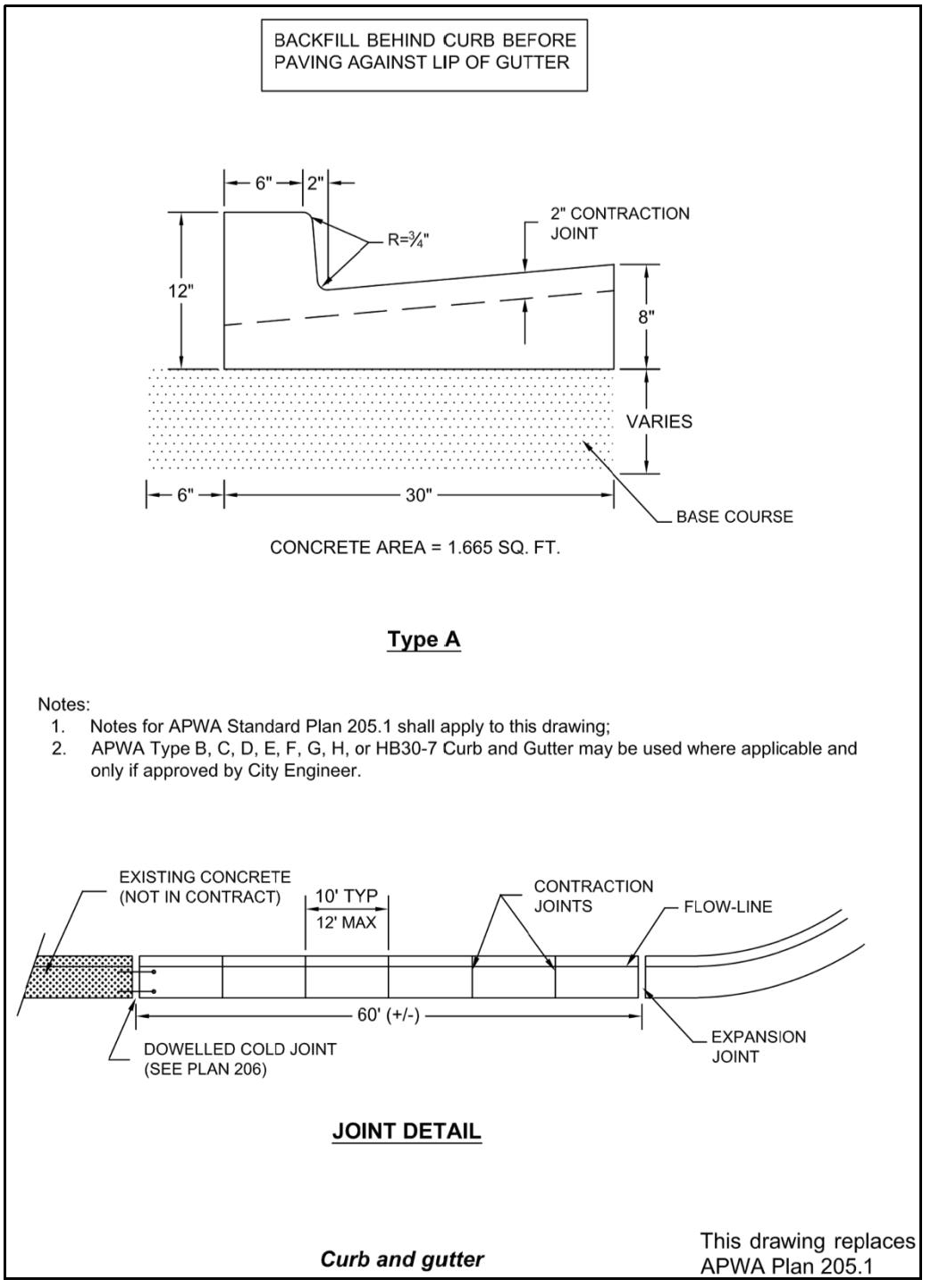
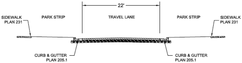
Plan 205.1: Curb and gutter. The City's standard plan is depicted below and replaces APWA Plan 205.1.
ii.
Plan 209: Curbs. No details from plan 209 are acceptable. The City of South Salt Lake standard is Type A, from plan 205.1.
iii.
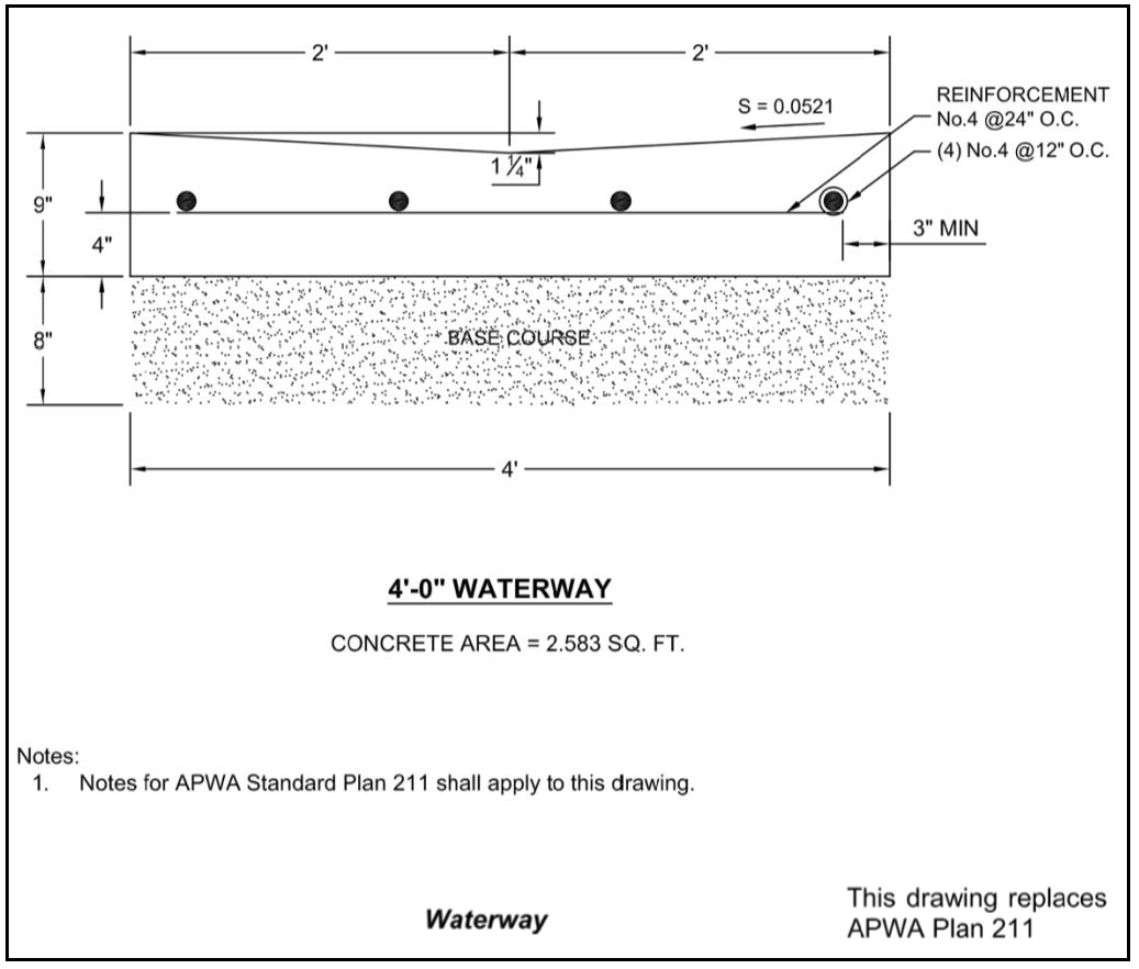
Plan 211: Waterway. The City's standard plan is depicted below and replaces APWA Plan 211. The City of South Salt Lake standard shall be a four-foot (4') waterway. No other details are acceptable.
iv.
Plan 225: Open driveway approach. This plan is not acceptable and is deleted.
v.
Plan 229.1: Bridge driveway approach. This plan is not acceptable and is deleted.
vi.
Plan 229.2: Bridge driveway approach. This plan is not acceptable and is deleted.
vii.
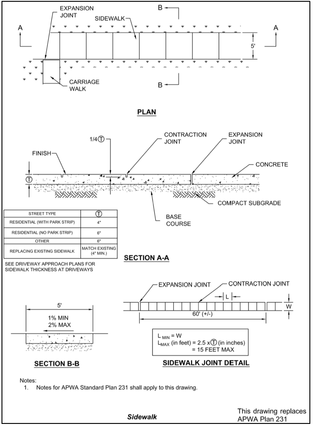
Plan 231: Sidewalk. The City's standard plan is depicted below and replaces APWA Plan 231. The City of South Salt Lake only accepts sidewalk widths of five feet (5').
viii.
Plan 235.1: Corner curb cut assembly. The City of South Salt Lake standard is Example B. Example A may be acceptable, at the City Engineer's sole discretion, if Example B is not feasible for the particular project.
ix.
Plan 235.2: Corner curb cut assembly. This plan is not acceptable and is deleted.
x.
Plan 235.3: Corner curb cut assembly. This plan is not acceptable and is deleted.
xi.
Plan 235.4: Corner curb cut assembly. This plan is not acceptable and is deleted.
xii.
Plan 256.1: Concrete pavement patch. This plan is not acceptable and is deleted.
xiii.
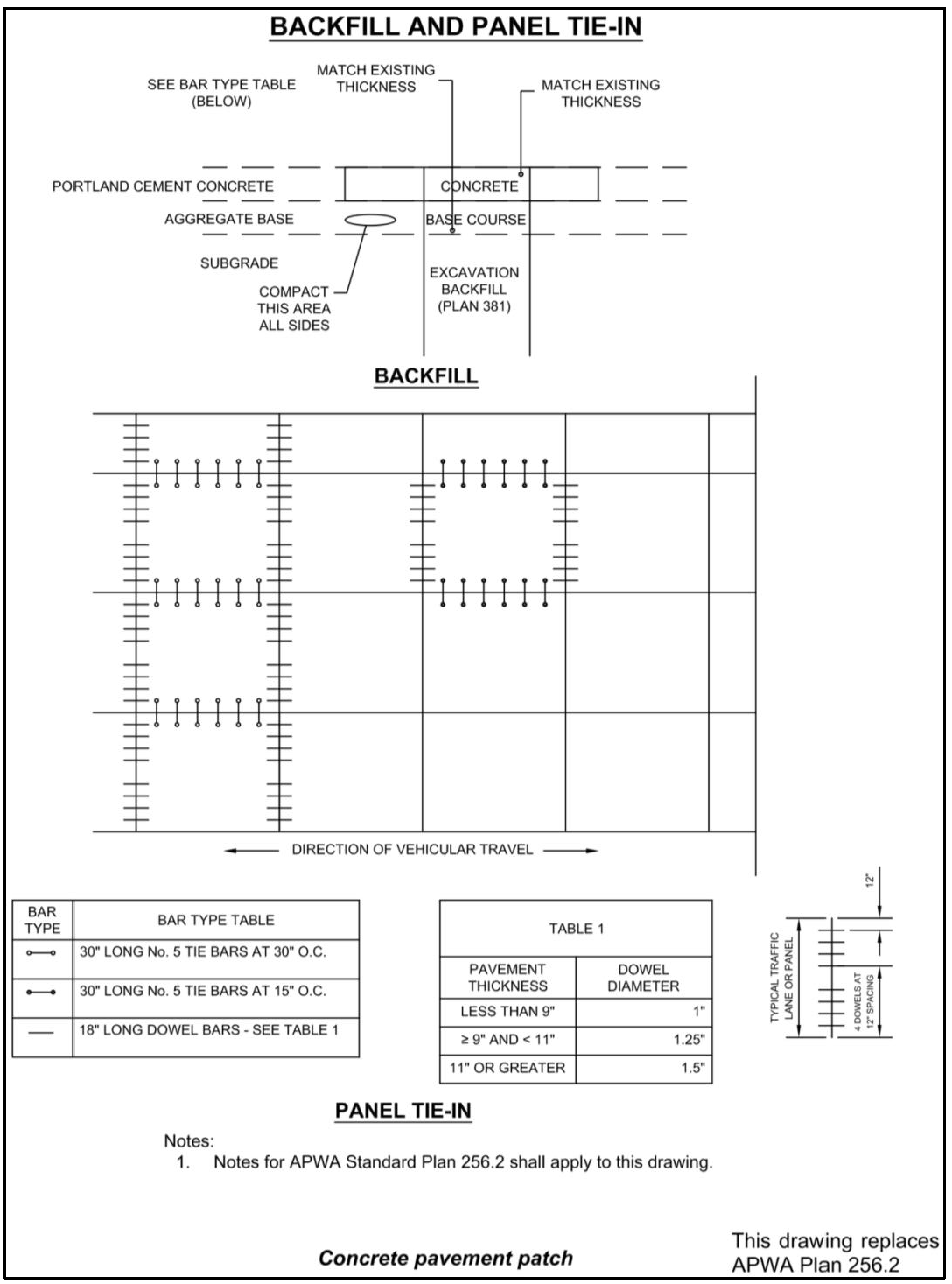
Plan 256.2: Concrete pavement patch. The City's standard plan is depicted below and replaces APWA Plan 256.2.
b.
Drainage catch basins, inlets, outlets, and hardware standards.
i.
Plan 303: 44" Frame and cover. This plan is not acceptable and is deleted.
ii.
Plan 304: 48" Cover and frame. This plan is not acceptable and is deleted.
iii.
Plan 305.1: 51" Cover and frame. This plan is not acceptable and is deleted.
iv.
Plan 305.2: 51" Cover and frame. This plan is not acceptable and is deleted.
v.
Plan 305.3: 51" Cover and frame. This plan is not acceptable and is deleted.
vi.
Plan 308: 35 ½" Grate and frame. Curb hoods are not allowed.
vii.
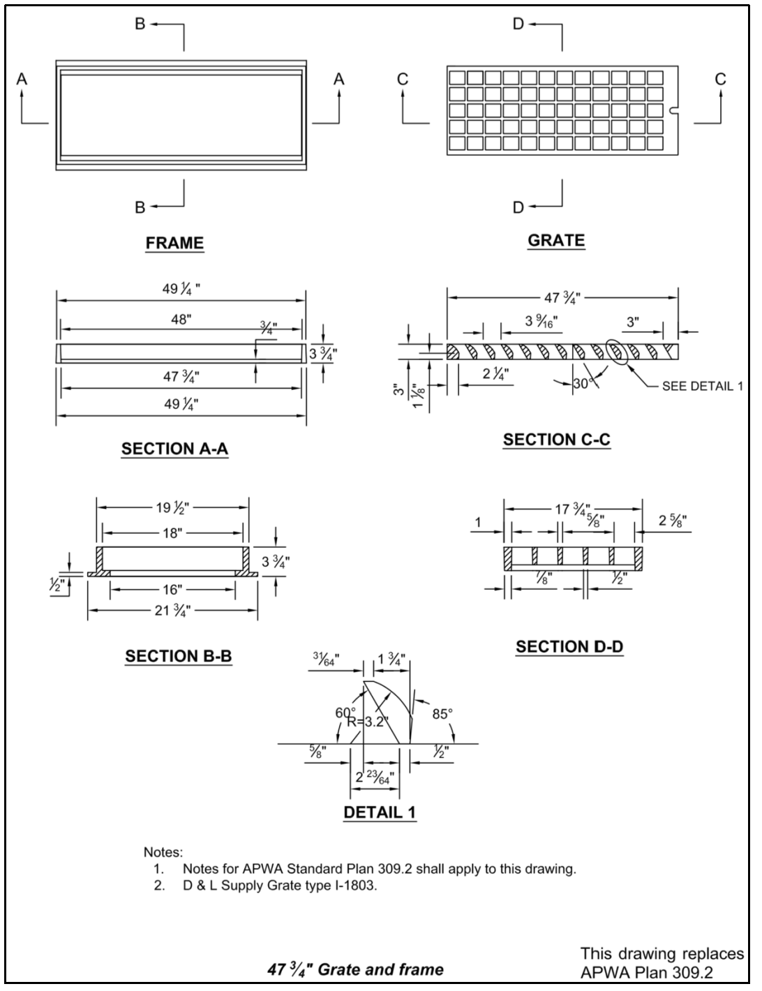
Plan 309: 47 ¾" Grate and frame. The City's standard plan is depicted below and replaces APWA Plan 309.
viii.
Plan 310: 48" Grate and frame. This plan is not acceptable and is deleted.
ix.
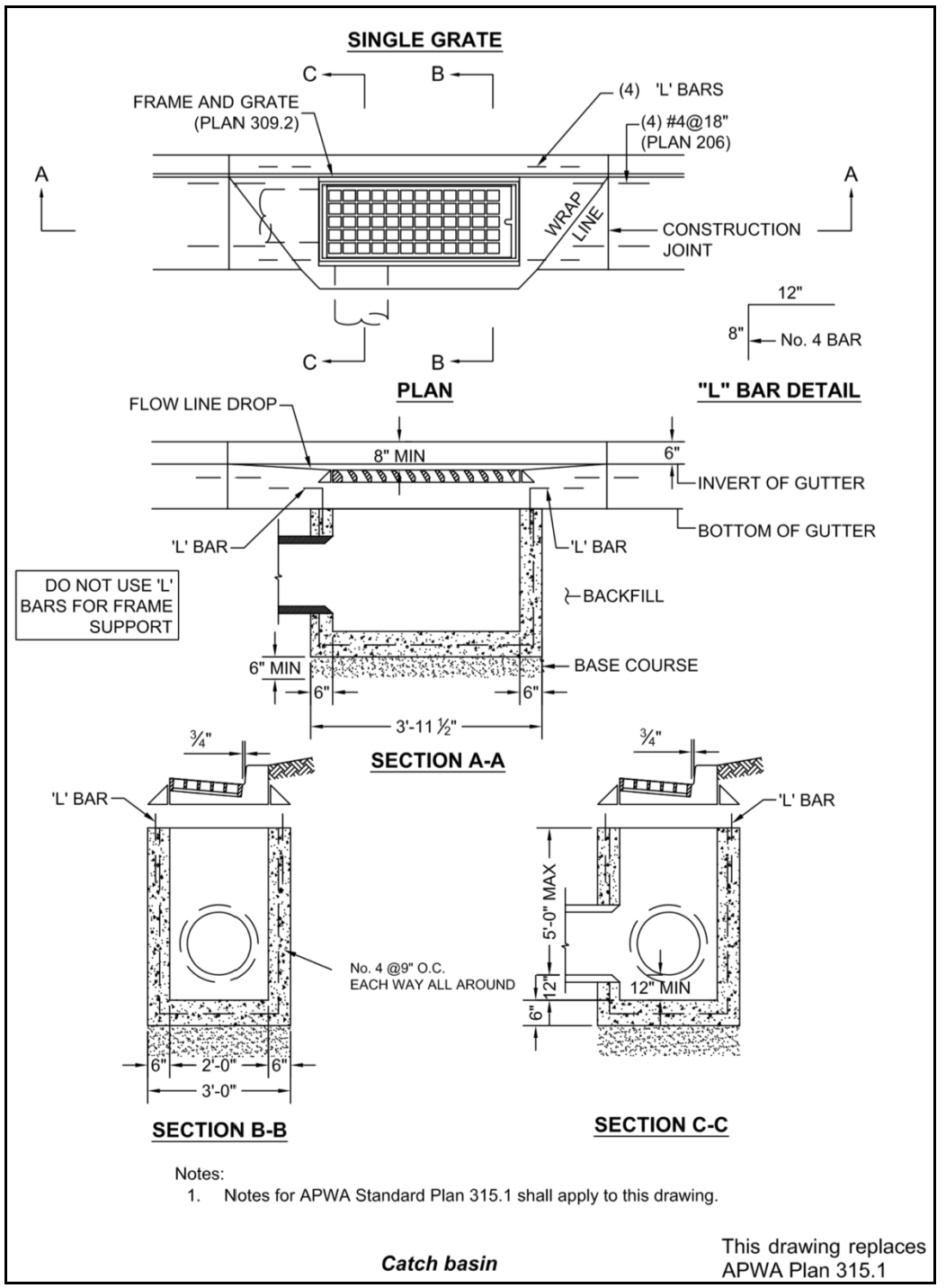
Plan 315.1: Catch basin. The City's standard plan is depicted below and replaces APWA Plan 315.1. Curb hoods are not allowed.
x.
Plan 315.2: Catch basin. The City's standard plan is depicted below and replaces APWA Plan 315.2. Curb hoods are not allowed.
xi.
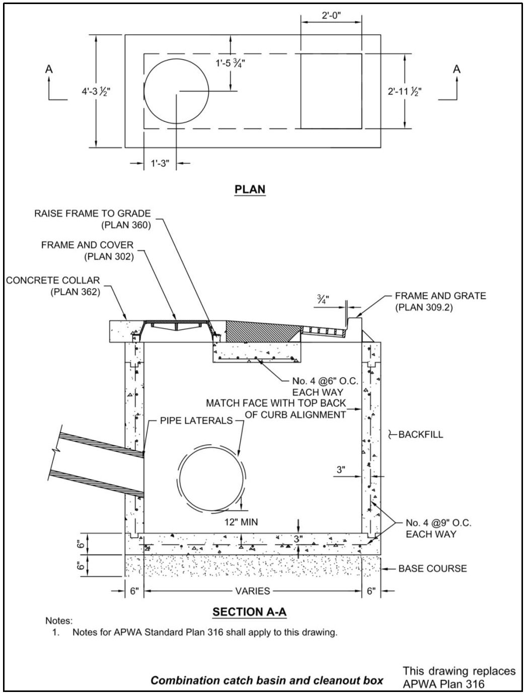
Plan 316: Combination catch basin and cleanout box. The City's standard plan is depicted below and replaces APWA Plan 316. Curb hoods are not allowed.
xii.
Plan 317: Curb face and inlet box. This plan is not acceptable and is deleted.
xiii.
Plan 322: Curb face outlet box. This plan is not acceptable and is deleted.
xiv.
Plan 331.1: Cleanout box. This plan is not acceptable and is deleted.
xv.
Plan 331.3: Cleanout box. This plan is not acceptable and is deleted.
xvi.
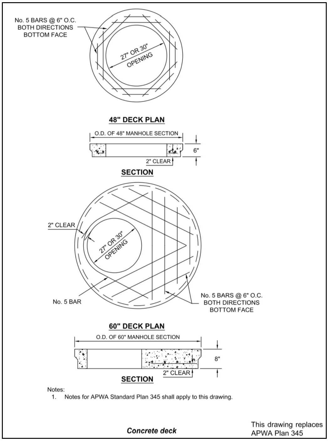
Plan 345: Concrete deck. The standard requires a 30" opening. The City's standard plan is depicted below and replaces APWA Plan 345. The City prohibits a 60" deck plan with a 38"—40" opening.
xvii.
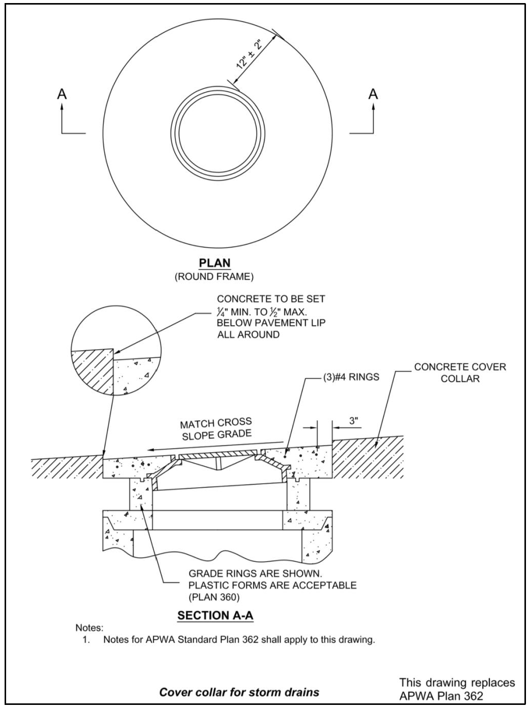
Plan 362: Cover collar for storm drains. The City's standard plan is depicted below and replaces APWA Plan 362. The only acceptable detail is in Section A-A.
xviii.
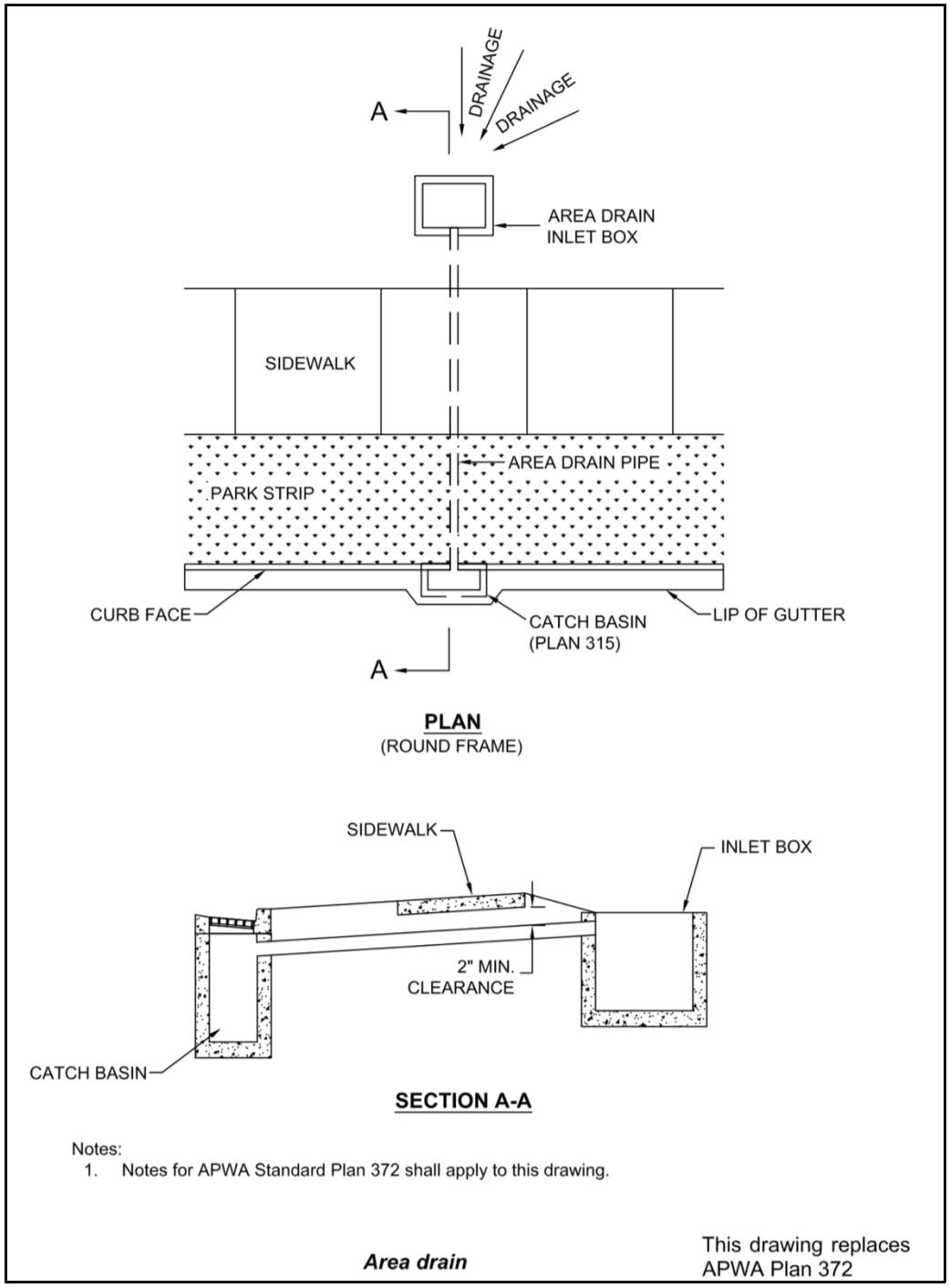
Plan 372: Area drain. The City's standard plan is depicted below and replaces APWA Plan 372. Curb hoods are not allowed.
xix.
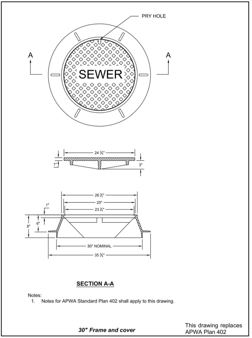
Plan 402: 30" Frame and cover. The City's standard plan is depicted below and replaces APWA Plan 402. The standard requires solid sewer covers. Sewer covers with holes are not acceptable.
6.
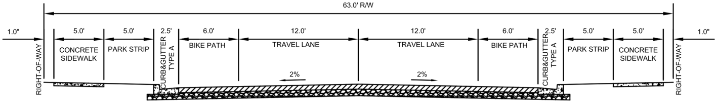
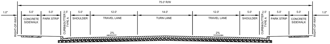
Standard Road Profiles. Each Subdivision or Condominium Plat shall Dedicate Public Streets according to the Roadways and Functional Classifications in the General Plan that meet the following applicable minimum road profiles:
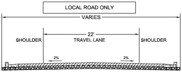
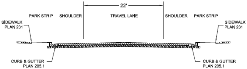
LOCAL
(RESIDENTIAL, NO ON STREET PARKING)

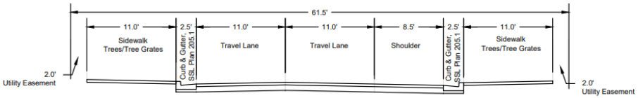
LOCAL
(RESIDENTIAL, ON STREET PARKING)
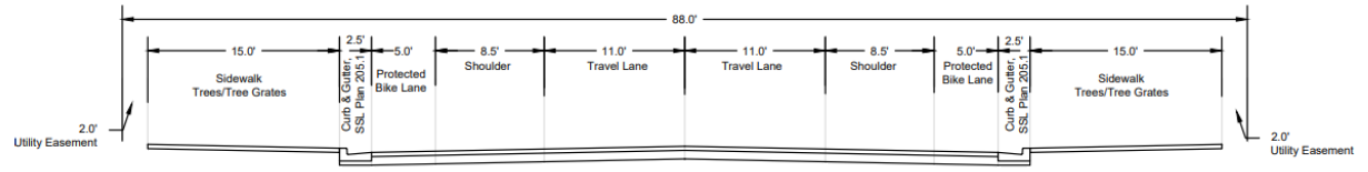
MINOR COLLECTOR - 2 L CONFIGURATION
MAJOR COLLECTOR - 3 L CONFIGURATION
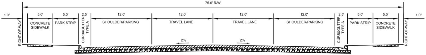
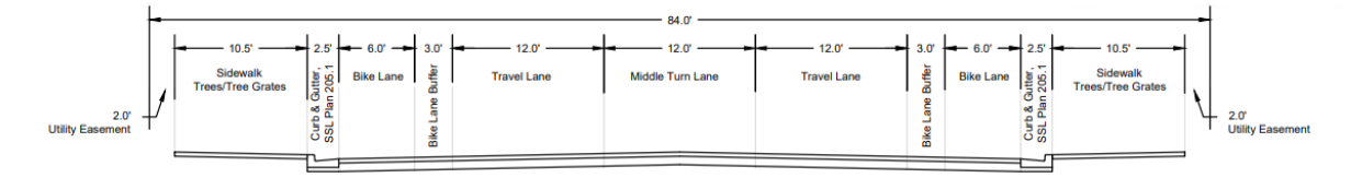
MINOR ARTERIAL - 2 L
(COMMERCIAL / RESIDENTIAL / INDUSTRIAL)
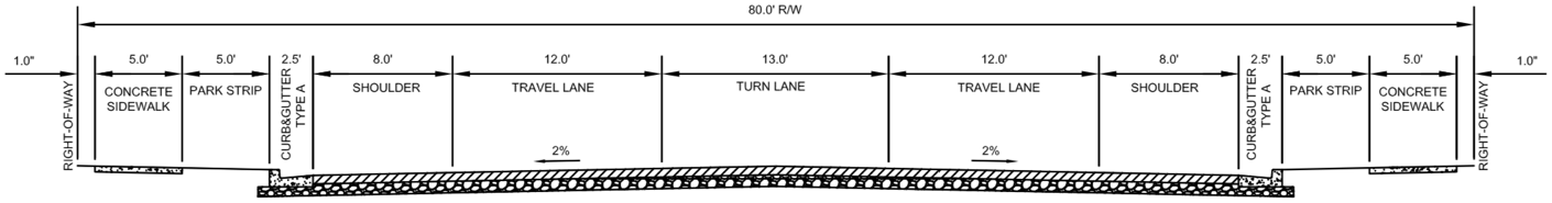
MINOR ARTERIAL - 3 L
(COMMERCIAL / RESIDENTIAL / INDUSTRIAL)
MINOR ARTERIAL - 4 L
(COMMERCIAL / RESIDENTIAL / INDUSTRIAL)
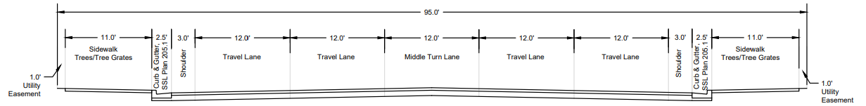
MAJOR ARTERIAL - 4 L
(COMMERCIAL / RESIDENTIAL)
![]()
MAJOR ARTERIAL - 5 L
(COMMERCIAL / RESIDENTIAL)
Oakland Avenue
(195 W Oakland Avenue To W Temple)
DOWNTOWN - STATE STREET
(2100 S To I80)
DOWNTOWN - 300 WEST
(2100 S To I80)

DOWNTOWN - LOCAL STREET
DOWNTOWN - MAIN ST.
(2100 S To I80)
DOWNTOWN - WEST TEMPLE
(2100 S To I80)
DOWNTOWN - UTOPIA
(MAIN TO TRAX (200W))
DOWNTOWN - HAVEN AVE
(STATE ST. To MAIN ST.)
TOWNHOUSE INTERNAL PRIMARY ACCESS ROAD
TOWNHOUSE SECONDARY INTERNAL ACCESS ROAD
7.
Required Townhome Internal Primary Access Road Right-of-Way Amenities. From public Street to public Street, each Townhome Development shall include provide one or more of the following design amenities on each side of the internal primary access road:
8.
Standard Local Road Intersection Profile. The intersection of local roads in each Subdivision or Condominium Plat shall be configured as follows:
SECTION
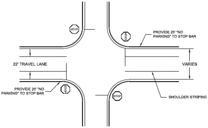
INTERSECTION
Narrow Travel Lane
1. GENERAL
A. The drawing is a typical arrangement. Construction varies according to the architechtural and engineering design.
2. PRODUCTS
A. Pavement Markings: Paint. APWA Section 32 17 23.
3. EXECUTION
A. Pavement Markings: Follow APWA Section 32 17 23.
9.
Standard Intersection Profile with Bulb-out. Each Subdivision or Condominium Plat shall incorporate the following traffic calming design at intersections as required by the City Engineer:
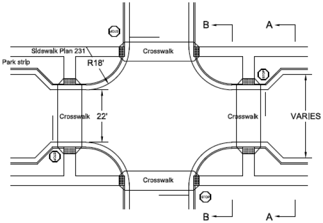
INTERSECTION
SECTION A-A
SECTION B-B
Bulb-out
10.
Each new subdivision shall incorporate the following solar powered, speed radar feedback signs within the Subdivision in locations designated by the City Engineer:
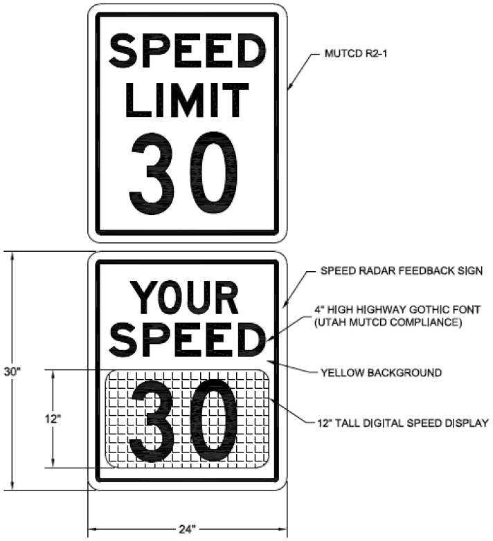
a.
For Collector Roads:
COLLECTOR
Notes:
1.
This sign shall be used on roads classified as "Collector."
2.
Standard static speed limit sign Utah MUTCD Sign R2-1. Solar powered feedback sign in preferred.
3.
Speed feedback sign shall be mounted below speed limit sign.
4.
Mounting Height: 7 ft. minimum, measured vertically from the bottom of the sign to the near edge of the traveled way, or the top of the curb. Unless approved by City Engineer.
Speed radar feedback sign
1.
GENERAL
A.
The drawing is a typical arrangement. Construction varies according to the architectural and engineering design.
2.
PRODUCTS
A.
Speed Limit Sign: Manual on Uniform Traffic Control Devices (MUTCD) R2-1 sign.
B.
Speed Feedback Sign: Dimensions match MUTCD R2-1 sign.
3.
EXECUTION
A.
Location: Collector roads only. Consult ENGINEER for location and spacing.
b.
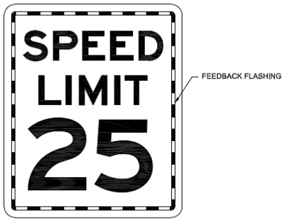
For Local Roads:
LOCAL ROAD
Notes:
1.
This sign shall be used on local road only.
2.
Standard Utah MUTCD Sign R2-1. Solar powered flashing is preferred.
3.
Mounting Height: 7 ft minimum, measured vertically from the bottom of the sign to the near edge of the traveled way, or the top of the curb. Unless approved by City Engineer.
Speed radar feedback sign
1.
GENERAL
A.
The drawing is typical arrangement. Construction varies according to the architectural and engineering design.
2.
PRODUCTS
A.
Speed Limit Sign: Manual on Uniform Traffic Control Devices (MUTCD) R2-1 sign, 25 mph.
B.
Feedback flashing strip.
3.
EXECUTION
A.
Location: Residential area only. Consult ENGINEER for location and spacing.
C.
Self-Imposed Restrictions. If the Owner places restrictions on any of the land contained in the Subdivision greater than those required by these regulations, such restrictions or reference thereto may be required to be indicated on the Subdivision Plat, or within restrictive covenants be recorded with the County Recorder simultaneously with the Plat in a form and substance approved by the City Attorney, the material terms of which may not be altered without prior Planning Commission approval.
D.
Restrictions Due to Character of The Land. Land that is unsuitable for Subdivision or Development due to flooding, improper drainage, potentially toxic wastes, wetlands, geologic hazards, utility easements, or other features that reasonably will be harmful to the safety, health, and general welfare of the present or future inhabitants of the Subdivision and/or its surrounding Areas, shall not be subdivided or Developed unless adequate methods are formulated by the Applicant and approved by the Planning Commission, upon recommendation of the City Engineer, to solve the problems created by the unsuitable land conditions. The burden of the proof shall lie with the Applicant. Without adequate remediation, such land shall be set aside or reserved for Uses that do not involve such a danger.
(Ord. No. 2020-02, § IV(Exh. C), 1-8-2020; Ord. No. 2021-06, § XX, 5-26-2021; Ord. No. 2022-08, § I(Exh. A), 4-13-2022; Ord. No. 2023-27, § 1(Exh. A), 9-12-2023; Ord. No. 2025-06, § 1(Exh. A), 3-12-2025; Ord. No. 2025-10, § 1(Exh. A), 4-23-2025)
17.10.130 - General Subdivision Requirements.
A.
Subdivision Name. The proposed name of the Subdivision and all roadways contained therein shall not duplicate, or too closely approximate, the name of any other Subdivision or Street in the Area covered by these regulations or those of Salt Lake County, Utah. The Planning Commission shall have final authority to designate the name of the Subdivision and to select Street names.
B.
Survey Monuments. Prior to Final Plat Approval, the Applicant shall place permanent survey monuments in the Subdivision as required herein or as otherwise approved by the City Engineer.
1.
Survey monuments shall be installed in accordance with the South Salt Lake City Construction Specifications and Standard Drawings.
2.
All monuments shall be properly set in the ground and approved by a Registered Land Surveyor prior to the time the Community Development Director or designee recommends approval of the Final Plat unless a performance Guaranty is established in accordance with the provisions of this Code.
C.
Limits of Disturbance/Vegetation Protection. A separate plan that addresses Limits of Disturbance and vegetation protection during construction and re-vegetation of disturbed Areas will be required. This shall include a construction plan for all project improvements such as Streets and utilities and a commitment to replace Significant Vegetation in a ratio of four (4) to four-(4) inch caliper trees for each tree outside of the Limits of Disturbance that qualifies as Significant Vegetation.
D.
Soil Conditions. Consideration must be given to soil conditions and ground water existence and may include appropriate Setbacks or restrictions.
E.
Trails and Sidewalks. Trails and sidewalks shall be provided to allow efficient internal circulation as well as links to adjacent trail systems on other Properties. Existing trails should be maintained and incorporated into open space elements of the project. This may include trails for pedestrian or bicycle use. Construction of new trails will be required concurrently with the installation of other Public Improvements. Although required trails may not link to adjacent trails immediately, each trail is a vital part of an overall Trails Master Plan. In most cases, the homeowners are required to maintain the trails internal to their Subdivision.
F.
Limits of Disturbance/Vegetation Protection. Limits of Disturbance or Building Pad lines shall be shown on the Preliminary and Final Plats if the staff determines that there is Significant Vegetation on the Site or if it is important to clearly designate future Building locations. Limits of Disturbance or Building Pad lines with definitions as approved by the Planning Commission must be reflected on the Final Plat.
G.
Top Soil Preservation and Final Grading. Topsoil shall not be removed from residential Lots or used as spoil, but shall be redistributed so as to provide at least six (6) inches of cover on the Lots and at least four (4) inches of cover between the sidewalks and curbs, and shall be stabilized by seeding or planting.
(Ord. No. 2020-02, § IV(Exh. C), 1-8-2020; Ord. No. 2023-27, § 1(Exh. A), 9-12-2023; Ord. No. 2024-04, § I(Exh. A), 5-8-2024)
17.10.140 - Subdivision Development Lot Standards.
A.
All Final Plats shall result in the creation of compliant Lots and Building sites.
B.
All Lots created by a Final Plat shall have Frontage on a Public Street that has been Dedicated to the City and has been improved to the applicable City Road Profile according to City Engineer approved Construction Standards and Specifications.
C.
Property designated as Street Right-of-Way shall be separate and distinct from subdivided Lots adjoining such Street Right-of-Way.
D.
The minimum area and dimensions of all Lots shall conform to the requirements of this Code.
E.
The side boundary lines of all Lots, so far as possible, shall be at right angles to the Street which the Lots face, or approximately radial to the center of curves, if such Street is curved.
F.
Side boundary lines of Lots shall be approximately radial to the center of a Cul-de-Sac on which the Lots face.
G.
Corner Lots for Residential Use shall be platted wider than Interior Lots within the Subdivision to facilitate conformance with the required Front Yard Street Setback requirements of this Code.
H.
A Lot shall not be divided by a City boundary line.
I.
Double Frontage residential Lots are not permitted for Single-Family residential Subdivision.
J.
Building sites or Development envelopes shall be designed to allow for minimum separations between Structures.
K.
Side Lot Lines shall be at right angles to Street lines, or radial to curving Street lines.
L.
Dimensions of Corner Lots shall be large enough to allow for erection of Buildings, observing the minimum Front Yard Setback and Site Distance Triangles from both Streets.
M.
Depth and width of Properties reserved or laid out for business, commercial, or industrial purposes shall be adequate to provide for the Off-Street parking and loading facilities required for the type of Use and Development generally contemplated in the District.
N.
New Single-Family Lots shall not Front on or access an Arterial or Collector Street.
O.
If Access from an Arterial or Collector Street is necessary for new adjoining Lots, at a minimum, such Lots shall be served by a separate Local Street to limit potential traffic hazards on larger Arterial or Collector Streets.
P.
Driveways shall be designed and arranged to avoid vehicles backing onto Streets. Single-Family homes may not back onto Arterial or Collector Streets.
Q.
Lots shall be laid out to provide positive drainage away from all Buildings and individual Lot drainage shall be coordinated with the general storm drainage pattern for the Area. Drainage shall be designed to avoid surface concentration of storm drainage water from any Lot to adjacent Lots or Streets.
(Ord. No. 2020-02, § IV(Exh. C), 1-8-2020; Ord. No. 2023-27, § 1(Exh. A), 9-12-2023; Ord. No. 2024-04, § I(Exh. A), 5-8-2024)
17.10.150 - Subdivision and Condominium Plat Layout Requirements.
A.
General Layout Requirements.
1.
Roads shall be graded and improved and conform to the South Salt Lake City Standards and Construction Specifications, and Standard Drawings and shall be approved as to design and specifications by the City Engineer, in accordance with the Construction Plans and Specifications required to be submitted prior to Final Plat approval.
2.
In Developments with non-Residential components, the Streets, and other Access ways shall be planned in connection with the grouping of Buildings, location of rail facilities, and the provision of Alleys, truck loading and maneuvering Areas, and walks and parking Areas to minimize conflict of movement between the various types of traffic and with pedestrians.
3.
Proposed Streets shall be extended to the boundary lines of the tract to be platted, unless prevented by topography or other physical conditions.
B.
Frontage on and Arrangement to Improved Roads.
1.
No Subdivision or Plat shall be approved unless the Area to be platted has Frontage on and Access from an existing Street on the Roadways and Functional Classifications in the General Plan unless such Street is an existing state highway; or a dedicated public Street shown upon a Subdivision Plat approved by the Planning Commission and recorded in the County Recorder's office. Such Street or highway must be suitably improved as required by the state highway rules, City regulations, specifications, or orders, or such improvements shall be secured by an Infrastructure Improvement Assurance, with the width and Right-of-Way and Road Profile required by this Chapter.
2.
Wherever the Area to be subdivided or platted is to utilize existing Street Frontage, such road shall be suitably improved as provided above.
3.
All Streets shall be integrated with the thoroughfares and Dedicated Rights-of-Way established in the Standard Road Profiles and in the Roadways and Functional Classifications in the General Plan.
4.
All thoroughfares shall be configured to address specific traffic generators such as industries, business districts, schools, churches, and shopping centers; to population densities; and to the pattern of existing, proposed, and future land Uses.
C.
Road Design Considering Blocks.
1.
Block lengths in Single-Family residential Areas should not exceed six hundred (600) feet and shall not be less than four hundred (400) feet in length.
2.
Wherever practicable, Blocks along Major Collector and all Arterial Streets shall be not less than six hundred (600) feet in length.
3.
Planning Commission may require the reservation of an easement through a Block to accommodate utilities, drainage facilities, and/or pedestrian traffic.
4.
Planning Commission may require improved pedestrian ways and crosswalks, not less than ten (10) feet wide, through the center of any proposed Development Block that is more than eight hundred (800) feet long.
D.
Access to/from Arterial or Collector Streets. Where a Subdivision or Plat borders on or contains an existing or proposed Arterial or Collector, the Planning Commission may require that Access to such Streets be limited by one (1) of the following means:
1.
The Subdivision of Lots to back onto the Arterial or Collector and Front onto a parallel Local Street; no direct Access from the primary Arterial or Collector Street, with Screening provided in a strip of land along the Rear Property Line of such Lots.
2.
A series of U-shaped Streets or short loops entered from and designed generally at right angles to such a parallel Street, with the rear boundary lines of their terminal Lots backing onto the Arterial or Collector Street.
E.
Construction of Dead-End Roads. The arrangement of Streets shall provide for the continuation of principal Streets between adjacent Properties to allow for convenient movement of traffic, effective fire protection, for efficient provision of utilities.
1.
Dead End Road-Temporary. If the adjacent Property is undeveloped and the Street must be a dead-end Street temporarily, the Right-of-Way shall be extended to the Property Line. A temporary turnabout shall be provided on all temporary dead-end Streets, with the notation on the Plat that land outside the normal Street Right-of-Way shall revert to abutting Property Owners whenever the Street is continued. The Planning Commission shall limit the length and use of temporary dead-end Streets in accordance with these regulations.
2.
Existing Dead-End Roads, Permanent. Where an existing road does not extend to the boundary of the Subdivision and its continuation is not required by the Planning Commission for Access to adjoining Property, its terminus shall not be nearer to such boundary than fifty (50) feet. The Planning Commission may require the reservation of an appropriate easement to accommodate drainage facilities, pedestrian traffic, or utilities. A Cul-de-Sac turnaround shall be provided at the end of a permanent, existing dead-end Street in accordance with the Design Standards, Construction Specifications, and Standard Drawings. For greater convenience to traffic and more effective police and fire protection, existing dead-end Streets shall be limited in length to six hundred and fifty (650) feet and no more than ten (10) equivalent residential units.
F.
Road Names. The Subdivision or Condominium Plat Applicant, upon consent of the Planning Commission, shall name all roads at the time of Preliminary Plat approval. Names shall be sufficiently different in sound and in spelling from other road names in Salt Lake County, Utah to prevent confusion to emergency responders. A road that is or is planned as a continuation of an existing road shall bear the same name.
G.
Road Regulatory Signs. The Applicant shall erect or post acceptable Guarantees ensuring each road regulatory Sign and Street name Sign required by the City Engineer has been installed at all road intersections prior to the first Certificate of Occupancy. Street and road regulatory signs shall be designed according to South Salt Lake City Design Standards, Construction Specifications, and Standard Drawings.
H.
Street Lights/Project Lighting. Installation of Street lights and Project lighting is required for every Subdivision of land and Condominium Plat and shall be placed by the Applicant in accordance with South Salt Lake City Design Standards, the South Salt Lake Lighting Master Plan, Construction Specifications, and Standard Drawings as approved, in writing, by the City Engineer.
1.
The Applicant shall pay to the City a Street light system development fee in the amount set forth in the City fee schedule, which amount, if necessary, shall be adjusted to cover the City's entire expense for the design, installation, and maintenance of a Street lighting system for the Development.
2.
The City shall provide for the design and installation of the Street lighting system by contract with Rocky Mountain Power (or its successor in interest) and shall pay the cost of electricity provided to the Street lighting system.
I.
Road Design Standards. In order to provide for roads of suitable location, width, and improvement to accommodate prospective traffic and afford satisfactory Access to police, fire fighting, snow removal, sanitation, and road maintenance equipment, and to coordinate roads so as to compose a convenient system and avoid undue hardships to adjoining Properties, the design standards for roads are hereby required to comply with the South Salt Lake City Development Standards, Construction Specifications and Standard Drawings, and Roadways and Functional Classifications in the General Plan.
1.
Road Surfacing and Improvements. After a four-(4) inch quad conduit duct and sewer and water utilities have been installed, the Applicant shall compose and compact all road base, shall construct curbs, gutters, sidewalks, culverts, drains, and bridges, and shall surface or cause to be surfaced roadways and the complete road profile installed. Said surfacing shall be of such character as is suitable for the expected traffic. Types of pavement shall be determined by the City Engineer, based on the soil's compaction test within the Right-of-Way. In all circumstances the City Engineer shall require at least four-(4) inch of asphalt upon untreated base course; native material must have a minimum CBR of 3.0. Adequate provision shall be made for culverts, drains, and bridges.
2.
All road pavement, shoulders, drainage improvements and Structures, curbs, turnarounds, and sidewalks shall conform to the adopted Construction Standards and Specifications and shall be incorporated into the construction plans required to be submitted by the Applicant for Plat approval.
J.
Fire Access. All Structures must meet the requirements of Appendix D of the International Fire Code in effect in the State of Utah.
K.
Intersection Design Standards.
1.
Streets shall be laid out to intersect as nearly as possible at right angles. A proposed intersection of two (2) new Streets at an angle within ten (10) degrees perpendicular is required. An oblique Street shall be curved approaching an intersection and shall be approximately at right angles for at least one hundred (100) feet there from. Not more than two (2) Streets shall intersect at any one (1) point.
2.
Proposed new intersections along one (1) side of an existing Street shall, wherever practicable, coincide with any existing intersection on the opposite side of such Street. Street jogs with center line offsets of less than one hundred and fifty (150) feet shall not be permitted, except where the intersected Street has separated dual drives without median breaks at either intersection. Where Streets intersect with Arterial or Collectors Streets, their alignment shall be continuous. Intersections of major Streets shall be at least eight hundred (800) feet apart.
3.
Minimum curb radius at the intersection of two (2) Local Streets shall be at least twenty (20) feet, and minimum curb radius at an intersection involving a collector Street shall be at least twenty-eight (28) feet. Alley intersections and abrupt changes in alignment within a Block shall have the corners cut off in accordance with standard engineering practice to permit safe vehicular movement and a safe Sight Distance Triangle.
4.
Intersections shall be designed with a flat Grade wherever practical. At the approach to an intersection, a leveling Area shall be provided having not greater than a two percent (2%) Slope for a distance of sixty (60) feet, measured from the nearest Right-of-Way line of the intersecting Street.
5.
The cross Slopes on all Streets, including intersections, shall be three percent (3%) or less.
L.
Road Dedications and Reservations.
1.
New Perimeter Streets. Street systems in new Subdivisions or Condominium Plats shall be configured to eliminate or avoid new perimeter half-Streets. The Planning Commission may authorize a new perimeter Street where the Applicant improves and Dedicates the entire required Street Right-of-Way width.
2.
Widening and Realignment of Existing Roads. Where a Subdivision borders an existing narrow road or when the Standard Road Profile and Roadways and Functional Classifications in the General Plan indicates plans for realignment or widening a road that would require use of some of the land in the Subdivision, the Applicant shall be required to improve and Dedicate at its expense such Areas for widening or realignment of such roads. Such Frontage roads and Streets shall be improved and Dedicated by the Applicant at its expense to the full width as required by these regulations. Land reserved for any road purpose may not be counted in satisfying Yard or Area requirements contained in this Title.
(Ord. No. 2020-02, § IV(Exh. C), 1-8-2020; Ord. No. 2021-06, § XXI, 5-26-2021; Ord. No. 2022-08, § I(Exh. A), 4-13-2022; Ord. No. 2023-27, § 1(Exh. A), 9-12-2023; Ord. No. 2024-04, § I(Exh. A), 5-8-2024)
17.10.160 - Drainage and Storm Sewers.
A.
General Requirements. Each Plat shall make adequate provision for storm or flood water runoff in compliance with Title 13 and the Construction Specifications and Standard Drawings. The storm water drainage system shall be separate from and independent of the sanitary sewer system. Storm sewers, where required, shall be designed by the Rational Method or other methods as approved by the City Engineer, and a copy of storm water system design computations shall be submitted along with plans. When calculations indicate that curb capacities are exceeded at a point, catch basins shall be used to intercept flow at that point. Surface water drainage patterns shall be shown for each and every Lot and Block. On-Site storm water detention is required.
B.
Nature of Storm Water Facilities.
1.
Location. Upon the recommendation of the City Engineer, the Planning Commission may require the Applicant to carry away by pipe or open channel any spring or surface water that may exist either previously to, or as a result of the Subdivision. Such drainage facilities shall be located in the road Right-of-Way where feasible, or in perpetual unobstructed easements of appropriate width Dedicated to the City and constructed in accordance with Title 13 and the Construction Standards and Specifications.
2.
Accessibility to Public Storm Sewers.
a.
Underground storm sewer systems shall be constructed throughout the Subdivision and be conducted to an approved out-fall, maintained by the Owner. Periodic inspection of facilities shall be conducted by the City Engineer over the life of the Development.
b.
If a connection to a public storm sewer will be provided eventually, as determined by the City Engineer and the Planning Commission, the Applicant shall make arrangements for future storm water disposal by a public utility system at the time the Plat receives final approval. Provision for such connection shall be incorporated by inclusion in the performance Guaranty required for the Subdivision Plat.
3.
Accommodation of Upstream Drainage Areas. A culvert or other drainage facility shall in each case be large enough to accommodate potential runoff from its entire upstream drainage Area, whether inside or outside the Subdivision. The Applicant shall hire a qualified engineer to determine the necessary size of the facility, based on the provisions of the current MS4 permit and Construction Standards and Specifications assuming conditions of maximum potential permitted Development. The City Engineer must review, recommend modifications where applicable, and approve the proposed design prior to Plat approval.
4.
Effect on Downstream Drainage Areas. The City Engineer shall also require the Applicant's qualified engineer to study the effect of each Subdivision on existing downstream drainage facilities outside the Area of the Subdivision. City storm drainage studies together with such other studies as shall be appropriate, shall serve as a guide to any needed improvements required by the Development to City facilities prior to Development approval. No Subdivision shall be approved unless adequate storm/flood water drainage will be provided to an approved drainage watercourse or facility with capacity to serve the anticipated storm water flow.
5.
Areas of Poor Drainage. Whenever a Plat is submitted for an Area that is subject to periodic flooding, the Planning Commission upon recommendation of the City Engineer, may approve such Subdivision provided that the Applicant fills the affected Area of said Subdivision with appropriate structural base materials to an elevation sufficient to place the elevation of Streets and Lots at a minimum of twelve inches (12") above the elevation of the maximum probable 100 year flood event. The Plat of such Subdivision shall provide for an overflow zone along the bank of any stream or watercourse, in a width that is sufficient in a time of high water to contain or move the flood water without damaging improved properties, including City Streets and facilities. No fill shall be placed in the overflow zone nor shall any Structure be erected or placed therein.
6.
Flood Plain Areas. The Planning Commission may, upon recommendation of the City Engineer and when it deems it necessary for the health, safety, or welfare of the present and future population of the Area and necessary to the conservation of water, drainage, and sanitary facilities, prohibit the Subdivision of any portion of the Property which lies within the flood plain of any river, stream, or drainage course. These flood plain Areas should be preserved from any and all destruction or damage resulting from clearing, Grading, or dumping of earth, waste material, or stumps.
C.
Dedication of Drainage Easements.
1.
General Requirements. Where a Subdivision is traversed by a watercourse, drainage way, channel, or stream, the Owner shall Dedicate to the City a storm water easement or drainage Right-of-Way conforming substantially to the lines of such watercourse, and of such width and construction or both as will be adequate for drainage in the 100 year flood event. The existing drainage will be maintained by an open channel with landscaped banks and adequate width for maximum potential volume of flow.
2.
Drainage Easements.
a.
Where topography or other conditions make impractical the inclusion of necessary drainage facilities within road Rights-of-Way, perpetual unobstructed easements at least twenty feet (20') in width for such drainage facilities shall be provided across the platted Property outside the platted road lines and with satisfactory access to the road. Drainage easements shall be indicated on the Plat. Drainage easements shall be carried from the road to a natural watercourse or to other drainage facility.
b.
When a proposed drainage system will carry water across private land outside the Subdivision, appropriate drainage rights must be secured from the affected land Owner and must be indicated on the Plat.
c.
The Applicant shall Dedicate, either in fee simple or by drainage easement, land on both sides of existing watercourses within the Subdivision.
d.
Low-lying lands along watercourses subject to flooding or overflowing during storm periods, whether or not included in Areas for Dedication, shall be preserved, and retained in their natural state as drainage ways.
(Ord. No. 2020-02, § IV(Exh. C), 1-8-2020; Ord. No. 2023-27, § 1(Exh. A), 9-12-2023)
17.10.170 - Water Facilities.
A.
General Requirements.
1.
The Applicant shall extend the public culinary water-supply system for the purpose of providing an adequate water-supply to the Plat that is capable of providing domestic water Use and fire protection for the proposed land uses within the Plat without diminishing the water-supply to land uses outside of the Plat.
2.
The Applicant shall install adequate water facilities, including fire hydrants, subject to the specifications of the City and Appendix C to the International Fire Code in effect in the state. All water mains shall be at least eight inches (8") in diameter.
3.
Water main extensions shall meet the City's standards and shall be approved by the City Engineer, the City Water Manager and, where applicable, the culinary water provider.
4.
Fire flow shall be approved by the Fire Marshal, consistent with Appendix B of the International Fire Code in effect in the state.
5.
The location of all fire hydrants, all water and storage supply improvements, and the boundary lines of proposed districts, indicating all improvements proposed to be served, shall be shown on the approved site plan, and the cost of installing same shall be included in the performance Guaranty to be furnished by the Applicant.
6.
Prior to approval of the Subdivision Plat by the City Engineer, a determination shall be made by the City Water Manager and City Engineer as to the location and extent of facilities to be maintained by South Salt Lake City. Private facilities may be required to be so noted on the Plat.
B.
Fire Hydrants. Fire hydrants are required for all Plats. Fire hydrants shall be located no more than one thousand feet (1,000') apart and within one hundred and fifty feet (150') of any Structure and shall be approved by the City Fire Marshal and City Engineer in accordance with Appendix D of the International Fire Code in effect in the state. To eliminate future Street openings, all underground utilities for fire hydrants, together with the fire hydrants themselves and all other water supply improvements shall be installed according to approved civil engineering plans before any final paving of a Street shown on the Subdivision Plat.
(Ord. No. 2020-02, § IV(Exh. C), 1-8-2020; Ord. No. 2022-16, § 1(Exh. A), 9-14-2022; Ord. No. 2023-27, § 1(Exh. A), 9-12-2023)
17.10.180 - Sewer Facilities.
A.
General Requirements. The Applicant shall install sanitary sewer facilities in manner prescribed by the applicable sanitary sewer authority's construction standards and specifications. All plans shall be designed in accordance with their rules, regulations, and standards.
B.
Residential and Nonresidential Subdivisions. Sanitary sewer facilities shall connect with the public sanitary sewer at sizes required by the sanitary sewer authority. No individual disposal system or treatment plants, private or group disposal systems, shall be permitted. Sanitary sewer facilities, including the installation of laterals in the Right-of-Way, shall be subject to the sanitary sewer authority's specifications, rules, regulations, and guidelines.
(Ord. No. 2020-02, § IV(Exh. C), 1-8-2020; Ord. No. 2023-27, § 1(Exh. A), 9-12-2023)
17.10.190 - Utilities
A.
Location. Utility facilities including, but not limited to, gas, fiber, electric power, fiber, telephone, and cable TV, shall be located underground in new Subdivisions wherever underground location does not violate safety standards of the particular utility. Underground service connections for water and sewer shall be installed to the Street Property Line of each plated Lot at the expense of the Applicant, as shall adequate casings or conduits for fiber and all other underground utilities. This section does not apply to the City Facility and City Facility (CF) Overlay district. *
B.
Easements.
1.
Easements shall be provided for private and municipal utilities. Such Easements shall be at least 10-feet wide along the front, side, and rear lot lines, when it does not negatively affect the location of the Development. The Easements shall not include those spaces occupied by an existing Building.
2.
The width may be reduced when new Development occurs. The provided Easements shall comply with the location and width and as shown on the table below. The Easements shall not include those spaces occupied by an existing Building.
* See 17.03.130
** See Approved MPMU, Overlay District, or Development Agreement.
3.
All easements shall be indicated on the Plat. Proper coordination shall be established by the Applicant between the applicable utility companies for the establishment of utility facilities and easements to adjoining Properties.
4.
Where necessary to ensure proper Access and maintenance, easement widths shall be increased as required by the City Engineer for the type of Development proposed. Easements for water lines shall be a minimum of thirty feet (30') wide.
(Ord. No. 2020-02, § IV(Exh. C), 1-8-2020; Ord. No. 2023-27, § 1(Exh. A), 9-12-2023; Ord. No. 2024-24, § I(Exh. A), 8-28-2024; Ord. No. 2025-10, § 1(Exh. A), 4-23-2025; Ord. No. 2025-32, § 2(Exh. A), 7-9-2025; Ord. No. 2025-38, § 1(Exh. A), 7-23-2025)
17.10.200 - Sidewalks, Trails, and Bike Paths.
The following are required Improvements:
A.
Sidewalks, Landscaping, bike lanes, curb, and gutter, shall be included within the Dedicated Right-of-Way of all roads, consistent with the applicable road profile, unless an alternate location has been specifically recommended by the City Engineer and approved by the Planning Commission.
B.
Trails, pedestrian paths, and bike paths shall relate appropriately to topography, require a minimum of Site disturbance, permit efficient drainage, and provide safe Access.
C.
Trails, pedestrian paths, and bike paths shall be provided by the Applicant in accordance with the Trails Master Plan and where otherwise necessary as determined by the Planning Commission. Trails should connect traffic generators such as schools, recreation facilities, commercial Areas, parks, and other significant natural features. Such trails shall be built to City specifications and easements shall be Dedicated for such trails. The trails shall be constructed at the time of road construction.
(Ord. No. 2020-02, § IV(Exh. C), 1-8-2020; Ord. No. 2023-27, § 1(Exh. A), 9-12-2023)
17.10.210 - Nonresidential Subdivisions.
A.
In addition to the principles and standards for residential Subdivisions in this Chapter the Applicant shall demonstrate to the satisfaction of the Planning Commission that the Street, Parcel, and Block pattern proposed is specifically adapted to the Uses generally applicable in the District anticipated and other Uses in the vicinity.
B.
The following principles and standards shall be observed:
1.
Proposed industrial Parcels shall be suitable in Area and dimensions to the types of industrial Development anticipated.
2.
Street Rights-of-Way subbase, pavement width, and pavement depth shall be adequate to accommodate the type, gross vehicle weight and volume of traffic anticipated to be placed thereupon.
3.
Every effort shall be made to protect adjacent residential Areas from potential nuisance from a proposed commercial or industrial Subdivision, including the provision of extra depth in Parcels backing up on existing or potential residential Development and provisions for a permanently landscaped Buffer strip when necessary.
(Ord. No. 2020-02, § IV(Exh. C), 1-8-2020; Ord. No. 2023-27, § 1(Exh. A), 9-12-2023)
17.10.220 - Specifications for Documents to be Completed
A.
Preliminary Plat Specifications. A Preliminary Plat shall include the following:
1.
General. The Preliminary Plat shall be prepared by a licensed land surveyor at an engineers' scale not more than one (1) inch equals twenty (20) feet, and the sheets shall be numbered in sequence if more than one (1) sheet is used and shall be twenty-four (24) inches by thirty-six (65) inches (24" × 36"). It should be noted that the map prepared for the Preliminary Plat may also be used during the preparation of the Final Plat and, therefore, should be drawn on mylar.
2.
Name.
a.
Name of Subdivision if Property is within an existing Subdivision.
b.
Proposed name if not within a previously plated Subdivision. The proposed name shall not duplicate the name of any Plat previously recorded in Salt Lake County, Utah.
c.
Name of Property if no Subdivision name has been chosen. This is commonly the name by which the Property is locally known.
d.
Name, address, including telephone number and email address, of the professional person(s) responsible for Subdivision design, for the design of Public Improvements, and for surveys.
e.
Proposed names of new Streets, subject to the approval by the Planning Commission.
3.
Ownership. Name and address, including telephone number, of legal Owner or Owner's Agent of the Property, a Property title report, and citation of last instrument conveying any attribute of title to each Parcel of Property involved in the proposed Subdivision, giving grantor, grantee, date, and land records reference.
a.
Citation and documentation of any existing legal Rights-of-Way or easements affecting the Property.
b.
Existing recorded covenants on the Property, if any.
c.
Name and address, including telephone number and email address, of the professional person(s) responsible for Subdivision design, for the design of Public Improvements, and for surveys.
d.
Copy of any environmental report prepared for the Property.
4.
Description. Location of Property by government Lot, section, township, range and county, graphic scale, north arrow, and acres.
a.
Location of Property Lines; existing easements; burial grounds; physical hazards; known geologic hazards; hazardous materials, flood plains, railroad Rights-of-Way; water courses; wetlands; each tree of six (6) inches or more in diameter (measured four (4) feet above ground level), groves of five (5) or more smaller trees, or clumps of oak or maple covering an area of fifty square (50) feet squared, as measured to the canopy dripline; location, width, and names of all existing or platted Streets or other public ways within or immediately adjacent to the Property; and names of adjoining record Property Owners within six hundred (600) feet of any perimeter boundary of the proposed Subdivision.
b.
Location, sizes, elevations, excess capacities, and Slopes of existing sewers, water mains, culverts, other underground Structures, and hydrants within the tract and immediately adjacent thereto; existing permanent Building and utility poles and lines on or immediately adjacent to the Site and utility Rights-of-Way.
c.
Approximate topography, at the same scale as the Preliminary Plat with at least two-(2) foot contour intervals.
d.
The approximate location and widths of proposed Streets.
e.
Preliminary proposals for connection with existing municipal water supply and sanitary sewer systems; and preliminary provisions for collecting, detaining, and discharging surface water drainage.
f.
The approximate location, dimensions, and areas of all proposed and/or existing Lots.
g.
The approximate location, dimensions, and areas of all Parcels of land proposed to be set aside for park or playground Use or other public Use, or for the common Use of Property Owners in the proposed Subdivision.
h.
The location of temporary stakes to enable the Planning Commission and staff to find and appraise features of the Preliminary Plat in the field.
i.
Whenever the proposed Preliminary Plat covers only a part of an Applicant's contiguous holdings, the Applicant shall submit, at the scale of no more than twenty (20) feet to the inch, a sketch of the proposed Subdivision Area, together with its proposed Street and trail system, and an indication of the probable future Street and drainage system of the remaining portion of the tract owned by the Applicant or its affiliates.
j.
A vicinity map showing Streets and other general Development of the surrounding Area. The Preliminary Plat shall show all school and special service district boundary lines.
k.
A plan designating Limits of Disturbance for each Parcel and for Subdivision improvements, such as utilities and roads.
5.
Features.
a.
The location of Property with respect to surrounding Property and Streets, the names of all adjoining Property Owners of record or the names of adjoining Developments, the names of adjoining Streets.
b.
Citation of any existing legal Rights-of-Way or easements affect the Property.
c.
Existing covenants on the Property, if any.
d.
The location and dimensions of all boundary lines of the Property to be expressed in feet and decimals of a foot.
e.
The location of existing Streets, easements, water bodies, streams, and other pertinent features such as swamps, railroads, Buildings, parks, cemeteries, drainage ditches, physical hazards, identified hazardous materials, or bridges.
f.
The location and width of all existing and proposed Streets and easements, Alleys, trails, and other public ways, and easement and proposed Street Rights-of-Ways and Building Setback lines.
g.
The location, dimensions, and areas of all proposed or existing Lots.
h.
The location and dimensions of all Property proposed to be set aside for park, playground, or other public or private reservation, with designation of the purpose thereof, and conditions, if any, of the Dedication or reservation.
i.
The name and address of the Owner or Owners of land to be subdivided, the name and address of the Applicant, if other than the Owner, and the name of the land surveyor.
j.
The date of the map, approximate true north point, scale, and title of the Subdivision.
k.
Sufficient data acceptable to the City Engineer to determine readily the location, bearing, and length of all lines, and to reproduce such lines upon the ground.
l.
Indication of the proposed Use of any Lot (i.e., Single-Family, two-Family, Multi-Family, Townhome) and all non-Residential Uses proposed by the Applicant.
m.
All Lots in each Block shall be consecutively numbered. Reserved Lots shall be lettered in alphabetical order.
n.
The following notation shall also be shown:
i.
Explanation of drainage systems and easements and Dedication of a public right of access to inspect or maintain such systems, if any.
ii.
Explanation of Site easements, if any.
iii.
Explanation of reservations, if any.
iv.
Owners' Dedication, if any, and Owners' consent to record as required by state law.
o.
Any restrictions or requirements necessary to ensure solar access shall be defined.
p.
All utility facilities existing and proposed throughout the Subdivision shall be shown on the Preliminary Plat or on accompanying engineering plans and specifications.
q.
A plan designating Limits of Disturbance or Building Pads and utilities corridors and connections for each Parcel and for Subdivision improvements, such as utilities and roads.
B.
Construction Plan Details.
1.
General. Construction Plans shall be prepared for all required improvements. Plans shall be drawn at a scale of no more than one-(1) inch equals twenty (20) feet, and map sheets shall be of the same size as the Preliminary Plat. The following shall be shown:
a.
Profiles showing existing and proposed elevations along the left and right edges of each road, and center lines of all roads. Where a proposed road intersects an existing road or roads, the elevation along the center line of the existing road or roads within one hundred (100) feet of the intersection shall be shown. Approximate radii of all curves, lengths of tangents, and central angles on all Streets.
b.
Plans and profiles showing the locations and typical sidewalks, drainage easements, irrigation ditches, servitudes, Rights-of-Way, manholes, and catch basins; the locations of Street trees, Street lights, and Street signs; the location, size, and invert elevations of existing and proposed sanitary sewers, storm water drains, and fire hydrants, showing connections to any existing or proposed utility systems; and exact location and size of all water, gas, or other underground utilities or Structures.
c.
Location, size, elevation, and other appropriate description of any existing facilities or utilities, including, but not limited to, existing Streets, sewers, drains, water mains, easements, water bodies or impoundments, streams, and other pertinent features such as wetlands, railroads, Buildings, features noted on the Official Land Use Map or Master Plans, at the point of connection to proposed facilities and utilities within the Subdivision, and each tree with a diameter of six (6) inches or more (measured four (4) feet above ground level), groves of five (5) or more smaller trees, or clumps of oak or maple covering an Area of fifty (50) square feet, as measured to the canopy dripline. The water elevations of adjoining ponds, rivers, or streams at the date of the survey, and the approximate high- and low-water elevations of such ponds, rivers, or streams. All elevations shall be referred to the South Salt Lake City Engineer's or U.S.G.S. datum plane. If the Subdivision borders a pond, river, or stream, the distances and bearings of a meander line established not less than twenty (20) feet back from the ordinary high-water mark of such water ways.
d.
Topography at the same scale as the Preliminary Plat with a contour interval of two (2) feet, referred to sea-level datum. All datum provided shall be latest applicable U.S. Coast and Geodetic Survey datum and should be so noted on the Plat.
e.
All other specifications, details, and references required by City Design Standards, Construction Specifications and Standard Drawings, including a Site-Grading plan for the entire Subdivision.
f.
Notation of approval of the Preliminary Plat as follows:
g.
Title, name, address, signature, and seal of professional engineer, and date, including revision dates.
h.
A Limits of Disturbance and revegetation plan.
C.
Final Subdivision Plat Requirements.
1.
General. The Final Plat shall be presented on reproducible mylar at the same scale and contain the same information required for a Preliminary Plat, except for any changes or additions required by the Planning Commission. All revision dates must be shown as well as the following:
a.
Notation of any self-imposed restrictions, and locations of any Building Lines proposed to be established in this manner, if required by the Planning Commission in accordance with these regulations.
b.
All survey monuments erected, corners, and other points established in the field in their proper places. The material of which the survey monuments, corners, or other points are made shall be noted at the representation thereof or by legend. The legend for metal monuments shall indicate the kind of metal, the diameter, length, and weight per lineal foot of the monuments.
c.
Form for endorsements by the Planning Commission Chair, City Mayor, Community Development Director, City Recorder, City Engineer, City Attorney, culinary water authority, sanitary sewer authority, Salt Lake County Health Department (as applicable), all applicable utilities, and other entities as required by the City Engineer and the City Attorney.
2.
Preparation. The Final Subdivision Plat shall be prepared by a land surveyor licensed by the state of Utah. The surveyor shall certify that the survey of the Property described on the Plat is in accordance with U.C.A. Title 17, Chapter 23, Section 17 (1953, as amended) and has verified all measurements and has placed monuments as represented on the Plat.
(Ord. No. 2020-02, § IV(Exh. C), 1-8-2020; Ord. No. 2023-27, § 1(Exh. A), 9-12-2023; Ord. No. 2024-04, § I(Exh. A), 5-8-2024)
17.10.230 - Assurance for Completion of Landscaping and Infrastructure Improvements.
A.
Costs of Improvements. All required Landscaping and Infrastructure Improvements shall be completed by the Applicant.
B.
Assurance for Landscaping and Infrastructure Improvements. The Applicant may post an Infrastructure Completion Assurance, in an amount estimated by the City Engineer, as sufficient to secure to the municipality the satisfactory construction, installation, and Dedication of any uncompleted portion of required Landscaping and Infrastructure Improvements and record a conforming the Final Plat prior to completion of all required Landscaping and Infrastructure Improvements. The Infrastructure Completion Assurance shall be satisfactory to the City Attorney as to form, sufficiency, and manner of execution. The period within which required improvements must be completed shall be specified by the Community Development Director or designee in the decision approving the Final Plat and shall be incorporated in the Assurance and shall not in any event exceed two (2) years from date of Final Approval.
1.
Reduction of Completion Assurance. An Infrastructure Improvement Assurance shall be reduced upon actual completion and acceptance of Landscaping and Infrastructure Improvements to the ratio that the accepted Landscaping and Infrastructure Improvements bears to the total Landscaping and Infrastructure Improvements for the Plat.
2.
Governmental Units. Governmental units to which these Assurances apply may file in lieu of said Assurance a certified resolution or ordinance from officers or agencies authorized to act on their behalf, agreeing to comply with the provisions of this Title.
C.
Prior to excavating or commencement of construction, the Applicant shall meet with the Community Development Director, the City Engineer, and other officials as required for a preconstruction meeting. The Applicant shall bring to the meeting all contractors responsible to build the Infrastructure Improvements associated with the project and to comply with a detailed construction management plan for the project.
D.
Inspection of Improvements General Procedure and Fees. The Planning Commission, in consultation upon the advice of the City Engineer, shall provide for inspection of required Landscaping and Infrastructure Improvements during construction and ensure their satisfactory completion. The Applicant shall, in accordance with the City's fee resolution, pay to the City an inspection fee and the Subdivision Plat shall not be signed by the Chairman of the Planning Commission unless such fee has been paid. These fees shall be due and payable upon demand of the City and no Building Permits or Certificates of Occupancy shall be issued until all fees are paid. If the City Engineer finds upon inspection that any of the required Landscaping or Infrastructure Improvements have not been constructed in accordance with the City's construction standards and specifications, the Applicant shall be responsible for completing the improvements. Wherever the cost of improvements is covered by an Infrastructure Completion Assurance, the Applicant, and the Guarantor, if any, shall be severally and jointly liable for completing the improvements according to approved plans and specifications. Prior to commencement of construction on any Public Improvement or private improvement required to be built to public standards, the Applicant shall first obtain a Notice to Proceed from the Community Development Director or her designee.
E.
Maintenance of Improvements. The Applicant/Owner shall be required to maintain all required Landscaping and Infrastructure Improvements and provide for maintenance and snow removal on Streets and sidewalks until acceptance of said Landscaping and Infrastructure Improvements by the Planning Commission. If there are any certificates of occupancy on a Street not Dedicated to the City, the City may on twelve (12) hours-notice, plow the Street or effect emergency repairs and charge same to Applicant/Owner.
F.
Completion of Improvements. Before the Plat is signed by the Chairman of the Planning Commission, the Applicant shall complete, to the satisfaction of the City Engineer, all the Street, sanitary sewer, culinary water, power, and other improvements (e.g. storm drainage, trails, sidewalk, curb, gutter, Street signs, water lines, etc.) and to Dedicate same to the local government, free and clear of all liens, environmental contamination, and encumbrances on the Property and Improvements thus Dedicated.
G.
Certificate of Satisfactory Completion. Subject to maintenance provisions contained in this Chapter, the City will not accept Dedication of required improvements, or release or reduce an Infrastructure Completion Assurance, until the City Engineer has submitted a certificate to the Planning Commission stating that all required improvements have been satisfactorily completed and until the Applicant's engineer or surveyor has certified to the City Engineer, through submission of detailed "as-built" construction drawings and survey Plats of the Subdivision, indicating location, dimensions, materials, and other information required by the Planning Commission and City Engineer, that the layout of the line and Grade of all Public Improvements is in accordance with the City approved construction plans for the Subdivision and that a commitment for a title policy or other acceptable evidence has been furnished to the City Attorney and City Engineer indicating that the improvements have been completed, are ready for Dedication to the local government and are free and clear of any and all environmental contamination, liens and encumbrances.
H.
Warranty. Upon such approval and recommendation of the City Engineer, the Applicant shall submit an Infrastructure Improvement Warranty, warranting that the Infrastructure Improvements have been installed as described in the approved construction plans and specifications, and a ten (10) percent Cash Deposit.
I.
Dedication. Upon the City Engineer's certification, approval, and recommendation, and the City Attorney's approval of the Infrastructure Improvement Warranty and ten (10) percent Cash Deposit, the Planning Commission shall thereafter accept the improvements for Dedication in accordance with the established policy and procedure.
J.
Issuance of Building Permits and Certificates of Occupancy.
1.
Building Permit. For any recorded Subdivision for which the City holds a current Infrastructure Completion Assurance, but the Infrastructure Improvements are not yet accepted, the extent of utilities and Street improvements shall be adequate for emergency response and vehicular Access by the prospective occupant and by police and fire equipment, prior to the issuance of any Building Permit.
2.
Certificate of Occupancy. Where an Infrastructure Completion Assurance has been accepted for a Final Subdivision Plat, no Certificate of Occupancy for any Building in the Subdivision shall be issued prior to the completion of the Public Improvements and Dedication of same to the City, as required in the Planning Commission's final approval of the Subdivision Plat. This restriction can be waived upon Good Cause shown and adequate assurance revived.
(Ord. No. 2020-02, § IV(Exh. C), 1-8-2020; Ord. No. 2023-27, § 1(Exh. A), 9-12-2023; Ord. No. 2024-04, § I(Exh. A), 5-8-2024)