
Sparks City Zoning Code
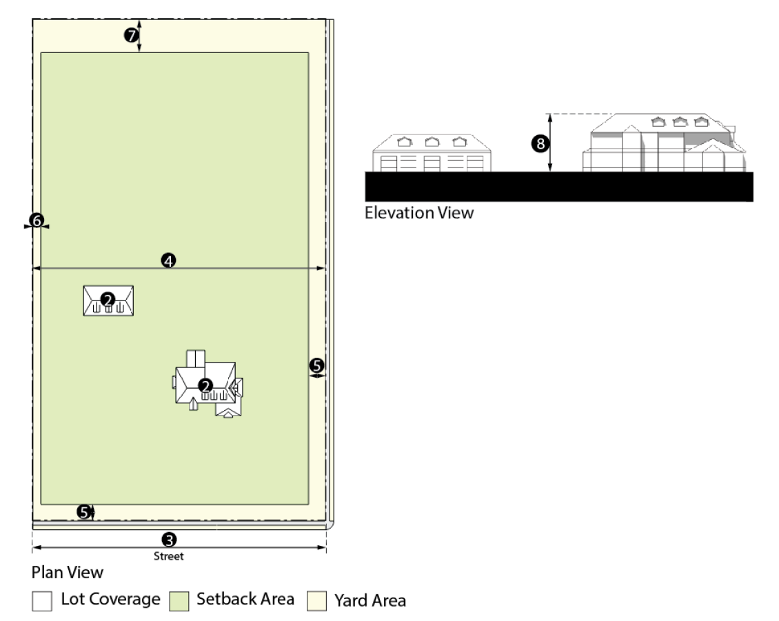
CHAPTER 20
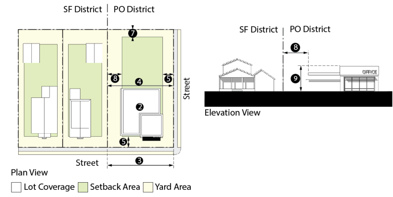
02 - ZONING DISTRICTS
Sections:
Section 20.02.001 - Districts established.
The following zoning districts are established:
(Ord. 2512, § 1(Exh. A), Add. 08/24/2015)
Section 20.02.002 - Zoning map.
A.
Generally. The zoning district boundaries are established and adopted on the map entitled "Zoning Map of Sparks, Nevada." This map is a part of this title together.
B.
Annotating boundary changes. When a change to the zoning map is approved by the city council, each such amendment shall be clearly delineated on the map entitled "Zoning Map of Sparks, Nevada."
C.
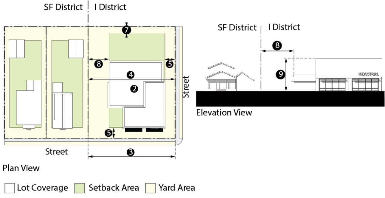
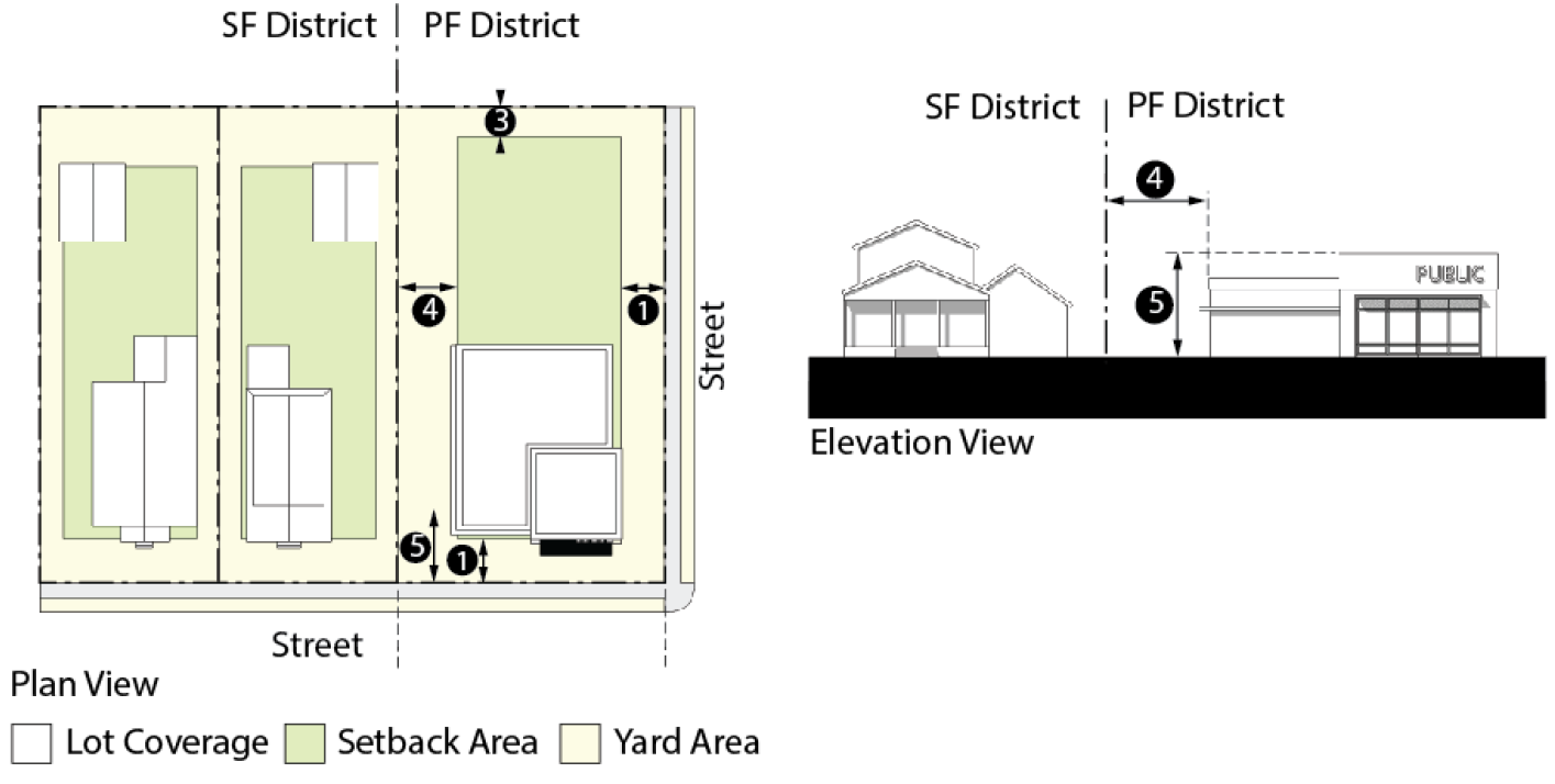
Identified Utility Corridors. All new development, in all zoning designations, adjacent to a Regional Utility Corridor shall provide a minimum setback of ten feet from the edge of the utility easement.
(Ord. 2512, § 1(Exh. A), Add. 08/24/2015)
Section 20.02.003 - Agricultural districts (A-40, A-5).
Purpose: This district accommodates existing farming, ranching or grazing activities until infrastructure becomes available for higher intensity urban uses. Conversion to higher intensity uses is guided by the land use designations planned for and identified in the City of Sparks Master Plan.
A.
Uses. Refer to Section 20.02.013 (Use Table).
C.
Dimensional Standards.
C.
Additional Regulations.
1.
Farms, stables and other structures used to house livestock shall be located at least 50 feet from any property line.
2.
Fenced pastures, paddocks or other enclosed livestock areas shall be located at least five feet from any property line.
(Ord. 2512, § 1(Exh. A), Add. 08/24/2015)
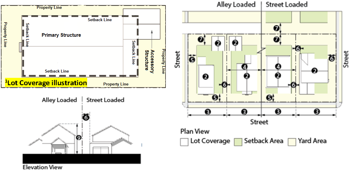
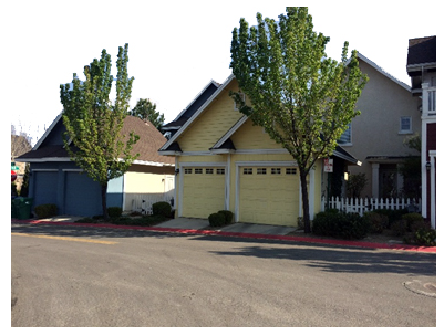
Section 20.02.004 - Residential single-family districts (SF).
Purpose: This district establishes uses, densities and intensities that are compatible with neighborhoods that are primarily single-family in character. The districts accommodate a range of development types, from conventional large lot subdivisions to smaller lots with a more urban setting. This section establishes two development options: (1) conventional development that incorporates minimum lot size, setback, and coverage standards, and (2) design development that incorporates design and density standards.
A.
Uses. Refer to Section 20.02.013 (Use Table).
B.
Area Regulations.
1.
No lot or parcel shall be reduced in area as to be less in any dimension than is required by the requirements applicable to the zoning district in which the lot is located.
2.
No portion of any lot or parcel of land which is part of the required a for an existing building shall be used as a part of the required area of any other lot or parcel or proposed building.
3.
When part of any lot or parcel is sold or transferred and the areas of that portion or the portion remaining no longer conforms to the required areas as defined in the zoning district in which the lot or parcel is located, the portion sold or transferred and the portion remaining are considered one parcel to determine the permitted number and location of buildings allowed to be replaced on both parcels.
C.
Dimensional Standards.
D.
Design Standards.
Purpose: These design standards maximize flexibility in the design of residential lots and encourage a variety of product types, while protecting of the community and its environmental resources. These standards encourage well-designed developments that: (1) reduce the prominence of garages in the front elevation, (2) promote pedestrian activity, (3) create functional and visual diversity, (4) provide community open space; and (5) protect significant features of the natural environment.
1.
Generally.
a.
New subdivisions that comply with these design standards are subject to the density standards, and not the minimum lot size and coverage requirements of this district (see subsection C above).
b.
The City's review of a single-family residential project will consider the following criteria:
(1)
Proportional size, mix and arrangement of lots;
(2)
Placement of dwelling unit on lot;
(3)
Varied garage placement and orientation;
(4)
Provisions of amenities (entrance treatment, landscaping, open space, etc.);
(5)
Preservation of natural features;
(6)
Treatment of grading drainage courses, and;
(7)
Treatment of walls.
2.
Site Planning Standards.
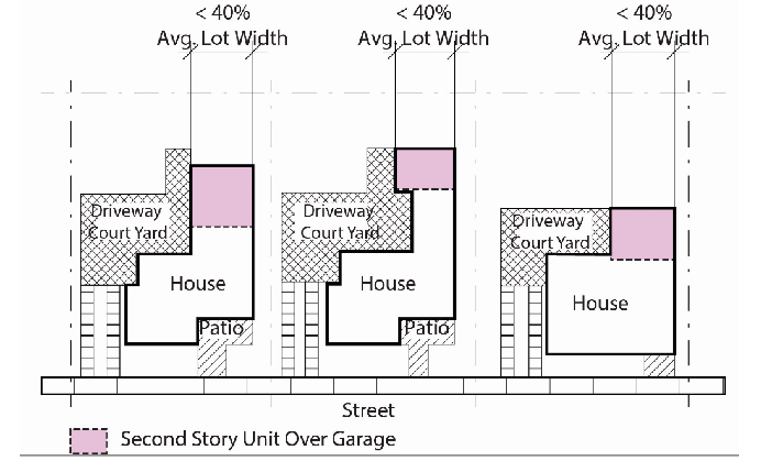
Purpose: These standards ensure that the relationship of units to each other and to other on-site uses are functional, attractive and create visual variety along the project's streets. Variation of development patterns within sub-divisions achieves visual diversity and avoids the appearance of monotonous development.
a.
Applicability. This subsection provides examples to the internal organization of a new residential development. Other alternatives which comply with the dimensional standards will be considered.
b.
Orientation.
| _____ | ||
| Varied Garage Placements and Orientation | Where SMC permits, garages can be entered from the front or side of the structure. |  |
| _____ | ||
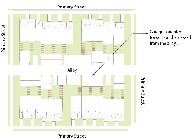
| Traditional Design with Alley | The use of public alleys in a subdivision will place the garage and vehicular traffic access off the alley and not the front of the home. Alley-loaded garages may utilize drive aprons whereas alley-loaded driveways are prohibited. | 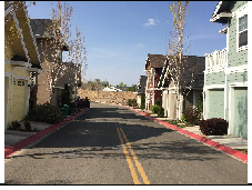 |
| _____ | ||
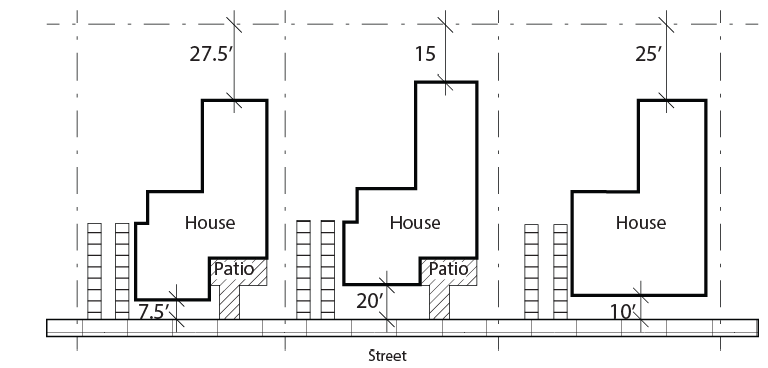
| Combined Front and Rear Setbacks | The combined front and rear setback requirements otherwise required for a conventional development are combined. The development may reduce the front and rear setback, but the combined total front and rear setback is equal to the conventional development. This allows a variety of setback combinations. If this option is used, setbacks cannot be reduced below the following minimums: | |
| • Front: 7.5 feet | ||
| • Rear: 15 feet | ||
| A 20-foot driveway length is required for a garage to accommodate required off-street parking. Therefore, a garage may not utilize the specific flexibility reduction in setbacks as depicted above. | ||
| Alley loaded garages are exempt from this flexibility as the garage is permitted to be at the rear property line. | ||
| The example below shows this option as applied to the SF6 district. Conventional development in SF-6 requires a 15′ front and 20′ rear setback, for a total of 35′. This option can use any combination of front or rear setbacks so long as (1) the total setbacks equal 35′ and (2) the minimum setbacks above are incorporated. | ||
3.
Architectural Standards.
a.
Building Design.
(1)
There is no specific architectural "style" required for residential structures. Within a development, the architecture shall include building style, form, size, color, materials and roof line that are complementary. Attached or detached garages or carports shall match the main structure in architecture, building material and roof pitch.
Example of roof and wall articulation, a mix of materials and architectural details.
(2)
Any building addition or additional building(s) (over 200 square feet) on a property shall match the main structure in building design, building materials, roof pitch and architectural character.
(3)
At least three distinctive floor plans are required within each subdivision. A subdivision with 20 or less lots may have less than three distinctive floor plans, upon approval of the Administrator.
(4)
The architectural character (i.e., exterior materials, window trims, cornices, arches, etc.) of the front elevations shall be utilized on all sides of the home.
(5)
Roofs shall have variations in plane accomplished by use of dormers (pitched, shed-roof or eyebrow), gables, hipped roofs and variations in pitch. Pitched roofs are preferred and when a flat roof is used, it must relate to the architectural style as approved by the Administrator. All roofs shall be articulated. This may be achieved by changes in plane or by the use of traditional roof forms such as hips, gables, and dormers.
(6)
In order to encourage front porches as a dominant feature for the street facade, and the connectivity of this space into the street neighborhood, front porches shall be allowed to encroach into the front yard setback five feet;
(a)
The roof of the porch shall be solid.
(b)
The porch shall be a minimum of 36 square feet with a minimum dimension of four feet in width.
b.
Building Materials.
(1)
Exterior elevation shall demonstrate a logical use of materials and a unified appearance. The design between the home and the garage shall use complementary materials and/or colors. The materials shall be architecturally related. Large expanses of uninterrupted, single exterior materials without window trim, plane or color changes shall not be allowed.
Example of house with balance in design between house/porch and garage.
(2)
Change of materials or color shall occur at changes in plane or at a logical break on that facade, so as not to give the appearance of "tacked-on" quality. Accent colors can be used for shutters, trim, balcony rail, columns, stucco recesses, or cornice bands and shall relate to the architectural character of the building. Accent materials utilized on the front façade corners shall extend and continue around the corners a minimum of 2 feet or a logical break on side facade.
(3)
Building materials and color schemes shall be consistent with the chosen architectural style. For example, with Spanish style homes, the design is consistent with stucco buildings and mission tile roof.
(4)
Exterior color elevations for all sides with proposed materials shall be provided for review and consideration by the Administrator prior to the issuance of a building permit.
c.
Garage Frontage and Location. The intent of the garage standards are to ensure that the garage is not the dominant feature of the street façade.
(1)
Street Loading Garages. To prevent the design of street loading garages as a dominant front visual street element of the building facade, houses with street loading garages shall not exceed 60% of the total overall length of the street building facade, and shall incorporate at least a two-foot offset as part of the front facade.
(2)
Side Loading Garages. To prevent the side of the garage towards the street from being a blank wall, houses with side loading garages shall incorporate architectural features, windows, faux windows, or other details on the facade of the garage facing the street.
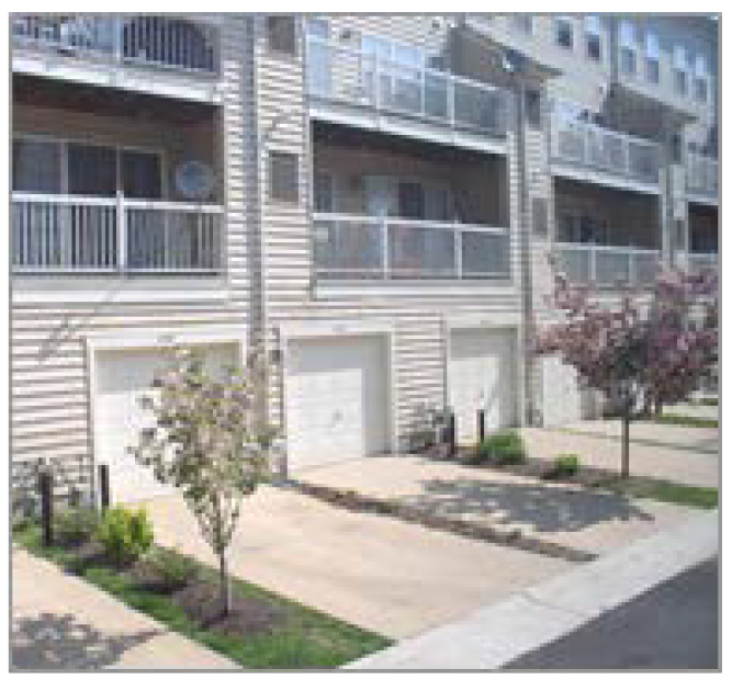
(3)
Alley Loading Garages. To ensure compatibility, the garage off the alley shall have architectural features that complement the main structure and shall be oriented so as to not block they alley.
Example of alley loaded garages that are architecturally compatible with the main structure.
(4)
Driveway Length. The length of a driveway to the front of a garage door shall be a minimum of twenty (20) feet. The driveway length shall be designed to prevent an automobile parked in the driveway from blocking the sidewalk and to accommodate off street parking per SMC.
(Ord. 2512, § 1(Exh. A), Add. 08/24/2015)
Section 20.02.005 - Residential multi-family districts (MF).
Purpose: The MF districts accommodate a range of housing types, typically near activity centers. These districts allow higher residential densities, and are accompanied by recreational facilities, pocket parks or other amenities. Lower density MF districts (MF2 and MF3) buffer single-family neighborhoods from higher density residential, commercial, or mixed-use areas, while the higher density categories (MF4 and MF5) transition from multi-family to commercial. Residences should be sited to provide privacy to occupants while providing connectivity to adjoining commercial or other uses.
A.
Uses. Refer to Section 20.02.013 (Use Table).
B.
Dimensional Standards.
Site is defined as a parcel or combination of parcels or lots which share a common development plan or which are dependent upon one another for access, parking or utilities.
*Setbacks listed above are intended to create a building envelope. Development within the envelope may create zero lot line development.
C.
Design Standards.
Purpose: These design standards maximize flexibility in the design of multi-family residential developments and encourage a variety of product types, while protecting the community and its environmental resources. These standards encourage well-designed developments that: (1) provide high quality front elevations, (2) promote pedestrian activity, (3) create functional and visual diversity, (4) provide community open space; and (5) protect significant features of the natural environment. The intent of these design standards is to allow maximum flexibility in the design of multi-family housing or attached single-family (such as condominiums and townhomes) and to encourage a variety of product types, while protecting the aesthetic value of the community, both the built and natural environments.
1.
Site Planning Standards.
a.
Site Character.
(1)
Natural site features shall be preserved and become part of the new project, whenever feasible. The applicant shall replace natural features that are removed with similar feature of same or greater visual or ecological value.
(2)
Natural features such as mature trees, creeks, riparian corridors and similar features unique to the site shall be preserved and incorporated into development proposals.
b.
Building Orientation.
(1)
Buildings shall be generally oriented with varying setbacks to provide visual interest and varying shadow patterns.
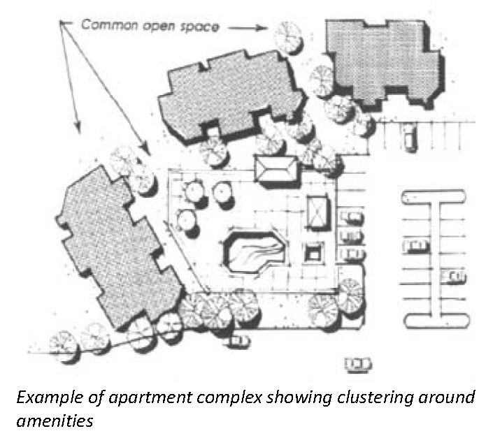
(2)
Buildings shall be oriented in such a way as to create courtyards and open space areas. Clustering of multi-family units shall be consistently planned throughout the development.
(3)
To provide indoor privacy between living spaces, there should be distance separations, buffering or changes in the angle of units. Private outdoor space shall be designed with maximum consideration for privacy, such as separations and orientation of the outdoor space. Building orientation shall provide opportunities for public spaces, for recreation and general open space. Public spaces shall be accessible to the majority of the surrounding units. The common area shall be useable areas and not steep slopes or riparian areas.
2.
Parking and Circulation.
a.
Entry Driveways shall include two of the following:
I.
Monuments;
II.
Pavers;
III.
Stamped concrete;
IV.
Landscaping;
V.
Decorative paving; or
VI.
Any similar material approved by the Administrator.
Entry drives shall have a sidewalk on both sides.
b.
Parking.
(1)
Parking spaces include carports, garages or surface parking.
(2)
Carports and garages shall be designed as an integral part of the architecture of the development. They shall be similar in materials, color and detail to the principal buildings of the development. Carports shall be designed to complement the architecture of the main buildings.
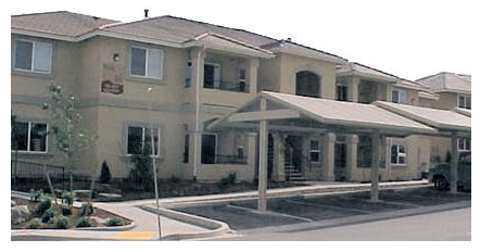
Example of a well-designed carport
c.
Pedestrian Circulation.
(1)
All multi-family/attached single-family developments shall incorporate pedestrian connections to adjoining residential, recreational and commercial uses.
(2)
Sidewalks along public streets shall have a minimum width of four feet.
(3)
The parking area shall be designed in a manner which links it to the building and sidewalk network as an extension of the pedestrian system. The pedestrian system shall be designed within the development to connect the buildings and open space/recreational facilities. This can be accomplished by using design features such as walkways with enhanced paving, trellis structures and/or landscaping treatment.
(4)
For projects along transit routes, they shall be designed to have a pedestrian entrance oriented towards transit stop(s) for convenient access.
3.
Community Amenities.
a.
Multi-family/attached single-family developments shall have useable community amenities, whether common or private, for recreation and social activities.
b.
Developments with less than 100 units shall choose at least three of the following recreational facilities. Developments with at least 100 units shall choose six of the following recreational facilities:
• swimming pool
• tennis courts
• horseshoes
• spa
• exercise equipment
• game room
• community room
• par course
• walking trails (minimum one-quarter mile in length)
• picnic areas to include tables with barbeques
• volleyball court
• basketball
• court and lawn areas for field games
• Play structure
• Or similar amenities of scale as approved by the Administrator
c.
To ensure that recreational facilities are conveniently located, the facilities shall:
(1)
Be located within 1,000 feet from any dwelling unit; and
(2)
Connected to residential buildings by sidewalks, trails, or open space.
d.
All living units shall have a private open space (i.e., decks or patios) and shall be contiguous to the units with a minimum of 25 square feet.
4.
Building Architecture.
a.
Building Design.
(1)
There is no specific architectural "style" required for multi-family residential structures. Within a development, the architecture shall include building style, form, size, color, material and roof lines that are complementary.
(2)
In order to avoid boxy and monotonous facades that lack a sense of human scale, buildings shall incorporate articulation with no flat wall planes, exceeding 50 feet vertically or horizontally, unless approved by the Administrator.
(3)
The following standards apply:
(a)
The architectural character (i.e., exterior materials, window trims, cornices, arches, etc.) of the exterior elevations shall be consistent on all sides of the building(s) that are visible from a public right of way.
(b)
Roofs shall have variations in plane accomplished by changes in plane or by the use of traditional roof forms such as dormers (pitched, shed-roof or eyebrow), gables, hipped roofs and variations in pitch. When a flat roof is used, it must relate to the architectural style as approved by the Administrator.
(c)
Stairs shall be compatible with the architecture of the buildings and integrated into the design of the building.
(d)
Access points to units shall be clustered. Use of distinctive architectural elements and materials shall be used to denote entrances.
Example of design to facilitate social interaction and effective Example of cluster
entrances
security
b.
Building Materials.
(1)
Exterior elevation shall demonstrate a logical use of materials, unified appearance and complementary materials and colors. The materials shall be architecturally related and avoid frequent changes in materials. Expanses of uninterrupted single exterior materials without planar or color changes are not allowed.
(2)
Change of materials or color shall occur at changes in plane or at a logical break point. Accent colors can be used for shutters, trim, balcony rail, stucco recesses, or cornice bands and shall relate to the architectural character of the building.
(3)
Building materials and color schemes shall be consistent with the chosen architectural style. For example, stucco buildings and mission tile roofs are consistent with Spanish style homes.
(4)
Materials such as brick and stone shall be left in their natural colors.
(Ord. 2512, § 1(Exh. A), Add. 08/24/2015)
Section 20.02.006 - Mixed-use districts (MU-C, MR, DT/VS, RN).
Purpose: These districts provide a mix of uses, including high-density residential. The district allows vertical and/or horizontal mixing of uses on sites. The regulations create mix of uses with an efficient and compact development pattern that encourages shared parking and economical use of land. Higher density and intensity is transitioned away from established neighborhoods.
*Note: Zoning within the Mixed-Use District is subject change and should be verified with the City of Sparks Zoning Map.
These standards support the preferred and anticipated character of each district, as follows:
A.
Uses. Refer to Section 20.02.013 (Use Table).
B.
Dimensional Standards.
1.
Generally.
2.
Exceptions. The following pre-existing situations are exempt from the minimum density/FAR requirements above if they are not consolidated as part of a larger development, subject to the following alternative standards:
C.
Design Standards
Purpose:
• Protect stable residential neighborhoods in the Mixed-Use Districts;
• Enhance the appearance of streets within the Mixed-Use Districts;
• Distinguish the character of service-oriented or utilitarian streets from areas where higher levels of pedestrian activity are desirable;
• Minimize the visual impacts of parking and maintain a pedestrian-friendly environment at the street edge;
• To ensure that infill and redevelopment are compatible with the established character of the historic neighborhoods;
• Reduce infill and redevelopment barriers by allowing for more compact parking configurations that maximize the efficiency of on-site parking and increases buildable areas;
• Provide a continuous and easily accessible pedestrian circulation network;
• Provide an on-site pedestrian network providing direct access to transit and the corridor-wide pedestrian circulation network;
• Maintain a well-defined pattern of urban blocks that provide frequent pedestrian connections to adjacent neighborhoods and serve as a framework for a varied mix of uses; and
• Ensure that activity centers are integrated with, rather than walled-off from adjacent neighborhoods.
1.
Applicability.
a.
An addition or renovation project proposed in a mixed-use district where the total square footage of the proposed addition is less than 50 percent of the total square footage of the existing primary structure is subject to parking requirements in Chapter 20.04, and is not eligible for the incentives provided in this Section.
b.
Publicly-owned lands within the Downtown Redevelopment Area are governed by the Redevelopment Plan and design guidelines prepared by the Redevelopment Agency rather than this Section.
c.
Routine Improvements. These regulations do not apply to:
(1)
The renovation of an existing single-family home; or
(2)
The routine maintenance and repair of a structure or other feature on the site, such as roof replacement or general repairs to a parking area or other site feature.
2.
Street Classifications. For purposes of applying these standards, the mixed-use districts are divided into "primary" streets and "secondary" streets, as follows:
3.
Transitional Standards.
Purpose: This section provides for a smooth and compatible transition between intensive, mixed-use or non-residential development and established residential neighborhoods.
a.
Applicability. This section applies to any non-residential or multi-family development in the MU-C, MR, or DT/VS district that adjoins a residential single-family district.
b.
Standards. Developments shall include at least one of the following transitional standards
(1)
Locate smaller-scale residential uses (e.g., townhomes) along the shared boundary of the development and the adjacent single-family district to promote a more seamless transition between uses;
(2)
Cluster taller structures (e.g., five stories or more) away from the primary street frontage and the adjacent neighborhood (e.g., at the center of the site);
(3)
Step down the height of structures as they approach the edges of the single-family district; and
(4)
Maintain or establish direct vehicular and pedestrian access points to the surrounding neighborhood and adjacent non-residential uses.
4.
Site Design.
a.
The following standards apply to site design within the MU-C, MR, DT/VS, and RN districts:
| Primary Streets |
Secondary
Streets |
Standard
("M" = Mandatory "O" = Optional) | ||
|---|---|---|---|---|
| Block Configuration | ||||
| M | M | (1) Maximum Block Size (resulting from block consolidation): 2.5 acres | ||
| M | M | (2) Maximum Block Length (any block face): 425 feet | ||
| Street Frontage | ||||
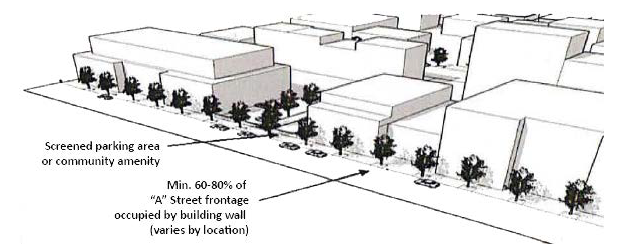
| M | O | (3) Minimum Building Frontage | ||
| This standard ensures that buildings are located near the sidewalk edge to promote an active pedestrian environment and help screen parking areas. Building walls shall occupy the following minimum percent of the lot width at the maximum street setback lines: | ||||
| MU-C & MR District DT/VC District | ||||
| Min. Building Frontage: 60% Min. Building Frontage: 80% | ||||
 | ||||
| M | M | (4) Required Sidewalk | ||
| To facilitate pedestrian activity, a sidewalk shall be provided along the street frontage with a minimum width and "clear zone" (area unobstructed by permanent or nonpermanent elements) as follows: | ||||
|
Sidewalks shall be a minimum width of 4′.
Sidewalks within the Downtown Center shall be specified through the development review and project entitlement process. | 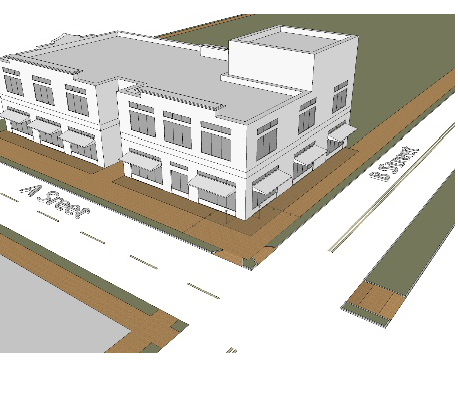 | |||
| M | O | (5) Required Street Tree/Furniture Area | ||
| To enhance the appearance of streets and promote a high-quality pedestrian experience, a street tree/furniture area shall be provided between the curb and sidewalk with a minimum width and landscaping/amenities as follows: | ||||
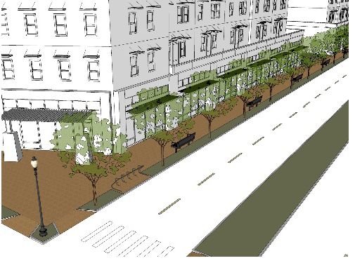 | ||||
| Min. Street Tree Area Width: | 4′ | |||
| Required Trees | Deciduous | |||
| Max. Average Tree Spacing in Tree Area: 1 | 30′ on center | |||
| Appropriate Elements for Tree Area: 2 |
• Street furniture (benches, seating,
etc.) | |||
| • Bicycle racks | ||||
| • Street lights | ||||
| • Waste receptacles | ||||
| • Outdoor dining | ||||
| • Utility equipment & vending boxes | ||||
| • Other similar items | ||||
| 1 Specifications for tree calipers and species are established in Chapter 20.04. | ||||
| 2 Must not obstruct pedestrian access or motorist visibility. | ||||
| M | O | (6) Required Pedestrian Connection to Building Entrance | ||
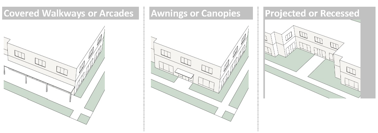
| Primary building entrances shall be connected to the sidewalk to ensure pedestrian access between buildings and transit corridors. Use one of the following options: | ||||
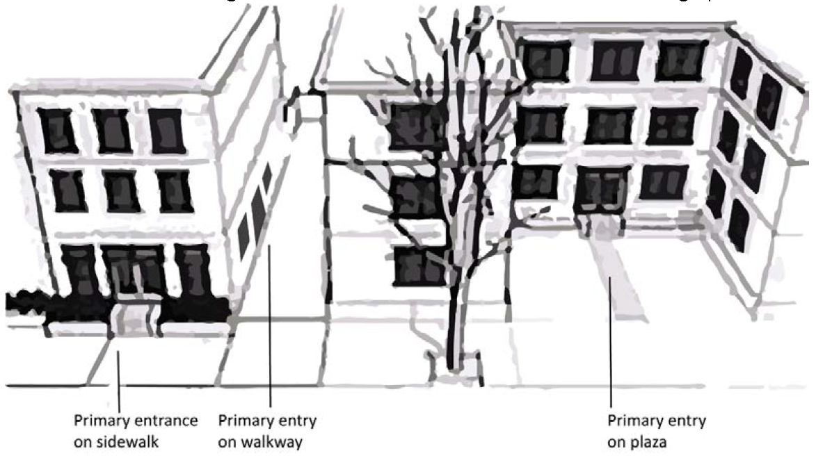 | ||||
| The primary building entrance is located at the sidewalk edge and faces the street | The primary building entry is located on a walkway or breezeway that is directly connected to the sidewalk (does not require walking around the building) | The primary building entry faces a public plaza that is oriented towards the street | ||
| M | M | (7) Required Pedestrian Connections Between Properties | ||
| To support an interconnected pedestrian system, connections shall be provided to the following types of off-site pedestrian amenities: | ||||
| A Sidewalks or walkways near the property line | 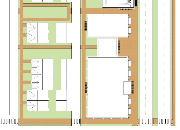 | |||
| B Adjacent transit stops | ||||
| C Adjacent residential areas | ||||
| D Adjacent parks, open spaces or trail systems | ||||
| E Adjacent civic uses | ||||
b.
The Administrator may approve alternative streetscape configurations and widths where the above configurations are not feasible. For example, existing development patterns and lot depths along some portions of Prater Way would limit sidewalk widths.
5.
Landscaping.
Purpose: This subsection emphasizes the use of landscaping at the street edge to:
• Provide visibility and needed shade;
• To enhance the pedestrian environment from a safety and transit supportive perspective;
• To promote a more compact, urban pattern of development along the city's major urban corridors; and
• To provide an incentive for infill and redevelopment.
a.
The minimum portion of the site area to be landscaped is as follows:
b.
Landscape standards are defined in Chapter 20.04, unless otherwise specified in this chapter. In the case of a landscaping ordinance conflict, the MUD landscaping standard prevails.
c.
The applicant may credit the following areas towards the minimum landscape requirements for "Primary" Streets above:
• Required street trees;
• Areas within the Street/Furniture Zone that are occupied by street furniture and
• Areas subject to the Streetscape and the Community Amenities requirements below.
D.
Residential Design Standards.
1.
Building Design. The following standards apply to residential building design within the MUD district:
a.
Residential development shall incorporate a combination of materials (e.g., horizontal siding, brick, and traditional stucco) and colors tailored to the surrounding neighborhood context. For the purposes of evaluating the surrounding neighborhood context, consideration shall be given to predominant characteristics of existing buildings along the immediate block and block face.
b.
All sides of a building that are visible from a public street shall include primary and accent materials as described below.
(1)
Primary building materials include, but are not limited to:
(a)
Brick, stone; or other masonry products;
(b)
Steel;
(c)
Stucco or EIFS (Exterior Insulation and Finish System). *Stucco or EIFS is limited to 75% as a primary material and windows may considered as a secondary material;
(d)
Cast stone;
(e)
Split face block;
(f)
Composite siding; or
(g)
Comparable material as approved by the Administrator.
(2)
Accent Materials may include:
(a)
Brick, stone, or other masonry products;
(b)
Steel or other metals;
(c)
Cast stone;
(d)
Composite siding;
(e)
Split face block;
(f)
Wood;
(g)
Stucco or EIFS (Exterior Insulation and Finish Systems); or
(h)
Comparable material as approved by the Administrator.
c.
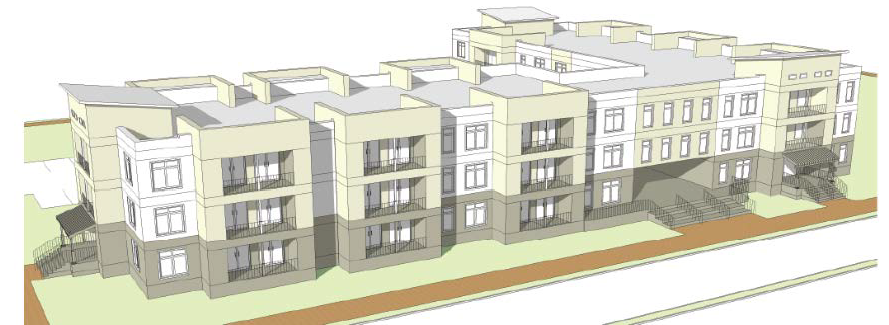
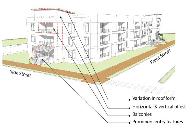
The sides of a building that are visible from a public street shall incorporate architectural detailing that is consistent with the front facade. Articulation of building walls shall be accomplished through the use of at least 4 of the following architectural features:
(1)
Covered porches or stoops;
(2)
Horizontal or vertical offsets;
(3)
Balconies;
(4)
Prominent entry features;
(5)
Windows;
(6)
Door openings;
(7)
Distinct variations in color;
(8)
Variations in texture and/or materials;
(9)
Variations in building height;
(10)
Variation in roof form;
(11)
Dormers;
(12)
Projected or recessed building walls; or
(13)
Alternative detail as approved by the Administrator.
d.
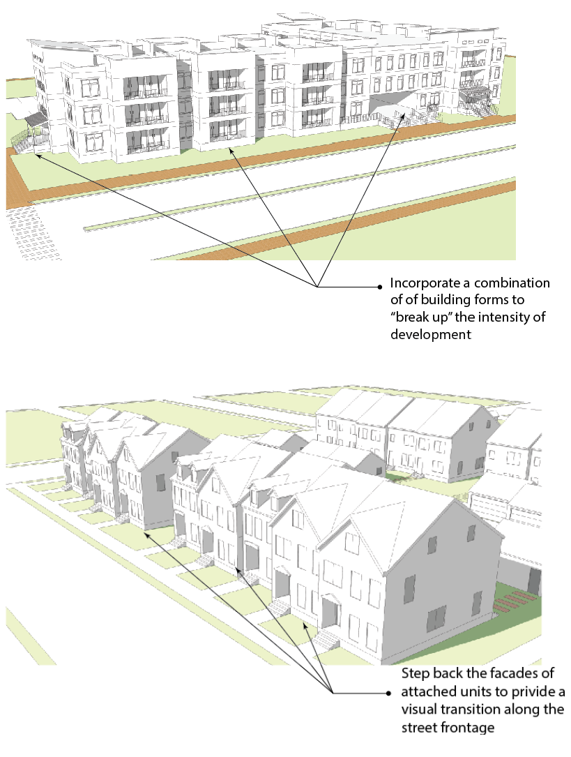
A variety of building massing forms and techniques is allowed in order to provide visual interest along the corridor's residential street frontages and accommodate a range of housing types. One or more of the following techniques shall be incorporated:
(1)
Step back the facades of attached units (town homes, triplexes, etc.) to provide a visual transition along the street frontage and create the appearance of a series of separate homes along the street frontage.
(2)
Design multiple unit buildings so that the massing and use of exterior materials gives each building the appearance of a large single-family home.
(3)
Orient unit's perpendicular to the front setback towards a central courtyard with an opposing row of units across the courtyard.
(4)
Incorporate a combination of building forms to "break up" the intensity of development and reinforce the pattern of the surrounding neighborhood.
(5)
Incorporate a combination of the above techniques or an alternative technique as approved by the Administrator.
2.
Site Design. The following standards apply to residential site design within the MUD district:
a.
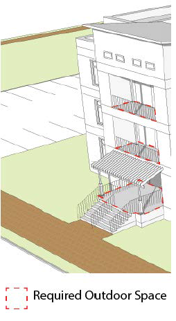
At least 25 square feet of outdoor space shall be provided per dwelling unit. Outdoor spaces may include a shared patio, balcony, or similar space and may be aggregate to one or more locations.
b.
Garage configurations are as follows:
(1)
Front-Loading (Street-Facing) Garages shall be detached from the primary structure and located in the rear yard, or are recessed behind the front facade at least of 10 feet.
(2)
On blocks with alley access, garages shall be oriented towards and accessed from the alley, not from the primary street. On blocks without alley access, garage entries, parking lots, and parking structures shall be internalized in building groupings and behind the primary structure, away from street frontages.
c.
Detached Garages and Carports:
(1)
Detached garages and carports:
(a)
Are limited to 60 feet or 6 garage bays in length, whichever is less, unless accompanied by carriage units (as described below), and
(b)
shall incorporate compatible materials, colors, architectural details, and roof slopes as the primary structure on the site.
(2)
"Carriage units" (accessory dwelling units are allowed above detached garages to increase the variety of housing options available within the corridor).
(3)
Tuck-under garages shall provide a landscape strip or island that separates each group of two garage doors or adjoining residence when a driveway is included.
Example of tuck-under garages with landscape strips
separating garage doors.
d.
Transitional Standards.
(1)
Residential development that is located adjacent to or within an established single-family residential neighborhood shall minimize impacts on adjacent homes by:
(a)
Limiting exterior lighting to full-cutoff shielded fixtures and directing lights away from adjacent properties;
(b)
Limiting sources of audible noise (e.g., heating and air conditioning units) from building facades that face lower intensity uses;
(c)
Locating off-street parking, loading, and service areas away from the shared property and incorporating them into the design of buildings they are intended to serve;
(d)
Placing windows on the new development so as to maintain privacy by avoiding direct lines of sight into adjacent homes; and
(e)
Orienting balconies and other outdoor living spaces away from a shared property line.
(2)
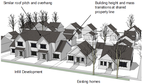
Residential infill that exceeds the height of adjacent existing homes by more than one story in height and/or are significantly larger in terms of their overall mass shall provide a transition using at least three of the following techniques:
(a)
"Stepping down" building height and mass along the shared property line to meet the height of the existing adjacent home. The "stepped down" portion of the building shall be at least ten feet in depth along at least 50 percent of the building's length;
(b)
Increasing the side yard setback at least 5 feet beyond that which is required and providing a landscape buffer along a shared lot edge;
(c)
Providing variations in the side building wall and roof form so that new structures have a comparable scale as adjacent homes along a shared side;
(d)
Using a roof pitch and overhang similar to that of the adjacent structures; and
(e)
Using dormers and sloping roofs to accommodate upper stories.
(3)
Alternative approaches may be approved by the Administrator provided the overall objective of this standard can be satisfied.
E.
Commercial and Mixed Use Building Design Standards.
1.
Building Design. The following standards apply to commercial and mixed-use building design in the mixed-use district:
a.
Buildings and their principal entrances shall face streets or interior pedestrian plazas. Along "secondary" streets, buildings may align perpendicular to a public street and face a parking area.
b.
Building walls shall occupy the following minimum percent of the lot width at the street: MU-C and MR = 60%, DT/VC = 80%.
c.
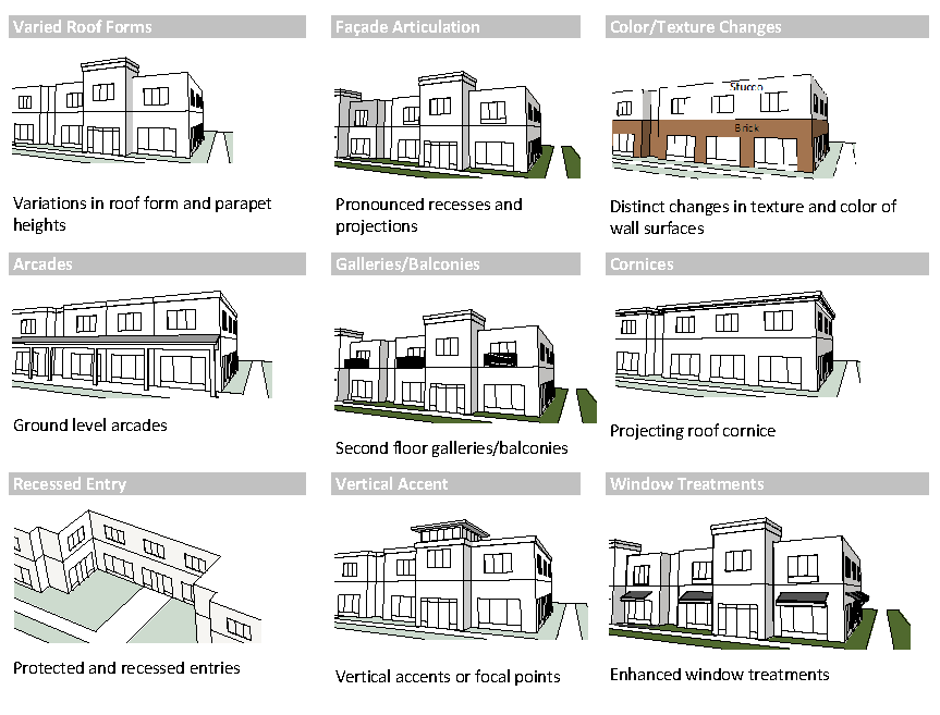
The perceived mass and scale of commercial and mixed-use buildings shall be reduced by incorporating a series of smaller design elements that are consistent with the development's architectural character. Select a minimum of four design elements from the following menu:
d.
Façade Materials.Building materials used on street-facing façades shall be durable and project an image of permanence to enhance community character. The following materials may be used:
e.
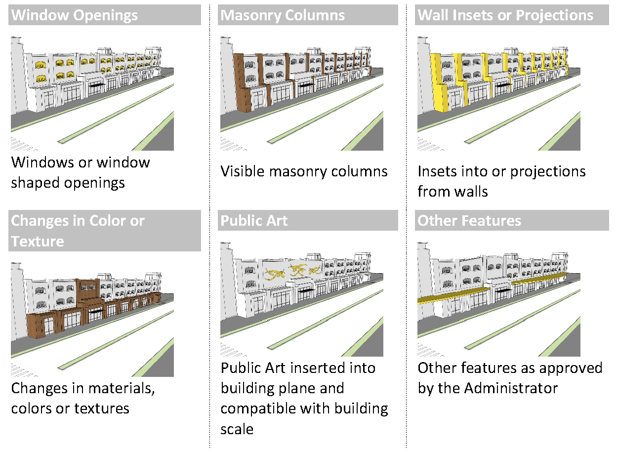
Parking Structure Façade Interest. To ensure that parking structures do not have a negative visual impact, they shall be designed to screen views of parked cars on all visible façades. Select at least 3 architectural elements from the following: 1
1 Parking structures must also meet requirements for ground floor pedestrian interest below.
f.
Ground Floor Pedestrian Interest.
(1)
Required Transparency. The following minimum percentage of the total area of each ground-level building facade shall be comprised of transparent window openings to allow views of interior spaces and merchandise, to enhance the safety of public spaces by providing direct visibility to the street, and to create a more inviting environment for pedestrians:
1 Ground-level area includes the area between the first and second floor plates for the full width of the façade elevation.
2 Applies only to large-format retail buildings that are incorporated as part of a mixed-use center.
3 Black or mirrored glass is prohibited.
g.
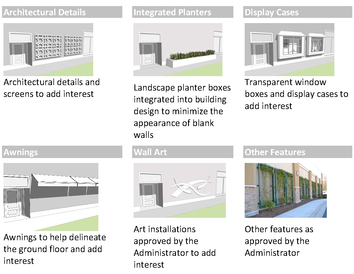
Transparency Alternative. Up to 50 percent 1 of required transparency may be met using a minimum of two of the following alternative options for ground floor pedestrian interest:
1 For a parking structure, alternative options for ground floor pedestrian interest may be used to meet 100% of required transparency
h.
Primary Entrance Requirements. Primary building entrances shall be clearly distinguished through the use of one or more of the following architectural features:
2.
Site Design.
a.
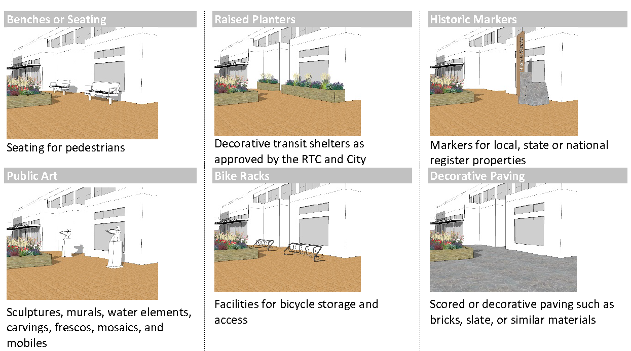
Required Community Amenities. To promote pedestrian use of landscape areas, at least 25% of the minimum landscaping requirement shall be devoted to community amenities. Such amenities shall be adjacent-to or integrated-with transit stops, or located in areas of high pedestrian activity and should include at least three of the following:
Easements may be required from the City to accommodate these amenities.
b.
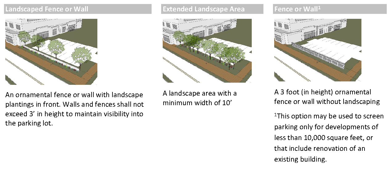
Required Screening of Surface Parking. All surface parking lots visible from the public right-of-way shall be screened using one of the following methods:
(Ord. 2590, § 1(Exh. 1), Amended 02/24/2020; Ord. 2547, § 1(Exh. A), Amended, 12/11/2017; Ord. 2512, § 1(Exh. A), Add. 08/24/2015)
Section 20.02.007 - Commercial districts (C).
Purpose: This district provides a mix of retail and other commercial services in concentrated centers that serve the local community, or tourist-oriented uses adjacent to I-80 and the Spanish Springs Valley. It may also include larger retail centers that serve as a regional draw. Single-use or "strip center" commercial patterns of development are discouraged. Smaller, limited use centers should be integrated into the surrounding neighborhood.
A.
Uses. Refer to Section 20.02.013 (Use Table).
B.
Dimensional Standards.
* May exceed height by Conditional Use Permit
C.
Design Standards.
1.
Site Planning Standards.
a.
Loading areas shall be located in the rear of the building and visually screened with architecturally compatible building materials. The screening shall reduce the impacts from noise generated from a loading area, as well as visually screen from adjacent development.
b.
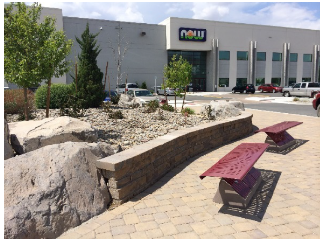
Adjacent residential and non-residential uses shall be as integrated as is necessary to maintain a livable residential environment. This may be achieved with masonry walls, landscaping, berms, building orientation window orientation, and fencing, but shall provide connectivity such as walkways, common landscape areas, building orientation and unfenced property lines; when there is mutual benefit.
Example of landscaping, berms, rockeries and connectivity.
2.
Building Placement.
a.
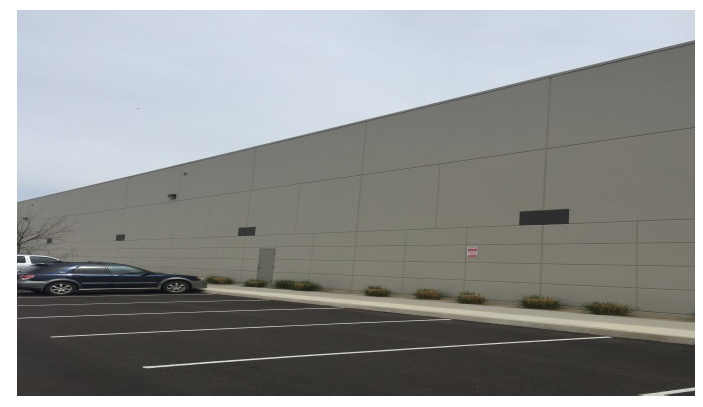
Blank building walls shall not be allowed.
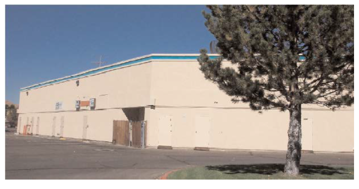
Example of poorly articulated building wall.
b.
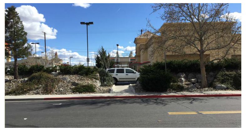
On commercial sites three acres and larger, a minimum of 15 percent and a maximum of 50 percent, of the total primary building frontage shall be oriented toward the front and arterial roadway with parking located in the middle, side or rear.
Example of appropriate commercial building layout.
Example of excessive building frontage on an arterial.
c.
Multiple buildings in a single project must demonstrate a functional relationship. Building design shall create opportunities for plazas and pedestrian areas. Texture, material and patterns shall be utilized to promote aesthetic consistency between buildings. This shall be accomplished through the use of arcades, trellis, colonnade, building materials, massing, form, texture, material, pattern or other open structures.
Example of appropriate use of open space between buildings.
d.
Buildings along transit routes shall have an entrance oriented toward transit stops for convenient access by transit passengers. Entrances shall be architecturally defined and easily recognizable.
e.
Open space areas shall be grouped into useable areas, rather than equally distributing them into smaller areas that have little or no impact, or to areas of minimal impact to the publics' view. The intent is to provide useable open space within a complex of buildings or a project.
Example of appropriate use of useable open space within a complex of buildings.
3.
Building Design.
a.
Articulation shall be horizontal, diagonal and vertical on walls.
b.
There shall be no long expanses of flat wall planes, vertically exceeding 20 feet or horizontally exceeding 30 feet. Examples of methods of articulation include:
(1)
Use of cornices
(2)
Use of awnings
(3)
Staggered parapets
(4)
Horizontal or vertical wall offsets
(5)
Deeply recessed windows
(6)
Extended windows
(7)
Covered arcades
(8)
Use of color
(9)
Material/texture changes
c.
Exterior walls shall be aesthetically consistent around the entire building. Blank walls are not permitted. (i.e. must incorporate a mix of color, texture, material and pattern)
d.
Buildings within a single project must be designed to be aesthetically consistent with a unified appearance using similar building materials, and having varied texture, color or design.
e.
The following materials are not permitted as a primary building material:
(1)
Reflective metal
(2)
Corrugated fiberglass or plastic
(3)
Asphalt shingles
(4)
Unprotected wood
f.
Columns, projections and exterior detailing shall be used to architecturally demarcate and enhance buildings.
g.
Ground floors of buildings adjacent to walkways and roadways shall be articulated with the use of smaller, more pedestrian scale features, such as building mass, roof lines, colonnades or planters.
4.
Roofs.
a.
The visible roof profile line shall not continuously run more than 150 feet. Methods to change the roof profile include the horizontal and vertical off-sets, jogging and varying parapets, roof over hangs or similar design elements.
b.
Mansard style roofs, canopies, awnings and cornices shall be aesthetically consistent around the entire building perimeter.
c.
Roof drains, leaders, and downspouts shall be integrated into the exterior design of the structure.
d.
Reflective metal shall not be used as the primary roofing material.
5.
Building color can dramatically affect the appearance of buildings and should be used to affect the scale and proportion of a building by highlighting architectural elements such as doors, windows, fascia, cornices, lintels and sills.
a.
Large areas (no more than 25 percent of one exterior side) of intense colors are prohibited.
b.
Bright or intense colors shall be used for accent only.
c.
Color shall be utilized on all sides of the building.
Section 20.02.008 - Professional office district (PO).
Purpose: This district provides office uses in the urbanized area, particularly in the vicinity of clinics, hospitals, commercial activities and major streets. This also provides a transitional land use between single family and commercial land uses.
A.
Uses. Refer to Section 20.02.013 (Use Table).
B.
Dimensional Standards.
C.
Design Standards.
1.
Site Planning Standards.
a.
Loading areas shall be located in the rear of the building and visually screened with architecturally compatible building materials. The screening shall reduce the impacts from noise generated from a loading area, as well as visually screen from adjacent development.
b.
Adjacent residential and non-residential uses shall be as integrated as is necessary to maintain a livable residential environment. This may be achieved with masonry walls, landscaping, berms, building orientation window orientation and fencing, but shall provide connectivity such as walkways, common landscape areas, building orientation and unfenced property lines; when there is mutual benefit.
2.
Building Placement.
a.
Blank Building Walls (facing public streets) shall not be allowed.
Example of poorly articulated wall facing a public street.
b.
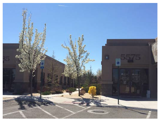
On office sites 3 acres and larger, a minimum of 15% of the total primary building frontage shall be oriented toward the front with parking located on the side or rear.
Example of building frontage oriented toward street.
c.
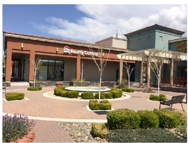
Multiple buildings in a single project must demonstrate a functional relationship. Building design shall create opportunities for plazas and pedestrian areas. Texture, material and patterns shall be utilized to promote aesthetic consistency between buildings. This shall be accomplished through the use of arcades, trellis, colonnade, building materials, massing, form, texture, material, pattern or other open structures.
Example of pedestrian area between buildings.
d.
Buildings along transit routes shall have an entrance oriented toward transit stops for convenient access by transit passengers. Entrances shall be architecturally defined and easily recognizable.
e.
Open space areas shall be grouped into useable prominent landscape areas, rather than equally distributing them into areas of low impact such as building peripheries, minimal side yard setbacks, behind a structure, or to areas of little impact to the public's view. The intent is to provide useable open space within a complex of buildings or project, and shall not be required with every building or project, nor shall every area surrounding buildings or project be useable space.
3.
Building Design.
a.
Articulation can be horizontal, diagonal and vertical on walls.
b.
There shall be no long expanses of flat wall planes, vertically exceeding 20 feet or horizontally exceeding 30 feet. Examples of methods of articulation include:
(1)
Use of cornices
(2)
Use of awnings
(3)
Staggered parapets
(4)
Horizontal or vertical wall offsets
(5)
Deeply recessed windows
(6)
Extended windows
(7)
Covered arcades
(8)
Use of color
(9)
Material/texture changes
c.
Exterior walls shall be aesthetically consistent around the entire building. Blank walls are not permitted (i.e. must incorporate a mix of color, texture, material, and pattern).
d.
Buildings within a single project must be designed to be aesthetically consistent with a unified appearance using similar building materials, and having varied texture, color or design.
e.
The following materials are not permitted as a primary building material:
(1)
Reflective metal
(2)
Corrugated fiberglass or plastic
(3)
Asphalt shingles
(4)
Unprotected wood
f.
Columns, projections and exterior detailing shall be used to architecturally demarcate and enhance buildings.
g.
Ground floors of buildings adjacent to walkways and roadways shall be articulated with the use of smaller, more pedestrian scale features, such as building mass, roof lines, colonnades or planters.
4.
Roofs.
a.
The visible roof profile line shall not continuously run more than 150 feet. Methods to change the roof profile include the horizontal and vertical off-sets, jogging and varying parapets, roof over hangs or similar design elements.
b.
Mansard style roofs, canopies, awnings, cornices and façade design shall be visually consistent around the entire building perimeter.
c.
Roof drains, leaders, and downspouts shall be integrated into the exterior design of the structure.
d.
Corrugated reflective silver metal shall not be used as the primary roofing material.
5.
Building Color can dramatically affect the appearance of buildings and should be used to affect the scale and proportion of a building by highlighting architectural elements such as doors, windows, fascia, cornices, lintels and sills.
a.
Large areas (no more than 25 percent of one exterior side) of intense colors are prohibited.
b.
Bright or intense colors shall be used for accent only.
c.
Color shall be utilized on all sides of the building.
(Ord. 2512, § 1(Exh. A), Add. 08/24/2015)
Section 20.02.009 - Industrial district (I).
Purpose: This district provides intensive work processes such as manufacturing or basic resource handling. These areas are generally located south of I-80 between the western and eastern City boundaries. Other potential areas suited are along I-80 and/or rail corridor.
A.
Uses. Refer to Section 20.02.013 (Use Table).
B.
Dimensional Standards.
Site is defined as a parcel or combination of parcels or lots which share a common development plan or which are dependent upon one another for access, parking or utilities.
C.
Commercial / Mixed Uses and Public/Civic/Institutional Uses.
1.
Locationally restricted parcels:
a.
Are located anywhere in the area bounded by Glendale Avenue on the north, Deming Way on the east, Rock Boulevard on the west, and Greg Street on the south; or
b.
Are within 600 feet of McCarran Boulevard, Glendale Avenue, or Rock Boulevard; or
c.
Are within 600 feet of the portion of Greg Street that is east of the City of Sparks boundary at the point where it intersects Greg Street and west of the intersection of Greg Street and McCarran Boulevard; or
d.
Are within 600 feet to the east of the portion of Sparks Boulevard that is north of the intersection with Interstate 80 and south of the intersection with Prater Way.
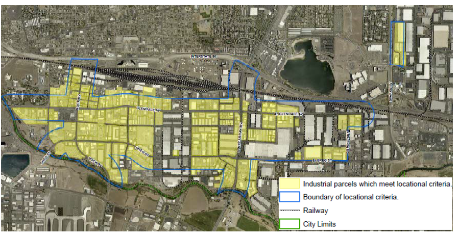
Industrial Parcels Locational Criteria Map
2.
All uses that are permitted by the locational criteria (see Use Matrix) are not permitted on a property with railway access.
3.
The Administrator may approve a use on a site that complies with the locational criteria and has railway access (shown on the "Industrial Parcels Locational Criteria" map) if it can be demonstrated the property can no longer access the rail.
D.
Design Standards.
1.
Site Planning Standards. Loading areas shall be located in the rear of the building and visually screened with architecturally compatible building materials. The screening shall reduce the impacts from noise generated from a loading area, as well as visually screen from adjacent development.
2.
Building Placement.
a.
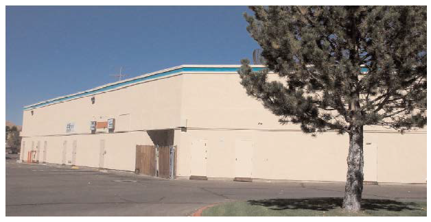
Blank building walls (facing public streets) shall not be allowed.
Example of poorly articulated industrial building.
b.
Multiple buildings in a single project must demonstrate a functional relationship. Building design shall create opportunities for plazas and pedestrian areas. Texture, material and patterns shall be utilized to promote aesthetic consistency between buildings. This shall be accomplished through the use of arcades, trellis, colonnade, building materials, massing, form, texture, material, pattern or other open structures.
c.
Buildings along transit routes shall have an entrance oriented toward transit stops for convenient access by transit passengers. Entrances shall be architecturally defined and easily recognizable.
d.
Open space areas shall be grouped into useable areas, rather than equally distributing them into smaller areas that have little or no impact, or to areas of minimal impact to the publics' view. The intent is to provide useable open space within a complex of buildings or a project. Open space may not be required with every building or project nor shall every area of surrounding a building or project be useable space.
Example of usable open space area
3.
Building Design.
a.
Articulation shall be horizontal, diagonal and vertical on walls.
b.
There shall be no long expanses of flat wall planes, vertically exceeding 30 feet or horizontally exceeding 50 feet. Examples of methods of articulation include
(1)
Use of cornices
(2)
Use of awnings
(3)
Staggered parapets
(4)
Horizontal or vertical wall offsets
(5)
Deeply recessed windows
(6)
Extended windows
(7)
Covered arcades
(8)
Use of color
(9)
Material/texture changes
c.
Exterior walls shall be aesthetically consistent around the entire building. Blank walls are not permitted. (i.e. must incorporate a mix of color, texture, material, and pattern.
d.
Buildings within a single project must be designed to be aesthetically consistent with a unified appearance using similar building materials, and having varied texture, color or design.
e.
The following materials are not permitted as a primary building material:
(1)
Reflective metal
(2)
Corrugated fiberglass or plastic
(3)
Asphalt shingles
(4)
Unprotected wood
f.
Columns, projections, and exterior detailing shall be used to architecturally demarcate and enhance buildings.
g.
Ground floors of buildings adjacent to walkways and roadways shall be articulated with the use of smaller, more pedestrian scale features, such as building mass, roof lines, colonnades, or planters.
4.
Roofs.
a.
The visible roof profile line shall not continuously run more than 150 feet. Methods to change the roof profile include the horizontal and vertical off-sets, jogging and varying parapets, roof over hangs, or similar design elements.
b.
Mansard style roofs, canopies, awnings, cornices and façade design shall be visually consistent around the entire building perimeter.
c.
Roof drains, leaders, and downspouts shall be integrated into the exterior design of the structure.
d.
Corrugated reflective silver metal shall not be used as the primary roofing material.
5.
Building Color can dramatically affect the appearance of buildings and should be used to affect the scale and proportion of a building by highlighting architectural elements such as doors, windows, fascia, cornices, lintels and sills.
a.
Large areas (no more than 25 percent of one exterior side) of intense colors are prohibited.
b.
Bright or intense colors shall be used for accent only.
c.
Color shall be utilized on all sides of the building.
(Ord. 2512, § 1(Exh. A), Add. 08/24/2015)
Section 20.02.010 - Public facilities district (PF).
Purpose: This district provides public facilities that are either inappropriate in another location due to site impacts, or that require flexible design and site planning.
A.
Uses. Refer to Section 20.02.013 (Use Table).
B.
Dimensional Standards.
(Ord. 2547, § 1(Exh. A), Amended, 12/11/2017; Ord. 2512, § 1(Exh. A), Add. 08/24/2015)
Section 20.02.011 - Historic preservation overlay (H).
Purpose: The City's policy is to promote the educational, cultural, economic and general welfare of the public through the recognition, enhancement, preservation and protection of sites and districts within the City of historical and cultural significance. It is the intent of this Title to create a flexible, self-perpetuating voluntary historic resources program to preserve and promote the community's functional resources in an economically viable manner.
A.
Criteria for Designating Historic Resources and Historic Districts. The Historic Review Commission (HRC) shall compile and maintain, on behalf of the City, a register of historic resources that possess integrity of location, design, setting, materials, workmanship, and in addition to being at least 50 years old, meet one or more of the following criteria:
1.
Be associated with events that have made a significant contribution to the broad patterns of our history; or
2.
Be associated with the lives of persons significant in our past; or
3.
Embody the distinctive characteristics of a type, period, or method of construction, or that represent the work of a master, or that possess high artistic values, or that represent a significant and distinguishable entity whose components may lack individual distinction; or
4.
Have yielded, or may be likely to yield, information important in prehistory or history.
B.
Procedures for Nomination and Listing.
1.
Any person may request the HRC to designate a historic resource.
2.
The owner of a property nominated to the Sparks Register of Historic Places must consent to the inclusion of said property on the register prior to the nomination process moving forward as outlined below.
3.
Upon receipt of an application for listing on the Sparks Register of Historic Places, HRC staff shall notify the property owner and building division of the pending request. No building or demolition permits shall be issued for any alteration to any improvement, fixture, or façade location on a site subject to a request for listing on the Sparks Register of Historic Places while an application is pending action from the HRC. In no event shall the delay be for more than 120 days.
4.
The HRC shall hold a duly noticed public meeting in accordance with the State of Nevada Open Meeting Law. In their review of the request for listing on the Sparks Register of Historic Places, the HRC shall consider the request by the criteria listed in Subsection A, above. For listing, a historic resource needs to successfully demonstrate that it meets at least one of these criteria.
5.
Subsequent to the public meeting, the HRC shall approve, approve with conditions, or deny the proposed application for listing on the Sparks Register of Historic Places.
6.
No later than ten working days following the HRC's decision regarding an application to the Sparks Register of Historic Places, the decision shall be filed with the HRC's clerk, and a notice thereof shall be mailed to the applicant.
7.
Any resource listed on the Sparks Register of Historic Places shall be identified on the zoning map of the City.
8.
Any historic designation conferred upon a resource pursuant to this chapter may be removed subsequent to notice thereof, publication, and a public hearing as provided above.
C.
Historic Districts. A Historic District may include any geographically definable area possessing a significant concentration or continuity of sites, buildings, structures, or objects unified by past events, or aesthetically by plan or physical development is eligible for historical district designation. Any historic district within the City's incorporated limits must meet at least one of the criteria listed in SMC 20.95.030.
D.
Historic District Overlay. The boundaries of a Historic District may be combined with any zoning district provided for in Title 20 as an overlay to be shown on the zoning map of the City. Development within an historic district overlay shall be subject to historical preservation provisions as set forth in this article, as well as to the regulations of the underlying zone. Where conflict occurs, the regulations set forth in this article shall apply.
E.
Historic Markers. Historic Markers displaying pertinent information about the district may be placed at various vehicular and pedestrian gateways into the historic district. All permanent signs displaying historic information shall comply with the requirements of SMC 20.56 of this title. A record of historic districts would be kept at the City of Sparks and at the Nevada State Historic Preservation Office or other agencies as required.
F.
Procedures for Establishing Historic Districts.
1.
Any person may request the HRC to designate a historic district.
2.
Upon receipt of a complete nomination submitted to the HRC, HRC staff shall schedule at least one meeting to discuss any proposed Historic District. All meetings shall be noticed to all property owners within the boundaries of the proposed historic district shall be notified and invited to attend and present testimony at any neighborhood meeting.
3.
Subsequent to all required neighborhood meetings, the HRC shall hold a noticed public meeting, at which time the HRC shall furnish a recommendation to the Planning Commission and the City Council to approve or deny a proposed Historic District. If the HRC finds that the district should be approved, the recommendation to the Planning Commission and the City Council shall include:
a.
A map showing the proposed boundaries of the historic district and identifying all structures within the boundaries, contributing or non-contributing;
b.
An explanation of the significance of the proposed district and description of the historic resources within the proposed boundaries;
c.
A statement regarding how the proposed district satisfies the criteria set forth in subsection A above.
4.
The Planning Commission, upon receipt of the notice from the HRC clerk that the HRC has recommended approval of a historic district, shall initiate a rezone request to add a historic landmark overlay to all the properties within the proposed district within 45 days of receiving the receipt. The Planning Commission shall forward a recommendation to rezone request of all properties within the proposed district, the recommendation to City Council shall contain the report from the HRC approving the proposed Historic District.
5.
Upon receiving a recommendation from the Planning Commission, the City Council shall review both the boundaries of the proposed district and the rezone request for all properties within the district. The City Council shall designate an area as a Historic District if it finds that the Historic District:
a.
Is a geographically definable area possessing a significant concentration or continuity of sites, buildings, structures or objects unified by past events, or aesthetically by plan or physical development;
b.
The collective historical value of the proposed historic district is greater than that of each individual historic resource contained therein;
c.
The proposed designation is in conformance with the purpose of the City's historic preservation provisions set forth in this article, the City's master plan, and the criteria established in subsection A above.
6.
After City Council action, the Council's decision shall be filed with the City Clerk. A notice thereof shall be mailed to the applicant at the address shown on the application and to the owners of properties located within the proposed historic district.
G.
Procedure and Criteria for Rescinding Historic Resources.
1.
Any person may submit a written request to the HRC to rescind his/her resource from the Sparks Register of Historic Places or from a Historic District. The application shall be made on forms provided by the City and shall be submitted to the planning division.
2.
Upon receipt of a complete application the HRC shall hold a duly noticed public meeting. In their review of the request to remove a resource from the Sparks Register of Historic Places or from a Historic District, the HRC shall consider the following criteria of this section.
a.
New documentation has been presented disproving the information upon which the resource was placed on the Sparks Register of Historic Places or included within the boundaries of a Historic District;
b.
Evidence has been presented showing that modifications and alterations to the resource have eliminated the distinctive architectural features that warranted its placement on the Sparks Register of Historic Places or its inclusion within the boundaries of a Historic District.
3.
Following the public meeting the HRC shall approve, approve with conditions, or deny the proposed application for rescinding a historic resource from the Sparks Register of Historic Places or from a Historic District.
4.
Upon approval of removing a resource from the Sparks Register of Historic Places or from a Historic District the Historic Preservation Overlay shall be removed from the zoning map of the City utilizing the process outlined in subsection F.
H.
Certificates of Appropriateness.
1.
It is unlawful for any person to tear down, demolish, construct, alter, remove or relocate any historic resource or any portion thereof that has been listed on the Sparks Register of Historic Places, or to alter in any manner any feature of such designated resource without first obtaining a certificate of appropriateness in the manner provided in this article. Such a certificate shall be obtained prior to the issuance of a building permit for the purpose of constructing, altering, and moving historic resources. In the event a building permit is not otherwise required, all property owners of historic resources listed on the Sparks Register of Historic Places shall meet with HRC staff to determine if the proposed alterations need a certificate of appropriateness. All repairs, alterations, constructions, restorations of applicable historic resources shall conform to the requirements of any historic design standards adopted by the HRC and City Council as well as to the Secretary of the Interior's Standards for Rehabilitation. Any permit not issued in conformity with this section shall be invalid.
2.
A certificate of appropriateness is not required for routine maintenance (masonry tuckpointing, cleaning and repainting), installation of temporary fixtures (awnings and canopies, light fixtures, steps, and landscape accessories) and maintenance and removal of plantings and non-mature trees that in the opinion of HRC staff does not significantly alter the historical features of any resource listed on the Sparks Register of Historic Places. Any maintenance of trees designated as historic must be approved in advance by the City's Urban Forester or their designee.
3.
This section does not prevent the construction, reconstruction, alteration, improvement, restoration, demolition to any resource listed on the Sparks Register of Historic Places if in the opinion of the City's Building Division that such action is required for the public safety due to an unsafe or dangerous condition which cannot be rectified without such action taking place.
I.
Submittal Requirements for Major and Minor Certificates of Appropriateness.
1.
An application for certificate of appropriateness shall be filed by the owner of a resource listed on the Sparks Register of Historic Places with the Community Development Department on a form provided by the City. The application shall be accompanied by sketches, drawings, photographs, specifications, descriptions and other necessary information regarding the proposed project.
2.
Following the City of Sparks' receipt of a complete application, HRC staff shall determine whether a project requires a minor certificate of appropriateness or a major certificate of appropriateness:
a.
Minor certificate of appropriateness projects shall be subject to HRC staff review and do not require a public meeting. HRC staff may, if necessary confer with the chairman and vice chairman of the HRC prior to determination. Minor project includes projects that do not in the opinion of HRC staff significantly alter or change the historic appearance of any resource listed on the Sparks Register of Historic Places involving minor restoration and exterior changes to architectural accents and decorative elements, porches, exterior staircases, exterior doors, windows, skylights, mechanical systems, storm windows and doors, security grilles, and fire escapes.
b.
Major certificate of appropriateness projects that require a certificate of appropriateness shall be subject to staff determination prior to review by the HRC. Major projects include any which significantly alter or change the historic appearance of any resource listed on the Sparks Register of Historic Places. These alterations include all but are not limited to; new construction, additions, removal, relocation, changes to the site, public right-of-way improvements, new freestanding signs, street furniture, exterior changes of building materials, large porches, changes in shape of roofs, solar collectors, retaining walls, fences and freestanding walls.
3.
In reviewing a certificate of appropriateness, HRC staff in the event of a minor certificate of appropriateness review or the HRC in the event of a major certificate of appropriateness review shall take into account the historic and architectural significance of the structure under consideration, the exterior form and appearance of any proposed modification to that structure, as well as the effect of such change upon other structures in the vicinity and shall make findings related to the following standards:
a.
Every effort shall be made to provide a compatible use for a property that requires minimal alterations of the resource and its environment, or to use a property for its original purpose.
b.
The distinguishing original qualities or character of a resource and its environment shall not be destroyed. The alteration or removal of any historic material or distinctive architectural feature shall be avoided.
c.
All resources shall be recognized as products of their own time. Alterations that have no historical basis and that seek to create an earlier appearance shall be prohibited.
d.
Changes that have taken place in the course of time are evidence of the history and development of a resource and its environment. These changes may have acquired significance in their own right. This significance shall be recognized as unique and respected.
e.
Distinctive stylistic features or examples of skilled craftsmanship that characterize a building, structure or site shall be treated with sensitivity.
f.
Deteriorated architectural features shall be repaired rather than replaced. In the event that replacement is necessary, the new material shall match the material being replaced in composition, design, color, texture, and other visual qualities. Repair or replacement of missing architectural features should be based on accurate duplication of features, substantiated by historic, physical or pictorial evidence, rather than on contextual designs, cost or the availability of different architectural elements from other buildings or structures.
g.
The surface cleaning of structures shall be undertaken with the gentlest means possible. Sandblasting and other cleaning methods which will damage the historic building materials shall be prohibited.
h.
Every reasonable effort shall be made to protect and preserve archaeological resources affected by or adjacent to any project.
i.
Contemporary design or alterations and additions to existing properties shall not be discouraged when such alterations and additions do not destroy significant historical, architectural or cultural material, and when such design is compatible with the size, scale, color, material and character or the property, neighborhood and environment.
j.
Other guidelines found within the most current edition of, "The Secretary of the Interior's Standards for Rehabilitation," and other standards, policies and guidelines adopted by the HRC and City Council.
4.
No later than ten (10) working days following action by HRC staff or by HRC, notification of the determination shall be filed with the clerk of the HRC and notice thereof shall be mailed to the applicant at the address shown on the application. If the determination was to approve the proposed work, HRC staff shall issue a certificate of appropriateness that outlines the approved work. If the determination was to disapprove the proposed work, the applicant shall be provided with a written statement giving the reasons for disapproval.
J.
Appeals of HRC Action.
1.
Any decision of the HRC may be appealed by the applicant, any aggrieved party, or any member of the HRC to the City Council by following the procedures in subsection 2 of this section within 21 days of the date of the HRC decision.
2.
Any project applicant or any aggrieved party may file an appeal as specified in this section provided that the appellant has filed written notice to the City Clerk to appeal a decision of the HRC within 21 days of the date of the HRC decision. The appeal letter shall include the appellant's name, mailing address, daytime phone number, and shall be accompanied by the appropriate fee. The letter shall specify the project or decision for which the appeal is being requested. The letter shall indicate which aspects of the decision are being appealed. No other aspect of the appealed decision shall be heard. The letter shall provide the necessary facts or other information which support the appellant's contention that the staff or HRC erred in its consideration or findings supporting its decision.
3.
Issues not addressed in the HRC meeting for a project which is being appealed may not be raised as a basis for the appeal unless there is substantial new evidence which has become available accompanied by proof that the evidence was not available at the time of the public meeting. If new information is submitted to the City Council, the application may be referred back to the HRC for further review and action.
4.
Upon determination that the appeal request is complete, the City Clerk shall request time on the next available City Council meeting agenda.
5.
Any decision or action of HRC staff may be appealed by the applicant, any aggrieved party, to the City Council as set forth in SMC 20.05.14.
K.
Avoiding Demolition Through Owner Neglect. Any structure or historic resource listed on the Sparks Register of Historic Places or within an established historic district shall be preserved against decay and deterioration and free from certain structural defects. Such structures shall be preserved and maintained by their owners in conformity with the requirements of this section and any standards adopted by the HRC or City Council.
L.
Minimum Maintenance of Historic Properties.
1.
The degree of maintenance and repair hereby required is that degree sufficient to prevent damage to a building's structural components and/or to its exterior that would cause the collapse of the structure or that would cause the building to become so deteriorated as to prevent its repair and preservation for resources listed on the Sparks Register of Historic Places. Acts which the owner may be required to perform pursuant to this section may include but are not limited to the following: securing the building or structure by boarding up doors and windows; and stabilizing walls, roofs and other parts of the building or structure.
2.
All owners of structures designated as historic properties shall maintain their structures in conformity with the following minimum standards:
a.
All structures shall be maintained in good general repair.
b.
Structural Elements.
(1)
All foundations shall support the structures and all points that provide for the structural integrity of the building shall be free of holes, wide cracks and buckling.
(2)
Exterior walls, trim and roofs shall be free of holes, wide cracks and loose, warped, protruding or rotting boards or any other condition which might admit moisture or other elements.
(3)
Masonry joints shall be maintained.
(4)
Exterior surfaces exposed to the weather shall be repaired and painted to protect them from further deterioration.
c.
Windows, exterior doors, bullheads, walls, and wood siding shall be watertight.
d.
Flashing, Gutters and Ventilation.
(1)
Exterior flashing, including those at chimneys, doors and windows, shall be maintained in good repair.
(2)
Down spouts and gutters shall be maintained so that rain runoff is directed away from the structure.
(3)
Foundation and attic vents shall be maintained to ventilate the crawl and attic spaces.
e.
Outside stairways, porches and appurtenances to stairways and porches shall be maintained in good repair.
f.
Unoccupied buildings shall be secured from intrusion and all utilities shall be properly maintained.
g.
Existing structures shall be protected during construction or renovation in a manner that assures no damage by weather to interior spaces or structural components.
h.
Any maintenance of trees designated as historic must be approved in advance by the City's Urban Forester or their designee.
M.
Emergency Demolition Permit.
1.
A request for a demolition permit involving a resource listed on the Sparks Register of Historic Places that has been subject to a catastrophic event, as defined in this article, shall be submitted in writing to the Community Development Department and shall include the property owner's authorization for submittal. In a situation where a resource must be demolished, the reuse of façade materials from the demolished resource is encouraged in the new structure as an effort to maintain the character of the original resource and the site's designation on the City register of historic places.
2.
On a case-by-case evaluation and upon consultation with the chairman and vice chairman of the HRC, HRC staff and the city Building Official, without a public meeting, may issue a permit for a complete or partial demolition of a historic resource that is listed on the Sparks Register of Historic Places, if it is determined that the catastrophic event has rendered said resource immediately hazardous and dangerous and/or detrimental to the public health and/or safety as defined in the latest adopted Building Code. Prior to approval for demolition, it shall be determined that the structure cannot be stabilized and secured for additional analysis.
3.
In determining the appropriateness of demolishing a resource under this emergency provision, HRC staff and the city Building Official shall give consideration to demolishing only those portions of a resource that are immediately hazardous, thereby allowing for the preservation/reconstruction of non-hazardous portions. HRC staff shall also consider whether the damage to the resource is so substantial that it alters the historic character of the resource.
N.
Non-emergency Demolition Permit.
1.
When HRC staff receives a request for non-emergency demolition of a resource listed on the Sparks Register of Historic Places, HRC staff shall perform a preliminary assessment to determine if the resource is significant. HRC staff may employ a registered historian to help make this determination. If the site is determined not to be significant, the demolition permit will be considered at HRC staff level after appropriate review has been noticed and issued and photo documentation to the city's satisfaction has been performed. If the historic resource is determined to be significant or if HRC staff's decision to approve the demolition permit is appealed, an application for a non-emergency demolition permit shall be submitted in writing to the community development department using forms provided by the city. In a situation where a resource must be demolished, the reuse of façade materials from the demolished resource is encouraged in the new structure as an effort to maintain the character of the original resource and the site's designation on the City register of historic places.
2.
The HRC shall hold a duly noticed public meeting prior to the demolition of a significant historic resource. The applicant shall provide, at a minimum, the following items to the satisfaction of HRC staff:
a.
Advertisement of the resource's availability for sale in at least one local newspaper and for a minimum period of two weeks;
b.
Research into the feasibility of relocating a significant resource within the community including a licensed contractor's bid for the cost of moving the resource. For structures, the research shall include the cost of improving the structure to meet relevant building code standards;
3.
The HRC may approve a demolition request upon making findings a, b, and c, and either d or e:
a.
That the Sparks Register of Historic Places is not diminished by the demolition of the subject resource, and that there remains in the community a like resource, (i.e., use, site, architectural style, or example of an architect's work);
b.
That all feasible physical alternatives to demolition have been evaluated, and that the applicant has shown that there is no alternative left to pursue, other than demolition;
c.
That the continued existence of the historical resource is detrimental to the public health, safety and welfare;
d.
If the property is approved for demolition, the Nevada Historical Society, Sparks Heritage Museum and/or other appropriate historic agency has access to the building to retrieve any historic material, and to provide photo documentation of the resources conducted according to Historic American Building Survey (HABS) specifications;
e.
The applicant shall have, or will have a plot plan or development plan approved by the City prior to issuance of a demolition permit.
4.
No later than ten (10) working days following the HRC action, the decision of the HRC shall be filed with the clerk of the HRC and a notice thereof shall be mailed to the applicant at the address shown on the application.
O.
HRC Recommendation on Conditional Use Permits, Administrative Reviews Variances and Rezoning Requests. All conditional use permits, administrative reviews, variances, and rezoning requests for historic resources listed on the Sparks Register of Historic Places shall obtain a recommendation of approval from the HRC prior to filing an application and being reviewed by Planning Commission or City Council. HRC shall review each request with the criteria in subsection A.
(Ord. 2512, § 1(Exh. A), Add. 08/24/2015)
Section 20.02.012 - Planned development.
Purpose: This chapter provides for maximum environmental choice for the citizens of the City of Sparks by encouraging flexibility and creativity of design and a greater diversity of building types, open space arrangements and other aspects of land planning while, at the same time, preserving public welfare, health, and the general intent of the Master Plan. An additional purpose of this chapter is to provide a degree of certainty for the duration of build out of a large tract of land, such certainty not otherwise available in other chapters of this Title.
A.
Minimum Site.
1.
The minimum site area is five acres.
2.
The City Council may waive this minimum if the proposal furthers the City's adopted redevelopment plan.
B.
Requirements for all Planned Development Reviews.
1.
Permitted uses. A planned unit development may include any uses permitted in any zone classification provided that any combination of uses is planned in a manner compatible to each and to the surrounding environment.
2.
Density. The allowable density for a planned unit development shall be within the range established in the City of Sparks' Adopted Master Plan for Growth Management. Factors to be considered in assigning density are:
a.
Site analysis;
b.
Topography;
c.
Drainage ways;
d.
Views;
e.
Soils;
f.
Layout of lots;
g.
site sectional studies.
3.
Common open space.
a.
Subject to the limitations of this section, all developments must provide for a minimum of 20 percent common open space.
b.
Irrespective of its size, no golf course may contribute more than one-quarter of the common open space required by this section.
c.
The common open space required by this section may be reduced by one quarter if it can be demonstrated to the satisfaction of the Administrator that the common open space is:
(1)
Landscaped, in a manner which exceeds the minimum standards imposed in Chapter 20.04;
(2)
Is interconnected with a trail system; and
(3)
Accessible from other portions of the development, with said accessibility provided for in the development plan.
d.
For non-residential development the common open space requirement can be met by providing a minimum of 20 percent of the development as landscaped area, which exceeds the minimum standards imposed in Chapter 20.32
4.
Buffer zones.
a.
The applicant must demonstrate, to the satisfaction of the Administrator, the proposed buffer zones between dissimilar uses within the development is sufficient.
b.
Special design considerations such as height controls, density controls, architectural modifications, and landscaping buffers shall be incorporated in any portion of the development which adjoins a previously approved entitlement.
5.
Landscaping on private property. Because a planned development may allow for increases in density, additional landscaping requirements may be imposed by the Administrator. The developer must provide an incentive plan for front yard landscaping and automated irrigation for single-family homes which will be approved as a part of the architectural manual.
6.
Existing projects may be considered for planned development if, in the opinion of the Administrator, they do not pose any health, safety or welfare problems.
7.
Dedication. Any land or interest therein within a planned unit development may be dedicated to the City for public use and maintenance, although the city is under no obligation to accept such dedication. In no event does land dedicated to and accepted by the City constitute common open space for the purposes of this chapter.
C.
Tentative Application Process.
1.
Pre-application conference. Prior to submitting a formal application, applicant will prepare a preliminary development plan for review by the administrator at an informal pre-application conference. Formal application for tentative approval must be made within six months following the pre-application conference.
2.
Formal application. An application for tentative approval of the plan for a planned unit development must be filed with the Administrator by or on behalf of the landowner. The application will be made on a form provided by the Administrator. A preliminary development plan, design regulations and architecture manual must be submitted with the application.
3.
Application fee. The application shall be accompanied by a fee as established by resolution of the City Council.
D.
Procedure of Tentative Approval.
1.
Staff review. The City staff will formally review the application, and development plan. Staff will evaluate the proposal and submit its recommendation for approval or denial to the Sparks Planning Commission.
2.
Public hearing. A public hearing on the application shall be held by the Sparks Planning Commission. No application in tentative approval will be scheduled for consideration before the Planning Commission or City Council if the application contains errata sheets or is missing any of the contents required by Appendix A-4 Application contents. Public notice of the hearing shall be given in the manner prescribed by in Section 20.05.05. The hearing may be continued from time to time or the Planning Commission may refer the matter to the Planning Department for a further report, but the public hearing or hearings shall be concluded within 60 days after the date of the first public hearing unless the landowner consents in writing to an extension of the time within which the hearings shall be concluded.
3.
Recommendation to grant, deny, or condition tentative approval.
a.
Following the conclusion of the public hearing, the Planning Commission shall recommend:
(1)
Granting tentative approval of the plan as submitted;
(2)
Granting tentative approval of the plan subject to specified conditions not included in the plan as submitted; or
(3)
Denying tentative approval of the plan.
b.
If granting tentative approval is recommended, the Planning Commission shall, as part of its action, specify the drawings, specifications and any special financial assurances that shall accompany an application for final approval.
4.
Findings of fact required. The recommendation must set forth the reasons for granting, with or without conditions, or for denying, and the minutes must set forth with particularity in what respects the plan would or would not be in the public interest, including but not limited to findings on the following:
a.
In what respects the plan is or is not consistent with the statement of objectives of a planned unit development.
b.
The extent to which the plan departs from zoning and subdivision regulations, otherwise applicable to the property, including but not limited to density, bulk and use, and the reasons why these departures are or are not deemed to be in the public interest.
c.
The ratio of residential to nonresidential use in the planned unit development.
d.
The purpose, location and amount of the common open space in the planned unit development, the reliability of the proposals for maintenance and conservation of the common open space, and the adequacy or inadequacy of the amount and purpose of the common open space as related to the proposed density and type of residential development.
e.
The physical design of the plan and the manner in which the design does or does not make adequate provision for public services and utilities, provide adequate control over vehicular traffic, and further the amenities of light, air, recreation and visual enjoyment.
f.
The relationship, beneficial or adverse, of the proposed planned unit development to the neighborhood in which it is proposed to be established.
g.
In the case of a plan which proposes development over a period of years, the sufficiency of the terms and conditions intended to protect the interests of the public, residents and owners of the planned unit development in the integrity of the plan.
5.
Specification of time for filing application for final approval. Unless the time is specified in an agreement entered into pursuant to NRS 278.0201, if a plan is recommended for tentative approval, an application for final approval of the plan, or any portion of the plan, must be filed within one year from the date of City Council tentative approval. In no event shall the first application for final approval be filed later than one year from the date of City Council tentative approval unless an alternative time frame is identified in the phasing of the project (as provided in the application for tentative approval).
6.
The Planning Commission shall file a written report of its recommendation with the City Clerk who shall place it on the agenda of the City Council. The City Council shall:
a.
Grant tentative approval of the plan as submitted;
b.
Grant tentative approval of the plan subject to specified conditions not included in the plan as submitted; or
c.
Deny tentative approval of the plan.
7.
In its grant or denial of tentative approval, the City Council must conduct a hearing and provide findings of fact as delineated in subsection C.4 above.
8.
The effect of tentative approval is to provide the applicant with a clear indication of requirements needed for final approval of the development plan including a schedule for submittal of application for final approval. Tentative approval does not qualify a plat or the planned unit development for recording or authorize development or the issuance of any building permit.
E.
Final Approval Application. An application for final approval is a necessary precursor to the issuance of a permit under SMC Chapter 15 for construction activity. An application for final approval must be accompanied by a final development plan, design regulations and a fee in the amount established by resolution of City Council.
F.
Procedure for Final Approval.
1.
Application for final review by the Sparks Planning Commission and ultimate final approval by the Sparks City Council must be made to the Administrator within the time specified by the minutes granting tentative approval.
2.
A public hearing on an application for final approval of the plan, or any part thereof, is not required if the plan, or any part thereof, submitted for final approval is in substantial compliance with the plan which has been given tentative approval. No application in final approval will be scheduled for consideration before the Planning Commission or City Council if the application contains errata sheets or is missing any of the contents required by Appendix A-4 Application contents. The plan submitted for final approval is in substantial compliance with the plan previously given tentative approval if any modification by the landowner of the plan as tentatively approved does not:
a.
Vary the proposed gross residential density or intensity of use;
b.
Vary the proposed ratio of residential to nonresidential use;
c.
Involve a reduction of the area set aside for common open space or the substantial relocation of such area;
d.
Substantially increase the floor area proposed for nonresidential use; or
e.
Substantially increase the total ground areas covered by buildings or involve a substantial change in the height of buildings.
3.
A public hearing need not be held to consider modifications in the location and design of streets or facilities for water and for disposal of storm water and sanitary sewage.
4.
All requirements and regulations pertaining to the application for final approval, substantial compliance with tentatively approved plan, alternative proceedings for final action on plans not in substantial compliance, recourse to courts for failure of city to grant or deny final approval, certification and filing of approved plan upon abandonment or failure to carry out approved plan shall be provided in NRS 278A.530 to 278A.580, inclusive.
G.
Modification of Final Approved Plan.
1.
The following persons may file with the Administrator an application to modify an approved final plan:
a.
An owner or owners of real property located within the boundaries of the planned unit development;
b.
The master developer; or
c.
Any other person, to the extent and in the manner expressly authorized by the provisions of the final approved plan.
2.
All provisions of the plan authorized to be enforced by the City may be modified, removed or released by the City, except grants or easements relating to the service or equipment of a public utility unless expressly consented to by the public utility. The following provisions of the plan may be enforced, modified, removed or released by the City:
a.
The use of land and the use, bulk and location of buildings and structures;
b.
The quantity and location of common open space;
c.
The intensity of use or the density of residential units; and
d.
The ratio of residential to nonresidential uses.
3.
Notice of a public hearing regarding an application for modification of an approved final plan shall be provided according to NRS 278.260 and SMC Section 20.05.03.
4.
Procedure for decision.
a.
Within 40 days after a public hearing, the Planning Commission shall file a written report with the City Clerk relative to the proposed modification.
b.
The report shall recommend approval, denial, or conditional approval of the proposed modification.
c.
Failure of the Planning Commission to file a report is deemed a recommendation for approval.
d.
Within five days of filing the report with the City Clerk, the Planning Commission shall mail to the applicant notice of the recommendation.
e.
Upon the filing of the report or the failure of the Planning Commission to file a report within 40 days, the City Clerk shall cause a bill prepared by the City Attorney to be placed on the agenda of the City Council for a first reading pursuant to Section 2.080(1) of the Sparks City Charter.
f.
The City Council shall comply with the ordinance enactment procedures set forth in Section 2.080 of the Sparks City Charter. At the meeting of the City Council held pursuant to Section 2.080(2) of the City Charter, the City Council shall hold a public hearing relative to the report of the Planning Commission and the proposed modification before taking any action on the proposed modification.
5.
Rights of residents.
a.
No modification, removal or release of the provisions of an approved final plan by the City may affect the rights of the residents of a planned unit residential development to maintain and enforce those provisions.
b.
All provisions of the plan shall run in favor of the residents of a planned unit residential development, but only to the extent expressly provided in the plan and in accordance with the terms of the plan and to that extent such provisions, whether recorded by plat, covenant, easement or otherwise, may be enforced at law or equity by the residents acting individually, jointly or through an organization designated in the plan to act on their behalf.
c.
No provision of the plan exists in favor of residents on the planned unit residential development except as to those portions of the plan which have been finally approved and have been recorded.
6.
Required findings. No modification, removal or release of the provisions of the plan by the City is permitted except upon a finding by the City, following a public hearing, that it:
a.
Is consistent with the City's Comprehensive Plan and Truckee Meadows Regional Plan and otherwise consistent with Nevada and federal law;
b.
Is consistent with the surrounding land uses;
c.
Will be fiscally positive to the City for a period of at least 20 years if the site affected by the modification, removal or release is 20 or more acres and the modification, removal or release involves permitted uses, residential density or nonresidential intensity;
d.
Furthers the mutual interest of the residents and owners of the planned unit development and of the public in the preservation of the integrity of the plan as finally approved;
e.
Will not impair the reasonable reliance of the residents and owners upon the provisions of the plan;
f.
Will not result in changes that would adversely affect the public interest;
g.
Is consistent with the efficient development and preservation of the entire planned unit development;
h.
Does not adversely affect either the enjoyment of land abutting upon or across a street from the planned unit development or the public interest;
i.
Is not granted solely to confer a private benefit upon any person; and
j.
Public notice was given and a public hearing held as required by the Sparks Municipal Code and Nevada Revised Statutes.
H.
Judicial Review. Any decision of the City under this chapter granting or denying tentative or final approval of the plan or authorizing or refusing to authorize a modification in a plan is a final administrative decision and is subject to judicial review in properly presented cases.
(Ord. 2547, § 1(Exh. A), Amended, 12/11/2017; Ord. 2512, § 1(Exh. A), Add. 08/24/2015)
State Law reference— Planned development, Ch. 278A.
Section 20.02.013 - Use table.
Purpose: The permitted, special and accessory uses within each zoning district are set out in the Use Table, below. The Use Table provides broad use categories, along with procedures for interpretation and ways to accommodate uses that are not specifically listed.
A.
Generally.
1.
No uses are allowed in any zoning district except those specifically listed as a permitted or conditional use in the Use Table.
2.
All uses are subject to the dimensional standards in each zoning district, any additional regulations established by the zoning district, any regulations applicable to the use (Chapter 20.03), and the development standards (Chapter 20.04).
3.
The Use Table establishes the following use categories:
B.
Unlisted Uses.
Purpose: The list of permitted uses is both broad and comprehensive. However, it is impossible to contemplate every possible use, or new uses that did not exist when this section was written. To ensure that all uncontemplated uses have a path to approval, this subsection establishes procedures to obtain a conditional use permit for such a use.
Generally. Uses not listed in the use table, are presumed to be prohibited. For uses not considered in the use table, a case can be made, the use is materially similar to uses permitted in the respective zoning district. The case will be considered by the Planning Commission through the Conditional Use Permit process. Conditional Use Findings will apply in addition to analysis pertaining to the following criteria:
1.
Provide rationale the proposed use is consistent with uses permitted in the respective zoning district by utilizing a nationally accepted land use classification manual, such as the North American Industry Classification System ("NAICS"), American Planning Association or Land-Based Classification Standards LBCS Tables.
2.
Document the actual or projected characteristics of the proposed use;
3.
Document the relative number of employees;
4.
Document hours of operation;
5.
Demonstrate types of vehicles used and a parking analysis;
6.
Provide a traffic analysis;
7.
Analyze the impacts on surrounding properties; and
8.
Provide analysis documenting the proposed use shall not generate average daily trips exceeding other uses proposed in the zoning district by more than ten percent (10%), as determined by the Institute of Transportation Engineers, Trip Generation or local traffic studies.
(Ord. 2650, § 1(Exh. 2), Amended, 06/09/2025; Ord. 2648, § 1(Exh. A), Amended 03/10/2025; Ord. 2643, § 1(Exh. A), Amended 09/09/2024; Ord. 2590, § 1(Exh. 1), Amended
02/24/2020; Ord. 2559, § 1, Amended, 07/09/2018; Ord. 2547, § 1(Exh. A), Amended,
12/11/2017; Ord. 2513, § 1(Exh. A),
Amend. 10/12/2015; Ord. 2512, § 1(Exh. A), Add. 08/24/2015)