
Sparks City Zoning Code
CHAPTER 20
04 - DEVELOPMENT STANDARDS
Section 20.04.001 - Generally.
Purpose: This chapter establishes uniform standards for the development and improvement of property throughout the City of Sparks.
A.
Applicability.
1.
This chapter establishes development and improvement standards for all development in the City of Sparks.
2.
This chapter applies to any application for rezoning, administrative review, conditional use permit, major or minor deviation, variance, or building permit review.
B.
Waivers. A standard in this chapter may be waived if an applicant obtains a variance from the standard or on appeal.
(Ord. 2512, § 1(Exh. A), Add. 08/24/2015)
Section 20.04.002 - Accessory structures.
A.
Applicability. This section applies to the location of any accessory structure. Any garage or accessory building which includes the storage of vehicles, boats or similar items, whether attached or detached, shall conform to the setback requirements of the district in which it is located and maintain a 10 foot setback from the permissive main structure.
1.
Detached Accessory Structures.
a.
Detached accessory structures must not exceed the height of the permitted main structure.
b.
There shall be no drainage from the roof onto adjacent property.
B.
Detached Garages and Carports.
1.
Generally. Detached garages and carports:
a.
Shall be built after the permitted main structure is built.
b.
May be constructed on any lot, subject to this section.
c.
Shall be located at least ten feet from the principal building, unless otherwise allowed by the building code.
d.
Shall not encroach on a drainage or utility easement.
e.
A detached garage or carport is subject to the same required setback as the main structure.
C.
In all residential districts, the design and construction of any garage or carport shall be similar to or compatible with the design and construction of the main building. Must not exceed the height of the main structure.
D.
Accessory structures are permitted if:
1.
They are incidental to and do not alter the character of the premises in respect to uses permitted in the district; and
2.
There is a permitted main structure on the same lot or parcel.
E.
Location of Accessory Structures.
1.
One-story detached accessory buildings used as tool and storage sheds, playhouses, gazebos, arbors and similar uses that do not exceed 200 square feet:
a.
Do not require a building permit
b.
Shall be located a minimum five feet from the permissive main structure
c.
Shall be at least three feet from the property lines.
d.
Shall only be located in the side or rear yard
2.
One-or-more-story detached accessory buildings used as tool and storage sheds, playhouses and similar uses that exceed 200 square feet:
a.
Require a building permit.
b.
Shall be at least five feet from the permissive main structure.
c.
Shall be at least five feet from the side and rear property lines.
d.
Shall only be located in the side or rear yard.
(Ord. 2512, § 1(Exh. A), Add. 08/24/2015)
Section 20.04.003 - Adjacency standards (cooperative planning area).
Purpose: This section defines adjacency standards for different types and intensities of development subject to cooperative planning.
A.
Applicability.
1.
This section applies to new development;
a.
Proposed in those areas identified as cooperative planning areas in settlement agreement in the case number CV02-03469, Washoe County v. Truckee Meadows Regional Planning Governing Board; and
b.
As depicted on maps filed with City Clerk and the Community Development Department, within 500 feet of the existing built environment or within 500 feet of platted lots.
2.
If the Administrator determines that a natural barrier (e.g., ridgeline, river, open space, or natural terrain change) buffers the existing built environment or platted lots from the new development, these standards do not apply.
3.
Subsections C through G do not apply where the property is within an adopted center or corridor plan that includes adjacency standards and was prepared in accordance with the cooperative planning process.
B.
Cooperative Planning Areas Include:
1.
The expanded city spheres of influence, post May 8, 2002;
2.
Land within the unincorporated area that was identified by the cities in the Settlement Agreement of October 17, 2002; and
3.
Lands annexed by a city under the provisions of NRS 268.670 outside the pre-May 9, 2002, spheres of influence, except as prescribed in the settlement agreement in Nevada Supreme Court Case 38749 (also known as the Verdi matter).
C.
Density. To the extent that land subject to this Section would be buildable under federal, state, or local regulations, the full eligible density may be used on other locations on the site.
D.
Lot Adjacency Standards—Large-Lot Single Family Residential (SFD)-to-SFD. To provide adequate transition between City of Sparks and unincorporated Washoe County single-family residential parcels designated one dwelling unit per five acres to one dwelling unit per acre, the minimum adjacent lot size is one acre.
E.
Lot Adjacency Standards—Single Family Residential (SFD)-to-SFD.
1.
To provide adequate transition between varying sizes of single-family residential parcels designated as one unit per acre or greater density, one of the following methods (parcel size matching, buffering, or yard matching) shall be used:
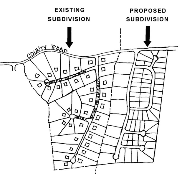 | |
| Parcel Size Matching → | |
| The minimum lot sizes identified in the land use designation of the immediately adjacent developed subdivision shall be maintained at the edge of the proposed subdivision. | |
| |
| Buffering → | |
| A "buffer zone" shall be established. When the buffer remains natural vegetation, the buffer zone shall be equivalent to one hundred (100) feet or 1/2 of the average minimum lot depth of the adjoining developed property, whichever is greater. The buffer zone may be common open space for the proposed subdivision and may include paths, trails or other subdivision amenities. | |
 | |
| Yard Matching → | |
| The rear yard widths of the proposed development shall match the rear yard widths of the existing development as depicted in Figure 20.45.050.3 |
Source: Washoe County Department of Community Development.
2.
Lots proposed within a new subdivision that share a common property line with an established subdivision shall not contain structures that exceed the maximum height of the adjacent equivalent zoning district, see SMC 20.05.05.
F.
Lot Adjacency Standards—Multi-Family Residential (MFD)-to-SFD. To provide adequate transition between multi-family and single-family residential parcels, where the density of the residential parcels is one unit per acre or greater the City of Sparks Zoning Code applies.
G.
Lot Adjacency Standards—Residential (SFD and MFD)-to-Non-Residential. To provide adequate transition between non-residential parcels and MFD parcels, and between non-residential parcels and SFD parcels where the density of the residential parcels is one unit per acre or greater the City of Sparks Zoning Code applies.
H.
Lot Adjacency Standards—Non-Residential-To-Non-Residential. To provide adequate transition between varying uses on parcels designated non-residential, the following side and rear setbacks are established:
I.
Grading. Grading for subdivision improvements, Conditional Use Permits, Administrative Review or other discretionary or building permits, adjacent to lots up to five acres in size, shall:
1.
Not result in slopes on fill in excess of, or steeper than, three horizontal to one vertical (3:1).
2.
For a distance of 50 feet from the shared common property line with an existing residence fills shall not differ from the natural grade by more than 48 inches and may not exceed a slope of 3 horizontal to 1 vertical (3:1).
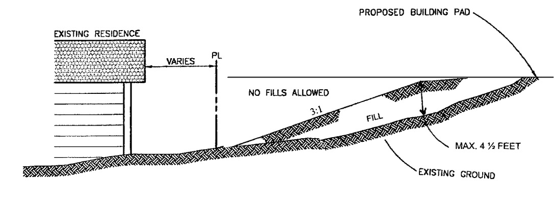
3.
Not result in slopes that differ from the natural grade by more than 20 feet within 500 feet of a shared common property line with existing development.
4.
Be limited on cut slopes of equal to, or less than, a slope of three to one (3:1). However, major cut slopes, in excess of 100 lineal feet, are permitted when the cut slopes include stepped-back structural containment in the form of benches and terraces that include landscaping on the terraces. Rockery walls used to create benches are limited to a maximum vertical height of six feet. The resulting terraces shall include a minimum horizontal width of six feet to provide for the landscaped bench. An exception may be allowed for cuts into stable rock, supported by a geotechnical report.
5.
Utilize a gradual transition or "rounding or contouring" of the manufactured slope at the intersection of a manufactured cut or fill slope and a natural slope.
6.
Visually integrate all slope faces (cut or fill) into the natural terrain by a gradual transition or "contouring/rounding" of the man-made land forms into the natural terrain.
7.
Prohibit the use of riprap and gabions as a mechanical stabilization for cut slopes, except where essential for safe access, for passage within the rights-of way of public roads and for storm drainage control devices.
8.
Address compatibility with adjacent lots, demonstrate visual impacts to the community, and propose design criteria, landscaping and buffering to mitigate impacts on adjacent property owners and the community's scenic character, if the applicant proposes cut, fills or slopes in excess of the requirements.
9.
Alternative materials and procedures supported by adequate engineering documentation may be approved, provided that they meet the aesthetic intent of these requirements and incorporate mitigation. All mitigation shall be reviewed and approved by the zoning Administrators of affected local governments.
J.
Cooperative Planning Area Lighting. Refer to Section 20.04.007.
K.
Ridgelines.
1.
Applications for master plan and zoning map amendments shall identify how the project furthers the goal of preserving the aesthetic appearance of important ridgelines and shall include information related to the following issues:
a.
Potential developable areas (0—30 percent slope) shall be identified;
b.
The existing landscape of such slope areas shall be described; and
c.
Information shall be provided and provisions shall be made to mitigate the visual impact of the project from developed areas, as follows:
(1)
At least three sight-line analyses shall be provided from the existing built environment, generally within one-quarter to one-half mile of the project site. Staff members of the local governments involved in the cooperative plan shall jointly select the locations for the sight-line analyses to represent typical views of the project site from nearby neighborhoods;
(2)
The maximum height, placement, design and coloration of structures shall be identified to minimize visual impacts of areas identified in the sight-line analyses; and
(3)
Minimum setbacks and height limits for structures on the back sides of slopes shall be identified to minimize visual impacts of areas identified in the sight-line analyses.
(Ord. 2512, § 1(Exh. A), Add. 08/24/2015)
Section 20.04.004 - Fences, walls and hedges.
Use Category: Accessory
A.
Applicability. This section applies to any fence, wall or hedge.
B.
Materials and Construction.
1.
A fence may be constructed of but not limited to: wire, chain links, wood, stone or any standard building materials to the approval of the Administrator.
2.
Barbed wire, (above ground) is only permitted in the C1, C2, TC, I and PF zoning districts.
a.
All barbed wire fencing shall be on top of an eight-foot fence.
b.
Extension arms, when used, shall not extend beyond the property line.
c.
Barbed wire must not extend beyond the property line.
3.
Razor wire fencing is only permitted in the "I" zoning district.
a.
All razor wire fencing shall be on top of an eight-foot fence.
b.
Extension arms, when used, shall not extend beyond the property line.
c.
Razor wire shall not extend beyond the property line.
4.
Electric fencing is only permitted in the "I" zoning district.
a.
Electrification. The energizer for electric theft deterrent devices shall be powered by a battery not to exceed 12 volts DC.
b.
Perimeter fence or wall.
(1)
No electric theft deterrent devices shall be installed or used unless it is completely within a non-electrical fence or wall that is at least 6 feet in height.
(2)
The electric fence shall not exceed ten feet in height.
c.
Warning signs.
(1)
Electric security fences shall be clearly identified with incidental signs that, at a minimum, read: "Warning-Electric Fence" at intervals of at least 25 feet.
(2)
At least one sign shall be placed on each side of the fence.
(3)
The minimum size of the sign shall be 12 inches wide by nine inches tall with a minimum lettering size of one inch. The sign shall be located on the perimeter of the fence, and directed to the inside and outside of the secured area.
C.
Fences or Walls.
1.
Fences or walls six feet or less in height may be erected in any zoning district except where a sight issue may be created. Therefore, when constructing in the required front or exterior side setback, fences shall comply with the following standards:
a.
No more than three feet in height.
b.
Fencing may be increased to four feet in height when the fence is at least 50 percent open construction.
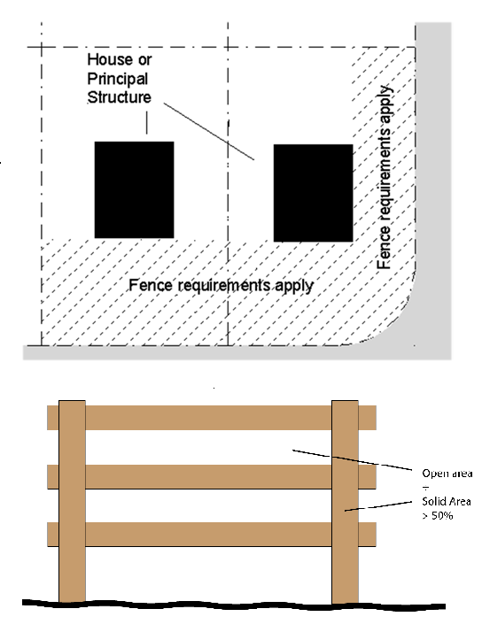
*example open construction
2.
Residential fences may be constructed up to six feet in height in the exterior side yard if the Administrator determines a visibility issue will not be created.
3.
Fences or walls in the I (Industrial) zoning district may be erected in the required front setback or exterior side yard and may extend six feet in height.
4.
Public utilities in any zone may be enclosed by a fence with barbed wire as long as the total height does not exceed nine feet.
(Ord. 2547, § 1(Exh. A), Amended, 12/11/2017; Ord. 2512, § 1(Exh. A), Add. 08/24/2015)
Section 20.04.005 - Intensity standards.
A.
Glare. Except in processes of construction, glare from arc welding, acetylene torch cutting or similar activity shall be performed so as not to be seen from any point outside the property on which the work is being performed.
B.
Noise. Noise shall be muffled so as not to become objectionable due to intermittence, beat, frequency or shrillness.
C.
Smoke, Odor and Gas.
1.
See SMC Title 7 (Health and Welfare).
2.
The emission of obnoxious odors of any kind shall not be permitted.
3.
No gas shall be emitted which is deleterious to the public health, safety or general welfare.
D.
Construction Hours.
1.
Unless otherwise specified by condition of entitlement. Hours of construction shall be limited to 5:00 a.m. to 7:00 p.m. Monday through Friday and 8:00 a.m. to 5:00 p.m. on Saturday. No construction is permitted on Sunday.
a.
Construction hours may be waived for a specific date and time through a temporary use permit request for review and consideration by the Administrator.
2.
A sign shall be posted at each construction site identifying the hours of construction, and provide a project contact with a contact number who is available 24 hours a day and seven days a week.
(Ord. 2603, § 1(Exh. A), Amended, 08/09/2021; Ord. 2547, § 1(Exh. A), Amended, 12/11/2017; Ord. 2512, § 1(Exh. A), Add. 08/24/2015)
Section 20.04.006 - Landscaping and screening.
Purpose: This section promotes the public health, safety and general welfare by establishing regulations for the installation and maintenance of landscaping according to recognized resource-efficient principles, and to provide for the protection of existing vegetation, where appropriate. The regulations:
• Enhance the aesthetics of the community;
• Conserve water and other natural and energy resources by requiring the use of resource-efficient guidelines and principles;
• Provide environmental controls such as, but not limited to, the reduction of noise, dust and erosion;
• Reduce air pollution by encouraging the use of vegetation for air filtration, absorption of carbon dioxide and production of oxygen;
• Assist in ground water recharge;
• Reduce visual pollution which might otherwise occur within an urbanized area;
• Establish a greater sense of privacy from visual and physical intrusion;
• Encourage a balanced landscape approach with a variety of landscape materials; and
• Buffer structures and uses from noise or undesirable views.
A.
Applicability. The provisions of this section apply to:
1.
All new development projects, including model homes for subdivisions.
2.
An expansion to any existing building, when not in conformance with the minimum landscaping requirements shall provide a proportionate amount to the expansion as demonstrated in the following example:
EXAMPLE:
Existing Building = 10,000 sf
Expansion = 1,000 sf or 10% increase
Zoning = C-2; 15% required
.10 × .15 = .015 or 1.5% of the site is to be landscaped.
3.
If a proposed building expansion exceeds 75% of the present size of the building, the site must be brought into compliance with the current landscape ordinance.
4.
Exceptions. This section does not apply to:
a.
Single-family dwelling units on separate lots, except common areas in planned developments.
b.
Permits such as, but not limited to, reroofing, siding, temporary power, change of electrical service, change of furnace, mobile home set-up, addition of interior plumbing, addition of interior electrical, fencing, on and off-premises signs and encroachment.
c.
Development projects where the existing vegetation to be retained meets or exceeds the requirements of this section.
5.
Exception to exceptions. This section does not exempt any property including single-family dwelling units or duplexes, from the standards set forth in the Property Preservation Code in Title 7 of the Sparks Municipal Code.
B.
Landscape and Irrigation Plan.
1.
Except as otherwise provided in this section, an approved landscape plan and irrigation plan shall be on file with the Administrator prior to issuance of a building permit.
2.
The landscape plan and irrigation plan shall include the information required by Appendix A to this title.
3.
When the landscaping is installed a licensed landscape architect shall certify the landscaping was installed per plan.
4.
A copy of the approved landscape plan and irrigation plan shall be kept on the job site until the project is inspected and accepted by the City.
C.
General Landscape Standards.
1.
Landscape elements shall provide a vertical dimension. Trees and tall shrubs shall be used in addition to grass and groundcover.
2.
Landscaping shall be used to enhance the quality of the residential environment, to buffer the units from noise or undesirable views and to separate roads within the development.
3.
Landscaping around the entire foundation base of buildings is required to enhance the edge between the parking lot and the structure.
4.
Landscaping shall be protected from vehicular and pedestrian encroachment by raised planters or the use of curbs. Stepping stones shall be provided as access through a landscape planter(s) when adjacent to parking spaces.
5.
All landscape planters shall be protected by a minimum six-inch inch high concrete curb.
6.
All ground surfaces shall have one or more of the following treatments:
a.
Paving.
b.
Turf.
c.
Four-inch rounded river rock.
d.
Decomposed granite with a pre-emergent herbicide using weed barrier underneath.
e.
Other similar ground surface as approved by the Administrator.
7.
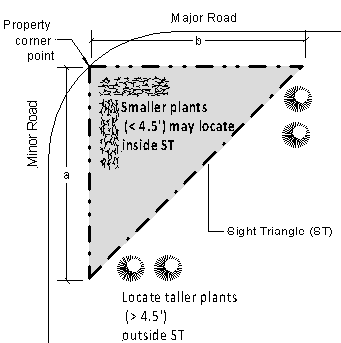
Landscaping shall be sited so that at maturity the plants do not inhibit visibility in any sight triangle.
8.
Planting islands in parking lots shall have a minimum width of eight feet interior, protected by six-inch high curb.
9.
Artificial turf is permitted as a landscape cover in side and rear yards that are not adjacent to streets.
D.
Specific Standards.
1.
Generally.
2.
The minimum portion of the site area to be landscaped, as required by this section, is:
Table 20.04.007-1 Required Landscaping
Notes:
a.
Applies to all uses except single-family and all projects in the MUD zoning district.
b.
Includes landscaping strips along street frontages. Landscaping strips shall be at least ten feet wide regardless of the percentage of the site area involved. The Administrator may approve narrower landscaping strips in conjunction with alternative screening compliance that exceeds the minimum requirements for perimeter landscaping in this section. This may include a combination of a masonry wall and plant materials or an increase in landscape plant materials of 30 percent or more above minimum quantities.
c.
When occupying an existing building, if compliance with the landscaping ordinance creates a non-conformance in any aspect of the code, an applicant may apply for an Administrative Review to demonstrate how the proposal will bring the site closer to compliance with the code.
d.
Includes all setback areas from public or private streets. Setback areas with street frontages shall be landscaped regardless of the percentage of the site area involved.
3.
The minimum number of trees to be planted in the required landscape area is 1 tree per 300 square feet in the MF zoning district and one tree per 500 square feet in other zoning districts. Parking area trees per subsection 8 are in addition to this requirement.
4.
Evergreen trees shall be at least 6 feet in height at time of planting. Fifty percent of deciduous trees shall be a minimum caliper of one inch and fifty percent shall be a minimum caliper of two inches at time of planting.
5.
Existing trees and shrubs may be incorporated into a landscaped area if they are healthy and in good condition and do not conflict with plant location requirements of this Section (such as in parking areas).
6.
Sixty percent) of container-grown shrubs and plants (excluding trees), and excluding those plants grown in flats, shall be minimum 5-gallon size and the remainder shall be minimum 1-gallon size at time of planting.
7.
Turf grass.
a.
The maximum slope of an area planted in turf grass is four to one.
b.
Turf grass is not required and may not constitute more than 80 percent of the required landscape area.
8.
Parking area landscaping is in addition to other required landscaping. The parking area is subject to the following minimum standards:
a.
Each planter island containing a tree shall have at least 288 square feet for double loaded parking and 144 square feet for single loaded parking, with an eight foot minimum interior width protected by a six inch-curb.
b.
At least one shade tree shall be planted for each seven parking spaces for parking lots under 125 spaces in size. For those over 125 spaces, at least one shade tree shall be planted for each ten parking spaces.
c.
All areas used for landscaping shall be surrounded by curbing at least six inches in height and four inches in width, and shall be constructed of reinforced concrete.
d.
Landscaping strips, a minimum of ten feet in width (except as otherwise specified in this title) shall be provided along public street frontages. One tree shall be planted in the landscaping strips for each 30 feet of street frontage.
9.
Ground covering shall be provided over the entire landscape area to prevent erosion, inhibit weed growth, and to present an aesthetically pleasing appearance. Ground covering may include:
a.
Living plants, such as shrubs, turf grasses, vines, or other living ground covers. Ornamental grasses and shrubs need to be 30 inches in height at maturity.
b.
Decorative rock, pavers, rock mulch, decomposed granite or other non-living materials may also be used.
c.
Non-permeable materials may not be used for more than 20 percent of the total landscaped area and excludes the areas of temporary coverage allowed for all plant and ground cover maturity.
10.
The following types of trees are prohibited in landscaping as required by this Section because of undesirable characteristics: Populus genus (poplars and cottonwoods), salix genus (willows), ulmus genus (elms) and zelkova genus (zelkova).
11.
If specimens of these trees exist on a site to be landscaped, they may be retained and counted towards the required number of trees.
12.
All landscaped areas shall be watered by a water-conserving irrigation system including drip, low-arching and/or low-gallonage heads, as appropriate, controlled by an automatic timer.
E.
Buffer Requirements.
The intent of buffering is to provide landscaped separation between residential and nonresidential uses and to screen from view certain land uses that may create visual clutter and distraction. The standards of this section provide for increases in the width and the opacity of the buffer as the land use intensity of the new or expanded development increases.
1.
Applicability. This section applies to any activity involving new construction when adjacent to existing residential development and applies to the following:
a.
Residential development adjacent to non-residential development, and
b.
Single-family development adjacent to multi-family development
2.
Buffering.
a.
Evergreen trees shall be planted to screen parking lots and non-residential building walls to provide a visual barrier between non-residential and residential uses. In no instance shall evergreen trees be planted further apart than 30 feet on center.
b.
Screening between uses (i.e. fencing, walls, landscape buffers, etc.) shall be required to mitigate impacts subject to the Administrator approval.
3.
Exemptions. This section does not apply to:
a.
Residential uses adjoining residential uses within the same residential zoning district.
b.
Agricultural uses.
c.
Nonresidential uses adjoining other nonresidential uses of the same zoning classification.
d.
Any change of use that does not increase the existing building square footage or parking area.
e.
Single-family dwellings located on an existing lot of record.
f.
Contiguous commercial parcels or land areas under common ownership.
4.
Reduction in Required Buffers. The buffer requirements are reduced where a buffer exists on an abutting property, and the net buffer satisfies the minimum buffer requirements of this section.
F.
Bonding Requirements.
1.
All landscaping material for a development project shall be installed in accordance with the landscape plan. A surety bond is required if the landscaping is not satisfactorily installed at the time a certificate of occupancy or business license is requested. The bond shall be written by a surety company authorized to do business in this state, to be filed with the City Clerk prior to issuance of a certificate of occupancy.
2.
In lieu of filing a surety bond, cash, a cashier's check, or a letter of credit issued by a bank licensed in this state may be filed with the City Clerk.
3.
The bond, cash deposit, cashier's check or letter of credit shall be in an amount sufficient to ensure the installation of all required landscaping as required by this section.
4.
The Administrator shall inspect the landscaping to insure proper installation according to the approved landscape plan.
5.
The bond, or equivalent surety, will not be released until final approval of the landscaping.
6.
If the landscaping material is not installed in accordance with the landscape plan, the Administrator may cause the bond, cash deposit, or letter of credit to be forfeited in an amount necessary to complete the installation. The Administrator may waive the surety requirement.
G.
Maintenance.
1.
If any portion of the landscaping material or irrigation equipment is damaged or destroyed, the owner, operator or other person in control of the development project shall replace or repair the damage or injury within thirty days following notification from the Administrator. If the season of the year makes this repair or replacement infeasible within the thirty-day period, the person responsible for the landscaping shall schedule an appropriate time for the accomplishment of this work with the Administrator.
2.
If the repair or replacement is not accomplished in a timely fashion, the Administrator may initiate proceedings to revoke the conditional use permit or business license for the subject use.
H.
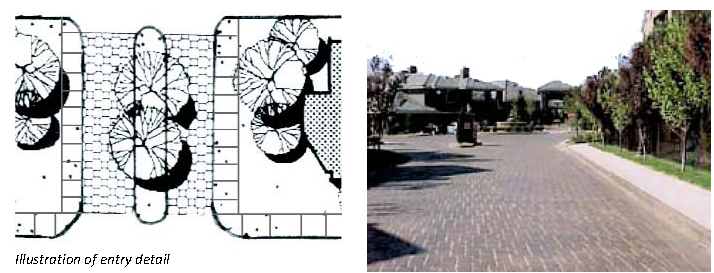
Landscaping at Site Entries.
1.
The project entry shall be treated with special landscape elements that will provide an individual identity to the project (i.e., special paving, graphic sign, water feature, specialty lighting, specimen trees and flowering plants).
2.
Entry/access drives for multi-family/attached single family projects with more than 50 units shall include at least one of the following:
a.
A minimum of five-foot wide (exclusive of curbs) landscaped median;
b.
Textured paving, interlocking pavers or rough textured concrete;
c.
Other "gateway" elements such as lights, bollards, water feature, monument/statue, entry walls, etc., as approved by the Administrator.
d.
A roundabout containing landscaping and/or water fountain/feature, artwork, etc.
3.
In parking lots with over 125 parking stalls, a main entry drive shall extend from the public street to the front cross aisle and shall:
a.
Include a minimum four-foot wide sidewalk from the street to the front cross aisle on at least one side.
b.
Include ten-foot wide landscape parkways on each side.
c.
Prohibit parking stalls along the entry drive.
d.
Include a minimum seven-foot wide enhanced paving crosswalk do delineate the pedestrian crossing at the public sidewalk.
I.
Trash Enclosure and Mechanical/Electrical.
1.
Trash enclosures shall allow convenient access from each tenant.
2.
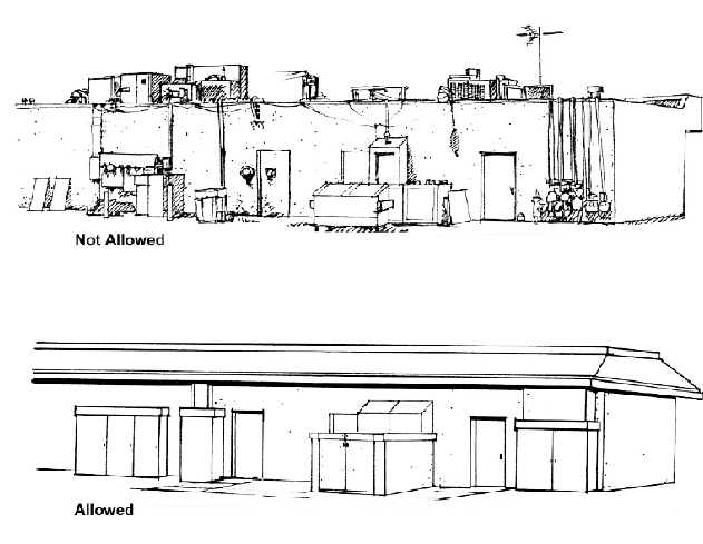
Trash enclosures shall be constructed to be architecturally compatible with the project. All trash enclosures shall be treated with anti-graffiti material. The trash enclosure shall be constructed of substantial building materials used in the design of the building(s). The gates shall be constructed of durable material that screens the trash enclosure. Wood and chain link gates are not allowed.
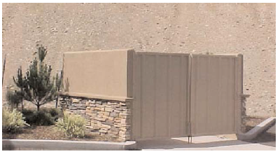
Example of architecturally compatible trash enclosure
3.
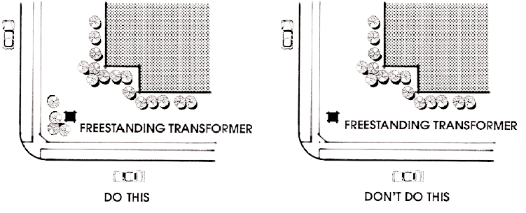
Switch boxes, transformers, electrical and gas meters, including ground mounted air conditioning units and other above ground or building mounted utility elements (including antennas or satellite disks), shall be screened or located out of view from public roads, driveways and common public areas, such as exterior entrances.
4.
All roof-mounted equipment shall be screened with a parapet from adjacent properties, public rights-of-way, and driveways/common areas within project. The screening elements shall be designed to be compatible with building architecture.
Example of screened mechanical equipment
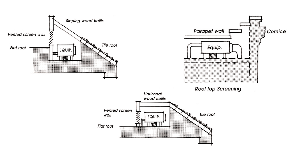
Example of screened rooftop equipment
J.
Walls. The following standards shall be used for the consistent design of perimeter walls:
1.
Walls shall be decorative using materials and colors to complement the architectural design of the adjacent buildings/development theme as approved by the Administrator.
2.
Walls shall incorporate at least one of the following every 50 linear feet:
a.
At least a two-foot change in plane for at least ten feet;
b.
At least 18-inch raised planter for at least ten feet;
c.
Use of a pilaster at 75-foot intervals, on property corners or at changes in wall planes; or
d.
A section of open metal fencing at least 4 feet in height for at least ten feet.
| Elevation of Staggered Wall | Elevation of wall/Wrought Iron Construction |
| Elevation of Solid Wall with Pilasters | Elevation of Wrought Iron with Pilasters |
| Examples of walls designs | |
3.
Walls adjacent to a public walkway (sidewalks, path/trails, etc.) shall have masonry construction (either solid or with metal fencing insets) and a landscaped setback of at least four feet. Walls or solid fences are not permitted between public open spaces and adjacent roads except upon approval of the Administrator.
4.
Walls between public open spaces shall have an open design and a maximum height of four feet. The Administrator shall approve solid fences/walls between open space and multi-family/attached single family developments.
5.
The maximum height of rockery is six feet.
6.
All screening devices shall be properly maintained.
(Ord. 2547, § 1(Exh. A), Amended, 12/11/2017; Ord. 2512, § 1(Exh. A), Add. 08/24/2015)
Section 20.04.007 - Lighting.
Purpose: This section sets forth criteria and standards to mitigate impacts caused by future development so as to promote dark skys.
A.
Generally. Any lighting facilities shall be installed to reflect away from adjoining properties to promote dark skys.
B.
Light. Any new development shall submit a photometric plan for review and approval by the Administrator at time of building permit demonstrating:
1.
Any lighting facilities will be installed to reflect away from adjoining properties.
2.
Covers will be installed on all lighting fixtures and lamps will not extend below the bottom of the cover.
3.
Light standards in or within 100 feet of residential zones will not exceed 12 feet in height. Additional standard height may be permitted by the Administrator if lights are a sharp cutoff lighting system.
4.
No permanent rotating searchlights are permitted in any zoning district, except that the Administrator may approve a temporary searchlight by temporary use permit for up to three days and up to three times in any calendar year.
C.
Lighting Design. The style and intensity of lighting shall consider not only function and appearance, but shall reflect the existing character of surrounding areas and shall replicate natural light color as much as possible.
D.
Parking Lot Lighting.
1.
The height of parking lot lighting shall not exceed 30 feet from grade of parking lot. The parking lot lighting poles shall be decorative, complementary and consistent with the architecture of the project.
(Ord. 2512, § 1(Exh. A), Add. 08/24/2015)
Section 20.04.008 - Patio covers, decks, and building projections.
Purpose:This section establishes rules to administer the lot and setback regulations, and to provide for the appropriate development of lots in zoning districts.
A.
Patio Covers/Decks.
1.
Patio Covers.
a.
Location. Patio covers may extend to within ten feet of a rear property line, but must not extend into any required front or side setback.
b.
Height. Unenclosed structures must not exceed the height of the permitted main structure.
2.
Decks Within Two Feet Above Grade. Uncovered structures such as decks not higher than the ground floor elevation of a building and not higher than two feet above grade at any point may:
a.
Extend to the side and rear property lines; but
b.
Must not encroach into a required front setback.
3.
Decks Higher than Two Feet above Grade.
a.
Decks with a floor higher than two feet above grade at any point must comply with the setback requirements of the district in which the permitted structure is located.
b.
Decks with a floor higher than two feet above grade shall not exceed the height of the permitted principal structure.
B.
Building Projections.
1.
Cornices, overhangs and eaves may not project more than two feet into any required front, side, or rear setback.
2.
Fireplaces, chimneys, greenhouse windows, bay windows, and other projections may project beyond the exterior wall of a building up to two feet. The maximum two-foot projection(s) shall not exceed ten square feet.
C.
More than One Dwelling On One Lot. There may be one or more single-family dwellings on an SF lot or parcel if:
1.
For every single-family dwelling there is at least the minimum area required per dwelling unit; and
2.
The dwellings are situated on the site to permit division of the site into two or more parcels which conform to all setback requirements of the zone where the parcel is situated.
(Ord. 2547, § 1(Exh. A), Amended, 12/11/2017; Ord. 2512, § 1(Exh. A), Add. 08/24/2015)
Section 20.04.009 - Parking and loading.
Purpose: This section sets minimum standards for off-street parking requirements for new construction and expansion of or changes to existing uses. This section ensures that uses have a minimum level of off-street parking to avoid congestion on surrounding streets without creating excessive parking, discouraging pedestrian access, driving up the cost of development and inviting excessive levels of traffic congestion.
A.
Applicability.
1.
Permanently maintained off-street parking shall be provided in accordance with this Section for all developed property within the City.
2.
Lawfully established uses which do not conform to this section are considered to be substandard developments.
3.
If the use of any developed lot or parcel is changed to increase the number of parking spaces required under this Section, all requirements of this section apply to that lot or site.
B.
Exceptions.
1.
All required parking must be located on the same site as the use it serves, except in the I, TC, C2, C1, and PO districts when off-site parking (excluding the public right of way) may be considered through a shared parking plan or alternative requirements through:
a.
Shared parking and alternative standards.
(1)
In any development where the requirements of this section can be met by non-concurrent, joint use of the same spaces by more than one business, the Administrator may permit the parking requirement to be reduced accordingly.
(2)
All joint use parking spaces shall be located within one-quarter of a mile of the uses that they serve. If the spaces are located off-site, this distance is measured from the property line of the use served.
(3)
The Administrator may approve the use of alternative parking space requirements based on Urban Land Institute, American Planning Association, Institute of Transportation Engineers or other analytical studies approved by the Administrator, that take into account monthly, hourly and weekly variation; peaking characteristics, ride share programs, proximity to transit stops and shared uses. The applicant shall justify the use of and appropriateness of alternative parking number calculations.
2.
All required parking must be on the same site it serves. Exceptions may be considered up to one-quarter mile from the respective site in the Mixed Use District provided that:
a.
Development within this district may use shared parking arrangements to reduce overall parking requirements, as provided in Chapter 20.04. On-street parking along the frontage of any use is counted toward required off-street parking.
b.
Onsite parking requirements may be further reduced through a shared parking credit.
c.
The Administrator may approve additional parking credits if the applicant provides a parking study that demonstrates that parking demands will be met with an alternative parking configuration or requirement.
d.
The Administrator may approve alternative parking configurations for multi-building developments subject to compliance with standards for setbacks building design, and site design. (i.e. parking located in the rear, side, or front of buildings.)
3.
A low income parking credit may be provided by the Administrator for residential uses that are income or rent restricted and are at or below 45 percent of AMI (Area Median Income) through a parking study.
4.
For residential uses on lots or sites occupied by no more than four dwelling units, the Administrator may approve a parking layout which contains tandem parking spaces.
5.
In parking facilities accommodating at least twenty cars, up to 25 percent of the parking spaces required by this Section may be sized for compact cars. The spaces shall conform to the minimum sizes and design geometry for compact cars, contained in subsection D, and shall be given preferred locations within the facility. Each compact space shall be clearly marked "compact only."
6.
Parking for the disabled shall be provided in all parking facilities serving the public.
a.
One accessible parking space shall be provided as follows:
Table 20.04.011-2 Accessible Parking Spaces
b.
One out of every eight accessible spaces shall be van accessible. If only one accessible space is required, it must be van accessible. Accessible parking spaces shall be at least eight feet wide and have an adjacent five foot wide aisle. Van accessible spaces shall be at least eight feet wide and have an adjacent eight foot wide aisle. These spaces shall be located on the shortest accessible route of travel to an accessible entrance. Those spaces must be indicated by a sign which complies with NRS 484.408 and the bottom of which is at least seven feet above the ground. For all van accessible spaces, an additional sign indicating that it is van accessible shall be mounted below the above described sign.
7.
Off-street parking facilities shall be striped and otherwise marked so that individual spaces and aisles are clearly indicated. Directional markers and signs indicating spaces reserved for compact cars and the handicapped shall be painted on the pavement or placed on standards, as directed by the Administrator.
8.
All off-street parking lots as well as driveways and access roads must be paved. The Administrator may grant an exception for any parking lot which is, of necessity, subject to regular use by heavy construction equipment.
A conditional use permit may authorize the use of unpaved parking lots for up to one year. Designs for paving, curb and gutter, sidewalks, utilities and drainage for all off-street parking facilities shall be approved by the Administrator prior to construction.
C.
Number of Off-street Parking Spaces Required.
1.
This section specifies the required number of off-street parking spaces related to various land uses.
2.
For any use not specifically covered by one of the following categories, the requirement shall be determined by the Administrator based on actual parking demand associated with that use.
3.
The Administrator may require spaces in addition to those specified in this section if special circumstances exist.
Table 20.04.011-3 Parking Ratios
4.
When an existing building is expanded, parking and loading spaces shall be added to meet the requirements of the parking ratio table for the entire building. Exceptions may be considered as outlined in this chapter.
D.
Parking Geometry.
1.
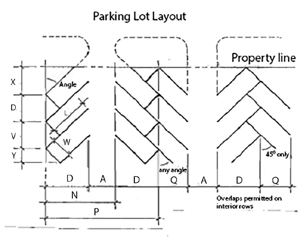
All required off-street parking facilities shall be designed and constructed according to the following geometric configurations:
*Minimum aisle width for two-way traffic is 20 feet.
2.
Curbs shall be provided where parking adjoins landscaping and sidewalks. A three foot overhang is permitted where parking abuts a landscape strip. This allows for a 15-foot stall length.
E.
Parking District No. 1.
The purpose of Town Center Parking District No. 1 is to:
• Provide for the use of parking spaces in city owned facilities to provide businesses within the district which are not able to provide the required off-street parking required by this section; and
• Provide for leasing of parking spaces in city owned parking facilities to private businesses to further the goals of the redevelopment effort.
1.
Victorian Square Parking District No. 1 is established.
2.
Boundaries. The boundaries of the parking district are described as follows:
Beginning at the intersection of the centerline of Victorian Avenue and the centerline of Fifteenth Street, and proceeding thence northerly along said extended line to its intersection with the centerline of D Street and Victorian Plaza Circle, thence easterly along the centerline of D street to its intersection with the centerline of the Pyramid Way, with the centerline of Victorian Avenue, extended westerly along said centerline to its point of origin.
3.
Parking space fee.
a.
The City Council may, by resolution, approve and adopt a form of agreement for the use of spaces in the parking district which include, but are not limited to, penalties for late payments, security for the payment of obligations, maintenance provisions and procedures to withdraw from the parking district.
b.
Terms of this agreement may be negotiated subject to specific redevelopment agreements developed in cooperation with the Sparks Redevelopment Agency.
4.
Requirements for commercial uses marked with a diamond (♦) in Parking Ratio Table are modified for Parking District No. 1 by the following exemption program:
a.
The indicated commercial uses are exempt from all parking requirements if they qualify based on one of the following three criteria:
(1)
New construction of a building less than 10,000 square feet in size;
(2)
New construction of a building addition where the total area of the building addition and the existing building is less than 10,000 square feet in size;
(3)
An indicated commercial use occupying an existing building of less than 10,000 square feet in size.
b.
If the 10,000 square foot limit is exceeded for an indicated commercial use, the use shall receive a parking exemption equal to the 10,000 square foot limit, and is responsible for providing parking for the area exceeding the 10,000 square foot limit in accordance with the requirements listed in the parking ratio table.
c.
If a business has existing excess parking, it may count that excess parking towards any new parking required as a result of expansion or new construction.
5.
Petition for inclusion in the parking district. At any time following the district formation, any parcel of land, whether contiguous or noncontiguous to the district, may be added to the district if the use is identified with a diamond and the owner of such parcel files with the City Council a petition for inclusion and the City Council grants such petition. The City Council must find that sufficient additional parking space is available in the parking district and that inclusion will benefit the parking district in order to grant the petition. If the petition is granted, the parcel is then entitled to the same rights as those which apply to other lands in the district, and is subject to all fees levied on a district member.
6.
Requirements for hotel/casino uses in Victorian Square Parking District No. 1 are 50 percent of what is required in Table 20.04.011-3 Parking Ratios.
F.
Off-street Loading.
1.
In order to avoid undue interference with the public use of streets or alleys, there shall be provided and maintained adequate off-street space for standing, loading or unloading for those uses involving receipt and distribution of vehicles or merchandise and materials off-street.
2.
Loading space design.
a.
Each required loading space shall be at least ten feet by 45 feet with a 14-foot height clearance.
b.
For a non-residential building containing less than 3,000 square feet of gross floor area, a combined parking and loading area is acceptable.
(Ord. 2590, § 1(Exh. 1), Amended 02/24/2020; Ord. 2559, § 1, Amended, 07/09/2018; Ord. 2547, § 1(Exh. A), Amended, 12/11/2017; Ord. 2512, § 1(Exh. A), Add. 08/24/2015)
Section 20.04.010 - Signs.
Section 20.56.010 Purpose, scope and authority. The purposes of these sign regulations are:
• To encourage the effective use of signs as a means of communication in the city; and
• To maintain and enhance the aesthetic environment and the city's ability to attract sources of economic development and growth; and
• To improve pedestrian and traffic safety; and
• To minimize the possible adverse effect of signs on nearby public and private property; and
• To balance the rights of businesses and individuals to convey messages through signs against the aesthetics and safety hazards that come from the proliferation of sign clutter.
• To enable the fair and consistent enforcement of these sign regulations.
This chapter is adopted pursuant to the powers conferred to the city in Chapter 278 of Nevada Revised Statutes and the Sparks City Charter.
A.
Applicability-Effect.
1.
It shall be unlawful to display, erect, place, establish, paint, or maintain a nonexempt sign in the city except in conformance with the standards, requirements, limitations and procedures of this section.
2.
The effect of this section as more specifically set forth herein, is:
a.
To prohibit all signs except as permitted by this section;
b.
To allow a variety of types of signs in tourist commercial, commercial and industrial zones, and a limited variety of signs in other zones, subject to content neutral standards requirements and limitations;
c.
To allow certain signs that are appropriately sized and incidental to the principal use of the respective lots on which they are located, subject to the substantive requirements of this ordinance, but without a requirement for permits;
d.
To establish standards, requirements and limitations, and a permit system that honor constitutional rights and requirements; and
e.
To provide for the enforcement of the provisions of this section.
3.
The effect of this sign ordinance on the mixed use district (MUD) is as follows:
a.
When a gateway sign is permitted in the MUD zoning district, the standards shall be regulated by the TC zoning district criteria for freestanding signs.
B.
Definitions.
C.
Exemptions.
1.
Unless specifically provided otherwise, the following types of signs and displays are not subject to the provisions of this chapter and are not counted in any aggregate area or number of sign computations:
a.
Official signs.
b.
Holiday decorations that (i) do not include a commercial message and (ii) are removed within thirty days after the holiday.
c.
Incidental signs whose size is the not greater than the larger of (i) two square feet or (ii) as specified for the particular type of sign in the Manual on Uniform Traffic Control devices published by the United States Department of Transportation incorporated by reference in 23 CFR Part 655, Subpart F.
d.
Handicap parking signs.
e.
Signs posted on or near easements held by public utilities warning or informing the public about the easements or location of public utilities.
f.
Building identification signs which show only the street address and/or building number/name.
g.
Nameplates appearing on residences or mailboxes.
h.
Civic displays.
i.
Flags not to exceed four in number and a cumulative total size of 216 square feet.
j.
Signs which are located within a structure and are not visible from a public street, sidewalk or alley.
k.
Building markers that do not exceed four square feet in size.
l.
Signs or copy permanently embroidered, screened, dyed, stenciled or painted into the fabric of umbrellas which are set up in sidewalk cafes.
m.
Signs painted on or integral to vending machines, fuel dispensing pumps or fuel storage tanks.
n.
Signs painted on the flat surface of the roof and only visible from the air.
o.
Murals.
2.
In the event that a sign fails to meet any criteria, condition or qualification established above for exemption, the sign shall be subject to and governed by all of the requirements of this Section.
D.
Prohibited Signs. The following types of signs are prohibited within the city:
1.
Signs not specifically permitted in or which violate any provision in this chapter.
2.
Signs attached to (i) official signs and their sign structures, (ii) trees or poles or standards which are used for a purpose other than sign structures, or (iii) utility structures.
3.
Roof signs.
4.
Any display or sign that imitates or resembles an official traffic signal, sign device or other official warning signs.
5.
Interactive signs.
6.
Signs on wind machines, cellular towers or other equipment except for logos and not exceed eight square inches.
E.
Prohibited Sign Location.
1.
General. Notwithstanding any provision in or right established in this chapter, no sign shall be permitted in any of the following locations.
2.
Drains, ditches, flood channels. Except for Official Signs, no sign shall be placed in any ditch, storm drain facility or flood channel, except for signs displayed by a utility regarding any easements or dangers that lie within the drain, ditch or flood channel.
3.
Truckee River Greenbelt.
a.
Except as provided in this subsection, no signs are permitted within three hundred feet of (i) the centerline of the Truckee River or (ii) the outer boundary of any area designated as the Truckee River Greenbelt, whichever is greater.
b.
Exceptions to the foregoing are:
(1)
Residential signs.
(2)
Building signs which are not visible from the river.
(3)
Official signs.
4.
Signs in the public right-of-way or on public property. No sign shall be displayed in any right of way or on public property except:
a.
Official signs.
b.
Building markers and building address signs.
c.
Directional signs owned by the City or with a permit.
d.
Community directory signs owned by the City or with a permit.
e.
Signs or copy permanently embroidered, screened, dyed, stenciled or painted into the fabric of umbrellas which are set up in sidewalk cafes in the right of way, provided that the café is operating under an outdoor dining and encroachment permit under Chapter 5.77 of Sparks Municipal Code.
f.
Signs located on a bus stop that is leased or licensed to the Regional Transportation Commission.
F.
Standards, Limitation and Requirements for All Signs.
1.
Consent of owner. No sign shall be placed on any lot without the express permission of the owner of the lot.
2.
No resemblance or interference with official or warning signs. No sign may resemble, simulate or conflict with the proper functioning of any official sign, or use yellow or red blinking or intermittent lights resembling danger or warning signals;
3.
No sound or emissions. Signs which produce odor, sound, smoke, flame or other emissions are prohibited.
4.
No obstruction or interference. No sign shall:
a.
Obstruct or impair access to a public sidewalk, public or private street or driveway, traffic control sign, bus stop, fire hydrant, or any other type of street furniture;
b.
Block the light and ventilation of any residence on any adjoining property which is zoned for residential use; or
c.
Mislead or confuse users of the roadway.
5.
Stacked signs. Stacked signs are allowed if (i) the other requirements of this chapter are satisfied (ii) the sign is integrated with the structure, and (iii) all signs on the same structure are similar in shape and material with one another, except for channel lettering.
6.
Compliance with codes. All signs shall comply with applicable provisions of all codes adopted pursuant to Title 15 of the Sparks Municipal Code, and with all other ordinances and provisions of Sparks Municipal Code.
7.
Permanent. Except for residential signs, election period signs, temporary signs, window signs, and special monument signs, all signs shall be permanently attached to the ground, a building, or another structure by direct attachment to a rigid wall, frame, or structure.
8.
Maintenance, repair and appearance. All signs and sign structures shall be maintained in good, safe, structural condition and repair. All signs and display surfaces shall be neat in appearance, and neatly painted or posted, and not ripped, tattered or faded. Premises immediately surrounding free standing signs shall be kept clean and free of rubbish, weeds and debris.
9.
Illumination standards.
a.
Direction of light. The light source for all indirect illumination signs shall be effectively shielded to prevent beams or rays from being directed at any roadway or abutting property.
b.
Intensity. The intensity and brilliance of light shall not be so great as to interfere with the effectiveness of any official sign or impair the vision of or distract any person on any roadway.
c.
Prohibited light sources. No sign shall use a beacon, strobe light, racing/traveling or an exposed individual light source (excluding LED and neon) which exceeds seventy five watts.
d.
Digital signs. See subsection I.6 for special standards.
G.
Computations.
1.
Signs not included in computations. If the following types of signs comply with all other requirements of this chapter, they need not be included in any allowance computations for area or number of signs:
a.
Building identification signs.
b.
Building markers.
c.
Incidental signs.
d.
Directional signs.
e.
Directory signs.
f.
Temporary signs as provided in subsection K of this section.
g.
Election period signs as provided in subsection L of this section.
h.
Window signs as provided in subsection H.4 of this section.
i.
Signs exempted under subsection C of this section.
j.
Special freestanding signs.
k.
Special monument signs.
l.
Projected/Suspended signs per subsection H.4 of this section.
m.
As specifically provided in other provisions in this section.
n.
Murals.
2.
Computation of sign area of individual signs. The allowable sign area shall apply to the maximum geometric area of all sign faces. The area of a sign comprised of individual letters or elements attached to a building wall, which are without an integrated background and are not enclosed in a frame or cabinet, the area of the letter can be calculated as long as the distance between the letters and/or elements is less than the largest dimension of the largest sign letter. If such a display consists of more than one line or component, the area of each line or component may be calculated separately. Where a display is enclosed in a frame or cabinet, or has an integrated background, the entire area within the frame, cabinet or background must be included in the calculation.
3.
Computation of area of multifaced signs. The sign area for a sign with more than one face shall be computed by adding together the area of all sign faces visible from any one point. When two sign faces are placed back to back, so that both faces cannot be viewed from any point at the same time, and when such sign faces are part of the same sign structure and are not more than 25 degrees apart, the sign area shall be computed by the measurement of one of the faces.
4.
Computation of number of signs.
a.
All signs contained within a single frame, structure, cabinet or integrated background shall be counted as one sign. If a display is not so contained, a single message or business name shall be counted as one sign. A business name combined with a brief slogan may be counted as one sign if the elements are visually integrated.
b.
In determining the number of signs:
(1)
Pennants or streamers shall be considered one sign.
(2)
One banner shall be considered one sign.
(3)
One large balloon or one bunch or string of small balloons shall be considered one sign.
H.
Building Signs.
1.
Except as otherwise provided in this chapter, it shall be unlawful to construct or maintain a building sign in violation of the specifications and requirements of this section.
2.
Specifications by zoning district.
Table 20.04.010-1 Building Sign Limitations
[1] Suspended signs located perpendicular to the front of the building and not exceeding six square feet in area will not be included in calculating the number of signs.
3.
Specifications applicable to all building signs.
a.
Building signs within 300 feet of and directly facing a residentially zoned district shall be non-illuminated.
b.
Signs for co-tenancy shall be calculated as part of the maximum allowable building sign area for the GFA of the building or business it leases or rents from.
4.
Specifications by sign type.
a.
Wall signs. Wall signs may not extend above or beyond the wall or roof line.
b.
Canopy signs. Only one canopy sign will be permitted per business on each frontage and it cannot exceed 25 percent of the vertical surface of the canopy.
c.
Building identification signs. Only one building identification sign is permitted per building.
d.
Marquee signs. Only one is permitted per building.
e.
Projecting/suspended signs. Projecting signs located on private property shall not extend beyond the property line into adjacent lots and, except in any redevelopment area, shall not extend into the right of way.
f.
Window signs. The total area of all window signs in a business frontage may not exceed 25 percent of the total area of all windows for that business in the building. Permits are not required for any window signs, and window signs are not governed by or counted against sign area or number limitations. Window signs must, however, conform to other standards, requirements and limitations in this chapter. The maximum size for digital signs shall be three square feet.
I.
Freestanding and Monument Signs.
1.
Except as otherwise specifically provided in this chapter, and subject to the maximum sign allowances set forth in this section, it shall be unlawful to construct a free standing or monument sign or sign structure in violation of the specifications and requirements of this section.
2.
Limitations by zoning district.
Table 20.04.010-2 Monument Sign Limitations
[1] Drive through businesses may have an additional maximum of two (2) monument signs, not to exceed a combined sixty-four (64) square feet in addition to the thirty-two square (32) feet in Table 20.04.010 -1 and must be oriented to be visible to the vehicles within the drive through lane. Monument sign separation restrictions do not apply to drive through businesses. If the drive-through use ceases or is abandoned, the sign are no longer permissible and shall be removed.
[2] The sign structure may extend above the sign by 10% of the height of a monument sign if (i) the sign structure is separately constructed from the cabinet or face of the sign; (ii) the portion above the cabinet or face does not contain any copy and (iii) the extension adds architectural embellishments to the sign.
Table 20.04.010-3 Freestanding Sign Limitations
Notes:
[1] The calculation for the freestanding signs maximum area shall be the sign area including centers name and tenant panels excluding the architectural embellishments to the sign.
[2] The sign structure may extend above the sign by 20% of the height of a freestanding sign or if (i) the sign structure is separately constructed from the cabinet or face of the sign, (ii) the portion above the cabinet or face does not contain any copy, and (iii) the extension adds architectural embellishment to the sign.
[3] The height of the sign may be measured from the elevation of the centerline of the nearest travel lane of the street or highway to which the sign is oriented rather than from "grade."
3.
Freestanding signs, special. In addition to other allowances, one special freestanding sign shall be permitted on each site in the "I" zoning districts under the following circumstances.
a.
When applying for the sign permit, the applicant will designate the proposed sign as its special freestanding sign hereunder, and the sign will be specially marked in accordance with instructions from the Department to indicate it is a special freestanding sign.
b.
The special freestanding sign area may not exceed 672 square feet. The sign is not counted against the maximum allowable sign area. If the actual size of the sign is less than 672 square feet, the difference cannot be added to allowable sign area.
c.
Rather than from "grade" as defined above, the height of the sign may be measured from the elevation of the centerline of the nearest travel lane of the street or highway to which the sign is oriented.
d.
Otherwise, each special freestanding sign is subject to and must comply with all other provisions of this chapter, applicable to a freestanding sign except as otherwise indicated.
e.
If the sign is digital sign or uses other method of illumination with LED or similar illumination, the special freestanding sign must comply with subsection I.6.
f.
For moving or tri-vision signs, the minimum exposure time for each panel is ten seconds and maximum twirl time is two seconds.
4.
Monument signs, special. In addition to other allowances, one special monument sign shall be permitted for each entrance of each site in all zoning districts specified in subsection I.2 above under the following circumstances and subject to the following conditions and requirements.
a.
No special monument sign area may exceed 32 square feet. The area of the sign shall not be counted against the maximum allowable sign area for the site, and if the sign is smaller than 32 square feet, the difference shall not be added to the maximum allowable sign area for the site.
b.
Special monument signs are subject to and must comply with all other requirements of this chapter applicable to monument signs, except:
(1)
They may not be illuminated and may not be digital signs.
(2)
The architectural requirement in subsection I.5.g does not apply.
5.
Other standards, limitations and requirements for freestanding or monument signs.
a.
Sign separation distance.
(1)
Monument signs. No monument sign (including a special monument sign) may be within 20 feet radius distance of any other monument sign.
(2)
Freestanding signs. Except for special freestanding signs:
(a)
No freestanding sign may be within 100 feet linear distance of any other freestanding sign.
(b)
If the freestanding sign includes a digital sign, the radial distance to another digital sign is 200 feet.
b.
Freestanding signs, special. A special freestanding sign may be placed within 1,500 linear feet distance of a freestanding sign (except an "outdoor advertising structure" as defined in subsection N.1, but no special freestanding sign may be placed within 1,500 linear feet distance of any other special freestanding sign or an "outdoor advertising structure" as defined in subsection N.1. Any special freestanding sign prior in existence to adoption of this ordinance may be converted to digital and shall be located a minimum of 1,500 linear feet from any other special freestanding sign. Any nonconforming outdoor adverting structure in existence prior to adoption of this ordinance which meets the requirements for a special freestanding sign, may be converted to digital and shall be located a minimum of 1,500 linear feet from any other special freestanding sign. Any new special freestanding sign constructed after adoption of the ordinance from which this title derives shall be a minimum of 1,500 linear feet from any other special freestanding sign, except that if the special freestanding sign is digital, it shall be a minimum of 3,000 linear feet from any other digital special freestanding sign.
c.
Extension over property lines. All freestanding or monument signs must be located on one site only and shall not extend over the property line to another site.
d.
Extension into right-of-way. All freestanding or monument signs, except for signs displayed in the Town Center Redevelopment Area of the city, shall not extend into any public right-of-way.
e.
Minimum setback for safe siting standards.
(1)
Except as provided in subsection (b) below, all freestanding and monument signs (including special freestanding and monument signs) must be located outside of the control area defined below and shall be located in accordance with the most recent edition of American Association State Highway and Transportation Officials (AASTHO) "Roadside Design Guide" and stamped by registered engineer.
(a)
For intersections of public streets with residential, collector, or arterial streets where the travel lane is a minimum of five feet from the edge of pavement: The control area is that area between the property lines and a line drawn between a point 15 feet back from the point of curvature of the intersection as measured at the property side of the sidewalk on each leg of the intersection. If no sidewalk exists, the measurement will be along the curb line.
(b)
For intersections of private driveways with residential, collector, or arterial streets where the travel lane is a minimum of five feet from the edge of pavement: The control area is that area between the property line and a line drawn between a point 10 feet back from the intersection of the driveway and the sidewalk as measured at the property side of the sidewalk and a line drawn to the point 10 feet back from the intersection of the driveway and the sidewalk as measured on the driveway. If no sidewalk exists, the measurement will be from the intersection of the driveway and the curb.
(c)
For intersections of public streets with arterial streets where the travel lane is at the edge of pavement: The control area is that area between the property lines and a line drawn between a point 15 feet back from the point of curvature of the intersection as measured at the property side of the sidewalk on the minor leg of the intersection and a point 50 feet back from the point of curvature of the intersection as measured at the property side of the sidewalk on the major leg of the intersection. If no sidewalk exists, the measurement will be along the curb line.
(d)
For intersections of private driveways with arterial streets where the travel lane is at the edge of pavement: The control area is that area between the property line and a line drawn between a point 15 feet back from the intersection of the driveway and the sidewalk as measured at the property side of the sidewalk and a line drawn to the point 15 feet back from the intersection of the driveway and the sidewalk as measured on the driveway. If no sidewalk exists, the measurement will be from the intersection of the driveway and the curb.
(2)
All freestanding and monument signs (including special freestanding and monument signs) to be located within the control area shall be in conformance with the safe siting standards set forth in the current edition of A Policy on Geometric Design of Highway and Streets, published by the American Association of State Highway and Transportation Officials, and as established by an analysis sealed by a professional engineer licensed in Nevada opining that the sign does not violate those safe siting standards.
(3)
If a permanent building extends into a control area as described above, freestanding, monument and special monument signs may be placed parallel to and within six inches of the walls of the building that extend into the control area, provided that the signs do not block any windows and do not extend beyond or wrap around the corner or edge of the walls. If it is impossible to locate a sign as specified herein because the building abuts the property line, a building sign may be placed on the wall that extends into the control area notwithstanding the limitation of the number of building signs set forth in subsection H.2, provided: (1) the sign is not a projecting sign, (2) the sign does not extend beyond or wrap around the corner or edge of any projecting sign, (3) the sign does not cover any windows, and (4) if the building sign is erected in lieu of a special monument sign, a building permit is obtained under Title 15 of the Sparks Municipal Code, if required.
f.
Residential. Permits are not required for residential signs.
g.
Architecture. All freestanding and monument signs and sign structures must contain similar architecture elements and materials visually compatible with buildings on the site. All poles used as a part of freestanding or monument sign structures shall be covered.
6.
Digital signs. In addition to all of the other limitations, standards and requirements for monument or freestanding signs, digital signs are subject to the following limitations, standards and requirements:
a.
Digital signs shall be allowed only in TC (Tourist Commercial), C2 (general commercial), and I (Industrial) zoning districts.
b.
Digital signs shall be allowed in PF (Public Facilities) sites that are over ten acres.
c.
Digital signs are permitted when allowed as a gateway sign.
d.
One digital sign per site frontage, maximum of two digital signs per site.
e.
The use of fade, dissolve, travel, message sequencing or scrolling is prohibited for signs over 32 square feet, except for properties zoned Tourist Commercial (TC) or a gateway sign. The use of video display, flashing or blinking is prohibited for any digital sign.
f.
Digital signs greater than 32 square feet must contain a minimum constant display of no less than eight seconds, including special freestanding signs. Maximum time allowed for messages to change is one second. Digital signs located in the TC zoning or a gateway sign district are exempt from this requirement.
g.
The digital sign portion shall not exceed 50 percent of the total allowed sign area for freestanding signs in C2 and I zoning districts. Gateway signs or within the TC zoning district, the digital sign portion shall not exceed 75 percent of the total allowed sign area. For monument and special freestanding signs, the entire sign may be a digital sign.
h.
Digital displays shall not operate at brightness levels of more than 0.3 foot candles above ambient light, as measured using a foot-candle meter at a pre-set distance. The pre-set distances to measure the foot-candles is calculated using the following formula:
Measurement Distance = √Area of Sign X 100
The measurement distance can be rounded to the nearest whole number.
i.
Digital signs shall be sited in a manner that the intensity or brilliance does not interfere with the effectiveness of an official traffic sign, device or signal.
j.
The digital sign shall include photo-sensors to provide automatic intensity adjustment based on ambient lighting conditions.
k.
Signs with a digital component shall consist of one unit.
l.
The distance separation for digital signs, refer to subsection I.5.
m.
The distance separation from any residentially zoned property shall be 300 feet. The distance separation shall be measured radially. The distance separation may be reduced to 150 feet if the digital sign is oriented away from the residentially zoned property.
7.
Gateway signs. A "gateway sign" is one freestanding sign per lot that meets all of the following criteria and which may have an elevation that is 30 feet above the "Interstate 80 elevation" as defined below, provided that it meets all other criterion for freestanding signs; and
a.
If any portion of a lot is located within 500 feet from the intersection of a gateway street as described by the GIS coordinates in Table 20.04.010-4 below a gateway sign may be erected anywhere on the lot if the lot:
(1)
Is located in the TC or MUD zoning districts; and
(2)
Is at least one acre in size.
Table 20.04.010-4 Gateway Street Coordinates
*Projected Coordinate System:
Name: NAD_1983_StatePlane_Nevada_West_FIPS_2703_Feet
Geographic Coordinate System:
Name: GCS_North_American_1983
b.
The sign must be oriented toward Interstate 80.
c.
The elevation of the top of the sign (subject to Note [1] to 20.04.010-1) must not exceed 30 feet over the Interstate 80 elevation, which is the elevation of the highest point of any improvement (except for any traffic signals or signs) that is within the Interstate 80 right-of-way and is within a lineal distance (as defined in subsection I.5(a) of 1,500 feet from the sign.
d.
Applications for sign permits for signs to be erected under this section shall be accompanied by a certificate of a licensed surveyor indicating that the base of the sign meets the restrictions of subsection "a" above and the height of the sign does not exceed the height requirements of subsection "c."
e.
Except for the height allowance set forth herein, the sign must otherwise comply with all provisions in this code.
J.
Fence Signs.
1.
Residential zoning districts. Fence signs in the SF residential zoning districts shall be regulated as monument signs under subsection I.
2.
All other areas. Fence signs in all other zoning districts shall be regulated as building signs and shall comply with the safe siting requirements set forth in this chapter.
K.
Temporary Signs.
1.
Portable signs.
a.
One portable sign may be displayed per business (licensee) without sign permit. Such signs are not to be counted in the maximum allowable sign area or number of signs limitations. Portable signs must comply with the following standards:
(1)
Maximum size of eight feet square with maximum height of four feet.
(2)
Can only be displayed during business hours.
(3)
Portable signs cannot be permanently affixed to the property as required by subsection F.7.
(4)
Portable signs may not be illuminated.
(5)
Portable signs shall be located within twenty (20) feet of the business (licensee) public entrance.
(6)
Portable signs shall not be located in public right-of-way, roadway, on- site drive aisle, designated parking area or landscape area and shall be located outside of the visibility triangle of the driveway and/or street.
(7)
Portable signs shall not obstruct vehicular or pedestrian traffic.
(8)
Portable signs shall not be attached to any structure or vegetation such as utility structures, traffic signs/poles, trees or similar items.
b.
They must otherwise comply with all other limitations, standards and requirements the limitations in this chapter except and subject to:
(1)
The distance requirements in subsection I.5.a do not apply.
(2)
The architectural requirements in subsection I.5.g do not apply.
2.
Temporary signs.
a.
Permit required; duration. At the discretion of the property owner and with the issuance of a temporary sign permit, each site may display up to two signs per public street entrance, not to exceed eight signs and restricted to a period as designated or specified on the temporary sign permit application. Display of temporary signs shall be based on a calendar year between January to December and must be reapplied for annually. If the site has any digital signs, the number of allowed temporary signs shall be reduced by two for each digital sign.
b.
Standards, requirements and limitations:
(1)
The temporary sign permit application must be approved/signed by the site owner/manager. If a site has more than one occupant who wishes to put up signs at the same time, the site owner or manager must determine who can display the signs.
(2)
Temporary signs may not be placed in a prohibited sign area (subsection E).
(3)
Any temporary sign shall be located on private property and setback at a minimum of one foot for every foot of height from the nearest travel lane. No temporary sign shall be higher than roof or parapet of the building.
(4)
The maximum size of a temporary sign shall be 18 square feet. Any sign over this size will require a sign permit and must comply with subsections H and/or I of this Section.
(5)
Temporary signs shall be kept neat, clean and in good repair. Signs which are faded, torn, damaged or otherwise unsightly or in a state of disrepair shall be immediately repaired or removed.
(6)
Each temporary sign must meet the standards and limitations for all signs set out in subsection F, except:
(a)
They cannot be affixed permanently to the ground or building.
(b)
They may not be illuminated per subsection F.9, nor digital per subsection I.6.
(c)
The distance requirements in subsection I.5.a do not apply.
(d)
Temporary signs shall not be attached to any structure or vegetation such as utility structures, traffic signs/poles, trees or similar items.
(7)
Permitted temporary signs do not count against the maximum allowable sign area.
c.
Exceptions: Each owner of a vacant building may display a temporary sign affixed to the building not to exceed eighty (80) square feet and does not require a temporary sign permit.
L.
Additional Signs During Election Periods.
1.
Election period. An election period begins the first day of filing before and ends ten days after any election conducted under federal, state, county, or city laws or ordinances in which residents of Sparks are entitled to vote, including elections or votes regarding selection or recall of any federal, state, county or city officials, any ballot questions, referendum or advisory vote.
2.
Additional signs during election period. Additional signs containing any message may be displayed on any site during an election period, subject to the following limitations, standards and requirements.
a.
Number and size. There is no limitation on the number or size of additional signs. Signs which comply with this subsection do not count against the maximum allowable sign area, or the maximum number of signs allowed under subsections H or I.
b.
No sign permit required. A sign permit is not required for any election period sign which otherwise complies with this section. However, building permits may be required under Title 15 of the Sparks Municipal Code depending on the size and nature of the sign.
c.
Standards, requirements and limitations.
(1)
Election period signs may not be placed in a prohibited sign area (subsection E).
(2)
Each election period sign must meet the standards and limitations for all signs set out in subsection F, with the following exceptions:
(a)
They need not be affixed permanently to the ground or building.
(b)
They may not be illuminated, or digital signs.
(c)
The distance requirements in subsection I.5.a do not apply.
(d)
The minimum lettering requirements in subsection I.5.g do not apply.
(e)
The architectural requirements in subsection I.5.g do not apply.
M.
Sign Permits.
1.
Requirement. Sign permits are required for all signs except:
a.
Exempt signs, subsection C.
b.
As specifically provided in this chapter provided that such signs comply with all of the standards, limitations and requirements in the section regulating them; including, but not limited to:
(1)
Residential signs.
(2)
Special monument signs per subsection I.4.
(3)
Election period signs per subsection L.
c.
Changes in copy of signs or plexiglass panel for which a valid permit exists so long as nothing else is changed in the sign. Any changes affecting the structure or the electricity of the sign including a change to digital sign requires issuance of a sign permit.
d.
If a sign permit is required, the permit must be obtained from the city before construction or installation is started. If a building permit is required under Title 15 of this code, it will be included as a part of the sign permit.
2.
General provisions applicable to all permits.
a.
Application and fees. Applicants shall use forms and provide information as required by the department, and shall submit fees in the amounts provided by resolution or ordinance and shall submit the fees at the times required by the department. Fees are nonrefundable, even if a sign permit is denied.
b.
Application date. The application date is the date that the department receives at its counter an application on the form provided by the department. An application which contains blanks where information is required to be filled in, or which does not include all the attachments required, or is not accompanied by any fees which must be submitted with the application may be rejected at the counter and is not deemed "received." Otherwise, the application is deemed received.
c.
Incomplete applications. Applications which do not contain all the information necessary, in the opinion of the administrator, to determine compliance with this chapter shall be denied. If convenient to department personnel, an applicant may be contacted to bring in additional information and the application may be held pending receipt of information, but if the information is not received by the action deadline, the application is deemed denied. If an application is denied for being incomplete, fees will not be refunded.
d.
Processing. The application will be simultaneously processed by the building official, who shall determine compliance with the requirements of Title 15 of Sparks Municipal Code, and the administrator, who shall determine compliance with this chapter and any other applicable provision.
e.
Standards. The building official shall make his decision based on compliance with the requirements of Title 15 of this code. The administrator shall make his decision based on compliance with this chapter and with any other applicable chapter of the Sparks Municipal Code. A denial of a permit must be based on a determination that, if approved, the sign described in the permit would violate an identifiable standard in Sparks Municipal Code.
f.
Conditional approvals. Conditions related to the application and enforcement of this Chapter may be imposed as a part of an approval of a permit. If any condition is not satisfied when due, it shall be treated as a violation of the permit.
g.
Effect of denial; judicial relief. In addition to any rights available to an aggrieved applicant under NRS 278.0233 and 278.0235, if an application is denied, the applicant may file or cause to be filed in the district court a petition for judicial examination of the validity of the denial as provided by NRS 34.185.
h.
Effect of approval of permit. Approval of a permit means that the sign described in the permit may be built subject to the terms and conditions stated in the permit, provided that the sign is constructed and continuously maintained in accordance with the provisions of this chapter even if the application describes a sign which does not comply with the provisions of this chapter.
3.
Sign permits.
a.
Action deadline; failure to reject by deadline waives permit requirements. For sign permits (except temporary sign permits), the "action deadline" is close of business on the thirtieth calendar day (starting with the first business day following the application date) following the application date. If the "action deadline" falls on a weekend or holiday, it is extended to close of business on the first business day following the weekend or holiday. By the action deadline, both the Building Official and the Administrator shall either approve or deny the application. The application is deemed denied if either the Building Official or the Administrator denies it even if the other approves it. If the application is neither approved nor denied by the action deadline, the applicant shall have a right to construct the sign in accordance with the provisions of this Title and Title 15 of the Sparks Municipal Code except for the requirement of a permit.
b.
Notice of denial. If an application is denied, a written notice shall be prepared and mailed or hand delivered to the applicant, first class mail, at the address indicated on the application, within five working days following the denial. The written notice of denial shall include the reason for the denial. If the denial is for an incomplete application, the notice shall specify what information needs to be submitted if the application is resubmitted. The deadline for filing for any judicial relief does not commence until this written notice is mailed or hand delivered to the applicant.
4.
Temporary sign permits.
a.
Expedited permit process; action deadline. The Administrator shall establish an expedited application and approval process for temporary signs, including a simplified application form which could be approved or disapproved over the counter (i) under ordinary circumstances, (ii) if every blank is correctly and completely filled in. If an approval of another official is required (such as approval of the airport authority for signs using searchlights), the permit may be approved subject to the condition that the applicant obtain such approval and the permit shall not be valid until that condition is met.
b.
Notification. Notification of approval or disapproval shall be in person, or by telephone, e-mail, fax or other expeditious form of communication.
5.
Suspension and revocation of sign permits. Any permit issued in error, or in reliance on an application which contains false, misleading, or incomplete information that was material to the Administrator's decision may be suspended and revoked by the Administrator. The applicant shall be given the notice required by subsection 5 of this section and shall have the right to judicial review as provided in subsection 6 of this section as if the suspension or revocation were a denial of an application.
6.
Violation of permit. It is unlawful to build or alter a sign in such a way that it does not strictly conform to the permit or any condition in the permit, the application for the permit, or the standards and requirements of this chapter.
N.
Nonconforming Signs.
1.
Nonconforming outdoor advertising structures. If a nonconforming sign is a "nonconforming outdoor advertising structure," as defined in state law (see 2001 Statutes of Nevada, chapter 451 or SB 265 of the 2001 legislature), the following provisions apply:
a.
Neither the sign nor supporting structure may be increased in size or height, nor may there be an addition or enhancement to the structure that increases the visual effect or increases the impact on the use of the site, including conversion to digital sign.
b.
The nonconforming outdoor advertising structure shall be removed on the earlier of:
(1)
In excess of 50 percent of the material structural value of the sign is damaged or destroyed as a result of a natural disaster, including, without limitation, a fire, flood, earthquake, windstorm, rainstorm and snowstorm.
(2)
A resolution of the city council (not related to the development or redevelopment of the site) orders removal of the sign which resolution provides for just compensation or relocation rights as required by state law. The city council shall give written notice to the owner of the site in accordance with Chapter 241 of Nevada Revised Statutes (the open meeting law) and shall hold a public hearing prior to considering such a resolution.
(3)
Upon the termination of any lease or rental agreement which governs the location of the sign on the site.
c.
Until an event enumerated in the subsection above occurs, the nonconforming outdoor advertising structure may remain on the site and may be given routine maintenance.
2.
Other nonconforming signs. The following provisions apply to nonconforming signs which are not "nonconforming outdoor advertising structure," as defined in state law (see 2001 Statutes of Nevada, chapter 451 or SB 265 of the 2001 legislature).
a.
Height and size. Neither the sign nor supporting structure may be increased in size or height, nor may there be an addition or enhancement to the structure that increases the visual effect or increases the impact on the use of the site, including conversion to digital sign.
b.
Right to maintain and continue use. A nonconforming sign may be maintained and continued in use, provided that:
(1)
It is not altered, enlarged or relocated without a sign permit (but see subsection N.2.a below);
(2)
It is maintained in good repair and does not become unsightly or hazardous.
3.
Termination of right to nonconforming sign.
a.
Any nonconforming sign which is a safety hazard shall be removed or repaired within ten days of notice to the owner of the site.
b.
Any nonconforming sign which requires repairs costing in excess of 50 percent of its replacement value shall be removed or made to comply with the provisions of this chapter.
4.
Alteration, enlargement or relocation. No sign permit shall be issued for the alteration, enlargement or relocation of a nonconforming sign unless the changes will increase the level of conformance with the provisions of this chapter. An existing nonconforming sign cannot be converted to digital unless it is brought into conformance with this code. An existing nonconforming digital sign may be replaced or enhanced as long as the changes will increase the level of conformance with the provisions of this chapter.
O.
Abandoned Signs.
1.
Criteria for establishing abandonment. A sign or sign structure shall be considered abandoned when any of the following occurs:
a.
Any business advertised thereon is no longer in business and has not been in business anywhere for more than 90 days;
b.
Any product or service advertised thereon is no longer offered and has not been offered for the past 90 days;
c.
The structure no longer supports a sign for a period of 90 days;
d.
The sign, structure or advertising display is visibly damaged or partially missing.
e.
Internal or halo illumination is partially or wholly burned out or inoperative.
2.
Removal of abandoned signs. Any sign or sign structure which has been abandoned shall be removed or restored to use within thirty days after a notice of abandonment is issued to the owner of the site. Notice shall be given by the Administrator using certified mail. The Administrator may allow an abandoned sign or sign structure to remain in place provided that the sign or sign structure is maintained in good condition, and that there is a reasonable possibility that the sign can be restored to use within a one-year period.
P.
Variances and Deviations.
1.
Variances under the provisions of this title may not be granted from the provisions of this chapter.
2.
Major and minor deviations, as provided in this title, may not be granted under this chapter.
Q.
Enforcement and Penalties.
1.
To the extent not inconsistent with this chapter, the enforcement and penalties provisions of this title shall apply to enforcement of this chapter.
2.
Illegal signs may be removed by city officials.
(Ord. 2590, § 1(Exh. 1), Amended 02/24/2020; Ord. 2547, § 1(Exh. A), Amended, 12/11/2017; Ord. 2512, § 1(Exh. A), Add. 08/24/2015)
Section 20.04.011 - Slopes, hilltops and ridges.
Purpose: this chapter regulates development on hills and slopes to promote quality land development by regulating the potential for the aesthetic degradation of sites through orderly development with slopes in conjunction with of the City's natural environment and scenic backdrop.
A.
Applicability.
1.
A presubmittal meeting with staff is required for any development project to be undertaken on project sites having slope gradients of at least ten percent or greater over at least 25 percent of the site. For development greater than ten acres and/or when exceeding any minimum standard in this section a conditional use permit may be applied for. For projects less than ten acres and compliance with standards is demonstrated, the administrative review process shall be utilized.
2.
The minimum average slope of a project site is used to identify the threshold (i.e., a slope map).
3.
The major deviation process (See Chapter 20.05) does not apply to this section.
B.
Design Policies. Any development subject to the requirements of this Section shall be designed in accordance with the best applicable practices of land use planning, engineering, geology, hydrology, civil and structural engineering, environmental design, architecture and landscape architecture, including but not limited to the following:
1.
The site of the proposed development shall be analyzed to identify the design constraints imposed by hydrological and geological conditions, soils, slopes and other natural topographic conditions. In order to secure a conditional use permit, the project shall respect the natural constraints in the design of the development.
2.
The development shall be designed with consideration for limiting aesthetic degradation of the site, as well as erosion, sedimentation and other hazards.
3.
Long slopes with sharp transitions are generally considered undesirable.
4.
Buildings should be designed and placed on the site so as to visually complement each other and the natural land forms of the site. The placement of buildings on or near hilltops or ridges must show a high degree of sensitivity to the terrain and its visual impact. Definitive plans shall be prepared that clearly demonstrate this sensitivity for project approval.
C.
Grading.
1.
No grading or clearing of any kind may be initiated until a final grading permit is issued unless exempted by Sparks Municipal Code Title 15. Grading shall also comply with the most restrictive requirements of Title 15 of the Sparks Municipal Code.
2.
Grading shall be designed so that finished grading resembles natural land forms as much as practical with rounded transitions or variable slope gradients.
3.
A graded slope that exceeds 33 percent (3:1) and over three feet in height shall have a solution presented that stabilizes the slope and minimizes scarring.
4.
The portion of any development site which may be cleared, graded or otherwise disturbed by construction is limited to a percentage of the site area, based on the natural slope of the site, as follows:
a.
The applicant shall provide a slope or "cell" map which groups small areas of similar slope together, gridded at a maximum contour interval of 2 feet.
b.
The slope categories or groups are as listed below. This establishes the maximum disturbed area within each slope category over the entire site.
c.
Then the maximum area within each category that can be disturbed is calculated by applying the fraction indicated below:
d.
Once the calculation of disturbed area is made, this becomes the total disturbed area over the entire site. Disturbed areas can be aggregated and do not need to be specific to the slope category.
5.
The final grading plan for the development shall include mapping and calculations necessary to demonstrate compliance with these requirements.
6.
Before a grading permit is issued, a temporary fence shall be constructed on the site defining the limits of the area to be disturbed as shown on the final grading plan. That fence shall be inspected and approved by the Administrator before the grading permit is issued and shall remain in place until final grading inspection and approval.
D.
Erosion and Sedimentation Control.
1.
For any project which involves a graded area larger than one acre, a temporary erosion and sedimentation plan, including dust control must be approved by the Administrator before a grading permit is issued. If grading of an area larger than one acre is to proceed in phases, the erosion and sedimentation control plan shall contain a phasing schedule showing how large an area will be exposed at any one time. Land will be considered exposed from the time it is cleared, graded or otherwise disturbed until it is permanently stabilized by paving, landscaping or vegetation according to approved plans.
2.
At any time during construction when more than one acre is exposed, all temporary erosion and sedimentation control measures shall be continuously applied and maintained.
3.
In order to keep the grading permit valid, a bond or other surety in an amount determined by the Administrator must be provided by the developer.
E.
Landscaping.
1.
In addition to the landscaping requirements of this chapter, landscaping and/or revegetation is required to stabilize all slopes which have been:
a.
Cleared;
b.
Graded;
c.
Otherwise disturbed by development subject to this section; or
d.
Visible from public rights-of-way.
2.
Landscaping shall be dispersed throughout the stabilized area.
3.
Interior side yard sloped areas of individual lots are exempt from the landscaping and irrigation requirement.
4.
Planting shall be designed to achieve 90 percent ground coverage of any disturbed area within three years.
F.
Open Space.
1.
Any portion of a development on which clearing and grading is not allowed under subsection C (undisturbed area) must be:
a.
Placed within any required open space;
b.
Protected from disturbance through fencing or other permanent access restrictions, or
c.
Subject to a permanent open space deed restriction in favor of the city.
2.
If the application involves subdivision plat approval, the applicant must provide a plan to maintain any required open space which is not a part of a developed lot.
3.
Open space areas shall include a variety of slope gradients and not contain only slopes within one slope category.
4.
The open space must be accessible to the residents.
G.
Hilltops or Ridgelines. Any hilltop or ridgeline, that is identified by the City as a significant hilltop or ridgeline, shall have additional setback requirements. The setback requirement shall vary dependent on the slope(s) of the ridgeline or hilltop and the proposed heights or structures.
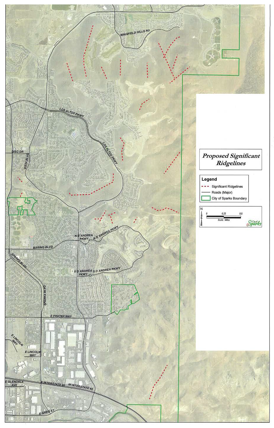
H.
Application Requirements. In addition to the usual requirements for a Conditional Use Permit or Administrative Review; the application for any development subject to the requirements of this Section shall include the information required in Appendix A7 and A8.
(Ord. 2547, § 1(Exh. A), Amended, 12/11/2017; Ord. 2512, § 1(Exh. A), Add. 08/24/2015)
Section 20.04.012 - Truckee River Corridor.
Purpose: The Truckee River Corridor is established in order to protect ecological balance and water quality of the Truckee River as well as to preclude the possibility of obstructing the flow of stormwaters.
A.
Applicability.
1.
This section applies to all development in the Truckee River Corridor, defined in subsection 2 below.
2.
The Truckee River Corridor comprises 2 zones as follows:
B.
Permitted Uses.
1.
Zone I. Landscaped areas using organic and inorganic plant material which enhances the natural appearance of the corridor, public pedestrian and equestrian trails and service roads, public parking, recreation areas, and facilities.
2.
Zone II. All permitted uses in underlying zoning district if:
a.
Parking lots areas are screened by landscape material or fencing so as not to be visible from Zone I.
b.
Outdoor storage is screened and fenced.
c.
Cut and fill areas are stabilized with organic and/or inorganic landscape material.
d.
Applicants install drought-tolerant, native species of plants and trees that are not otherwise prohibited as a nuisance plant or tree.
Parking lots, outdoor uses and outdoor storage areas are screened so as not to be visible from the Truckee River Trail. Where the Truckee River Trail is elevated more than three feet above grade of the parking lot, outdoor use, or outdoor storage site, the Administrator may approve screening that partially screens or reduces the visual impact of the operations from view of the Truckee River Trail.
(Ord. 2512, § 1(Exh. A), Add. 08/24/2015)
Section 20.04.013 - Utilities.
Purpose: this section establishes the standards for utilities improvements, including water, sewer, electrical, gas, telephone, cable, and related improvements associated with any development located outside of the public right-of-way.
A.
Applicability.
1.
This subsection does not apply if the parcel is part of a subdivision or a development agreement where the City has determined that there is sufficient capacity for, and has approved the design of, water, sewer, electrical, gas, telephone, cable, and related improvements for the proposed use.
2.
Administrative review is required if the utility project has not been approved as part of a subdivision plat application (unless a conditional use permit is required).
3.
The requirement for a conditional use permit and/or administrative review is not required for projects with an associated building permit.
B.
Easements and Dedication.
1.
Development plans shall identify needed right-of-way or easement locations necessary for the provision of utilities, drainage and vehicular or pedestrian circulation within the development which meet specified levels of service called for in adopted City plans and policies. Easements may be granted and right-of-way dedicated to the public by the applicant as part of the development approval process or through separate instrument, which shall be in a form approved by the City Attorney.
2.
Drainage easements needed for stormwater management as indicated on an approved drainage or grading plan shall be provided.
3.
Utility easements required by the various public and private utilities shall be provided. The various utility agencies and the City of Sparks shall be consulted as to current policy on design and required easement widths.
4.
Vegetation located on utility easements shall be placed so as to not interfere with the free movement of service vehicles.
5.
Structures shall not be placed on utility easements.
(Ord. 2512, § 1(Exh. A), Add. 08/24/2015)