
Statesville City Zoning Code
ARTICLE 3
- ZONING
Section 3.01 - Establishment of Zoning Districts
A.
Base Zoning Districts
To carry out the purpose and intent of this Code and provide for the orderly growth and development, the jurisdiction of the City is hereby divided into the following zoning districts:
B.
Conditional Zoning Districts
Each base zoning district, except HD and PUD, may be designated as a Conditional Zoning District by prefixing the base zoning district with "CZ" and the case number.
(Ord. No. 31-21, 2-1-2021)
Section 3.02 - Zoning Map
A.
Official Zoning Map
The City and its planning and development regulation jurisdiction, including any extraterritorial jurisdiction as now or hereafter fixed, is hereby divided into districts as established in Section 3.01 of the Code (Zoning Districts) and as shown on the Official Zoning Map of Statesville which, together with all explanatory matter thereon, is hereby adopted by reference and declared to be part of this Code. The Official Zoning Map shall be on file in the office of the Planning Director and shall bear the signature of the Mayor and attestation of the City Clerk, certifying it as the Official Zoning Map of Statesville in accordance with NCGS 160A-77 and 160A-78. The City Council may, from time to time, adopt a new Official Zoning Map which shall supersede the prior Official Zoning Map, in the event the Official Zoning Map becomes damaged or destroyed, or for purposes of clarity.
B.
Maintenance of the Official Zoning Map
If, in accordance with the provisions of this Code, changes are made in the district boundaries or other matters portrayed on the Official Zoning Map, the ordinance number and the date of each change shall be recorded by the Planning Director on the Official Zoning Map.
C.
Interpretation of the Official Zoning Map
1.
Zoning district boundaries shall be interpreted to follow recognizable and discernable boundaries, such as the centerlines of streets, highways, alleys or other public rights-of-way, platted lot lines, section lines, quarter lines, quarter section lines, or quarter-quarter section lines, the corporate limits, the centerlines of rivers, streams, creeks or other waterways, or a line midway between railroad tracks.
2.
Where a district boundary line divides a lot, the entire lot shall be deemed to be in that district in which the greater part of the lot lies.
3.
Boundaries not capable of being determined shall be as dimensioned on the Official Zoning Map or if not dimensioned, shall be determined by the scale shown.
(Ord. No. 02-23, exh. A, 1-9-2023)
Section 3.03 - Use Matrix and Interpretation
Table 3-1 lists the principal uses allowed within zoning districts and uses permitted by Special Use Permits. All uses are subject to the standards and regulations within this Code.
A.
Permitted Uses
A "P" indicates the listed use is allowed by-right within the respective zoning district. Note that some conditions may be established pursuant to Article 5 of this Code.
B.
Special Uses
A "S" indicates the listed use is allowed within the respective zoning district only after review and approval of a Special Use Permit. Note that some conditions may be established pursuant to Article 5 of this Code.
C.
Supplemental Regulations
A "SR" indicates the listed use is allowed within the respective zoning district only after review and approval by City Staff. Note that conditions for some of these uses are established in Article 5 of this Code.
D.
Performance Standards
A "PS" indicates that performance standards have been established in Article 5 of this Code.
E.
Prohibited Uses
An empty cell indicates the listed use is not allowed within the respective zoning district, unless otherwise expressly allowed within this Code.
F.
Reserved.
(Ord. No. 05-16, 3-21-2016; Ord. No. 08-21, 3-1-2021; Ord. No. 31-21, 2-1-2021)
Section 3.04 - Zoning District Regulations
Development within the jurisdiction, including Extraterritorial Jurisdiction (ETJ), shall be consistent with the purposes and standards of the applicable zoning district and all applicable provisions of this Code.
Table 3-1: Use Matrix
X — Permitted
SR — Supplemental Regulations
S — Special Use Permit
PS — Performance Standards
A.
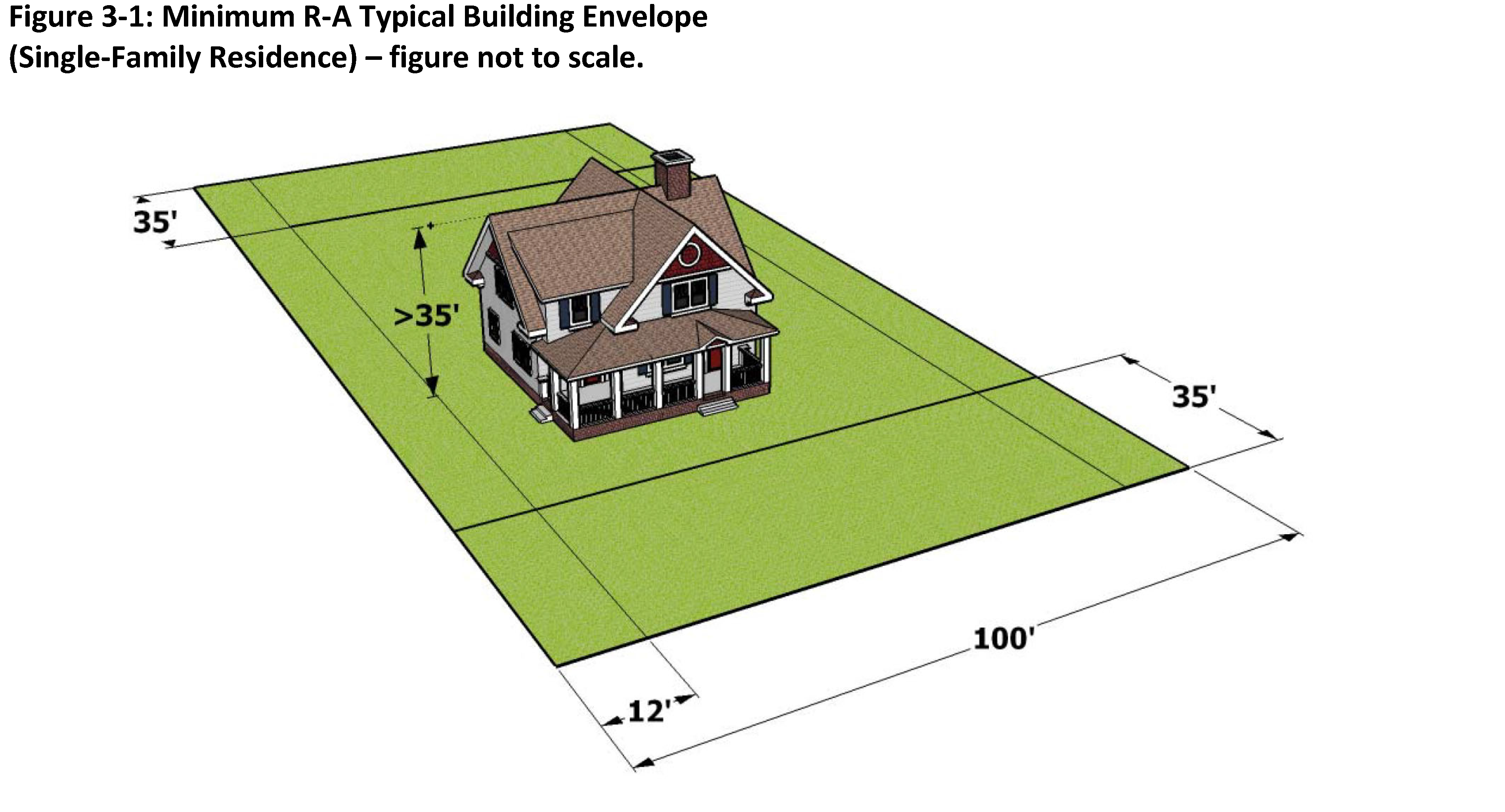
R-A - Residential Agricultural District
| Purpose: Allow a variety of residential uses in areas that are not yet urbanized and do not
have urban services.
This district is intended to allow agricultural uses to continue and to ensure that residential development will occur at a sufficiently low density to provide a compatible environment. It is also intended to hold land to be developed under other zoning districts until the land is needed for development and urban infrastructure is available. Authorized Uses: Uses permitted in this zoning district shall be limited to those indicated in Table 3-1, which include detached single family residences, detached Class A, B, and C, manufactured single family residences, agricultural uses, and related accessory uses. | DIMENSIONAL AND RATIO STANDARDS: | |
| Minimum Lot Size: | 20,000 sq. ft. | |
| Minimum Lot Width (at front setback line): | 100 ft. | |
| Front Setback: | 35 ft. | |
| Corner Lot Setback (lot with frontage on 2 streets): | See note 2 | |
| Side Setback: | 12 ft. | |
| Rear Setback: | 35 ft. | |
| Maximum Height Limit: | 35 ft. | |
 | ||
| Development Notes: | ||
| 1. Development shall comply with additional development standards as contained in Article 6. | ||
| 2. When a lot abuts more than one (1) street the front yard setback shall apply to the rear or side abutting a street. Where there is no lot fronting on the side or rear street immediately to the rear or side of the lot, the width of the side yard shall be equal to one-half (½) the front yard requirement. | ||
| 3. Density shall be in accordance with the provisions of Section 6.02 (B) of this Ordinance. | ||
| 4. Minimum lot size shall be determined based on the need to accommodate on-site wastewater disposal systems as indicated in Section 6.02 (A) of this Ordinance. | ||
B.
R-20 - Suburban Residential District
| Purpose: The purpose of this district is to accommodate low density, detached single family
residential development in a suburban setting, especially within the extra-territorial
jurisdiction area.
Authorized Uses: Uses permitted in this zoning district shall be limited to those indicated in Table 3-1, which includes detached, single family residences and related accessory uses. | DIMENSIONAL AND RATIO STANDARDS: | |
| Minimum Lot Size: | 20,000 sq. ft. (see note 5) | |
| Minimum Lot Width (at front setback line): | 100 ft. | |
| Front Setback: | 35 ft. | |
| Corner Lot Setback (lot with frontage on 2 streets): | See note 2 | |
| Side Setback: | 12 ft. | |
| Rear Setback: | 35 ft. | |
| Maximum Height Limit: | 35 ft. | |
 | ||
| Development Notes: | ||
| 1. Development shall comply with additional development standards as contained in Article 6. | ||
| 2. When a lot abuts more than one (1) street the front yard setback shall apply to the rear or side abutting a street. Where there is no lot fronting on the side or rear street immediately to the rear or side of the lot, the width of the side yard shall be equal to one-half (½) the front yard requirement. | ||
| 3. Density shall be in accordance with the provisions of Section 6.02 (B) of this Ordinance. | ||
| 4. Minimum lot size shall be determined based on the need to accommodate on-site wastewater disposal systems as indicated in Section 6.02 (A) of this Ordinance. | ||
| 5. Cluster subdivisions, reviewed and approved in accordance with Article 7, shall have a minimum lot area of fifteen thousand (15,000) square feet. | ||
C.
R-15 - Urban Fringe Low Density Residential District
| Purpose: The purpose of this district is to provide low density, detached single family residential
development in urbanizing areas partially served by urban services. These areas are
generally located in close proximity to low density urban areas.
Authorized Uses: Uses permitted in this zoning district shall be limited to those indicated in Table 3-1, which includes detached, single family residences and related accessory uses. | DIMENSIONAL AND RATIO STANDARDS: | |
| Minimum Lot Size: | 15,000 sq. ft. (see note 5) | |
| Minimum Lot Width (at front setback line): | 90 ft. | |
| Front Setback: | 30 ft. | |
| Corner Lot Setback (lot with frontage on 2 streets): | See note 2 | |
| Side Setback: | 10 ft. | |
| Rear Setback: | 30 ft. | |
| Maximum Height Limit: | 35 ft. | |
 | ||
| Development Notes: | ||
| 1. Development shall comply with additional development standards as contained in Article 6. | ||
| 2. When a lot abuts more than one (1) street the front yard setback shall apply to the rear or side abutting a street. Where there is no lot fronting on the side or rear street immediately to the rear or side of the lot, the width of the side yard shall be equal to one-half (½) the front yard requirement. | ||
| 3. Density shall be in accordance with the provisions of Section 6.02 (B) of this Ordinance. | ||
| 4. Minimum lot size shall be determined based on the need to accommodate on-site wastewater disposal systems as indicated in Section 6.02 (A) of this Ordinance. | ||
| 5. Cluster subdivisions, reviewed and approved in accordance with Article 7, shall have a minimum lot area of eleven thousand two hundred fifty (11,250) square feet. | ||
D.
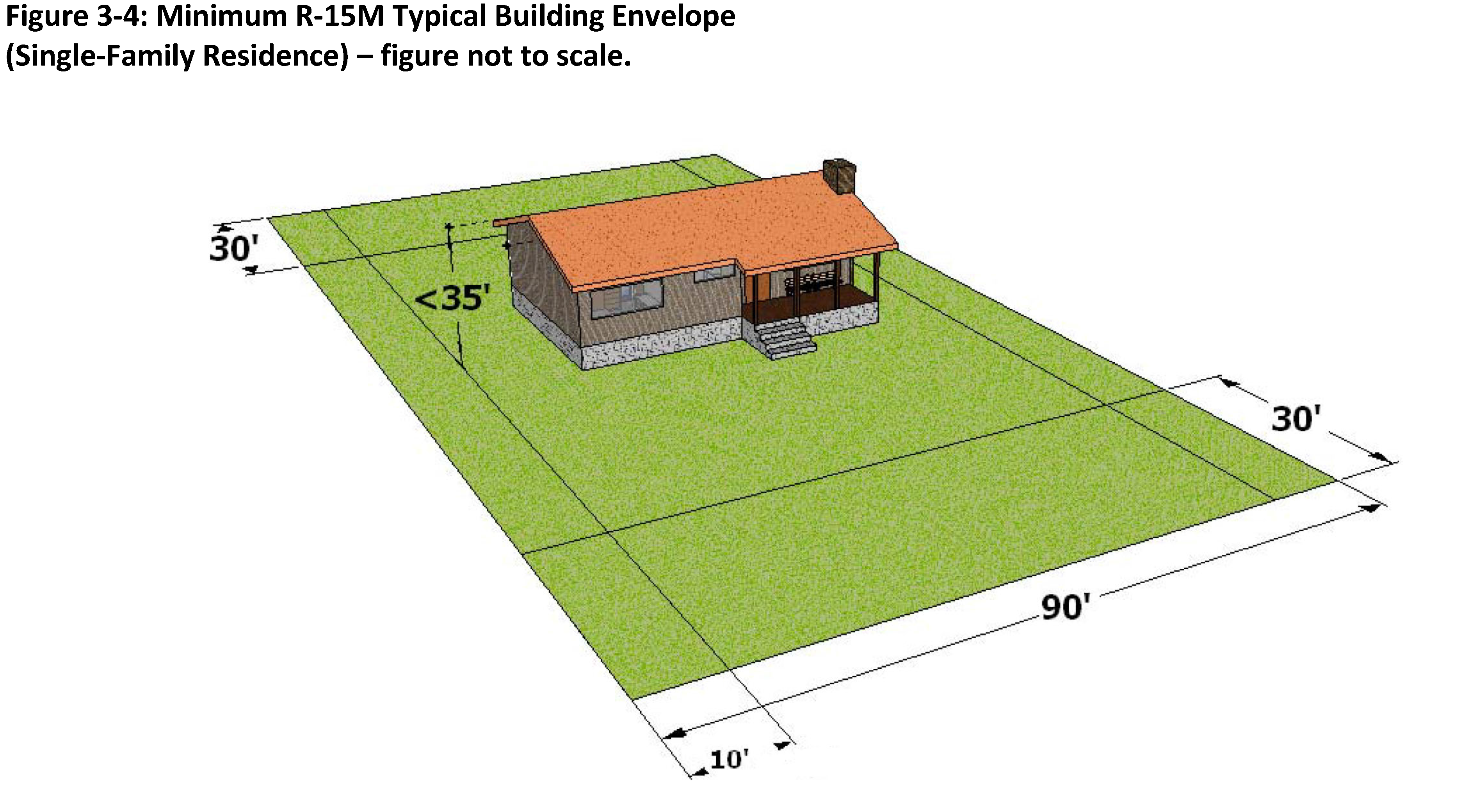
R-15M - Urban Fringe Low Density Residential/Manufactured Housing District
| Purpose: The purpose of this district is to accommodate manufactured housing in low density,
detached single family residential development in urbanizing areas partially served
by urban services. These areas are located in close proximity to low density urban
areas.
Authorized Uses: Uses permitted in this zoning district shall be limited to those indicated in Table 3-1, which includes detached, Class "A" manufactured single family residences and related accessory uses. | DIMENSIONAL AND RATIO STANDARDS: | |
| Minimum Lot Size: | 15,000 sq. ft. | |
| Minimum Lot Width (at front setback line): | 90 ft. | |
| Front Setback: | 30 ft. | |
| Corner Lot Setback (lot with frontage on 2 streets): | See note 2 | |
| Side Setback: | 10 ft. | |
| Rear Setback: | 30 ft. | |
| Maximum Height Limit: | 35 ft. | |
 | ||
| Development Notes: | ||
| 1. Development shall comply with additional development standards as contained in Article 6. | ||
| 2. When a lot abuts more than one (1) street the front yard setback shall apply to the rear or side abutting a street. Where there is no lot fronting on the side or rear street immediately to the rear or side of the lot, the width of the side yard shall be equal to one-half (½) the front yard requirement. | ||
| 3. Density shall be in accordance with the provisions of Section 6.02 (B) of this Ordinance. | ||
| 4. Minimum lot size shall be determined based on the need to accommodate on-site wastewater disposal systems as indicated in Section 6.02 (A) of this Ordinance. | ||
E.
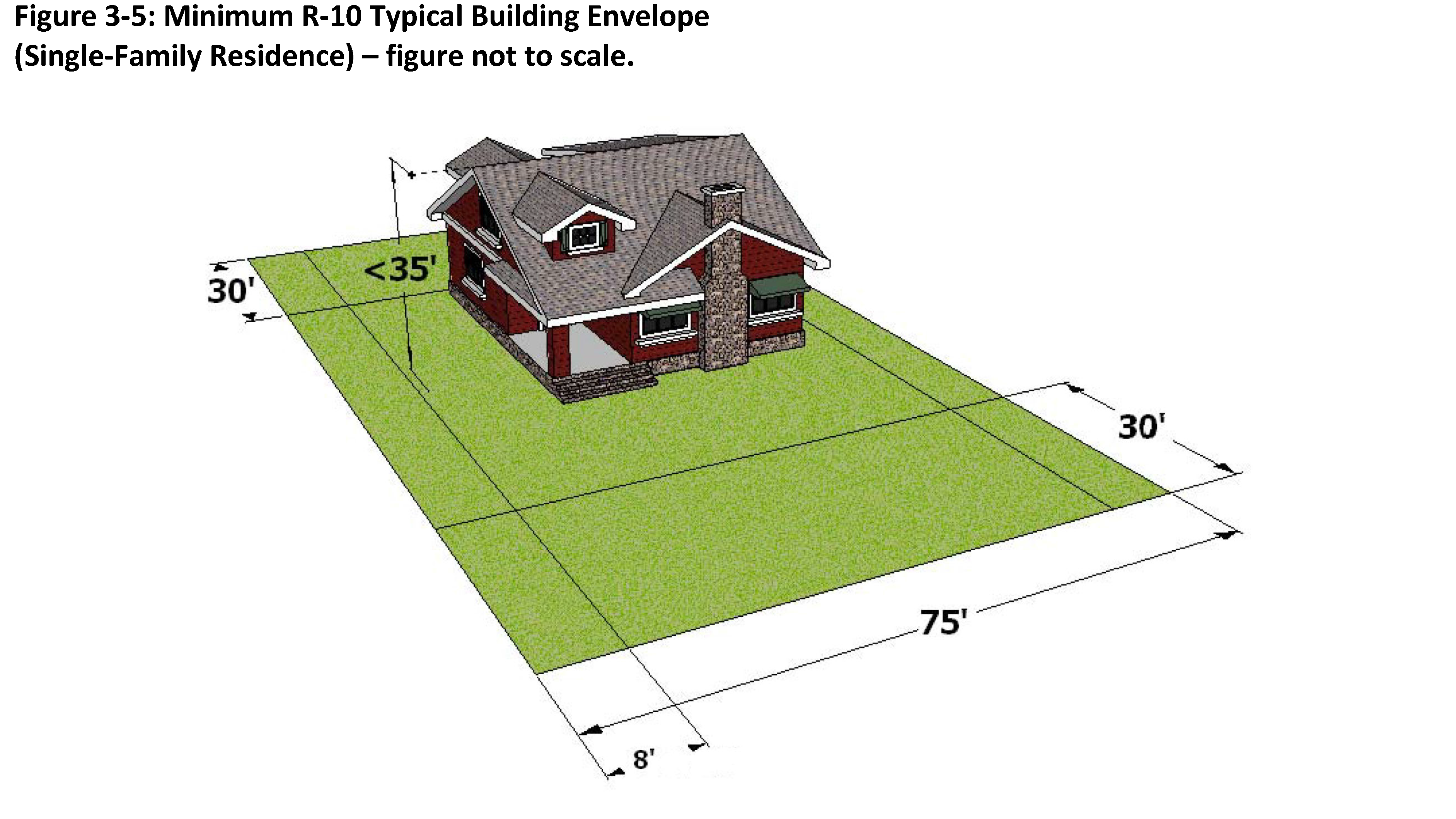
R-10 - Urban Low Density Residential District
| Purpose: The purpose of this district is to accommodate low density, detached single family
residential development in areas where full urban services are available.
Authorized Uses: Uses permitted in this zoning district shall be limited to those indicated in Table 3-1, which includes detached, single family residences and related accessory uses. | DIMENSIONAL AND RATIO STANDARDS: | |
| Minimum Lot Size: | 10,000 sq. ft. (see note 5) | |
| Minimum Lot Width (at front setback line): | 75 ft. | |
| Front Setback: | 30 ft. | |
| Corner Lot Setback (lot with frontage on 2 streets): | See note 2 | |
| Side Setback: | 8 ft. | |
| Rear Setback: | 30 ft. | |
| Maximum Height Limit: | 35 ft. | |
 | ||
| Development Notes: | ||
| 1. Development shall comply with additional development standards as contained in Article 6. | ||
| 2. When a lot abuts more than one (1) street the front yard setback shall apply to the rear or side abutting a street. Where there is no lot fronting on the side or rear street immediately to the rear or side of the lot, the width of the side yard shall be equal to one-half (½) the front yard requirement. | ||
| 3. Density shall be in accordance with the provisions of Section 6.02 (B) of this Ordinance. | ||
| 4. On-site wastewater disposal systems, as indicated in Section 6.02 (A) of this Ordinance, are not anticipated to be necessary to support development. Development is anticipated to be served by public utilities (i.e. water and sewer). | ||
| 5. Cluster subdivisions, reviewed and approved in accordance with Article 7, shall have a minimum lot area of seven thousand five hundred (7,500) square feet. | ||
F.
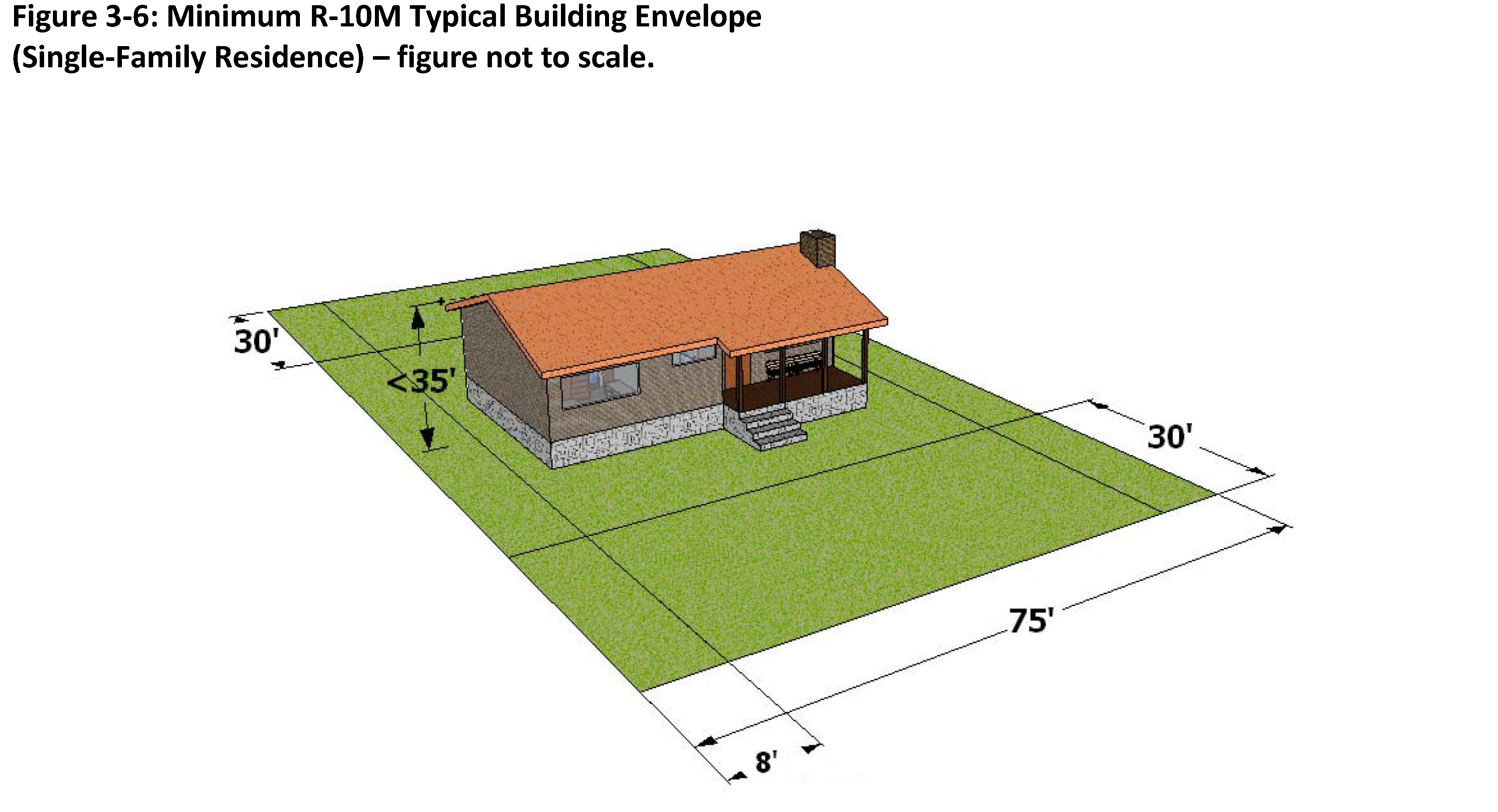
R-10M - Urban Low Density Manufactured Housing Residential District
| Purpose: The purpose of this district is to accommodate low density manufactured single family
residential development in areas where full urban services are available.
Authorized Uses: Uses permitted in this zoning district shall be limited to those indicated in Table 3-1, which includes detached, class "A" manufactured single family residences and related accessory uses. | DIMENSIONAL AND RATIO STANDARDS: | |
| Minimum Lot Size: | 10,000 sq. ft. | |
| Minimum Lot Width (at front setback line): | 75 ft. | |
| Front Setback: | 30 ft. | |
| Corner Lot Setback (lot with frontage on 2 streets): | See note 2 | |
| Side Setback: | 8 ft. | |
| Rear Setback: | 30 ft. | |
| Maximum Height Limit: | 35 ft. | |
 | ||
| Development Notes: | ||
| 1. Development shall comply with additional development standards as contained in Article 6. | ||
| 2. When a lot abuts more than one (1) street the front yard setback shall apply to the rear or side abutting a street. Where there is no lot fronting on the side or rear street immediately to the rear or side of the lot, the width of the side yard shall be equal to one-half (½) the front yard requirement. | ||
| 3. Density shall be in accordance with the provisions of Section 6.02 (B) of this Ordinance. | ||
| 4. On-site wastewater disposal systems, as indicated in Section 6.02 (A) of this Ordinance, are not anticipated to be necessary to support development. Development is anticipated to be served by public utilities (i.e. water and sewer). | ||
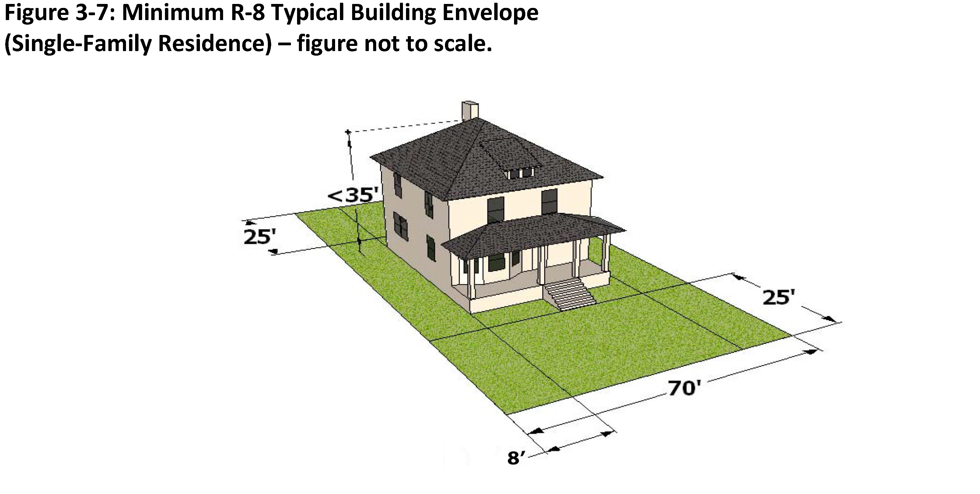
G.
R-8 - Medium Density Single-Family Residential District
| Purpose: The purpose of this district is to accommodate medium density single family residential
development.
Authorized Uses: Uses permitted in this zoning district shall be limited to those indicated in Table 3-1, which includes detached, single family residences and related accessory uses. | DIMENSIONAL AND RATIO STANDARDS: | |
| Minimum Lot Size: | 8,000 sq. ft. (see note 6) | |
| Minimum Lot Width (at front setback line): | 70 ft. (see note 6) | |
| Front Setback: | 25 ft. | |
| Corner Lot Setback (lot with frontage on 2 streets): | See note 3 | |
| Side Setback: | 8 ft. | |
| Rear Setback: | 25 ft. | |
| Maximum Height Limit: | 35 ft. | |
 | ||
| Development Notes: | ||
| 1. Development shall comply with additional development standards as contained in Article 6. | ||
| 2. Ten percent (10%) active open space shall be provided for in accordance with Section 6.06 of the Ordinance. | ||
| 3. When a lot abuts more than one (1) street the front yard setback shall apply to the rear or side abutting a street. Where there is no lot fronting on the side or rear street immediately to the rear or side of the lot, the width of the side yard shall be equal to one-half (½) the front yard requirement. | ||
| 4. Density shall be in accordance with the provisions of Section 6.02 (B) of this Ordinance. | ||
| 5. On-site wastewater disposal shall be provided by public utilities (i.e. water and sewer). | ||
| 6. Dwelling-unit Duplex developments shall observe a minimum lot size of twelve thousand (12,000) square feet and a minimum lot width of eighty (80) feet. | ||
H.
R-8M - Medium Density Single-Family/Manufactured Housing Residential District
| Purpose: The purpose of this district is to accommodate low density manufactured single family
residential development in areas where full urban services are available.
Authorized Uses: Uses permitted in this zoning district shall be limited to those indicated in Table 3-1, which includes detached, Class "A" manufactured single family residences and related accessory uses. | DIMENSIONAL AND RATIO STANDARDS: | |
| Minimum Lot Size: | 8,000 sq. ft. (see note 6) | |
| Minimum Lot Width (at front setback line): | 70 ft. (see note 6) | |
| Front Setback: | 25 ft. | |
| Corner Lot Setback (lot with frontage on 2 streets): | See note 3 | |
| Side Setback: | 8 ft. | |
| Rear Setback: | 25 ft. | |
| Maximum Height Limit: | 35 ft. | |
 | ||
| Development Notes: | ||
| 1. Development shall comply with additional development standards as contained in Article 6. | ||
| 2. Ten percent (10%) active open space shall be provided for in accordance with Section 6.06 of the Ordinance. | ||
| 3. When a lot abuts more than one (1) street the front yard setback shall apply to the rear or side abutting a street. Where there is no lot fronting on the side or rear street immediately to the rear or side of the lot, the width of the side yard shall be equal to one-half (½) the front yard requirement. | ||
| 4. Density shall be in accordance with the provisions of Section 6.02 (B) of this Ordinance. | ||
| 5. On-site wastewater disposal shall be provided by public utilities (i.e. water and sewer). | ||
| 6. Dwelling-unit Duplex developments shall observe a minimum lot size of twelve thousand (12,000) square feet and a minimum lot width of eighty (80) feet. | ||
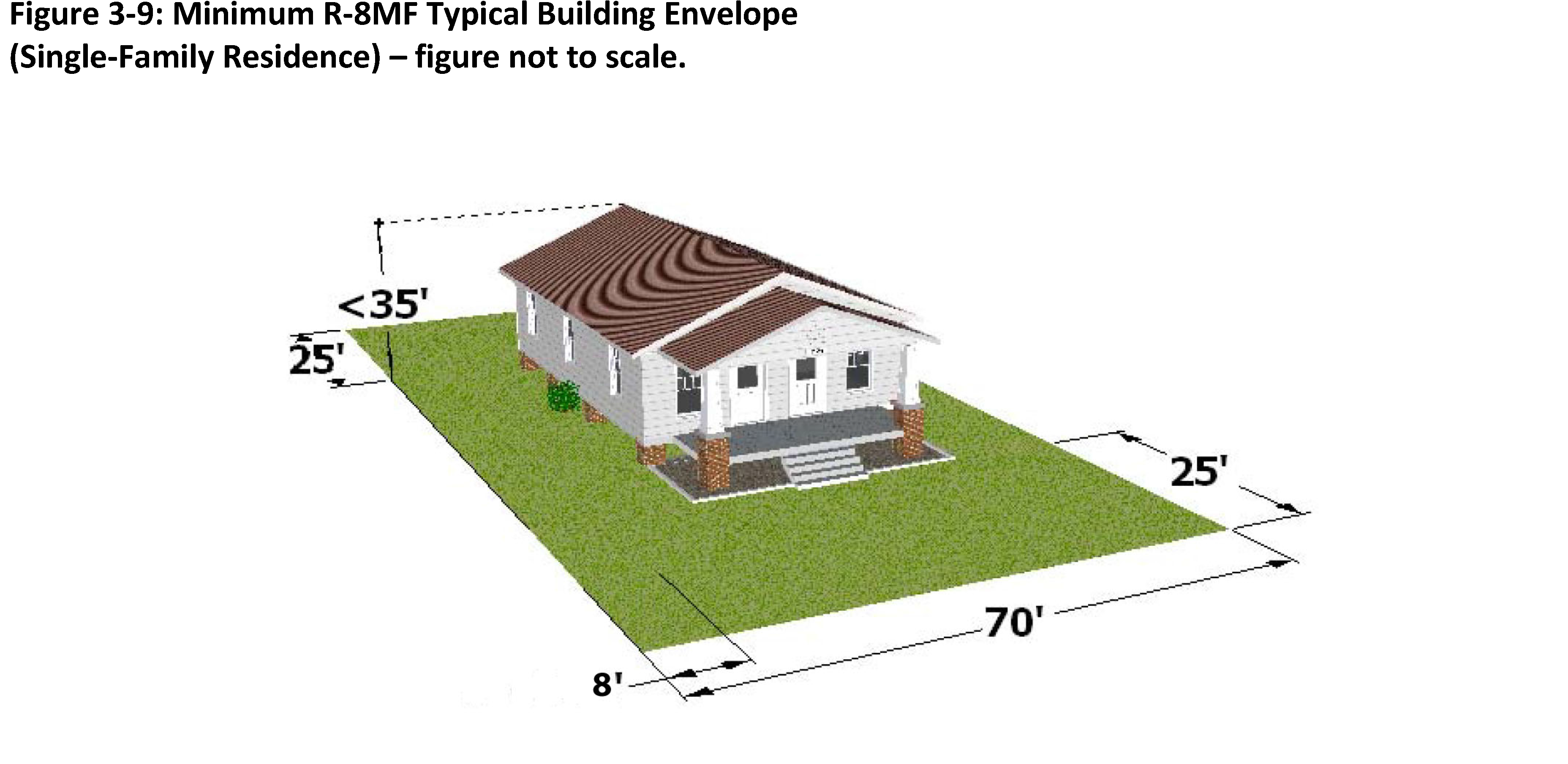
I.
R-8MF - Medium Density Multi-Family Residential District
| Purpose: The purpose of this district is to accommodate low density multi-family and/or single
family residential development in areas where full urban services are available.
Authorized Uses: Uses permitted in this zoning district shall be limited to those indicated in Table 3-1, which includes detached, single family residences and related accessory uses. | DIMENSIONAL AND RATIO STANDARDS: | |
| Minimum Lot Size: | 8,000 sq. ft. (see note 6) | |
| Minimum Lot Width (at front setback line): | 70 ft. | |
| Front Setback: | 25 ft. | |
| Corner Lot Setback (lot with frontage on 2 streets): | See note 3 | |
| Side Setback: | 8 ft. | |
| Rear Setback: | 25 ft. | |
| Maximum Height Limit: | 35 ft. | |
 | ||
| Development Notes: | ||
| 1. Development shall comply with additional development standards as contained in Article 6. | ||
| 2. Ten percent (10%) active open space shall be provided for in accordance with Section 6.06 of the Ordinance. | ||
| 3. When a lot abuts more than one (1) street the front yard setback shall apply to the rear or side abutting a street. Where there is no lot fronting on the side or rear street immediately to the rear or side of the lot, the width of the side yard shall be equal to one-half (½) the front yard requirement. | ||
| 4. Density shall be in accordance with the provisions of Section 6.02 (B) of this Ordinance. | ||
| 5. On-site wastewater disposal shall be provided by public utilities (i.e. water and sewer). | ||
| 6. Multi-family development: | ||
| a. Dwelling-unit Duplex: Development shall observe a minimum lot size of twelve thousand (12,000) square feet and a minimum lot width of eighty (80) feet. | ||
| b. Multi-family Development: | ||
| i. Infill Development: For lots in existence, and zoned R-8MF, as of December 31, 2022 and zoned R-8MF the following standards shall apply: | ||
| 1. Projects meeting applicable criteria, shall be approved by staff in accordance with Section(s) 2.17 and 2.24. Any proposed subdivision of property shall be processed in accordance with the provisions of Section(s) 2.02 and 2.03 of this Code. | ||
| 2. Shall be limited to Dwelling-unit Townhome or Dwelling-unit Multi-family projects with no more than four (4) units permitted per individually zoned parcel. | ||
| 3. Minimum lot size shall be twenty-four thousand (24,000) square feet. | ||
| a. Minimum size for individual Dwelling-unit - Townhome: Lot shall be six thousand (6,000) square feet for each individual unit; | ||
| b. Lot size may be reduced if difference is put into common open space. Under no circumstances may a townhome lot be reduced below two thousand (2,000) square feet in area. Open space area shall be owned in common by all property owners comprising the development through the establishment of a homeowners or property owners association. | ||
| 4. Minimum Lot width: The parent tract shall have the typical required minimum lot width for the R8-MF district increased by a minimum of ten (10) feet per additional unit for lots less than one hundred twenty-five (125) feet in width. | ||
| a. There shall be a minimum of 25 ft. of lot width per individual Dwelling-unit Townhome Lot. | ||
| 5. Setbacks from external property lines shall comply with the provisions of this section for end units. Zero-lot line setbacks shall be permitted for interior units. | ||
 | ||
| 6. A five-foot vegetative buffer shall be required along the side and rear property lines. | ||
| ii. New Development: Parcels created (i.e. subdivided) and/or zoned R-8MF after December 31, 2022 shall be reviewed and approved through the provisions of Section 2.07 of the Ordinance and comply with the provisions of Section 6.02 of this Code and the following dimensional standards:. | ||
| 1. Minimum Lot Area shall be as follows: twelve thousand (12,000) square feet minimum lot size with an additional four thousand (4,000) square feet of lot area for every proposed residential unit over two (2) units. | ||
| 2. Minimum size for individual Dwelling unit - Townhome lot shall be six thousand (6,000) square feet for each individual unit. Lot size may be reduced if difference is put into common open space; without limiting the number of lots where the lot size may be reduced, the amount put into common open space shall not be required to exceed twenty percent (20%) (ten percent (10%) of this shall be active open space), of the gross acreage of the project site. Under no circumstance may a townhome lot be reduced below two thousand (2,000) square feet in area. Open space area shall be owned in common by all property owners comprising the development through the establishment of a homeowners of property owners association. | ||
| 3. Minimum Lot width: The parent tract shall have the typical required minimum lot width for the R-8MF district increased by a minimum of ten (10) feet per additional unit for lots less than one hundred twenty-five (125) feet in width. there shall be a minimum of twenty-five (25) feet of lot width per individual Dwelling unit Townhome Lot; | ||
| 4. Setbacks from external property lines shall comply with the provisions of this section for end units. The minimum front yard setback for multi-family developments is ten (10) feet. Zero-lot line setbacks shall be permitted for interior units. | ||
| 5. A 5 ft vegetative buffer shall be required along the side and rear property lines. | ||
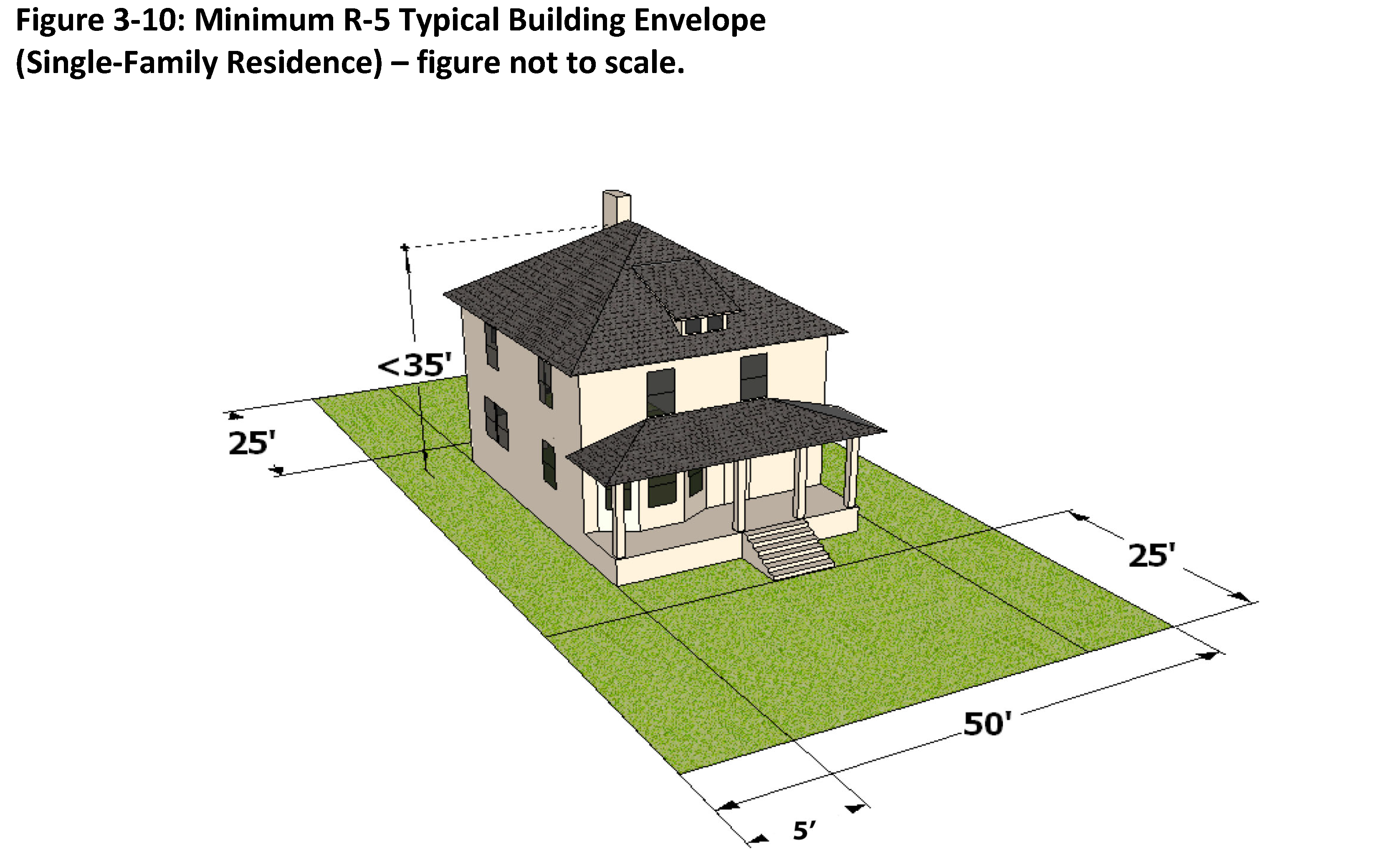
J.
R-5 - High Density Single Family Residential District
| Purpose: The purpose of this district is to accommodate higher density residences on smaller
lots in urban areas. This district includes single- and two-family residences and
allows smaller residences and higher-density neighborhoods.
Authorized Uses: Uses permitted in this zoning district shall be limited to those indicated in Table 3-1, including detached residential uses. | DIMENSIONAL AND RATIO STANDARDS: | |
| Minimum Lot Size: | 5,000 sq. ft. (see note 6) | |
| Minimum Lot Width (at front setback line): | 50 ft. (see note 6) | |
| Front Setback: | 25 ft. | |
| Corner Lot Setback (lot with frontage on 2 streets): | See note 3 | |
| Side Setback: | 5 ft. | |
| Rear Setback: | 25 ft. | |
| Maximum Height Limit: | 35 ft. | |
 | ||
| Development Notes: | ||
| 1. Development shall comply with additional development standards as contained in Article 6. | ||
| 2. Ten percent (10%) active open space shall be provided for in accordance with Section 6.06 of the Ordinance. | ||
| 3. When a lot abuts more than one (1) street the front yard setback shall apply to the rear or side abutting a street. Where there is no lot fronting on the side or rear street immediately to the rear or side of the lot, the width of the side yard shall be equal to one-half (½) the front yard requirement. | ||
| 4. Density shall be in accordance with the provisions of Section 6.02 (B) of this Ordinance. | ||
| 5. On-site wastewater disposal shall be provided by public utilities (i.e. water and sewer). | ||
| 6. Dwelling-unit Duplex: Development shall observe a minimum lot size of seven thousand five hundred (7,500) square feet and a minimum lot width of sixty (60) feet. | ||
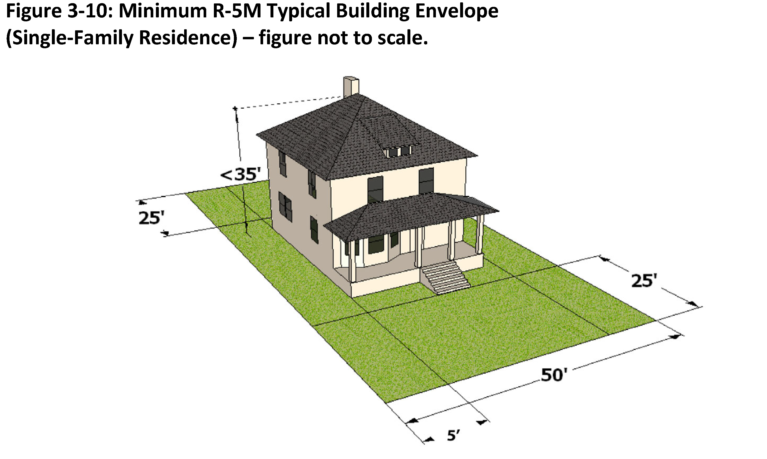
K.
R-5M - High Density Single Family/Manufactured Housing Residential District
| Purpose: The purpose of this district is to accommodate manufactured housing in higher density
residences on smaller lots in urban areas. This district includes single- and two-family
residences and allows smaller residences and higher-density neighborhoods.
Authorized Uses: Uses permitted in this zoning district shall be limited to those indicated in Table 3-1, which includes detached, Class "A" manufactured residential uses. | DIMENSIONAL AND RATIO STANDARDS: | |
| Minimum Lot Size: | 5,000 sq. ft. (see note 6) | |
| Minimum Lot Width (at front setback line): | 50 ft. (see note 6) | |
| Front Setback: | 25 ft. | |
| Corner Lot Setback (lot with frontage on 2 streets): | See note 3 | |
| Side Setback: | 5 ft. | |
| Rear Setback: | 25 ft. | |
| Maximum Height Limit: | 35 ft. | |
 | ||
| Development Notes: | ||
| 1. Development shall comply with additional development standards as contained in Article 6. | ||
| 2. Ten percent (10%) active open space shall be provided for in accordance with Section 6.06 of the Ordinance. | ||
| 3. When a lot abuts more than one (1) street the front yard setback shall apply to the rear or side abutting a street. Where there is no lot fronting on the side or rear street immediately to the rear or side of the lot, the width of the side yard shall be equal to one-half (½) the front yard requirement. | ||
| 4. Density shall be in accordance with the provisions of Section 6.02 (B) of this Ordinance. | ||
| 5. On-site wastewater disposal shall be provided by public utilities (i.e. water and sewer) | ||
| 6. Dwelling-unit Duplex: Development shall observe a minimum lot size of seven thousand five hundred (7,500) square feet and a minimum lot width of sixty (60) feet. | ||
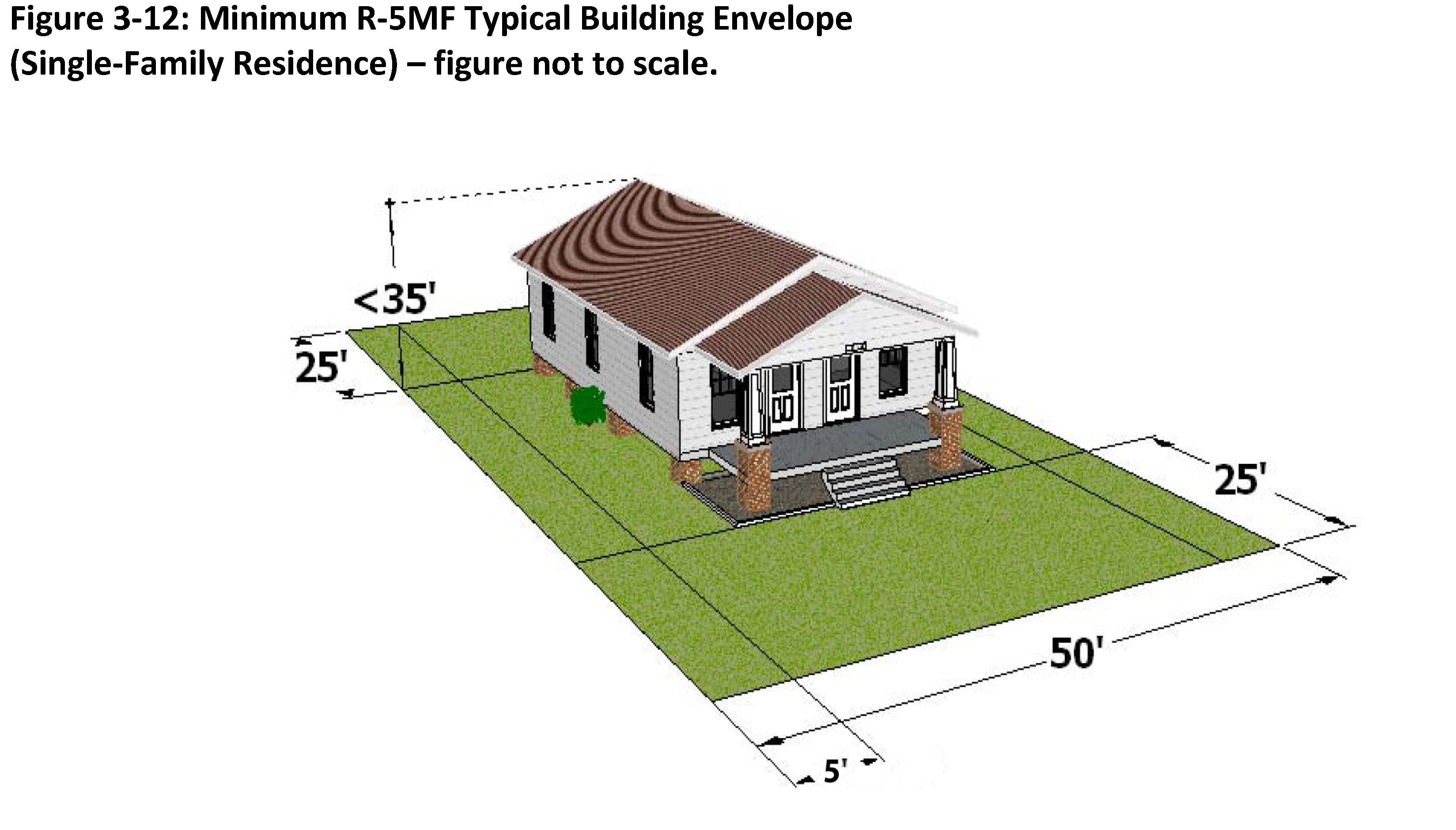
L.
R-5MF - High Density Multi Family Residential District
| Purpose: The purpose of this district is to accommodate higher density multi-family residences
in urban areas. This district allows for a mixture of dwelling types at compatible
densities.
Authorized Uses: Uses permitted in this zoning district shall be limited to those indicated in Table 3-1, which includes attached and detached residential uses. | DIMENSIONAL AND RATIO STANDARDS: | |
| Minimum Lot Size: | 5,000 sq. ft. (see note 6) | |
| Minimum Lot Width (at front setback line): | 50 ft. (see note 6) | |
| Front Setback: | 25 ft. | |
| Corner Lot Setback (lot with frontage on 2 streets): | See note 3 | |
| Side Setback: | 5 ft. | |
| Rear Setback: | 25 ft. | |
| Maximum Height Limit: | 35 ft. | |
 | ||
| Development Notes: | ||
| 1. Development shall comply with additional development standards as contained in Article 6. | ||
| 2. Ten percent (10%) active open space shall be provided for in accordance with Section 6.06 of the Ordinance. | ||
| 3. When a lot abuts more than one (1) street the front yard setback shall apply to the rear or side abutting a street. Where there is no lot fronting on the side or rear street immediately to the rear or side of the lot, the width of the side yard shall be equal to one-half (½) the front yard requirement. | ||
| 4. Density shall be in accordance with the provisions of Section 6.02 (B) of this Ordinance. | ||
| 5. On-site wastewater disposal shall be provided by public utilities (i.e. water and sewer). | ||
| 6. Multi-family development: | ||
| a. Dwelling-unit Duplex: Development shall observe a minimum lot size of seven thousand five hundred (7,500) square feet and a minimum lot width of seventy (70) feet. | ||
| b. Multi-family Development: | ||
| i. Infill Development: For lots in existence, and zoned R-5MF, as of December 31, 2022 the following standards shall apply: | ||
| 1. Projects meeting applicable criteria, shall be approved by staff in accordance with Section(s) 2.17 and 2.24. Any proposed subdivision of property shall be processed in accordance with the provisions of Section(s) 2.02 and 2.03 of this Code. | ||
| 2. Shall be limited to Dwelling-unit Townhome or Dwelling-unit Multi-family projects with no more than four (4) units permitted per individually zoned parcel. | ||
| 3. Minimum lot size shall be twenty thousand (20,000) square feet. | ||
| a. Minimum size for individual Dwelling-unit Townhome Lot shall be five thousand (5,000) square feet for each individual unit. | ||
| b. Lot size may be reduced if difference is put into common open space. Under no circumstance may a townhome lot be reduced below two thousand (2,000) square feet in area. Open space area shall be owned in common by all property owners comprising the development through the establishment of a homeowners of property owners association. | ||
| 4. Minimum Lot width: The parent tract shall have the typical required minimum lot width for the R-5MF district increased by a minimum of ten (10) feet per additional unit for lots less than one hundred twenty-five (125) feet in width. There shall be a minimum of twenty (20) feet of lot width per individual Dwelling-unit Attached (Townhome) Lot; | ||
| 5. Setbacks from external property lines shall comply with the provisions of this section for end units. Zero-lot line setbacks shall be permitted for interior units. | ||
 | ||
| 6. A five-foot vegetative buffer shall be required along the side and rear property lines. | ||
| ii. New Development: Parcels created (i.e. subdivided) and/or zoned R-5MF after December 31, 2022 shall be reviewed and approved through the provisions of Section 2.07 of the Ordinance and comply with the provisions of Section 6.02 of this Code and the following dimensional standards: | ||
| 1. Minimum Lot Area shall be as follows: seven thousand five hundred (7,500) square feet minimum lot size with an additional two thousand five hundred (2,500) square feet of lot area for every proposed residential unit over two (2) units. | ||
| 2. Minimum size for individual Dwelling unit - Townhome lot shall be five thousand (5,000) square feet for each individual unit. Lot size may be reduced if difference is put into common open space; without limiting the number of lots where the lot size may be reduced, the amount put into common open space shall not be required to exceed twenty percent (20%) (ten percent (10%) of this shall be active open space), of the gross acreage of the project site. Under no circumstance may a townhome lot be reduced below two thousand (2,000) square feet in area. Open space area shall be owned in common by all property owners comprising the development through the establishment of a homeowners of property owners association. | ||
| 3. Minimum Lot width: The parent tract shall have the typical required minimum lot width for the R-5MF district increased by a minimum of ten (10) feet per additional unit for lots less than one hundred twenty-five (125) feet in width. There shall be a minimum of twenty (20) feet of lot width per individual Dwelling unit Townhome Lot. | ||
| 4. Setbacks from external property lines shall comply with the provisions of this section for end units. The minimum front yard setback for multi-family developments is ten (10) feet. Zero-lot line setbacks shall be permitted for interior units. | ||
| 5. A five-foot vegetative buffer shall be required along the side and rear property lines. | ||
M.
O-1 - Office Single Lot District
| Purpose: The purpose of this district is to provide a high quality environment for professional
offices and services conducted entirely within buildings. This district also allows
converting residential homes into compatible office uses while maintaining the residential
characteristics.
Authorized Uses: Authorized Uses: Uses permitted in this zoning district shall be limited to those indicated in Table 3-1, which include a variety of office and institutional uses not principally engaged in sales of goods. | DIMENSIONAL AND RATIO STANDARDS: | |
| Minimum Lot Size: | 5,000 sq. ft. (see note 2) | |
| Minimum Lot Width (at front setback line): | 50 ft. | |
| Front Setback: | 25 ft. | |
| Corner Lot Setback (lot with frontage on 2 streets): | See note 3 | |
| Side Setback: | 10 ft. | |
| Rear Setback: | 25 ft. | |
| Maximum Height Limit: | 35 ft. | |
 | ||
| Development Notes: | ||
| 1. Development shall comply with additional development standards as contained in Article 6. | ||
| 2. Parcels zoned O-1 used for residential purposes shall meet the minimum five thousand (5,000) square feet minimum lot size for the district. | ||
| 3. When a lot abuts more than one (1) street the front yard setback shall apply to the rear or side abutting a street. Where there is no lot fronting on the side or rear street immediately to the rear or side of the lot, the width of the side yard shall be equal to one-half (½) the front yard requirement. | ||
| 4. Residential density shall be in accordance with the provisions of Section 6.02 (B) of this Ordinance. | ||
| 5. On-site wastewater disposal shall be provided by public utilities (i.e. water and sewer). | ||
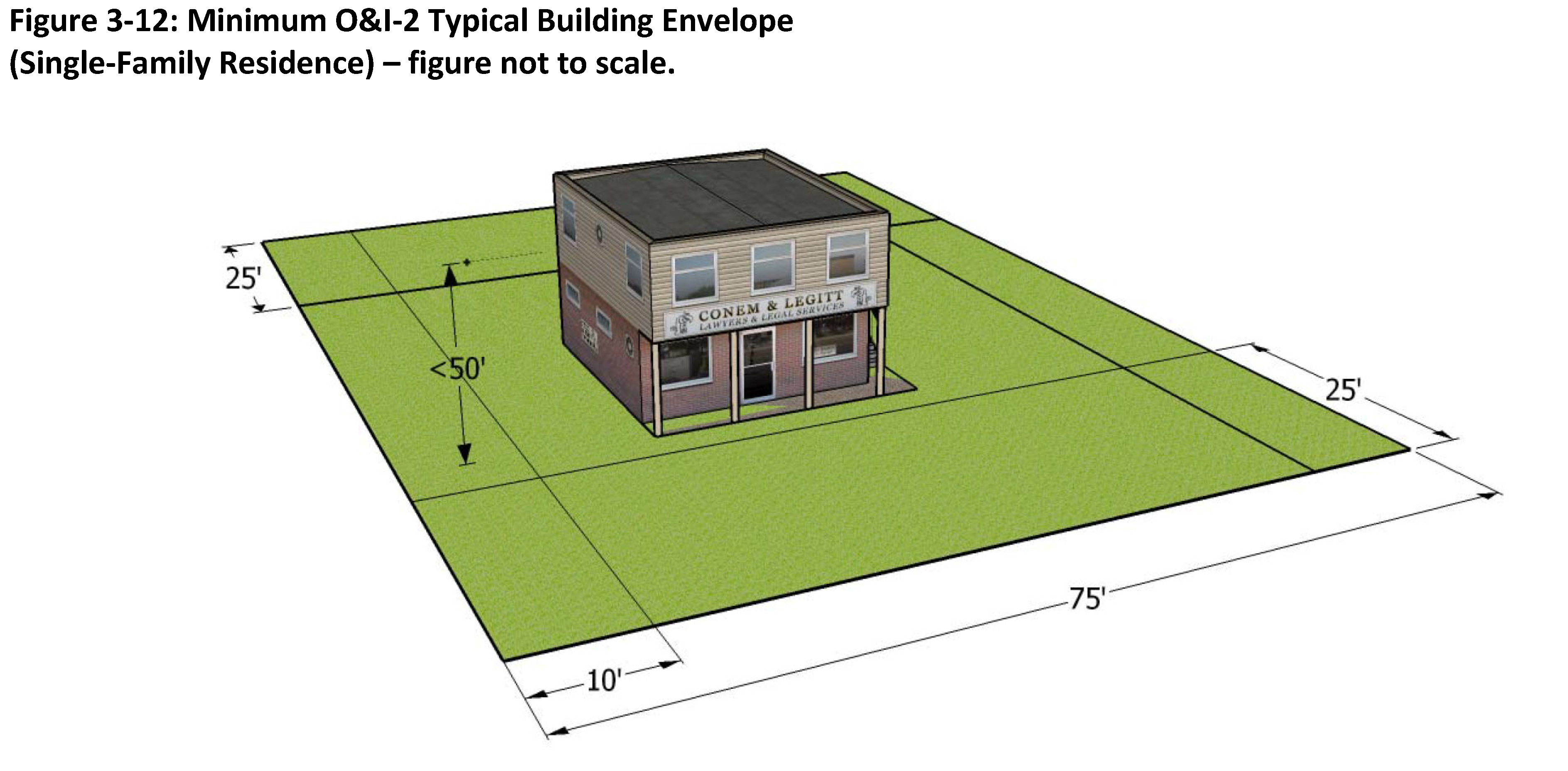
N.
O & I-2 - Office and Institutional Complex District
| Purpose: The purpose of this district is to accommodate larger office and institutional development,
including office parks and complexes with increased impacts on surrounding land uses,
such as increased traffic.
Authorized Uses: Uses permitted in this zoning district shall be limited to those indicated in Table 3-1, which include a variety of office and institutional uses not principally engaged in sales of goods. | DIMENSIONAL AND RATIO STANDARDS: | |
| Minimum Lot Size: | 10,000 sq. ft. (see note 2) | |
| Minimum Lot Width (at front setback line): | 75 ft. | |
| Front Setback: | 25 ft. | |
| Corner Lot Setback (lot with frontage on 2 streets): | See note 3 | |
| Side Setback: | 10 ft. | |
| Rear Setback: | 25 ft. | |
| Maximum Height Limit: | 50 ft. | |
 | ||
| Development Notes: | ||
| 1. Development shall comply with additional development standards as contained in Article 6. | ||
| 2. Parcels zoned O&I-2 used for residential purposes shall meet the minimum five thousand (5,000) square feet minimum lot size. | ||
| 3. When a lot abuts more than one (1) street the front yard setback shall apply to the rear or side abutting a street. Where there is no lot fronting on the side or rear street immediately to the rear or side of the lot, the width of the side yard shall be equal to one-half (½) the front yard requirement. | ||
| 4. Residential density shall be in accordance with the provisions of Section 6.02 (B) of this Ordinance. | ||
| 5. On-site wastewater disposal shall be provided by public utilities (i.e. water and sewer). | ||
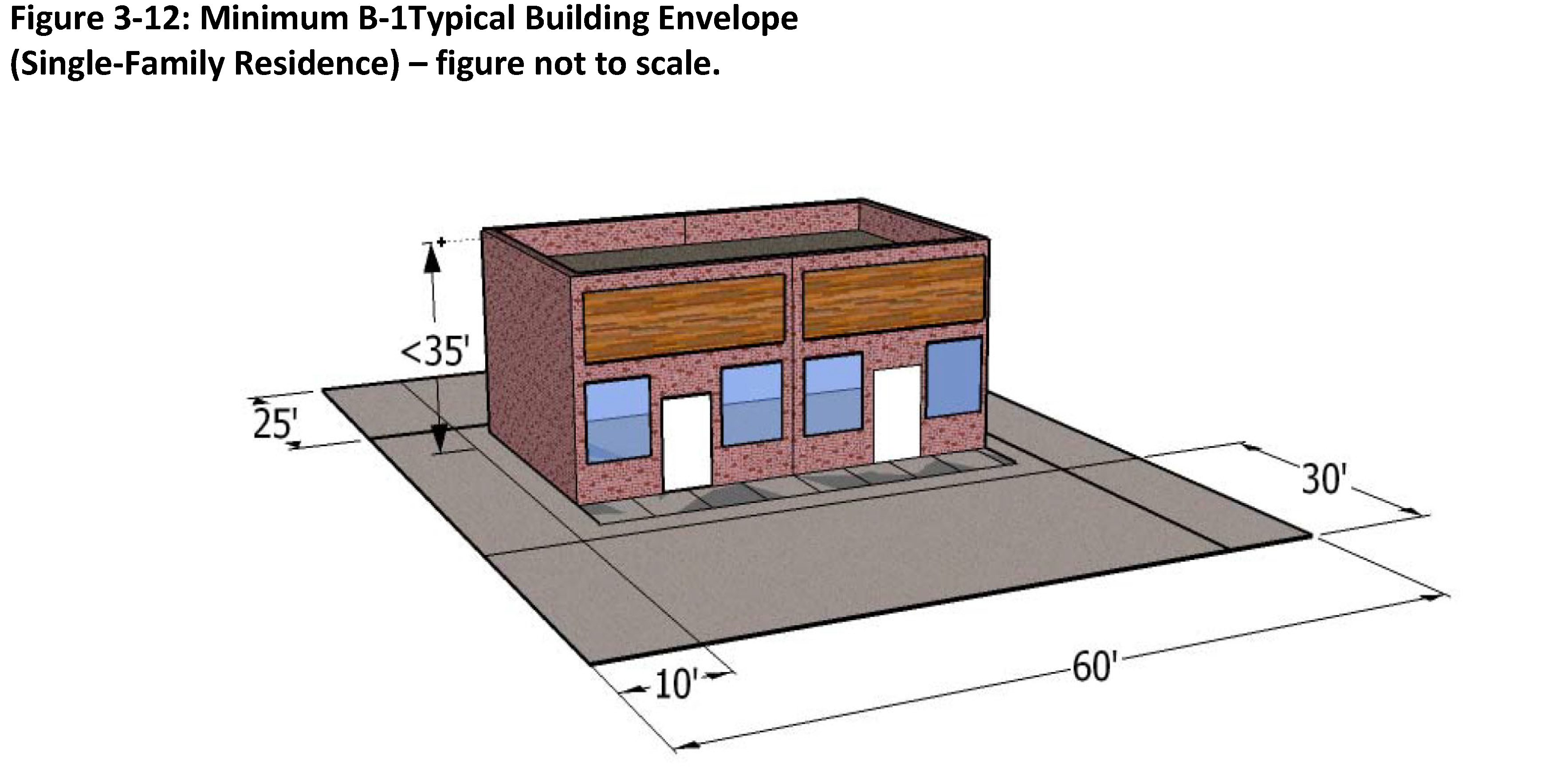
O.
B-1 - Neighborhood Service District
| Purpose: The purpose of this district is to accommodate commercial activities that provide
services to the residents of a particular neighborhood, such as limited personal services
and everyday retail needs.
Authorized Uses: Uses permitted in this zoning district shall be limited to those indicated in Table 3-1, which includes the sale of goods and services at a neighborhood scale. | DIMENSIONAL AND RATIO STANDARDS: | |
| Minimum Lot Size: | 6,000 sq. ft. (see note 2) | |
| Minimum Lot Width (at front setback line): | 60 ft. | |
| Front Setback: | 30 ft. | |
| Corner Lot Setback (lot with frontage on 2 streets): | See note 3 | |
| Side Setback: | 10 ft. | |
| Rear Setback: | 25 ft. | |
| Maximum Height Limit: | 35 ft. | |
 | ||
| Development Notes: | ||
| 1. Development shall comply with additional development standards as contained in Article 6. | ||
| 2. Parcels zoned B-1 used for residential purposes shall meet the minimum five thousand (5,000) square feet minimum lot size. | ||
| 3. When a lot abuts more than one (1) street the front yard setback shall apply to the rear or side abutting a street. Where there is no lot fronting on the side or rear street immediately to the rear or side of the lot, the width of the side yard shall be equal to one-half (½) the front yard requirement. | ||
| 4. Residential density shall be in accordance with the provisions of Section 6.02 (B) of this Ordinance. | ||
| 5. On-site wastewater disposal shall be provided by public utilities (i.e. water and sewer). | ||
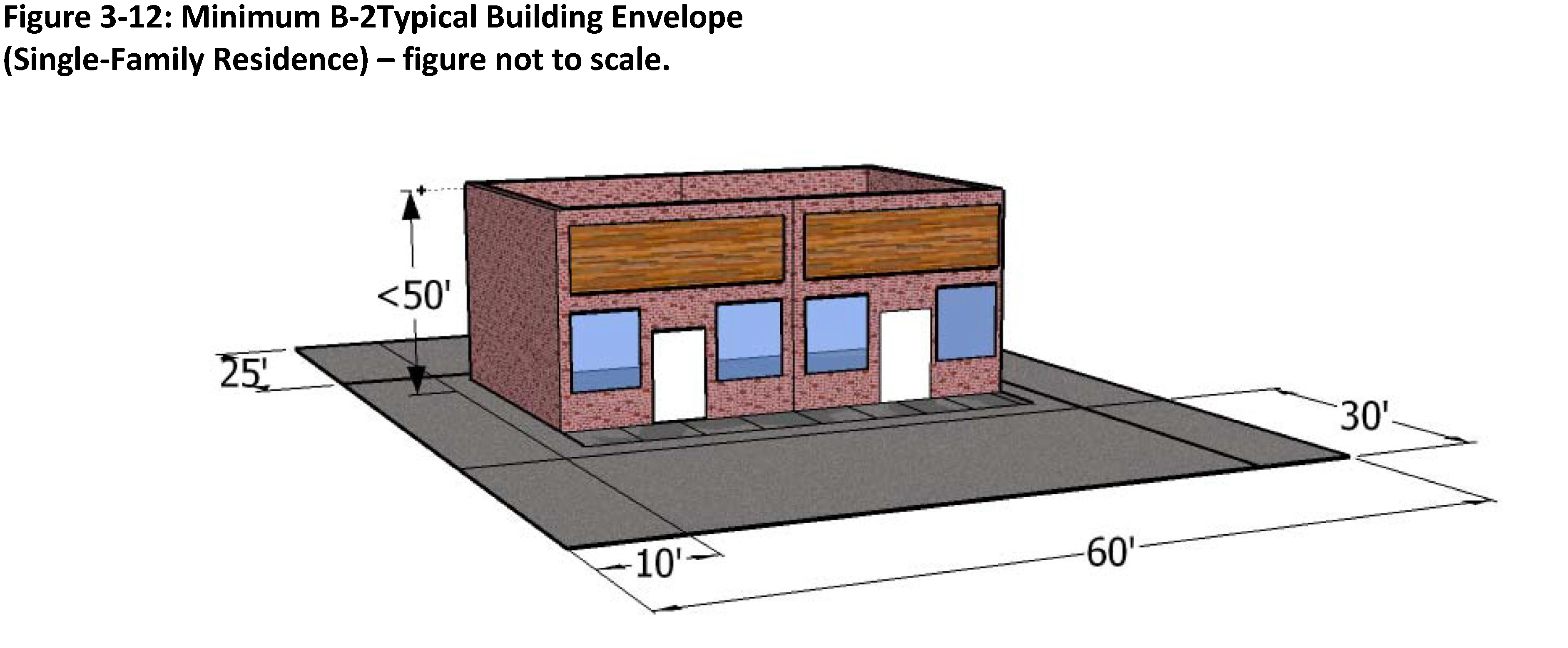
P.
B-2 - Neighborhood business district
| Purpose: The purpose of this district is to accommodate commercial activities along collector
streets and thoroughfares, including the provision of goods and services to the local
community.
Authorized Uses: Uses permitted in this zoning district shall be limited to those indicated in Table 3-1, which includes professional and institutional offices and convenience and retail stores. | DIMENSIONAL AND RATIO STANDARDS: | |
| Minimum Lot Size: | 6,000 sq. ft. | |
| Minimum Lot Width (at front setback line): | 60 ft. | |
| Front Setback: | 30 ft. | |
| Corner Lot Setback (lot with frontage on 2 streets): | See note 2 | |
| Side Setback: | 10 ft. | |
| Rear Setback: | 25 ft. | |
| Maximum Height Limit: | 50 ft. | |
 | ||
| Development Notes: | ||
| 1. Development shall comply with additional development standards as contained in Article 6. | ||
| 2. When a lot abuts more than one (1) street the front yard setback shall apply to the rear or side abutting a street. Where there is no lot fronting on the side or rear street immediately to the rear or side of the lot, the width of the side yard shall be equal to one-half (½) the front yard requirement. | ||
Q.
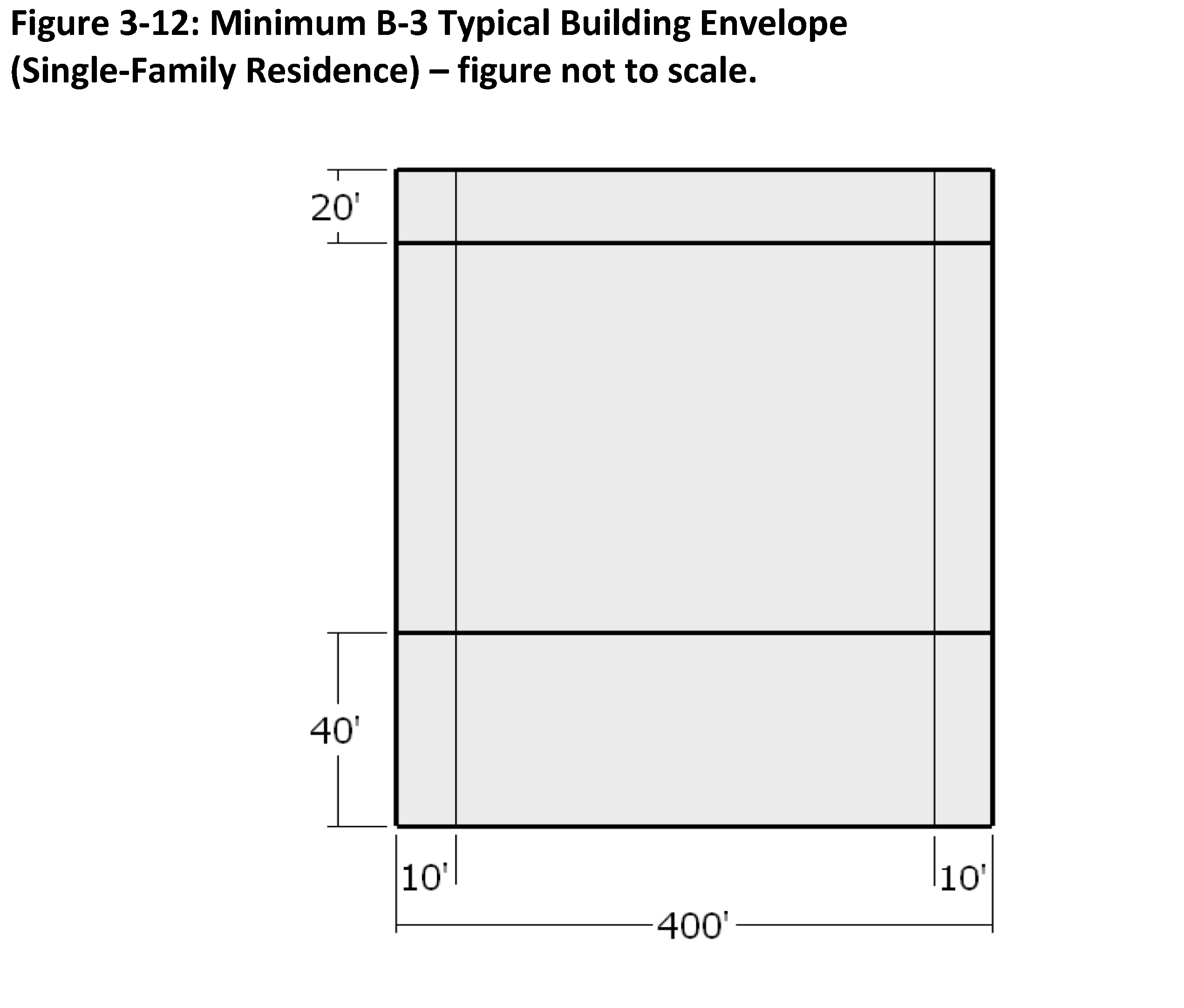
B-3 - Shopping Center District
| Purpose: The purpose of this district is to allow larger shopping centers having a community-wide
focus. This district provides appropriate locations for a wide variety of intensive
commercial activities involving outdoor operations, display and/or storage.
Authorized Uses: Uses permitted in this zoning district shall be limited to those indicated in Table 3-1, which include commercial uses such as shopping centers, hotels, restaurants and other retail sales and services. | DIMENSIONAL AND RATIO STANDARDS: | |
| Minimum Lot Size: | 220,000 sq. ft. (see note 3) | |
| Minimum Lot Width (at front setback line): | 400 ft. (includes outparcel lot(s)) | |
| Front Setback: | 40 ft. | |
| Corner Lot Setback (lot with frontage on 2 streets): | See note 2 | |
| Side Setback: | 10 ft. | |
| Rear Setback: | 20 ft. | |
| Maximum Height Limit: | 65 ft. | |
 | ||
| Development Notes: | ||
| 1. Development shall comply with additional development standards as contained in Article 6. | ||
| 2. When a lot abuts more than one (1) street the front yard setback shall apply to the rear or side abutting a street. Where there is no lot fronting on the side or rear street immediately to the rear or side of the lot, the width of the side yard shall be equal to one-half (½) the front yard requirement. | ||
| 3. Outparcel or single store sites as part of a shopping center development shall have a minimum lot size of ten thousand (10,000) square feet and may be subdivided with a property owner(s) agreement for all and/or shared common areas. | ||
R.
B-4 - Highway Business District
| Purpose: The purpose of this district is to accommodate general and automobile oriented commercial
businesses.
Authorized Uses: Uses permitted in this zoning district shall be limited to those indicated in Table 3-1, which include intensive retail sales and services that depend upon high traffic volumes. | DIMENSIONAL AND RATIO STANDARDS: | |
| Minimum Lot Size: | 10,000 sq. ft. | |
| Minimum Lot Width (at front setback line): | 75 ft. | |
| Front Setback: | 40 ft. | |
| Corner Lot Setback (lot with frontage on 2 streets): | See note 2 | |
| Side Setback: | 10 ft. | |
| Rear Setback: | 20 ft. | |
| Maximum Height Limit: | 65 ft. | |
 | ||
| Development Notes: | ||
| 1. Development shall comply with additional development standards as contained in Article 6. | ||
| 2. When a lot abuts more than one (1) street the front yard setback shall apply to the rear or side abutting a street. Where there is no lot fronting on the side or rear street immediately to the rear or side of the lot, the width of the side yard shall be equal to one-half (½) the front yard requirement. | ||
| 3. Outparcel or single store sites as part of a shopping center development shall have a minimum lot size of ten thousand (10,000) square feet and may be subdivided with a property owner(s) agreement for all and/or shared common areas. | ||
S.
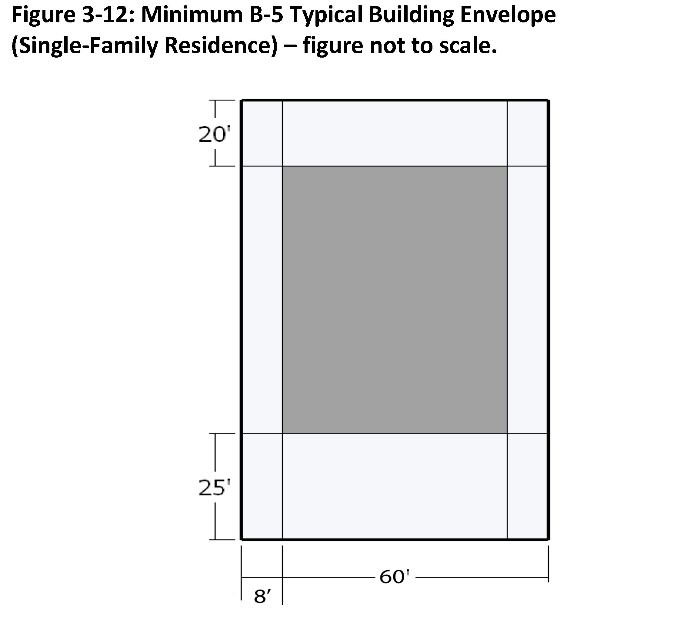
B-5 - General Business District
| Purpose: The purpose of this district is to accommodate retail, services, warehousing and
low intensity manufacturing businesses.
Authorized Uses: Uses permitted in this zoning district shall be limited to those indicated in Table 3-1, which include lumberyards, storage units, auto body shops and other commercial activities that generate loud noises, heavy truck traffic or other potential nuisances to neighboring residential uses. | DIMENSIONAL AND RATIO STANDARDS: | |
| Minimum Lot Size: | No minimum required | |
| Minimum Lot Width (at front setback line): | 60 ft. | |
| Front Setback: | 25 ft. | |
| Corner Lot Setback (lot with frontage on 2 streets): | See note 2 | |
| Side Setback: | 8 ft. | |
| Rear Setback: | 10 ft. | |
| Maximum Height Limit: | 65 ft. | |
 | ||
| Development Notes: | ||
| 1. Development shall comply with additional development standards as contained in Article 6. | ||
| 2. When a lot abuts more than one (1) street the front yard setback shall apply to the rear or side abutting a street. Where there is no lot fronting on the side or rear street immediately to the rear or side of the lot, the width of the side yard shall be equal to one-half (½) the front yard requirement. | ||
| 3. Outparcel or single store sites as part of a shopping center development shall have a minimum lot size of ten thousand (10,000) square feet and may be subdivided with a property owner(s) agreement for all and/or shared common areas. | ||
T.
CB - Central Business District
1.
Purpose: The purpose of this district is to provide a central retail district for uses which normally require a central location and provide merchandise and services to the entire City and its environs. It is intended that this district shall develop and be maintained as a tight-knit core of commercial activity.
2.
Authorized Uses: Uses permitted in this zoning district shall be limited to those indicated in Table 3-1, which include a wide range of residential, office, institutional and commercial uses that conduct operations and storage within enclosed areas.
3.
Development Standards: Development shall conform to the dimensional standards established in Article 6 of this code and summarized in Table 3-21.
Table 3-21: CB Lot Development Standards
*Front setback may be increased to preserve or create public open space, for architectural features or art and to protect existing trees or infrastructure on a case by case basis in accordance with adopted plans.
U.
CBP - Central Business Perimeter District
1.
Purpose: The purpose of this district is to establish a perimeter of uses around the central retail district of the City composed of uses which normally require a central location and provide merchandise and services to the entire City and its environs. This district is intended to develop and be maintained as a less intense commercial area on the perimeter of the CB Central Business District.
2.
Authorized Uses: Uses permitted in this zoning district shall be limited to those indicated in Table 3-1, which include a wide range of residential, office, institutional and commercial uses that conduct operations and storage within enclosed areas.
3.
Development Standards: Development shall conform to the dimensional standards established in Article 6 of this code and summarized in Table 3-22.
Table 3-22: CBP Lot Development Standards
*Front setback may be increased to preserve or create public open space, for architectural features or art and to protect existing trees or infrastructure on a case by case basis in accordance with adopted plans.
V.
H-115 - Highway 115/Shelton Avenue Corridor District
1.
Purpose: The purpose of this district is to establish this corridor as a major entryway into the downtown area. This district provides for mixed use, attached residential, civic and institutional uses, including a new municipal services node. This district is urban in character, with building setbacks and facades that are scaled to the pedestrian.
2.
Authorized Uses: Uses permitted in this zoning district shall be limited to those indicated in Table 3-1, which include a wide range of retail sales and services, excluding automotive uses and outdoor storage.
3.
Development Standards:
a.
Development shall conform to the dimensional standards established in Article 6 of this Code and summarized in Table 3-23.
Table 3-23: H-115 Lot Development Standards
*Front setback may be increased to preserve or create public open space, for architectural features or art and to protect existing trees or infrastructure on a case by case basis in accordance with adopted plans.
b.
Square footage expansions to existing occupied businesses in the H-115 District may be permitted provided the expansion does not make the site any more non-conforming to the development standards. Parking may be expanded for existing occupied businesses in the H-115 District in the front yard. The cumulative total of square footage expansion and parking expansion cannot exceed a total of thirty-five percent (35%) of the existing square footage of the primary structure. Outdoor storage of inventory and products cannot be expanded.
W.
LI - Light Industrial District
1.
Purpose: The purpose of this district is to accommodate light industrial uses that are compatible with general business uses. This use should not be inherently obnoxious to the urban area because of noise, odors, dust, smoke, light or uses of dangerous materials.
2.
Authorized Uses: Uses permitted in this zoning district shall be limited to those indicated in Table 3-1 which include uses involving indoor production, assembly and storage.
3.
Development Standards: Development shall conform to the dimensional standards established in Article 6 of this code and summarized in Table 3-24.
4.
Design Standards: Commercial development shall comply with the standards established in Section 6.08.
Table 3-24: LI Lot Development Standards
*Required setbacks unless required buffers in Section 6.04 are greater.
X.
HI - Heavy Industrial District
1.
Purpose: The purpose of this district is to allow industrial uses that are incompatible with general business uses, and to provide appropriate locations for light and heavy industrial uses that may involve outdoor storage, display or operations.
2.
Authorized Uses: Uses permitted in this zoning district shall be limited to those indicated in Table 3-1, which include all light and heavy industrial uses plus those involving outdoor storage, display and operations.
3.
Development Standards: Development shall conform to the dimensional standards established in Article 6 of this code and summarized in Table 3-25.
Table 3-25: HI Lot Development Standards
*Required setbacks unless required buffers in Section 6.04 are greater.
Y.
HD - Historic District Overlay
1.
Purpose: To preserve the historical resources of the community, there shall be an overlay zoning district applied to areas containing historic resources.
2.
Applicability: Historic District Overlay (HD) districts shall be delineated and identified on the zoning map. HD regulations apply to all tracts of land and structures located within designated historic districts, and all individual tracts of land or structures that have been designated as local or national historic landmarks. The requirements of the shall be applied in addition to underlying zoning district requirements. When the HD regulations conflict with underlying requirements, the standards of the HD shall prevail.
3.
Certificate of Appropriateness Required: Certificates of Appropriateness shall be required as per Section 2.14.
4.
Demolition or Removal: No building or structure located within an HD district shall be demolished or removed without a permit issued by City Council. If the Historic Preservation Commission has formally voted to recommend designation of a property as a landmark or designation of an area as a district, and final designation has not been made by the City Council, the demolition of any building, structure or site located on the proposed landmark or in the proposed district may be delayed by the Historic Preservation Commission for a period of up to one hundred eighty (180) days or until the City Council takes final action on the designation, whichever occurs first.
An application for a certificate of appropriateness and a permit to demolish or remove a building, structure or site shall be filed or processed as all other applications received. The Historic Preservation Commission shall hear the request and within forty-five (45) days of the hearing recommend to the City Council for or against the application. The City Council shall consider the following in deciding whether to issue a permit.
a.
The recommendation of the Historic Preservation Commission;
b.
The location of the structure within the historic district;
c.
The state of repair of the structure;
d.
The architectural and historical significance of the structure;
e.
The owner's plans with regards to replacing the structure;
f.
The overall impact of the demolition of the structure on the historic district; and
g.
The economic impact of the denial of the permit upon the owner of the structure.
The City Council may, as a condition of issuing a permit for demolition, require the owner to replace the structure to be demolished with another structure that meets plans submitted by the owner and approved by the City Council. The City Council may establish a reasonable period of time for the owner to replace the demolished structure.
5.
Nothing contained in this Code shall profit, impair or limit in any way the power of the City (at its own initiative or request of the Historic Preservation Commission) to prevent the construction, reconstruction alteration, restoration or removal of buildings, structures, appurtenant fixtures or outdoor signs upon historic properties in violation of the provisions of this Code, and the enforcement of any other remedy or remedies provided herein or in other ordinances or laws.
6.
The exterior features of any structure or outdoor advertising sign designated as an Historic Landmark or located within a designated historic district shall be preserved by the Owner or such other person who may have legal possession, custody and control thereof, against defects including decay, deterioration, dilapidation, and structural defects. Such person shall, upon written request by the City, repair such exterior features if they are found to be deteriorating or if their condition is contributing to deterioration, including, but not limited to, any of the following defects which have the effect of significantly impairing the integrity of such building or structure or the special character of such historic district:
a.
Deterioration of exterior walls, foundations or other vertical support that causes leaning, sagging, splitting, listing or buckling.
b.
Deterioration of flooring or floor supports, roofs or other horizontal members that causes leaning, sagging, splitting, listing or buckling.
c.
Deterioration of external chimneys that causes leaning, sagging, splitting, listing or buckling.
d.
Deterioration or crumbling of exterior plasters or mortars.
e.
Ineffective waterproofing of exterior walls, roofs and foundations, including broken windows or doors.
f.
Defective protection or lack of weather protection for exterior walls and roof coverings, including lack of paint, or weathering due to lack of paint or other protective covering.
g.
Rotting, holes and other forms of decay.
h.
Deterioration of exterior stairs, porches, handrails, window and door frames, cornices, entablatures, wall facings and architectural details that causes delamination, instability, loss of shape and form or crumbling.
i.
Heaving, subsidence or cracking of foundations, sidewalks, steps or pathways.
j.
Deterioration of fences, gates and accessory structures.
k.
Deterioration of any exterior feature so as to create or permit the creation of any hazardous or unsafe conditions to life, health or other property.
7.
Petition and Action: The Historic Preservation Commission may file a petition alleging specific defects with the Planning Director, requesting that the Planning Director require the correction of deterioration or making of repairs under the following procedures.
a.
Upon receipt of a petition alleging defects in a structure, the Planning Director shall investigate the allegation, and upon confirmation, shall within seven (7) days thereof, notify the Owner or person with legal possession, custody and control thereof. The writing shall state the charges and contain notice that: a hearing will be held before the Planning Director not less than thirty (30) nor more than sixty (60) days after the serving of such notice, the owner and/or parties in interest shall be given a right to answer through testimony at the place and time fixed in the complaint, the Historic Preservation Commission will also be given notice of the hearing and the rules of evidence prevailing in courts of law or equity shall not be controlling in hearings before the Planning Director. The hearing shall be held to receive evidence concerning the charge of deterioration and to ascertain whether the owner and/or parties in interest wish(es) to petition the Commission for a claim of undue economic hardship.
b.
If after such notice and hearing, the Planning Director determines that the structure is undergoing demolition by neglect because it is deteriorating, or if its condition is contributing to deterioration the Planning Director shall state in writing the findings of fact in support of such determination and shall issue and cause to be served upon the owner and/or parties in interest an order to repair within the time specified those elements of the structure that are deteriorating, contributing to deterioration or deteriorated. In the event that the owner and/or parties in interest wish to petition for a claim of undue economic hardship, the Planning Director's order shall be stayed until after the Commission's determination.
8.
Methods of Service: Complaints or orders issued by the Planning Director shall be served either personally or by registered or certified mail. If the whereabouts of such persons are unknown and the same cannot be ascertained by the Planning Director in the exercise of reasonable diligence, the Planning Director shall make an affidavit to that effect, stating the steps taken to determine and locate the person(s) in interest. After the creation of said affidavit, the serving of the complaint or order may be made by publishing the same once each week for two (2) successive weeks in a newspaper generally circulated within the City. When such service is by publication, a notice of the pending proceedings shall also be posted in a conspicuous place on the premises thereby affected.
9.
Economic Hardship: Upon receipt of a claim of economic hardship, the Planning Director shall notify the Historic Preservation Commission within ten (10) days following the hearing on the complaint. The HPC shall schedule a hearing on the claim at its next regular meeting, within the limitations of its procedures for application deadlines.
a.
Application: The petitioner shall present the information provided below to the Commission. The Commission may require that the owner and/or parties in interest furnish additional information that is relevant to the determination of undue economic hardship. The Commission may also direct its staff to furnish additional information the Commission believes is relevant. The Commission shall also state which form of financial proof it deems relevant and necessary to a particular case. Information required to be provided includes, but is not limited to:
(1)
Nature of ownership (individual, business or nonprofit) or legal possession, custody and control.
(2)
Financial resources of the owner and/or parties in interest.
(3)
Cost of repairs.
(4)
Assessed value of the land and improvements.
(5)
Real estate taxes for the previous two (2) years.
(6)
Amounts paid for the property, date of purchase and party from whom purchased, including a description of the relationship between the owner and the person from whom the property was purchased, or other means of acquisition of title, such as by gift or inheritance.
(7)
Annual debt service, if any, for previous two (2) years.
(8)
Any listing of the property for sale or rent, price asked and offers received, if any.
(9)
Annual gross income from the property for the previous two (2) years, if any.
(10)
Itemized operating and maintenance expenses for the previous two (2) years, including proof that adequate and competent management practices were followed, if the subject property is income producing.
(11)
Annual cash flow, if any, for the previous two (2) years.
(12)
The past year's income tax returns, if the subject property is income producing.
b.
Decision: Within sixty (60) days of the hearing, the HPC shall accept or deny the claim of economic hardship and enter the reasons for such action into the record.
(1)
Upon the denial of a claim of economic hardship, the HPC shall notify the Planning Director, and the Planning Director shall order such property to be repaired within the time specified.
(2)
Upon the acceptance of a claim of economic hardship, the HPC shall accompany the finding with a recommended plan to relieve the economic hardship. This plan may include, but is not limited to, property tax relief as may be allowed under North Carolina law, loans or grants from the City or other public, private or nonprofit sources, acquisition by purchase or eminent domain, building code modifications, changes in applicable zoning regulations or relaxation of the provisions of this Article sufficient to mitigate the undue economic hardship. The Commission shall report such finding and plan to the Planning Director. The Planning Director shall cause to be issued an order for such property to be repaired within the time specified and according to the provisions of the recommended plan.
c.
Appeals: Findings of the Planning Director and HPC may be appealed to the Board of Adjustment. To perfect an appeal, application must be filed by an aggrieved party with the Board of Adjustment within thirty (30) days following receipt of the order for repair o the property or determination. Appeals shall be in the nature of certiorari.
d.
Limitations: Nothing contained within this Section shall limit the City's power to declare a building unsafe or in violation of the housing code.
e.
Penalties and Remedies: Enforcement of this Section shall be carried out by one (1) or more of the following methods. Any action taken by authority of this Section shall not relieve the owner any other civil or criminal proceeding allowed by law.
(1)
The City may apply for any appropriate equitable remedy to enforce the provisions of this Section.
(2)
The City may apply for an order of abatement directing the owner to make improvements, repairs or any other action necessary to bring the property into compliance with this Section. In the event the City acquires an order of abatement, the City shall file a mechanic's and materialman's lien on the property for the cost of executing such order.
(3)
No civil penalty shall be levied unless and until the Planning Director delivers a written notice by personal service, registered US mail, or certified, US mail with return receipt requested, upon the person responsible for each violation indicating the nature of the violation and ordering corrective action. The notice shall set forth the date by which corrective measures must be completed, and shall state the failure to timely correct the violation will result in the assessment of civil penalties and other enforcement action. If after the allotted time period has expired and after the hearing of an appeal, if any, by the Board of Adjustment, corrective action has not been completed, a civil penalty shall be assessed in accordance with City Code.
10.
Exceptions: The provisions of this section shall not prevent the remedy of unsafe or dangerous conditions, including the construction, demolition, or modification of structures deemed necessary by the building inspector to protect the public health and safety.
11.
Limitations: Nothing contained in this Code shall limit the power of the City to prevent the placement, alteration, or removal of structures or outdoor signs located upon historic properties in violation of this Code. The enforcement of any remedy allowed herein shall not prevent the enforcement of any other remedy or remedies provided herein or in other ordinances or laws.
Z.
Planned Unit Developments
1.
Purpose - The Planned Unit Development District, hereinafter referred as the "PUD District", is established to accommodate large-scale, master-planned, mixed-use developments that could not be accomplished through conventional zoning districts. Development within each PUD District shall occur in accordance with unique conditions and standards established during the rezoning process. Such conditions and standards shall be applicable only to the specific parcel(s) of land that comprises the PUD District, and shall run with the land regardless of ownership. The PUD District is not intended for use with subdivisions or developments which accommodate a single or few land use(s) for which other zoning districts are intended.
2.
General Provisions - The following general provisions apply to the PUD District:
a.
Permissible Uses. Permissible uses in the PUD District shall be any use or range of uses specified in the zoning application. Permissible uses, by way of example, may include residential, commercial, or office uses. The type and location of any and all uses within the PUD District must be demonstrated to be appropriate for the project area and surrounding area. All proposed uses listed in the approved zoning application are considered to be conditional uses; all are permitted subject to the conditions established through the rezoning process in connection with the specific application.
b.
Minimum Size and Contiguity. The minimum area of a PUD District shall contain at least twenty (20) contiguous acres. Such contiguous acreage of land shall be under single or unified ownership or control. Parcels of land separated only by any right-of-way (road, utility, railroad) or public easement shall be considered contiguous.
c.
Ownership and Division of Land. No tract of land may be considered for a PUD District unless such tract is under single or unified ownership or control. If listed in several ownerships, the application for zoning shall be accompanied by each landowner's written consent. The holder of a written option to purchase or a developer under contract shall be considered an owner for purposes of this section provided the landowner's (or landowners') written consent is included with the application.
d.
Relationship to Other Regulations. All PUDs shall be subject to adopted local regulations in effect at the time of rezoning approval and shall also comply with State and Federal regulations.
3.
General Development Standards
a.
Private Covenants and Restrictions Required. Covenants and Restrictions for the property within a PUD District are required and must be recorded in the public records of Iredell County, prior to the approval of a plat or issuance of a building permit for a vertical building on the property. These restrictions will run with the land, so that if it is subdivided or developed in phases, then the Covenants and Restrictions will still be enforced.
b.
Open Space. The following Open Space requirements apply within a PUD District:
(1)
Not less than twenty percent (20%) of the gross land area of the PUD shall be devoted to Open Space.
(2)
Open Space within a PUD District may be comprised of a combination of the following: natural areas, wetland preserves, trails, boardwalks, parks, ball fields, equestrian fields or tracks, plazas, golf courses (excluding clubhouse and maintenance facilities), buffers (outside of a platted lot), any water bodies including ponds and lakes, and/or innovative and accessible water quality devices (i.e. storm water management ponds and systems). Unless dedicated to City or a similar legal entity, the POA is required to provide for the continuing maintenance of Open Space.
c.
Landscaping, Screening, Buffers and Trees. Due to the unique layout and integrated uses of this type of project, the current ordinance may not be applicable to its fullest extent. Therefore a landscape plan shall be submitted that follows the general provisions of the Section 30.6 Landscape Standards and will be approved by staff during the incremental master development process.
d.
Common Sign Plan. Signs within the development shall adhere to the standards set forth or as part of the zoning application or an amendment thereto. The applicant may submit a unified sign plan that establishes the design standards and sign locations for the project. Such unified sign plan may be submitted after the approval of the zoning application and may be approved by the administrator as an alternate to individual sign permits.
e.
Storm Water Control. Storm water management shall meet or exceed the requirements for storm water management in Section 8.05. A common master storm water management plan may be developed for the project as a whole and may employ best management practices. This does not prohibit the development of the PUD District in phases nor the phased implementation of the storm water management system.
f.
Street Design.
(1)
Street design shall adhere to the City's standards, however dimensional standards and design may be altered as part of the PUD process. The applicant may submit alternative street design standards that vary in response to proposed function of the street, the anticipated adjacent land uses, character of the neighborhood, the anticipated traffic volume (subject to City and/or NCDOT approval), the hierarchy within the street network, and the need for traffic calming measures.
(2)
Streets within the PUD may be private or may be dedicated to the City of Statesville with the City's consent. Such roads may be maintained by the City of Statesville or NCDOT according to jurisdiction. Private streets will remain the responsibility of the POA.
g.
Parking and Loading. The standards for parking and loading shall apply to all development within the PUD, with the following exceptions:
(1)
On-street parking shall be allowed provided that the road width will accommodate same. On-street parking may consist of parallel, perpendicular, angled or any combination of these types of parking spaces.
(2)
Parking standards and minimums shall be established for each non residential use as part of the PUD development standards.
(3)
On-street parking shall count as required parking for the uses that are adjacent to the on-street spaces.
(4)
Structured parking is allowed.
(5)
There is no off-street loading requirement for a building with less than ten thousand (10,000) square feet of gross building area. Otherwise, off-street loading shall comply with the requirements for off-street loading set forth.
4.
Phasing a PUD — A PUD may be developed in phases. Approval of the PUD shall authorize the applicant to commence the intended use for the property, to occupy any building, to sell any subdivision lots or obtain building permits before all of the infrastructure for the entire project is complete subject to the terms of a Development Agreement that complies with the provisions of Article 3 and the following conditions:
a.
Each incremental master development plan submittal shall clearly depict the submittal as a separate phase and the submittal shall provide a projected commencement date and substantial completion date for such phase.
b.
Once a phase is established and the incremental master development plan is approved, the commencement of the intended use, the occupancy of buildings or the sale of subdivision lots within such phase may not occur, except as provided in paragraph 4.c. of this section, until the required infrastructure improvements in that phase are substantially complete or guaranteed pursuant to the Development Agreement.
c.
In cases when, because of weather conditions or other factors beyond the control of the applicant (exclusive of financial hardship) it would be unreasonable to require the applicant to comply with the requirements of phasing in this section, the City Council may authorize the commencement of the intended use or the occupancy of buildings, the sale of subdivision lots or additional building permits so long as adequate security is provided per the requirements of this section.
5.
Additional Regulations for All Development Within a PUD.
a.
Residential Uses in Commercial and Office Buildings. A residential use may be located above a commercial or office use located on the first floor of the same building.
b.
Building Heights. The applicant may propose a height that exceeds the established limits of the current ordinance, provided the increased height does not negatively impact surrounding properties and is approved by the City of Statesville Planning Director.
c.
Appurtenances. A step, stoop, open porch, balcony, awnings or other appurtenance may extend up to four (4) feet into the front setback, provided such features do not impede pedestrian circulation.
d.
Utility Lines. All new utilities within the proposed development shall be underground unless just cause requires otherwise. Just cause shall be determined by the City Council.
e.
Accessory Uses.
(1)
Residential accessory uses. One (1) accessory dwelling unit is permitted as an accessory to a residential use. This structure may be used by a member of the family dwelling in the primary residence for a home occupation or personal office or as an accessory apartment, which may be occupied by domestic help, security, or occasional guests of the family dwelling in the primary residence.
(2)
Commercial accessory uses. Commercial uses may include as accessory uses any commercial use, activity, and structure on the same site or lot that:
(a)
is operated primarily for the convenience of employees, clients, or customers of the principal use;
(b)
is clearly subordinate to the principal use; and
(c)
is located and operated as an integral part of the principal use and does not comprise a separate business use or activity.
(d)
Commercial accessory uses cannot be located in required parking areas.
(e)
All accessory uses must be shown on the incremental master development plans and must be screened or enclosed.
(Ord. No. 18-13, 8-5-2013; Ord. No. 01-14, 3-17-2014; Ord. No. 27-15, 12-7-2015; Ord. No. 29-15, 12-7-2015; Ord. No. 02-16, 2-1-2016; Ord. No. 04-16, 3-21-2016; Ord. No. 10-16, 6-6-2016; Ord. No. 43-17, 11-20-2017; Ord. No. 04-18, 2-5-2018; Ord. No. 34-19, 10-21-2019; Ord. No. 25-20, 11-2-2020; Ord. No. 23-22, 6-6-2022; Ord. No. 02-23, exh. A, 1-9-2023; Ord. No. 10-23, § 1, 4-3-2023; Ord. No. 18-23, § 1, 5-1-2023; Ord. No. 22-23, § 1, 6-5-2023; Ord. No. 31-23, § 1, 8-7-2023; Ord. No. 45-23, 11-6-2023; Ord. No. 47-23, 11-6-2023; Ord. No. 13-25, 1-13-2025)