
Statesville City Zoning Code
ARTICLE 6
- DEVELOPMENT STANDARDS
Section 6.01 - Overview
This article establishes the general design standards for lots, blocks and site development, including standards for density, lots and blocks, alternative development patterns, parking, landscaping and open space.
Section 6.02 - Density and Dimensional Standards
A.
Minimum Lot Size
1.
Subject to the planned unit development provisions of Sections 2.09 and 3.04 Z and the alternative development patterns of Article 7, all lots in the following zones shall have at least the amount of square footage indicated in Article 3.
2.
Reserved.
3.
Duplex residences located in an R-5, R-5M, R-8, and R-8M zone shall be permitted on corner lots provided each dwelling entrance fronts a separate street having at least one hundred fifty percent (150%) of the minimum square footage required for one (1) dwelling unit. Furthermore, additional lot width shall be applicable in accordance with this section.
4.
Lots with individual sewage disposal systems shall be sized as necessary according to the results of percolation tests and subsoil investigations. Additional lot area is required in all R-15, R-10, R-8, and R-5 zoning districts when:
a.
The lot is served by either public water or sewer, but not both, in which case the lot shall exceed fifteen thousand (15,000) square feet.
b.
The lot is served by neither public water nor sewer, in which case the lot shall exceed twenty thousand (20,000) square feet.
5.
The size, shape and orientation of non-residential lots shall be appropriate for the type of development and use contemplated.
6.
No residential building or structure shall be erected in any district on a lot which does not abut a public street for a distance of at least thirty-seven and one-half (37½) feet. The property shall be fee simple ownership. Easements and lifetime rights shall not be acceptable. Provisions shall be made for non-residential lot for public utility services and maintenance upon request of Public Works or Director of Electric Utilities.
7.
No part of any yard or other open space required about any building for the purpose of complying with the provisions of this code shall be included as part of a yard or other open space similarly requires for another building.
8.
There shall not be more than one (1) principal residential building and its accessory building per lot except as otherwise permitted in this code.
B.
Residential Density
1.
Density (except in PUDs) shall be calculated by dividing the number of residential dwellings by the gross acreage of the site minus the acreage used for commercial or industrial uses, as shown in Figure 6-1. For a mixed-use building, the non-residential area need not be deducted from total area.
Figure 6-1: Sample Density Calculation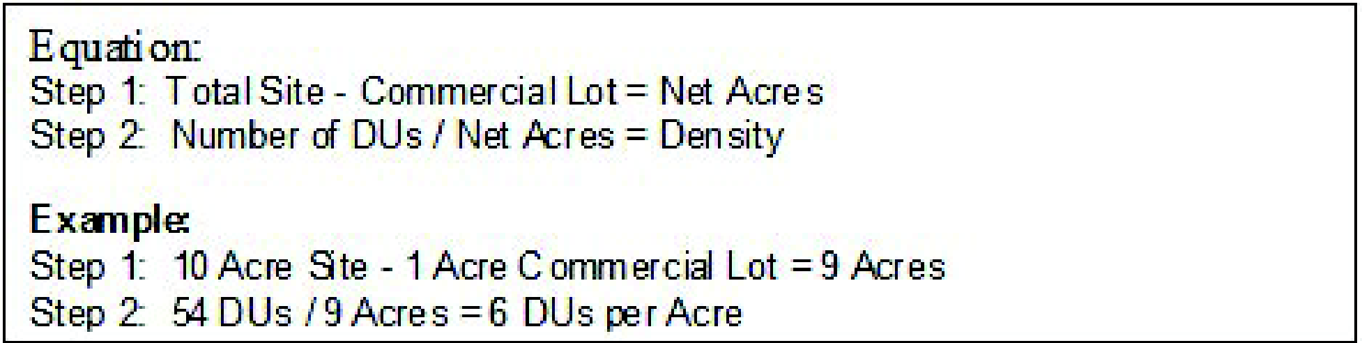
2.
Multi-Family and Townhomes
R-8MF maximum nine (9) units per acre for multi-family.
Townhome units may be increased up to nine (9) units per acre with a Special Use Permit and must meet the following criteria:
a.
A Class "C" fifteen-foot buffer will be provided along adjacent residentially-zoned properties.
b.
Development will be designed to connect internal streets.
c.
Internal and external streets will provide curb, gutter, sidewalks and street trees whether public or private.
d.
Entrance to development will be landscaped.
e.
Amenities such as walking trails, playgrounds, pools, picnic shelters and community centers will be located centralized in the development.
f.
Mix of materials such as brick, stone, stucco, hardi plank and vinyl and architectural features such as gable roof, porches, balconies, variation of height and depth will be provided in elevations.
g.
Driveways or streets shall connect to adjoining properties to minimize number of driveways.
h.
Development must meet the required Findings of Fact per Section 2.10, Special Use Permits.
i.
If requested through conditional zoning, the requirements of this section shall be met and a Special Use Permit is not required.
R-5MF maximum sixteen (16) units per acre for multi-family.
Townhome units may be increased up to twenty (20) units per acre with a Special Use Permit and must meet the following criteria:
a.
A Class "C" fifteen-foot buffer will be provided along adjacent residentially-zoned properties.
b.
Development will be designed to connect internal streets.
c.
Internal and external streets will provide curb, gutter, sidewalks and street trees whether public or private.
d.
Entrance to development will be landscaped.
e.
Amenities such as walking trails, playgrounds, pools, picnic shelters and community centers will be located centralized in the development.
f.
Mix of materials such as brick, stone, stucco, hardi plank and vinyl and architectural features such as gable roof, porches, balconies, variation of height and depth will be provided in elevations.
g.
Driveways or streets shall connect to adjoining properties to minimize number of driveways.
h.
Development must meet the required Findings of Fact per Section 2.10, Special Use Permits.
i.
If requested through conditional zoning, the requirements of this section shall be met and a Special Use Permit is not required.
C.
Lot Width and Depth
1.
Lots shall be of sufficient dimensions to allow construction of buildings that can be used for purposes permissible in that zoning district while complying with minimum setback requirements summarized in this section.
2.
Except in planned unit development provisions of Sections 2.09 and 3.04 Z. and the alternative development patterns of Article 7, the minimum lot width as measured at the front building line shall comply with the minimum lot widths in Article 3.
3.
Minimum lot widths in MF districts for two-family and multi-family shall be increased ten (10) feet per additional unit for lots less than one hundred twenty-five (125) feet in width.
4.
Minimum lot widths for two-family (duplexes) located within the R-8 and R-8M districts shall be one hundred (100) feet. Minimum lot widths for two-family (duplexes) located within the R-5 and R-5M districts shall be seventy-five (75) feet.
5.
Lot width shall not be less than required by the relevant district. The minimum width at the street line shall not be less than thirty-seven and one-half (37½) feet. Corner lots shall have an additional width of ten (10) feet to permit adequate setback from the abutting street. Greater lot width is required in all R-15, R-10, R-8, and R-5 zoning districts when:
a.
Either public water or sewer is provided, but not both. In such case, the minimum average width shall be eighty-five (85) feet.
b.
Neither public water nor sewer is provided. In such case, the minimum average width shall be not less than one hundred (100) feet.
6.
Greater lot depth is required in all R-15, R-10, R-8, and R-5 zoning districts when:
a.
Public water but not public sewer is provided. In such case, the minimum average depth shall be one hundred twenty (120) feet.
b.
Neither public water nor public sewer is provided. In such case, the minimum average depth shall be one hundred fifty (150) feet.
7.
Side lot lines shall be substantially at right angles or radial to street right-of-way lines.
D.
Building Setback Requirements
1.
Except in planned unit developments in Sections 2.09 and 3.04 W., and alternative development patterns in Article 7, as well as other provisions of this Section, no portion of any building may be located on any lot closer to any lot line than is authorized in Article 3.
2.
If the street right-of-way is readily determinable (by reference to a recorded map, set irons, or other means), the abutting yard's setback shall be measured from such right-of-way line. If the right-of-way line is not determinable, the abutting yard's setback shall be measured from the street centerline. Setbacks shall be one-half (½) the street right-of-way width for the applicable street classification as defined in Section 8.06, plus the required setback shown in Article 3. In the event that the Mobility and Development Plan provides for a future right-of-way, such setback line shall be measured from a line located a minimum distance of one-half (½) the proposed right-of-way width from the centerline of the street.
3.
Overhead canopies or roofs over gas pumps located within a business or industrial district shall have a minimum setback of twelve (12) feet from any street right-of-way.
4.
Gas pumps shall have a minimum setback of twenty (20) feet from the street right-of-way.
5.
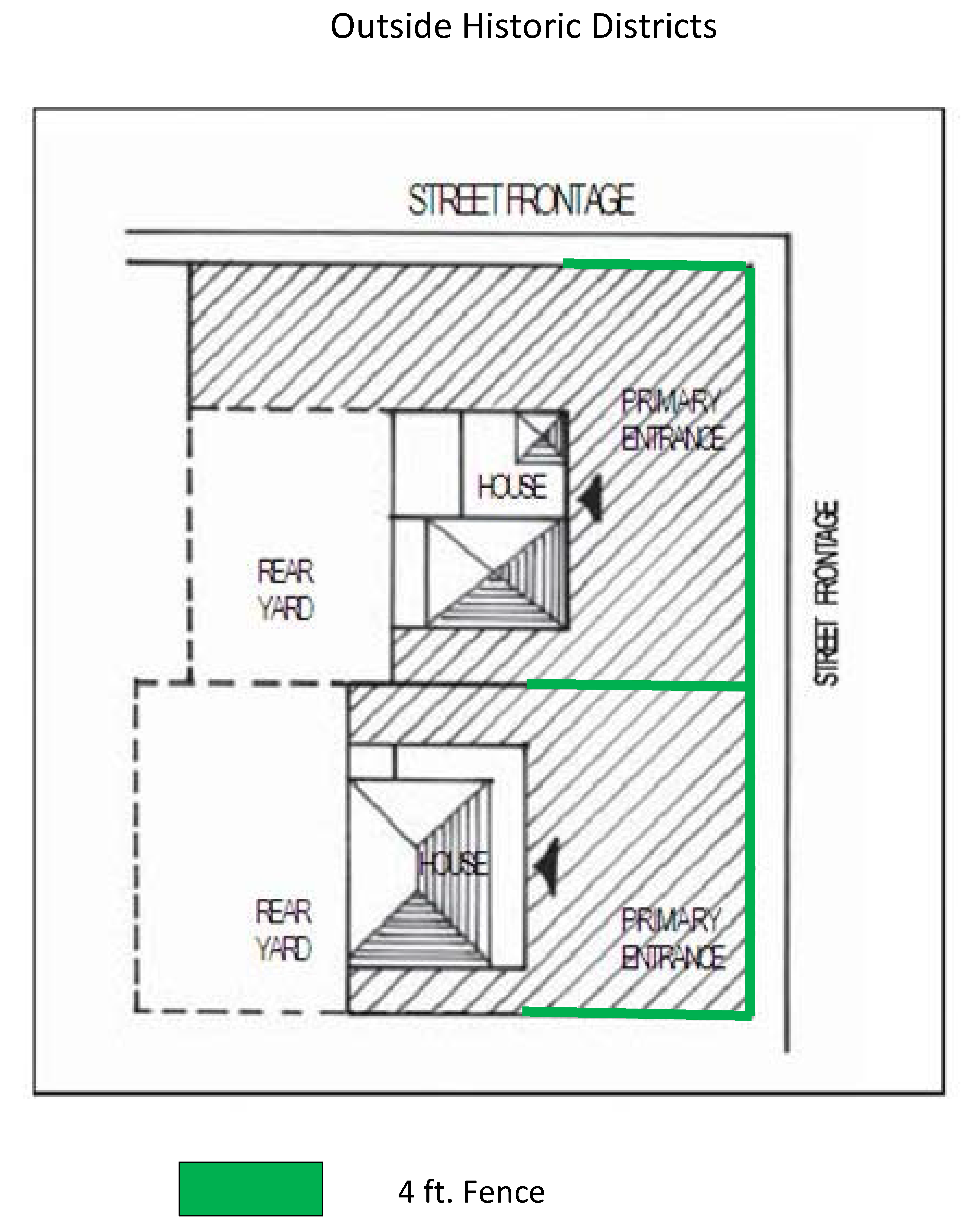
Residential fences running along street rights-of-way and beyond the front plane of the structure shall not exceed four (4) feet in height; except a six (6) feet fence is permitted in the abutting side yard where a residence is adjacent to commercial or industrial uses. All fences must be located outside the right-of-way. Residential fences located in the rear yard and behind the front plane of the structure may be taller than six (6) feet provided the fence meets setbacks for accessory structures in Section 5.02. Walls/fences around the perimeter of major subdivisions are excluded from this section; except that these fences must not be located in the right-of-way.
6.
Whenever a lot in a nonresidential district has a common boundary line with a lot in a residential district, the property line setback for the nonresidential lot shall be the greater of the two (2) districts.
7.
Setback distances shall be measured from the property line or street right-of-way to the nearest portion of any building, excluding:
a.
The outermost four (4) feet of any uncovered porch, step, eave, gutter, canopy, or similar fixture; and
b.
A deck or patio floor if no portion of the same extends more than twelve (12) inches off the ground; and
c.
Handicapped ramps and lifts.
E.
Building Height Limitations
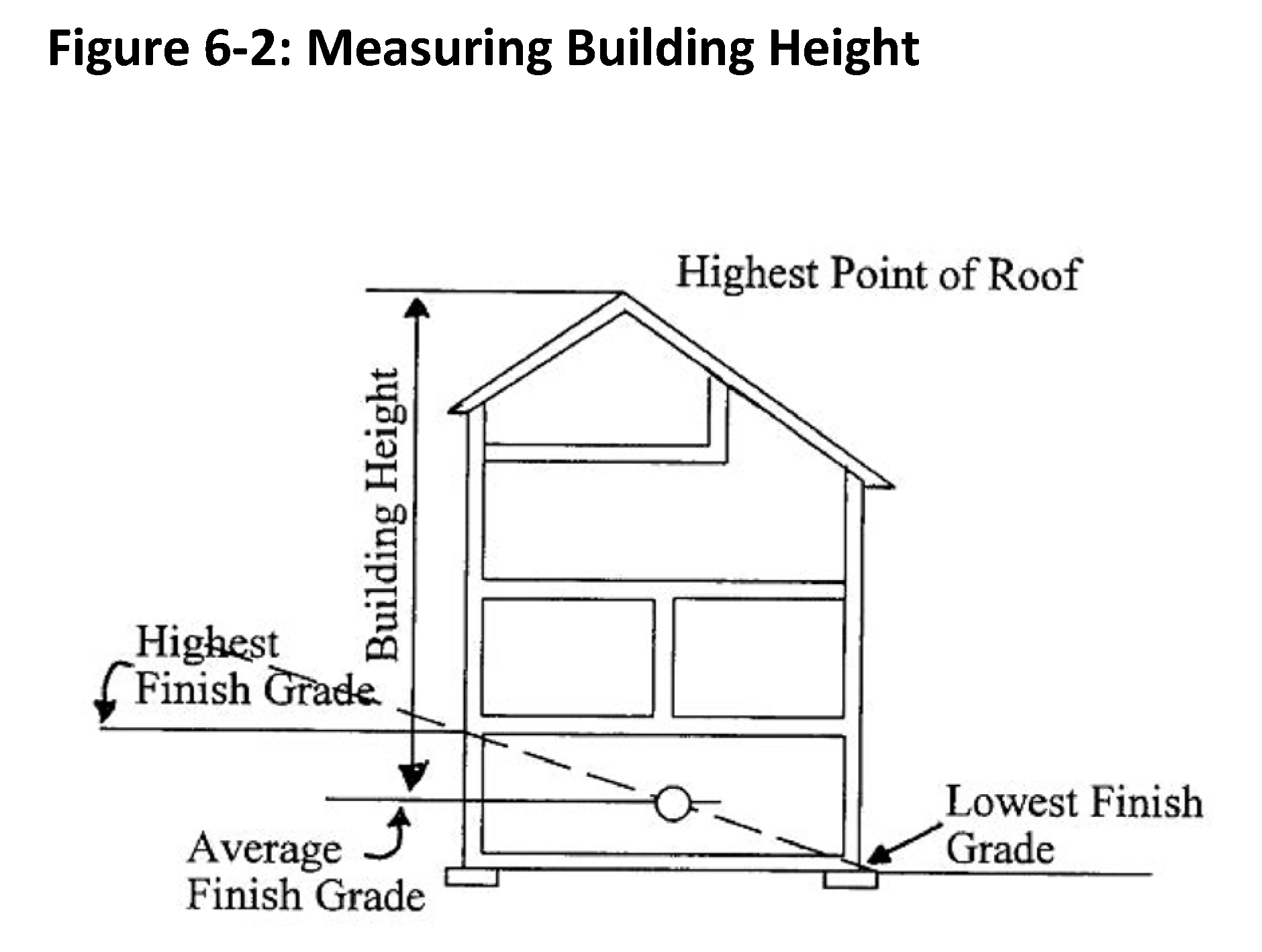
1.
For the purpose of this section, the height of a building shall be the vertical distance of a building measured from the average elevation of the finished grade around the perimeter of the foundation of the structure to the highest interior finished ceiling, excluding the exceptions established herein. The maximum height shall not exceed the height in Article 3.
2.
Principal uses other than single-family and two-family dwellings in residential, B-1 and O-1 Districts may exceed the thirty-five-foot height provided that the side yard is increased one (1) foot for every one (1) foot or fraction thereof of additional height. However, in no case shall a building in these districts exceed fifty (50) feet in height.
3.
In an O & 1-2 and B-2 district or in a B-3, B-4 and B-5 District, the height of a building may exceed fifty (50) or sixty-five (65) feet respectively provided that the side yard is increased by five (5) feet or a fraction thereof for every five (5) feet of additional height. However, in no case shall a building exceed sixty-five (65) feet in the O & 1-2 and B-2 Districts or eighty (80) feet in the B-3, B-4, and B-5.
4.
The following features are exempt from height limitations set forth in Article 3:
a.
Chimneys, church spires, elevator shafts, monuments, and similar structural appendages (belfries, cupolas, domes) not intended for human occupancy or storage.
b.
Flag poles and similar devices.
c.
Towers and antennas.
d.
Heating and air conditioning equipment, solar collectors, and similar equipment fixtures and devices.
5.
Notwithstanding the above table, in any zoning district the vertical distance from the ground to a point of access to a roof surface of any non-residential or multi-family residential structure containing four (4) or more units may not exceed thirty-five (35) feet in height unless the fire marshal had determined such building is designed to provide adequate access or is equipped to provide adequate protection against the dangers of fire.
F.
Blocks
1.
Block lengths shall not be longer than fifteen hundred (1,500) feet nor shorter than three hundred (300) feet, unless approved by the Planning Board to secure efficient use of land or to maintain desired features of street pattern. Where blocks are longer than five hundred (500) feet or at the ends of cul-de-sac streets, the Planning Board may require pedestrian crosswalks, which shall be at least ten (10) feet wide.
2.
Blocks shall have sufficient width to allow two (2) tiers of lots of minimum depth. Blocks may consist of single-tier lots where such are required to separate residential development from through vehicular traffic and nonresidential uses.
G.
Reserved
H.
Half-Streets
The dedication of half-streets at the perimeter of a new subdivision is prohibited. When a half street exists, the remaining half of the street shall be dedicated on the adjoining property.
I.
Alleys
1.
All alleys shall be constructed in accordance with City of Statesville Street Specification and Details.
J.
Intersections
1.
Streets shall intersect as nearly as possible at right angles. No street shall intersect at less than sixty (60) degrees. All intersections must be approved by the City Engineer.
2.
Arterial street intersections shall be at least eight hundred (800) feet apart measured from centerline to centerline.
3.
Property lines at street intersections shall be rounded with a minimum radius of twenty (20) feet. When the intersection angle is less than seventy-five (75) degrees, the City Engineer may require a greater radius.
4.
Jogs in streets shall be offset by at least one hundred fifty (150) feet.
K.
Easements
1.
Utility easements for residential subdivisions along front and rear lot lines shall be at least ten (10) feet wide and centered thereon; easements alongside lot lines shall be equal to the required side yard setback. Front, rear, and side yard utility easements for nonresidential, cluster and architecturally integrated cluster subdivisions shall be established by the City Council upon review and recommendation of the Technical Review Committee and Planning Board.
2.
Where a subdivision is traversed by a watercourse, drainage way, channel, or stream, a storm easement or drainage right-of-way conforming substantially to the boundaries of such watercourse, but no less than ten (10) feet in width, shall be provided in such width as required by the City Engineer.
3.
Lakes, ponds, creeks and similar natural areas within the City may be accepted for maintenance upon recommendation by the Planning Board and approved by the City Council.
L.
Permanent Reference Points
Prior to the approval of the final plat, permanent reference points shall have been placed in accordance with the following requirements:
1.
At least one (1) corner of the subdivision shall be designated by course and distance (tie) from a readily discernible reference marker. If a corner is within two thousand (2,000) feet of a U.S. Coast and Geodetic Station or N.C. Grid System coordinated monument or City coordinated system, the corner shall be marked with a monument designated by computed X and Y coordinates, which shall be identified on a map with a statement identifying this station or monument to an accuracy of one-ten thousandth (1/10,000) of a foot. When such a monument or station is not available, the tie shall be made to some pertinent and readily recognizable landmark or identifiable point, physical object or structure that is not likely to be destroyed.
2.
Within each block of a subdivision, at least two (2) monuments designed and designated as control corners shall be installed. The surveyor shall employ additional monuments if and when required. All monuments shall be constructed of concrete and shall be at least four (4) inches in diameter or square and not less than three (3) feet in length. Each monument shall have imbedded in its top or attached by a suitable means, a metal plate of noncorrosive material and marked plainly with the point, the surveyor's registration number, the month and the year it was installed and the words "Monument" or "Control Corner." Monuments shall be set at least thirty (30) inches in the ground with at least six (6) inches exposed above the ground unless this requirement is impractical. The location of monuments or control corners shall be determined by the City Engineer.
3.
A steel or wrought iron pipe or its equivalent, not less than three-fourths (¾) of an inch in diameter and at least thirty (30) inches in length, shall be set at all corners, except those located by monuments. A marker shall also be set at a point of curve, point of intersection, property corner, point of tangency and reference point, unless already identified by a monument.
4.
The allowable angular error of closure and linear error of closure for surveys within the City limits and extraterritorial jurisdiction shall be:
a.
Angular error of closure within the City limits shall not exceed twenty-five seconds (00°00'25") times the square root of the number of angles turned.
b.
Linear error of closure within the City limits shall not exceed one (1) foot per seventy-five hundred (7,500) feet of perimeter (1:7,500).
c.
Angular error of closure beyond the City limits shall not exceed thirty seconds (00°00'30") times the square root of the number of angles turned.
d.
Linear error of closure beyond the City limits shall not exceed one (1) foot per five thousand (5,000) feet of perimeter (1:5,000).
M.
Utility Services
Extension of City of Statesville's electric service is governed by the City's Services Policy Manual.
1.
Normally, the City's Electric distribution and service facilities are installed above-ground on poles or other fixtures. At the request of the owner (including builders, developers, contractors and customers), the City will install, own and maintain underground facilities under the terms and conditions of the City's Services Policy Manual.
a.
Utility services in all public and private housing developments shall be installed underground.
b.
All utilities shall be installed and maintained in accordance with the NESC (National Electric Safety Code).
2.
Whenever any electric or telecommunications company maintains pole along a street, they shall permit other such users to collocate additional facilities on their poles, provided such poles have available capacity to do so.
(Ord. No. 02-16, 2-1-2016; Ord. No. 08-17, 4-3-2017; Ord. No. 25-20, 11-2-2020; Ord. No. 33-21, 6-7-2021; Ord. No. 02-23, exh. A, 1-9-2023; Ord. No. 11-23, 4-3-2023; Ord. No. 19-23, 5-1-2023; Ord. No. 30-23, 8-7-2023; Ord. No. 47-23, 11-6-2023)
Section 6.03 - Parking Standards
A.
Off Street Parking Requirements
1.
Off-street parking shall be provided and permanently maintained on every lot on which any of the following uses are hereafter established in all districts.
In the Central Business (CB) District, nonresidential uses, and residential uses in upper stories of existing buildings are exempt from off-street parking requirements. New townhome or multi-family residential construction projects are required to provide one (1) parking space per unit.
2.
Off-street parking in the CB (where required), CBP, Municipal Service and H-115 Districts shall be located only in the defined side and rear yards, under a building or in an approved parking deck. If parking is located within the side yard, hardscape screening four (4) feet in height and/or landscape screening three (3) feet in height at planting (reaching four (4) feet in height within one (1) year) shall be required. Corner lots will screen side and rear yard parking from the intersecting streets.
3.
The number of required off-street parking spaces shall be increased when a change of use of either a structure or of land requires additional parking spaces in compliance with this Article. Parking spaces may be decreased when a change of use in either the structure or the land requires fewer spaces than provided for the replaced use.
4.
A one-time enlargement of a structure or increase in the amount of land used may be made for existing uses which are not deficient in off-street parking, provided that the enlargement or increase does not represent a requirement in excess of five (5) off-street parking spaces. In the event that such increase represents a requirement in excess of five (5) off-street parking spaces, such increase shall require complete compliance with the provisions of this section for the entire use.
5.
In residential areas, the parking or storage of motor vehicles, recreation vehicles, boats and/or trailers shall be prohibited in the area between the street and the front yard, except that the parking of motor vehicles, recreation vehicles, boats and/or trailers are permitted upon a driveway or parking area constructed of concrete, asphalt, gravel or any other material commonly used for parking of vehicles, but not including grass or dirt.
6.
A certificate of occupancy will not be issued for any use until all off-street parking and loading requirements in accordance with this ordinance have been met and are in place and ready for use.
B.
Computation of Off-Street Parking Requirements
1.
When units of measurement determining the number of required parking spaces results in the requirement of a fractional space, any remainder under one-half (½) shall be disregarded and any fraction equal to or over one-half (½) shall require the provision of one (1) entire parking space.
2.
Where seating consists of benches, pews, or other continuous seating surface, each twenty (20) inches of seating surface shall be considered as one (1) seat.
3.
Where more than one (1) work shift is employed for any operation, parking requirements based on the number of employees shall be calculated for the largest shift.
4.
Driveways shall be considered as providing off-street parking spaces for all single-family and two-family dwellings provided that there is a minimum of twenty (20) feet along the driveway between the building and the right-of-way, and that not more than thirty percent (30%) of the front yard is paved or graveled. Request for more than thirty percent (30%) shall be reviewed by TRC.
C.
Parking Space Dimensions
1.
Except as provided in the following paragraphs, each parking space shall contain a rectangular area at least eighteen (18) feet long and nine (9) feet wide. Lines demarcating parking spaces may be drawn at various angles in relation to curbs or aisles, so long as the parking spaces so created contain within them the rectangular area required by this section.
2.
In parking areas containing ten (10) or more parking spaces, up to twenty percent (20%) of the parking spaces needed may contain a rectangular area of only seven and one-half (7½) feet in width by fifteen (15) feet in length. If such spaces are provided, they shall be conspicuously designated as reserved for small or compact cars only.
3.
Wherever parking areas consist of spaces set aside for parallel parking, the dimensions of such parking spaces shall be not less than twenty-two (22) feet by nine (9) feet unless otherwise approved.
D.
Required Widths of Parking Area Aisles and Driveways
1.
Parking area aisle widths shall conform to Table 6-3 which varies the width requirement according to the angle of parking.
2.
Driveways shall be not less than ten (10) feet in width for one-way traffic and twenty (20) feet in width for two-way traffic.
Table 6-3: Required Aisle Width by Parking Angle (feet)
E.
General Design Requirements
1.
Unless no other practicable alternative is available, vehicle accommodation areas shall be designed so that vehicles may exit such areas without backing onto a public street. This requirement does not apply driveways that serve one (1) or two (2) dwelling units, except that the creation of a lot that requires backing onto arterial streets is prohibited.
2.
Vehicle accommodation areas of all developments shall be designed so that sanitation, emergency, and other public service vehicles can serve such developments without the necessity of backing unreasonable distances or making other dangerous or hazardous turning movements.
3.
Every vehicle accommodation area shall be designed so that vehicles cannot extend beyond the perimeter of such area onto adjacent properties or public rights-of-way. Such areas shall also be designed so that vehicles do not extend over sidewalks or tend to bump against or damage any wall, vegetation, or other obstruction.
4.
Circulation areas shall be designed so that vehicles can proceed safely without posing a danger to pedestrians or other vehicles and without interfering with parking areas.
5.
Except by way of approved driveways, access from or egress to a public road from a parking area shall be expressly prohibited.
F.
Vehicle Accommodation Area Surfaces
1.
Vehicle accommodation areas shall be graded to avoid ponding and surfaced with asphalt or concrete except under the following circumstances, provided however that the following provisions are not an exemption from required landscaping:
a.
In the LI and HI districts where the vehicle accommodation area is located at least two hundred (200) feet from the nearest residence;
b.
Commercial or other non-residential parking areas that are required to have fewer than ten (10) parking spaces;
c.
Driveways for single family or duplex residences.
2.
Parking spaces in concrete or asphalt surfaced parking lots shall be appropriately demarcated with painted lines.
3.
Vehicle accommodation areas that are not provided with concrete or asphalt surfaces shall:
a.
Be graded and surfaced with crushed stone, gravel, or other suitable material as suggested by the City Engineer to provide a stable surface;
b.
Be maintained to manage dust and erosion;
c.
Have perimeters clearly defined with bricks, stones, railroad ties, or other similar devices. In addition, whenever such a vehicle accommodation area abuts a paved street, the driveway leading from such street to such area (or, if there is no driveway, the portion of the vehicle accommodation area that opens onto such streets), shall be paved with concrete or asphalt for a distance of fifteen (15) feet back from the edge of the street pavement.
4.
The City Engineer may authorize the use of alternate parking surfaces after finding the surface to provide equivalent or better safety, dust control, convenience and durability.
G.
Joint Use of Required Parking Spaces
1.
One (1) parking area may contain required spaces for several different uses, but except as otherwise provided in this section, the required space assigned to one (1) use may not be credited to any other use.
2.
To the extent that developments that wish to make joint use of the same parking spaces operate at different times, the same spaces may be credited to both uses. For example, if a parking lot is used in connection with an office building on Monday through Friday but is generally ninety percent (90%) vacant on the weekends, another development that operates only on weekends could be credited with ninety percent (90%) of the spaces on that lot. Or, if a church parking lot is generally occupied only to fifty percent (50%) of capacity on days other than Sunday, another development could make use of fifty percent (50%) of the church lot's spaces on those other days.
H.
Satellite Parking
1.
If the number of off-street parking spaces required by this ordinance cannot reasonably be provided on the same lot where the principal use associated with these parking spaces is located, then spaces may be provided on adjacent or nearby lots in accordance with the provisions of this section. These off-site spaces are referred to in this section as "satellite" parking spaces. Satellite parking spaces shall only be located in the zoning district(s) where the principal use is permitted.
2.
All such satellite parking spaces (except spaces intended for employee use) must be located within three hundred (300) feet of a public entrance of a principal building housing the use associated with such parking, or within any principal building. Satellite parking spaces intended for employee use may be located within any reasonable distance.
3.
The developer wishing to take advantage of the provisions of this section must present satisfactory written evidence that he has the permission of the owner or other person in charge of the satellite parking spaces to use such spaces. The developer must also sign an acknowledgement that the continuing validity of his permit depends upon his continuing ability to provide the requisite number of parking spaces.
4.
All such off-street parking areas located in a Residential (R) district shall require the issuance of a Special Use Permit by the City Council in accordance with the following section.
I.
Number of Required Off-Street Parking Spaces
The number of required off-street parking spaces shall be as set forth in the Table 6-4.
J.
No Parking Indicated Near Fire Hydrants
Whenever a fire hydrant is located adjacent to any portion of a vehicle accommodation area required to be paved, the pavement shall be clearly marked to indicate that parking within fifteen (15) feet of such hydrant is prohibited.
K.
Handicapped Parking
Provisions relating to parking for the handicapped are set forth in the North Carolina State Building Code, and all vehicle accommodation areas shall comply with such requirements to the extent they are applicable.
L.
Reduction of Off-Street Parking Requirements in Age Restricted Developments
1.
Residential developments which are designed for and restricted to use by senior populations shall be designed to accommodate their special needs. These developments shall be defined as housing developments in which one hundred percent (100%) of the residents are sixty-two (62) years of age or older, or eighty percent (80%) of the total number of residents are fifty-five (55) years of age or older and the development is designed to have tenants age in place with appropriate facilities.
2.
Existing facilities meeting these criteria may apply for a reduction in their parking requirements. The City Council, after recommendation from the Planning Board, may authorize a reduction in the parking requirements to the following standards:
On Site Parking Requirements for Age Restricted Developments:
one (1) parking space (nine (9) feet by eighteen (18) feet) for each dwelling unit
one (1) parking space for each employee of the development
one (1) parking space for each service/transportation vehicle
one (1) drop-off/pick-up vehicle space (transit or other) including drive-through or turn around area.
3.
Documentation verifying the dedication of these units for elderly use only shall be provided, as well as a site plan meeting code requirements, for staff or Technical Review Committee review, if needed.
4.
Design for on-site parking shall comply with the requirements set forth in this section.
M.
Overflow or Additional Parking
Overflow or additional parking spaces equaling ten percent (10%) or more above that required in Table 6-4 shall be constructed as required herein unless an alternate plan is recommended by the Planning Board and approved by City Council.
Table 6-4: Required Parking
N.
Loading/Unloading Requirements
In order to assure a proper and uniform development of off-street loading areas throughout the City, every building or structure used for business, trade, or industry hereafter erected shall provide space as indicated herein for the loading and unloading of vehicles off the street or public alley.
1.
Retail operations and all first floor nonresidential uses, with a gross floor area of less than twenty thousand (20,000) square feet, and all wholesale and light industrial operations with a gross floor area of less than ten thousand (10,000) square feet.
2.
A loading space determined by the Planning Director to be sufficient to allow normal loading and unloading operations of a kind and magnitude appropriate to the use without hindering the movement of pedestrians and vehicles over the public right-of-way.
3.
Retail operations, including restaurant and dining facilities within hotels and office buildings, with a gross floor area of twenty thousand (20,000) square feet or more; One (1) loading berth with minimum dimensions of twelve (12) feet by thirty-five (35) feet and fourteen (14) feet overhead clearance where applicable for every twenty thousand (20,000) square feet of floor area and any fraction thereof in excess of ten thousand (10,000) square feet.
4.
Retail operations and all other uses within shopping center having an aggregate gross leasable area in excess of one hundred thousand (100,000) square feet; One (1) loading berth with minimum dimensions of twelve (12) feet by fifty-five (55) feet and fourteen (14) feet overhead clearance where applicable for every forty thousand (40,000) square feet of floor area.
5.
Office buildings and hotels with a gross floor area of fifty thousand (50,000) square feet or more; One (1) loading berth with minimum dimensions of twelve (12) feet by fifty-five (55) feet and fourteen (14) feet overhead clearance where applicable for every fifty thousand (50,000) square feet of floor area and any fraction thereof in excess of twenty-five thousand (25,000) square feet.
6.
Industrial and wholesale operations with a gross floor area of ten thousand (10,000) square feet or over shall provide berths no less than twelve (12) feet by fifty-five (55) feet and fourteen (14) feet overhead clearance where applicable in quantities determined by the Planning Director or his designee to be sufficient to allow normal loading without hindering the movements of pedestrians and vehicles over the public right-of-way.
7.
Places of assembly shall have one (1) passenger loading space for every one hundred (100) seat of capacity.
8.
Child care facilities shall have one (1) passenger loading space for every ten (10) children of capacity.
O.
Dumpsters/Recycling Containers
Bulk containers, rollout receptacles and recycling containers shall be screened from public streets for all new construction including improvements to properties whereby the cost of improvements equal or exceed fifty percent (50%) of the structural value. The screening shall consist of materials including masonry, wood, etc. (excluding chain link fences and vinyl). On scheduled pick up days for refuse collection it shall be the responsibility of the owner/tenant of the property to open the front screening to access the containers.
(Ord. No. 02-16, 2-1-2016; Ord. No. 04-16, 3-21-2016; Ord. No. 45-23, 11-6-2023)
Section 6.04 - Landscape Standards
A.
Purpose
The City of Statesville in a pro-active response to the marked increase in development seeks to positively impact the economy, to protect the natural resources of the community, and to provide aesthetic characteristics that will collectively improve the quality of life.
The purpose of establishing these standards is to encourage landscape development and preservation of the existing forest canopy that characterizes Statesville as a unique place by enhancing its natural beauty and maintaining a livable environment.
B.
Definitions
The following definitions shall apply to the regulation and control of landscaping within this ordinance:
1.
Buffer Yard: the required installation of landscaping and screening materials between adjacent properties along the periphery of the property.
a.
Type A: a planting strip having a minimum width of eight (8) feet which is intended to separate uses, provide vegetation in densely developed areas, and enhance the appearance of individual properties.
b.
Type B: a low density screen having a minimum width of ten (10) feet which is intended to partially block visual contact between zoning classifications and create spatial separation.
c.
Type C: a medium density screen having a minimum width of fifteen (15) feet which is intended to partially block visual contact between zoning classifications and create spatial separation.
d.
Type D: a medium-high density screen having a minimum width of twenty (20) feet which is intended to partially block visual contact between zoning classifications and create spatial separation.
e.
Type E: a high density screen having a minimum width of twenty-five (25) feet which is intended to substantially block visual contact between zoning classifications, create spatial separation, and reduce lighting and noise that would otherwise intrude upon adjacent zoning classifications.
f.
Type F: a very high density screen having a minimum width of thirty (30) feet which is intended to substantially block visual contact between zoning classifications, create spatial separation, and reduce lighting and noise that would otherwise intrude upon adjacent zoning classifications.
2.
Caliper: a standard trunk diameter measurement for nursery grown trees taken six (6) inches above the ground for up to and including four (4) inches in caliper size, and twelve (12) inches above the ground for larger sizes.
3.
Critical Root Zone (CRZ): a circular region measured outward from a tree trunk representing the essential area of the roots that must be maintained in order for the tree's survival. The critical root zone is one (1) foot of radial distance for every inch of tree DBH, with a minimum of eight (8) feet.
4.
Diameter-at-Breast-Height (DBH): is the tree trunk diameter measured in inches at a height of four and one-half (4½) feet above the ground.
5.
Dripline: an imaginary vertical line extending from the outermost edge of the tree canopy or shrub branch to the ground.
6.
Grading Permit: An erosion/sedimentation control permit issued by the North Carolina Department of Environmental and Natural Resources (DENR).
7.
Group Development: land under unified control to be developed either as a whole in a single development operation or a programmed series of development operations. (Further defined as Planned Development in Zoning Ordinance Definitions Section 10.4.1.)
8.
Planting Bed: the area prepared for the purpose of accommodating the planting of trees, shrubs, and other plant material.
9.
Shrub: an upright plant for ornamental or screening purposes.
a.
Large: ten (10) feet to twenty (20) feet in height at maturity.
b.
Medium: five (5) feet to ten (10) feet in height at maturity.
c.
Small: less than five (5) feet in height at maturity.
10.
Street Yard: a planting area parallel to a public street designed to provide continuity of vegetation adjacent to the right-of-way and to soften the impact of development by reducing glare, reflective and visual clutter.
11.
Technical Review Committee (TRC): a committee of City staff members including the City Arborist/Horticulturist, designated by the Director of Planning, to review and approve plans submitted for methods of compliance.
12.
Tree Topping: an unacceptable method of pruning which involves the cutting of limbs back to a stub, bud, or a lateral branch not large enough to assume the terminal role and causes decay and sprout production from the cut ends, resulting in a potentially hazardous situation. Tree topping is also referred to as heading, stubbing, tipping or rounding off.
13.
Tree: an upright plant for shade, screening, or aesthetic purposes such as flowers, interesting bark, or fall foliage.
a.
Ornamental: small to medium, growing fifteen (15) feet to forty (40) feet in height at maturity.
b.
Shade: large, growing to over forty (40) feet in height at maturity.
14.
Wetlands: lands and waters that come under the jurisdictional control of the U.S. Army Corps of Engineers, the U.S. Fish and Wildlife Service, and the U.S. Environmental Protection Agency.
C.
Applicability
This ordinance shall apply to all property owners/developers proposing new or expanded developments. Zoning clearances for development or construction are required with the following exemptions.
Exemptions:
1.
If there is no change in the existing use of the property and/or no change in the number of parking spaces.
2.
Single-family and two-family residential dwellings on single lots (excepting stream buffers).
3.
Central Business (CB) District properties inbound of Front, Meeting, Water, and Tradd Streets (excepting parking lots) are exempt from this ordinance.
4.
Parking lots in the CB, CBP and the H-115 Districts with four (4) or less parking spaces.
5.
Existing individual lots that have a shape or size that would create a hardship for the owner in that the full and strict compliance with this ordinance would prevent otherwise allowable development from being developed for the zone uses, may request consideration for alternative compliance.
D.
Landscape Development Process
The landscaping development process shall begin when the developer/owner meets with the Planning Department staff. Staff shall explain process, submission requirements, fees and review and public hearing schedule, if required. Steps shall be completed in the following order:
1.
A meeting between the staff and developer/owner shall be held to initiate dialog relative to the development and to ensure the compliance with this and other relevant ordinances. This meeting shall take place prior to any land disturbing activity, including defoliation of the property. A written authorization to proceed, issued by the staff, will be required prior to land disturbing activities.
2.
Developer/Owner shall submit completed code compliant documents, including a Tree/Landscaping Assessment, Landscape Site Plan and a grading/erosion control plan (a copy of the DENR permit shall suffice) for review by the TRC.
3.
Staff and TRC shall review submission per TRC schedule. If code requirements and documents are complete and in compliance, zoning clearances for grading and building permits shall be prepared if approval by Planning Board and City Council are not required.
4.
Developer/Owner shall apply for grading and building permits.
5.
Following completion of the development project, developer/owner shall request a zoning compliance final construction inspection to obtain a Certificate of Occupancy. A permanent Certificate of Occupancy for the development shall not be issued unless the landscaping required under this Section is installed in accordance with these standards and in accordance with the approved Landscape Site Plan. See Section 6.04 (I) Alternative Methods of Compliance.
6.
Health and vigor of planting materials shall be assured with a follow-up landscaping inspection by staff no later than twelve (12) months following the issuance of the Certificate of Occupancy.
E.
Grading Standards for Stream and Wetland Protection
1.
For requirements regarding soil erosion, storm drainage control, retention and/or detention, contact the North Carolina Department of Environment and Natural Resources [DENR].
2.
An undisturbed, natural buffer shall be maintained along each perennial stream within the planning jurisdiction. The minimum buffer width shall be fifty (50) feet as measured twenty-five (25) feet on each side from the center of the stream (U.S.G.S. Blue Line).
3.
No land-disturbing activities shall take place within a stream buffer or delineated wetland area, except for required streets and associated facilities, utility mains and easements, and/or greenways and pedestrian paths. Roads and golf courses may cross a buffer, provided they do not cross at an angle of less than sixty (60) degrees.
F.
Tree/Landscaping Assessment, Preservation Credits, Tree/Root Preservation Process
Identification of existing trees and topographical features on a site prior to the advanced preparation of development plans enables planned preservation of existing vegetation while considering unique site conditions. A Tree/Landscaping Assessment is intended to identify forest stands or trees of a uniform size and species, specimen trees of varying sizes and species (particularly free standing or open-grown or field-grown trees) and/or a distinctive tree line or forest edge.
1.
Tree/Landscaping Assessment Drawing
a.
The area in which to locate trees shall be within the proposed site and extend twenty-five (25) feet beyond the property lines.
b.
Provide a general written description on the drawing of the significant vegetation twelve (12) inches DBH or greater. Briefly describe the uniform size and height of trees including the typical tree species and spacing between trees.
c.
Show the dripline and general species of any existing forest stand with tree trunks six (6) inches DBH or greater located at the edge of the stand.
d.
Locate, show the dripline, and label species of all free standing, open grown, or field grown specimen trees twelve (12) inches at DBH or greater located on the site.
e.
Show all other important natural features influencing site design such as the location of wetlands, rock outcroppings, site topography at two (2) foot contour intervals, slopes steeper than five percent (5%), perennial streams, natural drainage ways, lakes, and other water bodies.
f.
Provide a brief statement of the reasons for tree removal (age of tree, tree damaged or diseased, location of building, driveways, etc.).
2.
Preservation Credits
a.
Upon approval by the Planning Department, credits for existing trees within Buffer Yards, Street Yards and Parking Lots will be accrued according to Table 3.
b.
Minimum size requirement to qualify for tree preservation is two and one-half (2½) inches diameter at DBH.
c.
Should any tree designated for preservation in the tree preservation plan die at any time after approval of the plan or issuance of a Certificate of Occupancy, the owner shall replace sufficient plant material equal to the tree preservation credit within one hundred eighty (180) days. The replacement tree shall meet the requirements of Section 30.6.8 Landscape Specifications.
3.
Tree and Root Preservation Process
a.
Tree and root preservation shall be incorporated as part of the Landscaping Site Plan.
b.
Prior to the start of development activities, the owner shall be responsible for the erection of tree and root protection fencing and associated protective measures.
c.
Sturdy and visible fencing shall be constructed from materials substantial enough to protect the roots, trunk, and crown of the tree before clearing and grading begins.
d.
The location for tree protection fencing shall be approved by TRC based upon the Tree/Landscaping Assessment and cannot be removed until after all development activities are completed. Fencing shall be placed at a minimum of two (2) feet from the outside of the tree dripline.
e.
No soil disturbance or compaction, stock piling of soil or other construction materials, vehicular traffic, or parking or storage of heavy equipment are allowed within the CRZ of trees to be preserved.
f.
Root pruning shall be kept to an absolute minimum using approved ANSI standards.
g.
Topping of trees is prohibited. Pruning of existing vegetation shall be completed in accordance with current standards of the American National Standards Institute (ANSI).
G.
Landscape Site Plan Submittal Requirements
The Landscaping Site Plan shall be drawn on the same scale as Development Site Plan, contain a North arrow, define necessary interpretive legends, and include the following:
1.
Location of buffer yards, street yard, and parking lot landscaping.
2.
Location of any proposed buildings, parking and traffic patterns, walkways and public sidewalks, irrigation systems, signage, and connections to existing streets or adjacent lots.
3.
Location of overhead and underground utilities.
4.
Location and description of landscape improvements such as earth berms, walls, fences, screens, sculptures, fountains, street furniture, lights, and courtyards or paved areas.
5.
Streams, wetlands, and required buffers.
6.
Zoning designation and use of adjacent properties.
7.
Location, type, and quantity of existing plant materials to be preserved and location of tree protection fencing (if applicable).
8.
Plant lists with botanical name, common name, quantity, and size of all proposed landscape material.
9.
Planting and installation details to ensure conformance with all required American National Standards Institute (ANSI) standards.
H.
Landscaping/Design Specifications
1.
Plant materials must be selected from an approved species list prepared by the City Arborist/Horticulturist and conform to the requirements described in the latest edition of American Standard for Nursery Stock. Use of native plant material is encouraged. No synthetic plants shall be used to satisfy the requirements.
2.
Planting standards for Buffer Yards and Street Yards are based on the minimum requirements per one hundred (100) feet linear feet. All fractional plant unit requirements resulting from linear calculations shall be rounded up to the nearest whole plant unit.
3.
Shade Trees shall be a minimum of two and one-half (2½) inches in caliper at time of planting.
4.
Ornamental Trees must be a minimum of eight (8) feet in height (from top of root ball to top of tree) at the time of planting.
5.
Shrubbery shall be a minimum of three (3) gallon in size at time of planting.
6.
No plant materials shall be installed within an underground or overhead utility easement or a drainage easement or be located in the proximity of meters, switches, equipment panels, covers, boxes, equipment, etc., associated with utilities or safety equipment without prior approval of the Director of Public Works and the easement holder at the time of the Landscape Site Plan approval.
7.
Developer/Owner shall furnish and ensure that all plant materials listed on the Landscape Site Plan are installed to adequately create a proper growing environment for plant material. This would include the location of material, planting, proximity to building and other plant material allowing for air, light, water, growth at maturity, etc. Plant beds shall be mulched and watered to ensure survival and growth of plant material.
8.
It shall be the responsibility of the property owner and/or tenant to maintain and ensure the survival of plant material in perpetuity. Such maintenance shall include all actions necessary to keep the landscaped areas free of liter and debris and to keep plantings healthy and orderly in appearance. Dead plant material must be replaced by the property owner and/or tenant as soon as practical, but in no case more than one hundred eighty (180) days.
9.
Walkways shall feature adjoining landscaped areas.
10.
Walkways along front and sides of buildings facing street yards where impervious surface directly abuts building shall provide planting beds with a minimum width of three (3) feet for foundation landscaping, except where features such as arcades, awnings, entrances or entryways are part of the facade.
11.
Building setbacks (as listed in Section 60.1.4) shall supersede landscaping requirements.
12.
Tree topping is prohibited. Trees, shrubs, or other plant material shall be pruned in accordance with American National Standards Institute (ANSI) standards.
13.
All planting areas subject to vehicular traffic shall be protected with barriers including, but not limited to, curbs, wheel stops, or walls. Wheel stops shall be used where curbing is not used or less than six (6) inches in height. Curbing and wheel stops shall be continuously maintained.
14.
Location of planting material outside shade of building: Where a building is located less than ten (10) feet from a property line, and the planting yard would be heavily shaded by buildings on both sides of the property line, the required trees and shrubs may be planted outside the shaded area to improve survivability.
I.
Alternative Methods of Compliance
1.
The Arborist/Horticulturist may approve an alternate landscape plan which proposes different plant materials or methods, provided that quality, effectiveness, durability, and performance are equivalent to that required by this ordinance. The plan must demonstrate how the alternate purposes and standards of this ordinance will be met by measures other than those found in the ordinance. Alternatives may be used where unreasonable or impractical situations would result from application of landscaping requirements or where necessary to protect existing vegetation.
2.
If plant materials are unavailable at time of installation or if weather conditions prohibit completion of the planting, the developer/owner may select one (1) of the following two (2) options:
a.
Request alternate selections from Arborist/Horticulturist providing there is no reduction in quantity of plant material, no significant change in size or location of plant materials, new plants are of the same general type, and plants have the same general design or characteristics (mature height, crown spread) as the materials being replaced.
b.
Submit a copy of a signed contract for purchase and installation of the required planting materials and post a surety bond equal to the amount of the contract. In no instance shall the surety bond be for a period greater than one hundred eighty (180) days. A surety bond will satisfy landscape requirements toward the issuance of a Certificate of Occupancy.
3.
If a taking of a right-of-way puts a property in noncompliance, the property shall come back into compliance as it was previous to the taking. If coming into compliance presents a hardship for the property owner, then the property owner may present an alternate method of compliance, if possible.
4.
If water is rationed or watering prohibited, the owner may request a deferment equal in time to the length of the City imposed prohibition.
J.
Landscaping and Design Standards for Buffer Yards/Fences
1.
Buffer Yard types are determined by zoning districts and use of adjacent properties.
a.
Table 1 determines the type of Buffer Yard that is required.
b.
Table 2 illustrates the required landscaping point system for Buffer Yard types A—F including the minimum yard width and type and quantity of plant material.
2.
Trees shall be equally distributed along the buffer yards to allow for pedestrian and vehicular cut throughs but not required to be at absolute equal intervals.
3.
Where properties abut an alleyway, the Buffer Yard requirement shall meet the buffer requirement for the zoning district on the other side of the alley.
4.
Where a vacant parcel is being developed adjacent to another vacant parcel, then the developer/owner or owner of the first parcel to be developed shall provide the landscaping required adjacent to the vacant land. Where a vacant parcel is being developed adjacent to an existing land use, then the developer/owner of the vacant parcel shall provide the landscaping required adjacent to the existing land use.
5.
In the case of a group development, the exterior boundaries of the land under unified control shall be initially landscaped according to the requirements of Table 2. The interior boundaries separating areas of development shall meet the requirements of Table 2 as areas are developed.
6.
Fences are permitted only where they are of uniform design, materials and construction. Fences shall be placed on the property to allow maintenance on site by the owner and shall be located behind street yards. Chain link fences located in non-industrial zones or industrial zones along street fronts shall be of dark earth-tone color (dark green or black). Public service facilities are exempt from fence restrictions.
K.
Landscaping and Design Standards for Street Yards
1.
Table 2 illustrates the required landscaping point system for Street Yards including the minimum yard width and type and quantity of plant material.
2.
Street Yard size shall be a minimum of sixty-four (64) square feet.
3.
A minimum of thirty percent (30%) of the total tree requirements for Street Yards shall be shade trees except in the case of a conflict with utility lines. Trees shall be equally distributed along the street frontage but not required to be at absolute equal intervals.
4.
No more than twenty percent (20%) of the Street Yard may be used for walkways or signs.
5.
Parking, merchandise display and off-street loading are prohibited in the Street Yard.
6.
No tree or shrub shall be planted within the Sight Triangle and/or Right-of-Way without the prior approval of the Director of Public Works.
L.
Landscaping and Design Standards for Parking Lots
1.
Table 2 illustrates the required landscaping point system for Parking Lots including the minimum planting bed width and type and quantity of plant material.
2.
Trees and shrubs planted within planting beds shall be set back a minimum of five (5) feet from the edge of the bed respective to vehicles parked perpendicular to the bed or a minimum of four (4) feet respective to vehicles parked parallel to the bed.
3.
A minimum of fifty percent (50%) of the total tree requirements for Parking Lots shall be shade trees.
4.
Required trees shall be located within or adjacent to Parking Lots in tree islands, medians, ends of parking bays, traffic delineators, or between rows or parking spaces in a manner such that no parking space is located more than sixty (60) feet from a Parking Lot tree. Exceptions to this standard regarding tree preservation credit shall be determined by the Arborist/Horticulturist.
5.
Trees located within Buffer Yards or Street Yards cannot be credited toward Parking Lot requirements.
6.
Planting beds shall be a minimum of eighty-one (81) square feet. Minimum inside width of planting beds (excluding curb) shall be ten (10) feet for beds perpendicular to parking spaces and eight (8) feet for beds parallel to parking spaces.
7.
Reduced Parking Requirements. The minimum number of required parking spaces (in a lot of thirty (30) or more) may be reduced by as much as ten percent (10%) if fifty percent (50%) of the reduced area is used for Parking Lot landscaping. Bonus landscaping area for reduced parking spaces shall apply to industrial, commercial, and office/institutional districts only.
8.
Existing Parking Lot Compliance. If an existing Parking Lot (paved or unpaved) is expanded or improved to add twelve (12) or more spaces, it shall comply with the Parking Lot requirements within the expanded or improved portion. In addition, existing Parking Lot landscaping shall be upgraded to comply at the same percentage as the percentage of increased space.
M.
Landscaping and Design Standards for Residential Subdivisions
1.
Street Yard trees shall be planted parallel to the street within ten (10) feet of the right-of-way or property line. All trees required under this Section shall be planted within the private lot.
2.
In addition to Street Yard requirements, each lot shall provide shade trees in accordance with the following schedule:
N.
Zoning Change
If the zoning district classification changes for an existing use or parcel, then the parcel shall come into compliance with the landscaping requirements of this ordinance. The developer/owner may need to install additional plant material on the parcel, especially on developed sites, to bring the parcel up to the standards for the landscaping required under this ordinance.
O.
Appeals and Penalties
1.
Any person affected by any decision of the Planning Director or Horticulturist/Arborist relating to the application of these regulations may appeal to the Board of Adjustments for a variance.
2.
Any act constituting a violation of these standards shall subject the property owner to a civil penalty as outlined in Section 1-7 General Penalty City Code.
3.
Each individual deficit shall constitute a separate, daily and continuing violation.
4.
The owner and/or tenant of any property wherein a violation exists, and any builder, contractor and/or agent who may have assisted in the commission of any such violation, shall be guilty of a separate offense.
5.
A non-monetary penalty, in the form of increased or additional planting requirements may be assessed in addition to or in lieu of any monetary penalties prescribed under this Section.
Statesville Landscape Ordinance - Table 1
Buffer Yards
Statesville Landscape Ordinance - Table 2
Required Landscaping Point System
* A minimum of fifty percent (50%) of the total tree requirements for Street Yards and Parking Lots shall be shade trees except in the case of a conflict with utilities.
Statesville Landscape Ordinance - Table 3
Preservation Credit
(Ord. No. 02-23, exh. A, 1-9-2023)
Section 6.05 - Lighting
1.
All outdoor lighting shall comply with the performance standards contained in Section 5.05(1) of the Code.
2.
Outdoor lighting shall be so located as not to directly reflect on adjacent property, or on public streets in such a manner as to adversely affect the enjoyment of adjacent property or endanger the motorist traversing such public streets. This shall be achieved by a number of methods including, but not limited to, shielding, orientation and lumen cast.
3.
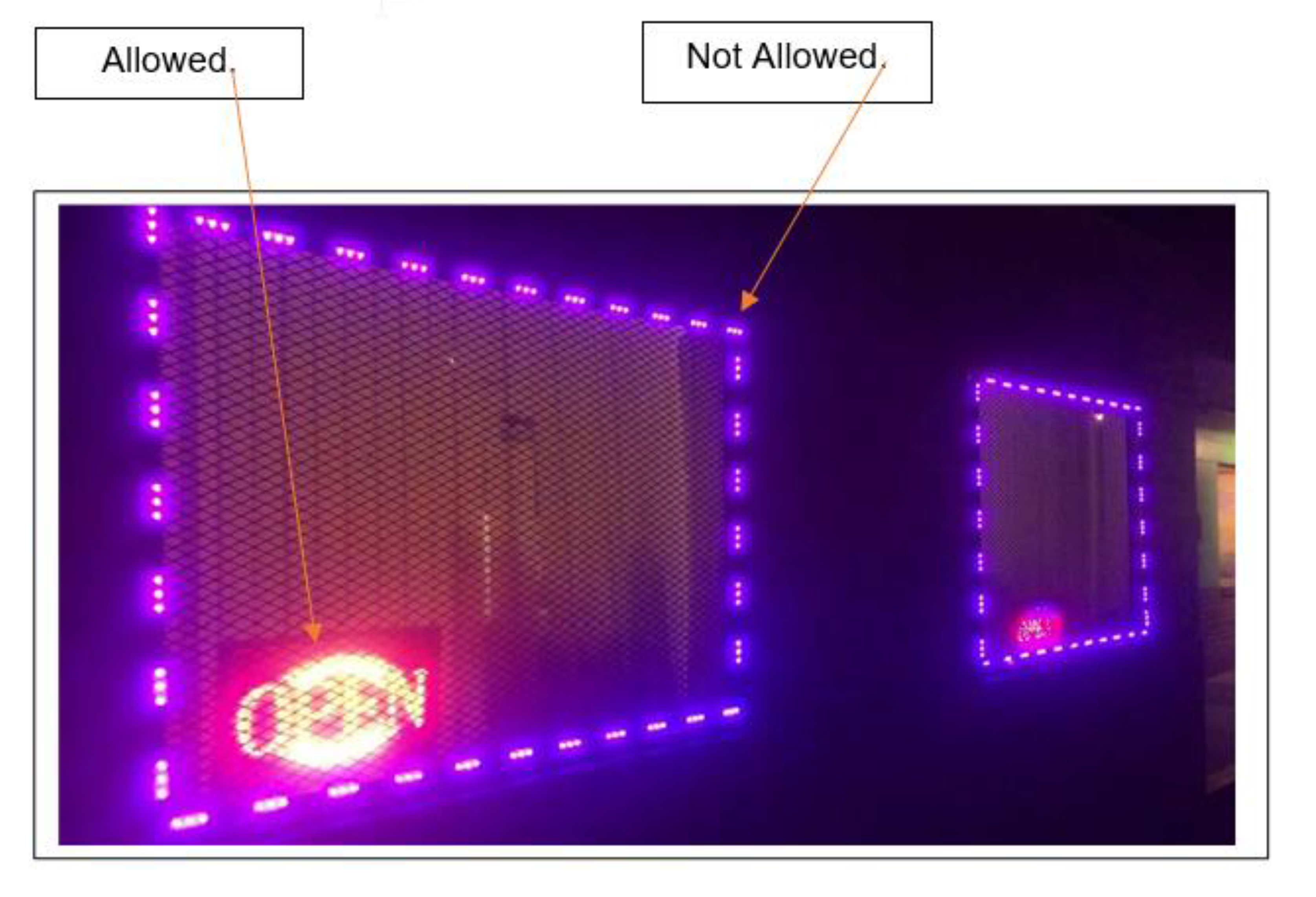
Lighting of Windows and Architectural Features: Lighting is prohibited from being used to define, outline or highlight windows or architectural features of the building (i.e. windows, doors, roof lines, eves, ownings, railings, etc.). This prohibition shall not extend to the use of neon or LED signage in a window consistent with applicable sign regulations (see example below).
4.
Lighting of Businesses and Landscaped Areas: Lighting fixtures shall be selected, located, aimed and shielded so that direct illumination is focused exclusively on the building façade, plantings and away from adjoining properties, public or private rights-of-way, and the night sky. Where building faces are illuminated, lighting fixtures must be integrated within the architectural design of the buildings.
(Ord. No. 22-23, § 3, 6-5-2023)
Section 6.06 - Open Space Standards
A.
Open Space Defined
Open space is land and/or bodies of water used for recreation, amenity or buffer; it will be freely accessible to all residents of a development, where required by this chapter. Open space shall not be occupied by buildings or structures unless accessory to a permitted recreational use, roads, parking or road rights-of-way, utility easements, nor shall it include the yards or lots of residential dwelling units required to meet minimum lot area or parking area requirements. Retention basins may be counted towards up to forty percent (40%) of open space, provided that side slopes are 5:1 run:rise or flatter unless otherwise approved by the City Engineer.
B.
Open Space Plan
An open space plan will be submitted as a part of the application for a planned unit development, cluster subdivision or architecturally integrated cluster subdivision that designates:
1.
The areas to be reserved as open space and the specific design of open space areas;
2.
The type of open space that will be provided; and
3.
The manner in which the open space will be perpetuated, maintained and administered.
C.
Types of Open Space
The types of open space which may be provided to satisfy the requirements of this chapter, together with the maintenance required for each type, are as follows: (NOTE: Areas that are designated as permanent soil stock piling or borrow pits cannot be dedicated as open space.)
1.
Natural areas are areas of undisturbed vegetation. Woodlands, wetlands and stream buffers are specific types of natural areas. Maintenance is limited to removal of litter, dead trees, plant materials, and brush. Natural water courses are to be maintained as free flowing and devoid of debris. Stream channels will be maintained so as not to alter floodplain levels.
2.
Recreational areas are designed for specific, active recreational uses such as tot lots, tennis courts, swimming pools, ballfields and similar uses. Recreational areas will be accessible to all residents of the development. Maintenance is limited to insure that there exist no hazards, nuisances or unhealthy conditions.
3.
Greenways are linear green belts linking residential areas with other open space areas. These greenways may contain bicycle paths, footpaths and bridle paths. Connecting greenways between residences and recreational areas are encouraged. Maintenance is limited to a minimum removal and avoidance of hazards, nuisances or unhealthy conditions.
4.
Landscaped areas and lawns with or without trees and shrubs will be mowed regularly to insure neatness. Landscaped areas will be trimmed, cleaned and weeded regularly.
D.
Preservation and Maintenance of Open Space
Land designated as common open space may not be sold or developed and must be platted as a lot. Open space areas will be maintained so that their use and enjoyment as open spaces are not diminished or destroyed. Open space areas may be owned, preserved and maintained as required by this section by any of the following mechanisms or combinations thereof:
1.
Dedication of and acceptance by a registered land trust;
2.
Common ownership of the open space by a property owner's association which assumes full responsibility for its maintenance;
3.
Private ownership which will prevent development and/or subsequent subdivision of the open space land and provide the maintenance responsibility. Copy of approved and recorded plat must be submitted to the City prior to the issuance of a certificate of occupancy.
E.
Areas Not Allowed as Open Space
The following areas shall not count toward common open space set-aside requirements:
1.
Private lots, yards, balconies and patios dedicated for use by a specific unit;
2.
Electric or gas transmission line rights-of-way;
3.
Public right-of-way or private streets and drives;
4.
Open parking areas and driveways for dwellings;
5.
Land covered by structures except for ancillary structures associated with the use of the open space such as gazebos and picnic shelters;
6.
Designated outdoor storage areas;
7.
Land areas between buildings of less than forty (40) feet;
8.
Land areas between buildings and parking lots or driveways of less than forty (40) feet in width;
9.
Required setbacks; and
10.
Detention/retention facilities except as provided in this section.
F.
Open Space Linkages
Where a trail, natural area or public park is dedicated to or acquired by the City, such area may be credited toward the minimum amount of common open space required. Such areas also may qualify for density bonuses.
G.
Design Criteria for Open Space
All common open space lands shall meet the following design criteria, as relevant:
1.
Water bodies, retention areas, detention basins and wetlands basins, may constitute up to forty percent (40%) of required open space, provided that retention facilities are designed to provide safe access to water and detention facilities encompass at least ten thousand (10,000) square feet of area with less than two percent (2%) grade. Side slopes to retention and detention facilities shall provide at least six (6) feet of horizontal run for each foot of vertical rise.
2.
At least forty percent (40%) of required open space must be dry land with a slope of less than ten percent (10%) unless otherwise approved the City Council.
3.
Unless otherwise approved by the City Council, open space shall be continuous, contiguous with open space on abutting properties and accessible to the public.
H.
Connectivity Required
To the maximum extent practicable, common open space shall be organized to create integrated systems of open space that connect with the following types of lands located within or adjacent to the development:
1.
Dedicated public park or greenway lands;
2.
Dedicated school sites;
3.
Other dedicated open spaces;
4.
Common open space located adjacent to the development;
5.
Portions of the regional trail and open space system;
6.
Neighborhood shopping and activity centers; and
7.
Adjacent employment centers.
I.
Contiguity Required
To the maximum extent practicable, common open space land shall be compact and contiguous unless the land is used as a continuation of an existing greenway, trail, or other linear park, or unless specific topographic features require a different configuration. An example of such topographic features would be the provision of open space along a scenic creek. With the exceptions of trails, the minimum width of an open space parcel shall be one hundred (100) feet.
J.
Accessibility Required
Common open space shall be reasonably accessible to all of the residents of the development:
1.
At a minimum, pedestrian access to common open space shall occur every five-hundred (500) feet of linear length of common open space.
2.
Pedestrian access to common open space shall occur within five hundred (500) feet of every dwelling unit in the development.
3.
The City may require access to be restricted if it would degrade, destroy, or adversely interfere with sensitive environmental or natural areas or with significant historic or cultural resources.
4.
Where provided, access to common open space shall be a minimum of twenty-five (25) feet wide and shall be located where such access is visible to dwelling units and shall not be isolated by walls, screening, landscaping, or any other kind of barrier that would prevent resident surveillance of the open space.
K.
Open Space Amenities
Common open spaces, other than those preserved as natural features or areas, should include gardens, courtyards, recreation, or play areas and shall contain at least three (3) of the following features:
1.
Seasonal planting areas.
2.
Benches or other seating.
3.
Gazebos or other decorative shelters.
4.
Play structures for children.
5.
On-site community recreation amenities.
Section 6.07 - Sign Regulations
A.
Purpose
The purpose of these regulations is to ensure that persons and businesses desiring to exercise their rights, under the First Amendment of the U.S. Constitution, by expressing commercial and non-commercial messages shall be treated uniformly while ensuring that the public health, safety and welfare are protected. These regulations for signs have the following specific objectives:
1.
To ensure that signs are designed, constructed, installed and maintained so that the public safety and traffic safety are not compromised;
2.
To allow and promote positive conditions for sign communications while at the same time avoiding nuisances to nearby properties and promoting an attractive environment;
3.
To reflect and support the desired character and development patterns of the various zoning districts;
4.
To allow for adequate and effective signs in commercial and industrial zones while preventing signs from dominating the appearance of the area; and
5.
To ensure that the constitutionally guaranteed right of free speech is protected.
B.
Applicability and Effect
Other than lawful nonconforming signs, no signs shall be permitted in any zoning district except in accordance with the provisions of this Section and shall require a sign permit in conformance with the provisions in Section 2.23.
1.
Applicability: The provisions of this Chapter shall apply to the erection, alteration, reconstruction, construction and maintenance of all on-premise and off-premise signs and billboards within the City and its Extraterritorial Jurisdiction.
2.
Restrictiveness: To the extent that any other provision of this Section shall be more restrictive than the provisions set forth in this Code, the more restrictive provision shall apply.
3.
Severability: The sections, paragraphs, clauses, and phrases of this Section are severable and if any phrase, clause, sentence, paragraph or section of this Section shall be declared unlawful by the valid judgment, decree or injunction order of a court of competent jurisdiction, such ruling shall not affect any of the remaining phrases, clauses, sentences, paragraphs and sections of this Section. In the event that, contrary to the policies, interests, and values of the City, a court of competent jurisdiction issues a judgment, decree or injunction order that this Section is unlawful because of any omission or prohibition in this Section, then all provisions of this Section not specifically declared to be unlawful shall remain in full force and effect. In the event that a judgment, decree or injunction order declaring all or a portion of this Section to be unlawful is reversed or vacated by a court of competent jurisdiction, the provisions contained in this Section shall remain in full force and effect.
C.
Definitions
For the purposes of this Section, the definitions contained in this zoning ordinance shall control. Figure 6-3 illustrates several common sign types referred to in this Section. In addition, the following words and phrases shall have the meanings respectively ascribed to them below, unless the context clearly indicates a contrary meaning:
Animated sign. See Flashing sign.
Awning sign shall mean any sign on a cloth, metal, plastic or other cover designed to shade a window or entrances and attached to any structure.
Back to back sign shall mean a sign with two (2) sign faces that are parallel or within up to fifteen (15) degrees of being parallel and oriented in opposite directions.
Banner sign. See Temporary sign.
Beacon. See Temporary sign.
Billboard. A large outdoor advertising structure typically found in high-traffic areas such as alongside busy roads. Billboards present large advertisements to passing pedestrians and drivers typically showing slogans and distinctive visuals, billboards are highly visible in the top designated market areas.
Building frontage shall mean the linear feet of the exterior wall of a building that faces any road or street that provides a means of direct ingress and egress to the lot.
Canopy sign. See Awning sign.
Directional Sign shall mean a sign that is designed to guide or direct to a specific path, location, or destination with arrows or words.
Eave shall mean the projecting lower edges of a roof overhanging the wall of a building.
Entrance sign shall mean any sign placed at the intersection of a public street and a public or private entryway into an apartment complex, condominium complex, office complex, industrial complex or other building or buildings with multifamily residential dwelling units or multiple commercial units.
Erect shall mean to build, paint, construct, attach, hang, place, suspend, assemble or affix.
Externally illuminated sign shall mean any sign illuminated by an external light source directed primarily toward such sign.
Fascia sign. See Wall sign.
Flag shall mean a usually rectangular piece of fabric of distinctive design that is the flag of the United States of America, the flag of nations recognized by the United States of America, the flag of the State of North Carolina, the flag of any state or territory of the United States of America, the flag of a political subdivision of any state or territory of the United States, or any religious, non-state political or other noncommercial flag as indicated by the Reed vs Gilbert Supreme Court decision.
Flashing sign shall mean any sign whose message or appearance scrolls, flashes, rotates or changes, or whose illumination changes in intensity more often than once every fifteen (15) seconds, including but not limited to reader boards and LED signs.
Freestanding Sign shall mean a sign which is attached to, erected on, or supported by some structure (such as a pole, mast, frame or other structure) that is not itself an integral part of a building or other structure whose principal function is something other than the support of a sign. (Also referred to as a ground, monument or pole sign).
Ground sign shall mean any sign supported by uprights or braces which are permanently placed into the ground, and not supported by or suspended from any building. Ground signs include monument-based signs, pole and post mounted signs.
Halo sign shall mean a sign using a three-dimensional message or logo which is lit in such a way as to produce a halo effect (also known as back-lit illumination).
Hand held human/mascot signs shall mean any sign larger than six (6) inches by six (6) inches displayed by a human and or mascot including but not limited to shields or sandwich boards.
Height shall mean the vertical distance measured from the lowest adjacent grade to the highest point of the sign or sign structure.
Incidental signs shall mean any sign used in conjunction with equipment or other functional elements of a use or operation. These shall include but not limit to: drive through window menu boards, signs on automatic teller machines, gas pumps, express mail drop, boxes, vending machines, newspaper delivery boxes, or signs painted or permanently attached to licensed motor vehicles that are not parked or located so as to function as a sign.
Internally illuminated signs shall mean any sign which has characters, letters, figures, designs or outlines illuminated by electric lights or luminous tubes located within the interior parts of the sign.
Mobile sign. See Temporary sign.
Monument sign shall mean a ground based sign that is a freestanding sign attached to a contiguous structural base or planter box that is the same width or greater than the message portion of the sign as opposed to a sign supported by and attached to poles or braces and is permanently affixed to the ground.
Multi-tenant structure in CB, CBP and the MSD Districts shall mean a structure containing more than one (1) commercial entity with ingress and egress through one (1) main door.
Multi-tenant structures in commercial zoning districts shall mean a structure containing more than one (1) commercial business.
Nonconforming sign shall mean any sign that does not conform with the provisions of this Section.
Off-premise advertising shall mean any permanent sign designed to advertise a good or service that is not provided on parcel on which the sign is located.
Pennant. See Temporary sign.
Pole sign. See Ground sign.
Portable sign. See Temporary sign.
Projecting sign shall mean any sign that is attached perpendicular to a building or other structure and extends more than twelve (12) inches horizontally from the plane of the building wall.
Reflectors shall mean any device created for the purpose of reflecting light directed at the device so as to render the device especially visible.
Roof sign shall mean a sign that is attached to a building or structure and is displayed above the lowest horizontal line of a building's roof.
Sandwich sign. See Temporary sign or Hand held sign.
Searchlight. See Temporary sign.
Shopping Center shall mean a group of commercial businesses planned and developed with coordinated parking, service areas, and shared access.
Sign shall mean any device, item, product, frame, letter, figure, character, mark, plane, point, design, picture, stroke, stripe, trademark, or reading matter, which is used or intended to be used to attract attention or convey information when the same is placed in view of the general public. For the purpose of determining number of signs, a single display surface or a single display device containing different elements that are organized, related, and composed to form a unit shall be considered to be one (1) sign. Where different elements are displayed in a random manner without an organized relationship to each other, or where there is reasonable doubt as to the relationship of different elements to each other, each element shall be considered to be a single separate sign.
Sign face area shall mean the area within a single, continuous perimeter enclosing the characters, lettering, logos, illustrations, and ornamentation, together with any material or color forming an integral part of the display or used to differentiate the sign from the background against which it is placed.
Stake sign shall mean any temporary sign supported by at least one (1) upright placed into the ground, and not supported by or suspended from any building with signable area not greater than eight (8) square feet.
Store front shall mean the primary facade of a single, undivided unit containing an area larger than seven hundred fifty (750) square feet.
Streamer. See Temporary sign.
Subdivision sign shall mean any entrance sign placed at the intersection of two (2) public roads to identify the development.
Suspended sign. See Projecting sign.
Temporary sign shall mean any sign or device that is not permanently attached to the ground or other permanent structure, which is designed to be mobile or is designed to remain in place for a limited time. This includes, but is not limited to, signs which are designed to be transported regularly from one location to another, signs which are designed with wheels, regardless of whether the wheels remain attached to the sign, or signs tethered to an existing structure. These signs include, but are not limited to, (i) sky lights, (ii) balloons, (iii) streamers, (iv) flag strings, (v) inflatable displays, (vi) banners, (vii) beacons, (viii) searchlights, (ix) pennants, and (x) mechanical or animated figures.
Wall sign shall mean any sign which is attached parallel to or painted on an exterior building wall, which may include a door and shall not project more than twelve (12) inches from the building. Non flush mounted wall sign is a permanent sign which is affixed to an attached structural architectural building feature such as a canopy, atrium, portico, veranda or porch.
D.
Measurements
1.
Height. Figure 6-4 shows the method for calculating sign height. Where topography, neighboring buildings, or existing landscaping would obscure a sign from the adjoining street, the applicant may request a variance in conformance with Section 2.11. The height of a sign shall be measured from the top of highest attached component of the sign, to the higher of:
a.
The average grade of the ground excluding berms, filling, mounding or excavations, at the base of the sign, or
b.
The average grade level of the adjacent street or highway centerline for signs located within twenty-five (25) feet of the right-of-way, whichever is higher.
2.
Sign Face Area. On-premise signs shall be calculated by measuring from the extreme boundaries of the each sign face, as illustrated in Figure 6-5. The message area shall include any emblem, logo, trademark, representation or other display, together with any material or color forming an integral part of the background of the display or used to differentiate the sign from the backdrop or structure against which it is placed, but shall not include the supporting framework, bracing, poles, apron, supports, structural members, decorative fence or wall that is clearly incidental to the sign and not a part of the message. Billboards and off-premise sign area calculations shall include the border and trim.
a.
Cabinet Signs: The sign area is determined by multiplying the width by the height. The sign area of round cabinet signs shall be calculated based on the formula: 3.14 × radius × radius.
b.
Back-to-Back Signs: The sign area of back-to-back signs shall be calculated by measuring only one (1) sign face. If there is a separation of more than three (3) feet between faces or an angle greater than fifteen (15) degrees, then each sign face shall be calculated.
c.
Multiple Signs: The sign area for multiple signs shall be calculated by taking the sum of the sign area for each individual sign.
E.
Sign Setbacks
Signs located within the required front yard or side street of a principal structure shall be located a minimum of five (5) feet from the property line of road right-of-way. The location of signs shall not interfere with the site visibility triangle.
F.
Freestanding Signs
Only one (1) freestanding sign may be erected per parcel except
1.
As otherwise allowed for properties with more than five hundred (500) feet of frontage; or
2.
For parcels that are one (1) acre or more in size that have frontage on two (2) public collector or arterial streets, a second freestanding sign may be authorized.
G.
Permitted Sign Standards
The type of sign permitted, maximum number of signs, maximum size, maximum height, maximum projection, minimum setback, lighting method, and permit requirement shall be in conformance with Table 6-13 in addition to the following standards:
1.
Construction Standards; All Signs
a.
Building code compliance: All signs shall be constructed and maintained in accordance with the provisions of the adopted building code.
b.
Materials required: All signs for which a permit is required by this Section, except temporary signs, shall be constructed of non-combustible material.
c.
Reflectors: Reflectors and lights shall be permitted on ground signs, roof signs, and wall signs; provided, however, that the reflectors and lights shall be provided with proper glass lenses so that no light therefrom creates a hazardous or dangerous condition.
d.
Internal illumination: The illumination of internally illuminated signs, which are authorized only in the B-3, B-4 and B-5 zoning districts, shall not exceed twenty (20) footcandles of incandescent light measured at a distance of ten (10) feet from such structure.
e.
External illumination: Externally illuminated signs shall be lighted so that no lights are positioned in such a manner that light glares or shines into the eyes of motorists or pedestrians or onto a residential structure.
2.
Special Limitations. In addition to the limitations set forth in the other sections of this article, the following limitations shall apply to these specific types of signs:
a.
Wall signs: No wall sign shall cover wholly or partially any wall opening, nor project beyond the ends or top of the wall to which it is attached.
b.
Projecting signs: See Section R. Sign Standards for the CB, CBP, Municipal Service and H-115 Districts.
c.
Awning signs:
(1)
Awning signs must be painted or installed directly on the valances of the awning.
(2)
Awning signs shall not have lettering or graphics exceeding eighteen (18) inches in height.
(3)
No awning sign may be internally illuminated.
(4)
The signable area of any awning sign shall not exceed ten percent (10%) of the surface area of the awning.
d.
Entrance sign: All entrance signs shall be placed on private property and may not be placed in the right-of-way, except in a center median based on the following criteria:
(1)
the sign has two (2) faces;
(2)
the location has been approved in writing by the City Engineer; and
(3)
applicant agrees to be responsible for maintenance and repair of the entrance sign and ensures that the existence of the entrance sign is documented on the final plat for the development.
e.
Subdivision sign: All subdivision signs shall be placed on private property and may not be placed in the right-of-way, except in a center median based on the following criteria:
(1)
the sign has two (2) faces;
(2)
the location has been approved in writing by the City Engineer; and
(3)
the applicant agrees in writing to be responsible for maintenance and repair of the entrance sign and ensures that the existence of the entrance sign is documented on the final plat for the development.
f.
Banners in City parks:
(1)
City sponsored or operated events shall be exempt from sign regulations.
(2)
Banners shall be considered temporary signs.
(3)
In addition to the special limitations of this Section, banners placed in the City parks shall be further regulated as follows:
(a)
Banners in the City's parks can be displayed for no more than seventy-two (72) hours;
(b)
No person shall be permitted to display more than one (1) banner on the premises, and only one (1) banner shall be displayed on the premises at any given time;
(c)
Each person is responsible for erecting and removing its banner;
(d)
No banner shall be any larger than sixty (60) square feet;
(e)
All banners shall be attached to poles provided by the City, and no banner shall at any time be attached to trees within the park.
3.
Sign Separation. A ground-mounted sign (e.g., pole and monument signs) shall not be located closer to another ground mounted sign than fifty (50) feet, measured parallel to the right-of-way. In circumstances where existing signs would preclude the installation of a sign in conformance with these spacing standards on a lot or parcel legally existing on the date of the adoption of these regulations, one freestanding sign shall be authorized for the parcel.
H.
Prohibited Signs
The following signs shall not be permitted in any district:
1.
Signs with flashing, moving, rotating, pulsating or glaring parts, including LED signs not specifically authorized by this Code except for time and temperature (see Section S. for exceptions for Houses of Worship, Schools and Daycare Centers);
2.
Signs which resemble traffic control signs or devices or use the words "stop", "slow", "danger", "caution" or the like which may confuse motorists and cause traffic hazards;
3.
Strings of lights, pennants, strings and loops of strings or ribbons, garlands, search lights, beacons, paper posters applied directly to a wall, pole, fence or building surface, and banners and streamers, are prohibited, except as allowed as a temporary sign in and for vehicle sales lots where ninety-five percent (95%) of the inventory is located outdoors, subject to issuance of a temporary use permit and payment of applicable fees;
4.
Abandoned signs or signs advertising a business, service or product no longer offered on the premises;
5.
Signs containing obscene messages, scenes or graphics, or false or misleading advertising or information;
6.
Portable or temporary signs other than those specifically permitted herein;
7.
Snipe signs or signs attached to trees, telephone poles, public benches, streetlights, utility poles, fences, or placed on any public property or public right-of-way, except as authorized by the City;
8.
Signs placed on vehicles or trailers that are parked or located for the primary purpose of displaying said sign;
9.
Signs placed on or extending over public right-of-way, except as otherwise allowed by this section;
10.
Any sign on which the illuminating or lighting device is so placed as to reflect or shine directly into the adjacent highways or streets in such a manner as to hamper the vision of a motor vehicle operator thereon;
11.
Roof signs, except mansard roofs as shown in Figure 6-5:
12.
Business, company, or other non-governmental flags displayed on roof-mounted poles;
13.
Mobile billboards or street blimps parked in any zoning district for more than one (1) hour in a twenty-four (24) hour period;
14.
Obstruction to doors, windows, or fire escapes: No sign shall be erected, relocated, or maintained so as to prevent free ingress to, or egress from, any door, window, or fire escape; nor shall any sign be attached to any stand pipe or fire escape;
15.
Off-premises signs except as permitted in Section 6.07, Sign Regulations;
16.
Handheld signs;
17.
New billboards.
Figure 6-3: Common Sign Types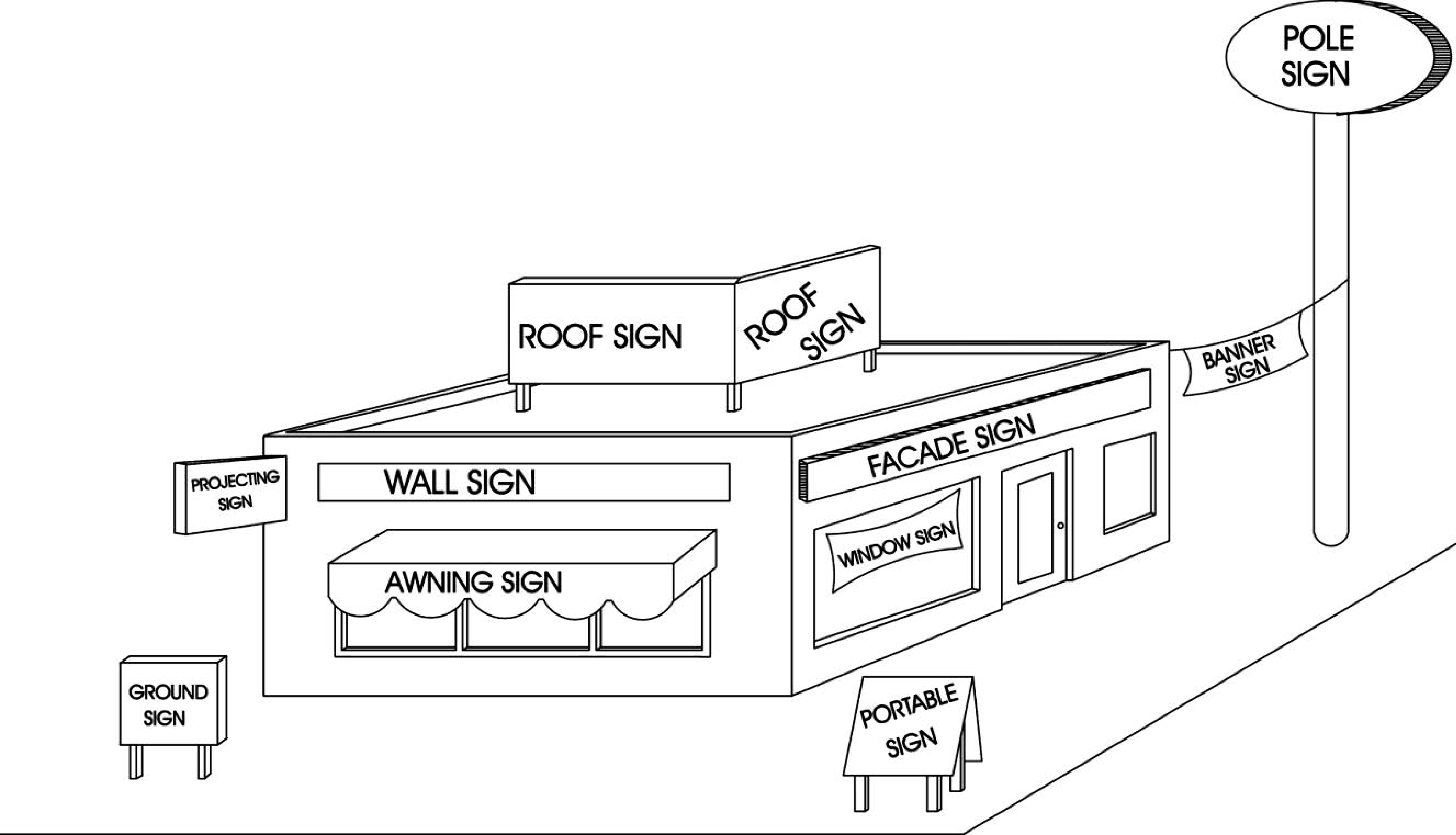
Figure 6-4: Sign Height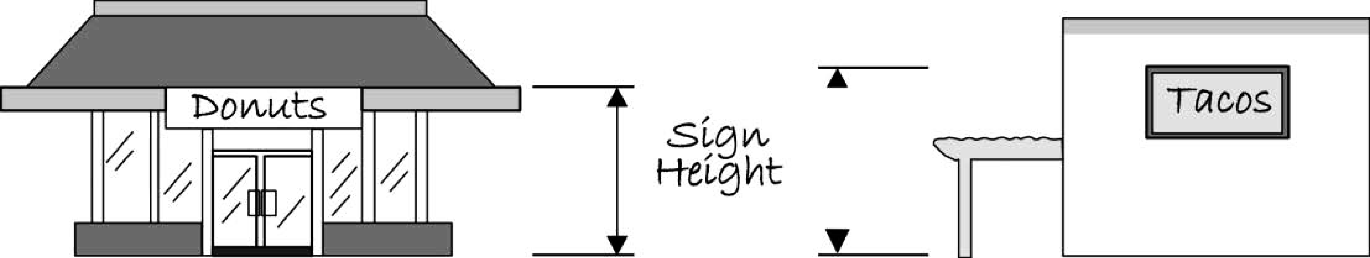
Figure 6-5: Calculating Sign Area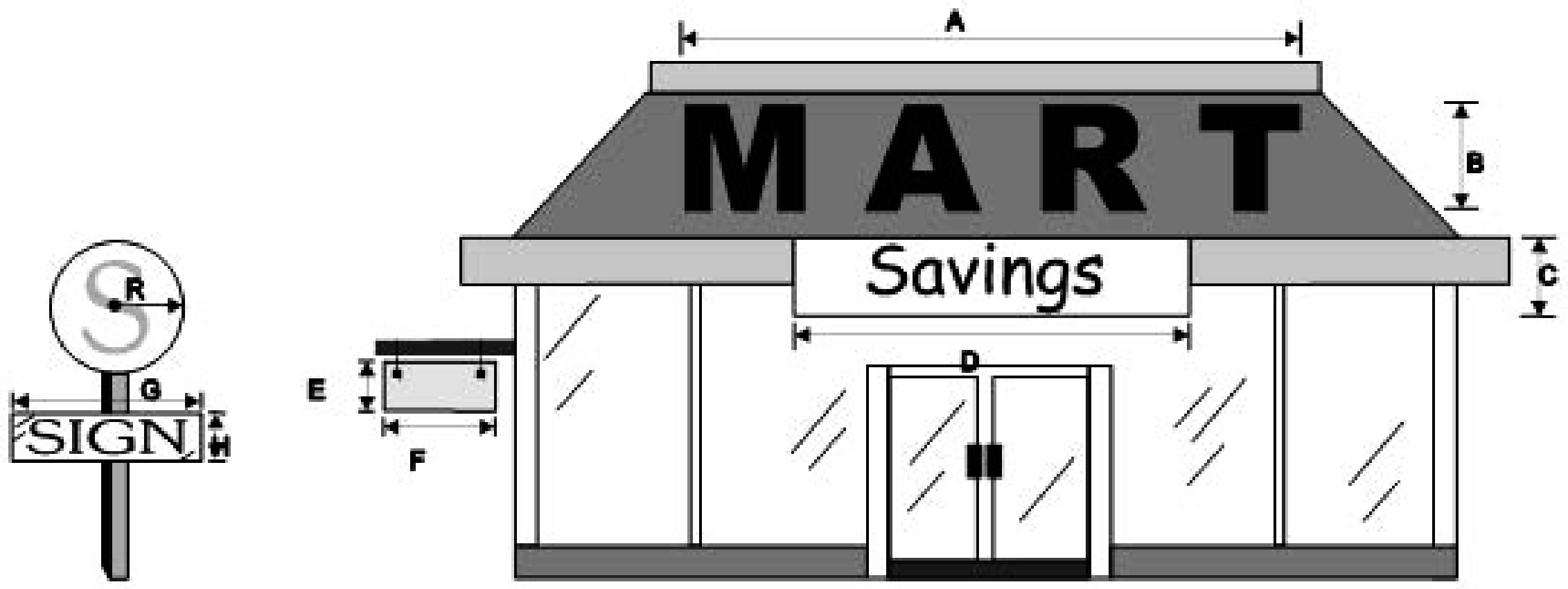
Table 6-13: Permitted Sign Standards by Zoning District
| Zoning District | Type of Sign | Structural Type | Maximum Number of Signs | Maximum Sign Area | Maximum Height | Additional Regulations |
|---|---|---|---|---|---|---|
| ON-PREMISES SIGNS—PERMANENT | ||||||
|
R-A, R-20,
R-15, R-15M, R-10, R-10M, R-8, R-8M, R-8MF, R-5, R-5M, R-5MF | On-premises sign for subdivisions and multi-family projects | Monument and median sign (see Section G. and see Section S. regarding signs for Houses of Worship, Schools and Daycare Centers) | 1 per street entrance to subdivision or multi-family project | 20 sq. ft. per sign face | 6 ft. | Permit required. Must not interfere with sight triangle. No internal illumination |
| Other signs for residential uses | Identification | 1 per dwelling | 1.5 sq. ft. | No internal illumination | ||
| Wall signs for customary home occupation | 1 per street front | 1.5 sq. ft. | under eave of building | Permit required. No internal illumination | ||
| On-premises sign for non-residential uses | Monument (See Section S. regarding signs for Houses of Worship, Schools and Daycare Centers) | 1 per street front | 32 sq. ft. | 6 ft. | Permit required. 5 ft. minimum setback from right-of-way. No internal illumination | |
| Wall sign | 1 per lot | 32 sq. ft. total sign area | under eave of building | Permit required. No internal illumination | ||
|
O-1
(If located in the MSD see Section 6.07 R.) | On-premises sign | Monument (See Section S. regarding signs for Houses of Worship, Schools and Daycare Centers) | 1 per street front | 32 sq. ft. per sign face or 40 sq. ft. with approved master sign plan (see Section J.) | 6 ft. monument | Permit required 5 ft. minimum setback from right-of-way. No internal illumination |
| On-premises sign | Wall sign, awning, marquee, or projecting sign | any number of signs not to exceed max. total sign area except not more than 1 projecting sign per business | 10% of each street facade not to exceed 100 sq. ft. maximum | under eave or parapet for wall, awning, marquee, window or projecting sign | Permit required. No internal illumination | |
| On-premises sign | Wall sign non-flush mounted | 1 per lot | 100 sq. ft. | Cannot exceed roofline | No internal illumination | |
| O & I-2 | On-premises sign | Monument (See Section S. regarding signs for Houses of Worship, Schools and Daycare Centers) | 1 per street front | 32 sq. ft. per sign face or 40 sq. ft. with approved master sign plan (see Section J.) | 6 ft. monument | Permit required 5 ft. minimum setback from right-of-way. No internal illumination of signs located on property sides that adjoin residential districts |
| On-premises sign | Wall sign, awning, marquee, or projecting sign | any number of signs not to exceed max. total sign area except not more than 1 projecting sign per business | 10% of each street facade not to exceed 500 sq. ft. for Hospitals and 200 sq. ft. for all other | under eave or parapet for wall, awning, marquee, window or projecting sign | Permit required. No internal illumination of signs located on property sides that adjoin residential districts | |
| On-premises sign | Wall sign non-flush mounted | 1 per lot | 100 sq. ft. | Cannot exceed roofline | No internal illumination | |
| B-1 | On-premises sign | Monument (See Section S. regarding signs for Houses of Worship, Schools and Daycare Centers) | 1 per street front | 32 sq. ft. per sign face or 40 sq. ft. with approved master sign plan (see Section J.) | 6 ft. monument | Permit required 5 ft. minimum setback from right-of-way. No internal illumination |
| On-premises sign | Wall sign, awning, marquee, or projecting sign | any number of signs not to exceed max. total sign area except not more than 1 projecting sign per business | 10% of each facade visible from right-of-way | under eave or parapet for wall, awning, marquee, window or projecting sign | Permit required. No internal illumination | |
| On-premises sign | Wall sign non-flush mounted | 1 per lot | 100 sq. ft. | Cannot exceed roofline | No internal illumination | |
| B-2 | On-premises sign | Monument (See Section S. regarding signs for Houses of Worship, Schools and Daycare Centers) | 1 per street front | 32 sq. ft. per sign face or 40 sq. ft. with approved master sign plan (see Section J.) | 6 ft. monument | Permit required 5 ft. minimum setback from right-of-way. No internal illumination of signs located on property sides that adjoin residential districts |
| On-premises sign | Wall sign, awning, marquee, or projecting sign | any number of signs not to exceed max. total sign area except not more than 1 projecting sign per business | 10% of each facade visible from right-of-way | under eave or parapet for wall, awning, marquee, window or projecting sign | Permit required. No internal illumination of signs located on property sides that adjoin residential districts | |
| On-premises sign | Wall sign non-flush mounted | 1 per lot | 100 sq. ft. | Cannot exceed roofline | No internal illumination | |
| B-3, B-4, B-5 | On-premises sign | Monument sign (See Section S. regarding signs for Houses or Worship, School and Daycares Centers) | 1 per street front, additional signs may be allowed at a rate of 1 per 500 feet of street front | 120 sq. ft. Multi-tenant structure | 8 ft. monument, may be increased by 1 fr. For each additional 5 ft. of setback up to 12 ft. in height | Permit required. 5 ft. minimum setback from right-of-way. Internally or externally illuminated |
| Out-parcel located on a parcel of land divided as a separate parcel which is located within a shopping center or on an individual lot | Monument | 1 per lot | 32 sq. ft. | 6 ft. | Permit required. 5 ft. minimum setback from right-of-way. Internally or externally illuminated. | |
| Shopping Centers | On-premises |
Freestanding Sign(excludes out-parcel signs)Example:
 | 1 per street front except may be replaced with Interstate Vicinity Sign if applicable | 200 sq. ft. | 32 ft. | Permit Required, 5 ft. setback, Internally or externally illuminated |
|
On-premises
Out-parcel(s) |
Monument SignExample:
 | 1 per lot | 32 sq. ft. | 6 ft. | Permit Required, 5 ft. setback, Internally or externally illuminated | |
| On-premises |
Directional SignExample:
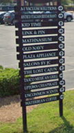 | 12 sq. ft. | 4 ft. | No permit | ||
| On-premises | Wall Sign | Any number not to exceed sign area | 10% of façade | Permit Required | ||
|
Business
Districts *B-1 thru B-5 | Interstate Vicinity sign within 1,000 feet of an interstate highway right-of-way | Pole | 1 per lot |
1 sq. ft. per 1 linear foot of frontage/
Maximum 200 sq. ft. | Height of district, exceptions see Section L. | Permit required. Property must be within 1,000 ft. of interstate right-of-way (see Section L.) Internally or externally illuminated |
| Hand Held Human/Mascot signs | No permit required outside right-of-way. Cannot impede traffic or public safety. Permission from property owner | |||||
| CB, CBP, MSD, H-115 | See Section 6.07 R. | |||||
| LI, HI | On-premises sign | Monument (See Section S. regarding signs for Houses of Worship, Schools and Daycare Centers) | 1 per street front | 32 sq. ft. per sign face | 8 ft. | Permit required 5 ft. minimum setback from right-of-way. No internal illumination of signs located on property sides that adjoin residential districts |
| On-premises sign | Wall sign, awning, marquee, or projecting sign | Any number of signs not to exceed max. total sign area except not more than 1 projecting sign per business | 10% of each facade visible from right-of-way not to exceed 500 sq. ft. | Under eave or parapet for wall, awning, marquee, window or projecting sign |
Permit required. Internally or externally illuminated.
*See footnote | |
| On-premises sign | Wall sign non-flush mounted | 1 per lot | 100 sq. ft. | Cannot exceed roofline | No internal illumination | |
| Entrance sign (Industrial Parks 49 acres or less) | Monument | 1 per entrance | 64 sq. ft. | 8 ft. | Permit required 5 ft. minimum setback from right-of-way. Logo/trademark only can be internally illuminated | |
| Entrance sign (Industrial Parks in excess of 50 acres) | Pole or Monument | 1 per entrance | 64 sq. ft. each side of sign (Limited to 4 sides) | 25 ft. | Permit required 5 ft. minimum setback from right-of-way. Logo/trademark only can be internally illuminated | |
| Off-premises directional sign (Industrial Parks in excess of 50 acres) | Pole, Monument or Ground | 1 per entrance | 64 sq. ft. | 25 ft. | Permit required 5 ft. minimum setback from right-of-way. Logo/trademark only can be internally illuminated. | |
| PUD | Per approved final PUD plan/Requires Master Signage Plan. If PUD approval does not address signs, then sign regulations for equivalent district, as determined by the Planning Director shall apply. | |||||
|
Existing
Billboards | See Section M. | |||||
| TEMPORARY SIGNS | ||||||
|
R-A, R-20,
R-15, R-15M, R-10, R-10M, R-8, R-8M, R-8MF, R-5, R-5M, R-5MF | Temporary | Pole/Post or monument | 1 per street front | 4 sq. ft. per sign face | 5 ft. for pole/post or monument | Permit required (see Section K.) No internal or external illumination |
| Temporary | Wall sign | 1 per street front | 4 sq. ft. per sign face | under eave | ||
|
O-1,
O & I-2, B-1, B-2 | Temporary | Pole/Post or monument | 1 per street front | 16 sq. ft. per face | 12 ft. for pole/post; 5 ft. for monument base | |
| Temporary | Wall sign | 1 per street front | 16 sq. ft. per face | under eave | ||
|
H-115, B-3,
B-4, B-5, LI, HI | Temporary | Pole/Post or monument | 1 per parcel | 32 sq. ft. per face | 25 ft. for pole/post | |
| Temporary | Wall sign | 1 per parcel | 32 sq. ft. per face | under eave | ||
| CB, CBP, MSD | Temporary | Wall sign | 1 per storefront | 16 sq. ft. per face | under eave | |
1. *Signs near residential zoning districts. No sign within one hundred fifty (150) feet of a residential zoning district may be illuminated between the hours of 10:00 p.m. and 6:00 a.m., unless there is no spillover of lighting or glare to the residential zoning districts beyond the boundaries of the lot where the lighting is located.
2. *Shielding of lights. External lighting directed toward a sign shall be shielded so that it illuminates only the face of the sign and does not shine directly into or cause glare onto a public right-of-way or residential premises.
3. *A dimmer switch shall be installed to regulate future concerns and/or complaints from adjoining residential properties.
I.
Exempt Signs
The following non-illuminated signs may be erected without the issuance of a permit. Exemption from a permit does not exempt property owners from duties and responsibilities established by private deed restrictions or covenants.
1.
Residential Signs
Non-illuminated signs not exceeding one and one-half (1.5) square foot in area that are customarily associated with residential use, such as signs identifying names or numbers or signs on mailboxes, and are not of a commercial nature, except for permitted home occupations, shall be exempt.
2.
Governmental Signs and Historic Markers
Signs erected by, or on behalf of, or pursuant to the authorization of a governmental body shall be exempt.
3.
Flags
Flags as defined above shall not be included in the total allowable signage of a lot along with schools and the CB, CBP and Municipal Service Districts.
Schools are permitted to erect flags that represent "welcome, school name, mascot or similar subject matter." Each school flag cannot exceed four (4) feet by six (6) feet in area. The total number of flags permitted is as follows:
Businesses in the CB, CBP and Municipal Service Districts are permitted to erect flags that represent "open, welcome, sale, or decorative without advertisement." Such flag cannot exceed three (3) feet by five (5) feet and is limited to one (1) per business. There must be at least seven (7) feet of clearance from the bottom of the flag and it cannot project more than six (6) feet from the building. If an "open" flag is erected, then no other open sign is permitted.
Advertising events or products on such flags is prohibited. Except in the B-4 or B-5 Districts, heights of flagpoles are limited to forty (40) feet and the maximum size of any governmental flag cannot exceed eight (8) feet by twelve (12) feet. If located in the B-4 or B-5 District and on a property with one hundred (100) feet or more of frontage on an Interstate Highway right-of-way, heights of flagpoles can be a maximum of one hundred thirty (130) feet and the maximum size of the flag cannot exceed forty (40) feet by eighty (80) feet and only one (1) per site is permitted. Flagpole plans must have an engineer's seal for stress load and wind shear.
4.
Decorative/Architectural Features
Holiday season decorations and signage; historic plaques, corner stones and commemorative plaques; and integral decorative or architectural features of buildings or works or art, so long as such features or works do not contain letters, trademarks or moving parts, and when cut into any masonry surface or when constructed of bronze or other incombustible materials.
5.
Directional Signs
On-premises, directional signs that do not exceed twelve (12) square feet per sign face or four (4) feet in height.
6.
Incidental Signs
Signs used in conjunction with equipment or other functional elements of a use or operation. These shall include, but not be limited to drive through window menu boards, signs on automatic teller machines, gas pumps, express mail drop boxes, vending machines or newspaper delivery boxes, or signs painted or permanently attached to currently licensed motor vehicles that are not parked or located so as to function as a sign. Not to exceed thirty-two (32) square feet in size. Menu boards may be increased to fifty-two (52) square feet provided they are located to the rear of the principal structure.
7.
Hospital Signs
Directional signs on premises not exceeding fifteen (15) square feet.
8.
Vehicular Signs
Signs painted on or otherwise permanently attached to currently licensed and operable motor vehicles, which vehicles are not stored in open areas or primarily used as signs.
9.
Constitutionally Protected Speech
Signs expressing constitutionally protected speech not otherwise addressed herein.
10.
Traffic Signs
Traffic signs authorized by act of the City Council or other public agency having authority over public use of right-of-way.
11.
Transportation Signs
Signs indicating location (bus stop, taxi stand and similar transportation facilities not to exceed three (3) square feet.
12.
Warning Signs
Warning signs, no trespassing, no hunting and similar signs not exceeding four (4) square feet in area.
13.
Small Wall Signs
Wall signs one (1) square foot and smaller.
14.
Hidden Signs
Signs that are not visible from any public right-of-way or any adjacent property.
15.
Signs Required by Law
Signs required to be posted by Federal law, State law or by the City Code.
16.
Real estate signs shall not be subject to permit requirements, but shall be subject to the following requirements:
a.
For lease or rent signs for non-residential property shall be posted on the wall or in the window of the space for lease and shall be counted towards allotted signage.
b.
All other on-site real estate signs.
(1)
Number of Signs. Only one (1) such sign shall be allowed along the border of each side of a lot that fronts upon a street and be located behind the street's right-of-way.
(2)
Allowed Area. If the lot has less than two hundred (200) feet of frontage, the sign may not exceed four (4) square feet in area. If the lot has two hundred one (201) feet to five hundred (500) feet of frontage, the sign may not exceed sixteen (16) square feet in area. Lot frontage over five hundred (500) feet may have a sign not to exceed thirty-two (32) square feet in area. For lots in industrial areas (General Business, Light Industrial, or Heavy Industrial) such signs may be up to thirty-two (32) square feet in area.
c.
Off-premises directional real estate signs.
(1)
A maximum of four (4) off-site directional signs allowed for a property for sale (there is no minimum distance requirements between signs).
(2)
Signs cannot exceed four (4) square feet in areas or four (4) feet in height.
(3)
Signs cannot be located in the public rights-of-way and cannot be located in the area of cross visibility.
(4)
Realtors and home builders and all others must obtain written permission by the property owner where they are placing a directional sign.
(5)
Signs must be removed within forty-eight (48) hours of the property closing or at the termination of the listing agreement.
(6)
A maximum of four (4) directional signs are allowed per intersection and not more than two (2) at any one (1) corner of an intersection.
(7)
Signs must be located within a one and one-half (1.5) mile radius of the property for sale.
(8)
Open house/special event signs must not be placed before 8:00 a.m. on a holiday or Saturday, and must be removed by 6:00 p.m. on Sunday, or the holiday, whichever comes late in the immediate succession.
(9)
Open house/special event signs cannot exceed six (6) square feet in area or four (4) feet in height.
(10)
Provisions regarding the posting of signage in the historical district shall override these provisions.
17.
Construction Sign
Such signs may identify the project, the owner or developer, architect, engineer, contractor and subcontractors, funding sources and may contain related information, including, but not limited to, sales or leasing information. Not more than one (1) such sign may be erected per site, and it may not exceed thirty-two (32) square feet in area. Such signs shall not be erected more than thirty (30) days prior to the issuance of a building permit and shall be removed within forty-eight (48) hours of the final property closing in the development.
18.
Special Event Sign
Signs indicating that a special event such as a fair carnival, circus, festival, or similar happening is to take place on the lot on which the sign is located, Such signs may be erected not sooner than thirty (30) days before the event and must be removed not later than three (3) days after the event.
19.
Noncommercial, Civic, Non-profit Signs
Signs or banners may be erected for more than fourteen (14) days announcing a noncommercial, civic, non-profit event in any district. Such signs or banners shall be limited to one (1) per lot with the written permission of the owner and may be located in required yards. Not included is the banner location on East Broad Street east of Tradd Street.
20.
Political Signs
Signs, non-illuminated, may be erected in connection with elections or political campaigns outside of the city right-of-way. Political signs are prohibited in the downtown streetscape and the landscaped median on E. Broad Street. Such signs shall be removed within five (5) days following the election or conclusion of the campaign. No such sign may exceed fifteen (15) square feet in surface areas if located within a residential area.
21.
Outdoor Inventory Signs
The following subsections apply to lots which have ninety-five percent (95%) of the standard inventory located out of doors. An annual fee of $250.00 shall apply to the aforementioned lots which advertise subject to any or all of these provisions.
a.
Temporary professionally made signs or banners erected for not more than thirty (30) days announcing a commercial event. Such signs or banners shall be limited to two (2) per lot and be required to be placed a minimum of five (5) feet back from the right-of-way. The maximum square footage of the sign or banner shall not exceed one hundred (100) square feet. The sign or banner may be attached to a building and/or on poles on the lot.
b.
Temporary signs to be displayed in windows of vehicles on a dealership lot. Signs must not exceed eight (8) square feet in area. A maximum of twelve (12) signs located in windows are permitted on a lot.
c.
Balloons/Pennants which are firmly attached to a stationary object, have a maximum tether height of thirty (30) square feet in area and do not encroach over public right-of-way.
d.
Magnetic signs attached to vehicles for sale on a vehicle dealership lot. The signs must not exceed thirty (30) square feet in area and a maximum of six (6) magnetic signs are allowed on a lot.
22.
Temporary Signs for Road Construction
Existing signs that are required to be removed due to road construction projects are permitted to be replaced with temporary signs during construction provided the following can be met:
a.
Temporary sign(s) in addition to the allowable wall sign(s) may be placed on the structure and shall be flush mounted wall signs or banners not to exceed a cumulative total of fifty (50) square feet. These signs are not allowed to be placed above the lowest horizontal line of the roof except for mansard roofs.
b.
Temporary free-standing signs shall be placed on the property outside the right-of-way and must not interfere with site visibility. These sign(s) shall not exceed a cumulative total of fifty (50) square feet or six (6) feet in height.
c.
All temporary signs must be removed once construction affecting the site is completed or the permanent free-standing sign has been erected.
23.
Existing Billboards
Existing billboards are exempt from the regulations of this ordinance except for the replacement of an existing billboard or the conversion to digital copy. Both must meet the requirements of Section 6.07 M., Existing Billboards.
J.
Master or Common Signage Plan
1.
Purpose
The purpose of a master signage plan is to ensure that signage for multi-tenant properties is coordinated and consistent with the standards of this code.
2.
Applicability
All applications for new construction or reconstruction of shopping centers, business and industrial parks and other multi-tenant developments shall be accompanied by a master signage or common signage plan or amendments thereto. The owner of the property shall be responsible for allocating sign area to tenants of the property.
3.
Master Signage Plan Contents
Any site plan application for applicable development projects shall include a master signage plan, signed by the property owners or their authorized agents, that includes the following information:
a.
Plot plan at scale;
b.
Location of buildings, parking lots, driveways and landscaped areas;
c.
Computation of the total frontage of the lot, parcel or tract and maximum total sign area, maximum area of individual signs, heights of signs, and number of pole/post signs;
d.
Location and placement of all signs;
e.
Setbacks and sign dimensions; and
f.
Landscaping and other site improvements to be coordinated with the sign placement.
4.
Sign Area Bonus for Master Signage Plans
The maximum total sign area allowed for a multi-tenant development may be increased by ten percent (10%) if the Master Signage Plan demonstrates the use of uniform wall signage, graphics, lettering, sizes, colors, materials, and placement. The plan may provide for design variations for colors and lettering that are part of a corporate logo or identification scheme. A single menu sign that incorporates and coordinates with these methods of signage shall be used rather than multiple signs for the property.
K.
Temporary Signs Requiring Permit
Temporary signs shall be permitted in conformance with the following regulations.
1.
Temporary signs are subject to the sign permitting process established in Article 2. Permits for temporary signs are valid for thirty (30) days from the date of permit issuance, except for banners placed in City parks, which must be removed within seventy-two (72) hours after placement on the lot.
2.
No more than four (4) periods per calendar year are allowed; or one (1) per quarter.
3.
All temporary signs shall be securely installed, and shall meet all applicable safety standards as prescribed by the building code, electrical code.
4.
Temporary signs shall not have moving parts, blinking or flashing or glaring lights. All temporary signs shall be secured from at least four (4) points to the ground or a building or structure to prevent the sign from being moved by physical or weather forces.
5.
If any temporary sign is erected or maintained in such a manner so as to be in violation of this Section or any other ordinance or law of the City, the City Council may give written notice to the owner thereof and to the owner of the property and premises upon which the sign is located that the sign must be removed within three (3) days. If the sign is not thereafter removed, the City Council may cause its removal and impose the cost of the removal as a lien upon the property upon which the sign sits.
6.
The Planning Director may authorize the installation of street banners within the public right-of-way to advertise special events beneficial to the public and community.
7.
Temporary non-illuminated blimps/inflatables may be erected for no more than fourteen (14) consecutive days announcing a commercial opening or special event. The blimp/inflatable must be securely anchored and may not exceed one hundred (100) feet in height. No more than one (1) blimp/inflatable may be erected per quarter of a calendar year.
L.
On-Premises Interstate Vicinity Signs
Commercial sites within one thousand (1,000) feet of an interstate highway right-of-way are allowed one (1) freestanding sign, such signs size to be calculated by one (1) square foot of sign face per linear foot of frontage along the street right-of-way or access road with a maximum size allowance of two hundred (200) square feet. The right-of-way shall be measured along the straightest right-of-way line, excluding all additional right-of-way used for ramping and/or interchanges. Sign height must comply with the district in which it is located, except that an automotive or filling station, restaurant or place of lodging within one thousand (1,000) [feet] is permitted a maximum height of eighty (80) feet. The sign shall display only the trade name logo of the product of the business advertised.
M.
Existing Billboards
Billboard signs are subject to the following regulations:
1.
All billboard signs located within six hundred sixty (660) feet from the edge of the road right-of-way line shall, except as noted, meet the criteria established by the North Carolina Department of Transportation Outdoor Advertising Manual or the provisions of this ordinance, whichever is stricter.
2.
Permitted sign size and dimensions. The maximum permitted sign size shall be determined from the road which the sign predominantly faces. If a sign equally faces two (2) different roads, the larger of the two (2) permitted sized signs may be erected.
a.
Billboard signs located within six hundred sixty (660) feet of the edge of interstate highway rights-of-way shall have a maximum area of four hundred (400) square feet. An additional allowance of a maximum of twenty (20) percent of the board size shall be permitted for cutouts.
b.
Billboard signs located within six hundred sixty (660) feet of the edge of U.S. or N.C. primary route and all other road rights-of-way within the City of Statesville zoning jurisdiction shall have a maximum area of three hundred (300) square feet.
c.
Billboard signs located within six hundred sixty (660) feet of the edge of Interstate highway rights-of-way shall have a maximum height of fifty (50) feet measured from the highest point of the sign to the nearest grade of adjacent roadway.
d.
Billboard signs located within six hundred sixty (660) feet of the edge of U.S. and N.C. primary routes and all other road rights-of-way within the City of Statesville planning jurisdiction shall have a maximum height of thirty (30) feet measured from the highest point of the sign to its base or grade of the nearest adjacent roadway, whichever is greater.
e.
All Billboard signs shall have a maximum length of forty-four (44) feet.
3.
Permitted illumination and motion.
a.
Signs which contain, include, or are illuminated by any flashing, intermittent or moving part, light or lights including animated LED signs are prohibited. LED and changeable copy signs are allowed outside the CB and CBP districts provided that the message does not change more than once every ten (10) seconds and that signs do not flash or blink.
N.
Off-Premises Commercial Directional Signs
1.
Purpose
The purpose of this Section is to provide notice to motorists of certain planned nonresidential multitenant developments or subdivisions which may not be directly accessible and visible through travel on thoroughfares, while maintaining the flow of traffic and vehicular safety.
2.
Sign Eligibility
a.
Access to the development is made exclusively by local streets not designated as thoroughfares on the most recently adopted version of the Statesville Mobility and Development Plan.
b.
The development is not visible from a thoroughfare.
c.
The development and the off-premises directional sign shall be located in a B-4, B-5 or HI zoning district for conforming uses only.
d.
A special use permit shall be required.
e.
The provisions set forth cannot supersede the authority of NCDOT with regards to outdoor advertising regulations.
f.
The owner of the sign shall have a set lease rate (per sign space) approved by the Statesville City Council.
g.
Noncompetitive provisions are prohibited.
3.
Location
a.
The off-premises directional sign shall be located at or in close proximity of the intersection of the thoroughfare and the local street.
b.
The sign shall be located outside of a public right-of-way and not create a cross-visibility obstruction.
c.
One (1) sign shall be permitted at any intersection that qualifies under these provisions.
d.
The development must be within one (1) mile of the intersection of the thoroughfare and the local street.
4.
Sign Criteria
a.
Sign size: Thirty (30) square feet; six (6) vertical feet by five (5) horizontal feet.
b.
Number of panel slots: Six (6) (One (1) per business panel, no duplications).
c.
Panel size: Eighteen (18) inches by twenty-four (24) inches.
d.
Height of sign: Eight (8) feet.
e.
Lighting: External only.
f.
Sign message: Business or development name and/or logo; non-changeable copy.
g.
Materials: Metal, wood, brick, non-reflective sign structure.
h.
A directional arrow will be located at the top or bottom of the sign.
i.
Sign design and artwork are subject to adopted criteria.
O.
Non-Conforming Signs
1.
Purpose
The purpose of this Section is to provide for the regulation of signs and sign structures that legally existed prior to the effective date of this Code, but which fail to comply with one (1) or more of the applicable regulations or standards. It is the intent of these regulations to specify those circumstances and conditions under which such nonconformities shall be permitted to continue.
2.
Applicability
These regulations apply to nonconforming signs and sign structures that were originally allowed and have been maintained over time. These signs and sign structures have legal nonconforming status and may continue so long as they are legal otherwise. Nonconforming signs and sign structures that were not permitted when they were established and have been maintained over time have no legal right to continue and shall be terminated.
3.
Non-Conforming Sign Procedures and Standards
a.
Status of Legal Non-conforming Signs: Any on-premises or off-premises sign or billboard which was lawfully established, erected or affixed prior to the adoption of this Section and which complied with all regulations in force at the time it was erected or affixed, but which fails to conform to all applicable regulations and restrictions of these regulations, shall be considered a legal nonconforming sign or billboard.
b.
Continuation of Legal Nonconforming Signs: A legal nonconforming sign or billboard may be continued so long as it is in conformance otherwise with these standards and is maintained in good condition.
c.
Conditions Under Which Legal Nonconforming Signs Shall be Permitted to Continue: An existing non-conforming sign may continue to be used subject to the following conditions:
(1)
The message displayed on a nonconforming billboard may be changed and painted messages on a nonconforming billboard may be repainted.
(2)
A non-illuminated, nonconforming sign or billboard shall not be illuminated.
(3)
A nonconforming on-premises sign may be changed or altered for the express purpose of making it a conforming sign.
(4)
In order to eliminate an unsafe condition(s), the Planning Director may order that repairs and/or alternations be made to a nonconforming sign or billboard. Such ordered repairs shall be the minimal necessary to correct an unsafe situation(s).
(5)
The type of materials used in the construction of the structural elements of a sign or billboard shall not be changed after the date the sign or billboard becomes a nonconforming sign nor shall structural alterations be made to a nonconforming sign or billboard with the exception of existing billboards outside the CB and CBP district.
(6)
Nothing contained in this Section shall be construed so as to permit the enlargement of a nonconforming sign or billboard.
d.
Conditions Under Which Nonconforming Signs and Billboards Shall Not be Permitted to Continue: Under the following conditions, a non-conforming sign shall be removed or brought into conformance with these regulations.
(1)
Illegal Sign: The sign or billboard was not established or expanded in conformance with the regulations of this Section or previous ordinances adopted by the City to regulate advertising and signs.
(2)
Destruction or Damage - Unintentional: If any nonconforming sign or billboard is completely destroyed or damaged, due to circumstances beyond the control of the owner or his agents, to the extent of fifty percent (50%) or more of the replacement cost of the sign and its structure, as determined by a certified real estate appraiser, the sign or billboard shall not be replaced.
(3)
Destruction or Damage - Intentional: A sign or billboard that has been intentionally damaged by fire or other causes within the control of the owner or his agents.
(4)
Value of Maintenance or Repairs Excessive: If the value of maintenance or repairs to ensure the safety and compliance of the sign or billboard with the regulations of this Section, is fifty percent (50%) or more of the fair market value of the sign, as determined by a certified real estate appraiser, the sign or billboard shall be brought into conformance with the provisions of this Section.
(5)
Cessation of Use of Property for Which Sign or Billboard was Used: A nonconforming sign shall be removed or made to conform with all the requirements of this Section if one (1) of the following occurs:
(a)
The use of the property for which the sign was intended to advertise is discontinued.
(b)
The business name changes.
(6)
Prohibited Nonconforming Signs and Billboards: Any sign that is prohibited under this Section shall be removed or made to conform to the current sign regulations within thirty (30) days of receipt of a notice of nonconformity.
P.
Maintenance
1.
General Maintenance
Every on-premises and off-premises sign or billboard and its supporting structure shall be maintained in good repair and the premises surrounding the signs shall be maintained by the owner in a sanitary and inoffensive condition, free and clear of all weeds, rubbish, and debris. All structural members and all advertising copy shall be kept painted and clean so as to prevent deterioration, oxidation, paint fading, paint peeling or other unsightly conditions. Owners that are found to be improperly maintaining on- or off-premises signs or billboards shall be given written notice to correct the condition with thirty (30) days. All electrical signs shall continuously conform to the electrical code adopted by the City.
2.
Inspection
Iredell County shall inspect or cause to be inspected all signs and shall require the removal of any sign found to have been established in violation of this Section. Signs shall be removed or repaired if they are:
a.
Not securely affixed to a substantial structure or anchored to the ground.
b.
Not in good repair.
c.
Related to a business or product which is no longer in operation or available.
d.
Unclean or faded to such an extent as to be unsightly.
e.
Creating a dangerous or unsafe condition for traffic or pedestrians.
Q.
Sign Standards by Zoning District
1.
Signs shall comply with the standards established in Table 6-13 in addition to the other standards established in this Section.
2.
No sign shall be illuminated, either internally or externally, in any district zoned R-A, R-20, R-15, R-15M, R-10, R-10M, R-5, R-5M, R-5MF except that entrance signs and subdivision signs may be externally illuminated from dusk until dawn.
3.
All temporary signs are prohibited on lots zoned for residential use, except for stake signs as allowed in this section.
4.
The following requirements shall be observed in the PUD district, in addition to other standards of this Code and the conditions of PUD district approval:
a.
A uniform design scheme of signs shall be established for the development as a whole and/or for each building in the development and approved by the Planning Board.
b.
Plans for the development shall include detailed descriptions of all signs, including, but not limited to, size, height, location, type, colors and materials to be used, lighting and ownership responsibility.
c.
Plans for signs shall undergo the same review and approval process as is required of other aspects of the development; provided that the City Council may make no modification of these regulations which would permit a sign otherwise prohibited under this Section.
d.
All signs shall be designed, erected and maintained in accordance with an approved plan.
R.
Sign Standards for the CB, CBP, Municipal Service and H-115 Districts
Prior to any sign clearance being issued in the CB, CBP and Municipal Service Districts by the City, approval shall be obtained by the Downtown Statesville Development Corporation. Signs in the H-115 District require only staff approval.
1.
Sign, area. The entire surface of the sign including any masking border, frame, architectural trim or structural embellishment shall be included within the total sign area. The width of the masking border or sign frame structure shall not extend beyond the maximum surface area more than six (6) inches. In the case of signs mounted back-to-back or angled away from each other, the surface area of one (1) side shall be computed. In the case of cylindrical signs, the circumference shall be calculated. Signs in the shape of cubes, or other signs which are substantially three-dimensional with respect of their display surfaces, the display surface or surfaces visible from the street shall be included in computations of area. In case of appurtenances (display portions of signs extending outside the general display area, i.e. pop-ups, cut-outs) shall be computed separately as part of the total surface area of the sign.
2.
Signs prohibited in the CB, CBP, Municipal Service and H-115 Districts. The following signs shall be prohibited:
a.
Signs listed in Section H.
b.
Any sign designed to be internally illuminated whether or not it has any electrical or mechanical components that create internal lighting, (halo signs shall be permitted in the CBP District). However, internally illuminated signs are permitted in the H-115 District.
c.
Billboards.
d.
Signs placed or extending over right-of-way except as otherwise regulated below.
3.
Signs encouraged but not mandated in the CB, CBP, Municipal Service and H-115 Districts.
a.
Awning signs.
b.
Window signs which are stenciled or painted to complement architectural period of the building.
c.
Neon signs in windows of the building which complement the architectural period of the building.
d.
Externally illuminated identification signs which are composed of materials in keeping with the architectural style of the downtown.
4.
Freestanding Monument Signs; H-115 District.
Freestanding monument signs are allowed in the H-115 District in association with a use within a building. A monument sign is a sign attached to a contiguous structural base or planter box that is the same width or greater than the message portion of the sign and is permanently affixed to the ground. One (1) sign shall be permitted per street front. No monument sign shall be located higher than six (6) feet above average grade as measured to the top of the sign. All signs shall be located behind the street right-of-way. No monument sign shall be located so that it violates traffic safety precautions. The maximum size of the monument sign shall not exceed the following:
5.
Freestanding Signs: CB, CBP, and Municipal Service District
Freestanding signs are allowed in the CB and CBP District in association with a use within a building. Types of freestanding signs are as follows:
a.
A monument sign is a sign attached to a contiguous structural base or planter box that is the same width or greater than the message portion of the sign and is permanently affixed to the ground. No sign shall be located higher than six (6) feet above average grade as measured to the top of the sign.
b.
A projecting pole mounted sign is a sign installed as a single pole in the ground with an arm projecting created for holding signage and is permanently affixed to the ground. No projecting pole mounted sign shall be located higher than six (6) feet above average grade as measured to the top of the sign and total height of structure not to exceed a total of eight (8) feet.
c.
A two-pole mounted sign is a sign installed as a double pole permanently affixed in the ground with the signage located parallel to the ground. No two-pole mounted sign shall be located higher than six (6) feet above average grade as measured to the top of the sign and total height of structure not to exceed a total of eight (8) feet.
6.
General Requirements of Freestanding Signs
One (1) sign shall be permitted per street front. All signs shall be located behind the street right-of-way. No freestanding sign shall be located that will violate traffic safety precautions. The maximum size of the freestanding sign shall not exceed the following:
7.
Wall Signs [5]
Shall be attached flush to the building and may not extend out more than twelve (12) inches. One (1) wall sign may be located on each building side having an entrance or on a building side visible from a street right-of-way. Wall signs shall not occupy more than ten (10) percent of the area of the facade upon which the sign is placed. Halo signs shall be permitted in the CBP District.
8.
Window Signs*
a.
Window signs, including neon and other permanent window signs shall not cover more that twenty-five percent (25%) of the window area or storefront glass area.
b.
Temporary signs are allowed within windows, provided that they are not displayed for more than thirty (30) days and all temporary signs shall not exceed thirty percent (30%) of any window area.
c.
Neon Signs shall be allowed in windows subject to the area limitations.
9.
Awning Signs*
a.
Awning signs shall have a maximum letter height of eighteen (18) inches per letter.
b.
The maximum area of any awning sign shall be twenty (20) square feet.
c.
Backlighting of awning signs is prohibited.
d.
If a business name is incorporated into the awning sign, a separate wall sign is prohibited.
10.
Projecting Signs*
a.
Facade projecting signs must be perpendicular to the face of the building on which it is attached with a minimum clearance of seven (7) feet from grade of sidewalk to base of sign. Projecting signs may not extend more than four (4) feet from the building wall to the edge of the sign or sign structure.
b.
Street corner projecting signs must be located on the corner of a building adjoining a public street or alleyway and installed in a vertical manner proportionate to the building with a clearance of fifteen (15) feet from grade to base of sign.
c.
The maximum area for a facade projecting or street corner projecting signs shall be two percent (2%) of the total storefront area not to exceed fifteen (15) square feet. If located on a corner then the maximum area will be derived from the square footage of the front facade excluding double frontage facades.
d.
The maximum square footage for multi-tenant structures shall be two percent (2%) of the total front facade not to exceed fifteen (15) square feet; divided equally on one (1) projecting sign.
e.
All projecting signs shall comply with the North Carolina Building Code.
f.
Projecting signs shall not be installed across cornices or other significant architectural features.
11.
Building Names
Buildings that have been recognized by the National Register of Historic Places shall be allowed to display the building name on the front of the building provided that the lettering shall not be taller than eighteen (18) inches on a single line, the materials are in keeping with the architectural style of the building and the length of the text does not exceed fifty percent (50%) of the building width (i.e. The City Center, The James Iredell Building).
12.
Uniform Sign Plan
Multi-tenant buildings are required to have a uniform sign plan. Multi-tenant buildings located in the CB and CBP must be approved by the Design Review Committee (DRC). Once a uniform sign plan has been approved by the DRC, each sign permit shall be issued by staff from that point forward. Uniform sign plans in the H-115 District require staff approval only. A uniform sign plan must include the size, types, placement, color, material and lighting details for all tenants before the first sign permit is issued. A uniform sign plan must show that the total signage as divided among all tenants does not exceed ten percent (10%) of the facade.
13.
Sandwich Board Signs
The sandwich board signs shall not exceed eight (8) square feet and four (4) feet in height and shall only be displayed between the hours of 7:00 a.m. and 10:00 p.m., EST. Each individual business shall have no more than one (1) sign and there must be at least fifteen (15) feet between each sign. A five (5) foot clearance must be maintained at all times on the sidewalk. No sandwich board sign shall block visibility, vehicular or pedestrian at any time. The sign must not be permanently affixed to any permanent object, structure or the ground. They are to be freestanding, self-supporting and be designed and weighted to prevent overturning.
The tenant or property owner that will be placing the signs within the City's right-of-way must carry an extended coverage liability insurance policy in the amount of $500,000.00 with the City of Statesville, NC named as additionally insured. For the tenants or property owners that will be placing their sandwich board signs on private property no insurance is required, but a permit must be obtained.
The following materials are not permitted:
a.
glass, clear acrylic sheeting or breakable materials
b.
paper or laminated paper
c.
corrugated or hollow core plastics
d.
pvc pipe frames
e.
internal illumination or spotlighting illumination
14.
Maintenance of Signs
All permitted signs shall at all times be maintained in good condition see Section 6.07 P.
15.
Temporary Signs and Banners
Shall be permitted as outlined in Section 6.07 K.
16.
Block Corner Directory Signs
a.
A block corner directory sign shall be defined as a sign composed of a post and hanging panels, each panel listing the name and/or use of a business, activity, organization, or office located nearby. Such sign panels shall not contain other advertising messages, except arrows pointing toward the business, activity, organization, or office identified.
b.
To improve pedestrian ability to locate certain businesses or services, to create a unique yet unified look for the downtown, and to increase public safety by combining various pieces of information at single locations, the City will determine where block corner directory signs may be placed. Business, organizations, and uses within the CB and CBP districts may request space on the corner sign posting. The City Council may specify the size, material, colors, letter height, and similar criteria for each panel on the corner directory sign. The Downtown Statesville Development Corporation will be responsible for installation and maintenance of the sign post, and will hang and remove all panels.
c.
Individuals or businesses must purchase an annual permit from the City for each panel. The City shall reserve the right to have panels removed that are so deteriorated or damaged that they may affect public safety, or those panels directing persons to uses no longer in existence. Annual fees for panels shall be set by the City Council and revised from time to time as deemed necessary.
S.
Houses of Worship, Schools, Daycare Centers, and Public Use Facilities
Houses of Worship, Schools, Daycare Centers and Public Use Facilities are permitted to have changeable copy LED monument sign in all zoning districts except for the CB and CBP zoning district but shall be subject to the following conditions:
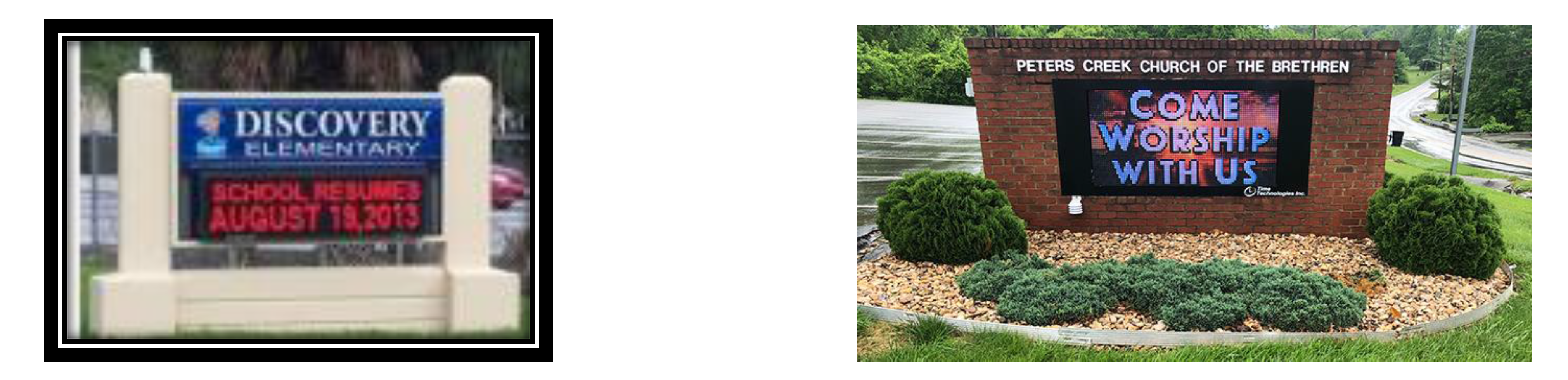
1.
The changeable copy portion of the sign may consist of up to one hundred percent (100%) of the total area of the permitted monument sign, the sign cannot be a flashing, fluttering or a rotating sign. The copy area of the monument sign for Churches, Schools, Daycares and Public Use Facilities are allowed to be thirty-two (32) square feet; All other requirements for monument signs are as stated in the UDC.
2.
The text on the changeable copy area cannot change more than once every fifteen (15) seconds. There may be no scrolling of messages from left to right or top to bottom;
3.
All signs must be equipped with a dimmer control and photocell that automatically adjusts the display's intensity according to natural ambient light conditions. No electronic message board shall be brighter than is necessary for clear and adequate visibility, and shall not exceed a maximum of five thousand (5,000) Nits during daytime hours (sunrise to sunset) and five hundred (500) Nits during nighttime hours (sunset to sunrise).
5.
The sign surround shall be clad in brick, stone or stucco matching the principal building.
6.
No sign shall be located closer than ten (10) feet to any adjacent lot line. A minimum fifteen-foot side-yard setback shall be required if the side lot line abuts a residential district.
(Ord. No. 20-13, 8-5-2013; Ord. No. 23-13, 9-16-2013; Ord. No. 17-14, 10-6-2014; Ord. No. 07-17, 4-3-2017; Ord. No. 02-18, 1-22-2018; Ord. No. 20-18, 6-4-2018; Ord. No. 19-19, 7-15-2019; Ord. No. 32-19, 10-7-2019; Ord. No. 33-19, 10-21-2019; Ord. No. 02-23, exh. A, 1-9-2023; Ord. No. 09-23, 4-3-2023; Ord. No. 19-23, 5-1-2023; Ord. No. 52-23, 10-2-2023; Ord. No. 17-25, 7-15-2025)
Each business may choose up to a total of three (3) of the four (4) options referenced in Sections R. 7-10. The total square footage of the three (3) options combined shall not exceed twelve percent (12%) of the facade.
Section 6.08 - Design Standards for Non-Residential Developments
A.
Purpose and Applicability
The purpose of this article is to ensure that the physical characteristics of proposed development are compatible when considered within the context of the surrounding area. Guidelines should be read in conjunction with the general development regulations and zone-specific standards. This section does not apply to the CB, CBP, HD, LI or HI zoning districts.
B.
General Compatibility Requirement
All development subject to this article shall be compatible with the established architectural character of the city by using a design that is complementary to predominant architectural styles, designs, and forms. Compatibility shall be achieved through techniques such as the repetition of roof lines, the use of similar proportions in building mass and outdoor spaces, similar relationships to the street, similar window and door patterns, and the use of building materials that have color, shades, and textures similar to those existing in the immediate area of the proposed development.
C.
General Principals - Site
The environmental/architectural inventory shall be the foundation on which all site design decisions are based. Minor variations to these regulations may occur based on environmental/architectural conditions at the site. The Planning Director shall approve all site design decisions based on the inventory.
D.
Building Relocation to Surrounding Properties
Buildings shall not significantly overshadow secluded private open spaces or main public area windows into adjacent buildings, ensure no significant loss of amenity to adjacent dwellings, open space or streetscape. Buildings shall not significantly block scenic vistas from public view. Active recreation and service areas shall be located away from secluded private open spaces on adjacent buildings.
E.
Building Aesthetics, Purpose
Building aesthetics establish a base criteria related to the appearance of specific structures. These regulations strike a balance between creativity and innovation on one hand, while avoiding obtrusive, incongruous structures on the other. The City strongly discourages architectural styles that do not build upon and promote the existing character of the City. The City supports the view that inspiring, well-maintained, and harmonious development is in the best economic development interests of all residents and businesses.
F.
Building Design
1.
Emphasize Human Scale
Building design shall emphasize a human scale at ground level, at entryways and along street frontages through the creative use of windows, doors, columns, canopies, and awnings.
2.
Major Building Design Features Proportional
Major building design features, such as windows, doors, eaves, and parapets shall be designed to be in proportion to one another.
3.
Structural Lines Retained at Storefront Level
The structural lines of a building and its materials shall be retained at the storefront level. For instance, brick piers and columns shall be carried down to street level.
4.
Awnings and Canopies
Awnings and canopies shall complement the color and material of the building to which they are fixed.
5.
Massing
A single, large, dominant building mass shall be avoided. Where large structures are required, mass should be broken up through the use of setbacks, projecting and recessed elements, and similar design techniques. Roofline offsets shall be provided to lend an architectural interest and variety to the massing of a building and to relieve the effect of a single long roof.
G.
Avoiding Monotony in Design
Monotony of design in single or multiple building projects shall be avoided by varying detail, form, and siting to the maximum extent practicable, within the standards set forth in this article, to provide visual interest.
H.
Harmony of Design
1.
Purpose
The purpose of this section is to achieve good design, not a certain stylistic result. It will also establish a consistent framework for assessing proposed development, to protect the visual pattern of the community, and to promote harmony in the visual relationships and transitions between new and older buildings. New buildings shall respect the scale, form, and proportion of existing development. This can be done by repeating building lines and surface treatments and by requiring some uniformity of detail, scale, proportion, texture, materials, color, and building form.
2.
Building Materials
Building materials shall either be similar to the materials already being used in the neighborhood or, if dissimilar materials are being proposed, other characteristics such as scale and proportions, form, architectural detailing, color, and texture, shall be utilized to ensure that enough similarity exists for the building to be compatible, despite the differences in materials. All sides of the building shall use materials consistent with those on the front if visible from public streets, public parking and/or drive-thru areas, and should be carefully designed with similar detailing, compatible quality, and compatible materials. Materials used only on one (1) face of a structure which gives the impression of thinness and artificiality are prohibited.
3.
Similar Size and Height for Infill Development
New Infill development shall either be similar in size and height or, if larger, be articulated and subdivided into massing that is proportional to the mass and scale of other structures on the same block, or if no buildings exist thereon, then on adjoining blocks.
4.
Unify Individual Storefronts
If several storefronts are located in one (1) building, the individual storefronts shall be unified in all exterior design elements, such as mass, window and door placement, color, materials, and signage. The unified design should represent a theme, rhythm and/or design flow.
5.
Additions and Renovations
Building additions and facade renovations should be designed to reflect existing buildings in scale, materials, window treatment, and color. A change in scale may require a transitional design element between the new development and existing buildings.
6.
Varying Architectural Styles
In developments with multiple structures of varying architectural styles, buildings shall be compatible by such means as a pattern of architectural features, similar scale and proportions, and consistent location of signage.
I.
Architectural Character
1.
Purpose
Architectural character focuses on the micro-level details that greatly affect the overall appearance of a particular development. These architectural character regulations provide direction in aspects of color, facade materials, rooflines, and the enhancement of entryways. The primary goal is to define the "finishing touches" that provide the development with a sense of permanence, style, and compatibility. The City prohibits proposals that have not taken these materials into account. The City desires that all development be treated as a lasting contributor to the community and as a "good neighbor" to its surroundings.
2.
Roofs
a.
Roof lines shall be varied to reduce the scale of structures and add visual interest. Flat roofs and roof pitches less than 3/12 shall include cornices, parapets and/or other detailing.
b.
Roof shape (for example: flat, hip, mansard, or gable) and material shall be architecturally compatible with facade elements and the rest of the building.
J.
Facades
1.
Recesses and Projections
Facades greater than one hundred (100) feet in length, measured horizontally, must incorporate recesses and projections along at least twenty percent (20%) of the length of the facade. Windows, awnings, and arcades should total at least sixty percent (60%) of the facade length abutting a public street.
2.
Repeating Design Patterns
Facades greater than one hundred (100) feet in length, measured horizontally, shall incorporate a repeating pattern of change in color, texture, and material modules. All elements should repeat at intervals of no more than thirty (30) feet, either horizontally or vertically.
3.
Materials
Brick, stone, or wood facades shall not be covered or replaced with artificial siding or panels except in residential neighborhoods where the preservation of such facades are economically or environmentally impractical. The use of mirrored glass is not permitted.
4.
Exterior Wall Cladding
All exterior walls visible from a parking lot or public right-of-way shall be clad with the same material required for the front of the building.
K.
Entryways
Each principle building on a site should have a clearly defined, highly visible customer entrance featuring no less than two (2) of the following: canopies or porticos, arcades, arches, wing walls, planters, recesses/projections, raised corniced parapets over the door, peaked roof forms, display windows, and/or architectural details such as tile work and moldings which are integrated into the building structure. Emergency exit doors, service doors and ventilation grates on the first floor and visible from a public street shall be decorative.
L.
Mechanical Screening
Projecting elements like mechanical equipment, utility meters, storage areas, trash enclosures, transformers, generators, propane gas tanks and other utility hardware on the building, roof or ground shall be screened from public view with material similar to the structure or they shall be so located as not to be visible from any public view with materials similar to the structure or they shall be located as not to be visible from any public view or from potential buildings, streets or residences nearby. Rooftop mechanical equipment shall be screened. Abandoned mechanical equipment is prohibited and shall be removed.
M.
Color and Materials
1.
Predominant Exterior Building Materials
Predominant exterior building materials shall be high quality materials, including brick, wood, sandstone, other native stone, aluminum composite materials and tinted/textured concrete masonry units. Tinted textural concrete masonry, can be used as accent block. Metal with no exposed fasteners may be used up to fifty percent (50%) on facades visible from public streets, public parking areas and/or drive-thru areas. Metal with exposed fasteners may be used up to thirty percent (30%) on facades visible from public streets, public parking areas and/or drive-thru areas as accent materials. Metal siding with exposed or non-exposed fasteners may be used up to one hundred percent (100%) for service facades not visible from public streets, public parking and/or drive-thru areas.
2.
Colors
a.
Facade colors shall be of low reflectance and/or subtle colors. Building trim may feature brighter colors. Neon tubing is not allowed as an accent material. The use of high intensity colors or fluorescent colors shall be prohibited.
b.
Variations in color schemes are encouraged in order to articulate entryways and public amenities so as to give greater recognition to these features.
N.
On-Site Storage
Storage of inventory, trailers, and containers shall be prohibited unless located within a screened area constructed of the same material as the main building on site.
(Ord. No. 12-22, 1-10-2022; Ord. No. 02-23, exh. A, 1-9-2023)
Section 6.09 - Guidelines for Structures in the Central Business, Central Business Perimeter and the Municipal Service Districts
A.
All exterior changes and new construction must be approved by the Downtown Design Review Committee in accordance with the adopted Design Guidelines; except art, which shall be reviewed by the Design Review Committee and approved by City Council.
B.
Metal exteriors (excluding roofing) in aforementioned districts shall be prohibited. The exteriors shall consist of masonry (excluding common face block, cement block, tilt up panels and dryvit) or other non-metal materials.
C.
The use of reflective or highly tinted glass is prohibited unless the applicant can demonstrate need for such material because of the use and function of the structure, its commonality with the surrounding structures, and the structure has no historical and/or architectural value.
D.
The enclosing, bricking in, or covering of windows or door openings shall not be permitted.
E.
Broken or missing glass in windows and doors shall be replaced within sixty (60) days of official notice by the City of Statesville.
F.
Dumpsters to be located in the downtown for construction/renovation/demolition are subject to Section 5.03.
(Ord. No. 04-13, 3-4-2013)
Section 6.10 - Fencing
Chain link and square wire fencing including barbed wire, concertina wire and razor wire are prohibited in the CB, CBP and H-115 Districts. Governmental uses requiring security fencing shall be reviewed by the Downtown Design Review Committee in the CB and CBP and the TRC if located in the H-115 District. Both committees shall review fences in regards to height, coloring, intended use to be secured and the location of the fence on the site.