
Storey County Unincorporated
City Zoning Code
City Zoning Code
CHAPTER 17
92 - MINERAL EXPLORATION, MINING, AND EXTRACTION
17.92.010 - Authority.
NRS 244.335 and 278.020 provides the board of commissioners with the authority to:
A.
Regulate all character of lawful trade, callings, industries, occupations, professions and businesses conducted in the county, outside of the limits of incorporated cities and towns (NRS 244.335).
B.
Fix, impose and collect a license tax for revenue or regulation on these trades, callings, industries, occupations, professions and businesses (NRS 244.335).
C.
Regulate and restrict the improvements of land and to control the location and soundness of structures (NRS 278.020).
D.
When regulating and restricting the improvements of land and controlling the location and soundness of structure, take into account the potential impairment of natural resources and the total population which the available natural resources will support without impairment (NRS 278.020).
(Ord. No. 12-244, § I, 12-4-2012)
17.92.020 - Applicability.
The provision of this chapter apply to exploration and mining for locatable metallic minerals, such as gold, silver, lead, copper, platinum, zinc, nickel, etc., and non-metallic minerals, such as fluorspar, mica, limestone and gypsum, titanium, heavy mineral placer form, and gemstones. Uses incidental to exploration and mining, including on-site maintenance of large domestic animals, crushing, milling, and processing are also included in the provisions of this chapter. Recreational use exploration and mining, as defined in Chapter 17.10 Definitions, including gold panning and sluicing activities lasting no longer than five days in a one year period, are exempt from the provisions of this chapter. Exploration and development associated with aggregate facilities, including rock quarries, gravel pits, sand or earth borrow pit operations, and the extraction and processing of sand, diatomite, gravel, and rock from the ground are regulated pursuant to the zones in this title.
(Ord. No. 12-244, § I, 12-4-2012)
17.92.030 - Findings of fact.
The board finds that that:
A.
Certain mineral and surface property rights exist across the county and this chapter serves to protect those rights. This chapter also recognizes and serves to abide by the Mining Law of 1872 which provides mineral property owners the right to mine where the property is a mine patent pursuant to title 30 of the United States Code Section 29, or an unpatented mining claim located pursuant to section 23, as well as the right to milling and ancillary uses pursuant to section 42(a).
B.
The county has a diversified economy including agriculture, commercial, industrial, tourism, recreation, and mining. Permitted uses under these categories are found to be economically and socially beneficial to the county, directly and indirectly, when they are appropriately regulated so that they do not cause substantial adverse impacts to adjacent uses and are not detrimental to the health, safety, and general welfare of the citizens, property owners, scholars, and businesses in the county.
C.
The provisions of this chapter serve to address and mitigate potential adverse impacts that mining and related activities may have on the natural and historic environment and adjacent land uses (e.g., residential, commercial, tourism, etc.) as they now exist or as they may in the future be developed as a result of the implementation of the provisions and policies of the county master plan, this title, and any other plan, program, map, or ordinance adopted or under consideration, pursuant to an official notice by the county or other governmental agency having jurisdiction to guide growth and development.
D.
The county master plan states that the existing historical environment, including natural and manmade features, in and around the Virginia City National Historic Landmark provides a sense of orientation and authentic place and feeling which is beneficial to residents, businesses, investors, visitors, scholars, and future generations. It emphasizes reducing land use conflicts between mining and other land uses and preserving the historic resources and heritage of the Comstock for the enjoyment and education of present and future residents and visitors and the economic opportunities afforded. Present and future mining and its ancillary uses within the Comstock, when conducted in a way to preserve and not cause substantial negative impacts to existing cultural resources, also contributes to the sense of orientation and authenticity of the historic mining area. The provisions of this chapter serve to consider certain mining proposals within the Virginia City National Historic Landmark while protecting its existing historic environment, including natural landscapes and manmade features.
E.
Surface mining (e.g., open-pit mining) by its nature causes substantially greater impact to the surface environment than underground mining, and in some instances, precludes complete restoration of the affected land to a condition existing prior to the surface mine. Thus, unless appropriately mitigated through reclamation of land, surface mining has a greater potential for adverse impacts to adjacent land uses, the Virginia City National Historic Landmark, the tourism economy, and the health, safety, and general welfare of the citizens of the county. While the provisions under this chapter provide for surface mining under certain circumstances, underground mining is highly encouraged in all areas of the county, including within the Virginia City National Historic Landmark, when conducted pursuant to the provisions of this chapter.
F.
Areas surrounding State Routes 341 and 342 within the Virginia City National Historic Landmark are found to contain critical natural and manmade features which contribute to the historic integrity of Gold Hill and Virginia City. This area has been incorporated into the "Comstock Historic Preservation Area" ("CHPA restricted area") map as shown in Appendix A and made part of this chapter.
G.
Under certain circumstances and when regulated by the provisions of this chapter, mining and processing of existing historic mine dumps and tailings, including those located within the Virginia City National Historic Landmark, may be found to be beneficial when the existing mine dumps and tailings contain Contaminates of Concern applicable to the Carson River Mercury Superfund Site and when appropriate measures are employed to preserve the historic significance of the manmade landscape features.
(Ord. No. 12-244, § I, 12-4-2012)
17.92.040 - Purpose and intent.
The purpose of this chapter is to recognize and protect both mineral and surface property rights, provide for mineral exploration, allow for surface mining where appropriate, and allow and encourage underground mining across the county, when exploration and mining activities are consistent with the general purpose, goals, and objectives of the county master plan, and when they do not result in substantial adverse impacts to adjacent residential and commercial uses, tourism, the local economy, natural resources (without appropriate mitigation), or other matters affecting the health, safety, and general welfare of the citizens of the county.
(Ord. No. 12-244, § I, 12-4-2012)
17.92.060 - Sale or transfer of site.
When an entitlement for exploration or mining, whether by transfer of land or right, is conveyed, the transfer must be disclosed in writing to the community development department at least ninety days before the assignee takes over the property or right. The permit holder must direct the party taking ownership or right to meet with the community development department to review the conditions of approval of the permit prior to the final sale or transfer.
(Ord. No. 12-244, § I, 12-4-2012)
17.92.070 - Scale of operations.
Surface and underground exploration and mining is divided into four categories: (1) recreational use; (2) casual use; (3) small operation; and (4) large operations. The following provisions will determine the category in which the exploration or mining operation fits:
A.
Recreational use. This classification includes recreational gold panning, sluicing activities, and "rock hounding" lasting no longer than five days in a one-year period. Recreational use exploration and mining are exempt from the provisions of this chapter.
B.
Casual use. This classification includes surface and underground exploration and mining with the use of hand tools for a longer period of time than recreational use. The use of explosives and mechanized or motorized equipment is prohibited. Tools typically associated with casual use include picks, shovels, gold pans, sluice boxes, miner's moss, wheelbarrows, ore carts, and other similar manually operated devices. Casual use exploration and mining are exempt from the provisions of this chapter.
C.
Small operations. This classification includes surface and underground mining and exploration involving the use of mechanized or motorized equipment, or involving the use of explosives, but remaining less than the duration, excavation, and surface area disturbance thresholds at which a special use permit is required for large operations, or the limitations imposed on the restricted CHPA. A combination or series of small operations permits or uses (i.e., serial or chain exploration or mining) that violate or serve to circumvent the letter and spirit of this chapter or title will not be permitted.
D.
Large operations. This classification includes surface and underground exploration and mining meeting or exceeding the duration, excavation, or surface area disturbance thresholds requiring a special use permit.
E.
Ancillary uses. When allowed by the provisions of Section 17.92.090 Ancillary Uses and the underlying regulatory zone, beneficiation and processing, boarding accommodations, concrete batch plants, and the keeping of large domestic animals which are incidental to the small operations or large operations exploration and mining may be made part of the submitted permit for exploration and mining.
(Ord. No. 12-244, § I, 12-4-2012)
17.92.080 - Application requirements.
Recreational use and casual use exploration and mining are exempt from application requirements and other provisions of this chapter. The application for small operations and large operations must be submitted as required by this section to the community development department on the application furnished by the department and approved by the planning commission. Plans, permits, and other documentation required by a federal or state agency will fulfill the application information requirements of this section when they are submitted as part of the county permit application. Requirements in this section that are inapplicable to the exploration or mining operation are not required to be submitted with the application. The completed application must include:
A.
Basic information. The name, address, and telephone number(s) of the owner of record, applicant, corporation, business association, or individual, and that of the operator, project manager, or local contact person.
B.
Demonstration of rights. Appropriate documentation showing that the applicant is the lessee or owner of the surface or mineral estate on which exploration, mining, or associated activity will occur and, if the applicant is a lessee, certification that the applicant has the right, power, and authority to conduct the described operation. The application must include the name, address, and telephone number of the private owner and any federal agency (i.e., Bureau of Land Management) having jurisdiction over the surface and mineral estate.
C.
Taxes. A certificate from the county assessor's office stating that no taxes or assessments are delinquent on the property for which the application is submitted.
D.
Vicinity map. A copy of the assessor's office vicinity map showing where the surface or underground project and property is located in association with surrounding properties. The document may be on eight and one-half inches by eleven inches or similar format, unless a larger format is needed to see details in the map.
E.
Operations plan requirements. An operations plan must be submitted with the application for review and approval by the county fire, emergency management, community development, and public works departments. The operations plan must be updated for county review annually or when substantial changes are made to the operation. The county may require an application for an amended or new permit when adjustments to the operations plan are substantially out of conformance with the conditions of the existing permit. The operations plan must otherwise meet the minimum requirements of this chapter and include the following information:
1.
Background-land. A brief history of activities on the applicable land and past exploration, mining, beneficiation, and processing which had taken place on the land.
2.
Background-applicant. A brief background of the applicant, company, or corporation applying for exploration or mining.
3.
Scale of operation. A narrative description of the scale of the proposal, including anticipated number of employees during construction, operation, and post-operation phases; hours of the operation (including continuous, seasonal, or other); estimated surface disturbances and underground work for the entire project, including phasing; blasting and ancillary uses; and estimated life of the operation, including reclamation and post-operation monitoring.
4.
Site plans and drawings. A site plan drawn to scale must include, as applicable, the following information:
a.
The project boundaries, including anticipated phasing;
b.
The location and placement of existing and proposed structures, including buildings; utility poles, lines, and substations; fire hydrants; water storage tanks; railroads and crossings; signs; fences, walls, and controlled access points; wells, water, sewer, and septic systems, as may be applicable;
c.
All setback dimensions as they apply to existing and proposed buildings and structures and exploration and mining activities;
d.
The location and placement of existing and proposed transportation routes, including access and egress points, driveways, parking, haul roads; public rights-of-way; and easements;
e.
The location of existing and proposed floodways; water bodies; bridges and culverts; and other hydrological features.
f.
The location and placement of existing and proposed manmade landforms and surface alterations, such as open pits, portals and other openings; heap leaches, tailings, dumps, and overburden placement, etc.
g.
The estimated location of newly proposed underground mine portals, tunnels, adits, drifts, and shafts in association with the rights to mine, including patented and unpatented claims.
5.
Methods. Narrative description of proposed methods including:
a.
Development of pits, trenches, and underground workings;
b.
Type of equipment to be used;
c.
Rationale for the type of mining proposed (i.e., surface versus underground) proposed;
d.
Processing, including whether and how ancillary reducing and milling will take place on- or off-site;
e.
Liquid and solid waste management;
f.
Grading and slope stability.
6.
Documenting and reporting. A plan showing how copies of federal and state permits, compliance reports, and violation notices will be submitted to the community development department. The plan must show that copies of the required documents will be submitted to the department within thirty days of the permit holder's receipt. As required by the federal Emergency Planning and Community Right-to-Know Act (EPCRA), all applicable hazardous chemical, material, or explosive submittals must also include copies of permits from the Nevada State Fire Marshall. Copies of all reports sent to the Nevada State Hazardous Material Data Base and the Local Emergency Planning Committee (LEPC) must also be submitted. The permit holder must immediately (within forty-eight hours receipt) report all environmental related violations, spills, accidents, notices, and cease-and-desist orders to the community development, fire, and emergency management departments.
7.
Emergency management and prevention. The applicant must submit with the operations plan an emergency management and prevention plan that will be reviewed for approval by the fire and emergency management departments.
8.
Transportation. A narrative description with accompanying visuals providing on-site and off-site access and egress routes, use of state and county rights-of-way, external and internal haul roads, and a plan for consulting with the applicable regulatory agencies for the use, protection, and repair of land and rights-of-way used for transporting goods, equipment, and people.
9.
Water. The availability, including ownership rights, anticipated use, and protection of quality and quantity of aboveground and underground water resources.
10.
Best management practices. A plan for obtaining and notifying the county of all applicable federal and state air, water, and stormwater permits and noxious weed abatement.
11.
Noise abatement. A plan indicating sufficient noise abatement to meet noise limitations determined by Chapter 8.04. When it is determined by the county that additional noise abatement is needed, further requirements, such as installation of sound-absorbing structures, earth-fill barriers, limitations on the number of motorized machines that may operate concurrently, and restrictions on the hours and days of operation, may be imposed as needed on a case-by-case basis. At a minimum, surface activities located within one thousand feet of a C, CR, E, P, or R zone or any permitted residential use in other zones, except those owned by the applicant or waived by the property owner, must not be allowed to take place between 5:00 p.m. and 8:00 a.m. and on Saturdays, Sundays, and national and state holidays.
12.
Explosives use. The plan must meet the requirements of Section 17.92.110 Use of Explosive Materials, when applicable.
13.
Historic structures protection. The provisions of this chapter will apply to exploration and mining located within the boundaries of the Comstock Historic District as defined by NRS 384:
a.
The application must include a list of all existing buildings within the exploration and mining boundary estimated to have been in existence as of 1942 and planned to be demolished, relocated, or altered as a result of the operation. Buildings applicable to this subsection include primary buildings and accessory buildings and mine head frames.
b.
The list of buildings and structures pursuant to subsection a. must include the estimated year of construction, a brief physical description, and a photograph of no less than all four sides of the structure. Those structures which will be proposed to the Comstock Historic District Commission for demolition, relocation, or alteration in association with the exploration or mining operation must be identified as such in the exploration and mining application;
c.
The historic structures plan must include a narrative description of how structures identified pursuant to subsection a. and b. above will be protected from disturbance or destruction;
14.
Cemetery protection. The plan must identify all known graves or cemeteries, as defined by NRS 452, located within one thousand feet of the proposed exploration and mine site(s) and explain measures which will be taken to protect the cemeteries and graves, and associated structures (i.e., headstones, monuments, fences, and enclosures) from demolition, alteration, and disturbances. A plan must be provided to initiate and maintain communication and collaboration with the Comstock Cemetery Foundation, or other applicable organization or agency managing and protecting the gravesite or cemetery, to develop a plan and enter into an agreement that assures adequate protection of the cemetery from potential impacts (e.g., surface vibrations) generated from exploration or mining activities. The applicable agency or organization may require a surface vibration monitoring program as it determines appropriate and necessary. The plan must be submitted to the community development department by the permit holder within thirty days of approval by the applicable cemetery protection organization or agency.
15.
Closure and reclamation. The reclamation and surety bond requirements imposed by a federal or state agency will supersede this subsection and serve as the reclamation and bonding requirements under the county approved exploration or mining permit. The requirements for reclamation under this subsection and surety bonding under Subsection 17.92.160 Special Use Permit Conditions, will apply, whether or not a special use permit is required, when no reclamation permit or surety bonding is required by a federal or state agency. Unless the exploration or mining operation falls within the regulations of a federal or state agency, the county reclamation plan must include the following information:
a.
Reclamation schedule. The plan must include a timeline showing time of closure, estimated phases of reclamation including all required stages in this subsection, and date of completion;
b.
Preexisting conditions. The plan must include photographic evidence, deemed acceptable by the director, showing the surface conditions, including grade and vegetation, existing prior to the exploration or mining operation;
c.
Grading and backfilling. The plan must show that all surface disturbances and excavations will be backfilled and contoured to a condition that is safe, stable, and reasonably flush and consistent with the surrounding environment. The plan may allow for access roads to remain following the permit expiration date if it is shown that the roads will provide access to expanded or new exploration or mining operations immediately following the active permit. Access roads must be reclaimed concurrently with the remaining operation if an application for additional exploration or mining is not submitted within thirty days of the expiration date of the active permit or the application is not approved by the director.
d.
Bore holes. Bore holes must be plugged as required by the Nevada Administrative Code.
e.
Safety. The plan must show abatement of all safety hazards and nuisances.
f.
Re-vegetation. The plan must include re-vegetation returning all disturbed surfaces to a reasonable condition existing prior to the exploration or mining operation. Unless directed otherwise by the county, seeding, re-seeding, and planning will take place in the autumn season during the months of October or November, but not during times of extreme weather conditions such as snow or sub-freezing conditions.
g.
Removal of equipment and structures. The plan must show that vehicles, equipment, stored materials, structures, and other manmade features will be removed from the land within ninety days of closure. Equipment used for reclaiming the land may remain until the completion of reclamation.
h.
Visual rendition. The application for large operations surface mining or expansion of existing large operations surface mining within one mile of a CR, E, or R zone or the CHPA restricted area must include a photographic or computer generated visual model consisting of the existing surface topography and the approximate topographic conditions during operations, including phasing, and following closure and reclamation. The applicant must consult with the community development department to determine appropriate locations and viewpoints for the visual model. The visual model may include screening and other systems represented in the operations plan to mitigate potential visual impacts.
(Ord. No. 12-244, § I, 12-4-2012)
17.92.090 - Ancillary uses.
The following ancillary uses may be proposed and submitted as part of the required application for surface and underground exploration and mining. Ancillary uses are defined as on-site systems such as those shown below which are reasonable and sometimes necessary to support surface and underground exploration and mining operations. Unless stated otherwise in this chapter, the following requirements apply to on-site ancillary uses for large operations exploration and mining:
A.
Accessory structures and uses. These uses include the deposit and storage of ore, tailings, and overburden; settling ponds; offices, repair shops, storage and other buildings; buildings for the storage of explosives; ditches and other mechanisms for the conveyance of water and utilities; and fueling facilities. The uses listed in this subsection may only be placed where allowable by the underlying zone. These uses are not subject to the CHPA restricted area.
B.
Keeping of large domestic animals. Large domestic animals (e.g., mules) may be used in association with exploration and mining when the limitations and requirements of the respective zone and any applicable county regulations are met.
C.
Processing and beneficiation. These uses may be allowed in the F, 12, 13, and SPR zones; they are prohibited in all other zones. No use involving crushing or hazardous substances, except those existing at the time of adoption of this chapter, may be permitted within one thousand feet of a CR, E, P, or R zone or an existing residence in other zones.
D.
Boarding accommodations. This ancillary use may be allowable in the F and SPR zones for temporary boarding accommodations for workers and other persons directly employed by the large operations if the temporary residential use exceeds the residential density allowance in the respective zone. The boarding accommodations must be located on-site of the large operation, i.e., within the boundaries of its special use permit, and must be removed and associated land reclaimed at the time of closure of the mine. This use must not be included as part of any small operations permit.
E.
Concrete batch plants. This ancillary use may be allowable in the A and F zones when they are temporary (lasting less than one year) and the 13 and 14 zones when they are permanent (lasting one year or longer). They are prohibited in and within one thousand feet of all other zones. Permanent and temporary concrete batch plants are permitted uses, but are subject to a special use permit, beneath the surface of any zone when they are operated entirely within the underground portion of a mine (i.e., adit, tunnel, drift, etc.) and when there are no impacts to the surface environment, including ground and air.
(Ord. No. 12-244, § I, 12-4-2012)
17.92.110 - Use of explosive materials.
A Storey County Fire Department Blasting Permit is required for any blasting or detonation of explosives. In addition to the requirements under the blasting permit, transportation, storage, and use of explosives must conform to the applicable federal regulations and five hundred feet of an existing private or parochial school, healthcare facility, or residence, except a residence owned by the permit holder. A blasting plan may be included with and as part of a special use permit application for exploration and mining. A blasting permit may be required, but a special use permit is not required for down-hole use of explosives for the purpose of dislodging or mobilizing seized borehole drilling equipment.
A pre-blast condition inspection must be conducted by a qualified person for all existing buildings, except those owned by the applicant, within one thousand feet of any blasting activity. The pre-blast condition inspection must be provided by the applicant at no cost to property owners, unless the property owner(s) refuse to allow the inspection to take place, and the county. The applicant must bear full responsibility for structural damage caused by blasting activities.
(Ord. No. 12-244, § I, 12-4-2012)
17.92.120 - Carson River Mercury Superfund Site.
In the 1970's the United States Geological Survey discovered high mercury levels in water samples in the Carson River. Subsequently, the United States Environmental Protection Agency (USEPA) designated the Carson River Mercury Superfund Site (CRMS) and placed it on the National Priorities List (NPL) regulated under the Comprehensive Environmental Response, Compensation, and Liability Act (CERCLA), 42 U.S.C. §§ 9601 et seq. The USEPA divided the CRMS into two Operable Units (OU's): OU1, which includes parts of Virginia City and Gold Hill, consists of the mill sites and those areas where tailings have contaminated surface soils; and OU2 is the Carson River itself, including sediments and biota (generally the depositional/ecological area). USEPA designated the Nevada Division of Environmental Protection (NDEP) as the CRMS lead agency to manage OU1. USEPA has determined that mercury, arsenic, and lead are Contaminates of Concern (CoC's) in OU1. To facilitate proper management of CoC's in OU1, the NDEP and EPA have developed the Carson River Mercury Superfund Site, Long-Term Sampling and Response Plan (LTSRP) to provide guidance for land disturbance activities conducted within the CRMS. The LTSRP requires commercial land development owners, including mining operation owners, to assess areas of the property each owner proposes to access or disturb in connection with its operations for the presence or absence of CoC's where historic mining, milling infrastructure, or mill tailings are identified.
By accepting any permit to conduct exploration or mining, the permit holder must acknowledge that the exploration or mining area, or portions thereof, may be within the CRMS and subject to CERCLA. Properly managing or removing existing mill tailings, mine waste, mine material, etc., from former mine and mill sites that are found to contain CoC's as applicable to the CERCLA will be the sole responsibility of the permit holder. Prior to disturbances of any ground surface within the CRMS site, the permit holder must comply with the applicable NDEP or USEPA requirements, including compliance with the LTSRP, for sampling and analyzing soils for possible CoC's. Handling, redistributing, or reprocessing by the permit holder of material containing CoC's above screening/action levels, as determined by NDEP, will be permitted when the comply with NDEP or USEPA requirements, as applicable. Official reports and results of each study required by NDEP or USEPA must be submitted to the county prior to commencement of surface disturbances. Naturally occurring mineral and elements, such as mercury, arsenic, lead, etc., and lands outside of the CRMS site will be managed under state and federal mining and environmental protection laws and regulations that are unrelated to the CERCLA.
(Ord. No. 12-244, § I, 12-4-2012)
17.92.135 - Small operations—Applicability and restrictions.
Small operations include exploration, surface mining, and underground mining having surface disturbances below the threshold categories in Section 17.92.140 Large Operations Applicability. Only small operations are allowed within the CHPA restricted area. The requirements are as follows:
A.
Permit required. A permit issued by the community development department is required for small operations exploration and mining. The conditions of the permit will incorporate the approved operations plan required in Section 17.92.080 Application Requirements, and include other conditions of approval that are found by the director to be necessary to conform to federal, state, and county regulations.
B.
Permit renewal. An application may be submitted to renew an active permit. The renewal application must be submitted to the community development department at least thirty days before the expiration of the active permit. The renewed permit may contain added or modified conditions that are deemed by the director to be necessary to comply with federal, state, and county regulations. All reclamation must be completed as shown in the approved operations plan before a new or renewed permit may be issued on land within one mile of the active or closed operation. The director must deny the application for a new or renewed permit if any active exploration and mining operations permit of the applicant is non-compliant with federal, state, and county regulations.
C.
Concurrent permits. An applicant may hold two or more small operations permits for surface mining concurrently when the surface mining operations are separated by at least one mile. An applicant may hold two or more small operations permits for exploration concurrently when their cumulative surface disturbance does not exceed five acres. The five acre cumulative surface disturbance limitation for small operations exploration does not apply to exploration which is combined with a small operations mining permit. Only one small operations permit may be active on any given parcel or claim. The scope of a small operations permit may include both exploration and mining.
D.
Allowable zones—Exploration. Small operations exploration is allowed in any regulatory zone for a period of one year; provided that it does not exceed ten days in the C, CR, E, P, and R zones. A new or renewed permit on the same land in the C, CR, E, P, and R zones may not be issued for a period of one year following the expiration of the previous permit.
E.
Allowable zones—Surface mining. Small operations surface mining is allowed in the A, F, I, and SPR zones and is prohibited in the C, CR, E, P, and R zones.
F.
Allowable zones—Underground mining. Underground mining is allowed beneath the surface of all zones, including the CHPA restricted area, when surface disturbances, such as the mine portal, access roads, and staging areas are not in the C, CR, E, P, or R zones.
G.
Force majeure extension. The small operation permit may be extended under circumstances where operation is impossible due to naturally occurring events beyond the control of the county or the permit holder, such as the destruction of sites or access due to flood or earthquake. Such extensions will last for a period of time equal to that during which the operation was rendered inoperable, but must not exceed one year.
(Ord. No. 12-244, § I, 12-4-2012)
17.92.140 - Large operations—Applicability.
The provisions under this section for a special use permit do not apply to surface or underground exploration or mining operations classified as recreational use, casual use, or small operations as defined in Section 17.92.070 Scale of Operations. Exploration and mining operations that meet or exceed the threshold classifications specified in this section are classified as large operations exploration and mining and a special use permit is required. The threshold classifications specified in this section apply only to the surface disturbances cause by exploration and mining, and not underground development such as tunnels, adits, and stopes. Surface disturbances caused by ancillary uses under Section 17.92.090 Ancillary Uses, or other permitted uses related to milling and processing, do not apply toward the threshold limitations shown below.
A.
Surface disturbance taking place within five hundred feet of any residence (unless that residence is the property of the applicant), public, private, or parochial school or academy, or health care facility, and that include any of the following:
1.
Exceeding thirty days duration;
2.
Grading of new roads and access routes exceeding five thousand gross cubic yards volume or five thousand square feet in area;
3.
Exploration exceeding one thousand gross cubic yards;
4.
Surface disturbance, except access roads, exceeding five thousand square feet; or
5.
Alteration of any stream, river, or floodway.
B.
Surface disturbance taking place within one thousand feet of any residence (unless that residence is the property of the applicant), public, private, or parochial school or academy, or health care facility, and that include any of the following:
1.
Exceeding ninety days duration;
2.
Grading of new roads and access routes exceeding five thousand gross cubic yards volume or five thousand square feet in area;
3.
Exploration exceeding five thousand gross cubic yards;
4.
Surface disturbance, except access roads, exceeding one acre;
5.
Alteration of any stream, river, or floodway; or
6.
Blasting or use of explosives as regulated by Section 17.92.110 Use of Explosive Materials.
C.
Surface disturbances taking place more than one thousand feet of any residence (unless that residence is the property of the applicant), or public, private, or parochial school or academy, or health care facility, and that includes any of the following.
1.
Exceeding one year duration;
2.
Grading of new roads and access routes exceeding ten thousand gross cubic yards volume and one acre in area;
3.
Exploration exceeding ten thousand gross cubic yards;
4.
Surface disturbance, except access roads, exceeding five acres.
5.
Alteration of any stream, river, or floodway; or
6.
Blasting or use of explosives as regulated by Section 17.92.110 Use of Explosive Materials.
(Ord. No. 12-244, § I, 12-4-2012)
17.92.145 - Large operations—Restrictions.
The following restrictions apply to large operations exploration and mining.
A.
Allowable zones—Surface mining. A special use permit is required for large operations surface mining in the A, F, I2, I3, and SPR zones. Large operations surface mining is prohibited in all other zones.
B.
Allowable zones—Underground mining. Large operations underground mining is allowable beneath the surface of any zone. Surface disturbances associated with underground mining, such as the portal and shaft opening, access roads, and staging areas are allowable in the A, F, I, and SPR zones and are subject to a special use permit pursuant Section 17.92.040 Large Operations Applicability. Surface disturbances meeting or exceeding those large operations threshold categories are prohibited in all other zones.
C.
Allowable zones—Exploration. A special use permit is required for large operations exploration in the A, F, I2, I3, and SPR zones. Large operations exploration is prohibited in all other zones.
D.
CHPA restricted area—Surface mining. Large operations surface mining is prohibited within the CHPA restricted area.
E.
CHPA restricted area—Underground mining. A special use permit is required for large operations underground mining that causes surface disturbances in the CHPA restricted area to meet or exceed the threshold classifications in Section 17.92.140 Large Operations Applicability. A special use permit is not required for development and expansion of operations that take place beneath the surface.
F.
CHPA restricted area—Exploration. A special use permit is required for large operations exploration in the CHPA restricted area.
G.
CHPA restricted area—Variance. Where a mine claim or other private property is divided by the CHPA restricted area boundary line, the applicant may request a variance to conduct large operations exploration and mining, including surface mining, on that land inside the restricted area. The variance will allow the large operations exploration and mining to take place pursuant to the regulations of this chapter that are applied to those operations taking place outside the restricted area. In the variance application and during the hearing, the applicant must show substantial evidence, including photographs, topographic maps and aerial imagery, and other appropriate documentation, that the portion of land where the variance is requested is not visible from any point within the Gold Hill and Virginia City townships, except for portions of those townships outside the restricted area. The application and public hearing procedure is pursuant to the regulations for a variance in Chapter 17.03 Administrative Provisions.
(Ord. No. 12-244, § I, 12-4-2012)
17.92.160 - Special use permit conditions.
The application for a special use permit for exploration and mining must meet the requirements of this chapter and Chapter 17.03 Administrative Provisions, if the county determines it lacks staff expertise to review an item submitted as part of the special use permit application and subject to the county's regulatory authority, the county may require a third-party review. Activities regulated by federal or state regulatory authorities are exempt from this third-party review requirement. The scope, schedule of work, costs, and firm for the third-party review must be accepted by the county before the special use permit is approved. The scope of work will be limited to checking for compliance with regulations and codes, accuracy of calculations, adequacy and completeness of the information submitted, and preparation under generally accepted professional practices.
A.
Requirements inclusive. The special use permit conditions of approval must, at a minimum, meet the requirements of this section and the findings of fact under Section 17.92.030 Findings of Fact, in order to protect cultural and natural resources and the tourism economy in Gold Hill and Virginia City, and the health, safety, and general welfare of the citizens of the county.
B.
Application requirements incorporated. The conditions of the special use permit must incorporate and may expand upon all application requirements under Section 17.92.080 Application Requirements.
C.
Duration. The special use permit must impose the following limitations on the duration of exploration and mining:
1.
Exploration. The special use permit may not exceed five years and may be limited to a lesser period of time, but not less than one year, as determined by the board with action by the planning commission;
2.
Surface and underground mining. The special use permit may not exceed twenty years and may be limited to a lesser period of time for surface mining, but not less than five years, as determined by the board with action by the planning commission.
D.
Documenting and reporting. All federal and state permits must be submitted to the community development department as described in the approved application operations plan.
E.
Permit renewal. An application may be submitted to renew an active permit. The renewal application must be submitted to the community development department at least thirty days before the expiration of the active permit. The renewed permit may contain added or modified conditions are deemed by the board with action by the planning commission to be necessary to comply with federal, state, and county regulations. The board with action by the planning commission may deny the application for a new or renewed special use permit if any active exploration and mining operations permit of the applicant is non-compliant with federal, state, and county regulations.
F.
Expiration of inactive permit. An extension of an inactive special use permit may be granted for good cause as allowed by Chapter 17.03 Administrative Provisions.
G.
Liability insurance and indemnification. The special use permit will require liability insurance in an amount deemed appropriate for the type and scope of the operation, but not less than one million dollars. The permit holder and all property owner(s) must agree, as evidenced by their acceptance of the special use permit, to hold the county, its officers, and its representatives harmless from the costs and liabilities associated with any damage or liability, and any/all other claims existing at the time of approval or which may occur as a result of the approved special use permit.
H.
Surety bond. A surety bond is required for any reclamation under a permit for small operations and a special use permit for large operations as stated in Subsection 17.92.080 E.15. A surety bond required by a federal or state agency overseeing the exploration or mining operation will fulfill this requirement when proof is submitted to the community development department as required by Section 17.92.080 Application Requirements. If no surety bond is required by a federal or state agency, the permit holder must post cash or other appropriate surety bonding to assure that disturbed land is reclaimed as required by the county approved operations and reclamation plan. The surety bond must be posted prior to disturbance of land and must be updated as the exploration and mining operations progress or change. The amount of the surety bond necessary to fulfill the county requirement will be determined by a qualified licensed engineer or environmental manager at the expense of the applicant and will be subject to review by a third-party approved by the county.
I.
Visitor and education element. The special use permit will required the applicant to develop an information and education center or kiosk adjacent to the large operations mine site for the public to view and learn about history and other information about mining on the Comstock and the active mining operation. The placement and design of the information and education center or kiosk must comply with the conditions of the special use permit.
(Ord. No. 12-244, § I, 12-4-2012)
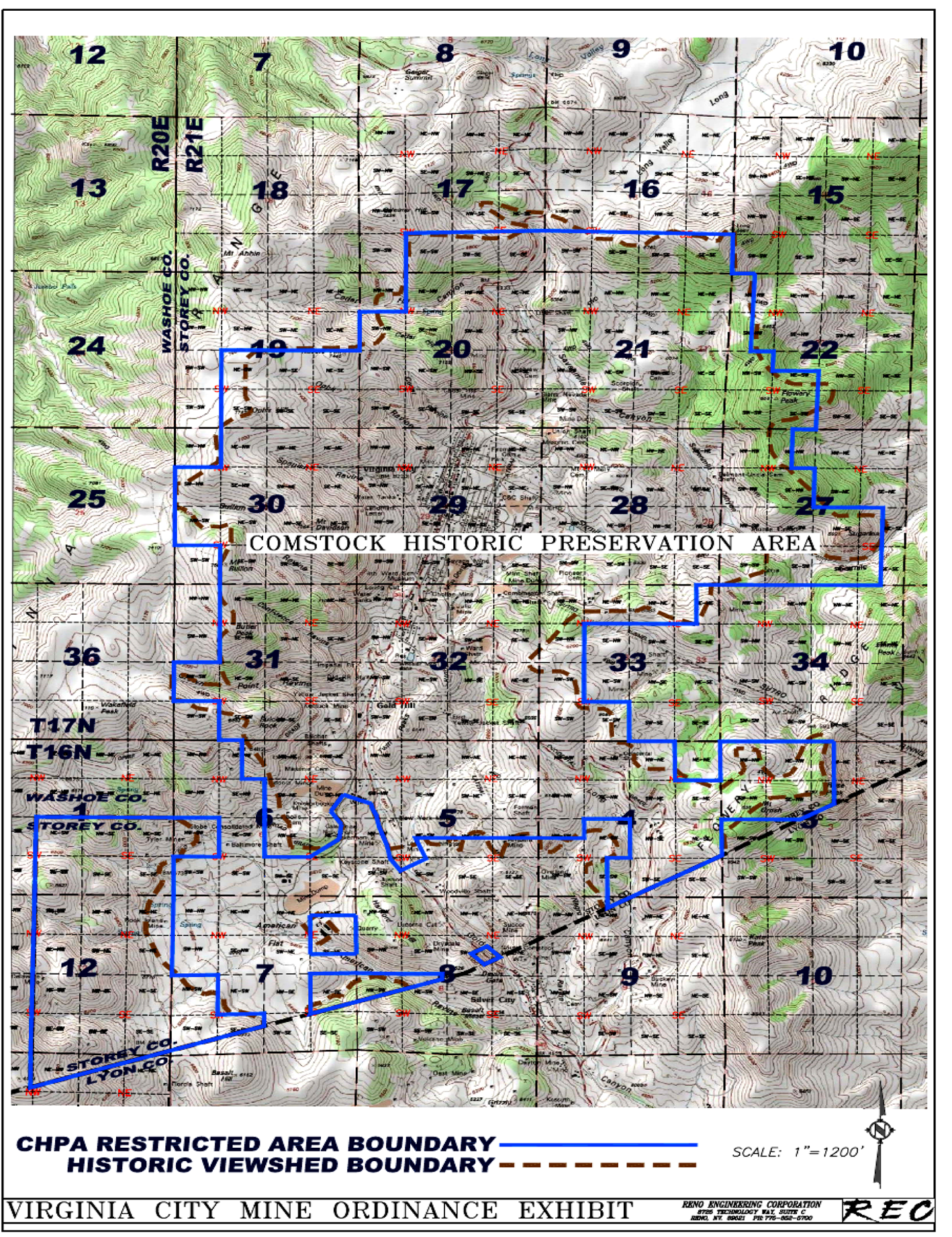
Appendix A. Comstock Historic Preservation Area Map
The Comstock Historic Preservation Area is located entirely within the boundaries of the Comstock Historic District but does not encompass the entire district. Its boundaries conform to the historic viewshed parameters from the Gold Hill and Virginia City town sites as shown in the Sensitivity Study of the Storey County Portions of the Comstock Historic District (Reno, 1990) included with and as part of the Storey County Master Plan.
(Ord. No. 12-244, § I, 12-4-2012)