
Sunset Hills City Zoning Code
SECTION 6
- SUBDIVISIONS
The intent and purpose of Section 6 of this title is to promote the health, safety, morals, and general welfare of the community through the control of the division of land, promotion of a safe and adequate street system, securing of the proper distribution of population and the necessary open spaces for light, air, and recreation. This Section prescribes minimum and maximum requirements for design of subdivisions, procedures for the approval of subdivisions, procedures for the enforcement of the Section, and establishes penalties for the violation of the requirements herein.
6.1 - Street Standards.
The arrangement, character, extent, width, grade, and location of all the streets shall be considered in their relation to existing and proposed streets, to topographical conditions, to public convenience and safety, and in their appropriate relation to the proposed uses of the land to be served by such streets. The following standards shall apply.
6.1.1
General Standards. These apply to residential and non-residential types of subdivisions.
1)
The developer shall make provisions for the extension and relocation of major, collector, and minor streets which affect the property. Except for dead-end streets, streets normally shall connect with streets already established, or provide for future connections to adjoining unsubdivided tracts, or shall be a reasonable projection of streets in the nearest subdivision tracts.
2)
Where a subdivision abuts or contains an existing or proposed major street, the Planning and Zoning Commission may require frontage or service streets, double frontage lots with screen planting, and non-access strips at the rear of such lots.
3)
Minor street intersection jobs or discontinuities with centerline offsets of less than one hundred feet (100') shall be avoided.
4)
Reserved strips of land which control or limit access at the terminus of streets are prohibited.
5)
A tangent of less than one hundred feet (100') in length shall be avoided between reverse curves on major and collector streets.
6)
A subdivision entrance street shall intersect the major or collector street with an interior angle between seventy degrees (70 °) and ninety degrees (90 °) and be positioned to provide adequate sight distance along each intersecting roadway as determined by the City engineer.
7)
All streets intersecting major or collector streets shall be directly opposite existing or other proposed streets or shall be a minimum of three hundred feet (300') distant, as measured between street centerlines.
8)
Streets shall be constructed to St. Louis County standard specifications, as amended from time to time, except as otherwise specified in this ordinance.
9)
Any subdivision platted along an existing street shall provide additional right-of-way, not to exceed twenty feet (20') on either side.
10)
When the subdivision is located on one side of an existing street, required right-of-way width shall be provided as measured from the centerline of the right-of-way as originally established or as traveled.
11)
The board may require a street to be dedicated to public use wherein when it is deemed in the best interest of the traveling public in order to provide circulation.
12)
No building permit may be issued for any lots abutting a temporary turnaround as shown on any recorded subdivision plat unless and until the temporary turnaround is actually constructed and has been approved by the City engineer. In addition, no building permit will be issued for display units on proposed lots that would be located where temporary turnarounds are required. The Planning and Zoning Commission may grant a variance providing that the following conditions are met:
a)
The developer submits to the Planning and Zoning Commission statements from all prospective lot purchasers affected by the temporary turnaround, excluding the developer, declaring that they agree to the use of their driveways for executing the turnaround movements at the terminus of the street and acknowledging that any repairs made necessary due to damage to the driveway caused by the use of their driveway for the turnaround movement shall in no way be deemed the responsibility of the City of Sunset Hills; and
b)
The developer provides an easement for the turnaround movement approved by the Planning and Zoning Commission.
13)
Sidewalks are required for subdivisions that will include public streets within public right-of-way.
14)
Private streets, including multiple family access streets shall have pavement thickness constructed to City standards. Maintenance of these streets shall be the sole responsibility of the property owners or trustees of the subdivision.
15)
When streets are proposed as private, the developer shall be required to have either a trust indenture or statement on the record plat establishing the method for providing continuous maintenance of streets, as well as storm sewers.
16)
All roads proposed within a development and located within the flood plain shall be protected from flood damage as directed by the City Engineer.
17)
All utilities shall be placed underground. The developer shall contract with the St. Louis County Water Company for lines to serve all lots. Fire hydrants shall meet or exceed the recommendation of the insurance service office.
6.1.2
Residential Standards.
1)
Street right-of-way.
a)
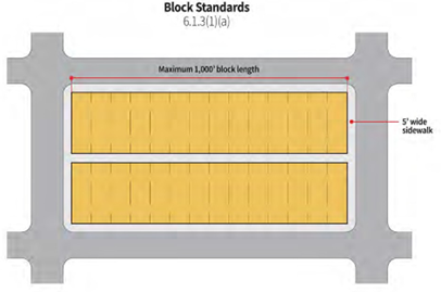
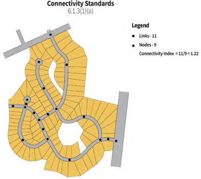
Blocks: No block shall be longer than one thousand feet (1,000') between street lines. Where it is desirable to subdivide a tract of land, which because of its size or location does not permit an allotment directly related to normal street arrangement, there may be established one or more "places." Such a place may be in the form of a court, a dead-end street or other arrangement; provided however, that proper access shall be given to all lots from a dedicated place (street or court). If such a place is more than one hundred fifty feet (150') in length, it shall terminate in an open space (preferably circular) having a minimum right-of-way radius of sixty feet (60'). In no instance shall the establishment of places reduce the connectivity index of a proposed subdivision below 1.2.
b)
Relation to adjoining street system: The arrangement of streets in new subdivisions shall make provisions for the proper location and width of major streets. The developer may be required to continue certain adjoining streets through the area that is being subdivided, whenever the same is necessary to provide for local movements of vehicles or to enable adjoining property to be properly subdivided.
c)
The minimum right-of-way of all streets within subdivisions shall be as follows:
i.
The minimum right-of-way width for all streets within subdivisions shall be fifty feet (50').
ii.
A minimum radius of twenty feet (20') at street right-of-way intersection and a minimum radius of thirty-two feet (32') at the back of the curb or edge of pavement shall be required. Greater radii may be required at the intersection and at the back of curb or edge of pavement of a street with a major or collector street as determined by the Planning and Zoning Commission.
iii.
Where a developer is subdividing property which does not have existing frontage on an existing public accepted road, he shall be required to connect the right-of-way and pavement in accordance with the above standards to the existing public accepted road or to a private street installed in accordance with the minimum standards of this ordinance, provided, however, that where it is not practicable for the developer to acquire the full fifty-foot (50') width of right-of-way and it is possible to provide easements for all required utilities to accessible for other parts of the subdivision in the rear or sides of lots and from adjacent property or the additional right-of-way width is not necessary, then a minimum right-of-way width of thirty feet (30') shall be required between the boundary of the subdivision proper and the existing paved street, and the width of the paving to provide the correction shall be in accordance with the standard requirements within subdivisions.
iv.
Where a developer is subdividing property which is situated adjacent to, abutting or contiguous with an existing residential area serviced by a private street or road and said undeveloped tract of land does not have frontage on an existing public accepted road, and the developer is unable to comply with the provisions of paragraph (ii) of Section 5.1.2(1)(c), variances may be granted from the requirements of paragraph (ii) of Section 5.1.2(1)(c) pertaining to the width and construction requirements of private streets or roadways to be used by the developer for ingress and egress to and from the property to be subdivided.
d)
Streets that are obviously in alignment with others already existing and named shall bear the names of the existing streets. Before the final plan for the subdivision shall be approved, the developer shall submit to the Planning and Zoning Commission a statement from St. Louis County making recommendations concerning the names of the proposed system of postal addresses along such streets, all subject of the final approval of the Planning and Zoning Commission. The developer shall provide and install all street name signs in accordance with instructions from the Director of Public Works.
e)
All streets, places, and parks except as otherwise provided for in this Section shall be established as private ways and areas. Provision shall be made in the deed restrictions accompanying the plat to dedicate such ways and areas to a subdivision. The restrictions shall make proper provisions for a board of trustees to have the power of assessment of property owners in the subdivision for the supervision, maintenance and construction or reconstruction of improvements on such ways, streets, or areas.
2)
Grading.
a)
Where the preliminary plat indicates that extensive grading and compaction are probable, the City Engineer may require the submission of additional information and modifications in the proposed plat before the developer may grade any land to be subdivided.
b)
A grading permit or approved improvement plans are required prior to any grading on the site. Erosion and siltation control devices shall be required as directed by the City Engineer.
c)
Proposed grading which creates a change in watersheds shall not be permitted.
d)
The Planning and Zoning Commission may require evidence as to the subsurface soil, rock, and water conditions of the tract to be developed.
e)
No fill material shall be placed in any floodplain area unless an equal volume of material is simultaneously removed from the same site.
3)
Paving engineering standards.
a)
Finished street grades shall not be less than one and one-half percent (1.5%) nor more than seven percent (7%). The Board of Aldermen, with a two-thirds vote, may approve a grade not to exceed ten percent (10%).
b)
All paving shall have a minimum width of twenty-six feet (26'), unless otherwise approved by the Planning and Zoning Commission. Cul-de-sacs shall have a minimum outside diameter of one hundred six feet (106'), unless arranged for one-way traffic around a circle in which case the minimum paving width shall be twenty-two feet (22'). Where, in the opinion of the Planning and Zoning Commission, a collector or arterial street is being constructed, a width greater than twenty-six feet (26') may be required.
c)
Construction standards: Paving of new streets shall be of a character suitable for the expected traffic and in harmony with surrounding areas. Curbs and gutters shall be provided. For primary streets, the minimum thickness of plain concrete pavement shall be eight inches (8") gutter to gutter; for secondary streets, the minimum thickness of plain concrete pavement shall be seven inches (7") gutter to gutter.
d)
All new streets, public or private, must be portland cement concrete with doweled center joint, doweled transverse joints and a four-inch (4") rolled stone base. The mix design shall be at least a six-sack mix with five percent (5%) entrained air. Maximum slump shall be three inches (3"). The contractor shall provide the City with evidence of the mix design.
e)
The base rock shall be compacted to ninety-five percent (95%) maximum compaction using the modified Proctor method. Compaction tests shall be performed by a firm chosen by the City and the City shall be provided with the results of said tests.
f)
Underdrains constructed to City standards shall be placed behind the curb on all new streets. Streets with a grade in excess of seven percent (7%) must include through storm drains and pavement lugs constructed according to St. Louis County Standards.
g)
There shall be no street tree requirements. No street trees nor shrubs shall be planted within three feet (3') of any street pavement or sidewalk.
h)
Street lights in new subdivisions shall conform to Ameren requirements and shall be installed at all street corners and at all cul-de-sacs; however, no lights shall be located closer than four hundred feet (400') apart.
i)
The Planning and Zoning Commission shall designate primary and secondary streets within the subdivision when reviewing the preliminary plans submitted by the developer or property owner. Paving shall be in accordance with these standards and applicable sections of St. Louis County construction standards.
j)
Prior to the application of base and surface course materials, the City Engineer or his delegate shall inspect the grading for streets and alleys to determine that the requirements for grading and other requirements hereof have been fulfilled. It shall be the responsibility of the developer to notify the City Engineer or his delegate not less than forty-eight (48) hours in advance that the work is to be ready for inspection. In the event that the developer fails to notify the City Engineer or his delegate, the developer shall pay for all costs of inspection, including test borings, laboratory analysis, or such other tests as required by the City Engineer.
k)
Acceptance and final approval: Before the applicant's obligation to the City of Sunset Hills is terminated, all required improvements shall be constructed under the observation and inspection of the inspecting agency and accepted for maintenance or given final approval by the City of Sunset Hills. A complete set of all "as built" construction drawings for streets, storm and sanitary sewers, and other utilities shall be filed with the City Clerk before the improvement bond, escrow or financial guarantee will be released.
4)
Stormwater standards.
a)
Adequate provision shall be made for the disposal of stormwater, subject to the approval of the Planning and Zoning Commission and the Metropolitan Sewer District. The detailed plans for the proper disposal of stormwater affecting the proposed subdivision, including the runoff from the area tributary as well as the area being developed, shall include such improvement as may be necessary to all open drainage channels, such as widening, straightening and paving, and a system of underground pipe sewers and appurtenances, which shall be separate and independent of the sanitary sewer system. The plans shall be prepared by a professional engineer, registered to practice in the State of Missouri, in accordance with the standard specifications and requirements of the Metropolitan St. Louis Sewer District.
b)
Plans for stormwater facilities, when submitted to the Planning and Zoning Commission for approval, shall bear the stamp of the approval of the Metropolitan St. Louis Sewer District.
c)
The construction of stormwater facilities shall be under permit from the inspection of said Metropolitan St. Louis Sewer District, and upon completion of construction, acceptance for maintenance by said Metropolitan St. Louis Sewer District shall be obtained by the subdivider from the district, in accordance with the regulations and requirements of said district.
d)
If stormwater detention is required by the Metropolitan Sewer District or the City of Sunset Hills for single-family residential subdivisions, it shall be provided underground in pipes or chambers designed for such detention. The pipes or chambers shall be constructed of reinforced concrete and shall be covered with earth and shall not be located in the principal building area of any lot. Dry or wet above ground detention shall not be permitted in single-family subdivisions.
5)
Sanitary sewers.
a)
A system of sanitary sewers and appurtenance, providing a connection to each lot in the subdivision, designed in accordance with the standard specifications and requirements of the Metropolitan St. Louis Sewer District and installed under permit from and inspection of said sewer district, shall be installed in the subdivision, original construction shall include installation of house laterals to the property line for all lots in the subdivision.
b)
Plans for the sanitary sewer system shall be prepared by a professional engineer, registered to practice in the State of Missouri, and shall carry the stamp of approval of the Metropolitan St. Louis Sewer District when submitted to the Planning and Zoning Commission for approval.
c)
Construction of the sanitary sewer system and inspection of Metropolitan St. Louis Sewer District and, upon completion of construction, acceptance for maintenance by Metropolitan St. Louis District shall be obtained by the subdivider from the district, in accordance with the regulations and requirements of said district.
d)
The sanitary sewer system, of the subdivision, when completed, shall connect to the sanitary sewer lines of the Metropolitan St. Louis Sewer District; or, except as provided in Subsection g) below, if such connection is impracticable, the subdivider shall provide a local sewage disposal facility for the subdivision.
e)
Plans and specifications for such local sewage disposal facility shall be prepared for the subdivider by a professional engineer registered to practice in the State of Missouri, and the facility shall be designed and installed in accordance with the regulations of the state Board of Health and under the inspection of the St. Louis County Health Department and Metropolitan St. Louis Sewer District.
f)
Acceptance of a local sewage disposal plant for operation and maintenance shall be by Metropolitan St. Louis Sewer District and shall be obtained by the subdivider in accordance with the requirements of said sewer district.
g)
In cases where no outlet to the sanitary sewer system of the Metropolitan St. Louis Sewer District is reasonably available for a two-lot subdivision development and where each lot contains a minimum of one acre, the subdivider may be permitted to install a disposal system for each lot (septic tank with disposal field). Such individual sewage disposal systems shall be erected in accordance with the regulations and requirements of the state Board of Health and under the supervision and inspection of the St. Louis County Health Department.
6)
Easements.
a)
All proposed subdivisions shall have easements as determined by the Planning and Zoning Commission to be adequate for the installation and maintenance of utility facilities, including cable television distribution systems.
b)
Where a cut or fill for a street extends beyond the limits of the right-of-way, the developer shall provide a slope easement or special escrow as determined by the Planning and Zoning Commission to be of sufficient area and limits to permit the construction and maintenance of the slope.
c)
Whenever a stream or surface drainage course is located in an area proposed for a subdivision, the developer shall provide an easement determined by the Planning and Zoning Commission to be adequate in area to contain facilities to take care of flooding or erosion along the stream or surface drainage course.
7)
Stormwater and stormwater control easement.
a)
Stormwater easements and drainage rights-of-way may be required if necessary, for proper drainage within and through a subdivision.
b)
Stormwater control easements are required along all major creeks and significant tributaries; around and including all new wet lakes functioning as part of a stormwater control system; and for all detention areas, basins, and related structures.
c)
Stormwater control easements shall include a minimum dimension of twenty feet (20') back from the bank of improved creek channels as approved on improvement plans, or of such width back from unimproved channels as required by MSD. Easements shall include a distance of not less than ten feet (10') back from the estimated high-water line of lakes, dry detention areas, and basins.
d)
Final location of stormwater control easements shall be approved by MSD and the county as part of the improvement plan approval. Such easements shall subsequently be shown on a record plat or special easement plat.
e)
In addition to stormwater control easements, stormwater control access easement shall be required as necessary to provide for upkeep of the area within designated stormwater control easements. Separately designated access easements shall not be less than twenty feet (20') wide.
f)
The Planning and Zoning Commission shall require script on the record plat or trust indentures for all development containing stormwater control easements and access easements to such areas, specifying assessments for and maintenance of such particular areas apart from other common land, until MSD accepts the easements.
8)
Survey monuments.
a)
Where none are existing, survey monuments shall be placed by a registered land surveyor at street corners; i.e., at a four-way intersection, two corners are required to be monumented, and at a three-way intersection, one corner is required to be monumented. For all other types of intersection, monuments shall be placed as determined by the City Engineer. In addition, monuments shall be so located to find angle points, points of tangency of curves on one side of the street, and at all out-boundary corners.
b)
Should conditions prohibit the placing of any monuments at the above locations, offsetting of the permanent marker is permitted; provided, however, that the exact offset courses and distances are shown on the letter of certification when monuments are set. If a monument would be in a driveway, a cross, steel pin, iron pipe, or railroad spike would be permitted in concrete or asphalt.
c)
Monuments shall be of Portland Cement concrete, four square inches (4 sq. in.) on the top tapering to six square inches (6 sq. in.) on the bottom; stone, four square inches (4 sq. in.) or larger; and iron pipe or steel pins, from one half inches (0.5") to one and one-half inches (1.5") in diameter. All monuments noted above will have a length of two feet (2') or longer.
d)
An existing permanent benchmark, or a new permanent benchmark shall be accessibly established and shall be accurately noted on the record subdivision plat.
9)
Disclosure of responsibility of street maintenance.
a)
So long as there shall be a private street or a street not accepted by the City for maintenance within any subdivision, no person shall sell, lease, rent, offer to sell, lease or rent, or advertise for sale, lease or rental, any dwelling unit or non-residential property without disclosing to each prospective purchaser or tenant his responsibility with respect to subdivision streets in the manner required by this section. For the purpose of this section, "prospective purchaser or tenant" includes any person making inquiry of any responsible party with respect to purchase, rental, or lease of a dwelling unit or non-residential facility.
b)
Disclosure shall be made to each prospective purchaser or tenant in substantially the following form, where applicable:
i.
THE STREETS IN THIS SUBDIVISION ARE PRIVATE. THE OWNERS, HOMEOWNERS' ASSOCIATION, OR CONDOMINIUM ASSOCIATION ARE RESPONSIBLE FOR ALL REPAIRS AND MAINTENANCE; or
ii.
THE CONSTRUCTION DESIGN OF THESE STREETS HAS BEEN APPROVED BY THE CITY OF SUNSET HILLS. UNTIL SUCH TIME AS STREETS ARE ACCEPTED BY THE CITY FOR MAINTENANCE, THE OWNERS, HOMEOWNERS' ASSOCIATION, OR CONDOMINIUM ASSOCIATION WILL BE RESPONSIBLE FOR ALL REPAIRS AND MAINTENANCE; or
iii.
THE STREETS IN THIS SUBDIVISION WHICH ARE CONSTRUCTED BELOW THE FLOOD ELEVATION ARE PRIVATE. THE OWNERS ARE RESPONSIBLE FOR ALL REPAIRS AND MAINTENANCE.
c)
Such modifications of the above language shall be made, and only such modifications may be made, as are necessary to plainly and accurately portray the current and future status of subdivision streets. Any reference in such disclosure to a board of trustees or managers or similar persons shall further disclose the manner of selection of existing and future trustees or managers and the manner in which any costs borne by such persons will be defrayed.
d)
The requirements of this section shall be complied with by any developer, development corporation, lender, title company, real estate broker, corporation, agent, manager or management corporation, and each agent or employee of any of the foregoing to the extent of involvement in marketing of subdivision property.
e)
It is the responsibility of each responsible party to accomplish the disclosure required by this section. Without limiting the generality of this obligation, a copy of the required disclosure, in any event shall be prominently listed in the sales office.
10)
Lots.
a)
All sidelines of lots shall be at right angles to straight street lines, or radial to curved street lines, unless a variation to this rule will give a better street and lot plan. Lots with double frontage shall be avoided.
b)
The minimum width of any lot in a subdivision shall not be less than the minimum width requirements of the zoning district in which the lot is located.
c)
The minimum area of any lot in a subdivision shall not be less than the minimum lot area requirements of the zoning district in which the lot is located. Lots with an area larger than the minimum requirements are desirable. Streets, roads, lanes, or easements for the same therefor shall not be included in minimum lot area.
d)
All developments with lots solely fronting on major streets should have a turnaround maneuvering area which eliminates having to back out onto streets.
e)
Two adjacent lots may share a common curb cut where it can be demonstrated that topography would require driveway slopes greater than twelve percent (12%) for house construction without the construction of measures such as extended foundations or retaining walls in order to match existing conditions. Driveway easements for the use of that portion of the adjoining property shall be provided by the owners.
11)
Building lines shall be shown on all lots intended for residential use of any character, and on commercial lots immediately adjoining the residential areas. Such building lines shall not be less than required by the Unified Development Ordinance. Provisions shall be made by indenture of restrictions requiring all parts of the building to be set back of such building lines.
12)
In subdividing property, consideration shall be given to suitable sites for schools, parks, playgrounds, and other common areas for public use, so as to conform to the recommendations of the Planning and Zoning Commission. Any provisions for schools, parks, and playgrounds should be indicated on the preliminary plan in order that it may be determined when and in what manner such areas will be dedicated to or acquired by the appropriate taxing agency. If such facility is to be retained in private ownership, then a suitable indenture must be provided and submitted for approval of the Planning and Zoning Commission.
6.1.3
Non-residential standards. In addition to the principles and standards in this ordinance which are appropriate to the planning of all subdivisions, the developer shall demonstrate to the satisfaction of the Planning and Zoning Commission that the street, parcel, and block pattern proposed is specifically adapted to the uses anticipated and takes into account other uses in the vicinity. The following principles and standards shall be observed:
1)
Proposed non-residential blocks shall comply in area and dimensions with all underlying zoning requirements for the types of non-residential development anticipated.
2)
The minimum right-of-way width for streets within non-residential subdivisions shall be fifty feet (50'). Paving width of streets shall be a minimum of twenty-six feet (26') and sidewalks shall be a minimum of five feet (5') with five feet (5') of planting strip between the sidewalk and curb. Streets terminating in a cul-de-sac shall have a circular paved open space of one hundred ten-foot (110') diameter, and a right-of-way of one hundred twenty-foot (20') diameter.
3)
Adjacent residential and other nonindustrial areas shall be protected from the potential nuisances of non- residential development. Protection methods shall comply with Section 4.2.3 of this ordinance.
4)
Streets carrying non-residential traffic, especially truck traffic, shall not be extended to the boundaries of adjacent existing or potential residential areas, as detailed in the Sunset Hills Comprehensive Plan, or connected to streets intended for predominantly residential traffic.
6.1.4
Procedure for the acceptance of private streets for public maintenance. The following procedures shall be followed in order to present an application to the Board of Aldermen for acceptance of private streets for maintenance by the City of Sunset Hills, Missouri ("City"):
1)
The adjacent property owners or their representative ("applicant") shall submit an application to the Department of Public Works ("Department") requesting that the City consider accepting a private street for maintenance by the City. If the subject street is within a subdivision that has a homeowners' or property owners' association, the application shall be joined or written by an authorized representative of the association board, and the application shall include any subdivision plat, indentures, declarations, bylaws, and any other governing documents applicable to the subdivision.
2)
The Director of Public Works shall present the application to the Public Works Committee. The department shall review the condition of the subject street and document all of the department's concerns including, but not limited to, street condition, legal issues, and ownership issues. The department shall also prepare a non-compliance report of any deficiencies that do not comply with the City street standards and codes. The Department shall further prepare a report regarding the annual maintenance costs to the City if the private street is accepted for public maintenance. The department's reports will be presented to the Public Works Committee and provided to the applicant.
3)
If the subject street is not fully compliant with all City street standards and codes, then the applicant shall submit detailed engineering plans which specify all necessary improvements required to cure any deficiency and bring the street into full compliance with City standards and codes. The proposed construction plan shall include a complete and accurate cost estimate for all proposed improvements and shall be certified by a licensed and registered design professional. After receiving the proposed construction plan, the department shall review them to determine whether the application and plans are complete and will cure the deficiencies.
4)
The application, construction plans, and department reports shall be submitted to the Public Works Committee, then to the Planning and Zoning Commission for review, evaluation, and a recommendation for approval. The applicant shall meet with the Public Works Committee and Planning and Zoning Commission and jointly collaborate in an attempt to resolve all outstanding issues relating to street standards. The Public Works Committee shall provide a recommendation to the Planning and Zoning Commission in favor of or against approval of the application. The Planning and Zoning Commission shall provide a recommendation to the Board of Aldermen in favor of or against approval of the application.
5)
The recommendations of the Public Works Committee and the Planning and Zoning Commission together with the application, construction plans, and all department reports shall be presented to the Board of Aldermen for consideration. The board shall consider, among other factors, who benefits from accepting the private street for public maintenance, the annual costs to the City, and any compelling public interest in accepting the private street. The City shall not accept any private street that does not allow public access.
6)
The Board of Aldermen shall vote on whether to accept the private street(s) for public maintenance and the board's acceptance is conditional upon the timely construction of improvements to raise the street(s) to City street standards and code. The recommendations of the Public Works Committee and the Planning and Zoning Commission shall not be binding upon the Board of Aldermen. Construction shall begin within three months of conditional board acceptance and shall be completed within one year without penalty unless expressly approved otherwise. The applicant is responsible for ensuring that construction is timely and properly completed, as agreed, in order to raise the street to City standards and codes. The applicant is responsible for all costs including but not limited to the costs of inspection, construction plans, and construction.
7)
Upon the Director of Public Works certifying that the subject street is fully compliant with City standards and codes, the Director will so inform the Board of Aldermen. After the Director informs the Board of Aldermen, the Board's acceptance will no longer be conditional, and the private street shall be deemed accepted by the City for public maintenance.
6.2 - Procedure.
6.2.1
Submission of concept plan. Prior to submitting a preliminary plat for the resubdivision of land within the corporate limits of the City of Sunset Hills, the developer may submit to the Planning and Zoning Commission a concept plan for the tract. Upon submission, the concept plan shall be posted on the transparency portal on the City's website. The City Engineer is required to advise aldermen of the respective ward when a developer notifies the City of its intent to submit a concept plan.
1)
The concept plan shall include the following information, all of which may be based on sources of information other than field survey data:
a)
The location of the tracts in relation to the surrounding area.
b)
The approximate location of all existing structures within the tract proposed to be retained and wooded areas within the tract or within two hundred feet (200') of the tract.
c)
The names of the owners of all the property adjoining the tract as disclosed by the most recent assessor's record.
d)
All existing streets, roads, wet and dry weather watercourses, and other significant physical features within the tract and within five hundred feet (500') of the tract.
e)
Approximate location of proposed streets and property lines.
f)
Direction of and approximate distance to nearest elementary and high school.
g)
A sketch of proposed site plan.
h)
A north arrow and graphic scale.
i)
Direction of and approximate distance to nearest existing major street intersections.
j)
Approximate location of any historical building within the boundaries of the tract.
k)
Intended method for processing sanitary waste.
2)
The Planning and Zoning Commission shall review and evaluate the concept plan as soon as practical and shall report to the developer its opinion as to the merits and feasibility of the improvements contemplated by the concept plan. This review and opinion shall not be construed as an approval.
3)
In the event that the developer elects not to submit a concept plan, all information contained thereon shall be submitted on or with the preliminary plat.
4)
The concept plan, as well as all staff and commission reports, will be posted on the transparency portal on the City's website.
6.2.2
Preliminary plat.
1)
The developer shall prepare and submit to the Planning and Zoning Commission such number of copies of a preliminary plat of the tract as shall be required. Such preliminary plat shall be submitted after receipt of the Planning and Zoning Commission's report on the concept plan, if a concept plan was submitted. Upon submission, the preliminary plat shall be posted on the transparency portal on the City's website. The preliminary plat shall be any scale from one-inch (1") equals twenty feet (20') through one-inch (1") equals one hundred feet (100'), so long as the scale is an increment of ten feet (10') and shall contain the following information:
a)
All information required in section 2.1, submission of concept plan, if no concept plan has been submitted.
b)
A key map showing the tract and its relation to the surrounding area.
c)
A north arrow and graphic scale.
d)
The name proposed for the tract or such part of the tract as is proposed to be subdivided, which shall be original and not a duplication of the name of any previously recorded subdivision or development in St. Louis County. The developer shall include a certification from the Recorder of Deeds office of St. Louis County to this effect.
e)
The date of plan submission to the Planning and Zoning Commission and the following names and addresses:
i.
The record owner or owners of the tract.
ii.
The party who prepared the plat.
iii.
The party for whom the plat was prepared.
iv.
The engineer and land surveyor who will design improvements for and survey the tract or such part of the tract as is proposed to be subdivided.
f)
The approximate area of the tract stated in 0.1 of an acre.
g)
Sufficient existing and proposed contour data to indicate the slope and drainage of the tract and the high and low points of the tract. Contour data shall extend one hundred fifty feet (150') beyond the limits of the subdivision boundaries. U.S.G.S. data is required.
h)
The location of existing and proposed lines, water courses, sink holes, areas within the tract subject to inundation by stormwater, railroads, bridges, culverts, storm sewers, sanitary sewers, easements of record, existing buildings including use or other identified improvements that are to remain, and significant natural features such as wooded areas and rock formations.
i)
The location of existing and proposed streets including additional right-of-way along existing streets as required in Section 6.1.
j)
The results of any tests made to ascertain subsurface rock and soil conditions and the water table.
k)
The zoning district, including delineation of flood plain, if any, and the Township, Range, Section, and U.S. Survey, school district, fire district, water company, and other special districts in which the tract is located.
l)
Any proposed alteration, adjustment, or change in the elevation or topography of any area shown on the Federal Emergency Management Agency's (F.E.M.A.) flood boundary and floodway maps.
m)
Approximate area in square feet of minimum and maximum size lots, if less than one (1) acre in area, and in acres and tenths of acres if one (1) acre or more in area, into which the tract is proposed to be subdivided.
n)
Indicate approximate location of existing and proposed sidewalks and pedestrian walkways.
o)
Indicate proposed building lines and setback requirements.
p)
Proposed type of treatment or method of sewage disposal to include name of trunk line, lateral or qualified sewage treatment system, where applicable.
q)
A certification by registered land surveyor or engineer who prepared the plat that the plat is a correct representation of all existing and proposed land divisions.
r)
Fire district comments must be received prior to preliminary plat approval for developments that have a single ingress and egress, and where variances are requested for pavement width reduction, maximum cul-de-sac length and number of units or lots served on a cul-de-sac.
s)
A copy of the preliminary plat shall be sent to the City Engineer and Director of Public Works for their review and comments. A copy of the City Engineer and Director of Public Works comments shall be transmitted to the Planning and Zoning Commission.
2)
Development of parcels within the F.E.M.A. designated floodplain shall require approval of a floodplain study.
3)
The Planning and Zoning Commission shall review the preliminary plat and shall approve or disapprove the plat within ninety (90) days from the date of filing.
a)
If the plat is satisfactory, the chairman or his authorized representative shall thereupon affix a notation of approval, date of approval and his signature on the plat, denoting satisfactory compliance with the requirements of this ordinance. The plat shall be returned to the applicant who may then proceed in compliance with subsection 2.6 of this Article.
b)
If the preliminary plat is unsatisfactory, the Planning and Zoning Commission shall give notice to the submitting party in writing, setting forth the conditions causing the disapproval, and the unsatisfactory conditions shall be remedied prior to further consideration by the Planning and Zoning Commission.
c)
Whenever a preliminary plat includes a proposed establishment of common land, and the Planning and Zoning Commission finds that such land is not suitable for common land due to terrain, benefit to a small portion of the lot owners, difficulty of maintenance or any similar reason, the Planning and Zoning Commission may either refuse to approve such an establishment, or it may require the rearrangement of the lots in the proposed subdivision, to include such land. In any case where the establishment of common land is permitted to be included in the subdivision of a tract, a trust indenture shall be recorded simultaneously with the record plat which shall provide for the proper and continuous maintenance and supervision of said common land by trustees to be selected and to act in accordance with the terms of such indenture and the common land shall be deeded to the trustees under said indenture by general warranty deed. Any alterations of the common land or improvement will require the submission of detailed improvement plans and will be considered a required improvement; the submission shall be made to and approved by the Planning and Zoning Commission.
d)
The approval by the Planning and Zoning Commission of the preliminary plat shall be valid for a period of one year from the date of approval or such longer period as the Planning and Zoning Commission may determine to be advisable if after review by the Planning and Zoning Commission such longer period is necessary to facilitate adequate and coordinated provisions for transportation, water, sewerage, schools, parks, playgrounds or other public requirements. If no record plat of a subdivision or any part of the tract for which a preliminary plat has been approved is recorded within said one-year (1-year) period, or such longer period as the Planning and Zoning Commission shall permit, a resubmission and review of the resubmission by the Planning and Zoning Commission shall be required.
e)
The preliminary plat, as well as all staff and commission reports, will be posted on the transparency portal on the City's website.
6.2.3
Improvement plan requirements. After the preliminary plat is approved, improvement plans prepared by an engineer for the subdivision of all or any part of the tract shall be submitted for review to the Planning and Zoning Commission. Upon submission, the improvement plan shall be posted on the transparency portal on the City's website. Improvement plans shall contain the following information:
1)
Title page, which shall include a key map, showing the relationship of the area to be subdivided to the tract and which shall reflect areas of the tract previously subdivided plus adjacent streets.
2)
North arrow and graphic scale.
3)
Title block showing the name and address of the developer and engineering firm, as well as the engineer's seal.
4)
One or more benchmarks, in or near the subdivision, to which the subdivision is referenced. The identity and elevation shall be based on sea level datum.
5)
List of the standards and specifications followed, citing volume, section, page, or other references.
6)
Paving details conforming to City specifications.
7)
Details of streets, sidewalks, existing and proposed sanitary sewers, drainage channels, swales, and storm sewers.
8)
Plans and profiles of streets and sewers, scale not less than one-inch (1") equals one hundred feet (100') horizontal; and one-inch (1") equals ten feet (10') vertical.
9)
Existing and proposed survey monuments on street plans or on submitted copy of plans to be on proposed record plat.
10)
A subdivision restriction agreement authorizing assessment of the property owners in the subdivision for the supervision, maintenance, construction and reconstruction of street paving, storm drainage facilities, sanitary facilitation, streetlights, sidewalks, common ground, and recreational equipment. If the proposed subdivision is small and does not reasonably require such an agreement, the Planning and Zoning Commission, upon advice of the City Attorney or special counsel, may waive the necessity of such an agreement provided that the subdivision does not contain any streets.
6.2.4
Improvement plan review procedure.
1)
If the subdivision is within the limits of the MSD, there shall be submitted copies of paving and street grading plans together with drainage maps and runoff sheets for stormwater. The plans shall be reviewed first by the City Engineer and then by the Planning and Zoning Commission. Corrections or additions shall be made, if needed, and when the plans are satisfactory to the City Engineer and to the Planning and Zoning Commission, they shall be approved for submission of the sewer plans to the MSD. After the MSD has approved sanitary and storm sewer plans, the approved plans shall again be submitted to the City Engineer and then to the Planning and Zoning Commission for review and final approval. Nothing in this ordinance shall prevent the developer from submitting improvement plans to the MSD prior to the improvement plans being submitted to the Planning and Zoning Commission. Complete approval of the plans by all reviewing agencies and payment of inspection fees constitute authority to start construction or to post bond or escrow to cover the cost of improvements.
2)
If the subdivision is not within the limits of the MSD, there shall be submitted the required number of paving and street grade plans together with drainage maps and runoff sheets for stormwater. The plans shall be reviewed first by the City Engineer and then by the Planning and Zoning Commission. The sanitary sewage facilities of the subdivision shall be reviewed first by the City Engineer, the proper St. Louis County approving authority and then by the Planning and Zoning Commission. Corrections or additions shall be made, if needed, and when the plans are satisfactory, the Planning and Zoning Commission shall give approval. Complete approval of the plans by all reviewing agencies and payment of inspection fees constitute authority to start construction or to post bond or escrow to cover the cost of improvements.
3)
Approval by the Planning and Zoning Commission of the improvement plans shall be valid for a period of two years from the date of approval, or for such longer period as the chairman may determine to be advisable if after review by the Planning and Zoning Commission such longer period is necessary to facilitate adequate and coordinated provisions for transportation, water, sewerage, schools, parks, playgrounds or other public requirements. If the construction of the improvements shall not have been completed within said two-year period or such longer period as the Planning and Zoning Commission may permit, a resubmission and review of the improvement plans by the Planning and Zoning Commission may be required.
6.2.5
Land subdivision improvements installed or guaranteed. After the improvement plans have been approved and all inspection fees paid, but before approval of the record subdivision plat, the applicant shall:
1)
Post a land subdivision bond or enter into an escrow agreement in accordance with the provisions hereafter set forth. The land subdivision bond or escrow agreement shall be prepared and executed on forms satisfactory to the Planning and Zoning Commission and shall be submitted to the Planning and Zoning Commission for approval. Said forms shall be approved by the City Attorney or special counsel prior to being sent to the Planning and Zoning Commission.
2)
A land subdivision bond shall be issued by a surety company or a title insurance company and shall insure or guarantee, to the extent of the amount specified by the Planning and Zoning Commission in its estimate of the cost of the land subdivision, the construction and completion of the improvements shown by the approved improvement plans.
3)
An escrow agreement shall provide that there shall be deposited with the escrow agent to be held in a special escrow account by the escrow agent, subject to audit by the City of Sunset Hills. The amount of the escrow shall not be less than the amount specified by the Planning and Zoning Commission in its estimate of the cost of the improvements as reflected by the approved improvement plans and shall be in one of the following forms:
a)
Cash; or
b)
An irrevocable letter of credit or commitment from a lending institution to the escrow agent guaranteeing to such escrow agent the availability of the amount on deposit from time to time upon demand;
c)
Certificates of deposit, treasury bills or other readily negotiable instruments, the type of which has been approved by the Planning and Zoning Commission and endorsed to the escrow agent.
4)
The bond shall remain in effect or the escrowed sum shall be held in the escrow account by the escrow agent, as the case may be, until such time as the Director of Public Works, with oversight by the City Administrator shall, by written authorization to the surety or escrow agent, release the surety from the obligation of the bond or the escrow agent from his obligation to retain the escrowed sum in the escrow account, which release may be partial and may occur from time to time, as improvements are completed, as required by the improvement plans and governing ordinance as applicable, and approved; provided, however:
a)
The Director of Public Works, upon recommendation of the City Administrator and the City Attorney, shall release the surety or escrow agent from all or any part of its obligation only upon receipt of the requisite written notification from the inspecting agency; and
b)
In no case shall the Director of Public Works, authorize the release of more than ninety-five percent (95%) of the amount held as the bond or escrow sum until said improvements have been completed in a satisfactory manner, approved by the Director of Public Works, with oversight by the City Administrator, and accepted or approved by the appropriate authority.
5)
The term of the land subdivision bond or the escrow agreement shall not exceed two years in duration subject to the following:
a)
If, at the end of the two-year period, all the improvements reflected by the approved improvement plan have not been completed, the Planning and Zoning Commission may extend the term of the land subdivision bond or the escrow agreement for a period not to exceed one additional year at each extension if after review by the Planning and Zoning Commission such longer period is necessary to facilitate adequate and coordinated provisions for transportation, water, sewerage, schools, parks, playgrounds or other public requirements. If said improvements have not been completed at the end of the two-year period or as extended by the Planning and Zoning Commission, the Planning and Zoning Commission may:
i.
Require the surety to perform on the bond and pay to the Planning and Zoning Commission such amount as shall be equal to the lesser of the amounts required to complete the improvements or the amount of the bond not theretofore released; or
ii.
Require the escrow agent to remit to the Planning and Zoning Commission in cash or negotiable instruments constituting the escrow sum, as the case may be, the balance in the escrow account required to complete the improvements and the balance, if any, in the escrow account which exceeds such amount shall be returned to the applicant; or
iii.
Require the applicant to submit a new land subdivision bond or escrow agreement which has been recalculated in order to allow for any inflation in the case of constructing improvements.
b)
If the surety fails to perform on the bond or the escrow agent fails to remit the amount required within 30 days after written request, the Planning and Zoning Commission may recommend that the City Attorney or special counsel take immediate action to require performance by the surety under the bond or to secure the payment by the escrow agent of the amount required.
6)
All escrow agents and sureties shall be subject to spot audits by the City of Sunset Hills under the supervision of the Planning and Zoning Commission. If the escrow agent or surety fails to comply with any of the provisions of the escrow agreement or the land subdivision bond, the escrow agent or surety shall not after that time be allowed to act as escrow agent or surety for any subdivision improvement in the corporate area of the City of Sunset Hills for a period of two years.
7)
If the developer petitions for acceptance of streets for public maintenance, and if the streets are so accepted, the developer shall post a bond acceptable in form to the City Attorney and in an amount sufficient to guarantee repairs due to construction and street failures. The bond shall be for a period of two years from the date of acceptance of the street.
6.2.6
Record plat. The record plat together with a copy of the subdivision indenture where such are too lengthy to be shown on the plat, and three (3) prints of certified plans showing the improvements that have been constructed within the subdivision (or a bond assuring construction of said improvements in accordance with plans previously approved) within a period of two (2) years shall be submitted to the Planning and Zoning Commission. The Planning and Zoning Commission shall act upon the final plat within sixty (60) days after it has been submitted unless the developer agrees to an extension of this period. The final plat is to be drawn at a scale of one hundred feet (100') or less to the inch from an accurate survey and on one or more sheets whose maximum dimensions are twenty-nine inches (29") by thirty-four inches (34"). In certain unusual instances where the subdivided area is of unusual size or shape, the Planning and Zoning Commission may permit a variation in the scale or size of the final plat. If more than two (2) sheets are required, an index sheet of the same dimensions shall be filed showing the entire subdivision on each sheet together with all areas shown on other sheets.
1)
The final plan shall show:
a)
The boundary lines of the area being subdivided with accurate distances and bearings; also, all sections, U.S. Survey and Congressional Township Lines and the boundary lines of incorporated areas, sewer, school, and other legally established districts within or adjoining the subdivided area.
b)
The lines of all proposed streets with their width and names, as well as the designation that the streets are private.
c)
The accurate outlines of any property which is offered for dedication for public use.
d)
The line of departure of one street from another.
e)
The lines of all adjoining lands and the lines of adjacent streets with their widths and names.
f)
All lot lines and an identification system for all lots and blocks.
g)
Building lines and easements for rights-of-way provided for public use, service or utilities with figures showing their dimensions.
h)
All dimensions, both linear and angular, necessary for locating boundaries of subdivisions, lots, streets, easements for building lines, and of any other areas for public or private use; the linear dimensions are to be expressed in feet and decimals of a foot.
i)
Radii, arcs and chords, points of tangency, central angles for all curvilinear streets, and radii for all rounded corners.
j)
All survey monuments and benchmarks together with their descriptions.
k)
The original record plat shall have a signature line for the Chairman of the Planning and Zoning Commission, the Mayor, the attestation by the City Clerk and a place for the ordinance number and the date of the ordinance.
2)
The record plat shall be filed with the Recorder of Deeds within sixty (60) days after approval by the Board of Aldermen, together with the restriction agreement provided in the improvement plan. If any record plat and restriction agreement is not filed within this period, the approval shall expire.
3)
One copy of the record plat and restriction agreement as filed with the Recorder of Deeds shall be filed with the City Clerk within 30 days after filing with the Recorder of Deeds. A building permit shall not be issued until the copy is filed with the City Clerk. If the record plat and restriction agreement is not filed with the City Clerk within the 30 days period, the approval shall expire.
(Ord. No. 2302, § 1, 7-11-2023)
6.3 - Lot Split Procedure.
No lot split shall be recorded in the office of the Recorder of Deeds unless and until approved by the Planning and Zoning Commission in compliance with this section. Whenever there is a tract or previously subdivided parcel under single ownership which is to be resubdivided into two lots, and which exists as a legal lot of record, such a division shall be designated as a "lot split" if the following criteria are met:
1)
That no additional improvements are required that would necessitate the posting of an escrow or bond, including water mains, and landscaping within a street right-of-way dedication. Establishment of a right-of-way only shall not be construed as an improvement in this section.
2)
That no provisions for common land or recreational facilities are included in the proposal.
3)
That the use of the lot split procedure does not adversely affect the subject parcel or any adjoining properties.
4)
That the proposed lot split is not in conflict with any provisions of the Unified Development Ordinance.
5)
No variances are required.
6.3.1
Procedure for the approval of a lot split.
1)
Two (2) drawings of a certified survey, prepared by a land surveyor registered in the State of Missouri on paper not less than eight and one-half inches (8.5") by eleven inches (11") in size showing the following shall be submitted:
a)
A legal description of both the original lot and each of the proposed lots. This must be surveyed and performed by a registered surveyor.
b)
North arrow and graphic scale.
c)
Location of proposed and existing streets and adjoining property.
d)
Location of all existing buildings.
e)
Within their boundaries of approval, improvements in Missouri American Water Company and the Metropolitan St. Louis Sewer District shall be shown on the tract drawings.
f)
Name, address, and telephone number of the owner of record and a copy of the deed of record.
2)
The following items shall accompany the required survey:
a)
Filing fee as set forth in the City's fee schedule.
b)
Certificate from the office of the St. Louis County Collector of Revenue showing that there are no delinquent taxes outstanding.
c)
Verification of fire hydrants and adequacy of water supply from applicable fire protection district.
d)
Verification of proper placement of survey monuments from the City Engineer, or an escrow agreement or land subdivision bond to guarantee installation of survey monuments in accord with subsection 6.1.3 of this ordinance.
3)
The Planning and Zoning Commission shall review the proposed lot split to ensure compliance with the Unified Development Ordinance including all design and improvement requirements. Lot splits found to be in compliance with the above requirements shall be approved by the Planning and Zoning Commission. The lot split plat shall be tendered to the St. Louis County Recorder of Deeds after adoption by the Board of Aldermen of an ordinance approving same.
6.4 - Minor Subdivisions.
1)
A subdivision shall be considered a minor subdivision if the division or redivision of land does not establish more than four lots which all meet the following criteria:
a)
That the proposed subdivision of land does not include an improvement within a street right-of-way, other than concrete sidewalks, landscaping, monuments, lateral extensions of sanitary and storm sewers, and water mains. Establishment of a right-of-way only shall not be construed as an improvement in this section. However, landscaping, street lights, monuments, and water mains shall be required unless waived. Requirement of any additional improvements or the use of any special procedure of the Unified Development Ordinance shall disqualify the proposed subdivision from consideration as a minor subdivision.
b)
That the proposed subdivision of land does not include a provision for common land or recreational facilities.
c)
That the proposed subdivision of land does not adversely affect, as determined by the Planning and Zoning Commission, the development of the parcel proposed for subdivision as well as the adjoining property.
d)
That the proposed subdivision of land is not in conflict with any provisions of the Unified Development Ordinance and no variance is required.
2)
The Planning and Zoning Commission may waive without a variance request the requirement of submission of all other plans except the record subdivision plat. However, in such cases, pertinent data as required by section 6.2.2, Submission and review of a preliminary plat, shall be submitted to the Commission for review.
3)
All requirements for the record plat shall be required prior to approval of any minor subdivision.
6.5 - Dwelling Unit Display Plat Procedure.
6.5.1
Purpose. To provide a procedure by which the construction of a display house or attached single-family display unit can begin prior to the recording of the record subdivision plat.
6.5.2
Procedure. After receiving approval of a preliminary plat of a proposed subdivision from the Planning and Zoning Commission the developer may submit a display plat to the City Engineer for review and approval. There may be two display houses or units for subdivisions proposing less than ten (10) lots or units. Developments containing at least 10 lots or units and not more than sixty (60) lots or units proposed shall be allowed three display houses. For developments containing greater than sixty (60) lots or units one additional display house or unit for every twenty (20) houses or units proposed beyond sixty (60) will be permitted, not to exceed ten (10) display houses or units.
6.5.3
Display plat. The display plat shall include a complete outboundary survey of the proposed subdivisions, and the location of each display in relation to proposed lots. The script shall comply with the requirements of the Planning and Zoning Commission including, but not limited to, the following:
1)
The display plat shall be recorded in the Office of the St. Louis County Recorder of Deeds prior to issuance of a building permit for any display.
2)
The display plat shall become null and void upon the recording of a record plat which establishes that each display is on an approved lot.
3)
No part of the proposed subdivision may be conveyed, nor an occupancy permit issued, for any structure in the proposed subdivision until the display house or units have been located on an approved lot.
4)
If initial construction of a display has not commenced within sixty (60) days, the Planning and Zoning Commission's approval shall lapse, and the display plat shall be null and void.
5)
Lots should be on an approved lot of record within one (1) year of the display plat's recording or such longer period as may be permitted by the Planning and Zoning Commission. If the record plat is not filed, the then-owner shall remove or cause to be removed all display houses or units from the property. Failure of owner to remove the display houses or units from the property within one year plus thirty (30) days of date of approval shall constitute the granting of authority of the City to remove or cause the display houses or units to be removed, the cost of which shall be borne by the owner and shall become a lien against the property.
6)
The display plat shall be executed by the owner and lienors.
6.6 - Boundary Adjustments; exceptions.
6.6.1
Purpose. The purpose of this section is to allow adjustments to be made to lot lines of platted lots or other lawful parcels for the purpose of adjusting the sizes of building sites; however, it is not intended that extensive replatting be accomplished by use of this section.
6.6.2
Boundary adjustments. Boundary adjustments must meet with following criteria:
1)
No additional lot shall be created by any boundary adjustment.
2)
The resulting lot or lots shall not be reduced below the minimum sizes and dimensions required by the Unified Development Ordinance.
6.6.3
Procedure.
1)
A boundary adjustment may be accomplished by plat or by deed but must include an adequate legal description of the boundaries of the original lots and of the adjusted lots.
2)
The boundary adjustment plat or deed shall be submitted to the Planning and Zoning Commission for review and approval prior to its recording with the Recorder of Deeds of St. Louis County.
6.7 - Fees.
Fees shall be required for the following and shall be included in the fees, penalties, and fines schedule of the City of Sunset Hills Municipal Code, as amended from time to time:
1)
Preliminary development plan and Final development plan;
2)
Amended development plan;
3)
Minor subdivision;
4)
Preliminary subdivision;
5)
Subdivision improvement plans;
6)
Subdivision record plat;
7)
Improvement plan approval;
8)
Boundary adjustment.
6.8 - Enforcement.
1)
No plat of any subdivision shall be entitled to be recorded in the County Recorder's office or have any validity until it shall have been approved in the manner prescribed in this Section.
2)
The appropriate designee shall not approve for issuance building or repair permits for any structure located on a lot in any subdivision the plat of which has been prepared after the date of the adoption of this ordinance, but which has not been approved in accordance with the provisions contained in this Section. Neither shall any building or repair permit be issued for a structure located on a lot which has been sold or transferred by metes and bounds if the deed for such lot was recorded after the date of the adoption of this ordinance.
3)
The Board of Aldermen shall not permit any public improvements over which it has any control to be made or any money expended for improvements in any area that has been subdivided or upon any street that has been platted after the date of the adoption of this ordinance unless such subdivision or street has been approved in accordance with the provisions contained in this Section.
6.9 - Penalties.
Any person, persons, firms, associates, corporations, agent, or employee of a firm, associate, or corporation, violating any of the provisions of this ordinance shall be punished in accordance with the fees, penalties, and fines schedule of the City of Sunset Hills Municipal Code.