
Tempe City Zoning Code
PART 5
- OVERLAY ZONING DISTRICTS
CHAPTER 5 — - HISTORIC OVERLAY DISTRICTS[2]
Chapter 5 was amended by Ord. No. 2005.19, adopted June 2, 2005.
CHAPTER 6 — - TRANSPORTATION OVERLAY DISTRICT[3]
Chapter 6 was amended by Ord. No. Ord. No. 2005.24, adopted Nov. 17, 2005.
Section 5-101 - Purpose.
The purpose of the Rio Salado Overlay District is to accomplish the objectives of the specific plan referred to as the "Tempe Rio Salado Plan" as adopted by the City Council. This district is necessary to provide an opportunity for a smooth transition to adjacent land uses.
Section 5-102 - Boundaries.
The location and boundaries of the Rio Salado Overlay District are established as shown on the map entitled "Zoning Map, City of Tempe", dated February 19, 2005, as amended.
Figure 5-102. Rio Salado Overlay District Boundary Map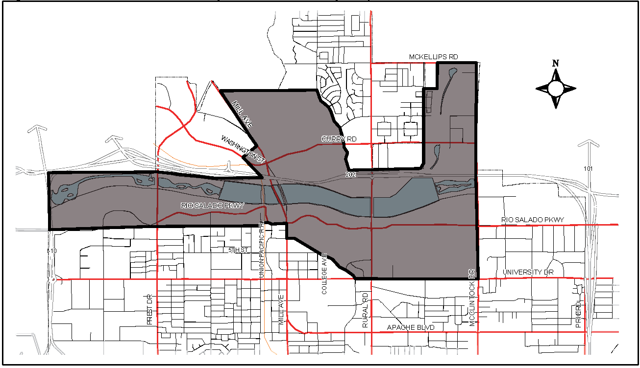
Section 5-103 - General Regulations.
A.
Rio Salado Advisory Commission. (Repealed)
B.
Review Procedure and Criteria. Proposals will be evaluated by the Tempe Rio Salado Advisory Commission, for applications processed through all decision-making bodies, in accordance with the overall intent of the following Tempe Rio Salado Plan objectives:
1.
Encourage the optimum development of land along the Salt River including: residential, commercial or industrial, open space, transportation and circulation, public facilities and services and adjoining land uses;
2.
Promote the development of recreational facilities; and
3.
Combine flood control with environmental design including the integration of lakes, ponds and streams.
(Ord. No. 2005.82, 1-5-2006; Ord. No. 2010.03, 3-4, 2010)
Section 5-104 - Additional Information and Regulations.
The following additional requirements apply:
A.
Flood Control. Flood control access zones in the district are:
1.
Zone "A": No objects or structures of any kind that would impede the motion of a maintenance vehicle are permitted in the fifteen (15) feet closest to the channel on either the levee or terrace as shown in Figure 5-104A;
2.
Zone "B": Only landscape and removable benches, ramadas or similar equipment that are approved by both the Flood Control District of Maricopa County and the City are permitted either in the ten (10) feet adjacent to the levee when the backfill is even with the top of the levee or the fifteen (15) feet adjacent to the base of the levee when the backfill is below the top of the levee as shown above. Replacement of any structural or landscape features within Zone "B" that are damaged as a result of emergency maintenance activities by the Flood Control District of Maricopa County shall be the sole responsibility of the owner or lessee of the site on which the features are located; and
3.
When the backfill is above the top of levee, Zone "A" restrictions apply, but there are no Zone "B" restrictions on objects or structures with regard to maintenance vehicle access.
Figure 5-104A. Flood Control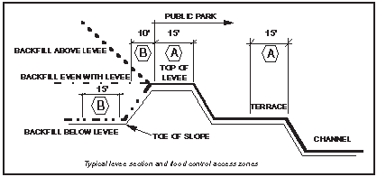
City Code reference—See TCC Chapter 7, bicycles; TCC § 12-16 et seq., flood control; TCC § 12-56 et seq., storm water retention.
Section 5-201 - Purpose.
The purpose of the Southwest Tempe Overlay District is to accomplish the objectives of the General Plan. This district is necessary to provide an opportunity for intense development with high standards.
Section 5-202 - Boundaries.
The location and boundaries of the Southwest Tempe Overlay District are established as shown on the map entitled "Zoning Map, City of Tempe", dated February 19, 2005, as amended.
Figure 5-202. Southwest Tempe Overlay District Boundary Map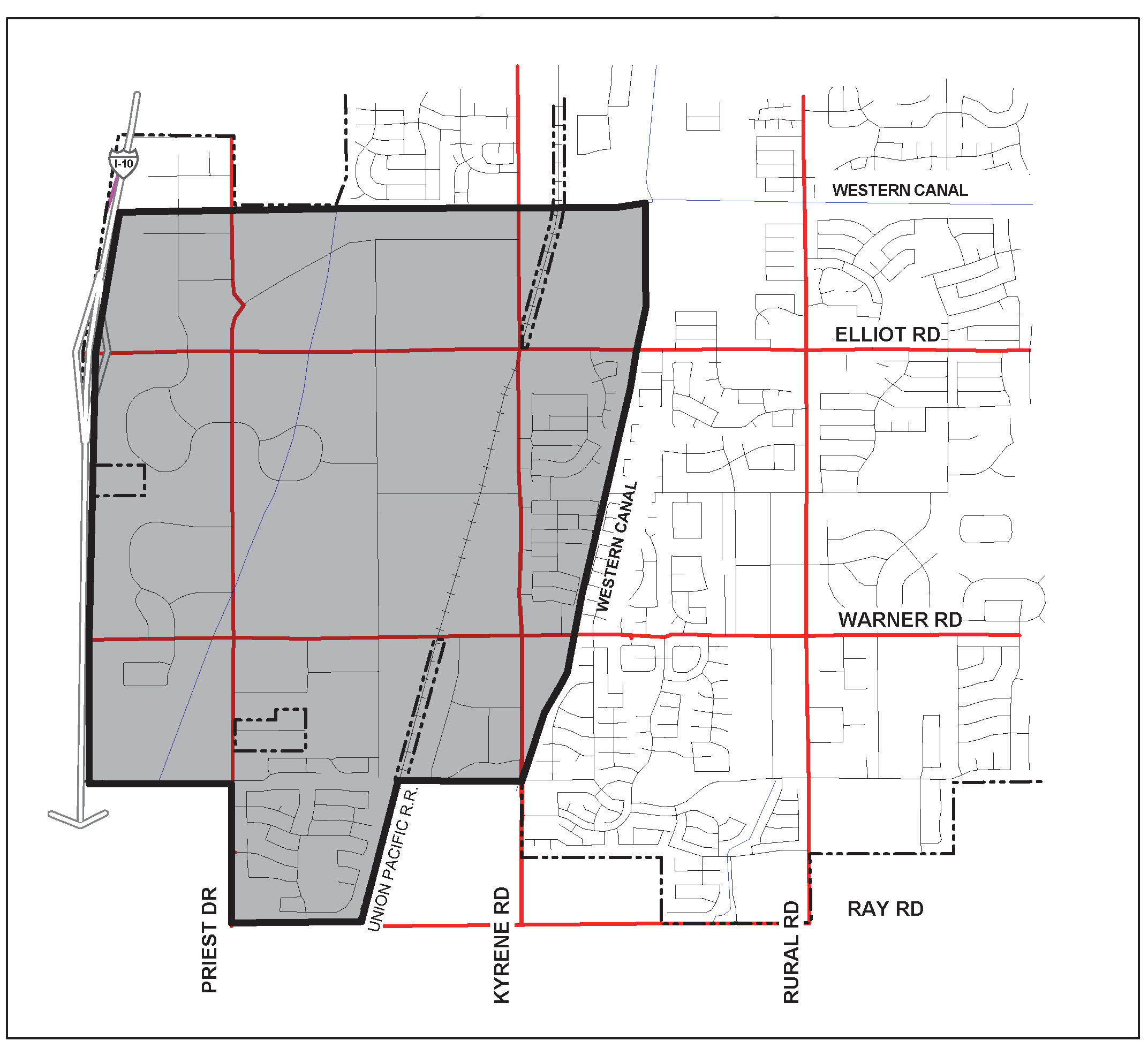
Section 5-203 - General Regulations.
A.
Land Use. All uses shall comply with the minimum regulations of the underlying zoning. All uses permitted in the underlying district, including uses permitted subject to use permits, are similarly permitted in the Southwest Tempe Overlay District, except as provided herein. Where the regulations for the overlay district differ from those of the underlying zoning the more restrictive regulations shall apply. In the granting of use permits the decision-making body must find that the proposed use is compatible with the overall intent of the Tempe General Plan.
B.
Review Procedure and Criteria.Development proposals shall be evaluated by the decision-making body in accordance with the overall intent of the following Southwest Tempe Overlay District objectives with emphasis on but not limited to:
1.
Encouraging the optimum development of land along the I-10 freeway and in the southwest portion of the City, thus promoting the development of a regional shopping center, major auto mall and other major retail uses. Such activities should be located in a master planned development adjacent to the I-10 freeway;
2.
Vehicular access to any individual automotive dealership should be from non-arterial streets;
3.
The overall site design of any individual automotive dealership, its buildings, parking areas, access points and signage should not adversely affect the present or potential development of nearby sites (either residential or commercial) or the traffic pattern on nearby streets;
4.
Sites for individual dealerships should be of sufficient size to provide for adequate visitor and employee parking, external display of vehicles for sale and appropriate buffering of repair operations;
5.
Spot or strip zoning patterns or uses should be discouraged;
6.
Used vehicles should be sold only in conjunction with new car sales; and
7.
Stabilizing the economic base of the City.
Section 5-204 - Prohibited Uses.
A.
Prohibited Uses. The following are prohibited uses:
1.
Abattoirs, stockyards and rendering plants;
2.
Junkyards, wrecking yards and salvageyards; and
3.
Sand and gravel excavating operations.
Section 5-205 - Special Regulations, Building Design.
A.
Architect's Design. All main buildings or primary structures shall be designed by an architect registered in the State of Arizona.
B.
Plan Submittal. The applicant shall provide the City with sufficient architectural, landscaping and site details at the time of original submittal for the City to judge the quality of the project.
Section 5-206 - Yard, Height, Area and Density Requirements.
All development must conform to the requirements of the underlying zoning districts, except a twenty-five (25) foot increase in the maximum allowable building height shall apply in all Zoning Districts west of Kyrene Road, except Single-Family Residential and Agricultural Districts.
Section 5-301 - Purpose and Applicability.
A.
Purpose. The purpose of General Industrial Overlay District (GIOD) is to provide a smooth transition from the GIOD to adjacent single-family residential districts. Projects in the GIOD zoning districts will be reviewed to assure the public that an appropriate transition is established while use of the property as permitted by the Code is still allowed.
B.
Applicability. The standards of the GIOD shall apply whenever a general industrial zoning district is adjacent to a single-family residential district (excluding AG, Agricultural and R1-PAD), or when separated from applicable single-family residential district only by an alley, tract, canal or easement.
(Ord. No. O2121.44, 10-14-2021)
Section 5-302 - Boundaries.
The boundaries of the General Industrial Overlay District are defined as all lots with General Industrial (GID) zoning adjacent to a single-family residential district, or separated from a single-family district by an alley, tract, easement, or canal (excluding AG, Agricultural and R1-PAD).
Section 5-303 - General Regulations.
A.
Land Use. All uses shall comply with the regulations of the underlying zoning. Where the regulations for this district differ from those of the underlying zoning the more restrictive provisions shall apply.
(Ord. No. O2025.46, 11-6-2025, effective 1-1-2026)
Section 5-304 - Uses Requiring a Use Permit.
A.
Uses Requiring a Use Permit. All uses shall be subject to the regulations of the underlying district and in addition the following uses shall be subject to a use permit:
1.
Any use that includes the use of trucks in excess of five (5) ton capacity before 6:00 a.m. or after 10:00 p.m.;
2.
Any use that requires a type H occupancy based upon the Building Code (storage of hazardous materials);
3.
Body shops and private garages (repair facilities); and
4.
Any use not appearing in this Code which is similar to the uses listed above, as determined by the Zoning Administrator, may be permitted upon securing a use permit.
Section 5-401 - Purpose.
The purpose of Planned Area Development Overlay Districts is to accommodate, encourage and promote innovatively designed developments involving residential and/or non-residential land uses, which form an attractive and harmonious unit of the community. Such a planned development may be designed as a large-scale separate entity, able to function as an individual community, neighborhood, or mixed-use development; as a small-scale project which requires flexibility because of unique circumstances or design characteristics; or as a transitional area between dissimilar land uses.
This zoning designation recognizes that adherence to a traditional pattern of development standards, (i.e. height, setback, lot coverage) space, bulk and use specifications contained elsewhere in this Code would preclude the application of the more flexible PAD concept. Therefore, where PAD zoning is deemed appropriate or necessary, traditional zoning regulations are replaced by performance considerations to fulfill the objectives of the General Plan. The PAD overlay district may be tailored to meet the specific development representations of an application. Hence one (1) PAD overlay may vary considerably from another overlay.
Section 5-402 - Applicability.
The Planned Area Development Overlay District may be applied to any zoning district in the City of Tempe. A PAD Overlay District may not be used for an individual detached single familydwelling. A Development Plan Review application shall be processed concurrently with a PAD Overlay District, pursuant to Section 6-306.
(Ord. No. 2014.72, 12-4-2014)
Section 5-403 - General Regulations.
A.
Land Use. All uses shall comply with underlying zoning district.
B.
Density. The PAD Overlay District shall not modify densities allowed by the underlying zoning district.
C.
Development Standards. The PAD Overlay District may establish alternate development standards (except density) for those standards found in Tables 4-202A, 4-202B, 4-202C, 4-203A, 4-203B, 4-204, Section 4-205, and parking standards found in Tables 4-603E AND 4-607A. PAD Overlays in the mixed-use zoning districts that identify a development standard as "NS" (No Standard) found in Table 4-203B, shall establish such standard. Standards developed through the PAD Overlay District process shall be appropriate to the location and context for the site for which the project is proposed. Standards created through the PAD Overlay should also assist in the fulfillment of the goals, objectives and policies in the General Plan. Approval of the standards is based on the site plan provided as part of the PAD.
D.
Modifications to PAD Overlay Standards. Once development standards are established through the PAD Overlay they may be amended only through the PAD Overlay modification process set forth in Section 6-312.
(Ord. No. 2006.82, 1-4-2007; Ord. No. 2014.72, 12-4-2014; Ord. No. O2121.44, 10-14-2021)
Section 5-501 - Purpose.
The purpose of Historic Overlay Districts is to provide protection for significant properties which represent important aspects of Tempe's heritage, to enhance the character of the community by taking such properties and sites into account during development, and to assist owners in the preservation and restoration of their properties.
Section 5-502 - Boundaries.
The following locations and boundaries are designated as Historic Overlay Districts within the City of Tempe. These district maps are located in Section 2-107, City of Tempe Zoning Map, respectively.
A.
Borden Homes. The location and boundaries of the Borden Homes Historic Overlay District are established as shown on the map entitled "Zoning Map, City of Tempe", dated June 2, 2005, as amended. Properties in the Borden Homes Historic Overlay District include lots 1 through 7, 9 through 50, 52 through 63, and 72 through 79 of Borden Homes according to Book 40 of Maps, Page 3, Maricopa County Recorder.
Figure 5-502A. Borden Homes Historic Overlay District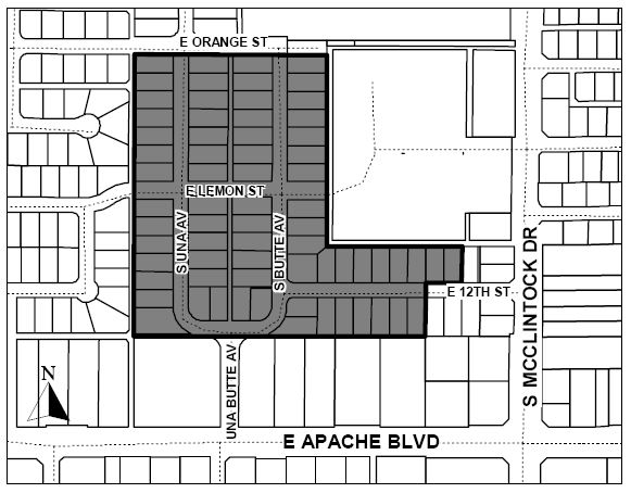
B.
Tomlinson Estates. The location and boundaries of the Tomlinson Estates Historic Overlay District are established as shown on the map entitled "Zoning Map, City of Tempe", dated May 4, 2006, as amended. Properties in the Tomlinson Estates Historic Overlay District include lots 1 through 67, of Tomlinson Estates, a subdivision recorded in Book 47 of Maps, Page 36, records of Maricopa County, Arizona.
Figure 5-502B. Tomlinson Estates Historic Overlay District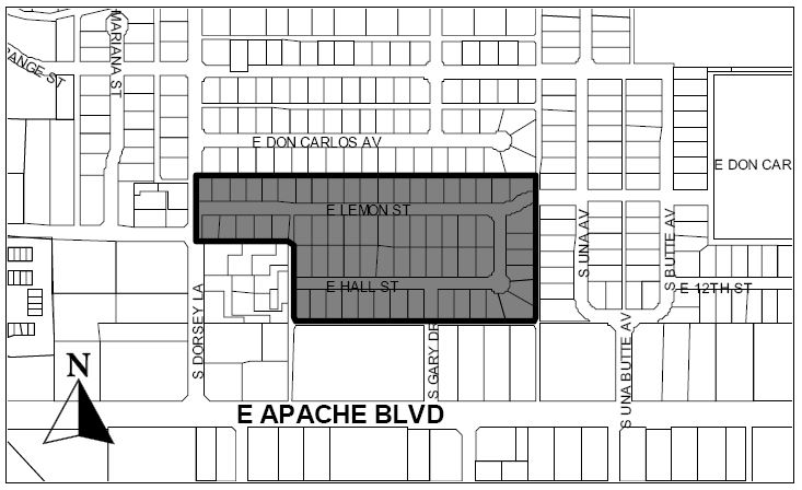
C.
Roosevelt Addition. The location and boundaries of the Roosevelt Addition Historic Overlay District are established as shown on the map entitled "Zoning Map, City of Tempe", dated August 17, 2006, as amended. Properties in the Roosevelt Addition Historic Overlay District include lots 1 through 22, of Roosevelt Addition to Tempe, according to the plat of record in the office of the Maricopa County Recorder in Book 33 of Maps, Page 42.
Figure 5-502C. Roosevelt Addition Historic Overlay District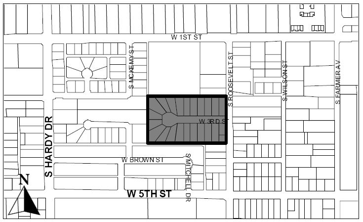
D.
Date Palm Manor. The location and boundaries of the Date Palm Manor Historic Overlay District are established as shown on the map entitled "Zoning Map, City of Tempe", dated May 28, 2009, as amended. Properties in the Date Palm Manor Historic Overlay District include lots 8 through 30 and 32 through 49, of Date Palm Manor Amended, as recorded in Book 59 of Maps, Page 8, according to the Maricopa County Recorder.
Figure 5-502D. Date Palm Manor Historic Overlay District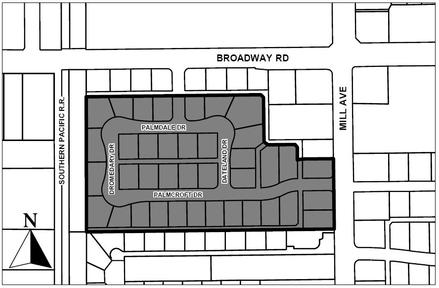
Section 5-503 - General Regulations.
A.
Historic Preservation. Maintaining the historic character and integrity of properties in Historic Overlay Districts is central to historic designation. Preservation of community cultural resources contributes to the stabilization of neighborhoods and encourages complementary design of alterations and renovations within historic districts, and of contemporary buildings developed on properties adjacent to historic districts. The Tempe Historic Preservation Program has been developed to encourage individuals, companies, and agencies to undertake programs that will preserve the historical, cultural, and architectural heritage unique to Tempe.
B.
Review Procedure and Criteria. Application requests through Community Development in an Historic Overlay District will be reviewed by the Tempe Historic Preservation Office or the Tempe Historic Preservation Commission in accordance with the provisions of the Tempe Historic Preservation Ordinance. The standard permitting process shall commence upon completion of historic preservation review. Historic Preservation review shall evaluate applications in accordance with development standards or criteria established in the following authorities:
1.
Tempe Historic Preservation Ordinance. The provisions contained in Chapter 14A of the Tempe City Code, the Tempe Historic Preservation Ordinance, shall apply to all requests for zoning considerations, construction, or major alterations of buildings or site features. Reasonable and fair regulations are included in this chapter as a means of balancing the rights of property owners and the value to the community for conservation and enhancement of these significant properties and sites. The designation of any property or district shall not inhibit uses as permitted by this Code, as adopted and amended by the City Council.
2.
Historic Property Nomination. Nomination materials, including the application, supporting information, research materials, and Staff reports and recommendations identify character-defining features of the district relating to the historic period of significance. Conservation and enhancement of these character defining features is the basis for historic preservation review.
3.
Design Guidelines. Subsequent to designation of an historic district, the Historic Preservation Commission will, in cooperation with representatives from the respective district, and in order to preserve and enhance the distinctive character of the respective district, adopt design guidelines which shall apply only to the exterior features and general character of contributing properties and alterations thereto, as well as any other new construction within the district as follows:
a.
District design guidelines will address general aspects such as building materials, massing, scale and proportion of openings and other features, orientation and relative position of buildings and landscape character; as well as specific aspects such as roof forms, textures, color theme, character of signage, window and door types, and other details relative to architectural and landscape styles significant to the district;
b.
District design guidelines will not regulate maximum building height, maximum lot coverage, minimum setbacks, required landscape, required parking, allowable signs or other provisions of this Code; and
c.
District design guidelines, upon adoption, will be included in the Appendix of this Code.
4.
Development Standards. District development standards may be created within designated historic districts through a code text amendment, as part of the public process for developing design guidelines and codifying design review criteria. If adopted, District development standards will be included in this Code.
5.
Interim Standards. Following designation of an historic district, and until such time as district specific design guidelines can be adopted, the Commission shall refer to the Secretary of the Interior's Standards for the Treatment of Historic Properties. The Secretary of the Interior's Standards for the Treatment of Historic Properties are common sense principles described in non-technical language. They help protect our cultural resources by promoting consistent preservation practices. Guidelines are given for preservation, rehabilitation, restoration and reconstruction.
6.
Cultural Resource Area. Historic Overlay Districts within a Cultural Resource Area, identified on the Tempe General Plan Projected Residential Density map, are considered culturally significant to the character of Tempe, based on the 2001 Post World War II Subdivision Study. It is desirable to maintain the character of these areas, therefore review procedure and criteria undertaken by preservation review shall conform to the Cultural Resource Area objectives set forth in the Tempe General Plan, as amended.
Section 5-601 - Purpose.
The purpose of the Tempe Transportation Overlay District (TOD) is to encourage appropriate land development and redevelopment that is consistent with and complementary to the community's focused investment in transit, bicycle and pedestrian infrastructure in certain geographic areas of the City. Tempe is developing a multi-modal transportation system intended to balance the choices people have to move throughout the City, meet the mobility needs of its citizens and mitigate the impacts of congestion and pollution. This Overlay District regulates land uses and establishes development standards in order to prevent developments which would interrupt the transit, bicycle and pedestrian experience.
The specific objectives of this District are to:
•
Promote and develop livable and sustainable neighborhoods;
•
Promote and increase the use of alternative modes of transportation such as walking, bicycling, car pooling, riding the bus or light rail;
•
Encourage a mix of uses and balance of densities and intensities within identified activity areas accessible to alternative modes of transportation;
•
Provide a quality of urban design (as defined within the standards) that attracts and encourages pedestrian activity;
•
Reinforce public investments and private development to achieve a compact form of development conducive to walking, bicycling, and transit use; and
•
Provide facilities that create a safe, accessible, comfortable and pleasant environment for people; maintain safe access for automobiles and adequate parking and minimize conflicts between vehicles and pedestrians.
Section 5-602 - Boundaries.
The location and boundaries of the Transportation Overlay District are established as shown on the map entitled "Zoning Map, City of Tempe," dated June 1, 2006, as amended.
A.
Properties are within the District if any portion of the parcel or development is:
1.
Adjacent to a public right-of-way located within one thousand nine hundred fifty (1,950) linear feet from the center of a light rail station platform, measured along the center of the public right-of-way; or
2.
Along a corridor ranging in width up to eight hundred (800) feet, centered on the light rail line.
B.
Properties are within a station area if any portion of the parcel or development is:
1.
Adjacent to a public right-of-way located within eight hundred (800) linear feet of a light rail station platform, measured along the center of any public right of way and including only properties adjacent to the public right-of-way.
C.
If any portion of a property falls within the boundaries established above, the balance of the property shall comply with these standards. For the purposes of determining development standards within the District, any property not within a station area is referred to as being in the corridor.
Figure 5-602A. Transportation Overlay DistrictBoundary Map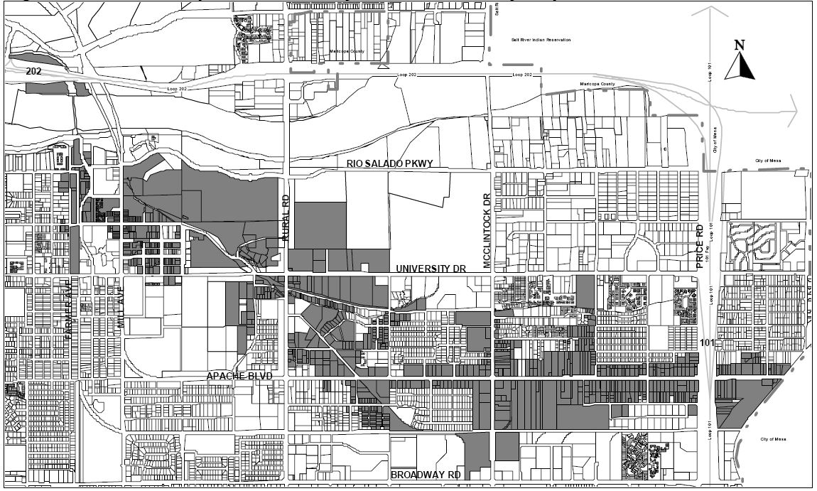
Figure 5-602B. Transportation Overlay District Cross Section of Typical Street
(Ord. No. 2006.35, 6-1-2006)
Section 5-603 - Applicability.
A.
Applicability. This chapter applies to all land use and development activity within the boundaries of the Transportation Overlay District except existing properties within the Single-Family Residential, Agricultural, Mobile Home or Mixed-Use-Educational zoned districts, or property within a Planned Area Development (PAD) recorded prior to the date of adoption of this Overlay. Regulations contained in this Chapter supplement and modify the provisions in many of the underlying zoning districts.
B.
Conformance. A project can meet the requirements of the Chapter by:
1.
Option A: Submitting and receiving approval for a project that conforms to the standards of the Chapter. These standards represent generally the level of transportation orientation the City requires.
2.
Option B: Submitting and receiving approval for a project that generally conforms to the intent of the Transportation Overlay District as outlined in the purpose and objectives in Section 5-601 of this Chapter, while not meeting the literal standards of this Chapter. General conformance to the intent of this Chapter shall be determined through the development plan review process defined below:
The Applicant provides the Community Development Director or designee a written letter requesting Option B. The letter should describe how the objectives in Section 5-601 and the pedestrian environment in Figure 5-612G are being met by the proposed development project. The letter must specify what deviations from the Overlay District standard(s) are being requested and how equivalency is being achieved. Within fourteen (14) business days the Community Development Director, or designee, will review the request and provide a written response specifying which deviations are determined to meet, as well as those that have not met, an equivalency to the intent of this Code.
3.
Option C: If an applicant is unable to use options listed above, the applicant may propose a zoning map amendment to a district allowing standards desired, using the process defined in Section 6-304 Zoning Map Amendments and Code Text Amendments; use a Planned Area Development Overlay as defined in Section 6-305 Planned Area Development Overlay Districts; request a use permit as needed, using the process defined in Section 6-308 Use Permit; or request a variance using the process defined in Section 6-309 Variances. Use of any of these requested processes are not a guarantee of the desired entitlements; granting of requests is determined by the authorized legislative body.
C.
Amendments.
1.
Zoning map amendments for a property that results in changes to zoning districts that are currently exempt from the Overlay, will require an amendment to this Overlay, in order to include the property.
2.
Subdivision plat amendments for a property that is within, or adjacent to, the Overlay will require an amendment to this Overly to either include or exclude the property, depending on whether the new parcels are inside or outside of the defined boundaries of the Overlay.
3.
A property that is outside the Overlay District may be added to the Overlay if it is adjacent to a property that is within the boundaries of the Overlay. The property owner must obtain a zoning map amendment pursuant to Section 6-304 Zoning Map Amendments and Code Text Amendments.
D.
Conflict between Transportation Overlay District, Zoning District, Overlays and Other Regulations. Where a conflict exists between a provision of the Transportation Overlay District and any underlying zoning district or development standard, the Transportation Overlay District provision shall govern. Where a conflict exists between provisions of the Transportation Overlay District, any other Overlay District, or the General Plan the provision that is most specific and restrictive to the situation as determined by the Zoning Administrator shall govern.
Section 5-604 - Permitted Uses in Residential Districts.
The Transportation Overlay District does not modify the permitted use provisions of any Residential District.
Section 5-605 - Permitted Uses in Commercial, Industrial, and Mixed-Use Districts.
The Transportation Overlay District modifies the permitted use provisions of all Commercial, Industrial and Mixed-Use Districts, except MU-Ed, as indicated in Section 5-606, Ground Floor Uses Required and Section 5-607, Permitted Uses Subject to a Use Permit.
Section 5-606 - Ground Floor Uses Required.
A.
Purpose. The purpose of this section is to require all non-residential zoning districts to provide uses which are accessible to the public on the first floor of the street facing side of buildings, to create an active pedestrian environment with public amenities, and to prevent development or uses which do not interact with the street, or that create impenetrable walls along the pedestrian walkway.
B.
Parking Structure Ground Floor Uses. Parking structures within the corridor shall have no more than forty percent (40%) of the façade length on the ground floor of parking structures facing the street; the remaining street façade of the structure at the ground level may have any of the allowed uses (Sections 5-605, 5-606 and 5-607) facing the street. Parking structures located at street intersections shall comply with these standards on each street façade of the structure.
C.
Ground Floor Uses in Station Areas. For land zoned commercial or mixed-use within station areas, buildings and parking structures shall be designed and built for occupancy of at least sixty percent (60%) of the ground floor street frontage with one (1) or more of the uses listed below. Buildings and parking structures located at street intersections shall comply with these standards on each street façade of the structure. Land zoned Industrial is exempt from this requirement. Figures 5-606A and 5-606B illustrate examples of this requirement. These uses shall be subject to the provisions in Part 3, Land Use, for requirements of the underlying district.
1.
Retail sales and service uses;
2.
Restaurants and bars;
3.
Customer service offices (any size office that has customer point of service);
4.
Entertainment, except adult oriented business;
5.
Hotels;
6.
Clinics;
7.
Child daycare and schools; or
8.
Uses that are similar to those listed above, as determined by the Zoning Administrator.
Figure 5-606A. Example of 60% Ground Floor Uses on Street Frontage within Station
Areas
Design a minimum of 60% of the street frontage to accommodate the uses listed in 5-606C.
Figure 5-606B. Example of 60% Ground Floor Uses at Street Intersections within Station
Areas
Design a minimum of 60% of the street frontage to accommodate the uses listed in 5-606C.
Figure 5-606C. Example of Ground Floor Uses
D.
Public Schools. Street-level use requirements do not apply to public educational uses. Public school or public university uses are encouraged to abide by the provisions of this chapter.
Figure 5-606D. Illustration of Uses Above and Below Ground Floor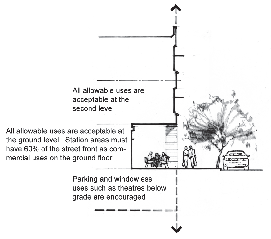
Section 5-607 - Permitted Uses Subject to a Use Permit.
A.
Purpose. The purpose of this section is to provide a public hearing process for uses which may or may not be appropriate to the area, depending on site context.
B.
Uses Allowed with a Use Permit. In addition to those uses defined by the underlying zoning,the following uses are permitted with a use permit within the Commercial, Mixed-Use and Industrial Zoning Districts within the Transportation Overlay District.
1.
Sales or rentals of two-wheeled vehicles which serve as an alternative mode of transportation;
2.
Wholesale showroom, provided that the design is pedestrian-oriented;
3.
Bulk retail uses, including food and beverage sales;
4.
Magazine and newspaper gang boxes; or
5.
Residential developments on ground floor street frontages within station areas, where the market is unable to support the required sixty percent (60%) ground floor uses requirement, pursuant to Section 5-606 Ground Floor Uses Required, as verified by the Economic Development Division.
Section 5-608 - Prohibited Uses.
A.
Purpose. The purpose of this section is to prohibit uses which do not contribute to a quality urban environment that attracts and encourages pedestrian activity, promotes the development of livable and sustainable neighborhoods, or provide facilities that create a safe, accessible, comfortable and pleasant environment for people.
B.
Prohibited Uses. The following uses are prohibited within the entire Overlay District.
1.
Adult-oriented business;
2.
Bulk wholesale uses including building materials, food and beverage sales, restaurant supplies, etc.;
3.
Drive-in businesses;
4.
Drive-through facilities, except as provided for in Section 5-608(E);
5.
Funeral homes, mortuaries and cemeteries;
6.
General manufacturing;
7.
Kennels;
8.
Manufactured home sales;
9.
Mini-warehouse;
10.
Mobile home parks, except in Mobile Home Districts;
11.
Nurseries or greenhouses;
12.
Outdoor storage;
13.
Parking as a principle use, except as provided for in Section 5-608(C) and Section 5-608(F);
14.
Recreational vehicle parks;
15.
Rental lots for motorized vehicles, boats or other recreational vehicles;
16.
Sales, repair or service of boats or other recreational vehicles;
17.
Sales, service, or rental of commercial equipment or construction materials;
18.
Salvage and recycling centers and transfer stations;
19.
Shipping or distribution, warehouse transport center;
20.
Telecommunication hotels on the ground level, or an any level of the street front;
21.
Vehicle towing services;
22.
Vehicle sales, repair, wash, fueling or service , auto body repair or auto service stations except as provided for in Section 5-608(D); or
23.
Warehouse or other indoor storage.
C.
Parking as a Principle Use in Station Areas.Principle-use parking is prohibited within station areas, except that parking facilities owned by the City or an operating transit agency, or private parking facilities operating as park-and-ride facilities in partnership with the City or an operating transit agency, are permitted.
D.
Motorist Amenity Uses in Station Areas.Motorist amenity uses (car wash, automobile detailing, vehicle maintenance or repair) are permitted within station areas only when the use is accessory to a principal-use parking facility that is allowed by Section 5-608(B).
E.
Drive-Through Uses.Drive-through uses are prohibited within station areas. Drive-through uses are subject to a use permit within the corridor. In addition to the criteria listed in Section 6-308(F), drive-through use permit requests within the TOD corridor are evaluated on the basis of:
1.
Extent of incorporation of pedestrian and transportation standards and guidelines promoted within the Transportation Overlay District;
2.
Extent to which the project provides a drive-through service not currently available in the area;
3.
Extent of benefit to individuals with limited mobility; and
4.
Compliance with Section 3-408, Drive-Through Facilities.
F.
Temporary Use Parking.Parking as a principle use may be permitted as a temporary use, subject to approval of an administrative review process, pursuant to Section 6-306, Development Plan Review.
1.
Such use shall be allowed for a maximum of (5) five years, from the date of approval. Additional time may be granted by the City Council at a public hearing.
2.
Such use shall not be allowed on property where initial demolition has occurred within the past twelve (12) months.
3.
In addition to the approval criteria found in Section 6-306(D), determination for acceptance of temporary use parking shall also be evaluated based on the following criteria:
a.
The site will be developed to ensure that it will not be detrimental to the surrounding neighborhood or to the public welfare in general;
b.
Temporary use parking may not be allowed when in close proximity to residential areas which may be detrimental to the character of the neighborhood;
c.
The improved surface for parking will reduce heat gain by including, but not limited to, the placement of boxed trees within the parking lot, limiting the amount of asphalt paved surface for any unimproved land, and providing stabilized porous surface material, authorized by the Community Development Director, or designee; and
d.
Reasonable design plans will provide buffering from the public sidewalk(s) through enhanced landscape or other features.
4.
Such use is exempt from the standards found in Part 4, Chapter 7 - Landscape and Walls of this Code and is exempt from the parking setbacks found in Part 4, Chapter 2 - General Development Standards. All other sections pertaining to parking shall apply including, but not limited to, lighting and retention.
5.
Vehicles shall not be parked on a temporary use parking lot for more than forty-eight (48) hours within seven (7) consecutive days. Business vehicles displaying signs or advertising are prohibited from parking on a temporary use parking lot.
6.
Temporary Use Parking; Termination Date, September 17, 2016: The Zoning and Development Code, Part 5 - Overlay Districts, Section 5-608(F), Temporary Use Parking, terminates on September 17, 2016 and is repealed on September 18, 2016.
(Ord. No. 2011.27, 8-18-2011)
Section 5-609 - Legal Non-Conforming Use or Development.
A legal non-conforming use is a use that is not permitted in the Transportation Overlay District, but was lawfully established prior to the establishment of the Transportation Overlay District. Expansions, rebuilding and reconstruction of structures housing a non-conforming use, and abandonment or change in use shall be subject to the provisions of Part 3 Chapter 5, Non-Conforming Use or Development.
Section 5-610 - Development Standards for Residential Districts.
A.
Single-Family Residential Districts. The Transportation Overlay District does not modify the development standards of any Agricultural or Single-Family District.
B.
Multi-Family Residential Districts. The Transportation Overlay District does not modify the development standards of any Multi-Family District, except in station areas, as indicated in Table 5-610A.
C.
Mobile Home Residential Districts. The Transportation Overlay District does not modify the development standards of any Mobile Home District.
D.
Transportation Overlay Street Setback. Required Ground Floor uses shall conform to the maximum setbacks ranging from zero (0) to twenty (20) feet, as required in Table 5-610A, shall comply with the standards defined in Section 5-613(D), Minimum and Maximum setbacks, and shall have a finished floor that is no more than five (5) feet above or below adjacent sidewalk grade.
a Buildings which exceed the height of adjacent buildings, and are adjacent to any Residential District, or are adjacent to a hotel or a mixed-use development with photovoltaic equipment (solar collectors, water heaters, etc.) or a swimming pool, must provide a solar study, identifying shade patterns at 9 a.m., Noon, 3 p.m. and 5 p.m., on the vernal equinox, summer solstice, autumnal equinox and winter solstice.
Section 5-611 - Development Standards for Commercial, Mixed-Use, and Industrial Districts.
A.
Commercial Districts. All development located in the Transportation Overlay District with the underlying zoning of CC, CSS, PCC-1, or PCC-2 District shall conform to the development standards in Table 5-611A. The Transportation Overlay District does not modify the standards of the underlying district for the R/O and RCC Districts. Refer to Section 4-203 Development Standards for Commercial and Mixed-Use Districts.
B.
Mixed-Use Districts. All projects located in the Transportation Overlay District with the underlying zoning of MU-1, MU-2, MU-3 or MU-4 Districts shall conform to the development standards in Table 5-611B.
C.
Industrial Districts. The Transportation Overlay District does not modify the standards of any Industrial District, except for standards identified in Section 5-612(H), Pedestrian and Transit Patron Amenities. Refer to Section 4-204, Development Standards for Office/Industrial Districts.
D.
Transportation Overlay Street Setback. Required Ground Floor uses shall conform to the maximum setbacks ranging from zero (0) to twenty (20) feet as required in Tables 5-611A and 5-611B, shall comply with the standards defined in Section 5-612(D), Minimum and Maximum Setbacks, and shall have a finished floor that is no more than five (5) feet above or below adjacent sidewalk grade.
a Buildings which exceed the height of adjacent buildings, and are adjacent to any Residential Districts, or are adjacent to a hotel or a mixed-use development with photovoltaic equipment (solar collectors, water heaters, etc.) or a swimming pool, must provide a solar study, identifying shade patterns at 9:00 a.m., Noon, 3:00 p.m. and 5:00 p.m., on the vernal equinox, summer solstice, autumnal equinox and winter solstice.
b Where ground level retail uses are present, setback may be increased up to twenty (20) feet for outdoor seating and patio dining.
c Features such as overhangs, porticos, balconies, pedestrian arcades, covered (non-enclosed) bicycle parking and similar architectural features placed on or in front of the street-facing side of the building are allowed within the setback.
d Properties zoned CSS adjacent to residentially zoned properties are required a minimum ten (10) foot side yard setback on the side adjacent to the residential property.
(U) Denotes use permit requirement in these Districts.
NS = No Standard.
a Buildings which exceed the height of adjacent buildings, and are adjacent to any Residential Districts, or are adjacent to a hotel or a mixed-use development with photovoltaic equipment (solar collectors, water heaters, etc.) or a swimming pool, must provide a solar study, identifying shade patterns at 9 a.m., Noon, 3 p.m. and 5 p.m., on the vernal equinox, summer solstice, autumnal equinox and winter solstice.
Section 5-612 - Pedestrian Oriented Design Standards.
A.
Purpose. Since all trips begin and end as pedestrian trips, the quality of the pedestrian environment and the nature of the pedestrian linkages between land uses and transportation modes play a large role in the success of this multi-modal transportation system. the purpose of this section is to require a quality of urban design that attracts and encourages pedestrian activity, creates a safe, accessible, comfortable and pleasant environment for people and minimizes conflicts between vehicles and pedestrians.
B.
Applicability. The provisions of this section shall apply to all new development, redevelopment, and exterior alterations to existing development in all zoning districts within the Transportation Overlay District.
C.
Exemptions. The following items are exempt from the requirements of this Section:
1.
Single-Family, Agricultural and Mobile Home Districts, are not part of the Transportation Overlay District; however, owners/occupants of property within these districts adjacent to the Transportation Overlay District are encouraged to plant and maintain trees within yards and landscape areas adjacent to public sidewalks for the purpose of providing shade and comfort. Neighborhoods are also encouraged to apply for neighborhood grants which facilitate pedestrian enhancements within the specified boundaries of this District;
2.
City, State or Federal Historic-designated properties, districts or buildings;
3.
Repair, maintenance, and replacement with comparable materials pursuant to Part 3 Chapter 5, Legal Non-Conforming Use or Development;
4.
Modifications to a structure to meet the requirements of the Americans with Disabilities Act;
5.
Exterior alterations to the existing development where the alterations are valued at forty percent (40%) or less of the building value as determined by a qualified appraiser and as approved by the Community Development Director or designee. (Property owners may request a use permit to be included within Section 5-612 standards for alterations valued at forty percent (40%) or less of the building value, however all standards are then applicable to the development);
6.
Expansions to existing facilities which result in required compliance with this code that is not feasible or prudent, as determined by the Community Development Director; or
7.
Industrial Districts, except for standards identified in Section 5-612(H), Pedestrian and Transit Patron Amenities.
D.
Maximum and Minimum Building Setbacks. The purpose of this section is to reduce the distance that pedestrians must walk to access buildings by bringing buildings closer to the street edge of the property, while providing opportunities for pedestrian amenities and variation in building façade. The maximum building setbacks of the Transportation Overlay District (Tables 5-610, 5-611A, and 5-611B) are applicable to new buildings, as follows:
1.
At least fifty percent (50%) of the length of the ground floor street-facing façade of the building must be at or within the maximum setback, as indicated in Figure 5-612A. No structure may be within the minimum setback, except as specified under minimum setbacks. When a building fronts onto more than one public street, this standard shall be met for each street.
2.
Where the minimum front yard setback is zero (0) feet, and the street front right-of-way line is eight (8) feet or less from the back-of-curb, buildings must be set back on the ground floor to allow a dedicated fourteen (14) foot back-of-curb right-of-way or pedestrian easement to accommodate pedestrian activity on the street front of the building.
3.
Parking shall be provided behind buildings, as indicated in Figure 5-613B preferred parking and access.
Figure 5-612A. Maximum Building Setback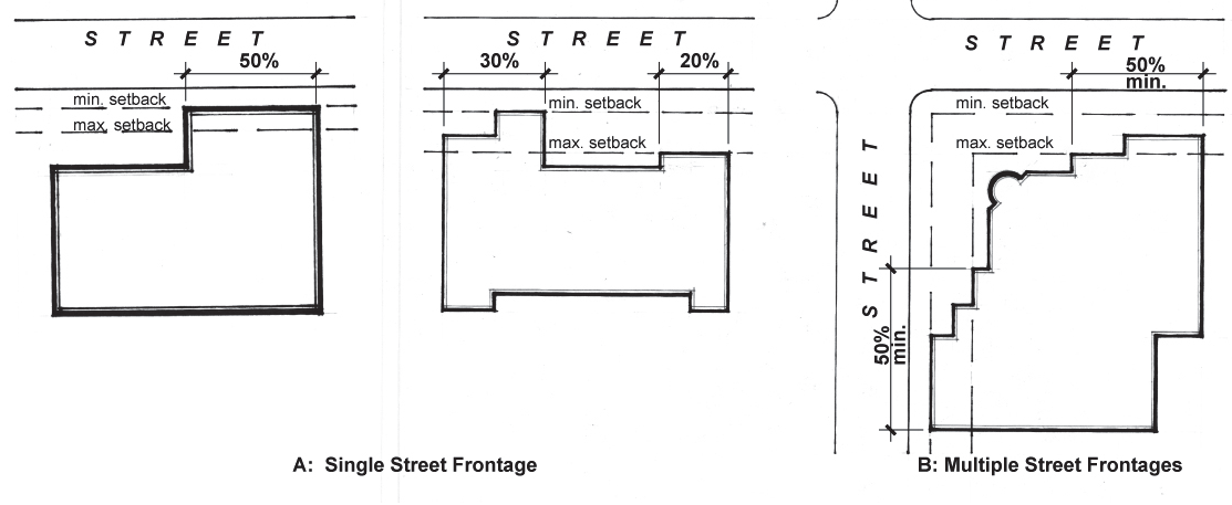
Figure 5-612B. Parking Location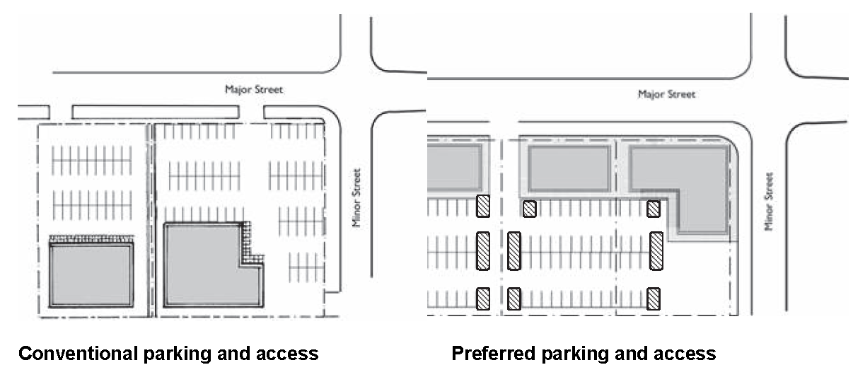
E.
Building Entrances. The purpose of this section is to provide convenient street front pedestrian access to buildings. New buildings shall provide entrances that conform to the following standards:
1.
New commercial, civic, and mixed-use buildings shall provide a primary building entrance that either faces an adjacent street or is placed at an angle of up to forty-five degrees (45 o ) from an adjacent street, measured from the street property line, as shown in Figure 5-612C. New commercial, civic, and mixed-use buildings adjacent to a bus transit stop or adjacent to a light rail station shall orient a primary building entrance to face the stop or station.
Figure 5-612C. Building Entrances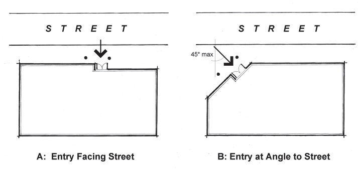
2.
New commercial, civic, and mixed-use buildings shall provide a primary building entrance not more than twenty (20) feet from the street sidewalk unless adjacent to a public pedestrian courtyard/plaza. Building entrances must be connected to the sidewalk with a pathway that meets the standards in Section 4-503, Pedestrian and Bicycle Access and Circulation Standards.
3.
When located at the intersection of two (2) public streets, the building shall provide one (1) of the following:
a.
Provide two (2) primary entrances, one (1) facing each street;
b.
Orient one (1) primary entrance to both streets by placing the entrance at the street corner; or
c.
Place one (1) entrance so that it is not more than twenty (20) feet from either street, as indicated in Figure 5-612D.
Figure 5-612D. Building Entrances at the Intersection of Two Streets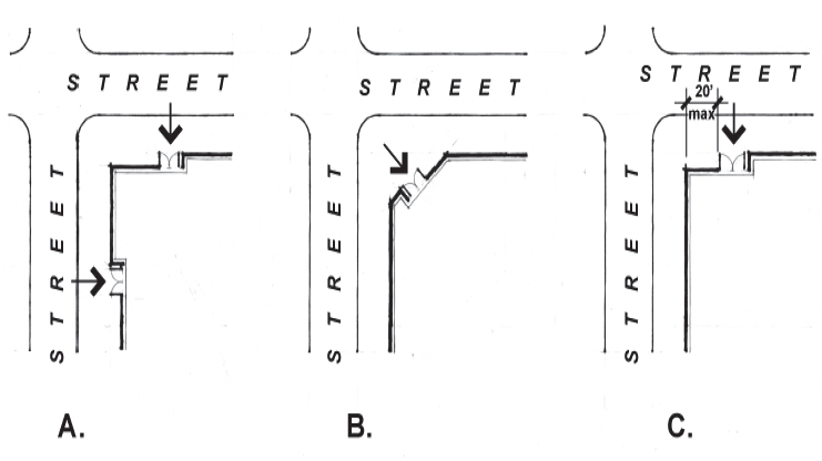
4.
When a building or development consists of more than six hundred (600) linear feet of street frontage, pedestrian access into the site shall be provided by means of an opening in the building frontage, such as a courtyard, breezeway or other means of access.
5.
Residential buildings shall have direct and convenient means of access to transit (e.g., via a pathway) as indicated in Figure 5-612E. Residential buildings may open onto a porch or patio located between the building and street, and may have a privacy wall no greater than four (4) feet tall.
Figure 5-612E. Building Entrances and Access to Transit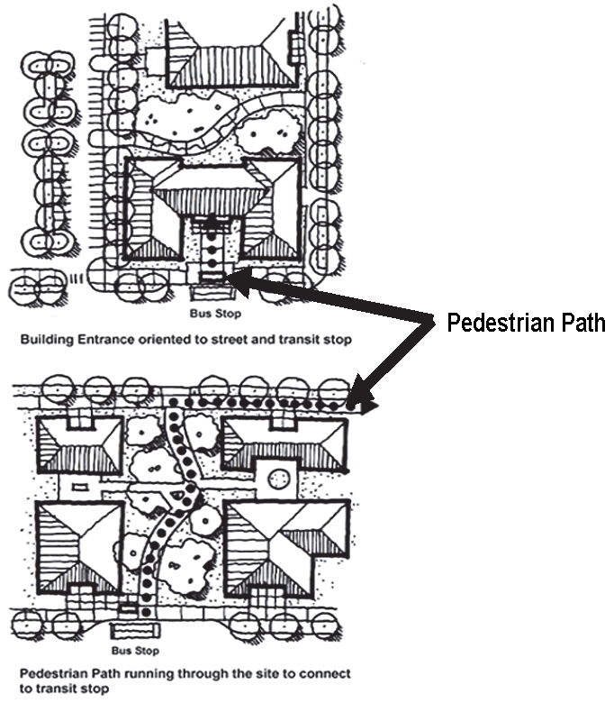
F.
Ground Floor Windows. The purpose of this section is to require visibility and access to and from buildings at the street front of a development in order to create a safe and interactive environment. Buildings along street frontages shall provide ground floor windows that conform to the following standards:
1.
Ground Floor windows shall be provided in at least fifty percent (50%) of the building length and twenty-five percent (25%) of the ground level wall area of all buildings façades that face a street or plaza. Ground floor window requirements shall apply to the area of the façade between three (3) feet and eight (8) feet above the adjacent finish grade or public sidewalk, whichever is greater. This requirement does not apply to residential units or to parking structures when set back at least five (5) feet and screened with landscape materials in conformance with Section 4-704, Parking Facility Landscape Standards.
Figure 5-612F. Ground Floor Windows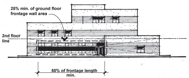
2.
Required window areas must be either windows that allow views into working areas, lobbies, pedestrian entrances or display windows set into the wall. Display cases attached to the outside wall do not qualify. The bottom of the windows must be no more than four (4) feet above the adjacent finish grade or public sidewalk. Transparent areas shall allow views into the structure or into display windows from the outside. Only clear or lightly tinted glass with up to fifty percent (50%) transparency for windows, doors, and display windows shall be considered transparent. Opaque, etched, frosted or mirrored glass is not transparent.
G.
Street-Facing Façades. The purpose of this section is to require visibility and access to and from buildings on the street in order to create a safe and interactive environment. At least fifteen percent (15%) of the area of each façade that faces a street lot line on all building stories must be windows, openings or main entrance doors. Windows used to meet this standard must allow views from the building to the street. Glass block shall not be considered windows. Windows in garage doors do not meet this standard, but windows in garage walls do.
H.
Pedestrian and Transit Patron Amenities.
1.
The land between a building or exterior improvement (patio, porch, courtyard) and the back-of-curb must be landscaped and/or hard-surfaced for use by pedestrians and contain pedestrian amenities such as benches, drinking fountains, cooling systems and/or other design elements (e.g., public art, planters, and kiosks) and be physically separated from parking areas by a landscape buffer that meets the standards in Section 4-704, Parking Facility Landscape Standards.
2.
The placement of shade-bearing elements and seating shall maximize shading for summer mid-day and afternoon hours.
3.
Any shade structure that is also proposed to serve as a transit patron waiting area shall conform to the City standards for transit shelters. All landscape provided shall be located to not obstruct the transit shelter canopy or visibility of a transit stop.
4.
Covered front porches, canopies, awnings, porticos, pedestrian arcades and similar shade-bearing features that used to meet this standard are exempt from the building site coverage requirements, and may be allowed to encroach in the City right-of-way, subject to an encroachment permit. See Section 5-612(S).
Figure 5-612G. The Complete Pedestrian Environment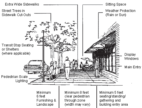
This figure represents the intent of this Code for creating a complete pedestrian environment. Existing right-of-way may not provide sufficient area to create this throughout the corridor. Provisions for pedestrian amenities are encouraged within private property to meet this intent.
I.
Residential-Facing Façades. The purpose of this section is to assure that new development retains privacy for existing residences and considers the views of the new development from the residences. For properties without an alley, adjacent to Single-Family, Multi-Family or Mixed-Use districts, the site design shall:
1.
Provide landscape buffers and screening to assure the privacy of adjacent residents;
2.
Minimize building heights shade impacts on adjacent solar equipment, gardens or pools;
3.
Design buildings to have similar attention to detail as the street front façade to provide visual interest in materials and structure to address potential views from residences; and
4.
Screen delivery entrances from residential view.
J.
Minimum Parking Ratios. The purpose of this section is to provide an optional reduction in parking to developments within the Overlay District; this may be done at the time of development, or planned into a future phasing to assure parking availability prior to light rail construction. The minimum number of required parking spaces, as provided in Section 4-603, is reduced for commercial uses that meet the criteria in Table 5-612A. The other methods of parking reduction (shared parking, parking demand model) provided in Section 4-604 Shared Parking, are also available for use in the Transportation Overlay District.
K.
Maximum Parking Ratios. Uses in the Transportation Overlay District shall conform to the maximum parking ratios in Section 4-603(E).
L.
On-Street Parking. When allowed within the street right-of-way, on-street parking along the lot frontage shall count towards the parking requirement for uses on the lot.
M.
Sidewalk Standards. Public sidewalks within the Transportation Overlay District shall have a minimum width of eight (8) feet, unobstructed by light poles, parking meters, street furniture, plant materials, fences, fire hydrants, or other obstructions.
N.
Landscape Standards. All standards and restrictions of Part 4 Chapter 7, Landscape Standards, are applicable, with the following additions and exceptions:
1.
Plant materials within five (5) feet of sidewalks or bike lanes shall not include any plants with thorns, spines or sharp points;
2.
Trees shall be planted within six (6) feet of sidewalks, or as determined by the Public Works Department to provide sufficient shade when trees have grown to mature form; and
3.
Mature trees must be trimmed for an eight (8) feet clear vertical height from top of walkway surface to the bottom of the tree canopy.
O.
Loading, Delivery, and Service Entrances. Site design must accommodate loading needs while preserving accessibility, mobility and safety for all other users.
1.
Provide sufficient space for safe maneuvering and ingress and egress of larger vehicles. Through-access solutions should be provided to minimize or eliminate turning within parking lots and minimize the amount of needed hardscaped area for maneuvering.
2.
Provide signs at entrance and exit points for loading and delivery, and provide audible signal when vehicle approaches pedestrian paths where appropriate. Understandable right-of-way signage shall be provided where truck, auto, pedestrian and bike conflicts may occur.
3.
Delivery vehicles should access loading from alleys or side streets where possible to minimize conflicts along heavy traffic areas.
4.
Deliveries during daylight off-peak traffic hours are preferred (when noise is not in conflict with residential uses).
P.
Open Space.Station areas shall include public open space as defined and determined within Station Area Plans. Within the corridor,public plazas, pocket parks, roof top gardens, courtyards and other forms of open space are encouraged. Retention areas may be used for park and recreation amenities as long as the primary use for storm water retention is still met. Pedestrian connections and corridors from neighborhoods through developments are encouraged to provide connectivity to open space amenities.
Q.
Station Areas. Station Area Plans will provide additional planning needs around light rail stations and identify future development opportunities. Station area plans identify land uses around each station, and design and development guidelines that can enhance the pedestrian environment and encourage transit ridership for the system. The station area plans shall define other design standards determined necessary to achieve a specific character for an area. The station area planning process can also evaluate the need for expanded TOD boundaries and/or creating pedestrian linkages along streets as needed. This would result in an amendment to the TOD. Station area planning may include a combination of any of the following:
1.
Land Use Inventory
a.
Existing and projected land uses
b.
Zoning analysis
c.
Land ownership analysis
d.
Open space assessment
e.
Vacant land inventory
2.
Neighborhood Character Analysis
a.
Visioning process
b.
Neighborhood focus groups
3.
Light Rail Station Connectivity
a.
Bike, pedestrian, bus and vehicular linkages
b.
Neighborhood connections
c.
Off-street paths, canals or trails
d.
Critical linkages
4.
Opportunity Site Assessment
a.
Underutilized property analysis
b.
City controlled property
c.
Opportunity site options
5.
Streetscape Design
a.
Street lighting and furniture
b.
Landscape improvements
c.
Shade
d.
Public art
6.
Best Practices in Other Cities
7.
Community Outreach
a.
Neighborhoods, businesses and developers
R.
Shade Standards. Public sidewalks shall be shaded with a minimum of thirty-three percent (33%) full shade. Shade may be provided by trees, green walls, trellises, canopies, or other structural features. Shade shall cover the walkable surface at 3:00 p.m. on the date of the summer solstice, verified by a development shadow study. Shade calculations for trees will assume canopy growth at five (5) years from planting.
S.
Structural Encroachment Standard. The encroachment of buildings and structures including marquees, awnings, balconies, and other architectural projections is permitted on a case by case basis with review by the City Engineer, or designee, as part of the encroachment permit process defined in Tempe City Code Chapter 8, Section 3202—3206. In addition to the encroachment permit, sidewalk cafes are required to obtain a specialty license from the City of Tempe's Tax and License Division, using the process defined in Tempe City Code Chapter 24, Division 4.
Section 5-701 - Purpose and Applicability.
A.
Purpose. The general purpose of the AFDPA is to encourage appropriate development and redevelopment for transforming an approximate 276 acre land area generally located between ASU and Tempe Town Lake into a mixed-use urban community with athletic fields and facilities.
B.
Applicability. Development standards, review and approval procedures specified by this chapter shall apply to the development of AFDPA commercial use, AFDPA residential use, and mixed uses within the AFDPA. Standards and review procedures specified by this chapter shall not apply to public university uses and public university related uses within the AFDPA. Where a conflict exists between a provision of the AFDPA and any underlying zoning district or development standard, the AFDPA provision shall govern.
C.
Design Standards. The design standards applicable to development of AFPDA commercial use, AFPDA residential use, and mixed uses within the AFPDA are described in the novus design standards as may be amended. where appropriate within the AFPDA, standards and best practices associated with the transportation overlay district shall be encouraged as described in subsection d and e below.
D.
AFDPA TOD Principles. The transportation oriented development principles of the AFDPA are as follows:
1.
Promote and increase the use of alternative modes of transportation such as walking, bicycling, carpooling, riding the bus or light rail;
2.
Encourage a mix of uses and balance of densities and intensities within identified activity areas accessible to alternative modes of transportation;
3.
Provide a quality of urban design (as defined within the standards) that attracts and encourages pedestrian activity;
4.
Reinforce the public investments and private development to achieve a compact form of development conducive to walking, bicycling, and transit use; and
5.
Provide facilities that create a safe, accessible, comfortable, and pleasant environment for people; maintain safe access for automobiles and adequate parking and minimize conflicts between vehicles and pedestrians.
E.
AFDPA TOD Design Principles. The AFDPA Transportation Oriented Development Design Principles are as follows:
1.
Commercial Projects. Design of commercial projects should enhance the urban experience of the District by considering the unique aspects of each project's ground floor and upper levels. As with all projects within the District, commercial projects should spatially reinforce the public realm.
2.
Residential Projects. Design of residential projects should enhance the urban experience of the District by considering the unique aspects of each project's ground floor and upper floors. Residential building design should convey the pedestrian circulation around and through the project to create a safe and livable environment for residents, visitors, and the public passing by.
(Ord. No. o2018.74, 12-20-18)
Section 5-702 - Boundaries and Amendments.
Section 5-703 - Permitted Uses.
AFDPA uses are specified in Table 3-202b, Mixed-Use Educational (MU-ED) District.
(Ord. No. o2018.74, 12-20-18)
Section 5-704 - Review and Approval Procedures.
AFDPA review and approval procedures are specified in Part 6, Table 6-101A.
(Ord. No. o2018.74, 12-20-18)
Section 5-705 - Neighborhood Notification Procedures.
A.
At least fifteen (15) days prior to the Joint Review Committee meeting, the applicant or representative of the subject property shall provide notice of the public meeting as follows:
1.
By electronic notice to the chairperson of the registered neighborhood association(s) and home owners association(s) within one thousand three hundred twenty (1,320) feet (¼ mile) of the subject property(ies). If electronic notice is not available, communication shall be provided by mailing a notice;
2.
By electronic notice to all members of the City Council and the Community Development Department, or designee;
3.
The development site shall be posted with public notice about the meeting not less than fifteen (15) calendar days prior to the date of the meeting, the date, time, and place, and a summary of the request. Such notice shall be clearly legible and wherever possible, placed adjacent to the right-of-way of a public street or road. It shall be the responsibility of the applicant to use reasonable efforts to maintain the notice once it has been placed on the subject property. Signs shall be no smaller than sixteen (16) square feet. It is the responsibility of the applicant to remove the sign within seven (7) calendar days of the meeting.
B.
Other notification requirements for public meetings and public hearings will be provided by the Community Development Department or the City Clerk, pursuant to Section 6-403 and 6-404.
(Ord. No. o2018.74, 12-20-18)
Section 5-706 - Development Standards.
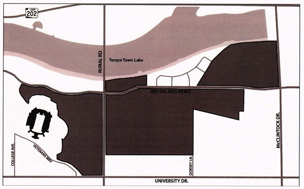
The development of AFDPA commercial uses, AFDPA residential uses, and mixed uses within the AFDPA shall be in conformance with the land use parameters specified within Table 5-706B and the development standards specified by Table 5-706C.
Figure 5-706A. AFDPA Subdistricts
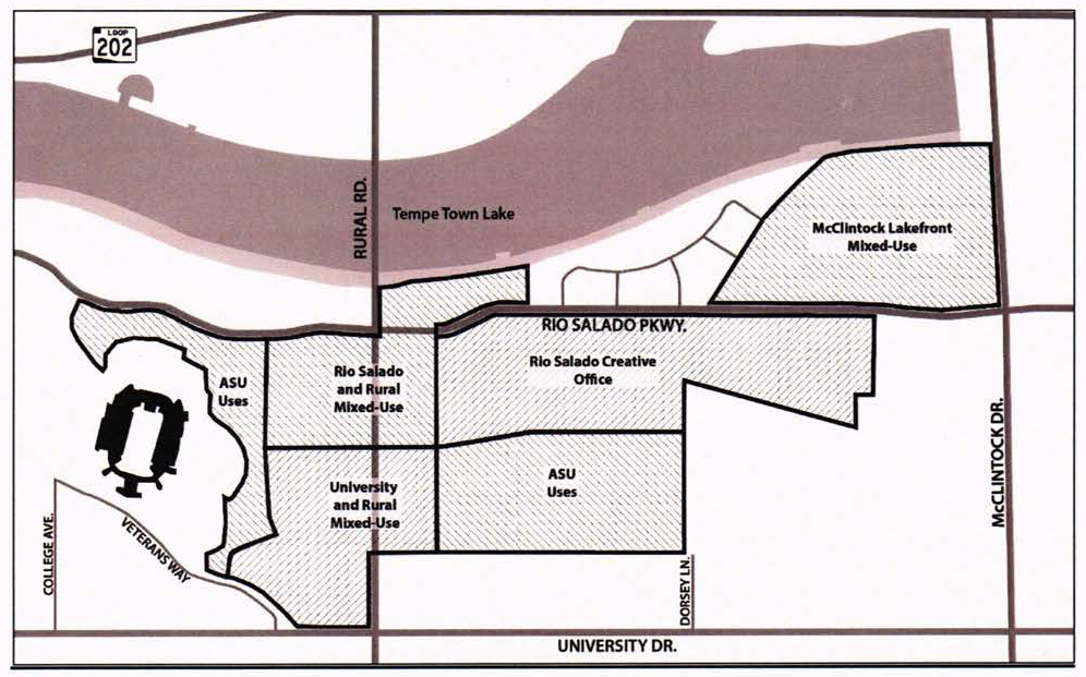
Table 5-706B. AFDPA Use Parameters
1.
Land Area acreages are approximate.
a.
Gross Developable Area - Reflects acreage measured from back-of-curb, except in cases of parcel frontages located adjacent to existing streets, where acreage is measured from the interior right-of-way boundary or roadway easement (the latter applying to existing private streets).
b.
Net Developable Area - Reflects acreage measured from the interior boundary of Private Development Easements located on each parcel, except in cases of parcel frontages located adjacent to existing streets without Private Development Easements. In such cases, net acreage is measured from the interior of the existing right-of-way boundary or public easement, as applicable.
2.
Open Space refers to areas dedicated to open space uses. It excludes open spaces that are contained within Gross and Net Developable Areas on individual parcels and public and private streets.
(Ord. No. O2022.41, 10-20-2022)
Table 5-706C. AFDPA Development Standards
NS = No Standard: Standard will be determined as part of the Development Plan Review process.
1.
Setbacks are measured from the interior boundary of Private Development Easements, except in cases of parcel frontages located adjacent to existing streets without Private Development Easements. In such cases, setbacks are measured from the interior right-of-way boundary, public easement or private utility easement, as applicable.
Section 5-707 - Parking Standards.
Parking standards established through the Joint Review Committee, pursuant to Section 4-601B, shall apply to parcels within the AFDPA. The use of shared parking facilities shall be maximized to the extent possible and overall parking quantities shall be limited to promote the transportation oriented development principles.
(Ord. No. o2018.74, 12-20-18)
Section 5-708 - Nonconforming Use or Development.
A legal non-conforming use is a use that is not currently permitted in the AFDPA, but was lawfully established prior to the establishment of the AFDPA. the expansion, rebuilding and reconstruction of structures containing a non-conforming use, and abandonment or change in use shall be subject to the provisions of Part 3, Chapter 5, non-conforming use or development. No part of a non-conforming use or development shall be interpreted as being applicable to the expansion, modification, rebuilding and/or reconstruction of a structure currently accommodating or planned to accommodate a public university use or a public university related use.
(Ord. No. o2018.74, 12-20-18)
Section 5-801 - Purpose and Applicability.
A.
Purpose. The purpose of the middle housing overlay district is to comply with A.R.S. § 9-462.13 for the development of duplexes, triplexes, fourplexes and townhouses. The regulations in this section are in addition to other codes and requirements of the City of Tempe.
B.
Applicability. Except as specified in subsection (4) of this Section 5-801 (b), the development of duplexes, triplexes, fourplexes and townhouses of equal number of units, shall be allowed as a permitted use in the following:
1.
All legal lots in single-family residential districts, including the agricultural district, that are at least partially located within a one (1) mile radius of Tempe's defined central business district, pursuant to Figure 5-802A. Middle Housing Overlay District Boundary;
2.
A legal lot must be either a previously recorded subdivision lot or a parcel of land that is in conformance with the minimum size site, dimension width and length requirements of the subject property;
3.
The middle housing overlay district allows a multi-family residential project without a rezoning application or use permit, that would otherwise require a public hearing. As a result, general plan land use conformity, pursuant to Section 6-302, and zoning map amendments, pursuant to Section 6-304, are not applicable in this overlay; and
4.
The site is not located within an exclusion area as described in Section 5-802(C).
(Ord. No. O2025.45, 11-6-2025, effective 1-1-2026)
Section 5-802 - Boundaries.
The locations and boundaries of the middle housing overlay district are established as being located within a one-mile radius from the defined "central business district", pursuant to Section 3-201(b)(3), and shown on the map identified in Figure 5-802A.
Figure 5-802A. Middle Housing Overlay District Boundary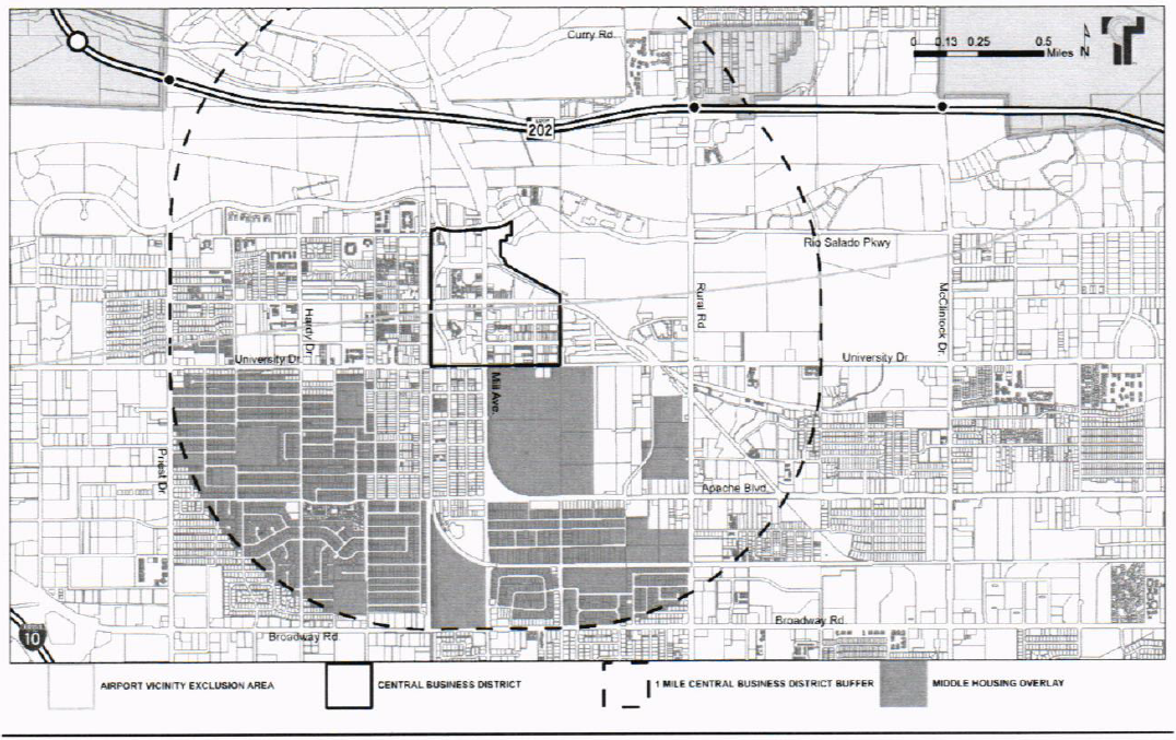
(Ord. No. O2025.45, 11-6-2025, effective 1-1-2026)
Section 5-803 - Middle Housing Opt-In Overlay.
Properties that are part of a larger new development can also construct middle housing if the parcel(s) consist of greater than ten (10) contiguous net acres and conform to the following regulations:
A.
Parcel(s) for new development that are in existing zoning for single-family residential districts, including the agricultural district, or new development when requesting the inclusion of middle housing as a part of an active application for a zoning map amendment to a single-family residential district, or the agricultural district, are eligible for such use;
B.
Sites are allowed to have duplexes, triplexes, fourplexes, or townhouses of equal number of units as a by right use, when the project designates up to twenty percent (20%) of the development's total net site area, including any lots, common area and private streets or driveways dedicated for such use. When the middle housing development area shares a private street opposite the single-family development the half-street area adjacent to middle housing shall be counted as a part of the allowed twenty percent (20%) allotment;
C.
The middle housing units shall be built on legal lots that comply with the minimum lot dimensions of the underlying single-family residential district;
D.
The construction of middle housing units within a larger new single-family development shall not be built in phases. Building permits shall be issued at the time the single-family component of the development has been permitted for construction; and
E.
The development site shall not be located within an exclusion area as described in Section 5-804.
(Ord. No. O2025.45, 11-6-2025, effective 1-1-2026)
Section 5-804 - Exclusions.
The following areas are not eligible for construction of middle housing:
A.
Areas that are not incorporated;
B.
Areas that lack sufficient urban services as determined by the City of Tempe, Public Works Department;
C.
Areas that are not served by water or sewer services;
D.
Areas that are not zoned for residential use;
E.
Areas that are not incorporated and are zoned under an interim zoning designation that maintains the areas potential for planned urban development;
F.
Areas covered under A.R.S. Title 48, Chapter 6, Article 4, "Alternative form of government for domestic water and wastewater improvement districts";
G.
Any land within the territory in the vicinity of a public airport as defined in Section 28-8486 or to the extent that this section would interfere with the public airport's ability to comply with laws, regulations or requirements of the United States related to applying for, receiving or spending federal monies; and
H.
Any land within the territory in the vicinity of a military airport as defined in A.R.S. Section 28-8461.
(Ord. No. O2025.45, 11-6-2025, effective 1-1-2026)
Section 5-805 - Development Standards.
An eligible middle housing project shall comply with the following development standards:
A.
Parking. A minimum of one (1) parking space per unit shall be provided on site.
B.
Height. Maximum height is limited to that allowed in the underlying zoning district. Middle housing units shall not be restricted to housing types of less than two (2) floors and shall not require a use permit, pursuant to Section 3-420.
C.
Density. Eligible projects do not need to comply with the density requirements of the underlying zoning district to the extent that the inclusion of middle housing causes the overall density to exceed the density that is otherwise allowed without the inclusion of middle housing.
D.
Number of dwelling units. Any individual parcel developed for middle housing is limited to a single duplex, triplex, or fourplex or no more than four (4) townhouse units. The number of townhouse units will be calculated based on the number of units on the lot prior to subdivision for the establishment of said townhouses. For the purposes of this section, "townhouses" are considered as a part of the middle housing units and are not eligible for Section 3-402, accessory dwelling units.
E.
Setbacks. Eligible projects shall conform to the setbacks of the underlying zoning district.
F.
Lot coverage. Eligible projects shall allow a maximum of fifty percent (50%) lot coverage. The lot may allow greater coverage if the underlying zoning district has "no standard" for required lot coverage.
G.
Landscape. A landscape plan shall be submitted to the Community Development Department, as a part of the development plan review, subject to landscape design guidelines. Specific landscape standards are not required, but shall be established through the approval of the development plan review, pursuant to Section 4-704.
(Ord. No. O2025.45, 11-6-2025, effective 1-1-2026)
Section 5-806 - Procedure.
A.
Evidence that the proposed duplex, triplex, fourplex, or townhouse is eligible as a permitted use and complies with the development standards in accordance with Part 5, Chapter 8, Middle Housing Overlay District.
B.
Middle housing is subject to the following approval processes:
1.
A complete application in conformance with city's development plan review approval, pursuant to Section 6-306.
2.
Evidence of site plan review and approval by any utility provider impacted by the proposed development;
3.
Evidence of sufficient urban services for the entire development; and
4.
Evidence of adequate existing public sewer and water service for the entire proposed development.
5.
New lots or parcels established as part of a townhouse or condominium project are subject to the applicable land division approval processes, pursuant to Section 6-307. A legal lot in all single-family residential districts may be further subdivided for the purpose of creating townhome lots with no more than the four (4) middle housing units allowed for the original lot.
6.
When opting into the middle housing overlay district pursuant to Section 5-803, the applicant shall submit a request that the city apply the overlay to the proposed new lots of a subdivision on which the middle housing shall be permitted. City staff shall conduct a review and when deemed eligible, upon approval of the development plan review and new subdivision plat recording, update the official zoning map to include the middle housing overlay district. This is an administrative action, pursuant to A.R.S. 9-461.13, and processed concurrent with the requirements above.
A.
An opt-in form, provided by the Community Development Department, shall identify the change to the middle housing overlay on certain lots and shall be signed by the subdivision owner, notarized, including a legal description of the lots, and recorded with the Maricopa County Recorder.
(Ord. No. O2025.45, 11-6-2025, effective 1-1-2026)
Section 5-807 - Definitions.
A.
Terms used in this section have the following definitions:
1.
"Duplex" means two (2) dwelling units on the same parcel or lot in attached, detached, or semi-detached arrangements that are designed for residential occupancy by not more than two (2) households living independently from each other.
2.
"Fourplex" means four (4) dwelling units on the same parcel or lot in attached, detached, or semi-detached arrangements that are designed for residential occupancy by not more than four (4) households living independently from each other.
3.
"Middle housing"
A.
Means buildings that are compatible in scale, form and character with single-family houses and that contain two (2) to four (4) attached, detached, stacked or clustered homes; and
B.
Includes duplexes, triplexes, fourplexes and townhouses.
4.
"Townhouse" means dwelling units that are constructed in a row of two (2) to four (4) attached units in which each dwelling unit is located on an individual lot or parcel and shares at least one (1) common wall with an adjacent unit and that are accessed by separate outdoor entrances.
5.
"Triplex" means three (3) dwelling units on the same parcel or lot in attached, detached, or semi-detached arrangements that are designed for residential occupancy by not more than three (3) households living independently from each other.
(Ord. No. O2025.45, 11-6-2025, effective 1-1-2026)