
Tiburon City Zoning Code
16-21
Residential Zones
16-21.010 - Purpose.
The purpose of division 16-21 is to establish the land uses that may be allowed within the residential zones established by section 16-14.020 (zoning map and zones), determine the types of zoning permit (if any) required for each use, and provide standards for site layout and building size.
(Ord. No. 519 N.S., § 3(Exh. A), 3-17-2010; Ord. No. 605 N.S, § 4, 6-21-2023; Ord. No. 606 N.S. , § 2, 12-6-2023)
16-21.020 - Purposes of the residential zones.
The purpose of each residential zone is as follows.
A.
R-1 (single-family residential) zone. The R-1 zone is intended to promote and encourage the maintenance of a suitable environment for suburban family living on smaller single-family residential lots in older developed areas of the town. The R-1 zone conforms with general plan land use designation medium high density (MH).
B.
R-1-B zones. The R-1-B zones are comprised of properties formerly located in unincorporated Marin County that were annexed to the town after incorporation in 1964. These properties were generally developed under County of Marin zoning districts with setbacks that do not correspond to other single-family residential zones in the town. The R-1-B zones conform with general plan land use designation medium high density (MH). R-1-B zones have modified setbacks in order to reduce the creation of nonconforming structures that would otherwise result from annexation of properties that were generally developed with different setback requirements.
1.
R-1-B-A (Bel Aire single-family residential) zone. The R-1-B-A zone serves the same purpose as the R-1 zone but is intended to reflect the different front and side setbacks historically found in the Bel Aire Estates neighborhood. The principal uses, conditional uses, and development standards for the R-1-B-A zone shall be the same as the R-1 zone with the exception of the front and side setbacks established in section 16-21.040 (residential zones development standards).
2.
R-1-B-2 (modified single-family residential) zone. The R-1-B-2 zone serves the same purpose as the R-1 zone but is intended to reflect the different front and side setbacks with which the properties were developed. The principal uses, conditional uses, and the development standards for the R-1-B-2 zone shall be the same as the R-1 zone with the exception of the front and side setbacks established in section 16-21.040 (residential zones development standards).
C.
RO (residential open) zone. The RO zone is intended to promote and encourage the maintenance of a suitable environment for low-density, single-family development on lots larger than those typically found in the R-1 zone. There are two RO zones, RO-1 and RO-2, each having its own development standards. The permitted and conditional uses are the same for both zones. The RO-1 zone conforms with general plan land use designation medium low density (ML). The RO-2 zone conforms with general plan land use designation medium density (M).
D.
R-2 (two-family residential) zone. The R-2 zone is intended to promote and encourage the establishment and maintenance of a suitable environment for suburban family living in areas appropriate by location and character for single-family and two-family dwellings. The R-2 zone conforms with general plan land use designation high density (H).
E.
R-3 (multifamily residential) zone. The R-3 zone is intended to promote and encourage the establishment and maintenance of a suitable environment for residence in areas appropriate by location and character for multifamily dwellings. The R-3 zone conforms with general plan land use designation very high density (VH).
F.
R-3-10 (multifamily residential) zone. The R-3-10 zone is intended to promote and encourage the establishment and maintenance of a suitable environment for higher density residences in areas appropriate by location and character for multifamily dwellings. The R-3-10 zone conforms with the general plan land use designation very high density (VH) and requires a minimum residential density of 10 dwelling units per acre.
G.
R-4 (multifamily residential) zone. The R-4 zone is intended to promote and encourage the establishment and maintenance of a suitable environment for higher density residences in areas appropriate by location and character for multifamily dwellings. The R-4 zone conforms with general plan land use designation very high density (VH-25) and requires a minimum residential density of 20 dwelling units per acre.
H.
Planned residential development zones. There are numerous planned developments where applicable zoning regulations have been previously established by adoption of master plans, precise plans, precise development plans, conditional use permits, or similar zoning permits. These planned developments are depicted on the map entitled "Planned Development Map," incorporated as section 16-14.020 (zoning map and zones). A current list of the applicable ordinances and/or resolutions governing the planned developments is on file at the community development department.
1.
RPD (residential planned development) zone. The RPD zone is intended to protect and preserve open space land as a limited and valuable resource without depriving owners of a reasonable use of their property for residential purposes. The regulations of the zone are designed to insure, to the extent feasible, the conservation of natural resources and the retention of land in its natural or near natural state in order to, among other things, assist in the containment of urban sprawl and protect the community from the hazards of fire, flood, seismic and other catastrophic activity, and to otherwise implement the goals and policies of the general plan. The RPD zone conforms with general plan land use designation low density (L) and PD-R planned development residential (PD-R).
2.
RMP (residential multiple planned) zone. The RMP zone has the same purposes and shall be governed by the same regulations as the RPD zone (Subsection 1. above) except as otherwise provided herein. The RMP zone conforms with general plan land use designation very high density (VH).
(Ord. No. 519 N.S., § 3(Exh. A), 3-17-2010; Ord. No. 564 N.S., §§ (B), (C), 4-6-2016; Ord. No. 605 N.S, § 4, 6-21-2023; Ord. No. 606 N.S. , § 2, 12-6-2023)
16-21.030 - Residential zones allowable land uses and permit requirements.
A.
General permit requirements. Table 2-1 identifies the uses allowed by this zoning ordinance in each residential zone, and the zoning permit required to establish each use, in compliance with section 16-20.030 (allowable land uses and zoning permit requirements). Permitted uses are shown as "P" uses in table 2-1.
B.
Permit requirements for certain specific land uses. Where the last column in table 2-1 ("Specific Use Regulations") includes a section number, the referenced section determines whether the use requires a conditional use permit. The referenced section may also refer to other requirements and standards applicable to the use.
C.
Additional uses. Additional specific uses which are, in the determination of the director, similar or accessory to those uses listed in table 2-1 shall be permitted only when a conditional use permit is granted therefore as provided in section 16-52.040 (conditional use permit) and shown as "U" uses in table 2-1.
D.
Improvement requirements.
1.
R-2 zone. Conversion of existing two-family or multifamily dwellings in the R-2 zone into single-family dwellings or buildings containing fewer dwelling units shall be subject to approval of the review authority as provided in section 16-52.020 (site plan and architectural review) except for projects which under State law qualify for ministerial review.
2.
R-3, R-3-10, R-4 zones. All improvements proposed for the R-3, R-3-10, and R-4 zone other than alterations, additions or other changes to existing structures are subject to approval of the review authority as provided in section 16-52.020 (site plan and architectural review) except for projects which under State law qualify for ministerial review.
3.
RPD and RMP zones. Approval of a precise development plan in compliance with the provisions of section 16-52.060 (precise development plan) is required prior to subdivision, grading, or improvements of any kind in the RPD and RMP zones.
Notes:
(1) See article X (definitions) for land use definitions.
(2) The keeping of horses subject to licensing of each horse pursuant to the Tiburon horse license ordinance. Use permits for keeping horses shall automatically terminate upon revocation of license issued under horse license ordinance.
(3) As defined by state law or any other residential care facility for the handicapped (as defined by the Fair Housing Act) located in a single-family dwelling. All such facilities shall be subject to all regulations of the California Health and Safety Code.
(4) Provided that design review board has approved or conditionally approved a detached two-family dwelling exception, as set forth in section 16-40.020. Detached two-family dwellings that lawfully existed on June 4, 2003, are deemed legal nonconforming structures subject to provisions of division 16-62.
(5) Also subject to the standards adopted by separate resolution of the town council.
(6) Except for chicken keeping and beekeeping as set forth in section 16-40.070.
Notes:
(1) See article X (definitions) for land use definitions.
(2) The keeping of horses subject to licensing of each horse pursuant to the Tiburon horse license ordinance. Use permits for keeping horses shall automatically terminate upon revocation of license issued under horse license ordinance.
(3) As defined by state law or any other residential care facility for the handicapped (as defined by the Fair Housing Act) located in a single-family dwelling. All such facilities shall be subject to all regulations of the California Health and Safety Code.
(4) Provided that design review board has approved or conditionally approved a detached two-family dwelling exception, as set forth in section 16-40.020. Detached two-family dwellings that lawfully existed on June 4, 2003, are deemed legal nonconforming structures subject to provisions of division 16-62.
(5) When located in a single-family dwelling.
(6) See Section 16-42.040 for specifics. Certain modifications, replacements and removals are subject to ministerial review and approval under federal law or are eligible for streamlined discretionary review.
(Ord. No. 519 N.S., § 3(Exh. A), 3-17-2010; Ord. No. 541 N.S. § 2(A), 8-15-2012; Ord. No. 542 N.S., §§ 2(C)(1), (2), 8-15-2012; Ord. No. 554 N.S., § 2(A)(Exh. A), 2-18-2015; 555 N.S., § 2(A)(Exh. A), 2-18-2015; Ord. No. 558 N.S., § 2, 6-3-2015; Ord. No. 562 N.S., § 2(A)(Exh. A), 11-18-2015; Ord. No. 568 N.S., § 2(A), 2-1-2017; Ord. No. 577 N.S., § 2(A), 5-16-2018; Ord. No. 605 N.S, § 4, 6-21-2023; Ord. No. 606 N.S. , § 2, 12-6-2023)
16-21.040 - Residential zones development standards.
A.
Development standards. Each subdivision shall comply with the minimum lot size requirements in table 2-2. Subdividers are advised that division 16.40 (standards for specific land uses) may require a specific land use to be on a lot larger than required by this section. Larger lots may be required based on slope restriction, refer to table 14-7.3 in Municipal Code chapter 14 (subdivision of land) for calculations of minimum lot size based on slope. Construction in flood hazard zones shall conform to the requirements in chapter 13D (flood damage prevention).
TABLE 2-2
RESIDENTIAL ZONES DEVELOPMENT STANDARDS
Notes:
(1) Some older planned development approvals do not specify setback requirements, in which case appropriate setbacks are determined by site plan and architectural review.
(2) In the R-2 zone, where a lot is contiguous with a submerged or tide lot that lies entirely or partially in the M zone, and all of such property is under the same ownership, the total area of such contiguous lots may be used in determining whether the minimum lot area requirements have been met. Notwithstanding any other provision of this Section to the contrary, no building or accessory building or part thereof shall extend seaward of the zone boundary line between the R-2 zone and the M zone other than as may be permitted in compliance with the regulations of the M zone (division 16-25).
(3) Unless otherwise specified in a precise development plan.
(4) Unless otherwise specified in a Precise Development Plan.
(5) Projections into setbacks shall be allowed consistent with subsection 16-21.040.D.1 (allowable projections).
(6) Minimum street side and interior side setbacks shall be 5 feet for detached garage(s) with a height not less than 1 story and 15 feet.
(7) Building stepback provisions apply, as described in subsection 16-21.040.D.4 (corner stepbacks).
B.
Open space standards.
1.
R-2 zone usable open space. Minimum required usable open space per dwelling unit in the R-2 zone is three hundred seventy-five square feet with a minimum dimension of not less than twelve feet.
2.
R-3, R-3-10, and R-4 zones amount of usable open space. Minimum required usable open space per dwelling unit in the R-3, R-3-10, and R-4 zones are as set forth below, consistent with subsection 16-21.040.B.3:
a.
Per efficiency or studio apartment: one hundred fifty square feet;
b.
Per one bedroom apartment: two hundred square feet;
c.
Per two-bedroom apartment: two hundred fifty square feet;
d.
Per three or more bedroom apartment: three hundred square feet.
The amount of usable open space required may be met using a combination of private open space or community open space. At least 50 square feet of private open space shall be provided as defined in subsection 16-21.040.G.1 (private open space). The required amount of usable open space may also be comprised of community open space as defined in subsection 16-21.040.G.2 (community open space).
C.
Density standards.
1.
Undeveloped land. Maximum residential densities for undeveloped land in the RPD and RMP zones shall be as established on the land use diagram in the land use element of the general plan.
2.
RPD zone developed land. Maximum residential densities for developed land in the RPD zone shall be as established by the adopted master/precise plan, precise development plan, or equivalent zoning permit for the development, as finalized by the recorded subdivision map(s) for the development. Planned developments with recorded subdivision maps are considered to be fully subdivided and are not subject to further subdivision and shall not exceed allowable general plan density limits.
3.
RMP zone developed land. Maximum residential densities for developed land in the RMP zone shall be as established by the adopted master and/or precise plans, precise development plans, or condominium plan for the development, as finalized by the recorded subdivision map, or condominium plan, for the development. Planned developments with recorded subdivision maps and/or condominium plans are considered to be fully subdivided and are not subject to further subdivision, and shall not exceed allowable general plan density limits.
D.
Building massing and stepbacks in R-3, R-3-10, and R-4 Zones.
1.
Allowable Projections. Specified building elements may project into required setbacks and the required minimum width for paseos, in accordance with Table 2.2A Allowable Projections into Setbacks. These requirements shall supersede subsection 16-30.30.F (allowed projections into setbacks).
Table 2-2A Allowable Projections into Setbacks and Paseos
(1) Not allowed more than 25 feet above finished grade.
(2) Balconies or bay windows shall be separated by at least 4 feet.
2.
Building width and separations. A building shall not be more than 180 feet in width or depth, as illustrated in Figure 1-1: Building Width and Massing Increment.
3.
Massing increment. Building massing shall not be more than 60 feet in width where it is within 10 feet of minimum required property-line setback from a property line, unless it is separated by a building recess into multiple massing increments, each with a massing increment of not more than 60 feet in width, as illustrated in Figure 1-1: Building Width and Massing Increment. A building recess that is used to separate adjacent massing increments shall have a depth of at least 6 feet from the principal facade planes that it abuts and a minimum width of 8 feet.
Figure 1-1: Building Width and Massing Increment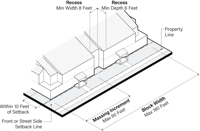
4.
Corner stepbacks. Building mass at building corners shall be stepped back, where it is within 10 feet of a minimum property-line setback. Additionally, building mass at building corners shall be stepped back where a minimum required property-line setback and minimum required paseo width as described in subsection 16-21.040.G.2a (paseos) intersect. Where a building corner stepback is required, then the building area that is above the ground floor shall be stepped back not less than 6 feet beyond the minimum required property-line setback and/or minimum required paseo width, and for a width of not less than 10 feet in either direction from where such setbacks intersect, as illustrated in Figure 1-2: Corner Stepbacks.
Figure 1-2: Corner Stepbacks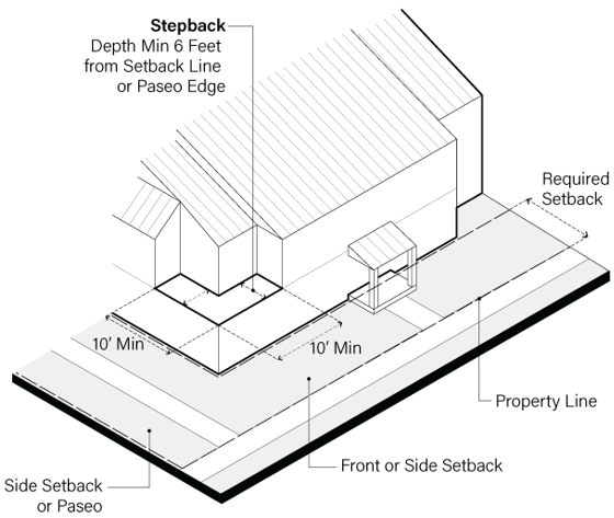
E.
Residential Frontages in R-3, R-3-10, and R-4 Zones.
1.
Residential street frontages. Not less than 75 percent of the available street frontage(s) adjacent to a public right-of-way shall be occupied by residential frontage, paseo, or some combination of the two, as illustrated in Figure 1-3: Street Frontage Continuity and described in subsection 16-21.040.E.3 (residential frontage design) and section 16-21.040.G (open space design), except that where project site has less than 100 linear feet of property line along a street, then the minimum residential street frontage can be reduced to allow vehicular access consistent with subsection 16-21.040.I.1 (vehicular access).
2.
Residential frontages along community open space. Where buildings abut a community open space, not less than 75 percent of the building edge shall be a residential frontage, as described in subsection 16-21.040.E.3 (residential frontage design).
Figure 1-3: Street Frontage Continuity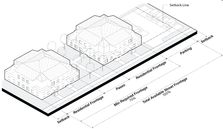
3.
Residential frontage design. Residential street frontages and residential frontages shall conform to the following standards.
a.
The residential ground floor shall not be more than 4 feet above finished grade, except within 20 feet of a vehicle entrance to a below-grade garage used by multiple households.
b.
Window and/or door openings shall comprise at least 25 percent of the surface area of the principal façade plane of each massing increment, as illustrated in Figure 1.4: Residential Window Area.
c.
Principal building entrances shall be accompanied by a porch, stoop, or vestibule with forecourt, are illustrated in Figure 1-5: Residential Entrance Types.
Figure 1-4: Residential Window and Door Area
Figure 1-5: Residential Entrance Types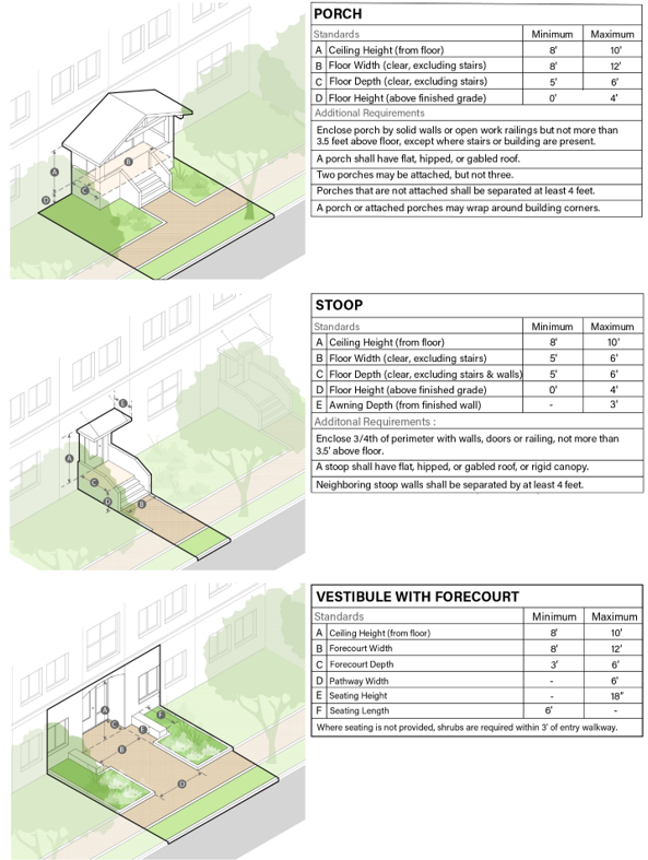
4.
Building entry and pedestrian access. Sidewalks that lead to principal building entrances shall connect directly to a public street as described in subsection 16-21.040.G.3 (sidewalks and bicycle facilities along public streets), or connect indirectly to a public street along a paseo as described in subsection 16-21.040.G.2.a (paseos), a shared court as described in subsection 16-21.040.G.2.c (shared courts), or along a sidewalk along a private street as described in 16-21.040.I.2 (private streets).
5.
Garage doors and openings. Garage doors and garage openings shall not comprise more than 50% of the width of each massing increment, as illustrated in Figure 1-6: Garage Doors & Openings. Garage openings that are used for up to 2 vehicles (or up to 4 vehicles if using tandem parking or mechanical lifts) shall be accompanied by garage doors that are not more than 18 feet in width. Adjacent garage doors shall be separated by a column or vertical panel not less than 12 inches in width.
Figure 1.6: Garage Doors & Openings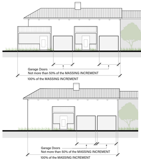
6.
Service area location and screening. Service areas shall be located:
a.
At least 30 feet from street rights-of-way;
b.
Enclosed within a building envelope; or
c.
Screened from view of public sidewalk(s) with a solid wall or fence at least 42 inches in height.
7.
Ground-level utility boxes and equipment. Ground-level utility boxes and equipment, including but not limited to back-flow preventers, air conditioner units, transformer boxes, gas and electric meters, generators and other utilities, shall not be located within a front or street side setback. If this is determined to be technically infeasible by a licensed engineer, ground-level utility boxes and equipment may be located in the front setback but shall be screened from all direct sight lines from public sidewalks by shrubs that can be expected to grow to the same height as the box or equipment.
F.
Building Design in R-3, R-3-10, and R-4 Zones.
1.
Exterior materials.
a.
Greyscale. Exterior finishes, garage doors, and roofs shall have a grey scale (color value) that is at least 30 percent and not more than 70 percent. The color of front doors, window frames, and mullions are exempt from this requirement.
b.
Prohibited finishes. Prohibited exterior finishes include: unfinished cinder block; unfinished cement block; mirrored glass; and vinyl and aluminum products, including those intended to simulate wood.
c.
Extent of single finish. No single finish material shall comprise more than 40 percent of the surface area of each principal façade plane, inclusive of doors and windows, as illustrated in Figure 1-7: Extent of Single Material. The exterior finish material must vary in two or more of the following ways:
• Vary among wood, stucco, metal, and cementitious materials;
• Vary among shingles, board-and-batten, shiplap, panels, and uninterrupted planes;
• Vary the color hue of the exterior finishes by at least 30 degrees within a 360-degree color wheel and/or vary the color grey value by at least 20 percent.
Figure 1.7: Extent of Single Material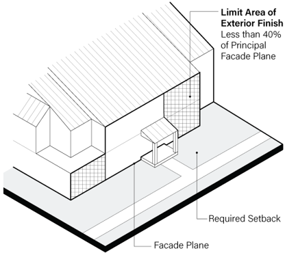
d.
Wood. Exterior application of wood shall be comprised of one of the following: wood modules comprised of lap siding, vertical plank siding with or without batten, horizontal plank siding, or shingles, or exterior plywood with battens to cover joints and horizontally spaced not less than 2 feet on center.
e.
Stucco and concrete. For exterior application of stucco and concrete, a horizontal expansion joint or control joint shall be placed within one foot of each floor level, and a vertical expansion joint shall occur at least every fifteen feet. For stucco, expansion and control joints shall be reinforced with metal.
f.
Metal. Metal pieces, panels, fasteners, and detailing affixed to the exterior surface of a building or accessory structure shall be resistant to corrosion.
g.
Brick and stone. If brick or stone are used adjacent to a building opening, a soldier course or solid lintel shall be incorporated, which is above the opening and at least 8 inches in height.
2.
Windows.
a.
Window type. Operable windows shall be limited to double-hung, awning, or casement type windows. Horizontal sliding and hopper windows are prohibited.
b.
Window materials. Solid wood or steel sash windows are required. Hollow window sections are not allowed.
c.
Mullions. Mullions may not be behind the surface of window glass, when viewed from outside.
d.
Clear glass. Except for bathroom windows, exterior glass shall be clear in appearance having at least 90 percent light transmission within the visible spectrum, and shall not be mirrored, frosted, or opaque.
e.
Recessed glass. Window glass shall be recessed at least 2 inches from the front face of adjacent trim or, if no trim is used, from the face of the adjacent exterior building wall.
f.
Privacy. Within the same development project, facing windows between buildings shall include at least one of the following:
• Building faces separated horizontally by at least 15 feet,
• Offset horizontally on the opposing building walls so facing window areas do not overlap,
• Having an interior sill height that is at least 48 inches above floor level; and/or
• Use of obscured glass in one or more windows if used with a bathroom or storage room.
3.
Roofs.
a.
Projections.
• Horizontal projections shall be limited consistent with Table 2-2A Allowable Projections into Setbacks and Paseos.
• Parapet walls shall not extend vertically more than three feet above roof.
• Roof-mounted mechanical equipment shall be entirely recessed within a sloped roof, or surrounded on all sides by a parapet wall with a top edge as high as the topmost point of the equipment.
• The following are exempt from the limitations of this subsection: solar panels, wireless communications equipment, window cleaning systems, equipment required by fire departments and other public agencies, and associated appurtenances.
b.
Roofs on sloped sites. On sites with an average slope that is greater than 15 percent:
• Roofs shall be either flat or sloped in the same direction as the finished slope below the building, within 30 degrees of a line parallel with the slope; and
• Gabled roof ends shall not be oriented in the same direction as the finished slope below the building, within 30 degrees of a line parallel with the slope.
G.
Open Space Design in R-3, R-3-10, and R-4 Zones.
1.
Private open space. Required private open space shall be comprised of a balcony, deck, covered porch, or yard dedicated to a specific dwelling unit, which have a minimum depth and width of at least 6 feet inclusive of posts and railings.
2.
Community open space. Community open spaces are for shared use by residents and may be used to provide pedestrian access to a public street as described in subsection 16-21.040.E.4 (building entry and pedestrian access). Community open spaces consistent with the open space types described below can be used to meet part of usable open space requirements in subsection 16-21.040.B.2 (open space standards), exclusive of areas comprised of sidewalks, building projections, and landscaped areas within 5 feet of a building.
a.
Paseos. Paseos may be directly accessible by members of the public or may be secured from direct public access behind a gate and fence/wall. Paseos shall conform to all of the following design requirements:
• A paseo's width shall be at least 25 feet between confronting façade planes, excluding allowable projections;
• Within 40 feet of property lines, paseo width shall be at least 40 feet (not including allowable projections);
• Along paseos, residential frontage shall conform to subsection 16-21.040.E.2 (residential frontages along community open space);
• At least one shared sidewalk not less than 6 feet in width shall run the length of the paseo; and
• Not less than 1 square-foot of lawn, seating, and/or play area(s) shall be provided for every 5 linear feet of paseo.
b.
Outdoor Recreation Space. Outdoor recreation space includes play areas, pools, ball courts, lawns, and similar recreational amenities. Outdoor recreation space may or may not be directly accessible by members of the public. Outdoor recreational space that conform to the following requirements may be counted towards usable open space:
• A width and depth of not less than 40 feet;
• Not less than 20 linear feet of fixed seating;
• Landscaped areas between adjacent residential frontage and the outdoor recreational space, with a depth of not less than 8 feet not including allowable projections and shared seating; and
• Not less than one tree planted for every 50 feet of adjacent residential frontage.
c.
Shared Courts. A shared court is a community space shared by pedestrians, bicyclists, and motor vehicles, and designed for very low vehicle speeds and traffic volumes. Shared courts may or may not be directly accessible by members of the public. Shared courts that conform to the following requirements may be counted towards usable open space, up to a maximum of 50 square feet per dwelling unit:
• No through traffic, except to provide access to garage(s) for eighteen (16) or fewer vehicles;
• Speed attenuation across the vehicular entrance to the share courts, such as a speed hump and/or rumble strip;
• Vehicle maneuvering dimensions consistent with subsection 16-21.040.I.3 (alleys) with a curb or fixed bollards at the edges of areas that allow motor vehicles to protect the residential frontage and associated landscape;
• Landscaped areas between residential frontage and the shared court, with a depth of not less than 8 feet (not including allowable projections and shared seating), with not less than one tree planted for every 50 feet of residential frontage and not less than 20 linear feet of fixed seating; and
• Surface material composed of permeable pavers made of brick, concrete, stone, and/or simulated stone, with a vertical depth of not less than 3 inches and horizontal diagonal dimension of not less than 13 inches, except to allow a concrete band up to 12 inches in width along the shared court's perimeter.
d.
Roof terraces. Roof terraces provide shared amenities for all residents on the top of roofs accessible by all project residents but not directly accessible by members of the public. A roof terrace can be used to meet usable open space requirements if it conforms to the following:
• A width and depth of not less than 25 feet;
• Universal access by all residents, including elevator access for persons with limited mobility;
• Not less than 25 percent of a roof terrace shall be comprised of lawn, seating, food preparation, and/or barbeque area(s);
• Not less than 10 percent of a roof terrace shall be landscaped; and
• At least one ADA-accessible unisex toilet provided.
e.
Community rooms. Community rooms include classrooms, day care centers, recreation centers, and reading rooms. A community room may be used to meet usable open space requirements if it contains uses that serve residents or is available for use by residents, and if it conforms to all of the following requirements:
• A width and depth of not less than 25 feet;
• A ground-floor location providing universal access by all residents;
• A direct access from a public street or community open space;
• Windows comprising not less than 50 percent of a community room's exterior wall(s) where the wall(s) face(s) a public street or community open space; and
• At least one ADA-accessible unisex toilet and at least one ADA-accessible kitchen that is not less than 50 square feet.
f.
Community gardens. A community garden may be counted towards usable open space, up to a maximum of 50 square feet per unit, if it conforms to the following:
• Direct pedestrian access via sidewalk(s) connected to a public street or network of on-site sidewalks;
• Slopes of less than 15 percent;
• Planter boxes that comprise not less than 50 percent of the community garden area and have a minimum depth and width of not less than 3 feet and a soil depth above finished grade of not less than 10 inches;
• Horizontal separation of at least 3 feet between planter boxes for pedestrian circulation; and
• At least two ADA accessible planter boxes.
3.
Sidewalks and bicycle facilities along public streets.
a.
Public Sidewalks. Where no sidewalk pre-exists along public street(s) adjacent to the project site, a new publicly-accessible sidewalk shall be provided. Where there is no existing public sidewalk in both directions within 200 feet from the project site boundaries, no new sidewalk is required. New sidewalks shall be located outside of vehicular travel lanes and required bikeway improvements, as described below:
• New sidewalks along public streets shall be not less than 6 feet in width;
• New sidewalks may be located within a street right-of-way, if an encroachment permit is obtained and there is 6 feet or more of unobstructed space between the street's existing curb and the project site's property line. Sidewalks of required width shall otherwise be located partly or entirely on the project site within newly dedicated public right-of-way; and
• Where the distance between the street's existing curb and edge of right-of-way exceeds 12 feet, then a landscape strip shall be provided between the new sidewalk and curb. The landscape strip shall not be less than 6 feet in width and include street trees planted not less than 35 feet on-center as measured parallel to the curb, not less than 24 inches from face of curb, and consistent with a street tree list and specifications provided by the Town.
b.
Bikeways. Where the project is adjacent to a roadway with bikeway facility locations designated in Tiburon General Plan Figure M-4 "Bikeway Network," bikeway improvements shall be made according to each bikeway classification and as further defined below:
• Class I Multi-Use Path - a bikeway not less than 10 feet, which is separated from vehicle travel lane of not less than 11 feet wide by a landscape strip not less than 6 feet wide;
• Class II Bike Lanes - not less than 11 feet for vehicle travel lane and 5 feet for adjacent bicycle lane, for a combined width of 16 feet; and
• Class III Bike Route - not less than 13 feet for one lane shared by bicyclists and motorists;
• Class IV Separated Bikeway - according to design specifications provided by the Town; and
• For all classifications, pre-existing parallel parking lanes shall be maintained and have a minimum width of 8 feet.
c.
Dedication of Land. The developer shall be responsible for making sidewalk, bikeway, and associated landscape strip improvements, and shall dedicate land with these improvements to the public right-of-way.
d.
Conformance with Standards. Street improvements shall conform to and in no event conflict with the Federal Highway Administration Manual on Uniform Traffic Control Devices or Caltrans design manuals, whichever is more restrictive at the time of project application, or Marin County standards if FHA or Caltrans standards are not in effect.
H.
Landscape Design in R-3, R-3-10, and R-4 Zones.
1.
Landscaped setbacks. Not less than 90 percent of setback areas shall be landscaped, except for areas occupied by building projections, pedestrian access, vehicular access, utilities, retaining walls, and community open space areas. Landscape materials shall be comprised of trees, shrubs, and groundcover consistent with .
2.
Trees and Plant Materials. Required landscaped areas shall be composed of trees, shrubs, and groundcover in compliance with the following:
• Trees shall be planted at 15-gallon size or larger;
• Shrubs shall be planted at one-gallon size or larger;
• Ground cover shall be planted at spacing not more than 12 inches on center; and
• Up to 10 percent of required landscape areas may be comprised of inorganic materials including, but not limited to, sand, stone, decomposed granite, or gravel.
3.
Vegetation Management Plan. A vegetation management plan shall be prepared in compliance with fire district regulations.
4.
Fences and walls. Fences and walls shall conform to the following standards, except for retaining walls which shall meet requirements in section 16-21.040.J (site preparation and engineering):
a.
Within front and street side setback areas, no fence or wall shall exceed a height of forty-two (42) inches above finished grade;
b.
In all other locations, no fence or wall shall exceed a height of seventy-two (72) inches above finished grade; and
c.
Fence and wall materials. The following fence materials are allowed in combination with posts:
• Wood board or picket;
• Wood or metal frame with metal wire;
• Metal bar;
• Stone or brick;
• Cast in place concrete; or
• Concrete block or cinder block where faced with stucco, tile, or cementitious panels.
Fence materials that are not allowed include:
• Barb wire;
• Razor wire;
• Chain link;
• Corrugated metal;
• Plastic and other synthetic materials; and
• Unfaced concrete block or cinder block.
5.
Site lighting. Lighting for parking and open space areas shall conform with the following standards:
a.
Pole-mounted lighting fixtures shall not exceed a height of 12 feet from finished grade;
b.
Within two feet of a building entryway at least one wall-mounted exterior light fixture shall be provided; and
c.
All proposed exterior lighting shall include shielded downlighting and shall not cast direct light beyond interior side and rear property lines, based on fixture specifications, location, and height.
I.
Vehicular Access and Parking in R-3, R-3-10, and R-4 Zones.
1.
Vehicular access.
a.
Regulatory Consistency. Street improvements shall conform to and in no event conflict with the Federal Highway Administration Manual on Uniform Traffic Control Devices or Caltrans design manuals, whichever is more restrictive at the time of project application, or Marin County standards if FHA or Caltrans standards are not in effect.
b.
Width of travel lanes. On-site vehicle travel lanes along private streets, shared driveways, and/or alleys shall have a paved width of 20 to 24 feet, exclusive of parking lanes, breakdown lanes (shoulders), or other obstructions.
c.
Slope of travel lanes. On-site vehicle travel lanes along private streets, shared driveways, and/or alleys shall comply with the standards of the applicable fire protection district.
d.
Vehicle egress. An uninterrupted line of sight shall be provided to the street and sidewalk from a driver's vantage point located not less than 5 feet from the street right-of-way, and within a cone of vision not less than 45-degrees angle in both directions from the direction of travel. A stop sign shall be located not more than 2 feet to the right of the uninterrupted line of sight. Driveways that cross public sidewalks shall be at the same level as the sidewalk.
e.
Fire access. Fire apparatus access to sides of structures and vehicular access routes shall comply with the standards of the applicable fire protection district.
2.
Private Streets. Private streets that provide access to both vehicles and pedestrians within a project site, in addition to consistency with section 16-21.040.I (vehicular access and parking), shall meet all of the following design requirements:
a.
Vehicle and pedestrian routes shall connect to a public street;
b.
Vehicle travel lanes may be flanked by parallel parking on one or both sides;
c.
Diagonal and perpendicular parking shall be limited to one side of travel lanes;
d.
Where parking abuts travel lane(s), parking and aisle dimensions shall conform to section 16-32.080 (parking design and development standards), except that aisle dimensions shall be interpreted to allow the front or rear of a vehicle to overhang a curb and/or landscaped area up to 2 feet from edge of pavement;
e.
Planting strips shall include street trees planted not less than 35 feet on-center as measured parallel to the curb, not less than 24 inches from face of curb, and consistent with subsection 16-21.040.H.2 (trees and plant materials).
3.
Alleys. Alleys may be used to provide vehicular access on-site without pedestrian circulation. Alleys shall meet all of the following design requirements:
a.
Travel lanes shall conform to subsection 16-21.040.I.1.b (width of travel lanes);
b.
Subsection where garage doors and/or surface parking are present along an alley, parking and aisle dimensions shall conform to section 16-32.080 (parking design and development standards), except that vehicle maneuvering shall assume aisle dimensions shall assume that vehicles can overhang the edge of alleys by 2 feet; and
c.
Alley pavement shall be comprised of asphalt, concrete, and/or permeable pavers.
4.
Parking.
a.
Parking ratios. On-site motor vehicle parking for vehicles shall conform with section 16-32.040 (number of parking spaces required). On-site bicycle parking shall be provided as follows:
• Secure covered bicycle room(s), lockers, or enclosed shed(s) accommodating one bike space per studio or one-bedroom unit and two bike spaces for larger units; and
• Bike racks accommodating one bike space per 10 units, but not less than 2 racks.
b.
Parking design. On-site parking for vehicles shall conform with section 16-32.080 (parking design and development standards), except that:
• Parking garages shall be located in conformance with section 16-21.040.E.2 (street and community open space frontages);
• A wall or fence having a height of between 36 and 42 inches above finished grade shall screen surface parking lots where they would otherwise be in direct view of a public sidewalk;
• Within surface parking lots, at least 1 tree for every 6 parking stalls shall be planted in a tree well with a width that is not less than 4 feet in all directions, and consistent with subsection 16-21.040.H.2 (trees and plant materials);
• Parking lots shall be separated from property lines by a landscape strip that is not less than 6 feet wide;
• Mechanical parking lifts shall be allowed within an enclosed garage when designated for use by residents, except for parking designated for use by persons with disabilities;
• Mechanical lifts shall be accompanied by an on-site battery or electrical generator to provide sufficient power to clear the lift of all vehicles, or shall be capable of manually clearing the lift without power; and
• A pair of tandem parking spaces shall be allowed when designated for use by members of the same household/dwelling unit.
J.
Site Preparation and Engineering in R-3, R-3-10, and R-4 Zones.
1.
Grading. Projects shall conform to the following.
a.
Development shall not occur on slopes that exceed 30% using a map with contour intervals of not more (not less detailed) than 2-feet, except to:
• Allow grading, site improvements including retaining walls, and buildings, to occur within 25 feet of the perimeter of slopes that are less than 30% and have a contiguous area at least 5,000 square feet, and/or
• Allow roadways, driveways, sidewalks, and/or trails across such slopes.
b.
Free-standing retaining walls shall not exceed 3.5 feet in height within setback areas, and not more than 6 feet in height in other areas.
c.
Retaining walls that are below buildings or part of structured parking garages shall not exceed 18 feet in height. Parts of parking garages that are below buildings shall be designed such that the residential ground floor that is above conforms with subsection 16-21.040.E.3 (residential frontage design).
d.
The top and the toe of each engineered slope shall transition to adjacent slopes so that there is not more than a 2% change in slope within one horizontal foot.
e.
Residential structures shall not be placed on areas with slopes over 10 percent that are within:
• An Earthquake Fault Zone as defined by the California Geologic Survey,
• An area mapped as landslide susceptibility class VIII, IX, or X by the California Department of Conservation, or
• A landslide, slump, or natural spring area as determined and mapped by a qualified civic or geotechnical engineer.
f.
Projects that are located on or within 500 feet of any area identified in subsection (e) above shall submit a geotechnical report prepared by the licensed geotechnical engineer of record that conforms to the California Building Standards Code requirements, notwithstanding any exclusions in the California Building Standards Code for building size or type of construction. The report shall address site preparation, foundation, grading and drainage recommendations, and proposed modification to the existing lagoon bulkhead if applicable, and expected ground water elevation at this site in relation to the proposed drainage improvements (including proposed subsurface drainage). The project shall incorporate all recommended measures identified by the geotechnical report into the project plans. Measures to be implemented during construction and operation of the project shall be listed on the improvement plans. The project applicant shall certify compliance with the measures.
g.
Slopes that have been graded, but that are free from buildings and other site improvements, shall be planted with trees, shrubs, and groundcover consistent with subsection 16-21.040.H.2 (trees and plant materials).
2.
Protected Trees. Protected trees shall be subject to permitting and other provisions described in chapter 15A (trees), except for housing development projects which qualify for streamlined ministerial review as required under California law for which the following shall apply:
• The project shall preserve and protect all heritage trees as defined in section 15A-2, and
• For any tree as defined in section 15A-2 which is removed, two replacement trees at least 15-gallon in size shall be planted within the project site.
3.
Biological Resources. Projects shall avoid construction or grading on portions of a site providing habitat for special-status species, wetlands, riparian areas, oak woodlands and habitats of significant value. Projects which qualify for streamlined ministerial review as provided under California law and containing area identified as a land use type other than urban in Figure C-1 of the Tiburon General Plan shall conform with the following:
a.
Projects shall submit a biological resources assessment prepared by a qualified professional that identifies special-status species, including endangered, threatened, sensitive, rare, and protected species, and their critical habitats, wildlife migration corridors, riparian habitat, and other sensitive natural communities (collectively "biological resources"). The biological resources assessment shall identify measures to protect biological resources based on local or regional plans, policies, regulations by the California Department of Fish and Game, US Fish and Wildlife Service, Bay Conservation and Development Commission, National Marine Fisheries Service, US Army Corps of Engineers, or other state or federal agency with jurisdiction over the biological resource, or best practices for resources conservation as established by resource protection or conservation plans.
b.
The project shall incorporate all biological resource measures identified by the biological resources report into the project plans. Measures to be implemented during construction and operation of the project shall be listed on the improvement plans. The project applicant shall certify compliance with the measures.
c.
The project shall provide a minimum of a 100-foot buffer from habitat for special-status species, wetlands, oak woodlands, and habitat of significant value as identified in the biological resources assessment which are present on the project site, unless a reduced buffer that is not less than 25 feet is determined to be adequate to protect such resources by the qualified biologist. No ground disturbance shall occur within the buffer area and the area within the buffer shall be permanent open space.
d.
If special-habitat species occur on the site or have the potential to occur on the site, as determined by the biological resources assessment, the qualified biologist shall identify adequate measures consistent with mitigation recommended by resource agencies (i.e., U.S. Fish and Wildlife Service, California Department of Fish and Wildlife) to avoid impacts to special-status species during any ground-disturbing and construction activities and the project shall implement such measures and include documentation demonstrating adherence to all measures. Certificates of occupancy shall not be approved without demonstration of adherence to all measures.
4.
Cultural Resources. Projects shall avoid construction or grading on portions of a site containing significant cultural resources. Projects which qualify for streamlined ministerial review as provided under California law and containing area identified as a land use type other than urban in Figure C-1 of the Tiburon General Plan shall conform with the following:
a.
A cultural resources assessment, including site survey, shall be conducted by a qualified archaeologist and shall identify the potential for cultural resources on the project site.
b.
If significant cultural resources, or the potential for significant cultural resources, are identified by the cultural resources assessment, the project shall avoid such cultural resources and shall provide a minimum of a 100-foot buffer from significant cultural resources, unless a reduced buffer that is not less than 25 feet is determined to be adequate to protect such resources by the qualified archaeologist or measures, such as capping the resource or relocation of the resources to permanent open space, are identified as adequate to preserve the significance of significant cultural resources. No ground disturbance shall occur within the buffer area and the area within the buffer shall be permanent open space. The project shall implement all recommended measures and include documentation demonstrating adherence to all measures. Certificates of occupancy shall not be approved without demonstration of adherence to all measures.
(Ord. No. 519 N.S., § 3(Exh. A), 3-17-2010; Ord. No. 541 N.S., § 2(B), 8-15-2012; Ord. No. 593 N.S., § 2, 1-19-2022; Ord. No. 605 N.S, § 4, 6-21-2023; Ord. No. 606 N.S. , § 2, 12-6-2023)