
Titusville City Zoning Code
ARTICLE III
DOWNTOWN MIXED-USE SMART CODE
Sec. 28-26. - Intent/purpose.
The general intent of this Land Development Code provision is to establish procedures and standards for the development of land within the City of Titusville Downtown Community Redevelopment Area (DCRA) boundary, enforceable under the planning jurisdiction of the City of Titusville in an effort to:
(a)
Provide for and encourage development within the DCRA in a manner that is harmonious with its environs, consistent with the Downtown CRA Plans, and Plans and Codes of the City.
(b)
Stimulate economic growth and redevelopment of not only the downtown, but the U.S. 1 corridor and other major corridors leading thereto.
(c)
Coordinate design pattern of streets, sidewalks, and other transportation facilities, including multi-modal forms of transportation.
(d)
Encourage public and civic spaces for recreation, water resource management, public gatherings, and placemaking.
(e)
Assure flood prevention, proper storm drainage, and appropriate utility systems so development is not a burden to the DCRA.
(f)
Conserve valuable and scenic natural features, with provision for adequate open space.
(g)
Conserve valuable and culturally significant historic structures and characteristics.
(h)
Promote the public health, safety, and general welfare by creating incentives for or eliminating impediments to a quality, well-planned development.
(i)
Require a high degree of quality and aesthetics in developments.
Sec. 28-27. - Relationship to downtown Master Plan from the downtown Master Plan.
The purpose of the Community Redevelopment Plan Update was to develop a plan for coordinated growth in the Downtown CRA through a series of strategic initiatives that can be realized over the next fifteen (15) to twenty (20) years. The plan identifies investments aimed at preserving the established qualities of the Downtown area and creating a vibrant mixed-use town center environment. The plan also identifies redevelopment opportunities to enhance local market conditions for new commercial and residential development, and to maximize the revitalization potential of the entire DCRA. The long-range vision reflects the objectives articulated by residents at workshops. These objectives include creating a series of clearly defined centers along the length of the DCRA. The plan envisions the addition of new mixed-use buildings on infill lots along the Washington/Hopkins one-way pairs, new open space amenities, enhanced streetscape conditions, and new public facilities (parking structures and stormwater ponds) that will increase the area's capability to accommodate new growth.
The plan envisions new standards for future development. These standards or regulations will be aimed at preserving the historic character while creating more appealing physical conditions. The goal is to realize a downtown area through "smart growth" that will attract and sustain private investment and create a unique sense of place. The following implementation recommendations in the plan are intended as follow-up measures in the Downtown CRA over the next five (5) to eight (8) years.
The private sector initiatives indicated include the following:
(a)
Implement the River Park mixed-use development next to the Stormwater Park.
(b)
Develop a variety of new residential opportunities throughout the DCRA.
(c)
Develop in-fill housing in the North and South Palm Street areas and adjacent to the FEC railroad.
(d)
Begin development of the Sand Pointe Plaza project and general area.
The public sector initiatives are as follows:
(a)
Conduct a real estate/market analysis and feasibility study for the DCRA.
(b)
Acquire land and assemble feasible development parcels around the Garden Street and U.S. 1 intersection.
(c)
Acquire land in the North Palm Street and South Palm Street areas.
(d)
Implement the Stormwater Park project.
(e)
Acquire land in the Town Center, Civic Center, and Southern Gateway areas for central parking and stormwater facilities.
(f)
Implement a priority streetscape enhancement program throughout the DCRA and at major entry points.
(g)
Implement proposed FDOT improvements along Washington Avenue and Hopkins Avenue.
(h)
Implement effective historic preservation measures.
The recommended regulatory issues include the following:
(a)
The adoption of a long-range development plan for the DCRA.
(b)
Modify the Comprehensive Plan to reflect the Town Center concept.
(c)
Modify existing zoning or establish an overlay district to attract desired types of development.
(d)
Adopt a "form-based" code and development standards.
(e)
Create a local historic district for the Old Town residential area.
(f)
Establish historic preservation criteria for commercial properties in the Town Center area.
These strategies are aimed at leveraging and maximizing the impact of future public investment in attracting private sector investment, and ensuring that the area develops in a manner consistent with the "vision" of the community.
This hybrid, form-based code seeks to implement the strategies identified above through a variety of tools:
(a)
Updating and integrating the existing Land Development Codes into one (1) concise document containing "everything anyone ever wanted to know" about development in Downtown Titusville. This makes it easier on the public sector, but more importantly, on the private, who needs to have consistency, clarity, and known expectations in order to assume the risk associated with redevelopment projects. It also attempts to streamline the process by having more flexibility, less travel through various boards/agencies, and more control for staff and the DCRA.
(b)
Using the concept of Smart Growth, and the model for Smart Codes, which looks at communities from the standpoint of a "transect", which are development areas lying between rural, suburban, and urban development zones.
(c)
Visually expressing the codes to streamline and be "user-friendly". Pictures tell a story and the graphic depiction of what the words mean can allay problems with interpretation, semantics, and expectations.
Sec. 28-28. - Relationship to Comprehensive Plan and City's Land Development Regulations.
It is the intention of the City Council and Local Planning Agency that this Chapter also serves to implement the requirements of the Local Government Comprehensive Planning and Land Development Regulation Act, Section 163.3202 of the Florida Statutes, which requires the adoption of Land Development Regulations. In the event of a conflict between these regulations and the Comprehensive Plan, the Comprehensive Plan shall prevail. In the event of a conflict between these regulations and the Citywide Land Development Regulations, this chapter shall prevail. In the event of any conflict, the Administrator shall make a determination that may be appealed to the DCRA.
Sec. 28-29. - Location, land use and zoning maps.
Maps 1—7 in Section 28-32 depict the general location, land use, zoning, DCRA sub-districts, and existing street network.
Sec. 28-30. - Applicability.
The Central Business District (CBD), and any other zoning district in the Community Redevelopment Area with the exception of the Residential Historic Preservation District is hereby repealed in its entirety and replaced with a new district entitled:
(a)
Downtown Mixed-Use Zoning District. The Downtown Mixed-Use (DMU) zoning district is hereby established to promote the health, safety, social and economic welfare of the residents of the City by increasing the City's tax base and promoting the long-term economic growth and vitality of the downtown area. This district enables the City to encourage public and private development compatible with the character of the downtown area and in conformance with the Community Redevelopment Plan. The DMU encourages a mix of uses and development form throughout the District. Through the DMU, the City can become the center for economic and business affairs, expand employment and living opportunities, protect historic resources, promote new investment, protect the natural beauty and public spaces that make Titusville special, and encourage public use (not necessarily ownership) of the waterfront. It is further intended that this district will use the existing grid street network as the spine or bones of improved pedestrian and vehicular circulation, parking management, and encouragement of excellence in urban design, preserving the unique character and historic fabric of the downtown. In this way, the City will have a diverse, welcoming downtown for entertainment, tourism, employment, recreation, business, and living.
(b)
Downtown Mixed-Use Zoning District (DMU) Boundaries. The boundaries of the Downtown Mixed-Use (DMU) zoning district are the same as the boundaries of the Downtown Community Redevelopment Area, with the exception of the Residential Historic Preservation Zoning District. The Residential Historic Preservation District shall retain the same zoning designation; however, all properties in this district with the DCRA shall comply with the Administrative procedures of Chapter 28, Article III, Division 1. The Downtown Community Redevelopment Area as created by City Council under Ordinance 66-1982 pursuant to the powers conferred by Section 163.330, Florida Statutes, entitled "The Community Redevelopment Act of 1986" and any amendments thereto, specifically those powers granted in Section 163.330 et seq. [Florida Statutes], and as refined within this subsection. The boundaries of the Community Redevelopment area are as follows:
(1)
North. The northwest property line of Parcel 28, Section 33, running southwest-northeast and extending from FEC Railroad on the west to the center of the navigable portion of the Indian River on the east.
(2)
South. An east-west line running parallel with the center line of Grace Street and extending from the FEC Railroad to the west, to the center of the navigable portion of the Indian River on the east.
(3)
East. A line running generally north and south, but continuous to the center of the navigable portion of the Indian River, and extending from the intersection with the south boundary as described above [and the] intersection with the north boundary as described above.
(4)
West. A line running generally north and south and parallel to the FEC Railroad, and extending from the intersection of the north boundary to the center line of Grace Street on the south.
(5)
Exception. Except the following: Beginning at the confluence of the west mean high water line of the Indian River and the east terminus of the River View Place right-of-way; thence west along the north right-of-way line of River View Place to the west right-of-way line of Indian River Avenue; thence south along the west right-of-way line of Indian River Avenue to the south right-of-way line of Palmetto Street; thence west along the south right-of-way line of Palmetto Street one hundred twenty-five (125) feet; thence south and parallel to the west right-of-way of Indian River Avenue to the south right-of-way line of Grace Street; thence east along the south right-of-way line of Grace Street to the west mean high water line of the Indian River; thence north along the west mean high water line of the Indian River to the point of beginning. (See Community Development Department for any question pertaining to boundaries.)
Within the Downtown Mixed-Use District (DMU) and the Residential Historic Preservation Zoning District, all applicable laws pertaining to the DCRA and including the goals and objectives of the Community Redevelopment Plan shall be adhered to.
The regulations established in the DMU have been established in accordance with the Community Redevelopment Plan with reasonable consideration, among other things, to prevailing land uses, growth opportunities, the elimination of slum and blight and to encourage the development and redevelopment of land in the community redevelopment area and community input. Therefore, the district provides regulations to implement applicable goals, objectives and policies of the City's redevelopment efforts so as to be consistent with the applicable goals, policies and objectives of the City's Comprehensive Plan.
(c)
Severability. If any part or provision of this section or application thereof to any person or circumstances is adjudged invalid by a court of competent jurisdiction, such judgment shall be confined in its operation to the part, provisions or application directly involved in the controversy in which such judgment shall have been rendered. That judgment shall not affect or impair the validity of the remainder of this section or the application thereof to any other persons or circumstances.
(d)
Repeal of conflicting ordinances. The provisions of this section shall supersede any ordinance in conflict herewith. The procedure for processing development within the redevelopment area shall be in accordance with this ordinance and shall supersede conflicting provisions.
(e)
Enactment. This section shall take effect as provided by law; provided that when any provisions of this ordinance [section/article] are amended, the effective date of such amendment shall apply for the purposes of deciding any question directly controlled by such amendment.
Sec. 28-31. - Guiding principles.
Decision making by City staff, boards, agencies, and Council should be influenced by the following guiding principles:
(a)
That development within the DMU should be compact, pedestrian oriented, and Mixed-Use.
(b)
That ordinary activity of daily living should occur within walking distance of most dwellings, allowing independence to those who do not drive.
(c)
That interconnected networks of streets, alleys, sidewalks, bike paths, and greenways should be designed to disperse traffic and reduce the length of automobile trips.
(d)
That within neighborhoods, a range of housing types and price levels should be provided to accommodate diverse ages and incomes.
(e)
That appropriate building densities, intensities, heights, and land uses should be provided within the DMU to create a viable, thriving urban center.
(f)
That development should encourage or be served by transit and within walking distance of transit stops.
(g)
That Civic, Institutional, and Commercial activity should be embedded in downtowns.
(h)
That a range of open space including parks, squares, playgrounds, and other civic spaces should be distributed within the neighborhood and downtown.
(i)
That buildings and landscaping should contribute to the physical definition of streets, sidewalks, outdoor seating, plazas, and similar civic places.
(j)
That development should adequately accommodate automobiles while respecting the pedestrian and the spatial form of public areas.
(k)
That the design of streets and buildings should reinforce safe environments, but not at the expense of accessibility.
(l)
That architecture and landscape design should reflect the Titusville climate, topography, history, and building practice.
(m)
That buildings, infrastructure, site design, and features should utilize energy-efficient methods.
(n)
That civic buildings and public gathering places should be provided to reflect and reinforce community identity.
(o)
That the preservation and renewal of historic buildings should be facilitated, to affirm the continuity and evolution of this community and our society.
(p)
That new construction should be compatible with adjacent uses, respect the natural environment, and create little impact on the adjacent built environment.
Sec. 28-32. - Preexisting conditions/applicability.
(a)
Where buildings exist on adjacent lots, the Administrator may require that a proposed building be compatible with the adjacent buildings rather than the provisions of this Code.
(b)
Any addition to or modification of a structure that has been designated as historical or located within the Historical District by the Local Preservation Organization or to a building actually or eligible for inclusion on a state, local or national historic register, shall be subject to approval by the local Historic Preservation Board or other City designated organization.
(c)
The restoration or rehabilitation of an existing building shall not require the provision of (1) parking in addition to that existing or (2) on-site stormwater retention/detention in addition to that existing or to provide same if neither is provided. Provisions for regional parking and regional stormwater programs and payments in-lieu of on-site provision are found in Chapter 30. Existing parking requirements that exceed those for this Code may be reduced as provided by the waiver provisions outlined in Section 28-34.
(d)
All new buildings, renovations of thirty-five (35) percent of the square footage, or improvements involving roof, structural, window replacement, painting, facade repair/replacement, additions or demolition/repair of existing buildings are subject to the Downtown Mixed-Use District Code and Downtown Urban Design Manual.
(e)
Existing buildings which have a change of use shall be reviewed by the Administrator for a modification determination. An example of a change of land use is from commercial to residential, office to commercial, office to mixed use, and so on. Any waivers to these requirements shall be determined as outlined in Section 28-34. Modification determination shall include consideration of the last time improvements were made to a structure:
(1)
If a structure has not been modified or updated within five (5) years, the following minimum improvements shall be required consistent with all current land development regulations and the Urban Design Manual:
a.
If painting of structure.
b.
If landscaping.
c.
If new signage (must conform to current standards).
d.
If replacement of safety hazards.
e.
If addition of one (1) design feature from the Urban Design Manual appropriate to the style of the building.
(2)
If a structure has not been modified or updated between five (5) and ten (10) years, the following minimum improvements shall be required consistent with all current Land Development Regulations and the Urban Design Manual:
a.
Painting, landscaping, new signage and replacement of safety hazards.
b.
Repair, replacement, or fixing of broken windows, structural problems, roof problems.
c.
Addition of three (3) design features from the Urban Design Manual appropriate to the style of the building.
(3)
If a structure has not been modified or updated in more than ten (10) years, and not of historic character or on a register, the following minimum improvements shall be required consistent with all current Land Development Regulations and the Urban Design Manual:
a.
If compliance with the Land Development Regulations, unless and variances and/or waivers are approved per Section 28-34.
b.
If compliance with the Urban Design Manual.
Sec. 28-33. - Administration, submittals and review process.
(a)
Interpretation. Interpretation of the standards in this section shall be the responsibility of the City Manager or designee. Appeals from his/her interpretations shall be taken to the Downtown Community Redevelopment Agency (DCRA).
(b)
Design review process. The DRC shall have authority to review and approve all aspects of exterior architecture, signage, landscape, streetscape or hardscape improvements for aesthetic appropriateness, and conformance to the adopted DMU District Code and Design Guidelines; and, for conformance to the City Comprehensive Plan and Land Development Code for all projects equal to or less than one and one-half (1.5) acres in size or with buildings up to ten thousand (10,000) square feet in size. The DCRA shall receive recommendations from the DRC and make final approval on all projects in excess of one and one-half (1.5) acres or ten thousand one (10,001) square feet. Any appeals to a decision of the DRC shall be heard by the Downtown Community Redevelopment Agency (DCRA). Said decision must be appealed within thirty (30) days after rendered. The fee for the appeal shall be as adopted by the City.
(c)
Minimum submittal requirements for design review for DMU projects. At a minimum, the following shall be required for review of projects to be located within the redevelopment area on undeveloped sites, all sites greater than one and one-half (1.5) acres, or on sites where a building is to be demolished or renovated to more than fifty (50) percent of its current assessed value:
(1)
A current certified site survey.
(2)
A conceptual site plan, drawn to either one (1) inch equals twenty (20) feet or one (1) inch equals fifty (50) feet, which shall contain:
a.
Building locations and orientations and landscape areas;
b.
Parking locations and number of spaces;
c.
Paved surfaces, materials, and locations;
d.
Site location diagram, map and legal description:
1.
Signage; and
2.
Tree survey of all trees larger than eight (8) inches dbh.
e.
Building elevations illustrating all sides of structures that face public streets or spaces and specific architectural design elements for which bonuses may be sought.
f.
Description of density or height bonuses being applied for and justification, as applicable.
g.
Other supporting documentation as may be requested or required.
(d)
Site Development Agreement or Binding Development Agreement. May be used to confirm or establish via negotiation the form of on- or off-site improvements that are required to be performed by either an owner, developer, or stakeholder and the DCRA. Such agreements shall be adopted in accordance with Chapter 34, Article VIII of the City's Land Development Regulations.
Sec. 28-34. - Project procedures for the community redevelopment area.
(a)
Conditional uses. The location, design and condition for operation of these uses require special review and approval by the Downtown Community Redevelopment Agency (DCRA) in accordance with procedures set forth in Chapter 34, Article II, Division 4 of the City's Land Development Regulations. Such uses may be developed in the districts specified if special findings are made that the standards and conditions as set forth in Chapter 28 have been met.
(b)
Variances/waivers.
(1)
Variances and waivers. This section supersedes the City's Land Development Code provisions for variances in Chapter 34, Article II, Division 4, Conditional use permit process. Where the strict application of the code provisions cannot be met, variances or waivers may be granted within the DCRA.
Waivers may be granted by the DRC as provided in Chapter 34, Article V, Division 6. Waivers are small deviations from the Code for specific issues outlined in Chapter 34, Article V, Division 6 and are necessary when trying to redevelop an area with small lots, existing buildings, and when codes or regulations have been designed for vast suburban vacant land instead of urban vacant lands. Waivers allow the DCRA the flexibility desired in moving quickly to facilitate development. Waivers are a variation from particular standards of this code that is justified by need, hardship, physical constraint, or to improve the overall design of the project, but is done through an administrative process rather than as a variance, in order to implement the Downtown Redevelopment Plan.
Sec. 28-35. - Community Redevelopment Agency development approval authority.
(a)
Variances on any item that would be considered within the DCRA shall be approved by the Board of Adjustments and Appeals.
(b)
Conditional use permits within the DCRA shall be approved by the City Council.
Sec. 28-36. - Reserved.
Editor's note— Sec. 9 of Ord. No. 31-2017, adopted Oct. 24, 2017, deleted § 28-36, No use or sale of land or building except in conformity with the provisions of this ordinance, which derived from the original codification. User is directed to § 27-15 for provisions pertaining to said subject matter.
Sec. 28-37. - Incentives.
(a)
To encourage development within the DCRA, the City Council may grant the following incentives, to the extent authorized by state law:
(1)
Applications for development within the DCRA shall be processed with priority over those in other areas of the City.
(2)
The DCRA sub-committee may grant waivers for parking, setbacks, and on-site stormwater as set forth or others as may be provided for herein.
(3)
The City may waive or reduce review fees for a certain period of time to the extent allowable or practical (under staff review).
(4)
The DCRA may recommend, and City Council approve, increased density by the use of Transfer of Development Rights.
(5)
As U.S. 1 is being improved and the City is a "Dense Urban Land Area" (DULA), the City may waive the traffic impact report, and allow a deferment of impact of fees.
(6)
The DCRA may consider constructing those portions of a development that are for the public purpose: parking, stormwater, landscaping, plazas, civic spaces, required improvements in open space areas accessible for use by the public, roadway connectivity, pedestrian/bike paths, and the like.
(7)
The DCRA may consider the reimbursement of Tax Increment Revenues anticipated to be derived from a development to that development over a negotiated period of time in order to help the project be financially feasible or meet their pro forma.
Sec. 28-41. - Intent/purpose.
In 2008, the Titusville Downtown Community Redevelopment Agency (DCRA) updated the adopted Redevelopment Plan. It states: "Overall, as redevelopment occurs in the City there is a need to remain flexible. Second, there is a need to identify the market forces that are shaping the available options and target efforts to take advantage of these forces. Third, redevelopment is generally more expensive than new development. We, therefore, need to offer developers the support of the DCRA, including the investment of the tax increment revenues generated by their projects back into the redevelopment area." This section of the new code seeks to identify opportunities for both the overall new Downtown Mixed-Use (DMU) District, and the sub-areas, contained therein.
Sec. 28-42. - Instructions.
Through the City's visioning and the recent workshops, there is a clear desire to recognize the Downtown Community Redevelopment Agency (DCRA) as the urban core and to create standards to allow for an urban style of development. There is a clear and present desire to integrate Smart Code principles. Smart Code principles are based upon a system known as the Transect, which divides an "environment" into segments based upon its geological, or in terms of a "City", its development form.
Sec. 28-43. - Downtown Mixed-Use Zoning District.
The Downtown Mixed-Use Zoning District (DMU) is established to promote the health, safety, social and economic welfare of the residents of the City by increasing the City's tax base and promoting the long-term economic growth and vitality of the downtown area. This district enables the City to encourage public and private development compatible with the character of the downtown area and in conformance with the Community Redevelopment Plan. The DMU encourages a mix of uses and development from throughout the District. Through the DMU, the City can become the center for economic and business affairs, expand employment and living opportunities, protect historic resources, promote new investment, protect the natural beauty and public spaces that make Titusville special, and encourage public use (not necessarily ownership) of the waterfront. It is further intended that this district will use the existing grid street network as the spine or bones of improved pedestrian and vehicular circulation, parking management, and encouragement of excellence in urban design, preserving the unique character and historic fabric of the downtown. In this way, will the City have a diverse, welcoming downtown for entertainment, tourism, employment, recreation, business and living.
Sec. 28-44. - Sub-districts described.
The specific uses, dimensions and development criteria are defined in Chapter 28, Article IV through Article IX. The sub-districts are described in the map below:
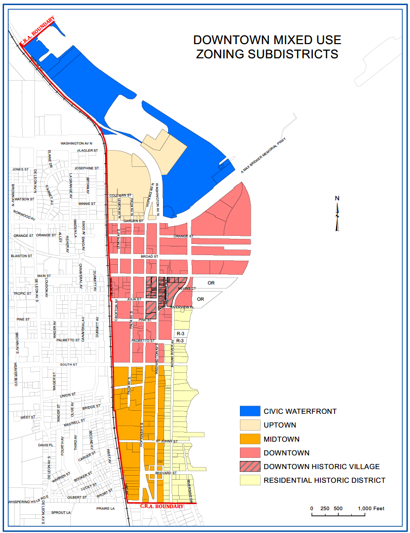
(a)
Uptown: Located at the North end of the DCRA, this district has land on both sides of U.S. 1. The just north of Garden Street consists of smaller residential and commercial parcels to the south of a large vacant parcel. The privately held land on the east side of U.S. 1 is a marina and has opportunities to bring commerce to the waterfront and engage the public.
Uptown—The Smart Code Perspective: This area shall contain the higher density and height allowances, flexibility for building types, uses, and building placements and contain the greatest variety of uses, and civic buildings of regional importance. It may have smaller blocks; streets have steady street tree planting and buildings are set close to wide sidewalks.
General character: Medium to High-Density Mixed-Use buildings, entertainment, civic and cultural uses. Attached buildings forming a continuous street wall; trees within the public right-of-way; highest pedestrian and transit activity.
Building placement: Shallow setbacks or none; buildings oriented to street, defining a street wall.
Frontage types: Stoops, dooryards, forecourts, shopfronts, galleries, and arcades.
Typical building height: Maximum of five (5) stories with a few shorter buildings; and up to ten (10) stories for multifamily uses west of US 1, convention/hotel/entertainment facilities and/or transit oriented development as approved by the City Council with a recommendation from the DCRA.
Type of civic space: Parks, plazas and squares.
(b)
Civic Waterfront: This is the soul of the DCRA where there are physical, visual, and spatial connections to the water by the public and the uses found on the land. Uses are primarily to be water dependent and water related and open to the public. Uses also do not have to be publicly owned, but open and available for public use at least ten (10) hours per day.
(c)
Residential Historic District:
Historical Residential—Smart Code Perspective: As a neighborhood with the largest concentration of historic homes in the City, this area consists of unique architecture and low density residential areas, adjacent to higher zones that have some mixed residential uses, home occupations, professional offices, some personal service, accessory or outbuildings. Planting is naturalistic and setbacks are relatively deep. Blocks may be large and the roads irregular to accommodate natural conditions.
General character: Lawns, and landscaped yards surrounding detached single-family houses; pedestrians occasionally.
Building placement: Large and variable front and side yard setbacks.
Frontage types: Porches, fences, freestyle tree planting.
Typical building height: One- to two-story with some three-story buildings.
Type of civic space: Parks, greenways.
(Editor's note: The Residential Historic District is governed by the Residential Historic Preservation District.)
(d)
Downtown. This area is the heart of the DCRA. Predominately developed, downtown should contain the highest densities, intensities and heights creating a true downtown, urban area.
Downtown—The Smart Code Perspective: The heart of the DCRA, this urban center area shall consist of higher density mixed-use buildings that accommodate retail, offices, government, civic, and public buildings, along with a mix of housing types including rowhouses and multifamily units. It has a tight network of streets, with wide sidewalks, steady street tree planting and buildings set close to the sidewalks.
General character: Specialty, retail, general shopping mixed with residential, offices, workplace, and civic buildings; predominantly attached buildings; trees within the public right-of-way; substantial pedestrian activity.
Building placement: Shallow (little space between building and sidewalk) setbacks or none; buildings oriented to street defining a street wall.
Frontage types: Stoops, shopfronts, galleries, dooryards, large window areas, higher first floor elevations.
Typical building height: Maximum five stories with a one-story waiver per chapter 28, zoning, article III, downtown Mixed-Use Smart Code, Division 1, General Provisions, Section 28-34, Project procedures for the community redevelopment area.
Type of civic space: Parks, plazas and squares.
Downtown Historic Village: Reserved.
(e)
Midtown: The southern gateway into the DCRA, Midtown, appears as more suburban than the other areas. Uses which can be dual classified between commercial and industrial are located within this area (or sub-district). The Midtown area is structured such that many of the uses are to be validated as part of sustainability, and guide their change through design elements. Redevelopment and new criteria will attempt to create a tighter urban environment to enhance the core.
Midtown—The Smart Code Perspective: General Urban Zone consists of mixed use. In this district, it is a heavier commercial fabric, with larger lot uses and development, such as vehicle sales, auto repair shops, some industrial uses, and scattered older residential uses within an urban fabric. It contains a wide range of building types more suburban in nature than urban, even though it is adjacent to the urban core. Setbacks and landscaping are variable. Streets with curbs and sidewalks define medium-sized blocks.
General character: Mix of houses, older, small apartment buildings with scattered industrial and commercial activity; little balance between landscape and buildings; large lots and uses are not conducive to pedestrians.
Building placement: Should have shallow to medium front and side yard setbacks.
Frontage types: Porches, fences, dooryards.
Typical building height: Three (3) stories.
Type of civic space: Squares, greens.
(f)
Transit Oriented Development (TOD) defined: This Land Development Code envisions one (1) or more opportunities for a TOD: the area north of Garden in the Uptown District. TOD is an approach to development that focuses land uses around a transit station or within a transit corridor typically characterized by:
•
A mix of uses.
•
Moderate to high density.
•
Pedestrian orientation/connectivity.
•
Transportation choices.
•
Reduced parking.
•
High-quality design.
TODs shall be located within one-quarter-mile, or a five- to seven-minute walk, of a transit station. TODs may incorporate transit stations into a development, or focus on building reuse and infill. In more suburban areas, TOD often takes the form of new development clustered around a station on underutilized or vacant sites. TODs use landscaping, street furniture, street lighting, and other urban and site design features that encourage pedestrian activity to integrate the station area into the surrounding community. An essential ingredient of any successful TOD, whether in a large urban center or smaller village is connectivity between street networks and adjoining uses, which can be achieved through landscape design, sidewalks and pathways, signage, building facade treatments, parking strategies, and a variety of land uses. Historically, bus transit stops have not generated TODs because bus routes and stops, as well as level of services can be relocated at any time and vary. The trend toward public investment in busways with a dedicated right-of-way and large bus transit centers may make bus transit stations more attractive for transit-oriented development. The standard density for TODs is twelve (12) to fifteen (15) units per acre to make them feasible. A section of the Appendix will be devoted to design standards for TOD forms of development.
(1)
Transit-Oriented design maximum height with bonus described. A TOD design may apply for a height bonus of up to ten (10) stories for projects that meet the intent of TOD and requirements as described in Section 28-324. This approval shall be completed through Design Approval by the DCRA as described in Section 28-33 of these [Land Development] Regulations.
(Ord. No. 02-2020, § 1, 2-12-20; Ord. No. 19-2020, § 10, 11-10-20)