
Titusville City Zoning Code
ARTICLE VI
ZONING DISTRICT STANDARDS
Sec. 28-301.- Residential Estate (RE).
| Residential Estate (RE) | ||
|---|---|---|
| (a) Purpose. | ||
| The Residential Estate (RE) district is intended to provide for low-density large lot estate type development of one (1) acre or larger in size. Certain structures and uses that will serve governmental, religious, and other immediate needs of such areas are permissible as permitted or conditional uses subject to all restrictions necessary to preserve and protect the low density character of the district. | ||
| (b)Use Standards Typical Lot Pattern | ||
| See Chapter 28 Article IV and Article V | 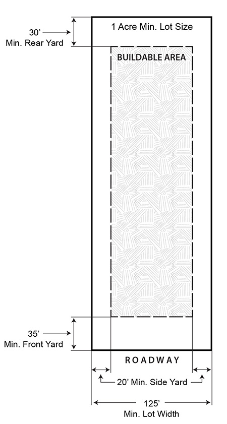 | |
| (c) Intensity and Dimensional Standards | ||
| Lot area, minimum (sq. ft.) | 43,560 | |
| Lot width, minimum (ft.) | 125 | |
| Density, maximum (du/ac) | 1 | |
| Floor area per dwelling unit, minimum (sq. ft.) | 2,000 | |
| Building coverage, maximum (% of lot area) | 30 | |
| Lot coverage, maximum (% of lot area) | NA | |
| Height, maximum (ft.) | 35 | |
| Front yard setback, minimum (ft.) | 35 | |
| Side corner yard setback, minimum (ft.) | 35 | |
| Interior side yard setback, minimum (ft.) | 20 | |
| Rear yard setback, minimum (ft.) | 30 | |
| Accessory Use Development Standards | See Chapter 28 - Article VII | |
| NOTES: | ||
| Typical Development Configuration (For illustrative purposes only) | ||
 | ||
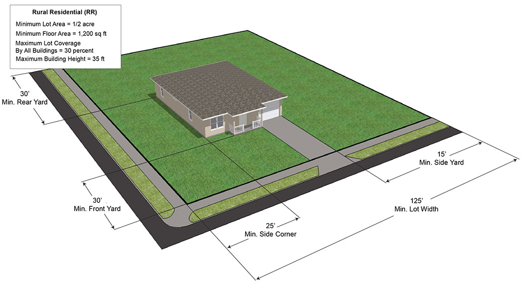
Sec. 28-302. - Rural Residential (RR).
| Rural Residential (RR) | ||
|---|---|---|
| (a) Purpose | ||
| The Rural Residential district (RR) is intended to provide for low-density large lot development of one-half (0.5) acre or larger in size. Certain structures and uses that will serve governmental, religious, recreational, and other immediate needs of such areas are permissible as permitted or conditional uses subject to all restrictions necessary to preserve and protect the low density character of this district. | ||
| (b) Use Standards | Typical Lot Pattern | |
| See Chapter 28 Article IV and Article V | 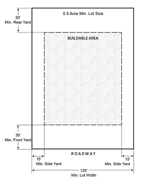 | |
| (c) Intensity and Dimensional Standards | ||
| Lot area, minimum (sq. ft.) | 21,780 | |
| Lot width, minimum (ft.) | 125 | |
| Density, maximum (du/ac) | 2 | |
| Floor area per dwelling unit, minimum (sq. ft.) | 1,200 | |
| Building coverage, maximum (% of lot area) | 30 | |
| Lot coverage, maximum (% of lot area) | NA | |
| Height, maximum (ft.) | 35 | |
| Front yard setback, minimum (ft.) | 30 | |
| Side corner yard setback, minimum (ft.) | 25 | |
| Interior side yard setback, minimum (ft.) | 15 | |
| Rear yard setback, minimum (ft.) | 30 | |
| Accessory Use Development Standards | See Chapter 28 Article VII | |
| NOTES: | ||
| Typical Development Configuration (For illustrative purposes only) | ||
 | ||
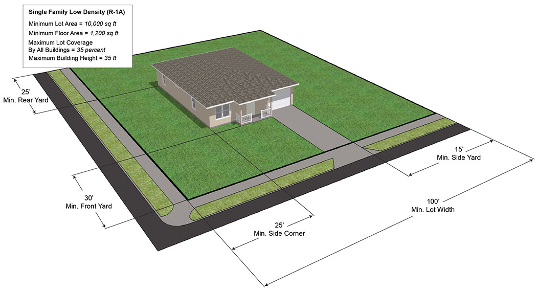
Sec. 28-303. - Single-Family Low Density (R-1A).
| Single-Family Low Density (R-1A) | ||
|---|---|---|
| (a) Purpose | ||
| The Single-Family Low Density (R-1A) district is established as a designation for the principal use of low-density single-family dwellings of spacious character together with certain structures and uses that are compatible with property in the district. It is further intended that governmental religious, recreational and other immediate needs of this district are served while the existing development of this character is protected. | ||
| (b) Use Standards | Typical Lot Pattern | |
| See Chapter 28 Article IV and Article V | 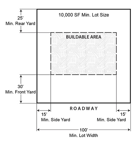 | |
| (c) Intensity and Dimensional Standards | ||
| Lot area, minimum (sq. ft.) | 10,000 | |
| Lot width, minimum (ft.) | 100 | |
| Density, maximum (du/ac) | 4.3 | |
| Floor area per dwelling unit, minimum (sq. ft.) | 1,200 | |
| Building coverage, maximum (% of lot area) | 35 | |
| Lot coverage, maximum (% of lot area) | NA | |
| Height, maximum (ft.) | 35 | |
| Front yard setback, minimum (ft.) | 30 | |
| Side corner yard setback, minimum (ft.) | 25 | |
| Interior side yard setback, minimum (ft.) | 15 | |
| Rear yard setback, minimum (ft.) | 25 | |
| Accessory Use Development Standards | See Chapter 28 Article VII | |
| NOTES: | ||
| Typical Development Configuration (For illustrative purposes only) | ||
 | ||
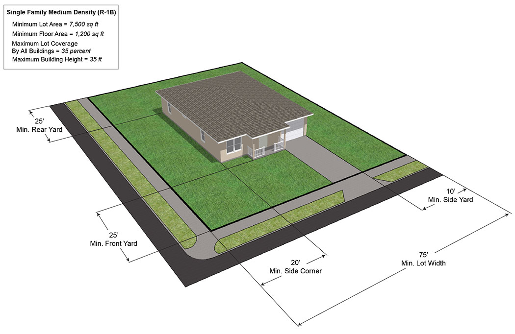
Sec. 28-304. - Single-Family Medium Density (R-1B).
| Single-Family Medium Density (R-1B) | ||
|---|---|---|
| (a) Purpose | ||
| The Single-Family Medium Density (R-1B) district is designed as a district for the principal use of medium-density single-family dwellings. The purpose of the district is to promote orderly and proper development of single-family residential units together with certain structures and uses that are compatible with property in the district. It is further intended that governmental, religious, recreation and other immediate needs of this district are served while a quality environment is provided for the residents of this designation and City. | ||
| (b) Use Standards | Typical Lot Pattern | |
| See Chapter 28 Article IV and Article V |  | |
| (c) Intensity and Dimensional Standards | ||
| Lot area, minimum (sq. ft.) | 7,500 | |
| Lot width, minimum (ft.) | 75 | |
| Density, maximum (du/ac) | 5.8 | |
| Floor area per dwelling unit, minimum (sq. ft.) | 1,200 | |
| Building coverage, maximum (% of lot area) | 35 | |
| Lot coverage, maximum (% of lot area) | NA | |
| Height, maximum (ft.) | 35 | |
| Front yard setback, minimum (ft.) | 25 | |
| Side corner yard setback, minimum (ft.) | 20 | |
| Interior side yard setback, minimum (ft.) | 10 | |
| Rear yard setback, minimum (ft.) | 25 | |
| Accessory Use Development Standards | See Chapter 28 Article VII | |
| NOTES: | ||
| Typical Development Configuration (For illustrative purposes only) | ||
 | ||
Sec. 28-305. - Single-Family High Density (R-1C).
| Single-Family High Density (R-1C) | ||
|---|---|---|
| (a) Purpose | ||
| The Single-Family High Density (R-1C) district is established as a designation for the principal use of high-density single-family dwellings. The purpose of this district is to promote stable quality residential development at slightly increased densities together with certain structures and uses that are compatible with property in the district. It is further intended that governmental, religious, recreational and other immediate needs of this district are served while a quality environment is provided for the residents of the designation and City. This district provides the transition between single-family densities and higher density development. | ||
| (b) Use Standards | Typical Lot Pattern | |
| See Chapter 28 Article IV and Article V | 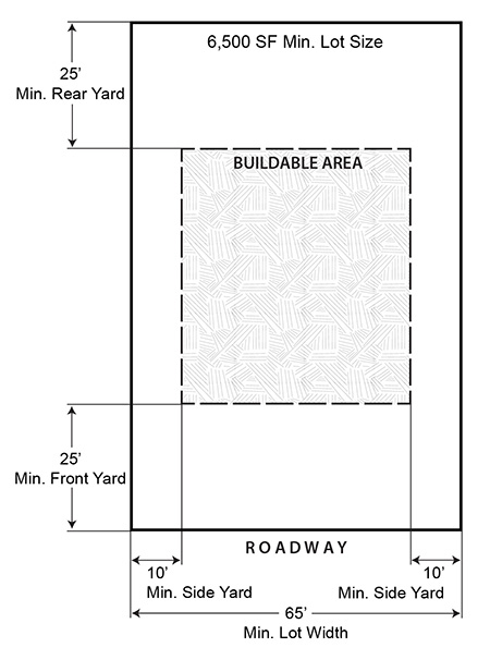 | |
| (c) Intensity and Dimensional Standards | ||
| Lot area, minimum (sq. ft.) | 6,500 | |
| Lot width, minimum (ft.) | 65 | |
| Density, maximum (du/ac) | 6.7 | |
| Floor area per dwelling unit, minimum (sq. ft.) | 900 | |
| Building coverage, maximum (% of lot area) | 35 | |
| Lot coverage, maximum (% of lot area) | NA | |
| Height, maximum (ft.) | 35 | |
| Front yard setback, minimum (ft.) | 25 1 | |
| Side corner yard setback, minimum (ft.) | 20 | |
| Interior side yard setback, minimum (ft.) | 10 | |
| Rear yard setback, minimum (ft.) | 25 | |
| Accessory Use Development Standards | See Chapter 28 Article VII | |
| NOTES: 1 Front setback with rear garage reduced to 20 feet. | ||
| Typical Development Configuration (For illustrative purposes only) | ||
 | ||
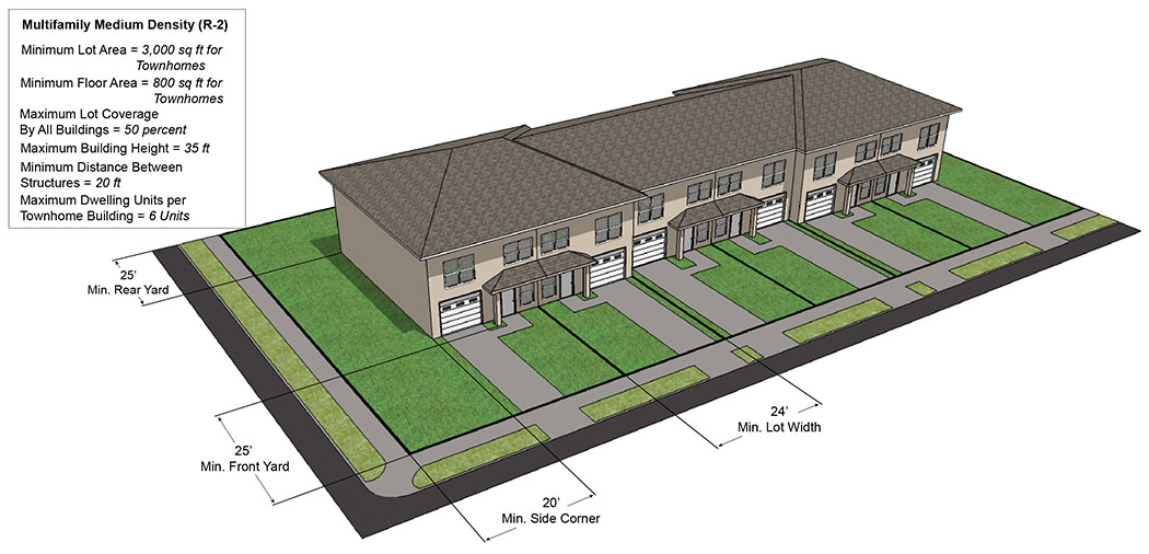
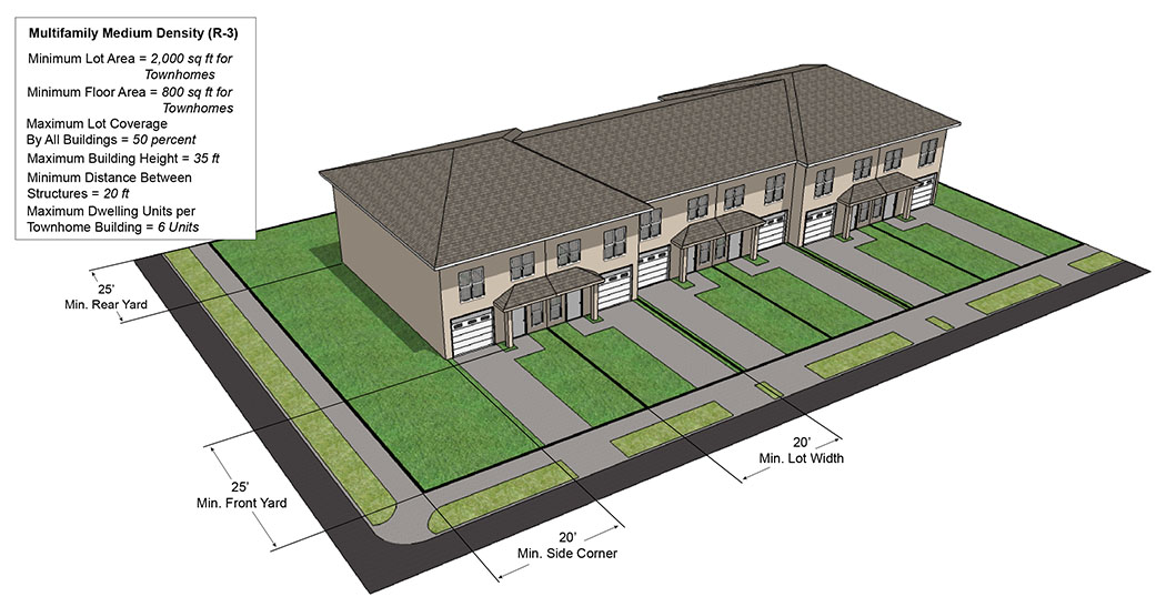
Sec. 28-306. - Multifamily Medium Density Residential (R-2).
| Multifamily Medium Density Residential (R-2) | ||
|---|---|---|
| (a) Purpose | ||
| The Multifamily Medium Density Residential (R-2) district is intended to allow the erection of a variety of housing types at a maximum density of nine (9) units per acre. This district is designed to allow development adjacent to arterial or collector streets and is well served by public services and facilities. When adjacent to R-1 zoning districts, the development within this district shall be designed carefully to provide maximum compatibility with adjacent development by proper architectural design, landscaping, screening and parking. | ||
| (b) Use Standards | Typical Lot Pattern | |
| See Chapter 28 Article IV and Article V | 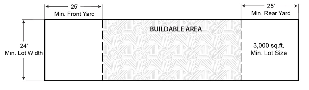 | |
| (c) Intensity and Dimensional Standards | ||
| Lot area, minimum (sq. ft.) |
Townhomes: 3,000
Multifamily: 4,000 per DU | |
| Lot width, minimum (ft.) |
Townhomes: 24
Multifamily: None | |
| Density, maximum (du/ac) | 9 | 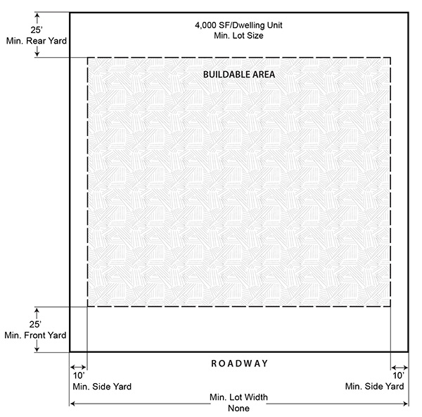 |
| Floor area per dwelling unit, minimum (sq ft) |
Townhomes: 800
Multifamily: Efficiency - 600 1 Bedroom - 700 2 Bedroom - 800 3 Bedroom 900 | |
| Building coverage, maximum (% of lot area) | 50 | |
| Lot coverage, maximum (% of lot area) | NA | |
| Height, maximum (ft.) | 35 | |
| Front yard setback, minimum (ft.) | 25 | |
| Side corner yard setback, minimum (ft.) | 20 | |
| Interior side yard setback, minimum (ft.) | 10 1 | |
| Rear yard setback, minimum (ft.) | 25 | |
| Accessory Use Development Standards | See Chapter 28 Article VII | |
|
NOTES:
- Townhome and Multifamily developments shall have a minimum distance between structures of 20 feet. - A maximum of six (6) dwelling units shall be allowed in a building group of townhouse units. - Staggered setbacks are encourage to lessen the straight row effect. 1 For properties meeting one of the specified characteristics described in Comprehensive Plan Future Land Use Element Policy 1.7.7 for infill development, and where the required building setbacks established in this section are less than that required by Chapter 30, Development standards, Article III, Improvements, Division 10, Landscaping, the required landscape yard may be reduced to be consistent with the building setback regulations in this section. | ||
| Typical Development Configuration (For illustrative purposes only) | ||
 | ||
 | ||
(Ord. No. 1-2025, § 2, 1-14-25)
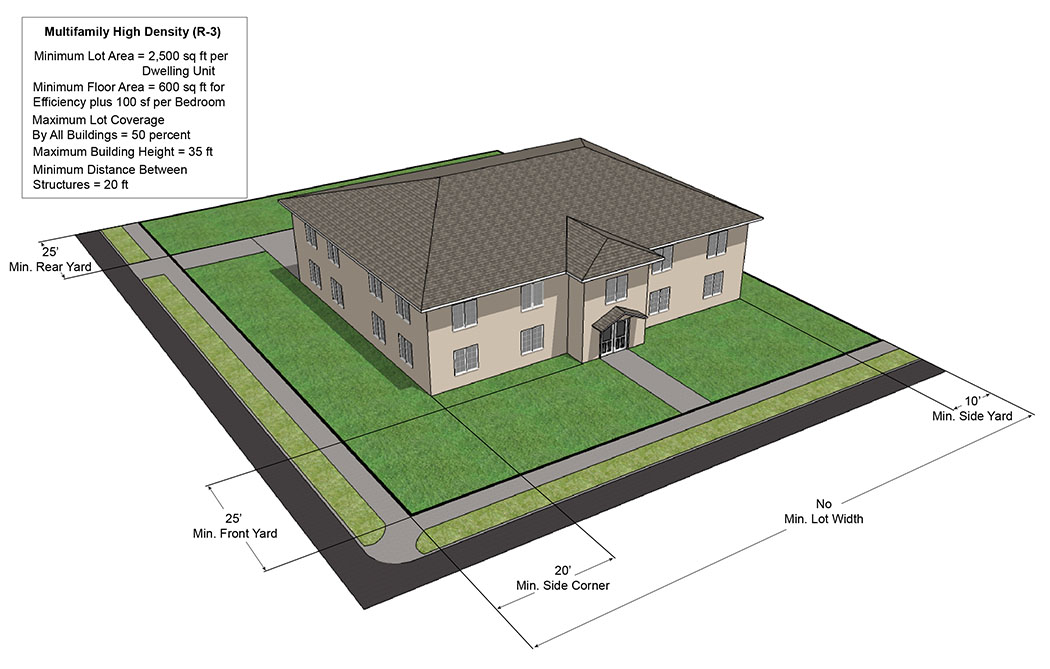
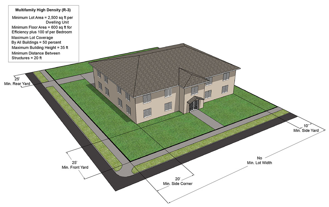
Sec. 28-307. - Multifamily High Density Residential (R-3).
| Multifamily High Density Residential (R-3) | ||
|---|---|---|
| (a) Purpose | ||
| The Multifamily High Density Residential (R-3) district is intended to allow the development of a variety of housing types at a maximum density of fifteen (15) units per acre. This district is further intended to satisfy the need for a high concentration of population, is located adjacent to arterial or collector streets and is well served by public services and facilities. When adjacent to R-1 zoning districts, the development within the district shall be designed carefully to provide maximum compatibility with adjacent development by proper architectural design, landscaping, screening, and parking. | ||
| (b) Use Standards | Typical Lot Pattern | |
| See Chapter 28 Article IV and Article V | ||
| (c) Intensity and Dimensional Standards | ||
| Lot area, minimum (sq. ft.) |
Townhomes: 2,000
Multifamily: 2,500 per DU | |
| Lot width, minimum (ft.) |
Townhomes: 20
Multifamily: None | |
| Density, maximum (du/ac) | 15 | 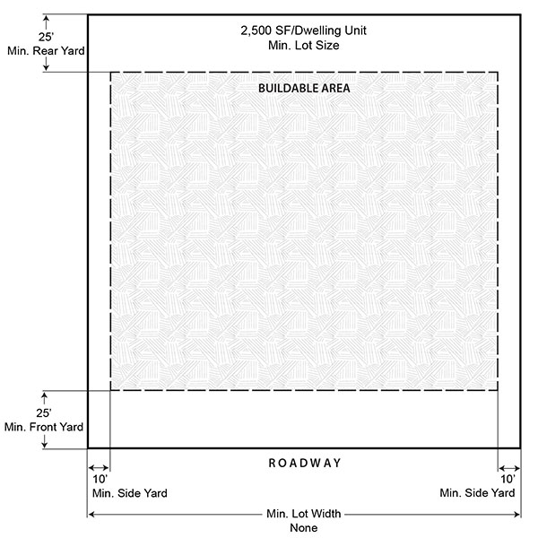 |
| Floor area per dwelling unit, minimum (sq. ft.) |
Townhomes: 800
Multifamily: Efficiency - 600 1 Bedroom - 700 2 Bedroom - 800 3 Bedroom - 900 | |
| Building coverage, maximum (% of lot area) | 50 | |
| Lot Coverage, maximum (% of lot area) | NA | |
| Height, maximum (ft.) | 35 | |
| Front yard setback, minimum (ft.) | 25 1, 2 | |
| Side corner yard setback, minimum (ft.) | 20 2 | |
| Interior side yard setback, minimum (ft.) | 10 2, 3 | |
| Rear yard setback, minimum (ft.) | 25 1, 2 | |
| Accessory Use Development Standards | See Chapter 28 Article VII | |
|
NOTES:
- Townhouse and Multifamily developments shall have a minimum distance between structures of 20 feet. - A maximum of six (6) dwelling units shall be allowed in a building group of townhouse units. - Staggered setbacks are encourage to lessen the straight row effect. - Multifamily units shall contain a private storage area of thirty-two (32) square feet per unit. 2 For townhome developments, see Section 30-151, Projections. 3 For properties meeting one of the specified characteristics described in Comprehensive Plan Future Land Use Element Policy 1.7.7 for infill development, and where the required building setbacks established in this section are less than that required by Chapter 30, Development standards, Article III, Improvements, Division 10, Landscaping, the required landscape yard may be reduced to be consistent with the building setback regulations in this section. "Where a landscape yard is reduced consistent with this footnote, a visual screen as described in Section 30-339 shall be provided." | ||
| Typical Development Configuration (For illustrative purposes only) | ||
 | ||
 | ||
(Ord. No. 53-2018, § 1, 11-13-17; Ord. No. 1-2025, § 3, 1-14-25)
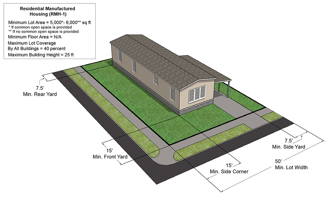
Sec. 28-308. - Residential Manufactured Housing (RMH-1).
| Residential Housing (RMH-1) | ||
|---|---|---|
| (a) Purpose | ||
| The Residential Manufactured Housing (RMH-1) district is established to allow for the suitable development of mobile homes and manufactured housing subdivisions platted in accordance with the subdivision regulations of the Land Development Regulations. Manufactured housing subdivisions shall be developed at a maximum density of six (6) units per acre and shall be located, designed and improved to provide a desirable residential living environment, protection from potentially adverse neighboring influences, protection for adjacent residential properties and access for vehicular traffic without traversing minor streets in adjoining residential neighborhoods. It is the further intent to declare that the mixing of manufacturing housing and conventional dwellings in the same development may potentially produce mutual incompatibility for both types of dwellings. To that end, manufactured housing shall be developed in residential manufactured housing subdivisions. | ||
| (b) Use Standards | Typical Lot Pattern | |
| See Chapter 28 Article IV and Article V | 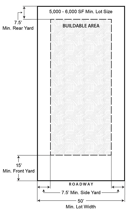 | |
| (c) Intensity and Dimensional Standards | ||
| Lot area, minimum (sq. ft.) | 5,000 | |
| Lot width, minimum (ft.) | 50 | |
| Density, maximum (du/ac) | 6 | |
| Floor area per dwelling unit, minimum (sq. ft.) | None | |
| Building coverage, maximum (% of lot area) | 40 | |
| Lot coverage, maximum (% of lot area) | NA | |
| Height, maximum (ft.) | 25 | |
| Front yard setback, minimum (ft.) | 15 | |
| Side corner yard setback, minimum (ft.) | 15 | |
| Interior side yard setback, minimum (ft.) | 7.5 | |
| Rear yard setback, minimum (ft.) | 7.5 | |
| Accessory Use Development Standards | See Chapter 28 Article VII | |
| NOTES: | ||
| Typical Development Configuration (For illustrative purposes only) | ||
 | ||
Sec. 28-309. - Residential Manufactured Housing Park (RMH-2).
| Residential Manufactured Housing Park (RMH-2) | ||
|---|---|---|
| (a) Purpose | ||
| The Residential Manufactured Housing Park (RMH-2) district is created to provide for the suitable development of mobile homes and manufactured housing in a parklike setting. Such manufactured housing communities shall be developed at a maximum density of eight (8) units per acre and shall be located, designed and improved to provide a desirable residential living environment, protection from substantially adverse neighboring influences, protection for adjacent residential properties and access for vehicular traffic without traversing minor streets in adjoining residential neighborhoods. It is the further intent to declare that the mixing of manufacturing [manufactured] housing and conventional dwellings in the same development may potentially provide mutual incompatibility for both types of dwellings. Therefore, manufactured housing shall be developed in a parklike setting. Accommodation for travel trailer parks as a conditional use shall be provided within this designation. | ||
| (b) Use Standards | Typical Lot Pattern | |
| See Chapter 28 Article IV and Article V | 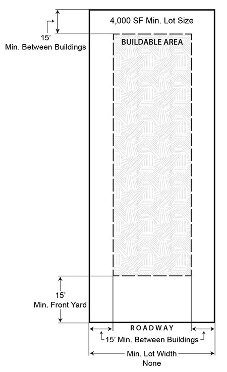 | |
| (c) Intensity and Dimensional Standards | ||
| Lot area, minimum (sq. ft.) | 4,000 | |
| Lot width, minimum (ft.) | None | |
| Density, maximum (du/ac) | 8 | |
| Floor area per dwelling unit, minimum (sq. ft.) | None | |
| Building coverage, maximum (% of lot area) | 40 | |
| Lot coverage, maximum (% of lot area) | NA | |
| Height, maximum (ft.) | 25 | |
| Front yard setback, minimum (ft.) | 25 1 | |
| Side corner yard setback, minimum (ft.) | 15 2 | |
| Interior side yard setback, minimum (ft.) | 15 2 | |
| Rear yard setback, minimum (ft.) | 15 2 | |
| Accessory Use Development Standards | See Chapter 28 Article VII, Section 28-8(c)8, Porches, cabanas, awnings and accessory structures | |
|
NOTES:
1 When abutting a public Right-of-Way. 2 Minimum distance between structures. | ||
| Typical Development Configuration (For illustrative purposes only) | ||
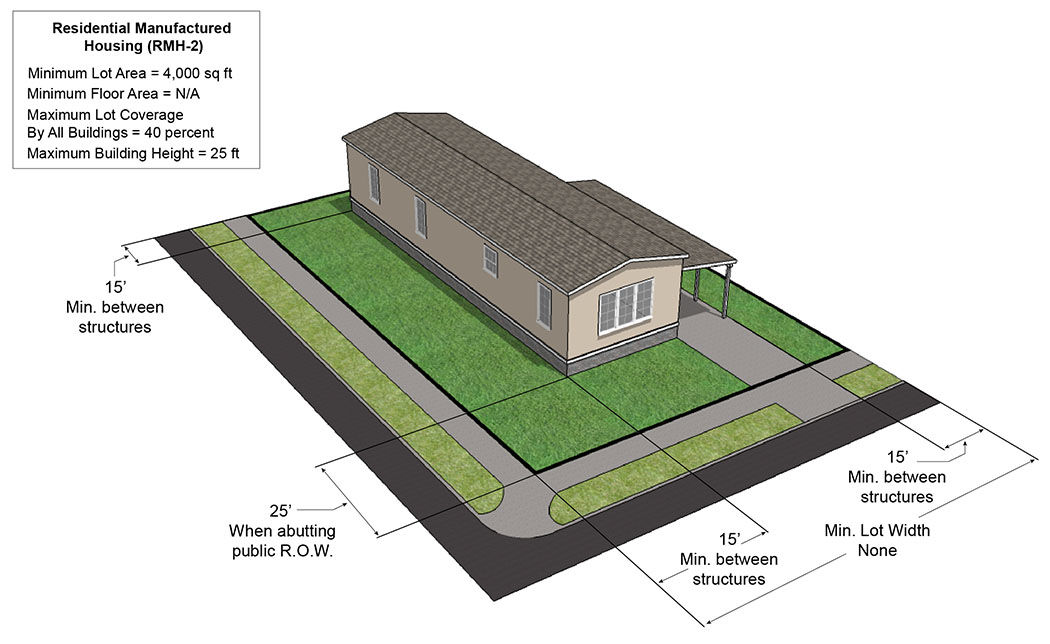 | ||
| (d) Additional Standards | ||
| (1) Minimum open space - See Chapter 30, Development Standards, Article II, Improvements, Division 3, Open Space | ||
(Ord. No. 34-2018, § 2, 7-24-18)
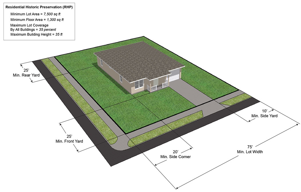
Sec. 28-310. - Residential Historic Preservation (RHP).
| Residential Historic Preservation (RHP) | ||
|---|---|---|
| (a) Purpose | ||
| The Residential Historic Preservation (RHP) district is established as a special district to protect the substantial public interest of the unique downtown residential area along the Indian River that is of great historical and aesthetic importance and should be preserved for future generations. The intent of this district is to preserve the character and harmony of the district. It is further intended that the district be in accord with and promote the purposes set forth in the Comprehensive Plan. | ||
| (b) Use Standards | Typical Lot Pattern | |
| See Chapter 28 Article IV and Article V | 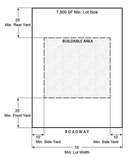 | |
| (c) Intensity and Dimensional Standards | ||
| Lot area, minimum (sq. ft.) | 7,500 | |
| Lot width, minimum (ft.) | 75 | |
| Density, maximum (du/ac) | 5.8 | |
| Floor area per dwelling unit, minimum (sq. ft.) | 1,300 | |
| Building coverage, maximum (% of lot area) | 35 | |
| Lot coverage, maximum (% of lot area) | NA | |
| Height, maximum (ft.) | 35 | |
| Front yard setback, minimum (ft.) | 25 | |
| Side corner yard setback, minimum (ft.) | 20 | |
| Interior side yard setback, minimum (ft.) | 10 | |
| Rear yard setback, minimum (ft.) | 25 | |
| Accessory Use Development Standards | See Chapter 28 Article VII | |
| NOTES: | ||
| Typical Development Configuration (For illustrative purposes only) | ||
 | ||
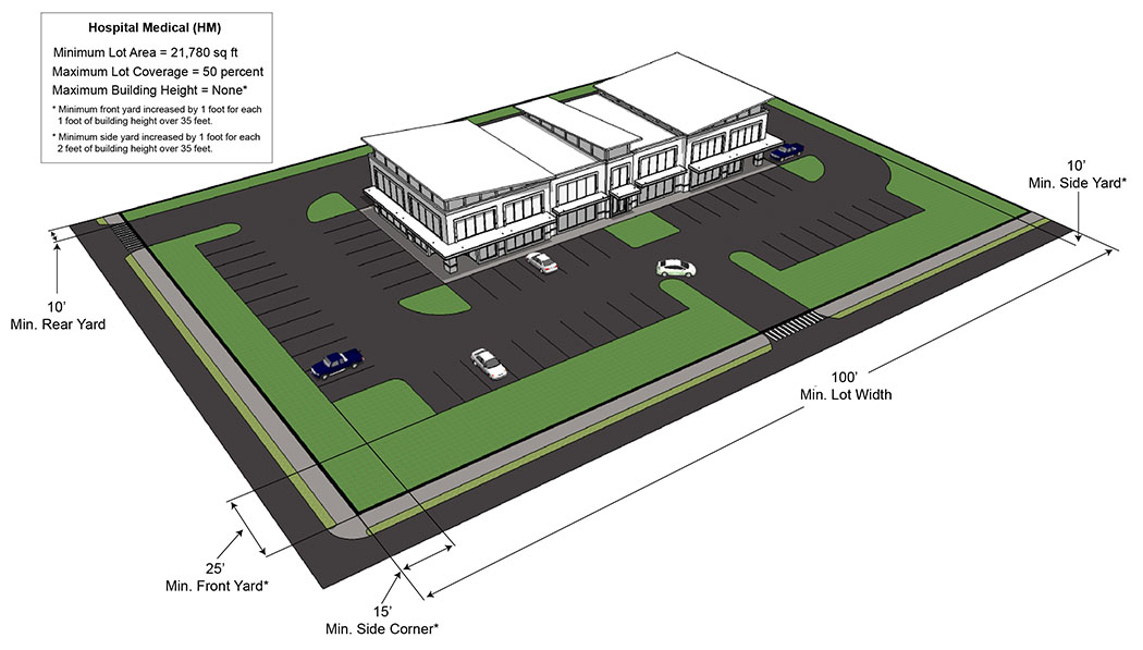
Sec. 28-311. - Hospital Medical (HM).
| Hospital Medical (HM) | ||
|---|---|---|
| (a) Purpose | ||
| The Hospital Medical (HM) district is created to provide a protective area for the harmonious development of health care facilities and accessory services convenient to arterial streets. The district is intended to be protected from encroachment by land uses that are incompatible to the location, operation and expansion of medical facilities development. | ||
| (b) Use Standards | Typical Lot Pattern | |
| See Chapter 28 Article IV and Article V |  | |
| (c) Intensity and Dimensional Standards | ||
| Lot area, minimum (sq. ft.) | 21,780 | |
| Lot width, minimum (ft.) | 100 | |
| Density, maximum (du/ac) | NA | |
| Floor area per dwelling unit, minimum (sq. ft.) | NA | |
| Building coverage, maximum (% of lot area) | 50 | |
| Lot coverage, maximum (% of lot area) | None | |
| Height, maximum (ft.) | None | |
| Front yard setback, minimum (ft.) | 25 1 | |
| Side corner yard setback, minimum (ft.) | 15 2 | |
| Interior side yard setback, minimum (ft.) | 10 2 | |
| Rear yard setback, minimum (ft.) | 10 2 | |
| Accessory Use Development Standards | See Chapter 28 Article VII | |
|
NOTES:
1 Plus one (1) foot for each foot of building height over thirty-five (35) feet. 2 Plus one (1) foot for every two (2) feet of building height over thirty-five (35) feet. | ||
| Typical Development Configuration (For illustrative purposes only) | ||
 | ||
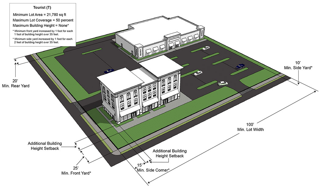
Sec. 28-312. - Tourist (T).
| Tourist (T) | ||
|---|---|---|
| (a) Purpose | ||
| The Tourist (T) district is intended to provide the motoring public, transient and tourist populations with localized areas convenient to arterial streets. It is further intended that goods and services combined with safe and attractive facilities will be established to serve those needs. The district is designed to develop and infill within the U.S. #1 and S.R. 50-Cheney Highway and Garden Street areas of the City and along S.R. 405 one-half (½) mile north and south of the intersection of the center line of S.R. 405 and S.R. 50. | ||
| (b) Use Standards | Typical Lot Pattern | |
| See Chapter 28 Article IV and Article V |  | |
| (c) Intensity and Dimensional Standards | ||
| Lot area, minimum (sq. ft.) | 21,780 | |
| Lot width, minimum (ft.) | 100 | |
| Density, maximum (du/ac) | NA | |
| Floor area per dwelling unit, minimum (sq. ft.) | NA | |
| Building coverage, maximum (% of lot area) | 50 | |
| Lot coverage, maximum (% of lot area) | None | |
| Height, maximum (ft.) | None | |
| Front yard setback, minimum (ft.) | 25 1 | |
| Side corner yard setback, minimum (ft.) | 15 2 | |
| Interior side yard setback, minimum (ft.) | 10 2 | |
| Rear yard setback, minimum (ft.) | 20 2 | |
| Accessory Use Development Standards | See Chapter 28 Article VII | |
|
NOTES:
1 Plus one (1) foot for each foot of building height over thirty-five (35) feet. 2 Plus one (1) foot for every two (2) feet of building height over thirty-five (35) feet. | ||
| Typical Development Configuration (For illustrative purposes only) | ||
 | ||
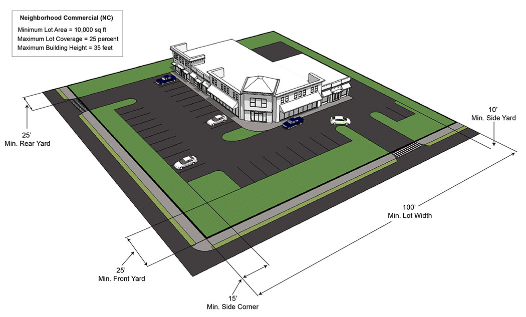
Sec. 28-313. - Neighborhood Commercial (NC).
| Neighborhood Commercial (NC) | ||
|---|---|---|
| (a) Purpose | ||
| The Neighborhood Commercial (NC) district is designed to provide a number of selected establishments that will principally serve one or several residential neighborhoods. These areas are generally located along or at the intersection of two collector streets or greater street designation, is designed as a low intensity land use category on the Future Land Use Map. The district is not intended for use by major or large scale commercial or service concerns. Orientation to and compatibility with the neighborhoods to be served are critical. | ||
| (b) Use Standards | Typical Lot Pattern | |
| See Chapter 28 Article IV and Article V | 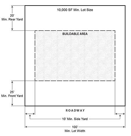 | |
| (c) Intensity and Dimensional Standards | ||
| Lot area, minimum (sq. ft.) | 10,000 1 | |
| Lot width, minimum (ft.) | 100 2,3 | |
| Density, maximum (du/ac) | NA | |
| Floor area per dwelling unit, minimum (sq. ft.) | NA | |
| Building coverage, maximum (% of lot area) | 25 | |
| Lot coverage, maximum (% of lot area) | NA | |
| Height, maximum (ft.) | 35 | |
| Front yard setback, minimum (ft.) | 25 | |
| Side corner yard setback, minimum (ft.) | 15 | |
| Interior side yard setback, minimum (ft.) | 10 | |
| Rear yard setback, minimum (ft.) | 20 | |
| Accessory Use Development Standards | See Chapter 28 Article VII | |
|
NOTES:
1 Minimum seven-thousand five-hundred 7,500 square feet for properties the Low Intensity Commercial or Downtown Mixed-Use future land use designations. 2 Must have frontage on a collector or higher classification thoroughfare. 3 Minimum seventy-five (75) feet in the Low Intensity Commercial or Downtown Mixed-Use future land use designations. | ||
| Typical Development Configuration (For illustrative purposes only) | ||
 | ||
Sec. 28-314. - Community Commercial (CC).
| Community Commercial (CC) | ||
|---|---|---|
| (a) Purpose | ||
| The Community Commercial (CC) district is established for general commercial activity. This district is designed to provide for a wide range of permitted uses and conditional uses that offer goods and services of both a convenience and desirable nature to shoppers. This district will serve a group of neighborhoods and larger trade areas. Development within this district requires larger land areas and is primarily located along arterial thoroughfares and major street intersections. It is not the intent of this district that it shall be used to encourage the extension of strip commercial areas and the development of intersections is preferable to linear development. | ||
| (b) Use Standards | Typical Lot Pattern | |
| See Chapter 28 Article IV and Article V | 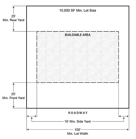 | |
| (c) Intensity and Dimensional Standards | ||
| Lot area, minimum (sq. ft.) | 10,000 1 | |
| Lot width, minimum (ft.) | 100 2,3 | |
| Density, maximum (du/ac) | NA | |
| Floor area per dwelling unit, minimum (sq. ft.) | NA | |
| Building coverage, maximum (% of lot area) | 30 | |
| Lot Coverage, maximum (% of lot area) | NA | |
| Height, maximum (ft.) | None | |
| Front yard setback, minimum (ft.) | 25 4 | |
| Side corner yard setback, minimum (ft.) | 15 5 | |
| Interior side yard setback, minimum (ft.) | 10 5 | |
| Rear yard setback, minimum (ft.) | 25 5 | |
| Accessory Use Development Standards | See Chapter 28 Article VII | |
|
NOTES:
1 Minimum seven-thousand five-hundred 7,500 square feet for properties the Low Intensity Commercial or Downtown Mixed-Use future land use designations. 2 Must have frontage on a collector or higher classification thoroughfare. 3 Minimum seventy-five (75) feet in the Low Intensity Commercial or Downtown Mixed-Use future land use designations. 4 Plus one (1) foot for each foot of building height over thirty-five (35) feet. 5 Plus one (1) foot for every two (2) feet of building height over thirty-five (35) feet. | ||
| Typical Development Configuration (For illustrative purposes only) | ||
 | ||
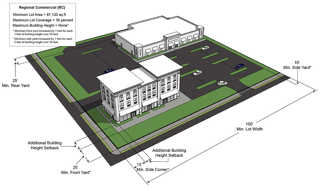
Sec. 28-315. - Regional Commercial (RC).
| Regional Commercial (RC) | ||
|---|---|---|
| (a) Purpose | ||
| The Regional Commercial (RC) district is intended to provide for intensive, highly automotive oriented uses that require an accessible location along thoroughfares designated as arterials in the comprehensive plan and these regulations. These districts provide a wide range of goods and services of both a convenience and desirable nature to shoppers. RC districts shall be located in a high intensity land use designations on the Future Land Use Map. Permitted uses and conditional uses require larger land areas with ample off-street parking and loading space. It is not the intent of this district that it shall be, used to encourage the extension of strip commercial areas. | ||
| (b) Use Standards | Typical Lot Pattern | |
| See Chapter 28 Article IV and Article V | 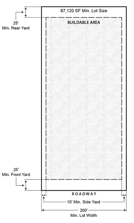 | |
| (c) Intensity and Dimensional Standards | ||
| Lot area, minimum (sq. ft.) | 87,120 | |
| Lot width, minimum (ft.) | 200 1 | |
| Density, maximum (du/ac) | NA | |
| Floor area per dwelling unit, minimum (sq. ft.) | NA | |
| Building coverage, maximum (% of lot area) | 30 | |
| Lot coverage, maximum (% of lot area) | NA | |
| Height, maximum (ft.) | None | |
| Front yard setback, minimum (ft.) | 25 2 | |
| Side corner yard setback, minimum (ft.) | 15 3 | |
| Interior side yard setback, minimum (ft.) | 10 3 | |
| Rear yard setback, minimum (ft.) | 25 3 | |
| Accessory Use Development Standards | See Chapter 28 Article VII | |
|
NOTES:
1 Must have frontage on an arterial or higher classification thoroughfare and be located within one-thousand three-hundred twenty (1,320) feet of an intersection of at least a collector road and the required frontage road. 2 Plus one (1) foot for each foot of building height over thirty-five (35) feet. 3 Plus one (1) foot for every two (2) feet of building height over thirty-five (35) feet. | ||
| Typical Development Configuration (For illustrative purposes only) | ||
 | ||
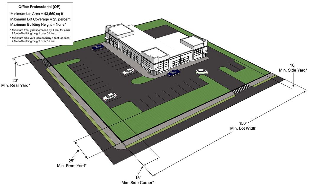
Sec. 28-316. - Office Professional (OP).
| Office Professional (OP) | ||
|---|---|---|
| (a) Purpose | ||
| The Office Professional (OP) district is created to encourage and accommodate the development of professional and business office space at locations where such use is compatible with the surrounding land use pattern and consistent with land use policies and future land use map of the comprehensive plan. These districts should be located adjacent to or have direct access to collector or higher classification roadways. The OP district is designed to be compatible with residential uses and is partially intended to serve as a buffer or transitional area between such development while occupying larger land areas. Properties developed as a Planned Office Park shall meet the regulations established in Chapter 33, Article III. | ||
| (b) Use Standards | Typical Lot Pattern | |
| See Chapter 28 Article IV and Article V | 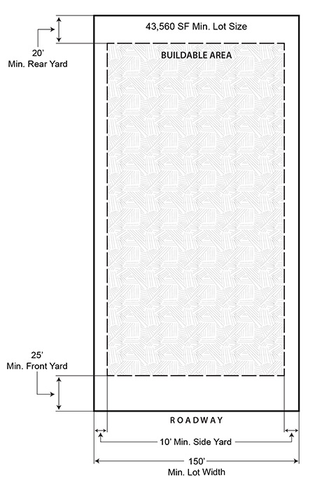 | |
| (c) Intensity and Dimensional Standards | ||
| Lot area, minimum (sq. ft.) | 43,560 1 | |
| Lot width, minimum (ft.) | 150 2,3 | |
| Density, maximum (du/ac) | NA | |
| Floor area per dwelling unit, minimum (sq. ft.) | NA | |
| Building coverage, maximum (% of lot area) | 25 | |
| Lot coverage, maximum (% of lot area) | NA | |
| Height, maximum (ft.) | None | |
| Front yard setback, minimum (ft.) | 25 4 | |
| Side corner yard setback, minimum (ft.) | 15 5 | |
| Interior side yard setback, minimum (ft.) | 10 5 | |
| Rear yard setback, minimum (ft.) | 20 5 | |
| Accessory Use Development Standards | See Chapter 28 Article VII | |
|
NOTES:
1 Minimum seven-thousand five-hundred 7,500 square feet for properties the Low Intensity Commercial or Downtown Mixed-Use future land use designations. 2 Must have frontage on a collector or higher classification thoroughfare. 3 Minimum seventy-five (75) feet in the Low Intensity Commercial or Downtown Mixed-Use future land use designations. 4 Plus one (1) foot for each foot of building height over thirty-five (35) feet. 5 Plus one (1) foot for every two (2) feet of building height over thirty-five (35) feet. | ||
| Typical Development Configuration (For illustrative purposes only) | ||
 | ||
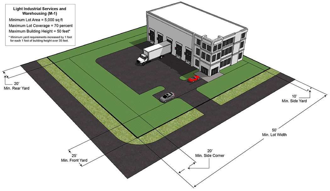
Sec. 28-317. - Light Industrial Services and Warehousing (M-1).
| Light Industrial Services and Warehousing (M-1) | ||
|---|---|---|
| (a) Purpose | ||
| The Light Industrial Services and Warehousing (M-1) District is intended to provide areas for service and repair establishments, personal storage facilities and warehousing, light manufacturing processing and distribution. It is further intended that new development within this district will accommodate limited industrial and support facilities. These regulations are designed for the general public and are intended to prevent or reduce friction between uses in the district and to protect nearby residential and commercial districts. This district is only appropriate in areas convenient to collector or higher classification roadways and served by public service and facilities. | ||
| (b) Use Standards | Typical Lot Pattern | |
| See Chapter 28 Article IV and Article V | 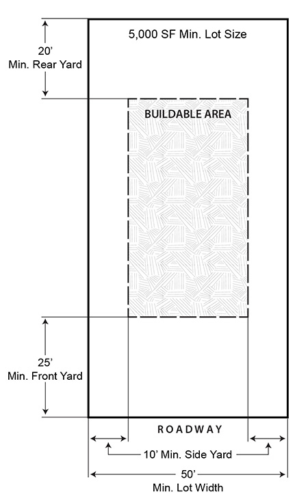 | |
| (c) Intensity and Dimensional Standards | ||
| Lot area, minimum (sq. ft.) | 5,000 | |
| Lot width, minimum (ft.) | 50 | |
| Density, maximum (du/ac) | NA | |
| Floor area per dwelling unit, minimum (sq. ft.) | NA | |
| Building coverage, maximum (% of lot area) | NA | |
| Lot coverage, maximum (% of lot area) | 70 | |
| Height, maximum (ft.) | 50 | |
| Front yard setback, minimum (ft.) | 25 1 | |
| Side corner yard setback, minimum (ft.) | 20 1 | |
| Interior side yard setback, minimum (ft.) | 10 1 | |
| Rear yard setback, minimum (ft.) | 20 1 | |
| Accessory Use Development Standards | See Chapter 28 Article VII | |
|
NOTES:
1 Plus one (1) foot for each foot of building height over thirty-five (35) feet. | ||
| Typical Development Configuration (For illustrative purposes only) | ||
 | ||
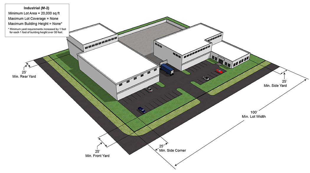
Sec. 28-318. - Industrial (M-2).
| Industrial (M-2) | ||
|---|---|---|
| (a) Purpose | ||
| The Industrial (M-2) District is established to preserve such districts for the function of various heavy and extensive industrial activity, wholesaling, warehousing and distribution without creating hazards or property devastation to surrounding land uses. This district shall be located in areas accessible to collector or higher classification roadways and served by public services and facilities. These districts shall be discouraged from locating next to areas designated for residential or low intensity commercial uses. | ||
| (b) Use Standards | Typical Lot Pattern | |
| See Chapter 28 Article IV and Article V | 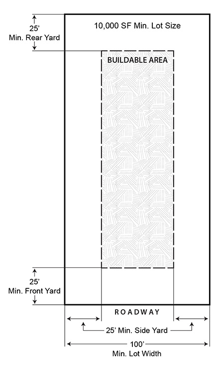 | |
| (c) Intensity and Dimensional Standards | ||
| Lot area, minimum (sq. ft.) | 20,000 | |
| Lot width, minimum (ft.) | 100 | |
| Density, maximum (du/ac) | NA | |
| Floor area per dwelling unit, minimum (sq. ft.) | NA | |
| Building coverage, maximum (% of lot area) | NA | |
| Lot coverage, maximum (% of lot area) | None | |
| Height, maximum (ft.) | 50 1 | |
| Front yard setback, minimum (ft.) | 25 2 | |
| Side corner yard setback, minimum (ft.) | 25 2 | |
| Interior side yard setback, minimum (ft.) | 25 | |
| Rear yard setback, minimum (ft.) | 25 | |
| Accessory Use Development Standards | See Chapter 28 Article VII | |
|
NOTES:
1 Any structure which exceeds fifty (50) feet in height shall provide one (1) additional foot of setback in all required setbacks for each foot above fifty (50) feet. 2 Setbacks abutting Golden Knights Boulevard shall be fifty (50) feet. | ||
| Typical Development Configuration (For illustrative purposes only) | ||
 | ||
(Ord. No. 16-2024, § 2, 6-11-24)
Sec. 28-319. - Highway Industrial Infill (M-3).
| Highway Industrial Infill (M-3) | ||
|---|---|---|
| (a) Purpose | ||
| The Highway Industrial Infill (M-3) district is designed to accommodate smaller individual parcels located along the U.S. 1 north of Buffalo Road to City limits and 405 from S.R. 50 to Fox Lake Road corridors. It is intended that singular industrial development will infill within these areas. Therefore, the primary purpose of this district is to regulate this infill development by encouraging criteria and provisions that will promote creative design an improved level of aesthetics and the protection of existing and future City development. | ||
| (b) Use Standards | Typical Lot Pattern | |
| See Chapter 28 Article IV and Article V | 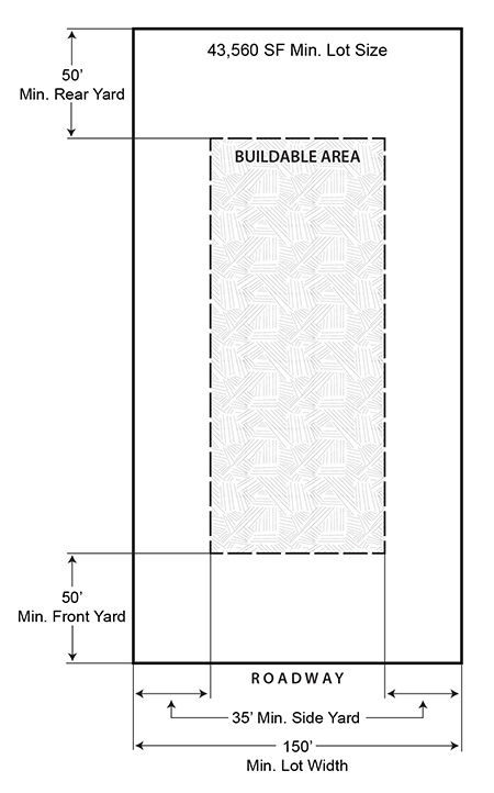 | |
| (c) Intensity and Dimensional Standards | ||
| Lot area, minimum (sq. ft.) | 43,560 | |
| Lot width, minimum (ft.) | 150 | |
| Density, maximum (du/ac) | NA | |
| Floor area per dwelling unit, minimum (sq. ft.) | NA | |
| Building coverage, maximum (% of lot area) | NA | |
| Lot coverage, maximum (% of lot area) | None | |
| Height, maximum (ft.) | 50 1 | |
| Front yard setback, minimum (ft.) | 50 | |
| Side corner yard setback, minimum (ft.) | 35 2 | |
| Interior side yard setback, minimum (ft.) | 35 | |
| Rear yard setback, minimum (ft.) | 50 3, 4 | |
| Accessory Use Development Standards | See Chapter 28 Article VII | |
|
NOTES:
1 Any structure which exceeds fifty (50) feet in height shall provide one (1) additional foot of setback in all required setbacks for each foot above fifty (50) feet. 2 Parking permitted in the side setback must be set back a minimum of fifteen (15) feet. 3 Parking permitted in the rear setback must be set back a minimum of fifteen (15) feet. 4 When abutting I-95, the setback may be lowered to 25 feet. | ||
| Typical Development Configuration (For illustrative purposes only) | ||
 | ||
| (d) Additional Standards | ||
| (1) Development procedure. Prior to review by various City Departments, the Administrator shall present the site plan to the Planning and Zoning Commission for their review, advice and comment as to the suitability of creative design and aesthetic enhancement of the site plan. | ||
| (2) Mechanical/electrical equipment. | ||
| a. Mechanical equipment or other utility fixtures on the roof, ground or buildings shall be screened from public view with material harmonious with the building or they shall be so located as not to be visible from any public street or adjoining property. | ||
| (3) Building design. Buildings should demonstrate compatibility in materials and consistency in style with other property, in the district. | ||
| a. Architectural style is not restricted but evaluation of the building design shall be based on the quality of its design and relationship to surroundings. | ||
| b. Monotony of design shall be avoided. Variation of detail, form and siting shall be used to provide visual interest. | ||
| c. Materials and finishes shall be selected for their durability and wear as well for aesthetic appearance. | ||
| d. Color schemes should be utilized that blend with those of neighboring developments and accent color chosen to enhance architectural details. | ||
| (4) Site design. Site design should enhance the streetscape and provide for variety in relationship between buildings and site design. | ||
| a. Off-street parking areas are prohibited in front and side corner yard setbacks. | ||
| b. Service areas and refuse containers shall be located to the rear of the buildings. | ||
| c. Yard setbacks in excess of the zoning requirements is encouraged to provide diversity in site appearance. | ||
| d. The site should be planned to accomplish a smooth transition from adjacent properties that differ in land use and/or design philosophy by the use of site breaks such as screens, berms, fences and walls for aesthetic appearance. | ||
| e. The installation of building foundation landscaping should be considered as an option. | ||
| f. Walkways and circulation patterns should be defined through variations of pavement texture and sign placements. Landscape elements like flower beds, hedges and landscaped embankments can be utilized to achieve this purpose. | ||
| g. Site parking areas should indicate separation of parking and circulation relationship through landscaping. Large impervious surface masses should also be avoided and mitigated through the use of curbed landscape islands, wheel stops and other measures. | ||
| (5) Open space and Greenbelt requirements are set forth per Chapter 30 Development Standards, Article II Improvements, Division 3 Open Space. | ||
| (6) Lighting. | ||
| a. Artificial lighting utilized to illuminate the premises shall be directed away from adjacent properties and streets, shinning only on the subject site. | ||
Sec. 28-320. - Planned Industrial Development (PID).
| Planned Industrial Development (PID) | ||
|---|---|---|
| (a) Purpose | ||
| The Planned Industrial Development (PID) district is created to provide for areas of large scale, high technology and other clean light industry in an attractive parklike atmosphere. It is further intended that this district be utilized to promote industrial activity, more efficient and economical industrial land use, harmony in physical design and industrial relationships, variety and amenity in industrial development and the protection of adjacent and nearby existing and future nonindustrial uses and activities. Planned industrial development districts will encourage originality, flexibility and innovation in site planning and development including architecture, landscaping, and graphic design. This district is intended to develop within those areas identified as Planned Industrial Park on the Comprehensive Plan Future Land Use Map. Developments within the PID zoning district shall also meet the regulations established in Chapter 33, Article II. | ||
| (b) Use Standards | Typical Lot Pattern | |
| See Chapter 28 Article IV and Article V | 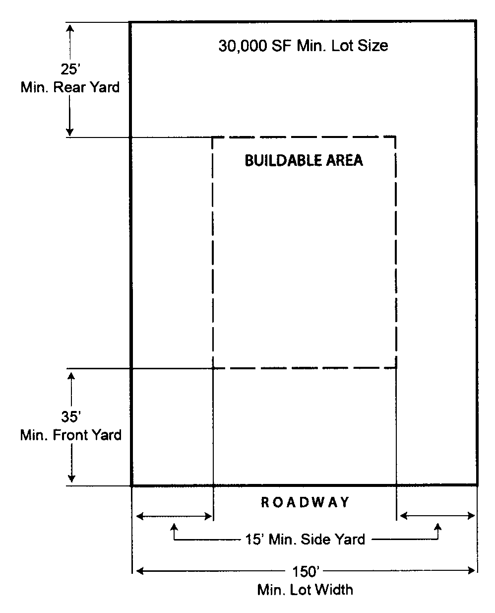 | |
| (c) Intensity and Dimensional Standards | ||
| Lot area, minimum (sq. ft.) | 30,000 | |
| Lot width, minimum (ft.) | 150 | |
| Density, maximum (du/ac) | NA | |
| Floor area per dwelling unit, minimum (sq. ft.) | NA | |
| Building coverage, maximum (% of lot area) | NA | |
| Lot coverage, maximum (% of lot area) | None | |
| Height, maximum (ft.) | 50 1 | |
| Front yard setback, minimum (ft.) | 35 2 | |
| Side corner yard setback, minimum (ft.) | 35 2 | |
| Interior side yard setback, minimum (ft.) | 15 2 | |
| Rear yard setback, minimum (ft.) | 25 2 | |
| Accessory Use Development Standards | See Chapter 28 Article VII | |
|
NOTES:
1 Any structure which exceeds fifty (50) feet in height shall provide one (1) additional foot of setback in all required setbacks for each foot above fifty (50) feet. 2 No portion of any building or structure and no activity related to any use within the PID shall be located any closer than one hundred (100) feet to any property which is utilized, zoned or which has a future land use designation for residential. | ||
| Typical Development Configuration (For illustrative purposes only) | ||
 | ||
(Ord. No. 14-2019, § 1, 5-14-19)
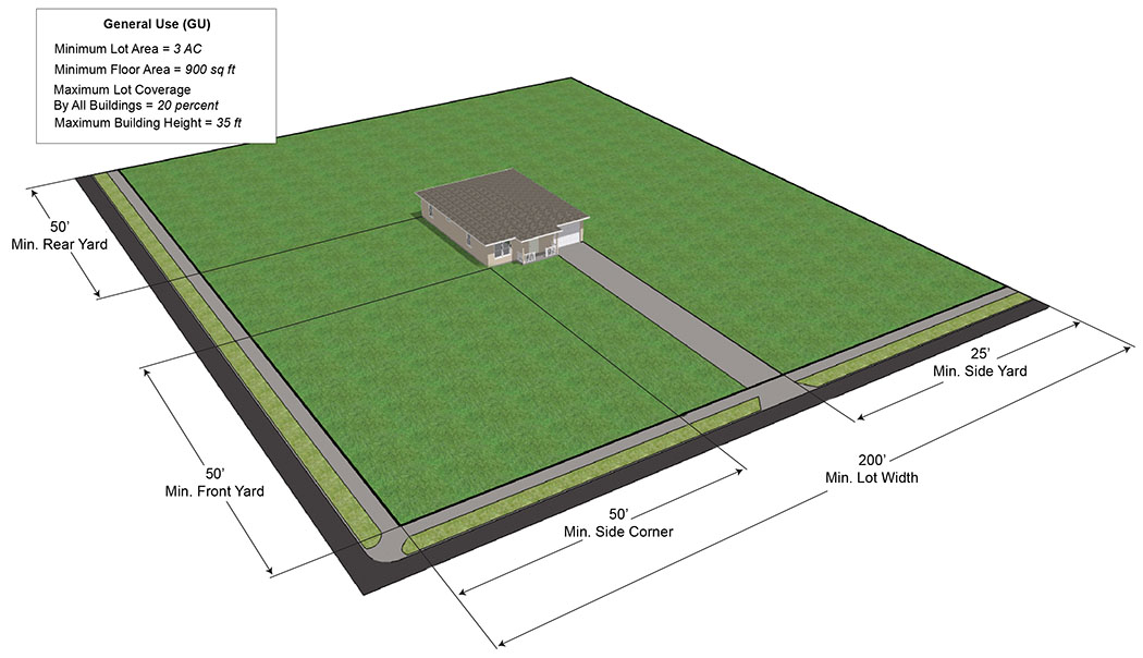
Sec. 28-321. - General Use (GU).
| General Use (GU) | ||
|---|---|---|
| (a) Purpose | ||
| The General Use (GU) District is created to apply to areas where urban services are not presently available. The regulations for this district are intended to retain these lands under this designation pending the proper timing of economical provision of public services and facilities to ensure orderly development. It is further intended that this district will implement the goals, objectives, and policies of the Comprehensive Plan. | ||
| (b) Use Standards | Typical Lot Pattern | |
| See Chapter 28 Article IV and Article V | 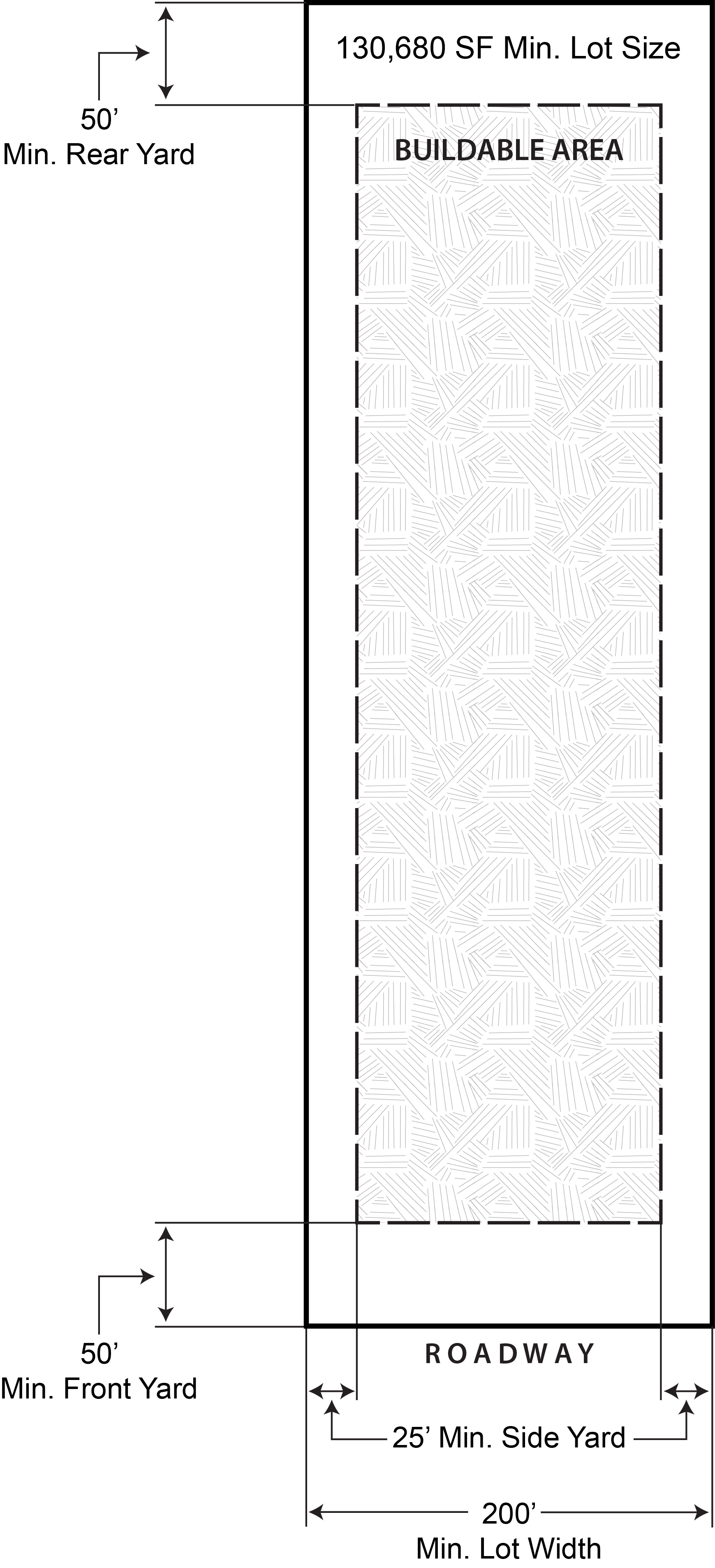 | |
| (c) Intensity and Dimensional Standards | ||
| Lot area, minimum (sq. ft.) | 130,680 (3 ac) | |
| Lot width, minimum (ft.) | 200 | |
| Density, maximum (du/ac) | 1du/3ac | |
| Floor area per dwelling unit, minimum (sq. ft.) | 900 | |
| Building coverage, maximum (% of lot area) | 20 | |
| Lot coverage, maximum (% of lot area) | None | |
| Height, maximum (ft.) | 35 | |
| Front yard setback, minimum (ft.) | 50 | |
| Side corner yard setback, minimum (ft.) | 50 | |
| Interior side yard setback, minimum (ft.) | 25 | |
| Rear yard setback, minimum (ft.) | 50 | |
| Accessory Use Development Standards | See Chapter 28 Article VII | |
| NOTES: | ||
| Typical Development Configuration (For illustrative purposes only) | ||
 | ||
Sec. 28-322. - Open Space and Recreation (OR).
| Open Space and Recreation (OR) | ||
|---|---|---|
| (a) Purpose | ||
| The Open Space and Recreation (OR) District is established to provide for the conservation and protection of sensitive lands within the City. It is intended that this district will not function as a holding designation for land but rather a permanent classification in order to ensure that present and future residents of the City are able to enjoy the benefits of the natural environment of the City. It is further intended that the district will implement the goals, objectives and policies of the Comprehensive Plan. | ||
| (b) Use Standards | Typical Lot Pattern | |
| See Chapter 28 Article IV and Article V | 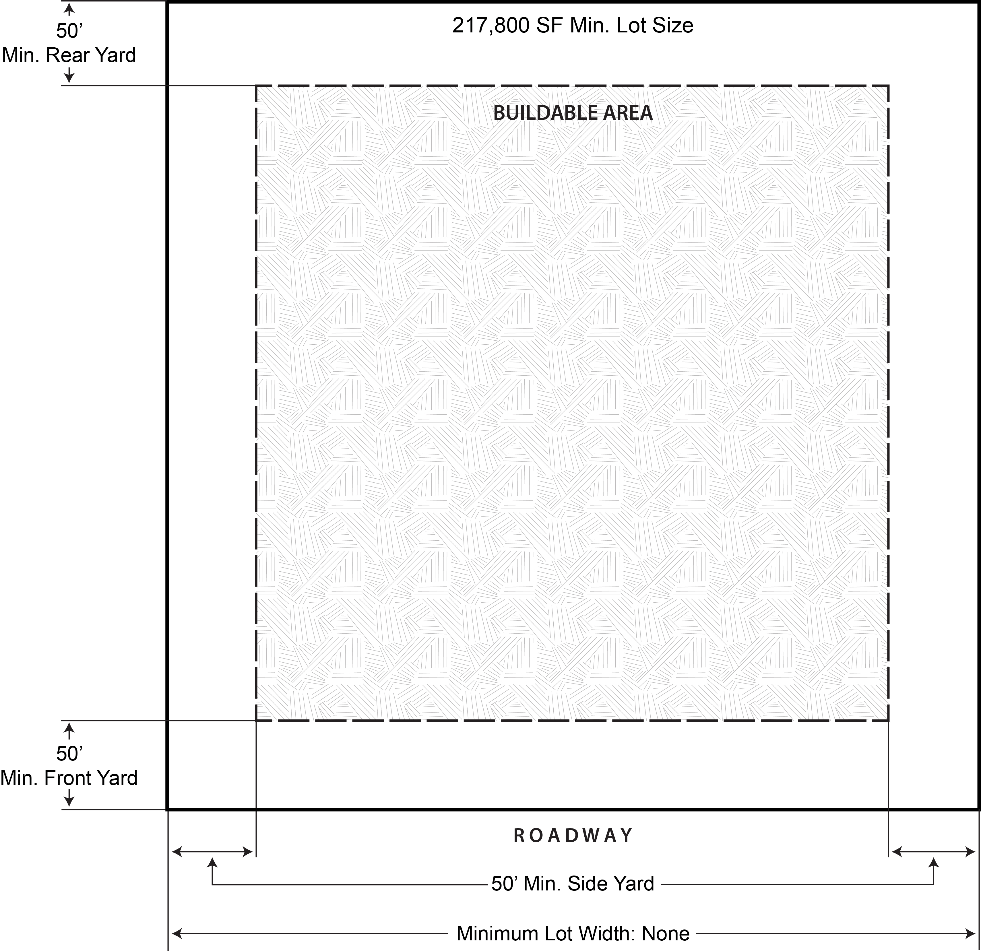 | |
| (c) Intensity and Dimensional Standards | ||
| Lot area, minimum (sq. ft.) | None | |
| Lot width, minimum (ft.) | None | |
| Density, maximum (du/ac) | 1du/5ac 1 | |
| Floor area per dwelling unit, minimum (sq. ft.) | None | |
| Building coverage, maximum (% of lot area) | None | |
| Lot coverage, maximum (% of lot area) | None | |
| Height, maximum (ft.) | 35 | |
| Front yard setback, minimum (ft.) | 50 | |
| Side corner yard setback, minimum (ft.) | 50 | |
| Interior side yard setback, minimum (ft.) | 50 | |
| Rear yard setback, minimum (ft.) | 50 | |
| Accessory Use Development Standards | See Chapter 28 Article VII | |
|
NOTES:
1 Single-family homes in wetlands must obtain a Conditional Use Permit prior to construction as required in Section 28-80, Single-family dwellings (detached). | ||
| Typical Development Configuration (For illustrative purposes only) | ||
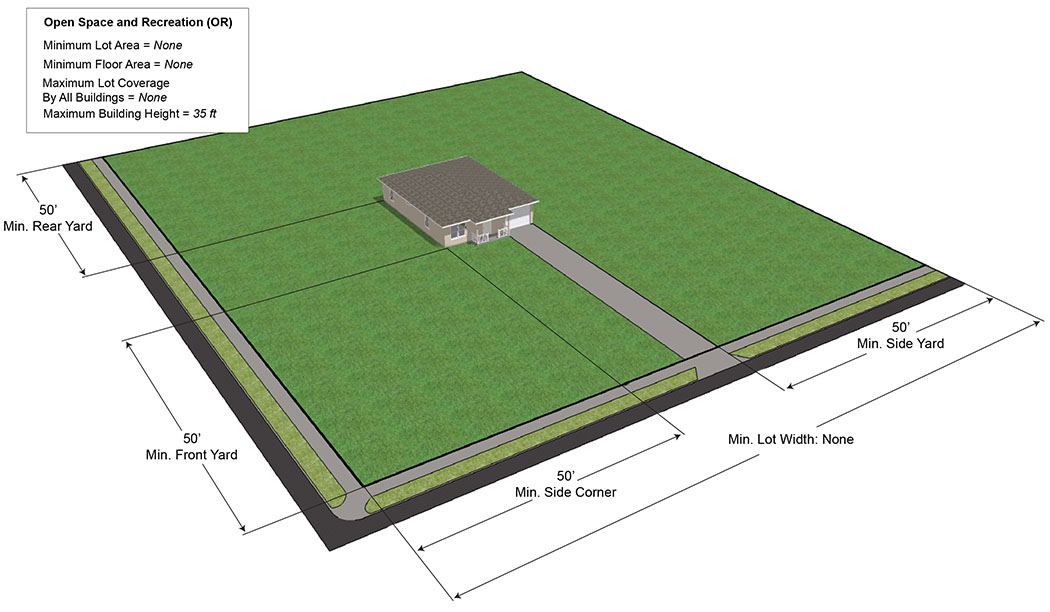 | ||
(Ord. No. 16-2023, § 4, 3-14-23)
Sec. 28-323. - Public (P).
(Ord. No. 41-2025, § 6, 11-25-25)
Sec. 28-324. - Downtown Mixed-Use (DMU) Smart Code.
(Ord. No. 12-2018, § 1, 2-27-18; Ord. No. 19-2019, § 1, 4-23-19; Ord. No. 02-2020, § 2, 2-12-20; Ord. No. 13-2022, § 4, 4-26-22)
Sec. 28-325. - Urban Mixed-Use (UMU).
(Ord. No. 37-2017, § 32, 11-14-17)
Sec. 28-326. - Shoreline Mixed-Use (SMU).
Sec. 28-327. - Regional Mixed-Use (RMU).
Building setbacks from road right-of-way lines. In addition to other required setbacks and buffer areas, all buildings within a RMU district shall have the following minimum setback from the road right-of-way (ROW):
Sec. 28-328. - Urban Village (UV).
(Ord. No. 38-2018, § 1, 8-28-18; Ord. No. 10-2022, § 3, 4-12-22)
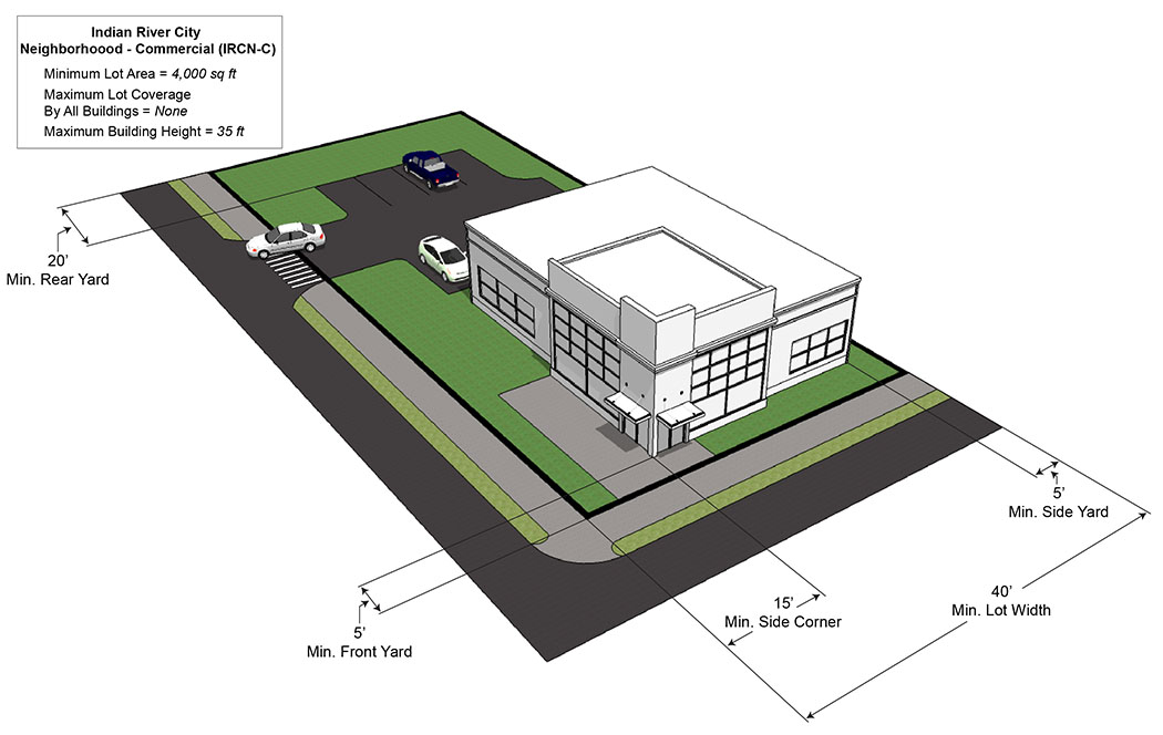
Sec. 28-329. - Indian River City Neighborhood-Commercial (IRCN-C).
| Indian River City Neighborhood-Commercial (IRCN-C) | ||
|---|---|---|
| (a) Purpose | ||
| In the Indian River City Neighborhood Commercial (IRCN-C) district, it is intended that positive design elements of both commercial and residential development be protected and enhanced, and where appropriate mixed residential and commercial structures be developed. It is intended to encourage the expansion of commercial uses where stormwater requirements, buffering to residential areas and aesthetics can be improved. It is further intended that the district be in accord with and promote the purposes set forth in the Comprehensive Plan. | ||
| (b) Use Standards | Typical Lot Pattern | |
| See Chapter 28 Article IV and Article V | 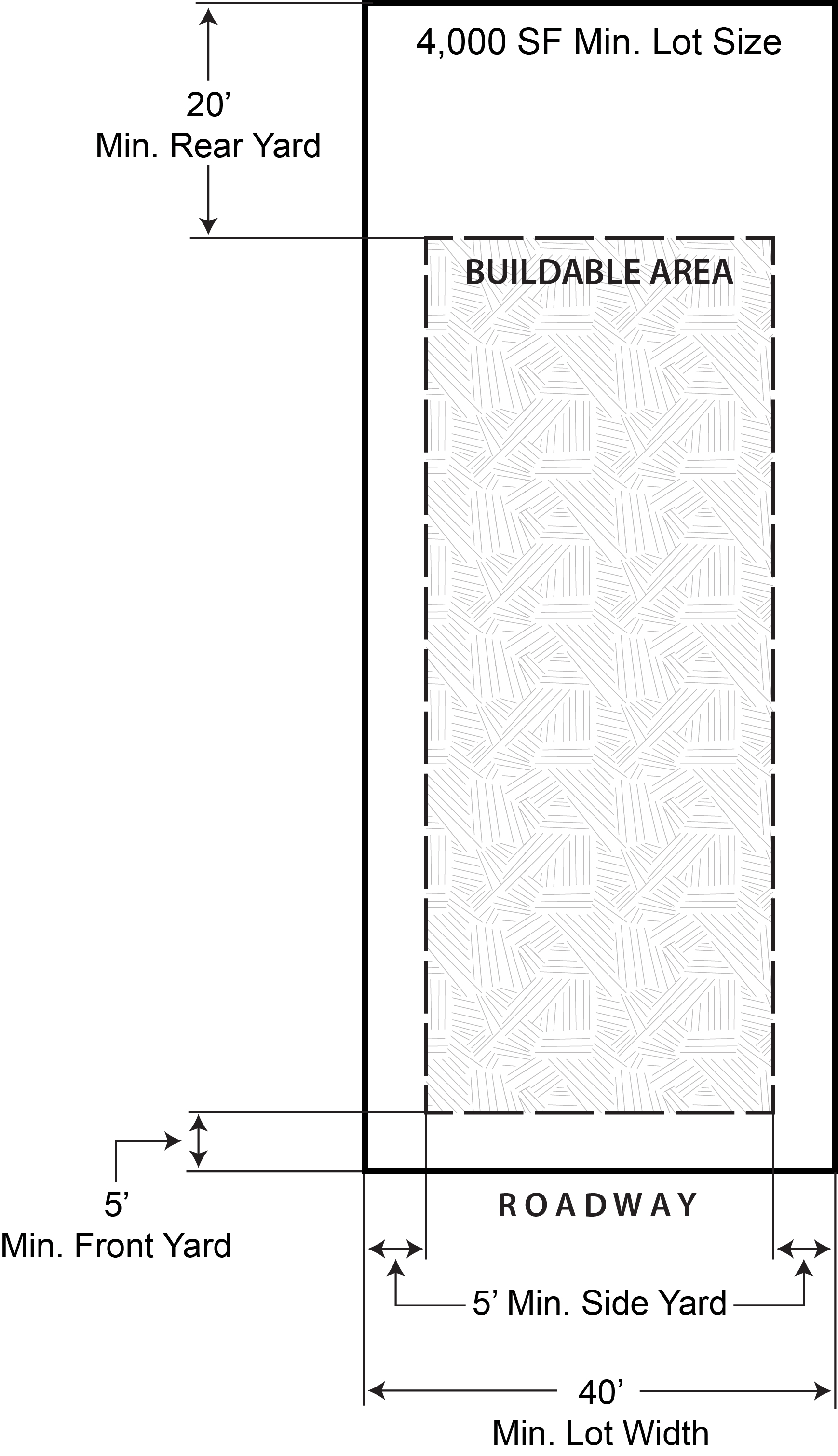 | |
| (c) Intensity and Dimensional Standards | ||
| Lot area, minimum (sq. ft.) | 4,000 | |
| Lot width, minimum (ft.) | 40 | |
| Density, maximum (du/ac) | NA | |
| Floor area per dwelling unit, minimum (sq. ft.) | None | |
| Building coverage, maximum (% of lot area) | None | |
| Lot coverage, maximum (% of lot area) | None | |
| Height, maximum (ft.) | 35 | |
| Front yard setback, minimum (ft.) | 5 | |
| Side corner yard setback, minimum (ft.) | 15 | |
| Interior side yard setback, minimum (ft.) | 5 | |
| Rear yard setback, minimum (ft.) | 20 | |
| Accessory Use Development Standards | See Chapter 28 Article VII | |
| NOTES: | ||
| Typical Development Configuration (For illustrative purposes only) | ||
 | ||
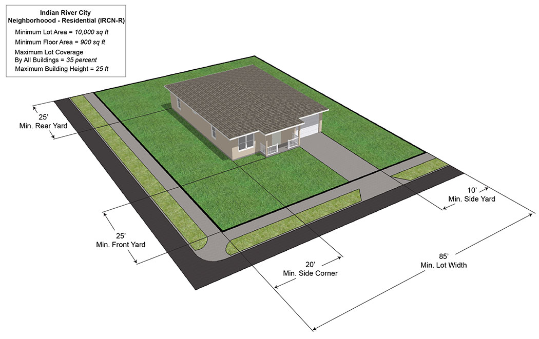
Sec. 28-330. - Indian River City Neighborhood-Residential (IRCN-R).
| Indian River City Neighborhood-Residential (IRCN-R) | ||
|---|---|---|
| (a) Purpose | ||
| In the Indian River City Neighborhood Residential (IRCN-R) district, it is intended that the single-family residential land uses be recognized and enhanced as the predominant land use in this district, and to encourage new infill single-family residential development. Although the intent of the district is to preserve and expand single-family residential uses, existing multifamily uses shall be recognized as a permitted use. It is further intended that the district be in accord with and promote the purposes set forth in the Comprehensive Plan, specifically Future Land Use Element Policies 1.1.4 and Policy 1.1.5. | ||
| (b) Use Standards | Typical Lot Pattern | |
| See Chapter 28 Article IV and Article V | 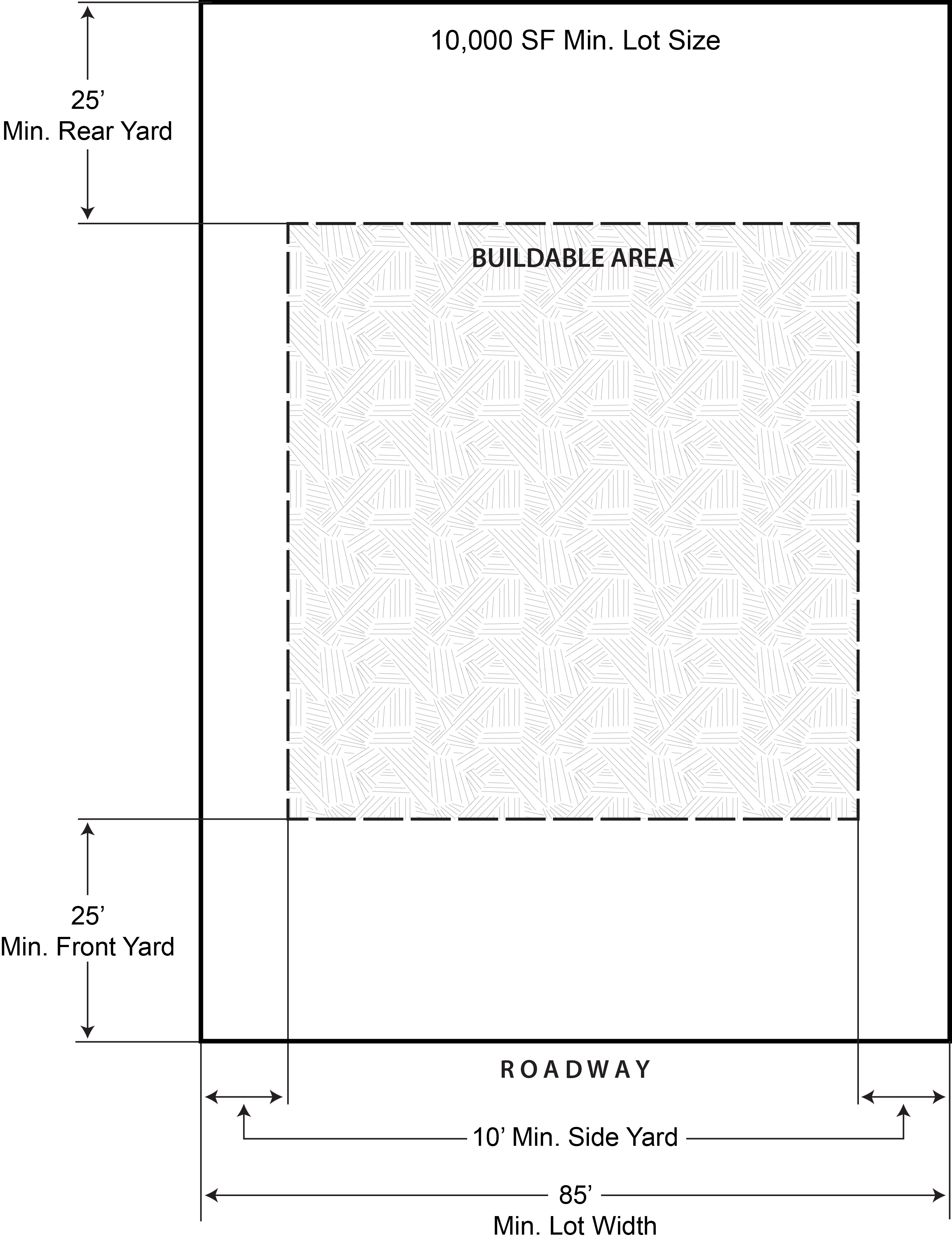 | |
| (c) Intensity and Dimensional Standards | ||
| Lot area, minimum (sq. ft.) | 10,000 | |
| Lot width, minimum (ft.) | 85 | |
| Density, maximum (du/ac) | 4 | |
| Floor area per dwelling unit, minimum (sq. ft.) | 900 | |
| Building coverage, maximum (% of lot area) | 35 | |
| Lot coverage, maximum (% of lot area) | None | |
| Height, maximum (ft.) | 25 | |
| Front yard setback, minimum (ft.) | 25 | |
| Side corner yard setback, minimum (ft.) | 20 | |
| Interior side yard setback, minimum (ft.) | 10 | |
| Rear yard setback, minimum (ft.) | 25 | |
| Accessory Use Development Standards | See Chapter 28 Article VII | |
| NOTES: | ||
| Typical Development Configuration (For illustrative purposes only) | ||
 | ||