
Upper Arlington City Zoning Code
ARTICLE 5
- ZONING DISTRICTS AND USE STANDARDS
§ 5.01 - GENERAL PROVISIONS.
(A)
Regulation of the use and development of land and structures: These regulations are established and adopted governing the use and physical development of land and/or structures.
(B)
Rules of application: These regulations shall be interpreted and enforced according to the following rules:
(1)
Identification of uses: Listed uses are to be defined by their customary name or identification, except where they are specially defined or limited in this Ordinance.
(2)
Permitted uses: Only a use designated as a permitted use shall be allowed as a matter of right in a zoning district and any use not so designated shall be prohibited except, when in character with the zoning district, such other additional uses may be added to the permitted uses of the zoning district by an amendment to this UDO. Only lawful uses shall be permitted and prior zoning approval of a use does not override state or federal laws.
(3)
Conditional uses: A use designated as a conditional use shall be allowed in a zoning district when such conditional use, its location, extent and method of development will not substantially alter the character of the vicinity or unduly interfere with the use of adjacent lots in the manner prescribed for the zoning district, and is not inconsistent or contrary to master plan objectives related to uses. To this end BZAP shall, in addition to the development standards for the zoning district, set forth such additional requirements as will, in its judgment, render the conditional use compatible with the existing and future use of adjacent lots and the vicinity. Additional standards for conditional uses are listed in Section 6.10.
(4)
Accessory uses: A use designated as an accessory use shall be permitted in a zoning district when such use is subordinate in area, extent, and purpose to the principal use and is located on the same lot and in the same zoning district as the principal use.
(5)
Development standards: The development standards shall be the minimum required for development in a zoning district unless otherwise stated. If the development standards are in conflict with the requirements of any other lawfully adopted rules, regulations or laws, the more restrictive or higher standard shall govern.
(6)
Secondary or auxiliary uses: Secondary or auxiliary uses are subject to the same requirements as primary uses. A prohibited or conditional use is not permitted simply because it is a secondary or auxiliary use to a permitted primary use. A primary use that is prohibited or conditional is not permitted simply because a secondary or auxiliary use may be permitted. The granting of a conditional use permit for a primary use does not constitute conditional use approval of any secondary or auxiliary uses. The granting of a conditional use permit for a secondary or auxiliary use does not constitute conditional use approval of any primary uses.
(C)
Districts: The City is divided into the following zoning districts, which shall be governed by all the use and area requirements of this Ordinance. The following lists each district along with its appropriate symbol:
(Ord. No. 96-2010, 3-16-2011; Ord. No. 75-2021, § 1(Exh. A), 12-13-2021; Ord. No. 67-2022, § 2(Exh. A), 12-5-2022)
§ 5.02 - RESIDENTIAL DISTRICTS.
(A)
Purpose: The following generally describes the purpose and general characteristics of each residential district:
(1)
R-S residential suburban district: The purpose of the R-S district is to allow single-family dwellings in low-density residential neighborhoods. This district is further subdivided into four (4) sub districts: R-Sa, R-Sb, R-Sc, and R-Sd, differing primarily in required lot area and yard space. Net densities range from thirty-three hundredths (0.33) dwelling units per acre in the R-Sa district to two (2) dwelling units per acre in the R-Sd district. Permitted uses generally include, but are not limited to, single-family residential, institutional, cultural, recreation, and day care.
(2)
R-1 one-family residence district: The purpose of the R-1 district is to allow single-family dwellings in low- to medium-density residential neighborhoods. Two-family dwellings are a conditional use. The district is further subdivided into three (3) sub districts: R-la, R-1b, and R-1c, differing primarily in required lot area and yard space. Net densities range from 1.09 dwelling units per acre in the R-1a district to four and eighty-four hundredths (4.84) dwelling units per acre in the R-1c district. Permitted uses generally include, but are not limited to, single-family residential, institutional, cultural, recreation, and day care.
(3)
R-2 one-to-four-family residence district: The purpose of the R-2 district is to allow single-family dwellings and two- to four-family dwellings in medium-density residential neighborhoods. The district is further subdivided into two (2) sub districts: R-2a and R-2b, differing only in height regulations. Net densities range from 4.84 dwelling units per acre in the R-2a district to 14.52 dwelling units per acre in the R-2b district. Permitted uses generally include, but are not limited to, single-family and two- to four-family residential, institutional, cultural, recreation, and day care.
(4)
R-3 multi-family residence district: The purpose of the R-3 district is to allow single-family dwellings and multi-family dwellings (up to six (6) units in a building) in medium-density residential neighborhoods. The district is further subdivided into two (2).
(5)
RCD residential community development district: The purpose of the RCD district is to allow residential uses in medium- to high-density residential complexes. Permitted uses generally include, but are not limited to, single-family, and two- to six-family residential, institutional, cultural, recreation, day care, and adult care facility retirement homes.
(B)
Permitted, prohibited, accessory, and conditional uses: Permitted, prohibited, accessory, and conditional uses for each of the residential use districts are listed in Table 5-A, Residential Uses and Table 5-B, Home Occupational Uses. No residence or portion thereof may be rented or sublet/subleased out to any tenant(s) for a period of less than thirty (30) days.
(C)
Performance standards: Development standards for each of the residential districts are listed in Table 5-E, Residential Building Area, Density, and Setback Standards and Table 5-F, Residential Building Coverage and Height Standards. Standards for the RCD, residential community development district, shall be established by specific text approved by the Board of Zoning and Planning for each individual development.
(Ord. No. 21-2016, § 6, 5-9-2016; Ord. No. 38-2018, § 2, 4-23-2018; Ord. No. 22-2019, § 3, 4-8-2019; Ord. No. 40-2023, § 1(Exh. A), 8-28-2023)
§ 5.03 - COMMERCIAL DISTRICTS.
(A)
Purpose: The following generally describes the purpose and general characteristics of each commercial district:
(1)
B-1 neighborhood business district: The purpose of this district is to allow local retail business or service establishments that supply commodities or perform services needed on a daily basis primarily for residents of the immediate neighborhood. Permitted uses generally include, but are not limited to, personal services, professional offices, coffee shops, barber shops, laundromats, and child day care centers.
(2)
B-2 community business district: The purpose of this district is to allow retail business or service establishments that supply commodities or perform services needed on a daily basis primarily for residents of the community. Permitted uses generally include, but are not limited to, offices, restaurants, personal services, child day care centers, entertainment, supermarkets, and pharmacies.
(3)
B-3 conditional business district: The purpose of this district to allow retail, retail service, eating and drinking places, including drive-in carry out and other types of fast food restaurants, automotive service and entertainment and commercial recreation uses. Sexually-oriented businesses are also a permitted use in this district.
(4)
O office district: The purpose of this district is to allow offices of varying types within the community. Permitted uses in the O district are: professional offices, single occupancy office buildings, and such permitted uses as are set forth or may in the future be set forth in Table 5-C. At least eighty-five percent (85%) of the gross floor area of any building located in an O district shall be exclusively dedicated to one of these permitted uses. The lesser of fifteen percent (15%) of the gross floor area or ten thousand (10,000) square feet of any building located in an O district may be dedicated to secondary conditional uses as listed in Table 5-C. Secondary conditional uses shall be subject to the conditional use review process set forth in UDO Subsection 4.05(F).
(5)
PB-3 planned shopping center district: The purpose of this district is to allow retail business or service establishments that supply commodities or perform services primarily for residents of the community on a day-to-day basis within an integrated shopping center design. Permitted uses generally include, but are not limited to, retail and personal services, offices, restaurants, child day care centers, department stores, groceries, and supermarkets. The PB3 is a planned district requiring development plan approval.
(6)
ORC office and research district: The purpose of this district is to allow offices and research facilities that will contribute to the city's physical pattern of planned, healthy, safe, and attractive neighborhoods. The ORC district should also provide job opportunities and services to residents and contribute to the City's economic stability. Permitted uses in the ORC district are: business and professional offices, research and development, book and periodical publishing, insurance carriers, corporate data centers, survey research firms, bank finance and loan offices, outpatient surgery centers, hospitals, and such permitted uses as are set forth or may in the future be set forth in Table 5-C. At least eighty-five percent (85%) of the gross floor area of any building located in an ORC district shall be exclusively dedicated to one of these permitted uses. The lesser of fifteen percent (15%) of the gross floor area or ten thousand (10,000) square feet of any building located in an ORC district may be dedicated to secondary conditional uses as listed in Table 5-C. Secondary conditional uses shall be subject to the conditional use review process set forth in UDO Subsection 4.05(F).
(7)
Planned mixed office district:
(a)
The purpose of this district is to allow for a planned and targeted, walkable, mixed-use environment with a primary focus on office and office-related uses with a limited amount of residential and retail use. The PMOD will provide job opportunities and services related to business, healthcare, technical and professional uses. Additional residential and commercial uses can be permitted as a Secondary Permitted Use as listed in Table 5-C.
(b)
Square footage requirement. Measured per acre of the property, at least 10,000 (ten thousand) square feet shall be exclusively dedicated to one (1) of the permitted uses. If the square footage requirement is met, the remainder of the property may be dedicated to one or more Secondary Permitted Uses as listed in Table 5-C. If the project is phased, at least fifty percent (50%) of the square footage requirement must be established prior to or contemporaneously with the establishment of any other secondary permitted uses. The square footage may be accommodated in one (1) or more buildings.
(c)
Lake Preservation. In order to preserve the enjoyment of the existing lakes, any restaurant use shall cease operation by 10:00 p.m. and shall not have a service area within 100 (one hundred) feet of the lake's maintenance easement. The area between the building and lake shall include pedestrian amenities with enhanced landscaping.
(B)
Permitted, prohibited and conditional uses: Permitted, prohibited and conditional uses for each of the commercial districts are listed in Table 5-C, Commercial Uses and Table 5-D, Mixed Uses.
(C)
Development standards: Development standards for each of the commercial districts are listed in Table 5-G, Commercial Development Standards.
(Ord. No. 106-2009; Ord. No. 36-2014; Ord. No. 67-2022, § 2(Exh. A), 12-5-2022)
§ 5.04 - PLANNED MIXED-USE DISTRICTS.
(A)
Purpose: It is the purpose and intent of planned use districts to implement the goals, policies, and strategies of the master plan by allowing a mixture of residential, office, and commercial uses in a high quality urban environment. This type of development pattern was recommended in the master plan for seven (7) specific areas of the City. Other areas of the City may be considered for planned mixed-use designation if the development meets the guidelines established in Article 7. These seven (7) areas, or planned mixed use districts as further described in Volume 2: Study Areas Report of the Master Plan, are the following:
(1)
Kingsdale: The area contains three (3) sub-areas which are demonstrated in the master plan. The Kingsdale Core and Triangle area bounded by Northwest Boulevard, Tremont Road and Zollinger Road containing approximately thirty-eight (38) acres. The Kingsdale West area is generally bounded by Tremont Road, Fishinger Road, Ardleigh Road and Somerford Road.
(2)
Henderson Road: The area on both sides of Reed Road and south of Henderson Road containing approximately fifty (50) acres.
(3)
Tremont: The area encompassing a seven-acre commercial center and an 18-acre multi-family site north of the center.
(4)
Lane Avenue: A predominantly commercial corridor that includes thirty-three (33) acres on both sides of Lane Avenue from North Star Road to Northwest Boulevard. This area is further broken down into five separate context zones. See UDO Article 5.05(C) for additional requirements.
(5)
Northwest Boulevard: The area along Northwest Boulevard from Zollinger Road to the Ridgeview Road area containing approximately thirteen (13) acres.
(6)
U.S. 33: The area along the U.S. 33 corridor and more specifically the area around both the Fishinger Road and Trabue Road intersections with U.S. Route 33.
(7)
Mallway: The area bounded generally by Arlington Avenue, Guilford Road, Coventry Road, and Waltham Road.
(B)
Criteria: In order to be eligible for approval under this section, a proposed development must meet all of the following criteria:
(1)
Design criteria: The property shall be situated within a study area as identified in Volume 2: Study Areas Report of the Master Plan. Each study area shall include:
(a)
Mixed use centers with vertical and horizontal integration of office, residential, and retail functions.
(b)
Prominently located civic spaces and uses that also serve as a gathering place for residents and visitors.
(c)
Increased floor area and higher intensity use of land to create vitality and enhance real property values.
(d)
Emphasis on office use within a mixed-use district.
(e)
Enhanced physical image to compliment the character of Upper Arlington's oldest residential neighborhoods.
(f)
Interconnected uses with pedestrian and vehicular links to adjacent neighborhoods.
(g)
Demonstrated consistency with the design guidelines outlined in Article 7.
(2)
Focus: The proposed development shall, in general, be consistent with the master plan recommendations for each study area, shall have a strong pedestrian orientation, and shall be of overall economic and aesthetic benefit to the community. The design of each development shall also adhere to the following recommended focus:
(a)
Kingsdale and Kingsdale West: Town center with a mix of uses including office, retail, residential, and civic; the focus for the Kingsdale West area is residential uses except for office, retail and residential along Tremont Road.
(b)
Henderson Road: Regional office corridor with a supporting mix of uses.
(c)
Lane Avenue: Mixed-use corridor with office emphasis, improved streetscape, and gateway treatment.
(d)
Tremont: Neighborhood center with retail, office, and residential.
(e)
Northwest Boulevard: Mixed-use corridor with office and residential.
(f)
U.S. 33: Improved design character, especially at key intersections.
(g)
Mallway: Neighborhood center with retail, office and civic uses.
(3)
Timing: It is expected that individual development projects will only address one (1) geographic portion of a planned mixed-use district (PMUD). In those areas, the development should address the City's intent for a particular PMUD, but it may propose a portion of a PMUD that fits within the overall concept and the study area plan.
(C)
Permitted and conditional uses: Permitted, prohibited and conditional uses for the mixed-use districts are listed in Table 5-D, Mixed Uses.
(D)
Development standards: Development standards for each of the commercial districts are listed in Table 5-G, Commercial Development Standards.
(Ord. No. 106-2009; Ord. No. 5-2020, § 2, 9-14-2020; Ord. No. 75-2021, § 1(Exh. A), 12-13-2021)
§ 5.05 - OVERLAY DISTRICTS.
(A)
Wireless Communication District: The purpose of this section is to protect the health, safety and welfare of the public while not unreasonably interfering with the development of the competitive wireless telecommunication market place through the establishment of requirements for the installation of wireless telecommunication facilities. The goals of this Ordinance are to:
(1)
Protect residential areas and land uses from potential adverse impacts of towers and antennas.
(2)
Minimize the total number of towers throughout the community.
(3)
Strongly encourage the joint use of new and existing tower sites as a primary option rather than construction of additional single use towers.
(4)
Encourage users of the towers and antennas to locate them, to the extent possible, in areas where the adverse impact on the community is minimal.
(5)
Ensure that users of towers and antennas configure them in a way that minimizes the adverse impact of the towers and antennas through careful design, landscape screening, and innovative camouflaging techniques.
(6)
Enhance the ability of the providers of telecommunications services to provide such services to the community quickly, effectively and efficiently.
(7)
Consider the public health and safety of communication towers.
(8)
Avoid potential damage to adjacent properties from tower failure through engineering and careful siting of tower structures.
(B)
Historic District: The purpose of this section is to preserve and protect the architectural character, history and significance of the buildings within the Upper Arlington Historic District through provisions designed to:
(1)
Establish guidelines and encourage sensible rehabilitation of buildings within the Historic District.
(2)
Ensure that the Historic District maintains its historic architectural character in Upper Arlington into the future.
(3)
Ensure that new additions and remodeling are compatible with the neighborhood.
(4)
Avoid potential damage to adjacent properties from the removal of an irreplaceable asset.
(5)
Provide a public procedure for a historic demolition.
(C)
Lane Avenue Planned Mixed Use District (PMUD):
(1)
Introduction.
(a)
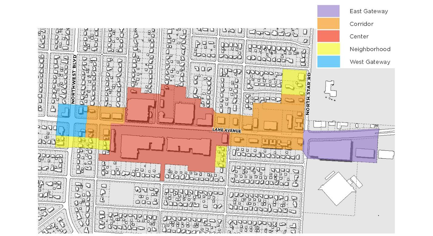
Context Areas. The Lane Avenue PMUD is organized by Context Areas derived from existing and future neighborhood characteristics. Context Areas are distinguished from one another by their overall physical and functional form, including but not limited to: street and block patterns, building placement and height, diversity, distribution, and intensity of land uses, and diversity of mobility options. This approach provides a range of zoning options that set standards for new development that change based on the established context of a particular Context Area. The following Context Areas are established below:
i.
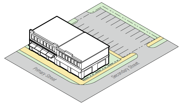
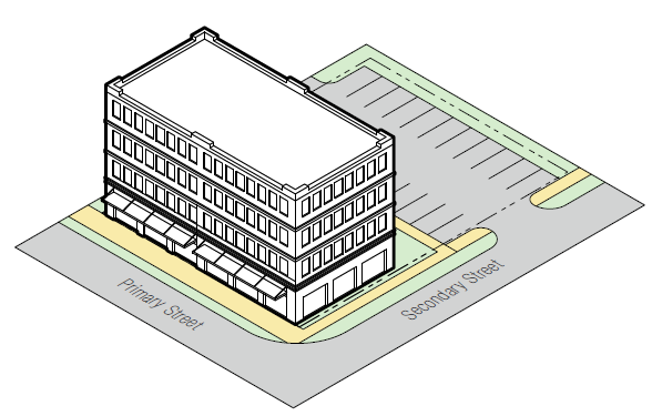
East Gateway (EAST). This Context Area serves as the eastern most entrance to the Lane Avenue PMUD and contains a mix of uses within higher-rise structures supported by structured parking.
ii.
Corridor (CORR). Development in this Context Area is limited by shallow lot depths and proximity to the adjacent residential neighborhood. Uses permitted in this area are in mid-rise structures with surface and structured parking.
iii.
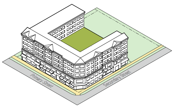
Center (CENTER). Located mid-way along this segment of Lane Avenue between Northwest Boulevard and North Star Road, the Center area is typified by larger lots (width and depth) with a mix of uses in mid-to higher rise buildings supported by structured parking.
iv.
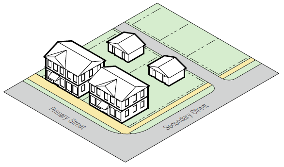
Neighborhood (NH). The Neighborhood Context Area serves as a transition area between the more intensely developed East Gateway, Corridor, and Center areas and the surrounding low-rise single-family residential neighborhood with surface parking.
v.
West Gateway (WEST). This Context Area serves as the western most entrance to the Lane Avenue PMUD as well as a transition zone between the residential portions of Lane Avenue west of Northwest Boulevard. Uses permitted in this are housed in low to mid-rise buildings with surface and structured parking.
(2)
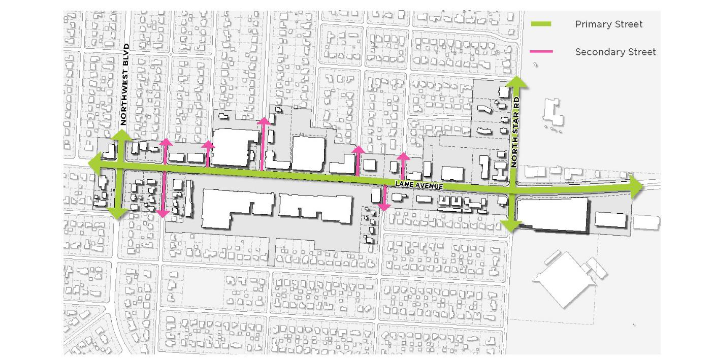
Primary and Secondary Streets. For the purpose of this PMUD, Lane Avenue, Northwest Boulevard and North Star Road function as the Primary Streets and are served by a network of intersecting Secondary Streets.
(3)
Requirements.
(a)
Introduction. The following zones and standards were developed to promote an urban development form that aligns with the vision and policies set forth by the Lane Avenue Corridor Framework Plan. This Plan defines a vision for growth that is urban, mixed-use, walkable, neighborhood-friendly and contributes to a high-quality public realm.
(b)
Title. This overlay is the Lane Avenue Planned Mixed Use District (PMUD) and is referred to or cited throughout this section as the "Lane Avenue PMUD" or "PMUD."
(c)
Purpose. This Lane Avenue PMUD provides the means to guide implementation of the citizen-endorsed vision and helps to foster predictable results and a high-quality public realm. This is accomplished by prescribing the physical form of buildings and other elements and addressing the relationship between building facades and the public realm, the form and mass of buildings in relation to one another, and the scale and types of streets and blocks. The following plans and code documents serve as a basis for the Lane Avenue PMUD:
i.
Lane Avenue Transitional Overlay District (1991);
ii.
Master Plan Study Area Report (2001);
iii.
Master Plan Update (2013); and
iv.
Lane Avenue Planning Study (2020).
(d)
Intent. This Lane Avenue PMUD is intended to balance conservation and development by:
i.
Promoting development that maintains Lane Avenue's position as one of the region's economic centers.
ii.
Promoting development along transit corridors that enhances their function as mixed-use, walkable centers that serve surrounding residential neighborhoods.
iii.
Providing standards for compatible transitions of use, building scale, and height between existing and new development.
iv.
Guiding reinvestment that builds upon and reinforces unique characteristics.
v.
Providing clear and consistent procedures for appropriate and effective public involvement in land use and development decisions.
vi.
Providing building and site design standards that address the public aspects of private development and how building form, placement, and uses contribute to the quality of the public realm.
vii.
Providing parking and access standards that appropriately balance pedestrian and vehicular needs and result in safe pedestrian environments and streetscapes of the highest quality.
viii.
Promoting high quality, innovative landscape design.
ix.
Providing clear regulations and processes that result in predictable, efficient, and coordinated review processes.
(e)
Applicability.
i.
The Lane Avenue PMUD applies to all property within the Lane Avenue Context Areas as shown in the City of Upper Arlington Official Zoning Map (also known as the Digital Zoning Map or Zoning Map).
ii.
All standards and references to streets in the Lane Avenue PMUD apply to both public and private streets. Private streets must not be obstructed.
(f)
Conflicting Provisions.
i.
Where UDO Section 5.05(C), Lane Avenue Planned Mixed Use District and Article 7, Design Guidelines conflicts with a standard in the Lane Avenue PMUD, the standard of this overlay controls.
ii.
Illustrations, photographs and graphics are included in this Lane Avenue PMUD to illustrate the intent and requirement of the text. In the case of a conflict between the text of this Lane Avenue PMUD and any illustrations, photographs, or graphics, the text governs.
(4)
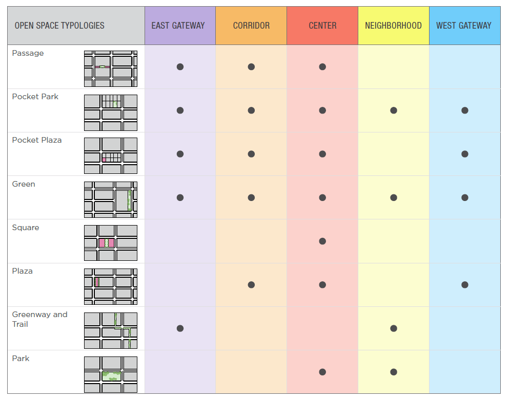
Context Zones.
(a)
Summary of Uses. The uses listed in the following table are either permitted, conditional, or prohibited within the Lane Avenue PMUD. Uses not listed are prohibited.
(b)
Summary of Dimensions and Standards. The dimensions and standards for the Lane Avenue PMUD are summarized in the following table and are found in more detail in UDO Section 5.05(C)(4)(c-g).
(c)
East Gateway.
i.
General Uses and Intent.
A.
General Uses. Ground floor commercial or service uses with a mix of commercial, residential, service, and/or office uses on upper stories.
B.
Intent. To reinforce and enhance the downtown urban core and provide the highest-intensity vibrant, compact, walkable urban environment. A variety of building types with active pedestrian street facades and a diverse range of uses supported by active ground floor frontages. A wide range of regional-center uses as well as employment, retail, services, civic, or public uses.
ii.
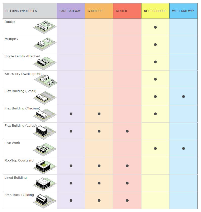
Permitted Building Typologies. The following Building Typologies are permitted in the East Gateway Context Area. More detailed descriptions are found in UDO Section 5.05(C)(5), Building Typologies.
A.
Flex Building (Medium).
B.
Flex Building (Large).
C.
Rooftop Courtyard.
D.
Lined Building.
E.
Step-Back Building.
iii.
Permitted Frontage Typologies. The following Frontage Typologies are permitted in the East Gateway Context Area. More detailed descriptions are found in UDO Section 5.05(C)(6), Frontage Typologies.
A.
Patio.
B.
Shopfront.
C.
Parking Garage.
D.
Arcade.
E.
Gallery.
iv.
Permitted Open Space Typologies. The following Open Space Typologies are permitted in the East Gateway Context Area. More detailed descriptions are found in UDO Section 5.05(C)(7), Open Space Typologies.
A.
Passage.
B.
Pocket Park.
C.
Pocket Plaza.
D.
Green.
E.
Greenway and Trail.
v.
Development Standards.
vi.
Permitted and Conditional Uses. See UDO Section 5.05(C)(4)(a), Summary of Uses.
vii.
Public Realm.
(d)
Corridor.
i.
General Uses and Intent.
A.
General Uses. Ground floor commercial or service uses with a mix of commercial, residential, service, and/or office uses.
ii.
Intent. To enhance the City's existing corridors so that over time they will become more walkable and serve multiple districts with a diverse range of commercial, retail, service, and office uses, and small-to-large footprint, moderate-intensity building types. This zone also supports public transportation hubs.
iii.
Permitted Building Typologies. The following Building Typologies are permitted in the Corridor Context Area. More detailed descriptions are found in UDO Section 5.05(A)(5), Building Typologies.
A.
Flex Building (Medium).
B.
Flex Building (Large).
C.
Rooftop Courtyard.
D.
Lined Building.
E.
Step-Back Building.
iv.
Permitted Frontage Typologies. The following Frontage Typologies are permitted in the Corridor Context Area. More detailed descriptions are found in UDO Section 5.05(A)(6), Frontage Typologies.
A.
Patio.
B.
Shopfront.
C.
Parking Garage.
D.
Arcade.
E.
Gallery.
v.
Permitted Open Space Typologies. The following Open Space Typologies are permitted in the Corridor Context Area. More detailed descriptions are found in UDO Section 5.05(A)(7), Open Space Typologies.
A.
Passage.
B.
Pocket Park.
C.
Pocket Plaza.
D.
Green.
E.
Plaza.
vi.
Development Standards.
vii.
Permitted and Conditional Uses. See Section 5.05(C)(4)(a), Summary of Uses.
viii.
Public Realm.
(e)
Center.
i.
General Uses and Intent.
A.
General Uses. Ground floor commercial or service uses with a mix of commercial, residential, service, and/or office uses on upper stories.
B.
Intent. To reinforce a vibrant, compact, walkable, urban center that serves the community and the overall region with a diverse range of uses in a variety of building types with active pedestrian street facades on multiple frontages.
ii.
Permitted Building Typologies. The following Building Typologies are permitted in the Center Context Area. More detailed descriptions are found in UDO Section 5.05(A)(5), Building Typologies.
A.
Flex Building (Large).
B.
Rooftop Courtyard.
C.
Lined Building.
D.
Step-Back Building.
iii.
Permitted Frontage Typologies. The following Frontage Typologies are permitted in the Center Context Area. More detailed descriptions are found in UDO Section 5.05(A)(6), Frontage Typologies.
A.
Patio.
B.
Shopfront.
C.
Parking Garage.
D.
Arcade.
E.
Gallery.
iv.
Permitted Open Space Typologies. The following Open Space Typologies are permitted in the Center Context Area. More detailed descriptions are found in UDO Section 5.05(A)(7), Open Space Typologies.
A.
Passage.
B.
Pocket Park.
C.
Pocket Plaza.
D.
Green.
E.
Square.
F.
Plaza.
G.
Park.
v.
Development Standards.
 |  |
vi.
Permitted and Conditional Uses. See Section 5.05(C)(4)(a), Summary of Uses.
vii.
Public Realm.
(f)
Neighborhood.
i.
General Uses and Intent.
A.
General Uses. Primarily multi-unit residential uses with smaller neighborhood-supporting uses at appropriate locations.
B.
Intent. To reinforce established neighborhoods in walkable urban areas. Neighborhoods will evolve through the use of small to medium building footprints and medium intensity building types to achieve a compact urban form that accommodates a variety of urban housing choices. This zone also supports public transportation alternatives.
ii.
Permitted Building Typologies. The following Building Typologies are permitted in the Neighborhood Context Area. More detailed descriptions are found in UDO Section 5.05(C)(5), Building Typologies.
A.
Duplex.
B.
Multiplex.
C.
Single-Family Attached.
D.
Accessory Dwelling Unit.
E.
Flex Building (Small).
F.
Flex Building (Medium).
G.
Live-Work.
iii.
Permitted Frontage Typologies. The following Frontage Typologies are permitted in the Neighborhood Context Area. More detailed descriptions are found in UDO Section 5.05(C)(6), Frontage Typologies.
A.
Raised Yard.
B.
Stoop.
C.
Forecourt.
D.
Porch.
E.
Shopfront.
iv.
Permitted Open Space Typologies. The following Open Space Typologies are permitted in the Neighborhood Context Area. More detailed descriptions are found in UDO Section 5.05(C)(5), Open Space Typologies.
A.
Pocket Park.
B.
Green.
C.
Greenway and Trail.
D.
Park.
v.
Development Standards.
vi.
Permitted and Conditional Uses. See Section 5.05(C)(4)(a), Summary of Uses.
vii.
Public Realm.
(g)
West Gateway.
i.
General Uses and Intent.
A.
General Uses. Primarily office or multi-unit residential uses with neighborhood-supporting retail, commercial, and/or service uses on the ground floor.
B.
Intent. To provide walkable, urban neighborhoods with a variety of urban housing choices in small to large footprint, medium-intensity building types that support and are within short walking distance of neighborhood-serving commercial and service uses. This zone also supports public transportation alternatives.
ii.
Permitted Building Typologies. The following Building Typologies are permitted in the West Gateway Context Area. More detailed descriptions are found in UDO Section 5.05(C)(5), Building Typologies.
A.
Flex Building (Small).
B.
Live-Work.
iii.
Permitted Frontage Typologies. The following Frontage Typologies are permitted in the West Gateway Context Area. More detailed descriptions are found in UDO Section 5.05(C)(6), Frontage Typologies.
A.
Patio.
B.
Shopfront.
iv.
Permitted Open Space Typologies. The following Open Space Typologies are permitted in the West Gateway Context Area. More detailed descriptions are found in UDO Section 5.05(C)(7), Open Space Typologies.
A.
Pocket Park.
B.
Pocket Plaza.
C.
Green.
D.
Plaza.
v.
Development Standards.
vi.
Permitted and Conditional Uses. See UDO Section 5.05(C)(4)(a), Summary of Uses.
vii.
Public Realm.
(5)
Building Typologies.
(a)
Summary of Building Typologies.
(b)
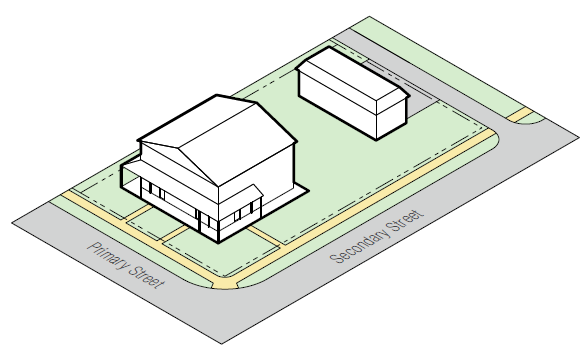
Duplex.
i.
Typical Configuration.
ii.
Description.
A.
A detached structure with two units that is massed as a single structure. Setbacks can range from small to large and units are typically side-by-side but may be stacked.
iii.
Standards.
A.
Each dwelling unit shall have its own front entrance, which must face the street.
(c)
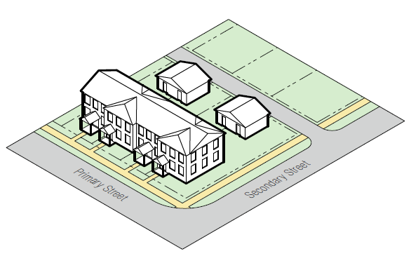
Multiplex.
i.
Typical Configuration.
ii.
Description.
A.
A medium structure that consists of three (3) to six (6) side-by-side and/or stacked dwelling units, typically with one shared entry or individual entries along the front. This type has the appearance of a medium-sized family home and is a scaled to fit within primarily single-family neighborhoods or into medium-density neighborhoods. This type enables higher densities and is important for providing a broad choice of housing types and promoting walkability.
iii.
Standards.
A.
Main entrance location shall face Primary Street.
B.
Each unit may have an individual entry.
(d)
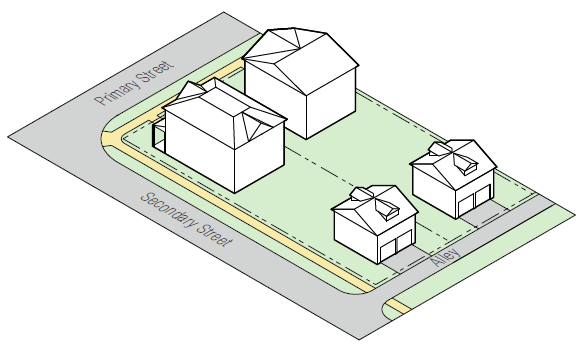
Single-Family Attached.
i.
Typical Configuration.
ii.
Description.
A.
A structure with common walls on either side and no units below or above. Garage access is typically from a rear alley or shared parking area.
iii.
Standards.
A.
Single-family attached units must have a rear access lane, rear alley, rear driveway, or an easement that serves as a rear access lane or alley in order to provide access to parking while minimizing curb-cuts along public frontages.
B.
A maximum of six (6) townhouses are allowed to be attached.
C.
Each unit shall have an individual entry facing a street.
(e)
Accessory Dwelling Unit.
i.
Typical Configuration.
ii.
Description.
A.
A subordinate living unit detached from a single-family dwelling that provides basic requirements for independent living. An Accessory Dwelling Unit may be a stand-alone structure, or located above a garage or workshop behind the primary residence.
iii.
Standards.
A.
Carriage Houses shall not be taller or have a larger footprint than the main building on the lot.
B.
Accessory Dwelling Units shall have a maximum footprint of eight hundred sixteen (816) square feet.
C.
The Carriage House must be set back at least twenty (20) feet from the front facade of the primary building.
(f)
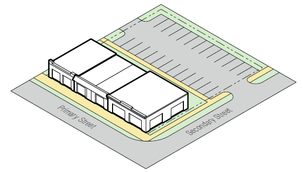
Flex Building (Small).
i.
Typical Configuration.
ii.
Description.
A.
Consists of attached or detached structures ranging from one to three stories. Structures can include single or mixed-uses. Parking is located in the rear or side of the building and typically accessed from a rear alley, when possible.
iii.
Standards.
A.
Upper floor units located in the main building shall be accessed by a common entry along the front street.
B.
Ground floor units may have individual entries along the Primary Street or Secondary Street.
C.
On corner lots, units in a secondary wing or accessory structure may enter from the side street.
(g)
Flex Building (Medium).
i.
Typical Configuration.
ii.
Description.
A.
Consists of attached or detached structures ranging from three to four stories. Structures can include single or mixed-uses. Parking is located in the rear of the building typically accessed from a rear alley, when possible.
iii.
Standards.
A.
Upper floor units located in the main building shall be accessed by a common entry along the front street.
B.
Ground floor units may have individual entries along the Primary Street or Secondary Street.
C.
On corner lots, units in a secondary wing or accessory structure may enter from the side street.
(h)
Flex Building (Large).
i.
Typical Configuration.
ii.
Description.
A.
Consists of attached or detached structures ranging from four to eight stories. Structures can include single or mixed-uses. Parking is located in the rear of the building typically accessed from a rear alley, when possible.
iii.
Standards.
A.
Upper floor units located in the main building shall be accessed by a common entry along the front street.
B.
Ground floor units may have individual entries along the Primary Street or Secondary Street.
C.
On corner lots, units in a secondary wing or accessory structure may enter from the side street.
(i)
Live-Work.
i.
Typical Configuration.
ii.
Description.
A.
An attached building type which provides flexible space at the street level for retail or office, with a complete living unit above.
iii.
Standards.
A.
Ground-floor space and upper unit shall have separate entries.
B.
Main entrance location shall face Primary Street.
C.
If off-street, on-site parking is provided, live-work units must have a rear access lane, rear alley, rear driveway, or an easement that serves as a rear access lane or alley in order to provide access to parking while minimizing curb-cuts along public frontages.
(j)
Rooftop Courtyard.
i.
Typical Configuration.
ii.
Description.
A.
A large structure composed of multiple attached or stacked units accessed from a shared courtyard, a series of courtyards, or a common corridor.
iii.
Standards.
A.
Total Courtyard Area: Four hundred (400) square foot minimum.
B.
Percentage of Width of Building: Fifty (50) percent maximum.
C.
A minimum of two courtyard boundary edges must be adjacent and defined by the building.
D.
Courtyard edges not defined by the building must be defined by a wall of a minimum of three (3) feet and maximum of five (5) feet in height.
E.
The proportions and orientation of courtyards should be oriented based on sunlight for user comfort.
(k)
Lined Building.
i.
Typical Configuration.
ii.
Description.
A.
A large building chiefly designed for the storage of vehicles, but also providing commercial or residential space along its frontage.
iii.
Standards.
A.
Lined buildings should mask the entire height of the garage, if facing the Primary Street.
B.
If facing the Secondary Street, lined buildings are required to mask the first two stories of the parking structure, although it is encouraged to mask all stories from view.
(l)
Step-Back Building.
i.
Typical Configuration.
ii.
Description.
A.
A large building with the upper floor(s) set back, relative to the floors below, in order to soften the mass of the building and afford sunlight and air on the street and open spaces.
iii.
Standards.
A.
See UDO Section 5.05(C)(8)(e)(iii)(B)(1) for standards regulating Step-Back Buildings.
(6)
Frontage Typologies.
(a)
Summary of Frontage Table.
(b)
Raised Yard.
i.
Typical Configuration.
ii.
Description.
A.
The Raised Yard Frontage Type is a variation of the front yard. It generally represents an historic residential lot character in which the front yard is elevated above the sidewalk, often in a sloped condition and sometimes with a masonry retaining wall (often composed of dry-laid limestone) at the sidewalk edge, or some combination of the two. The raised yard is often a continuous frontage condition for multiple adjacent lots. Front walks connecting the public sidewalk to the main building entrance are typically terraced with a set of steps at or near the public sidewalk and a second set of steps at the building facade, often at a front porch or stoop.
iii.
Dimensions.
iv.
Standards.
A.
Elevation varies according to existing site topography.
B.
Sidewalk connections must be terraced through the raised yard as appropriate to the elevation.
(c)
Stoop.
i.
Typical Configuration.
ii.
Description.
A.
A component type featuring a set of stairs with a landing leading to the entrance of a building.
iii.
Dimensions.
iv.
Standards.
A.
Stoops may be recessed into the building facade.
B.
Stoop may be built perpendicular or parallel to the building face but must lead directly to ground level or an abutting sidewalk from the building entrance.
C.
A recessed stoop may not be enclosed.
D.
Stoops, when built as part of a townhouse or live-work building, may be configured as a split stair to access a below grade unit.
E.
Stairs are not permitted to encroach onto any abutting sidewalk.
F.
If a stoop is built encroaching onto a public sidewalk, it must provide at least five (5) feet of clear and unobstructed areas between its outermost face and the face of the curb.
(d)
Forecourt.
i.
Typical Configuration.
ii.
Description.
A.
A portion of the main facade of the building is at or near the property line and a smaller portion is set back, creating a courtyard space. The space could be used as an entry court or shared garden for apartment buildings, or as an additional shopping or restaurant seating area within commercial areas. The proportions and orientation of these spaces should be carefully considered for solar orientation and user comfort.
iii.
Dimensions.
iv.
Standards.
A.
This frontage type should be used sparingly and should not be repeated along a frontage.
B.
A short wall, hedge, or fence shall be placed along the Build-to Line (BTL) where it is not defined by a building.
C.
Sidewalk(s) connecting an entry door and public sidewalk must have a direct walk connection.
(e)
Porch.
i.
Typical Configuration.
ii.
Description.
A.
Common frontage type for residential building types. Porches should be an extension of the internal living space.
iii.
Dimensions.
iv.
Standards.
A.
Front porches may encroach up to fifty percent (50%) of their depth into the front setback.
B.
Stairs are not permitted to encroach onto any abutting sidewalk.
C.
A minimum of five (5) feet clear zone must be maintained between the public walk and/or side lot line and the porch.
D.
A porch may be enclosed with screens provided the percentage of window area to wall area is seventy percent (70%) or greater. Permanent enclosure of a porch to create year-round living space is not permitted.
(f)
Patio.
i.
Typical Configuration.
ii.
Description.
A.
The patio frontage is used primarily to provide outdoor seating associated with ground floor dining uses within a building. The patio is a hardscaped area that may be located to the front or side of a building between the building and sidewalk.
iii.
Dimensions.
iv.
Standards.
A.
Patio may be structurally raised above sidewalk level to the height of the finished floor elevation of the associated building.
B.
Patios may be fully or partially covered using awnings, canopies or an open structure including, but not limited to a pergola. A pergola or similar structure must be limited in height to the eave line of the associated principal building.
C.
Patios may be fully or partially enclosed with an open fence, masonry wall, or raised planters.
D.
The materials and design of patio enclosures must be coordinated with the design and style of the associated building or storefront.
E.
Enclosures or barriers for outdoor dining shall be a minimum of thirty-six (36) inches in height and a maximum of forty-two (42) inches in height.
(g)
Shopfront.
i.
Typical Configuration.
ii.
Description.
A.
A shopfront is a non-load bearing assembly of commercial entry doors and windows providing access and light to a commercial space and a place to display goods, services, and signs.
iii.
Dimensions.
iv.
Standards.
A.
An unobstructed view of the interior space or a lighted and maintained merchandise display(s) must be provided for a depth of at least four (4) feet behind storefront display windows.
B.
When shopfronts are set back from the front lot line, the frontage area must be paved.
C.
When present, awnings and canopies must be mounted between columns, pilasters, or piers; above doorways and display windows; and below the sign band. Awnings shall contain a rigid valance with no advertising material.
D.
Exterior security grilles, gates, and roll-down security doors and windows are prohibited.
(h)
Parking Garage.
i.
Typical Configuration.
ii.
Description.
A.
A garage frontage is used when structured parking is located in close proximity to a street and sidewalk. This may apply to a stand-alone parking structure or to portions of a building consisting of integrated ground floor parking. The garage frontage consists of decorative architectural elements that complement the overall building design and a landscape buffer between the garage and sidewalk.
iii.
Dimensions.
iv.
Standards.
A.
Structured parking is not permitted to have frontage on Primary Streets.
B.
Structured parking associated with buildings on primary frontage streets must be lined by Pedestrian Active Uses along the Primary Street. Active uses may be located within a building attached to the garage, or in a separate building with structured parking located to the rear.
C.
The garage frontage must include a landscape bed with a continuous foundation landscape treatment and trees spaced at a minimum of thirty-five (35) feet on-center.
D.
All street-facing parking structure facades must include a pedestrian entrance directly connected to the sidewalk.
E.
The facade must be designed with vertical increments (projections or recesses) including, but not limited to: columns, pilasters, or a similar architectural feature that provides visual relief along the building face at least every thirty (30) feet.
F.
Any horizontal distance along the facade greater than fifteen (15) feet must have windows, fenestration, decorative grate, etc. to avoid blank and windowless walls.
(i)
Arcade.
i.
Typical Configuration.
ii.
Description.
A.
An arcade is a frontage type featuring a pedestrian walkway covered by the upper floors of a building. The ground story facade is setback and upper floors are supported by a colonnade or supports.
iii.
Dimensions.
iv.
Standards.
A.
Arcades must extend the entire width of a building and must have a consistent depth.
B.
Support columns or piers may be spaced no farther apart than they are tall.
C.
Arcades are considered part of the building for the purpose of measuring facade build-out.
D.
Arcades may be combined only with storefront and lobby entrance frontages.
E.
The finished ceiling of an arcade interior may be arched or flat, but must have a greater clearance than the openings between columns or piers.
(j)
Gallery.
i.
Typical Configuration.
ii.
Description.
A.
The main facade of the building is at the frontage line and the gallery element overlaps the sidewalk. This frontage type is intended for buildings with ground-floor commercial or retail uses and may be one or two stories. The gallery must extend close enough to the curb so that a pedestrian cannot bypass it. Due to the overlap of the right-of-way, an easement is usually required.
iii.
Dimensions.
iv.
Standards.
A.
Galleries must have a consistent depth along a frontage.
B.
Gallery must project over a sidewalk. Sidewalk shall be placed on private property with a public easement.
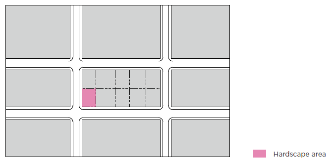
(7)
Open Space Typologies.
(a)
Summary of Open Space Table.
(b)
Passage.
i.
Typical Configuration.
ii.
Description.
A.
A passage is an informal or formal gathering space that serves equally as a pedestrian connector between other gathering places or between streetscapes. Passages are near the middle of a block, providing easy walk access through the block. A passage provides additional frontage opportunities for the shops and/or houses along its edges.
iii.
Standards.
(c)
Pocket Park.
i.
Typical Configuration.
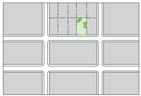
ii.
Description.
A.
Pocket parks are small-scale, primarily landscaped open spaces fronting a primary or secondary street and designed to provide opportunities for neighborhood gathering and typically passive recreation for those who live within walking distance.
Pocket parks are typically located in residential neighborhood settings but can be in a commercial neighborhood. Landscaping, including public art, is encouraged.
iii.
Standards.
(d)
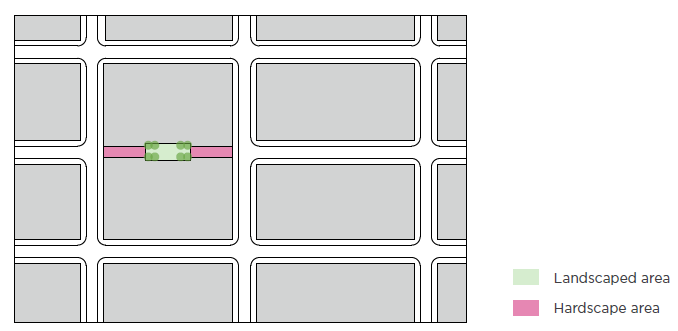
Pocket Plaza.
i.
Typical Configuration.
ii.
Description.
A.
Pocket plazas are small-scale, primarily hardscaped open spaces designed to provide opportunities for impromptu gathering and resting areas for passersby and for those who live or work in adjacent buildings or nearby destinations. Pocket plazas are typically designed as an extension from the public sidewalk, but are clearly delineated as a separate space using features including, but not limited to landscaping, public art and/or seating walls. Pocket Plazas are typically located along highly trafficked streets and in commercial areas with frequent pedestrian activity.
iii.
Standards.
(e)
Green.
i.
Typical Configuration.
ii.
Description.
A.
Greens are medium-scale, informal open spaces fronting a primary or secondary street and designed to provide for active or passive recreation in neighborhood settings. They typically include some landscape areas and is generally for those who live within walking distance.
iii.
Standards.
(f)
Square.
i.
Typical Configuration.
ii.
Description.
A.
Squares are medium-scale formal open spaces designed to serve as gathering spaces in prominent commercial, civic and mixed-use settings. Squares are typically rectilinear and framed on all sides by streets. They are typically designed with a combination of both hardscape and landscape areas and contain amenities including, but not limited to, benches and seating areas, planting areas, walking paths, gazebos or pavilions, fountains, and public art.
iii.
Standards.
(g)
Plaza.
i.
Typical Configuration.
ii.
Description.
A.
Plazas are spaces available for civic purposes and commercial activities intended to add to the vibrancy of streets and neighborhoods. Building frontages typically define the edges of these spaces. The landscape consists of primarily hardscape and can include public art. If trees are included, they are formally arranged.
iii.
Standards.
(h)
Greenway and Trail.
i.
Typical Configuration.
ii.
Description.
A.
Greenways are primarily linear open spaces that connect other types of open spaces as part of a larger system. They typically include a path, trail, or public art as a primary feature. The greenway and trail open space is most effective when connecting to another open space type.
iii.
Standards.
(i)
Park.
i.
Typical Configuration.
ii.
Description.
A.
Parks are larger-scale, typically informal open spaces designed to provide a variety of active and passive recreational opportunities to the general public. Parks may include natural areas, green infrastructure, and public art. These open spaces may have a variety of forms, with edges defined by streets, neighborhoods, or natural features.
iii.
Standards.
(8)
Design Standards and Guidelines.
(a)
General Intent. Urban design criteria in the form of Standards and Guidelines are to be applied in conjunction with the vision for the area in the Lane Avenue Planning Study. Standards and Guidelines are intended to encourage creativity within the design framework, while maintaining a consistent level of quality between individual projects. Standards and Guidelines do not mandate a particular architectural style or building material.
i.
Standards and Guidelines do:
A.
Define a standard of design quality intended to enhance the public realm;
B.
Promote cohesive development patterns while allowing for diversity and variety in the design and construction of individual projects;
C.
Assist City Staff, planners, designers, developers, and property owners in making consistent choices that reinforce the vision;
D.
Recognize that the corridor will evolve over time and that development will respond to changes in the market; and
E.
Integrate and transition new development into surrounding communities.
(b)
Design Standards and Guidelines Defined.
i.
Design Standards. Design Standards are objective criteria that provide specific direction for achieving the stated Intent. Standards denote issues that are considered critical. Standards use the term "shall" to indicate that compliance is required.
ii.
Design Guidelines. Design Guidelines provide alternative solutions for accomplishing the goals set forth by the Intent Statements. They are more flexible and harder to quantify than Standards. They often amplify a related Standard. Guidelines use the term "should" or "may" to denote they are considered relevant to achieving the Intent Statement, and will be pertinent to the review process. When they amplify a Standard, they are preferred but not mandatory criteria. However, Guidelines are strongly considered in circumstances when a Standard is not being met and an alternative is being sought. In such a case, it must be demonstrated that the alternative meets one or more of the following criteria:
A.
The alternative better achieves the stated Intent;
B.
The Intent Statement that the Standard was created to address will not be achieved by application of the Standard in this particular circumstance;
C.
The application of Guidelines to achieve stated Intents will be improved by not applying the Standard in this particular case; and
D.
Unique site characteristics or market factors make the Standard impractical or cost prohibitive.
(c)
Circulation.
i.
General Intent. To establish a logical and interconnected system of streets, sidewalks, and pathways that balance mobility with the making of a significant urban place. Site circulation should provide adequate and safe access for automobiles, cyclists, and pedestrians by incorporating the best characteristics of the City's multi-modal urban street system.
ii.
Vehicular Circulation and Access.
A.
Intent. To locate vehicular access in a way that:
1.
Minimizes conflict with other modes of transportation, especially pedestrian traffic;
2.
Protects residential streets from the effects of undue congestion and noise;
3.
Encourages multi-modal transportation; and
4.
Provides for the safe and efficient movement of pedestrians, bicycles, and vehicles.
B.
Design Standards.
1.
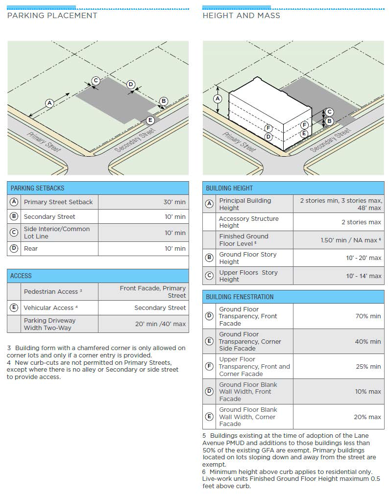
New curb-cuts are not permitted on Primary Streets, except where there is no alley or Secondary Street to provide access. Cross access easements shall adjoin parking lots where alleys are not available or feasible.
2.
Vehicular access must be provided via an alley when the alley is determined to be open or accessible by the City Engineer.
3.
In the absence of alleys, the Secondary Street or side street, must be used as the principal vehicular access.
4.
Any development project with a total, cumulative site area of 1.5 to 3.9 acres must provide an alley.
5.
Sites larger than two (2) acres must provide a network of connected streets (public or private) that provide circulation within the site and current and future connections to the existing street network and to adjacent properties.
6.
All vehicular access points in the public right-of-way, including curb-cuts, driveways, alleys, and new street network plans must be approved by the City Engineer.
C.
Design Guidelines.
1.
A single curb-cut or driveway should not be wider than what is minimally required by the City Engineer for the safe movement of traffic.
2.
Curb-cuts and driveways are discouraged close to the curb line at the corners of blocks.
3.
Drop-offs serving the entrances of specific uses such as hotels should be located outside the right-of-way, where possible. Drop-offs in the right-of-way will require approval by the Director of Community Development and the City Engineer.
iii.
Pedestrian and Bicycle Circulation and Access.
A.
Intent.
1.
To reinforce the historic pattern, hierarchy, and logic of the City's pedestrian sidewalk system.
2.
To incorporate alternate modes of transportation, especially walking and cycling, into the design of vehicular street systems.
3.
To connect the development to existing designated bike routes and trail systems, where feasible.
4.
To connect the development to future and existing neighborhoods.
B.
Design Standards.
1.
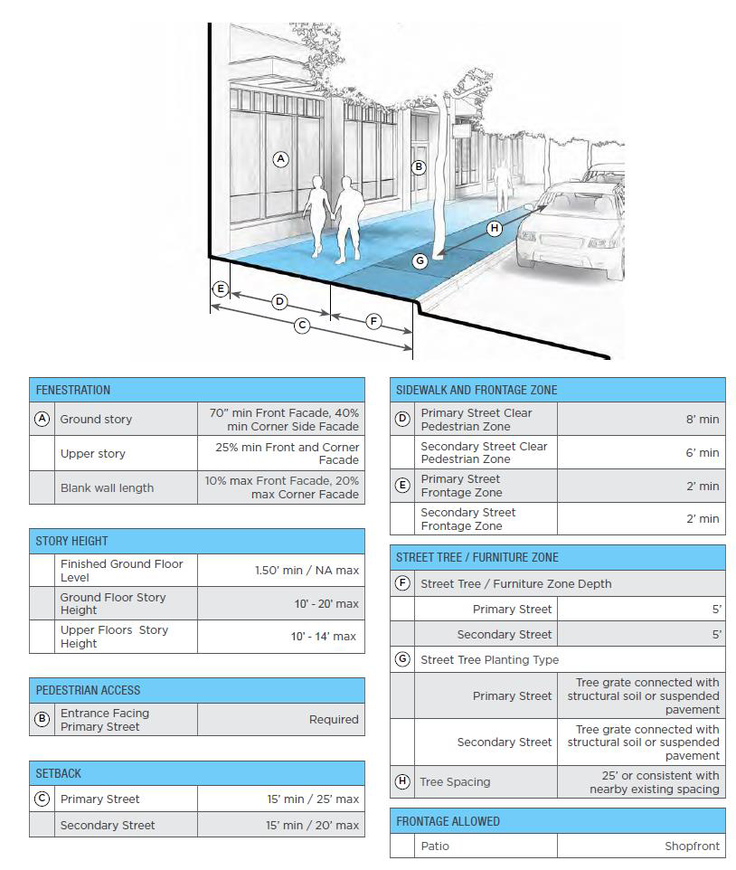
All development must provide safe, direct and convenient pedestrian access connecting public streets and parking lots to primary building entrances and to all other uses in the development that allow for public access.
2.
Pedestrian access must consist of an accessible, easily discernible, well-lit, six-foot and ADA compliant walkway.
3.
The pedestrian access surface located on private property must be paved with fixed, nonslip semi-pervious or impervious materials.
4.
Pedestrian access routes between and adjacent to buildings and parking areas must be physically separated from drive aisles, except when crossing a drive aisle.
5.
Where a pedestrian walkway crosses a drive aisle, the walkway must have a continuous surface treatment across the drive aisle.
6.
Pedestrian walkways must be designed and installed to allow for cross-access between abutting properties.
C.
Design Guidelines.
1.
All new streets should be designed to allow pedestrian and bicycle access.
2.
The system of pedestrian and bicycle circulation should be designed to connect to and extend from similar circulation systems on adjacent existing streets.
3.
Pedestrian crossings of all streets should be accommodated at street grade without requiring the use of a bridge or tunnel.
4.
For designated bike routes, painted lanes or "sharrows" (as approved by the City Engineer) are encouraged.
(d)
Site Planning.
i.
General Intent. The success of an urban environment is in the quality of its streetscapes. Planning of individual sites should consider the complex relationship between vehicular streets, sidewalks, sidewalk amenities, landscaping, and the location and continuity of building edges. In addition, open spaces adjacent to development and accessible from the public right-of-way serve the social, environmental, and psychological needs of the community. It is also important to thoughtfully consider the location and design of parking areas, service areas, and site utilities so they do not detract or conflict from the quality of the development.
ii.
General Streetscape (Public Realm) Design.
A.
Intent.
1.
To encourage streetscapes that distinguish and support various modes of transit, including but not limited to vehicular traffic, cycling, and walking.
2.
To provide adequate and logical connections of streets and sidewalks within the development and between the development and adjacent neighborhoods.
3.
To provide sidewalks of adequate width to contain, define, and concentrate pedestrian uses.
4.
To encourage pedestrian activities on the sidewalk such as walking, eating, and browsing retail storefronts.
5.
To encourage streetscapes with tree rows that create a continuous canopy at maturity.
B.
Design Standards.
1.
All sidewalks within the public right-of-way must meet the separate standards of, and be approved by, the City Engineer.
2.
All plantings in the Furniture Zones shall meet the requirements of the City Forester.
3.
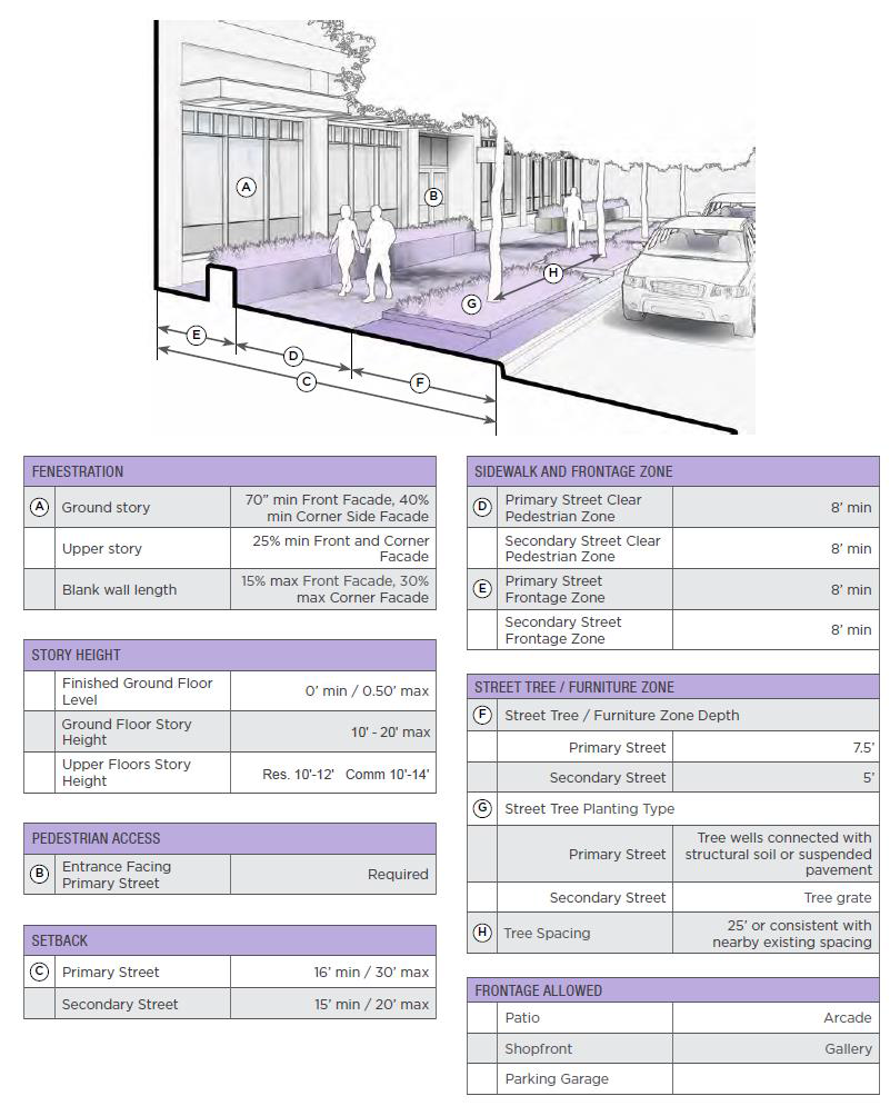
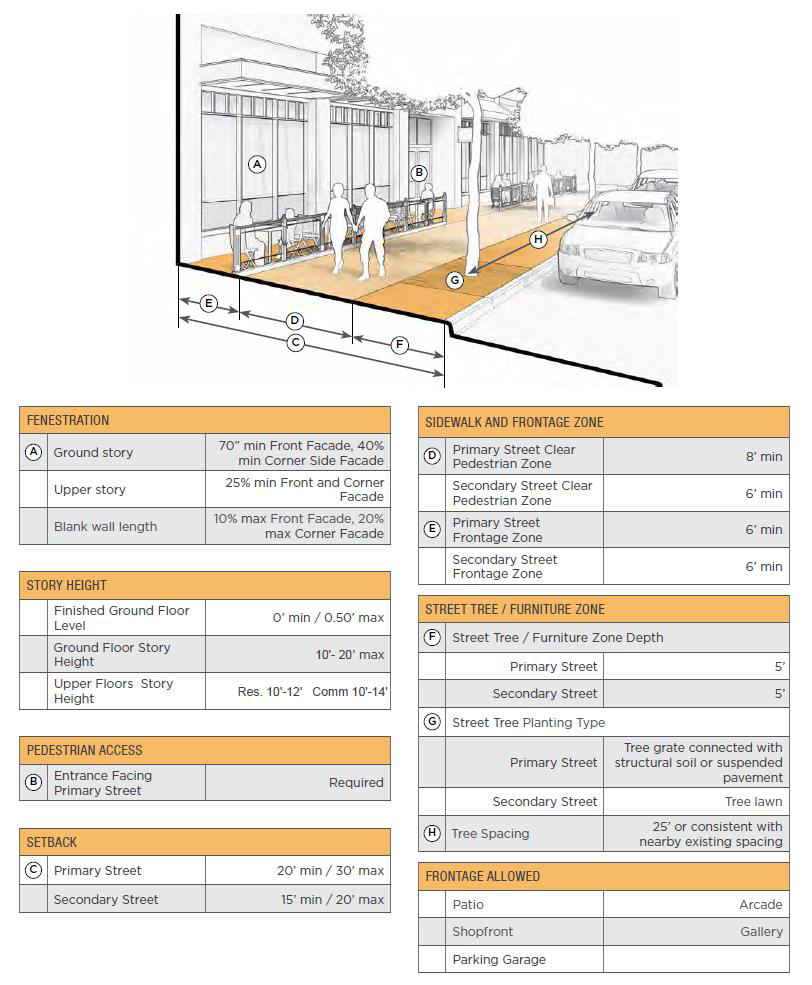
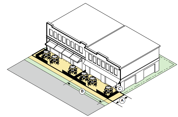
For all Primary Streets, sidewalks shall be designed to include, at a minimum:
I.
A six-foot wide Pedestrian Zone, free of all obstructions.
II.
A five-foot wide Furniture Zone, measured from the curb line. This zone shall contain street trees, brick pavers, seating, or other pedestrian amenities.
4.
Every sidewalk on a Secondary Street shall be designed to include at a minimum:
I.
A six-foot wide Pedestrian Zone, free of all obstructions;
II.
A five-foot wide Furniture Zone that shall contain street trees; and
III.
Within the public right-of-way, encroachments into the six (6) foot wide minimum, eight (8) foot maximum Pedestrian Zone by the Furniture Zone shall be allowed by permit only.
C.
Design Guidelines.
1.
Zones, which include building-related functions such as sidewalk seating, are encouraged on enhanced pedestrian streets such as Lane Avenue and Northwest Boulevard.
iii.
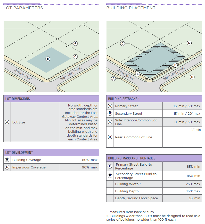
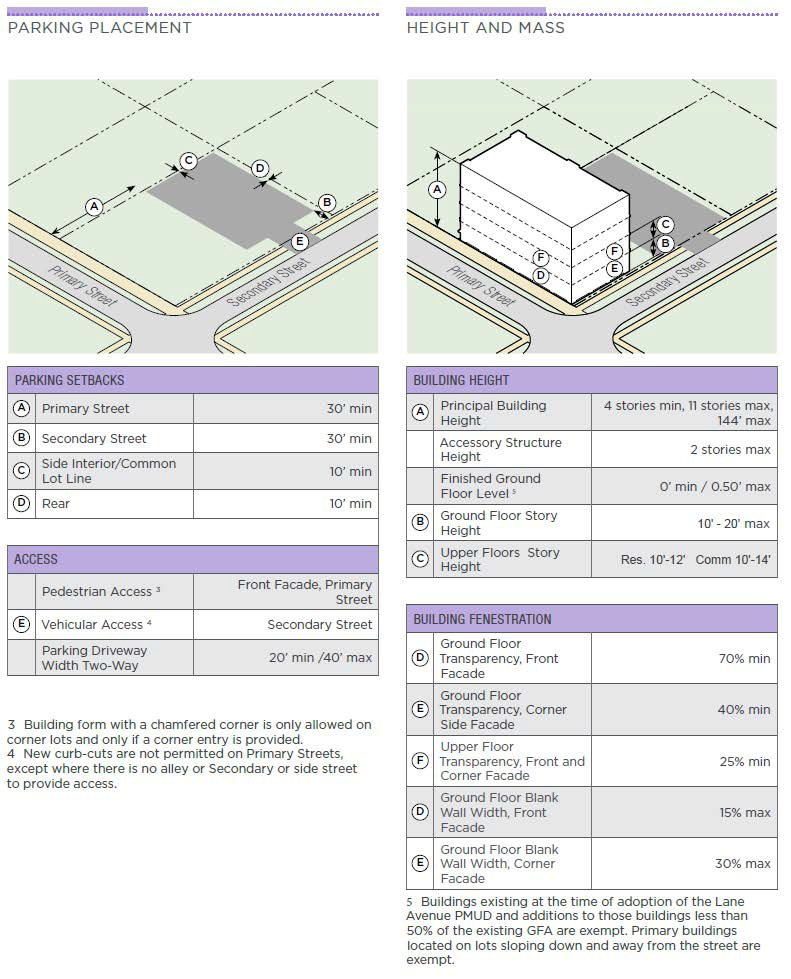
Building Location, Orientation and Use - Build to Requirements.
A.
Intent.
1.
To create a street wall that defines the three-dimensional space of the street and contributes to its sense of place.
2.
To maintain the continuity of the street wall for the majority of the length of the street.
B.
Design Standards.
1.
All buildings shall adhere to the setback requirements of the underlying zone district in which the building or structure resides except as modified below.
2.
Build-to zones are required along primary and secondary streets in all Sub-areas. This zone is the area running along the Property Line in which the Building Facade must be located within the build-to zone.
C.
Design Guidelines.
1.
Where gaps between buildings are contemplated, they should be located and proportioned to:
I.
Relate to major transitions in use or character;
II.
Relate to open spaces;
III.
Relate to adjacent buildings; and
IV.
Correspond to historic or surrounding zone block widths or depths.
2.
In general, ground floor arcades are discouraged in favor of building façades that directly front the street. However, arcades may satisfy the build-to requirement when:
I.
They extend no more than one floor in height;
II.
The exterior face of the arcade column line is within the build-to zone;
III.
The exterior face of the column line generally continues the wall plane of the building above;
IV.
The average depth of the arcade is no less than six feet clear as measured from the back face of the column line;
V.
The average depth of the arcade is no more than two-thirds (⅔) of its average clear height as measured from the front face of the column line; and
VI.
The arcade column width and column spacing does not substantially impede views of the Pedestrian Active Uses from the Pedestrian Zone.
iv.
Building Location, Orientation and Use - Pedestrian-Active Use Requirements.
A.
Intent.
1.
To locate and orient uses in a way that encourages and intensifies pedestrian activity and interest along the street.
2.
To require a predominance of Pedestrian Active Uses fronting the street.
B.
Design Standards.
1.
Seventy-five percent of ground floor frontages facing Lane Avenue, Northwest Boulevard, and North Star Road shall be occupied by Pedestrian Active Uses. For all remaining Primary Streets, at least sixty-five percent (65%) of all ground floor frontages shall be occupied by Pedestrian Active Uses.
C.
Design Guidelines.
1.
A majority of the ground floor frontage of commercial buildings and parking structures on all streets should contain Pedestrian Active Uses.
2.
Portions of the building not parallel with the street should be related to building uses that complement pedestrian activities along the street.
v.
Building Location, Orientation and Use—Gateway Areas.
A.
Intent.
1.
To emphasize and differentiate special corners or intersections from the surrounding building architecture.
2.
To aid in wayfinding and articulate important changes in character and use.
3.
To inform building design in a manner that will successfully articulate designated gateways and encourage pedestrian active uses.
B.
Design Standards.
1.
Gateway Areas shall be designated at primary intersections.
2.
Within each designated Gateway Area, at least two of the following design strategies shall be employed:
I.
Visibly increased or decreased density, building height, and/or building setback relative to surrounding structures;
II.
Provision of a plaza or expanded streetscape;
III.
Incorporation of unique building signage and/or art; and
IV.
Enhanced building character (form, materials, fenestration, and facade articulation on building façades visible from the street).
3.
Within a designated Gateway Area, there shall be at least one pedestrian entrance.
4.
Exposed parking garage frontage shall not occur at the ground floor within a Gateway Area.
vi.
Parking Location and Orientation - Surface Parking Lots.
A.
Intent.
1.
To locate and orient surface parking on the site in a way that reduces its visual and environmental impact.
B.
Design Standards.
1.
New surface parking shall not exceed twenty-five percent (25%) of block frontage along any Primary Street or fifty percent (50%) of block frontage along any Secondary Street.
2.
No new surface parking is allowed between the front of a building and the street.
3.
New surface parking shall provide safe pedestrian passage by incorporating an efficient system of five-foot wide pedestrian paths.
C.
Design Guidelines.
1.
Surface parking lots are discouraged in favor of structured parking.
2.
At least eight percent (8%) of the paved surface area of each new surface parking lot shall be shaded by mature landscaping within five (5) years.
3.
Electric vehicle (EV) charging stations are encouraged to be provided and may be substituted for required parking spaces.
vii.
Parking Location and Orientation - Structured Parking Garages.
A.
Intent.
1.
To encourage structured parking of a mixed-use character.
2.
To locate and orient structured parking on the site in a way that reduces its visual and environmental impact.
B.
Design Standards.
1.
Exposed above-grade parking structures shall not exceed thirty percent (30%) of block frontage along any Primary Street at the ground floor.
2.
For all exposed above-grade parking structures on Secondary Streets, at least fifty percent (50%) of the ground floor level must be covered by an architectural screen.
3.
Exposed parking garage frontage at the ground floor shall not occur within a Gateway Area.
C.
Design Guidelines.
1.
Above-grade parking structures should be located and oriented to minimize frontage on all streets, especially Primary Streets.
2.
Below-grade structured parking is encouraged.
3.
Above-grade structured parking should be located on the site in a way that minimizes its visual impact on adjacent residential areas.
4.
The exposed faces of above-grade parking garages should be oriented away from residential areas. Where faces are exposed to view, enhanced building materials, details, and/or landscaping should be employed to improve their aesthetic appearance.
5.
Where feasible, above-grade parking should be wrapped with or contain commercial or residential uses, especially at the ground floor.
viii.
Site Service and Utility Areas.
A.
Intent.
1.
To minimize the visual presence of service functions, such as delivery and refuse pickup.
B.
Design Standards.
1.
Service and utility areas shall not be located:
I.
Within twenty-five (25) feet horizontally of any pedestrian entry, and forty (40) feet from a single-family lot line;
II.
Between the building and the street.
2.
Service and utility areas shall be concealed from the street by employing means such as:
I.
Locating underground;
II.
Locating internal to a structure or group of structures;
III.
Providing enclosing walls, fences, screening and/or landscaping of sufficient height and density year-round; and
IV.
Locating along internal alleys or service drives.
C.
Design Guidelines.
1.
Utility and service areas should be shared between buildings, among groups of similar uses, or otherwise consolidated to minimize the proportion of the site dedicated to these functions.
(e)
Building Design.
i.
General Intent. Buildings help characterize and define the street, enhance the sense of "place," and contribute to the high quality of a vibrant, mixed-use urban community. Buildings that enhance the urban realm, should pay careful attention to issues of massing, form, facade articulation and the location of entrances. Special consideration must be given to the thoughtful integration of building utilities and services as well as the design of parking structures.
ii.
Building Massing and Form.
A.
Intent.
1.
To encourage buildings whose forms are responsive to the surrounding context.
2.
To encourage original building design.
3.
To generate visual interest in the built environment by emphasizing changes in use, marking transitions between districts, and creating iconic elements that mark entrances and terminate views.
4.
To moderate scale changes between adjacent buildings.
5.
To encourage building forms that promote sun and sky exposure to streets and open spaces.
B.
Design Standards.
1.
Step-backs shall be required for any facade that fronts a Pedestrian Zone along Lane Avenue and is higher than fifty (50) vertical feet. For that portion of the facade that is over fifty (50) feet in height, at least twenty-five percent (25%) of the horizontal length of the facade should step-back ten (10) feet from the front lot line.
C.
Design Guidelines.
1.
Additional bulk reduction is encouraged for buildings on the south and east sides of streets and open spaces to allow for greater penetration of sunlight into these spaces.
2.
Articulation of the building form is encouraged to express typical architectural elements such as:
I.
The location of entrances and vertical circulation;
II.
Significant changes in building use or occupancy;
III.
Changes from one residential unit to another;
IV.
The expression of structural bays; and
V.
The expression of balconies and above-grade terraces.
3.
Articulation of the building mass and form is also encouraged to express a building's relationship to its context, including:
I.
Adjacency to significantly lower or taller buildings;
II.
Response to existing structures;
III.
Relationships to the corners of blocks or major site entrances;
IV.
Response to the termination of views; and
V.
The creation of an engaging profile or skyline.
iii.
Height Adjacent to a Protected Zone.
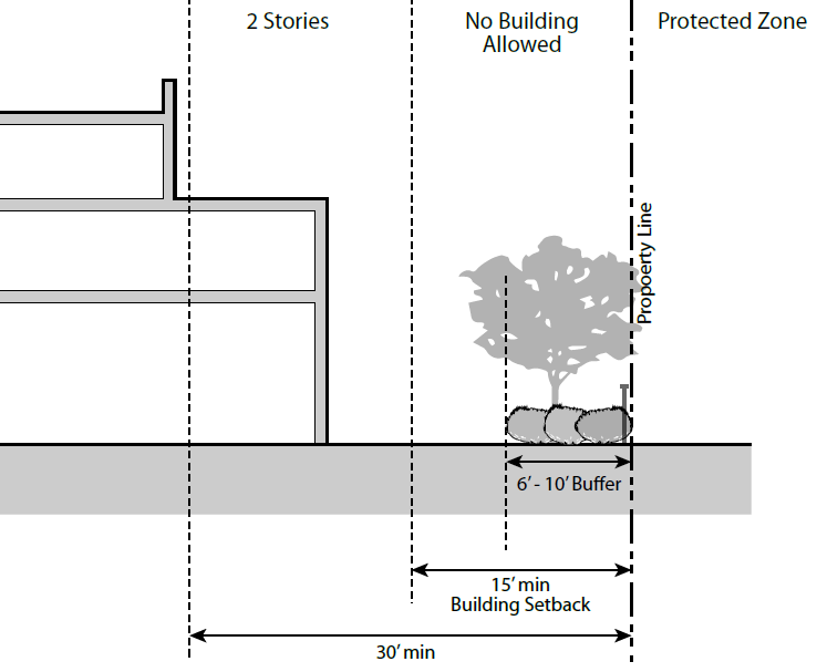
A.
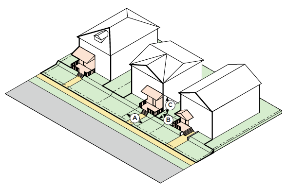
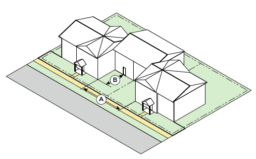
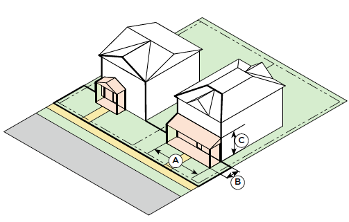
The maximum height of any portion of a building or structure within thirty (30) feet of a common lot line abutting a Protected Zone is two and a half (2½) stories or thirty-five (35) feet. Property separated by a street or alley is not considered abutting. No building, including an accessory structure, shall be permitted within fifteen (15) feet of a protected zone.
iv.
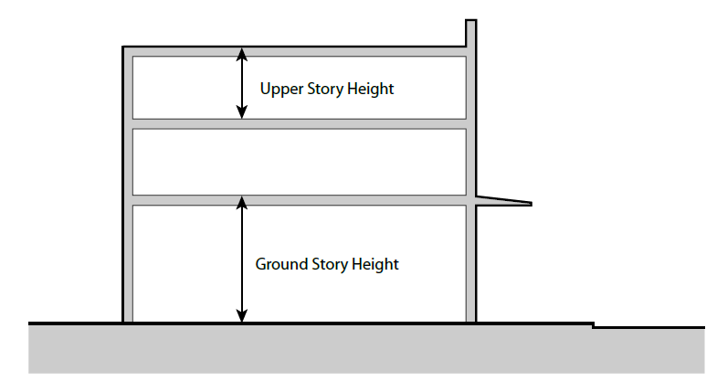
Story Height.
A.
Story height is the height of each story of building and it is measured from the top of the subject finished floor to the top of the finished floor above. When there is no floor above, upper story height is measured from the top of the finished floor to the top of the wall plate above.
B.
Open structures, such as pergolas or shade devices, do not constitute a story and may be placed on building roofs.
C.
Shade or Shadow Study Requirement. Shadow studies shall be required for all proposed buildings exceeding four stories or sixty (60) feet in height. Based upon the findings of the shadow study, the fourth or higher story of the building may be required to be set back (see UDO Section 5.05(C)(8)(e)(iii)(B)(1)) to minimize shade impacts on adjacent properties or the public right-of-way.
v.
Building Mass.
A.
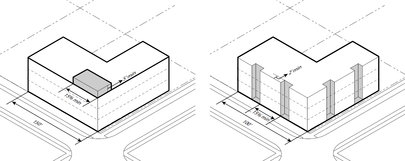
Articulation in Building Height. For buildings one hundred and fifty (150) feet or more in length, at least fifteen percent (15%) of the street-facing roof line must have a variation in height of at least five (5) feet. On a corner lot, the variation in height must be located at the corner of the building that addresses both street fronts.
B.
Articulation in Building Facade. For buildings one hundred (100) feet or more in length, at least two (2) portions of the street-facing building facade must have a variation in setback of at least two (2) feet. The combination of the required variations in setback must total no less than fifteen percent (15%) of the length of the building.
vi.
Building Character.
A.
Materials.
1.
Intent.
I.
To create visual interest through a varied palette of texture, color, and module.
II.
To give buildings and surfaces a human-scale.
III.
To ensure the consistent use of high quality materials.
IV.
To promote durability, sustainability, and ease of maintenance.
V.
To complement existing materiality of the Lane Avenue PMUD and the surrounding neighborhoods.
2.
Design Standards. Building walls should reflect and complement the traditional materials and techniques of Upper Arlington's architecture. They should express the construction techniques and structural constraints of traditional, long-lasting, building materials. Simple configurations and solid craftsmanship are favored over complexity and ostentation in building form and the articulation of details. All building materials to be used shall express their specific properties. For example, heavier more permanent materials (masonry) support lighter materials (wood).
3.
Required and Desirable Materials.
I.
At least fifty percent (50%) of the building's exterior must be brick, natural limestone, and/or architectural cast limestone;
II.
Glass;
III.
Architectural metal panel systems;
IV.
Decorative metal framing systems with an exterior-grade finish system; and
V.
Materials such as cementitious or metal panels, siding, cedar siding, metal siding, copper, or tile.
4.
Undesirable Materials.
I.
Unpainted concrete precision block walls;
II.
Metal, excluding architectural metal panel systems or standing seam roofs;
III.
Vinyl or plastic siding;
IV.
Stucco, exterior insulated foam systems (e.g. Dryvit) and similar materials except when used as trim;
V.
Mix of unrelated styles (e.g. rustic wood shingles and polished chrome);
VI.
Materials with a glossy finish;
VII.
Exterior insulation and finishing systems (EIFS) shall not be used on ground floor façades up to thirty-five (35) feet in height;
VIII.
Materials of a structural or unfinished nature such as tilt-up concrete panels shall not be used on building façades visible from the street; and
IX.
Concrete masonry units.
5.
Design Guidelines.
I.
The expression of smaller material modules is encouraged to enhance the sense of human-scale architecture, especially at ground and second floor façades.
II.
Materials with the greatest durability, such as brick or stone, should be used on ground floor façades. Other materials, such as glass and wood, may also be added to ground floor façades.
III.
Materials should also be selected with consideration given to their environmental and sustainable attributes, including:
1.
Life-cycle cost - including embodied energy,
2.
Proportion of post-consumer or post-industrial recycled content,
3.
Local or regional availability,
4.
Re-use or recycling potential after useful life.
6.
Materials should be composed within the building facade in a way that adheres to a visual and structural logic. For example, materials that clad or express a structural element should be more prominent than those that clad or express an infill element.
7.
The use of synthetic materials that imitate natural materials should be avoided. A synthetic material should be used in a way that reflects the material's intrinsic characteristics.
B.
Fenestration.
1.
Intent.
I.
To enhance street-level activity and interest by providing a high degree of transparency, particularly at the ground floor.
II.
To provide a level of transparency at upper floors sufficient to be aware of internal activities when viewed from the street.
III.
To create rhythms and patterns on building façades that provide visual interest and reflect the uses within.
IV.
To limit the glare from reflective glass.
2.
Design Standards.
I.
Facades shall have a minimum percentage of window-to-solid wall area as shown in the Summary of Dimensions and Standards Table.
II.
Residential façades shall provide no less than twenty percent (20%) window to solid wall area.
III.
In new construction, no highly reflective glazing shall be permitted. All glazing shall have a maximum reflectance factor of 0.20. No first-surface reflective coatings shall be permitted.
IV.
Individual windows above the ground floor exceeding thirty-five (35) square feet shall be subdivided by at least one horizontal or vertical mullion or joint.
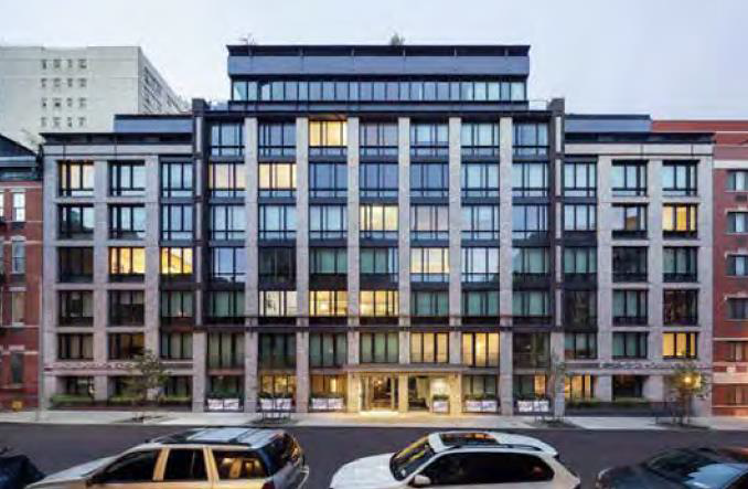
3.
Design Guidelines.
I.
Where the required window to wall ratio is not feasible or is in conflict with internal functions, elements such as public art, retail displays, or enhanced signage and building detail should be integrated to maintain the visual interest at street level.
II.
No more than fifty percent (50%) of the required glazing area in a facade should be consolidated in one area.
III.
Glass block or other glazing products that provide adequate light transmission but distort view should not be used on ground floor building façades.
IV.
Clear glazing is preferred at the ground floor, but the use of colored, patterned, or fritted glass may be allowed when it is above the required percentage of transparency.
V.
Fenestration should recess or project from the adjacent wall surface or surround to create a visible shadow line.
VI.
Large areas of glazing should be subdivided by mullions, joints, or similar scaling elements to provide a reasonable level of scale and detail, especially at the ground and second floors.
VII.
Louvered or other unglazed facade openings should also be articulated with a system of scaling elements to provide a level of scale and detail complementary to glazed areas.
VIII.
Operable windows are desirable and should be strongly considered.
IX.
Durable and permanent low-emissivity coatings on the second or third glazing surface are encouraged to provide greater energy efficiency.
X.
Sunshades and screens are encouraged as long as they do not significantly block views through the window in either direction.
C.
Facade Articulation.
1.
Intent.
I.
To create visually interesting and human-scaled façades, particularly those that face streets or open spaces.
II.
To avoid large areas of undifferentiated façades.
2.
Design Standards.
I.
Building façades or portions of building façades visible from the street shall incorporate, at a minimum, three (3) of the following architectural scaling elements:
1.
A change in color;
2.
A change in material or pattern;
3.
A system of horizontal and vertical scaling elements such as a belt course, string course, projecting fins, or projecting cornice or eyebrow;
4.
Expression of the structural system and infill panels through a change in plane of at least three (3) inches;
5.
Articulation of window and doorway surrounds, which may include sills, lintels, pilasters, and mullions, through a change in plane of at least two (2) inches;
6.
A system of horizontal and vertical articulating reveals of at least three-eighths (⅜) inch width by three-eighths (⅜) inch depth; and
7.
A system of art or ornament integral to the building (such as an inset decorative panel or metal framework anchored to embeds in the building façade).
II.
Architectural scaling elements shall occur both horizontally and vertically and be part of a cohesive system.
3.
Design Guidelines.
I.
Architectural scaling elements should be composed in a way that highlight a building's intrinsic architectural characteristics, including but not limited to the building's:
1.
Structural module;
2.
Vertical divisions represented by the floor, sill, lintel, and parapet;
3.
Building composed of a "base," "middle," and "top;"
4.
Patterns of fenestration; and
5.
Primary uses or transitions between use or ownership.
II.
Facade articulation should be more detailed at the ground floor.
III.
Architectural scaling elements should be integrated into the building facade and not appear as an insubstantial overlay.
IV.
Where a primary building facade abuts a facade of secondary importance (such as along an alley or internal service area), architectural scaling elements should be integrated into that portion of the secondary facade exposed to public view.
vii.
Building Entries and Access.
A.
Pedestrian Access.
1.
Intent.
I.
To encourage pedestrian activity between buildings and the street by providing adequate ground level, street-oriented entrances.
II.
To promote pedestrian safety by separating pedestrian and vehicular points of access.
2.
Design Standards.
I.
Primary building entrances serving pedestrians shall be oriented toward and visible from the Primary Street.
II.
A vehicular entrance shall not be combined with a pedestrian entrance.
3.
Design Guidelines.
I.
Locating primary pedestrian entrances within an arcade is discouraged in favor of entrances that open directly to a public street or open space.
B.
Vehicular Access.
1.
Intent.
I.
To provide for safe and efficient vehicle ingress and egress.
II.
To promote pedestrian safety by segregating pedestrian and vehicular points of access.
III.
To locate vehicle entrances in a way that preserves the continuity of the pedestrian streetscape.
2.
Design Standards.
I.
The location, width, and spacing of all vehicular access points within the public right-of-way shall be approved by the City Engineer.
II.
A vehicular entrance shall not be combined with a pedestrian entrance.
III.
Vehicular entrances incorporating a ramp shall be screened from view of the street.
3.
Design Guidelines.
I.
Driveways should be consolidated when practical.
II.
Vehicular entrances should not be located within or directly oriented to public open spaces, except when open space is incorporated into the public right-of-way. Vehicular entrances may be allowed within or oriented toward open spaces if their design is appropriately integrated with that open space.
III.
Vehicular entrances should be spaced in a manner that allows for an uninterrupted Pedestrian Zone.
IV.
Driveways not accessible from a Secondary Street but directly accessed from a Primary Street and serving individual tenants in multi-tenant buildings - or serving individual dwelling units - are discouraged, though they may be allowed at the discretion of the City Engineer if, for example:
1.
The tenant is of sufficient size.
2.
The building is physically isolated from other nearby buildings.
3.
If the driveway is in the public right-of-way, its design is approved by the City Engineer.
C.
Building Entries.
1.
Intent.
I.
To provide convenient access to buildings and pedestrian active uses from the street.
II.
To clearly articulate and create a visual hierarchy of building entrances as an aid in wayfinding.
III.
To locate building entrances in a way that activates streetscapes, enhances Gateway Areas and building corners and invigorates public open spaces.
2.
Design Standards.
I.
Every single building or combined structure shall provide at least one primary building entry opening directly onto a primary or Secondary Street or public open space for every three hundred (300) feet of building frontage or portion thereof.
II.
Groups of uses on higher floors with no direct street connection shall be accessed by at least one primary building entrance at the ground floor serving as a common lobby and facing a street.
III.
Service entries shall appear visually distinct from the primary pedestrian building entry.
3.
Design Guidelines.
I.
Building entries should be incorporated into the composition of a building's mass and form, and in the case of pedestrian building entries, may be located at corners or take advantage of the termination of views.
II.
Primary building entrances should be articulated in a way that differentiates them from adjacent storefronts, building façades, and secondary building entrances. Strategies may include:
1.
Concentrating or relaxing architectural scaling elements;
2.
Greater differentiation of the color, scale, and module of those elements;
3.
Substantially greater or lesser transparency; and
4.
Inclusion of building accessories and lighting.
III.
Each tenant at the ground floor should have one primary tenant entrance that opens onto a street or open space and is accessible to the public. Exceptions may be made for entrances from a common lobby, if that lobby opens directly onto a street or publicly accessible plaza.
IV.
Ground floor residential units facing a street or publicly accessible plaza should have individual unit entrances oriented to that street or plaza.
V.
Buildings directly adjoining structured or surface parking may have a secondary building entrance oriented to and accessed from that parking.
VI.
Service entrances visible from the street should not be emphasized or articulated in a manner that visually competes with a primary building entrance or significant tenant entrance facing a street.
VII.
Service entrances should be screened from view.
D.
Building Services and Utilities.
1.
Intent.
I.
To reduce the visual impact of building services and utilities on the public realm.
2.
Design Standards.
I.
Utility pads and similar "on-grade" building services shall not be located between a building facade and a Primary Street or open space or within the public right-of-way. These services shall be located along an alley, service drive, or within a screened service area whose design is compatible with the building being served in terms of form, material, detail and color.
II.
Rooftop mechanical units or other services and utilities located above grade shall be screened from the street and street-level views in surrounding neighborhoods by implementing one or more of the following strategies:
1.
Locating the utility within or behind an architectural screen;
2.
Enclosing the utility within a roof that is integrated into the building form;
3.
Locating the utility within an enclosed mechanical penthouse whose materials and detailing complement the building architecture; and
4.
Locating the utility far enough from the parapet to be effectively invisible from adjacent Primary and Secondary Streets.
3.
Design Guidelines.
I.
No new utility or service should be visible from the street, regardless of architectural or landscape treatment and should be encouraged to be placed underground. Existing overhead lines can remain.
II.
Utility pads and similar "on-grade" building services should be screened from the ground floor view of adjacent properties.
III.
Small-scale utilities and services (individual meters, telephone and communications pedestals, HVAC condensing units, and the like) should not be mounted on or in front of primary building façades without screening that is integrated into the building architecture or landscape design.
IV.
Landscaping may be an adequate screening material for small-scale utilities and services if its branch structure is sufficiently dense or it has foliage throughout the year.
E.
Parking Garage Design (Visible from the Street).
1.
Intent.
I.
To minimize the visual impact of structured parking garages on the public realm.
II.
To mitigate the impact of vehicle noise, headlights, building lighting, and mechanical systems associated with parking facilities.
III.
To design garages to be visually compatible with the surrounding development.
IV.
To encourage garages with a mixed-use character.
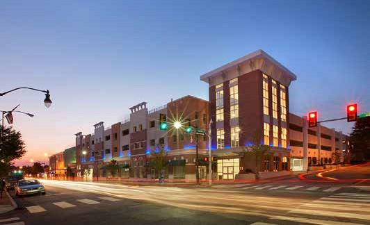
2.
Design Standards.
I.
The façades of parking garages exposed to view shall be orthogonal in composition and shall not express ramping systems.
II.
Spandrel panels or opaque architectural wall systems, a minimum of forty-two (42) inches high, shall be required to screen the view of parked cars and car headlights from the opposite side of the street and from streets within adjacent neighborhoods.
III.
For any parking garage fronting a Primary Street, at least sixty-five percent (65%) of its ground floor shall contain Pedestrian Active Uses.
IV.
For all exposed above-grade parking structures on Secondary Streets, at least fifty percent (50%) of the ground floor level must be covered by an architectural screen.
V.
Parking structure lighting shall be screened from all streets and not protrude from the garage.
VI.
Parking garages exposed to view shall be subject to the same standards as buildings in terms of massing, form, and building character.
VII.
Internal lighting shall be designed to limit the visibility of light sources from inside the garage. Strategies may include providing full-cutoff fixtures for interior lighting near perimeter openings.
3.
Design Guidelines.
I.
Opaque architectural screening with a minimum height of forty-two (42) inches may be substituted for spandrel panels if it can be demonstrated that car headlights will not create glare in direct view by adjacent uses or neighborhoods.
II.
The ground floor of parking garages should be designed to a height and depth that is easily converted to Pedestrian Active Uses such as retail or commercial.
viii.
Landscape Design.
A.
General Intent. The City of Upper Arlington has a long-established tradition of green streets and neighborhoods dating back to the founding of the City by planting street trees. Modern landscape design expands these early concepts to include a greater sense of environmental stewardship and broader range of recreational choices.
B.
General Landscape Requirements.
1.
Intent.
I.
To ensure that all site areas receive thoughtful landscape design.
II.
To encourage landscape and hardscape design that is resource efficient, improves site permeability, reduces the urban heat island effect, slows stormwater run-off, and is easily maintained.
2.
Design Standards.
I.
All areas of the site not including those areas covered by buildings, structures, parking areas, service areas, standard walks, pathways, or other non-decorative improved impervious surfaces, shall be landscaped or hardscaped.
II.
All plantings shall adhere to the requirements of the City Forester.
III.
On any single Primary or Secondary street front, street trees shall be planted in a uniform pattern, centered on the width of the Furniture Zone and paced equally to create a relatively continuous canopy upon maturity.
IV.
Plant material, fencing, screening, or any other landscape improvement within the public right-of-way shall adhere to the requirements of the City Engineer in regard to planting within all "Intersection Clearance Zones" (see UDO Section 2.05, Definitions).
3.
Design Guidelines.
I.
No area of the site exposed to public view should be left without landscape or hardscape treatment.
II.
Landscape design within the development should use a minimum of twenty percent (20%) less potable water than conventional designs. Reductions of up to fifty percent (50%) less water are encouraged. Strategies to reduce consumption may include specification of low water need plant materials, mulches or ground covers that limit evaporation, use of drip irrigation or other systems that more efficiently deliver water to plants, and use of reclaimed or captured, rather than potable water.
III.
Small variations in street tree location or spacing are allowed, if approved by the City Forester.
IV.
Effort should be made to reuse existing topsoil removed during construction activity for areas of the site requiring re-vegetation and landscaping. Structural soil or vaults may be required for street trees in tree wells.
V.
General landscape design, including the location of landscaped areas, their type, form and materials, should control erosion and limit sedimentation of municipal water drainage systems.
C.
Landscape Component Standards.
1.
Intent.
I.
To ensure that specified plant materials are healthy, meet horticultural industry minimum standards, and are suited to an urban environment.
II.
To encourage the use of plant materials which are non-invasive and resource efficient.
III.
To encourage reasonable water conservation practices.
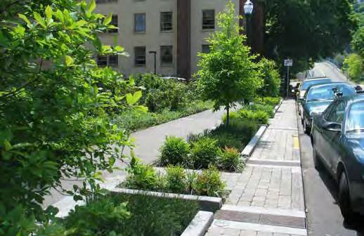
2.
Design Standards.
I.
All plants shall be "A-Grade" or "No. 1 Grade," free of any defects, of normal health, height, leaf density and spread for that species as defined by the American Association of Nurserymen and as approved by the City Forester.
II.
Plant materials shall be drought tolerant, suited to the climate, and/or native to the region.
III.
Plant materials with similar water and light needs shall be grouped together.
IV.
Street trees within the Furniture Zone shall have a minimum two (2) inch caliper.
V.
The minimum shrub size shall be five (5) gallons.
VI.
The minimum vine and perennial size shall be one (1) gallon.
VII.
The minimum size for mass ground cover shall be two and one-fourth (2¼) inches with a minimum planting density of six (6) inches to nine (9) inches, on-center.
3.
Design Guidelines.
I.
Plant materials should be selected that are appropriate for the regional climate or "Plant Hardiness Zone, 6A," reflective of historic patterns, and provide seasonal interest.
II.
Landscaped areas within the development should endeavor to exceed a twenty percent (20%) reduction in the use of potable water over conventional landscape practices.
III.
Irrigation systems should be automatically controlled to respond to daily and seasonal variations in evapotranspiration rate and precipitation levels.
IV.
Landscape areas under awnings or overhangs shall be irrigated.
D.
Hardscape Component Standards.
1.
Intent.
I.
To provide paving materials which are safe, durable, and easy to maintain.
2.
Design Standards.
I.
All sidewalk paving shall meet City standards.
II.
Any paving within the public right-of-way must be approved by the City Engineer.
III.
Improvements to the public right-of-way, such as corner bulb outs, handicapped curb ramps, curb and gutter, and sidewalks shall be consistent with the Public Works Division standards.
3.
Design Guidelines.
I.
Special paving within the public right-of-way is typically only allowed in the streetscape area and only if it is not maintained by the City.
II.
Special paving systems are encouraged within designated Gateway Areas and to identify special areas of the streetscape such as intersections, pedestrian building entrances, and plazas.
III.
Special paving systems used in private spaces should be coordinated with paving systems in public areas where they are both visible from the street.
IV.
Special paving systems should be appropriate for heavy urban traffic. Colored concrete, brick, concrete unit pavers, and unpolished stone are recommended.
V.
The use of permeable pavement systems in parking areas is highly encouraged.
E.
Site Furnishing Standards.
1.
Intent.
I.
To provide a system of site furnishings that unifies and adds character to the streetscape.
II.
To encourage pedestrians to inhabit and engage the streetscape through activities such as relaxing, eating, browsing, gathering, and reading.
III.
To provide street furnishings that are durable, attractive, and low maintenance.
2.
Design Standards.
I.
Site furnishings shall not impede the required clear width of the Pedestrian Zone.
II.
Permanent seating shall be placed to serve bus stops, plazas and other open spaces. Seating shall meet the following requirements: a minimum depth of fifteen (15) inches, a minimum width of eighteen (18) inches, and a height between sixteen (16) and eighteen (18) inches.
3.
Design Guidelines.
I.
Covered bus stops are encouraged. Bus stops are encouraged to incorporate maps, benches, and other amenities.
II.
Low site walls, including those for water features and planter beds, may be used to satisfy the seating requirement if they meet the minimum dimensional criteria above and are not obstructed.
III.
Trash receptacles should be placed convenient to seating areas, but not directly against any individual seat.
IV.
The quantity, placement and design of outdoor amenities should respond to the natural environment, adjacent structures, and the proximity of other amenities.
F.
Screening, Fencing, Walls, and Railings.
1.
Intent.
I.
To conceal undesirable uses or services without impeding the transparency and visibility of the pedestrian realm.
II.
To integrate screening, fencing, walls, and railings into the general architectural character of the development.
III.
To encourage design of these elements that is safe, durable, and easy to maintain.
2.
Design Standards.
I.
Fences and walls shall use similar materials, modules, and details as those on nearby or adjacent buildings.
II.
Railings located at the ground floor between buildings with Pedestrian Active Uses and the street shall be at least fifty percent (50%) open or transparent
3.
Design Guidelines.
I.
Fencing, walls, and railings visible from the street should be of high-quality materials, decorative rather than utilitarian, and substantial in appearance commensurate with an urban environment and the scale of adjacent buildings.
G.
Site Detention Areas.
1.
Intent.
I.
To accommodate detention of storm water on-site in a way that is a positive part of an integrated landscape design.
II.
To create storm water detention areas that are attractively landscaped and can serve the active and passive recreational needs of the community.
III.
To utilize underground detention areas where appropriate.
2.
Design Standards.
I.
Site detention areas shall use landforms and live native plant material in a way that satisfies detention and water-quality requirements while allowing for passive or active recreational uses.
II.
Site detention areas shall minimize the use of pea gravel, rip-rap, rock, cobble stones, or other non-organic landscape materials.
III.
Water detention and quality features for private on-site runoff is not permitted in the public right-of-way.
3.
Design Guidelines.
I.
Site detention should creatively combine detention strategies and technologies, including but not limited to the use of planted roofs, below-grade vaults, bioretention facilities or rain gardens, water features, and pervious paving systems.
II.
Encourage the dispersal of site detention to reduce size.
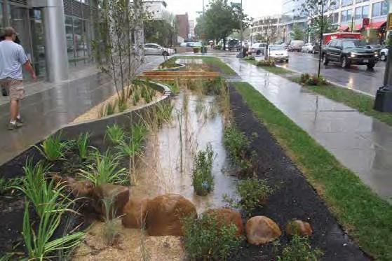
H.
Parking Area Landscaping.
1.
Intent.
I.
To enhance the aesthetic appearance of surface parking areas and screen them from view.
II.
To reduce the urban heat-island effect attributed to large areas of exposed paving.
III.
To provide safe and attractive pathways through parking areas for pedestrian traffic.
2.
Design Standards.
I.
Minimum parking area landscaping standards for all new parking areas shall be governed by UDO Section 6.07(J).
II.
New surface parking areas shall have a minimum forty-two (42) inch fence or seat wall barrier in the front yard area of parking spaces.
3.
Design Guidelines.
I.
Landscaping within a new parking area should be evenly distributed.
II.
New parking areas should accommodate safe and direct pedestrian passage between building entrances, through the parking lot, and from the parking lot to the street.
ix.
Site and Building Signage.
A.
Site and Building Signage.
B.
General Intent. Mixed-use areas contain an intensity and density of uses commensurate with an active urban environment. A well-conceived system of site and building signage is important for making sense of this environment. To be most effective, signs should be integral and complementary to the character of the streetscape and the architecture of the buildings that they serve. In addition to basic functions such as tenant identity and wayfinding, signage should enhance the character of specific building types, reinforce the hierarchy of streets and spaces, and contribute to the ambiance of the district. Signage requirements are addressed in the UDO for all zone districts (Section 6.06) and are specifically modified for Planned Mixed Use Districts (Section 7.13). Existing regulations govern signage within the Lane Avenue PMUD unless specifically modified below.
C.
Lane Avenue PMUD District Signage.
1.
Intent.
I.
To create an organized and interrelated system of signs, sign structures, sign lighting, and graphics.
II.
To create signage that is creative in its use of form, materials, lighting, color and graphics.
III.
To accommodate signage that aids in wayfinding while enhancing the character of a district.
IV.
To mitigate visual clutter of the streetscape.
2.
Design Standards.
I.
All district signs shall conform to the UDO and any required comprehensive sign plans.
II.
All district signs on buildings fronting a Primary Street shall be wall or projecting signs.
III.
All district signs shall be of durable materials and construction suited to an urban environment.
IV.
All conduits, transformers, or other "unfinished" elements providing support or power to district signs shall be concealed from view from the street.
V.
No portion of a district sign shall be located closer than twenty (20) feet horizontally from any other district sign.
VI.
Awnings shall include a rigid valance and not contain any text or logos.
3.
Design Guidelines.
I.
District signage should be located within twenty-five (25) feet vertically of adjacent grade and oriented toward the street.
II.
District signage that is located in the Furniture Zone should be aligned with, centered between, or otherwise integrated into the design of the street tree and street furnishing system and within Gateway areas.
III.
District signage should be compatible with the architecture of surrounding buildings in terms of form, material, color, and detailing.
IV.
Halo-lit signage is preferred in the district.
D.
Building Signage.
1.
Intent.
I.
To create signs and graphic elements that are appropriate to and expressive of the use they identify.
II.
To encourage signs which are creative in their use of form, materials, lighting, and graphics without creating visual clutter.
III.
To provide building signage that communicates effectively and is visually integrated into the building architecture.
IV.
To mitigate the external effects of building signs on adjacent properties and surrounding neighborhoods.
2.
Design Standards.
I.
All building signs shall conform to the UDO and any required comprehensive sign plans.
II.
All buildings with ground floor commercial uses shall provide areas of the primary building facade designed to accommodate changeable tenant signage. Structure, materials, detailing and power sources shall be designed with consideration of signage installation requirements and shall be readily adaptable and reparable as tenant sign needs change.
III.
All building signs shall be of durable and attractive materials and construction suited to an urban environment.
IV.
All conduits, transformers, or other "unfinished" elements providing support or power to building signs shall be screened from view from pedestrian walks on all streets.
V.
In addition to one universal parking sign, parking garages shall be allowed only one other building identification sign per vehicular entry and exit.
VI.
No portion of a projecting sign shall be located closer than twenty-five (25) feet horizontally from any other projecting sign.
VII.
The number of signs per tenant shall be limited to three (3).
3.
Design Guidelines.
I.
Building sign design should be compatible with the architecture of the building being served in terms of form, material, color and detailing.
II.
Building signs of any type should not be located within the facade of any residential portion of a mixed-use building.
III.
Wall, window, and arcade signs should not overlap or conceal major architectural elements. Certain projecting signs may overlap architectural elements if specifically approved by BZAP.
IV.
Tenant identification signage should not directly orient to existing residential areas.
E.
Building Signage Typologies.
1.
Blade Sign.
I.
Typical Configuration.
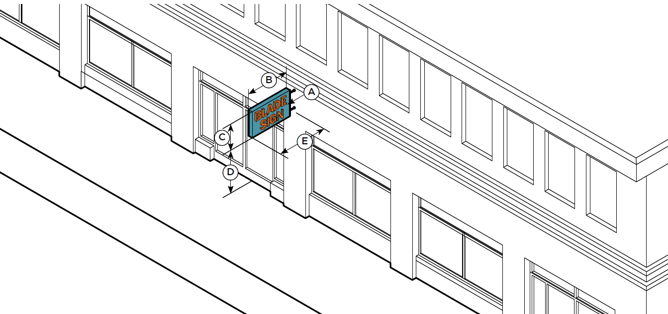
II.
Description.
1.
A small, two-sided, non-illuminated sign that is attached to and projecting perpendicularly from the facade of a building that identifies a commercial establishment. Blade signs are intended to be viewed by pedestrians on the same side of the street.
III.
Dimensions.
IV.
Standards.
1.
Sign shall be oriented perpendicular to the building, but may be oriented at a forty-five (45) degree angle if at a building corner.
2.
Blade sign should be located no higher than the first building story.
3.
Information displayed should be limited to business name, address and logo. Additional information is prohibited.
2.
Wall Sign.
I.
Typical Configuration.
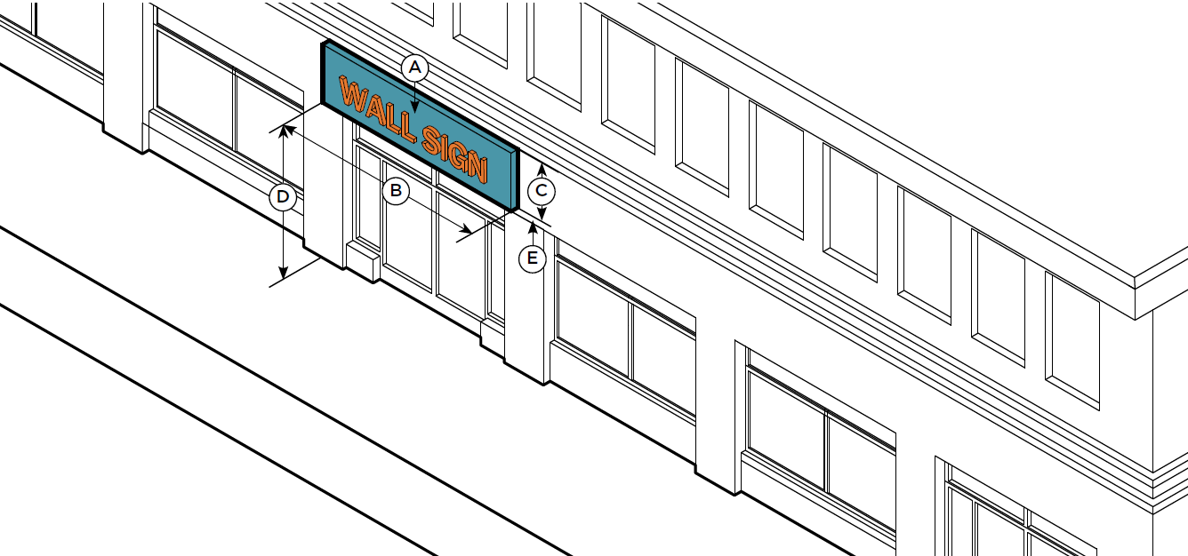
II.
Description.
1.
A sign attached flat or mounted parallel to the facade of a building that identifies a commercial establishment. Wall signs are intended to be viewed by pedestrians on the opposite side of street.
III.
Dimensions.
IV.
Standards.
1.
Sign should align with a building's entablature, and placed to fit harmoniously with horizontal molding, friezes, sills, or other ornament or within the sign band area.
2.
Wall signs must generally be placed no higher than the window sills of the second floor
3.
Wall signs may be placed under the window sills of upper stories by special permit.
4.
Information displayed should be limited to business name, address and logo. Additional information is prohibited.
5.
The wall panel shall not be illuminated.
3.
Window Sign.
I.
Typical Configuration.
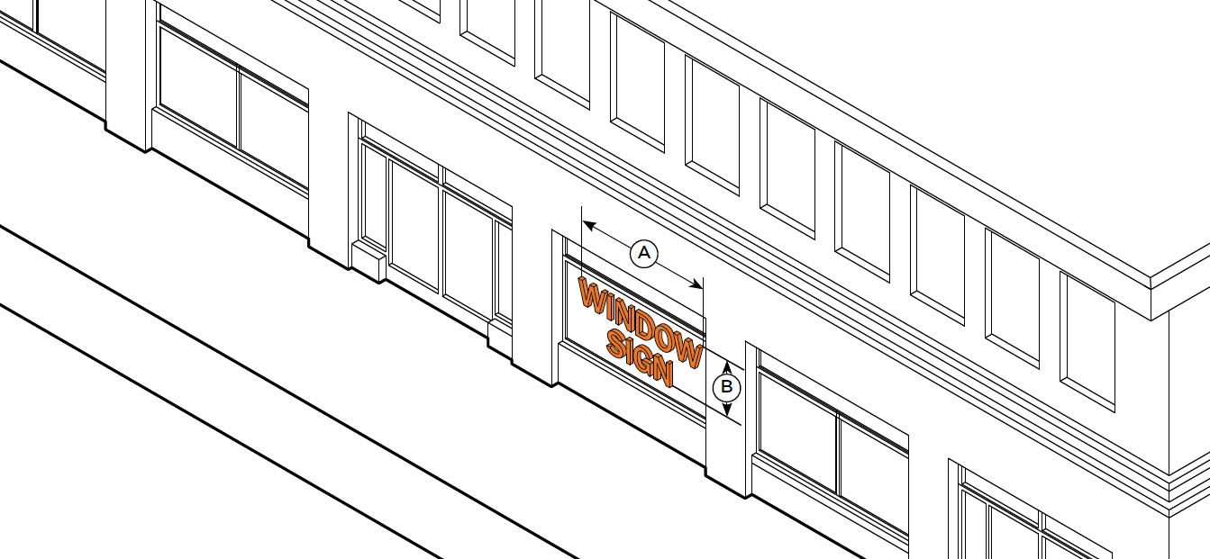
II.
Description.
1.
Individual letters, numerals, or a logo applied directly to the inside of a window or door to identify a commercial establishment. Window signs are intended to be viewed at close range by pedestrians.
III.
Dimensions.
IV.
Standards.
1.
Windows signs must be applied directly to inside of the windows glass, at or above eye level, and have a transparent background.
2.
Information type is limited to business name, logo, hours of operations, and product types. Additional information and signs that flash or blink intermittently are prohibited.
4.
Suspended Sign.
I.
Typical Configuration.
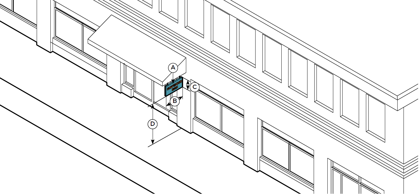
II.
Description.
1.
A small, two-sided, non-illuminated sign mounted to the underside of a component, or from the roof of a porch, gallery, or arcade that identifies a commercial establishment. Suspended signs are intended to be viewed by pedestrians at close range on the same side of the street.
III.
Dimensions.
IV.
Standards.
1.
A suspended sign may not extend beyond the edge of the awning or canopy it is mounted below.
2.
May be hung above the entrance to a porch or elsewhere on the architrave (beam at top of columns).
3.
Information displayed should be limited to business name, address and logo. Additional information is prohibited.
5.
Display Sign.
I.
Typical Configuration.
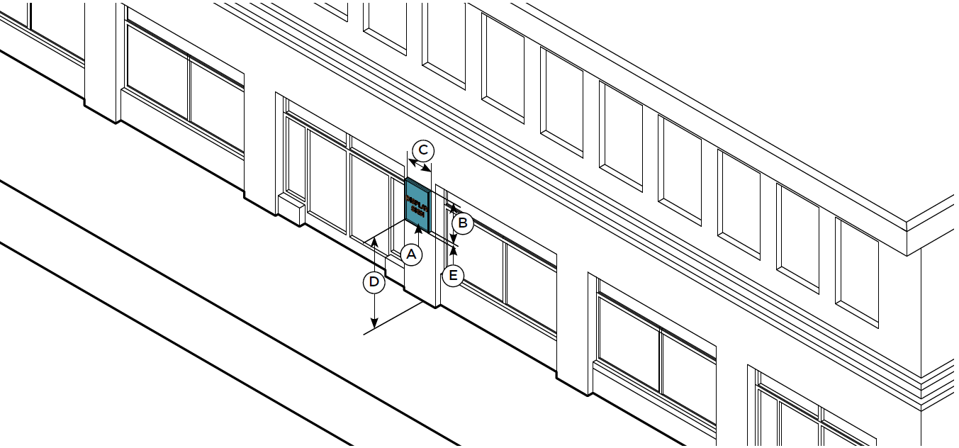
II.
Description.
1.
A wall mounted, lockable, framed cabinet with a transparent window to display information like a changeable menu or list of event show times. Display cases are intended to be viewed at close range by pedestrians.
III.
Dimensions.
IV.
Standards.
1.
Display signs must be attached to the facade or wall of a recessed storefront entrance.
2.
Display signs may be internally or externally illuminated.
3.
The bottom edge of display sign may be placed no higher than six (6) feet from the ground, the sign is meant to be legible at close proximity by pedestrians and should not be significantly higher than eye-height.
6.
Roof and Skyline Sign.
I.
Typical Configuration.
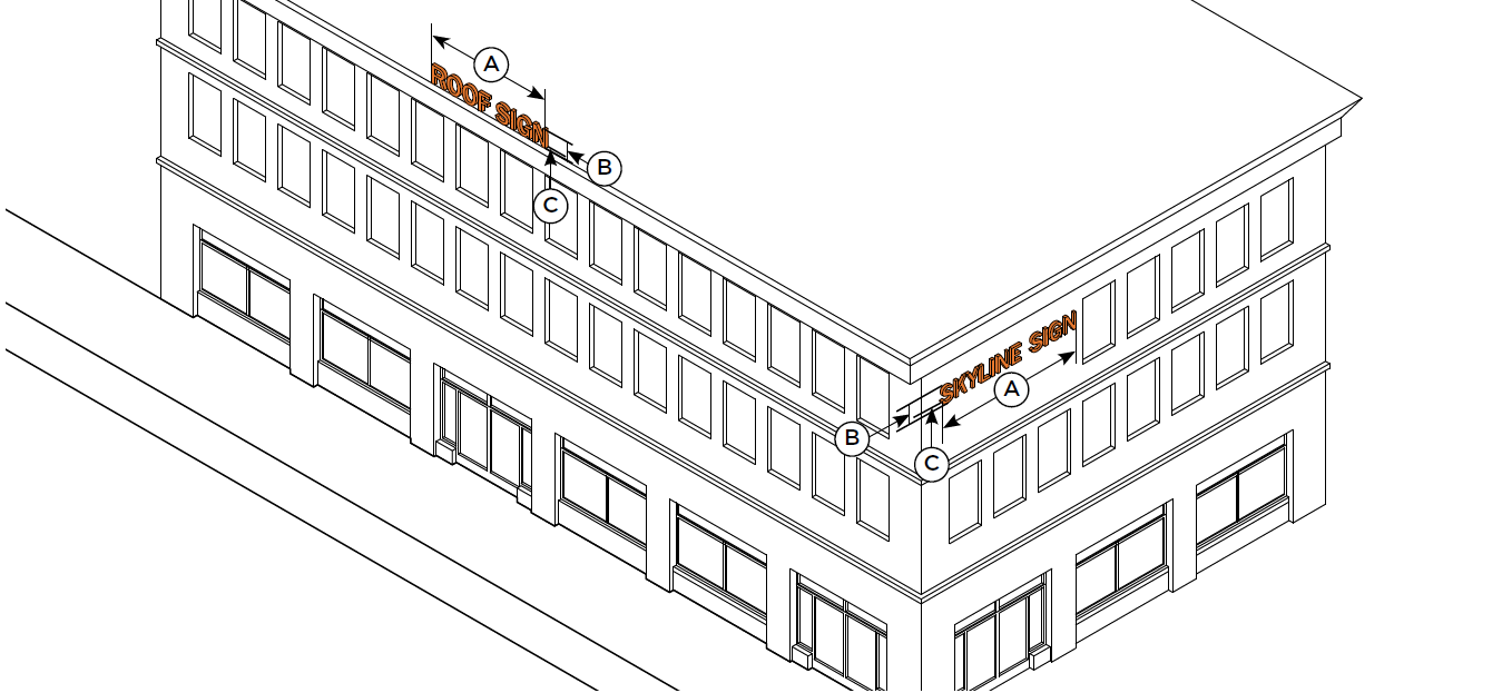
II.
Description.
1.
A sign erected on the roof or mounted to the uppermost horizontal architectural band of a building to identify the name of the building or primary tenant. Roof/skyline signs are intended to be viewed by pedestrians and motorists from a distance and serve as an icon for the building.
III.
Dimensions.
IV.
Standards.
1.
No portion of a roof/skyline sign is permitted to extend below the start of highest story of a building or above the roof line, parapet wall, or cornice of the top portion of a facade and is prohibited from covering windows or architectural details.
2.
Only internal illumination is permitted.
3.
Information type is limited to building or primary tenant name only. Additional information is prohibited.
4.
Roof and skyline signs shall not be placed higher than three stories unless in the East Gateway context area.
7.
Mural Sign.
I.
Typical Configuration.
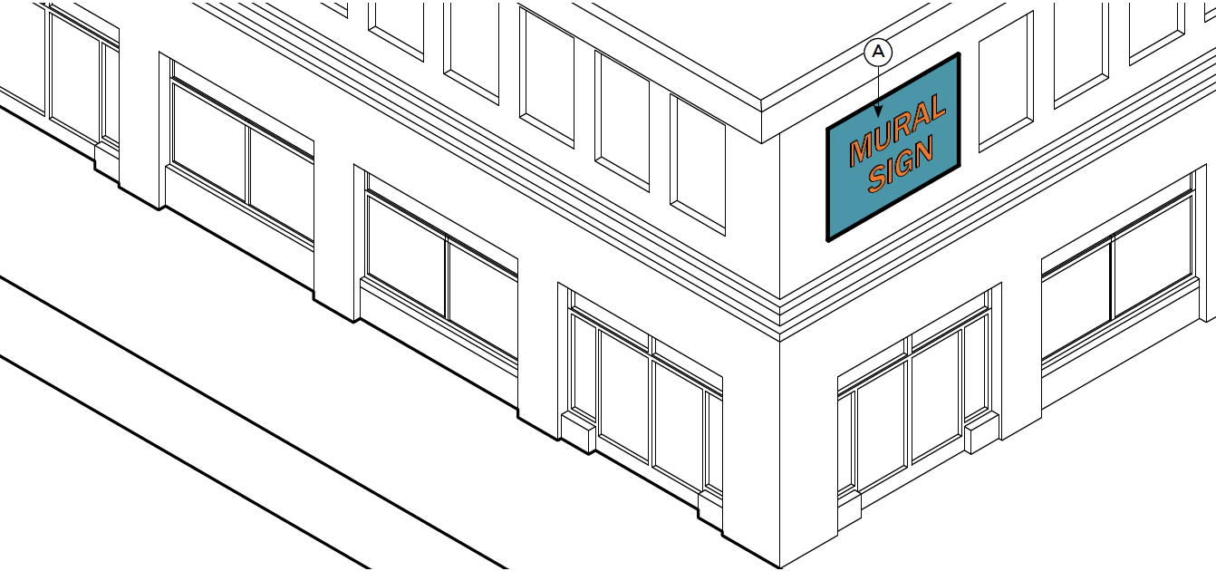
II.
Description.
1.
A sign that is directly painted on to the exterior wall of a building or screen printed, sewn, or adhered onto a canvas-like material that is mounted flush with the facade of a building and identifies a commercial establishment. Wall murals are intended to be viewed by pedestrians and motor vehicles from a distance.
III.
Dimensions.
IV.
Standards.
1.
Painted wall signs may be used as the primary sign or the secondary sign of a business and should not contain any form of advertising.
2.
One painted wall sign allowed per street frontage, not to exceed two (2).
3.
A painted border shall not be included in the overall dimensional size limitations.
4.
Any such sign shall be painted out within thirty (30) days of change in occupancy.
5.
Maintenance shall be required for any portion of the painted wall sign that is unreadable or unsightly due to weather, sunlight or graffiti.
8.
Banner Sign.
I.
Typical Configuration.
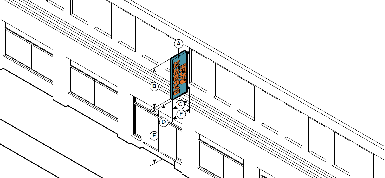
II.
Description.
1.
A tall, narrow, two-sided sign that is attached to and projecting perpendicularly from the facade of a building that identifies a commercial establishment. Vertical blade/banner signs are intended to be viewed by pedestrians and motorists from a distance.
III.
Dimensions.
IV.
Standards.
1.
Sign may be oriented at a forty-five (45) degree angle from a building corner.
2.
Banner signs should occur above the first floor, above the line of the second floor window sills, except when part of a marquee sign.
3.
No portion of the sign may project above the roof-line of the facade to which it is attached.
4.
Information displayed should be limited to business name. Additional information is prohibited.
x.
Site and Building Lighting General Intent. Illumination of building and landscape elements can provide additional nighttime interest and foster community identity. Enhanced street lighting, if designed properly to reduce glare and limit contrast, can enhance feelings of pedestrian security and safety. However, lighting design must consider energy efficiency and glare control so that it does not detract from the quality of the urban environment. Street lighting in the public right-of-way is in the purview of the Engineering Division which has standards for lighting type, location, and spacing.
A.
Street Lighting.
1.
Intent.
I.
To integrate City standards with regard to general street illumination into the character of the development (See UDO Section 6.08).
II.
To encourage pedestrian lighting in commercial areas that enhances district character and the pedestrian experience.
III.
To limit additional pedestrian lighting in residential areas.
2.
Design Standards.
I.
Pedestrian lighting is only allowed in the public right-of-way if it is not maintained by the City. Where provided, pedestrian lighting shall be located in the Furniture Zone.
II.
Light levels for pedestrian lighting shall be designed to limit glare into adjacent properties and surrounding neighborhoods, and avoid extreme contrast between light and shadow.
3.
Design Guidelines.
I.
Pedestrian lights, if provided, may match an approved City light fixture or be of a different type with equivalent durability and quality.
II.
A system of pedestrian lights along Primary Streets should consist of only one fixture type, or consist of a limited vocabulary of fixtures that visually complement one another and be spaced evenly and align with each other along the length of the Pedestrian Zone and within the Furniture Zone.
III.
All fixtures should provide cut-off or shielding to minimize light trespass directly to the sky or into residential areas.
IV.
Lamps in light fixtures exposed to public view should provide as high a color rendition index as is feasible.
B.
Parking Area Lighting.
1.
Intent.
I.
To limit glare onto adjacent properties and surrounding neighborhoods.
II.
To provide adequate light levels to create a safe, secure environment.
2.
Design Standards.
I.
Parking area lighting shall be designed to provide no more than the recommended level of illumination as set forth by the IESNA Lighting Handbook for pedestrian and vehicular safety, reduce glare onto adjacent properties, avoid extreme contrasts between light and shadow, and minimize light trespass directly to the sky by orienting downward and/or shielding the fixture. See UDO Section 6.08(G).
II.
Maximum light pole height shall be thirty (30) feet.
III.
Light sources shall be placed closer to rather than further from the surface being illuminated. For example, a closer spacing of lower-height light poles is preferable to a greater spacing of taller light poles.
C.
Open Space Lighting.
1.
Intent.
I.
To create a comfortable and safe nighttime ambience in open spaces.
II.
To highlight appropriate elements of open spaces to aid in orientation and provide visual interest.
III.
To provide continuity in light levels between streetscapes and adjoining open spaces.
2.
Design Standards.
I.
Lighting in open spaces shall be designed to illuminate pedestrian paths, limit glare into adjacent properties and surrounding neighborhoods, and minimize glare directly to the sky. Also see UDO Section 6.08(G).
II.
General illumination of large areas of landscaping shall not be allowed (for example, using fixtures with a flood-type distribution to illuminate rows and clusters of trees or large areas of lawn).
III.
Illumination of individual landscape elements (trees and individual planter areas) shall be limited to two thousand (2,000) lumens.
3.
Design Guidelines.
I.
Pedestrian lighting may be used to illuminate primary walking paths or accent paved areas. Spacing should generally be equivalent to or less than that of the adjacent Pedestrian Zone along a major street to indicate an area of heightened activity and interest.
II.
Focal points such as gazebos, trellises, and water features should be lit in order to become an inviting presence at night.
III.
Illumination sources that are low to the ground such as bollard, step, and walkway lighting are encouraged.
IV.
Lamps should provide a minimum color rendition index of sixty (60).
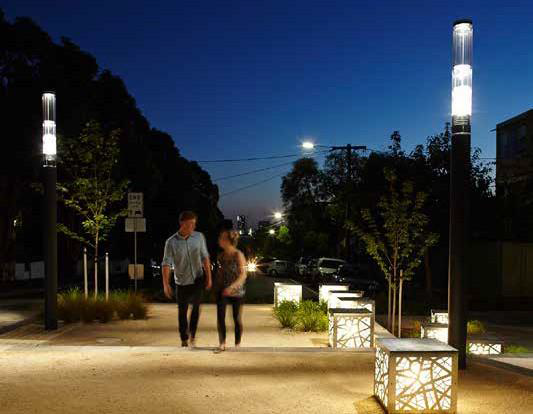
D.
Building Lighting.
1.
Intent.
I.
To provide building accents above street level.
II.
To ensure adequate lighting for service areas.
2.
Design Standards.
I.
Building lighting shall be designed to reduce glare into adjacent properties and surrounding neighborhoods, minimize light trespass directly to the sky (See UDO Section 6.08(G)), and integrate into the building architecture by being concealed or through the use of materials, detailing, form, and spacing that complements the building being illuminated.
II.
Building light fixtures shall be of architectural quality regarding durability, construction, and aesthetic appearance.
III.
Building light fixtures on all streets, whether exposed or concealed, shall not have exposed conduit runs, junction boxes, or other "unfinished" elements exposed to view.
IV.
Utilitarian building lighting fixtures located in service areas shall be concealed from view from Primary and Secondary Streets.
3.
Design Guidelines.
I.
Building illumination above the second floor should be shielded or provide full cutoff to minimize the view of exposed lamps from the street, adjacent occupied space, or adjacent neighborhoods.
II.
Where lighting of buildings and buildings elements is proposed, the overall lighting design should orient to Primary Streets, reinforce Gateway Areas, reflect primary building entrances, complement adjacent plazas and expanded streetscapes, avoid illuminating building faces adjacent to and directly facing existing residential areas, and avoid glare.
xi.
Open Space. This Section addresses the general configuration and design concepts for all open spaces required per the Lane Avenue PMUD and as illustrated in UDO Section 5.05(C)(7), Open Space Typologies. This Section addresses private open spaces designed for the exclusive use of building tenants or residents, including private internal courtyards and open-air terraces and patios.
A.
Open Space Layout.
1.
Intent.
I.
To provide open space of an adequate size and proportion to serve a variety of community recreation and leisure needs.
II.
To complement but not replace existing public parks which have historically served the surrounding neighborhoods.
III.
To create a variety of urban open spaces - including parks, plazas, and expanded streetscapes - that will help define neighborhoods and nodes within the Lane Avenue PMUD area.
2.
Design Standards.
I.
Open spaces shall be architecturally defined by the buildings that surround them.
II.
Open spaces shall have direct access from a pedestrian walk on at least one side and for at least fifty percent (50%) of the length of that side.
III.
The open spaces shall:
1.
Be easily accessible and viewed from the street.
2.
Be at a level within eighteen (18) inches above or below the nearest adjoining public sidewalk.
3.
Be publicly accessible and publicly usable.
4.
Be open to the sky but could include structures such as pavilions or gazebos.
IV.
Provision of Open Space.
1.
Open space within the Lane Avenue PMUD shall be provided in accordance with the following table:
V.
Suitability of Open Space. In determining the suitability of areas to be set aside for new open space types or in considering the ability of existing open space types to meet the requirement, the TRC or other reviewing body may consider all relevant factors and information, including but not limited to:
1.
The goals and objectives of the 2013 Master Plan, the 2018 Parks & Recreation Comprehensive Plan, and the Arts & Culture Master Plan,
2.
Suitability of the open space for active or passive recreational use; or
3.
The proximity or potential connectivity to other open space types.

3.
Design Guidelines.
I.
Open spaces should be of a size, proportion, and orientation in relation to surrounding structures that optimizes sky and sunlight exposure over the course of the year.
II.
Open spaces may be located where they support a transition between Context Areas, between areas of substantially different use or character, or between new development and existing communities.
B.
Streetscape Open Space Sidewalks.
1.
Intent.
I.
To create vibrant streetscapes that will contribute to the public realm and surpass City minimum standards.
II.
To ensure that sidewalks qualifying as open spaces surpass City standards.
2.
Design Standards.
I.
Streetscapes that provide the required Public Realm improvements along both Primary and Secondary Streets may count the total square foot area of these improvements toward meeting the required Open Space contribution.
II.
Sidewalks qualifying as open space shall incorporate a cohesive system of amenities in the Furniture Zone that includes brick pavers, plantings, and site furnishings (as specified in the Lane Avenue Corridor Framework Plan).
3.
Design Guidelines.
I.
The application of amenities along the Primary Streets (Lane Avenue, Northwest Boulevard and North Star Road) may vary by Context Area.
II.
For required furnishings, refer to UDO Section 5.05(C)(8)(c-g).
III.
For required decorative paving, refer to UDO Section 5.05(C)(8)(c-g).
C.
Open Space Landscaping (See UDO Section 5.05(C)(7), Open Space Typologies).
1.
Intent.
I.
To introduce natural elements and hardscaped gathering areas into the built environment.
II.
To provide urban open spaces which give relief to the Private Realm and create opportunities to gather and interact.
2.
Design Standards.
I.
A minimum of fifteen (15) and maximum of forty (40) percent of the area of a plaza shall be composed of planting materials (grass, ground covers, or planting beds).
3.
Design Guidelines.
I.
Open spaces should be oriented to take advantage of views and sunlight.
II.
Open spaces should visually and physically connect to the adjacent streetscape.
III.
No portion of the surface area of an open space should be greater than eighteen (18) inches vertical from adjoining grade to preserve a sense of physical connectedness.
IV.
The placement of trees and plantings should conform to an overall identifiable design and should not be located in a way that would prevent optimal growth and maintenance.
V.
Ornamental trees and plantings that provide seasonal interest are encouraged.
D.
Open Space Furnishings.
1.
Intent.
I.
To provide a system of street and open space furnishings that unifies and adds character to the streetscape.
II.
To encourage pedestrians to inhabit and engage the streetscape and open spaces through activities such as relaxing, eating, browsing, gathering, and reading.
III.
To provide street furnishings that are durable, attractive, and low maintenance.
IV.
To provide active, engaging furnishings that encourage public interaction.
2.
Design Standards.
I.
Furnishings shall not impede the required clear width of the Pedestrian Zone.
II.
Permanent seating shall be placed to serve bus stops, plazas and other open spaces. Seating shall be a minimum depth of fifteen (15) inches, a minimum width of eighteen (18) inches, and a height between sixteen (16) and eighteen (18) inches.
3.
Design Guidelines.
I.
Open spaces should provide adequate permanent seating supportive of informal gathering and passive recreational activities.
II.
Open spaces should incorporate, at a minimum, one linear foot of seating for every fifty (50) square feet of area.
III.
Seating at least thirty (30) inches in depth and with access to both sides may count double toward seating requirements.
IV.
Open spaces should provide wayfinding information and charging stations for electronic devices.
V.
Low seat walls, including those for water features and planter beds, may be used to satisfy the seating requirement if they meet the minimum dimensional criteria above and are not obstructed.
VI.
Trash receptacles should be provided at a minimum of four cubic feet of capacity for every two thousand (2,000) square feet of open space area.
VII.
Trash receptacles should be placed convenient to seating areas, but not directly against any individual seat.
VIII.
In addition to tree planting and seating area requirements, each open space should contain at least one of the following amenities:
1.
Formal planters, planting beds, or hedges;
2.
A drinking fountain; and/or
3.
Public art, a shelter (gazebo, trellis), a water feature (fountain, water wall), or similar permanent focal element.
4.
Elements shall consider year-round appearance.
E.
Open Space Hardscape Component Standards.
1.
Intent.
I.
To encourage a logical, hierarchical system of standard and decorative paving within designated open space areas.
II.
To provide paving materials which are safe, durable and easy to maintain.
2.
Design Standards.
I.
All sidewalk paving shall meet City standards.
II.
Any paving within the public right-of-way must be approved by the City Engineer.
III.
Improvements to the public right-of-way, such as corner bulb outs, handicapped curb ramps, curb and gutter and sidewalks shall be consistent with the Engineering Division standards.
3.
Design Guidelines.
I.
Special paving systems should be appropriate for heavy urban traffic. Colored concrete, brick pavers as specified in the Lane Avenue Corridor Framework Plan, concrete unit pavers, and unpolished stone are recommended.
II.
The use of permeable pavement systems is encouraged.
(Ord. No. 96-2010, 3-16-2011; Ord. No. 75-2021, § 1(Exh. A), 12-13-2021)
§ 5.06 - OFFICIAL ZONING MAP.
(A)
Official zoning map adopted: All land in the municipality is placed into zoning districts as shown on the official zoning map that is hereby adopted and declared to be part of the UDO.
(1)
Final authority: The official zoning map, as amended from time to time, shall complement appropriate legislation as the final authority for the current zoning district status of land under the jurisdiction of the UDO.
(2)
Land not otherwise designated: All land under the UDO and not designated or otherwise included within another zoning district map shall be included in the R-S, suburban residential district.
(B)
Identification of the official zoning district map: The official zoning map, with any amendments made thereon, shall be identified by the signatures of the mayor and all members of City Council under the following words:
Official Zoning District Map, Upper Arlington, Ohio.
Adopted by the City Council, Upper Arlington, Ohio.
Date President of Council
___________
___________
___________
___________
___________
___________
(C)
Establishment of zoning districts: The names and symbols for zoning districts as shown on the official zoning map are as follows:
(D)
Legend and use of color or patterns: There shall be provided on the official zoning map a legend which shall list the name and symbol for each zoning district. In lieu of a symbol, a color or black and white pattern may be used on the official zoning map to identify each zoning district as indicated in the legend.
(E)
Interpretation of zoning district boundaries: The boundaries of the zoning districts are shown upon the official zoning map. The official zoning map and all notations, references, and other information are a part of the UDO. A certified copy of the official zoning map shall be kept on file with the city clerk.
(F)
Rules for determination: When uncertainty exists with respect to the boundaries of zoning districts as shown on the official zoning map, the following rules shall apply:
(1)
Along a street or other right-of-way: Where zoning district boundary lines are indicated as approximately following a center line of a street or highway, alley, railroad easement, or other right-of-way, or a river, creek, or other watercourse, such centerline shall be the zoning district boundary.
(2)
Along a property line: Where zoning district boundary lines are indicated as approximately following a lot line, such lot line shall be the zoning district boundary.
(3)
Parallel to right-of-way or property line: Where zoning district boundary lines are indicated as approximately being parallel to a centerline or a property line, such zoning district boundary lines shall be parallel to a centerline or a property line and, in the absence of a specified dimension on the official zoning map.
(4)
Actual conflict with map: When the actual street or lot layout existing on the ground is in conflict with that shown on the official zoning map, the party alleging that such conflict exists shall furnish an actual survey for interpretation by the director of community development.
(5)
Right-of-way vacation: Whenever any street, alley or other public way is vacated by official action of council, the zoning district adjoining each side of such street, alley or public way shall be automatically extended to the center of such vacation, and all area included in the vacation shall then and henceforth be subject to all appropriate regulations of the extended district or districts.
Table 5-A: Residential Uses
KEY: P=Permitted Use, C=Conditional Use, Pr=Prohibited Use, A=Accessory Use
2 =Permitted on property zoned R-5 with not less than 5 (five) acres.
Table 5-B: Home Occupations
KEY: P=Permitted Use, C=Conditional Use, Pr=Prohibited Use, A=Accessory Use
Table 5-C: Commercial Uses
P=Permitted Use, C=Conditional Use, Pr=Prohibited Use, A=Accessory Use, S=Secondary Conditional Use, SPU=Secondary Permitted Use
Table 5-D: Mixed Uses
Table 5-E: Residential Building Area, Density and Setback Standards
See Article 2, Profile Coefficient Definition.
2 Dimension Stated, or ¼ of the lot depth, whichever is less .
3 OPU is Other Permitted Uses.
4 For elevations longer than 40 feet, see Article 2, Side Yard Increased.
5 Lot dimensions, setbacks, and stories are subject to neighborhood compatibility standards in Article 7.17.
Table 5-F: Residential Building Coverage and Height Standards
1 In no case shall a detached garage exceed 870 square feet unless located within the buildable area of the lot.
2 TLA is Total Land Area is the total square footage of the property.
3 OPU is Other Permitted Uses (see Table 5-A).
4 Excepting steeples which may go to a height of 60 feet.
5 Not more than 25% of the required front yard may be occupied by development cover, unless the use is an OPU, in which case 60% cover shall be permitted.
6 The Director of Community Development may administratively approve any new building or development cover request that results in equivalent or less cover for sites currently exceeding permissible limits.
7 The maximum permitted height for properties located in the River Ridge Addition (extended) shall not exceed 28 feet in height. All building heights are subject to neighborhood compatibility standards in Article 7.17.
TLA is Total Land Area.
Table 5-G: Commercial Development Standards
(Ord. No. 62-2015, § 4, 11-23-2015; Ord. No. 87-2015, § 5, 12-14-2015; Ord. No. 21-2016, §§ 7, 8, 5-9-2016; Ord. No. 54-2017, §§ 14, 15, 12-11-2017; Ord. No. 38-2018, § 3, 4-23-2018; Ord. No. 50-2018, § 3, 7-9-2018; Ord. No. 22-2019, § 3, 4-8-2019; Ord. No. 16-2019, §§ 12, 13, 14(Exh. A), 6-10-2019; Ord. No. 5-2020, § 2, 9-14-2020; Ord. No. 7-2020, § 10, 9-14-2020; Ord. No. 67-2021, § 4, 11-8-2021; Ord. No. 75-2021, § 1(Exh. A), 12-13-2021; Ord. No. 67-2022, § 2(Exh. A), 12-5-2022; Ord. No. 28-2023, § 1(Exh. A), 8-28-2023; Ord. No. 40-2023, § 1(Exh. A), 8-28-2023; Ord. No. 11-2024, § 1(Exh. A), 3-4-2024)