
Upper Arlington City Zoning Code
ARTICLE 6
- DEVELOPMENT STANDARDS
§ 6.01 - LOT ARRANGEMENT AND DIMENSIONAL STANDARDS.
(A)
Purpose: The purpose of this section is to regulate the arrangement of lots and building heights within a subdivision and to ensure that lot and height dimensions are consistent with the appropriate zoning district standards.
(B)
Lots: All lots shall front onto a public or private road, and all lots shall conform to or exceed the requirements of the UDO and the zoning district regulations for the district in which they are located. The following regulations shall govern the design and layout of lots and lot improvements:
(1)
Lot arrangement: The lot arrangement shall be such that there will be no foreseeable difficulties, for reasons of topography or other conditions, in securing building permits to build on all lots in compliance with health and building regulations and in providing approved driveway access to buildings on the lots from an approved road.
(2)
Lot dimensions: All lots shall comply with the standards of Table 5-E for residential uses and Table 5-G for commercial uses.
(3)
Future subdivision lots: Where lots are more than double the minimum required area, BZAP may require that those lots be arranged so as to allow further subdivision and the opening of future streets where they would be necessary to serve potential lots, all in compliance with the UDO.
(4)
Side lot lines: In general, side lot lines shall be at right angles to street lines (or radial to curving street lines) unless a variation from this rule is approved by BZAP when such variance will give a better street or lot plan.
(5)
Corner lots: Dimensions of corner lots shall be large enough to allow for the construction of buildings, observing the minimum front yard setback from both streets.
(6)
Building setback - Residential districts: The building setback line shall be established from the edge of the right-of-way or the edge of an access easement. It shall be equal to the building setbacks listed in Table 5-E unless otherwise platted, in which case the platted setback shall take precedence as the minimum standard. The setbacks in the RCD, Residential Community Development District, shall be established by development standards approved by the Board of Zoning and Planning and City Council, and shall take precedence in all cases over the platted setback.
Building setback - Commercial, office and planned mixed-use districts: The building setback line shall be established from the edge of the right-of-way or the edge of an access easement. It shall be equal to the building setbacks listed in Table 5-G and shall take precedence in all cases over the platted setback.
(7)
Commercial and mixed uses: Depth and width of lots reserved or laid out for commercial and/or mixed use purposes shall be adequate to provide for the off-street parking and loading facilities required for the type of use and development contemplated.
(8)
Depth-to-width ratio: No lot shall have an average depth, which is more than 4.5 times its average width. However, BZAP or the Director of Community Development as appropriate may permit a waiver of this recommended standard, permitting the lot depth to be up to 3.5 times the average width.
(9)
Double frontage lots: In general, double frontage lots and reversed frontage lots should be avoided except where necessary to provide separation of residential development from traffic arterials or to overcome specific disadvantages of topography or orientation, as determined by BZAP or the Director of Community Development as appropriate.
As to lots included in any plat approved by the BZAP and accepted by Council after April 1, 1960, the required depth of the front yard shall be the distance between the street right-of-way line and the setback line shown on the plat, if less than forty (40) feet. As to any lots in any recorded plat which has greater restrictions than are required under this Ordinance, then these recorded restrictions shall apply and the Board shall have no authority to grant variances therefrom.
For corner lots where there is no platted setback along the longer street frontage, then the minimum front yard setback shall be twenty (20) feet.
(10)
Lot frontage: A lot shall front onto an improved public or private road. Lot frontage is measured at the right-of-way line.
(11)
Side yard modification: Beginning at the front face on the building, each side yard, where required, shall be increased in width by two (2) inches for each foot by which the elevation length of the building, adjacent to the side yard, exceeds forty (40) feet. Adjacent in this context means any portion of the side wall that is closer to the side property line than twenty-five percent (25%) of the lot width at the place of measurement. In no case, other than corner lots shall the total elevation length of the side wall of a principal structure exceed fifty percent (50%) of the average lot depth, or the depth.
(a) This example illustrates how the side yard is modified as an extension is added
to an existing home.
(12)
Rear and side yard computation: In computing the depth of a rear yard or the width of a side yard, where the rear or side yard abuts an alley, one-half (½) of the width of the alley may be included as a portion of the required rear or side yard, as the case may be. However, in no event shall any building or structure be erected closer than five (5) feet from any lot line, except accessory buildings.
(C)
Height modifications: The height limitations stipulated elsewhere in this Ordinance shall not apply to the following:
(1)
Places of public assembly: Places of public assembly in churches, schools and other permitted public and semi-public buildings, provided that these are located on the first floor of such buildings and provided that for each three (3) feet by which the height of such building exceeds the maximum height otherwise permitted in the district, its side and rear yards shall be increased in width or depth by an additional foot over the side and rear yards required for the highest building otherwise permitted in the district.
(D)
Yard projections in R-districts: Certain architectural features may project into required yards or courts as follows:
(Ord. No. 87-2015, § 5, 12-14-2015; Ord. No. 44-2016, § 3, 10-24-2016; Ord. No. 16-2017, § 5, 4-10-2017; Ord. No. 35-2018, § 3, 5-29-2018; Ord. No. 16-2019, § 15, 6-10-2019; Ord. No. 7-2020, § 11, 9-14-2020; Ord. No. 67-2021, § 5, 11-8-2021; Ord. No. 40-2023, § 1(Exh. A), 8-28-2023)
§ 6.02 - TRANSPORTATION STANDARDS.
(A)
Purpose: The arrangement, character, extent, width, grade construction and location of all roads shall conform to the Upper Arlington Thoroughfare Plan or subsequent amendments, and shall be considered in their relation to existing and planned streets, topographical conditions, public convenience and safety, and in their appropriate relations to the proposed uses of the land to be served by such streets. The arrangement of streets shall provide for the continuation of principal streets between adjacent properties when such continuation is necessary for convenient movement of traffic, effective fire protection, and for the efficient provision of utilities and/or where such continuation is in accordance with the master plan. The street pattern shall discourage traffic through the interior of a subdivision. The developer/subdivider shall provide within the boundaries of the subdivision plat, the necessary right-of-way for the widening, continuance or alignment of such streets in conformity with the thoroughfare portions of the thoroughfare plan.
(B)
General design standards: In addition to the requirements established herein, the standards for the design and construction of all streets and roads are as detailed by the City Engineer.
(1)
Classification: All roads shall be classified as arterial, collector, or local. In classifying roads, the City shall consider projected traffic demands after twenty (20) years of development.
(2)
Level of service: No development shall be approved if such development, at full occupancy, will result in or increase traffic on an arterial or collector so that the street does not function at a level of service of C or better as defined by the "Institute of Traffic Engineers (ITE)". The applicant may propose and construct approved traffic mitigation measures to provide adequate roadway capacity for the proposed development. The applicant shall refer to the City's access management policy and/or a recommendation of the City Engineer to determine if a traffic impact analysis is required.
(3)
Grading and improvement plan: Roads shall be graded, improved and conform to city standards and specifications, and shall be approved as to design and specifications by the City Engineer in accordance with construction plans required to be submitted prior to final plat approval. The entire existing road frontage shall be graded to a typical section approved by the City Engineer. For all public or private roads including local roads in subdivisions, the City Engineer shall determine design and specifications.
(4)
Arrangement: All streets shall be properly integrated with the existing and proposed system of major thoroughfares and dedicated rights-of-way as established in the thoroughfare plan. All thoroughfares shall be properly related to special traffic generators such as industries, business districts, schools, churches and shopping centers; to population densities; and to the pattern of existing and proposed land uses. Appropriate street patterns include rectangular gridiron, curvilinear streets, U-shaped or loop streets and a limited number of cul-de-sacs may be permitted where such use will result in a more desirable layout. Proposed street rights-of-way shall be extended to the boundary lines of the tract to be subdivided, unless prevented by topography or other extreme physical conditions, or unless in the opinion of BZAP such extension is not necessary or desirable for the coordination of the layout of the subdivision with the existing layout or the most advantageous future development of adjacent tracts.
(5)
Blocks: The arrangement of blocks shall be such as to conform to the street planning criteria set forth herein and shall be arranged to accommodate lots and building sites of the size and character required as set forth in the UDO and to provide for the required community facilities. Irregularly shaped blocks, those intended for cul-de-sacs or loop streets, and those containing interior parks or playgrounds, may be approved by BZAP if properly designed and located and if maintenance of the interior public spaces is covered by a Homeowners Association. Block length shall be consistent with the master plan and study area plans. However, no blocks shall be longer than one thousand five hundred (1,500) feet and the block width shall accommodate two (2) tiers of lots of appropriate depths. Exceptions to this prescribed block width shall be permitted under special circumstances only where blocks are adjacent to major streets, railroads or waterways or where unusual topography or other exceptional physical circumstances exist.
(6)
Topography: Roads shall be related appropriately to the topography. Local streets shall be laid out to conform as much as possible to the topography to discourage use by unrelated through traffic, to permit efficient drainage and utility systems, and to require the minimum number of streets necessary to provide convenient and safe access to property. Streets serving business developments and accessory parking areas shall be planned to connect with arterial or collector streets so as not to generate through traffic on local residential streets. The intersections of driveways from parking areas with arterial or collector streets shall be located so as to cause the least interference with traffic movement in the streets, and shall be located not less than one hundred (100) feet from the right-of-way line at the intersection of an arterial or collector street with any other street, and shall be spaced not less than two hundred (200) feet from each other unless a more significant spacing is required by the access management policy or in the opinion of the City Engineer.
(7)
Commercial subdivisions and mixed-use developments: In commercial and mixed-use developments, the streets and other access ways shall be planned in connection with the groupings of buildings, and the provision of alleys, truck loading, maneuvering areas, walks, and parking areas so as to minimize conflict of movement between the various types of traffic, including pedestrian. The intersections of service streets from parking areas with arterial or collector streets shall not be less than fifty (50) feet from the right-of-way line at the intersection of the arterial or collector street with any other street unless a more significant spacing is required by city's access management policy or in the opinion of the City Engineer. Street rights-of-way shall be planned to be extended to the boundaries of any adjoining land planned for commercial development, except for severe physical conditions or if BZAP finds such extension is not in accordance with the approved plans of the area.
(8)
Road names: The preliminary plan shall include proposed names for all streets, which shall be reviewed and approved by BZAP prior to submittal of the preliminary plan. The developer/subdivider shall also consult with the postmaster prior to selecting names. Final road names shall be shown on the preliminary plan and final plat. The following criteria shall be used in naming streets:
(a)
Names shall be sufficiently different in sound and spelling from other road names in the City so as not to cause confusion. Proposed street names should not duplicate existing street names of record in the emergency response district, unless they are extensions;
(b)
Where feasible, road names should bear a relationship to the subdivision name; and
(c)
Road names shall be continuous the entire length of the road.
(9)
Street lights: Installation of street lights shall be required at key intersections in major subdivisions and at the entrance of subdivisions. Street light posts, if located in the right-of-way, shall be of a breakaway design unless otherwise approved by the City Engineer. In the planned mixed-use district, street lights shall be provided in all streets and drives.
(10)
Stub streets and culs-de-sac: If a street must be a temporary dead-end and the adjacent property is undeveloped, the rights-of-way shall be extended to the property line. In all cases, temporary dead ends or cul-de-sacs shall conform to the design requirements for a permanent turnaround. If the temporary dead-end is not to be used for a period in excess of eighteen (18) months and is within four hundred (400) feet of an intersection, a T-type turnaround shall be used if so approved by the City Engineer.
Where a road does not extend to the boundary line of the subdivision and its continuation is not required by BZAP or Director of Community Development as appropriate for access to adjoining property, its terminus shall normally not be nearer to such boundary than fifty (50) feet. However, BZAP or Director of Community Development as appropriate may require the reservation of an appropriate easement to accommodate drainage facilities, pedestrian traffic or utilities. A cul-de-sac turnaround shall be provided at the end of all permanent turnarounds. For greater convenience to traffic, more effective police and fire protection, and efficiency of road maintenance, permanent cul-de-sacs shall be limited to a maximum length of eight hundred (800) feet or serving twenty (20) dwelling units, whichever is larger, however, in no instance shall a cul-de-sac exceed one thousand two hundred (1,200) feet in length.
The preferred cul-de-sac design is circular. Landscaped islands are strongly preferred over paved islands and should be dedicated to an existing or proposed Homeowners Association for ownership and maintenance. Circular culs-de-sac should be designed with twenty-seven-foot four and one-half-inch inside radius, and a forty-six-foot one-inch outside pavement radius if an island is included.
Cul-de-Sac Islands
As an option to a standard cul-de-sac, a one-way fifteen-foot wide circular lane can be used if approved by BZAP or Director of Community Development as appropriate. Such an approach is advisable when an outstanding natural feature exists in the location of a proposed cul-de-sac, such as a mature stand of trees or a pond. The lane must be shown on the preliminary plan, placed in a public right-of-way and a cross section provided for review and approval by the City Engineer.
(11)
Traffic calming: In all cases developers/subdividers should design local streets within subdivisions to slow traffic to protect public safety. Local streets shall be designed to accommodate a maximum twenty-five (25) miles per hour speed limit. Traffic calming devices shall meet the design requirements of the City Engineer.
(12)
Frontage on an approved road: No subdivision (major or minor) shall be approved unless the area to be subdivided shall have frontage as required herein on an existing road or a street shown upon a plat recorded in the county recorder's office, or an approved access easement as permitted herein. Such public road, street or highway must be suitably improved by the developer as approved. In situations with poor site distance and to ensure appropriate access, cross access easements may be permitted.
(13)
Access limitations: Where a subdivision borders on or contains an existing arterial or proposed arterial road, BZAP or Director of Community Development may require that access to such streets be limited by one of the following means:
(a)
Access: The subdivision of lots so as to back onto the primary arterial and front onto a parallel local street; no access shall be provided from the primary arterial, and screening shall be provided in a strip along the rear property line of such lots within a landscape easement.
(b)
Streets: A series of U-shaped streets, short loops or culs-de-sac entered from and designed generally at right angles to such a parallel street, with the rear lines of their terminal lots backing onto the major arterial.
(c)
Service road: A marginal access or service road (separated from the primary arterial by a planting or grass strip and having access thereto at suitable points).
(14)
Access points in major subdivisions: In all major subdivisions designed to accommodate more than twenty-five (25) dwelling units, there shall be at least two (2) exclusive streets existing or created to have access in and out of the subdivision to the existing street system for fire and police protection purposes. Larger subdivisions may be required by BZAP to have a proportionately greater number of such access points to ensure adequate and reasonable police and fire accessibility.
(15)
Private roads: As an alternative to publicly dedicated roads, private roads may be provided with the approval of BZAP. Such private roads shall be placed in private right-of-way on the final plat. The design of private roads shall be reviewed by the City Engineer, but construction and maintenance shall be the responsibility of the developer/subdivider and future homeowners. Private roads may be designed to a pavement width of not less than eighteen (18) feet, but shall meet the same cross section standards as public roads. Private roads should be designed to accommodate a twenty-five (25) miles per hour design speed. The final plat shall not be recorded until a professional civil engineer versed in subdivision development has provided documentation approving the installation of the roadway(s) as provided in the reviewed plans. Pre-existing private roads shall not be accepted by the City as publicly dedicated roads unless such pre-existing roads are improved by the controlling private entity to meet the applicable design and construction standards of the City Engineer's office.
(16)
Sidewalks: All development plans, site plans, and subdivisions shall be required to install sidewalks when bordering right-of-way without a sidewalk. All sidewalks shall meet minimum city specifications, unless otherwise approved by the City Engineer, and shall be continued through any driveway intersection.
(17)
Bicycle paths/routes: to be completed per the transportation/thoroughfare plan.
(18)
Transit: To be completed per the transportation/thoroughfare plan.
(Ord. No. 106-2009; Ord. No. 87-2015, § 5, 12-14-2015)
§ 6.03 - PARKING AND LOADING STANDARDS.
(A)
Purpose: The purpose of this section is to outline requirements for parking, stacking, and loading spaces by use and to regulate the location of parking areas in relation to adjacent uses.
(B)
General requirements: The following general requirements apply:
(1)
Parking, stacking and loading space required: When any building or structure is erected, modified, enlarged, or increased in capacity, or any open use is established, modified, or enlarged, the requirements of this section shall be met. For enlargements, modifications, or increases in capacity, the requirements of this section shall apply only to such enlargements, modifications, or increases in capacity. In other cases of mixed-use occupancy, the minimum number of parking, stacking, and loading spaces shall be the cumulative total of individual use requirements unless otherwise specified (Table 5-G, Commercial Development Standards).
For properties with multiple uses, like churches, office campuses, schools, shopping centers, etc., the required minimum number of parking spaces may be based on the percentage of each use for the particular site if they will not all be used simultaneously, subject to review and approval by the Community Development Director.
(2)
Off- and on-street parking spaces: In all districts except the planned mixed use districts, all required parking spaces shall be provided as off-street spaces. In the planned mixed-use districts, required parking spaces may be provided as both off-street and on-street spaces. The credit for on-street spaces for a lot shall be determined as provided in Subsection 7.10.
(3)
Handicap spaces: Spaces for the physically handicapped shall be provided as required by the Building Code and Americans with Disabilities Act in off-street parking areas.
(4)
Minimum required: In all instances where parking is required, except for residential uses and uses in the planned mixed-use districts, a minimum of five (5) parking spaces shall be provided.
(5)
Maintenance: All parking, stacking and loading facilities shall be permanently maintained by the owners or occupants. They shall be in good condition and repair, with clearly marked lanes and spaces.
(6)
Access: All parking, stacking, and loading facilities shall have vehicular access to a street, either directly or via a shared driveway or alley. This shall not apply to the Lane Avenue PMUD unless there is no Secondary Street or alley to provide access.
(7)
Additional parking facilities: If any use change or expansion or any building or structure increase results in the need for an increase in off-street parking spaces of less than ten percent (10%) of the parking facilities previously provided or of less than five (5) spaces, whichever number is greater, no additional parking facilities shall be required.
(8)
Parking lot reduction: Reducing the size of any parking lot in a manner that reduces the number of parking spaces below the amount required by the UDO shall require approval from BZAP.
(9)
Electric vehicle supply equipment (EVSE) or charging stations: Any structured parking lot or surface parking lot having more than 50 surface parking spaces shall be required to install a minimum of one EVSE or electric charging station in a conspicuous location.
(C)
Parking requirements: Parking spaces shall be provided per Table 6-G, Parking Requirements. For any use not specifically listed in Table 6-G, the parking requirements shall be those of the most similar use as determined by the Director of Community Development. Parking space dimensions and aisle widths shall be provided per Table 6-A, Minimum Parking Space Dimensions and Table 6-B, Minimum Aisle Width in feet. Up to 20% of required off-street parking spaces may be compact parking spaces.
(D)
Maneuvering: Every parking and loading space shall have sufficient access and maneuvering area as defined in Tables 6-B, E and F.
(E)
Stacking requirements: Any use having a drive-through structure unit shall provide drive-in stacking area on-site to minimize off-site traffic congestion while waiting for service. For each pick-up window associated with a use, an owner shall provide stacking spaces, each the size of a regular parking space. The area required for any stacking space(s) is exclusive of any required parking space, loading space, driveway, aisle or required yard and is dependent on the total number of pick-up windows as shown in Table 6-D, Vehicle Drive-Through Stacking Requirements. Sites with stacking shall include an exclusive by-pass lane with a minimum width of ten (10) feet or include an aisle, driveway or other circulation area in the parking lot designed to allow vehicles to by-pass the stacking line. A pick-up window may project up to one (1) foot into the stacking area.
(F)
Loading requirements: The minimum number of off-street loading spaces required for various types of uses shall not be less than that as set forth in Table 6-E, Minimum Number of Loading Spaces for Institutional and Office, and Table 6-F, Minimum Number of Loading Spaces for Commercial Uses. Each use of an institutional or office nature including but not limited to a business office, hotel, motel, recreational or entertainment type use shall provide loading spaces based on gross floor area as shown in Table 6-E. Each commercial use involving the retail or wholesale exchange, sale, storage, processing or manufacturing of merchandise or personal property of any type, which is permitted in any commercial or mixed-use district, shall provide loading spaces based on gross floor areas as shown in Table 6-F. No off-street loading space shall be located in any part of a required front yard. Any off-street parking space may be located in any part of the required side or rear yard, except the side yard along the side street of a corner lot. No off-street loading space shall be located closer than fifty (50) feet to any lot in any residential district, unless wholly within a completely enclosed building or unless enclosed on all sides by a masonry wall or uniformly painted solid board fence matching the principal structure in color and not less than six (6) feet in height.
(G)
Design standards: For the purposes of this section, non-residential shall mean all commercial, office and institutional properties and uses. The term shall further include multi-family residential dwellings consisting of four (4) units or more. The following design standards shall apply to both residential and non-residential properties and uses, unless otherwise indicated:
(1)
Design: Parking facilities shall be designed and constructed to allow unobstructed movement into and out of each parking space without interfering with fixed objects or vehicles; minimize delay and interference with traffic on public streets and access drives; and maximize sight distances from parking lot exits and access drives. All off-street parking spaces in parking lots shall have access from parking lot driveways and not directly from streets.
(2)
Screening: Screening for non-residential properties and uses shall be provided per Subsection 6.07(K), landscaping, screening, and buffering.
(3)
Lighting: Lighting for non-residential properties and uses shall be provided per Section 6.08, on-site lighting.
(4)
Striping: All non-residential parking areas shall be striped and maintained in good condition to be clearly visible with lines four (4) inches wide to indicate parking space limits.
(5)
Traffic control: Any non-residential off-street parking area shall be marked or posted with such traffic control devices as may be determined necessary by the Director of Community Development for the protection of operators and pedestrians, including directional arrows, one-way signs, no parking signs and fire lane signs and meet the Ohio Manual of Uniform Traffic Control Devices (OMUTCD).
(6)
Improvements: Required parking spaces, access drives, and loading areas shall be paved and maintained with concrete, asphalt, or similar material of sufficient thickness and consistency to support anticipated traffic volumes and weights. Curb and gutter or an equivalent drainage system shall be provided along the periphery of the parking lot, except where it is determined by the City Engineer that such system is not practical for storm drainage purposes. All facilities shall be graded, properly drained, stabilized, and maintained to minimize dust and erosion.
(7)
Wheel stops: Whenever a non-residential parking area extends to a lot line, sidewalk, planter strip or building, a wheel stop device consisting of blocks, a permanent curb, expanded sidewalk or other suitable restraint shall be installed. The minimum height of a wheel stop device shall be five (5) inches and the minimum distance from a wheel stop device to a property line or protected area shall be two (2) feet six (6) inches.
(8)
Driveways: A driveway is an access corridor leading from a public right-of-way to a parking lot, aisle, parking circulation area, garage, off-street parking space or loading space. Each driveway shall be located and designed in a manner that provides for the safety of motorists and pedestrians. A driveway serving a non-residential parking lot shall be located and designed so that vehicles entering or leaving such parking lot will be traveling in a forward motion. Driveway construction, which requires the removal of trees within the public right-of-way shall receive the prior approval of the City Forester. The City Forester shall determine the number, type, size and location of replacement trees required.
(a)
Residential driveways:
• To ensure the location of driveway flares in front of the subject property, a driveway shall maintain a minimum three (3) feet setback from the (continued) side property line at the street, unless there is a shared driveway.
• A driveway shall be six (6) feet or more from another driveway, except for a common drive serving two (2) adjoining lots, which uses a common driveway apron.
• A driveway serving a residence shall have a minimum width of eight (8) feet and a maximum throat width of eighteen (18) feet. Shared residential drives shall not exceed a combined throat width of twenty-four (24) feet.
• A driveway shall consist of an approved impervious material (i.e. concrete, asphalt, concrete pavers, etc.) Permeable pavement materials such as porous asphalt or concrete, modular or permeable pavers, or similar products, may be approved subject to review and approval by the Director of Community Development.
• Residential properties, not located in the Upper Arlington Historic District, may be permitted to install one (1) dedicated parking space forward of the front building setback line, subject to approval of a certificate of zoning compliance (CZC) which demonstrates compliance with the following five (5) conditions:
1)
The dedicated parking space shall maintain a minimum setback of ten (10) feet from the public right-of-way line and three (3) feet from the side property line;
2)
Evergreen and perennial landscaping shall be required to screen the outer perimeter of the parking space to a minimum fifty percent (50%) opacity during all seasons of the year;
3)
The parking space must be parallel and contiguous to the existing driveway;
4)
Front yard development coverage shall not exceed twenty-five percent (25%) and overall site development coverage shall not exceed the limits set forth in Table 5-F; and
5)
The dedicated parking space and access throat area shall not exceed a total of two hundred fifty (250) square feet.
• Residential parking spaces shall not be occupied by recreational vehicles, commercial vehicles, boats, or trailers, unless in compliance with Subsection 6.09(D)(5).
• The driveway flare shall be a minimum distance of thirty-two (32) feet from a street intersection.
(b)
Commercial driveways:
• A driveway shall be six (6) feet or more from another driveway, except for a common drive serving two (2) adjoining lots, which uses a common driveway apron.
• One-way driveways shall have a minimum throat width of ten (10) feet. All other two-way non-residential driveways shall have a minimum throat width of twenty (20) feet and a maximum throat width of thirty-five (35) feet, except curb returns.
(11)
Bicycle racks: A bicycle rack accommodating at least two (2) bicycles shall be installed near at least one (1) building entrance. The rack shall not interfere with pedestrian or vehicular circulation, and shall adhere to ADA and all other applicable requirements. It shall be securely anchored to the ground or building structure.
(H)
Location: When required off-street parking is permitted to be located off-site, it shall begin within the distance specified in Table 6-C, Maximum Walking Distances to Parking Lots.
1.
Parking for any use may be provided in any non-residential district if parking is a permitted use or approved as a conditional use.
2.
Surface parking in a residential district for any use not permitted in that district is allowed under the following conditions:
a.
The area where the parking is located shall be part of or abut the zone lot containing the use which the parking serves;
b.
All access to such property shall be through non-residentially zoned property;
c.
No parking shall be located more than one hundred twenty (120) feet into the residential zoning district;
d.
Such surface parking lots shall include landscape islands of not less than eight (8) feet in width dividing the parking areas into bays of not more than ten spaces per bay. At least one Type A tree shall be placed in each required landscape island. Shrubbery, hedges, and other plant materials shall be used to complement the tree, but shall not be used in locations where they would be subject to damage by car overhangs or the opening of car doors.
e.
Long term or dead storage, loading, sales, repair work, or servicing of vehicles is prohibited.
f.
Must be a permitted use or approved as a conditional use for surface parking.
3.
Underground parking in a residential district for any use not permitted in that district is allowed under the following conditions:
a.
The area where the parking is located shall abut the district containing the use which the parking serves;
b.
All access to such property shall be through non-residentially zoned property;
c.
No parking shall be located more than two hundred (200) feet into the residential zoning district;
d.
Long term or dead storage, loading, sales, repair work, or servicing of vehicles is prohibited.
e.
Must be a permitted use or approved as a conditional use for surface parking.
(I)
Combined parking: The owners of two (2) or more separate uses as specified in this section may establish a joint off-street parking facility to provide the total number of required off-street parking spaces for all such combined uses, provided a valid legal instrument is executed by the consenting parties for such joint use. Such instrument shall be approved as to form and executed by the City Attorney and filed with the application for a building permit. Not more than fifty percent (50%) of the required off-street parking spaces for a theater, bowling alley, dance hall, or an establishment for the sale and consumption of food, alcoholic beverages or refreshments on the premises, and up to one hundred percent (100%) of the required off-street parking spaces for a church or an auditorium incidental to a private, public or parochial school, may be supplied by the following uses: banks, business offices, retails stores, personal service shops, household equipment or furniture shops, clothing or shoe repair or service shops, manufacturing buildings and similar uses.
(J)
Planned mixed-use districts: The provision of parking within planned mixed-use districts shall meet the maximum requirement provided in this section. In most cases, the provision of parking shall occur in parking lots and garages that meet the needs of multiple tenants and users. In cases where a single tenant structure or user is meeting all of its parking needs in a separate facility, the maximum parking requirement shall still apply.
(1)
Shared parking factor: For all properties in the planned mixed-use districts that must provide parking minimums, a shared parking factor may be applied upon approval by the Director of Community Development. All fractions of a parking space shall be rounded up to the nearest whole number.
(a)
The Shared Parking Factor for two functions, when divided into the sum of the two amounts as listed on the Required Parking table, produces the Effective Parking needed for each site involved in sharing. Conversely, if the Sharing Factor is used as a multiplier, it indicates the amount of building allowed on each site given the parking available. The following shows how, using office and retail functions together, the shared parking requirement is calculated:
Step 1: Calculate Number of Office Spaces: 3.0/1,000 (Office) x 10,000 (Example SF) = 30 Spaces.
Step 2: Calculate Number of Retail Spaces: 4.0/1,000 (Retail) x 10,000 (Example SF) = 40 Spaces.
Step 3: Add Office and Retail Spaces: 30 spaces + 40 spaces = 70 Total Retail and Office spaces.
Step 4: Divide Total Office and Retail Spaces by Shared Parking Factor (from Shared Parking Factor Table): 70/1.2 = 58.3 (or rounded to nearest whole number = 58).
(K)
Bicycle parking:
(1)
Calculation of Required Spaces:
(a)
Where bicycle parking has been provided by the City in the right-of-way, one required bicycle space may be substituted for every bicycle space provided by the City, provided the spaces immediately abut the subject property. Each space provided by the City may only be counted for one property.
(2)
Minimum Required Bicycle Parking: A minimum of one bicycle parking space shall be provided for every ten (10) residential units and/or every five thousand (5,000) square feet of commercial space.
(3)
Bicycle Parking Facilities:
(a)
Bicycle parking must be located on-site, be publicly accessible in a convenient and visible area.
(b)
Each required bicycle parking space must be at least one and a half (1.5) feet by six (6) feet. Where a bicycle can be locked on both sides of a bicycle parking space without conflict, each side can be counted as a required space.
(c)
Bicycle parking spaces must be located on paved or pervious, dust-free surface with a slope no greater than three percent (3%). Surfaces cannot be gravel, landscape stone or wood chips.
(d)
Bicycle parking must be provided in a well-lit area.
(e)
Spacing of the bicycle racks must provide clear and maneuverable access.
(f)
All bicycle parking spaces must be able to accommodate cable locks and "U" locks, including removing the front wheel and locking it to the rear fork and frame, and must be able to support a bicycle in a stable position, giving two points of contact with the bicycle frame.
Table 6-A: Minimum Parking Space Dimensions
Table 6-B: Minimum Aisle Width
Table 6-C: Maximum Walking Distances to Parking Lots
Table 6-D: Vehicle Drive-Through Stacking Requirements
Table 6-E: Minimum Number of Loading Spaces for Institutional and Office
Table 6-F: Minimum Number of Loading Spaces for Commercial Uses
Table 6-G: Parking Requirements
A. Residential
B. Office
C. Institutional
D. Commercial
E. Recreation and Entertainment
F. Mixed Use
(Ord. No. 106-2009; Ord. No. 74-2010; Ord. No. 96-2010; Ord. No. 65-2014, §§ 2, 3, 12-8-2014; Ord. No. 87-2015, § 5, 12-14-2015; Ord. No. 44-2016, § 4, 10-24-2016; Ord. No. 16-2017, §§ 6, 7, 4-10-2017; Ord. No. 54-2017, §§ 16—18, 12-11-2017; Ord. No. 7-2020, § 8, 9-14-2020; Ord. No. 75-2021, § 1(Exh. A), 12-13-2021; Ord. No. 40-2023, § 1(Exh. A), 8-28-2023)
§ 6.04 - STORMWATER AND DRAINAGE STANDARDS.
(A)
Purpose and applicability: The purpose of these stormwater drainage standards is to provide adequate facilities to accommodate stormwater runoff created by a development project, either through on-site or off-site improvements or alterations to the existing drainage system.
(B)
Stormwater design manual:
(1)
The stormwater design (Stormwater Design Manual, published by the Mid-Ohio Regional Planning Commission, June 1977) is hereby adopted by the City, and the policies, standards, specifications and provisions contained therein shall apply to the development of all subdivisions in the City.
(2)
The most current Ohio Environmental Protection Agency's "Authorization for Stormwater Discharges Associated with Construction Activity under the National Pollutant Discharge Elimination System" Post-construction stormwater management requirements shall apply to the development of all subdivisions in the City.
(C)
Contract of sale prior to preliminary plat: No person, firm, or corporation, proposing to make or having made a subdivision within the territorial jurisdiction of this UDO shall enter into any contract for the sale of, or shall offer to sell any subdivision or any part thereof, or shall proceed with any construction work on such proposed subdivision, including grading, until he or it has obtained from BZAP the approval of the preliminary plan of the proposed subdivision has been obtained from BZAP. Such preliminary plan and subdivision, in addition to meeting the requirements of the UDO, shall comply with the requirements of this section.
(D)
Drainage system requirements: Every subdivision shall be provided with a stormwater sewer or drainage system adequate to serve the area being platted in accordance with standards as part of the stormwater design manual adopted by the City and otherwise meeting the approval of BZAP and Council.
(1)
No lot, required yard, court, building setback area, parking area or other space shall be reduced in area or dimension so as to make the area or dimension less than the minimum required by the UDO. No part of a yard, court, parking area or other space provided about, or for, any building or structure for the purpose of complying with the provisions of this UDO, shall be included as part of a yard, court, parking area or other space required under this UDO for another building or structure; and
(2)
No surface of a storage facility shall be altered or covered as to decrease the perviousness thereof.
(E)
Paving of lots in residential districts: The requirements of Section 6.04 shall apply to all residential districts within the City.
(F)
Hydrologic and hydraulic studies: A hydrologic and hydraulic study of the subdivision shall be submitted with each preliminary plan. These studies will be used to establish the adequacy of the drainage system of the development site. As part of these studies, the adequacy of storm drainage facilities necessary to carry the runoff from the initial storm design shall be shown. Also the flow routes and drainageways necessary to convey the 100-year storm (the emergency flow way) through the development shall be shown. Necessary easements shall be shown.
These studies will also be used to establish the adequacy of the drainage system of the proposed development to receive and convey the initial and major storms from dominant (upstream) property.
These studies will also be used to establish the adequacy of the drainage system of the proposed development so as not to create or worsen drainage problems downstream. As part of these studies, storage facilities, when required, will be located and identified by type. The post-development rate of run-off shall be the same as the pre-development rate.
(G)
Improvements required: The following improvements are required:
(1)
Development in flood area: If the required hydrologic and hydraulic studies reveal that the proposed development is in an area with flooding or drainage problems, BZAP may approve the plat, provided the subdivider legally binds himself to make such improvements as, in the judgment of BZAP, will render the subdivision safe, acceptable for the intended use and in compliance with city standards. In this case, the subdivider shall post a surety performance bond pursuant to ORC § 4715.12 running to the City, sufficient to cover the cost of such improvements as estimated by the officials having jurisdiction. In order to protect the health, safety and general welfare of the people, BZAP will reject any proposed subdivision where periodic flooding renders the site incapable of meeting the standards adopted by the City for the five-year storm and regional flood.
(2)
Development to increase flooding: If the required hydrologic and hydraulic studies reveal that the proposed development would increase runoff beyond the standards adopted by the City, then the development permit shall be denied unless one (1) or more of the following requirements acceptable to the City, are met:
(a)
On-site storage: Provide on-site storage of stormwater that results from the proposed development, and provide release mechanisms to limit the storm runoff from the storage facility in accordance with the design standards adopted by the City;
(b)
Off-site storage: Provide, or contribute proportional funding for, off-site storage facilities that will control storm runoff so that runoff rates are not increased beyond the standards adopted by the City. In using off-site storage, an engineering study must be done to show that property located between the proposed development and the storage facilities will not be damaged by increased runoff; and
(c)
Improvements of existing drainage system: Improve the existing drainage system, in accordance with the design standards adopted by the City, to accommodate safely the increased runoff from the proposed development. Care must be exercised in utilizing this option so that the natural environment of the existing drainage system is not adversely affected.
(3)
Provision of adequate facilities: Adequate facilities to provide for the drainage of lots and public ways within each subdivision shall be installed in accordance with the specifications of the City Engineer. Initial drainage systems shall be designed to accommodate a minimum five-year frequency storm runoff, and collector drainage facilities shall be located within street rights-of-way whenever practicable. In the event these collector facilities cannot be located within the street rights-of-way, then they shall be located adjacent to side or rear lot lines where easements shall be provided to, and along, the facilities.
(4)
Outleting drainage: All stormwater flow from the proposed subdivision including flows from upstream areas passing through, and further including increased flows attributable to changes in time of concentration or changes in the former runoff factor (imperviousness), shall be conveyed to the proper outlet for the entire tributary area via a natural channel or an artificial channel either or both of which shall be improved so as to be of adequate capacity.
(5)
Design standards: All improvements shall be designed and constructed in accordance with the standards established by the design manual and adopted by the City.
(H)
Soil sediment regulations: This section is intended and adopted for the purpose of regulating earth-disturbing activities to control sediment pollution and to protect the storm drainage system and water resources from sedimentation, both of which are caused by accelerated soil erosion during development or construction.
(1)
General requirement: No person owning or responsible for a development area or any earth moving activity, shall cause or allow earth-disturbing activities except in compliance with the standards and criteria of Subsection (C) and the applicable items below:
(a)
When a proposed development area involves less than one (1) acre, all earth-disturbing activities shall be subjected to surveillance and site investigation by the Director of Community Development to determine compliance with the standards and regulations;
(b)
When a proposed development area involves one (1) acre or more, the responsible person is required to obtain permit coverage from the Ohio Environmental Protection Agency and a stormwater management permit from the City of Upper Arlington, and shall develop and obtain approval of a sediment control plan prior to any earth-disturbing the responsible person shall develop and obtain approval of a sediment control plan prior to any earth-disturbing activity. Such a plan shall include specific requirements of the design manual adopted by the City, and be filed with the preliminary plat;
(c)
A statement of policy for sediment control (a continuing narrative plan) in conjunction with standard operations, such as the installation of transmission lines by utility companies or road and highway construction or maintenance and stream channel improvement or maintenance, by public entities or agencies, may be approved by the Director of Community Development in lieu of a specific plan for each development; and
(d)
In all construction or earth-disturbing work contracted to be done by the City, the specifications shall include the criteria listed in Subsection 6.04(I)(2).
(2)
Standards and criteria: Meeting the following standards and criteria does not relieve any person from liability for sediment damage to another person's property.
To control sediment pollution from sheet and rill erosion, no development area shall have a predicted average annual soil loss (as calculated by the universal soil loss equation) leaving the development area which exceeds fifteen (15) tons per acre the first year commencing from the time of initial earth disturbance and five (5) tons per acre for any other year.
In order to control sediment pollution of water resources, the owner or person responsible for the development area shall use conservation planning and practices to maintain the level of conservation established by the following standards:
(a)
Timing of sediment-trapping practices: Sediment control practices shall be functional throughout earth-disturbing activity. Settling facilities, perimeter controls and other practices intended to trap sediment shall be implemented as the first step of grading or construction and within seven (7) days from the start of grubbing. They shall continue to function until the upslope development area is re-stabilized.
(b)
Stabilization of denuded areas: Denuded areas shall have soil stabilization applied within seven (7) days if they are to remain dormant for more than twenty-one (21) days. Areas within fifty (50) feet of a stream must be seeded within two (2) days if they are to remain dormant for more than twenty-one (21) days. Permanent or temporary soil stabilization shall be applied to denuded areas within seven (7) days after final grade is reached on any portion of the site, and shall also be applied within seven (7) days to denuded areas which may not be at final grade, but which will remain dormant (undisturbed) for longer than twenty-one (21) days. Temporary seeding and mulching may be disturbed several times during construction and replacement applications will be required. The design standards contained in the latest edition of Rainwater and Land Development, published by Ohio Department of Natural Resources, shall be used to determine appropriate stabilization specifications and methods.
(c)
Settling facilities: Concentrated stormwater runoff from denuded areas shall be filtered or diverted to a settling facility. The minimum capacity of the sediment basin to the elevation of the crest of the pipe spillway shall be sixty-seven (67) cubic yards (0.04 acre-feet) for each acre within the drainage area that will be disturbed by construction during the designed life of the sediment basin. If other areas within the drainage area are actively eroding, additional sediment capacity must be added (volume will be determined based on site conditions). The depth of the sediment settling pond must be less than or equal to five (5) feet. The configuration between inlets and the outlet of the basin must provide at least two (2) units of length for each one (1) unit of width (> 2:1 length: width ratio). The City Engineer will consider alternate methods, proposed by the developer, for accumulating, processing and storing sedimentation, so long as the methods selected meet "Best Management Practices" standards.
(d)
Sediment barriers: Sheet flow runoff from denuded areas shall be filtered or diverted to a settling facility. Sediment barriers such as sediment fence or diversions to settling facilities shall protect adjacent properties and water resources from sediment transported by sheet flow.
(e)
Storm sewer inlet protection: All storm sewer inlets which accept water runoff from the development area shall be protected so that sediment-laden water will not enter the storm sewer systems without first being filtered or otherwise treated to remove sediment, unless the storm sewer system drains to a settling facility.
(f)
Working in or crossing streams: Streams including bed and banks shall be re-stabilized immediately after in-channel work is completed, interrupted or stopped. To the extent practicable, construction vehicles shall be kept out of streams. Where in-channel work is necessary, precautions shall be taken to stabilize the work area during construction to minimize erosion. If a live (wet) stream must be crossed by construction vehicles regularly during construction, a temporary stream crossing shall be provided. Existing stream bank vegetation shall be preserved to the maximum extent practical and the crossing shall be as narrow as possible.
(g)
Construction access routes: Measures shall be taken to prevent soil transport onto surfaces where runoff is not checked by sediment controls, or onto public roads.
(h)
Sloughing and dumping: No soil, rock, debris or any other material shall be dumped or placed into a water resource or into such proximity that it may readily slough, slip, or erode into a water resource unless such dumping or placing is authorized by the City Engineer, and, where applicable, the U.S. Army Corps of Engineers, for such purposes as, but not limited to, constructing bridges, utility lines, culverts and erosion control structures. Unstable soils prone to slipping or landsliding shall not be graded, excavated, filled or have loads imposed upon them unless the work is done in accordance with a qualified professional engineer's recommendations to correct, eliminate or adequately address the problems.
(i)
Cut and fill slopes: Cut and fill slopes shall be designed and constructed in a manner which will minimize erosion. Consideration shall be given to the length and steepness of the slope, soil type, upslope drainage area, groundwater conditions and slope stabilization.
(j)
Stabilization of outfalls and channels: Outfalls and constructed or modified channels shall be designed and constructed to withstand the expected velocity of flow from a post-development, ten-year frequency storm without eroding.
(k)
Preservation of natural watercourses: Existing streams and channels shall not be altered or channeled without express permission from the City, and shall be preserved with their natural tree or vegetation canopy intact as a means to prevent their pollution from runoff containing sediment. The buffer area necessary to protect such watercourses shall be determined by the City Engineer. The engineer may rely, as a guide for determining appropriate buffer area, on the latest edition of Rainwater and Land Development, published by Ohio Department of Natural Resources for Streams and Watercourses. When the City Engineer determines that in his opinion prohibiting channelization of an existing natural watercourse would cause an undue hardship for the development of property subject to these regulations, he may permit such alteration after reviewing plans outlining the extent and nature of the channelization or alteration. Additionally, whenever such watercourse is being considered for alteration, the group seeking permission to alter the watercourse shall provide the names of the owners of the three (3) next lower riparian properties under wholly different ownership, and such property owners shall be notified in writing of the intended watercourse alteration.
(l)
De-watering: Sediment laden water that is removed from trenches or other facilities shall be directed to a sediment-settling pond or other equally effective sediment control device. Dewatering activities shall not cause turbid discharges to surface waters. At no time can untreated discharge from any sediment laden depression, structural or non-structural, be pumped directly into a stream, onto the street, or into a storm sewer inlet.
(m)
Establishment of Permanent Vegetation: Permanent vegetation shall not be considered established until ground cover is achieved which, in the opinion of the Community Development Department, provides adequate cover and is mature enough to control soil erosion satisfactorily and to survive adverse weather conditions.
(n)
Maintenance: All temporary and permanent erosion and sediment control practices shall be designed and constructed to minimize maintenance requirements. They shall be maintained and repaired as needed to assure continued performance of their intended function. The person or entity responsible for the continued maintenance of permanent erosion controls shall be identified to the satisfaction of the Community Development Department.
(3)
Plan content: The preliminary plan of a proposed development area shall contain the following information to set forth how the standards and criteria established by this section will be met:
(a)
Identification and location of off-site areas susceptible to sediment deposits or to erosion caused by accelerated runoff;
(b)
Identification and location of off-site areas affecting potential accelerated runoff and erosion control;
(c)
Existing topography of the development area and adjacent land within approximately one hundred (100) feet of the boundaries. A topographic map should contain a two-foot contour interval to portray the conformation and drainage pattern of the area;
(d)
The location of existing buildings, structures, utilities, water bodies, location of receiving streams or surface waters, wetlands, drainage facilities, vegetative cover, paved areas (streets, roads, driveways, sidewalks, etc.), and other significant natural or man-made features on the development area and adjacent land within approximately two hundred (200) feet of the boundaries;
(e)
A general description of the predominant soil types, their location, and their limitations for the proposed use;
(f)
Proposed use of the development area including present development and ultimate utilization with detail on soil cover both vegetative and impervious, and if available, the quality of any discharge from the site;
(g)
All proposed earth disturbances including:
i.
Areas of excavation, grading, and filling;
ii.
The finished slope, stated in feet horizontal to feet vertical, of cut and fill slopes;
iii.
Kinds of utilities and proposed areas of installation;
iv.
Proposed paved and covered areas in square feet or to scale on a plan map;
v.
Makeup of surface soil as developed (upper six (6) inches) on areas not covered by buildings, structures, or pavement. The description shall be in such terms as: original surface, soil, subsoil, sandy, heavy clay, stony, etc.;
vi.
Proposed kind of cover on areas not covered by buildings, structures, or pavement. The description shall be in such terms as: lawn, turf grass, shrubbery, trees, forest cover, rip-rap, mulch, etc.; and
vii.
Proposed location of any in-stream activities including stream crossings.
(h)
Provisions for temporary and permanent erosion control;
(i)
Provisions for the management of stormwater, including the control of accelerated runoff, to a stable receiving outlet;
(j)
Provisions for maintenance of control facilities including easements to insure short as well as long term erosion and sediment pollution control and stormwater management;
(k)
Proposed construction sequence and time schedule for all earth-disturbing activities and installation of provisions for erosion and sediment pollution control and stormwater management;
(l)
Design computations and applicable assumptions for all structural measures for erosion and sediment pollution control and water management. Volume and velocity of flow must be given for all surface water conveyance measures and pipe outfalls;
(m)
Seeding mixtures and rates, lime and fertilizer application rates, and kind and quantity of mulching for both temporary and permanent vegetative control measures;
(n)
Title, scale, direction, legend, and date of all plan maps;
(o)
Name and address of the person(s) preparing the plan, the owner, and the person responsible for the development area;
(p)
Certification that all earth disturbance, construction, and development will be done pursuant to the plan; and
(q)
BZAP may either waive specific requirements for plan detail or require additional information if needed to show that the work will conform to the basic requirements of this UDO.
(I)
Easements and access: Flood control or storm drainage facilities access shall be controlled as follows:
(1)
Access to flood control or storm drainage ditches, channels, and storage facilities, shall be by means of easements. Such easements shall be not less than 15 feet in width, exclusive of the width of the ditch, channel, or other facility it is to serve, and an easement of this type shall be provided on one (1) side of a flood control or storm drainage ditch, channel, or similar type facility;
(2)
Access along flood control or storm drainage ditches and channels, shall be by means of easements. Such easement shall be not less than fifteen (15) feet in width, exclusive of the width of the ditch, channel, or other facility it is to serve, and an easement of this type shall be provided on both sides of a flood control or storm drainage ditch, channel, or similar facility;
(3)
Access along the initial drainage system shall be by means of easements. Such easement shall be not less than twenty (20) feet in width, exclusive of the ditch, channel or other facility, with a minimum of fifteen (15) feet in width on one (1) side of the centerline;
(4)
Access around storage facilities shall be by a fifteen-foot easement measured from the line of the design high water level and shall include the storage facility itself;
(5)
Easements for the emergency flow ways shall be a minimum of fifteen (15) feet in width; and
(6)
Flood control or storm drainage easements containing underground facilities shall have a minimum width of twenty (20) feet, exclusive of the facility itself, with a minimum of fifteen (15) feet in width on one (1) side of the facility.
(J)
Grading and drainage plans required: The following shall be required:
(1)
Grading and drainage plans shall be submitted with each application for a development permit. The results of all hydrologic and hydraulic studies including the 100-year flood contour elevation must be clearly shown on all site plans where applicable. In addition, a soils investigation report to evaluate possible drainage and erosion problems may be required at the option of the City Engineer where unstable slopes or other site conditions warrant such study. Detailed information shall be included in the plans and reports as required by the design manual;
(2)
All lots shall be graded in such a manner that stormwater will drain there from and there will not be any undrained depressions. Grading shall be accomplished in such a manner that it will not obstruct the natural drainage of adjoining and adjacent properties to the subdivision; and
(3)
Wherever possible, with exceptions being made where the topography of an area does not permit such grading practice, or where other drainage ways are provided, lots shall be graded from the rear lot line to the street. Where a lot abuts directly on two (2) streets, the grade shall be from the corner of the lot which is diagonally opposed to the corner of the two (2) streets on which the lot abuts. This regulation is included in a desire to reduce the amount of water standing in yards to minimum. Therefore, where it is not possible to grade a lot in the prescribed manner, the owner or developer shall provide for the adequate drainage of any and all low areas and tie such drainage into and make it a part of the storm sewer of the development and the City, as directed by the City Engineer, with approval of such drainage subject to inspection by the engineer, along with the inspection of other storm sewer installations.
(K)
Cost of drainage improvements: The following requirements will determine the proportions of drainage improvement costs resulting from the proposed development:
(1)
If all the proposed drainage improvements are contained within and are solely for the benefit of the proposed development, then the total cost of these improvements will be borne by the developer of the proposed development;
(2)
If some of the proposed drainage improvements are not contained within the proposed development but are necessitated by and accrue benefits solely to the proposed development then the total costs of these improvements will be borne by the developer of the proposed development;
(3)
If off-site drainage improvements are required as the result of more than one (1) development then the costs of these improvements will be proportioned among the developers benefited according to the computation procedures for prorating the drainage costs established and adopted by the City;
(4)
If a developer wants to develop a portion of an area draining to a proposed off-site drainage improvement, before this improvement is constructed, he may, with the approval of the City, use either of the following options:
(a)
Construct the proposed off-site drainage improvement which will serve the entire area draining to this facility; or
(b)
Provide the funds pursuant to this Subsection 6.04(L), for the construction of this drainage facility and request the City to construct the improvement. The developer may then proceed with the improvements of his land upon the drainage facility improvements being made. The City will collect, on pro-rata basis, any excess funds plus interest expended by this developer beyond his proportionate share of the cost of such improvements from future properties within the watershed served by such drainage improvements when such properties are developed within a period of ten (10) years from the date that the drainage improvements are financed or constructed. These funds plus interest, if collected, will be refunded to the initial developer or his assigns.
(5)
If the City chooses to provide drainage facilities, the cost of these facilities will be prorated and assessed as a development cost when and if development occurs on the affected lands.
(L)
Security for construction: After approval of improvement plans by applicable authorities, but prior to City Engineer plat signature, the subdivider shall:
(1)
Satisfactorily complete required street, roadway, stormwater management, erosion and sedimentation control, and waterline and sanitary sewer improvements; or
(2)
Provide satisfactory construction and performance sureties for the improvements.
(M)
Use and release of security: Should the subdivider fail to adequately implement or complete improvements, the subdivider and subdivision may be subject to enforcement measures. The City Engineer may complete required improvements with the securities. Securities may be released at times and in amounts deemed appropriate by the City Engineer. A minimum of ten percent (10%) of surety shall be held until the site has become stabilized and final acceptance of all improvements is made.
(N)
Maintenance: Any portion of the drainage system, including on-site and off-site storage facilities, that is constructed by the developer will be continuously maintained by the owner or owners subsequent in title of the affected lands unless it is officially accepted by the City Engineer for city maintenance. The developer shall cause the maintenance obligation to be inserted in the chain of title to the affected lands as a covenant running with the land in favor of the City.
(O)
Violations: The following shall apply:
(1)
Violations and penalties: It shall be unlawful to locate, erect, construct, reconstruct, enlarge, change, maintain or use any building or land in violation of any of the provisions of this UDO of the Codified Ordinances, or any amendment or supplement thereto adopted by the City. Any person, firm, corporation, or other entity who violates any of the provisions of this UDO of the Codified Ordinances, or any amendment or supplement thereto, shall be deemed guilty of a misdemeanor and, upon conviction thereof, shall be fined not more than five hundred dollars ($500.00). Each and every day during which such illegal location, erection, construction, reconstruction, enlargement, change, maintenance, or use continues, shall be deemed to be a separate offense.
(2)
Remedies: In case any building is or is proposed to be located, erected, constructed, reconstructed, enlarged, changed, maintained or used, or any land is or is proposed to be used in violation of this UDO of the Codified Ordinances, or any amendment or supplement thereto, the City Council, the City Manager, the City Attorney, the Director of Community Development or any adjacent or neighboring property owner who would be specially damaged by such violation may, in addition to other remedies provided by laws, institute appropriate action or proceedings to prevent such unlawful location, erection, construction, reconstruction, alteration, conversion, maintenance, or use: to restrain, correct or abate such violation; to prevent the occupancy of said building structure or land; or to prevent any illegal act, conduct, business or use in or about such premises.
§ 6.05 - FLOODPLAIN DESIGN STANDARDS.
(A)
General provisions:
(1)
Lands to which this Ordinance applies: This ordinance shall apply to all areas of special flood hazard within the jurisdiction of Upper Arlington, Ohio as identified by FEMA, including any additional flood hazard areas annexed by the City of Upper Arlington, Ohio that are not identified on the effective flood insurance rate map.
(2)
Basis for establishing the areas of special flood hazard: The areas of special flood hazard have been identified by the FEMA in a scientific and engineering report entitled, Flood Insurance Study for Franklin County and Incorporated Communities. This study, with accompanying flood boundary and floodway maps and/or flood insurance rate maps dated March 16, 2004 and any revisions thereto, is hereby adopted by reference and declared to be a part of this Ordinance. The flood insurance study is on file in the Upper Arlington Community Development Department, Upper Arlington Municipal Services Center, 3600 Tremont Road.
(3)
Compliance: No structure or land shall hereafter be located, erected, constructed, repaired, extended, converted, enlarged or altered without full compliance with the terms of this Ordinance and all other applicable regulations which apply to uses within the jurisdiction of this Ordinance, unless specifically exempted from filing for a development permit as stated in Subsection 4.07(I).
(4)
Abrogation and greater restrictions: This ordinance is not intended to repeal, abrogate or impair any existing easements, covenants or deed restrictions. However, where this Ordinance and another ordinance, easement, covenant or deed restriction conflict or overlap, whichever imposes the more stringent restrictions shall prevail.
(5)
Interpretation: In this interpretation and application of this Ordinance, all provisions shall be:
(a)
Considered as minimum requirements;
(b)
Liberally construed in favor of the governing body; and
(c)
Deemed neither to limit nor repeal any other powers granted under state statutes. Where a provision of this Ordinance may be in conflict with a state law, such state law shall take precedence over the ordinance.
(6)
Warning and disclaimer of liability: The degree of flood protection required by this Ordinance is considered reasonable for regulatory purposes and is based on scientific and engineering considerations. Larger floods can and will occur on rare occasions. Flood heights may be increased by man-made or natural causes. This ordinance does not imply that land outside the areas of special flood hazards or uses permitted within such areas will be free from flooding or flood damages. This ordinance shall not create liability on the part of Upper Arlington, Ohio, any officer or employee thereof, or the FEMA, for any flood damages that result from reliance on this Ordinance or any administrative decision lawfully made thereunder.
(B)
General Standards: In all areas of special flood hazards, the following standards are required:
(1)
Compensatory storage requirement.
(a)
Fill within the area(s) of special flood hazard shall result in no net loss of natural floodplain storage. The volume of the loss of floodwater storage due to filling in the special flood hazard area shall be offset by providing an equal volume of flood storage by excavation or other compensatory measures at or adjacent to the development site.
(b)
Volumetric calculations demonstrating compensatory storage have been provided in Subsection 6.05(B)(1)(a).
(2)
Anchoring.
(a)
All new construction and substantial improvements shall be anchored to prevent flotation, collapse or lateral movement of the structure resulting from hydrodynamic and hydrostatic loads, including the effects of buoyancy; and
(b)
All manufactured homes not otherwise regulated by the Ohio Revised Code pertaining to manufactured home parks shall be anchored to prevent flotation, collapse or lateral movement of the structure resulting from hydrodynamic and hydrostatic loads, including the effects of buoyancy. Methods of anchoring may include, but are not to be limited to, use of over-the-top or frame ties to ground anchors.
(3)
Construction materials and methods.
(a)
All new construction and substantial improvements shall be constructed with materials resistant to flood damage;
(b)
All new construction and substantial improvements shall be constructed using methods and practices that minimize flood damage; and
(c)
All new construction and substantial improvements shall be constructed with electrical, heating, ventilation, plumbing and air conditioning equipment and other service facilities that are designed and/or located so as to prevent water from entering or accumulating within the components during conditions of flooding.
(4)
Utilities: The following standards apply to all water supply, sanitary sewerage and waste disposal systems not otherwise regulated by the Ohio Revised Code:
(a)
All new and replacement water supply systems shall be designed to minimize or eliminate infiltration of floodwaters into the systems;
(b)
New and replacement sanitary sewerage systems shall be designed to minimize or eliminate infiltration of floodwaters into the systems and discharge from the systems into floodwaters; and
(c)
On-site waste disposal systems shall be located to avoid impairment to them or contamination from them during flooding.
(5)
Subdivision proposals.
(a)
All subdivision proposals, including manufactured home subdivisions, shall be consistent with the need to minimize flood damage;
(b)
All subdivision proposals, including manufactured home subdivisions, shall have public utilities and facilities such as sewer, gas, electrical and water systems located and constructed to minimize flood damage;
(c)
All subdivision proposals, including manufactured home subdivisions, shall have adequate drainage provided to reduce exposure to flood damage; and
(d)
All subdivision proposals, including manufactured home subdivisions, shall meet the specific standards of Subsection 6.05(C)(4).
(6)
Standards in areas of special flood hazard without base flood elevation data: In all areas of special flood hazard identified as zone A on the flood insurance rate map where base flood elevation data are not available from any source, new construction and substantial improvements of any residential, commercial, industrial, or other non-residential structure shall have the lowest floor, including basement, elevated to at least two (2) feet above the highest adjacent natural grade.
(C)
Specific standards: In all areas of special flood hazards where base flood elevation data have been provided as set forth in Subsection 6.05(A)(2), basis for establishing the areas of special flood hazard or Subsection 4.06(D)(2), use of other base flood elevation and floodway data, the following provisions are required:
(1)
Residential construction.
(a)
New construction and substantial improvement of any residential structure shall have the lowest floor, including basement, elevated to the base flood elevation.
(b)
In AO zones indicated on the flood boundary and floodway maps, new construction and substantial improvements shall either have the lowest floor, including basement, elevated above the highest adjacent grade at least as high as the depth number on the community's flood insurance rate map (at least two (2) feet, if no depth number is specified), and adequate drainage paths shall be provided around structures on slopes, to guide floodwaters around and away from proposed structures.
(2)
Non-residential construction.
(a)
New construction and substantial improvement of any commercial, industrial or other non-residential structure shall either have the lowest floor, including basement, elevated to the level of the base flood elevation or, together with attendant utility and sanitary facilities, shall:
i.
Be flood proofed so that the structure is watertight with walls substantially impermeable to the passage of water to the level of the base flood elevation in order to be eligible for lower flood insurance rates. The structure should be flood proofed at least one (1) foot above the base flood elevation;
ii.
Have structural components capable of resisting hydrostatic and hydrodynamic loads and effects of buoyancy; and
iii.
Be certified by a registered professional engineer or architect that the design and methods of construction are in accordance with accepted standards of practice for meeting the standards of this subsection. Such certification shall be provided to the officials as set forth in Subsection 4.06(D).
(b)
In AO zones indicated on the flood boundary and floodway maps, new construction and substantial improvements shall either have the lowest floor, including basement, elevated above the highest community's flood insurance rate map (at least two (2) feet, if no depth number is specified); or be flood proofed to that level consistent with the flood proofing standards of this section, and adequate drainage paths shall be provided around structures on slopes, to guide floodwaters around and away from proposed structures.
(3)
Accessory structures: A relief to the elevation or dry flood proofing standards may be granted for accessory structures (i.e., sheds, detached garages) containing five hundred seventy-six (576) square feet or less in gross floor area. Such structures must meet the encroachment provisions of Subsection 6.05(D) and the following additional standards:
(a)
They shall not be used for human habitation;
(b)
They shall be designed to have low flood damage potential;
(c)
They shall be constructed and placed on the building site so as to offer the minimum resistance to the flow of floodwaters;
(d)
They shall be firmly anchored to prevent flotation; and
(e)
Service facilities such as electrical and heating equipment shall be elevated or flood proofed.
(4)
Manufactured homes and recreational vehicles: The following standards shall apply to all new and substantially improved manufactured homes not subject to the manufactured home requirements of ORC § 3733.01:
(a)
Manufactured homes shall be anchored in accordance with Subsection 6.05(B)(1); and
(b)
Manufactured homes shall be elevated on a permanent foundation such that the lowest floor of the manufactured home is at or above the base flood elevation.
(5)
Enclosures below the lowest floor: The following standards apply to all new and substantially improved residential and non-residential structures which are elevated to or above the base flood elevation using pilings, columns or posts. Fully enclosed areas below the lowest floor that are useable solely for parking of vehicles, building access or storage in an area other than a basement and which are subject to flooding shall be designed to automatically equalize hydrostatic flood forces on the exterior by allowing for the entry and exit of floodwaters. Designs for meeting this requirement must:
(a)
Be certified by a registered professional engineer or architect; or
(b)
Must meet or exceed the following criteria:
i.
A minimum of two (2) openings having a total net area of not less than one (1) square inch for every square foot of enclosed area shall be provided; and
ii.
The bottom of all openings shall be no higher than one (1) foot above grade; and, openings may be equipped with screens, louvers, valves or other openings provided that they permit the automatic entry and exit of floodwaters.
(6)
Subdivisions and large developments: In all areas of special flood hazard where base flood elevation data have not been provided in accordance with Subsection 6.05(A)(2), basis for establishing the areas of special flood hazard, or Subsection 4.06(D)(2), use of other base flood elevation data, the following standards apply to all subdivision proposals, including manufactured home subdivisions, and other proposed developments containing at least fifty (50) lots or acres (whichever is less):
(a)
The applicant shall provide base flood elevation data performed in accordance with standard engineering practices; and
(b)
If Subsection 6.05(b)(1) is satisfied, all new construction and substantial improvement shall comply with all applicable flood hazard reduction provisions of Subsection 6.05(B), general standards, and Subsection 6.05(C), specific standards.
(D)
Floodways:
(1)
Areas with floodways: The flood insurance study referenced in Subsection 6.05(A)(2) identifies a segment within areas of special flood hazard known as a floodway. Floodways may also be delineated in other sources of flood information as specified in Subsection 4.06(D). The floodway is an extremely hazardous area due to the velocity of floodwaters, which carry debris, potential projectiles, and erosion potential. The following provisions apply within all delineated floodway areas:
(a)
Prohibit encroachments, including fill, new construction, substantial improvements, and other development unless a hydrologic and hydraulic analysis performed in accordance with standard engineering practices demonstrates that the proposed encroachment would not result in any increase in flood levels during the occurrence of the base flood discharge.
(b)
If Subsection 6.05(D)(1)(a) is satisfied, all new construction and substantial improvements shall comply with all applicable flood hazard reduction provisions of Subsection 6.05(C), specific standards.
(c)
Any encroachment within the floodway that would result in an increase in base flood elevations can only be granted upon the prior approval of the FEMA. Such request must be submitted by the Director of Community Development to the FEMA and must meet the requirements of the National Flood Insurance Program.
(2)
Areas without floodways: In all areas of special flood hazard where FEMA has provided base flood elevation data set forth in Subsection 6.05(A)(2), but FEMA has delineated a floodway, the following provisions apply:
(a)
New construction, substantial improvements, or other development (including fill) shall only be permitted, if it is demonstrated that the cumulative effect of any proposed development, when combined with all other existing and anticipated development, shall not increase the water surface elevation of the base flood more than one (1) foot at any point.
(b)
If the above conditions are satisfied, all new construction and substantial improvements shall comply with all applicable flood hazard reduction provisions of Section 6.05, floodplain design standards.
§ 6.06 - SIGNS.
A.
Purpose, Intent, and Findings: Signs can obstruct views, distract or confuse motorists, displace alternative uses for land, lead to visual clutter, harm community aesthetics, and pose other problems that call for regulation. The City has significant and compelling interests in reducing these harms; these regulations are designed to be content-neutral and narrowly tailored to these interests, and to leave ample alternative channels of communication available. The purposes of these sign regulations are:
1.
To encourage the proper development and use of planned graphic signage systems and to permit and regulate signs in such a way as to support and complement land use objectives set forth in the Master Plan.
2.
To preserve the non-commercial character of residential neighborhoods, and to provide reasonable yet appropriate conditions for identifying businesses and services rendered in commercial districts by controlling the size, type and design of signs in relation to the type and size of establishment.
3.
To reduce traffic and pedestrian hazards by restricting signs and lights that increase the probability of accidents by distracting attention or obstructing vision.
4.
To preserve order and cleanliness, maintain open spaces and avoid the appearance of clutter, protect property values, to encourage architectural harmony and design standards, and prevent nuisances; signs are as susceptible to becoming nuisances to adjacent properties or the community in general, for example by excessive brightness or glare causing light pollution and distracting drivers, as noise, odors, debris and like characteristics and are therefore subject to regulation designed to prevent such nuisances from developing.
5.
To protect the public peace, general health, safety and welfare, convenience and comfort, and to protect and encourage a more attractive economic, business and overall physical appearance of the community, all signs and signing systems are subject to the regulations that follow in this Section.
B.
Permit Required: No permanent sign except those specifically excluded in Section 6.06 C, shall hereafter be erected, replaced, constructed or maintained within the limits of the City of Upper Arlington until a permit for the same has been issued by the Department of Development and payment of a fee in the amount specified in Section 1.10.
1.
The application for a sign permit shall be on a form specified by the Community Development Department and shall include two (2) sets of scale drawings, which shall include a complete description of the sign and an elevation of the sign. An elevation of the building upon which the sign will be mounted shall also be required for building mounted signs; these drawings shall be stamped by a registered architect or engineer.
2.
Permit applications will be evaluated by the Community Development Department to determine that the proposed sign would comply with the criteria in this Section or previously approved graphics plan. If the sign would not require BZAP review, and if the Community Development Department has not denied the permit application within 30 business days of the application's submittal, the application shall be deemed granted and a permit will issue. If the sign requires BZAP review under the terms of this Section, then a graphics plan or variance application will need to be submitted for BZAP review.
3.
Decisions of the Community Development Department or of BZAP may be appealed pursuant to the procedures set forth in UDO § 4.10.
4.
If the structure of a sign requires a permit under the Building Code, then approval of an application under this Section shall be conditioned upon compliance with all Building Code requirements. Processing of building permit applications and other approvals under the Building Code shall not be subject to the time limits established in Section 6.06(B)(2). The applicant may display a temporary sign while the application for the permanent sign is pending approval under the Building Code, and such temporary sign will not count toward the applicant's total permitted temporary signs during the pendency of the application. It will count toward the applicant's total permitted permanent signs.
C.
Permit Not Required.
1.
Traffic Control Signs: Traffic control signs which are necessary for the regulation of traffic and parking areas on private property in nonresidential districts do not require a permit. No such sign shall include advertising material.
2.
Flags: Flags may be erected and displayed without a permit, subject to the following:
a.
No more than three flags may be flown per parcel.
b.
The maximum height for a flag pole shall be 20 feet as measured from established grade line to the top of the pole.
3.
Barber Poles or Signs and Other Signs Required by Federal, State, or Local Law: Barber shops may display either a barber pole or a window sign reading Barber without a permit. If a pole is displayed, it may not exceed 28 inches in height. Where a federal, state, or local law requires a property owner to post a sign on the owner's property to warn of a danger or to prohibit access, no permit is required. However, the sign must otherwise comply with the size, construction, and other requirements of this Code unless such requirements conflict with the federal, state, or local law requiring posting of the sign.
4.
Window Signs: Signs incorporated into a window display may be displayed without a permit, provided such signs are in conformance with the other requirements of this Section.
5.
Temporary Signs and Banners: Temporary signs and banners may be displayed without a permit provided such signs are in conformance with the other requirements of this Section.
6.
Traffic Control Devices: Except as provided in Subsection 6.06(J), control devices erected by the City, state, or federal governments for purposes of directing or regulating traffic or identifying street, place, or landmark names, are not subject to this Section. The placement of such signs serves the City's compelling interest in maintaining traffic and pedestrian safety.
7.
Display Signs: Building-mounted, lockable, framed cabinets with a transparent window to display information intended to be viewed at close range by pedestrians. The sign shall not exceed ten square feet, or project further out from the building than eight inches, and the bottom edge of the sign shall not be placed higher than six feet above the adjacent walking surface.
D.
General Conditions and Requirements.
1.
Prohibited Signs: The following signs are prohibited:
a.
Except for building mounted signs, free-standing signs and window signs, and temporary signs and banners as otherwise permitted in this Section, all signs visible from outdoors.
b.
Flashing, animation or full-video, scrolling, moving or creating the illusion of movement, rotating signs with text or graphics, intermittently lighted signs or other mechanically or manually rotated or eye-catching devices, or flashing or running lights giving the illusion of movement, including time and temperature devices.
c.
A sign of any kind that causes, creates or allows public viewing of any adult material describing or relating to specified sexual activities or specified anatomical areas from any sidewalk, public or private right-of-way, or any property other than the lot on which the business is located.
d.
Signs with changeable copy, digital or manual.
e.
Inflatable signs, sails, feather flags or balloons used to advertise or direct attention.
f.
Mobile billboards.
g.
Signs mounted on or attached to a pole (not including flags, as noted above).
h.
Messages or graphics projected onto a surface from an external or detached source.
i.
Wall-wraps or building-size supergraphics.
j.
Signs which closely resemble or approximate the shape, form, and color of official traffic control devices or signals, where such sign is within 15 feet of any public right-of-way and facing a direction of travel on such right-of-way.
k.
Mural or pictorial signs.
l.
Permanent free-standing signs for businesses located within the Lane Avenue PMUD.
2.
Prohibited Locations: Signs shall not be installed in any of the following locations:
a.
No sign shall be located where the sign would obstruct or interfere with a required doorway, other required means of ingress or egress, or traffic visibility. At an intersection of two right-of-way lines, no sign shall be located within an intersection clearance zone formed by a line connecting the two right-of-way lines at points 30 feet back along each line from their point of intersection (See definition and graphic for Intersection Clearance Zone in Section 2.02). Where more than two right-of-way lines intersect, or where the intersection is of an irregular or unusual configuration, BZAP shall determine the appropriate intersection clearance zone so that sight lines and visibility will be maintained, for purposes of maintaining traffic and pedestrian safety.
b.
No sign shall be attached to the standard of a free-standing sign, other than on the display surface of such sign.
c.
No sign shall be attached to or painted or otherwise displayed on a roof, bench, light standard, gasoline pump, outdoor patio fence, umbrella, fence, wall, post, tree or other structure, or to any portable supporting device.
d.
Except for temporary signs and banners used to advertise special commercial events, no sign or banner shall be installed off premises.
e.
No sign shall be placed in public right-of-way. No sign shall be placed on City property without prior written permission of the City.
3.
Design: The shape, form and colors of signs shall conform to the following:
a.
No sign shall closely resemble or approximate the shape, form and color of an official traffic sign, signal or device where such sign is within 15 feet of any public right-of-way and facing a direction of travel on such right-of-way.
b.
No more than four colors are permitted to be used on a sign or signs in aggregate on any one building except for a registered trademark that is comprised of more than four colors and which is used for identification of the sign user. For the purpose of this Section, black and white shall be considered colors.
4.
Illumination: The illumination of signs shall conform to the following:
a.
Signs illuminated or equipped in any way with electric devices or appliances shall conform to the provisions of the current applicable Building Code.
b.
Signs illuminated by fluorescent lamps shall be limited to 425 milliamperes or by transformers to 30 milliamperes. Fluorescent lamps of 800 milliamperes may be used provided the spacing between each lamp is no less than nine inches from center to center of the lamps and such lamps are not closer than five inches from center of lamp to inside face or faces of sign.
c.
Except for window signs, neon tube-type lighting shall be powered, at the maximum, by 60 milliampere transformers and only when such neon tube-type lighting is used to backlight silhouetted letters or for the internal illumination of plastic faced signs or letters. Neon tube-type lighting used for internal illumination of plastic faced signs shall not be visible to the eye and shall not be closer than one inch to the plastic face or letter of any sign.
d.
Internally illuminated signs shall illuminate letters, numbers and graphic symbols only. All other elements of the sign and its structure shall be opaque so that the background of the sign shall not be internally illuminated.
e.
Externally illuminated signs shall be illuminated by a white, stationary light not exceeding 600 lumens (or 10 watt fluorescent or LED), directed solely at the sign with a full cutoff fixture and/or shield to eliminate glare and off-site illumination.
f.
Signs shall not be illuminated between the hours of 11:00 PM and 6:00 AM unless the business is open for business outside those hours, in which case the sign shall be illuminated only during those business hours.
5.
Construction:
a.
Signs shall be so constructed that they will withstand a wind pressure of at least 30 pounds per square foot of surface, and will be otherwise fastened, suspended or supported so that they will be in conformance with the applicable provisions of the current Building Code and otherwise shall not be a menace to persons or property.
b.
All permanent signs shall be constructed of non-combustible material.
c.
All signs, canopies and awnings, which are constructed on, over, or within five feet (5') of a public thoroughfare, shall have no nails, tacks, wires, or other hazardous projections protruding therefrom.
6.
Comprehensive Graphics Plan Required: To avoid visual clutter and visual blight, to improve wayfinding, to decrease distraction for motorists and pedestrians, and to encourage economic development and placemaking as contemplated by the Master Plan in the City's Planned Mixed Use Districts (PMUDs), a comprehensive graphics plan shall be required for all projects located in a PMUD. This shall be reviewed by BZAP for signage types, locations, color scheme, sizes, illumination, compatibility with architecture, and establishment of unity of design for the development. In evaluating a Comprehensive Graphics Plan, this Section shall serve as a reference but the Comprehensive Graphics Plan may supersede this Section's requirements; provided, however, that any deviation from this Section's requirements in a Comprehensive Graphics Plan shall not impair the City's aesthetic objectives, traffic and pedestrian safety, or the City's other interests as noted in this Section. After adoption of a comprehensive graphics plan, all new individual signs shall be reviewed by the Community Development Department for conformance with such graphics plans. The Community Development Director shall determine whether minor amendments to graphics plans, other than those related to the specific types of signage permitted, shall require BZAP review.
BZAP has the right to rescind any approval, or any subsequent approvals, if the graphic design criteria required are not adhered to by the owners, tenants, or other parties permitted to erect signs by future owners.
7.
Right to Substitute Message: Subject to the landowner's consent, a non-commercial message of any type may be substituted for any duly permitted or allowed commercial message or any duly permitted or allowed non-commercial message; provided, that the sign abides by the provisions of Section 6.06, without consideration of message content. Such substitution of message may be made without any additional approval or permitting. This provision prevails over any more specific provision to the contrary within Section 6.06. The purpose of this provision is to prevent any inadvertent favoring of commercial speech over non-commercial speech, or favoring of any particular non-commercial message over any other non-commercial message. This provision does not create a right to increase the total amount of signage on a parcel nor does it affect the requirement that a sign must comply with all other regulations set forth in Section 6.06.
E.
Permanent Signs:
1.
General:
a.
All permanent signs shall conform to the general conditions and requirements contained in Section 6.06 D and pertinent regulations contained herein respective to their type (e.g. building mounted or free-standing).
b.
A site may contain both building mounted and free-standing signs in compliance with this Section. When a free-standing sign is constructed, the maximum permitted sign area of a building mounted sign is not permitted to be more than 50 percent of that otherwise permitted. As a condition of free-standing sign approval, existing building mounted signs must be replaced or reduced in area to comply with the provisions of this section as necessary.
c.
Permanent signs shall be maintained in good appearance, repair, and safe working condition.
2.
Building Mounted Signs: Permanent building mounted signs shall comply with the following:
a.
Only one building mounted sign per street elevation is permitted, and no more than two building-mounted signs are permitted for a building with more than one street frontage. A sign shall only be mounted on the building which houses the business establishment advertised by such sign, except as otherwise specifically authorized by this Section.
b.
Building mounted signs shall be located on or along a wall of the building along the street elevation. Signs shall not project above the roof line or the cap of parapets of such building, whichever is higher, unless the sign is located within the Lane Avenue PMUD. Such signs shall not be placed higher than three stories unless in the East Gateway overlay district. Signage shall not face a residential district unless the distance from the signage to the nearest residential property line is at least 150 feet. In the case of a building that does not front a public street, the drives and parking spaces adjacent to such building shall be considered as public streets for the purpose of this Section.
c.
Signs shall be parallel to the wall on which they are installed, and shall be as nearly flush with such wall as is practical.
d.
One blade sign is permitted per street frontage and is not counted as a building-mounted sign, subject to the following:
i.
One sign, not more than six (6) square feet in area, projecting outward from the building wall not more than four feet, is permitted to be erected at each entrance to such building.
ii.
No part of any sign shall be less than eight feet above the sidewalk or ground level where such sign projects forward of the wall on which it is mounted to such an extent as to constitute a hazard or inconvenience to pedestrian or vehicular traffic. No part of any sign shall be closer than 18 inches to either end of the building face (including any wall extension) on which it is erected. Where more than one sign is erected on the same face of a building, there shall be a distance of at least three feet between signs.
iii.
A blade sign shall be installed for any building fronting along W. Lane Avenue within the Lane Avenue PMUD.
e.
The total sign area on any one side of a building is not permitted to exceed more than one and one-third times the allowable message area for such side computed in accordance with the following rules:
i.
Except as required in Section 6.06 E.1.b, the maximum aggregate message area of all exterior building mounted signs of every nature shall not exceed one and one-half square feet for each lineal foot of street frontage of the business space.
ii.
In the case of a corner lot, outparcel or other situation where the building site abuts more than one public street (not including alleys), the applicant shall specify which is the primary frontage, and message areas will be permitted on the basis of the area authorized above for each lineal foot of primary street frontage and one-half the permitted amount for non-primary street frontage.
iii.
No part of any sign shall be less than eight feet above the sidewalk or ground level where such sign projects forward of the wall on which it is mounted to such an extent as to constitute a hazard or inconvenience to pedestrian or vehicular traffic. No part of any sign shall be closer than 18 inches to either end of the building face (including any wall extension) on which it is erected. Where more than one sign is erected on the same face of a building, there shall be a distance of at least three feet between signs.
f.
The message area shall be limited to identification of the name of the business, the business address and the type of business maintained or operated on the premises, except that 20 percent of the permitted message area is permitted to contain business descriptions, explanations and representations including, but not limited to, slogans, price lists, testimonials and guarantees.
g.
Building mounted signs that are not on a street elevation shall not be illuminated, shall not be greater than four square feet in area, and shall contain text only. No permit shall be required for such signs, and the area thereof shall not count toward the total square footage of sign area permitted.
3.
Free Standing Signs: Permanent free-standing signs shall comply with the following:

Free Standing Sign
a.
Only one free-standing sign per street frontage is permitted.
b.
A written application for free-standing signs shall be filed with the Community Development Department, together with a drawing of the proposed sign showing its design, size, height, color, materials, typefaces, type sizes, graphic logo's and other graphic features which are part of the sign, shown both to scale and dimensioned on illustrative drawings. A site drawing showing the dimensions of the site and the location of the proposed sign shall also be provided.
c.
Sign pedestals shall be brick or stone compatible with the material used on the principal building. Landscaping shall be provided at the base of the free-standing sign. It shall consist of evergreens, perennials, or both. Annuals may be added seasonally. Landscaping shall be maintained so that it does not obstruct the view of vehicle operators or pedestrians entering or exiting any driveway, parking area, or sidewalk. Landscape maintenance and plant replacement shall be performed as needed and shall not be considered to be a modification of the sign.
d.
A free-standing single identifier sign shall comply with the following requirements:
i.
The maximum sign height and overall height of the sign shall comply with Table 6-H. Sign pedestals shall not be included as part of the total sign area, but shall be included in the calculation of total overall sign height.
ii.
The maximum message area permitted, including text, graphics and symbols, is specified in Table 6-H.
iii.
The sign area, sign message area or slogan area of any one surface in aggregate shall not exceed that stipulated in Table 6-H. The message area permitted on all free-standing signs, including text, graphics and symbols, is defined in Table 6-H. The maximum area permitted for business descriptions, explanations and representations including, but not limited to, slogans, price lists, testimonials and guarantees is specified in Table 6-H and is denoted as slogan area. The remainder of the message area shall be limited to identification of the name of the business, the business address and the type of business maintained or operated on the premises.
iv.
No part of the sign will be closer to any right-of-way line or property line than 15 feet.
v.
No part of the sign message shall be closer than 18 inches to the highest grade elevation around the base of the sign. This 18 inch band shall not be included as part of the total sign area, but shall be included in the calculation of the total sign height.
vi.
Sign faces shall be perpendicular to the nearest path of vehicular travel whenever practical.
vii.
When a sign is designed and arranged to be visible from two or more roads at an intersection, the most restrictive among the combined regulations shall apply. Protected turn lanes shall not be included in the number of lanes counted.
e.
To avoid visual clutter and visual blight, to improve wayfinding, to decrease distraction for motorists and pedestrians, and to encourage economic development and placemaking as contemplated by the Master Plan in the City's commercial and PMUDs, a free-standing main site identifier sign shall comply with the following requirements:
i.
Where more than one business enterprise is located on a single tract of land, having an entrance or entrances or parking area or areas used in common by the customers of such establishments, only one main site identifier is permitted for the entire tract. The existence and boundaries of tract shall be determined by community of use, rather than by the ownership thereof, it being intended by this provision to limit each shopping center or similar joint operation to one main site identifier, except in the case of a shopping center which is contiguous to two streets which do not intersect each other at a point adjacent to such shopping center, in which case one main site identifier sign, fronting on each street, may be authorized.
ii.
The maximum sign height and overall height of such sign shall comply with Table 6-I. Sign pedestals shall not be included as part of the total sign area, but shall be included in the calculation of total overall sign height.
iii.
The sign area, message area or slogan area of all surfaces in aggregate shall not exceed twice the area stipulated in Table 6-I. The maximum message area permitted on all free-standing signs, including text, graphics and symbols, is specified in Table 6-I. The maximum area permitted for business descriptions, explanations and representations including, but not limited to, slogans, price lists, testimonials and guarantees is specified in Table 6-I and is denoted as slogan area. The remainder of the message area shall be limited to identification of the name of the business, the business address and the type of business maintained or operated on the premises.
iv.
No part of the sign will be closer to any right-of-way line or property line than 15 feet.
v.
Sign messages shall be at least 18 inches above the highest grade elevation around the base of the sign. This 18 inch band shall not be included as part of the total sign area, but shall be included in the calculation of the total sign height.
vi.
Sign faces shall be perpendicular to the nearest path of vehicular travel whenever practical.
vii.
When a sign is designed and arranged to be visible from two or more roads at an intersection, the most restrictive among the combined regulations shall apply. Protected turn lanes shall not be included in the number of lanes counted.
viii.
BZAP has the right to rescind any approval, or any subsequent approvals, if the graphic design criteria required are not adhered to by the owners, his tenants, or other parties permitted to erect signs by future owners.
ix.
It shall be unlawful to display both a building sign and a main site identifier sign for the same parcel of land and/or building or center, except in conformity with the exemptions provided in this Ordinance, and unless BZAP grants specific main site identifier signage approval under the criteria outlined herein.
F.
Temporary Signs and Banners: In order to preserve the character of residential neighborhoods, reduce traffic and pedestrian hazards, maintain open spaces and avoid the appearance of clutter, protect property values, and prevent nuisances, temporary signs and banners, other than those governed by Section 6.06H, shall comply with the general conditions and requirements contained in Section 6.06 and the following specific requirements:
1.
Temporary Signs and Banners on Residential Property:
a.
Temporary Signs and Banners on Residential Property: Temporary signs are allowed on residential property and are subject to the following conditions:
i.
Location: Signs and banners shall be located on the property. Signs and banners shall not be located in the public right-of-way.
ii.
Maximum Area: No sign or banner shall exceed eight square feet per side. From May 7 through July 7, signs and banners with a size not in excess of 3' by 6' are permitted.
iii.
Maximum Height: A sign or banner shall be a maximum four feet above grade if free-standing and shall not be attached to any roof or roof element if building mounted.
iv.
Maximum Number Permitted: No more than five such signs or banners per lot are permitted. In addition to the five permitted signs or banners per lot, the property shall be permitted an additional one sign or banner per street frontage if the property or a unit of the property is under construction or is on the market for sale or lease.
v.
Maximum Permitted Duration: Commercial construction or commercial real estate signs or banners must be removed within five days after the sale, lease or completion of the improvement. All signs or banners shall be removed if the City Manager or designee determines the sign or banner to be deteriorated, as defined in Section 2.02, or when displayed in a non-compliant location, as defined in Section 6.06, or when displayed for more than three (3) months.
vi.
Illumination of temporary signs and banners is prohibited.
vii.
Changeable copy/text are prohibited on temporary signs and banners.
2.
Temporary Signs and Banners on Non-Residential Property: Temporary signs and banners erected on non-residential property are allowed, subject to the following conditions:
i.
Design: Temporary signs and banners must be professional in good appearance and repair. All signs and banners shall be removed if the City Manager or designee determines the sign or banner to be deteriorated, as defined in Section 2.02, or when displayed in a non-compliant location, as defined in Section 6.06, or when displayed for more than three (3) months.
ii.
Maximum Area: Free-standing temporary signs and banners shall not exceed 20 square feet per side and 40 square feet total area. Building mounted single-faced signs and banners may not exceed 60 square feet in area.
iii.
Location: Signs and banners may be located on the property. Signs and banners shall not be located in the public right-of-way.
iv.
Maximum Height: A sign or banner shall be no more than six feet above grade if free-standing and shall not be attached to any roof or roof element if building-mounted.
v.
Maximum Permitted Number: Maximum Permitted Number: One sign or banner per street frontage is permitted, up to two (2) commercial signs or banners. The total number of all temporary signs and banners, whether commercial or noncommercial, permitted on the premises shall not exceed four.
vi.
Maximum Permitted Duration: Signs shall be removed if the City Manager or designee determines the sign or banner to be deteriorated, as defined in Section 2.02, or when displayed in a non-compliant location, as defined in Section 6.06. To avoid visual clutter, confusion for pedestrians and motorists, and misleading the public, if the sign is a commercial sign and it is advertising a commercial event on a specific day, it shall be installed no more than ten days prior to the advertised event and removed no later than 48 hours after the advertised event. A-frame signs may be displayed on-site during hours of operation.
If the sign or banner is advertising the improvement, sale, or lease of the property during a period when it is being improved, or is being offered for sale or lease, such sign shall be removed no later than five days after the sale, lease or completion of the improvement.
vii.
Illumination of temporary signs and banners is prohibited.
viii.
Changeable copy/text are prohibited on temporary signs and banners.
3.
Temporary Signs and Banners on City Property or Located within the Public Right-of-Way:
a.
All signs not placed by the City, or not with the prior written permission of the City, including temporary signs and banners, are prohibited in the public right-of-way.
b.
The Code Compliance Officer or designee shall remove signs on City property or located within the public right-of-way as set forth below:
i.
The Code Compliance Officer or designee shall remove all signs that are erected on City property or within the public right-of-way that have not been placed by the City or that have not been placed pursuant to the express authority of the City acting in its proprietary capacity. The Code Compliance Officer or designee shall not be required to provide prior notice of the removal to the adjacent property owner, or to the presumptive owner of the sign if identified on the sign.
ii.
Unauthorized signs placed in the right-of-way or on City property shall be considered abandoned property. Any sign removed pursuant to this section may be disposed of without notice or compensation.
c.
Exemption: Traffic control signals and devices installed by the City, state, or federal governments; boundary and landmark markers; and public notices by these governmental bodies are exempt from this provision. This exemption serves the purposes of sign regulation because the placement of the signs and devices exempted is found to improve vehicle and pedestrian safety by providing a means for the control of traffic; improving vehicular and pedestrian wayfinding; and avoiding hazardous distraction of motorists and pedestrians. Moreover, the City finds that its proprietary interests in the City's rights-of-way are served best by limiting placement to the City, state, or federal government.
G.
Window Signs. Window signs are permitted to be physically affixed to, painted on, or placed within two feet of windows so as to be viewed from outside the building subject to the following conditions:
1.
Location: Window signs may only be placed in ground level windows.
2.
Area: Window signs are limited to 50% per window.
The use of opaque film will reduce the total window area by the same amount.
3.
Maintenance: Window signs must be maintained in good appearance and repair. All signs shall be removed if the City Manager or designee determines the sign to be deteriorated, as defined in Section 2.02, or when displayed in a non-compliant location.
4.
Illumination: Is not permitted, except from a concealed light source. Blinking window signs are prohibited.
H.
R-Districts—Signs Prohibited: To preserve the residential character of R-districts, to maintain property values, and to avoid visual clutter in R-districts, except for temporary signs specifically permitted under Subsection 6.06(F), signs are prohibited in any R-district. Signs shall not be attached to any building, except that the Board may authorize signs attached to a building in the R-4 district upon finding that such signs are reasonably required in connection with the proposed use and that they will comply with the provisions of this Chapter and any conditions and restrictions as the Board may deem necessary for the protection and enjoyment of other property in or adjacent to such district. Signage issued through and in compliance with a City home recognition program is permitted.
I.
Non-Conforming Signs.
1.
Except as otherwise specifically provided, nothing in this Section shall require the removal or discontinuance of a legally existing permanent sign which is attached to the realty, as distinguished from a temporary or portable sign, that is not altered, rebuilt, enlarged, extended or relocated, and the same shall be deemed a non-conforming use under the terms of this Ordinance.
2.
No sign shall hereafter be altered, rebuilt, enlarged, extended or relocated except in conformity with the provisions of this Section. The repainting and/or refacing of signs shall not be deemed to be an alteration within the meaning of this Ordinance so long as the repainting or refacing constitutes an exact replica of the existing sign face.
3.
Commercial signs which advertise an abandoned business shall be removed within 60 days after the business ceases operation.
J.
Government Speech.
1.
Signs, banners and other noticing devices relating to economic development activities and any and all other matters of civic and cultural benefit as determined by the City may be erected and displayed on City Property or private property, with permission of the property owner, that is determined to be appropriate by the City for government speech to assist in the enhancement of civic and cultural events and the economic development of the City, subject to approval from the City Manager.
2.
Unless specifically authorized by the Codified Ordinances, or any applicable state or federal law as recognized by the City, no signs, banners or other noticing devices may be displayed on City Property, except in or on a traditional public forum and in accordance with the Codified Ordinances. Any unauthorized sign, banner or other noticing device posted on City Property may be summarily removed by the City as a trespass and a public nuisance. It is prohibited and unlawful to display a sign on City Property unless permitted by the City Manager in accordance with the provisions of the Codified Ordinances.
3.
The following signs may be erected and displayed on City Property, subject to approval by the City Manager in accordance with the provisions of the Codified Ordinances:
(a)
Traffic control and traffic directional signs erected by the City including, but not limited to, temporary traffic and traffic direction signs.
(b)
Official notices required or authorized by controlling law.
(c)
Signs placed by the City in furtherance of its governmental functions including, but not limited to, governmental directional signs and commercial signs authorized by City Manager.
(d)
Signs placed by the City on City Property that express the City's own message, such as governmental directional signs or signs which relate to city-sponsored events.
(e)
Signs placed by the City on City Property that express the City's own message, such as governmental directional signs.
(f)
Signs placed by another governmental entity with the City's prior written permission.
4.
Additionally, the City may locate governmental directional signs at its discretion on City property to allow persons to be directed to areas within the City subject to approval by the City Manager pursuant to the provisions of the Codified Ordinances.
K.
Variances: Applications for variances from the time, place, and manner regulations in this Section shall be processed as provided in UDO Section 4.09. However, the standards for approval of a sign variance shall be as follows in this subsection. All of the following factors shall be found by the BZAP prior to approval of a sign variance:
1.
That the variance will not impair any of the regulatory purposes provided within this sign code;
2.
That special conditions and circumstances exist which are peculiar to the land or structure involved and which are not applicable generally to other lands or structures in the same zoning districts. Examples of such special conditions or circumstances are: exceptional irregularity, narrowness, shallowness, or steepness of the lot, or adjacency to nonconforming and inharmonious uses, structures, or conditions;
3.
That the variance is the minimum necessary to resolve the practical difficulties prompting the variance request;
4.
That the essential character of the neighborhood would not be substantially altered;
5.
That adjoining properties will not suffer substantial detriment as a result of the variance;
6.
That the variance would not adversely affect the delivery of governmental services such as public safety services response, or water, sewer, or trash pickup; and
7.
That the special conditions or circumstances on the property were not caused by the current owner who is requesting the variance.
Variances shall not be granted where the special conditions and circumstances are the result of actions by the current owner of the property.
L.
Severability: If any provision of this Section or the application thereof is held invalid, such invalidity shall not affect the other provisions or applications of this Section, which can be given effect without the invalid provisions or application, and to this end the provisions of this Section are hereby declared severable.
(Ord. No. 87-2015, § 5, 12-14-2015; Ord. No. 42-2017, § 4, 6-26-2017; Ord. No. 53-2017, § 5, 12-11-2017; Ord. No. 42-2021, §§ 1, 2, 6-28-2021; Ord. No. 75-2021, § 1(Exh. A), 12-13-2021; Ord. No. 32-2023, § 3, 6-26-2023)
§ 6.07 - LANDSCAPING, SCREENING AND BUFFERING.
(A)
Purpose: The purpose of these landscape regulations is to establish the minimum standards for the provision, installation and maintenance of the landscaped environment within Upper Arlington. All landscaping, screening and buffering are subject to the regulations that follow in this chapter.
(1)
The intent is to protect and enhance the visual appearance and natural beauty of Upper Arlington by encouraging the preservation of existing trees and requiring the planting of new trees and vegetation.
(2)
To protect and enhance property values by providing reasonable yet appropriate conditions for buffering and screening buildings and uses from adjacent properties.
(3)
To provide ecological benefits including: reduced stormwater runoff, reduced erosion, improved air and water quality, increased presence of native and pollinator-friendly flowers and plants, and to help promote energy conservation through the reduction in heat island effects and heat gain/loss.
(B)
Applicability: These requirements shall apply to new and existing development through a landscape plan which is part of a development plan, site plan or major subdivision application. Such landscape plan shall be approved prior to the installation of any plant material. All landscaping shall be installed and permanently maintained in accordance with the approved landscape plan, and shall be replaced if damaged, removed or destroyed. Minor amendments to the landscape plan, such as tree location or species selection, may be approved by the City Forester.
(C)
Tree preservation and habitat protection: All existing on-site healthy trees shall be preserved to the fullest extent reasonable, unless directed otherwise by BZAP and/or the City Forester. Special consideration should be given to mature or exceptional specimens. If appropriate, a habitat protection area shall be established to protect stream banks, wetlands, steep slopes, wildlife scenic views and other unique natural resources.
(D)
Development coverage: Site development coverage shall not exceed the percentages listed in Table 5-F and Table 5-G. Permeable paving surfaces are encouraged as a means to mitigate stormwater runoff. Patios and sport courts which exceed 500 square feet and are within ten feet of a property line require approval of drainage and grading plan.
(E)
Recommended species: The following types and minimum sizes (at installation) of landscaping are recommended in Upper Arlington. Trees and shrubs not on this list may be substituted with approval from the City Forester. All existing invasive species should be removed and any new landscaping should include a majority of native species.
Table 6-J: Recommended Landscape Plants
(F)
Streetscape: There shall be one Type A or B or similar tree planted along or within the City's right-of-way for each twenty-five (25) feet of street frontage. These required street trees may be planted in side and/or rear yards as Type C or D or similar trees. Decorative landscape beds within the City's right-of-way may be permitted, subject to approval by the City Forester.
(G)
Foundation plantings:
(1)
All building facades fronting on a public street or plaza, where the building is greater than four (4) feet from the sidewalk, shall have continuous foundation plantings consisting of Type G or H or similar plants.
(2)
In the case of additions to existing buildings, the facades of both the addition and the existing building shall be landscaped with continuous foundation plantings of Type G or H or similar plants.
(3)
Foundation plantings may be accommodated in planters or clustered in landscaped beds when continuous plantings are not feasible.
(H)
Trash containers, loading areas and mechanical devices: Trash containers, loading areas, and mechanical devices shall be located at least twenty-five (25) feet from a pedestrian entry and forty (40) feet from a single-family lot line. They shall not be located between the building and the street. Service and utility areas shall be concealed from the street by employing means such as locating underground, locating internal to a structure or group of structures, providing enclosing of walls, fences, or screening, and locating along internal alleys or service drives. Trash containers and loading areas shall be shielded from view with either an opaque wall or fence that is compatible with the principal structure. Trash containers are to have an opaque gate that is to remain closed when not in use. In addition to the wall or fence, a landscape buffer of either Type F, G or H plants shall be installed on the side(s) that impact adjacent property owners. All such walls, fences, and gates shall exceed the height of the dumpster by a minimum of one (1) foot and shall be a minimum of six (6) feet in height. Commercial mechanical devices, including but not limited to, air conditioners, generators and heat pumps shall be screened to minimize visual and noise impacts. Rooftop mechanical units must be screened from view from adjacent streets. This may include locating the unit within a mechanical penthouse, locating it behind an architectural screen, or locating it far enough into the building to effectively be invisible from view. Utility structures shall be screened per the provisions of Article 6.10(C)(11).
(I)
Minimum landscape buffer: Any property within a multi-family residence district, neighborhood business district, community business district, conditional business district, planned mixed use district or planned shopping center district shall contain a minimum landscape buffer of at least ten feet in width, except street frontages. The minimum landscape buffer shall provide the following, unless otherwise approved by the Board of Zoning and Planning:
(1)
Fence or wall: A six-foot tall high-quality wood fence or masonry wall shall be installed along side and rear property lines within the landscape buffer. If adjacent to a residential district, the fence or wall may project in front of the adjacent residential building line if reduced to a maximum of three and one-half (3.5) feet in height.
(2)
Fence or wall screening: The fence or masonry wall along side and rear property lines shall be screened with at least one Type G or H or similar shrub planted every three (3) feet within the landscape buffer.
(3)
Canopy and shielding: At least one Type A, B, C or D or similar tree shall be installed a minimum of every twenty (20) feet within the landscape buffer and shall exceed the height of the adjacent fence at installation.
(J)
Parking area landscaping: Any surface parking area containing five (5) or more parking spaces in a one-family residence district, one-to-four family residence district, multi-family residence district, neighborhood business district, community business district, conditional business district, planned mixed use district or planned shopping center district shall be required to provide the following landscaping:
(1)
Landscape islands: One landscape island shall be installed to divide parking areas in the above districts, except the planned mixed use district and planning shopping center district, into bays of not more than ten (10) parking spaces per bay. For parking areas in the planned mixed use district and planning shopping center district, one landscape island shall divide the parking area into bays of not more than fifteen (15) parking spaces. The minimum width of a landscape island is eight (8) feet; however, alternative designs meeting the general code intent may be approved. At least one Type A, B or C or similar tree shall be planted in each required landscape island, and shrubbery, hedges or other landscape plants shall be used to compliment the tree.
(2)
Interior greenspace ratio: Interior parking lot landscaping shall cover a minimum of eight (8) percent of the surface parking area.
(3)
Minimum landscape buffer: A landscape buffer around the parking area that complies with the requirements of UDO Article 6.07(I).
(4)
Adjacent to public right-of-way: A minimum ten-foot wide landscape buffer shall be located between the parking lot and the right-of-way. A hedge, stone wall or other durable landscape barrier of Type G or similar plants shall extend the entire length of the landscape buffer. One Type A or similar tree shall be planted for each twenty (20) feet of length of the landscape buffer, but may be relocated elsewhere on the property if approved by the City Forester.
(5)
Landscaping at driveway and street intersections: In order to maintain the safety and visibility of pedestrians and motor vehicles, all landscaping that exceeds proscribed heights shall be planted outside of the intersection clearance zone and sight visibility triangles.
(6)
Shopping cart corrals: The perimeter of a shopping cart corral area shall be designed with a landscape buffer or hedge of Type H or similar plants. The buffer or hedge may be tied into other landscape islands. The landscaped cart corral may count toward landscape island requirements if a Type A, B, or C or similar tree is planted. Vertical signage or identification is prohibited.
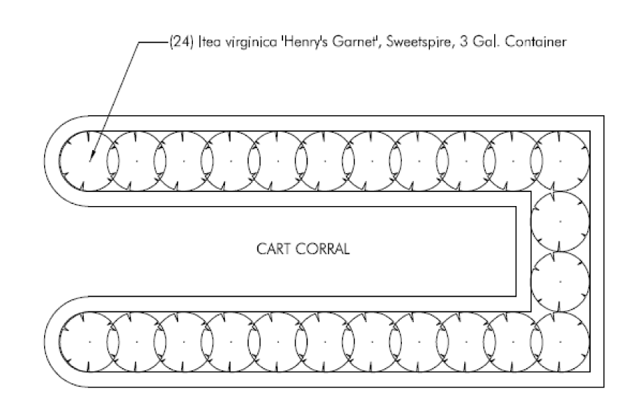
(K)
Rain barrels: Rain barrels are encouraged but shall not be located nearer to any street than the nearest wall of the principal building and shall maintain a setback of at least three (3) feet from side and rear property lines. The rain barrel should match the color of the adjacent structure. A complete rain barrel system shall consist of the holding tank, downspout connector/diverter, a sealed lid or mosquito screen, a hose bib and an overflow connected to a storm sewer or an approved location.
(L)
Rain gardens: Rain gardens are encouraged, but shall be located a minimum of ten (10) feet from building foundations and a minimum of fifteen (15) from property lines. Rain gardens shall be subject to review and approval of the Chief Building Official and shall be constructed in accordance with the latest edition of the "Rain Garden Guidelines for Southwest Ohio" published by the Ohio State University Extension, Hamilton County. Rain gardens installed in the right-of-way by the City or a utility company shall not be subject to these regulations.
(M)
Green roofs: Green roofing systems are encouraged, but shall meet all fire and wind requirements for roof systems, as determined by the Chief Building Official. All systems shall include design load verification submitted by a licensed design professional.
(N)
Community and private gardens: Community and private gardens for edible produce shall be properly maintained and cared for, and shall not be located in City right-of-way. Community gardens may be permitted on private property with approval of the property owner. No community garden shall be located in a front yard.
(O)
Compost bins: Compost bins are permitted, provided that such materials are contained in a bin or enclosure, are properly turned and maintained, and do not create or cause a nuisance to adjacent property owners. The compost bin shall be located behind the nearest wall of the principal building and shall maintain a setback of at least three feet from side and rear property lines. Compost scrap piles are not permitted.
(Ord. No. 9-2015, §§ 1, 2, 4-27-2015; Ord. No. 54-2017, § 19, 12-11-2017; Ord. No. 16-2019, §§ 16, 17, 6-10-2019; Ord. No. 75-2021, § 1(Exh. A), 12-13-2021; Ord. No. 40-2023, § 1(Exh. A), 8-28-2023)
§ 6.08 - OUTDOOR LIGHTING STANDARDS.
(A)
The purpose of these outdoor lighting standards is to provide adequate illumination for safety and security, improve nighttime visibility through glare reduction and lighting uniformity, reduce sky-glow to increase night sky access, and to reduce overall light pollution. The intent is also to promote energy efficient, cost effective and high quality outdoor lighting systems.
(B)
Applicability: All non-residential developments are required to provide outdoor lighting for all exterior doorways, pedestrian pathways, and parking and loading/service areas. Single-family residential and all commercial development is subject to the light trespass criteria as noted in Subsection 6.08(D) of this Ordinance. High intensity light beams in the form of outdoor search lights, lasers or strobe lights are prohibited.
(C)
Minimum site lighting criteria: All outdoor lighting shall meet the following standards:
(1)
0.5 footcandles minimum maintained: As measured at grade in all parking and loading areas and pedestrian pathways, actual site measurement compliance shall not drop below this stated minimum. For design purposes, the light loss factor (LLF) shall be calculated per current Illuminating Engineering Society of North America (IESNA) standards.
(2)
Lighting uniformity shall not exceed:
(a)
10:1 maximum to minimum light levels.
(b)
4:1 average to minimum light levels.
(3)
Pole mounted luminaire overall height limitations: Height shall be measured from finished grade to top of fixture.
(D)
Light trespass criteria: Light originating on-site shall not be permitted to exceed the following values when measured at grade fifteen (15) feet beyond the property line for the following adjacent uses:
Outdoor sports facilities will be reviewed for compliance with regard to the intent of these exterior lighting standards to minimize the impact of light trespass and glare on all surrounding properties and public rights-of-way.
(E)
Glare control criteria: In order to eliminate glare, all fixtures shall be mounted horizontal to the ground and meet the following:
(1)
All other outdoor lighting, including but not limited to parking lots, loading/service areas, pedestrian pathways, doorways, architectural, accent, landscape, signage, decorative, security, floodlighting, or area lighting shall meet Illuminating Engineering Society of North America (IESNA) full cutoff classification.
(2)
Directional control shields may be required in order to limit stray light. These are to be aimed and controlled so that the directed light is confined to the object intended to be illuminated.
(3)
No portion of the lamp, reflector, lens, or refracting system may extend beyond the housing or shield, nor shall any illumination occur upward from a reflected light source.
(F)
Non-essential illumination: All non-essential lighting shall be turned off by 10:00 p.m. or when not in use. The use of timers or motion sensors is encouraged. Public spaces that are frequented at night should stay illuminated until closed.
(G)
Energy efficiency and dark skies: In order to promote energy efficiency and dark skies, light-emitting diode (LED) and induction lighting shall be considered before incandescent, halogen, florescent, or high pressure sodium lamp fixtures. Narrow band amber LED (NBALED), Phosphor-converted amber LED (PCALED), Filtered LED, Low Temperature (1800K-2700K) white LED or Low-Pressure Sodium (LPS) are all encouraged.
(H)
Lighting plan submittal criteria: See Subsection 4.07(K) for submittal requirements.
(Ord. No. 106-2009; Ord. No. 44-2016, § 5, 10-24-2016)
§ 6.09 - ACCESSORY STRUCTURES AND USES.
(A)
Purpose: Accessory structures may be erected upon a lot on which a principal structure already exists. The use of the accessory structure must be secondary and incidental to the principal structure and use. An accessory structure that is attached to the main building shall comply with all the requirements of these regulations that are applicable to the principal building.
(B)
Permit required: A certificate of zoning compliance is required to be issued before an accessory structure is constructed or an accessory use may occur on a parcel or in a building (See Article 4, development procedures). A major accessory structure or use shall be approved by BZAP and a minor accessory structure or use shall be approved by the Director of Community Development. A building permit is required for any accessory structure that exceeds two hundred (200) square feet in area. See Table 5-f for size limitations.
(C)
General provisions: The following general provisions shall apply:
(1)
No accessory structure shall be located in a reserve, preservation/do not disturb area or public right-of-way. An accessory structure may be located within a platted easement with approval of an easement encroachment permit when no site excavation work is performed.
(a)
No accessory structure shall be located in front of a platted building line or in a front yard, unless specifically exempted.
(b)
In residential districts, the number of accessory structures for non-residential permitted uses (other permitted uses) may exceed the limitations in subsections (3)(a), (b), and (c), so long as the total coverage area of all accessory structures is in compliance with the coverage limitation in Table 5-F.
(c)
Mechanical devices building support systems shall not exceed sixty (60) decibels in sound output when measured at the property line. The test cycle of a generator should be set for each Wednesday at noon.
(2)
Aesthetic consideration: The vistas of adjacent property owners shall be considered with the installation and maintenance of storage structures, detached habitable structures, swimming pool equipment, swimming pool houses and generators. As viewed from neighboring property lines, no more than fifty percent (50%) of said structure or equipment shall be visible during all seasons of the year. Fifty percent (50%) opacity can be achieved by use of the following methods:
(a)
Existing or new vegetation.
(b)
Existing or new fencing.
(c)
Existing structures (detached garages, neighboring accessory structures, etc.).
(3)
Temporary exceptions/modifications to this section: The Director of Development is authorized to grant temporary exceptions to or modifications of this section in special circumstances where a necessity exists for the use of a vehicle described in Subsection 6.09(D)(6) and the prohibitions contained in said section would constitute a real hardship. Such special circumstances may include, but are not limited to, the location of a field office required for a construction project. Such permission shall be limited to the time during which the use of such vehicle is reasonably necessary for the project for which such exception was granted.
(4)
Keeping of livestock: The keeping of livestock on any property, other than those properties zoned for agricultural use, shall be prohibited unless otherwise approved by the Board of Zoning and Planning.
Table 6-K: Accessory Structures
(D)
Standards: The following standards are presented by accessory use and/or building type.
(1)
Detached garages and carports:
(a)
Setbacks: No detached garage or carport shall be permitted nearer to any front lot line than sixty (60) feet. For corner lots, the detached garage or carport can be built along the front setback line when proposed along the longer of the street frontages. A detached garage or carport shall maintain a minimum side and rear yard setback of at least three (3) feet and shall not occupy any easement. In the River Ridge Addition only, existing carports may be enclosed to create a garage if there are no changes to the footprint and if an additional story is not included. Such enclosure shall be compatible with the principal residence and include fence or other landscape screening adjacent to the structure.
(b)
Timing of construction: No detached garage or carport shall be erected or constructed prior to the erection or construction of the principal or main building, except in conjunction with the same.
(c)
Quantity: There shall be no more than one (1) detached garage or carport per dwelling unit.
(d)
Height: Detached garage or carports located outside of the buildable area of the lot shall not exceed the height limitations specified in Table 5-F for detached garages and carports. Detached garages or carports located completely within the buildable area of the lot shall not exceed the height limitations specified in Table 5-F for principal buildings.
(e)
Detached garage dormers: Dormers are not permitted except when they face one (1) or more streets contiguous to a property line.
(f)
Detached garage area limits: Detached garages or carports located outside of the buildable area of the lot shall not exceed the detached garage building cover limit specified in Table 5-F. The 870-square foot limit shall not apply to detached garages located in multi-family residential districts, only the detached garage cover limit.
(g)
Detached garage roof and plate height: The top plate wall height supporting all roofs for detached garages and carports outside of the buildable area of the lot shall not exceed nine (9.5) feet and six inches above the parking floor elevation.
(h)
Driveway required: All detached garages and carports are required to have a hard surface driveway that consists of an approved impervious material and shall have a minimum width of eight (8) feet.
(i)
Attached roof structures: Pergolas, trellises and other roof structures that are attached to the detached garage shall meet all provisions within this Section.
(j)
Habitable spaces: Habitable space (limited to home gyms, home offices, work studios, bathrooms and finished storage areas) are permitted within a detached garage as long as all requirements of detached garages are met. Separate dwellings, sleeping places, or in-law suites are not permitted within a detached garage.
(2)
Decks and balconies:
(a)
Location: Decks may be located in an interior side yard or rear yard as long as they are at least three (3) feet from the side and rear property lines, do not occupy any part of a platted easement, and are subject to the limitations described below. Unless utilized for a front porch or entrance platform per the requirements of Article 6.01(D), no deck shall project into the front yard. Detached or floating decks must be located within the buildable area of the lot, and are subject to limitations described below for encroaching decks. Balconies shall be attached or contiguous to the principal structure or building, and located completely within the buildable area.
(b)
Encroachments: The following requirements apply only to decks that encroach into required yards and shall not apply to decks that are located entirely within the buildable area:
i.
The deck platform shall not exceed two (2) feet above grade at any point within six (6) feet of the deck's perimeter.
ii.
The deck shall have no walls or roof planes, or permanently attached benches, seats, or other structures of any kind, except a guardrail, which may be up to forty-two (42) inches in height above the top of the deck.
(3)
Home offices and occupations:
(a)
Permitted uses: A home office or occupation is permitted as an accessory use in a dwelling unit in any residential area. All provisions of this UDO pertaining to residential uses shall be met. In addition, all special conditions specified in this UDO shall apply.
(b)
Additional permitted uses: Additional home offices and occupations not listed in Table 5-B may be permitted when, in the opinion of the Director of Community Development, these uses are similar in nature and will not violate any of the conditions noted below.
(c)
Prohibited uses: Therefore, the uses specified in Table 5-B shall not be permitted as accessory home offices and occupations in a residential zone because of their potential to impair the use and value of a residentially zoned area.
(d)
Additional prohibited uses: Additional home offices and occupations not listed in Table 5-B may be prohibited when, in the opinion of the Director of Community Development, these uses are similar in nature or will violate one (1) or more of the conditions noted below.
(e)
Conditions: The following conditions and limits of activity apply to all home occupations within the City:
i.
Business traffic: No traffic shall be generated by any home occupation unreasonably greater in volume or different in nature than would otherwise normally occur in the residential neighborhood in which it is located;
ii.
Construction alterations: All structural alterations must comply with the building code when the scope of these alterations exceeds the building code's definition of accessory use;
iii.
Employees/Independent contractors: No more than two (2) employees or independent contractors shall be on the premises at any given time, unless they are residents of the premises;
iv.
Signage: There shall be no advertising, signs, display, or other indications of the home office or occupation in the yard, on the exterior of the dwelling or visible from anywhere outside the dwelling;
v.
Business area: The home office or occupation shall be conducted within the principal structure or dwelling unit. It may be located anywhere within the dwelling unit, but its total area shall not exceed twenty percent (20%) or five hundred (500) square feet, whichever is the lesser, of the habitable square footage of the premises, which is entirely above grade. The entire structure must comply with the building code when this area exceeds the State of Ohio's definition of accessory use;
vi.
Hazard: No toxic, explosive, flammable, combustible, corrosive, radioactive, or other restricted materials are used or stored on the site, and no process may be used which is hazardous to public health, safety, morals, or general welfare;
vii.
Performance: No plumbing, electrical wiring or equipment or apparatus of any kind may be installed or used that would create or increase the threat of fire, explosion, radiation, noise, odor, smoke, particulate, or other nuisance or hazard of any kind;
viii.
Interference: Electrical or mechanical equipment that creates visible or audible interference in radio or television receivers, or causes fluctuations in line voltage outside the dwelling unit, or that creates noise not normally associated with residential uses shall be prohibited. The lack of adequate shielding of neighboring receivers shall not be a defense to interference claims;
ix.
Storage: Storage of equipment or materials used in the home office or occupation is permitted in addition to the business area limits specified above, as long as it does not further reduce the habitable space at the premises. Both storage areas and business areas must comply with the building code when these areas separately or collectively exceed the State of Ohio's definition of accessory use. There shall be no display or storage of equipment, materials, goods, or supplies used in the conduct of the home occupation outside of an enclosed building;
x.
Employee/Independent contractor parking: If the Director of Community Development determines that a parking nuisance is being created by a home occupation, the provisions of Subsection 3.06(A) may be invoked to remove this nuisance from the neighborhood;
xi.
Vehicle graphics: No passenger car as defined in ORC § 4501.01 as amended, with the home office or occupation name, descriptive wording, and/or identifying graphics on it shall exceed the graphic limitations identified in Subsection 6.09(D)(6)(b) for parking of trucks and trailers on private property when parked on the premises outside of a completely enclosed building;
xii.
Appearance: There shall be no change in the outside appearance of the building or premises, or other visible evidence of the conduct of such home office or occupation when viewed from off the premises, except for the parking specifically permitted in these special conditions;
xiii.
Residency: The owner, operator or officer of the home office or occupation shall reside in the dwelling unit in which the business operates; and
xiv.
Multiple home offices and occupations: More than one (1) home office or occupation may be permitted within an individual dwelling unit, provided all other standards and criteria applicable to home office and occupations are complied with. Such criteria shall be applied cumulatively to all home offices and occupations within the same dwelling.
(4)
Home sales:
(a)
Home sale: Means a sale of personal property to the general public conducted in or on any property within a residential zoning district, to include, without limitation, garage sales, patio sales, yard sales, porch sales, driveway sales, motor vehicle sales, and the sale of boats, trailers, motorcycles, motor homes and the like.
(b)
Prohibitions: No person shall sell or offer for sale at such home sale any merchandise that has been purchased, consigned or otherwise acquired for purposes of resale. The offering of new merchandise for sale shall be evidence that such merchandise was acquired by the resident for purpose of resale. No person shall sell or offer at such sale any personal property except such as has been owned and maintained by such person or members of his family on or in connection with the premises on which such sale is held. The provisions of this paragraph shall not apply to not-for-profit corporations, churches, temples, schools, fraternities, sororities, associations, clubs or lodges. Such organizations may conduct sales of personal property donated to them on real estate owned or occupied by such organizations subject to the other provisions of Subsection 6.09(D)(6).
(c)
Frequency and duration of sales: Only one such sale may be conducted on any parcel of real estate in any six-month period, which sale shall be limited to not more than three (3) consecutive days or two (2) consecutive weekends of two (2) days each. No sale may commence before the hour of 8:00 a.m. or extend later than 8:00 p.m. This subsection shall not apply to the sale of motor vehicles, boats, trailers, motorcycles or motor homes.
(d)
Other conditions of sales: Personal property offered for sale may be displayed in the front, side or rear yard of any such premises provided that such personal property is not located within a right-of-way or otherwise obstructs clear vision All signage shall be consistent with the provision of Subsection 6.06(F)(3). Only one such sign may be displayed and its display shall be limited to the dates and hours during which the sale is held. Such sign shall not be larger than four (4) square feet in area, shall not be illuminated or animated, and shall not contain any advertising material unrelated to the conduct of the sale. No sign may be displayed for the sale of a motor vehicle, boat, trailer, motorcycle or motor home on the premises.
(e)
Sale of motor vehicles, boats, trailers, motorcycles and motor homes: The following provisions shall apply in the case of any motor vehicle, boat, trailer, motorcycle or motor home offered for sale:
i.
Such vehicles may be displayed for sale only upon an impervious surface on any portion of the lot, including those located in any front, rear or side yards, provided that the vehicle is not parked in the City's right-of-way. Only one such item may be displayed at any time;
ii.
No person shall park or leave standing the above named vehicles upon any property not owned or controlled by such person for the principal purpose of advertising or displaying it for sale;
iii.
Not more than two (2) signs, each of which shall not exceed one (1) square foot in area, may be displayed for the sale of such item upon or in the motor vehicle, boat, trailer, motorcycle or motor home only, provided that such signs shall not be illuminated or animated; and
iv.
Any such motor vehicle, boat, trailer, motorcycle or motor home displayed for sale must be in operating condition and capable of being immediately moved under its own power if self-propelled or if not self-propelled by towing by ordinary means available upon the premises. This subsection shall not apply to corporations not-for-profits, churches, temples, schools, fraternities, sororities, associations, clubs, lodges, or any form of business, whether sole proprietorship, partnership, or corporation, carried on for profit whether formally organized or not.
v.
Motor vehicles, boats, trailers, motorcycles, recreational vehicles, watercraft and recreational trailers offered for sale shall comply with the requirements of this section and Subsections 6.09(D)(6) and 6.09(D)(7).
(f)
Exemptions: Except as provided in Subsection 6.09(D)(4)(b), (d), and (e) above, the provisions of Subsection 6.09(D) shall not apply to a sale of property publicized solely by classified newspaper advertising, which describes or identifies the specific property offered for sale and does not designate the date, hours or location of the sale other than by stating the name, address or telephone number of the seller.
(5)
Parking of motor vehicles:
(a)
Restrictions: In any zoning district, an automobile, motorcycle or other motor vehicle as defined in Section 2.02 shall not remain on any non-impervious parking surface (such as lawn) of any lot for a period of more than four (4) hours. All vehicles parked or stored on private property other than in completely enclosed buildings shall be in operable condition and bear proper tags and validation stickers. For purposes of this section, a motor vehicle shall be deemed inoperable when any of the following conditions exist:
i.
One (1) or more wheels are missing;
ii.
One (1) or more tires are missing;
iii.
One (1) or more tires are flat;
iv.
One (1) or more windows are cracked, broken or missing;
v.
The windshield is shattered or missing;
vi.
Parts necessary for the operation of the vehicle are missing; or
vii.
When the vehicle is not capable of being started and driven from the location in question; or
viii.
When an invalid license plate is displayed on the vehicle.
(b)
No parking: No motor vehicle shall be parked, stored or allowed to remain on a driveway within the City's right-of-way, or in violation of Subsection 6.09(D)(5)(a), except for emergency vehicles as defined in section 2.02.
(c)
Collector's vehicles: In accordance with ORC § 4513.65, collector's vehicles as defined in Section 2.02 may be kept on private property with the permission of the person having the right to possession of the property, except that the vehicle must bear current registration, be parked on an impervious surface in compliance with the UDO and be concealed by means plant material or landscape design elements which obscure the visibility of the parked vehicle from adjacent residential property and public right-of-way.
(6)
Parking of trucks and trailers on private property:
(a)
Required screening: No motor vehicle having more than four (4) tires, and no trailer having more than two (2) tires, shall be parked, stored or allowed to remain for more than two (2) hours in any twenty-four-hour period on any lot or parcel of land in this City, unless fully contained within an enclosed structure. No vehicle excepted from the definition of motor vehicle, excluding motorized bicycles, no matter how many tires, shall be parked, stored or allowed to remain for more than two (2) hours in any twenty-four-hour period on any lot or parcel of land in this City, unless fully contained within an enclosed structure.
(b)
Restrictions for unscreened parking: Any motor vehicle with no more than four (4) tires, and any trailer with no more than two (2) tires, may be parked, stored or allowed to remain outside of a fully enclosed structure, subject to the following conditions:
i.
All such vehicles and trailers, when parked more than two (2) hours in any twenty-four-hour period, shall be located no closer to any street than the building setback line or the most remote wall of the building elevation facing the street, whichever is further from the street;
ii.
All such vehicles or trailers, shall be parked at least three (3) feet from any side lot line. A side yard facing a street on a corner lot shall be considered a front yard;
iii.
Only one such vehicle or trailer may be parked outside of a fully enclosed building at any one (1) dwelling unit, and may not be parked outside in addition to a recreational vehicle, trailer or boat parked in compliance with Subsection 6.09(D)(7);
iv.
Any equipment and/or load attached to, or supported by, such vehicle must be totally enclosed within this vehicle to conceal it from external observation; and
v.
Graphics are permitted on the sides of such vehicles only. Graphics are limited to the front passenger doors or to ten percent (10%) of the total area of each side of the vehicle, whichever is less. Said area shall be measured behind the cab or behind the front passenger door on a pick-up or van. Graphics are computed for and permitted on each side of the vehicle. No more than three (3) colors, exclusive of vehicle color, may be used. For the purposes of this UDO, black and white are considered colors.
vi.
All such vehicles or trailers shall be in operable condition as provided for in Subsection 6.09(D)(5) and shall not be parked or stored on any non-impervious parking surface (such as a lawn) of any lot for a period of more than four (4) hours.
(c)
Exemption for noncommercial vehicles: Passenger cars that qualify as noncommercial motor vehicles, as defined in ORC § 4501.01, are exempt from the requirements of this UDO.
(d)
Exemptions for temporary vehicle usage: This UDO shall not apply to recreational vehicles, watercraft or recreational trailers as defined in Subsection 6.09(D)(7), or to such vehicles used for conveying the necessary tools and materials to premises where labor, using such tools and materials, is to be performed during the time of parking such vehicles, or to the time during which such vehicle, trailer or semi-trailer is being loaded or unloaded, or used to deliver or hoist property or merchandise for completion of delivery, if such loading, unloading or other activities referred to in this provision are conducted diligently and without unnecessary delay.
(7)
Parking of recreational vehicles, watercraft and recreational trailers on private property: This UDO addresses three (3) types of equipment generically called recreational vehicles, watercraft and recreational trailers, (hereinafter referred to as vehicles), which are further defined below:
(a)
Definition of recreation trailers: Types of recreational trailers include, but are not limited to, any form of device, equipment, or machinery on wheels, or a single wheel, that is intended to be pulled by a motor vehicle, whether or not attached to a motor vehicle. This shall include every vehicle designed and utilized for the sole purpose of transporting any boat, auto, snowmobile, recreational habitation, and the like, which does not have motor power, but is designed to be drawn by another vehicle.
(b)
Definition of watercraft: Types of watercraft include, but are not limited to, any of the following when used or capable of being used for transportation on the water:
i.
A boat, or similar personal watercraft, operated by machinery either permanently or temporarily affixed;
ii.
A sailboat other than a sailboard;
iii.
An inflatable, manually propelled boat having a hull identification number meeting the requirements of the United States Coast Guard; and
iv.
A canoe or rowboat.
(c)
Definition of recreational vehicles: See Article 2: Definition, Recreational Vehicle.
(d)
Specifications: All vehicles shall meet the following conditions when parked in any zoning district within the City:
i.
Location/Screening: When located outside an enclosed structure, all such vehicles must be parked on an impervious surface within the buildable area of any given lot, and be screened from the view of surrounding neighbors and passing motorists. The use of tarpaulins and/or location within an open-sided carport does not qualify as adequate screening. If an objection to the degree of obscurity is received by the Director of Community Development, the Director shall determine if adequate screening, or obscurity exists. The opinion of the Director of Community Development may be appealed to BZAP by any party affected by this opinion, pursuant to Section 4.10. The extent of owner liability for obscurity is limited to the erection of a six-foot opaque wooden fence screening the vehicle from view from all abutting property owners and streets.
ii.
Parking beyond buildable area: No vehicle which is parked, stored or allowed to remain on a lot within the City shall remain for more than two (2) hours in any twenty-four-hour period outside the buildable area of that lot, except that a vehicle may be parked outside of the buildable area for not more than five (5) full or five (5) partial days in any thirty-day period when being loaded or unloaded. For purposes of this Ordinance, the term partial day shall mean more than two (2) hours cumulatively in any twenty-four-hour period.
iii.
Improvements: No vehicle shall be parked, stored or allowed to remain on a lot or parcel of land which is not improved with a principal building.
iv.
Habitation/Guest occupancy: A vehicle may not be used for overnight sleeping or living while parked on private property within the City, except that a vehicle may be parked on private property inside or outside the buildable area for a period not to exceed in the aggregate, seventy-two (72) hours in any thirty-day period, if the owner or person in charge of such vehicle is a bona fide guest of the occupant or occupants of such private property.
v.
Storage: No materials of any kind shall be temporarily or permanently placed or stored beneath, or on top of, parked vehicles.
vi.
Registration: All recreational vehicles and recreational trailers shall be operable and have borne valid registration and licenses within the most recent twelve-month period. All watercraft shall be operable and have been registered within the most recent twelve-month period. Operable in the case of a powered vehicle means a vehicle capable of being started and driven from the location in question. Operable in the case of a non-powered or waterborne vehicle means a vehicle capable of being towed from the location in question.
vii.
Indoor storage: Parking vehicles under roof within a permanent enclosure is encouraged.
viii.
Maintenance/Condition: A vehicle is inadequately maintained, and shall be removed from the City, when all of the following conditions are met:
a)
The vehicle is three (3) years or older; and
b)
The vehicle is extensively damaged. Such damage may include but is not limited to any of the following: broken windows or windshield, missing wheels, tires, motor or transmission; and/or the vehicle is apparently inoperable.
ix.
Ownership: The vehicle must be owned by a resident on whose lot it is parked, unless it qualifies for the guest occupancy exception above.
x.
Safety: The vehicle shall not be parked in an unsafe manner.
xi.
Commercial use of vehicle: Any vehicle used partially or wholly for commercial purposes shall be governed by Subsection 6.09(D)(5), commercial purpose may include, but is not limited to:
a)
Advertising on the vehicle indicating a non-residential use; or
b)
The use of the vehicle for entertainment of customers related to a business purpose.
xii.
Construction/Delivery: The other provisions of this section notwithstanding, this section shall not apply to such vehicles used for conveying the necessary tools and materials to premises where labor, using such tools and materials, is to be performed, during the time of parking such vehicles or to the time during which such vehicle is being loaded or unloaded or used to deliver or hoist property or merchandise for completion of delivery, if such loading, unloading or other activities referred to in this provision are conducted diligently and without unnecessary delay.
xiii.
Watercraft length: Watercraft may not exceed twenty-four (24) feet in length as measured from bow to stern.
xiv.
Number of vehicles: Only one such vehicle may be parked outside of a fully enclosed building at any parcel and shall not be parked outside in addition to a truck or trailer in compliance with Subsection 6.09(D)(6).
(8)
Authority to grant parking exceptions: The City Manager is authorized to grant temporary exceptions to or modifications in special circumstances where a necessity exists for the use of a vehicle described in Subsections 6.09(D)(6)(c) and (d) hereof, and the prohibitions contained in said section would constitute a real hardship. Such special circumstances may include, but are not limited to, the location of a field office required for a construction project. Such permission shall be limited to the time during which the use of such vehicle is reasonably necessary for the project for which such exception was granted.
(9)
Antenna and antenna towers: Antenna means any system of wires, poles, rods or similar devices used for the transmission or reception of television broadcast signals, direct britches signals, direct britches satellite services or multi-channel multi-point distribution services, as defined and regulated by 47 C.F.R. Statute 1.4000. Antenna tower means any structure, greater than twenty-five (25) feet in height, used for the primary purpose of supporting one (1) or more antennas as defined above, including foundation, guys and other components thereof.
No antenna tower or tower mast shall be located in or occupy any part of a required front or side yard. Antennas, antenna towers, including foundation guys and other components thereof, shall not project over any property line. No antenna tower or tower mast shall extend more than sixty (60) feet above the ground site on which it is located. If mounted on the roof of a dwelling or other building, an antenna tower or mast shall not extend more than twenty (20) feet above the highest ridge of the roof nor more than twenty (20) feet above the ground level immediately below.
Not more than one (1) antenna tower with antennas or not more than one (1) satellite ground station as defined in this section shall be erected on any lot or parcel of land, whether the same is free-standing, attached to a building wall or mounted on a building roof; provided, however, that this restriction shall not apply to a tower or antenna attached to a wall or mounted on the roof of a residence which does not project more than six (6) feet above the highest ridge of the roof, and if the maximum horizontal dimension of such tower and antenna does not exceed twelve (12) feet.
(10)
Regulation of dish-type satellite signal receiving antennas: The purpose of these regulations is to regulate the proper development and use of dish-type satellite signal receiving antennas in order to ensure safe installation, and to protect and enhance the overall physical appearance of the community. All dish-type satellite signal receiving antennas are subject to the provisions set forth in this section.
Satellite signal receiving antennas which are one (1) meter or more in diameter located in all zones, and two (2) meters or more in diameter located in industrial or commercial districts shall comply with the following restrictions so that the health, safety and aesthetic objectives of the community can be accomplished:
(a)
A satellite antenna may be mounted on a roof as long as it does not project above the ridge of the roof to which it is attached; or if attached to a flat roof, it may not project more than three (3) feet above the coping or parapet of said roof.
(b)
A satellite antenna shall not be mounted upon architectural features including but not limited to towers, cupolas, spires or chimneys.
(c)
A satellite antenna may be ground mounted if no portion of the antenna exceeds a height of six (6) feet above the elevation of the ground site on which it is located; and shall be erected on a foundation designed to support the loads intended. Where the ground under the foundation has been raised to a higher level than the surrounding surface, the permissible height of the satellite antenna shall be reduced by the height of such mound or raised surface.
(d)
A satellite antenna may be mounted to the side or rear walls of the principal building, but may not project above adjacent roof edge, ridge, and/or eave lines.
(e)
A satellite antenna shall not be visible from the street, except when either located on the side or rear wall of the building, in the rear yard, or in the buildable area adjacent to the rear yard and behind the principal structure.
(f)
Satellite antennas shall not be erected in the City without a zoning compliance and an electrical permit. A building permit is also required when a foundation is involved.
(11)
Private swimming pools and hot tubs:
(a)
Location, area and height:
i.
All hot tubs shall be located within the buildable area unless the hot tub is partially buried below grade. Swim spas (or hot tubs having more than one hundred fifty (150) square feet of area on the water surface when filled to capacity) shall meet all regulations for swimming pools;
ii.
All swimming pools, swim spas and buried hot tubs and portions thereof, including walkways and decking, shall be located at least ten (10) feet from side and rear property lines, and shall be located behind the front building setback line. Location within a platted easement, platted reserve or platted side or rear yard setback line is prohibited; any change or modification would require plat amendment approval. Installation of a swimming pool may allow a development coverage bonus per Table 5-F;
iii.
The top of the walls, decks or walks of any swimming pool, swim spa or buried hot tub shall not project more than two (2) feet above the average finished grade of the pool site or portion of the lot immediately surrounding the pool;
iv.
Swimming pool accessories are limited to diving boards, slides and lights designed to illuminate the pool and the immediate surrounding area. None of these accessories may exceed ten (10) feet in height, such height to include handrails, supports and other safety devices, and may not cover a ground surface area in excess of thirty (30) square feet;
v.
Swimming pool equipment shall be located a minimum of three (3) feet from side and rear property lines, and shall not occupy any part of an easement; and
vi.
Swimming pool equipment shall not exceed sixty (60) decibels in sound output when measured at the property line.
(b)
Fences:
i.
Every swimming pool (including existing pools) shall be completely enclosed by a fence of sturdy construction not less than forty-eight (48) inches in height, measured from the level of the ground where located, which shall be of such design and construction as to effectually prevent a child from crawling or otherwise passing though or under such fence. Each gate in such fence shall be provided with a secure lock and shall be kept locked at all times when the depth of water in the pool exceeds eighteen (18) inches, unless said pool is in use or is under the immediate observation of a responsible person. No part of any fence shall be located between the building setback line and the street on which the lot or parcel abuts.
(c)
Lights: All lights used for illuminating such swimming pool, hot tub or the surrounding areas shall be so designed, located and installed as to confine the direct beams thereof to the lot or parcel on which the pool is located, and so as not to constitute a nuisance or undue annoyance to occupants of abutting property.
(d)
Drainage: Provisions shall be made for drainage of swimming pools or hot tubs in compliance with the Ohio Plumbing Code and EPA standards.
(e)
Permits and operation:
i.
No person shall locate, construct or install any swimming pool or make any change therein or in the appurtenances thereof without having first submitted an application and plans therefore to, and having obtained a permit from the Department of Community Development and the health commissioner;
ii.
Such permit shall not be issued unless and until the plans and specifications shall have been approved as to structural safety and compliance with this UDO by the Director of Community Development;
iii.
Every swimming pool, including existing swimming pools, shall be provided with a filtration system approved by the Board of Health; and
iv.
No person shall use, operate, repair or maintain any swimming pool or hot tub in violation of any of the provisions of this UDO or of any lawful order of the Director of Community Development, or in violation of any regulation of the Board of Health or any order of the health commissioner issued pursuant thereto.
(f)
Application of requirements: All provisions of this UDO shall apply to private or noncommercial swimming pools and hot tubs. The provisions of Subsections 6.09 (D)(12)(b)—(f), inclusive, shall apply to all swimming pools.
(12)
Fences:
(a)
Purpose: The purpose of these fence regulations is to preserve and protect property values, to enhance safety and security, to provide privacy, and to improve the visual environment.
(b)
Applicability: No fence, wall or barrier, other than a temporary construction or snow fence, shall be constructed, erected, installed or substantially replaced on any property without an approved fence permit from the Community Development Department. Minor repairs and maintenance do not require a fence permit. An underground/invisible pet fence shall not be subject to the limitations associated with fences, but shall not be located in city right-of-way.
(c)
Prohibited fences: The following fences are prohibited:
i.
Fences or walls having wire, metal prongs, spikes, or cutting points or edges of any kind whatsoever, or which is charged with electric current. Picket fences shall have points blunted. Chain link fences shall be coated with black, brown, or dark green vinyl, plastic, or other similar material.
ii.
No fence or fences shall be constructed so that there are two (2) more or less parallel fences in the same yard on one (1) property unless there is a distance of at least five (5) feet between the fences or their appurtenances. This section is not intended to prohibit adjoining property owners from erecting abutting fences along a shared property line.
(d)
Location and height: Fences may be located in yards as follows:
i.
Front yard: As measured from the building setback line to the City right-of-way line:
A.
Fences may extend fifteen (15) feet forward of the building line, provided such fence does not exceed three and one-half (3.5) feet in height, as measured above the elevation of the surface of the ground at such point.
B.
Fence posts may exceed the height of the fence by a maximum of six (6) inches.
ii.
Side and rear yards:
A.
Fences shall not exceed six (6) feet in height, as measured above the elevation of the surface of the ground at such point, unless the side and/or rear yard abuts a Commercial or Planned District, then a fence may extend up to eight (8) feet in height.
B.
Fence posts may exceed the height of the fence by a maximum of six (6) inches.
iii.
For purposes of determining the location and height requirements, each yard abutting upon a street shall be considered as a front yard on each respective street.
iv.
Fences or walls located completely within the buildable area are not subject to these height limitations.
v.
Property line location: The accurate determination of the property line is the responsibility of the property owner or contractor securing the fence permit. The issuance of a fence permit does not indicate city review or approval of the property line location.
vi.
Fences shall not be located in platted landscape preservation easements, do not disturb areas, planting strips or drainage easements. Fences may be located in a reserve, unless otherwise noted on the subdivision plat.
(e)
Supporting elements: Fences or walls supported by posts on the side of the fence or wall shall be erected so that exposed posts and supporting cross elements face the property upon which the fence or wall is being constructed. This provision shall not apply if adjacent property owners file, with the Director of Community Development, written consent to have the fence erected so that such posts and cross elements face their property. Fences shall be erected so that no exposed posts or supporting cross elements face public property. This section shall not apply if the fence is the same on both sides, such as split rail or board and batten fences.
(f)
Construction on a mound: Where a fence, wall, ornamental feature or hedge is constructed on a mound, or where the ground under the same has been raised to a higher level than the surrounding surface, the permissible height of the fence, wall, ornamental feature or hedge shall be reduced by the height of such mound or raised surface.
(g)
Ornamental and entry features: May be located in yards as follows:
1.
Shall not exceed forty-two (42) inches in height.
2.
Shall not exceed twenty (20) feet in total length.
3.
Shall not be located in city right-of-way, but may be located in any yard, provided they conform to intersection clearance zone requirements.
(h)
Retaining walls and dry-stacked decorative stone walls: May be located as follows:
1.
Shall not be located in city right-of-way, but may be located in the front yard, provided they conform to intersection clearance zone requirements.
2.
Shall not exceed thirty-six (36) inches in height, if located in a front yard.
3.
Retaining walls shall be constructed per the Residential Code of Ohio.
(i)
Swimming pool fences: Every swimming pool shall be completely enclosed by a fence of sturdy construction not less than forty-eight (48) inches in height, as measured on the side of the fence that faces away from the swimming pool. Refer to Appendix G of the Residential Code of Ohio for additional requirements pertaining to swimming pool fences.
(j)
Lamp posts and columns: May be located as follows:
1.
Shall not be located in city right-of-way, but may be located in the front yard, provided they conform to intersection clearance zone requirements.
2.
Shall not exceed 72 inches in height, not including the light fixture.
3.
Shall conform to the residential lighting requirements of Article 6.08.
4.
Shall require an Electrical Permit for non-low voltage wiring and/or a Gas Line Permit for gas lamps.
(13)
Portable storage units:
(a)
Specifications: All portable storage units and/or collection boxes shall meet the following conditions when located in any zoning district in the City:
i.
Duration:
• Residential properties and uses - Portable storage units shall be permitted for a period not to exceed five (5) days and no permit shall be required. Collection boxes shall not be permitted on residential properties.
• Non-residential properties and uses - Portable storage units and/or collection boxes shall be permitted for a period not to exceed five (5) days and no permit shall be required. The period may be extended to not more than twenty-one (21) days by permit only. Not more than two (2) permits shall be issued in any one (1) calendar year.
• For the purposes of this section, non-residential shall mean all commercial, office and institutional properties and uses.
ii.
Location: Portable storage units shall be internally located and not located at the perimeter of any property. Containers shall be located on an impervious surface and shall not obstruct right-of-way vision clearance at any time.
iii.
Number: Not more than one (1) unit per property is permitted.
iv.
PMUD: Portable storage units shall not be permitted in any planned mixed-use district unless otherwise approved as part of a final development plan.
v.
Prohibited: Semi-trailer donation centers shall be prohibited.
(b)
Exceptions: The specifications noted above shall not apply to the following:
i.
Temporary construction sites, provided the portable unit is removed within sixty (60) days from the final occupancy issue date.
ii.
When necessary to facilitate clean up and/or restoration activities resulting from natural disasters or fire for a period not to exceed one hundred eighty (180) days provided that a permit is obtained.
iii.
Portable storage units used for the collection and storage of articles donated to a recognized charitable or educational organization may be approved by the Director of Community Development provided such unit will not be objectionable to contiguous properties or properties located directly across the street. Such approval may be subject to reasonable health, safety and welfare conditions as to the location, size, type and maintenance of such unit. Portable storage units shall not be permitted in any planned mixed-use district unless otherwise approved as part of a final development plan.
(14)
Outdoor display - General: All business, services or processing shall be conducted wholly within a completely enclosed building, except for the sale of automotive fuel, lubricants, fluids and such outdoor display or storage of vehicles, materials and equipment at service stations, as hereinbefore specifically authorized or as may be authorized by the Board. Merchandise may be displayed on the sidewalk, or walkway, immediately in front of and adjacent to business establishments provided:
(a)
No less than four (4) feet of uninterrupted pedestrian waking space is provided.
(b)
Stacked merchandise shall not be displayed any closer to any entrance or exit than a distance equal to the actual height of the stacked materials; but in no event shall any merchandise be located any closer than three (3) feet from any entrance or exit.
(c)
No merchandise shall be stacked higher than five (5) feet excepting merchandise that itself is higher than five (5) feet such as trees.
(d)
Bagged or boxed material shall be stacked neatly and safely so as not to endanger pedestrians.
(e)
No bulk or loose material may be piled. Plants, flowers, shrubs or trees shall not interfere with the required walking space.
(f)
No signs, whirligigs or pennants (other than descriptions and price tags) may be used.
(g)
This subsection does not relieve the business proprietor from obtaining the consent of the property owner(s) to use such private sidewalks.
(15)
Temporary sales trailer specifications: All temporary sales trailers require a certificate of zoning compliance and shall meet the following conditions:
(a)
Duration: Temporary sales trailers shall be permitted for a period not to exceed the shorter of three hundred sixty-five (365) days from the issuance of a certificate of zoning compliance or within ten (10) days of occupancy of the sales unit within the building;
(b)
Location: The trailer shall be permitted in any non-residential zoning district and shall be located on the site as to provide safe access to the structure, be served by adequate parking, and shall not cause undo traffic congestion on the site;
(c)
Number: Not more than one (1) trailer per development is permitted;
(d)
Maximum size and height: Temporary sales trailers shall not exceed 720 square feet in size and 11′-6″ in height;
(e)
Hours of operation: Temporary sales trailers shall only operate between the hours of 8:00 a.m. and 7:00 p.m. each day;
(f)
Lighting/Screening: Temporary sales trailers shall have lights near the entrance and shall have a skirt around the entire trailer base. An approved landscape plan shall be required;
(g)
Access: Temporary sales trailers shall have an ADA compliant ramp;
(h)
Signage: Only one (1) sign up to thirty-two (32) square feet is allowed;
(i)
Outdoor storage: Outdoor storage is strictly prohibited;
(j)
Extensions: The Director of Community Development may extend the duration or hours of operation after considering the unique conditions and circumstances of the property and the impact on adjacent property owners.
(16)
Solar panels: A solar photovoltaic panel, or solar hot air or water panel collector device, which relies upon solar radiation as an energy source for the generation of electricity or transfer of stored heat, shall comply with the following restrictions:
(a)
Location:
1.
Ground mounted solar panels exceeding two (2) square feet in area shall be located in a side or rear yard only, shall maintain a setback of ten (10) feet from property lines, and shall not be located in a platted easement. However, utility companies may install solar panels within an easement, subject to aesthetic considerations and Subsection 6.10(C)(11).
2.
Roof and flush-mounted solar panels may be located on any principal residence, detached garage or accessory structure.
(b)
Height:
1.
Ground mounted solar panels shall not exceed eight (8) feet in height.
2.
Roof and flush-mounted solar panels shall not project vertically above the peak of the roof to which it is attached, or project vertically more than five (5) feet above a flat roof installation.
(c)
Exemptions: Solar panels less than two (2) square feet in area and those installed within the right-of-way by a utility company pursuant to Subsection 6.10(C)(11) or by the City are not subject to the regulations set forth above.
(17)
Handicap ramps:
(a)
Location: All handicap ramps shall be attached or contiguous to the principal structure or principal building. Ramps may be located in a front yard, interior side yard or rear yard, as long as they are at least three (3) feet from the side and rear property lines and do not occupy any part of a platted easement.
(b)
Screening: Ramps projecting into the front yard setback must be screened with evergreen landscaping to a fifty (50) minimum percent opacity.
(Ord. No. 106-2009; Ord. No. 8-2012; Ord. No. 87-2015, § 5, 12-14-2015; Ord. No. 21-2016, §§ 9—12, 5-9-2016; Ord. No. 16-2017, § 8, 4-10-2017; Ord. No. 54-2017, §§ 20—22, 12-11-2017; Ord. No. 32-2018, §§ 9, 10, 4-23-2018; Ord. No. 35-2018, § 4, 5-29-2018; Ord. No. 16-2019, §§ 18—23, 6-10-2019; Ord. No. 7-2020, §§ 9, 12, 9-14-2020; Ord. No. 67-2021, § 6, 11-8-2021; Ord. No. 75-2021, § 1(Exh. A), 12-13-2021; Ord. No. 40-2023, § 1(Exh. A), 8-28-2023)
§ 6.10 - CONDITIONAL USES.
(A)
Purpose: The purpose of this section is to establish the provisions of conditional uses where such uses may be allowed in specific zoning districts.
(B)
General provisions: The following general provisions shall apply:
(1)
Administration: Any owner of property in the City may submit an application to the City requesting a conditional use permit. The procedure required prior to authorization of a conditional use shall be as prescribed in Article 4, development procedures.
(2)
Development standards: A conditional use, and its accessory uses, shall be permitted in a zoning district only when the use, and its location, extent, and method of development will not substantially alter the character of the area or interfere with the use of adjacent lots in the manner prescribed for the zoning district. The districts in which these uses are permitted are identified in Tables 5-A, 5-B, 5-C, and 5-D, Use Standards. In addition, the particular facts and circumstances of each proposed use, in terms of the decision standards, shall be reviewed, and the special standards in Subsection (C) shall be fully addressed.
(3)
Compatibility: If not otherwise stated in the following standards, the standards established in the underlying district in which the conditional use is proposed to be located shall apply to the conditional use.
(C)
Special standards: This section presents the standards applicable to the specific conditional uses listed. Unless otherwise noted, the development standards of the zoning district and UDO shall apply:
(1)
Bar, lounge, and tavern:
(a)
Purpose: The use shall be for the purpose of selling food and beverages, including alcoholic beverages, to be consumed on the premises.
(b)
Standards:
i.
Such establishment shall be located at least two hundred fifty (250) feet from a residential district, churches and schools.
ii.
All activities shall take place in a fully enclosed sound-resistant building, with closed windows and double-door entrances that provide a sound lock.
iii.
The site shall be kept free of litter and debris.
iv.
The use of bars, lounges or taverns shall be no later than 2:00 a.m. unless otherwise specified in the approval.
(2)
Reserved.
(3)
Day care, child (type A) and/or adult:
(a)
Purpose: The use shall be for the purpose of providing temporary care for a portion of the day to children and/or adults. A day care facility also may be operated as an accessory use to a place of worship, school, or other public or semi-public organization.
(b)
Standards:
i.
Minimum lot area shall be one and one-half (1.5) acres and the minimum lot width shall be two hundred (200) feet.
ii.
There shall be on the site a safe outdoor play space or recreation area that is enclosed or otherwise protected from traffic or other hazards. The space shall contain no less than sixty (60) square feet per client and shall provide an opportunity for supervised outdoor play or recreation each day in suitable weather. The area shall be enclosed by a fence or wall a minimum of five (5) feet in height. However, when the recreational area abuts a residential property, it shall instead be enclosed by a solid wood fence or masonry wall at least six (6) feet high along the property.
iii.
Required parking shall be on the same lot as the principal use.
iv.
An on-site drop off shall be provided at the main entrance to the facility with cueing area sufficient to accommodate eight (8) automobiles for facilities with twenty (20) or fewer clients plus one (1) additional vehicle for each additional ten (10) clients served.
v.
Access to an arterial or collector street is required or access shall be provided in a manner that does not cause heavy traffic on residential streets.
vi.
The City may require additional fencing, screening, or other measures necessary to protect the health, safety, and welfare of clients using day care centers in commercial, industrial, or other high hazard areas. It may also deny a request to locate a facility in such areas based on these considerations.
vii.
All day care centers shall provide evidence of comprehensive liability insurance insuring against damage to property or physical injury, in combined single limit form, in an amount of twenty-five thousand dollars ($25,000.00) per person authorized to be cared for.
viii.
The facility will comply with all applicable codes, as well as the specific requirements for child and/or adult day care facilities as set forth in ORC § 5104.
ix.
Use of outdoor recreational areas shall be limited to between the hours of 7:30 a.m. and 8:00 p.m.
(4)
Free-standing drive-through structures:
(a)
Purpose: The use shall be for retail or service establishments, which provide a designated place where people can drive up in automobiles and conduct the major portion of business without having to get out of their automobiles or where the serving of the automobile is the major business. Drive-through uses include but are not limited to drive-through restaurants that prepare and/or dispense food or beverages and do not provide a place for all its customers to eat inside the building or which serve food or beverages for carry out; drive-in theaters, drive-in eating and drinking places, establishments where customers may serve themselves and may eat or drink the food or beverages on the premises; and drive-in banks.
(b)
Standards:
i.
Minimum lot area shall be one and one-half (1.5) acres or sufficient area to accommodate the primary use and drive-through structure.
ii.
Drive-through menu board signs shall include freestanding, pole, pylon and monument signs. One (1) drive-through menu board sign is permitted only when all of the following conditions are fulfilled: the sign is located on the property to which it refers; the sign is not visible from the public right-of-way; the sign does not exceed six (6) feet in height; and the sign is located at least seventy-five (75) feet from a residential zone.
iii.
All outdoor storage must be completely screened from view from adjacent properties and the street.
iv.
Loud speaker systems shall be approved as part of the site plan and shall not create a nuisance for adjacent properties. Lighting shall be regulated in accordance with Section 6.08.
v.
No portion of the structure or its appurtenances, including ancillary, associated, or auxiliary equipment, shall be located in front of the established building line and at least one hundred (100) feet from any adjacent residential property or district. A solid wood fence, masonry wall, or hedge at least six (6) feet high shall be required along the property line on any side of the site adjacent to a residential property.
vi.
Such facilities shall be located on a major street in an area least disruptive to pedestrian and vehicular traffic. Access shall be from an arterial street or commercial collector or shall be provided in a manner that does not cause heavy impact on residential streets. Access drives shall be one hundred (100) feet from an intersection. One (1) access drive per street frontage shall be permitted and interconnecting circulation aisles between parcels shall be provided in cross access easements.
vii.
The circulation areas shall provide smooth, continuous flow with efficient, non-conflicting movement throughout the site. Major pedestrian movements shall not conflict with major vehicular circulation movements.
viii.
Every parking and loading space shall have sufficient access and maneuvering area. All maneuvering areas shall be on the same lot as the use the area is intended to serve.
ix.
Off-street cueing space for eight (8) vehicles shall be provided for every drive-through facility. Cueing spaces shall not block or otherwise interfere with parking or site circulation patterns. Customer and employee parking shall be separated from drive-through activities and customer parking shall be located in the area with highest accessibility to customer sales.
x.
This use may be permitted when it can be demonstrated at the time of conditional use request that the use is distributed and properly integrated into the site plan to avoid congestion, to minimize conflict points between auto traffic and pedestrians, to reduce the number of curb cuts and to prevent strip type development.
xi.
Hours of operation shall be limited to between the hours of 8:00 a.m. and 10:00 p.m., if the drive-through is adjacent to a residential use. Drive-throughs adjacent to non-residential uses may operate no longer than 11:00 p.m. or as specified in the approval.
(5)
Hotel, lodge, and motel:
(a)
Purpose: The use shall be for the purpose of providing overnight accommodation to transient guests for compensation.
(b)
Standards:
i.
Parking and service areas shall be completely screened from view by a six-foot solid fence, wall or evergreen hedge when adjacent to a residential use.
ii.
Access to an arterial or collector street is required. Sufficient area shall be provided to accommodate vehicular loading, unloading and drop-off without conflicting with parking and drive-aisles.
iii.
The use shall be located on a major street.
(6)
Reserved.
(7)
Motor vehicle-oriented business:
(a)
Purpose: The use shall be for the purpose of providing services to motor vehicles, including but not limited to car washes, gasoline service stations and motor vehicle repair stations. It is exclusive of drive-through structures, such as restaurants, banks, etc.
(b)
Standards:
i.
Facilities shall be compatible with the surrounding area with sufficient site area to accommodate existing and future uses.
ii.
All outdoor storage must be completely screened from view from adjacent properties and the street.
iii.
Car wash facilities where vehicles are moved through the facility by a chain conveyor, rollover, or other similar methods shall be equipped with blow dryers to prevent excess water from pooling within the right-of-way.
iv.
All hydraulic hoists, oil pits and all lubricants, greasing and repair equipment shall be enclosed entirely within a building. No outdoor assembly or repair of motor vehicles shall be permitted.
v.
No portion of the structure or its appurtenances, including ancillary, associated, or auxiliary equipment shall be located in front of the established building line.
vi.
All outdoor display areas, canopies, and any buildings used for service shall be located at least fifty (50) feet from any adjacent residential property or district.
vii.
All outdoor display areas, gasoline pumps, canopies, and any buildings used for service or repair work shall be located at least fifty (50) feet from any adjacent residential property or district.
viii.
A solid wood fence, masonry wall, or hedge at least six (6) feet high shall be required along the property line adjacent to a residential property.
ix.
The minimum distance of driveways from intersections shall be two hundred (200) feet. The minimum distance of driveways to an entrance of a school, place of worship, cemetery, or day care center shall be one hundred (100) feet.
x.
Access shall be from an arterial street or collector or shall be provided in a manner that does not cause heavy impact on residential streets. Access drives shall be two hundred (200) feet from an intersection; one (1) access drive per street frontage shall be permitted. Interconnecting circulation aisles between parcels shall be provided.
xi.
The circulation areas shall provide smooth, continuous flow with efficient, non-conflicting movement throughout the site. Major vehicular circulation movements shall not conflict with major pedestrian movements. Access to an arterial or collector street is required.
xii.
Every parking and loading space shall have sufficient access and maneuvering area. All maneuvering areas shall be on the same lot as the use the area is intended to serve.
xiii.
Five (5) off-street cueing spaces shall be provided for the facility. Cueing spaces shall not block or otherwise interfere with parking or circulation on the site.
xiv.
Off-street, cueing space shall be provided for two (2) vehicles for each gasoline pump island located on the site. Cueing spaces shall not block or otherwise interfere with parking or site circulation patterns. Customer and employee parking shall be separated from drive-through activities and customer parking shall be located in the area with highest accessibility to customer sales.
xv.
All areas not paved or covered by the building shall be landscaped and all landscaped areas shall be separated from all paved areas by six-inch high curbing.
xvi.
Car wash facilities shall not operate when the outdoor temperature is below 32 degrees Fahrenheit.
xvii.
All repair work shall be performed entirely within a motor vehicle repair station. During the time work is performed on a vehicle, the vehicle shall be entirely within the building.
(8)
Motor vehicle dealer (including new and used):
(a)
Purpose: The use shall be for the display or sale of new or used passenger motor vehicles, motorcycles, or trucks and where no repair work is done except minor incidental repair of passenger motor vehicles, motorcycles, or trucks to be displayed and sold on the premises.
(b)
Standards:
i.
Minimum lot area shall be one (1) acre and the minimum lot width shall be two hundred (200) feet.
ii.
For parking and display of automobiles, the front yard minimum dimensions shall be twenty (20) feet, and the side/rear yard minimum dimensions shall be twenty (20) feet.
iii.
All outdoor display, storage, and sales facilities and areas shall be screened to their full height from the views from adjacent property view and shall be maintained in a neat and orderly condition.
iv.
The outdoor display of goods for sale shall not be located in areas intended for traffic circulation according to the site plan. Access to an arterial or collector street is required.
v.
All stored goods, merchandise, vehicles, or implements must be secured against theft, vandalism, or loss. All outdoor display, storage, and sales facilities shall be limited to those shown on the approved site plan.
(9)
Convenience food stores and related drive-in and drive-through facilities; and fast food restaurants:
(a)
Purpose: The use shall be for the sale of food for consumption on the premises and/or pick-up via drive-in or drive-through facility.
(b)
Standards:
i.
Minimum lot area shall be seven thousand five hundred (7,500) square feet, except those uses with drive-in or drive-through facilities shall be located on lots with a minimum area of forty thousand (40,000) square feet.
ii.
All structures, including drive-in or drive-through windows and lanes, shall be set back at least one hundred (100) feet from any residential property.
iii.
A solid wood fence or masonry wall six (6) feet high shall be constructed where a convenience food store, drive-in or drive-through store or fast food restaurant is located adjacent to a residential property.
iv.
Stacking space for eight (8) vehicles shall be provided for every drive-in and drive-through facility. Stacking spaces shall not block or otherwise interfere with site circulation patterns.
v.
Customer and employee parking shall be separated from drive-in and drive-through activities and customer parking shall be located in the area with highest accessibility to dining or sales areas.
vi.
The circulation system shall provide smooth, continuous traffic flow with efficient, non-conflicting movement throughout the site. Major pedestrian movements shall not conflict with major vehicular circulation movements.
vii.
Access shall be from an arterial street or commercial collector or shall be provided in a manner that does not cause heavy traffic on residential streets.
(10)
Wind energy conversion systems. Wind energy conversion systems: any device, such as a wind charger, windmill, or wind turbine, and associated facilities including the support structure of the system such as a tower, that converts wind energy into electrical energy, shall comply with the following restrictions:
(a)
Setbacks: Wind energy conversion systems shall meet the minimum yard setback requirements as forth in the Unified Development Ordinance for the zoning district in which the system is proposed to be located. All new systems shall provide the minimum setback defined by the equation in this section. Setback distances shall be measured from the property line on which the system is located to the closest point on the perimeter of the turbine blade.
Section 1.01 EQUATION
Wind Energy Conversion System Setback = 2T-40
{Where T = maximum support tower height}
(b)
Aesthetic consideration: The wind turbine shall be either white or gray monochrome in color and advertising or identification of any kind on the system is prohibited, except for applicable warning and equipment information signage required by the manufacturer or by federal, state or local regulations. Lighting shall be limited only to what is required by the Federal Aviation Administration and noise levels shall not exceed fifty (50) decibels.
(c)
Maintenance: All wind energy conversion systems shall be kept in good repair and free from rust, damaged supports, framework or other components.
Abandoned or unused towers: All abandoned or unused wind energy conversion systems shall be removed within twelve (12) months of the cessation of operations unless an extension is granted by the Board. After the wind energy conversion system is removed, the owner or operator shall restore the site to its original, or to an improved, condition.
(11)
Utility stations and structures:
(a)
Purpose: The use shall be for the purpose of allowing the installation of utility structures within any yard or right-of-way.
(b)
Certificate of zoning compliance and Building Permit:
i.
A certificate of zoning compliance issued by the Director of Community Development shall be required for the following utility structures:
1.
New small utility structures located in the front yard or right-of-way.
2.
New medium utility structures regardless of location.
3.
New large utility structures located in the side or rear yard.
4.
Replacement of large utility structures in the front yard or right-of-way.
ii.
The Director of Community Development shall review the application submitted by the utility company and any written concerns submitted by the property owner and all property owners within one hundred (100) feet of the utility structure.
iii.
The Director of Community Development may issue a certificate of zoning compliance approving the utility structure as a conditional use if it meets the location guidelines and screening criteria and all unused utility structures are promptly removed.
iv.
A Building Permit shall be required for any new and/or replacement utility station(s).
(c)
Conditional use permit:
i.
A conditional use permit approved by the Board shall be required for the following utility station and/or structures:
1.
New large utility structures located in the front yard or right-of-way.
2.
New utility poles located in the front yard or right-of-way.
3.
Any new or replacement utility station.
ii.
The board shall conduct a public hearing to determine whether all criteria are met.
(d)
No approval required: No certificate of zoning compliance or conditional use permit is required for the following utility structures:
i.
New small utility structures in the side or rear yard.
ii.
New utility poles in the side or rear yard.
iii.
Replacement of small or medium utility structures regardless of location, provided that all unused utility structures are promptly removed.
iv.
Replacement of large utility structures in the side or rear yard, provided that all unused utility structures are promptly removed.
v.
Replacement of utility poles regardless of location, provided that all unused utility structures are promptly removed.
(e)
Notification requirements:
i.
If a certificate of zoning compliance or conditional use permit is required, the utility company shall provide for written notice to the property owner and all property owners within one hundred (100) feet of the utility structure or three hundred (300) feet of the utility station.
ii.
The written notice may be hand-delivered or sent by ordinary mail.
iii.
The utility company may request the Community Development Department to provide the written notice for a fee.
iv.
A certificate of zoning compliance or a conditional use permit may not be issued until at least ten (10) days after the written notice has been hand-delivered or mailed.
v.
If the utility structure does not require a certificate of zoning compliance or conditional use permit, then the utility company shall provide post-installation notification to the Director of Community Development within thirty (30) days.
(f)
Size classifications:
i.
Small utility structures shall be less than thirty (30) inches in height above grade, less than eighteen (18) inches in width, and less than eighteen (18) inches in depth.
ii.
Medium utility structures shall be thirty (30) inches to fifty-four (54) inches in height above grade, eighteen (18) inches to fifty (50) inches in width, and eighteen (18) inches to thirty-six (36) inches in depth.
iii.
Large utility structures shall be greater than fifty-four (54) inches in height above grade, greater than fifty (50) inches in width, and greater than thirty-six (36) inches in depth.
iv.
If all three (3) dimensions do not fall within the same size classification, then the utility structure will be classified based on the dimension that falls within the largest classification.
(g)
Location guidelines:
i.
Utility structures should not be placed within the intersection clearance zone and should have a ten-foot minimum clearance from fire hydrants.
ii.
Utility structures should be located within the public right-of-way, a platted utility easement, or a private utility easement.
iii.
Utility structures should be coordinated with existing utility structures, reducing the total number of utility structures, providing the most effective screening, and minimizing the impact on existing trees should be considered in locating utility structures.
iv.
Utility stations shall be located within the buildable area of the property and meet all applicable performance standards. No utility station shall be located in an RCD, Residential Community Development, zoning district.
(h)
Screening criteria for Utility Structures:
i.
The utility company shall minimize the visual impact of the utility structure, including size, color, and screening.
ii.
The vistas of the property owner and adjacent property owners shall be considered with a goal of obtaining fifty percent (50%) opacity as viewed from neighboring property lines. Fifty percent (50%) opacity should be obtained upon installation. However, the Director of Community Development may permit planting to be postponed due to seasonal conditions. Fifty percent (50%) opacity shall not be required for utility poles or for wires and cables.
iii.
Screening can be achieved by the use of the following methods:
1.
Existing or new vegetation.
2.
Existing or new fencing.
3.
Existing structures (detached garages, neighboring accessory structures, etc.).
(i)
Temporary approvals:
i.
The Director of Community Development may grant a utility company temporary approval of a utility structure when it is necessary in order to provide essential services in an emergency or to a new customer.
ii.
If immediate action is required, a utility company has temporary approval to take whatever action is necessary in order to respond to an emergency. As soon as is practicable, the utility company shall notify the Director of Community Development of the emergency and the action taken.
iii.
Within five (5) days after obtaining temporary approval, the utility company shall file for a certificate of zoning compliance or for a conditional use.
iv.
Temporary approvals shall expire after ninety (90) days.
v.
Temporary approvals are conditioned upon the utility company relocating or removing the utility structure within one hundred twenty (120) days if a certificate of zoning compliance or conditional use permit is not granted for the utility structure.
(j)
Appeals:
i.
Except as provided herein, appeals shall be conducted in accordance with the provisions of Section 4.10 of the UDO.
ii.
The Director of Community Development's decision to issue or deny a certificate of zoning compliance for new medium and large utility structures in the side or rear yards and for replacement large structures in the front yard or right-of-way may be appealed to the City Manager.
iii.
The City Manager's decision on appeal to issue or deny a certificate of zoning compliance for new medium and large utility structures in the side or rear yards and for replacement large structures in the front yard or right-of-way may be appealed to the Board.
iv.
The Director of Community Development's decision to issue or deny a certificate of zoning compliance for new small and medium structures in the front yard or right-of-way may be appealed to the Board.
v.
Any decision of the Board may be appealed to City Council.
vi.
All appeals involving utility structures must be made within ten (10) calendar days from the date of the action being appealed.
vii.
Any decision to issue a certificate of zoning compliance or conditional use permit shall not take effect prior to the expiration of the appeal period.
(k)
Exception: Subsection 6.10(C)(11) shall not apply to a utility structure that is physically attached to a building, such as a meter or service box or to the wiring, cable, pipe, or conduit that provides utility service from a service main to the individual property, or to gas meter regulators.
(l)
Fees:
i.
The fee for a certificate of zoning compliance set forth in C.O. Ch. 401 shall be waived for utility structures.
ii.
The fee for a conditional use set forth in C.O. Ch. 401 shall apply.
iii.
The fee for a building permit set forth in C.O. Ch. 401 shall apply.
(m)
Summary of requirements: Table 6-L summarizes the utility structure requirements under the UDO.
Table 6-L: Utility Structure Review Requirements
NOTE: BZAP = Board of Zoning and Planning; DOCD = Director of Community Development; CZC = Certificate of Zoning Compliance; CUP = Condition Use Permit
Standards apply to rights-of-way, yards, utility easements and private easements.
All unused utility structures, including poles, must be removed upon the installation of a new or replaced structure.
1 If a structure exceeds one of the size dimensions, it shall be classified as the next higher size. Height is measured from grade level.
(n)
Criteria for Utility Stations in addition to Conditional Use requirements:
i.
As practicable, all pipes, valves and related equipment shall be located inside fully enclosed, sound-limiting buildings, with closed windows and double-door entrances. Such buildings shall be designed to meet the City's Residential Design Standards in Article 7.17, which includes an architectural style in terms of height, scale, massing and exterior building materials that shall be consistent with the street segment. This shall include a pitched roof and at least 50 percent of the exterior building material shall be brick and/or stone.
ii.
There shall be no more than three buildings per property: a larger primary building, a smaller secondary building, and an accessory building. Each building has a height limit: 25'-6" for the primary, 15 feet for the secondary and 10 feet for the accessory.
iii.
A landscape plan shall be submitted, which includes six-foot tall privacy fencing (or wall) along the side and rear property lines, not in the front yard, and a mixture of deciduous and evergreen trees. A minimum of one tree for each 25 feet of property line length shall be installed on-site. Any mature trees marked as good condition by the City Forester should be preserved.
iv.
The property shall be restored to grass if the utility station is abandoned for more than two years.
(Ord. No. 62-2015, § 5, 11-23-2015; Ord. No. 87-2015, § 5, 12-14-2015; Ord. No. 38-2018, § 4, 4-23-2018; Ord. No. 22-2019, § 3, 4-8-2019; Ord. No. 40-2023, § 1(Exh. A), 8-28-2023; Ord. No. 11-2024, § 1(Exh. A), 3-4-2024)
§ 6.11 - WIRELESS COMMUNICATION FACILITIES.
(A)
Applicability. The provisions of this Section 6.11 shall apply to all wireless communication facilities regardless of the zoning district in which they are located, unless such facilities are small cell facilities located in the city right-of-way or wireless support structures located in the city right-of-way, in which case Chapter 933 of the Codified Ordinances shall apply. Nothing herein supersedes the applicability of Ohio Revised Code section 4939 to small cell facilities and wireless support structures in City right-of-way. Underlying zoning district regulations and other provisions of the Codified Ordinances shall still apply to wireless communication facilities when not superseded by regulations within this Section 6.11, Chapter 933 of the Codified Ordinances, or section 4939 of the Ohio Revised Code. Any wireless overlay zone shall not apply to small cell facilities and wireless support structures in the right-of-way. In the case of conflict with other provisions of the Codified Ordinances, with the exception of Chapter 933 of the Codified Ordinances, the regulations of this Section 6.11 shall control. Wireless communication facilities shall not be regulated or permitted as essential services, public utilities or private utilities.
(1)
New towers and antennas: All new wireless communication facilities in the City of Upper Arlington shall be subject to these regulations unless otherwise subject to Chapter 933 of the Codified Ordinances.
(2)
Preexisting towers or antennas: Preexisting towers or preexisting antennas shall not be required to meet the requirements of this Section 6.11 other than the requirements of Subsection 6.11(M), Subsection 6.11(N), and Subsection 6.11(G)(8), sections 11, 12 and 13. No additions, alterations or modifications shall be made to any preexisting wireless communication facilities that do not comply with Section 6.11 without BZAP review and City Council approval, except for repairs and routine maintenance or when such addition, alteration, or modification is permitted as of right under federal law. For purposes of this section, repair and routine maintenance shall include replacement of an existing antenna with a new antenna of the same size and appearance in the same location, provided that no modification of the antenna tower or base station is required. Replacement antennas and equipment require approval of a building permit. New antennas and equipment require approval of a wireless facilities permit.
(B)
Permitted and conditional use locations:
(1)
General: Antennas shall not be permitted in any location except a) those areas designated wireless communication district ("WCD") on the WCD overlay map and b) on City-owned land, rights-of-way and parks if approved by City Council. A different existing use of an existing structure on the same lot shall not preclude the installation of wireless telecommunication facilities on such lot when it is located in a WCD overlay zone.
(2)
Permitted use locations: Any location for use as a no impact antenna facility as defined by Section 2.02 and all public property as defined by Section 2.06, which is designated WCD on the WCD overlay district map attached to and incorporated herein by reference as Exhibit A, excluding small cell facilities located in city right-of-way, shall be a principally permitted location for wireless communications facilities, except for antenna towers or antenna support structures in the right-of-way and antenna towers with an antenna tower height as defined in Section 2.02 exceeding forty (40) feet. Permitted uses must be implemented in accordance with the provisions of Section 6.11.
(3)
Conditional use locations: Wireless communication facilities shall be a conditional use in any of the locations identified within the overlay districts designated WCD on the WCD overlay map attached to and incorporated herein by reference as Exhibit A and which are not permitted locations as described in Subsection (B)(2). Antenna towers with an antenna tower height exceeding forty (40) feet but less than fifty-five (55) feet and antenna support structures are a conditional use in the right-of-way adjacent to all residential districts and planned districts and not subject to section 933.24 of C.O. ch. 933. Antenna towers with an antenna tower height exceeding forty (40) feet but less than seventy-five (75) feet and antenna support structures are a conditional use in the right-of-way adjacent to all commercial districts and not subject to section 933.24 of C.O. ch. 933. Approved conditional uses must be implemented in accordance with the provisions of Section 6.11. If a right-of-way is adjacent to a commercial district and a residential or planned district, than the residential or planned district provisions shall apply.
(4)
Prohibited use locations: Antenna towers exceeding fifty-five (55) feet are a prohibited use in the right-of-way in all residential districts and planned districts. Antenna towers exceeding seventy-five (75) feet are a prohibited use in the right-of-way in all commercial districts. Antennas shall not be permitted on City-owned decorative street lights.
(C)
Approval procedures for permitted uses:
(1)
General: Permitted locations and uses identified in Subsection 6.11(B)(2) shall not require the approval of BZAP or City Council, except when the antenna tower height as defined in Section 2.02 exceeds forty (40) feet. When an antenna tower and/or antenna exceeds forty (40) feet in height it shall be considered a conditional use.
(2)
Design standards: All proposed wireless communication facilities must meet the design standards as set out in Subsection 6.11(G) herein as approved by the Community Development Department. All proposed small cell facilities and wireless support structures must meet the design guidelines as set forth in Chapter 933 of the Codified Ordinances.
(3)
License or lease: In all cases a license or lease authorizing a wireless communication facility must be approved by the City Council.
(D)
Approval procedures for conditional uses:
(1)
General: In accordance with the provisions of Section 3.02, conditional use approval for all wireless communication facilities shall be required for locations designated WCD on the WCD overlay map which are not permitted locations.
(2)
BZAP review: A wireless communication facility shall not be constructed or erected except upon a permit issued by the City after approval by BZAP. BZAP shall conduct a public hearing with advance notice of the hearing published in a newspaper of general circulation in the City and the applicant shall notify by certified mail all property owners within a distance equal to seven (7) times the proposed tower height, rounded to the nearest ten-foot increment, from any part of the subject property on which the tower is to be located. A dimension of five (5) feet shall be rounded up to the next ten-foot increment. The foregoing requirement of public notice and hearing may be waived by BZAP for the construction of a new antenna on an existing structure which application does not require the construction of a new tower or associated facilities.
(a)
In granting conditional use approval, BZAP may impose conditions to the extent BZAP concludes such conditions are necessary to minimize any adverse effect of the proposed tower or antenna on adjoining properties.
(b)
Any information of an engineering nature that the applicant submits, whether civil, mechanical, or electrical, shall be certified by an Ohio licensed professional engineer.
(c)
An applicant for a conditional use shall submit the information described in this section and a non-refundable fee as established in the fee schedule to reimburse the City for the costs of reviewing and providing legal notice for the application.
(3)
City Council review: Approval of BZAP of the granting of a permit shall become effective only following review and public hearing by City Council. The requirement of a public hearing before City Council may be waived by City Council if either:
(a)
The application is for co-location on an existing antenna tower; or
(b)
The application is for location on an existing building and is otherwise implemented in accordance with the provisions of Section 6.11.
(E)
Multiple antenna and tower plan: So as to lessen proliferation, the City of Upper Arlington encourages the users of towers and antennas to submit a single application for approval of multiple users on a single site. Applications for approval of multiple user sites shall be given priority in the evaluation process.
(F)
Submittal requirements: Permit applicants for principally or conditionally permitted wireless communication facilities shall submit the following information:
(1)
Survey of existing conditions: A survey for the entire property shall be prepared by a surveyor licensed to practice in the State of Ohio. This survey shall indicate all observable physical features on the site and on property abutting the site, ownership of the property and of all property abutting the site, underground and overhead utilities, easements, deed restrictions, property line bearings and distances. Topography at two-foot intervals shall be shown for the entire property or within at least a one hundred fifty-foot radius of the tower, whichever is less. Spot elevations may be used when contour intervals are impractical.
(2)
Legal description: Legal description of the parent tract and leased parcel if applicable.
(3)
Site development proposal: A scaled site plan and specifications clearly indicating the location of all new and existing underground and overhead facilities. This shall include, but not be limited to, the proposed tower, antenna and associated buildings, uses and structures on the same and adjacent properties, underground and overhead utilities, and exterior lighting. Adjacent roadways, proposed means of access, parking and other information deemed necessary by BZAP for a review of the application shall also be shown.
(4)
Setback dimensions: Setback dimensions shall show the distance between each property line and the closest point on the perimeter of the tower structure, excluding guy wires and other similar miscellaneous stabilizers whose collapse would not endanger surrounding property.
(5)
Grading and landscaping plan: A proposed site grading and landscape plan showing specific landscape materials, sizes and species proposed. Land contours shall be shown at two-foot intervals and the surface drainage concept shall be indicated for the entire property, or within at least a one hundred fifty-foot radius of the tower, whichever is less. Spot elevations may be substituted where contour elevations are impractical.
(6)
Antenna and towers: Plans, elevation drawings and material specifications for all proposed antenna tower, antenna support structure, and antenna.
(7)
Buildings: Building plans, elevation drawings and material specifications for all proposed buildings, structures, fences, walls and gates.
(8)
Fences: Shall include a plan and elevations drawn to scale together with a material specification for all security enclosures.
(9)
Certification of compliance: A written certification from a registered professional engineer of compliance with all applicable federal, state, county or local laws including all provisions with this Ordinance. Additionally, prior to receiving final inspection by the Community Development Department documented certification shall be submitted to the FCC, with a copy to the City certifying that the wireless communication facility complies with all current FCC regulations for non-ionizing electromagnetic radiation (NIER).
(10)
Co-location statement: A notarized statement by a registered professional engineer, hired by the applicant, that verifies that construction of the tower will accommodate co-location of additional antennas for future use and also states the ultimate height needed for the co-location capacity required.
(11)
Lease agreement: A copy of the proposed antenna tower site lease agreement including all easements and access rights.
(12)
Inventory:
(a)
List of applicant locations: Each applicant for an antenna and/or tower shall provide to the building official an inventory of its the applicant's existing towers, antennas, or sites approved for towers or antennas, and its existing small cell facilities and wireless support structures, that are either within the jurisdiction of the City of Upper Arlington or within two (2) miles of the border thereof, including specific information about the location, height, and design of each tower. The City may share such information with other applicants seeking to locate antennas with the jurisdiction of the City, provided, however, that the City is not, by sharing such information, in any way representing or warranting that such sites are available or suitable.
(b)
Specification of backhaul providers: Identification of the entities providing the wireline backhaul facility for the tower(s) or antenna(s) described in the application and other cellular sites owned or operated by the applicant in the City.
(13)
Justification: A description of the suitability of the use of existing towers, other structures or technology not requiring the use of the proposed new tower.
(a)
Existing facilities not available. A demonstration that a technically suitable location is not reasonably available on an existing tower, building or structure.
(b)
Co-location rejected. If another tower is technically suitable the applicant must show that the applicant has requested to co-locate and that the request was rejected by the owner of the tower, building or structure.
(14)
Master plan of provider: A description of the feasible locations of future towers or antennas within the City based upon existing physical, engineering, technological or geographical limitations in the event the proposed tower or antenna is erected.
(15)
Radio frequency (RF) engineer testimony: Testimony shall be made by a radio frequency engineer at all required public hearings and he/she shall attest to the engineering need for the tower height requested.
(G)
Design standards: For the protection of the public health, welfare and safety, all principally and conditionally permitted wireless communication facilities shall meet or exceed the following standards.
(1)
Co-location: As a condition of issuing a permit to construct and operate a tower in the City, the owner/operator of the tower is required to allow co-location until said tower has reached full antenna capacity, but in no event shall the tower be able to accommodate fewer than one (1) additional antenna for one (1) additional provider. Antenna towers are not permitted to be built to a height which exceeds the applicant's service need as substantiated by the testimony of a radio frequency engineer. If the tower must be extended in the future to accommodate co-location, the initial tower foundation must be designed to support this co-location capacity, and the tower must be designed to accommodate this extension capability. The antenna tower setback defined in Subsection 6.11(G)(3) below must be based on the ultimate co-location tower height planned. The ultimate height must be specified on the drawings submitted. Tower height shall not be extended until co-locators are installed. Agreement to this provision must be included in the lease by the landowner, if different from the owner/operator of the tower. Written documentation must be presented to BZAP and the Council evidencing that the landowner of the property on which the tower is to be located has agreed to the terms of the section as well as the requirements, regulations and standards established in this Chapter. As an additional condition of issuing the permit to construct and operate the tower in the City, the owner/operator of the tower is required to sign a statement that all disputes with future providers concerning co-location and the terms and conditions of co-location shall be submitted to commercial arbitration under a system selected by the parties but if the parties are unable to agree, then under the auspices of the Commercial Arbitration Provisions of the American Arbitration Association.
(2)
Separation: There shall be a separation of at least one-quarter (¼) mile between new antenna towers. BZAP may waive this requirement with the approval of City Council for the purposes of clustering of towers and placement of towers on electric high tension towers.
(3)
Setbacks and lot area: Wireless communication facilities shall meet the minimum yard setback requirements as forth in the zoning code for the zoning district in which the antenna and/or tower is proposed to be located. The lot on which the facility is located shall meet all lot area requirements for that zoning district. All new antenna towers shall provide the minimum setback defined by the equation in this section whenever the tower property is adjacent to private residential property lines or is on the opposite side of the street from private residential property lines. Setback distances shall be measured from the property line on which the wireless communication facility is located to the closest point on the perimeter of the antenna tower, excluding guy wires and other similar miscellaneous stabilizers.
EQUATION
Antenna Tower Setback = 2T-40
{where T = maximum antenna tower height - as defined in Section 2.02}
Exceptions to antenna tower height and setback requirements:
(a)
New and replacement antennas located on or attached to the municipal water tower located at 1760 Zollinger Road.
(b)
New antenna attached to the existing tower and a replacement tower up to 130 feet in height in the general location of the existing antenna tower at 3600 Tremont Road.
(4)
Antenna tower design: All new and replacement antenna towers in the City of Upper Arlington shall be of stealth design.
(5)
Materials: Towers shall be galvanized steel and be painted a color approved by the Community Development Department to reduce visual obtrusiveness. If required by the FAA, towers may be painted pursuant to FAA requirements.
(6)
Service equipment: All cable, conduit, piping, equipment and miscellaneous devices serving wireless telecommunication facilities shall be either buried or concealed within the structures involved, except when otherwise required by the Ohio Basic Building Code and the National Electric Code.
(7)
Accessory structures: All principle structures, accessory structures, buildings, shelters and equipment enclosures, together with supporting development including, but not limited to, fence enclosures, driveways, gates and miscellaneous pavement serving and supporting the operation of the antenna tower(s) and antenna(s) shall meet the following requirements:
(a)
Compatibility: All development including, but not limited to, buildings, shelters, enclosures, driveways, gates and miscellaneous pavement located in residential zones shall meet the zoning standards of the underlying zone, and shall be residential in appearance. Buildings, shelters, enclosures, driveways, gates and miscellaneous pavement located in other zones shall meet the zoning standards of the underlying zone and shall be compatible with the adjacent buildings and neighborhood.
(b)
Roof-mounted equipment: All roof-mounted wireless communication facilities shall be screened from view, except when this screening will interfere with the signals being transmitted.
(c)
Roof shape: Principal structures, accessory structures, buildings, shelters, and equipment enclosures greater than six (6) feet in height shall use either gable, pitched or hip roof forms. Flat roofs, mansard roofs, gambrel roofs, shed roofs and other roof forms may only be use when needed for adjacent building design compatibility. Roof-mounted wireless communication facilities shall use roof shapes that are compatible with the supporting building or structure.
(d)
Roof covering: Roof covering on sloping roofs for principal structures, accessory structures, buildings, shelters, and equipment enclosures greater than six (6) feet in height shall consist of heavy-weight composition shingles (three hundred (300) pounds per square or above), slate, copper, clay tile or similar high-quality roofing material.
(e)
Exterior walls: All exterior walls of principal structures, accessory structures, buildings, shelters and equipment enclosures greater than six (6) feet in height shall have seventy percent (70%) of the exterior surface faced with brick and/or stone, except when used in a roof-mounted building or structure which is designed to blend with the principal structure's materials and colors. Doors and windows are not included in the exterior surface area used for computation of this requirement.
(f)
Windows and dormers: Faux windows and dormers shall be used to amplify the residential appearance of principal structures, accessory structures, buildings, shelters and equipment enclosures greater than six (6) feet in height when located in underlying residential zones, except when the wireless communication facility is roof-mounted.
(g)
City Manager authority: When the antenna and antenna tower is a permitted use and City Council has waived its review authority pursuant to Subsection 6.11(D)(3), the City Manager shall review and approve the final design of all accessory buildings, shelters and enclosures for compliance with this Ordinance prior to the issuance of a building permit. BZAP review is not required. The City Manager may require additional plans, design modifications, material specification changes and impose conditions of approval as he/she feels are necessary to ensure building and/or shelter compatibility with the surrounding area.
(8)
Storage: Outdoor storage of any supplies, vehicles or equipment related to the use of the facility is prohibited.
(9)
Fences: Screen fencing shall be provided for aesthetic and public safety reasons when the wireless communication facility is ground based. No impact facilities are not subject to this requirement. Fences shall be opaque. All structural components of the fence shall be substantially hidden and face the interior of the PCS facility, and all materials shall be either stone, brick or wood. A fence six (6) feet in height will be erected completely around the communication tower and any related support facilities. A six-foot wide decorative wrought iron gate no higher than six (6) feet may be provided on one (1) side to accommodate external observation of the interior.
(10)
Landscape: A landscaped buffer area of not less than ten (10) feet in depth shall be placed between the wireless communication facilities and the public rights-of-way, residential zoning districts, and any adjacent residential uses when the wireless communication facility is ground based. No impact facilities and roof-top facilities are not subject to this requirement. The ten-foot landscape buffer shall consist of a tight screen fence of hardy evergreen shrubbery not less than six (6) feet in height. The landscaping shall be continuously maintained and any dead material shall be promptly removed and replaced with living material of the same species. Additional landscaping buffers may be required by the Board of Zoning and Planning and/or City Council.
(11)
Illumination: Except as required by law, an antenna or a tower shall not be illuminated and lighting fixtures or signs shall not be attached to the antenna or tower. If lighting is required by FAA regulations, white strobe lights shall not be permitted at night unless no other alternative is permitted by the FAA. Lighting for security purposes shall be permitted at the wireless telecommunication facility with prior approval of the review authority specified in this Ordinance for the application involved.
(12)
Advertising: No advertising shall be permitted on any wireless telecommunication facility.
(13)
Security: No trespassing signs shall be posted around the wireless telecommunication facility with a telephone number of a person to contact in the event of an emergency.
(14)
Certification: Towers and antennas shall be designed and sealed by a registered professional engineer in accordance with the provisions of the Ohio Basic Building Code and the National Electric Code.
(15)
Underground equipment shelters: Underground equipment shelters shall be required where appropriate screening of equipment cannot be accomplished. Should landscape screening be replaced more than two times, such equipment shall be placed underground in a shelter.
(16)
City-owned antenna support structures: Notwithstanding any other provisions of the UDO or Codified Ordinances, antennas shall not be permitted on any City-owned antenna support structures without the recommendation of the City Engineer and the approval of the City Manager.
(H)
Certification of registered professional engineer: Prior to action by the review authority specified in this Ordinance, the City may require a review/report by an independent registered professional engineer engaged by the City and paid for by the applicant pursuant to its reimbursement of city expenses pursuant to Section 6.11. Among other things, the engineer may review and recommend the written certification of the applicant's engineer filed pursuant to Section 6.11, may review and recommend the applicant's propagation studies showing the necessity for the location of the tower, and may review and recommend the structural integrity, electrical integrity and electrical safety of the wireless telecommunication facility in its projected uses so as to assure the protection of the health, safety and welfare of the citizens of the City of Upper Arlington.
(I)
Reimbursement of expenses: The applicant shall be responsible for all expenses incurred by the City for any technical engineering services deemed necessary by City Council, the City Attorney, or Community Development Department to perform the reviews required by this Chapter.
(J)
Denial of request: Any decision to deny a request to place, construct or modify a wireless communication antenna or tower shall be in writing and supported by substantial evidence contained in a written record of the proceedings of BZAP and City Council, if applicable.
(K)
Permits: A wireless communication facility may not be constructed or erected except where located in compliance with Section 6.11. The Community Development Department shall authorize the issuance of permits required by the chapter and shall collect the fees therefore in accordance with the schedule found in Section 1.10.
(L)
Time limitation for beginning of construction: After issuance of a permit to construct a wireless communication facility, the permit holder shall begin construction within one hundred eighty (180) days and shall complete construction within three hundred sixty (360) days or the permit and approval shall expire.
As a condition of the permit, BZAP shall require the permit holder and site owner to certify that if construction is not commenced within one hundred eighty (180) days or completed within three hundred sixty (360) days that the site shall be available for another wireless communications facility.
(M)
State or federal requirements: All towers/antennas must meet or exceed current standards and regulations of the FAA, the FCC, and any other agency of the state or federal government with the authority to regulate towers and antennas. If such standards and regulations are changed, then the owners of the towers and antennas governed by the ordinance shall bring such towers and antennas into compliance with such revised standards and regulations within three (3) months of the effective date of such standards and regulations, unless a different compliance schedule is mandated by the controlling state, county or federal agency. Failure to bring towers and antennas into compliance with such revised standards and regulations shall constitute grounds for the removal of the tower or antenna at the owner's expense.
(N)
Termination of use:
(1)
Removal: The owner or operator shall agree to remove a non-functioning facility within six (6) months of ceasing its use and return the site or antenna support structure to its preexisting condition. The owner of the wireless communication facility shall annually file a declaration with the Community Development Department to the continuing operation of every facility installed subject to this Chapter. The owner/operator of antennas or antenna towers shall provide annually a certification from a registered professional engineer regarding the structural integrity and safety of the antennas or antenna towers in conformance with this Chapter.
(2)
Bond: The owner or operator shall be required as a condition of issuance of a permit to post a cash or surety bond acceptable to the City Attorney of not less than one hundred dollars ($100.00) per vertical foot from natural grade of the wireless communication tower which bond shall warrant that an abandoned, obsolete or destroyed wireless communication antenna or tower will be removed within six (6) months of cessation of use and abandonment. If the wireless communication facility is not removed within six (6) months of cessation of use or abandonment, the owner or operator shall forfeit this bond, but the obligation to remove the wireless communication facility and restore the site to its preexisting condition shall remain. In the event that a tower is not removed within six (6) months of cessation of operations at a site, the tower and associated facilities may be removed by the municipality and the costs of removal assessed against the property or recovered by other legal means from the owner or operator. Any co-locator shall be required to additionally execute such bond, as principal, to ensure that the bond will be in place during the period of time that the co-locator occupies the tower.
(O)
Civil action: Whenever any person fails, neglects or refuses to comply with any order of the Community Development Department, under the provisions of Section 6.11, or when any building or other structure is used or occupied so as to be in violation of or not in conformity with any provision of Section 6.11, the Director of Community Development may, in his discretion, institute an appropriate action in law or in equity to retain the execution and violation of Section 6.11, to prevent the occupation or use of such building or other structure and to prevent or terminate any violation of Section 6.11.
(P)
Remedies cumulative: The exercise of the rights and remedies granted in this Chapter shall in no way preclude or limit the City from exercising any other right or remedy not or hereafter granted to it under the laws of Ohio or the Ordinance of the City.
(Q)
Severability: If any provision of this Ordinance or the application thereof is held invalid, such invalidity shall not affect the other provisions or applications of this Ordinance, which can be given effect without the invalid provisions or application, and to this end the provisions of this Ordinance are hereby declared severable.
(R)
Repeal of ordinances in conflict: All other ordinances of the City of Upper Arlington or portions thereof, which conflict with this or any part of this Ordinance, are hereby repealed.
(S)
Procedure for district designation:
(1)
City Council, in accordance with the procedures for amending the zoning map set forth in C.O. § 4.04, may designate any additional area, after review and recommendation by BZAP, as a wireless communications district overlay zone (WCD). Approval of amendment requests will be influenced by the degree to which the proposal meets at least one of the following criteria:
(a)
The area is a non-residential zone with surrounding buildings and equipment that will obscure the wireless communication tower and antenna from view.
(b)
The area includes internal tree masses and/or buildings that will obscure a wireless communication facility from view.
(c)
The area contains an existing building or structure which can accommodate a stealth designed antenna and tower installation.
(2)
All areas labeled WCD on the WCD overlay map included at the time of enactment of Section 6.11 have met, or are capable of meeting, at least one of the criteria above and are hereby so designated.
(T)
Penalty: Any person violating any provision of this Chapter shall be deemed, upon conviction of the first offense, guilty of a misdemeanor of the third degree and shall be fined not more than five hundred dollars ($500.00) or imprisoned not more than sixty (60) days or both. Any person convicted of a subsequent violation of this Chapter shall, upon conviction, be deemed guilty of a misdemeanor of the first degree and shall be fined not more than one thousand dollars ($1,000.00) or imprisoned not more than six (6) months or both. Such person shall be deemed guilty of a separate offense for each and every day or portions thereof during which any violation of any of the provisions of this Chapter is committed, permitted or continued.
EXHIBIT A WIRELESS COMMUNICATION DISTRICT OVERLAY MAP
(Ord. No. 106-2009; Ord. No. 87-2015, § 5, 12-14-2015; Ord. No. 44-2017, § 4, 7-5-2017; Ord. No. 47-2018, §§ 21—24, 6-25-2018; Ord. No. 16-2019, § 24, 6-10-2019)
§ 6.12 - SEXUALLY ORIENTED BUSINESSES.
(A)
Sexually oriented businesses: Sexually oriented businesses include adult motion picture theaters, sexually oriented business establishments, and adult-only entertainment establishments.
(B)
Development standards: The following standards shall apply to adult motion picture theaters, sexually oriented business establishments, and adult- only entertainment establishments:
(1)
No person shall operate, locate, or permit the location of a sexually oriented business, adult motion picture theater, or adult only entertainment establishment within five hundred (500) feet, as measured from nearest property line to nearest property line, of any residential use or district, school, preschool, child day care center, place of worship, park, library, federal, state, county, township, or city building, cemetery, or other civic uses or public use within the City of Upper Arlington.
(2)
No person shall operate, locate, or permit the location of a sexually oriented business, adult motion picture theater, or adult-only entertainment establishment within two thousand (2,000) feet of another sexually oriented business, adult motion picture theater, or adult-only entertainment establishment as measured from nearest property line to nearest property line.
(3)
No portion of the exterior of a sexually oriented business establishment shall utilize or contain any flashing lights, search lights, or spot lights, or any other similar lighting systems, or any words, lettering, photographs, silhouettes, drawings, or pictorial representations of any manner except to the extent specifically allowed pursuant to Section 6.06, signs.