
Valley City City Zoning Code
CHAPTER 11
03.- ZONING DISTRICTS
Section 11-03-01.- Zoning Map.
The city and surrounding area of jurisdiction are hereby divided into zoning districts as shown on the Zoning Map, which, together with all explanatory matter thereon, is hereby adopted by reference and declared to be a part of this Zoning Ordinance.
1.
The boundaries of the zoning districts established by this Zoning Ordinance are shown on a map or series of maps designated the "Zoning Map," which is adopted and made a part of this Zoning Ordinance as fully as if it were set out in this section in detail.
2.
The Zoning Map shall be identified by the signature of the President of the City Commission attested by the City Auditor and bearing the seal of the city under the following words: "This is to certify that this is the Official Zoning Map of the City of Valley City, North Dakota, and its environs."
3.
If, in accordance with the provisions of this Zoning Ordinance, changes are made in district boundaries or other matter portrayed on the Zoning Map, such changes shall be made on the Zoning Map promptly after the amendment has been approved by the City Commission.
4.
Original copies of the Zoning Map shall be maintained by the city.
5.
Regardless of the existence of purported copies of the Zoning Map, which may from time to time be made or published, the Official Zoning Map shall be the final authority of the current zoning status and shall be maintained by the city.
6.
Any unauthorized change of whatever kind by any person or persons shall be considered a violation of this Zoning Ordinance and punishable as provided under the provisions of this Zoning Ordinance.
Section 11-03-02. - Zoning district boundaries.
Where uncertainty exists with respect to the boundaries of any of the zoning district boundaries as shown on the Zoning Map, the following rules apply:
1.
Streets, waterways and railroads.
a.
Where district boundaries are indicated as approximately following the centerlines of streets or highways, street line, or highway right-of-way lines such centerlines, street lines, or highway right-of-way lines shall be construed to be such boundaries.
b.
Where district boundaries are so indicated that they are approximately parallel to or extensions of the center lines or street lines of streets, or the center lines or right-of-way lines of highways, such district boundaries shall be construed as being parallel thereto or extensions thereof and at such distance wherefrom as indicated on the Zoning Map. If no distance is given, such dimension shall be determined by the use of the scale shown on said Zoning Map.
c.
Where the boundary of a district follows a railroad line, said boundary shall be deemed to be located midway between the main tracks of said railroad line.
d.
Zoning district boundaries follow the centerlines of streets, alleys, waterways, railroad rights-of-way and other similar features, unless otherwise clearly indicated. When a boundary line shown on the Zoning Map appears to coincide with a street, alley, waterway or railroad right-of-way, the centerline of that street, alley, waterway or railroad right-of-way will be construed to be the zoning district boundary line.
2.
Street vacations. Whenever any street, alley or public way is vacated by official action of the City Commissioners, the zoning districts adjoining each side of such street, alley, or public way will be automatically extended to the center of such vacation and all area included in the vacation will be subject to all regulations of the extended district.
3.
Lot lines. A zoning district boundary shown as approximately following the boundary line of a lot or separate parcel of land will be construed to be the boundary of the lot or parcel of land. If a lot line cannot be used to determine the boundary, its location will be determined by use of the scale shown on the Zoning Map.
4.
Omitted land. The zoning classification of any land that does not appear to be classified within any of the districts shown on the zoning map shall be AG (Agriculture).
5.
Uncertainties. Where actual on-the-ground conditions contradict those shown on the Zoning Map, or in cases of any other uncertainties regarding the location of zoning district boundaries, the Planning and Zoning Commission shall interpret the district boundaries.
6.
Zoning of annexed lands. When land within the city's extraterritorial jurisdiction is annexed to the city, the City Commission shall have three options:
a.
To classify such land in the AG (Agriculture) Zoning District;
b.
To classify such land in a zoning district that reflects the existing use of the property; or
c.
To classify such land in any other zoning district included in this Zoning Ordinance, in accordance with the procedures of section 11-07-06.
Section 11-03-03. - Zoning use matrix.
Table 1 summarizes the uses listed in the Ordinance. Uses below are generalized. Consult section 11-02 for definitions and consult section 11-05 for standards for a number of permitted or conditional uses.
P = Principal Permitted Use C = Conditional Use
* Permitted uses within R-3 Mobile Home District, but not permitted within established mobile home park.
(Ord. No. 1128, § 3, 5-2-2023; Ord. No. 1137, § 8-1-2023)
Section 11-03-04. - Zoning Districts Established.
In order to more effectively protect and promote the general welfare, the city is divided into zoning districts of such number, boundaries, shape and area that are deemed most suitable to provide for the best development of the community, while protecting the common rights and interests of all through associated regulations and restrictions. For the purposes of this Zoning Ordinance, the city is divided into the following zoning districts.
Section 11-03-05. - AG Agricultural District.
1.
Intent. The Agriculture District is composed of land being used for agricultural activities and other open land uses, in proximity to land within the city's urbanized area. The specific purpose of the district is to preserve and protect agricultural land use by directing nonfarm development and urban oriented growth into lands adjacent and/or contiguous to the city and to promote a compact development pattern.
2.
Permitted uses.
a.
Accessory uses customarily incidental to these permitted uses.
b.
Cemetery.
c.
Churches and other places of worship.
d.
Commercial kennels.
e.
Country clubs and golf courses.
f.
Essential services.
g.
Farms.
h.
Government uses except those customarily considered industrial.
i.
Public parks, playgrounds, and recreational facilities.
j.
Recreational vehicle park.
k.
Retail sales of farm products grown on the premises.
l.
Single-family detached, including mobile homes.
m.
Veterinary services.
n.
Wind generation structures, in compliance with Title 15, Public Works.
3.
Conditional uses.
a.
Airports and landing strips (private).
b.
Bed and breakfast.
c.
Boarding house.
d.
Crew camp housing.
e.
Excavation and processing of mineral resources.
f.
Farm equipment sales and service.
g.
Home occupation.
h.
Intensive livestock operations.
i.
Temporary uses.
j.
Wireless communication facilities.
k.
Other uses of the same general character to those listed above, provided they are deemed fitting or compatible with this zoning district by the Planning and Zoning Commission.
4.
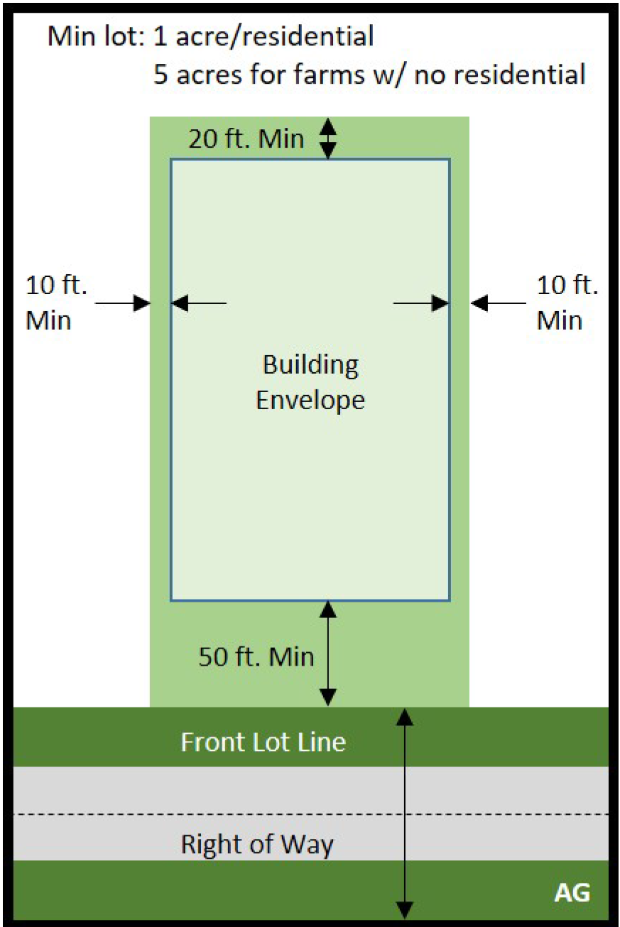
Development standards.
a.
Minimum lot area:
(i)
Residential with individual sewer systems: 1 acre.
(ii)
Farm without residential uses: 5 acres.
b.
Minimum lot width: N/A.
c.
Minimum lot depth: N/A.
d.
Maximum building coverage: 5% of total lot area.
e.
Maximum impervious area: 5% of total lot area.
f.
Setbacks:
(i)
Minimum front yard: 50 feet.
(ii)
Minimum rear yard: 20 feet*.
(iii)
Minimum side yard: 10 feet*.
g.
Maximum building height: 35 feet*.
* Farm structures exempted.
Section 11-03-06. - AP Airport Overlay District.
1.
Intent. The Airport Overlay District is designed to provide for airports, heliports, and landing areas for other types of aircraft.
2.
Permitted principal uses.
a.
Any principal permitted use in the primary zone to which the AP-Airport overlay district classification is applied.
b.
Activities and purposes compatible with normal airport operations, including landing and takeoff of aircraft, including airplanes, helicopters, and other types of aircraft. These provisions shall apply to private, commercial and all other types of ownership.
3.
Permitted accessory uses.
a.
Any permitted accessory use allowed in the primary zone to which the AP-Airport Overlay District classification is applied.
b.
Facilities accessory to the normal and continual operation of a landing field, but not to include general repair depots and other commercial and industrial operations not normally found at all such landing fields unless permitted in the primary zone.
4.
Conditional uses. Same as underlying zoning district(s).
5.
Space limits Airport Overlay District. Same as underlying zoning district(s).
6.
Procedure Airport Zone. When a property owner wishes to develop a landing field he may apply for a zoning change to the AP-Airport Overlay District. Said zoning change shall be an amendment to the zoning map and shall follow all procedural requirements for such changes set forth herein.
Section 11-03-07. - AZ Aviation Safety Zone Overlay District.
1.
Description. The Aviation Safety Zone Overlay District is an overlay district consisting of three separate protection zones, known as: the Runway Protection Zone (RPZ) - Safety Zone 1, Inner Approach/Departure Corridors - Safety Zone 2, and Inner Turning Area - Safety Zone 3 as shown on the Safety Compatibility Zones map of the City of Valley City. The official map shall be on file at City Hall.
2.
Purpose and intent. The purpose of the Aviation Safety Zone Overlay District is to minimize potential risk for endangering the lives and property of users of the Barnes County Municipal Airport, and property or occupants of land in its vicinity. The City of Valley City recognizes that to promote the health, safety, and general welfare of the community, certain uses and building heights are incompatible within specified proximities of Barnes County Municipal Airport.
3.
Safety Zone 1. Safety Zone 1 is comprised of the Runway Protection Zones for each of Barnes County Municipal Airport's two runways.
a.
Permitted uses:
(i)
Aviation related structures, aviation-related services, and support facilities provided there are no assemblages of people for any purpose or duration of time.
(ii)
Other structures set by aeronautical function.
b.
Accessory uses: Accessory uses and structures customarily incidental to permitted uses.
c.
Prohibited uses:
(i)
All uses and structures not specifically permitted or not permitted by conditional use shall be prohibited in Safety Zone 1.
(ii)
No assemblages of people for any purpose or duration of time shall be permitted in Safety Zone 1.
4.
Safety Zone 2. Safety Zone 2 encompasses the runways and inner approach and departure corridors.
a.
Uses permitted in Safety Zone 2 include those permitted in the underlying district which each respective parcel is located as listed in Section 11-03-07(3) subject to:
(i)
Structures are located the maximum distance from extended runway centerlines.
(ii)
No critical community infrastructure facilities are placed in Safety Zone 2.
(iii)
Avigation easement dedication.
b.
Accessory uses and structures customarily incidental to permitted uses.
c.
Prohibited uses:
(i)
Children's schools, day care centers, libraries.
(ii)
Nursing homes, hospitals, hospices.
(iii)
Churches, religious institutions and places of worship.
(iv)
Hazardous materials storage.
(v)
Hazards to flight.
(vi)
Highly noise sensitive outdoor uses.
(vii)
Above ground bulk storage of hazardous materials.
d.
Space limits:
(i)
Further subdivision in underlying Agricultural Districts shall be prohibited.
(ii)
Residential subdivision in all other underlying districts shall be limited to one dwelling unit per ten acres.
5.
Safety Zone 3. Safety Zone 3 encompasses the inner turning areas where small aircraft turn either inward toward the runway and descend for landing or outward from the runway on takeoff as they begin to climb to pattern altitude or enroute to cruise altitude.
a.
Permitted special uses: Uses permitted in Safety Zone 3 include those permitted in the underlying district which each respective parcel is located except as listed under Prohibited Uses subject to:
(i)
No critical community infrastructure facilities are placed in Safety Zone 3.
(ii)
Avigation easement dedication.
b.
Accessory uses: Accessory uses and structures customarily incidental to permitted uses.
c.
Prohibited uses:
(i)
Children's schools, day care centers, libraries.
(ii)
Nursing homes, churches, hospitals.
(iii)
Hazardous materials storage.
(iv)
Hazards to flight.
(v)
Highly noise sensitive outdoor uses.
(vi)
Above ground bulk storage of hazardous materials.
d.
Space limits:
(i)
Further subdivision in underlying Agricultural Districts shall be prohibited.
(ii)
Residential subdivision in all other underlying districts shall be limited to one dwelling unit per two acres.
6.
Height restrictions. Notwithstanding height restrictions specified for any specific zone set forth herein, no building, structure, vegetation, or use of land shall be constructed or permitted to grow to a height exceeding limits indicated on the zoning district maps entitled "Airport Approach and Turning Zone" which are a part of this Ordinance, or may hereafter be adopted as a part of this Ordinance.
Section 11-03-08. - R-1 Single-Family Residential District.
1.
Intent. This district is intended to provide for single-family residential uses and certain compatible nonresidential uses.
2.
Permitted uses.
a.
Accessory uses customarily incidental to these permitted uses.
b.
Churches or similar places of worship.
c.
Elementary schools, junior high schools, high schools.
d.
Essential services.
e.
Government uses except those customarily considered industrial.
f.
Public parks and playgrounds.
g.
Single-family detached (excluding mobile homes).
h.
Wind generation structures, in compliance with title 15, public works.
i.
Foster care for adults.
j.
Group homes with six or fewer individuals.
3.
Conditional uses.
a.
Bed and breakfast.
b.
Boarding house.
c.
Country clubs and golf courses.
d.
Day care—Adult and child.
e.
Family day care.
f.
Guest inn.
g.
Home occupations.
h.
Temporary use of residential home as sales and construction office.
i.
Wireless communication facilities.
j.
Other uses of the same general character to those listed above, provided they are deemed fitting or compatible with this zoning district by the Planning and Zoning Commission.
4.
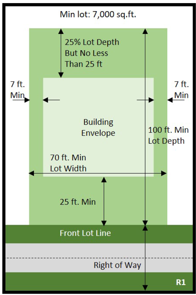
Development standards.
a.
Minimum lot area: 7,000 square feet.
b.
Minimum lot width: 70 feet.
c.
Minimum lot depth: 100 feet.
d.
Maximum building coverage: 30% of total lot area.
e.
Maximum impervious area: 40% of total lot area.
f.
Setbacks:
(i)
Minimum front yard: 25 feet.
(ii)
Minimum rear yard: 25 feet.
(iii)
Minimum side yard: 7 feet.
g.
Maximum building height: 35 feet.
(Ord. No. 1121, § 1, 12-6-2022; Ord. No. 1128, § 4, 5-2-2023; Ord. No. 1137, § 3, 8-1-2023)
Section 11-03-09. - R-2 Two-Family Residential District.
1.
Intent. This district is intended to provide for single-family and two-family residential uses and certain compatible nonresidential uses. The purpose of this district is to allow a density of housing opportunities with related development where public utilities are or may be made available.
2.
Permitted uses.
a.
Accessory uses customarily incidental to these permitted uses.
b.
Churches or similar places of worship.
c.
Duplex.
d.
Elementary schools, junior high schools, high schools.
e.
Essential services.
f.
Government uses except those customarily considered industrial.
g.
Public parks and playgrounds.
h.
Single-family attached (limited to two units).
i.
Single-family detached (excluding mobile homes).
j.
Wind generation structures, in compliance with Title 15, Public Works.
k.
Group homes with eight or fewer individuals
3.
Conditional uses.
a.
Bed and breakfast.
b.
Boarding house.
c.
Country clubs and golf courses.
d.
Day care—Adult and child.
e.
Family day care.
f.
Guest inn.
g.
Home occupations.
h.
Temporary use of residential home as sales and construction office.
i.
Wireless communication facilities.
j.
Other uses of the same general character to those listed above, provided they are deemed fitting or compatible with this zoning district by the Planning and Zoning Commission.
4.
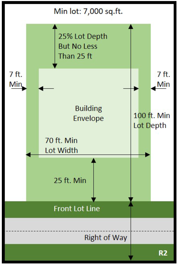
Development standards.
a.
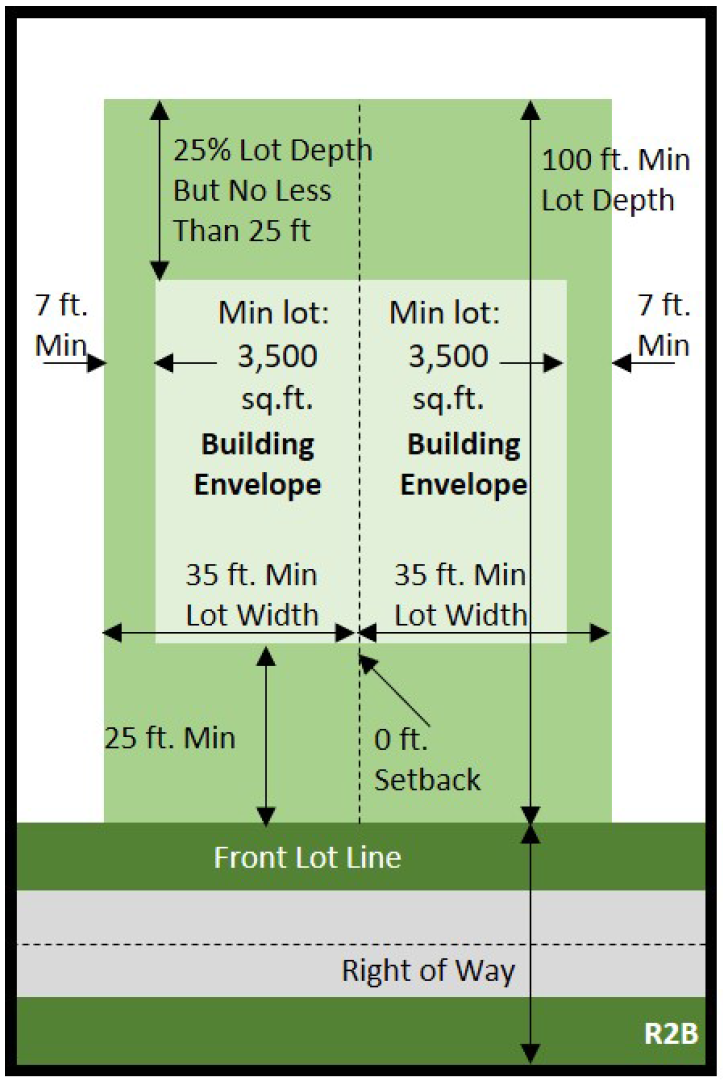
Minimum lot area:
(i)
Single-family attached: 3,500 square feet per unit.
(ii)
All other permitted uses: 7,000 square feet.
b.
Minimum lot width:
(i)
Single-family attached: 35 feet per unit.
(ii)
All other permitted uses: 70 feet.
(iii)
Platted lots in existing plats: 50 feet.
c.
Minimum lot depth: 100 feet.
d.
Maximum building coverage:
(i)
Single-family attached: 35% of total lot area.
(ii)
Two-family: 35% of total lot area.
(iii)
All other permitted uses: 30% of total lot area.
e.
Maximum impervious area:
(i)
Single-family attached: 45% of total lot area.
(ii)
Two-family: 45% of total lot area.
(iii)
All other permitted uses: 40% of total lot area.
f.
Minimum front yard: 25 feet.
g.
Minimum rear yard: 25 feet.
h.
Minimum side yard:
(i)
Single-family attached: 7 feet and 0 feet for internal lot line(s).
(ii)
All other permitted uses: 7 feet.
i.
Maximum building height: 35 feet.
(Ord. No. 1121, § 2, 12-6-2022; Ord. No. 1128, § 5, 5-2-2023; Ord. No. 1137, § 4, 8-1-2023)
Section 11-03-10. - R-3 Mobile Home District.
1.
Intent. The intent of this district is to provide an area for the installation of mobile homes, the development of mobile home parks, and other compatible uses.
2.
Permitted uses.
a.
Accessory uses customarily incidental to these permitted uses.
b.
Churches or similar places of worship.
c.
Single-family detached.
d.
Duplex.
e.
Elementary schools, junior high schools, high schools.
f.
Essential services.
g.
Government uses except those customarily considered industrial.
h.
Mobile home parks.
i.
Mobile homes.
j.
Public parks and playgrounds.
k.
Wind generation structures, in compliance with Title 15, Public Works.
3.
Conditional uses.
a.
Bed and breakfast.
b.
Boarding house.
c.
Country clubs and golf courses.
d.
Day care—Adult and child.
e.
Guest inn.
f.
Home occupations.
g.
Temporary use of residential home as sales and construction office.
h.
Wireless communication facilities.
i.
Other uses of the same general character to those listed above, provided they are deemed fitting or compatible with this zoning district by the Planning and Zoning Commission.
4.
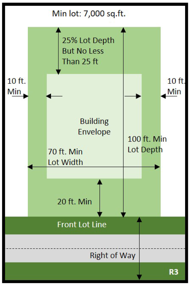
Development standards.
a.
Minimum lot area: 7,000 square feet.
b.
Minimum lot width: 70 feet*.
*Platted lots in existing plats: 50 feet.
c.
Minimum lot depth: 100 feet.
d.
Maximum building coverage: 35% of total lot area.
e.
Maximum impervious area: 45% of total lot area.
f.
Minimum front yard: 20 feet.
g.
Minimum rear yard: 25 feet.
h.
Minimum side yard: 10 feet.
i.
Maximum building height: 35 feet.
5.
Mobile home park standards. The provisions of chapter 8-07 and section 11-05-11 shall apply to all mobile home parks. Only mobile homes along with their additions and accessory structures, park service buildings, parks and playgrounds shall be permitted uses within a mobile home park. A modular home or other similar structure constructed in accordance with the North Dakota Building Code, as adopted in section 7-01-06, and attached to a permanent foundation is not permitted in a mobile home park.
6.
Mobile home standards. All mobile homes shall be constructed and installed in accordance with N.D.C.C. § 54-21.3-08; N.D. Admin. Code Ch. 108-03-01 (North Dakota Manufactured Home Installation Program); and 42 U.S.C. 5401 et seq., including 24 CFR Part 3280 (Federal Manufactured Home Construction and Safety Standards) and 24 CFR Part 3286 (Federal Manufactured Home Installation Program), all as amended; or shall be constructed and installed in accordance with section 7-01-06. The following local standards shall apply:
a.
Mobile home construction standards. No mobile home shall be permitted in the city unless it has been manufactured in accordance with 24 CFR Part 3280, and bears a HUD certification label from the manufacturer, or is constructed in accordance with section 7-01-06. A mobile home installed in or otherwise moved to the city on or before January 1, 2025, that was not manufactured or constructed in accordance with this paragraph, may continue to be maintained as a nonconforming structure; however, all other provisions of this code shall apply.
b.
Mobile home installation standards. All HUD-built mobile homes installed on or after January 1, 2006, shall be installed and inspected by individuals licensed by the State of North Dakota in accordance with regulations referenced in this section. Unless attached to a permanent foundation, a mobile home shall be placed on piers (blocked), leveled, and anchored against winds and floods.
c.
Age of mobile homes. No mobile home shall be moved to the city unless it was manufactured within the 30-year period immediately preceding the move.
d.
Drainage. All mobile home lots shall provide site drainage that meets or exceeds installation regulations referenced in this section.
e.
Skirting. Unless attached to a permanent foundation, a mobile home shall have skirting and a ground vapor barrier that meets or exceeds the installation regulations referenced in this section.
(Ord. No. 1121, § 3, 12-6-2022; Ord. No. 1128, § 6, 5-2-2023; Ord. No. 1172, § 3, 7-17-2025)
Section 11-03-11. - R-4 Multi-Family Residential District.
1.
Intent. This district is intended to provide for higher density, two-family, multiple-family residential uses and certain compatible nonresidential uses. The purpose of this district is to allow greater densities of residential and related development.
2.
Permitted uses.
a.
Accessory uses customarily incidental to these permitted uses.
b.
Bed and breakfast.
c.
Boarding house.
d.
Churches or similar places of worship.
e.
Clubs and lodges.
f.
Duplex.
g.
Elementary schools, junior high schools, high schools.
h.
Essential services.
i.
Local government uses including those customarily considered industrial.
j.
Guest inn.
k.
Multi-family.
l.
Public parks and playgrounds.
m.
Single-family attached.
l.
Single-family detached (excluding mobile homes).
o.
Wind generation structures, in compliance with title 15, public works.
p.
Group homes with eight or fewer individuals.
3.
Conditional uses.
a.
Assisted living facilities.
b.
Country clubs and golf courses.
c.
Day care—Adult and child.
d.
Home occupations.
e.
Hospice.
f.
Hospitals and urgent care facilities.
g.
Temporary use of residential home as sales and construction office.
h.
Wireless communication facilities.
i.
Other uses of the same general character to those listed above, provided they are deemed fitting or compatible with this zoning district by the Planning and Zoning Commission.
4.
Development standards.
a.
Minimum lot area for multi-family buildings:
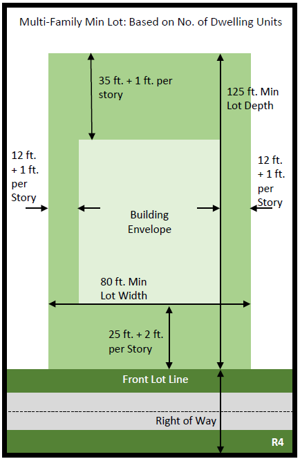
For all multi-family buildings with more than 24 dwelling units, the required area per unit shall be based on two or more bedrooms per unit. The required lot area for the given number of dwelling units may be reduced by 250 square feet per one bedroom or efficiency dwelling unit.
For all proposed multi-family buildings with more than 42 units, an applicant must submit a traffic study that considers the impact of the development on increased congestion and carrying capacity of abutting infrastructure.
b.
Minimum lot area for other uses:
(i)
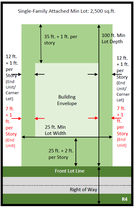
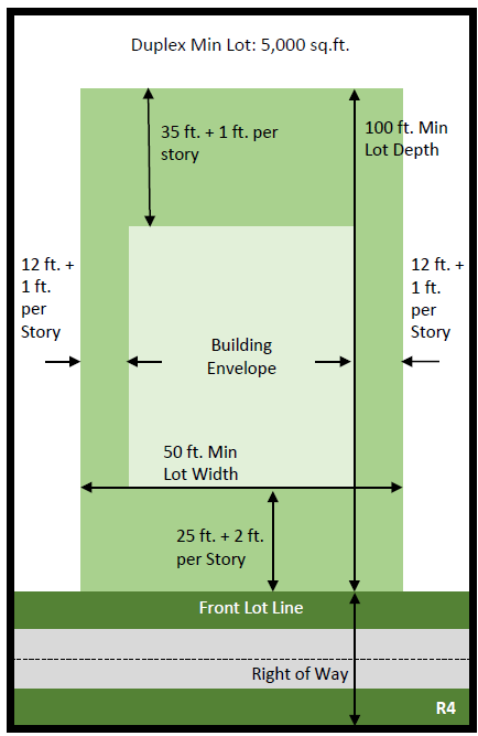
Single-family attached: 2,500 square feet per unit.
(ii)
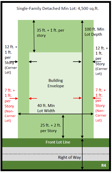
Single-family detached: 4,500 square feet per unit.
(iii)
Duplex: 5,000 square feet per unit.
(iv)
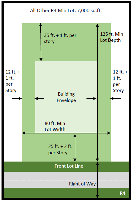
All other uses: 7,000 square feet.
c.
Minimum lot width:
(i)
Multi-family: 80 feet.
(ii)
Single-family attached: 25 feet.
(iii)
Single-family detached: 40 feet.
(iv)
Duplex: 50 feet.
(v)
All other uses: 80 feet.
d.
Minimum lot depth:
(i)
Multi-family: 125 feet.
(ii)
Single-family attached: 100 feet.
(iii)
Single-family detached: 100 feet.
(iv)
Duplex: 100 feet.
(v)
All other uses: 125 feet.
e.
Maximum building coverage: 40 percent of total lot area.
f.
Maximum impervious area:
(i)
Building with 12 units or less: 55 percent of total lot area.
(ii)
Building with more than 12 units: 65 percent of total lot area.
g.
Minimum front yard: 25 feet + 2 feet per story.
h.
Minimum rear yard: 35 feet + 1 foot per story.
i.
Minimum side yard:
(i)
Multi-family uses: 12 feet + 1 foot per story.
(ii)
Single-family attached - End units: 7 feet + 1 per story, except that corner lots shall have a minimum side yard of 12 feet + 1 foot per story.
(iii)
Single-family attached - Interior: 0 foot setback.
(iv)
Single-family detached - 7 feet + 1 per story, except that corner lots shall have a minimum side yard of 12 feet + 1 foot per story.
(v)
All other uses: 12 feet + 1 foot per story.
k.
Distance between buildings on the same lot. No principal building shall be closer to any other principal building than the average of the heights of said buildings unless it meets IFC Code.
l.
Maximum building height 40 feet*.
(*Except an increased height may be permitted under conditions imposed by the City Commission.)
(Ord. No. 1088, § 1, 10-5-2021)
(Ord. No. 1128, § 7, 5-2-2023; Ord. No. 1137, § 5, 8-1-2023)
Section 11-03-12. - B-1 Central Business District.
1.
Intent. This district is intended to preserve and enhance the Valley City downtown as the center for office employment, shopping, financial and cultural activities.
2.
Permitted uses.
a.
Accessory uses customarily incidental to these permitted uses.
b.
Assisted living facilities.
c.
Banks and financial establishments.
d.
Bar and cocktail lounge.
e.
Business, commercial or trades schools.
f.
Churches or similar places of worship.
g.
Clubs and lodges.
h.
Convenience food and beverage.
i.
Day care—Adult and child.
j.
Entertainment facilities.
k.
Essential services.
l.
Funeral home, no cremation.
m.
Government uses except those customarily considered industrial.
n.
Grocery store.
o.
Guest inn.
p.
Hospitals, urgent care facilities and outpatient surgery facilities.
q.
Hotel/motel.
r.
Multi-family use.
s.
Personal service establishments.
t.
Pet grooming and boarding facilities.
u.
Professional and business offices accessory to industrial uses.
v.
Professional, medical and business offices.
w.
Public parks and playgrounds.
x.
Recreational facilities.
y.
Research and development facilities.
z.
Restaurants excluding drive-in establishments.
aa.
Retail sales.
bb.
Sales or leasing of consumer vehicles including passenger vehicles, motorcycles, light and medium trucks and recreational vehicles.
cc.
Wind generation structures, in compliance with Title 15, Public Works.
3.
Conditional uses.
a.
Automobile parking garage.
b.
Funeral home with cremation.
c.
Manufacturing assembly from previously prepared materials.
d.
Allowing assembly from previously prepared or manufactured products, including food, plastic, electronics, and metal products including sub-assemblies.
e.
Supermarket.
f.
Temporary uses.
g.
Variety store.
h.
Wireless communication facilities.
i.
Other uses of the same general character to those listed above, provided they are deemed fitting or compatible with this zoning district by the Planning and Zoning Commission.
4.
Development standards.
a.
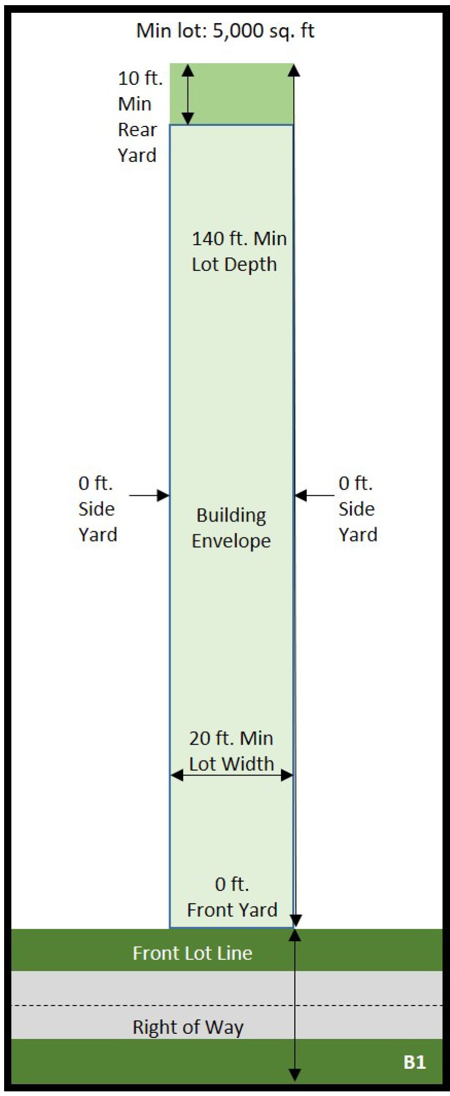
Minimum lot area: 5,000 square feet.
b.
Minimum lot width: 20 feet.
c.
Minimum lot depth: 140 feet.
d.
Maximum building coverage: N/A.
e.
Maximum impervious area: N/A.
f.
Residential open space. A usable open space equivalent to ten percent of the total lot area shall be provided for all residential dwelling units. Patio and deck space and enclosed court yards shall be considered as usable open space.
g.
Setbacks:
(i)
Minimum front yard: 0 feet.
(ii)
Minimum rear yard: 10 feet.
(iii)
Minimum side yard: 0 feet*.
(*A fire wall must be built when a structure is built within five feet of the property line and a 15-foot side yard is required when abutting a residential district.)
h.
Maximum building height: 50 feet**.
(**Except an increased height may be permitted under conditions imposed by the City Commission.)
Section 11-03-13. - B-2 Highway Business District.
1.
Intent. This district is intended to provide a B-2 Highway Business District for uses appropriate to the major street locations, which are largely dependent upon auto and truck traffic and are not generally suitable within the Central Business District.
2.
Permitted uses.
a.
Accessory uses customarily incidental to these permitted uses.
b.
Agriculture equipment sales and service.
c.
Allowing assembly from previously prepared or manufactured products, including food, plastic, electronics, and metal products including sub-assemblies.
d.
Automobile parking garage.
e.
Automobile service stations.
f.
Banks and financial establishments.
g.
Bar and cocktail lounge.
h.
Building material sales, lumberyards.
i.
Business, commercial or trades schools.
j.
Car wash.
k.
Churches or similar places of worship.
l.
Clubs and lodges.
m.
Contractors yards.
n.
Convenience food and beverage.
o.
Day care—Adult and child.
p.
Department store.
q.
Entertainment facilities.
r.
Essential services.
s.
Funeral home, with cremation.
t.
Funeral home without cremation.
u.
Furniture and appliance stores.
v.
Government uses except those customarily considered industrial.
w.
Grocery store.
x.
Hospitals, urgent care facilities and outpatient surgery facilities.
y.
Hotel/motel.
z.
Manufacturing, assembly from previously prepared materials.
aa.
Personal service establishments.
bb.
Pet grooming and boarding facilities.
cc.
Private ambulance or car rental services.
dd.
Professional and business offices accessory to industrial uses.
ee.
Professional, medical and business offices.
ff.
Recreational vehicle park.
gg.
Research and development facilities.
hh.
Restaurants including drive-in establishments.
ii.
Restaurants excluding drive-in establishments.
jj.
Retail sales.
kk.
Sales and storage of building materials.
ll.
Sales or leasing of consumer vehicles including passenger vehicles, motorcycles, light and medium trucks and recreational vehicles.
mm.
Self-service storage.
nn.
Supermarket.
oo.
Variety store.
pp.
Veterinary services.
qq.
Wholesale trade and warehouse uses.
rr.
Wind generation structures, in compliance with Title 15, Public Works.
3.
Conditional uses.
a.
Adult entertainment center.
b.
Bulk petroleum, gas, or chemicals storage.
c.
Chemical use, storage, and manufacturing.
d.
Temporary uses.
e.
Heavy equipment repair.
f.
Heavy equipment service stations.
g.
Wireless communication facilities.
h.
Other uses of the same general character to those listed above, provided they are deemed fitting or compatible with this zoning district by the Planning and Zoning Commission.
4.
Development standards.
a.
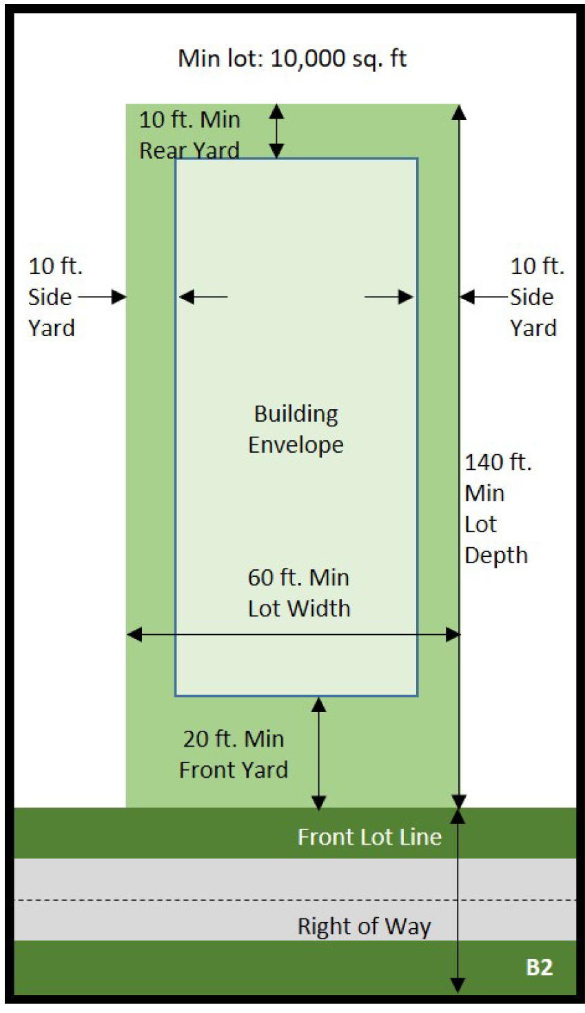
Minimum lot area: 10,000 square feet.
b.
Minimum lot width: 60 feet.
c.
Minimum lot depth: 140 feet.
d.
Maximum building coverage: 60% of total lot area.
e.
Maximum impervious area: 90% of total lot area.
f.
Setbacks:
(i)
Minimum front yard: 20 feet.
(ii)
Minimum rear yard: 10 feet.
(iii)
Minimum side yard: 10 feet*.
(*A fire wall must be built when a structure is built within five feet of the property line and a 15-foot side yard is required when abutting a residential district.)
g.
Maximum building height: 35 feet.
(**Except an increased height may be permitted under conditions imposed by the City Commission.)
Section 11-03-14. - I-1 Light Industrial District.
1.
Intent. This district is intended to provide locations within the city for light manufacturing, storage and other related activities and facilities, which will not create hazards, offensive or loud noises, excessive vibration, smoke or glare.
2.
Permitted uses.
a.
Accessory uses customarily incidental to these permitted uses.
b.
Agriculture equipment sales and service.
c.
Allowing assembly from previously prepared or manufactured products, including food, plastic, electronics, and metal products including sub-assemblies.
d.
Automobile service stations.
e.
Body shops and wrecker services, including storage yards.
f.
Building material sales, lumberyards.
g.
Cleaning and maintenance services.
h.
Contractors yards.
i.
Essential services including storage yards.
j.
Government uses including those customarily considered industrial.
k.
Heavy equipment repair.
l.
Heavy equipment service stations.
m.
Industrial plants.
n.
Laboratories.
o.
Landscaping, snowplowing and lawn service.
p.
Manufacturing, appliance.
q.
Manufacturing, assembly from previously prepared materials.
r.
Manufacturing, light sheet metal products.
s.
Manufacturing, novelties, toys and signs.
t.
Open storage yards.
u.
Private ambulance or car rental services.
v.
Professional and business offices accessory to industrial uses.
w.
Professional, medical, and business offices.
x.
Research and development facilities.
y.
Sales and storage of building materials.
z.
Self-service storage.
aa.
Trade or industrial schools.
bb.
Veterinary services.
cc.
Wholesale trade and warehouse uses.
dd.
Wind generation structures, in compliance with Title 15, Public Works.
3.
Conditional uses.
a.
Bulk petroleum or gas storage.
b.
Chemical use, storage, and manufacturing.
c.
Excavation and processing of mineral resources.
d.
Metal working shops.
e.
Temporary uses.
f.
Tool and die.
g.
Truck and freight terminals, and maintenance facilities.
h.
Wireless communication facilities.
i.
Other uses of the same general character to those listed above, provided they are deemed fitting or compatible with this zoning district by the Planning and Zoning Commission.
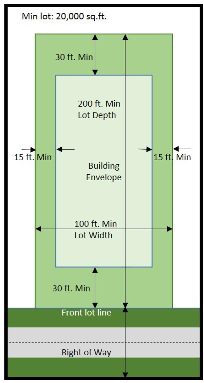
4.
Development standards.
a.
Minimum lot area: 20,000 square feet.
b.
Minimum lot width: 100 feet.
c.
Minimum lot depth: 150 feet.
d.
Maximum building coverage: 70% of total lot area.
e.
Maximum impervious area: 85% of total lot area.
f.
Minimum front yard: 20 feet.
g.
Minimum rear yard: 15 feet.
h.
Minimum side yard: 10 feet.
i.
Maximum building height: 35 feet**.
(**Except an increased height may be permitted under conditions imposed by the City Commission.)
Section 11-03-15. - I-2 General Industrial District.
1.
Intent. This district is intended to provide industrial locations within the city and to protect manufacturing and industrial operations from encroachment by lower intensity, incompatible uses.
2.
Permitted uses.
a.
Accessory uses customarily incidental to these permitted uses.
b.
Agriculture equipment sales and service.
c.
Body shops and wrecker services, including storage yards.
d.
Allowing assembly from previously prepared or manufactured products, including food, plastic, electronics, and metal products including sub-assemblies.
e.
Bottling works.
f.
Building material sales, lumberyards.
g.
Bulk petroleum or gas storage.
h.
Cleaning and maintenance services.
i.
Contractors yards.
j.
Essential services including storage yards.
k.
Government uses including those customarily considered industrial.
l.
Heavy equipment repair.
m.
Heavy equipment service stations.
n.
Industrial plants.
o.
Laboratories.
p.
Landscaping, snowplowing and lawn service.
q.
Manufacturing, appliance.
r.
Manufacturing, assembly from previously prepared materials.
s.
Manufacturing, light sheet metal products.
t.
Manufacturing, novelties, toys and signs.
u.
Metal working shops.
v.
Open storage yards.
w.
Private ambulance or car rental services.
x.
Professional and business offices accessory to industrial uses.
y.
Research and development facilities.
z.
Sales and storage of building materials.
aa.
Self-service storage.
bb.
Tool and die.
cc.
Trade or industrial schools.
dd.
Truck and freight terminals, and maintenance facilities.
ee.
Wholesale trade and warehouse uses.
ff.
Wind generation structures, in compliance with Title 15, Public Works.
3.
Conditional uses.
a.
Chemical use, storage, and manufacturing.
b.
Excavation and processing of mineral resources.
c.
Manufacturing, food products manufacturing including slaughtering, smoking or curing.
d.
Recycling and salvage yards.
e.
Temporary uses.
f.
Wireless communication facilities.
g.
Other uses of the same general character to those listed above, provided they are deemed fitting or compatible with this zoning district by the Planning and Zoning Commission.
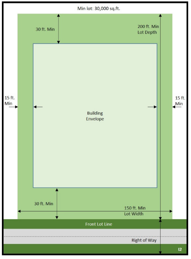
4.
Development standards.
a.
Minimum lot area: 30,000 square feet.
b.
Minimum lot width: 150 feet.
c.
Minimum lot depth: 200 feet.
d.
Maximum building coverage: 85% of total lot area.
e.
Maximum impervious area: 100% of total lot area.
f.
Minimum front yard: 30 feet.
g.
Minimum rear yard: 30 feet.
h.
Minimum side yard: 15 feet.
i.
Maximum building height: 65 feet**.
(**Except an increased height may be permitted under conditions imposed by the City Commission.)
Section 11-03-16. - Open Space District.
1.
Intent. This district is established to conserve existing open space, to protect the flood plain, and to preserve natural growth in order to stabilize steep slopes, to assist aquifer recharge, to cool adjacent residential neighborhoods on hot summer days and to provide a wildlife habitat in close proximity to children.
2.
Permitted uses.
a.
Farms.
b.
Parks, playgrounds, golf courses, forest preserve and other public recreation space.
c.
Greenhouses and nurseries.
d.
Other uses of the same general character to those listed above, provided they are deemed fitting or compatible with this zoning district by the Planning and Zoning Commission.
3.
Development standards.
a.
Minimum lot area: 30,000 square feet.
b.
Minimum lot width: 150 feet.
c.
Minimum lot depth: 200 feet.
d.
Maximum impervious area: 5% of total lot area.
e.
Minimum front yard: 30 feet.
f.
Minimum rear yard: 30 feet.
g.
Minimum side yard: 15% of lot width.
h.
Maximum building height: 35 feet.
Section 11-03-17. - Floodway and Floodplain Overlay Districts.
1.
Intent. The Floodway and Floodplain Use Overlay Districts are sets of regulations superimposed upon the existing zoning districts, superseding existing underlying regulations only to the extent expressed in the floodplain provisions and having in effect, in all other respects, the regulations applicable in the underlying use district in which the land is situated. There are two designations: FW Floodway and FP Floodplain. The purpose and intent of this section as follows:
a.
Prevent development in flood-prone areas that is incompatible with land subject to frequent periodic inundation.
b.
Prevent loss of life, loss of property, health and safety hazards, disruption of commerce and governmental services, extraordinary public expenditures for flood protection and relief, and impairment of the tax base, all of which adversely affect the public health, safety and general welfare.
2.
General provisions. This section shall apply to all lands within the zoning and subdivision jurisdiction of the City of Valley City shown on the City of Valley City zoning map as FW Floodway and FP Floodplain Overlay District designation.
a.
Compliance. No structure or land shall hereafter be used and no structure shall be located, extended, converted or structurally altered without full compliance with the terms of this section and other applicable regulations.
b.
Abrogation and greater restrictions. It is not the intent of this section to repeal, abrogate or impair any existing deed restrictions, existing Zoning Ordinance or other city regulations; however, where this section imposes greater restrictions, the provisions of this section shall prevail. All other ordinances inconsistent with this section are hereby repealed to the extent of this inconsistency only.
c.
Interpretation. In interpretation and application, the provisions of this section shall be held to be minimum requirements and shall be liberally construed in favor of the City of Valley City and shall not be deemed a limitation or repeal of any other powers granted by the North Dakota Statutes.
d.
Warning and disclaimer of liability. This section does not imply that areas outside the floodplain districts or land uses permitted within such districts will be free from flooding or flood damage. This section does not create liability on the part of the City of Valley City or any officer or employee thereof for any flood damages that result from reliance on this section or any administrative decision lawfully made hereunder.
e.
Severability. If any section, clause, provision or portion of this section is adjudged unconstitutional or invalid by a court of competent jurisdiction, the remainder of this section shall not be affected thereby.
3.
FW Floodway Overlay District.
a.
Underlying use district permitted uses and structures. Underlying permitted uses shall be considered conditional uses within the "FW" District. Open space uses are permitted unconditionally. Underlying permitted use structures shall be prohibited in the Floodway as provided in section 11-03-17(3)(b).
b.
Floodway obstructions. No structure, fence, fill, or excavation shall be made in a designated FW which may impede, retard, or change the direction of the flow of water either by itself or by catching or collecting debris, unless a permit to construct and maintain such obstruction has been obtained from the Floodplain Administrator.
4.
FP Floodplain Overlay District.
a.
Fill or the deposition of materials in the FP Floodplain Overlay District shall have some beneficial purpose as determined by the Floodplain Administrator and the amount thereof will not be greater than necessary to achieve that purpose, as demonstrated by a plan, submitted by the owner, showing the final dimensions and elevations of the proposed fill, the use to which the filled land will be put. Said fill or other materials will be protected against erosion by rip-rap, suitable vegetative cover or a bulk-head structure. Fill material shall be approved by the City Engineer.
b.
Fill or the deposition of materials in the FP District shall have some beneficial purpose as determined by the Floodplain Administrator and the amount thereof will not be greater than necessary to achieve that purpose, as demonstrated by a plan, submitted by the owner, showing the final dimensions and elevations of the proposed fill, the use to which the filled land will be put. Said fill or other materials will be protected against erosion by rip-rap, suitable vegetative cover or a bulk-head structure. Fill material shall be approved by the City Engineer.
5.
Engineer's report. Whenever the Floodplain Administrator is required to pass on matters within the FW District concerning protection of life and property from flood hazards, he shall request a report and recommendations thereon from the U.S. Corps of Engineers. If no such report and recommendations are obtainable from the Corps of Engineers within 60 days, the Floodplain Administrator shall request it from the City Engineer. Said report shall find that any proposed construction, filling, draining, construction of levees or other improvement will not materially impair the required capacity of the watercourse, said report shall be considered final and conclusive and the Building Inspector shall be bound thereby.
6.
Reclamation. Nothing herein shall be so construed as to prohibit, the lawful rehabilitation or reclamation of any lands outside of the floodway, provided, that no filling, draining, construction of levees or other improvements intended to eliminate or reduce the danger of flood or erosion shall be commenced until first reviewed and authorized by the Floodplain Administrator.
7.
Type of storage and equipment. Stored equipment, materials or wastes shall have a specific gravity substantially heavier than water, or shall be securely enclosed against floating away, shall not be a source of water pollution or contamination in case of flood, and shall not obstruct any existing or potential floodway.
8.
Right of passage. No person may obstruct the passage of waters and water-craft nor prevent the use by the public of the bed, banks, water and floodway of any stream, except properties holding riparian rights.
9.
Existing uses—Continuation. All uses legally existing in the flood plain districts at the time of adoption of this Zoning Ordinance may continue and shall not be classified as a nonconforming use except a) dwellings with any floor below the regional flood plain level, and b) all other uses which do not have adequate provisions for flood proofing, as determined by the Floodplain Administrator.
10.
New dwellings. All dwellings hereafter constructed in the flood plain shall have no first floor area below the regional flood plain level except areas devoted exclusively to vehicle storage. Basements of dwellings and all other uses shall have adequate provisions for flood proofing.
11.
Warning and disclaimer of liability. The degree of flood protection intended to be provided by this Zoning Ordinance is considered reasonable for regulatory purposes. Larger floods may occur on occasions or the flood height may be increased by manmade or natural causes, such as ice jams and bridge openings restricted by debris. This Zoning Ordinance does not imply that areas outside of designated flood plain districts or land uses permitted within such districts will always be totally free from flooding or flood damages. Nor shall this Zoning Ordinance create a liability on the part of, or a cause of action against the city or any employee thereof for any flooding or flood damages that may result from reliance on this Zoning Ordinance.
Section 11-03-18. - PUD Planned Unit Development.
1.
Intent. A PUD is planned and built as a unit thus fixing the type and location of uses and buildings over the entire project. It provides a more flexible means of land development and redevelopment than is otherwise permissible under the lot-by-lot restrictions of the other zoning districts. The intent of this district is as follows:
a.
To allow a planned and coordinated mix of land uses which are compatible and harmonious, but not permitted under conventional zoning procedures.
b.
To encourage a more creative and efficient utilization of land, a concentration of open space in more usable areas, and a preservation of the natural resources of the site.
c.
To provide the means for greater creativity and design flexibility than is provided under the strict application of the zoning and subdivision ordinances while at the same time preserving the health, safety, order, and general welfare of the city and its residents.
d.
To encourage the overall planning and designing of large land areas.
e.
To provide a better means of cooperation between the city and private developers in the urbanization of new lands and the renewal of areas of the city needing rehabilitation and redevelopment.
2.
Application. Planned Unit Development applies only to a tract of land for which an application for a Planned Unit Development project is made, as herein after provided and the tract of land is under the control of a) a single owner; or b) a group of land owners, acting through a corporation, where each owner agrees in advance to be bound by the conditions and regulations which will be effective within the district and to record such covenants, easements and other provisions with the County Registrar of Deeds.
a.
Designation. All approved Planned Unit Development districts shall be designated on the Official Zoning Map of the city and shall be numbered in sequence.
b.
Concept statement. The applicant shall submit a written statement and sketch to the Building Inspector for an approval in principle and the Planning and Zoning Commission shall so approve by identical resolution prior to the submission of a PUD district rezoning application. (The purpose of the concept statement is to inform the city of the applicant's intent and to afford the applicant an opinion whether or not his proposal may be acceptable before he invests in plans and studies.) The concept statement shall identify the boundaries and proposed type of PUD district and be in sufficient detail to identify specific land uses, population densities and building intensity; to suggest a compatible relationship with surrounding uses, proposed circulation patterns, proposed parks and other open space; and the tentative development schedule. Approval of the concept statement in writing by the city shall be limited to the general acceptability of the land uses proposed and their inter-relationships and shall not be construed to endorse precise location of uses, arrangement of structures or site improvements or the economic or engineering feasibility of the proposal. (The final acceptance of land uses are subject to the following procedures.)
c.
Preliminary plan—Initiation. After receiving approval of the concept statement, the applicant shall submit to the Building Inspector an application for a zoning amendment. The application shall be accompanied by a plan showing the location and dimensions of the area, the exact sizes and locations of existing and proposed buildings, the existing and proposed uses of structures and open areas, and information relating to topography, access, surrounding land uses and other matters, including documents showing ownership and a preliminary plat if requested by the Building Inspector. In the case of projects to be executed in increments, a schedule showing the time within which applications for approval of the various parts are intended to be filed shall also be attached. The application shall be accompanied by a fee obtained from the fee schedule to cover the costs of publication of notice of public hearing.
d.
Preliminary plan—Building Inspector. Upon receipt of the application and plan, the Building Inspector shall refer it to other departments and agencies for review as to compliance with pertinent city standards and regulations. Within 30 days the Building Inspector shall recommend to the Planning and Zoning Commission: a) approval of the proposal in the form submitted, or b) approval with modifications, or c) disapproval of the proposal. The recommendation of the Building Inspector shall include findings of fact and shall set forth the reasons for the recommendation specifying with particularity in what respects the plan would or would not be in the public interest, including but not limited to the following:
i)
The extent to which the plan departs from zoning and subdivision regulations otherwise applicable to the subject property, including but not limited to density, bulk and use, and the reasons why such departures are or are not deemed to be in the public interest.
ii)
The manner in which said plan does or does not make adequate provision for public services, provide adequate control over vehicular traffic, and further the amenities of light and air, recreation and visual enjoyment.
iii)
The nature and extent of open space, the reliability of the proposals for maintenance and conservation of the common open space, and the adequacy or inadequacy of the amount and function of the open space in terms of the densities proposed in the plan.
iv)
The relationship, beneficial or adverse, of the planned development project upon the neighborhood in which it is proposed to be.
v)
In the case of a plan which proposes development over a period of years, the sufficiency of the terms and conditions proposed to protect and maintain the integrity of the plan; which finding shall be made only after consultation with the City Attorney.
vi)
In built-up areas, the suitability of the proposed structures in relation to existing structures to remain and anticipated future development of the area.
e.
Preliminary plan—Planning and Zoning Commission. Within 30 days after receiving the Building Inspector's report, the Planning and Zoning Commission shall hold a public hearing on the application. Within 30 days after such hearing the Planning and Zoning Commission shall submit its recommendations to the City Commission. The Planning and Zoning Commission may recommend tentative approval in whole or in part, with or without modifications, or recommend disapproval.
f.
Preliminary plan—City Commission. The City Commission shall either grant tentative approval of the application, with or without modification, or deny such application.
g.
Final plan. Upon tentative approval of the preliminary plan, the applicant shall submit a) a final plan with required modifications and b) that portion of the final plat for the segment to be developed first, if required, to the Building Inspector within the time specified by the City Commission, but in any case not more than one year from the date of tentative approval or the tentative approval is void and the applicant must pay the fee and start the proceedings again.
3.
Approval.
a.
Final approval. If the Building Inspector finds the final plan and plat to be in substantial agreement with the actions of the Planning and Zoning Commission and City Commission, he shall submit the documents directly to the City Commission for final action; if not, he shall identify such discrepancies in a letter of transmittal to the City Commission. If the application is granted by the City Commission the area of land involved shall be re-designated as a Planned Unit Development district by ordinance and such ordinance shall incorporate the plan, including any conditions or restrictions that may be imposed by the City Commission.
b.
Effect of approval. The final plan as approved together with the conditions and restrictions imposed, shall constitute the zoning and subdivision regulations for the district; provided that regulations which were applicable to the land involved prior to approval of the plan and which are not inconsistent with the plan shall continue to be applicable.
c.
Certification. No building permit shall be issued for any structure within the district unless and until the Building Inspector certifies that it conforms to the provisions of the plan and other applicable zoning requirements.
d.
Review. The Building Inspector shall periodically review each Planned Unit Development and shall make a report to the City Commission on the status of the development in each PUD district. If the City Commission finds that the development has not occurred according to the established development schedule or is not otherwise reasonable in the view of the City Commission, the City Commission may initiate rezoning by removing the Planned Unit Development district. In any event, it shall not be necessary for the City Commission to find the rezoning to a PUD district was in error.
e.
Minor changes. Minor changes in the location, placement and height of structures may be authorized by the Building Inspector. Changes in use, the provision of open spaces and other major changes shall be made only after public hearing by the Planning and Zoning Commission and adoption by the City Commission. Any such changes shall be recorded as amendments to the recorded copy of the final development plan.
Section 11-03-19. - U University District.
1.
Intent. This district is intended to provide for the Valley City State University campus uses and related uses which are compatible with the adjacent residential neighborhoods. All district land must be contiguous to one of the two main campus areas.
2.
Permitted Uses.
a.
University campus buildings that are a part of city-approved master plan.
b.
University campus parking lots that are a part of city-approved master plan.
c.
University campus open space, outdoor sports and other university sponsored outdoor activity spaces that are a part of city-approved master plan.
d.
All campus buildings, parking lots, open space, outdoor sports and other university sponsored outdoor activity spaces existing as of October 1, 2024.
3.
Conditional Uses.
a.
New campus buildings, parking lots, open space, outdoor sports and other university sponsored outdoor activity spaces.
b.
Off-campus multi-family residential uses.
4.
Development Standards.
a.
Minimum lot area.
i.
Campus buildings must be on land that allows building setbacks with non-campus property lines to be met, but there is not a defined minimum lot area.
b.
Minimum lot width.
i.
Campus buildings must be on land that allows building setbacks with non-campus property lines to be met, but there is not a defined minimum lot width.
c.
Minimum lot depth.
i.
Campus buildings must be on land that allows building setbacks with non-campus property lines to be met, but there is not a defined minimum lot depth.
d.
Maximum building coverage.
i.
Campus uses: consistent with city-approved master plan or 50 percent of the land surrounding the building up to adjacent building lines.
e.
Maximum impervious area.
i.
Campus uses: consistent with city-approved master plan or 70 percent of the land surrounding the building up to adjacent building lines.
f.
Minimum front yard setback.
i.
Campus uses: consistent with city-approved master plan or not less than 20 feet.
g.
Minimum side yard setback.
i.
Campus uses: consistent with city-approved master plan or not less than ten feet.
h.
Minimum rear yard setback.
i.
Campus uses: consistent with city-approved master plan or not less than ten feet.
i.
Maximum height.
i.
Campus uses: consistent with city-approved master plan or not more than 75 feet.
5.
Master Plan Requirements.
a.
A city-approved master plan for Valley City State University must include all campus property within 1,000 feet of the site of proposed changes and 1,000 feet outside the campus measured from the nearest point to the site of proposed changes.
b.
If a campus wide master plan is approved by the city, amendments to the master plan need only address land within 600 feet of the site of proposed changes.
c.
Any master plan or master plan amendment shall address the following topics using graphics and text to describe the plan:
i.
Municipal and private roadways.
ii.
Anticipated traffic volume and parking demand.
iii.
Parking areas including on-street parking.
iv.
Sidewalks, walking or multi-use trails, and similar paths for non-motorized travel.
v.
Approximate building footprints, square footage, scale, and distance to other buildings and property lines.
vi.
Building uses.
vii.
Proposed utility service plan.
viii.
Conceptual landscape plan.
ix.
Lot lines and ownership of adjacent non-campus land.
x.
Approximate footprints and uses of existing buildings on adjacent non-campus land.
d.
A master plan shall be approved in the same manner as a conditional use permit:
i.
It requires a planning and zoning public hearing and notice to adjacent property owners.
ii.
It requires approval by the Board of City Commissioners.
iii.
Conditions of approval regarding the master plan may be stipulated.
(Ord. No. 1164, § 1, 11-6-2024)

