
Walterboro City Zoning Code
SECTION 2
7 - Overlay Districts
2.7.1 - Airport Overlay (A-O)
2.7.1.1 Zones Established
A.
In order to carry out the provisions of this Section, there are hereby established certain zones which include all of the areas of the city lying beneath the approach surfaces, transitional surfaces, horizontal surfaces and conical surfaces as they apply to Lowcountry Regional Airport. An area located in more than one (1) of the following zones is considered to be only in the zone with the most restrictive height limitation. These zones are as follows:
1.
Airport overlay. A zone that is centered about the runway and primary surface and is capped by the horizontal surface.
2.
Approach zone. A zone that extends away from the runway, ends along the extended runway centerline and is capped by the approach surfaces.
3.
Conical zone. A zone that circles around the periphery of and outward from the horizontal surface and is capped by the conical surface.
FIG. 2.3: AIRPORT OVERLAY ZONES ILLUSTRATION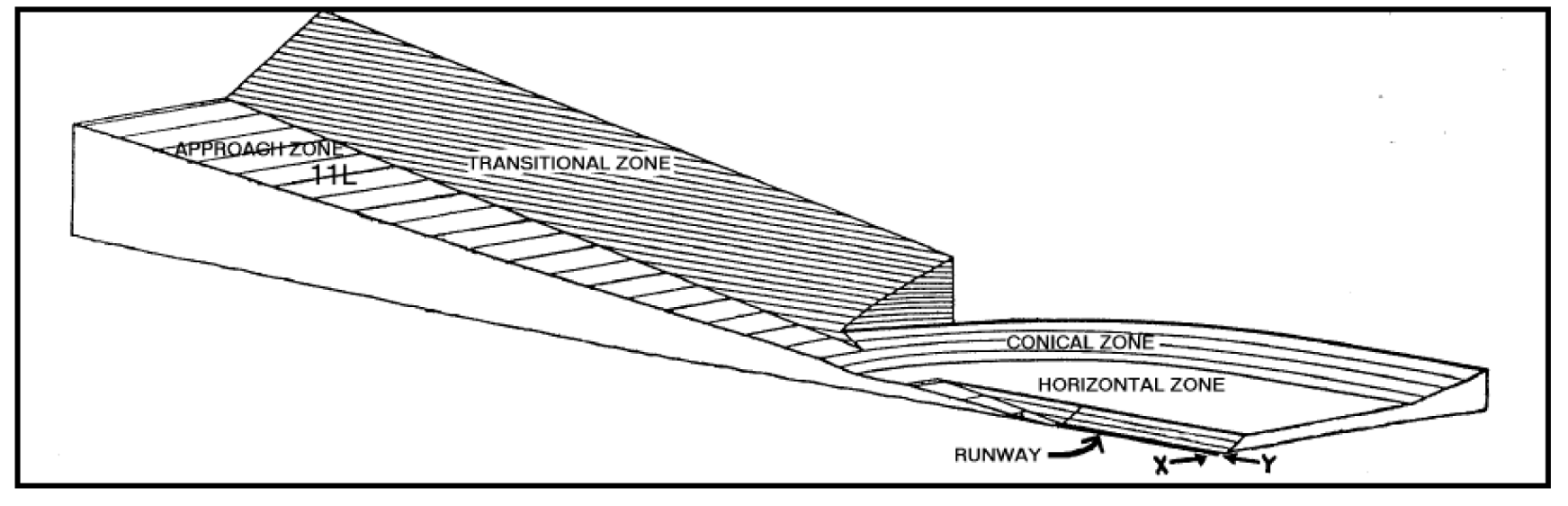
B.
Specific geometric standards for these zones are to be found in 14 C.F.R. §§ 77.21-77.25 (2010) or in successor federal regulations.
C.
The Airport Overlay District Map is adopted as an addendum to the Official Zoning Map and is indicated on the Walterboro-Colleton County Airport Commission Airspace Drawings as drawn by Pearson Engineering, dated August 2006.
Except as otherwise provided in this Section, in any zone created by this Section no structure shall be erected, altered or maintained, and no vegetation shall be allowed to grow to a height so as to penetrate any referenced surface of any zone provided for in Section 2.7.1.1 at any point. The height restrictions for the individual zones shall be those planes delineated as surfaces in 14 C.F.R. §§ 77.21-77.25 (2010), or in successor federal regulations.
Notwithstanding any other provision of this Section, within any zone established by this Section no use may be made of land or water in such a manner as to:
A.
Create electrical interference with navigational signals or radio communications between the airport and aircraft;
B.
Diminish the ability of pilots to distinguish between airport lights and other lights;
C.
Result in glare in the eyes of pilots using the airport;
D.
Impair visibility in the vicinity of the airport;
E.
Create the potential for bird strike hazards; or
F.
Otherwise in any way endanger or interfere with the landing, takeoff, or maneuvering of the aircraft intending to use the airport.
A.
Except as provided in Subsection (B) below, the regulations prescribed by this Section shall not require removing, lowering, changing or altering any structure not conforming to the regulations as of April 27, 2010, nor shall they otherwise interfere with the continuance of a nonconforming use. Nothing contained in this Section shall require any change in the construction, alteration or intended use of any structure, the construction or alteration of which was begun prior to April 27, 2010, and has been diligently pursued.
B.
Notwithstanding the provisions of Subsection (A) above, the owner of any existing nonconforming structure or vegetation or any structure or vegetation that may in the future become or be found to be nonconforming, is hereby required to comply with the following:
1.
in the case of a nonconforming structure, to permit the installation, operation and maintenance thereon of whatever markers and lights deemed necessary by the Federal Aviation Administration, the state Aeronautics Commission or the administrator to indicate to the operators of aircraft in the vicinity of the airport the presence of that airport obstruction; or
2.
in the case of nonconforming vegetation, to allow the cutting and complete removal of the vegetation and not just the portion of the vegetation that is found to encroach in the protected airspace.
C.
The markers and lights referenced in this section shall be installed, operated and maintained at the expense of the Walterboro Colleton County Airport Commission.
D.
The cutting and removal of vegetation referenced in this Section shall be at the expense of the Walterboro Colleton County Airport Commission.
A.
No structure shall be erected or otherwise established in any zone created by this Section unless a Certificate of Zoning Compliance therefore shall have been applied for and granted. Each application for a permit shall indicate the purpose for which it is desired with sufficient specificity to determine whether the resulting structure would conform to the regulations prescribed in this Section. No permit for a structure inconsistent with this Section shall be granted unless a variance has been approved as provided in Subsection (D) below.
B.
No permit shall be granted that would allow the establishment or creation of an obstruction or permit a nonconforming use or structure to become a greater hazard to air navigation than it was on April 27, 2010, or the effective date of any amendments to the ordinance from which this Section is derived or than it was when the application for a permit was made.
C.
Whenever the Administrator determines that a nonconforming structure has been abandoned or more than 50 percent destroyed, physically deteriorated or decayed, no permit shall be granted that would enable such structure to be rebuilt, reconstructed or otherwise refurbished so as to exceed the applicable height limit or otherwise deviate from the regulations contained in this Section.
D.
Any person desiring to erect or increase the height or size of any structure not in accordance with the regulations prescribed in this Section may apply for a variance from such regulations to the City Council sitting as the Airport Safety Appeals Board. The application for variance shall be accompanied by a determination from the Federal Aviation Administration as to the effect of the proposal on the operation of air navigation facilities and the safe, efficient use of navigable airspace. A variance shall be allowed when it is duly found that a literal application or enforcement of the regulations would result in unnecessary hardship and relief granted would not be contrary to the public interest, would not create a hazard to air navigation, would do substantial justice, and would be in accordance with the spirit of this Section.
E.
Any permit or variance granted may, if such action is deemed advisable to effectuate the purpose of this Section and be reasonable in the circumstances, be so conditioned as to require the owner of the structure in question to install, operate and maintain, at the owner's expense, such markings and lights as may be deemed necessary.
The Administrator shall administer and enforce the regulations prescribed in this Section. Applications for permit and variances shall be made to the administrator on a form published for that purpose.
2.7.1.7 Appeals & Judicial Review
A.
Any person aggrieved or affected by a decision of the administrator may appeal to the City Council sitting as the Airport Safety Appeals Board.
B.
Any person aggrieved or affected by a decision of the Airport Safety Appeals Board may appeal to the Circuit Court in the County.
2.7.2 - Corridor Overlay (C-O)
2.7.2.1 Purpose
The purpose of this overlay is to protect the capacity and aesthetics of high visibility, highway corridors with design standards in addition to underlying zoning district standards and coordinated with Colleton County where applicable. Highway Corridors are especially important to the future viability and economic development potential of the City.
A.
The corridors identified are as follows:
1.
Bells Highway (SC Hwy 64) from North Jefferies Blvd (US Hwy 15) to city limits
2.
Hampton Street (SC Hwy 63) from South Jefferies Blvd (US Hwy 17-A/SC Hwy 63) to city limits
3.
Hendersonville Highway (US Hwy 17-A) from intersecting point of South Jefferies Blvd (US Hwy 17-A/SC Hwy 63) and Sniders Hwy (SC Hwy 63) to city limits
4.
North Jefferies Boulevard (US Hwy 15) from South Jefferies Blvd (US Hwy 17-A/SC Hwy 63) to city limits
5.
South Jefferies Boulevard (US Hwy 17-A/SC Hwy 63) from North Jefferies Blvd (US Hwy 15) to Sniders Highway (sc Hwy 63)
6.
Sniders Highway (SC Hwy 63) from South Jefferies Blvd (US Hwy 17-A/SC Hwy 63) to city limits
7.
Wichman Street (US Hwy 17-A) from North Jefferies Blvd (US Hwy 15) to city limits
B.
The overlay applies to the public right-of-ways identified as corridors as well as the adjacent private properties that are zoned for commercial use. Commercial Zoning Districts included in these corridors are:
1.
Central Business District (CBD)
2.
General Commercial District (GCD)
3.
Highway Commercial District (HCD)
4.
Interstate Interchange Commercial District (IICD)
5.
Neighborhood Commercial District (NCD)
In areas where public landscaping plantings exist or public landscaping project plans and design have been adopted by City Council, landscaping as required in the applicable zone should strive to achieve unity of design. The unity of design should pertain to types of plantings used in public landscaping plantings or proposed to be planted in public landscaping adopted plans, and required street yard landscaping plant types to be installed on properties to be developed or redeveloped.
2.7.3 - Historic Preservation Overlay (HP-O)
2.7.3.1 Purpose & Authority
A.
The purpose of the Historic Preservation Overlay is to:
1.
protect, preserve and enhance the distinctive architectural and cultural heritage of Walterboro, South Carolina;
2.
safeguard the heritage of the City of Walterboro by promoting the educational, cultural, economic and architectural history of Walterboro;
3.
foster civic pride and beauty;
4.
ensure harmonious, orderly and efficient growth and development of Walterboro;
5.
strengthen the local economy;
6.
stabilize and improve property values in the historic districts and surrounding properties, and
7.
improve and maintain property values in the historic districts and surrounding properties, and
8.
provide for the designation and preservation of historic properties within the city's limits.
B.
The City of Walterboro's intent is to create a sense of general harmony of style, proportion and materials between buildings of historic and contemporary design. The objective is for Walterboro's historic buildings and historic districts to serve as visible reminders of the significant historical and cultural heritage of Walterboro and the State of South Carolina. This Overlay is designed as a tool to assist in the preservation of the unique historical resources for the education and pleasure of present as well as future residents of the City of Walterboro.
C.
City Council expressly adopts this Overlay enacted pursuant to the South Carolina Code of Laws 6-29-870 et sequitur, to
1.
Make specific provision for the preservation and protection of historic and architecturally valuable districts and neighborhoods, as well as individual historic structures located in areas other than the historic districts, and
2.
Protect the unique and special character of the historic districts and properties in the City of Walterboro.
2.7.3.2 Establishment of the Historic Preservation Overlay
A.
The Historic Preservation Overlay is hereby established, with boundaries as shown on the Official Zoning Map.
B.
The Historic Preservation Commission is established in Section 10.5 of this Ordinance. The jurisdiction of the Historic Preservation Commission, in general, is hereby restricted to the boundaries of the Overlay and any individual Historic Landmark identified.
( Ord. No. 2014-08 , 7-22-14)
2.7.3.3 Historic Design Guidelines
The Historic Preservation Commission shall utilize the appropriate design guidelines referenced in Sections 4.6 and 4.7 for the review of Certificate of Appropriateness requests as set forth in Section 11.5. Requirements for properties within the historic overlay zones that are considered "non-historic" or "noncontributing" shall be reviewed using the guidelines for new construction.
These guidelines are intended to apply to building typology and not the use within the structure, recognizing that an older building may be converted for alternative uses. However, the structure should maintain the integrity of its original purpose. New structures will be categorized by the same building types as the existing structures.
( Ord. No. 2014-08 , 7-22-14)
2.7.3.4 Certificate of Appropriateness Requirements
A.
A Certificate of Appropriateness is a requirement for the demolition, new construction, exterior alteration, rehabilitation, renovation, restoration, exterior painting, or any addition to properties, including walls, fences, steps, walks, terraces, signs, carports, handicapped ramps, and lights.
B.
A Certificate is required for any property located in any of the four areas contained in the Historic Preservation Overlay.
C.
A Certificate is required for any designated Historic Landmark.
D.
Any building permit issued without a required Certificate of Appropriateness shall be considered void.
E.
The Certificate of Appropriateness approval process is in Section 11.5 of this Ordinance.
F.
Any decision made by the Administrator regarding the Historic Preservation Overlay may be appealed to the Historic Preservation Commission beginning with Step 4 in Section 11.5 of this Ordinance.