
Washington County Unincorporated
City Zoning Code
City Zoning Code
ARTICLE I
INTRODUCTION AND GENERAL PROVISIONS
101 - TITLE AND STRUCTURE OF CODE
101-1
Title
This Code shall be known as the Washington County Community Development Code.
101-2
Structure of Code
101-2.1
This Code is comprised of seven articles which contain specific standards that regulate specific aspects of development and the development process.
101-2.2
Article I, Introduction and General Provisions, describes the general applicability of this Code and contains definitions applicable to this Code.
101-2.3
Article II, Procedures, sets forth the procedures to be used for reviewing and decision making for development proposals. In addition to Article II, Article VII, Public Transportation Facilities, specifies procedures to be used for reviewing and decision making for development proposals for public transportation facilities.
101-2.4
Article III, Land Use Districts, contains the primary and overlay land use districts which establish the primary uses permitted in each district. In addition to Article III, uses/development are also permitted by Article VI, Land Divisions and Property Line Adjustments; and Article VII, Public Transportation Facilities.
101-2.5
Article IV, Development Standards, contains development standards that are applicable to uses permitted by Article III and Article VI. Standards in Article IV are only applicable to uses authorized by Article VII when expressly stated in Article VII. The review of Type II and III uses subject to Article IV is through a two-step approval process, consisting of preliminary review and final review.
101-2.6
Article V, Public Facilities and Services, sets forth public facility and service requirements that are applicable to development permitted by Articles III and VI.
101-2.7
Article VI, sets forth the standards that are applicable to property line adjustments, Partitions and Subdivisions. These development actions are also subject to specific standards in Article IV.
101-2.8
Article VII, Public Transportation Facilities, establishes the public transportation facilities permitted in each district, sets forth the procedures for reviewing and decision making for development proposals for public transportation facilities authorized by the Transportation Plan, and sets forth the development standards that are applicable to these uses. In addition to the development standards in Article VII, specific standards in Articles III and IV are applicable to public transportation facilities when required by Article VII.
(Ord. No. 890A, § 2.A.(Exh. 1, § 1.), 2-7-23, eff. 3-9-23)
102 - PURPOSE
The purpose of this Code is to implement the Washington County Comprehensive Plan through the adoption and coordination of planning and development regulations which provide for the health, safety and general welfare of the citizens of Washington County. Standards and requirements of the Community Plans, the Rural/Natural Resource Plan, and the Transportation Plan that are applicable to development applications, including but not limited to urban Land Divisions, are specified in this Code.
(Ord. No. 890A, § 2.A.(Exh. 1, § 1.), 2-7-23, eff. 3-9-23)
103 - SCOPE
Land within the unincorporated portion of Washington County may be used, or developed by Land Division or otherwise, and a structure may be used or developed by construction, reconstruction, alteration, occupancy or otherwise only as the Comprehensive Plan and this Code permit. The provisions of this Code, including standards and requirements of the Community Plans, the Rural/Natural Resource Plan, and the Transportation Plan that development applications are required to comply with, apply to any person developing or using land or a structure, and to the person's successor(s) in interest.
(Ord. No. 890A, § 2.A.(Exh. 1, § 1.), 2-7-23, eff. 3-9-23)
104 - CONSISTENCY WITH PLAN AND LAWS
104-1
All use or development of land or structures in unincorporated Washington County shall comply with the Washington County Comprehensive Plan, the Washington County Charter, and applicable Regional, State, Federal and Local laws. Determination of compliance with Regional, State, Federal or Local laws shall be made by the applicable Regional, State, Federal or Local authority responsible for administering the subject law(s). A determination of compliance with such law shall not be a standard or condition of approval, except that proof that mandatory permits have been obtained may be required by specific standards of this Code or as a condition of approval imposed by the Review Authority. Nothing in this Code shall relieve a use or development from compliance with other applicable laws except as provided herein.
104-2
Unless otherwise specified, the provisions of this Code shall be held to be minimum requirements. Where this Code imposes greater restrictions than are imposed or required by other provisions of law or by other rules or regulations, the provisions of this Code shall control.
105 - SEVERABILITY
105-1
If any portion of this Code is for any reason held invalid or unconstitutional by a court of competent jurisdiction, such portion shall be deemed a separate, distinct and independent provision and such holding shall not affect the validity of the remaining portions of this Code.
105-2
The Comprehensive Plan mandates the implementation of a stream-lined process that allows for a master application and consolidated review of all issues relating to a proposed development. To accomplish this goal, this Code includes provisions similar to those which formerly appeared in separate ordinances and which are not "planning" or "zoning" regulations as meant by Chapter X of the Washington County Charter. Examples include the establishment of fees for development actions, technical standards for drainage and roads, and nuisance control. These provisions are included for purposes of convenience and efficiency only and remain distinct and separate from the "zoning" and "planning" provisions of this Code for purposes of Chapter X. To the extent that regulations have not been deemed to be encompassed by Chapter X, similar regulations herein shall be severable and are subject to the notice and enactment procedures of Chapter V of the Charter exclusively.
106 - DEFINITIONS
106-1
The definitions contained in this Code are used as follows:
106-1.1
Words used in present tense include the future tense, and the singular includes the plural, unless the context clearly indicates the contrary.
106-1.2
The term "shall" is always mandatory and the word "may" is permissive.
106-1.3
Any word or term not herein defined shall be used as defined by "Webster's Third New International Dictionary," copyright 1993, located in the Washington County Department of Land Use and Transportation.
106-1.4
Where words or terms are defined by Oregon Revised Statute(s) (ORS) or Oregon Administrative Rules (OAR) and are applicable to this Code, those definitions shall apply as defined herein. Where words or terms are further defined by OAR Chapter 660, Division 33 Agricultural Land, and are different from ORS, those definitions shall apply as defined in the OAR.
106-1.5
Terms and definitions related to specific uses may be located within their own sections.
(Ord. No. 826A, § 2.A.(Exh. 1, § 1), 10-24-17, eff. 11-24-17; Ord. No. 890A, § 2.A.(Exh. 1, § 2.), 2-7-23, eff. 3-9-23)
106-3
Access. The right to cross between public and private property, allowing pedestrians and vehicles to leave or enter property.
106-5
Accessory Building or Structure. A detached, subordinate structure, the use of which is customarily incidental to that of the dominant use of the main building, structure, or land and which is located on the same lot or parcel as the main building, structure or use (An Accessory Dwelling Unit is not considered an Accessory Building or Structure, see definition for Accessory Dwelling Unit, Section 106-6).
106-6
Accessory Dwelling Unit. (See Dwelling Unit, Accessory).
(Ord. No. 859, § 2.A.(Exh. 1, § 1), 9-17-19, eff. 11-28-19; Ord. No. 885A, § 2.1.(Exh. 1, § 1.), 6-28-22, eff. 7-28-22)
106-7
Reserved
Editor's note— Ord. No. 866, § 2.C.(Exh. 3, § 1), adopted September 1, 2020, effective October 1, 2020, repealed § 106-7, which pertained to Adult Bookstore and derived from the 2016 Code.
106-9
Reserved
Editor's note— Ord. No. 866, § 2.C.(Exh. 3, § 1), adopted September 1, 2020, effective October 1, 2020, repealed § 106-9, which pertained to Adult Motion Picture Theater and derived from the 2016 Code.
106-10
Airport. The strip of land used, or intended for use, for taking off and landing aircraft, together with all adjacent land and water area used, or intended for use, in connection with the aircraft landing or taking off from the strip of land, including but not limited to land used for existing airport uses.
Public Use Airports are open to the flying public considering performance and weight of the aircraft being used; facilities may or may not be attended or have services available.
Private Use Airports, as referenced in this Code, have restricted access, except for aircraft emergencies, based upon prior arrangements made with the airport sponsor. An example of a private use airport is a residential airstrip that is collectively owned, operated and utilized by adjacent residents.
Personal Use Airports, as referenced in this Code, are restricted, except for aircraft emergencies, to use by the owner, and, on an infrequent and occasional basis, by his invited guests, and to commercial activities in connection with agricultural operations only. No aircraft may be based on a personal use airport other than those owned or controlled by the owner of the airport.
106-10.1
Aircraft. Any contrivance used or designed for navigation of or flight in the air, but does not mean a one-person motorless glider which is launched from the earth's surface solely but the operator's power.
106-10.2
Airport Direct Impact Area. The area located within 5000 feet of an airport runway, excluding lands within the runway protection zone (RPZ) and approach surface.
106-10.3
Airport Elevation. The highest point of an airport's usable runway, measured in feet above mean sea level.
106-10.4
Airport Imaginary Surfaces. Imaginary areas in space or on the ground that are established in relation to the airport and its runways. Imaginary areas for private use airports are defined by the primary surface and approach surface. Imaginary areas for public use airports with instrument approaches are defined by the primary surface, runway protection zone (RPZ), approach surface, horizontal surface, conical surface and transitional surface.
106-10.5
Airport Noise Impact Boundary. Areas located within 1500 feet of an airport runway or within established noise contour boundaries exceeding 55 LDN (Day - Night Equivalent Sound Level per Federal Aviation Authority definition).
106-10.6
Airport Sponsor. The owner, manager, or other person or entity designated to represent the interests of an airport.
106-10.7
Approach Surface. A surface longitudinally centered on the extended runway centerline and extending outward and upward from each end of the primary surface. An approach surface is applied to each end of the runway.
A.
For private use airports with only visual approaches, the inner edge of the approach surface is the same width as the primary surface and it expands uniformly to a width of 450 feet for that end. The approach surface extends for a horizontal distance of 2,500 feet at a slope of 20 feet outward for each 1 foot upward.
In the case of North Plains Gliderport, the approach surface is applied only to the eastern end of the runway and extends for a horizontal distance of 5,000 feet, at a slope increment of 40 feet outward for each 1 foot upward.
B.
For utility runways at public use airports having only visual approaches, the inner edge of the approach surface is the same width as the primary surface and it expands uniformly to a width of 1,250 feet. The approach surface extends for a horizontal distance of 5,000 feet at a slope of 20 feet outward for each foot upward for all utility runways.
106-10.8
Conical Surface. A surface extending outward and upward from the periphery of the horizontal surface at a slope of 20 to 1 for a horizontal distance of 4,000 feet.
106-10.9
Oregon Department of Aviation (ODA). The state agency responsible for developing aviation as an integral part of Oregon's transportation network; creating and implementing strategies to protect and improve Oregon's aviation system; encouraging aviation-related economic development; supporting aviation safety and education; and increasing commercial air service and general aviation in Oregon.
106-10.10
Federal Aviation Administration (FAA). A division of the United States Department of Transportation primarily responsible for the advancement, safety, and regulation of civil aviation.
106-10.11
FAA's Technical Representative. As used in this ordinance, the federal agency providing the FAA with expertise on wildlife and bird strike hazards as they relate to airports. This may include, but is not limited to, the USDA-APHIS-Wildlife Services.
106-10.12
Heliport. An area of land, water, or structure designated for the landing and take-off of helicopters or other rotorcraft.
106-10.13
Horizontal Surface. A horizontal plane 150 feet above the established airport elevation, the perimeter of which is constructed by swinging arcs of specified radii from the center of each end of the primary surface of each runway of each airport and connecting the adjacent arcs by lines tangent to those arcs. The radius of each arc is 5,000 feet for all runways designed as utility.
106-10.14
Obstruction. Any structure or tree, plant or other object of natural growth that penetrates an imaginary surface.
106-10.15
Other than Utility Runway. A runway that is constructed for and intended to be used by turbine-driven aircraft or by propeller-driven aircraft exceeding 12,500 pounds gross weight.
106-10.16
Primary Surface. A surface longitudinally centered on a runway. The primary surface ends at each end of a runway. When a runway has a specially prepared hard surface, the primary surface extends 200 feet beyond each end of that runway. When a runway has no specially prepared hard surface, or planned hard surface, the primary surface ends at each end of that runway. The elevation of any point on the primary surface is the same as the elevation of the nearest point on the runway centerline. The width of the primary surface is 200 feet for private use runways, and 250 feet for utility runways having visual approaches.
106-10.17
Public Assembly Facility. A permanent or temporary structure or facility, place or activity where concentrations of people gather in reasonably close quarters for purposes such as deliberation, education, worship, shopping, employment, entertainment, recreation, sporting events, or similar activities. Public assembly facilities include, but are not limited to, schools, religious institutions, conference or convention facilities, employment and shopping centers, arenas, athletic fields, stadiums, clubhouses, museums, and similar facilities and places, but do not include parks, golf courses or similar facilities unless used in a manner where people are concentrated in reasonably close quarters. Public assembly facilities also do not include air shows, structures or uses approved by the FAA in an adopted airport master plan, or places where people congregate for short periods of time such as parking lots or bus stops.
106-10.18
Runway. A defined area on an airport prepared for landing and takeoff of aircraft along its length.
106-10.19
Runway Protection Zone (RPZ). An area off the runway end used to enhance the protection of people and property on the ground. An RPZ is required for all runways at public use airports identified by the Department of Aviation. The RPZ is trapezoidal in shape and centered about the extended runway centerline. The inner width of the RPZ is the same as the width of the primary surface. The outer width of the RPZ is a function of the type of aircraft and specified approach visibility minimum associated with the runway end.
For the runway at Stark's Twin Oaks Airpark (exclusively serving small aircraft with visual only approach), the outer width of each RPZ is 450 feet. The RPZ extends from each end of the primary surface for a horizontal distance of 1,000 feet for utility runways of public use. (Note: RPZ dimensions are specified by airport type in OAR 660, Division 13, Exhibit 4.)
106-10.20
Significant. As it relates to bird strike hazards, "significant" means a level of increased flight activity by birds across an approach surface or runway that is more than incidental or occasional, considering the existing ambient level of flight activity by birds in the vicinity.
106-10.21
Transitional Surface. Those surfaces that extend upward and outward at 90 degree angles to the runway centerline and the runway centerline extended at a slope of 7 feet horizontally for each 1 foot vertically from the sides of the primary and approach surfaces to the point of intersection with the horizontal and conical surfaces.
106-10.22
Utility Runway. A runway that is constructed for and intended to be used by propeller driven aircraft of 12,500 pounds maximum gross weight or less.
106-10.23
Visual Runway. A runway intended solely for the operation of aircraft using visual approach procedures, where no straight-in instrument approach procedures or instrument designations have been approved or planned, or are indicated on an FAA-approved airport layout plan or any other FAA planning document.
106-10.24
Water Impoundment. Includes wastewater treatment settling ponds, surface mining ponds, detention and retention ponds, artificial lakes and ponds, and similar water features. A new water impoundment includes an expansion of an existing water impoundment except where such expansion was previously authorized by land use action approved prior to the effective date of this ordinance.
(Ord. No. 826A, § 2.A.(Exh. 1, § 1), 10-24-17, eff. 11-24-17)
106-11
Alley. A street or road primarily intended to provide secondary access to the rear or side of lots or buildings and not intended for normal through vehicular traffic.
106-13
Alteration. A change or modification in use of a structure or a parcel of land; or addition or modification in construction of a structure. Alterations to nonconforming uses or structures are governed by Section 440.
106-15
And/or. For the purposes of this Code "and/or" means, and something, or something, or any combination thereof.
106-17
Appearance of Record. One or more of the following: an oral statement made at a hearing sufficiently identifying the speaker; a written statement giving the name and address of the maker of the statement and introduced into the record prior to or at a public hearing (a person's name and address on a petition introduced into the record constitutes an appearance of record); any written comments giving the name and address of the author that are submitted to, and received by, the Planning Director for review during the comment period for Type II actions.
106-19
Applicant. The person in whose name a development proposal is pursued. For purposes of this Code, applicant includes any person authorized to represent the applicant.
106-21
Average Daily Traffic (ADT). The average number of vehicles passing a specified point during a 24-hour period, as specified for a particular use generator by the Institute of Transportation Engineers or as determined by other documented traffic engineering studies as approved by the Director.
106-22
Base Flood. The flood having a one percent chance of being equaled or exceeded in any given year.
(Ord. No. 845, § 2.A.(Exh. 1, § 1), 4-2-19, eff. 5-2-19)
106-23
Basement. That portion of a building which has less than one-half of its height measured from finished floor to finished ceiling above the average grade of the adjacent ground. This shall not be deemed a story unless the ceiling is 6 feet or more above the grade. Also refer to Section 421-2.1 for definition of basement for flood and drainage hazard area management purposes.
(Ord. No. 845, § 2.A.(Exh. 1, § 1), 4-2-19, eff. 5-2-19)
106-25
Board. Unless otherwise specified, Board shall mean the Board of Commissioners of Washington County.
106-27
Building. Any structure having a roof supported by columns or walls and used for housing or enclosure of persons, animals, chattels or property of any kind.
106-28
Building Footprint. The horizontal building area as seen in plan view (as in floor plan, view from above), measured from outside of all exterior walls and supporting columns.
(Ord. No. 885A, § 2.1.(Exh. 1, § 1.), 6-28-22, eff. 7-28-22)
106-29
Business. Employment of one or more persons for the purpose of earning a livelihood.
106-31
Canopy Tree. Any plant material having the capability of growth that will produce vegetative canopy above a trunk not less than 10 feet high.
106-33
Change in Use. A change in tenant or activity occupying a parcel of land, premises, or structure, which creates a change in vehicular trip generation as defined by the Institute of Transportation Engineers, which changes the parking classification as set forth in Section 413, or which changes the occupancy classification as defined by the Uniform Building Code.
(Ord. No. 903, § 2.M.(Exh. 13, § 1.), 10-15-24, eff. 11-14-24)
106-34
Commercial Activities in Conjunction with Farm Use. Commercial activities are limited to providing products and services essential to the practice of commercial agriculture.
A commercial activity in conjunction with farm use includes, but is not limited to, processing facilities which convert harvested agricultural crops from their natural state into new products, such as drying, freezing, canning, etc. In addition, the preparation and storage of a product which includes significant amounts of agricultural crops not raised by the operator of the storage facility shall also be considered a commercial activity. The storage, sale and application of farm chemicals used in conjunction with the growing of farm crops necessary to serve nearby farm uses shall also be considered a commercial activity subject to meeting the following standards:
A.
The chemicals shall be limited to those used in conjunction with the growing of farm crops; chemicals used only for other uses, such as forest uses, cannot be stored, sold or applied; and
B.
The sale of farm chemicals shall be limited to quantities purchased by operators of commercial farm enterprises which contribute in a substantial way to the area's existing agricultural economy and help maintain agricultural processors and established farm markets.
(Ord. No. 866, § 2.C.(Exh. 3, § 1), 9-1-20, eff. 10-1-20)
106-35
Commercial Parking Facility. A parking structure or surface parking lot operated for profit that has parking spaces that are not accessory to a primary use. This term does not include a park and ride lot.
106-36
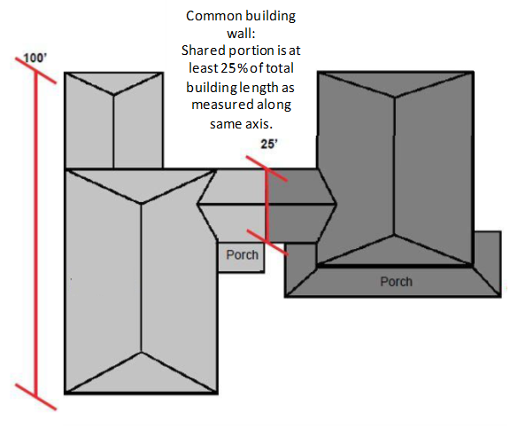
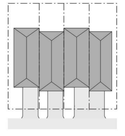
Common Building Wall. A wall or set of walls, shared by two or more attached dwelling units. The common building wall may be any wall of the building, including the walls of attached garages. The shared portion is at least 25% of the total length of the building as measured along the same axis. A common wall requirement is met whether the shared wall exists on multiple stories of a building or just on the ground floor.
A breezeway may also be considered to meet the common building wall definition when it:
• Meets the above 25% requirement; and
• Is a shared covered space that extends from an exterior door of one unit to an exterior door of another unit.
(See common building wall figure, below).
Common Building Wall
(Ord. No. 885A, § 2.1.(Exh. 1, § 1.), 6-28-22, eff. 7-28-22)
106-37
Community Plans. Plans which provide specific land use designations on property within the unincorporated urban area of the county and also provide detailed policy direction to guide development based upon community needs and desires. Previous plans of development are not included in this definition.
(Ord. No. 885A, § 2.1.(Exh. 1, § 1.), 6-28-22, eff. 7-28-22)
Editor's note— Ord. No. 885A, § 2.1.(Exh. 1, § 1.), adopted June 28, 2022, effective July 28, 2022, redesignated the former §§ 106-36 and 106-37 as §§ 106-37 and 106-38.
106-38
Compatible. Capable of existing together in harmony; capable of orderly, efficient integration and operation with other elements in a system considering building orientation, privacy, lot size, buffering, access, and circulation.
(Ord. No. 885A, § 2.1.(Exh. 1, § 1.), 6-28-22, eff. 7-28-22)
Note— See editor's note at § 106-37.
106-39
Compliance Permit. A permit required prior to occupying a site approved through Development Review. To receive a compliance permit, a developer shall construct or install the required improvements or shall provide the County with an approved assurance that all improvements will be carried out in accordance with the terms of the Development Review Approval.
106-41
Comprehensive Framework Plan (CFP). This document provides a framework of policies and strategies to be used as the basis for more specific planning activities, functional elements (e.g., transportation, housing, solid waste), Community Plans, regulatory ordinances and capital improvement programs. The CFP, together with the Resource Document, Community Development Code and these more specific plans comprise the County's Comprehensive Plan.
106-42
Comprehensive Plan. A generalized coordinated land use map and policy statement of the county that inter-relates all functional and natural systems and activities relating to the use of the land, including, but not limited to, the Comprehensive Framework Plan which includes the following components: the individual Community Plans, the Rural Natural Resource Plan, the Community Development Code, and the Transportation Plan.
(Ord. No. 885A, § 2.1.(Exh. 1, § 1.), 6-28-22, eff. 7-28-22)
Editor's note— Ord. No. 885A, § 2.1.(Exh. 1, § 1.), adopted June 28, 2022, effective July 28, 2022, redesignated the former § 106-43 as § 106-42.
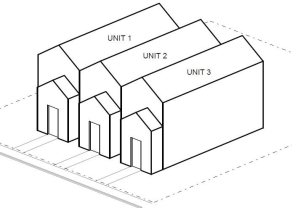
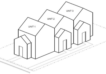
106-43
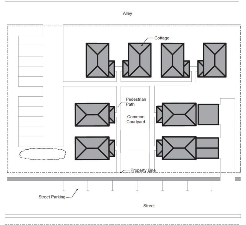
Cottage. Individual dwelling unit with a maximum footprint of 900 square feet (not counting up to 200 square feet of an attached garage or carport) that is part of a Cottage Cluster.
106-43.1
Cottage Cluster. A grouping of up to 12 cottages that share a common courtyard. Individual cottages may be on a single shared lot or parcel, or on separate lots or parcels.
106-43.2
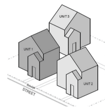
Cottage Cluster Development. Site containing one Cottage Cluster or more.
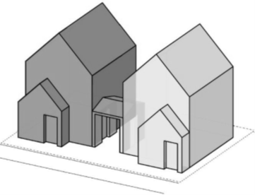
Cottage Cluster Example
(Ord. No. 885A, § 2.1.(Exh. 1, § 1.), 6-28-22, eff. 7-28-22; Ord. No. 890A, § 2.A.(Exh. 1, § 1.), 2-7-23, eff. 3-9-23)
106-44
Cultural Resource. Any site, structure, object, district or building which demonstrates national, state or local historic, architectural, archaeological or cultural significance.
106-45
Cubic Foot Per Acre Per Year. The average annual increase in cubic foot volume of wood fiber per acre for fully stocked stands at the culmination of mean annual increment as reported by the USDA Natural Resource Conservation Service (NRCS) soil survey information, USDA Forest Service plant association guides, Oregon Department of Revenue western Oregon site class maps, or other information determined by the State Forester to be of comparable quality. Where such data are not available or are shown to be inaccurate, an alternative method for determining productivity may be used. An alternative method must provide equivalent data as explained in the Oregon Department of Forestry's Technical Bulletin entitled "Land Use Planning Notes Number 3 dated April 1998" and be approved by the Oregon Department of Forestry.
106-46
Cubic Foot Per Tract Per Year. The average annual increase in cubic foot volume of wood fiber per tract for fully stocked stands at the culmination of mean annual increment as reported by the USDA Natural Resource Conservation Service (NRCS) soil survey information, USDA Forest Service plant association guides, Oregon Department of Revenue western Oregon site class maps, or other information determined by the State Forester to be of comparable quality. Where such data are not available or are shown to be inaccurate, an alternative method for determining productivity may be used. An alternative method must provide equivalent data as explained in the Oregon Department of Forestry's Technical Bulletin entitled "Land Use Planning Notes Number 3 dated April 1998" and be approved by the Oregon Department of Forestry.
106-47
Day. Unless otherwise specifically stated, day shall mean calendar day (a 24-hour period of time).
106-48
Day Care Facility. A facility operated by an agency, organization or individual providing care for six or more children or adults during a part of the 24 hours of a day. A day care facility does not include:
A.
A nursery school (see Section 430-121);
B.
A facility providing care that is primarily supervised training in a specific subject, including but not limited to dancing, drama, music or religion;
C.
A facility operated by a school district, political subdivision of the State of Oregon or a governmental agency;
D.
A residential facility licensed under ORS 443.400 to 443.445;
E.
Baby-sitters; or
F.
A family day care provider, as defined in Section 106-78.
(Ord. No. 855, § 2.A.(Exh. 1, § 1), 8-6-19, eff. 11-28-19)
106-49
Deed Restriction. A covenant or contract constituting a burden on the use of private property for the benefit of property owners in the same subdivision, adjacent property owners, the public or Washington County, and designated to mitigate or protect against adverse impacts of a development or use to ensure compliance with a Comprehensive Plan.
106-51
Demolish. To raze, destroy, dismantle, deface or in any other manner cause partial or total ruin of a structure or resource.
106-53
De Novo Hearing. A new hearing conducted in a similar manner to an initial hearing. The record, findings, and conclusions below may be disregarded. A limited de novo hearing is one in which the Review Authority hears specific issues in the same manner as an initial hearing. The other issues are reviewed based on the record of the prior Review Authority.
106-55
Density. The intensity of residential land uses per acre, stated as the number of dwelling units per gross acre.
106-57
Development. Any man-made change to improved or unimproved real estate or its use, including but not limited to construction, installation or change of land or a building or other structure, change in use of land or a building or structure, land division, establishment, or termination of right of access, storage on the land, tree cutting, drilling, and site alteration such as that due to land surface mining, dredging, grading, construction of earthen berms, paving, improvements for use as parking, excavation or clearing. Also refer to Section 421-2.2 for definition of development for flood and drainage hazard area management purposes.
(Ord. No. 845, § 2.A.(Exh. 1, § 1), 4-2-19, eff. 5-2-19; Ord. No. 890A, § 2.A.(Exh. 1, § 1.), 2-7-23, eff. 3-9-23)
106-58
Development Permit. The Director's or Hearings Officer's written approval shall be the Development Permit for any Type I, Type II, or Type III decisions. A "permit" issued by the Building Official authorizing performance of a specified activity is a Type I development permit.
106-59
Development Review. The process of reviewing a proposed development action for conformance with this Code and the applicable standards and requirements of the Comprehensive Plan as specified by this Code. Development review may be processed through a two-step process consisting of a preliminary review and a final review. Final review shall be through a Type I procedure, unless otherwise specified by the Review Authority in the preliminary approval.
106-60
Development Site. A lot or parcel or combination of lots or parcels upon which any development, as defined by Section 106-57, occurs.
106-61
Dimensional Standard.
A.
A numerical measurement for a distance or area standard of this Code, such as a setback, lot depth or width, building height, lot area, sign area; or
B.
A percentage of a distance or area measurement of this Code, such as maximum lot coverage or minimum required area for landscaping.
106-62
Director. The person appointed by the County Board of Commissioners who is given the responsibility for administering this Code, or a designated representative appointed by the Director.
106-63
Drainage Hazard Area. Any land area outside the mapped base flood area that is susceptible to being inundated by water in the four percent chance annual flood.
(Ord. No. 845, § 2.A.(Exh. 1, § 1), 4-2-19, eff. 5-2-19)
106-64
Drainage Master Plan. A comprehensive, basin-wide plan for the provision of the major elements of a stormwater drainage system including pipes, culverts, ditches, detention ponds and natural water courses to accommodate the ultimate level of development provided by the Comprehensive Framework Plan, which includes the Rural/Natural Resource Plan and Community Plans.
106-65
Drainageway. The normal stream or drainage channel needed to convey the waters of a 25-year storm.
106-67
Drainage Right-of-Way or Easement. The lands dedicated or granted by easement to the public for the installation of stormwater sewers, detention or retention basins or drainage ditches, or for preservation of a natural or man-made stream or water course which provides for the flow or temporary storage of water therein to safeguard the public against flood damage.
106-69
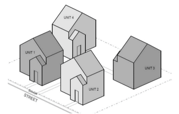
Duplex. Two primary dwelling units that, unless Middle Housing Duplex units, share either a common building wall (as defined in Section 106-36) or a common floor/ceiling. Middle Housing Duplex units may be attached or detached, in any configuration on a lot or parcel.
Whether designed as Middle Housing or not, individual units may be on a single shared lot or parcel, or on separate lots or parcels.
Duplex Examples
 Attached Side-by-Side Attached Side-by-Side | 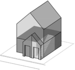 Attached Stacked Attached Stacked |
 Attached by Breezeway Attached by Breezeway | 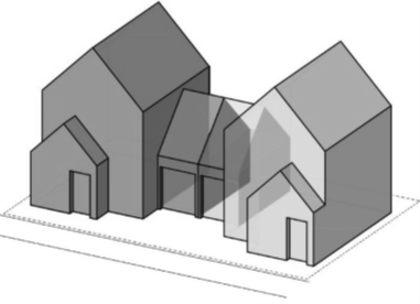 Attached by Garage Wall Attached by Garage Wall |
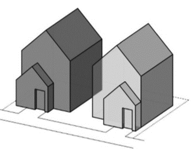 Detached Middle Housing Duplex Units -- Side-by-Side Detached Middle Housing Duplex Units -- Side-by-Side | 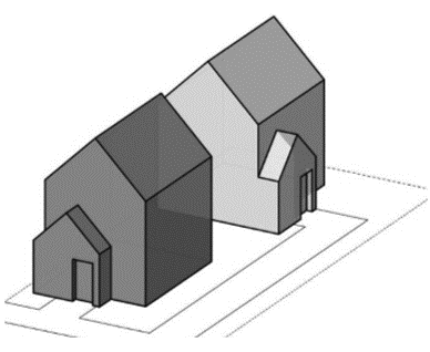 Detached Middle Housing Duplex Units -- Front to Back Detached Middle Housing Duplex Units -- Front to Back |
(Ord. No. 885A, § 2.1.(Exh. 1, § 1.), 6-28-22, eff. 7-28-22; Ord. No. 890A, § 2.A.(Exh. 1, § 1.), 2-7-23, eff. 3-9-23)
106-70
Dwelling. A building (not including a tent or teepee) or portion thereof intended for residential occupancy, but not including hotels, motels or boarding houses.
106-70.1
Dwelling Unit. An individual unit providing living facilities for one or more persons, including permanent provisions for living, sleeping, eating, cooking and sanitation.
A.
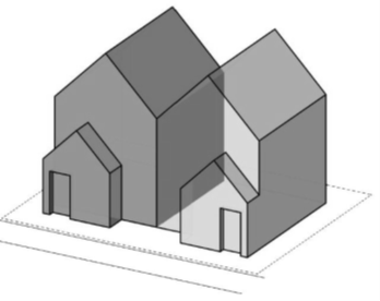
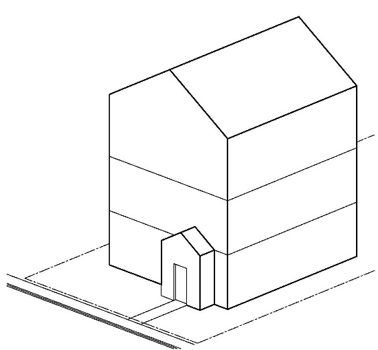
Dwelling Unit, Accessory (ADU). An auxiliary dwelling allowed with a Single Detached Dwelling Unit, which meets size restrictions and other requirements of Section 430-2. The accessory unit functions as a complete living unit with its own kitchen, bathroom and sleeping area. ADUs are classified as either attached or detached based on the following characteristics:
(1)
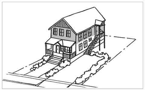
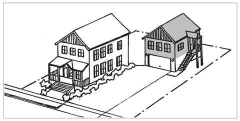
Attached. An attached ADU shares a common building wall or floor/ceiling with the primary dwelling and may be created from existing square footage within the primary dwelling, added square footage, or a combination thereof. It may have access only from within the primary dwelling unit, or it may have a separate entry door from the outside. See Figures 1 and 2 for examples.
(2)
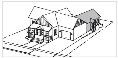
Detached. A detached ADU does not share a common wall, roof or foundation with the primary dwelling. See Figure 3 for example.
Section 106-70.1A Figure 1 - Attached ADU (addition)
Section 106-70.1A Figure 2 - Attached ADU (conversion of existing space)
Section 106-70.1A Figure 3 - Detached ADU (addition/conversion over detached garage)
B.
Dwelling Unit, Attached. Two or more primary dwelling units with a common building wall and/or ceiling, on individual lots or on a single shared lot, including "Residential Facility" as defined in ORS 197.660.
C.
Dwelling Unit, Detached. One primary dwelling unit that is not attached to any other primary dwelling unit.
D.
Dwelling Unit, Single Detached. A detached dwelling unit as described above, when on its own separate lot or parcel, not including a detached Middle Housing Unit.
E.
Dwelling Unit, Primary. Main dwelling on a lot, not subject to Accessory Dwelling Unit provisions of this code. When more than one Middle Housing Unit is sited on a single lot or parcel, each is considered a primary dwelling unit.
(Ord. No. 885A, § 2.1.(Exh. 1, § 1.), 6-28-22, eff. 7-28-22; Ord. No. 890A, § 2.A.(Exh. 1, § 1.), 2-7-23, eff. 3-9-23)
Editor's note— Ord. No. 885A, § 2.1.(Exh. 1, § 1.), adopted June 28, 2022, effective July 28, 2022, redesignated the former § 106-69 as § 106-70.
106-71
Easement. A right held by a person, or the public, to use the land of another.
106-71.1
Easement for Public Travel. An area that is reserved for the physical placement of a transportation facility, such as, but not limited to a sidewalk, accessway, greenway, private street, or private drive. When an easement is reserved for multiple uses, such as a sidewalk and a public utility easement, the easement for public travel shall be only that area within the easement reserved for public travel.
106-73
Eating and Drinking Establishment. Any establishment which is required to have an Oregon State Health Division Restaurant License or Oregon State Liquor License.
106-75
Effective Vehicular Barrier. A fence or barrier consisting of wood, metal, masonry, boulders, earth berms or natural features arranged in such a way as to provide an effective barrier for vehicular traffic.
106-77
Reserved
Editor's note— Ord. No. 832A, § 2.A.(Exh. 1, § 1), adopted September 18, 2018, effective October 18, 2018, repealed § 106-77, which pertained to Elderly Households and derived from the 2016 Code.
106-78
Family Day Care Provider. A day care (child care) provider who resides in the home and regularly provides day care in the provider's home to fewer than 16 children (or as specified otherwise by ORS 657A.280), including children of the provider, regardless of full-time or part-time status.
(Ord. No. 855, § 2.A.(Exh. 1, § 1), 8-6-19, eff. 11-28-19)
106-79
Farm Use. As defined by Oregon Revised Statutes.
106-80
Farmers Market. An outdoor market open to the public, operated by a public agency, a nonprofit corporation, or one or more producers, at which:
A.
At least 50% of the products sold are farm products or value-added farm products as computed over the entirety of the market offerings or within a vendor's mix of offerings and over the length of the market season;
B.
At least 50% of the vendors regularly participating during the market's hours of operation are producers, or family members or employees of producers; and
C.
Farmers Markets are distinct from Farm Stands and are not allowed in EFU or AF-20 land use districts.
106-80.1
Mini Farmers Market. Defined same as farmers market but with a maximum of five vendors.
106-80.2
Farm Products. Fruits, vegetables, mushrooms, herbs, nuts, shell eggs, honey, or other bee products, flowers, nursery stock, livestock and dairy food products (including meat, milk, cheese and other dairy products), poultry, seafood, fish, or similar products approved by the Director or the Director's designee.
106-80.3
Producer. A person or business that raises or produces farm products on land that the person or business farms and owns, rents, or leases. Also means a person or business that propagates and/or harvests fish, seafood, or other aquatic species.
106-80.4
Value-added Farm Product. Any product processed by a producer from a farm product such as baked goods, jams, and jerky.
106-81
Fence (Sight Obscuring). A fence consisting of wood, metal, masonry, landscaped berm or natural feature arranged in such a way as to obstruct vision at the time of installation.
106-83
Floodplain. Any land area susceptible to being inundated by water in the base flood including the floodway and flood fringe.
(Ord. No. 845, § 2.A.(Exh. 1, § 1), 4-2-19, eff. 5-2-19)
106-85
Floodway. The channel of a river or other watercourse and the adjacent land areas that must be reserved in order to discharge the Base Flood without cumulatively increasing the water surface elevation more than a designated height.
(Ord. No. 845, § 2.A.(Exh. 1, § 1), 4-2-19, eff. 5-2-19)
106-87
Floodway Fringe. The area of the floodplain, lying outside the floodway, which does not contribute appreciably to the passage of flood water, but serves as a retention area.
106-88
Food Market. A retail establishment (e.g., grocery store) which sells to the public staple foodstuffs (e.g., flour, cereal, canned foods); beverages; meats; and other foods (e.g., fruit, vegetables, dairy products, baked goods, and deli foods); incidental household supplies used in or around the home (e.g., cleaning items, paper napkins, matches); and personal items used in the home (e.g., magazines, health and beauty aids, school supplies, greeting cards). Food markets may provide accessory deli seating. The sale of other non-foodstuffs (e.g., floral items, pharmaceuticals), or the provision of financial or personal services (e.g., video rental, photographic reproduction), are permitted provided the combined maximum floor area devoted to these uses does not exceed 20% of the building floor area devoted to retail sales (not including storage areas).
(Ord. No. 866, § 2.C.(Exh. 3, § 1), 9-1-20, eff. 10-1-20)
106-89
Forest Lands. As defined by the Statewide Planning Goals and the Forest Practices Act (ORS 527.610-730 and 527.990).
106-90
Food Cart or Food Truck. See Mobile Food Unit.
(Ord. No. 831A, § 2.A.(Exh. 1, § 1), 7-17-18, eff. 8-16-18)
106-91
Forest Uses. As defined by the Statewide Planning Goals and the Forest Practices Act (ORS 527.610-730 and 527.990).
106-93
Frontage. The portion of a lot or parcel which abuts a street or road.
106-95
Ground Cover. Any low shrubs, grasses or herbaceous plants planted so as to have the capability to completely cover the ground.
106-97
Ground Level (Existing). The contour of the ground surface before grading.
106-99
Hearing Below. The prior hearing.
106-101
Height. The highest point of a structure or tree, plant or other object of natural growth, measured from mean sea level.
106-101.1
Height (Maximum Building Height). The vertical distance measured from the adjoining curb level to the highest point of the roof surface of a flat roof, to the deck line of a mansard roof, and to the mean height level between the eaves and edge of a gable, hip or gambrel roof; provided however, that where buildings are set back more than the required setback from the street line the height of the building shall be measured from the building grade. The building grade shall be the average of the finished ground level at the center of the walls of a building.
106-103
Industrial. The use of land or structures to treat, process or manufacture materials into products.
106-105
Industrial Park. Any planned industrial development which occurs on a single lot or parcel or contiguous lots or parcels designed as a coordinated environment for a variety of industrial and industrially related activities, having a master development plan, approved through a planned development procedure, that ensures internal compatibility as well as compatibility with adjacent uses which occur on a parcel or contiguous parcels under single ownership or development control.
106-107
Land Division. Division (Partition or Subdivision) of a lot or parcel into two or more new lots or parcels through a Partition or Subdivision.
For purposes of this Code, the terms "Standard Land Division," "Standard Subdivision," and "Standard Partition" are used in reference to land divisions that are subject to Sections 601, 602, 603 and either 605 or 610. These are distinct from a Middle Housing Land Division, defined below.
(Ord. No. 890A, § 2.A.(Exh. 1, § 2.), 2-7-23, eff. 3-9-23)
106-109
Lot. A unit of land that is created by a subdivision of land. Lot includes parcel unless the context provides otherwise.
106-111
Lot Area (Lot Size). The total area within the boundaries of a lot or parcel, except as may be provided in Article III.
106-112
Lot(s), Child. Lot(s) or parcel(s) resulting from division of a parent lot.
(Ord. No. 885A, § 2.1.(Exh. 1, § 1.), 6-28-22, eff. 7-28-22)
106-113
Lot Line. The lines bounding a lot as defined herein.
106-113.1
Front Lot Line. For interior lots, a line separating the lot from the street right-of-way. For corner lots, the line separating the narrowest frontage from the street right-of-way.
106-113.2
Rear Lot Line. The line which divides one lot from another opposite from the front lot line. For irregular or triangular lots, the rear lot line shall be a line 10 feet in length, within the lot, parallel to and at the maximum distance from the front lot line. A four-sided irregular lot is one in which a side lot line and the rear lot line form an interior angle of at least 135 degrees.
106-113.3
Side Lot Line. For interior lots, the line separating one lot from the abutting lot(s) fronting on the same street. For corner lots, a line separating the longest frontage of the lot from the street.
106-115
Lot of Record (Rural - in the AF-10, AF-5, RR-5, R-COM, R-IND and MAE Districts. This definition does not apply in the EFU, EFC, or AF-20 Districts.). Any lot or parcel lawfully created by a subdivision plat of record in the Recording Division of the Washington County Department of Assessment & Taxation, or by deed or sales contract and of record in the Recording Division, which is eligible to receive a building permit for any use permitted, if such permit would have issued but for the minimum lot size provisions of the district, regardless of whether or not contiguous tax lots are in the same ownership. Each tax lot lawfully created by a deed or sales contract prior to the effective date that the District is applicable to the subject property, shall be deemed a lot of record. When a tax lot consists of two or more noncontiguous lots or parcels created as a result of a lawful partition by deed or sales contract prior to the effective date that the district is applicable to the subject property, each noncontiguous lot or parcel shall be considered a lot of record. A lot of record does not authorize development of a lot or parcel which does not comply with the requirements of a "parcel" as defined by Section 106-150.
(Ord. No. 885A, § 2.1.(Exh. 1, § 1.), 6-28-22, eff. 7-28-22)
106-117
Lot of Record, Urban. Applicable to all urban districts. Any lot or parcel created by a lawful sales contract or deed and of record prior to March 26, 1984, the effective date of this Code. A lot of record does not authorize development of a lot or parcel which does not comply with the requirements of a "parcel" as defined by ORS 215.
(Ord. No. 833, § 2.A.(Exh. 1, § 1), 8-7-18, eff. 9-6-18)
106-119
Lot Depth. The perpendicular distance measured from the midpoint of the front lot line to the midpoint of the opposite lot line. See Figure No. 1.
Section 106-119. Figure No. 1.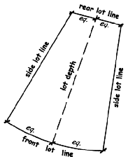
106-121
Lot Width. The horizontal distance between the side lot lines measured at right angles to the lot depth at a point midway between the front and rear lot lines. See Figure No. 1.
Section 106-121. Figure No. 1.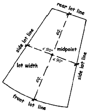
106-123
Manufacturing. The processing or converting of raw, unfinished, or finished materials or products or any combination thereof into an article or substance of different character, or for use for a different character or purpose.
106-124
Middle Housing. Residential development in the R-5, R-6, R-9, R-15, R-24, R-25+, R-6 NB, R-9 NB, R-15 NB, TO: R9-12, TO: R12-18 or TO: R18-24 district, that meets provisions for Middle Housing as adopted into district standards and CDC Section 430-84, limited to:
A.
Duplexes, including those created through conversion of existing Single Detached Dwelling Units;
B.
Triplexes, Quadplexes, Cottage Clusters, and Townhouses, including those created through conversion of existing Single Detached Dwelling Units or Duplexes, on lots or parcels where Sufficient Infrastructure (as defined in 106-210) exists or is provided by the applicant consistent with requirements of this Code.
(Ord. No. 885A, § 2.1.(Exh. 1, § 1.), 6-28-22, eff. 7-28-22; Ord. No. 890A, § 2.A.(Exh. 1, § 1.), 2-7-23, eff. 3-9-23)
106-125
Middle Housing Conversion. Additions to, or conversions of, an existing Single Detached Dwelling Unit into Middle Housing, provided the addition or conversion does not increase nonconformance with applicable clear and objective standards.
(Ord. No. 885A, § 2.1.(Exh. 1, § 1.), 6-28-22, eff. 7-28-22; Ord. No. 890A, § 2.A.(Exh. 1, § 1.), 2-7-23, eff. 3-9-23)
106-126
Middle Housing Land Division. Expedited division (Partition or Subdivision) of a lot or parcel of land on which the development of Middle Housing is allowed, into separate lots or parcels for individual Middle Housing units (Section 606). A Middle Housing Land Division is an action distinct from other types of land divisions per Oregon law. (See Land Division definition above).
(Ord. No. 885A, § 2.1.(Exh. 1, § 1.), 6-28-22, eff. 7-28-22; Ord. No. 890A, § 2.A.(Exh. 1, § 2.), 2-7-23, eff. 3-9-23)
106-129
Mitigation. Reducing the impacts of a proposed development and/or offsetting the loss of habitat values resulting from development. In fish, wildlife, and big game range areas, mitigation may include, but is not necessarily limited to, requiring:
1)
Clustering of structures near each other and roads, controlling location of structures on a parcel to avoid habitat conflicts, minimizing extent of road construction to that required for the proposed use; and,
2)
Replacing unavoidable loss of values by reestablishing resources for those lost, such as: forage for food production, escape or thermal shelter.
In other areas of significant wildlife value, such as wetlands, riparian vegetation and special bird nesting sites, maintenance and enhancement of remaining habitat, setbacks and restoration of damage and avoiding damage would be appropriate.
106-131
Manufactured Dwelling. Also refer to Section 421-2.10 for definition of manufactured dwelling for flood and drainage hazard area management purposes.
106-131.1
Residential Trailer. A structure constructed for movement on the public highways that has sleeping, cooking and plumbing facilities, that is intended for human occupancy, that is being used for residential purposes and that was constructed before January 1, 1962.
106-131.2
Mobile Home. A structure constructed for movement on the public highways that has sleeping, cooking and plumbing facilities, that is intended for human occupancy, that is being used for residential purposes and that was constructed between January 1, 1962, and June 15, 1976, and met the construction requirements of Oregon mobile home law in effect at the time of construction.
106-131.3
Manufactured Home. A structure constructed for movement on the public highways that has sleeping, cooking and plumbing facilities, that is intended for human occupancy, that is being used for residential purposes and that was constructed in accordance with federal manufactured housing construction and safety standards regulations in effect at the time of construction.
106-131.4
Does not mean any building or structure subject to the structural specialty code adopted pursuant to ORS 455.100 to 455.450, any unit identified as a recreational vehicle by the manufacturer or a modular home.
(Ord. No. 845, § 2.A.(Exh. 1, § 1), 4-2-19, eff. 5-2-19)
106-133
Manufactured Dwelling Park. A lot or parcel of land under single ownership on which two or more manufactured dwellings are occupied as residences. The manufactured dwelling sites usually are rented or leased. Also refer to Section 421-2.11 for definition of manufactured dwelling park or subdivision for flood and drainage hazard area management purposes.
(Ord. No. 845, § 2.A.(Exh. 1, § 1), 4-2-19, eff. 5-2-19)
106-135
Manufactured Dwelling Subdivision. A Standard Subdivision designed and approved for the sale of lots on which to place manufactured dwellings. Also refer to Section 421-2.11 for definition of manufactured dwelling park or subdivision for flood and drainage hazard area management purposes.
(Ord. No. 845, § 2.A.(Exh. 1, § 1), 4-2-19, eff. 5-2-19)
106-136
Manufactured Dwelling Space. A plot of land within a manufactured dwelling park designed to accommodate one manufactured dwelling.
(Ord. No. 885A, § 2.1.(Exh. 1, § 1.), 6-28-22, eff. 7-28-22)
Editor's note— Ord. No. 885A, § 2.1.(Exh. 1, § 1.), adopted June 28, 2022, effective July 28, 2022, redesignated the former § 106-136 as § 106-137.
106-137
Mixed-Use. A development site that includes more than one land use (e.g., residential, office, and/or retail commercial) allowed in the underlying land use district and is comprised of either a stand-alone building (vertical mixed-use), individual buildings (horizontal mixed-use) or a combination of both.
(Ord. No. 885A, § 2.1.(Exh. 1, § 1.), 6-28-22, eff. 7-28-22)
106-138
Model Home. A dwelling unit constructed prior to subdivision plat recording intended to showcase housing styles and craftsmanship for potential buyers.
106-139
Noise Sensitive Use. A structure or use normally used for sleeping, or normally used as a school, religious institution, hospital or public library. Structures or property used in industrial or agricultural activities are not "noise sensitive" unless they meet the above criteria in more than an incidental manner.
106-140
Mobile Food Site. All or part of a development site that contains one or more mobile food units and associated amenities. Also known as a food cart pod.
(Ord. No. 831A, § 2.A.(Exh. 1, § 1), 7-17-18, eff. 8-16-18)
106-141
Nonconforming Use. A structure or use of land which does not conform to the provisions of this Code or Comprehensive Plan lawfully in existence on the effective date of enactment or amendment of this Code or Comprehensive Plan.
106-142
Mobile Food Unit. Pursuant to OAR 333-150 and 333-162, any vehicle that is self-propelled or that can be pulled or pushed down a sidewalk, street, or highway, in which food is prepared, processed or converted or which is used in selling and dispensing food to the ultimate consumer. Also known as a food cart or food truck.
(Ord. No. 831A, § 2.A.(Exh. 1, § 1), 7-17-18, eff. 8-16-18)
106-143
Multi-Dwelling Structure (or multi-dwelling attached units, not on individual lots). Five or more attached primary dwelling units that share a common floor/ceiling with one or more units. The units may also share common building walls. The land underneath the structure is not divided into separate lots. Examples include apartments and condominiums.
(Ord. No. 885A, § 2.1.(Exh. 1, § 1.), 6-28-22, eff. 7-28-22)
106-144
Office. A room or building in which a person transacts business, a profession or similar activities. Such activities normally include administration, bookkeeping, record keeping, sales meetings and preparation for or follow-up after a sale, correspondence or other similar activities. Products or merchandise are not to be stored or manufactured in an office, although mail, telephone and incidental walk-in sales may be made in an office.
(Ord. No. 885A, § 2.1.(Exh. 1, § 1.), 6-28-22, eff. 7-28-22)
Editor's note— Ord. No. 885A, § 2.1.(Exh. 1, § 1.), adopted June 28, 2022, effective July 28, 2022, redesignated the former § 106-143 as § 106-144.
106-145
Occupancy Permit(Certificate of Occupancy). The permit provided in the Uniform Building Code which must be issued prior to occupying a building or structure or portion thereof. For the purposes of this Code, "occupancy permit" includes the final inspection approval for those buildings or structures not required to obtain an occupancy permit by the Uniform Building Code.
106-147
Overlay District. A supplementary district placing special restrictions or allowing special uses of land beyond those required or allowed in the Primary District.
106-149
Owner. The legal owner(s) of record as shown on the tax rolls of the County, or where there is a recorded land sales contract in force, the purchaser thereunder.
106-150
Parcel. As defined by Oregon Revised Statutes 215.
(Ord. No. 885A, § 2.1.(Exh. 1, § 1.), 6-28-22, eff. 7-28-22)
Editor's note— Ord. No. 885A, § 2.1.(Exh. 1, § 1.), adopted June 28, 2022, effective July 28, 2022, redesignated the former § 106-151 as § 106-150.
106-151
Parent Lot. Original tract of land prior to its division through a Partition, Subdivision, or Middle Housing Land Division.
(Ord. No. 885A, § 2.1.(Exh. 1, § 1.), 6-28-22, eff. 7-28-22; Ord. No. 890A, § 2.A.(Exh. 1, § 1.), 2-7-23, eff. 3-9-23)
106-152
Partition. As defined by ORS 215. For purposes of this Code, the term "Partition" is not used in reference to a Middle Housing Land Division except in Section 606 or as specifically indicated elsewhere.
(Ord. No. 890A, § 2.A.(Exh. 1, § 2.), 2-7-23, eff. 3-9-23)
106-153
Partition Land. As defined by Oregon Revised Statutes 92.
106-155
Pedestrian Way. A publicly owned or dedicated and accepted way designated for public use by pedestrian traffic.
106-157
Performance Contract. A contract between the owner and the County for installation or construction of improvements and the security given in addition thereto prior to final plat approval to insure such construction or installation, all in accordance with Articles V and VI.
106-159
Person. An individual, firm, partnership, corporation, company, association, syndicate, organization, or any legal entity, and including a trustee, a receiver, assignee, or other similar representative thereof.
106-161
Planned Development. An integrated, coordinated development of land, normally involving increased flexibility in use and design standards, with special incentives or restrictions on development.
106-163
Planning or Development Action. An action by the County that concerns the adoption, amendment, or application of the Comprehensive Plan or this Code.
106-165
Plat. Includes a final map and other writing containing all the descriptions, locations, specifications, dedications, provisions and information concerning a Subdivision, Partition or replat.
(Ord. No. 890A, § 2.A.(Exh. 1, § 1.), 2-7-23, eff. 3-9-23)
106-167
Preliminary Plat. Means a map and plan of a proposed Subdivision, in the form required by Article VI.
106-169
Primary District. A land use district as designated on the Community Plan Map or the Rural/Natural Resource Plan, (such as R-5, R-6, R-9, INST, TO:R9-12, R-6 NB, CBD, GC, IND, EFU, EFC, AF-20).
(Ord. No. 866, § 2.C.(Exh. 3, § 1), 9-1-20, eff. 10-1-20; Ord. No. 890A, § 2.A.(Exh. 1, § 1.), 2-7-23, eff. 3-9-23)
106-171
Primary Use. The main use to which the premises are devoted and the principal purpose for which the premises exist.
106-172
Property Line Adjustment. The relocation of a common property line between two abutting properties.
106-173
Quadplex. Four primary dwelling units each of which, unless Middle Housing Quadplex units, shares at least one common building wall or a common floor/ceiling with another dwelling unit. Middle Housing Quadplex units may be attached or detached, in any configuration on a lot or parcel.
Whether designed as Middle Housing or not, individual units may be on a single shared lot or parcel, or on separate lots or parcels.
Quadplex Examples
 Attached Side-by-Side Attached Side-by-Side | 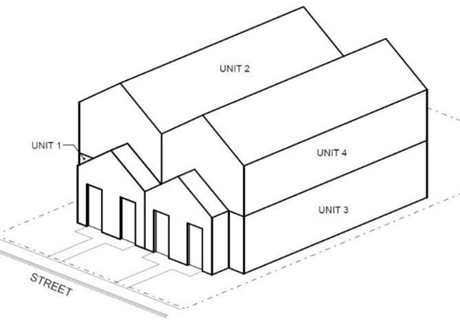 Attached Stacked Attached Stacked |
Detached Middle Housing Quadplex
(Ord. No. 885A, § 2.1.(Exh. 1, § 1.), 6-28-22, eff. 7-28-22)
106-174
Quorum. The minimum number of members of a body who must be present for the valid transaction of business. In all cases a quorum shall consist of a majority of the active members. For purposes of opening a meeting or hearing and continuing the matter to a time and date certain, a majority of those members in attendance shall constitute a quorum.
(Ord. No. 885A, § 2.1.(Exh. 1, § 1.), 6-28-22, eff. 7-28-22)
Editor's note—
Ord. No. 885A, § 2.1.(Exh. 1, § 1.), adopted June 28, 2022, effective July 28, 2022, redesignated
the former § 106-173 as § 106-174.
Prior to the reenactment of § 106-174 by Ord. No. 885A, Ord. No. 826A, § 2.A.(Exh. 1, § 1), adopted October 24, 2017, effective November 24, 2017 repealed
§ 106-174, which pertained to Terms Relating to Receiving and Transmitting Antennas,
Communication and Broadcast Towers and derived from the 2016 Code.
106-175
Recreational Vehicle. A vehicle with or without motive power that is designed for use as temporary living quarters, to be easily transported and set up on a daily basis and is any one of the following:
A.
A vehicle that is eight and one-half feet wide or less and is certified by the manufacturer or builder as complying with the applicable version of the NFPA 1192 or 501C or ANSI A119.2 standards, depending on which standards apply to the year of manufacture, for the construction of recreational vehicles that was in effect at the time of manufacture;
B.
A vehicle that is eight and one-half feet wide or less and is certified by the applicant as complying with the applicable version of the NFPA 1192 or 501C or ANSI A119.2 standards if the vehicle is not new and no manufacturer or builder certification is available, depending on which standards apply to the year of manufacture, for the construction of recreational vehicles that was in effect at the time of manufacture; or
C.
A Park Model Recreational Vehicle (Section 106-176).
Also refer to Section 421-2.13 for definition of recreational vehicle for flood and drainage hazard area management purposes.
(Ord. No. 845, § 2.A.(Exh. 1, § 1), 4-2-19, eff. 5-2-19; Ord. No. 866, § 2.C.(Exh. 3, § 1), 9-1-20, eff. 10-1-20)
106-176
Park Model Recreational Vehicle (PMRV). A recreational vehicle that:
A.
Is designed for use as temporary living quarters;
B.
Is built on a single chassis mounted on wheels;
C.
Has a gross trailer area that does not exceed 400 square feet;
D.
Is more than eight-and-one-half feet wide; and
E.
Is certified by the manufacturer or builder, or the applicant if the PMRV is not new and no manufacturer or builder certification is available, as complying with the version of the ANSI A119.5 standard for the construction of park model recreational vehicles that was in effect at the time of manufacture.
(Ord. No. 866, § 2.C.(Exh. 3, § 1), 9-1-20, eff. 10-1-20)
106-177
Regional Shopping Center. A planned commercial center intended as a coordinated environment to serve shoppers
at a regional level, developed with a comprehensive development plan for a parcel
or adjacent parcels of land under single ownership or development control. A regional
shopping center includes two or more major department stores which serve as anchor
tenants and a variety of office, commercial, retail and related activities generally
sharing common parking facilities.
A major department store has over 50,000 square feet of floor area. A junior department
store has less than 50,000 square feet.
106-178
Religious Institution. A building or other development used for a faith-based organization such as a church, mosque, temple or synagogue; together with its accessory uses and buildings, including but not limited to monasteries, offices, schools and living quarters for caretakers. In the Exclusive Farm Use (EFU) and the Agriculture and Forest (AF-20) Districts, the definition of Religious Institution is as set forth above, except that schools are not included as accessory uses.
106-179
Reserved
Editor's note— Ord. No. 832A, § 2.A.(Exh. 1, § 1), adopted September 18, 2018, effective October 18, 2018, repealed § 106-79, which pertained to Residential Home and derived from the 2016 Code.
106-181
Review Authority. Any person or body empowered pursuant to this Code to review development proposals and grant an approval or denial.
106-183
Right-of-Way. The area between the platted boundary lines of a street or public easement. Where not platted, the boundary lines of the street or public easement.
106-185
Riparian Corridor (Water Areas and Wetlands). Within the rural area, this term shall have one of the following two meanings:
(1)
For areas that have not been the subject of a Goal 5 analysis completed and a program decision adopted pursuant to OAR 660-023 (effective September 1, 1996), riparian corridor shall mean the area, adjacent to a water area, which is characterized by moisture-dependent vegetation, compared with vegetation on the surrounding upland, as determined by a qualified botanist or plant ecologist, or in no case less than a ground distance of 25 feet on either side of the channel. Where, in its existing condition, a wetland or watercourse has no discernible channel which conveys surface water runoff, the riparian zone shall be measured from the center of the topographic trough, depression or canyon in which it is located.
(2)
For areas that have been the subject of a Goal 5 analysis completed and a program decision adopted pursuant to OAR 660-023 (effective September 1, 1996), riparian corridor shall mean a Goal 5 resource that includes the water areas, fish habitat, adjacent riparian areas, and wetlands within the riparian area boundary, or the definition of the term used in OAR 660, Division 23. The boundary of a riparian corridor having this meaning shall be defined pursuant to OAR 660-023-0090.
(Ord. No. 902A, § 2.B.(Exh. 2, § 1.), 11-5-24, eff. 12-5-24)
106-187
Roadway. The portion or portions of a street right-of-way developed for vehicular traffic.
106-189
Rural Area. The land area located in Washington County which is outside an acknowledged Urban Growth Boundary.
106-190
School, Commercial. A facility where instruction is given to students in arts, crafts, or trades operated as a commercial enterprise as distinguished from public or private schools endowed and/or supported by taxation.
106-191
School, Nursery (Preschool). A school offering instruction or guided activity to preschool children for 4 hours or less during a day. A facility providing care to preschool children for more than 4 hours during a day is a day care facility (see Section 430-53.1).
(Ord. No. 832A, § 2.A.(Exh. 1, § 1), 9-18-18, eff. 10-18-18)
106-192
Site Grading or Clearing. Any site grading, excavation, fill, dredging or clearing except those excluded by Sections 201-1 and 410 or 407-3.2.
106-193
Sign. A name, identification, description, display or illustration, which is affixed to, painted or represented directly or indirectly upon a building, or other outdoor surface which directs attention to an object, product, place, activity, person, institution, organization or business and where sign area means the space enclosed within the extreme edges of the sign for each face, not including the supporting structure or where attached directly to a building wall or surface, the outline enclosing all the characters of the word. Signs located completely within an enclosed building, and not exposed to view from a street, shall not be considered a sign. Each display surface of a sign shall be considered to be a sign.
106-193.1
Electric. Any sign containing electric wiring. This does not include signs illuminated by an exterior floodlight source.
106-193.3
Flashing. Any illumined sign on which the artificial light is not maintained stationary or constant in intensity and color at all times when such sign is in use. For the purpose of this Code any moving illuminated sign, except digital billboards permitted pursuant to Section 414-2.2 G, shall be considered a flashing sign.
106-193.4
Freestanding. A sign erected and maintained on a freestanding frame, mast or pole not attached to any building, and not including ground mounted signs.
106-193.5
Ground Mounted. A sign which extends from the ground, or has support which places the bottom of the sign less than 2 feet from the ground.
106-193.6
Integral. A sign that is embedded, extruded or carved into the material of a building façade. A sign made of bronze, brushed stainless steel or aluminum, or similar material attached to the building façade. There are no restrictions on sign orientation including whether it is freeway-oriented. Integral sign shall not exceed 72 square feet per façade. Integral signs may be illuminated externally but shall not be illuminated internally.
106-193.7
Marquee. A canopy or covering structure bearing a signboard or copy projecting from and attached to a building.
106-193.9
Projecting. A sign, other than a wall sign, which projects from and is supported by a wall of a building or structure.
106-193.10
Roof. A sign located on or above the roof of any building, not including false mansard roof, canopy, or other fascia.
106-193.11
Temporary. A banner, pennant, poster or advertising display constructed of cloth, canvas, plastic sheet, cardboard, wallboard, plywood or other like materials and intended to be displayed for a limited period of time.
106-193.12
Flat Wall (Façade-Mounted). A sign affixed directly to or painted on or otherwise inscribed on an exterior wall and confined within the limits thereof of any building and which projects from that surface less than 12 inches at all points.
106-193.13
Digital Billboard. A sign that is static and changes messages by any electronic process or remote control, provided that the change from one message to another message is no more frequent than once every 10 seconds and the actual change process is accomplished in 2 seconds or less. Digital signs complying with Section 414-6.4 shall not be considered flashing as defined by this Code.
106-194
Significant Habitat. Within the UGB, a category of Significant Natural Resources identified on the Significant Natural and Cultural Resources Maps in the Community Plans and Map B in the Comprehensive Framework Plan for the Urban Area Policy 41. These areas provide important movement corridors and support the life-cycle requirements of the fish and wildlife species that use them. As specified in Section 422, Significant Habitat includes the following two categories:
106-194.1
Riparian Wildlife Habitat. Riparian Habitat is comprised of the following two components:
A.
Water Areas including wetlands, rivers, streams, and open water habitats (e.g., lakes and ponds); and
B.
An associated riparian buffer. The riparian buffer is the area within a specified distance of a Water Area. Riparian buffers are established and verified in accordance with the methodology in Section 422-8.1.
106-194.2
Upland Wildlife Habitat. Lands primarily comprised of forests and woodlands adjacent to the Riparian Wildlife Habitat. All Significant Habitat that is not otherwise classified as Riparian Wildlife Habitat is classified as Upland Wildlife Habitat.
(Ord. No. 902A, § 2.B.(Exh. 2, § 1.), 11-5-24, eff. 12-5-24)
Editor's note— Ord. No. 859, § 2.A.(Exh. 1, § 1), adopted September 17, 2019, effective November 28, 2019, renumbered former § 106-194 as § 106-6 as set out herein.
106-195
Solid Waste
106-195.1
Mixed Solid Waste. Means solid waste that contains recoverable or recyclable materials, and materials that are not capable of being recycled or recovered for further use.
106-195.2
Source Separated Recyclables. Means, at a minimum, recyclable materials designated "principle recyclable materials" by the State Environmental Quality Commission under ORS 459A.025, with the exception of yard debris. Currently these materials include newspaper, ferrous and non-ferrous scrap metal, used motor oil, corrugated cardboard, office paper, and tin cans (OAR 340-060-0030).
106-195.3
Residual Mixed Solid Waste. Means useless or discarded material commonly disposed of by residential and non-residential generators after some level of source separation and recycling has occurred.
106-195.4
Storage Area. Means the space necessary to store mixed solid waste and source separated recyclables that accumulate between collection days.
106-196
Specified Anatomical Areas. Uncovered or less than opaquely covered, post-pubertal human genitals, pubic areas, post-pubertal human female breast below a point immediately above the top of the areola, or the covered human male genitals in a discernibly turgid state.
106-197
Specified Sexual Activities. Human genitals in a state of sexual stimulation or arousal, acts of masturbation, sexual intercourse, sodomy, flagellation, torture or bondage either real or simulated.
106-198
Stormwater Facilities.
106-198.1
Vegetated Stormwater Facilities are on-site: swales, ponds, inverted planting areas, detention facilities, and other water quality and/or quantity facilities where the land surface of the facility is covered with native vegetation.
106-199
Story. That portion of a building included between a floor and the ceiling next above it, exclusive of a basement.
106-201
Street Plug or Reserve Strip. A strip of land located between a subdivision and other property and not dedicated to public use, but conveyed to the County for the purpose of giving the County control over development of adjacent property.
106-203
Street Tree. Any plant material located adjacent to a public street, having the capability of growth that will produce a vegetative canopy above a trunk not less than 10 feet high.
106-205
Structure. Anything which is built, erected or constructed and located on or under the ground, or attached to something fixed to the ground. Structures include, but are not limited to, buildings, towers, walls (includes retaining walls), fences more than 6 feet in height, billboards, and utilities. Structures do not include paved areas.
106-207
Subdivide Land. As defined by Oregon Revised Statutes 92.
106-209
Subdivision. As defined by ORS 92. For purposes of this Code, the term "Subdivision" is not used in reference to a Middle Housing Land Division except in Section 606 or as specifically indicated elsewhere.
(Ord. No. 890A, § 2.A.(Exh. 1, § 2.), 2-7-23, eff. 3-9-23)
106-210
Sufficient Infrastructure. The following minimum level of public services required to serve Middle Housing Triplex, Quadplex, Townhouse or Cottage Cluster development:
A.
Connection to a public sewer system capable of meeting established service levels.
B.
Connection to a public water system capable of meeting established service levels.
C.
Access via public or private streets meeting adopted emergency vehicle access standards to a public street system.
D.
Storm drainage facilities capable of meeting established service levels for storm drainage.
(Ord. No. 885A, § 2.1.(Exh. 1, § 1.), 6-28-22, eff. 7-28-22; Ord. No. 890A, § 2.A.(Exh. 1, § 1.), 2-7-23, eff. 3-9-23)
106-211
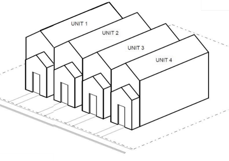
Townhouses (or attached dwelling units on separate lots). Dwelling units that are part of a row of two or more attached primary dwelling units, where each unit shares at least one common building wall with an adjacent unit. A Townhouse unit does not share a common floor/ceiling with another dwelling unit.
Townhouses Example (with required separate lots)
(Ord. No. 885A, § 2.1.(Exh. 1, § 1.), 6-28-22, eff. 7-28-22)
Note— See editor's note at § 106-223.
106-212
Triplex. Three primary dwelling units each of which, unless Middle Housing Triplex units, shares at least one common building wall or a common floor/ceiling with another dwelling unit. Middle Housing Triplex units may be attached or detached, in any configuration on a lot or parcel.
Whether designed as Middle Housing or not, individual units may be on a single shared lot or parcel, or on separate lots or parcels.
Triplex Examples
 |  |
| Attached Side-by-Side | Attached Front to Back |
 |  |
| Attached Stacked | Detached Middle Housing Triplex |
(Ord. No. 885A, § 2.1.(Exh. 1, § 1.), 6-28-22, eff. 7-28-22)
Note— See editor's note at § 106-224.
106-213
Vanpool/Carpool. Two or more people who share the use and/or cost of a van or car for transportation to and from a destination.
(Ord. No. 867, § 2.A.(Exh. 1, § 1), 9-1-20, eff. 10-1-20)
106-214
Vegetated Corridor. Lands that are located within the Clean Water Services boundary and are defined in the "Design and Construction Standards for Sanitary Sewer and Surface Water Management" or its successor. Vegetated corridors are generally preserved and maintained lands intended to protect the water quality functions of water quality sensitive areas.
(Ord. No. 867, § 2.A.(Exh. 1, § 1), 9-1-20, eff. 10-1-20)
106-215
Vehicle Camping Site for Homeless Persons. A location where overnight camping spaces are provided temporarily to homeless persons living in vehicles, as allowed pursuant to program requirements adopted by a city or County or other public agency that are designed to aid in transition to stable housing (Section 201-2.36).
For the purpose of a Vehicle Camping Site for Homeless Persons, a "vehicle" is a car, van, truck, motorized or towable recreational vehicle/camper/trailer/tiny home on wheels or similar conveyance, without regard to whether the vehicle was designed for use as temporary living quarters.
(Ord. No. 867, § 2.A.(Exh. 1, § 1), 9-1-20, eff. 10-1-20)
106-216
Warehouse. A structure or part of a structure used for storing goods, wares or merchandise, whether for the owner or for others.
106-217
Water Quality Sensitive Areas. Lands that are located within the Clean Water Services boundary and are defined in the "Design and Construction Standards for Sanitary Sewer and Surface Water Management" or its successor. Water quality sensitive areas generally include, but are not limited to, existing or created wetlands, rivers, streams, springs and natural lakes.
106-218
Wetlands. Those areas that are inundated or saturated by surface or ground water at a frequency and duration sufficient to support, and that under normal circumstances do support, a prevalence of vegetation typically adapted for life in saturated soil conditions.
106-219
Wind Energy Conversion Systems. Any device, such as a wind charger, windmill or wind turbine and associated facilities that converts wind energy into electrical energy. These systems may include generators, turbines and support structures, such as monopoles or towers.
106-220
Working Day. Days that the Department of Land Use & Transportation is open for business.
106-221
Yard (Setback). An open space on a lot or parcel which is unoccupied or unobstructed by buildings or other structures from the ground upward, except by landscaping or vegetation or as provided in Section 418 or other sections of this Code. Required yards shall be measured from the property line, sidewalk, or easement for public travel, whichever is closest to the building line of the lot or parcel a building will be constructed on, except as provided otherwise by the primary district. See Figure 106-3 below.
106-221.1
Yard, Front. A yard extending the full width of the lot, the depth of which is the minimum distance between the front lot line and a line parallel thereto at the nearest point of a building or structure. For a lot resulting from a Middle Housing Land Division, whether it abuts a street or not, the building façade that contains the front door/main entry may be considered the front building wall, and the yard that abuts and runs parallel to it may be considered the front yard. A garage door does not qualify as a front door/main entry for purposes of this allowance.
106-221.2
Yard, Rear. A yard extending across the full width of the lot between the rear of a building or structure and the nearest point of the rear lot line. Where a Single Detached Dwelling Unit or Middle Housing unit has a door to a deck, patio, porch or outdoor yard area that is oriented to a side lot line, and no door to the rear of the lot, the rear and side yards may be reversed. See Figures 106-3 and 106-4 below. For attached multi-dwelling developments where an individual dwelling unit's primary access to the lot's main outdoor yard area is oriented to a side lot line and not the rear lot line, the primary district's rear and side yards shall be reversed. See Figure 106-5. Any additional screening and buffering setback required by Section 411 shall also be provided the length of the rear lot line.
106-221.3
Yard, Side. A yard between a building or structure and the side lot line extending from the front yard to the rear yard, unless the dwelling's rear and side yard has been reversed as described in Section 106 Yard, Rear. The width of the side yard shall be measured horizontally from the nearest point of the side lot line to the nearest part of the main building. Any additional screening and buffering setback required by Section 411 shall also be provided the length of the side lot line.
(Ord. No. 833, § 2.A.(Exh. 1, § 1), 8-7-18, eff. 9-6-18; Ord. No. 885A, § 2.1.(Exh. 1), 6-28-22, eff. 7-28-22; Ord. No. 890A, § 2.A.(Exh. 1, § 2.), 2-7-23, eff. 3-9-23)
106-222
Zero-Lot-Line. Attached or detached dwelling units which are constructed with zero side or rear setbacks.
Figure 106-3. Example of a Single-Detached Dwelling Unit on a Lot with Standard Yards
(Setbacks)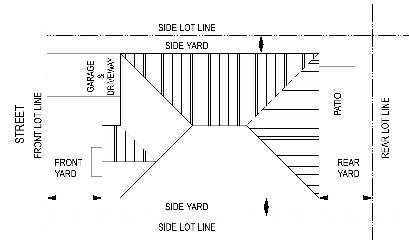
Figure 106-4. Figure 106-4. Example of a Single Detached Dwelling Unit on a Lot with
Reversed Side and Rear Yards (Setbacks)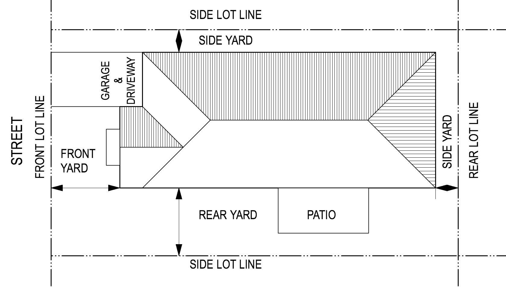
Figure 106-5. Example of a Multi-Dwelling Development with Standard Yards (Setbacks)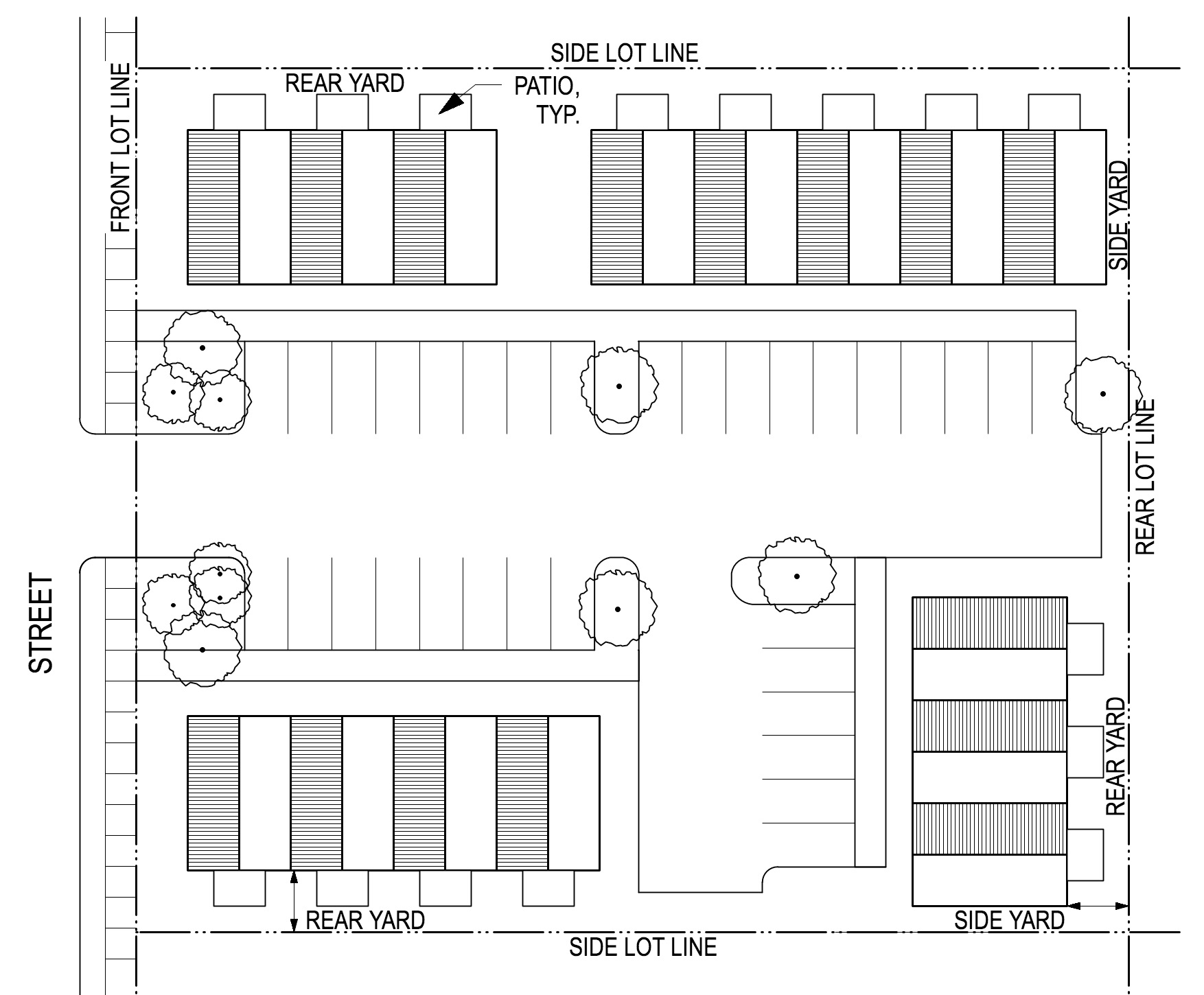
(Ord. No. 885A, § 2.1.(Exh. 1), 6-28-22, eff. 7-28-22; Ord. No. 890A, § 2.A.(Exh. 1, § 2.), 2-7-23, eff. 3-9-23)
106-223
Urban Unincorporated Area. The land area located in Washington County that is within the acknowledged Urban Growth Boundaries and outside of city limits.
(Ord. No. 885A, § 2.1.(Exh. 1, § 1.), 6-28-22, eff. 7-28-22)
Editor's note— Ord. No. 885A, § 2.1.(Exh. 1, § 1.), adopted June 28, 2022, effective July 28, 2022, repealed the former § 106-223, which pertained to Mixed-Use development sites and derived from Ord. No. 833, § 2.A.(Exh. 1, § 1), adopted August 7, 2018, effective September 6, 2018. Subsequently, Ord. No. 885A redesignated the former § 106-211 as § 106-223.
106-224
Urban Growth Boundaries (UGB). The legally defined boundaries adopted by Washington County, Metro or appropriate incorporated cities, and acknowledged by LCDC, that identify and separate urbanized land from rural and natural resource land.
(Ord. No. 867, § 2.A.(Exh. 1, § 1), 9-1-20, eff. 10-1-20; Ord. No. 885A, § 2.1.(Exh. 1, § 1.), 6-28-22, eff. 7-28-22)
Editor's note— Ord. No. 885A, § 2.1.(Exh. 1, § 1.), adopted June 28, 2022, effective July 28, 2022, redesignated the former § 106-212 as § 106-224. The historical notation has been preserved for reference purposes.
107 - PLANNING PARTICIPANTS
The following are the major participants in the planning process in Washington County. The roles of these participants are generally outlined here. The roles and responsibilities may be further defined by the Board of Commissioners through ordinance or Resolution and Order.
107-1
Board of Commissioners
107-1.1
The Board of Commissioners is the policy and ultimate decision-making body for the County except as otherwise provided by the Comprehensive Plan, the Constitution of the State of Oregon, Oregon State Statutes or the Washington County Charter. The Board of Commissioners retains and exercises all the powers granted to the county except as provided herein, by the Comprehensive Plan, or by action of the Board through either the adoption of an ordinance or Resolution and Order.
107-1.2
The Board of Commissioners may, by ordinance or Resolution and Order, create a Planning Commission or Commissions which shall act as the planning and development advisory body(s) to the Board and shall have such other powers and authority as described in this Code or as may be specified by the Board through ordinance or Resolution and Order.
107-1.3
The Board of Commissioners, may, by ordinance or Resolution and Order, create subcommittee(s) of the Planning Commission(s) and delegate to such subcommittee(s) such powers and authority deemed necessary by the Board.
107-1.4
The Board of Commissioners may, by ordinance or Resolution and Order, create, revise or consolidate planning advisory committees for individual geographic areas of the county to consult within the preparation, adoption, revision and implementation of community plans for the respective areas. Advisory committees may be composed of residents, property owners, and business operators in the area.
107-1.5
The Board of Commissioners may, by ordinance or Resolution and Order, designate a land use hearings officer to serve at its pleasure to hear and determine development actions and contested cases.
107-1.6
The Board of Commissioners may, by intergovernmental agreement pursuant to Oregon Revised Statutes, create joint Planning Commissions for any or all of the unincorporated area of Washington County and other such area as may be agreed upon.
107-1.7
The Board of Commissioners may interpret the Community Development Code where ambiguity exists as to the meaning of specific provisions. This interpretation, when made, shall be used to guide staff and the Review Authority in applying the Code to specific situations. The Board by ordinance or Resolution and Order shall develop procedures for implementing this section.
107-2
Planning Commission
107-2.1
Membership:
A.
There is hereby established a Planning Commission which shall consist of members appointed by the Board of Commissioners for four year terms or until their respective successors are appointed and qualified. The members' terms shall be staggered. The members of the Planning Commission existing on the day that this Code is adopted, may continue in office until the end of their respective terms. No member shall serve more than two consecutive four-year terms. Members may serve until a replacement is appointed.
B.
Upon the resignation, permanent disqualification or removal of any member of the Planning Commission, the Board may appoint a successor to fill out the remainder of the term. If the remainder of the term is less than two years the successor may be appointed by the Board for two additional full terms.
C.
Planning Commissioners shall serve at the pleasure of the Board and may be removed without cause at any time. This provision shall not apply during the current term of any Planning Commission member serving on the effective date of this ordinance. It shall govern all new appointees, including existing Planning Commission members appointed to additional terms. Existing members may be removed only as provided in former Section 107-2.1 C. during their current terms.
D.
Members of the Planning Commission shall serve without compensation other than reimbursement for duly authorized expenses as authorized by the Director.
E.
Members of the Planning Commission shall be residents of various geographic areas of the county. No more than two members shall be engaged principally in the buying, selling, or developing of real estate. No more than two members shall be engaged in the same occupation.
107-2.2
Responsibility and Authority:
A.
The Planning Commission shall advise the Board of Commissioners on legislative planning and development issues such as the adoption, revision or repeal of any Comprehensive Plan or implementing ordinance or Code related to the responsibilities and authority granted by applicable State law, the Washington County Charter and the Washington County Comprehensive Plan.
B.
The Planning Commission may initiate planning and development actions.
C.
The Planning Commission shall have the authority to act on planning and development matters as authorized in the Comprehensive Plan, this Code or Resolution and Order of the Board of Commissioners. The Planning Commission shall perform such other functions as may be authorized by this Code or other ordinances or by Resolution and Order of the Board of Commissioners.
D.
The Planning Commission may appoint a subcommittee or subcommittees of the Planning Commission to act upon such matters as the Planning Commission or Board of Commissioners may delegate through ordinance or Resolution and Order.
E.
The Planning Commission shall coordinate with, cooperate with and advise other regional, county and city planning commissions and may upon request, or on its own initiative, furnish advice or reports to any city, county, regional, state, or federal agency, department, officer or association, concerning any matter relating to county planning.
F.
The Planning Commission members or their agents may, in the performance of their functions, enter upon any land and make examinations or surveys, take photographs or place and maintain the necessary monuments or markers thereon.
107-2.3
Rules and Procedures:
A.
The Planning Commission may conduct business only when a quorum of the members are present. For purposes of interpreting the Community Development Code or any provisions of these rules, a Planning Commissioner is not considered "present" for purposes of determining the votes needed on a matter when he/she has abstained from participation on that matter.
B.
The Planning Commission shall, at its first meeting after January each year, elect and install one of its members to serve as Chairman and another to serve as Vice-Chairman.
C.
Planning or development actions by the Planning Commission require a majority vote of those voting.
D.
A tie vote on a planning or development action shall not constitute an approval or denial of the request. If the final vote on the matter is a tie, the matter shall automatically be continued to the next regularly scheduled meeting for another vote. A member not present earlier may participate if the member indicates on the record that he or she has reviewed the material and listened to the audio recording of the hearing. If a tie vote remains after the second meeting the action is deemed to be denied.
(Ord. No. 813, § 2.C.(Exh. 3, § 1), 8-23-2016, eff. 11-25-2016)
107-3
Director
The Director shall:
107-3.1
Be responsible for the administration of planning and development activities within the county and shall be the chief administrator in charge of Planning. The Director's responsibilities shall be outlined in the job description and may include but are not limited to the following activities:
A.
Schedule and assign cases for review and hearings;
B.
Conduct all pertinent correspondence of the Hearings bodies;
C.
Give notice as required by this Code;
D.
Maintain agendas and minutes of all Planning Commission and Hearings Officer meetings;
E.
Compile and maintain all necessary records, files and indexes for Planning and Development activities; and,
107-3.2
Provide professional expertise, staff assistance and act as secretary to the Planning Commission and Hearings Officer, keeping an accurate, permanent and complete record of all proceedings.
107-3.3
Provide professional expertise and staff assistance to the Board of Commissioners as necessary for planning matters.
107-3.4
Coordinate planning functions with other county departments, other jurisdictions within the county and other agencies as is necessary to carry out planning duties.
107-3.5
Provide assistance and information to the public on land use activities.
107-3.6
Other activities as specified by the Board of Commissioners.
107-4
Hearings Officer
107-4.1
Appointment:
A Hearings Officer may be appointed and removed at the discretion of the Board of Commissioners.
107-4.2
Duties:
The Hearings Officer shall conduct hearings and take action on development requests as specified by this Code and as may be further specified by ordinance or Resolution and Order of the Board of Commissioners.
107-5
Land Use Ordinance Notices
107-5.1
Purpose:
The purpose of this section is to implement Chapter X of the Washington County Charter. Chapter X is intended to ensure adequate notice of proposed land use ordinances to encourage meaningful citizen participation. The provisions of this section shall be liberally construed to this end.
107-5.2
Definitions:
A.
Annual Land Use Notice. Means a notice annually mailed to each property owner of record as shown in the current assessment roll and to each officially recognized citizen involvement organization. It also includes a display advertisement published at least twice per year in a newspaper of general circulation in Washington County.
B.
Individual Notice. Means written notice mailed by first class mail to those persons who have requested notice as provided in Chapter X of the Washington County Charter and to each officially recognized citizen involvement organization.
C.
General Notification List. Means a list of each officially recognized citizen involvement organization and those persons who have requested in writing individual notice of public hearings on all land use ordinances.
D.
Land Use Ordinance. Means one which adopts, amends or repeals a comprehensive plan, development or zoning code and related maps or otherwise directly governs the use of land. It does not include such subjects as: financing public improvements, road engineering and utility standards, building code, development fees, sewer or septic regulations or nuisance control.
107-5.3
General Notification List:
A.
The Department shall maintain the general notification list.
B.
The list shall consist of:
(1)
All individuals, companies, corporations, partnerships, nonprofit organizations and other such entities that have made a written request containing the name and complete mailing address of the requesting party together with the fee specified in Section 107-5.4; and
(2)
The designated representative of all officially recognized citizen involvement organizations including Community Participation Organizations (CPOs) and neighborhood organizations or neighborhood associations as defined by Section 107-8.
C.
A general notification list shall be maintained for each legislative period, such period being March 1 through October 31 of each year. All requests, including payment of the fee, received on or after November 1 of a year and prior to March 1 of the following year shall be placed on the general notification list for the next legislative period. Requests received during a legislative period shall be valid only for the period in which they are received.
107-5.4
Notice Fee:
A.
The annual notice fee for placement on the general notification list shall be established by Resolution and Order of the Board based on a reasonable estimate of mailing costs.
B.
For purposes of this section, costs shall include expenses incurred for mailing the individual notice, such as materials, printing, collating, placing in envelopes, addressing, postage and similar costs. Costs shall not include staff time drafting said notice or maintaining the general notification list.
C.
All fees shall be placed in a notice fee account or fund to be used solely to pay the costs of mailing the individual notice to parties on the general notification list. Any year-end balance or deficit in the notice fee account or fund shall be carried forward and used in computing any decrease or increase in the fee.
107-5.5
Annual Land Use Notice:
A.
Content
The annual land use notice shall be drafted by the Director or a designated representative. The notice shall include, but not be limited to:
(1)
A general description of the land use ordinance adoption process;
(2)
An explanation that those on the general notification list will receive individual notice of the public hearings as provided in Section 104 of Chapter X of the Washington County Charter;
(3)
The address for submitting notification requests and a telephone number for persons with questions; and
(4)
The amount of the fee as described in Section 107-5.4.
B.
Mailing
(1)
The annual land use notice shall be included with the ad valorem tax statements mailed by the Department of Assessment & Taxation and shall be mailed to each officially recognized Community Participation Organization at approximately the same time. In addition, the Board may direct that an annual land use notice may be mailed at such other times as deemed advisable.
(2)
Failure to receive notice shall not invalidate any ordinance unless caused by willful action and the failure to receive notice results in prejudice to the substantial rights of the person who did not receive notice.
C.
Newspaper Notice
(1)
Newspaper notice shall be published once during the second week of January and once during the second week in October of each year. A newspaper notice also may be published at approximately the same time that any annual land use notice is mailed. It shall be published in a newspaper of general circulation in Washington County as declared by the Board.
(2)
The content of the newspaper notice shall, at a minimum, be as set forth in Subsection A of this Section.
(3)
The notice shall be in the form of a display advertisement. It shall be located in the copy section of the newspaper rather than the classified advertisement or legal notice section.
107-5.6
Individual Notice:
Individual notice shall be sent by first class mail to those on the current notification list. The County may rely on the name and address provided by the requesting person for inclusion on the list. Failure to receive notice shall not invalidate any ordinance unless caused by willful action and the failure to receive notice results in prejudice to the substantial rights of the person or entity who did not receive notice.
(Ord. No. 828, § 2.C.(Exh. 1, § 1), 9-26-17, eff. 11-24-17)
107-6
Committee for Community Involvement (CCI)
107-6.1
Purpose: The purpose of the Committee for Community Involvement (CCI) is:
A.
To serve as the officially recognized citizen and community participation resource committee, which is representative of geographic areas and interests;
B.
To be dedicated and committed to the success of citizen participation in the government decision-making process;
C.
To evaluate citizen involvement process;
D.
To encourage and promote the expansion of the CPO program;
E.
To provide a direct line of communication between the citizens and county government; and
F.
To assist the Board of Commissioners in complying with LCDC Goal #1 by developing a citizen involvement program that insures the opportunity for citizens to be involved in all phases of the planning process.
107-6.2
Membership consists of the following:
A.
Active CPOs: Two regular and two alternate representatives from each recognized CPO in Washington County. The selection or appointment method and the term of the representatives will be as approved in the bylaws of individual CPOs
B.
Other members, listed below, subject to the selection process and terms as approved in the bylaws of the CCI:
(1)
Inactive CPOs: Two regular and two alternative representatives from an Inactive CPO.
(2)
Members at Large: Representatives from organizations that have an interest in land use and livability issues in Washington County.
(3)
Chairpersons of authorized CCI Committees.
(Ord. No. 828, § 2.C.(Exh. 1, § 1), 9-26-17, eff. 11-24-17; Ord. No. 889A, § 2.C.(Exh. 3, § 2.), 2-7-23, eff. 3-9-23)
107-7
Community Participation Organization (CPO)
107-7.1
Purpose:
A.
To facilitate effective citizen and community involvement in the planning and development of Washington County.
B.
To assist in the development of and revisions to the County Comprehensive Plan.
C.
To participate in special projects and studies affecting communities.
107-7.2
Membership:
Membership in a CPO is open to all citizens of voting age who either reside, own land or own or operate a business within the boundaries of the CPO.
107-7.3
Bylaws:
Bylaws, including requirements for voting, shall be determined by each individual CPO.
107-7.4
Boundaries:
The boundaries of the individual CPOs shall be defined and may be amended through ordinance or Resolution and Order of the Board of Commissioners.
107-7.5
Additional Duties and Responsibilities:
As may be determined by the Board of Commissioners through ordinance or Resolution and Order.
(Ord. No. 828, § 2.C.(Exh. 1, § 1), 9-26-17, eff. 11-24-17)
107-8
Neighborhood Organization or Association
107-8.1
Purpose:
To provide recognition by the Board of Commissioners of a citizen's group representing a small defined area of the county with specific interest in county activities affecting their area and to provide standing for the group in a specific land use matter.
107-8.2
Membership:
The organization or association must represent 60% of the registered voters within its boundaries and must have at least 50 members. Membership in the organization or association shall be open to all citizens of voting age who either reside, own land or own or operate a business within the boundaries of the organization or association.
107-8.3
Boundaries:
The boundaries of each neighborhood organization or association shall be defined by Resolution and Order, by the Board, and shall lie entirely within the unincorporated boundary of the county. Within the boundary, at least 50% of the land must be developed for residential use.
110 - TRANSITION TO DEVELOPMENT CODE
110-1
Intent and Purpose
110-1.1
The purpose of this Section is to provide an orderly transition:
A.
From Article II of the 1973 Community Development Ordinance, Relating to Zoning, Article III, Relating to Subdivision and Land Partitioning, and the 1982 Rural Plan and implementing Ordinance to this Code and the Comprehensive Plan;
B.
In Transit Oriented Districts, from the Community Development Code Element of the Comprehensive Plan (Volume IV), adopted by Ordinance No. 308 and last amended by Ordinance No. 479 on August 5, 1997, to this Code, which includes amendments made by Ordinance No. 486 on October 28, 1997; and
C.
In the Bull Mountain and West Tigard Community Plan areas, from Ordinance No. 487 (Article VIII), as amended, and Ordinance No. 488 (Article IX), to this Code, which includes amendments made by Ordinance No. 659.
110-1.2
This Section is intended to protect the interests of those who have received and acted upon previous requests under those former ordinances, while furthering the public interest, by ensuring that future development occurs pursuant to the provisions of this Code.
110-2
Pending Land Use Applications
110-2.1
All applications filed under Ordinance Nos. 263, 264, 265, 278, 279, and 280 shall continue to be processed pursuant to the provisions of the former ordinance, except procedures, until a final decision is rendered by the County or the application is withdrawn. If approved, the development shall obtain any further approvals required by the former ordinance and commence development within the time periods specified in that ordinance.
110-2.2
All applications filed under Ordinance No. 308, as amended, prior to the effective date of Ordinance No. 486, that are for development located in a transit oriented district, shall continue to be processed pursuant to the provisions of this Code that were in effect prior to the effective date of Ordinance No. 486, except procedures, until a final decision is rendered by the County or any appellant body or the application is withdrawn. If approved, the development shall obtain any further approvals required by the former Code provisions and commence development within the time periods specified in the former Code provisions.
110-3
Transition Provisions for Approval Granted Under Article III of the 1973 Community Development Ordinance and Article VI, Subdivision and Partitioning
The following shall govern land use approvals granted pursuant to Article II of the 1973 Community Development Ordinance and Article VI, Subdivision and Partitioning prior to the effective date of this Code:
110-3.1
Preliminary Land Division plan approvals shall be valid for two years from September 26, 1983 for those areas except for Raleigh Hills, Garden Home, Metzger-Progress, Sunset West and the Rural Natural Resource Area. Said areas to have two years from March 26, 1984, except that an approval for a phased development shall be valid in accordance with the time table approved but not to exceed five years total. Final approval shall be determined in accordance with the standards of the former ordinances and former Comprehensive Plan and shall be valid for one year. All further approvals, such as design review, must be obtained and the development commenced as defined in Section 201-6, within that period. No extensions shall be granted.
110-3.2
Final PUD master plan approvals shall be valid for two years from the effective dates set forth in 110-3.1. Further approvals shall be obtained and commencement of development, as defined in Section 201-6, shall occur within that time and no further extensions shall be granted.
110-3.3
All rezonings to the provisions of Sections 251 through 265, Planned Residential District, of former Article II of the Community Development Ordinance which have not been commenced on the effective date of this Code hereby are void and of no further effect. The conditions of approval of any constructed or commenced P-R development shall continue unless in direct conflict with this Code or the Comprehensive Plan. P-R phases not yet commenced, as defined in Section 201-6, on the effective dates set forth in 110-3.1 are void. Nothing in this paragraph shall be deemed to void a valid nonconforming use or vested right.
110-3.4
Prior final design review approvals shall be valid for a period of two years the dates set forth in 110-3.1. Administrative actions approved under the former ordinances which have not obtained a required design review approval, and are not provided for above, shall have one year from the dates set forth in 110-3.1 to obtain such approval under the former standards. All administrative actions not receiving such approval within one year shall be subject to the Development Review Standards of this Code. If those standards cannot be met, a variance or adjustments must be obtained or the prior approval shall be reversed and the development denied.
110-3.5
Except as specified for particular uses by other Sections of this code, conditional use permits shall continue to be valid for a period of five years from the dates set forth in 110-3.1, except for home occupations which shall be valid for one year. Holders of conditional use permits may seek a development permit if the use is permitted, or continue beyond expiration as a nonconforming use. Nonconforming conditional uses shall continue to be subject to all conditions imposed at the time of approval.
110-3.6
Prior final Land Division approvals shall be void if not recorded within one year of the dates set forth in 110-3.1.
110-3.7
All conditions of approval imposed under the former ordinance shall continue in full force and effect, unless the condition directly contradicts a specific and more restrictive provision of this Code, or is otherwise provided in the applicable Community Plan. All land required under prior approvals to be utilized as Open Space shall remain in that status and shall be unbuildable. No density transfer or bonuses shall be granted for said land except as provided in the prior approval.
110-3.8
Notwithstanding any other provision, the applicant and owner of a property or their successor(s) may void all prior approvals and seek a development permit under this Code on development which has been approved but has not yet commenced.
(Ord. No. 824, § 2.B.(Exh. 2, § 1), 9-5-17, eff. 11-24-17; Ord. No. 889A, § 2.C.(Exh. 3, § 1.), 2-7-23, eff. 3-9-23; Ord. No. 890A, § 2.A.(Exh. 1, § 1.), 2-7-23, eff. 3-9-23)
110-4
All development permits issued pursuant to Ordinance Nos. 263, 264, 265, 278, 279, and 280 shall expire two years from issuance. Extensions may be granted only if the Review Authority determines that this ordinance imposes no substantive changes on the development.
110-5
Transition Provisions in Transit Oriented Districts
The following shall govern land use approvals granted pursuant to Ordinance No. 308, as amended, prior to the effective date of Ordinance No. 486 that are for development located in a transit oriented district:
110-5.1
All preliminary approvals shall be valid for two years from the date of preliminary approval of a development application. All preliminary approvals shall expire two years from the date of approval unless final approval has been granted. Final approval shall be determined in accordance with the former standards of Ordinance No. 308, as amended, and former requirements of the Comprehensive Plan. All final approvals shall be valid for one year, except that a final approval of a phased development shall be valid in accordance with the time table approved but shall not exceed five years total. No extensions to a preliminary or final approval shall be granted.
110-5.2
Special uses, approved prior to the effective date of Ordinance No. 486 which have not obtained a required design approval, shall have one year from approval to obtain the required design review approval under the former standards. If those standards cannot be met or if the approval is not obtained within one year of special use approval, the special use approval shall expire.
110-5.3
Under an application that has not received final approval prior to the effective date of Ordinance No. 486, an applicant shall not be allowed to use any of the provisions adopted by Ordinance Nos. 483, 484, 485, and 486 on any portion of the subject site. In order to use any of the provisions adopted by Ordinance Nos. 483, 484, 485, and 486, the application shall be withdrawn and a new application for the subject site shall be submitted which is consistent with this Code as amended by Ordinance No. 486 and the applicable provisions of Ordinance Nos. 483, 484, and 485.
110-6
Transition Provisions in the Bull Mountain and West Tigard Community Plan Areas
The following shall govern land use applications submitted or approved pursuant to Ordinance No. 487 (Article VIII), as amended, and Ordinance No. 488 (Article IX) prior to the effective date of Ordinance No. 659. The subject area is described in Exhibit 1 to Ordinance No. 659.
110-6.1
Approval of all land use applications shall be determined in accordance with the former standards of Ordinance No. 487, as amended, and Ordinance No. 488 consistent with ORS 215.427(3)(a).
110-6.2
All preliminary approvals shall be valid for 18 months from the date of preliminary approval of a development application. All preliminary approvals shall expire 18 months from the date of approval unless final approval has been granted. No extensions to a preliminary approval shall be granted.
110-6.3
All final approvals shall be valid for 18 months, except that a final approval of a phased development shall be valid in accordance with the timetable approved, but shall not exceed five years total. No extensions to a final approval shall be granted. All final approvals shall expire unless commencement of development has occurred in accordance with the provisions of Section 201-6, except as provided otherwise by Section 110-6.4.
110-6.4
Final Land Division approvals shall be void if not recorded with 18 months of final approval. Development of a recorded Land Division is not required to commence development within 18 months of recording.
110-6.5
Prior approvals shall be developed in accordance with the conditions and standards of the approval. All land required under prior approvals to be utilized as Open Space shall remain in that status and shall be unbuildable. No density transfer or bonuses shall be granted for said land except as provided in the prior approval.
110-6.6
Notwithstanding any other provision, the applicant and owner of a property or their successor(s) may void all prior approvals and seek a development permit under this Code on development which has been approved, but has not yet commenced.
(Ord. No. 890A, § 2.A.(Exh. 1, § 1.), 2-7-23, eff. 3-9-23)