
Washington County Unincorporated
City Zoning Code
City Zoning Code
ARTICLE IV
DEVELOPMENT STANDARDS
401 - INTRODUCTION
In addition to all the other applicable standards of this Code the standards of this Article are applied to all proposed development authorized by Article III, unless otherwise noted. In the event standards of this Article conflict with the provisions of the primary district or an overlay district the standards of this Article shall prevail.
Sections 405, 408, 409, 410, 411, 418, 420, 421, 422, 424, 426, 427, 428 and 431 are applicable to proposed development authorized by Article VI, unless otherwise noted. Uses authorized by Article VII are not subject to the standards of this Article unless specifically required by Article VII.
Additionally, all development, including Standard Land Divisions, shall also comply with the applicable standards and requirements of the Community Plans, the Rural/Natural Resource Plan, and the Transportation Plan listed below. Section 390-3 in the North Bethany Subarea Overlay District references additional standards and requirements from the Bethany Community Plan that are also applicable to development in the North Bethany Subarea (Chapter 2 of the Bethany Community Plan). Section 391 in the Bonny Slope West Subarea Overlay District references additional standards and requirements from the Cedar Hills - Cedar Mill Community Plan that are also applicable to development in the Bonny Slope West subarea.
(Ord. No. 890A, § 2.A.(Exh. 1, § 1.), 2-7-23, eff. 3-9-23)
401-1
Community Plan Provisions:
401-1.1
General Design Elements;
401-1.2
Subarea Provisions, including the Design Elements and Area of Special Concern and Potential Park/Open Space/Recreation requirements;
401-1.3
Significant Natural Resource Designations;
401-1.4
Historic and Cultural Resource Designations;
401-1.5
Mineral and Aggregate Resource Designations (District A and B designations);
401-1.6
Major Transit Stop Designations;
401-1.7
Interim Light Rail Station Area Overlay Designations;
401-1.8
Transportation Circulation Designations;
401-1.9
Street Corridor, Arterial Access and Pedestrian System Designations; and
401-1.10
Local Street Connectivity Lands Designations.
(Ord. No. 903, § 2.M.(Exh. 13, § 15.), 10-15-24, eff. 11-14-24)
401-2
Rural/Natural Resource Plan Provisions:
401-2.1
Significant Natural Resource Designations;
401-2.2
Historic and Cultural Resource Designations;
401-2.3
Mineral and Aggregate Resource Designations (District A and B designations);
401-2.4
Habitat Protection Plan; and
401-2.5
Implementing Strategy E of Policy 10 (Implementing Oregon Department of Fish and Wildlife Habitat Protection Plan recommendations for Big Game Range areas within EFU, EFC and AF-20 land use districts).
401-3
Comprehensive Framework Plan for the Urban Area
401-3.1
Policy 41, Urban Growth Boundary Expansions
401-4
The Transportation System Plan
401-4.1
Goals 1 through 11 including their implementing objectives and strategies;
401-4.2
The Functional Classification System Map;
401-4.3
The Lane Numbers Map;
401-4.4
The Special Area Street Overlay Maps;
401-4.5
The Transit System Map;
401-4.7
The Bicycle System Map; and
401-4.8
The Pedestrian System Map.
401-5
General Provisions - Development Review
401-5.1
Procedures
The review of applications through the provisions of Sections 403 and 404 may be processed through a two-step process consisting of a preliminary review and a final review. Preliminary review shall be through the procedure type listed in the applicable land use district. Final review shall be through a Type I procedure, unless otherwise specified by the Review Authority in the preliminary approval.
401-5.2
Expiration
Preliminary approval shall expire automatically four years from the date of approval unless final approval has been granted or development has commenced pursuant to Section 201-6 or an extension, according to the provisions of Section 201-5, has been requested and approved.
401-5.3
Review Standards
A.
Preliminary Review:
The proposed project shall be reviewed for compliance with the applicable provisions of this Code, including Section 401-1, 401-2, 401-3, and 401-4.
B.
Final Review:
The request for final approval of a project shall be reviewed for consistency with the preliminary approval and shall comply with the standards and conditions of the preliminary approval.
401-5.4
Minor Revisions to Master Plans and Development Review Projects that have received Preliminary Approval
The purpose of minor revisions are to allow flexibility in master planning or site design in order to accommodate changes that inevitably occur between preliminary and final plans. When revisions are proposed, the original proposal must remain fundamentally intact. For example, site plans, street layouts, and lotting patterns may not be reversed (flip flopped). The Type I minor revision process only allows changes that have no off-site impacts. Therefore, only limited changes are allowed through this process.
A.
Minor revisions to a preliminary approval for a Master Plan or development review project may be made through a Type I procedure for the following:
(1)
Lot dimensions;
(2)
Street locations;
(3)
Lot patterns;
(4)
Decreases in density;
(5)
Parking locations;
(6)
Changes in parking spaces;
(7)
Building locations;
(8)
Decreases in building square footage;
(9)
Phasing of the development, including adjusting approved phasing; and
(10)
Inclusion of a gated private street, subject to Section 409-4.6.
B.
Minor revisions shall meet the following standards:
(1)
Lot dimensions and patterns: Minor changes to lot dimensions and lot patterns may occur, but the overall lotting pattern shall remain the same as the original;
(2)
Streets within a development that abut an adjacent property or an exterior adjacent street shall not be relocated more than one-half the width of the right-of-way, easement or tract; or relocated so that they abut a different property from that approved in the preliminary plat approval, or as required in the primary district;
(3)
Stub streets within a development that abut an adjacent property or an exterior adjacent street shall not be changed to permanent "dead-end" streets (e.g., cul-de-sac or hammerhead) within the development;
(4)
Permanent "dead-end" streets within a development shall not be changed to a stub street which abuts an adjacent property or connected to an exterior adjacent street;
(5)
The revisions shall continue to comply with the circulation standards of this Code. However, where connections were approved as direct, they must remain direct. Where connections were approved as circuitous, they must remain circuitous. The street network must maintain the planned functional classification of new and existing roads in the area. No modification to the review standards of Section 408 is allowed;
(6)
Density decreases shall not exceed 5% and must meet the minimum density standards required in the applicable land use district;
(7)
Changes in parking spaces shall meet the requirements of Section 413;
(8)
Building locations, parking areas and water quality facilities shall not be relocated in areas designated as Significant Natural Resources or relocated closer to any adjacent residential property;
(9)
No reduction to the screening and buffering standards (Section 411) are allowed;
(10)
For commercial and industrial development, no changes to the number of stories are allowed; and
(11)
Outside the UGB, the commercial and industrial uses approved through the preliminary review must remain the same. Inside the UGB, the ADT at the access point(s) must not exceed the ADT reviewed by the county as part of the preliminary approval.
C.
All other revisions shall be processed as a new application and shall be subject to the standards that are in effect at the time the new application is submitted.
401-5.5
Revisions to Master Plans and Development Review Projects that have received Final Approval
Revisions to a Master Plan or a development review project that has been reviewed through Section 401-5 and has received final approval shall be processed as a new application and shall be subject to the standards that are in effect at the time the new application is submitted.
(Ord. No. 855, § 2.A.(Exh. 1, § 19), 8-6-19, eff. 11-28-19)
402 - INTENT AND PURPOSE
It is the intent and purpose of the Development Standards to:
402-1
Promote site planning and design which consider the natural environment, creative and innovative project design, character of the neighborhood and the requirements of the Comprehensive Plan;
402-2
Maintain the required dimensional standards while promoting energy conservation, needed privacy, logical off-site development and harmony of scale, texture and color;
402-3
Consider use of native plant materials considering existing landscape elements, including landscaped areas along roadways and within parking lots, and to provide guidance in planting and maintenance while protecting existing trees from indiscriminate or unnecessary removal;
402-4
Insure the integrity of the roadway system while providing a safe and efficient transportation system which encourages alternatives such as pedestrian ways, bike paths and mass transit;
402-5
Protect lives and property from natural or man-made geologic, hydrologic or soils hazards through site development practices which protect and enhance the natural environment, minimizing soils erosion, sedimentation and drainage problems;
402-6
Provide standards which separate different land uses to eliminate or minimize potential negative impacts;
402-7
Improve the soil environment for vegetative growth;
402-8
Promote safe and efficient parking and loading areas for new development, changes of use or occupancy or enlargement of existing uses or structures;
402-9
Regulate the size, location and character of exterior signs, including identification of proprietor's products and services and provide for design, installation and maintenance to protect the public safety;
402-10
Regulate the spillover of light and glare on operators of motor vehicles, pedestrians and land uses while providing on-site direction, circulation, safety and crime inhibitors; and
402-11
Provide for enhanced views, improve the general living environment and prolong the economic life of a development while providing adequate services and facilities.
403 - APPLICABILITY
403-1
Compliance Permit
Prior to occupying a site approved through Development Review, a compliance permit is required. Before the compliance permit is issued, the developer shall construct or install the required improvements or shall provide the County with an approved assurance that all improvements will be carried out in accordance with the terms of the Development Review approval or the standards of this Code. The Board may, by Resolution and Order, specify acceptable assurance mechanisms and terms.
403-2
Master Plan - Minimum Requirements for all Development
At a minimum, all development, including Standard Land Divisions, Middle Housing Land Divisions, and exemptions through Section 201-2, shall provide a Master Plan prepared in accordance with Sections 403-2.1 through 403-2.4, including necessary written findings. A Master Plan may be reviewed in conjunction with a specific development review project for all or a portion of the subject site, or it may be reviewed independently and implemented through a future development review application(s). Development review applications shall be consistent with the final approved Master Plan and shall, at a minimum, be processed through the Type I procedure. Final approval of a Master Plan shall be granted prior to the submission of a subsequent application that implements a Master Plan.
Minor revisions to a Master Plan that has received preliminary approval shall comply with the provisions of Section 401-5.4. All other revisions to a Master Plan with preliminary approval or a Master Plan with final approval shall be processed as a new application and shall be subject to the standards that are in effect at the time the new application is submitted.
403-2.1
A Master Plan in a schematic form which contains the following when determined to be applicable by the Review Authority:
A.
Proposed Uses and Densities where applicable;
B.
Proposed and existing structure and building locations and types;
C.
Landscape and Open Space, except for one detached dwelling on a lot of record inside the UGB and all single dwellings and agriculture or forest buildings outside the UGB;
D.
Roads, Parking and Circulation; and
E.
Phasing-Development Schedule if applicable.
A development application (Master Plan or Site Analysis application) for a development shall be for the entirety of the site, including all phases of a phased development. The development application shall demonstrate compliance, or demonstrate that it is feasible, for all portions of the site to comply with the standards of the Articles III (e.g., density if applicable, setbacks, height), IV (e.g., grading and drainage, any parking and landscaping requirements,), V (e.g., access spacing), and VI. When a residential development will occur in phases, or the development site is divided into multiple residential lots or parcels, each phase or lot or parcel shall develop as proposed and approved in the development application unless the original development application is modified consistent with the applicable requirements of this Code.
403-2.2
A statement that:
A.
The Development is permitted in the primary district; and
B.
The siting maintains all minimum dimensional requirements for the District and use.
403-2.3
Additional Evaluation Criteria
Except for Single Detached Dwelling Units and their accessory structures, housing that meets the definition of Middle Housing in Section 106, home occupations and agricultural uses, Master Plans for Type II and III uses shall also be evaluated for conformance to the following standards. Design standards of Sections 430-37.1 and 430-84 apply to above noted housing types instead of those standards in the remainder of Section 403-2.3.
A.
Provision of facilities for the handicapped pursuant to the Uniform Building Code, 1979 Edition, if required by the Uniform Building Code;
B.
Incorporation of design features which reflect or complement the surrounding structural and architectural character through building style and materials;
C.
Use, in open space or park settings, of lines and materials (including plant materials) which blend with the natural features of the site or site background;
D.
Renovation or revitalization of existing structures identified within the Community Plan;
E.
Arrangement of structures and use areas for compatibility with adjacent developments and surrounding land uses, using the following design and siting techniques:
(1)
Locate and design structures and uses not to obscure or degrade identified scenic views or vistas from adjacent properties and public thoroughfares, considering setbacks, building height, bulk and landscaping;
(2)
Orient major service activity areas (e.g., loading and delivery areas) of a development away from existing dwellings;
(3)
Contain all refuse storage areas within opaque enclosures and gates, built with the same type materials as the development. Refuse storage areas shall be located with easy access for trucks and shall be screened and buffered from residential living spaces; and
(4)
"Street furniture" such as bus shelters, streetlights, drinking fountains, benches and mailboxes shall be similar in design and materials to the buildings of the development.
F.
For multi-dwelling, commercial, industrial and institutional developments, lay out streets and building lots to allow buildings to maximize solar access, using techniques such as:
(1)
East-west street direction so that principal building façades will face south;
(2)
Make configuration of lots to allow orientation of the front or rear of buildings within 20 degrees of true south in order to maximize potential solar access.
G.
For multi-dwelling developments, structures shall be located, to the extent practicable, subject to compliance with all applicable review standards, so they will not shade the buildable area of urban residential property to the north that is or will be developed with a single-family dwelling or a manufactured dwelling in order to protect solar access to these properties;
H.
For single-family dwelling development, compliance with the standards of Section 427-3 (Solar Access Standards for New Development);
I.
Design buildings conducive to energy efficiency and conservation;
J.
Design entry areas in residential developments to act as an outdoor extension of each dwelling or transition between semi-public and private areas, using such techniques as:
(1)
Changing the level, color, scale, texture or direction of a path; and
(2)
The use of gates, fences, doors and landscaping.
K.
Design and cluster units to maximize privacy, using such techniques as:
(1)
Facing main housing areas toward garden areas, open space and exposure to sun; and
(2)
Placement of buildings to minimize the potential of windows facing directly toward primary living areas of other units/homes.
L.
Provide for storage of articles such as bicycles, barbecues, luggage, outdoor furniture, etc. These areas shall be completely enclosed and easily accessible to dwelling units.
403-2.4
Needed Housing
Discretionary permit procedures and standards shall not have the effect, either in themselves or cumulatively, of discouraging needed housing through unreasonable cost or delay.
(Ord. No. 885A, § 2.1.(Exh. 1, § 12.), 6-28-22, eff. 7-28-22; Ord. No. 890A, § 2.A.(Exh. 1, §§ 1., 15.), 2-7-23, eff. 3-9-23)
403-3
Additional Standards Inside the UGB
In addition to the requirements of Table I, all Master Plan and Site Analysis applications shall address the requirements of Sections 404-419, 421-423, 427 and 429.
403-3.1
Type III development, except those detailed in Section 403-3.2, may be denied based on the following:
A.
The proposed development will have significant adverse impacts on property values in the area;
B.
The proposed development will unduly conflict with the character of an area not otherwise in transition; or
C.
The public interest is not served by permitting the proposed development to occur on the proposed site at the proposed time. Development proposed to serve significant portions of the county may be evaluated for its impacts on the entire area to be served.
403-3.2
Section 403-3.1 does not apply to:
A.
Residential Planned Developments, Subdivisions, or residential Group Care (Section 430-53.2, 430-53.3 or 430-53.5). Type III residential planned developments, Subdivisions, and residential Group Care are presumed to be appropriate, provided that the specific standards of this Code are met.
(1)
Development may be denied or conditioned as provided in Article V;
(2)
Conditions of approval may be imposed to mitigate adverse impacts;
(3)
The flexibility in standards and open space provisions provided under the Type III process shall be used to permit development of a variety of housing types at the designated density while protecting identified significant natural features and accomplishing the objectives of the community design elements.
B.
Applications processed through Section 404-5, the Flexible Design Option for Regulated Affordable Housing.
(1)
Development may be denied or conditioned as provided in Article V;
(2)
Conditions of approval may be imposed to mitigate adverse impacts.
403-3.3
Section 403-3.1 does not apply to Plan Amendments except as may be set forth in the Comprehensive Plan.
403-3.4
Section 403-3.1 does not apply to:
A.
Type I or II applications reviewed at a Type III proceeding;
B.
Type I and II uses in transit oriented districts that are Type III uses because they do not follow the design standards in Section 431; and
C.
Applications in the North Bethany Subarea in the Bethany Community Plan.
403-3.5
The standards of Section 403-3.1 do not have to be addressed by the applicant in the initial application submittal.
403-3.6
If objections to an application for a Type III development request are raised under the criteria of 403-3.1 in a specific and factual manner by an opponent or staff, the applicant shall be afforded reasonable opportunity to develop and present factual evidence and findings which address the objection(s) under the criteria in 403-3.1. Such issues shall be raised with sufficient specificity so as to afford the Review Authority, applicant and parties, adequate opportunity to respond to each objection. The Review Authority shall state at the public hearing whether the opponent or staff has submitted factual evidence that addresses the criteria in 403-3.1.
403-3.7
It shall be the applicant's responsibility to provide evidence that demonstrates compliance with the specific criteria of 403-3.1 under which the objection(s) was raised.
(Ord. No. 832A, § 2.A.(Exh. 1, § 21), 9-18-18, eff. 10-18-18; Ord. No. 841, § 2.A.(Exh. 1, § 1, 9-18-18, eff. 11-23-18; Ord. No. 890A, § 2.A.(Exh. 1, § 1.), 2-7-23, eff. 3-9-23)
403-4
Additional Standards Outside the UGB
In addition to the requirements of Sections 401, 402 and 403, the following standards apply to development outside an urban growth boundary.
403-4.1
Section 406 - Building, Siting and Architectural Design. Only applicable to commercial, industrial and institutional uses, and as necessary, for Special Uses as determined by the Review Authority, not including Special Use approval for single-family dwelling units.
403-4.2
Section 407 - Landscape Design. Only to R-COM, R-IND, MAE, Special Uses of Section 430, as required by Section 407-4, Tree Preservation and Removal and as determined by the Review Authority.
403-4.3
Section 408 - Neighborhood Circulation. Sections 408-5.1 and 408-5.2 apply only to Standard Land Divisions within an Urban Reserve Area.
403-4.4
Section 409 - Private Streets. Only Section 409-5 - Private Driveways and Private Streets Outside the UGB.
403-4.5
Section 410 - Grading and Drainage. For any proposed road or public transportation facility and for structures prior to issuance of a building permit.
403-4.6
Section 411 - Screening and Buffering. R-COM, R-IND, MAE, and Special Uses as identified or as determined by the Review Authority.
403-4.7
Section 413 - Parking and Loading. As applicable to Commercial, Institutional and Industrial Uses and as necessary for Special Use Permits as determined by the Review Authority. Surfacing requirements do not apply to Single Detached Dwelling Units. Maximum parking requirements in Section 413-6.3 do not apply to development outside of an urban growth boundary.
403-4.8
Section 414 - Signs. Agricultural Sign Requirements and as required for Rural Commercial, Rural Industrial and MAE Districts and Special Uses of Section 430 as determined by the Review Authority.
403-4.9
Section 417 - Irrigation. Only applies when 407 (Landscape Design) applies.
403-4.10
Section 418 - Setbacks.
403-4.11
Section 419 - Height.
403-4.12
Section 421 - Floodplain and Drainage Hazard Area Development. Only as it applies to Standard Land Divisions, construction of structures, roads, other public transportation facilities, and other permitted alterations to the floodplain or drainage hazard area.
403-4.13
Section 422 - Significant Natural Resources.
403-4.14
Section 423 - Environmental Performance Standards. (except for Farm and Forest uses).
403-4.15
Section 424 - Creation of Parcels in the EFU, EFC and AF-20 Districts.
403-4.16
Section 425 - Designation of Marginal Lands in the AF-20 District.
403-4.17
Section 426 - Erosion Control.
403-4.18
Section 428 - Forest Structure Siting and Fire Safety Standards. Only applicable to the EFC District and as otherwise specified
403-4.19
Type III development may be denied based on the following:
A.
The proposed development will have significant adverse impacts on property values in the area;
B.
The proposed development will unduly conflict with the character of an area not otherwise in transition; or
C.
The public interest is not served by permitting the proposed development to occur on the proposed site at the proposed time. Development proposed to serve significant portions of the county may be evaluated for its impacts on the entire area to be served.
403-4.20
Section 403-4.19 does not apply to Plan Amendments except as may be set forth in the Comprehensive Plan.
403-4.21
Section 403-4.19 does not apply to nonfarm dwelling applications in the EFU & AF-20 Districts.
403-4.22
Section 403-4.19 does not apply to Type I or Type II applications reviewed at a Type III proceeding.
403-4.23
The standards of Section 403-4.19 do not have to be addressed by the applicant in the initial application submittal.
403-4.24
If objections to an application for a Type III development request are raised under the criteria of 403-4.19 in a specific and factual manner by an opponent or staff, the applicant shall be afforded reasonable opportunity to develop and present factual evidence and findings which address the objection(s) under the criteria in 403-4.19. Such issues shall be raised with sufficient specificity so as to afford the Review Authority, applicant and parties, adequate opportunity to respond to each objection. The Review Authority shall state at the public hearing whether the opponent or staff has submitted factual evidence that addresses the criteria in 403-4.19.
403-4.25
It shall be the applicant's responsibility to provide evidence that demonstrates compliance with the specific criteria of 403-4.19 under which the objection(s) was raised.
(Ord. No. 890A, § 2.A.(Exh. 1, § 1.), 2-7-23, eff. 3-9-23; Ord. No. 903, § 2.M.(Exh. 13, § 16.), 10-15-24, eff. 11-14-24)
404 - MASTER PLANNING
Master Planning through the Site Analysis (Master Planning - Site Analysis) or Planned Development (Master Planning - Planned Development) is provided to encourage development which best utilizes the existing on- and off-site characteristics, to encourage flexibility and a creative approach in land development with a more efficient, aesthetic and desirable use of open space, and to establish desirable physical links within a community. It is not the intent of this Section to require full engineering or landscape drawings prior to receiving approval of a requested use. Preliminary (conceptual) plans shall be submitted with the Master Plan application. Prior to issuance of permits final drawings will be required.
Master planning may be processed through a two-step process consisting of a preliminary review and a final review. Final review shall be through a Type I procedure, unless otherwise specified by the Review Authority in the preliminary approval.
404-1
Type I, Site Analysis of a New Use or Expansion of an Existing Use
Site Analysis is the review of an entire site, including contiguous property under the same ownership.
404-1.1
On-site analysis is required for all development except:
A.
Development exempt from the public facilities standards of Section 501-2;
B.
A detached dwelling on a Lot of Record in the R-5 and R-6 Districts;
C.
One Duplex on an approved Duplex lot (Section 430-13.3) if the proposed Duplex is exempt from public facilities standards per Section 501-2.2;
D.
A single dwelling outside the UGB.
404-1.2
Except as provided in 404-1.1 Off-Site Analysis is required of all new development and expansions which exceed 50% of the existing development.
404-1.3
Where required, an On-Site Analysis including the area within 50 feet of the proposed development and future site, if any, shall contain the requirements as listed in Table I, below.
TABLE I
* Soil Information from Soil Conservation, Soil Survey Report, Washington County, July, 1982.
404-1.4
Off-Site Analysis
Where required, an off-site analysis inside the UGB shall include at a minimum:
A.
The land in an area created by an equal extension of the dimensions and configuration of the Master Plan in each direction (N, NE, E, SE, S, SW, W and NW) from the site.
B.
Where this extension crosses a Freeway, Principal Arterial or Arterial, as identified in the Transportation System Plan, with limited access (as defined by the County Engineer), the road may serve as one boundary.
C.
An analysis in this extended area shall show in conceptual form all items required by the On-Site Analysis, Future Site, (Table I) at the same scale as the On-Site Analysis and Master Plan. An aerial photograph identifying these areas is an acceptable data base.
(Ord. No. 834, § 2.B.(Exh. 2, § 1), 8-21-18, eff. 11-23-18; Ord. No. 890A, § 2.A.(Exh. 1, § 1.), 2-7-23, eff. 3-9-23)
404-2
Modification of Standards through the Site Analysis
Front, side and rear yard setbacks and lot dimensions (does not include lot area) may be reduced up to 10%, when the Review Authority finds, based on evidence in the record, that the modification is necessary to retain natural or topographic features, such as mature trees, drainage swales, slopes, ridge lines, or rock outcropping.
404-3
Type II, Site Analysis Inside the UGB
The public facilities requirements of a Type I Site Analysis may be reviewed through a Type II process only to determine whether the public facilities requirements can be met.
404-4
Planned Development
The Planned Development review process provides flexibility in standards and the location of permitted uses, compensated through innovative design and the provision of common or private open space. The Planned Development review process shall not be utilized in transit oriented districts or in the North Bethany Subarea of the Bethany Community Plan. The Planned Development standards applicable to the North Bethany Subarea are in Section 390-17.
404-4.1
Planned Development Review
Modifications to development standards as detailed in this Section may be approved through a Planned Development review process if the applicant submits written evidence and site and building plans to support the requested modifications and there is a finding by the Review Authority that the following can be achieved by the proposal:
A.
Only those uses allowed within the Primary District are permitted;
B.
Site design utilizes concepts that reduce major alterations of the site. Examples of major alterations include excavations, retaining walls, steep road cuts and fill, and extensive grading;
C.
Site design retains to the greatest extent feasible existing natural features, such as drainage swales, slopes, ridgelines, rock outcroppings, vistas, natural plant formations and trees; and
D.
Open space and recreational facilities are provided as required in this Section, and are improved and landscaped to reflect the intended character of the development.
404-4.2
The Planned Development is processed through a Type II procedure, except where Type III process is required.
404-4.3
In the R-5 District:
A.
Planned Developments require a Type III process;
B.
Attached dwellings require a Planned Development. On parcels less than 2 acres attached dwellings are limited to Duplexes.
404-4.4
Modification of Standards through the Planned Development.
Upon submission of an on- and off-site Site Analysis as described in Section 404-1, and when the request conforms to the standards of this Code, the Review Authority may modify the standards below within the prescribed limits.
A.
Interior private street standards
Private roadway pavement width may be reduced, provided that all on-street parking spaces eliminated by reducing roadway pavement width are replaced with off-street parking spaces. In no event can the street pavement reduction exceed that approved by the appropriate fire district.
B.
Lot dimension requirements may be reduced.
C.
Lot size requirements may be reduced. However, this modification shall not allow increased density.
D.
Lot coverage requirements may be modified.
E.
Yard (setback) requirements
Front, side and rear yards may be reduced to zero provided:
(1)
Building code standards are met;
(2)
The Primary District's driveway setback standard is not reduced and other applicable standards of the Primary District are met; and
(3)
Standards of Sections 411 and 430-147 are met.
F.
Building height maximum may be increased (except the building height standards of Section 427-3) as shown below; however, no height increase shall be permitted that would result in any building over 100 feet tall.
G.
Minimum landscaping standards of Section 407-1 may be reduced.
H.
Land use districts, as designated by the applicable Community Plan, may float within the boundaries of the proposed planned development. The share of land within each land use district must remain the same.
I.
Planned Developments on sites of 2 acres or less in R-5 and R-6 districts are subject to the privacy enhancement standards established in Section 430-72.3 B.
404-4.5
Standards for Required Open Space
Site design shall comply with the following standards for open space:
A.
The gross acreage of the development site, excluding existing public road rights-of-way, shall be used to calculate the minimum total required open space based on the following area requirements:
(1)
15% on sites between zero and 50 acres; and
(2)
10% on sites greater than 50 acres.
B.
When an indoor recreational facility is provided, such as a fitness center or swimming pool, the floor area of the facility may be used to satisfy the open space requirements of 404-4.5 A.(1) and (2) above.
C.
Open space required by the standards of this section shall not be located within public or private rights-of-way, except as specifically allowed by this Section.
D.
Except as provided under 404-4.5 G. and H., areas used as required common open space shall:
(1)
Maintain a minimum dimension of 10 feet and a minimum area of 1,000 square feet.
(2)
Be located within 0.25-mile of 90% of the dwelling units affected by any reduction in standards, and be accessible to all residents and/or tenants of the development.
(3)
Be illuminated for safety during hours of darkness. Natural areas described in Section 404-4.5 E.(1), (2) and (4) below may be exempt from this requirement.
(4)
Be free from major structural encroachments (such as roof overhangs and other architectural features) of structures on abutting properties.
E.
Areas used as Planned Development required open space shall be approved by the Review Authority. Open space shall be in addition to that required by Section 405-1 and other Code standards, except as listed below.
(1)
Commercial or Institutional Planned Development proposals shall be allowed to count areas on the subject property mapped or delineated as floodplain, drainage hazard, wetland, wetland buffer, Riparian Wildlife Habitat verified in accordance with Section 422, toward up to 50% of Planned Development open space, provided that the area is not used for parking (see Section 421-13).
(2)
Planned Development proposals that include residential dwelling units shall be allowed to count areas on the subject property mapped or delineated as floodplain, drainage hazard, wetland, wetland buffer, Riparian Wildlife Habitat verified in accordance with Section 422, toward up to 20% of Planned Development open space, provided that the area is not used for parking (see Section 421-13). Amenities such as boardwalks, paths, trails and/or viewing areas that are accessible to all residents and/or tenants of the development must be provided in, or adjacent to, these areas.
(3)
Areas of the site that are used to meet requirements of Section 411 (Screening and Buffering) may count toward Planned Development open space requirements, provided they meet the standards listed in 404-4.5 D.(1) and (2).
(4)
Upland Wildlife Habitat verified in accordance with Section 422 may count toward Planned Development open space requirements, provided such areas remain undeveloped except for amenities such as boardwalks, paths, trails and/or viewing areas that are accessible to residents and/or tenants of the development.
F.
Recreational Facilities Standards for Open Space
Open space required by Section 404-4.5 A. shall meet the following standards for recreational facilities:
(1)
Development sites that are less than 10 acres in size must include at least two recreation facilities.
(2)
Development sites that are 10 or more acres in size must include at least three recreation facilities, at least one of which must be an active recreation facility.
Examples of passive and active recreation facilities include, but are not limited to:
(3)
Pedestrian and bicycle facilities required by Section 408 may not be counted as Planned Development recreational facilities. However, pedestrian and bicycle facilities on the development site required by Section 408 may count toward the open space requirement in 404-4.5 A.(1) and (2), provided they meet the standards listed in 404-4.5 D.(1) and (2).
(4)
Recreational facilities used to meet requirements of Section 404-4.5F. may be placed within the Planned Development open space or within a building (such as a fitness center), but shall not be located within an area utilized for another Code-required use or activity (including parking and loading, private and public street rights-of-way, solid waste and recycling facilities), except as specifically allowed by this Section.
G.
Private open space provided in spaces such as individual yards, patios, balconies, rooftops, porches or terraces may be counted toward up to 20% of the open space requirement in 404-4.5 A.(1) and (2), if the following criteria are met:
(1)
Dwelling unit patios and terraces are differentiated from common open space areas through use of landscaping, decorative pavers, pervious pavement, and/or changes in paving color, pattern and texture, or similar method.
(2)
The private open spaces meet the following minimum area requirements:
H.
In the Community Business District, Office Commercial District, Community Core Mixed-Use District and Neighborhood Mixed-Use District, private open space provided in spaces such as individual yards, patios, balconies, rooftops, porches or terraces may be counted toward up to 80% of the open space requirement in 404-4.5 A.(1) and (2), if they meet the criteria in 404-4.5 G.(1) and (2) above.
(Ord. No. 811, § 2.A.(Exh. 1, § 1), 10-4-16, eff. 11-3-16; Ord. No. 827A, § 2.A.(Exh. 1, § 3), 10-24-17, eff. 11-24-17; Ord. No. 853A, § 2.A.(Exh. 1, § 3), 10-15-19, eff. 11-28-19; Ord. No. 857, § 2.D.(Exh. 4, § 2), 8-27-19, 11-28-19; Ord. No. 890A, § 2.A.(Exh. 1, § 1.), 2-7-23, eff. 3-9-23Ord. No. 903, § 2.M.(Exh. 13, § 17.), 10-15-24, eff. 11-14-24; Ord. No. 902A, § 2.B.(Exh. 2, § 30.), 11-5-24, eff. 12-5-24)
404-5
Flexible Design Option for Regulated Affordable Housing
This Flexible Design Option (Option) is intended to facilitate and encourage regulated affordable housing by allowing design flexibility and density bonuses.
The Planned Development standards in Section 404-4 are not applicable to projects reviewed under this Section. In cases where other CDC Sections normally require review through a Planned Development, review under this Section shall supersede that requirement.
Community Plan Subarea and Area of Special Concern requirements, and CDC Sections 418-3 (Corner Vision), 421 (Floodplain and Drainage Hazard Area Development), 422 (Significant Natural Resources) and 501-8.5 F. (Sight Distance) shall prevail when there are conflicts with provisions of this Section. In the event of a conflict between the requirements of this Section and requirements of any other provision of a community plan or the CDC, the requirements of this Section shall control.
404-5.1
This Option is available only to developments wherein all dwelling units will be Regulated Affordable Housing that complies with the following:
A.
Inside the urban growth boundary (UGB), in a district where residential uses are permitted;
B.
Made affordable on a continuous basis to households earning 80% of Area Median Income (AMI) or less, based on household size, as determined annually by the U.S. Department of Housing and Urban Development (HUD) for the applicable Metropolitan Statistical Area (MSA);
C.
Have a local, state, or federal compliance agreement or contract that ensures compliance with 404-5.1 B., above, for a minimum of 20 years from the issuance date of the occupancy permit.
This Option allows for one consolidated process under one action, for land use review of a proposal, including development review, variations from typical standards, and/or preliminary (not final) review of Standard Subdivisions/Standard Partitions to the extent outlined below.
Housing types (attached or detached) shall be consistent with what is permitted in the district except as otherwise allowed by this Option. Neighborhood meetings are required pursuant to Section 203-3.2 as indicated for Standard Partitions, Standard Subdivisions and Type II or III development review.
404-5.2
Applications for review under the Flexible Design Option shall include written narrative and evidence establishing how the development will comply with all requirements of Section 404-5. Evidence shall include copies of the legally binding document required under 404-5.1 C., above, which shall be recorded and shall run with the land to ensure ongoing compliance. That document will be subject to review and approval by County Counsel, and evidence that it has been recorded shall be submitted to the project planner prior to issuance of occupancy permits.
404-5.3
Review Type
A.
Applications utilizing any or all provisions allowed under Section 404-5.4 will be subject to a Type II review.
B.
Applications utilizing any or all provisions allowed under Section 404-5.5 will be subject to a Type III review.
404-5.4
The following alternatives are available through the Flexible Design Option for Regulated Affordable Housing, subject to a Type II review:
A.
Residential density may be increased by up to 30% of the district maximum;
B.
For attached multi-dwelling housing in districts where allowed, building height may be increased above the district maximum to the minimum extent needed to achieve allowed residential density, including any allowed density bonus.
In such districts where the CDC does not reflect a maximum density in units per acre (mixed-use projects that include attached units in CBD, CCMU, TO:RC or TO:BUS), however, no height increase shall be permitted that would result in any building over 100 feet tall;
C.
Standards precluding more than one detached dwelling on a single lot may be waived as long as allowed density is not exceeded;
D.
Private roadway pavement width may be reduced, subject to fire district approval;
E.
In districts that require ground floor commercial/nonresidential uses, that requirement may be waived;
F.
Minimum lot area, width, and depth requirements of the district may be reduced; and
Minimum lot width at the street/street frontage may be reduced or eliminated on a lot-by-lot basis to the extent necessary, as long as parking, when provided, is in accordance with Section 413;
G.
Minimum Outdoor Yard Area required by district standards may be reduced or eliminated within individual lots to the extent that an equal amount is reallocated to outdoor common space available to all residents;
H.
In cases where landscaping requirements apply, the amount provided may be reduced by up to 50% of the standard;
I.
Setbacks of the district for front, side, street side, and rear yards may be reduced or eliminated, provided that:
(1)
No setback to garage vehicle entrance is reduced;
(2)
Screening and Buffering (Section 411) "Additional Setback" reductions allowable under 404-5.4 J., below, are not taken for the affected yard. (Reductions allowed under either 404-5.4 I. or J. may be applied to the yard, but not both); and
(3)
Building Code standards are met.
J.
Where Screening and Buffering standards of CDC Section 411 would normally apply "Additional Setbacks" to a particular yard, the Additional Setback may be reduced or eliminated within that yard, subject to the following:
(1)
District setback reductions allowable under 404-5.4 I., above, are not taken for the affected yard. (Reductions allowed under either 404-5.4 I. or J. may be applied to the yard, but not both);
(2)
If district/use standards do not require a minimum yard/setback, Additional Setbacks required by Section 411 must not be reduced to less than 5 feet (see also 404-5.4 J.(3)(b));
(3)
Fences, walls, other structures and plantings shall be provided as required by the Screening and Buffering type identified in Section 411-6 that would normally apply (as if no reduction to the Additional Setback were to be taken); and if the Additional Setback is reduced to less than the standard minimum of that Screening and Buffering type:
(a)
Minimum requirements for fences, walls, other structures and plantings shall be those normally required for the smallest Additional Setback listed under that Screening and Buffering type; and
(b)
If the Screening and Buffering type that would normally apply is #4, #5, or #6, to accommodate required plantings no reduction shall result in less than 10 feet of space between the affected property line and nearest building wall.
404-5.5
In addition to those listed under 404-5.4, the following alternatives are available through the Flexible Design Option for Regulated Affordable Housing, subject to a Type III review:
A.
Variation from standards is allowed as follows:
(1)
Residential density may be increased by up to 50% of the district maximum instead of, not in addition to, the density increase available through a Type II review when:
(a)
The site is within one-quarter mile of a public park; or
(b)
The development will include on-site gathering space (indoor, outdoor or a combination thereof) available for common use by all residents, meeting one of the following minimum square footage requirements, whichever is greater:
(i)
One thousand square feet; or
(ii)
The minimum square footage required by the Oregon Structural Specialty Code (OSSC) to accommodate the total number of residents of the development, assuming two residents per studio unit and two per bedroom.
B.
Alternatives to strict compliance with certain standard(s) as follows:
(1)
In the R-9, R-15, R-24 and R-25+ districts, the applicant may propose alternatives to Building Façade standards of the district, which may be approved when the applicant provides written findings and evidence demonstrating that the alternatives are adequate to otherwise provide for pedestrian-oriented façade design.
(2)
In Transit Oriented districts, the applicant may propose alternatives to principles and standards of:
(a)
Sections 431-5.3 A and B, regarding Building Façades, which may be approved when the applicant provides written findings and evidence demonstrating that the alternatives otherwise provide for pedestrian-oriented façade design in areas planned and developed to function as transit-oriented/station communities in nature.
(b)
Sections 431-6.1 and 431-6.2, regarding Parking Areas, Garages and Parking Structures, which may be approved when the applicant provides written findings and evidence demonstrating that the alternatives are adequate to otherwise provide for pedestrian-oriented design in areas planned and developed to function as transit-oriented/station communities in nature.
(3)
In the CCMU and NMU districts, the applicant may propose alternatives to Section 392-9 (Development Standards for Pedestrian-Oriented Mixed-Use Districts), which may be approved when the applicant provides written findings and evidence demonstrating that the alternatives are adequate to otherwise provide for pedestrian-oriented façade design.
(4)
Findings/evidence to address requirements of (1), (2), or (3), above, may include proof that another jurisdiction allows practices similar to the proposed alternative to address the intent. Any documentation and narrative, however, that clearly supports the adequacy of the alternative to address the intent of the original standard will be considered.
(Ord. No. 841, § 2.A.(Exh. 1, § 2), 9-18-18, eff. 11-23-18; Ord. No. 855, § 2.A.(Exh. 1, § 20), 8-6-19, eff. 11-28-19; Ord. No. 857, § 2.D.(Exh. 4, § 2), 8-27-19, 11-28-19; Ord. No. 885A, § 2.1.(Exh. 1), 6-28-22, eff. 7-28-22; Ord. No. 890A, § 2.A.(Exh. 1, § 1.), 2-7-23, eff. 3-9-23; Ord. No. 903, § 2.M.(Exh. 13, § 17.), 10-15-24, eff. 11-14-24)
405 - OPEN SPACE
405-1
The following categories identified in the Site Analysis, Section 404-1, shall be preserved as open space, except as may be otherwise provided:
405-1.1
Confirmed land movement hazard areas, as identified through the application of the standards of Section 410, or mapped as a Significant Natural Area on the Community Plan;
405-1.2
Areas confirmed to have severe erosion potential due to soil type, geologic structure and vegetation, as identified through the application of the standards of Section 410, or mapped as a Significant Natural Area on the Community Plan;
405-1.3
Bodies of water such as rivers or lakes;
405-1.4
Land within the Floodplain, Drainage Hazard Area or riparian zone, except as provided in Sections 421 and 422; or
405-1.5
Other specific areas identified for open space within the Community Plan, including areas identified as Density Restricted Lands in the North Bethany Subarea of the Bethany Community Plan, with the exception of slopes greater than 25% that are located outside of the Natural Features Buffer shown on the Urban/Rural Edge Map of the North Bethany Subarea Plan.
405-2
Protection
Site Planning and development shall avoid disturbance of identified open space resources. Full use should be made of density transfers, siting of structures and roads, and other appropriate means in designing the development around the open space.
405-3
Classification
405-3.1
Private Open Space - Areas intended for the private use of an individual owner or group of owners (owners' association).
405-3.2
Public Open Space - Areas intended for common and public use either privately or publicly owned and maintained.
405-4
Maintenance
At a minimum, maintenance shall include the following:
405-4.1
In natural areas, areas of undisturbed vegetation or areas replanted with vegetation after construction and woodlands, woodland swamps or wetlands, maintenance is limited to removal of litter and hazardous plant materials. Except as provided by Section 421, natural water courses are to be maintained as free-flowing.
Stream channels shall be maintained so as not to alter floodplain or drainage hazard area levels, except as provided by Section 421;
405-4.2
For garden plots which are the division of open space into plots for cultivation as gardens by residents, maintenance may be limited to weeding and fallowing;
405-4.3
For recreational areas which are areas designed for specific active recreational uses such as totlots, tennis courts, swimming pools, ballfields, and similar uses, maintenance shall insure that no hazards, nuisances, or unhealthy conditions exist;
405-4.4
For greenways which are linear green belts linking residential areas with other open-space areas, maintenance shall insure that there exist no hazards, nuisances, or unhealthy conditions. These greenways may contain bicycle paths, footpaths, and bridle paths. Connecting greenways between residences and recreational areas are encouraged;
405-4.5
For lawn areas which are grass with or without trees, maintenance may be limited to mowing to insure neatness and usability.
405-5
Ownership Maintenance
Open space areas shall be maintained so that their use and enjoyment as open space are not diminished or destroyed. Open space areas may be owned, preserved and maintained as required by this Section by any of the following mechanisms or combinations thereof:
405-5.1
Dedication of open space to an appropriate public agency, when a public agency is willing to accept the dedication.
405-5.2
Ownership of the open space by a homeowners' association or property owner(s) assuming full responsibility for its maintenance.
405-5.3
Dedication of development rights of open space to an appropriate public agency with ownership remaining with the applicant or owner or homeowners' association. Maintenance responsibility shall remain with the property owner.
405-5.4
Deed-restricted private ownership which prevents development of the open space land and provides for maintenance.
406 - BUILDING, SITING AND ARCHITECTURAL DESIGN
406-1
Review Standards
The Review Authority shall evaluate all applications (whether Type I, II or III review) and associated building and site plans, including those for detached dwelling units and Middle Housing, to ensure that the proposed development:
406-1.1
Is permitted within the primary district;
406-1.2
Is sited to comply with applicable setback and lot coverage requirements of the primary district;
406-1.3
Complies with maximum height limits of the primary district.
(Ord. No. 885A, § 2.1.(Exh. 1, § 13.), 6-28-22, eff. 7-28-22; Ord. No. 890A, § 2.A.(Exh. 1, § 1.), 2-7-23, eff. 3-9-23)
406-2
Additional Requirements for Type II and Type III Development
In addition to the requirements of Section 406-1, all Type II and Type III structures and site plans, except those listed in Section 406-2.4, shall:
406-2.1
Incorporate design features which reflect or complement the surrounding structural and architectural character through building style and materials. Use, in open space or park settings, lines and materials (including plant materials) which blend with the natural features of the site or site background;
406-2.2
Renovate or revitalize existing structures identified within the Community Plan;
406-2.3
Arrange structures and use areas for compatibility with adjacent developments and surrounding land uses, using the following design and siting techniques:
A.
Locate and design structures and uses not to obscure or degrade identified scenic views or vistas from adjacent properties and public thoroughfares, considering setbacks, building height, bulk and landscaping;
B.
Orient major service activity areas (e.g., loading and delivery areas) of the proposed development away from existing dwellings;
C.
"Street furniture" such as bus shelters, streetlights, drinking fountains, benches and mailboxes shall be similar in design and materials to the buildings of the development.
406-2.4
Exceptions. The following are not subject to Section 406-2:
A.
Single Detached Dwelling Unit, Duplex or Middle Housing, which are subject to design standards of Sections 430-37.1 and/or 430-84;
B.
Development proposals that require Type II or Type III review solely because they are within a Significant Habitat boundary, but which otherwise would require either a Type I permit or no development permit. These proposals are subject to the standards in Section 422 but are not subject to the Additional Requirements in Section 406-2.
(Ord. No. 833, § 2.A.(Exh. 1, § 2), 8-7-18, eff. 9-7-18; Ord. No. 885A, § 2.1.(Exh. 1, § 13.), 6-28-22, eff. 7-28-22; Ord. No. 890A, § 2.A.(Exh. 1, § 1.), 2-7-23, eff. 3-9-23; Ord. No. 902A, § 2.B.(Exh. 2, § 31.), 11-5-24, eff. 12-5-24)
406-3
Energy Conservation Guidelines
Type II and Type III Developments:
406-3.1
Where possible, lay out streets and building lots for multi-dwelling, commercial, industrial and institutional developments to allow buildings maximum solar access, using techniques such as:
A.
East-west street direction so that principal building facades will face south;
B.
Make configuration of lots to allow orientation of the front or rear of buildings within 20 degrees of true south in order to maximize potential solar access.
406-3.2
Where possible, design multi-dwelling, commercial, industrial and institutional buildings conducive to energy efficiency and conservation.
406-3.3
Where possible, subject to compliance with applicable review standards, design multi-dwelling developments so structures will not shade the buildable area of urban residential property to the north that is or will be developed with a Single Detached Dwelling Unit or a manufactured dwelling in order to protect solar access to these properties.
406-3.4
Where applicable, compliance with the standards of Section 427-3.
(Ord. No. 885A, § 2.1.(Exh. 1), 6-28-22, eff. 7-28-22; Ord. No. 890A, § 2.A.(Exh. 1, § 1.), 2-7-23, eff. 3-9-23)
406-4
Privacy Guidelines
Type II and Type III Developments, except those for a Single Detached Dwelling Unit, Duplex or Middle Housing, which are subject to design standards of 430-37.1 and/or 430-84, where possible shall:
406-4.1
Design entry areas in residential developments to act as an outdoor extension of each dwelling or transition between semi-public and private areas, using such techniques as:
A.
Changing the level, color, scale, texture or direction of a path; and
B.
The use of gates, fences, doors and landscaping.
406-4.2
Design and cluster units to maximize privacy, using such techniques as:
A.
Facing main housing areas toward garden areas, open space and exposure to sun; and
B.
Placement of buildings to minimize the potential of windows facing directly toward primary living areas of other units/homes.
(Ord. No. 885A, § 2.1.(Exh. 1, § 13.), 6-28-22, eff. 7-28-22; Ord. No. 890A, § 2.A.(Exh. 1, § 1.), 2-7-23, eff. 3-9-23)
406-5
Storage
Provide for storage of articles such as bicycles, barbecues, luggage, outdoor furniture, etc. These areas shall be completely enclosed and accessible to dwelling units.
(Ord. No. 885A, § 2.1.(Exh. 1, § 13.), 6-28-22, eff. 7-28-22)
406-6
Mixed Solid Waste and Recyclables Storage Facilities
Mixed solid waste and source-separated recyclables storage standards of this section shall apply to:
A.
Type I, II or III residential development listed below containing five or more units, including addition of any number of new unit(s) that causes existing development described below to reach five units or more:
(1)
Attached units;
(2)
Detached units on a single shared lot;
(3)
Attached and/or detached units on separate lots that will not have public or private street frontage; and
B.
New or remodeled commercial, industrial and institutional construction that is subject to a Type II or III review procedure and is located inside the Regional Urban Growth Boundary.
Developments as described in A or B, above, shall incorporate functional and adequate space for on-site storage and efficient collection of mixed solid waste and source-separated recyclables prior to removal by haulers by complying with the standards of this section.
To provide for flexibility in the design of functional storage areas, this section provides three different methods to meet the objectives of providing adequate storage space for mixed solid waste and recyclables and improving collection efficiency. An applicant shall choose one of the following three methods to demonstrate compliance: 1) minimum standards; 2) waste assessment; or 3) a comprehensive recycling plan.
406-6.1
Minimum Standards Method
The Minimum Standards Method identifies dimensional standards for storage area facilities that are based upon the size and general use category of new or remodeled construction. This method is most appropriate when the specific use of a new or remodeled building is unknown.
The size and location of the storage area(s) shall be indicated on the site plan of any construction subject to this section. Compliance with the general and specific requirements set forth below is verified during the site plan review process.
A.
General Requirements:
(1)
The storage area is based on the predominant use(s) of the building (e.g., residential, office, retail, wholesale/warehouse/manufacturing, educational/institutional, or other). If a building has more than one of the uses listed herein and that use occupies 20% or less of the floor area of the building, the floor area occupied by that use shall be counted toward the floor area of the predominant use(s). If a building has more than one of the uses listed herein and that use occupies more than 20% of the floor area of the building, then the storage area requirement for the entire building shall be the sum of the requirement for the area of each use.
(2)
Storage areas may be combined and shared for multiple uses on a single site and for dwelling units described under Section 406-6 A.
(3)
The specific requirements are based on an assumed storage height of 4 feet for solid waste/recyclables. Vertical storage higher than 4 feet but no higher than 7 feet may be used to accommodate the same volume of storage in a reduced floor space (potential reduction of 43% of specific requirements). Where vertical or stacked storage is proposed, the site plan shall include drawings to illustrate the layout of the storage area and dimensions of containers.
B.
Specific Requirements
(1)
For residential development described under Section 406-6 A. that contains five to 10 units, a minimum storage area of 50 square feet shall be provided. When such developments contain more than 10 units, the storage area shall include an additional five square feet for each unit beyond 10. Individual curbside collection for Townhouses (attached dwelling units on separate lots) may be permitted pursuant to Section 406-6.4 C.(4).
(2)
Non-residential buildings shall provide a minimum storage area of 10 square feet plus:
Office: 4 square feet/1,000 square feet gross floor area (GFA);
Retail: 10 square feet/1,000 feet GFA;
Wholesale/Warehouse/Manufacturing: 6 square feet/1,000 square feet GFA;
Educational and Institutional: 4 square feet/1,000 square feet GFA; and
Other: 4 square feet/1,000 square feet GFA.
406-6.2
Waste Assessment Method
This method tailors the storage area size to a waste assessment and management program for the specific user of a new building. It is most appropriate when the specific use of a building is known and the type and volume of mixed solid waste to be generated can be estimated.
A pre-application conference with the solid waste coordinator for the Washington County Health & Human Services Solid Waste and Recycling Program and development review staff is required if the waste assessment method is proposed. The applicant shall estimate the volumes of source-separated recyclables/mixed solid waste generated. From this information, the applicant can design a specific management, storage and collection system. Techniques such as a compactor or cardboard bailer may be implemented to minimize the square footage of the site which must be set aside for a storage area.
The waste assessment method shall be prepared by the applicant and submitted with the site plans. The plans must identify the size and location of interior or exterior storage area(s), specialized equipment, collection schedule, etc. required to accommodate the volumes projected in the waste assessment. The application shall demonstrate that the mixed solid waste and recyclables volumes expected to be generated can be stored in less space than is required by the Minimum Standards Method. The solid waste coordinator shall review and approve the waste assessment method as part of the development review process.
406-6.3
Comprehensive Recycling Plan Method
The comprehensive recycling plan method is most appropriate when an applicant has independently developed a comprehensive recycling plan that addresses materials collection and storage for the proposed use. This method can be used when a comprehensive recycling plan has been developed for a specific individual facility or for residential development described under Section 406-6 A. It is most suited to large non-residential uses such as hospitals, schools and industrial facilities.
A pre-application conference with the solid waste coordinator for the Washington County Health & Human Services Solid Waste and Recycling Program and development review staff is required if the comprehensive recycling plan method is proposed. The comprehensive recycling plan shall be submitted at the same time site plans are submitted for development review. The applicant shall submit plans and text that show how mixed solid waste and recyclables generated by the proposed development will be served under a comprehensive recycling plan. The application shall also demonstrate that the mixed solid waste and recyclables volumes expected to be generated can be stored in less space than is required by the Minimum Standards Method. The solid waste coordinator shall review and approve the comprehensive recycling plan as part of the development review process.
406-6.4
Standards for Storage Areas, Containers and Associated Access
The following standards are applicable to all three methods of compliance: 1) minimum standards; 2) waste assessment; and 3) comprehensive recycling plan.
A.
Location Standards:
(1)
To encourage its use, the storage area for source-separated recyclables shall be co-located with the storage area for residual mixed solid waste.
(2)
Indoor and outdoor storage areas shall comply with Building Code requirements.
(3)
Storage area space requirements can be satisfied with a single location or multiple locations, and can combine both interior and exterior locations.
(4)
Exterior storage areas shall be located in central and visible locations on the site to enhance security for users.
(5)
Exterior storage areas can be located in a parking area, if the proposed use provides at least the minimum number of parking spaces required for the use after deducting the area used for storage.
(6)
The storage area shall be accessible for collection vehicles and located so that the storage area will not obstruct pedestrian or vehicle traffic movement on the site or on public or private streets adjacent to the site.
(7)
Exterior storage areas shall comply with the yard requirements of the primary district and the sight triangle requirements of Section 418-3.
B.
Additional Standards for Storage Areas and Containers:
(1)
The floor area of an interior or exterior storage area required by Section 406-6 shall be excluded from the calculation of lot coverage and from the calculation of building floor area for purposes of determining minimum storage requirements.
(2)
The dimensions of the storage area shall accommodate containers consistent with current methods of local collection.
(3)
Storage containers shall meet Uniform Fire Code standards and be made and covered with waterproof materials or situated in a covered area.
(4)
Exterior storage areas shall be contained within opaque enclosures and gates, and screened from residential living spaces. Gate openings which allow access to users and haulers shall be provided. Gate openings for haulers shall be a minimum of 12 feet wide and shall be capable of being secured in a closed and open position.
(5)
Storage area(s) and containers shall be clearly labeled to indicate the type of materials accepted.
C.
Access Standards:
(1)
Access to storage areas can be limited for security reasons. However, the storage area shall be accessible to users, and to collection service personnel on the day and approximate time they are scheduled to provide collection service.
(2)
Storage areas shall be paved and designed to be easily accessible to collection trucks and equipment, considering paving, grade of storage areas and vehicle access. A minimum of 12 feet horizontal clearance and 14 feet of vertical clearance is required if the storage area is covered.
(3)
Storage areas shall be accessible to collection vehicles without requiring backing out onto a public or private street (includes alleys). If only a single access point is available to the storage area, adequate turning radius shall be provided to allow collection vehicles to safely exit the site in a forward motion.
(4)
Curbside collection of solid waste and recyclables from individual Townhouse Units (attached dwelling units on separate lots) in buildings containing five or more units on a public or private street (includes alleys) may be permitted by the solid waste coordinator.
(Ord. No. 885A, § 2.1.(Exh. 1, § 13.), 6-28-22, eff. 7-28-22; Ord. No. 890A, § 2.A.(Exh. 1, §§ 1., 16.), 2-7-23, eff. 3-9-23)
406-7
Submittal Requirements
In all development review applications which are required to conform to the standards of Building Siting and Architectural Design, or are required to demonstrate compliance with standards related to building façade, the following information must be submitted:
406-7.1
Site Plan showing the location of all proposed structures, including required storage facilities for mixed solid waste and recyclables;
406-7.2
Building Floor Plans;
406-7.3
Building Elevations and Sections;
406-7.4
Building Materials for all nonresidential uses, except as specified otherwise by a provision of this Code; and
406-7.5
Building Shadow Plan.
406-7.6
For development described in 406-6 A or B, a written statement from the Washington County Health & Human Services Solid Waste and Recycling Program concerning the adequacy of the proposed method, design, location and accessibility of the mixed solid waste and recyclables storage facilities as required by Sections 406-6.1, 406-6.2, 406-6.3, 406-6.4 A. (6), 406-6.4 B. (4), and 406-6.4 C.
(Ord. No. 885A, § 2.1.(Exh. 1, § 13.), 6-28-22, eff. 7-28-22)
407 - LANDSCAPE DESIGN
407-1
Minimum Landscape Standards
407-1.1
The minimum landscaping area requirements may include landscaping around buildings and in parking and loading areas, outdoor recreational use areas, screening and buffering as required under Section 411, and vegetated stormwater facilities as defined by Section 106-198.1.
407-1.2
Areas determined unbuildable due to slopes, floodplains, water quality sensitive areas, vegetated corridors, or are required as open space under Sections 405 or landscaping within parking areas under Section 407-1.7, shall not be used to calculate or satisfy minimum landscape requirements.
407-1.3
Residential:
A minimum percentage of the buildable land area pursuant to Section 407-1.2 shall be used for landscaping in residential districts. Redevelopment or additions to buildings that include attached dwelling units shall meet the following minimum landscape area requirements:
*On a lot of record located in an urban residential district or rural district
407-1.4
Commercial, Industrial and Institutional Districts:
A.
For new development, the minimum area required for landscaping shall be 15% of the land area.
B.
For developed areas where 15% of the land area is not landscaped, where there are additions, alterations or changes, the following amounts of landscaping shall be provided until the 15% requirement is satisfied:
(1)
On sites of two acres or less:
(a)
Changes in use as defined in Section 106-33 or structural additions up to 1,999 square feet, shall be required to landscape at least 5% of the entire developed site area.
(b)
Structural additions of 2,000 to 4,999 square feet shall be required to landscape at least 10% of the entire developed site area.
(c)
Structural additions of 5,000 square feet or more shall be required to meet the current minimum landscape requirement for new development.
(2)
On sites of more than two acres, any structural additions shall be required to provide landscaping proportional to the additional footage being proposed.
Example:
(3)
Where successive occupancy changes or additions occur the landscape requirement shall accumulate until total conformance is reached.
407-1.5
All areas of a building site not identified in a site plan or development plan application as intended for a specified immediate use, shall be landscaped except where enclosed and blocked from the view of public streets by solid fencing or buildings.
407-1.6
The minimum landscape area required by Sections 407-1.3 and 407-1.4 may be reduced when the requirements of A. or B. below are met. Subsection 407-1.6 shall not be used to satisfy the requirements of Subsection 407-1.7.
A.
A reduction of up to 20% of the required landscape area is permitted when the following construction design features and materials are used in the development. The amount of reduction is related to the extent of the proposed improvements (more improvements result in a greater reduction). The application shall include a recommendation from Clean Water Services that indicates the amount of reduction warranted by the proposed improvements.
(1)
Structure(s) incorporate vegetated roofs; or other low-impact features designed to reduce storm water runoff; or
(2)
Required driveways, sidewalks or off-street parking areas are designed and constructed to reduce stormwater runoff rates and volumes through the use of pervious materials and/or other on-site stormwater management techniques;
B.
Up to 50% of the verified Upland Wildlife Habitat on a site may be used as a credit to reduce the required amount of landscaping when the portion of Upland Wildlife Habitat that is used as a credit is:
(1)
Preserved and maintained consistent with the requirements of Sections 405-4 and 405-5; and
(2)
Used to retain or replace native trees in accordance with Section 422.
407-1.7
The following interior landscaping requirements shall apply to all parking areas for ten or more vehicles:
A.
Ten square feet of landscaping per parking space, excluding perimeter landscaping;
B.
Landscaped islands shall be a minimum of 120 square feet.
(Ord. No. 842, § 2.A.(Exh. 1, § 5), 9-18-18, eff. 11-23-18; Ord. No. 885A, § 2.1.(Exh. 1, § 14.), 6-28-22, eff. 7-28-22; Ord. No. 890A, § 2.A.(Exh. 1, §§ 1., 17.), 2-7-23, eff. 3-9-23; Ord. No. 903, § 2.M.(Exh. 13, § 18.), 10-15-24, eff. 11-14-24; Ord. No. 902A, § 2.B.(Exh. 2, § 32.), 11-5-24, eff. 12-5-24)
407-2
Standards for Landscaping Materials
In order to reduce water usage, developments are encouraged to use native trees and plant materials. Developments are also encouraged to use pervious materials and compost amended soils to reduce storm water runoff.
Where landscaping is required by Section 407-1, the materials, installation and maintenance are subject to the following provisions:
407-2.1
Allowable Materials:
Landscaping is to include a combination of any of the following materials:
A.
Trees, shrubs, ground cover, vines, flowers and lawns;
B.
Brick, bark, timber, decorative rock or other decorative materials, provided that materials other than planting materials are not to exceed 25% of the total area of landscaping; and
C.
Features including fountains, pools, artwork, walls and fences.
407-2.2
Prohibited Materials:
Landscaping required by Section 407 shall not include any plant material which:
A.
Is identified by the Director as having root structures that in their mature state may damage or interfere with the normal use of existing public or private underground electrical lines, cables or conduits, pipes or other underground structures; or public or private sidewalks, curbs, gutters or paved parking turnaround areas, drainage improvements, or adjacent structures, foundations, or landscape materials;
B.
Cast a shadow, which is greater than the shadow cast by a hypothetical wall 7 feet high located along the property line, between 10:00 a.m. and 2:00 p.m. on December 21, upon an existing solar collector; and
C.
Are identified on regional or local plant lists as invasive or noxious plant species.
407-2.3
Landscape materials should be selected and sited to produce a hardy and drought-resistant landscaped area. Selection should include consideration of soil type and depth, spacing, exposure to sun and wind, slope and contours of the site, building walls and overhangs, and compatibility with existing native vegetation preserved on the site.
407-3
Tree Preservation and Removal
407-3.1
Applicability
Section 407-3 applies to all tree removal except as specified in Section 407-3.2 below.
407-3.2
Exemptions from Tree Preservation and Removal Requirements
The requirements of Section 407-3 do not apply to the following:
A.
Trees identified and approved for removal through a Type II or III procedure in an approved Development Plan;
B.
Trees in a hazardous condition that present a danger to health or property. If such trees are located within Significant Habitat inside the UGB, their removal is subject to the requirements of Section 422;
C.
Trees located within a floodplain or drainage hazard area inside the UGB, which are subject to Section 421; or
D.
Trees located within Significant Habitat inside the UGB, which are subject to Section 422.
407-3.3
Submission Requirements
Applications for tree removal shall include the following information:
A.
Written narrative containing:
(1)
A description of the size, species and condition (e.g., diseased, healthy) of each tree or group of trees, proposed for removal or replacement;
(2)
An explanation of the purpose of removal;
(3)
A description of any associated floodplain or drainage hazard area alterations;
(4)
Findings addressing the application requirements of Section 422; and
(5)
Findings addressing relevant design elements of the applicable community plan.
B.
A Site Plan showing:
(1)
The location, size and species of trees 6 inches or greater in diameter at 4 feet above grade. For forested areas that are larger than 5 acres, the general locations of trees may be shown with one or more detailed one acre sample areas. Sample areas must be representative of the site.
(2)
A delineation of any floodplain, drainage or wetland areas in accordance with Sections 421 and 422.
C.
An approved erosion control plan from the Clean Water Services.
407-3.4
Tagging Required:
Trees proposed for removal shall be identified for field inspection by means of flagging, staking, paint spotting or other means readily visible but not detrimental to a healthy tree.
If a proposed harvest area is located within 25 feet of a rear or side property line, not including property lines adjacent to a public or private street, the applicant shall:
A.
Mark or stake the property line(s) so that it is readily visible; and
B.
Identify trees within 25 feet of the property line that are proposed to be removed in the manner described above.
407-3.5
Removal Standards:
A.
Compliance with Section 422 and any other applicable Code requirement; and
B.
Inside the UGB, the harvesting of forest tree species for the commercial value of the timber shall be subject to the following additional requirement:
(1)
The harvesting of trees shall use a selective cutting procedure. Clear-cutting shall not be permitted.
(2)
For the purposes of Section 407-3, clear-cut means any harvest unit that leaves fewer than 50 living, healthy and upright trees per acre that are well-distributed over the unit and that measure at least 11 inches in diameter at 4 feet above grade. Species left should reflect the same species proportions existing prior to harvest.
C.
The Review Authority may require the applicant to identify a property line through a boundary survey when evidence has been submitted which indicates that trees that are proposed to be removed may be located on an adjacent property. If required, the boundary survey shall be made and recorded in the county Survey Division prior to the removal of any trees from the area in question.
(Ord. No. 902A, § 2.B.(Exh. 2, § 32.), 11-5-24, eff. 12-5-24)
407-4
Landscape Plan
The purpose of a landscape plan is to identify the type and placement of plant materials. By detailing the plantings, a landscape plan provides an effective means for evaluating whether chosen plant materials will survive in the climate and soils of a given site and satisfy the functional objectives of landscaping (such as erosion control, screening and shade) within a reasonable time. Landscaping plans are to be prepared, processed and used as follows:
407-4.1
When Required:
Landscaping plans are required to be submitted as part of a development application, except for detached and Duplex dwelling units located within the R-5, R-6 and Agricultural Districts.
407-4.2
Landscape Plan Content:
Landscape plans are to be neatly and accurately drawn, at a scale that will enable ready identification and recognition of information submitted. Where a project covers only a portion of a site, the landscape plan need show only the areas where existing soil contours and vegetation will be disturbed by construction or use, or other areas where landscaping is required. Landscaping plans shall show:
A.
The location of all trees 6 inches or larger in diameter at 4 feet above grade existing in or within 50 feet of the area of the site proposed for grading or other construction. Trees proposed to be removed are to be identified;
B.
Proposed landscaping details including the location, species, container size and number of trees, shrubs and ground cover;
C.
Details and location of proposed fencing, entryways, trash collection areas and freestanding signs;
D.
Walkways, plazas and sitting areas, play areas, including related street furniture and permanent outdoor equipment; and
E.
Outdoor light fixtures, including their location, height and wattage.
F.
No fill material shall be placed adjacent to existing trees inside the drip line.
G.
When applicable, demonstration of compliance with Tree Canopy Requirements in Section 407-6.9.
(Ord. No. 890A, § 2.A.(Exh. 1, § 1.), 2-7-23, eff. 3-9-23; Ord. No. 903, § 2.M.(Exh. 13, § 18.), 10-15-24, eff. 11-14-24)
407-5
General Provisions and Guidelines
407-5.1
The landscape design shall incorporate existing significant trees and vegetation, which shall be protected during construction to the extent practicable.
407-5.2
Patterns of landscape design established on adjacent properties through a consistent use of species or spacing should be continued within a development.
407-5.3
Fencing adjacent to stream buffers or other wildlife habitat areas shall be designed to allow the passage of wildlife. Fencing shall include openings appropriately sized and spaced to accommodate the passage of wildlife common to urban Washington County including deer, beaver, coyote, muskrat, rabbit, raccoon, and skunk.
407-6
Parking Area Landscaping
407-6.1
The landscaping located within and adjacent to access roads and parking areas shall consist of a mixture of ground covers, shrubs and trees.
407-6.2
Landscaped areas shall be located to provide shade for parking lots and to create small clusters of parking.
407-6.3
In addition to pedestrian ways, parking areas and access roads shall be separated from the exterior wall of a structure with landscaping except where loading and access ways exist.
407-6.4
A minimum 5-foot landscape strip shall be created along any parking lot boundary, including access roads, except where the use of joint parking or a zero setback is approved.
407-6.5
Landscape "islands" located within parking areas shall maintain a minimum width and length dimension of 5 feet (see Section 407-1.6).
407-6.6
Entryways into parking lots shall be bordered by a minimum 5-foot-wide landscape strip.
407-6.7
Landscape plans that do not meet the minimum area standard through requirements intended to provide landscaping around buildings and in parking and loading areas, and screening and buffering as required under Section 411, are required to focus landscaping along pedestrian walkways linking on-site building(s) to the street in order to meet the minimum area standard.
407-6.8
In the Pedestrian-Oriented Mixed-Use Districts, the applicable screening requirements between a surface parking area and an adjacent right-of-way are those listed in Section 392.
407-6.9
Tree Canopy Requirements
A.
Applicability. Developments that propose surface parking areas that cumulatively provide more than 0.5-acre of surface parking are subject to the requirements of this Section. This includes:
(1)
New surface parking of more than 0.5-acre;
(2)
Existing parking areas that are enlarged to more than 0.5-acre; or
(3)
Reconstruction of a surface parking area that continues to exceed 0.5-acre.
B.
Minimum Canopy Requirements. Development shall provide tree canopy coverage of a minimum of 40% of the surface parking area within 15 years of planting.
C.
Surface Parking Area Calculations.
(1)
The surface parking area shall be measured based on the area of all new off-street parking spaces, maneuvering lanes, and maneuvering areas, including driveways and drive aisles.
(2)
The following surfaced areas are exempt from the minimum canopy requirements.
(A)
Mixed solid waste and recyclable storage facilities as required by Section 406-6.
(B)
Truck loading areas and off-street drop-off areas as required by Section 413-9 and 413-10.
D.
Tree Canopy Plan Requirements.
(1)
Development of a tree canopy plan under this Section shall be done in coordination with the local electric utility, including pre-design, design, building and maintenance phases to not interfere with overhead and/or underground facilities.
(2)
The tree canopy plan must be prepared and certified by a registered landscape architect.
E.
Canopy Design Requirements.
(1)
Tree spacing and species planted must be designed to maintain a continuous canopy except when interrupted by driveways, drive aisles, and other site design considerations.
(2)
Trees must be planted and maintained to maximize their root health and chances for survival, including having ample high-quality soil, space for root growth, and reliable irrigation according to the needs of the species.
(3)
Trees should be planted in continuous trenches where possible.
(4)
Trees planted to meet this standard shall be planted and maintained consistent with the 2021 American National Standards Institute (ANSI) A300 standards.
F.
Exemptions. Developments that are required to comply with OAR 330-135-0010 are not subject to this Section.
(Ord. No. 857, § 2.D.(Exh. 4, § 3), 8-27-19, 11-28-19; Ord. No. 903, § 2.M.(Exh. 13, § 18.), 10-15-24, eff. 11-14-24)
407-7
Urban Street Tree Standards
Inside an urban growth boundary, when fronting on public or private roadways or access drives, new structures including a Single Detached Dwelling Unit or Duplex on an existing lot or parcel, or Middle Housing, and any Standard Land Division or Middle Housing Land Division, shall be required to plant street trees in accordance with the following standards:
407-7.1
The species of street trees to be planted shall be chosen from the approved list of street trees unless approval of another species is given by the Director through a Type I procedure. Trees shall be selected and spaced to provide canopy overlap for shade. Trees shall be installed at an average of one tree per 35 feet of lineal road frontage unless otherwise required by district standards, or the Director approves, through a Type I procedure, a greater average spacing based on submitted evidence demonstrating the approved species typically requires such spacing, and that the alternative spacing will result in canopy overlap.
407-7.2
Exemption from the requirement to plant street trees may be granted by the Director to the extent that existing trees meet location and diameter requirements below. This exemption may be granted through a Type I procedure;
407-7.3
Street trees shall be installed on public or private property no more than five feet from the designated right-of-way; and
407-7.4
Street trees shall be a minimum of 1½ inches in diameter as measured at four feet above grade.
(Ord. No. 885A, § 2.1.(Exh. 1, § 14.), 6-28-22, eff. 7-28-22; Ord. No. 890A, § 2.A.(Exh. 1, § 17.), 2-7-23, eff. 3-9-23)
407-8
Installation and Maintenance
407-8.1
Landscape plant materials will be installed to current nursery industry standards.
407-8.2
Landscape plant materials shall be properly guyed and staked to current industry standards. Stakes and guy wires shall not interfere with vehicular or pedestrian traffic.
407-8.3
Mandated deciduous trees shall be fully branched, have a minimum caliper of 1½ inches, and a minimum height of 8 feet in height at the time of planting. Reduction in the minimum size may be permitted, except where the plant material is required by Section 411, Screening and Buffering, if certified by a registered landscape architect that the reduction will not diminish the chance of survival or intended effect of the plant material.
407-8.4
Evergreen trees shall be a minimum of 6 feet in height, fully branched, at the time of planting. Reduction in the minimum size may be permitted, except when the plant material is required by Section 411, if certified by a registered landscape architect that the reduction shall not diminish the plant material's chance of survival or intended effect.
407-8.5
Shrubs shall be supplied in one gallon containers or 8-inch burlap balls with a minimum spread of 12 inches. Reduction in the minimum size may be permitted, except when the plant material is required by Section 411, if certified by a registered landscape architect that the reduction will not diminish the plant materials chance of survival or intended effect.
407-8.6
Ground cover plantings shall be planted at a maximum of 30 inches on center and 30 inches between rows. Rows of plants shall be staggered for a more effective covering. Ground cover shall be supplied in a minimum 4 inch size container or a 2¼ inch container or equivalent if planted 18 inches on center. Reduction in the minimum size may be permitted, except when the plant material is required by Section 411, if certified by a registered landscape architect that the reduction will not diminish the plant materials chance of survival or intended effect.
407-8.7
Except as allowed by Sections 407-8.9 and 407-8.10, all landscaping required by this Code and approved by the Review Authority shall be installed prior to the issuance of any compliance permits.
407-8.8
Prior to requesting occupancy in an attached dwelling unit development, where landscaping has not been completely installed according to the approved plan, the applicant may choose either to post security or request compliance permits for not more than 50% of the total number of units in the project, or if the project is being built in phases, not more than 50% of the units in the phase being developed. If the latter choice is made, the compliance permits for the remaining units shall not be issued until the landscaping has been completely installed according to the approved plan.
407-8.9
Compliance permits may be issued prior to the complete installation of all required landscaping if security equal to 110% of the cost of the landscaping, as determined by the Director, is filed with the county to assure such installation within a time specified by the Director, but not to exceed six months after occupancy. The applicant shall provide the estimated cost of landscaping materials and installation to the satisfaction of the Director prior to approval of the security. "Security" may consist of a faithful performance bond payable to the county, cash, certified check, time certificate of deposit, or assignment of a savings account. The form shall meet with the approval of the Director. If the installation of the landscaping is not completed within the period specified by the Director, or within an extension of time authorized by the Review Authority, the security may be used by the county to complete the installation.
Upon completion of the installation, any portion of the remaining security deposited with the county shall be returned. The final landscape inspection shall be made prior to any security being returned. Any portions of the plan not installed properly shall cause the compliance permit to be withheld until the project is completed or cause the security to be used by the county.
407-8.10
All landscaping approved through the Development Review process shall be continually maintained, including necessary watering, weeding, pruning and replacement, in a substantially similar manner as originally approved by the Review Authority, unless a modification is approved.
408 - NEIGHBORHOOD CIRCULATION
408-1
Purpose and Intent
This Section is intended to implement the safe and convenient bike and pedestrian access and access to transit provisions of the administrative rule of the Oregon Department of Land Conservation and Development implementing Statewide Planning Goal 12 - Transportation, and to meet the street connectivity requirements of Title 6, Section 3 of Metro's Urban Growth Management Functional Plan. In recognition of the role that local street design plays in helping to preserve the effectiveness of the arterial and collector street system, this Section includes standards requiring a connected local street network in new development. This supports local travel needs so that local trips are not forced onto the arterial or collector street system. This Section is not necessarily intended to require a grid street system, but is intended to provide a development pattern which provides choices and convenient circulation for pedestrians, bicyclists and transit users as well as motorists.
This Section has been developed to provide a specific set of review standards which will result in a development pattern which is supportive of pedestrians, bicyclists and transit users. This section provides modification standards in recognition of the fact that any one or more of the specific review standards may not in all cases best meet the intent of the Transportation Planning Rule and/or Metro's Urban Growth Management Functional Plan.
408-2
Applicability
408-2.1
Notwithstanding the requirements of Section 408-10, within an urban growth boundary the requirements of 408-4 - 408-9 shall apply as follows:
A.
To all Land Divisions which result in any lot or parcel less than 10 acres, not including Middle Housing Land Divisions (Article VI).
B.
To all Type II and Type III development except for the uses listed below:
(1)
Single Detached Dwelling Unit or Duplex on a lot of record;
(2)
Temporary Uses as defined in Section 430-135;
(3)
Home Occupations as defined in Section 430-63;
(4)
Floodplain Alterations;
(5)
Development of General Commercial and Industrial property except for the uses listed below:
(a)
Campground (430-25);
(b)
Campus Development uses as defined in 381-4.3;
(c)
Convenience Grocery (430-35);
(d)
Eating and Drinking Establishment;
(e)
Industrial Business Park (430-71) and permitted Accessory Uses (320-3.2);
(f)
Lodging Places;
(g)
Park and Ride Facility (430-89);
(h)
Public Building;
(i)
Services Establishments; and
(j)
Transit Center (430-137).
(6)
Specific land uses, as determined by the Review Authority, may be exempt from the provisions of this Section on a case-by-case basis, based on findings that:
(a)
The nature of the use will create minimal demand for pedestrians and bicycle use; and
(b)
The subject property does not front on an Arterial or Collector; or
(c)
All properties abutting the subject site that do not have frontage on an Arterial or Collector are developed; or
(d)
All properties abutting the subject site that do not have frontage on an Arterial or Collector are designated as Industrial or General Commercial; or
(e)
Walking distances to the nearest Arterial or Collector from all properties abutting the subject site that do not have frontage on an Arterial or Collector will not increase more than 200 feet if the subject property were found to be exempt from this Section.
(7)
Middle Housing.
C.
To construction of new parking lots or expansion of existing parking lots, except in conjunction with the land uses exempted in Section 408-2.1. B. (4) and (5).
D.
To Parks (Type I) - Section 430-97.
E.
On those undeveloped or underdeveloped lands of five acres or more that are added into the UGB after August 24, 2000, the effective date of A-Engrossed Ordinance 552, Local Street Connectivity, the provisions of Section 408-6 shall apply.
408-2.2
Outside the Urban Growth Boundary the standards of Section 408-6.2 shall apply to all proposed Standard Land Divisions within an acknowledged Urban Reserve Area.
(Ord. No. 885A, § 2.1.(Exh. 1, § 15.), 6-28-22, eff. 7-28-22; Ord. No. 890A, § 2.A.(Exh. 1, § 1.), 2-7-23, eff. 3-9-23)
408-3
Definitions
As used in this Section, the words listed below have the following meaning:
408-3.1
Accessway. An off-street way which is intended for use by pedestrians and/or bicycles. These are intended to be illuminated and paved pathways that provide pedestrian and bicycle access when a full street connection is not practicable.
408-3.2
Bikeway. A road, path, or way open to bicycle travel regardless of whether such facilities are designed for the preferential use of bicycles or are to be shared with other transportation modes. This includes a shared roadway, shoulder bikeway, bike lane or bike path. The basic design treatments used for bicycle travel on roads are shared roadways, shoulder bikeways and bike lanes. Enhanced versions of bikeways on roads include buffered bike lanes, cycle tracks and neighborhood bikeways (also called neighborhood greenways or bike boulevards). Off-street shared-use paths (also called multi-use trails) are also a type of bikeway.
408-3.3
Greenway. Any off-street way which is intended for travel use by pedestrian and bicyclists, but also intended for recreational use. Greenways may include linear parks, open space corridors, or multi-purpose corridors, as long as they are particularly intended for travel use by pedestrians and bicyclists.
408-3.4
Off-Site. All lands or facilities which are within the analysis area but are not on-site.
408-3.5
On-Site. All lands in the development application and one-half the right-of-way (to centerline) of roads lying adjacent to such lands.
408-3.6
Pedestrian Oriented Use. Those land uses which by their nature or neighborhood orientation attract a greater than average level of pedestrian use or serve as an essential destination. Pedestrian oriented uses include but are not limited to schools, parks, trails, transit stops and facilities, recreation centers, medical facilities, social service providers and commercial centers.
408-3.7
Pedestrian Way. Any paved way designated for the use by pedestrians regardless of preferential use by other transportation modes.
408-3.8
Sidewalk. A concrete way located generally parallel to a street and is generally within the right-of-way, which meets adopted design standards and is used primarily by pedestrians as a means of travel.
408-3.9
Street. A way which provides access to property, or provides travel between places by means of vehicles or other modes. A street may serve as a bikeway or pedestrian way.
408-3.10
Underdeveloped. A lot or parcel that has not been fully improved to a use permitted by the primary district through a Type II or III procedure, excluding the following Type II uses: home occupations, temporary uses, accessory uses and structures, and a detached dwelling.
408-3.11
Trail. Any Regional Trail, Community Trail, or Trail Refinement Area identified in the Transportation System Plan. Trails are typically off-street facilities that accommodate pedestrians and/or bicycles.
408-4
Circulation Analysis
408-4.1
For all development on a site of two acres or less the applicant shall submit a circulation analysis which at a minimum meets the Off-Site analysis requirements of Section 404-1.4. A larger analysis area may be required in order for the applicant to demonstrate compliance with the requirements of 408-5 or 408-6.
408-4.2
For all development on a site which exceeds two acres, the applicant shall submit a circulation analysis which at a minimum includes the subject site and the entirety of all property within 300 feet of the proposed development site. A larger analysis area may be required in order for the applicant to demonstrate compliance with the requirements of 408-5 or 408-6. This plan shall incorporate the following features both on-site and off-site:
A.
The neighborhood circulation plan shall be produced on paper that is 18" x 24" in size, or a size approved by the Director;
B.
Scale of Drawing - 1" to 100' is suggested, however, the scale may be increased or decreased at a scale approved by the Director;
C.
Existing and proposed topography for slopes of 10% of greater, with contour intervals not more than 10 feet;
D.
Drainage hazard areas, floodplains, and significant natural resources areas;
E.
The name, location, right-of-way, pattern and grades of all existing and approved streets, trails, bikeways, and pedestrian ways;
F.
Proposed streets, trails and/or off-street bikeways or pedestrian ways identified in the Transportation System Plan or Community Plans;
G.
All permanent structures;
H.
Property lines;
I.
Pedestrian oriented uses within 1,000 feet of the site;
J.
Regular Bus Service route, Frequent Bus Service route or an Existing High Capacity Transit station as designated on the Transportation System Plan;
K.
All streets and accessways proposed by the applicant;
L.
Future connections to established or planned roadways, accessways, trails, easements and other transportation facilities identified on the Transportation System Plan including Roadway or Active Transportation Refinement Areas; and
M.
Within designated Roadway Refinement Areas, Regional Trail Refinement Areas and High Capacity Transit Study Corridors identified in the Transportation System Plan, the development application must demonstrate how practicable solutions to the transportation need will (at a minimum) not be precluded by the proposed development.
408-5
Review Standards for Development on Lands Not Designated on the Community Plan Local Street Connectivity Maps or on Lands Not Designated as a Pedestrian/Bicycle District
The following review standards shall: 1) Be used to provide a generally direct and uncircuitous pattern of streets and accessways to ensure safe and convenient access for motor vehicles, pedestrians, bicyclists, and transit users; and 2) To ensure that proposed development will be designed in a manner which will not preclude properties within the circulation analysis area from meeting the requirements of Section 408-5. These standards are applicable to all lands that are not designated on a Community Plan's Local Street Connectivity map or as a Pedestrian/Bicycle District on the Transportation System Plan Pedestrian System map.
408-5.1
For single-family or Duplex residential development, on-site streets shall be provided which meet the following:
A.
Block lengths for Local Streets, Neighborhood Routes and Collector Streets shall not exceed 600 feet between through streets, measured along the nearside right-of-way line of the through street, except when the provisions of Sections 408-5.1 E., 408-5.5, 408-5.6 or 408-7 are met.
B.
The total length of a perimeter of a block for Local Streets, Neighborhood Routes and Collector Streets shall not exceed 1,800 feet between through streets, measured along the nearside right-of-way line, except when the provisions of Sections 408-5.1 E., 408-5.5, 408-5.6 or 408-7 are met.
C.
Vehicular access to properties adjoining the subject site shall be provided when the adjoining property:
(1)
Only has frontage on a street classified as an arterial or collector street in the Transportation System Plan;
(2)
Does not have approved permanent access consistent with Section 501-8.5 and does not qualify for an access on its frontage based on the standards in Section 501-8.5(B); and
(3)
Is considered to be redevelopable, for purposes of this section, based on either:
a.
Residential districts: The ability to partition, subdivide, or add attached dwelling units to meet minimum density standards; or
b.
Commercial, Industrial, or Institutional districts: Lack of permanent access consistent with the spacing standards in Section 501-8.5.
D.
Cul-de-sacs and permanent dead-end streets shall be prohibited except where construction of a through street is found to be impracticable due to the provisions of Section 408-5.1 E., or application of Sections 408-5.5, 408-5.6 or 408-7. When cul-de-sacs or closed end streets are allowed under these provisions, they shall be limited to 200 feet and no more than 25 dwelling units unless impracticable.
E.
The Review Authority may approve a modification to the review standards of Section 408-5.1 A., B., C., or D. above based on findings that the modification is the minimum necessary to address the constraint and the application of the standard is impracticable due to the following:
(1)
Topography, although grades that may be too steep for a street are not necessarily too steep for an accessway;
(2)
Drainage hazard areas, wetlands, floodplains, or a Significant Natural Resource area;
(3)
Existing development patterns on abutting property which preclude the logical connection of streets or accessways;
(4)
Abutting undeveloped or underdeveloped property is not designated R-5, R-6, R-9, R-15, TO:R9-12, TO:R12-18, TO:R18-24, FD-20, FD-10 or an urban reserve area;
(5)
Arterial access restrictions; or
(6)
Railroads.
F.
Streets shall connect to all existing or approved stub streets which abut the development site.
408-5.2
For single-family or Duplex residential development, an on-site pedestrian and bicycle circulation system shall be provided which meets the following:
A.
For blocks abutting an Arterial or Collector, when block lengths exceed 600 feet, an accessway shall be provided to connect streets for every 400 feet of frontage or portion thereof;
B.
Trails and accessways shall connect with all existing or approved trails and accessways which abut the development site;
C.
Accessways shall provide direct access to abutting pedestrian oriented uses which are not served by a direct street connection from the subject property. Accessways shall provide future connection to abutting underdeveloped or undeveloped property which is not served by a direct street connection from the subject property, where the abutting property line exceeds 100 feet, except for designated Industrial or General Commercial land.
Where the abutting property line exceeds 400 feet, additional accessways may be required by the Review Authority based on expected pedestrian demand. The Review Authority may reduce the number of required accessways to abutting properties if a) Such a reduction results in spacing of streets and/or accessways of 330 feet or less, and b) Reasonably direct routes are still provided for pedestrian and bicycle travel in areas where pedestrians and bicycle travel is likely if connections are provided. Construction of a trail identified on the Transportation System Plan Pedestrian System map may substitute for such an accessway.
D.
Direct connection of cul-de-sacs and dead-end streets to the nearest available street or pedestrian oriented use;
E.
Accessways may be required to stub into adjacent developed property if the Review Authority determines that existing development patterns or other constraints do not physically preclude future development of an accessway on the developed property or the adjacent developed property attracts a greater than average level of pedestrian use. Construction of a trail identified on the Transportation System Plan Pedestrian System map may substitute for such an accessway.
F.
Trails identified on the Transportation System Plan shall be consistent with the identified alignment and may be required. Regional Trail Refinement Areas identified on the Transportation System Plan shall consider potential trail alignments and not preclude implementation of the trail. Construction of the Regional Trail identified by the refinement area may be required.
408-5.3
For all development which is not single-family or Duplex residential, on-site streets and/or trails shall connect to all existing or approved stub streets or trails which abut the development site;
408-5.4
For all development which is not single-family or Duplex residential, an on-site pedestrian and bicycle circulation system shall be provided which meets the following:
A.
Trails, accessways and internal pedestrian walks within the site as required by Sections 408-9.13, 408-9.14, 408-9.17, and 408-10;
B.
Accessways shall provide future connection to abutting underdeveloped and undeveloped property for each abutting parcel where the property line exceeds 100 feet. Where abutting property lines exceed 400 feet, additional accessways may be required by the Review Authority based on expected pedestrian demand. Where the main building on the site is setback 50 feet or less, the Review Authority may modify the accessway requirement to abutting properties based on a determination that the sidewalk or trail in the public right-of-way provides a reasonably direct route.
(1)
Accessways are not required to abut underdeveloped or undeveloped properties that have an industrial land use designation or to abut undeveloped or underdeveloped residential property less than 1 acre in size.
(2)
Trails identified on the Transportation System Plan Pedestrian System map are required to be provided to the abutting property line along an alignment consistent with the Transportation System Plan regardless of land use designation or development status.
C.
Trails and accessways shall connect with all existing or approved trails or accessways which abut the development site;
D.
Accessways shall provide direct access to nearby pedestrian oriented uses which are not served by a direct street connection from the subject property;
E.
Direct connection of cul-de-sacs and dead-end streets to the nearest available street or pedestrian oriented use;
F.
Accessways may be required to stub into adjacent developed property if the Review Authority determines that existing development patterns or other constraints do not physically preclude future development of an accessway on the developed property and current or probable future use of the adjacent property will generate pedestrian or bicycle trips that are likely to use the accessway. Construction of a trail identified on the Transportation System Plan Pedestrian System map may substitute for such an accessway; and
G.
Trails identified on the Transportation System Plan shall be consistent with the identified alignment and may be required. Regional Trail Refinement Areas identified on the Transportation System Plan shall consider potential trail alignments and not preclude implementation of the trail. Construction of the Regional Trail identified by the refinement area may be required.
408-5.5
The Review Authority may approve a modification to the review standards of Section 408-5 based on findings that strict compliance with the standards is not practicable due to topography, the standards of Sections 421 and 422, existing development patterns on abutting property which preclude the logical connection of streets or accessways, or the provisions of a Significant Natural Resource as identified in the Community Plan, and that the modification is the minimum necessary to address the constraint.
408-5.6
The Review Authority may approve a modification to the dimensional standards in Section 408-5 based on findings that these standards conflict with the standards of Article V or other traffic safety concerns identified through the development review process and that the modification is the minimum necessary to address the constraint.
(Ord. No. 851A, § 2.B.(Exh. 2), 8-27-19, eff. 9-27-19; Ord. No. 890A, § 2.A.(Exh. 1, § 1.), 2-7-23, eff. 3-9-23)
408-6
Review Standards for Development on Lands Designated in the Community Plan Local Street Connectivity Maps or on Lands Designated as a Pedestrian/Bicycle District
The following review standards shall apply to lands designated on a community plan's Local Street Connectivity map or as a Pedestrian/Bicycle District on the Transportation System Plan's Pedestrian System map and shall be used to:
A.
Meet Metro's street connectivity requirements;
B.
Provide a generally direct and uncircuitous pattern of streets and accessways to ensure safe and convenient access for motor vehicles, pedestrians, bicyclists, and transit users; and
C.
Ensure that proposed development will be designed in a manner which will not preclude properties within the circulation analysis area from meeting the requirements of this section.
408-6.1
In the event of a conflict between the standards in Section 408-6 and Local Street Connectivity maps element or specific Town Center or LRT Station Community Plan elements, the more specific Community Plan elements shall control.
408-6.2
For residential, office, retail, and institutional development, on-site streets shall be provided which meet the following:
A.
Block lengths for Local Streets, Neighborhood Routes and Collector Streets shall not exceed 530 feet between through streets, measured along the nearside right-of-way line of the through street, except when the provisions of Sections 408-6.2 G., 408-6.4, 408-6.5 or 408-7 are met.
B.
The total length of a perimeter of a block for Local Streets, Neighborhood Routes and Collector Streets shall not exceed 1,800 feet between through streets, measured along the nearside right-of-way line, except when the provisions of Sections 408-6.2 G., 408-6.4, 408-6.5 or 408-7 are met.
C.
Vehicular access to properties adjoining the subject site shall be provided when the adjoining property:
(1)
Only has frontage on a street classified as an arterial or collector street in the Transportation System Plan;
(2)
Does not have approved permanent access consistent with Section 501-8.5 and does not qualify for an access on its frontage based on the standards in Section 501-8.5(B); and
(3)
Is considered to be redevelopable, for purposes of this section, based on either:
a.
Residential districts: The ability to partition, subdivide, or add attached dwelling units to meet minimum density standards; or
b.
Commercial, Industrial, or Institutional districts: Lack of permanent access consistent with the spacing standards in Section 501-8.5.
D.
Cul-de-sacs and permanent dead-end streets shall be prohibited except where construction of a through street is found to be impracticable due to the provisions of Section 408-6.2 G., or application of Sections 408-6.4, 408-6.5 or 408-7.
E.
Streets shall connect to all existing or approved stub streets which abut the development site.
F.
When cul-de-sacs are allowed, they shall be limited to 200 feet and no more than 25 dwelling units unless impracticable.
G.
The Review Authority may modify the review standards of Section 408-6.2 A., B., C., or D. above based on findings that the modification is the minimum necessary to address the constraint and the application of the standard is impracticable due to the following:
(1)
Topography, although grades that may be too steep for a street are not necessarily too steep for an accessway;
(2)
Drainage hazard areas, wetlands, floodplains, or a Significant Natural Resource area;
(3)
Existing development patterns on abutting property which preclude the logical connection of streets or accessways;
(4)
Abutting undeveloped or underdeveloped property is not designated with an urban residential district, a transit oriented district, FD-10, FD-20 or an urban reserve area;
(5)
Arterial access restrictions; or
(6)
Railroads.
408-6.3
For residential, office, retail, and institutional development, an on-site pedestrian and bicycle circulation system shall be provided which meets the following:
A.
For blocks abutting an Arterial or Collector, when block lengths exceed 530 feet, an accessway shall be provided to connect streets for every 330 feet of frontage or portion thereof. A trail identified on the Transportation System Plan Pedestrian System map may substitute for such an accessway;
B.
Accessways shall connect with all existing or approved accessways which abut the development site;
C.
Accessways shall provide the most reasonably direct access to abutting pedestrian oriented uses which are not served by a direct street connection from the subject property. Accessways shall provide future connection to abutting underdeveloped or undeveloped property which is not served by a direct street connection from the subject property, where the abutting property line exceeds 100 feet, except for designated Industrial or General Commercial land.
Where the abutting property line exceeds 400 feet, additional accessways may be required by the Review Authority based on expected pedestrian demand. The Review Authority may reduce the number of required accessways to abutting properties if:
1)
Such a reduction results in spacing of streets and/or accessways of 330 feet or less, and
2)
Reasonably direct routes are still provided for pedestrian and bicycle travel in areas where pedestrians and bicycle travel is likely if connections are provided.
D.
Direct connection of cul-de-sacs and dead-end streets to the nearest available street or pedestrian oriented use;
E.
Accessways may be required to stub into adjacent developed property if the Review Authority determines that existing development patterns or other constraints do not physically preclude future development of an accessway on the developed property and the adjacent developed property attracts a greater than average level of pedestrian use. A trail identified on the Transportation System Plan Pedestrian System map may substitute for such an accessway;
F.
Trails shall connect with all existing or approved trails which abut the development site. Trails identified on the Transportation System Plan shall be consistent with the identified alignment and may be required. Regional Trail Refinement Areas identified on the Transportation System Plan shall consider potential trail alignments and not preclude implementation of the trail. Construction of the Regional Trail identified by the refinement area may be required.
408-6.4
The Review Authority may approve a modification to the review standards of Section 408-6, based on findings that strict compliance with the standards is not practicable due to:
A.
Topography;
B.
The standards of Sections 421 or 422;
C.
Existing development patterns on abutting property which preclude the logical connection of streets or accessways, or;
D.
The provisions of a Significant Natural Resource as identified in a Community Plan.
The modification shall be the minimum necessary to address the constraint.
408-6.5
The Review Authority may approve a modification to the dimensional standards in Section 408-6 based on findings that the application of these standards creates a conflict with the standards of Article V or other traffic safety concerns identified through the development review process and that the modification is the minimum necessary to address the constraint.
(Ord. No. 851A, § 2.B.(Exh. 2), 8-27-19, eff. 9-27-19)
408-7
Modification of Standards For an Alternate Design Through a Type III Procedure
The Hearings Officer may approve a modification to the circulation analysis review standards of Section 408-5 or 408-6 through a Type III procedure based on findings that:
408-7.1
The applicant has submitted an alternate design which serves the purpose of providing safe, convenient and direct pedestrian and bicycle access and access to transit consistent with the standards of the Transportation System Plan, the Community Plans, the Transportation Planning Rule (OAR 660-012), and Metro's Urban Growth Management Functional Plan; and
408-7.2
The development's proposed circulation analysis for pedestrian, bicycle and access to transit meets the following criteria:
A.
Does not preclude abutting property from meeting the review standards of Section 408-5 or 408-6;
B.
Provides street, trail and accessway connections to all existing or approved stub streets, trails and accessways which abut the site;
C.
Provides streets, trails and accessways as required by Section 408-5 and 408-6;
D.
Provides a street and pedestrian/bicycle circulation system which is compatible with abutting developed property;
E.
Provides safe, convenient and generally direct access to transit and nearby pedestrian oriented uses;
F.
Walking distances on pedestrian ways within and from the new development are not increased from what would be developed under the requirements of Section 408-5 or 408-6; and
G.
Provides for all facilities identified on the Transportation System Plan.
408-8
Ownership, Liability and Maintenance of Accessways
To ensure that all accessways will be adequately maintained over time, the Review Authority shall require the following:
408-8.1
The developer shall incorporate the accessway in a recorded tract, and shall convey the tract to the county for ownership, liability and maintenance. The assurance provisions of Section 501-8.8 shall apply; or
408-8.2
The developer shall incorporate the accessway in a recorded easement or tract which specifically requires the property owner and future property owner(s) to provide for the ownership, liability, and maintenance of the accessway. In this case, the Review Authority shall determine whether the accessway shall be recorded as an easement or as a tract.
408-9
Accessway, Trail and Greenway Design
408-9.1
Accessways shall be direct with at least one end of the accessway always visible from any point along the accessway.
408-9.2
Accessways shall have a maximum slope of 5% wherever practical.
408-9.3
Accessways shall be no longer than 300 feet in length between streets. Accessways less than 150 feet in length shall include a 15-foot wide right-of-way with a 10-foot wide paved surface to safely accommodate both bicycles and pedestrians. For accessways over 150 feet, a 20-foot right-of-way shall be provided with a 10-foot wide paved surface. The length of the accessway shall be measured from the edge of right-of-way between streets.
408-9.4
Fencing along or within ten feet of lot lines adjacent to accessways is permitted, provided that it is constructed of metal or wood and does not exceed five feet in height. Solid, opaque fences are not permitted.
408-9.5
The paved portion of the accessway shall be free of horizontal obstruction and shall have a 9-foot, 6-inch vertical clearance to accommodate bicyclists.
408-9.6
All accessways shall be landscaped. New landscaping materials shall be selected and sited in conformance with Section 407-2.3, and be limited to canopy trees, shrubs, ground cover, vines, flowers, lawns, brick, bark, timber, decorative rock or other decorative materials which meet requirements of Section 407-2.2.
408-9.7
Existing trees within the right-of-way are subject to preservation or removal according to procedures in Section 407-3.
408-9.8
Where street lighting is not present at accessway entrances, pedestrian scale lighting not to exceed 16 feet in height, having a minimum of 0.5 footcandles average illumination and a uniformity ratio not exceeding 5:1 shall be provided at both entrances to all accessways, and may also be required at intermediate points along the accessway as determined by the county engineer or building official. The following conditions shall also apply:
A.
The lamp shall include a high-pressure sodium bulb with an unbreakable lens; and
B.
Lamps shall be oriented so as not to shine excessive amounts of light upon adjacent residences or into nearby habitat areas.
408-9.9
Accessway surfaces shall be constructed of asphaltic concrete according to the County Road Standards or other all-weather surfaces (including pervious paving materials) as approved by the County Engineer.
408-9.10
Accessway curb ramps shall be provided where accessways intersect with streets.
408-9.11
Accessways shall be signed to prohibit access by unauthorized motor vehicles where accessways intersect with streets.
408-9.12
Accessways shall require a physical barrier at all intersections with streets, to prevent use of the facility by unauthorized motor vehicles. Barriers shall:
A.
Be removable, lockable posts permitting access by authorized vehicles;
B.
Be reflectorized for night visibility and painted a bright color for day visibility; and
C.
Be spaced 5 feet apart.
408-9.13
When an accessway is provided between two properties, and at least one of the accessways is an internal connection, the accessway shall be 10 feet wide. For example, a shopping center required to provide a connection to an undeveloped office commercial property shall leave at least a 10-foot wide gap in any fence or berm built near the property line at the end of the connection.
408-9.14
When an accessway is required to connect to an existing accessway, and the existing accessway has a paved width less than ten feet, a transition shall be provided between the two accessways as part of the required accessway.
408-9.15
Greenways, intended to partially fulfill the circulation review standards in 408-5, shall include a minimum 30-foot wide right-of-way with a 10-foot wide paved surface. Greenways may exceed 300 feet. Greenways shall also meet the standards of 408-9.5 through 408-9.12.
408-9.16
The Review Authority may modify the accessway and greenway design standards based on findings that strict compliance with the standards is not practicable, and that the modification is the minimum necessary to address the constraint.
408-10
Internal Pedestrian Circulation
408-10.1
Number of Pedestrian Connections
A.
All developments with 20 or more parking spaces or that generate 14 or more additional ADT shall provide a pedestrian connection between the street and the main entrance of the primary structure on the lot. For lots with more than one street frontage, a connection shall be provided to each street. As an alternate for new development on lots with multiple buildings, a pedestrian connection shall be provided between the street and the center of the internal pedestrian network. These requirements do not apply to single-family or Duplex residential development.
B.
All developments that generate 500 or more ADT shall provide:
(1)
A connection from the main entrance of the primary structure to within 20 feet of any transit stop located along the frontage of the subject property;
(2)
A connection to within 20 feet of any mid-block pedestrian crossing; and
(3)
A connection for every 200 feet of street frontage including connections provided per (1) and (2) above. Connections shall be generally spaced to ensure direct access to buildings on the lot for pedestrians accessing the lot from any direction.
C.
As an alternative to 408-10.1 A. and B. (1-3) above, pedestrian connections shall be provided for new development as part of campus development which connect each building within the campus area and directly connect the building complex to the most appropriate street(s) or pedestrian route(s). More than one pedestrian connection may be required to a particular street or pedestrian route in order to decrease out of direction travel.
D.
In addition to pedestrian connections required by 408-10.1 A. and 408-10.1 B., connections shall be provided between the proposed development and all off-site pedestrian connections on adjacent properties or streets as required by Sections 408-5 or 408-6.
E.
The most reasonably direct internal pedestrian connections shall also be provided between different major developments on the lot, such as from one building to another, or between an on-site recreation facility to a building. Connections are not required between buildings or portions of a lot which are not intended for or likely to be used by pedestrians.
F.
For new development that is part of a larger existing use that shares common automobile parking spaces and access and is under common ownership, and the total larger use generates 500 or more ADT and does not meet the standards of 408-10.1 B. 408-10.1 C., 408-10.1 D. or 408-10.1 E., the following pedestrian connections shall be provided:
(1)
For new development that results in an increase of more than 10%, but less than 50% of the ADT of the larger use, a pedestrian connection shall be provided between the abutting street with the highest functional classification (except freeways) and the internal pedestrian network of the larger use or the main entrance of the primary structure on the site. If one or more abutting streets of the larger use have the same functional classification, a connection shall be provided to all streets with the highest functional classification. Pedestrian connections shall be designed consistent with Section 408-9.3.
(2)
For new development that results in an increase of 50% or more of the ADT of the larger use, the larger use shall meet the standards of 408-9.1 B., 408-9.1 C., 408-9.1 D., and 408-9.1 E.
408-10.2
Reduction of Number of Pedestrian Connections
A reduction of the number of pedestrian connections required by 408-9.1 A. through D. may be granted by the Review Authority based on a determination that reducing the number of connections would not result in an increase in out of direction travel from the street or trail to any main building entrance for pedestrians or cyclists accessing the site from: 1) An off-site accessway or trail, 2) The sidewalk or shoulder along the street where the property has frontage, 3) A transit stop, 4) Pedestrian crossings on Arterials and Collectors, and 5) from pedestrian oriented uses across a Collector, Neighborhood Route or Local Street.
408-10.3
Pedestrian Connection Design
A.
Connections shall be as direct as practicable; circuitous routes shall be avoided.
B.
Where connections cross driveways, parking areas, or loading areas, the connection must be clearly identifiable through the use of striping, elevation changes, speed bumps, a different paving material, or other similar method. If striping is used to identify a connection, the striping must be thermal plastic striping or other heavy-duty material that will have relatively little maintenance. Where connections are parallel and adjacent to an auto travel lane, the connection must be safely separated from the auto travel lane through the use of a raised path, a raised curb, bollards, landscaping or other physical barrier.
C.
Connections shall be at least 10 feet in paved unobstructed width when bicycles are intended to share the connection. When bicycle travel is otherwise adequately provided, connections shall be at least 5 feet in paved unobstructed width. Connections which are likely to be used at night must be lighted. If lighting for other purposes provides adequate light to a pedestrian connection, separate lighting is not required.
(Ord. No. 827A, § 2.A.(Exh. 1, § 4), 10-24-17, eff. 11-24-17; Ord. No. 890A, § 2.A.(Exh. 1, § 1.), 2-7-23, eff. 3-9-23)
408-11
Community Plan Pedestrian Connectivity Areas
408-11.1
Pedestrian connectivity areas are areas identified on the applicable community plans where pedestrian and bicycle facilities are needed to improve local pedestrian and bicycle connectivity. These are areas where the pedestrian and bicycle facilities will connect neighborhoods and/or provide a more direct route for pedestrians and cyclists to use. Each pedestrian connectivity area identifies the locations that are to be connected. The appropriate types of pedestrian and bicycle improvements within these areas are sidewalks along streets, accessways, off-street trails, off-street pathways, or a combination of these improvements.
408-11.2
The pedestrian connectivity areas identify the entirety of each parcel where the pedestrian and bicycle facilities may be provided across is shown. For other pedestrian connectivity areas, a particular type of facility and its location is identified, such as an accessway. Through the development review process, the appropriate type of facilities to be provided in these areas and their location will be identified, except in those areas where a specific facility is shown. The required pedestrian and bicycle facilities shall be constructed as part of the development of the affected properties.
409 - PRIVATE STREETS
A private street means any way that provides ingress to, or egress from, property by means of vehicles or other means, or that provides travel between places by means of vehicles, and over which the public has no right of use as a matter of public record.
409-1
Intent and Purpose
It is the intent of this Section to regulate the development of certain private streets to ensure that they are constructed to meet minimum safety and structural standards for their intended use, and that maintenance of these facilities is provided for.
409-2
Applicability
409-2.1
The requirements of Sections 409-3 and 409-4 shall apply to the development of private streets inside an urban growth boundary for the following:
A.
Detached and attached homes on separate lots when a private street:
(1)
Exceeds 100 feet in length;
(2)
Serves or will serve three or more lots or units; or
(3)
Serves flag lot(s); and
B.
Commercial, industrial, institutional, and multi-dwelling residential:
(1)
Which provide access to more than one parcel, development, or multiple uses on a single parcel or development, and;
(2)
Which is not a parking aisle or parking lot driveway.
C.
Uses described below, except that requirements of Section 409 are limited as follows:
(1)
When any Single Detached Dwelling Unit or Duplex fronts a private street not described in A, above:
(a)
Drainage shall be addressed as required by Section 410;
(b)
Evidence of easement rights and provisions consistent with Section 409-4.1 and 409-4.2 must be provided if the street will serve more than one unit.
(2)
When Middle Housing development other than a Duplex fronts a private street:
(a)
Written confirmation from the Fire Marshal must be submitted with the application, consistent with requirements for "Sufficient Infrastructure" as defined in Section 106, that access from a public street system to the site via public or private streets meets emergency vehicle access standards;
(b)
Drainage shall be addressed as required by Section 410; and
(c)
Evidence of easement rights and provisions consistent with Section 409-4.1 and 409-4.2 must be provided.
(3)
When a Middle Housing Land Division is proposed the following must be provided:
(1)
Evidence of compliance with requirements of 409-2.1 C(2)(a); and
(2)
All private street frontage, along resulting lots only, shall meet street and sidewalk requirements of Section 409.
409-2.2
The requirements of Section 409-5 shall only apply to private streets outside an urban growth boundary.
409-2.3
In transit oriented districts, all private streets shall meet the requirements of Section 431. In the event there is a conflict between the requirements of Section 431 and this Section, the requirements of Section 431 shall control. (See Section 431 for use-specific exclusions).
(Ord. No. 885A, § 2.1.(Exh. 1, § 16.), 6-28-22, eff. 7-28-22; Ord. No. 890A, § 2.A.(Exh. 1, § 1.), 2-7-23, eff. 3-9-23)
409-3
Urban Private Street Standards
409-3.1
A private street may be permitted when all of the following criteria are met:
A.
The street is not needed to provide access to other properties in the area in order to facilitate provisions of the applicable Community Plan(s), the Transportation Plan, or Section 431, access spacing, sight distance, and circulation standards and requirements, or emergency access standards or concerns;
B.
The street is not designated as a proposed facility in the Transportation Plan, or is not identified as a public street in the applicable Community Plan or by the requirements of Section 431;
C.
The street is not designated as a public street by a previous land use action, or by a study adopted by the county;
D.
The street does not serve as a collector or arterial street, or as a Special Area Commercial Street; and
E.
In transit oriented districts, the street is permitted as a private street by Section 431.
409-3.2
Notwithstanding the above criteria for access spacing, circulation, emergency access, and collector function, the Review Authority may approve a private street in conjunction with a proposed development upon adequate findings from the applicant that environmental or topographic constraints make construction of a public street impractical and that no serious adverse impacts will occur to surrounding properties or roads.
409-3.3
All streets proposed to be of private ownership inside the UGB shall conform to the following standards:
A.
Local Residential Streets:
*Adequate turn around facilities shall be provided pursuant to Section 409-3.7.
** Minimum pavement width does not include parking. If parking is permitted for development of a private street, the paved width of the private street shall be constructed to meet the applicable public street width standard.
***Curbs shall be required only if they are needed for drainage.
****Sidewalk and curb may be omitted on one side of the street subject to the following:
•Site width/shape can accommodate new residential lots only along one side of the street, and that side of the street shall be provided with curb and sidewalk for its full length;
•No residential or pedestrian-oriented use (as defined in Section 408-3.6) exists or can reasonably be accommodated on-site or abutting the site along the opposite side of the street, based on considerations such as topography, land use district, or existing development;
•If curb is needed for drainage where sidewalk is omitted, curb shall be required;
•The development will meet Neighborhood Circulation requirements of Section 408.
B.
Private Commercial and Industrial Streets:
*Adequate turn around facilities shall be provided pursuant to Section 409-3.7.
** Minimum pavement width does not include parking. If parking is permitted for development of a private street, the paved width of the private street shall be constructed to meet the applicable public street width standard.
***Curbs shall be required only if they are needed for drainage.
C.
Private Street Length:
For the purpose of this Section, private street length shall be measured as the distance between the near side curb line of the intersecting street and the far edge of pavement of the private road, including any turnaround.
D.
Private Street Width:
The entire length of the individual private street tract shall maintain the required paved width based on the total units or ADT as specified in Section 409-3.3 A. or B. Tapering of the private street width is not allowed. Emergency turnarounds designed in accordance with approved Fire Marshal standards are exempt from this restriction.
E.
Accessory Dwelling Units (430-2) do not count as units for purposes of determining the applicable private street standards.
409-3.4
Private Street Design and Construction
A.
Construction Plans
(1)
Construction plans for private streets constructed per Sections 409-3.3 A.(3), A.(8 through 11), or B.(1 through 10) shall be prepared by a registered civil engineer. Prior to final approval, written certification shall be provided by the engineer that the proposed design complies with the applicable requirements of Sections 409-3.3, 409-3.5 and 409-3.6, any modifications approved pursuant to Section 409-3.8 and in accordance with the preliminary approval.
(2)
Construction plans for private streets constructed per Sections 409-3.3 A. (1, 2, 4, 5, 6 or 7) are not required to be prepared by a civil engineer unless the applicant chooses to construct the street in accordance with the County road standards as provided by Section 409-3.6 A.(1).
(3)
Final construction plans for all private streets shall be submitted prior to final approval.
B.
Private Street Construction
(1)
Private streets constructed per Section 409-3.3 A.(3), A.(8 through 11), or B.(1 through 10) shall be constructed prior to final plat approval for Land Divisions; or prior to occupancy or issuance of a certificate of occupancy for commercial, industrial, institutional or multi-family development, whichever occurs first. The applicant's engineer shall provide written certification that the street(s) has been constructed in accordance with the certified final construction plans.
(2)
Private streets constructed per Section 409-3.3 A. (1, 2, 4, 5, 6, or 7) shall be constructed prior to final plat approval unless approved otherwise by the Director. The applicant's engineer or contractor shall provide written certification that the street was constructed in accordance with the final construction plans prior to final approval, or prior to issuance of any building permit within the development when the Director permits the street to be constructed after final approval.
409-3.5
Private Street Tracts
The pavement width of all private streets, except private streets serving one or two single-family residential lots or parcels, shall be located in a tract which meets the provisions of Section 409-4. Sidewalks and curbs may be located outside a tract on individual lots or parcels when approved by the Review Authority provided the following standards are met:
A.
The sidewalk or curb is located in an easement subject to an access and maintenance agreement consistent with the criteria in Section 409-4.1; and
B.
Except in transit oriented districts, a minimum 20-foot setback to the garage vehicle entrance, measured from the sidewalk or easement for public travel, whichever is closest shall be provided. In transit oriented districts, the minimum setback to the garage vehicle entrance shall be no less than the minimum setback required by Section 375 or Section 431.
409-3.6
Structural Section Key:
All private streets shall be constructed to the following minimum standards as identified in Section 409-3.3:
A.
Structural Section Type:
(1)
Three-inch Type "C" AC over 6 inches compacted crushed rock or in accordance with the standards of the Washington County Road Design and Construction Standards.
(2)
Three-inch Type "C" AC over 2 inches of three-quarter minus and 6 inches of 2-inch minus compacted crushed rock or in accordance with the standards of the Washington County Road Design and Construction Standards.
(3)
Two-inch Type "C" AC over 2-inch Type "B" AC over 2 inches of three-quarter minus and 6 inches of 2-inch minus compacted crushed rock or in accordance with the standards of the Washington County Road Design and Construction Standards.
(4)
Two inches Type "C" AC over 3 inches Type "B" AC over 2 inches of three-quarter minus and 6 inches of 2-inch minus compacted crushed rock or in accordance with the standards of the Washington County Road Design and Construction Standards.
(5)
In lieu of being constructed of asphaltic concrete as described in items (1) through (4) above, private streets or driveways may be constructed of pervious paving materials when the applicant's engineer provides written certification with the application that appropriate site conditions exist for the use of pervious materials and that the proposed design and construction will be equal to or superior to the structural standards specified in the table in Subsections 409-3.3 A. and B.
B.
Curb Standards Type:
(1)
Standard curb and gutter, 6 inches exposed (see standard drawings of the County Road Standards).
(2)
Mountable curbs (see standard drawing of the County Road Standards).
(3)
When vegetated stormwater management facilities will be used to convey and treat street runoff, curb cuts will be allowed for the purpose of draining runoff from the private street or driveway.
C.
Sidewalks:
(1)
Concrete sidewalks, minimum 5 feet width (see standard drawings of the County Road Standards), and sidewalk ramps at street corners.
(2)
In lieu of being constructed of concrete, as described in (1) above, sidewalks may be constructed of pervious paving materials when the applicant's engineer provides written certification with the application that appropriate site conditions exist for the use of pervious materials and that the proposed design and construction will be equal to or superior to the structural standards specified in (1) above.
D.
Drainage:
All roadways shall be drained pursuant to the requirements of the Drainage Standards, Section 410.
E.
Additional Street Design Requirements:
Street design characteristics not otherwise addressed in this section such as intersections, sight distance, and vertical and horizontal alignments, shall be designed to meet nationally accepted specifications and standards, and shall be approved by the appropriate fire district.
409-3.7
Emergency Service and Solid Waste and Recycling Collection Provider Access:
A dead-end private street (includes alleys) exceeding 150 feet in length shall have an adequate turn around facility designed in accordance with approved Fire Marshal standards unless:
A.
The Fire Marshal determines that a turnaround is not needed to provide emergency service vehicle access; and
B.
The solid waste coordinator for the Washington County Health & Human Services Solid Waste and Recycling Program determines that a turnaround is not needed to provide solid waste and recyclable collection vehicle access.
409-3.8
Modification of Private Road Standards
A variance to the provisions of Section 409-3.3 may be approved by the Review Authority in accordance with Section 435 and the following:
A.
The design has been approved by the appropriate Fire Marshal and by the solid waste coordinator;
B.
The design has been prepared, submitted and certified by a registered engineer (Oregon); and
C.
The design has been documented and references nationally accepted specifications or standards.
(Ord. No. 842, § 2.A.(Exh. 1, § 6), 9-18-18, eff. 11-23-18; Ord. No. 855, § 2.A.(Exh. 1, § 21), 8-6-19, eff. 11-28-19; Ord. No. 866, § 2.C.(Exh. 3, § 18), 9-1-20, eff. 10-1-20; Ord. No. 885A, § 2.1.(Exh. 1), 6-28-22, eff. 7-28-22; Ord. No. 889A, § 2.C.(Exh. 3, § 14.), 2-7-23, eff. 3-9-23)
409-4
General Provisions For Urban Private Streets
409-4.1
A recorded document providing for the ownership, use rights, and allocation for liability for maintenance of all private streets, including curbs and sidewalks, shall be submitted to the Review Authority prior to or in conjunction with final approval.
409-4.2
When streets are proposed to be private, access easements shall be provided to all properties needing access to the private street.
409-4.3
A traffic signing plan shall be provided for proposed private streets. At a minimum, the Review Authority shall require a standard "stop sign" at the intersection of private and public streets, "No Parking" signs as applicable, and a sign stating "private street, not maintained by Washington County" at the entrance to the public street. Dead end streets shall be so signed.
409-4.4
Private streets which access public or county roads shall be located, designed and constructed (within the public right-of-way) in accordance with adopted standards for county roads.
409-4.5
Private street access to a county or public road shall be permitted only upon issuance of an access permit upon demonstration of compliance with the provisions of the county road standards, the standards of this Section and Section 501-8.5. Additional sight distance may be required where a safety hazard exists.
409-4.6
Urban private streets providing access to residential developments in a Regional or Town Center, Light Rail Station Community, Main Street or Transit Corridor shall not be gated except when required by the Director to address an operational or safety issue or as permitted by Section 431-4.2E(2). Urban private streets outside of these areas that provide access to residential Land Divisions or attached unit residential developments from a county or public street may be gated when approved by the applicable Fire Marshal and the Washington County Traffic Engineering Division. Documentation shall also be obtained from affected service providers confirming that the gate will not interfere with their provision of services and/or ability to access and maintain their infrastructure.
(Ord. No. 855, § 2.A.(Exh. 1, § 21), 8-6-19, eff. 11-28-19; Ord. No. 889A, § 2.C.(Exh. 3, § 14.), 2-7-23, eff. 3-9-23; Ord. No. 890A, § 2.A.(Exh. 1, § 1.), 2-7-23, eff. 3-9-23)
409-5
Private Streets Outside an Urban Growth Boundary
409-5.1
Private streets (driveways), or portions thereof, shall demonstrate adequate accessibility for emergency vehicles. The private street (driveway) shall comply with the access road requirements of the Oregon Fire Code. If new parcels are created, Section 409-5.2, below, applies.
Compliance with the Oregon Fire Code shall be assessed upon submittal of a site plan and accompanying narrative illustrating all improvements needed for the existing and proposed private driveways longer than 150 feet to meet the standards in the current Oregon Fire Code, including:
(1)
Turnaround alternative for dead-end streets/driveways;
(2)
Turnouts for access roads longer than 400 feet;
(3)
Road gradient and road width; and
(4)
Surface and load capacities of the road.
The Fire Marshal shall have the first opportunity to review private streets (driveways), per item A., below. If the Fire Marshal fails to review the private street (driveway), or in cases where no Fire Marshal has jurisdiction, approval by the Building Official or his designee is required, as outlined under item B., below. In these cases, the applicant shall provide evidence that the Fire Marshal waives his review.
A.
Fire Marshal Review
To demonstrate compliance, the applicant shall provide a site plan signed by the Fire Marshal or designee illustrating all required improvements to the entire driveway between the development and the public street providing access. The signature serves to acknowledge that the length of the private street (driveway), once improved as shown on the site plan, can meet District standards for access for emergency vehicles.
B.
Building Official Review
(1)
For private streets (driveways) or portions thereof outside of Fire District boundaries, or which have not previously been reviewed by the Fire Marshal, the Building Official shall review the private street (driveway) for compliance with the Oregon Fire Code. The Building Official's initials on the site plan and narrative serve to acknowledge that the length of the private street (driveway), once improved as shown on the site plan, can meet Fire Code standards for access for emergency vehicles.
(2)
Private streets (driveways) for which existing portions have previously been reviewed and approved by the Fire Marshal, the applicant shall demonstrate prior approval of the existing portion of the private street (driveway) by providing evidence of Fire Marshal approval of the constructed street. If the applicant does not provide adequate evidence of prior Fire Marshal approval, current standards are applicable.
(a)
If Building Official review determines that a previously approved private street (driveway) still meets the standards under which it was originally approved, no changes shall be required to the previously approved portion of the street.
(b)
If the Building Official finds that the private street (driveway) no longer meets the specifications previously approved by the Fire Marshal, he may require that the road be brought up to the originally-approved specifications before approving the access.
409-5.2
All private streets providing access from a public roadway to a proposed Land Division shall meet the following standards:
A.
Have a minimum sight distance in compliance with adopted county standards at any intersection with a public road. Additional sight distance may be required where safety hazards exist.
B.
For each private street, there shall be a legal recorded document which includes:
(1)
A legal description of the proposed easement;
(2)
Ownership of the street;
(3)
Use rights; and
(4)
A maintenance agreement which includes Fire Marshal approved street specifications and turn around area (if required) and the allocation and/or method of determining liability for maintenance. For new private streets, this agreement shall be a maintenance and construction agreement which addresses the above elements.
C.
Each private street shall have a sign stating: "private street, not maintained by Washington County." Dead end streets shall be so marked.
D.
Where drainage conditions require it, a private street shall be ditched in conformance with the county road standards.
E.
Private streets which access public or county roads shall be located, designed and constructed (within the public right-of-way) in accordance with adopted standards for county roads.
F.
Prior to establishing a private driveway or a private street, the owner shall obtain an access permit for access to the intersecting public road and pay the prescribed fee. As a condition of granting access to a public road, the county may require the applicant to clean the ditch serving the parcel and remove sight obstructing vegetation in the vicinity of the access.
G.
If an existing driveway or privately maintained street is to be used as an access in a proposed Land Division, the applicant shall submit at preliminary review a letter from the appropriate Fire Marshal stating that the proposed access is satisfactory to serve the proposed parcels, or the letter shall set forth the improvements required to make the access satisfactory.
H.
To establish a new private road, the applicant shall submit at preliminary review the following information:
(1)
A written statement from the appropriate Fire Marshal setting forth the road standards that are applicable to the proposed development;
(2)
Preliminary road construction plans, including right-of-way and road surface widths, grading, drainage and surface type (for example, asphalt pavement or gravel). Private streets shall comply with the grading and drainage standards of Section 410. Final construction plans shall be submitted prior to final approval; and
(3)
A statement of the maximum number of dwellings, or lots or parcels the street can serve.
I.
For private streets created through a Partition, the applicant shall comply with one of the following:
(1)
Prior to final approval of the Partition, construct the private street in accordance with the plans and specifications approved in the preliminary approval. The appropriate Fire Marshal or, if the Fire Marshal fails to review the private street, approval by the Building Official or his designee shall inspect and approve the private street for conformance to the standards originally approved. A written letter of approval shall be provided to the county prior to final approval of the Partition; or
(2)
For each vacant parcel that is not served by the completed private road execute a restrictive covenant which states:
"This parcel is ineligible for a building permit except for farm or forest structures other than dwellings and shall be limited to farm and forest use until such time as the privately maintained road described in document #_______(Date), has been approved by the appropriate Fire Marshal to a point where the parcel can be served. This restrictive covenant shall run with the land."
The Director shall authorize the removal of the restrictive covenant after the private street has been constructed to serve any parcel subject to the restrictive covenant and the appropriate Fire Marshal or, if the Fire Marshal fails to review the private street, approval by the Building Official or his designee has certified the private street meets the standards specified in the recorded road construction agreement.
Prior to the issuance of a building permit, the appropriate Fire Marshal shall inspect and approve the private street after it has been constructed for conformance to the standards originally approved. A written letter of approval from the Fire Marshal shall be provided to the county prior to issuance of a building permit.
(Ord. No. 866, § 2.C.(Exh. 3, § 18), 9-1-20, eff. 10-1-20; Ord. No. 890A, § 2.A.(Exh. 1, § 1.), 2-7-23, eff. 3-9-23)
410 - GRADING AND DRAINAGE
410-1
General Provisions
410-1.1
All grading and drainage activities are to occur pursuant to the provisions of Chapter 14.12 of the Washington County Code and the applicable State of Oregon Plumbing Code or its successor and this Code. All grading and drainage activities on lands located within the Clean Water Services (CWS) boundary shall also occur pursuant to the provisions of the "Design and Construction Standards for Sanitary Sewer and Surface Water Management" or its successor. In the event of any conflict between the provisions of this Code, the Community Plan, the Rural/Natural Resource Plan, and Chapter 14.12, the more restrictive standard shall prevail.
Grading applications may be processed through a two-step procedure consisting of a preliminary review (grading plan) and a final review (grading permit), unless the Director consolidates the applications into one review.
No grading and drainage activities that are subject to Section 410 shall be undertaken without a grading permit.
For Type I development, preliminary grading plans may be submitted as a standalone application. For development reviewed through the Type II and III procedure, preliminary grading plans are to be submitted with the development application.
The purpose of a preliminary grading plan (conceptual) is to determine whether or not it is feasible to comply with the grading permit review standards of Section 410-3. Full engineering drawings are not required at the preliminary review stage. However, preliminary grading plans shall be accurate enough to provide a basis for determining whether or not the proposed activity, as designed and to be implemented, will meet the applicable Code requirements for a grading permit.
All grading permit applications (the second step) shall include detailed plans, per Section 410-2, rather than preliminary grading plans.
410-1.2
Grading Plan
The grading plan shall include:
A.
A vicinity map.
B.
A site plan which includes the following:
(1)
A graphic representation drawn to a scale which is noted on the drawing. In all cases the scale used shall be standard, being 10, 20, 30, 40, 50, or 60 feet to the inch or multiples of ten of any one of these scales;
(2)
Except as required by Section 421, applications for land inside the UGB shall show existing and proposed topography using the following contour intervals:
(a)
For slopes of 5% or less, contour intervals not more than one foot; or
(b)
For slopes greater than 5% and up to and including 10%, contour intervals not more than 2 feet; or
(c)
For slopes greater than 10%, contour intervals not more than 5 feet.
(3)
Except as required by Section 421, applications for land outside the UGB shall show existing and proposed topography using the following contour intervals:
(a)
For slopes of 10% or less, generalized existing contours and drainage channels, including areas of the subject site and adjoining properties that will be affected by the disturbance either directly or through drainage alterations; or
(b)
For slopes greater than 10%, contour intervals not more than 5 feet.
(4)
Proposed elevations after grading is completed, including any modifications to drainage channels;
(5)
Any required retaining walls or other means of retaining cuts or fills including typical cross sections;
(6)
Typical cross sections showing existing and proposed elevations. Cross sections are to be taken through the areas that will show the most detail of the grading project;
(7)
The site plan shall show the area of the site where construction, grading, cut or fill is proposed, plus a minimum of 50 feet surrounding the area;
(8)
Flow lines of surface waters onto and off the site;
(9)
Proposed building pad, areas with an impervious surface and existing and proposed finished floor and street elevations if building or parking construction is proposed;
(10)
Existing and proposed Riparian Wildlife Habitat verified in accordance with Section 422, water quality sensitive areas, vegetated corridors, and drainage channels including drainage swales, wetlands, ditches and berms;
(11)
Location and design of any proposed facilities for storage or for conveyance of runoff into indicated drainage channels, including sumps, basins, channels, culverts, ponds, storm drains and drop inlets;
(12)
Location of any buildings or structures, parking areas or accessways existing or proposed on the site within 50 feet of the area that may be affected by the proposed grading operations;
(13)
Location of any proposed streets; and
(14)
Location of any proposed stockpile areas, either on site or off.
C.
Written narrative and/or supplemental information including all of the following:
(1)
Explanation of the reason for the proposed grading, which must be an allowed use in the district;
(2)
Estimates of surface area disturbed by proposed grading and total parcel size;
(3)
Estimates of cut/fill volume in cubic yards; and
(4)
Estimates of existing and increased runoff resulting from the proposed improvements.
(5)
Soil Map, including a soil survey legend, range of percent slopes (e.g., 3% to 7% slopes), and soil description if no limitations exist from the USDA, Soil Conservation Service, Soil Survey Report, Washington County, July 1982. Soil limiting features must address depth to bedrock from pages 120-123 from the report, and other features which may be restrictive to construction, drainage and revegetation of property;
(6)
Provision for saving the site topsoil (surface 12 inches) for later revegetation and landscaping, including the locations of any temporary stockpile areas;
(7)
Provisions for the disposal of excavated material, including the location of disposal;
(8)
Written statement demonstrating the feasibility of complying with Section 410-3. Demonstrating feasibility does not require detailed solutions, but there must be enough information for the review authority to find that solutions to problems are possible and likely.
(9)
In addition to the above, for Middle Housing (other than a Duplex):
(a)
The applicant shall submit a written statement from Clean Water Services consistent with requirements for "Sufficient Infrastructure" as defined in Section 106, that existing storm drainage facilities are capable of meeting established service levels for storm drainage, or describing improvements needed to comply; and
(b)
Improvements deemed necessary by above noted service providers, for "Sufficient Infrastructure" as defined in Section 106, must be shown on the applicant's plan;
(c)
The applicant must include a written statement within the application agreeing to complete and obtain inspection approval for these improvements prior to issuance of the first occupancy permit.
(d)
When a Middle Housing Land Division is proposed:
(i)
The applicant shall comply with requirements of (a) through (c) above; and
(ii)
All street frontage along resulting lots or parcels shall meet drainage requirements for required street improvements (see Sections 409 and 501).
D.
Erosion Control Plan:
(1)
For areas inside the Tualatin River and Oswego Lake sub-basins, an erosion control plan as required by Section 426 shall be submitted.
(2)
For areas outside the Tualatin River and Oswego Lake sub-basins, an erosion control plan that complies with the requirements of the "Washington County Erosion Control Plans Technical Guidance Book," January 1991, or its successor, is required when:
(a)
Grading requiring a permit is proposed to be conducted or left in an unfinished state during the period from October 1 through May 1; or
(b)
Land disturbance activities are conducted in geologically unstable areas, on slopes in excess of 20%, or there is disturbance of more than 6,000 square feet of development area, or within 50 feet of any drainage hazard area or floodplain area.
E.
A request for an imported fill material more than 5,000 cubic yards in an EFU or AF-20 District shall be accompanied by a written recommendation from the Soil and Water Conservation District.
F.
A request for a Clean Fill Site shall include a reclamation schedule.
410-1.3
Exemptions from Grading Plan and Permit Requirements:
In addition to those activities listed in Section 201-2.12, the following are exempt from Section 410 except as necessary to address Section 410-3.8:
A.
Grading on a Disposal Site for activities permitted by the Department of Environmental Quality consistent with ORS Chapter 459. Grading on a Disposal Site for activities that are not regulated by an approved DEQ permit are not exempt;
B.
Excavations or fills for public roads and transportation facilities substantially in the public right of way or as shown on a Transportation Plan or adopted Public Facility Plan, together with piping and culverting, accessory drainage systems such as catch basins, and necessary accessory structures and easements or other public projects conducted or approved by the County or public facilities and service projects such as sewer and water lines;
C.
Surface mining operations approved in accordance with this Code;
410-1.4
Private Street Ditch Standards
A.
Existing roadside ditches alongside new development or the construction of new roadside ditches shall:
(1)
Be constructed to pass all required flows;
(2)
Have a maximum depth of no more than 2 feet as measured from the shoulder of the road;
(3)
Have side slopes no steeper than 2:1;
(4)
Have sufficient grade to provide for water conveyance; and
(5)
Have a maximum flow velocity when flowing full that does not exceed the erosive velocity limits of soils in the ditch. "Open Channel Hydraulics" by V. T. Chow, McGraw Hill Book Company, Inc., 1988, is presumed to be the best available reference for maximum permissible velocity.
B.
Except as provided under E. below, any proposed roadside ditch improvement that does not meet the requirements in Section 410-1.4 A. shall be piped.
C.
All proposed or modified ditches shall have adequate erosion control provisions to prevent potential damage to the shoulder of the adjacent road as well as the ditch.
D.
No pipes, culverts or other structures shall be permitted to protrude into a ditch.
E.
In lieu of retaining existing ditches or constructing new ditches, vegetated stormwater facilities may be constructed when site conditions are determined appropriate by CWS. All such facilities shall comply with any applicable CWS Design and Construction Standards.
(Ord. No. 885A, § 2.1.(Exh. 1, § 17.), 6-28-22, eff. 7-28-22; Ord. No. 890A, § 2.A.(Exh. 1, § 18.), 2-7-23, eff. 3-9-23; Ord. No. 902A, § 2.B.(Exh. 2, § 33.), 11-5-24, eff. 12-5-24)
410-2
Grading Permit - Application Content
410-2.1
The grading permit plans shall be detailed (final drawings) rather than preliminary drawings (conceptual). The grading permit is to be prepared and certified by a registered civil engineer, and is to include specifications covering soils engineering or engineering geology construction and material requirements in addition to the information required in Section 410-1.2 where:
A.
The grading will move more than 5,000 cubic yards or more; or
B.
Is located on slopes of 20% or greater; or
C.
Grading for public improvements such as public roads, tracks, ponds and drainage facilities; or
D.
Is within an identified hazard area, or is located within a Floodplain or Drainage Hazard area; or
E.
The Building Official determines that special conditions or unusual hazards exist.
If none of these conditions apply, then the plans need not be prepared by a registered civil engineer. Outside the UGB, the Building Official may determine that an engineer's certification is not required for Section 410-2.1 A.
410-2.2
In addition to the grading plan requirements of Section 410-1.2, and application for a grading permit shall include:
A.
If required by the Building Official, a compaction report where a site is proposed to be filled to be used for a building pad;
B.
If required by the Building Official, a soil engineering report, including data regarding the nature, distribution and strength of existing soils, conclusions and recommendations for grading procedures and criteria for corrective measures when necessary, and opinions and recommendations covering adequacy of sites to be developed by the proposed grading;
C.
If required by the Building Official, an engineering geology report, including a description of site geology, conclusion and recommendations regarding the effect of geologic conditions on the proposed development, and opinions and recommendations covering the adequacy of sites to be developed by the proposed grading; and
D.
Intended means of revegetation, pursuant to Section 410-3.4, including the location, species, container size and quantity of plant materials proposed, and the proposed time of planting.
410-3
Criteria for Approval
A grading permit, which shall apply only to the area of the site where construction, grading, cut or fill is proposed, may be issued only after the Review Authority finds:
410-3.1
The extent and nature of proposed grading is appropriate to the use proposed, and will not create site disturbance to an extent greater than that required for the use;
410-3.2
Proposed grading will not cause erosion to any greater extent than would occur in the absence of the proposed development or result in erosion, stream sedimentation, or other adverse off-site effects or hazards to life or property; and
410-3.3
Appropriate siting and design safeguards shall ensure structural stability and proper drainage of foundation and crawl space areas for development with any of the following soil conditions:
A.
Seasonal, perched, high or apparent water table;
B.
High shrink-swell capability;
C.
Low bearing strength such as compressible organic; or
D.
Shallow depth-to-bedrock.
410-3.4
Revegetation:
Where previously undisturbed vegetation has been removed through grading in areas not affected by the landscaping requirements and that are not to be occupied by structures, such areas are to be replanted as set forth in this subsection to prevent erosion after construction activities are completed.
A.
Preparation for Revegetation:
In preparation for grading and construction, top soil removed from the first 12 inches shall be stored on or near the sites and protected from erosion while grading operations are underway. Such storage may not be located where it would cause suffocation of root systems of trees intended to be preserved. After completion of such grading, topsoil is to be restored to exposed cut and fill embankments or building pads to provide a suitable base for seeding and planting. This does not require that the property have sufficient topsoil to revegetate the site after grading, only that the topsoil that is removed be reused for revegetation.
B.
Methods of Revegetation:
Acceptable permanent or temporary vegetation measures appropriate for the site and soil drainage conditions shall be seeded and fertilized by September 1 of each year. Establishment or green growth should take place by October 1 of each year, but is dependent upon suitable fall moisture. Where lawn or turf grass is to be established, lawn grass seed or other appropriate landscape cover is to be sown at not less than four pounds to each 1,000 square feet of land area. Other revegetation methods offering equivalent protection may be approved by the Review Authority. Plant materials are to be watered at intervals sufficient to assure survival and growth. Native plant materials are encouraged to be used to reduce irrigation demands.
410-3.5
Final Contours:
Contours, elevations and shapes of finished surfaces are to be blended with adjacent terrain consistent with land use and surface water management requirements to achieve a consistent grade and transition to the adjacent properties. Tops of cut slopes and bottoms of fills are to be rounded off to a minimum radius of 5 feet to blend with the natural terrain. This section is not applicable to retaining walls.
410-3.6
Except for permitted piping and culverting, the proposed grading protects and preserves existing natural drainage channels. For the purposes of Section 410-3.6, an existing natural drainage channel is a natural drainage channel that carries more than a de minimis amount of runoff;
410-3.7
The proposed grading will preserve the functioning of off-site drainage courses or bodies of water. When examining off-site drainage courses or bodies of water, a natural resource assessment is not required;
410-3.8
Comply with the applicable standards for permanent storm water quality control facilities adopted by the Oregon State Department of Environmental Quality, as set forth in OAR 340-041-0345(4)(a-e). This standard is satisfied by submittal of a service provider letter from the CWS indicating the proposed development is in compliance with DEQ requirements or will be in compliance when the requirements set forth in the service provider letter are met.
410-3.9
Clean Fill Sites:
A.
Sites approved for more than 5,000 cubic yards shall have direct access to a collector or arterial road;
B.
Each phase of the operation shall be reclaimed within one year after fill activities cease on any segment of the project area.
410-4
Landslide Study Area Requirements
Lands shown on adopted Landslide Study Area Maps or lands described in Sections 410-4.1.B and 410-4.2.B are subject to requirements of this Section. The Landslide Study Area Maps indicate the general location of areas of moderate and high susceptibility to landslides, and areas of known slide hazards.
The intent of the Landslide Study Area maps is to identify areas in need of on-site analysis. Where a parcel-specific analysis has been provided pertaining to landslide susceptibility, the county will maintain map notations and a record of site-specific reports.
Approval of a grading plan and issuance of a grading permit by the Building Official for new development on lands shown on adopted Landslide Study Area maps shall be required for all grading and/or filling activities associated with development, except for the following activities:
A.
Exempt grading activities identified in Section 410-1.3;
B.
The removal or control of noxious vegetation; and
C.
Emergency actions which must be undertaken immediately to prevent an imminent threat or danger to public health or safety or private property. The person undertaking emergency action shall notify the Building Official on all regulated activities associated with any grading permit within one working day following the commencement of the emergency activity. If the Building Official determines that the action or part of the action taken is beyond the scope of emergency action, enforcement action may be taken. Within 14 days of completion of the emergency action, the person undertaking said action shall apply for a grading permit.
The requirements of this Section are in addition to other provisions of Article IV. Where the provisions of this Section conflict with other provisions of the Code, the provisions that are the more restrictive of regulated development activity shall govern.
410-4.1
Pre-Submittal Requirements
Prior to submitting a development application or a grading plan, that is not in conjunction with a development application, on lands shown on the County's adopted Landslide Study Area Maps, the following shall occur:
A.
A pre-application conference shall be held with the applicant and/or applicant's representative. The purpose of the pre-application conference is to review the proposed development application, which shall include at minimum, a preliminary site development plan showing the proposed street and lotting pattern and detailed conceptual grading and drainage plans and other topographic information necessary to describe the proposed development of the property. A waiver shall not be granted for this pre-application conference.
B.
An engineering geology report prepared and stamped by an Oregon certified engineering geologist shall be submitted for review and approval by the Building Official prior to submittal of a development application or prior to submittal of a grading permit application for lands within areas determined to be susceptible to shallow-seated or deep-seated landslides. The engineering geology report shall be required for the developing property when located as described below.
(1)
Shallow-Seated Landslide Susceptibility:
(a)
For lands within a High or Moderate Susceptibility zone; or
(b)
When the land is within 250 feet of a lot or parcel that is within a High or Moderate Susceptibility zone.
(2)
Deep-Seated Landslide Susceptibility:
(a)
For lands within a High or Moderate Susceptibility zone; or
(b)
When the land is within 250 feet of a lot or parcel that is within a High or Moderate Susceptibility zone.
C.
The engineering geology report prepared in accordance to Section 410-4.1 B. shall include the following land within the study area:
(1)
Zero to five acres: Development site, plus an area measuring at least 250 feet from the perimeter of the property.
(2)
Five acres and greater: Development site, plus an area measuring at least 500 feet from the perimeter of the property.
D.
The engineering geology report prepared in accordance to Section 410-4.1 B. shall:
(1)
Address any potential geological hazard associated with grading on steep slopes and the proposed development and recommend measures intended to mitigate potential hazards;
(2)
Address any potential landslide hazards associated with grading on land and developing land determined to be susceptible to either shallow- or deep-seated landslides and recommend measures intended to mitigate potential landslide hazards;
(3)
Contain a detailed description of the study area's (as defined in Section 410-4.1) geology and include findings regarding the effect of the geologic conditions on the proposed development;
(4)
When applicable, provide findings regarding the effect of the geologic conditions on the susceptibility of both shallow- and deep-seated landslides; and
(5)
Address proposed stormwater management approach.
E.
An engineering geology report is not required for the following:
(1)
A replacement dwelling provided that the new dwelling does not exceed the prior dwelling's lot coverage;
(2)
Other exempt activities listed in this Section.
410-4.2
Submittal Requirements
In addition to the requirements of this Section, the following shall be submitted with development applications involving lands subject to Section 410-4:
A.
A copy of the pre-application notes prepared by the county (Section 410-4.1 A.).
B.
A copy of an engineering geology report required by Section 410-4.1 B. approved by the Building Official.
C.
A geotechnical engineering report prepared for all development and non-exempt grading activities involving lands within areas determined to be susceptible to shallow-seated or deep-seated landslides as described below.
(1)
Shallow-Seated Landslide Susceptibility:
(a)
For lands within a High or Moderate Susceptibility zone.
(b)
When the land is within 250 feet of: 1) A lot or parcel within a High or Moderate Susceptibility zone; or 2) A lot or parcel with existing slopes of 25% or greater.
(2)
Deep-Seated Landslide Susceptibility:
(a)
For lands within a High or Moderate Susceptibility zone.
(b)
When the land is within 250 feet of: 1) a lot or parcel within a Moderate Susceptibility zone; or 2) a lot or parcel with existing slopes of 25% or greater.
A geotechnical engineering report required under Section 410-4 shall include a comprehensive description of the site topography and geology; an opinion as to the adequacy of the proposed development from an engineering standpoint; and opinion as to the extent that instability on adjacent properties may adversely affect the project; a description of the field investigation and findings; conclusions regarding the effect of geologic conditions on the proposed development; and specific requirements for plan modification, corrective grading and special techniques and systems to facilitate a safe and stable development. The report shall provide other recommendations as necessary, commensurate with the proposed grading and development.
410-5
North Bethany Drainage Master Plan
410-5.1
Introduction
Clean Water Services (CWS) adopted the North Bethany Drainage Master Plan (the Plan) that is applicable to most of the North Bethany Subarea. A portion of the Portland Community College Rock Creek Campus is not subject to the Plan. The Plan addresses regional stormwater management (water quality and quantity) and 100-year floodplain and drainage hazard areas. It also addresses stormwater management for streets and at the individual building site level.
410-5.2
Applicability
Properties subject to the Plan are identified in the North Bethany Subarea. Development within the boundaries of the Plan is subject to review by CWS for consistency with the Plan. For street low impact development approaches (LIDA), coordination with the County Engineer is required.
410-5.3
Development Standards
In addition to Section 421, the following standards shall apply:
A.
Proposed Type II or III development in the North Bethany Drainage Master Plan area shall be designed to be consistent with the Plan, or as approved otherwise by CWS. An applicant shall coordinate with and provide written documentation from CWS that the site specific design for drainage and stormwater management and design of LIDA features are consistent with the Plan.
(1)
LIDA (e.g., swales, flow-through planters, rain gardens, porous pavement, and green roofs) shall be provided when required by the Plan, unless approved otherwise by CWS.
(2)
All proposed LIDA shall be designed and constructed in accordance with CWS Design and Construction Standards.
B.
Where the standards of Section 410, Grading and Drainage, and Section 421-7 (development standards for floodplain and drainage hazard areas) are addressed by the Plan, compliance with those Code standards is made when an applicant demonstrates its development is consistent with the Plan.
C.
Prior to granting final approval of a Type II or III development, the applicant shall provide written documentation from CWS that final plans are consistent with the Plan.
411 - SCREENING AND BUFFERING
411-1
Applicability
411-1.1
Screening and Buffering requirements are in addition to the setback requirements in residential and institutional districts and inclusive of the setback requirements in the commercial, mixed-use and industrial districts, as well as the setback requirements and design standards of the transit oriented districts, and shall be provided on the subject site at the time of development.
411-1.2
Screening and Buffering shall apply to all Development permits as determined in Section 411-3 or as determined by the Review Authority.
411-1.3
Screening and buffering provisions of Section 411 do not apply to:
A.
One Single Detached Dwelling Unit on a lot of record (when the lot is not otherwise made subject to Section 411 through a Standard Partition or Standard Subdivision);
B.
Middle Housing;
C.
Middle Housing Land Division.
(Ord. No. 857, § 2.D.(Exh. 4, § 4), 8-27-19, 11-28-19; Ord. No. 885A, § 2.1.(Exh. 1, § 18.), 6-28-22, eff. 7-28-22; Ord. No. 890A, § 2.A.(Exh. 1, § 19.), 2-7-23, eff. 3-9-23)
411-2
Location
Screening and Buffering shall be located on the perimeter of a lot or parcel, extending to the lot or parcel boundary line. Buffering shall not be located on any portion of an existing or dedicated public or private street or right-of-way. In a case of two overlapping types of buffers, the higher type shall prevail.
411-3
Determination of Screening and Buffering Requirements
411-3.1
To determine the type of Screening and Buffering required, the following procedure shall be used:
A.
Identify the primary district of the subject site by referring to the applicable Community Plan;
B.
Identify the primary district(s) of the surrounding properties by referring to the applicable plan(s);
C.
Determine the Screening and Buffering type by referring to the Screening and Buffering Matrix (Section 411-5); and
D.
Determine the Screening and Buffering Standards by referring to the Screening and Buffering Standards (Section 411-6).
411-3.2
Responsibility for Screening and Buffering:
A.
When a property is the first to develop adjacent to a vacant parcel, the first property shall provide the buffer identified in the vacant land use category as shown on the Screening and Buffering Matrix, Section 411-5.
B.
The second use to develop shall, at the time it develops, provide all additional plant materials, landscaping, and land necessary to provide total screening and buffering required by the Screening and Buffering Matrix for developed uses.
C.
Screening and buffering is not required when lots or parcels are separated by a public street or road.
D.
Where two adjacent developments in different districts are developed with the same housing type and maintain the same standards as the lower density district, the screening and buffering requirements may be reduced to the level of the lower density use through a Type II procedure when a recorded legal instrument (such as a deed restriction) ensures that the lot and house type will remain the same as the lower density requirements for the life of development.
411-4
Limitations
All areas for screening and buffering shall remain void of buildings, building mechanical equipment (e.g., heat pumps, air conditioners), parking, service areas (e.g., solid waste and recyclables storage and pick-up facilities, loading and delivery areas), signing, lighting (except lighting of pathways) and utilities (unless underground). Area required for screening and buffering may be used to satisfy landscape and open space requirements and be included in the density calculation of the site.
411-5
Screening and Buffering Matrix
ADJACENT LAND USE DISTRICT
1 When adjacent to the Urban Growth Boundary, City Limits or the Institutional District, the Screening and Buffering shall be determined by the Review Authority.
411-5.1
The numbers in the Screening and Buffering Matrix refer to the Screening and Buffering Standards in Section 411-6.
411-5.2
Required fences shall be located as near the property line as practical or most effective.
411-5.3
Walls, fences and berms shall be the requirement of the higher intensity use.
411-5.4
All plant unit fractions are rounded up, and existing vegetation may be used to satisfy planting requirements.
411-5.5
Screening and Buffering requirements for Commercial, Industrial, Institutional Districts and special uses outside the Urban Growth Boundary shall be determined by the Review Authority based on impact to surrounding uses.
411-5.6
Gaps in berms, fences, walls or landscaping are allowed if required by Section 408.
(Ord. No. 857, § 2.D.(Exh. 4, § 4), 8-27-19, 11-28-19)
411-6
Screening & Buffering Standards
411-7
Structures
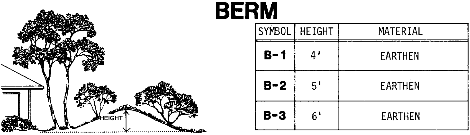
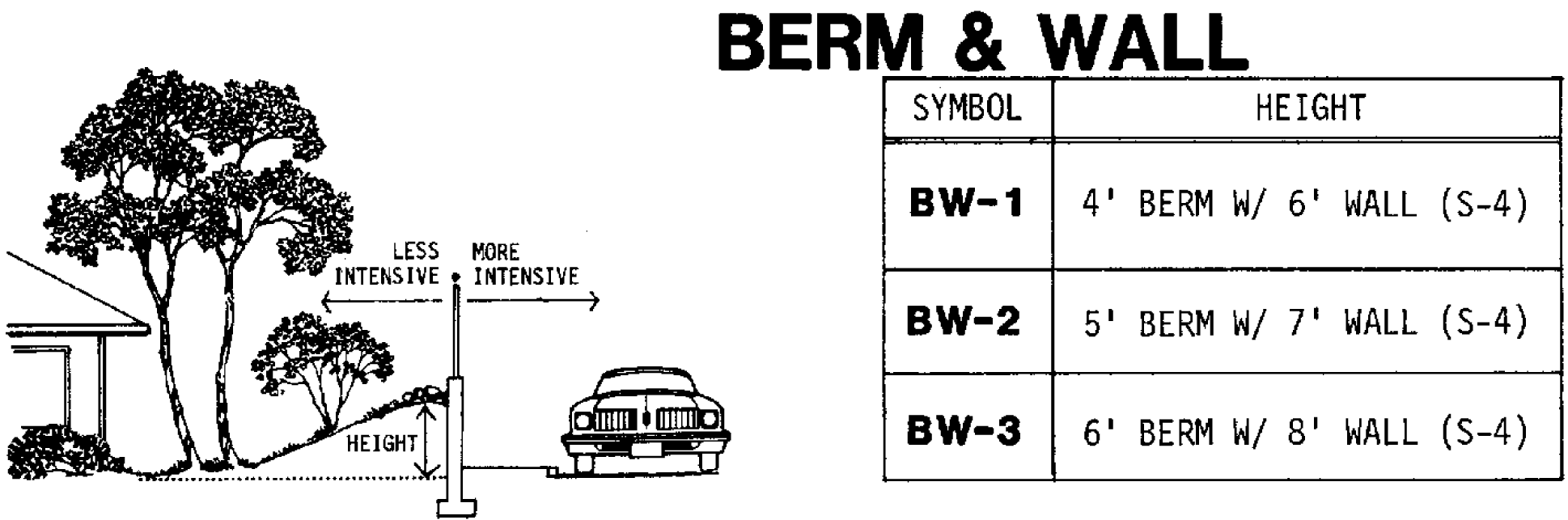
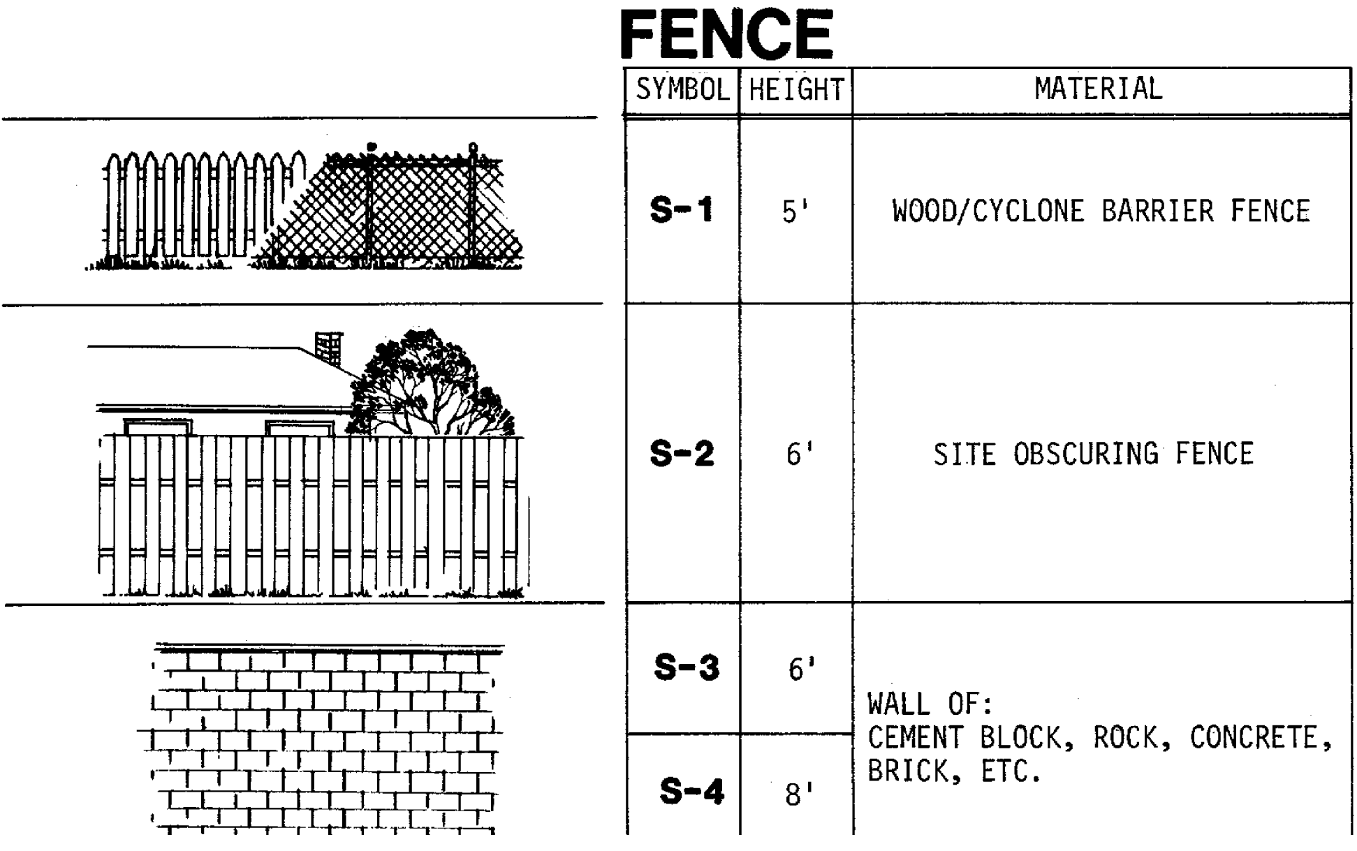
413 - PARKING AND LOADING
This Section applies in all Districts. Developments inside the UGB that do not provide off-street parking must still comply with all other applicable standards of this Section and all applicable standards of this Code.
Definitions:
Terms and definitions that apply throughout the Community Development Code are found in Section 106. Following are definitions for the terms found in Section 413:
Accessible Parking Space. A parking space consistent with the requirements of ORS 447.233.
Parking Demand. The total accumulation of vehicles parked on or near a given site at any associated point in time. Parking demand consists of both long-term (e.g., residents and employees) and short-term demand (e.g., visitors and/or customers) and may include on-street parking.
Off-Set Peak Hour Uses. Two or more land uses where the peak hour of parking demand for each use is determined not to occur at or around the same time period based on estimates from the Institute of Transportation Engineers Parking Generation Manual for the proposed land use(s) or as determined by a parking utilization study.
(Ord. No. 827A, § 2.A.(Exh. 1, § 5), 10-24-17, eff. 11-24-17; Ord. No. 833, § 2.A.(Exh. 1, § 3), 8-7-18, eff. 9-7-18; Ord. No. 903, § 2.M.(Exh. 13, § 19.), 10-15-24, eff. 11-14-24)
413-1
Development Permit for Parking Areas
A development permit shall be required for any area used for off-street parking except the parking allowed for a detached dwelling on an existing lot or parcel.
413-2
General Requirements
413-2.1
Off-street parking for a residential use shall be used solely for:
A.
The storage of passenger vehicles owned by occupants of the dwelling structure or their guests;
B.
One unoccupied travel or utility trailer, or recreation vehicle;
C.
One boat; and
D.
Farm equipment used in conjunction with farming on the premises.
413-2.2
Residential parking and garage facilities shall not be used for the storage of commercial vehicles (other than a commuter vehicle), tractor-trailer, semi-truck, heavy equipment or for the parking of automobiles belonging to employees, owners, tenants, visitors or customers of business or manufacturing establishments.
413-2.3
Parking spaces shall be available for the parking of operable automobiles of residents, guests, customers, patrons, employees, or any other person or organization subject to a contractual agreement to rent, leased or otherwise be assigned as permitted under Section 413-8.
413-2.4
Development permits for parking shall be reviewed through a Type I procedure except as otherwise specified in this Code.
413-2.5
Proper maintenance of off-street parking and loading facilities shall be a continuing obligation of the property owner.
413-2.6
In case of enlargement of a building or use of land existing on the effective date of this Code, the number of parking and loading spaces required shall be based on floor area or capacity of the entire use.
413-2.7
In the event several uses occupy a single structure or parcel of land, the total requirements for off-street parking and loading shall be the sum of the requirements of the several uses computed separately or as determined by Sections 413-8.3 and 413-8.5. In the rural area, development with two or more uses may use the same parking or loading area when the peak hours of operation of each use do not overlap.
413-2.8
All applications for a development permit proposing off-street parking and loading shall include a site plan drawn to scale, showing the parking or loading facilities to be provided. The required site plan shall include but is not limited to:
A.
Delineation of individual parking spaces and accessible parking spaces;
B.
Circulation area necessary to serve spaces;
C.
Vehicular and pedestrian access to streets, alleys and properties to be served;
D.
Curb cuts;
E.
Dimensions, continuity and substance of screening;
F.
Grading, drainage, surfacing and subgrading details;
G.
Delineation of all structures or other obstacles to parking and circulation on the site;
H.
Specifications for signs and bumper guards; and
I.
Specifications of proposed landscaping (see Section 407-8).
413-2.9
Private driveways providing access to urban attached unit residential development from a county or public street shall not be gated unless approved by the governing Fire Marshal and the Washington County Traffic Engineering Division.
(Ord. No. 827A, § 2.A.(Exh. 1, § 5), 10-24-17, eff. 11-24-17; Ord. No. 903, § 2.M.(Exh. 13, § 19.), 10-15-24, eff. 11-14-24)
413-3
Off-Street Parking Lot Design
All off-street parking lots including up to 50% of the spaces for compact cars, shall be designed in accordance with County standards for stalls and aisles dimensions as set forth in the following drawings and tables:
FIGURE 1 - Off Street Parking Lot Design - for illustrative purposes only
The following figure illustrates design principles included in this Code. It is intended for illustrative purposes only, and does not supersede any Code references.
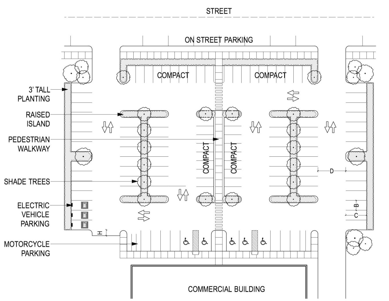
* no bumper overhang
** parallel to aisle
413-3.1
For one row of stalls use "C" plus "D" as minimum bay width.
413-3.2
The minimum aisle width for two-way traffic and for emergency vehicle operations area is 24 feet. The minimum aisle width for emergency vehicle (one-way traffic) is 15 feet.
413-3.3
Where appropriate bumper overhang area is provided (extruded curbs), "G" can be subtracted from "C" to determine stall depth.
413-3.4
Parallel Parking:
Space dimensions are to be 9 by 22 feet. Aisle dimensions for parallel parking are to be 12 feet for one-way aisles and 24 feet for two-way aisles.
413-3.5
Pedestrian Access and Landscaping:
In parking lots of 50 or more spaces and two or more rows of parking stalls, or 0.5-acre or more:
A.
Separate internal pedestrian connections shall be provided consistent with 408-10 to minimize vehicular-pedestrian conflicts, and allow safe pedestrian movement within the lot. Parking lots dedicated to the display and storage of automobile, recreational and other vehicle sales are exempt.
B.
Parking lots must include landscaping as provided in Section 407-6.
413-3.6
If provided, electric vehicle charging parking spaces, either public or private, shall comply with the following requirements:
A.
Electric vehicle charging parking spaces may substitute for required minimum off-street parking spaces of Section 413-6.1 at a 1:1 ratio.
B.
A minimum of one electric vehicle charging space shall be ADA compliant.
C.
Electric vehicle charging parking spaces shall be posted with signage not to exceed 5 square feet in size.
D.
Electric vehicle charging unit outlets and operable parts shall be no less than 18 inches off the ground if indoors and 24 inches off the ground if outdoors and no higher than 48 inches off the ground to ensure easy access.
(Ord. No. 827A, § 2.A.(Exh. 1, § 5), 10-24-17, eff. 11-24-17; Ord. No. 857, § 2.D.(Exh. 4, § 5), 8-27-19, 11-28-19; Ord. No. 903, § 2.M.(Exh. 13, § 19.), 10-15-24, eff. 11-14-24)
413-4
Off-Street Parking Standards
413-4.1
All off-street parking and loading areas inside the UGB shall be surfaced with concrete or asphaltic material to conform with either of the following standards:
A.
A minimum of 4 inches of concrete for vehicles and 6 inches for commercial vehicles or trucks; or
B.
Two inches of asphalt overlaying a 6-inch base (compacted) of crushed stone.
C.
In lieu of being constructed as described under A. or B. above, off-street parking and loading areas may be constructed of pervious paving materials when the applicant's engineer provides written certification with the application that appropriate site conditions exist for the use of pervious materials and that the proposed design and construction will be equal to or superior to the structural standards specified in A. or B. above.
413-4.2
Off-street parking and loading areas outside the UGB may be required by the Review Authority to be surfaced to the standards of 413-4.1 where:
A.
The site is adjacent to a paved limited access highway or arterial; or
B.
Located adjacent to a developed RR-5 Rural Community; or
C.
Where the Review Authority finds there is an adverse impact on adjacent properties.
413-4.3
Minimum standards for all required parking and loading areas outside the UGB shall consist of a gravel surface with 4 inches of base rock with 2 inches of three-quarter-inch minus leveling course.
413-4.4
Based upon approval of a grading plan pursuant to Section 410, for the purpose of temporary or overflow parking, or storage of heavy equipment or vehicles in the Industrial District, a gravel surface may be approved with a minimum 4 inches of base rock with 2 inches of three-quarter-inch minus leveling course.
413-4.5
All off-street parking areas, except for detached or two unit attached dwellings on a single lot and areas outside the UGB, shall be constructed with curbs of concrete or asphalt. Driveways for detached dwelling units that are less than 100 feet in length shall be paved. All driveways for Townhouse dwelling units shall be paved. Those areas constructed with a gravel surface may use curbs of wood or other materials as may be approved by the Review Authority.
413-4.6
Parking spaces in paved parking areas having more than three stalls are to be marked with paint striping, a minimum of 2 inches in width. Parking spaces in gravel surfaced lots may be identified by wheel stop barriers.
413-4.7
Covered parking spaces are to have a vertical clearance of at least 7 feet, 6 inches above the parking lot surface for all uses except residential.
413-4.8
The finished grade of a parking lot is not to exceed 5% slope.
413-4.9
Parking and loading areas that are not associated with a structure shall have no less than a 10-foot front and rear yard setback and shall conform to the street side yard requirements of the primary district.
413-4.10
All parking lots shall be landscaped as required by Section 407-6.
413-4.11
The minimum driveway width for each single-family attached or detached dwelling unit with individual vehicular access to a street shall be 10 feet. The minimum driveway depth for single-family detached and single-family attached units shall be consistent with standards of the primary district for setbacks to garage vehicle entrance. Within a driveway, each 10-foot wide area meeting the minimum driveway depth may be counted as one off-street parking space.
413-4.12
Driveways for two individual lots, each containing a Townhouse or detached dwelling unit, may be combined when the following standards are met:
A.
The minimum combined driveway width shall be 20 feet; and
B.
Driveway surface within each lot shall measure a minimum continuous width of 10 feet.
Figures 413-2—413-4:
Examples of Combined Driveways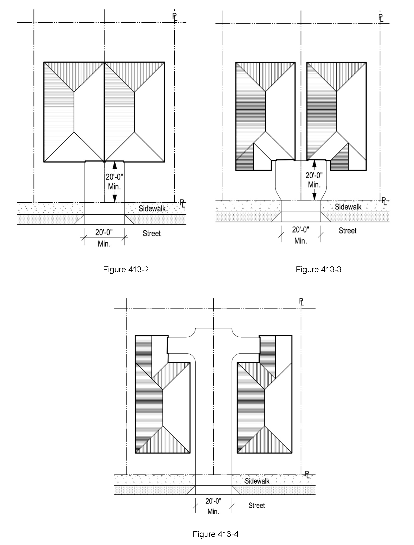
413-4.13
There shall be at least 18 feet of curb face along the street between combined and/or single driveways where a required on-street parking space is proposed.
413-4.14
The following minimum dimensional standards apply to garages intended for motor vehicles for detached and attached dwelling units. Garages that meet these standards serve as off-street parking.
A.
Interior garage space:
(1)
Ten feet wide and 20 feet deep for single vehicle garages.
(2)
Twenty feet wide and 20 feet deep for double vehicle garages.
(3)
Ten feet wide and 40 feet deep for tandem vehicle garages.
(4)
Minimum interior dimensions shall not be obstructed by utilities, water heaters or other permanent fixtures.
B.
Garage door entrances:
(1)
Eight feet wide for single vehicle garages.
(2)
Sixteen feet wide for double vehicle garages.
(Ord. No. 827A, § 2.A.(Exh. 1, § 5), 10-24-17, eff. 11-24-17; Ord. No. 842, § 2.A.(Exh. 1, § 7), 9-18-18, eff. 11-23-18; Ord. No. 855, § 2.A.(Exh. 1, § 22), 8-6-19, eff. 11-28-19; Ord. No. 866, § 2.C.(Exh. 3, § 19), 9-1-20, eff. 10-1-20; Ord. No. 885A, § 2.1.(Exh. 1), 6-28-22, eff. 7-28-22; Ord. No. 889A, § 2.C.(Exh. 3, § 15.), 2-7-23, eff. 3-9-23; Ord. No. 890A, § 2.A.(Exh. 1, § 1.), 2-7-23, eff. 3-9-23; Ord. No. 903, § 2.M.(Exh. 13, § 19.), 10-15-24, eff. 11-14-24)
413-5
[Reserved]
Editor's note— Ord. No. 903, § 2.M.(Exh. 13, § 19.), adopted Oct. 15, 2024, effective Nov. 14, 2024, repealed § 413-5, which pertained to On-Street Parking Requirements for Urban Residential Districts and derived from Ord. No. 827A, § 2.A.(Exh. 1, § 5), adopted Oct. 24, 2017, effective Nov. 24, 2017; Ord. No. 885A, § 2.1.(Exh. 1, § 19.), adopted June 28, 2022, effective July 28, 2022; Ord. No. 890A, § 2.A.(Exh. 1, § 20.), adopted Feb. 7, 2023, effective March 9, 2023.
413-6
Minimum and Maximum Off-Street Parking Requirements
The minimum and maximum number of off-street parking spaces by type of use shall be determined in accordance with the following tables. New development shall provide no more than the maximum number of off-street parking spaces listed unless exempted by Sections 413-6.4 or 413-6.7, or adjusted by Sections 413-6.5 or 413-6.6. The minimum and maximum off-street parking requirements for a use not listed shall be the same as the most similar listed use as determined by the Review Authority, or as determined through a parking analysis as described in Section 413-8.6.
413-6.1
Minimum Off-Street Parking Spaces Required outside the UGB. Development inside the UGB is exempt from minimum parking standards:
413-6.2
The following definition applies where specified in Table 413-6.1. Regulated affordable housing shall be defined as housing that is made affordable through public subsidies and/or statutory regulations that restrict or limit resident income levels and/or rents. To be considered regulated affordable housing, units must:
A.
Have a local, state, or federal compliance agreement or contract;
B.
Be affordable to households at or below 80% Median Family Income as defined annually by Housing and Urban Development (HUD) for the Portland-Vancouver Metropolitan Statistical Area (MSA); and
C.
Remain regulated affordable housing units for a minimum of 20 years from the date of occupancy.
413-6.3
Maximum Off-Street Parking Requirements for Areas Inside the UGB
In areas inside the UGB, the maximum number of allowable off-street parking spaces by type of use shall be determined by the following:
413-6.4
Parking spaces in parking structures, fleet parking, parking for vehicles that are for sale, lease, or rent, and employee vanpool/carpool parking spaces are exempt from the maximum off-street parking standards in Section 413-6.3.
413-6.5
The Review Authority may approve through a Type II procedure off-street parking in excess of the maximum parking standards if a development is located more than a 0.5-mile walk via easements for public travel to the closest bus stop with 15 minute peak hour service, or if 15 minute peak hour service is no longer provided within 0.5-mile of a property and the development is located outside of a Metro 2040 Center.
413-6.6
The Review Authority may approve through a Type II procedure off-street parking in excess of the maximum parking standards based on findings that:
A.
The nature of the development will result in a higher off-street parking demand relative to similar uses in the same parking zone; and
B.
To the greatest degree practicable, the development includes the implementation of opportunities for shared parking, parking structures, utilization of public parking spaces and other appropriate demand management programs. Demand management programs may include, but are not limited to, subsidized transit passes, shuttle service, and carpool programs.
413-6.7
For land uses with more than 65,000 square feet of floor area, surface parking area may not exceed the floor area of the building. Non-surface parking, such as tuck-under parking, underground and subsurface parking, and parking structures are exempt.
A.
Surface parking shall be measured inclusive of all surface area on which a vehicle is designed to maneuver including all parking stalls, driveways and drive-through lanes within the property regardless of length, and all maneuvering areas regardless of depth.
B.
Paved areas not for use by passenger vehicles, such as loading areas or outdoor storage of goods or materials, are not counted as surface parking area.
413-6.8
A minimum of one accessible parking space is required for any development required to provide one or more off-street drop-off and loading space(s) (Section 413-9) unless the Review Authority determines through a Type II procedure that the accessible space is not necessary or feasible.
413-6.9
Development outside of a UGB is exempt from the maximum parking standards in Section 413-6.3 and 413-6.7.
(Ord. No. 827A, § 2.A.(Exh. 1, § 5), 10-24-17, eff. 11-24-17; Ord. No. 831A, § 2.A.(Exh. 1, § 17), 7-17-18, eff. 8-16-18; Ord. No. 832A, § 2.A.(Exh. 1, § 22), 9-18-18, eff. 10-18-18; Ord. No. 859, § 2.A.(Exh. 1, § 11), 9-17-19, eff. 11-28-19; Ord. No. 885A, § 2.1.(Exh. 1, § 19.), 6-28-22, eff. 7-28-22; Ord. No. 903, § 2.M.(Exh. 13, § 19.), 10-15-24, eff. 11-14-24)
413-7
Vanpool/Carpool Parking
If 50 or more parking spaces are provided for an institutional, commercial, or industrial use, preferential parking for vanpool/carpool shall be provided as set forth below.
413-7.1
At least 10% of the employee or student spaces shall be designated for exclusive use by vanpools/carpools.
413-7.2
Spaces reserved for exclusive use by vanpools/carpools shall have a minimum width of 9.5 feet and be clearly marked for vanpool/carpool use.
413-7.3
Vanpool/carpool spaces shall be generally located closest to the primary entrance for employees or students utilizing such spaces but not closer than spaces for handicapped parking or visitor parking. For developments with more than 20 required vanpool/carpool spaces and more than one primary entrance, 50% of all of the required vanpool/carpool parking may be clustered in one or more centralized, convenient locations.
413-7.4
In case of enlargement of a building or a change in the use of a building, the number of vanpool/carpool parking spaces required shall be based on floor area or capacity of the entire use of the building. If the building is part of a larger existing use with multiple buildings, only the subject building shall meet the vanpool/carpool parking requirements.
(Ord. No. 827A, § 2.A.(Exh. 1, § 5), 10-24-17, eff. 11-24-17; Ord. No. 903, § 2.M.(Exh. 13, § 19.), 10-15-24, eff. 11-14-24)
413-8
Reduction of Minimum Off-Street Parking Outside the UGB
The minimum number of off-street parking spaces required by Section 413-6.1 may be reduced through the application of Sections 413-8.1 through 413-8.5. The total cumulative reduction to minimum off-street parking for non-residential developments shall not exceed 50% of the required minimum spaces, except as allowed by Section 413-8.5. The total cumulative reduction to minimum off-street parking for residential developments shall not result in a ratio below 0.5 spaces per unit, except as allowed by Section 413-8.5.
413-8.1
Reduction of Minimum Off-Street Parking Based on Vanpool/Carpool
Sites having 50 or more parking spaces may reduce total minimum parking space requirements by two standard or compact size spaces for every one vanpool/carpool space provided. Vanpool/carpool spaces are exempt from the maximum parking requirements of Section 413-6.3.
413-8.2
Reduction of Minimum Off-Street Automobile Parking Based on Bicycle Parking
Reduction of the minimum quantity of off-street automobile parking required by Section 413-6 is allowed as described in this section. All bicycle parking spaces must meet the standards of Sections 429-7, 429-8 and 429-9.
A.
Sites may reduce total minimum automobile parking space requirements by one standard or compact size space, up to 10% of required automobile spaces, for every two secured, long-term bicycle spaces provided per Section 429-5 B.
B.
Replacement bicycle parking spaces in existing development are exempt from permit requirements per Section 201-2.33. Alterations in parking lot requirements beyond this exemption will be subject to development review.
413-8.3
Reduction to Minimum Off-Street Automobile Parking Based on Mixed-Use or Shared Parking Agreement
The minimum number of off-street parking spaces required by Section 413-6 may be reduced for two or more uses, structures or lots whose owners agree to jointly use the same parking and/or loading spaces, subject to the following:
A.
On-site parking may be shared by two or more uses with concurrent peak hour uses, provided the following standards are met:
(1)
The use or uses are located within a mixed-use development. The site may include multiple parcels as long as they are under the same ownership and are contiguous. The total combined required minimum vehicle parking may be determined using the following formula:
a.
Primary use, i.e., that with the largest proportion of total trip generation within the development, at 100% of the minimum vehicle parking required for that use.
b.
Secondary use, i.e., that with the second largest percentage of total trip generation within the development, at 85 of the vehicle parking required for that use(s);
c.
All other uses at 70% of the vehicle parking required for that use(s).
(2)
Access to the shared parking is not blocked or impeded by the sharing uses or any other use; and
(3)
Full access to such parking and/or loading areas shall be exhibited in a recorded deed, lease or contract.
B.
On-site parking may be reduced when the peak hours of parking demand for two or more of the land uses are complementary and do not overlap (off-set peak hour uses), provided the following standards are met:
(1)
The total combined required minimum vehicle parking may be determined using the following formula:
a.
Primary use, i.e., that with the largest proportion of total trip generation within the development, at 100% of the minimum vehicle parking required for that use.
b.
Secondary use, i.e., that with the second largest percentage of total trip generation within the development, at 85% of the vehicle parking required for that use(s);
c.
All other uses at 70% of the vehicle parking required for that use(s).
(2)
The shared parking is within 500 feet of all uses sharing the parking;
(3)
Pedestrians should not be required to cross an arterial street except at a signalized intersection along the pedestrian pathway;
(4)
Access to the shared parking is not blocked or impeded by the sharing uses or any other use; and
(5)
Full access to such parking and/or loading areas shall be exhibited in a recorded deed, lease or contract.
C.
Off-site parking may be shared by two or more non-residential uses with concurrent peak hour parking demand if the following standards are met:
(1)
The total combined required minimum vehicle parking may be determined using the following formula:
a.
Primary use, i.e., that with the largest proportion of total trip generation within the development, at 100% of the minimum vehicle parking required for that use.
b.
Secondary use, i.e., that with the second largest percentage of total trip generation within the development, at 85 percent of the vehicle parking required for that use(s);
All other uses at 70% of the vehicle parking required for that use(s).
(2)
The shared parking is within 800 feet of all uses sharing the parking;
(3)
Pedestrians should not be required to cross an arterial street except at a signalized intersection along the pedestrian pathway;
(4)
Access to the shared parking is designed to be safe and comfortable for pedestrians; and
(5)
Full access to such parking and/or loading areas shall be exhibited in a recorded deed, lease or contract.
413-8.4
Reduction of Minimum Off-Street Automobile Parking Based on Availability of On-Street Parking
A.
The minimum number of off-street parking spaces required by Section 413-6 for non-residential uses may be reduced by one space for every two on-street spaces provided the following standards are met:
(1)
On-street parking spaces are along the frontage of the subject site; and
(2)
The parking spaces are delineated parallel or angled parking in accordance with the standards of the Washington County Road Design and Construction Standards (perpendicular parking is not allowed).
413-8.5
Reduction of Minimum Off-Street Automobile Parking Based on a Parking Analysis
A.
The Review Authority may approve through a Type II procedure a reduction of up to 100% of the off-street parking minimums based on a parking analysis which substantiates the basis for the parking reduction. The parking analysis shall ensure that the parking requirements are adequate for each phase of development including the ultimate development scenario.
B.
The parking analysis shall be prepared by a qualified parking or traffic consultant or civil engineer, and shall include, at a minimum, the following information:
(1)
Location of the subject property;
(2)
Property description;
(3)
Owner/consultant contact;
(4)
Inventory of parking facilities within 500 feet of the subject site including on-street and publicly accessible off-street parking;
(5)
Utilization of existing facilities during peak periods of parking demand;
(6)
Estimate the parking demand generated by each component of the development;
(7)
An assessment of the feasibility and appropriateness of shared parking;
(8)
A parking strategy if the parking demand cannot be accommodated on-site;
(9)
Information and plans showing the location of any off-site parking and the lease arrangements for this parking.
(Ord. No. 827A, § 2.A.(Exh. 1, § 5), 10-24-17, eff. 11-24-17; Ord. No. 833, § 2.A.(Exh. 1, § 3), 8-7-18, eff. 9-6-18; Ord. No. 857, § 2.D.(Exh. 4, § 5), 8-27-19, 11-28-19; Ord. No. 903, § 2.M.(Exh. 13, § 19.), 10-15-24, eff. 11-14-24)
413-9
Minimum Off-Street Drop-off and Loading Requirements
In all primary districts, drop-off and loading areas complying with the dimensions of 413-10 shall be provided according to the following schedule:
413-9.1
Residential:
None required, except for high rise (above three stories) attached dwelling units which shall be provided with one drop-off and loading space as a minimum and shall provide one additional drop-off and loading space for each 50 dwelling units over 100 dwelling units.
(Ord. No. 827A, § 2.A.(Exh. 1, § 5), 10-24-17, eff. 11-24-17; Ord. No. 903, § 2.M.(Exh. 13, § 19.), 10-15-24, eff. 11-14-24)
413-10
General Drop-off and Loading Space Requirements
413-10.1
It shall be unlawful to store or accumulate goods in a loading space if it renders it useless for loading and unloading operations.
413-10.2
Drop-off and loading spaces shall be located on the site and directly accessible to main structures. The location of the drop-off and loading spaces shall comply with the requirements of Sections 403-2.3 E. (2).
413-10.3
The minimum length and width of drop-off and loading spaces required by 413-9 shall be according to the requirements in the following table:
(Ord. No. 827A, § 2.A.(Exh. 1, § 5), 10-24-17, eff. 11-24-17; Ord. No. 903, § 2.M.(Exh. 13, § 19.), 10-15-24, eff. 11-14-24)
414 - SIGNS
The following sign regulations shall apply to all uses as indicated.
414-1
Residential Districts
414-1.1
Scope:
This Section (414-1) shall apply to all Residential Districts.
414-1.2
Size:
For each lot or parcel, signing at the listed size may be allowed:
A.
One sign not exceeding two square feet in area shall be permitted per dwelling unit. For attached dwellings exceeding three units, one or more additional signs not exceeding a total of 12 square feet in area shall be permitted per structure.
B.
For Residential Developments (including subdivision identification) the maximum size and number of signs shall be controlled according to the following:
(1)
Residential developments 4 acres or less in area may have a sign or signs with a total area of no more than 32 square feet.
(2)
Residential developments over 4 acres but less than 40 acres in area may have a sign or signs which have a total area of no more than 48 square feet.
(3)
Residential developments of 40 acres or more in area may have a sign or signs with a total area of no more than 102 square feet.
414-1.3
Location:
Permitted signs may be anywhere on the premises, except in a required side yard or within 10 feet of a street right-of-way.
414-1.4
Height:
The following maximum heights shall apply to signs:
A.
If ground-mounted, the top shall not be over 4 feet above the ground;
B.
If building mounted, shall be flush mounted and shall not project above the roof line; and
C.
If freestanding, shall not exceed 20 feet in height.
414-1.6
Illumination:
Illumination if used shall not be blinking, fluctuating or moving. Light rays shall shine only upon the sign and upon the property within the premises.
414-2
Commercial and Institutional Districts
414-2.1
Scope:
This Section shall apply to all Commercial Districts and the Institutional District.
414-2.2
Number and Size:
For each lot or parcel, signing at the listed size may be allowed:
A.
In the Neighborhood Commercial (NC), Office Commercial (OC), Institutional (INST), Neighborhood Corner Commercial (NCC NB), Neighborhood Commercial Mixed Use (NCMU NB), and Institutional North Bethany (INST NB) districts, except as otherwise required within standards for the particular district or use, signs shall not exceed 35 square feet.
B.
In the Community Business District (CBD), General Commercial (GC) and Rural Commercial (R-COM) districts, signs shall not exceed the following area requirements:
C.
Two or more lots or parcels having a combined linear frontage of 85 feet may combine their sign areas allowed by Section 414-2.2 B. for the purpose of providing one common free-standing or ground-mounted sign. The sign shall not exceed 150 square feet.
D.
Corner Lots:
Where a lot fronts on more than one street, only the square footage computed for each street frontage shall face that street frontage.
E.
In addition to all other sign standards, incidental signs are governed by the following:
F.
Commercial Center:
Signs used for Commercial Centers shall be allowed as follows:
(1)
Only one sign of 150 square feet shall be permitted for centers less than five acres and greater than one acre.
(2)
A maximum of two signs of 400 square feet shall be permitted for complexes for 5 to 50 acres.
(3)
A maximum of three signs of 400 square feet shall be permitted for complexes of more than 50 acres.
(4)
Individual businesses are allowed a face building mounted sign pursuant to Section 414-2.2 A. and B.
G.
Outdoor Signs:
Outdoor signs, including digital billboards and excluding bench signs (see Section 414-5.2), shall be permitted only in the General Commercial (GC) District. Such signs shall not exceed t300 square feet per face, nor shall the face exceed a length of 25 feet or a height, excluding foundation and supports, of 12 feet. In determining these limitations, the following shall apply:
(1)
Minimum spacing shall be as follows:
(2)
For the purpose of applying the spacing requirements of Section 1 above, the following shall apply:
(a)
Distances shall be measured parallel to the centerline of the highway; and
(b)
A back-to-back, double-faced or V-type sign shall be considered as one sign.
414-2.3
Location:
A.
Flat Wall Signs may be located on any wall of the building.
B.
Freestanding Signs must have a minimum clearance of 8 feet 6 inches above a sidewalk and 15 feet above driveways or alleys.
C.
One Freestanding or Ground-Mounted sign per lot or parcel except as provided in Section 414-1.2 B. and 414-2.2 F. may be located anywhere on the premises except as follows:
(1)
A ground-mounted sign shall not be located in a required side yard, rear yard or within 5 feet of a street right-of-way.
(2)
A freestanding sign shall not be located in a required side or rear yard. A freestanding sign may project up to the street right-of-way provided there is a minimum ground clearance of 8 feet 6 inches.
D.
Marquee Signs or signs located on or attached to marquees must have a minimum clearance of not less than 8 feet 6 inches. The maximum vertical dimension of signs shall be determined as follows:
E.
Wall signs shall not extend above the top of a parapet wall or a roofline at the wall, whichever is higher.
F.
Permitted outdoor signs, including digital billboards, may be allowed anywhere on the premises except in a required side yard, rear yard or within 20 feet of a street right-of-way.
G.
No portion of a digital billboard shall be located within 250 linear feet of the property line of a parcel with a residential land use designation that fronts on the same street and within the line of sight of the billboard face.
414-2.4
Height:
A.
Ground-mounted signs shall not exceed 4 feet in height from ground level.
B.
Freestanding signs shall not exceed 28 feet in height from ground level.
C.
Outdoor signs, including digital billboards, shall not exceed 35 feet in height from ground level.
414-2.5
Content:
A.
Any of the signs pursuant to this Section (414-2) may be changeable copy signs.
B.
The primary identification sign for each firm shall contain its street number. The street number shall be clearly visible from the street right-of-way.
414-2.6
Illumination:
Shall be as provided in Section 414-7.
(Ord. No. 857, § 2.D.(Exh. 4, § 6), 8-27-19, 11-28-19)
414-3
Pedestrian-Oriented Mixed-Use Districts
414-3.1
Scope:
This section shall apply to the Pedestrian-Oriented Mixed-Use Districts (Section 392).
A.
The standards of Section 414-2 (Signs - Commercial and Institutional Districts) shall apply, with the additional specifications and prohibitions stated below.
(1)
In the CCMU District, sign size shall comply with the requirements of Section 414-2.2 B.
(2)
In the NMU District, sign size shall comply with the requirements of Section 414-2.2 A.
(3)
Ground-mounted monuments or site entry markers up to 15 feet in height may be approved subject to the following:
a.
Total area and volume of the portion of the monument or marker incorporating sign letters shall not exceed 45 square feet or 90 cubic feet; and
b.
Position of the monument or marker shall not obscure roadway visibility or result in potential traffic hazard(s) as may be determined by the County Engineer.
(4)
Prohibited signs:
a.
Free-standing signs (e.g., pole-mounted signs) as defined in Section 106-193.4;
b.
Other signs prohibited under Section 414.
(Ord. No. 857, § 2.D.(Exh. 4, § 6), 8-27-19, 11-28-19)
Editor's note— Ord. No. 857, § 2.D.(Exh. 4, § 6), adopted August 27, 2019, effective November 28, 2019, renumbered former §§ 414-3—414-10 as §§ 414-4—414-11 and enacted a new § 414-3 as set out herein.
414-4
Industrial
414-4.1
Scope:
This Section shall apply to the Industrial District.
414-4.2
Number and Size:
A.
One sign for each street frontage, each with a maximum area of 5% of the total square footage of the face of the building facing that street frontage shall be permitted.
B.
One freestanding or ground-mounted sign not exceeding 50 square feet per lot or parcel.
C.
Industrial Park signing shall be controlled according to the following:
(1)
A maximum of two signs of 300 square feet per face shall be permitted for industrial parks or complexes of less than 10 acres;
(2)
A maximum of three signs of 400 square feet shall be permitted for complexes of 10 acres or more. More than three signs may be approved through a Type I procedure, provided the total sign area does not exceed 1,200 square feet.
414-4.3
Location:
Shall be as provided in Section 414-2.3.
414-4.4
Illumination:
Shall be as provided in Section 414-7.
(Ord. No. 857, § 2.D.(Exh. 4, § 6), 8-27-19, 11-28-19)
See the editor's note to § 414-3.
414-5
Agriculture and Forestry Signs
414-5.1
Scope:
This Section shall apply to the agricultural and forestry areas outside the Urban Growth Boundaries.
414-5.2
Size:
A maximum area of 32 square feet per sign.
414-5.3
Location:
Signs shall be at least 5 feet from a right-of-way, and shall be at least 25 feet from an adjacent lot.
414-5.4
Illumination:
As provided in Section 414-7.
414-5.5
Maximum number of signs:
(Ord. No. 857, § 2.D.(Exh. 4, § 6), 8-27-19, 11-28-19)
See the editor's note to § 414-3.
414-6
Exemptions and Supplemental Criteria
The following signs are exempted from development permit requirement and from the standards set forth above; however, a permit may be required as determined by the Building Official.
414-6.1
Temporary Signs:
Temporary signs are permitted subject to the following standards:
A.
Shall not exceed 16 square feet in area;
B.
Shall not be located within any dedicated right-of-way; and
C.
Shall be removed within 14 days after the election, sale, rental, lease or conclusion of event.
414-6.2
Bench Signs:
On street benches provided:
A.
The benches shall not be higher than 4 feet above ground;
B.
Limited to 14 square feet in area;
C.
The benches are not located closer than 5 feet to any street right-of-way line;
D.
Benches are located in a manner not to obstruct vision;
E.
Shall be included as part of the total permitted sign area of the premise on which it is located.
414-6.3
Directory Signs are permitted when the maximum total area does not exceed 100 square feet. Directory signs shall not front on any public street.
414-6.4
Integral Signs
414-6.5
Private Traffic Direction:
Signs directing vehicular, bicycle, and/or pedestrian traffic movement onto a premise or within a premise, not to exceed 5 square feet in area for each sign. Illumination of these signs shall be in accordance with Section 414-7. Horizontal directional signs flush with paved areas are exempt from these standards.
414-6.6
Street Banners for Public Events (Temporary)
414-6.7
Original Art Display
A hand-painted work of visual art that is either affixed to or painted directly on the exterior wall of a building. An original art display does not include: mechanically produced or computer generated prints or images, including but not limited to digitally printed vinyl; electrical or mechanical components; or changing image art display.
Original art displays are allowed provided that they meet the following requirements:
A.
Located outside the Urban Growth Boundary;
B.
Shall not be placed on a dwelling;
C.
Shall not extend more than 6 inches from the plane of the wall upon which it is painted or to which it is affixed;
D.
Shall be no more than 64 square feet in size, per lot or parcel;
E.
Compensation will not be given or received for the display of the original art or the right to place the original art on site; and
F.
Shall not be illuminated.
(Ord. No. 857, § 2.D.(Exh. 4, § 6), 8-27-19, 11-28-19)
See the editor's note to § 414-3.
414-7
Illumination
No sign shall be erected or maintained which, by use of lights or illumination, creates a distracting or hazardous condition to a motorist, pedestrian or the general public. In addition:
414-7.1
No exposed reflective type bulb, par spot or incandescent lamp, which exceeds 25 Watts, shall be exposed to direct view from a public street or highway, but may be used for indirect light illumination of the display surface of a sign.
414-7.2
When neon tubing is employed on the exterior or interior of a sign, the capacity of such tubing shall not exceed 300 milliamperes rating for white tubing or 100 milliamperes rating for any colored tubing.
414-7.3
When fluorescent tubes are used for the interior illumination of a sign, such illumination shall not exceed:
A.
Within Residential districts:
Illumination equivalent to 425 milliamperes rating tubing behind a Plexiglas face with tubes spaced at least 7 inches, center to center.
B.
Within land use districts other than Residential:
Illumination equivalent to 800 milliampere rating tubing behind a Plexiglas face spaced at least 9 inches, center to center.
414-7.4
Digital billboards allowed pursuant to Section 414-2.2 G shall:
A.
Display only static messages that remain constant in illumination intensity and do not have movement or the appearance or optical illusion of movement;
B.
Not operate at an intensity level of more than 0.3 foot-candles over ambient light as measured at a distance of 150 feet;
C.
Be equipped with a light sensor that automatically adjusts the intensity of the billboard according to the amount of ambient light;
D.
Be designed to either freeze the display in one static position, display a full black screen, or turn off in the event of a malfunction; and
E.
Provide evidence that best industry practices for eliminating or reducing uplight and light trespass were considered.
(Ord. No. 857, § 2.D.(Exh. 4, § 6), 8-27-19, 11-28-19)
See the editor's note to § 414-3.
414-8
Prohibited Signs
Signs or lights which:
414-8.1
Are of a size, location, movement, coloring, or manner of illumination which may be confused with or construed as a traffic control device or which hide from view any traffic or street sign or signal;
414-8.2
Contain or consist of banners, posters, pennants, ribbons, streamers, strings of light bulbs, spinners, or other similarly moving devices or signs which may move or swing as a result of wind pressure. These devices when not part of any sign are similarly prohibited, unless they are permitted specifically by other legislation;
414-8.3
Have blinking, flashing or fluttering lights or other illuminating devices which exhibit movement, except digital billboards as permitted pursuant to this Code;
414-8.4
Are roof signs;
414-8.5
Are freeway-oriented signs; and
414-8.6
Are portable signs.
(Ord. No. 857, § 2.D.(Exh. 4, § 6), 8-27-19, 11-28-19)
See the editor's note to § 414-3.
414-9
Procedures
Applications for a sign permit shall be processed through a Type I procedure.
(Ord. No. 857, § 2.D.(Exh. 4, § 6), 8-27-19, 11-28-19)
See the editor's note to § 414-3.
414-10
Nonconformity and Modification
Except as provided in Section 414-10.2 of this Chapter, signs in existence on the date of adoption of this Code, which do not conform to the provisions of this Code, but which were in compliance with the applicable regulations at the time they were constructed, erected, affixed or maintained shall be regarded as nonconforming.
414-10.1
For the purpose of amortization, these signs may be continued from the effective date of this Code for a period not to exceed 10 years.
414-10.2
Signs which were nonconforming to the prior Ordinance and which do not conform to this Code shall be removed on or before November 6, 1983, as was provided for purposes of amortization in Article II of the former Community Development Ordinance.
414-10.3
Nonconforming outdoor signs under the provisions of Section 414-10 in conformance with ORS Chapter 377 shall not be considered to be nonconforming signs requiring removal. This provision applies to signs on all highways. Removal of such outdoor signs shall be only as provided by Oregon Revised Statutes.
(Ord. No. 857, § 2.D.(Exh. 4, § 6), 8-27-19, 11-28-19)
See the editor's note to § 414-3.
414-11
Compliance
Any sign which is altered, relocated, replaced or shall be brought immediately into compliance with all provisions of this Code.
(Ord. No. 857, § 2.D.(Exh. 4, § 6), 8-27-19, 11-28-19)
See the editor's note to § 414-3.
415 - LIGHTING
415-1
Applicability
The roadways, access drives, parking lots and sidewalks of all new developments of attached units (except those proposed to meet the definition of Middle Housing in Section 106), shall be lighted in conformance to the standards of this Section (415). This Section is not intended to apply to public street lighting.
(Ord. No. 885A, § 2.1.(Exh. 1, § 20.), 6-28-22, eff. 7-28-22; Ord. No. 890A, § 2.A.(Exh. 1, § 1.), 2-7-23, eff. 3-9-23)
415-2
Lighting Plan
Prior to the issuance of a Development Permit for a structure other than a detached dwelling or attached dwelling of less than three units, an Exterior Lighting Plan shall be submitted in order to determine whether the requirements of this Section (415) have been met. This plan shall include:
415-2.1
Site Plan and Building Floor Plans and Elevations showing luminaire location;
415-2.2
Luminaire details;
415-2.3
Lighting coverage and cutoffs; and
415-2.4
Any additional information necessary to insure compliance with Section 415.
415-3
Definitions
415-3.1
Candle Power:
The amount of light that will illuminate a surface 1 foot distant from a light source to an intensity of 1 foot candle. Maximum (peak) candle power is the largest amount of candlepower emitted by any lamp, light source, or luminaire.
415-3.2
Cutoff:
The point at which all light rays emitted by a lamp, light source or luminaire are completely eliminated (cutoff) at a specific angle above the ground.
415-3.3
Cutoff angle:
The angle formed by a line drawn from the direction of light rays at the light source and a line perpendicular to the ground from the light source, above which no light is emitted.
415-3.4
Cutoff-type luminaire:
A luminaire with elements such as shields, reflectors, or refractor panels which direct and cut off the light at a cutoff angle that is less than 90 degrees.
415-3.5
Foot-candle:
A unit of illumination produced on a surface, all points of which are 1 foot from a uniform point source of one candle.
415-3.6
Glare:
The brightness of a light source which causes eye discomfort.
415-3.7
Luminaire:
A complete lighting unit consisting of a light source and all necessary mechanical, electrical, and decorative parts.
415-3.8
Maximum permitted illumination:
The maximum illumination measured in foot-candles at the property line or, if required, interior screening and buffering line at ground level, in accordance with the standards of Section 415-4 below.
415-4
Standards
The following standards are required of all exterior lighting except the outdoor recreational uses specifically exempted below. Many uses have the option of providing a lower light post with a non-cutoff type luminaire or a higher pole, up to 40 feet, with a luminaire that totally cuts off light spillover at a cutoff angle smaller than 90 degrees (Figure 1). The maximum light post height permitted is dependent on the amount of cutoff provided. This is designed as a protection against excessive glare and light spilling over to neighboring properties. The exceptions which are permitted provide adequate protection for neighboring residential property. Exterior lighting shall meet one of the following standards:
415-4.1
When light source or luminaire has no cutoff:
415-4.2
When a luminaire has total cutoff of an angle greater than 90 degrees (Figure 2), (as compared to 90 degrees exactly [Figure 3]), the maximum illumination and the maximum permitted luminaire height shall be:
415-4.3
When a luminaire has total cutoff of light at an angle less than 90 degrees (Figure 1) and is located so that the bare light bulb, lamp, or light source is completely shielded from the direct view of an observer 5 feet above the ground at the point where the cutoff angle intersects the ground, then the maximum permitted illumination and the maximum permitted height of the luminaire shall be:
415-4.4
Exemption for specified public outdoor recreation uses:
A.
Because of their unique requirements for nighttime visibility and their limited hours of operation, public ball diamonds, public playing fields, and public tennis courts are exempted from the exterior lighting standards of Sections 415-4.1 through 415-4.3 above. These outdoor recreational uses must meet all other requirements for this Section and of this Code.
B.
The outdoor recreational uses specified above shall not exceed a maximum permitted post height of 80 feet.
C.
The outdoor recreational uses specified above may exceed a total cutoff angle of 90 degrees, provided that the luminaire is shielded to prevent light and glare spillover to adjacent residential property. The maximum permitted illumination at the property line or, if required, the interior screening and buffering line, shall not exceed two foot candles.
415-5
General Provisions
Notwithstanding any other provision of this Section to the contrary:
415-5.1
No flickering or flashing lights shall be permitted.
415-5.2
Light sources or luminaires shall not be located within areas identified for screening or buffering except on pedestrian walkways.
415-5.3
Lighting shall be located and oriented so as not to shine excessive light into nearby habitat areas, including Significant Natural Resource Areas as identified in a Community Plan or the Rural Natural Resources Plan.
The following figures are examples:
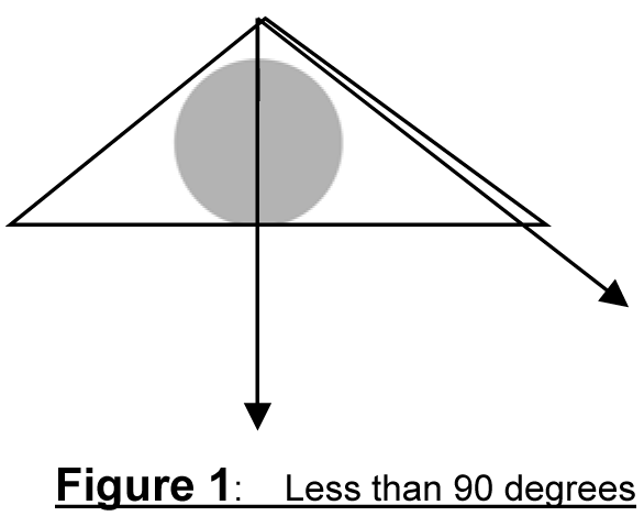
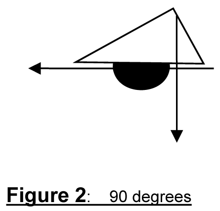
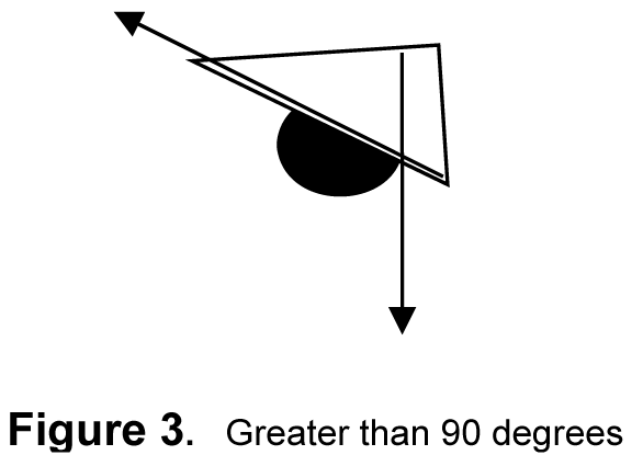
(Ord. No. 866, § 2.C.(Exh. 3, § 20), 9-1-20, eff. 10-1-20; Ord. No. 902A, § 2.B.(Exh. 2, § 34.), 11-5-24, eff. 12-5-24)
416 - UTILITY DESIGN
416-1
General Provisions
416-1.1
All utility distribution facilities supplying electric, communication, or similar or associated service, installed in and for the purpose of supplying such service to any development shall be placed underground; provided however, that the word "facilities" as used herein shall not include standards used for street lighting, traffic signals, pedestals for police and fire system communications and alarms, pad-mounted transformers, pedestals, pedestal-mounted terminal boxes and meter cabinets, concealed ducts, substations, or facilities used to carry voltage higher than 50,000 volts.
416-1.2
Notwithstanding Section 416-1.1, overhead utility distribution lines may be permitted upon approval of the Review Authority through a Type I procedure when terrain, soil, or geologic conditions prohibit underground installation, or when proposed development is part of an urban infill process and surrounding developments do not have underground utilities. Location of such overhead utilities shall be along rear or side lot lines wherever feasible.
416-1.3
Easements necessary for sewers, water mains, electric lines, stormwater facilities, or other public utilities shall be provided. The easements will vary according to the need of various utilities. When possible, the easement shall be located on one side of a lot line.
416-1.4
The location, design, installation and maintenance of all utility lines and facilities shall conform to ORS Ch. 92 and be carried out with minimum, feasible disturbance of soil and site.
416-1.5
For a Middle Housing Land Division, separate utilities shall be provided for each dwelling unit, except to the extent that standards of Clean Water Services and/or County Building Services allow for shared storm or sanitary sewer system elements.
(Ord. No. 890A, § 2.A.(Exh. 1, § 21.), 2-7-23, eff. 3-9-23)
417 - IRRIGATION
Irrigation Standards are provided to insure healthy and proper growth habits of plant materials, accelerate the desired effects of required landscaping, reduce maintenance and promote longevity of plant materials.
417-1
Provision of Method of Irrigation
All developments, which are required to provide landscaping, shall provide appropriate methods of irrigation for the landscaping. Landscaping which exceeds 1,000 square feet shall be irrigated with automatic sprinkler systems. Hose bibs and manually operated methods of irrigation may be approved by the Review Authority based upon written verification, submitted by a registered landscape architect, that the alternatives can satisfy the intent and purpose of the irrigation standards.
417-2
Irrigation System Details
Irrigation system details shall include:
417-2.1
A plan and schedule of equipment including gate valve, backflow preventor, control valves, piping, sprinkler heads, meter size and location; and
417-2.2
Water source, including type, size of service connection, flow in gallons per minute (GPM), static water pressure in pounds per square inch (PSI), and maximum pressure in PSI required to operate the irrigation circuit with the greatest pressure loss in the system.
417-3
General Provisions
417-3.1
The irrigation plan shall provide a full and uniform coverage to all landscape materials which require irrigation.
417-3.2
Irrigation techniques shall include methods of water conservation.
418 - SETBACKS
418-1
Obstruction in Required Yards
Required yards shall be horizontally unobstructed except as follows:
418-1.1
Cornices, eaves, belt courses, sills, canopies, or other similar architectural features (not including bay windows or vertical projections) may extend, or project into a required side yard not more than 2 inches for each (1) foot of width of such side yard and may extend or project into a required front or rear yard not more than 20 inches. Chimneys may not project into a front or rear yard more than 24 inches. Chimneys may project up to 24 inches into a side yard setback, but no closer than 3 feet to a property line.
418-1.2
Open balconies and unenclosed stairways more than 30 inches in height and not covered by a roof or canopy, may extend or project into a required rear yard not more than 4 feet and may extend into a required front yard not more than 30 inches.
418-1.3
A ground level deck not more than 30 inches in height and not covered by a roof or canopy may be allowed in any yard regardless of the setback requirements.
418-1.4
A deck more than 30 inches in height, not covered by a roof or canopy, may be allowed in a required rear yard not closer than 5 feet to the rear property line when the rear yard abuts a designated open space or public non-buildable tract. Such tracts may include floodplains, power line easements, or drainage courses.
(Ord. No. 833, § 2.A.(Exh. 1, § 4), 8-7-18, eff. 9-6-18)
418-2
Additional Setbacks Required for Future Right-of-Way
418-2.1
Where a yard or setback abuts a street having insufficient right-of-way width, the minimum yard or setback requirement shall be increased to accommodate the future right-of-way. The future right-of-way shall be measured from the centerline of the existing right-of-way. The yard or setback shall be measured from the future edge of right-of-way and allow for half the maximum right-of-way as shown in the following diagram. The maximum right-of-way width shall be determined by the Transportation System Plan, including the Functional Classification Map, the Functional Classification Design Parameters Table and the Lane Numbers Map. The County Engineer may designate an alternative future right-of-way for streets where the area of the right-of-way is not balanced with respect to the current right-of-way centerline. Section 418-2 does not apply to a Single Detached Dwelling Unit or its expansion, a Duplex on an approved Duplex lot (Section 430-13.3), or Middle Housing.
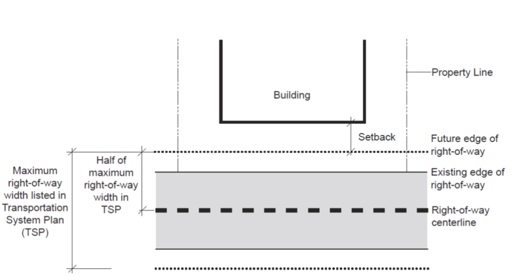
418-2.2
Prior to issuance of a building permit where the land use action is subject to growth management, an applicant shall dedicate the additional right-of-way to meet the County standard. Notwithstanding the above, outside the UGB, dedication of additional right-of-way to meet the county standards shall be required prior to the issuance of any building permit where required as a valid condition of approval.
418-2.3
Setback requirements shall be determined from future rights-of-way as set forth by the official Washington County Functional Classification System Map, and as indicated on the Washington County Transportation System Plan. When a stub street abuts a site, the property owner shall place all on-site structures in such a way as to not preclude extension of that stub street into or through the site.
418-2.4
The setback requirements of this Code shall not apply to existing structures when the setback is reduced by a public dedication. If the setback is not reduced by a public dedication, the structure(s) shall meet the setback requirements of this section.
(Ord. No. 814, § 2.D.(Exh. 4, § 1), 10-25-16; Ord. No. 885A, § 2.1.(Exh. 1, § 21.), 6-28-22, eff. 7-28-22; Ord. No. 889A, § 2.C.(Exh. 3, § 16.), 2-7-23, eff. 3-9-23; Ord. No. 890A, § 2.A.(Exh. 1, § 1.), 2-7-23, eff. 3-9-23)
418-3
Corner Vision
Lots or parcels on street corners (public and/or private) shall maintain a sight triangle with no sight obstruction between 3 feet and 10 feet in height as measured from street grade. Sight obstructions include, but are not limited to, fences, vegetation, berms, and structures. The sight triangle shall be measured from the street corner (apex), a distance of 20 feet along each street side (see Figure 1). For the purpose of this Section, street corner is defined as that point where the extended edge of the road surface of two intersecting streets meet. The county may require additional vision clearance based on a hazard identified by the county. Nothing in this Section shall supersede proper application of the sight distance standards in Section 501-8.5 F.
418-4
Fences and Retaining Walls
418-4.1
The setback requirements of this Code are not applicable to the following fence or retaining wall structures (or any combination thereof) except as required by Section 418-3:
A.
A fence, wall (includes retaining wall), screen or lattice work not more than seven feet in height.
B.
A fence, wall (includes retaining wall), screen or lattice work not more than eight feet in height along a rear, side or front yard which abuts an arterial or limited-access highway.
C.
A combination fence (not more than six feet in height) and retaining wall structure (not more than four feet in height) located in a side or rear yard (for design standards see Section 419-4).
D.
Tiered retaining wall structures not exceeding seven feet in height in any required yard. The maximum height measurement includes all tiers located within the yard or setback area. All non-tiered retaining walls located within the yard or setback area shall not exceed a combined total of seven feet in height.
E.
All retaining wall structures, exceeding seven feet in height, not within a required yard or setback area, on two or more contiguous properties, are exempt from the side yard setback requirement.
F.
A wall not more than eight feet in height along a side or rear property line as required by Section 411.
418-4.2
Residential lots or parcels shall maintain a clear vision area with no sight obscuring fence or wall (does not include retaining wall) more than three feet in height, measured from finished grade, within a 15 by 15-foot square along a driveway. A clear vision area shall be measured from the property line, sidewalk, or easement for public travel, whichever is closest to the fence line (for design standards see Figure 2 and Figure 3). Middle Housing and Middle Housing Land Divisions need not meet the 15 by 15-foot requirement above, but fence/wall restrictions otherwise noted above shall apply to any fence/wall within 15 feet of the front property line, and street-side property line on a corner lot.
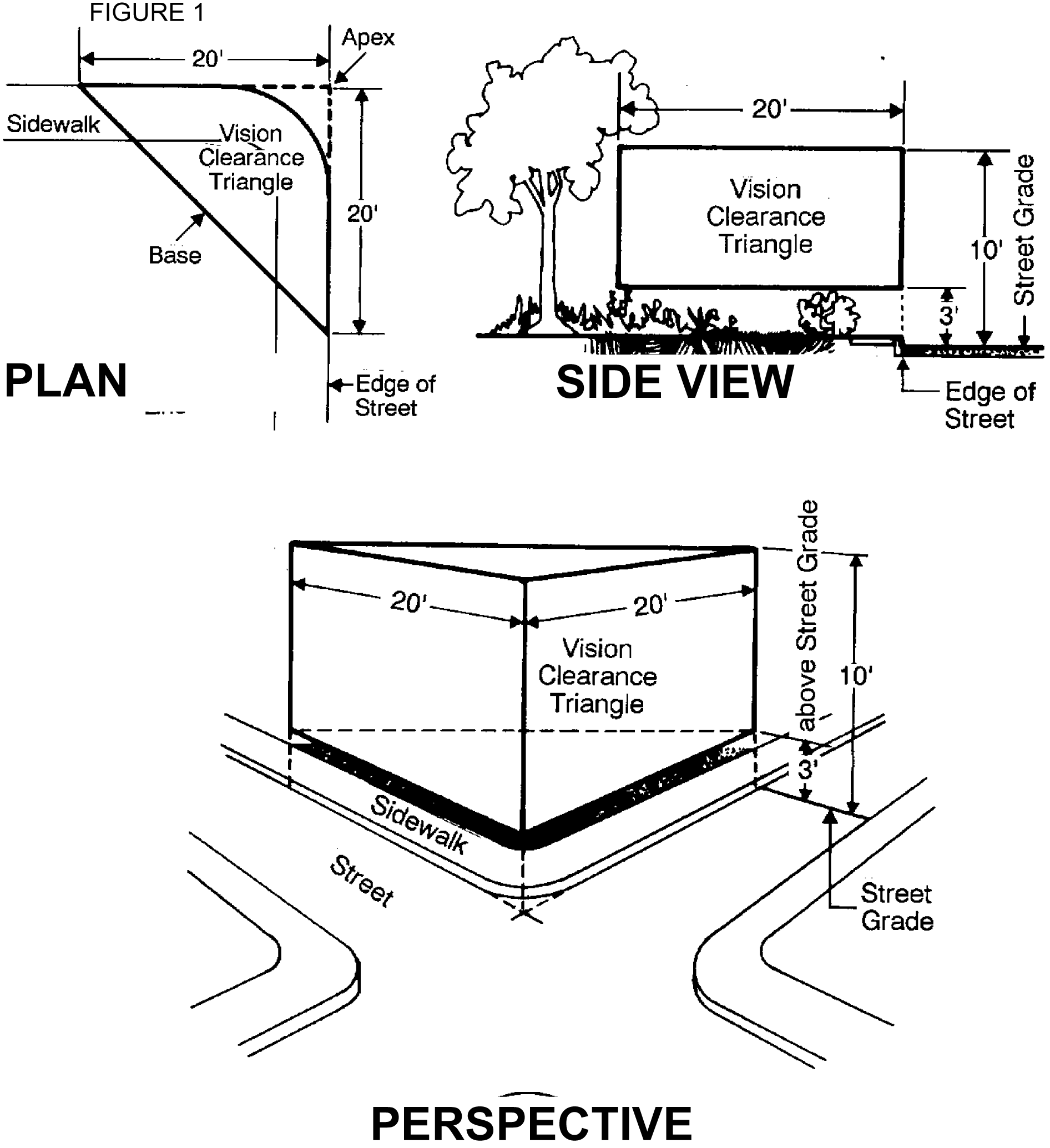
Figure 2. Plan View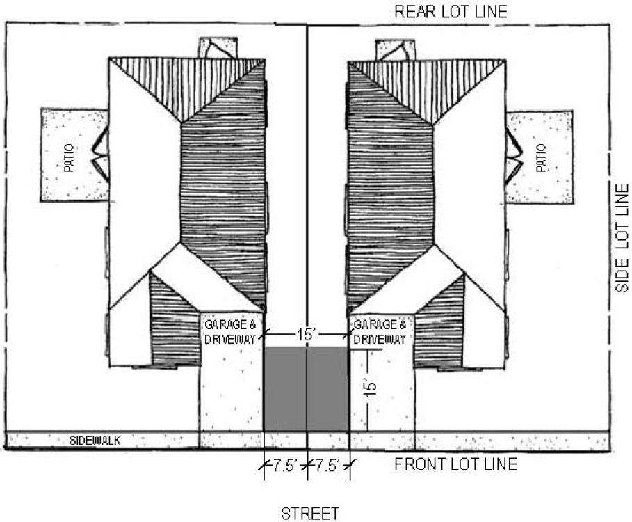
Figure 3. Side View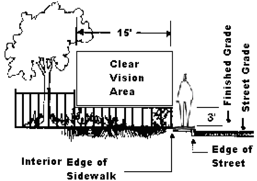
(Ord. No. 828, § 2.C.(Exh. 1, § 9), 9-26-17, eff. 11-24-17; Ord. No. 885A, § 2.1.(Exh. 1, § 21.), 6-28-22, eff. 7-28-22; Ord. No. 890A, § 2.A.(Exh. 1, § 1.), 2-7-23, eff. 3-9-23)
419 - HEIGHT
In addition to the height restrictions in the primary districts, the following limitations shall apply:
419-1
Within 20 feet of another primary district with a lower height restriction, the height restriction of the adjacent district shall apply.
419-2
Beyond the 20-foot area in Section 419-1 above, the height may increase on the subject property at a ratio of 1 foot of height to 1 foot of horizontal distance from the adjacent primary district with a lower height limitation, to the maximum height permitted in the primary district.
419-3
A fence, lattice work, screen or wall (includes retaining wall) not more than 7 feet in height may be located in any required side, front or rear yard, except as required by Section 418-3 (corner vision). Where a rear, side or front yard abuts an arterial or limited access highway, fence height along the yard may be increased to 8 feet. Any fence over 7 feet in height requires a building permit. Any retaining wall over 4 feet in height requires a building permit (the height measurement of a retaining wall is from the bottom of footing to the top of the retaining wall).
419-4
A combination fence and retaining wall structure may be located in a side or rear yard. This structure shall consist of a retaining wall [not more than 4 feet in height] and a fence [not more than 6 feet in height]. The fence portion shall be measured from the back-filled or highest side of this structure and may not exceed 6 feet in height. The non-back-filled or lowest side measurement may not exceed a combined total of 10 feet in height. This provision may only be used when there is an existing or proposed grade difference between properties and a retaining wall is required by the Building Official (see Figure 1). This structure is exempt from a structural building permit only when the backfill is level for a proportional horizontal distance to the height of the retaining wall or as approved by the Building Official.
419-5
Tiered retaining wall structures shall not exceed 7 feet in height in any required yard. The maximum height measurement includes all tiers located within the yard or setback area. All non-tiered retaining walls located within the yard or setback area shall not exceed a combined total of 7 feet in height.
419-6
There shall be no limitation of vegetation such as hedges, except as provided in Section 418-3.
419-7
No structure or structural part shall exceed height standards for any airport in the county established in accordance with Federal Aviation Administration's Aviation Regulations.
Figure 1.
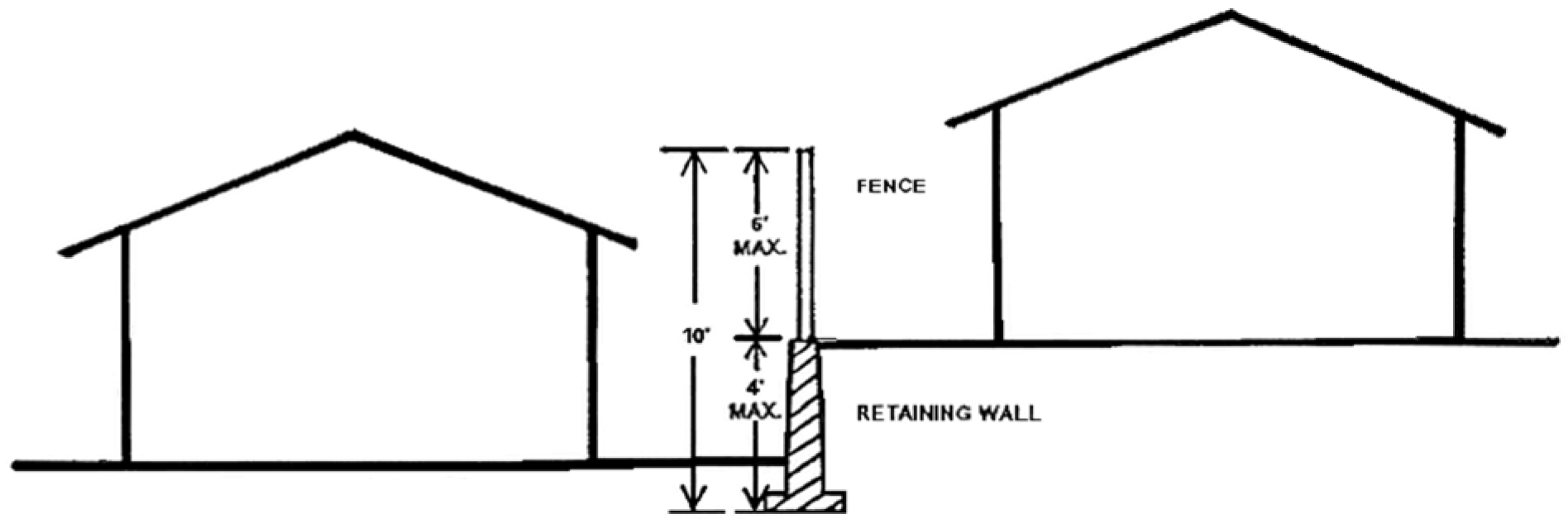
420 - CREATION OF LOTS BELOW 20,000 SQUARE FEET IN THE R-9, R-15, R-24 AND R-25+ DISTRICTS
Approval of a Partition or Subdivision in the R-9, R-15, R-24 or R-25+ District that will result in any lot less than 20,000 square feet shall be based on the following. This Section is not applicable to a Middle Housing Land Division reviewed under Article VI.
(Ord. No. 885A, § 2.1.(Exh. 1, § 22.), 6-28-22, eff. 7-28-22; Ord. No. 890A, § 2.A.(Exh. 1, § 1.), 2-7-23, eff. 3-9-23)
420-1
Placement of the dwelling units in a manner which will not preclude future development of the site unless the development plan indicates complete parcelization of the site;
420-2
A plan indicating access and circulation on the site and the relationship to surrounding properties, street stubs, existing rights-of-way and proposed roads;
420-3
The location of urban services. If urban services are not available, the time table for their provision and the future location of the services;
420-4
Location of any natural features (floodplain or other hazards or Riparian Wildlife Habitat subject to Section 422) which might inhibit full development;
(Ord. No. 902A, § 2.B.(Exh. 2, § 35.), 11-5-24, eff. 12-5-24)
420-5
Compliance to the requirements of Articles V and VI.
421 - FLOODPLAIN AND DRAINAGE HAZARD AREA DEVELOPMENT
The County administers and enforces the State of Oregon Specialty Codes pursuant to the requirement established in ORS 455. The Oregon Specialty Codes contain certain provisions that apply to the design and construction of buildings and structures located in Special Flood Hazard Areas. Therefore, this Section is intended to be administered and enforced in conjunction with the Oregon Specialty Codes.
421-1
Lands Subject to Floodplain and Drainage Hazard Area Standards
421-1.1
Floodplain
The following data sources shall be referenced for purposes of determining lands subject to floodplain standards. In any event, the most restrictive flood boundary information shall be utilized. The maps referenced herein are on file at the offices of the Washington County Department of Land Use & Transportation.
A.
The following maps are adopted by reference:
(1)
"Flood Insurance Rate Map, Washington County, Oregon," effective date October 19, 2018 with amendments; and
(2)
"Flood Insurance Study for Washington County, Oregon and Incorporated Areas," dated October 19, 2018 with amendments.
B.
Where base flood elevation data has not been provided (approximate A Zone):
(1)
"Floodplain Series, Washington County, Oregon, revision 5/01/1974, 1/03/1978, 1/1981, 5/25/1983 and 12/12/1983" based upon data from the U.S. Army Corps of Engineers.
(2)
In addition, the Director shall obtain, review and reasonably utilize any base flood elevation data available from a federal or state source, or hydrologic and hydraulic analysis performed in accordance with standard engineering practice by a licensed professional engineer, in order to administer this Section.
C.
In addition to the information sources identified in A. and B. above, the Director may also utilize any other available authoritative flood data, including but not limited to high water marks, photographs of past flooding or historical flood data.
421-1.2
Drainage Hazard Areas
The following data sources shall be referenced for purposes of determining lands subject to drainage hazard area standards. In any event, the most restrictive flood boundary information shall be utilized. The maps referenced herein are on file at the offices of the Washington County Department of Land Use & Transportation.
A.
"Floodplain Series, Washington County, Oregon, revision 5/01/1974, 1/03/1978, 1/1981, 5/25/1983 and 12/12/1983" based upon data from the U.S. Army Corps of Engineers.
B.
In addition, the Director shall obtain, review and reasonably utilize any flood elevation data available from a federal or state source, or hydrologic and hydraulic analysis performed in accordance with standard engineering practice by a licensed professional engineer, in order to administer this Section.
C.
In addition to the information sources identified in A. and B. above, the Director may also utilize any other available authoritative flood data, including but not limited to high water marks, photographs of past flooding or historical flood data.
421-1.3
Persons seeking to develop within a floodplain or drainage hazard area must do so with the understanding that they and their successors assume the risks and that the risks cannot be eliminated, even with strict compliance with the standards adopted herein. This Section does not imply that lands outside of floodplain or drainage hazard areas, or development permitted within, will be free from flooding or flood damage.
(Ord. No. 811, § 2.A.(Exh. 1, § 2), 10-4-16, eff. 11-3-16; Ord. No. 828, § 2.C.(Exh. 1, § 10), 9-26-17, eff. 11-24-17; Ord. No. 840, § 2.B.(Exh. 2, § 1), 9-18-18, eff. 10-18-18; Ord. No. 845, § 2.A.(Exh. 1, § 3), 4-2-19, eff. 5-2-19)
421-2
Definitions
As used in this section, the words listed below have the following meaning:
421-2.1
Basement. Any area of the building having its floor subgrade (below ground level) on all sides.
421-2.2
Development. Any man-made change to improved or unimproved real estate, including but not limited to buildings or other structures, mining, dredging, filling, grading, paving, excavation or drilling operations or storage of equipment or materials.
421-2.3
Flood or Flooding.
A.
A general and temporary condition of partial or complete inundation of normally dry land areas from:
(1)
The overflow of inland waters.
(2)
The unusual and rapid accumulation of runoff of surface waters from any source.
(3)
Mudslides (i.e., mudflows) which are proximately caused by flooding as defined in paragraph A.(2) of this definition and are akin to a river of liquid and flowing mud on the surfaces of normally dry land areas, as when earth is carried by a current of water and deposited along the path of the current.
B.
The collapse or subsidence of land along the shore of a lake or other body of water as a result of erosion or undermining caused by currents of water exceeding anticipated cyclical levels or suddenly caused by an unusually high water level in a natural body of water, accompanied by a severe storm, or by an unanticipated force of nature, such as flash flood or by some similarly unusual and unforeseeable event which results in flooding as defined in paragraph A.(1) of this definition.
421-2.4
Flood area. A floodplain or drainage hazard area.
421-2.5
Flood Insurance Rate Map (FIRM). An official map of a community on which the Federal Insurance Administrator has delineated both the special flood hazard areas and the risk premium zones applicable to the community.
421-2.6
Flood Insurance Study (FIS). An examination, evaluation and determination of flood hazards and, if appropriate, corresponding water surface elevations, or an examination, evaluation and determination of mudslide (i.e., mudflow) and/or flood-related erosion hazards.
421-2.7
Flood surface elevation. Elevation of the surface water of a floodplain or drainage hazard area.
421-2.8
Historic structure. Any structure that is:
A.
Listed individually in the National Register of Historic Places (a listing maintained by the Department of Interior) or preliminarily determined by the Secretary of the Interior as meeting the requirements for individual listing on the National Register;
B.
Certified or preliminarily determined by the Secretary of the Interior as contributing to the historical significance of a registered historic district or a district preliminarily determined by the Secretary to qualify as a registered historic district;
C.
Individually listed on a state inventory of historic places in states with historic preservation programs which have been approved by the Secretary of the Interior; or
D.
Individually listed on a local inventory of historic places in communities with historic preservation programs that have been certified either:
(1)
By an approved state program as determined by the Secretary of the Interior, or
(2)
Directly by the Secretary of the Interior in states without approved programs.
421-2.9
Lowest floor. The lowest floor of the lowest enclosed area (including basement). An unfinished or flood resistant enclosure, usable solely for parking of vehicles, building access or storage in an area other than a basement area is not considered a building's lowest floor; provided, that such enclosure is not built so as to render the structure in violation of the applicable nonelevation design requirements of this Section.
421-2.10
Manufactured dwelling. A structure, transportable in one or more sections, which is built on a permanent chassis and is designed for use with or without a permanent foundation when attached to the required utilities. The term "manufactured dwelling" does not include a "recreational vehicle."
421-2.11
Manufactured dwelling park or subdivision. A parcel (or contiguous parcels) of land divided into two or more manufactured dwelling lots for rent or sale.
421-2.12
New construction. Structures for which the "start of construction" commenced on or after October 19, 2018 and includes any subsequent improvements to such structures.
421-2.13
Recreational vehicle. A vehicle which is:
A.
Built on a single chassis;
B.
400 square feet or less when measured at the largest horizontal projection;
C.
Designed to be self-propelled or permanently towable by a light duty truck; and
D.
Designed primarily not for use as a permanent dwelling but as temporary living quarters for recreational, camping, travel, or seasonal use.
421-2.14
Start of construction. Includes substantial improvement, and means the date the building permit was issued, provided the actual start of construction, repair, reconstruction, rehabilitation, addition placement, or other improvement was within 180 days of the permit date.
The actual start means either the first placement of permanent construction of a structure on a site, such as the pouring of slab or footings, the installation of piles, the construction of columns, or any work beyond the stage of excavation; or the placement of a manufactured dwelling on a foundation.
Permanent construction does not include land preparation, such as clearing, grading and filling; nor does it include the installation of streets and/or walkways; nor does it include excavation for a basement, footings, piers, or foundations or the erection of temporary forms; nor does it include the installation on the property of accessory buildings, such as garages or sheds not occupied as dwelling units or not part of the main structure. For a substantial improvement, the actual start of construction means the first alteration of any wall, ceiling, floor, or other structural part of a building, whether or not that alteration affects the external dimensions of the building.
421-2.15
Structure. A walled and roofed building, including a storage tank (gas or liquid) or silo, that is principally above ground. Structure does not include such things as pipes, culverts, roads, bridges and other transportation facilities.
421-2.16
Substantial damage. Damage of any origin sustained by a structure whereby the cost of restoring the structure to its before damaged condition would equal or exceed 50% of the market value of the structure before the damage occurred.
421-2.17
Substantial improvement. Any reconstruction, rehabilitation, addition, or improvement of a structure, the cost of which equals or exceeds 50% of the market value of the structure before the "start of construction" of the improvement. This term includes structures which have incurred "substantial damage," regardless of the actual repair work performed. The term does not, however, include either:
A.
Any project for improvement of a structure to correct existing violations of state or local health, sanitary, or safety code specifications which have been identified by the local code enforcement official and which are the minimum necessary to assure safe living conditions; or
B.
Any alteration of an "historic structure," provided that the alteration will not preclude the structure's continued designation as an "historic structure."
(Ord. No. 845, § 2.A.(Exh. 1, § 3), 4-2-19, eff. 5-2-19)
421-3
Submittal Requirements
In addition to the requirements of Sections 203-4 and 410, an application for a floodplain or drainage hazard area alteration shall contain the following information for the area proposed to be disturbed. This information shall be prepared by a licensed professional engineer and may be submitted with or be made part of a site plan or grading plan for the proposed development.
421-3.1
Recognizing that the scale may be such that the true and accurate floodplain or drainage hazard area boundaries cannot be determined from the maps referenced in Sections 421-1.1 and -1.2 alone, all persons seeking a development permit for lands within said areas and within 250 feet of the map boundary of a floodplain or drainage hazard area identified in Sections 421-1.1 and -1.2, except as noted below for Land Divisions and property line adjustments, shall submit with the development permit application:
A.
A delineation of the floodplain and the floodway boundaries, established by a registered engineer or a registered surveyor from the surface elevations for the floodplain based upon maps or other data sources referenced in Section 421-1.1; and
B.
A delineation of the drainage hazard area and the drainageway, established by a registered engineer or a registered surveyor from surface elevations for the drainage hazard area based upon maps or other data sources referenced in Section 421-1.2. Such delineation shall be based on mean sea level datum and be field located from recognized landmarks.
C.
Standard Land Divisions and property line adjustments outside the UGB may provide only generalized floodplain information, such as contour maps and aerial photos, which need not be prepared by an engineer. Notwithstanding this provision, for the purpose of implementing the requirements of Section 421-14.7, applicants may be required to submit detailed delineations as specified in 421-3.1 A. and B. above.
D.
For each of the above, submitted plans shall be accurately drawn and at an appropriate scale that will enable ready identification and understanding of the submitted information. The plans shall include the locations of any existing or proposed property lines, buildings, structures, parking areas, streets, accessways, or other relevant information on the subject property, and within 50 feet of the delineation.
421-3.2
Existing and proposed topography within the boundaries of the flood area using the following contour intervals:
A.
For slopes of 5% or less, contour intervals not more than 1 foot;
B.
For slopes greater than 5% and up to and including 10%, contour intervals not more than 2 feet; and
C.
For slopes greater than 10%, contour intervals not more than 5 feet.
421-3.3
For applications for Type II and III floodplain or drainage hazard area alterations, documentation which demonstrates compliance with the applicable review standards of Sections 421-7 through 421-14.
421-3.4
Upon demonstration by the Director of no other alternative, applicants shall obtain a Conditional Letter of Map Revision (CLOMR) from FEMA before an encroachment, including fill, new construction, substantial improvement, fences or other development, in the regulatory floodway is permitted that will cause any increase in the base flood elevation. The CLOMR shall be submitted prior to the application being deemed complete.
(Ord. No. 811, § 2.A.(Exh. 1, § 2), 10-4-16, eff. 11-3-16; Ord. No. 845, § 2.A.(Exh. 1, § 3), 4-2-19, eff. 5-2-19; Ord. No. 890A, § 2.A.(Exh. 1, § 1.), 2-7-23, eff. 3-9-23)
421-4
Uses and Activities Permitted Through a Type I Procedure
Unless specifically prohibited in the applicable Community Plan, the Rural/Natural Resource Plan, CDC Section 422, or Clean Water Services Design and Construction Standards for sanitary sewer and surface water management, a development permit may be approved in a flood area through a Type I procedure for the following:
421-4.1
Recreation or nature trails and removal of vegetation down to duff or bare soil provided:
A.
The area of disturbance is not designated as a Significant Natural Resource in the applicable Community Plan or the Rural/Natural Resource Plan; and
B.
The applicant obtains a permit for erosion control.
421-4.2
Property line adjustments.
421-4.3
Wildlife viewing areas, including interpretive signs, and off-street parking which requires no grading, and viewing platforms or structures, provided that all viewing platforms or structures:
A.
Are elevated by pilings;
B.
Have the lowest floor at least 1 foot above the flood surface elevation; and
C.
A building permit is obtained for the proposed platform or structure.
421-4.4
Maintenance, preservation and repair of local public streets and private streets except as provided for by Section 421-16.7, including paving and grading of existing road surfaces, and grading and shaping of roadside ditches.
421-4.5
Above ground electrical, communication and signal transmission and distribution lines on a single-pole system. For the purposes of this section, a single-pole system is defined as above ground electrical, communication or signal lines and their supporting concrete, wood or metal poles, excluding self-supporting steel lattice-type structures.
421-4.6
Restoration and stabilization of the bank of a river or other watercourse or body of water for erosion control provided:
A.
The application includes a licensed professional engineer's certification that:
(1)
The project is in response to a demonstrated bank failure that resulted from a specific flood event or which has occurred within the last 2 years;
(2)
The project only restores and stabilizes the bank to its original location before the demonstrated bank failure;
(3)
The length of the bank involved does not exceed 250 feet;
(4)
The project is located outside an urban growth boundary; and
(5)
If riprap is used, it will be keyed in to the bed and bank of the body of water as specified in OAR 141-089-0005.
B.
Whether or not riprap is used, the length of bank within the project boundary, from the ordinary high water level to the top of the bank, shall be planted with vegetation that grows roots which will stabilize the bank. Plant species used shall be those in the 1987 or most current list entitled "Shrubs, Trees and Aquatic Plants for Wildlife Plantings" prepared by the Oregon Department of Fish and Wildlife. The plantings shall meet the following requirements, unless different requirements are established for the project by the Oregon Division of State Lands through their permitting process:
(1)
At least five plants shall be placed per 100 square feet of bank area; and
(2)
At least 20 percent of the plants placed shall be trees.
C.
Upon completion of the project, a licensed professional engineer shall submit a statement certifying that the project was completed in compliance with the provisions of this Section.
421-4.7
Maintenance, preservation or repair of off-right-of-way drainage facilities.
421-4.8
Vehicular access to a single-family residence or for farm or forest uses; including culverting for driveway crossings provided the application includes a registered civil engineer's certification that the project complies with Sections 421-7.1 through 421-7.12.
421-4.9
Authorized airport related activities within the Public Use Airport Overlay District, as identified in section 387-4.
421-4.10
Maintenance, preservation or repair of sanitary sewer facilities provided that:
A.
Work is located within the right-of-way or an existing easement;
B.
The sanitary sewer facilities are not being upsized; and
C.
The submittal includes the following:
(1)
An existing conditions site plan and proposed grading and restoration plan demonstrating that the ground and vegetation will be restored to the same or better condition that existed at the time of original construction;
(2)
Documentation of compliance with CWS Design and Construction standards; and
(3)
Copies of applicable U.S. Army Corps of Engineers and Oregon Department of State Lands permit applications or documentation that permits are not required.
(Ord. No. 811, § 2.A.(Exh. 1, § 2), 10-4-16, eff. 11-3-16; Ord. No. 833, § 2.A.(Exh. 1, § 5), 8-7-18, eff. 9-6-18; Ord. No. 845, § 2.A.(Exh. 1, § 3), 4-2-19, eff. 5-2-19)
421-5
Uses and Activities Allowed Through a Type II Procedure
Unless specifically prohibited in the applicable Community Plan, the Rural/Natural Resource Plan, CDC Section 422, or Clean Water Services Design and Construction Standards for sanitary sewer and surface water management, a development permit may be approved in a flood area through a Type II procedure for the following:
421-5.1
One detached dwelling (including a manufactured dwelling) together with no more than two accessory structures and off-street parking on a parcel lawfully created prior to March 26, 1984, when the lot or parcel contains insufficient area outside of the flood area upon which to locate the dwelling, and/or accessory structures.
421-5.2
Substantial improvements to lawfully established structures that have not been abandoned. Applications for substantial improvements to structures shall comply with all applicable requirements of Sections 421-7, 421-8, 421-9 and 421-10.
421-5.3
Improvements to a lawfully established structure when the cost of the improvement is less than 50% of the market value of the structure and there is compliance with Section 421-7. For the purpose of this subsection, improvement means any repair, reconstruction, addition or improvement of a structure except as follows:
A.
Any project for improvement of a structure to comply with existing state or local health, sanitary or safety code specifications which is solely necessary to assure safe living conditions; or
B.
Any alteration of a structure listed on the National Register of Historic Places or a state or local inventory of historic plans.
421-5.4
Accessory structure customarily provided in conjunction with the use set forth in the applicable primary District.
421-5.5
Subdivisions and Partitions.
421-5.6
Water quality or quantity improvement facilities, or a required wetland mitigation project when:
A.
Mandated by a local, state or federal regulatory agency;
B.
In conjunction with an adopted Drainage Master Plan as defined by Subsection 106-64; or
C.
In conjunction with any other master plan for water or wetlands management improvements approved by Ordinance or Resolution and Order of the Board.
Sites that are designated as a Significant Natural Resource are subject to the requirements of Section 422.
421-5.7
Dams, weirs, ponds and similar water impoundment devices and mitigation and enhancement improvements, not authorized by Subsection 421-5.6 when in conjunction with an enhancement plan approved through Subsection 422-3.4.
421-5.8
Dams, weirs, ponds and similar water impoundment devices, and mitigation and enhancement improvements for farm or forest purposes when in conjunction with farm use as defined in ORS 215 or forest uses as defined by the Forest Practices Act.
421-5.9
Operations for the exploration for and production of geothermal resources, oil and gas.
421-5.10
Vehicular access to permitted uses, including driveway crossings, except as permitted by Section 421-4.8.
421-5.11
Construction or major improvement or alteration of underground pipes and conduits, including sewer, water and gas lines, transmission and distribution lines for geothermal resources, gas and oil, underground electrical, telephone and television transmission and distribution lines, including necessary accessory structures and drainage systems.
421-5.12
Removal of vegetation down to duff or bare soil in an area designated as a Significant Natural Resource in the applicable Community Plan or the Rural/Natural Resource Plan.
421-5.13
Above ground electrical, communication and signal transmission lines, except as provided by Section 421-4.5.
421-5.14
Parks, golf courses and other recreational uses and associated off-street parking which require grading, excluding structures.
421-5.15
Recreation or nature trails and associated off-street parking, when grading, piping, culverting or bridges are required.
421-5.16
Creation or restoration of wetlands, including wetland mitigation, creation, enhancement and restoration within public use airport approach surface areas and airport direct impact boundaries, pursuant to Section 388-9.
421-5.17
Culverting and piping to implement an approved development, other than crossings for public and private streets and other public transportation facilities, in an area that is not designated as a Significant Natural Resource in the applicable Community Plan or the Rural/Natural Resource Plan when the pipe or culvert connects to an existing pipe, culvert or drainageway. Culverting and piping in a flood area may be subject to local, state and federal agencies.
421-5.18
Construction or major improvement or alteration of public local streets and private streets within the UGB, or approved as part of a Land Division, including culverting and piping, accessory drainage systems such as catch basins, and necessary accessory structures.
421-5.19
Bank maintenance, restoration or stabilization, including riprapping for erosion control, of a river or other watercourse or body of water inside an urban growth boundary or not otherwise permitted by Section 421-4.6.
421-5.20
Replacement of a nonconforming recreational vehicle that does not meet the exemption criteria of Section 421-16.8. The applicant shall demonstrate compliance with all applicable requirements of Section 421, including the elevation and anchoring requirements for manufactured dwellings in Section 421-9.
421-5.21
One Middle Housing Duplex (Section 430-84), together with no more than two accessory structures (total, not per dwelling) and off-street parking on a parcel lawfully created prior to March 26, 1984, when the lot or parcel contains insufficient area outside of the flood area upon which to locate the dwelling units, and/or accessory structures.
(Ord. No. 845, § 2.A.(Exh. 1, § 3), 4-2-19, eff. 5-2-19; Ord. No. 866, § 2.C.(Exh. 3, § 21), 9-1-20, eff. 10-1-20; Ord. No. 885A, § 2.1.(Exh. 1, § 23.), 6-28-22, eff. 7-28-22; Ord. No. 890A, § 2.A.(Exh. 1, § 1.), 2-7-23, eff. 3-9-23)
421-6
Uses Allowed Through A Type III Procedure
Unless specifically prohibited by the applicable Community Plan, the Rural/Natural Resource Plan, Section 422, or Clean Water Services Design and Construction Standards for sanitary sewer and surface water management, a development permit for the following may be approved through the Type III procedure:
421-6.1
Parking area for adjacent multi-dwelling, institutional, commercial or industrial development;
421-6.2
In any area designated as a Significant Natural Resource by the applicable Community Plan, culverting or piping of a flood area that is designed to improve the overall drainage system to facilitate private development. Such requests shall be processed as a Type III Planned Development. Culverting or piping that is permitted by Section 421-5 is not intended to be addressed by this subsection; and
421-6.3
Low head hydroelectric power generation facilities.
(Ord. No. 845, § 2.A.(Exh. 1, § 3), 4-2-19, eff. 5-2-19; Ord. No. 885A, § 2.1.(Exh. 1), 6-28-22, eff. 7-28-22)
421-7
Development Standards for all Type II and Type III Floodplain and Drainage Hazard Area Uses or Activities
The applicant for a proposed floodplain or drainage hazard area development shall demonstrate compliance with the following applicable standards as required by Section 421-3 above:
421-7.1
Development proposed to encroach into a regulatory floodway adopted and designated pursuant to FEMA regulations shall:
A.
Demonstrate through hydrologic and hydraulic analysis, performed in accordance with standard engineering practice by a licensed professional engineer, that the cumulative effect of the proposal, when combined with all other existing and anticipated development within the basin based upon full development of the basin as envisioned in the applicable Community Plan or the Rural/Natural Resource Plan, will not result in any increase in flood levels during the occurrence of the base flood discharge; and
B.
Comply with all applicable flood hazard reduction provisions of Section 421.
421-7.2
Notwithstanding Section 421-7.1, development that would result in an increase in flood levels may be approved if the County, at the sole expense of the applicant, first obtains FEMA approval in accordance with 44 CFR Ch. 1, Part 65 (October 1, 1990 edition, or its successor).
421-7.3
Development proposed on a floodplain site where the development does not encroach into an adopted FEMA regulatory floodway shall demonstrate through hydrologic and hydraulic analysis, performed in accordance with standard engineering practice by a licensed professional engineer, that the cumulative effect of the proposal, when combined with all other existing and anticipated development within the basin based upon full development of the basin as envisioned in the applicable Community Plan or the Rural/Natural Resource Plan, will not increase flood levels during the occurrence of the base flood discharge more than 1 foot.
421-7.4
In areas where a regulatory floodway has not been designated, no new construction, substantial improvements, or other development (including fill) shall be permitted within flood areas on the Flood Insurance Rate Map (FIRM), unless it is demonstrated through hydrologic and hydraulic analysis, performed in accordance with standard engineering practice by a licensed professional engineer, that the cumulative effect of the proposal, when combined with all other existing and anticipated development within the basin based upon full development of the basin as envisioned in the applicable Community Plan or the Rural/Natural Resource Plan, will not increase flood levels during the occurrence of the base flood discharge more than 1 foot.
421-7.5
Notwithstanding Sections 421-7.3 and 421-7.4, an increase in flood levels in excess of 1 foot may be approved if the County, at the sole expense of the applicant, first obtains FEMA approval in accordance with 44 CFR Ch. 1, Part 65 (October 1, 1990 edition, or its successor).
421-7.6
Development proposed on a drainage hazard area site shall demonstrate through hydrologic and hydraulic analysis, performed in accordance with standard engineering practice by a licensed professional engineer, that the cumulative effect of the proposal, when combined with all other existing and anticipated development within the basin based upon full development of the basin as envisioned in the applicable Community Plan or the Rural/Natural Resource Plan, will not result in any increase to the drainage hazard area elevation at any point in the community.
Notwithstanding this provision, an increase may be approved if the area in which the rise will occur contains no structures and the owner of such property signs a written acceptance of any increase in the drainage hazard area elevation.
421-7.7
Encroachments into a floodway allowed under Section 421-7.1 shall be designed so as to minimize the risk that the encroachment will catch substantial debris or otherwise significantly impede floodwater flows. Designs may include, but are not limited to, adequate sizing of openings, secured breakaway bridges, diverters or spacing of supports.
421-7.8
The proposal will not increase the existing velocity of flood flows so as to exceed the erosive velocity limits of soils in the flood area. Energy dissipation devices or other measures to control the mean velocity so as not to cause erosion of the flood area may be used to meet this standard. "Open Channel Hydraulics" by V. T. Chow, McGraw-Hill Book Company, Inc., 1988, is presumed to be the best available reference for maximum permissible velocity. "Hydraulic Engineering Circular No. 14," Hydraulic Design of Energy Dissipators for Culverts and Channels, published by the Federal Highway Administration, September 1983, is presumed to be the best available reference for the design of energy dissipators.
421-7.9
All cut and fill shall be structurally sound and designed to minimize erosion. All fill below the flood surface elevation shall be accompanied by an equal amount of cut or storage within the boundary of the development site unless:
A.
The proposed cut and fill is found to be in compliance with an adopted Drainage Master Plan; or
B.
Off-site excavation will be utilized to balance a fill, provided:
(1)
The off-site excavation area will be part of the application for the development proposing to place the fill;
(2)
The off-site excavation area will be located in the same drainage basin as the proposed fill area;
(3)
The off-site excavation area will be located within points of constriction on the drainage system, if any, and as close to the fill site as practicable. The applicant's licensed professional engineer shall conduct a storage routing analysis to determine the location of the fill;
(4)
The off-site excavation area will be constructed as part of the development placing the fill;
(5)
Any use or future development of the excavated area shall comply with the standards of Section 421 and Section 422 if the area is designated as a Significant Natural Resource; and
(6)
Ownership of the excavated area shall be by one of the following mechanisms:
(a)
Dedication of the area to an appropriate public agency when a public agency is willing to accept the dedication;
(b)
Ownership of the area by the applicant of the proposed development;
(c)
Dedication of the development rights of the area to an appropriate public agency with ownership remaining with the property owner. Maintenance of the area shall be the responsibility of the applicant or property owner; and
(d)
Deed or easement-restricted private ownership which prevents any use or future development of the area as specified by Section 421-7.9 B.(5). Maintenance of the area shall be the responsibility of the applicant or property owner. A contract for conditions shall be required as specified by Section 207-5.3. The contract for conditions shall be recorded in the Department of Assessment & Taxation, Recording Division.
421-7.10
There is adequate storm drainage behind a dike such as a lift pump or flap gate to drain the floodplain or drainage hazard area behind the dike.
421-7.11
The standards of Section 422 have been met, if applicable.
421-7.12
Drainage systems shall be designed and constructed according to the adopted Drainage Master Plan for the area, if one exists.
421-7.13
Proposed Partitions and Subdivisions shall minimize flooding by complying with the applicable standards of Sections 410, 421, 426, 605-3.2 and 610-3.1, and Clean Water Services Design and Construction Standards for sanitary sewer and surface water management.
421-7.14
Public utilities and facilities in proposed Partitions and Subdivisions shall be located and constructed in a manner that will minimize flood damage.
421-7.15
Proposed Partitions and Subdivisions shall provide adequate drainage to reduce exposure to flood damage by complying with the standards of Section 410 and applicable standards of Section 605-3.2 or 610-3.1, whichever is applicable.
(Ord. No. 811, § 2.A.(Exh. 1, § 2), 10-4-16, eff. 11-3-16; Ord. No. 845, § 2.A.(Exh. 1, § 3), 4-2-19, eff. 5-2-19; Ord. No. 890A, § 2.A.(Exh. 1, § 1.), 2-7-23, eff. 3-9-23; Ord. No. 902A, § 2.B.(Exh. 2, § 36.), 11-5-24, eff. 12-5-24)
421-8
Criteria for Dwellings
421-8.1
No new dwelling shall be constructed in a flood area if:
A.
The lot or parcel contains sufficient, suitable, existing buildable land area that is located outside the flood area so as to permit construction at least 1 foot above the delineated flood surface elevation; and
B.
The buildable land area shall be deemed suitable if it includes a minimum 10-foot perimeter setback around the proposed dwelling that is outside the delineated flood area.
421-8.2
Construction standards for new dwellings and substantial improvements to existing dwellings in flood areas:
A.
All new dwellings and substantial improvements to existing dwellings shall have the lowest floor, including any basement, elevated to at least 1 foot above the flood surface elevation and shall be anchored so as to prevent flotation, collapse or lateral movement;
B.
New dwellings and substantial improvements to existing dwellings may be placed on pressure treated pilings when:
(1)
Certified by a registered engineer as sufficient to prevent collapse or movement during a 100-year flood.
(2)
Pilings are placed on stable compacted fill on no greater than 10-foot centers; and
(3)
Pilings greater than 6 feet high are reinforced;
C.
New dwellings and substantial improvements to existing dwellings may be placed on approved fill providing the building site, which includes the ground under the structure plus a 10-foot setback around all sides of the structure, is above the flood surface elevation.
D.
All new construction and improvements to existing structures shall be done with approved materials and utility equipment resistant to flood damage, using approved construction methods and practices that minimize such damage. All new construction and improvements to existing structures shall be anchored to prevent flotation, collapse or lateral movement;
E.
Fully enclosed areas below the lowest floor that are subject to flooding shall be designed to automatically equalize hydrostatic flood forces on exterior walls by allowing for the entry and exit of floodwaters. Designs for meeting the above requirement must either be certified by a registered professional engineer, or must meet or exceed the following minimum criteria:
(1)
A minimum of two openings having a total net area of not less than 1 square inch for every square foot of enclosed area subject to flooding shall be provided;
(2)
The bottom of all openings shall be no higher than 1 foot above grade; and
(3)
Openings may be equipped with screens, louvers, or other coverings or devices provided that they permit the automatic entry and exit of floodwaters without manual intervention.
(Ord. No. 845, § 2.A.(Exh. 1, § 3), 4-2-19, eff. 5-2-19)
421-9
Criteria for Manufactured Dwellings and Manufactured Dwelling Parks and Subdivisions
In addition to the criteria set forth in Sections 430-75, 430-77 and 430-79, manufactured dwellings and manufactured dwelling parks and subdivisions located in a flood area shall comply with the following standards:
421-9.1
Manufactured dwellings shall not be located within the floodway except in a manufactured dwelling park or subdivision existing on March 26, 1984;
421-9.2
Manufactured dwellings shall be anchored to resist flotation, collapse or lateral movement, by providing over-the-top and frame ties to ground anchors in accordance with the following:
A.
Require that over-the-top ties be provided at each of the four corners of the manufactured dwelling, with two additional ties per side at intermediate locations. Manufactured dwellings less than 50 feet long require only one additional tie per side;
B.
Require that frame ties be provided at each corner of the dwelling with five additional ties per side at intermediate points. Manufactured dwellings less than 50 feet long require only four additional ties per side;
C.
Notwithstanding Section 421-9.2 B. above, allow a manufactured dwelling to utilize only frame ties if:
(1)
The dwelling was constructed in compliance with the Oregon Mobile Code in effect between 1972 and 1976 and bears a label to that effect;
(2)
The dwelling was constructed in compliance with the "National Manufactured Housing Construction and Safety Standards Act;"
(3)
The dwelling is multi-sectional (double-wide or greater); or
(4)
The ground upon which the dwelling is located is at an elevation above the base flood level.
D.
All components of the anchoring system be capable of carrying a force of 4,800 pounds; and
E.
Any additions to the manufactured dwelling be similarly anchored.
421-9.3
In new manufactured dwelling parks and subdivisions, or in expansions to existing manufactured dwelling parks and subdivisions, or where the repair, reconstruction or improvement of the streets, utilities and pads equals or exceeds 50% of value of the streets, utilities and pads before the repair, reconstruction or improvement has commenced; and for manufactured dwellings not placed in a manufactured dwelling park or subdivision, the following shall be required:
A.
Stands or lots shall be elevated on compacted fill or on pilings so that the bottom of the longitudinal chassis frame beam is elevated to be at or above the base flood elevation. The Oregon Manufactured Dwelling Specialty Code also requires that all electrical crossover connections shall be a minimum of 12 inches above the base flood elevation. The more restrictive requirement shall prevail.
B.
Adequate surface drainage and access for a hauler are provided; and
C.
In the instance of elevation on pilings, that:
(1)
Lots are large enough to permit steps;
(2)
Piling foundations are placed in stable soil not more than 10 feet apart; and
(3)
Reinforcement is provided for pilings more than 6 feet above the ground level.
D.
Manufactured dwellings supported on solid foundation walls shall be constructed with flood openings that comply with Section 421-8.2 E.
421-9.4
Placement of, or substantial improvements to, manufactured dwellings on sites outside of a manufactured dwelling park or subdivision, or in a new or existing manufactured dwelling park or subdivision, or in an expansion to an existing manufactured dwelling park or subdivision, shall be elevated on compacted fill or on pilings so that the bottom of the longitudinal chassis frame beam is elevated to be at or above the base flood elevation. Elevation on pilings shall meet the requirements of Section 421-9.3 C. The Oregon Manufactured Dwelling Specialty Code also requires that all electrical crossover connections shall be a minimum of 12 inches above the base flood elevation.
(Ord. No. 845, § 2.A.(Exh. 1, § 3), 4-2-19, eff. 5-2-19)
421-10
Criteria for Non-Dwelling Structures
421-10.1
New construction or substantial improvement of nondwelling structures shall:
A.
Ensure the lowest floor, including any basement, is elevated to or above the flood surface elevation; or
B.
Ensure that all fully enclosed areas below the lowest floor that are subject to flooding are designed to automatically equalize hydrostatic flood forces on exterior walls by allowing for the entry and exit of floodwaters. At a minimum, designs for meeting this requirement shall:
(1)
Contain a minimum of two openings with a total net area of not less than 1 square inch for every square foot of enclosed area subject to flooding;
(2)
Contain openings where the bottom of each opening is no higher than 1 foot above grade;
(3)
Contain openings equipped with screens, louvers, or other coverings or devices provided that they permit the automatic entry and exit of floodwaters without manual intervention;
(4)
Be constructed with approved materials and utility equipment resistant to flood damage, using approved construction methods and practices that minimize such damage;
(5)
Show how the structure is anchored to prevent flotation, collapse or lateral movement; and
(6)
Have structural components capable of resisting hydrostatic and hydrodynamic loads and effects of buoyancy.
C.
A licensed professional engineer or architect shall certify that the proposed design and methods of construction comply with the criteria described in Section 421-10.1 B.
421-10.2
Structural support poles for unenclosed agricultural buildings in the 100-year floodplain shall be composed of waterproof material resistant to flood damage, using approved construction methods and practices that minimize such damage.
421-10.3
In accordance with FEMA regulations, the flood insurance premiums for flood-proofed non-dwelling structures will be based on the rates that are 1 foot below the flood-proofed level (e.g., a building flood-proofed to the base flood level will be rated as 1 foot below) or as otherwise amended by FEMA.
(Ord. No. 811, § 2.A.(Exh. 1, § 2), 10-4-16, eff. 11-3-16; Ord. No. 845, § 2.A.(Exh. 1, § 3), 4-2-19, eff. 5-2-19)
421-11
Criteria for Utilities and Tanks
421-11.1
New and replacement water supply systems shall be designed to minimize or eliminate infiltration of flood waters into the system. The applicant shall obtain all applicable local, state or federal permits.
421-11.2
New and replacement sanitary sewage systems shall be designed to minimize or eliminate infiltration of flood waters into, or discharge from, the system. The applicant shall obtain all applicable local, state and federal permits.
421-11.3
On-site disposal systems shall be permitted only if located and designed to avoid impairment and eliminate contamination of flood waters. The applicant shall obtain all applicable local, state and federal permits.
421-11.4
Above ground electrical, communication and signal transmission and distribution lines and related accessory structures other than poles or towers shall be constructed at or above the flood surface elevation. Poles and towers shall be constructed and placed to minimize risk of damage.
421-11.5
Electrical, heating, ventilation, plumbing, and air-conditioning equipment and other service facilities shall be designed and/or otherwise elevated or located so as to prevent water from entering or accumulating within the components during conditions of flooding.
421-11.6
Construction of utilities shall be done in a way which minimizes the impact on the flood area. The site shall be restored, as far as practicable, to its original state.
421-11.7
New and replacement tanks in flood hazard areas shall either be elevated above the base blood elevation on a supporting structure designed to prevent flotation, collapse or lateral movement during conditions of the base flood, or be anchored to prevent flotation, collapse or lateral movement resulting from hydrostatic loads, including the effects of buoyancy assuming the tank is empty, during conditions of the design flood.
421-11.8
New and replacement tank inlets, fill openings, outlets and vents shall be placed a minimum of 2 feet above Base Flood Elevation or fitted with covers designed to prevent the inflow of floodwater or outflow of the contents of the tank during conditions of the design flood.
421-12
Criteria for Piping, Culverting and Man-Made Creek Beds, Except as Permitted in Section 421-5
Piping or the use of culverts or man-made creek beds to drain or alter the water flow of a flood area shall be approved in conjunction with a Planned Development processed as a Type III action. The proposed development shall meet the following:
421-12.1
Include provisions for open space as required by Section 404-4;
421-12.2
Improve the drainage system or flood protection of all or a substantial portion of the land within the boundaries of the Planned Development application; and
421-12.3
The application, if located within the Tualatin Hills Park and Recreation District (THPRD) boundary, shall demonstrate that the applicant has worked with the park district or other appropriate service provider to coordinate any plans for parks, open space or other use of the flood area. For applications outside of the boundary of THPRD, the application shall demonstrate that the applicant has worked with the appropriate recreation service provider or other appropriate service provider to coordinate any plans for parks, open space or other use of the flood area.
421-12.4
These standards do not apply to piping or the use of culverting or man-made creek beds for:
A.
Uses and activities permitted by Section 421-5;
B.
Improvements necessary to provide access to an approved commercial, industrial, institutional or multi-dwelling parking area; or
C.
Improvements which are in compliance with an adopted Drainage Master Plan.
(Ord. No. 885A, § 2.1.(Exh. 1), 6-28-22, eff. 7-28-22)
421-13
Criteria for Parking for Multi-Dwelling, Institutional, Commercial and Industrial Developments
421-13.1
Land within the flood area may be used for parking by Multi-Dwelling, Institutional, Industrial or Commercial developments, regardless of whether located on the same lot or parcel, if an approval for parking is obtained through the Type III procedure. The parking shall be approved only upon findings that:
A.
The parcel or lot could not develop at the planned density, including any density transfers or bonuses, due to lack of land area to provide ground level parking areas on the same lot or parcel outside the floodplain or drainage hazard area;
B.
Adequate drainage can be provided to minimize the off-site impact of changes in water flow, direction or velocity caused by creation of the parking area;
C.
The applicant will minimize to the extent practicable or as outlined in the appropriate Community Plan or Rural/Natural Resource Plan, any adverse impacts on the natural integrity of the flood area, including wildlife and riparian vegetation. Significant features such as natural ponds, large trees and endangered vegetation shall be preserved to the extent possible. The application for the development, if located in the THPRD boundary, shall demonstrate that the applicant has worked with THPRD to coordinate any plans for parks, open space or other use of the flood area;
D.
The parking area shall be posted to warn users that the area is within the flood area and shall not be used during periods of flood warning; and,
E.
Vehicular access will be provided on a roadway no portion of which is below the flood surface elevation. The parking area shall be located and oriented to minimize to the extent practicable the need to fill to provide such access. All fill shall be structurally sound and designed to avoid erosion.
(Ord. No. 885A, § 2.1.(Exh. 1), 6-28-22, eff. 7-28-22)
421-14
General Requirements and Prohibitions
421-14.1
Property owners shall maintain the flood area in such a manner as to prevent reduction of the natural carrying capacity. Maintenance outside of the public right-of-way shall be done by means of hand implements unless a development permit for an alteration is first obtained (lawn mowers are considered hand implements).
421-14.2
Storage of petroleum products, explosives, herbicides, pesticides, insecticides, poisons, defoliants, fungicides, desiccants, nematocides and rodenticide is prohibited.
421-14.3
Dumping of solid waste in the flood area is prohibited.
421-14.4
Section 421 is in addition to any and all Federal, State or special district laws and regulations in force at the time of approval of the development permit. Any permits required from a local, state or federal agency shall be obtained prior to any development within the flood area.
421-14.5
The standards and criteria of this Section are cumulative and in addition to any other requirements of this Code. Any more stringent provisions of an applicable Community Plan or the Rural/Natural Resource Plan shall control.
421-14.6
The Review Authority may condition any Type II or III development permit to the extent necessary to avoid any specifically identified deleterious impacts on the natural integrity of the flood area or to wildlife and vegetation within the flood area.
421-14.7
In the case of the partitioning or subdivision of land for the location of structures for human occupancy, such site shall provide a building site, which includes the ground under the structure plus a 10-foot setback around all sides of the structure, with a ground elevation at least 1 foot above the flood surface elevation. No Partition or Subdivision shall create a lot whose dimensions do not meet this standard.
421-14.8
There shall be no dumping of fill in a flood area without a floodplain or drainage hazard area alteration permit.
421-14.9
The applicant shall submit to the Director technical data as set forth in Section 421-14.10 prior to any watercourse alteration that will result in the expansion, relocation or elimination of the special flood hazard area.
421-14.10
Within 6 months of project completion, an applicant who obtains a CLOMR from FEMA, or whose development alters a watercourse, modifies floodplain boundaries, or Base Flood Elevations shall obtain from FEMA a Letter of Map Revision (LOMR) reflecting the as-built changes to the Flood Insurance Study (FIS) and/or Flood Insurance Rate Map (FIRM).
421-15
Duties of the County
421-15.1
The Director shall obtain and maintain the following information. Such information shall be public record.
A.
Where base flood elevation data is provided through the Flood Insurance Study, FIRM, or as provided in Section 421-1.1, the County shall obtain and record the actual elevation (in relation to mean sea level) of the lowest floor (including basement) of all new or substantially improved structures located within the flood area and whether or not such structures contain a basement.
B.
For all new or substantially improved floodproofed structures where base flood elevation data is provided through the Flood Insurance Study, FIRM, or as provided in Section 421-1.1:
(1)
Verify and record the actual elevation (in relation to mean sea level) of the lowest floor (including basement);
(2)
Obtain and maintain the certification required in Section 421-10.1 C.; and
(3)
Obtain and maintain certification by a licensed surveyor of the elevation to which the structure was floodproofed.
421-15.2
For alteration of watercourses, the Director shall:
A.
Notify adjacent communities, Oregon Department of Land Conservation and Development, and other relevant State agencies of any approval prior to alteration of a watercourse;
B.
Submit evidence of said notification to the Federal Insurance Administration; and
C.
Require that maintenance is provided within the altered or relocated portion of said watercourse so that the flood carrying capacity is not diminished.
421-15.3
The Director shall review all development proposed in flood areas, including drainage hazard areas, for compliance with the provisions of Section 421.
421-15.4
The Director shall review all development permits to determine if the proposed development is located in the floodway. If located in the floodway the Director shall assure that the encroachment provisions of Section 421-7 are met.
(Ord. No. 845, § 2.A.(Exh. 1, § 3), 4-2-19, eff. 5-2-19)
421-16
Exemptions
Unless specifically prohibited in the applicable Community Plan, Rural/ Natural Resource Plan, or Clean Water Service's Design and Construction Standards for sanitary sewer and surface water management, the following are exempt from the requirement of obtaining a development permit for a floodplain or drainage hazard area alteration:
421-16.1
Farming or raising of livestock not utilizing a structure;
421-16.2
Propagation or harvesting of timber for personal consumption, provided that the use of a caterpillar tractor, yarder, backhoe, grader or similar heavy mechanized equipment is prohibited;
421-16.3
A wire boundary fence designed to impede as little as practicable the movement of water or water borne materials;
421-16.4
Accessory residential or institutional uses such as lawns, gardens and play areas, provided that no structure is permitted;
421-16.5
Recreational and accessory recreational uses such as parks or game fields, provided that no grading or structures are permitted;
421-16.6
Commercial forestry activities when in compliance with the Oregon Forest Practices Act and Oregon Administrative Rules;
421-16.7
Maintenance, preservation or repair of public or private streets and other public transportation facilities, including culverting and piping, accessory drainage structures and necessary accessory structures that does not constitute development as defined in Section 421-2.2, provided that the work shall comply with local, state and federal regulatory requirements.
421-16.8
A recreational vehicle which meets the following criteria:
A.
On-site for fewer than 180 days; and
B.
Fully licensed and ready for highway use, on its wheels or jacking system attached to the site only by quick disconnect type utilities and security devices, and having no permanently attached additions;
421-16.9
An emergency measure necessary for immediate safety of persons or protection of property, such as riprapping for erosion control, provided however, that an application for a development permit shall be filed within 90 days of water receding if the measure otherwise would require such a permit but for the emergency, and that the work shall comply with local, state and federal regulatory requirements;
421-16.10
Line borings for installation of utilities when certified by a licensed professional engineer: that the line is located at least 36 inches below ground surface in floodways, floodplains, and drainage hazard areas; that the land disturbance will not alter flood storage capacity or water velocities; that all construction will take place outside the delineated floodplain or drainage hazard area; and that all spoils will be removed from the flood area and placed in an appropriate disposal site.
(Ord. No. 811, § 2.A.(Exh. 1, § 2), 10-4-16, eff. 11-3-16; Ord. No. 845, § 2.A.(Exh. 1, § 3), 4-2-19, eff. 5-2-19)
422 - SIGNIFICANT NATURAL RESOURCES
This Section applies to identified Significant Natural Resource Areas as follows:
A.
The provisions in Sections 422-1 to 422-13 shall apply to areas within the regional Urban Growth Boundary (UGB).
B.
The provisions in Sections 422-20 to 422-23 shall apply to the rural area.
(Ord. No. 902A, § 2.A.(Exh. 1, § 1.), 11-5-24, eff. 12-5-24)
422-1
Intent and Purpose of Significant Habitat Standards Inside the UGB
The intent and purpose of Sections 422-2 through 422-12 is to regulate development on properties with Significant Habitat within the regional UGB in compliance with Statewide Planning Goal 5, Oregon Administrative Rule (OAR) Chapter 660, Division 23, and the Metro Urban Growth Management Functional Plan (UGMFP) Title 13 (Nature in Neighborhoods).
The standards of these sections are established for the following purposes:
A.
Protect Significant Habitat, including streams, wetlands, riparian areas and priority forest and woodlands, for their ecological function, as an amenity for the community, and to promote improved hydrology, flood protection, aquifer recharge, and habitat functions.
B.
Maintain and enhance water quality and control erosion and sedimentation by placing limits on uses and impervious surfaces in proximity to streams and wetlands.
C.
Balance conservation of resources with economic use of the land and provide mitigation standards for the replacement of natural resource values lost through development of resource areas.
D.
Provide clear and objective standards as well as optional discretionary processes consistent with Statewide Land Use Planning Goal 5 and OARs.
(Ord. No. 902A, § 2.A.(Exh. 1, § 1.), 11-5-24, eff. 12-5-24)
422-2
Significant Habitat Classifications and Maps for Areas within the UGB
The requirements of Section 422-2 through 422-12 apply to properties within the regional UGB that contain Significant Habitat, as specified below. These lands contain habitat identified as significant by Washington County pursuant to Metro UGMFP Title 13 requirements and Statewide Planning Goal 5 procedures.
422-2.1
Significant Habitat provides important movement corridors and supports the life-cycle requirements of the fish and wildlife species that use it. It includes the following two categories:
A.
Riparian Wildlife Habitat, which includes:
1.
Water Areas including wetlands, rivers, streams, and open water habitats (e.g., lakes and ponds); and
2.
An associated riparian buffer. The riparian buffer is the area within a specified distance of a Water Area. Riparian buffers are established and verified in accordance with the methodology in Section 422-8.1.
B.
Upland Wildlife Habitat, which primarily includes forests and woodlands adjacent to the Riparian Wildlife Habitat. All Significant Habitat that is not otherwise classified as Riparian Wildlife Habitat pursuant to Section 422-2.1.A is classified as Upland Wildlife Habitat. This includes areas identified as Riparian Wildlife Habitat on the Significant Natural Resources Maps, but subsequently found to be outside the verified Riparian Wildlife Habitat boundary.
422-2.2
The general location of Significant Habitat is identified on the Significant Natural and Cultural Resources Maps in the Community Plans and Map B in Comprehensive Framework Plan for the Urban Area (CFP) Policy 41. Together these are referred to as the Significant Natural Resources Maps (SNR Maps). Those maps also distinguish between:
A.
Significant Habitat on lands that were inside the UGB on Dec. 28, 2005, referred to as "Pre-2006 UGB Significant Habitat."
B.
Significant Habitat on lands added to the UGB after Dec. 28, 2005, referred to as "Post-2005 UGB Significant Habitat."
Additional information about the location, attributes and values of the different habitat types are described in the adopted Washington County's Habitat Inventory and Goal 5 Reports contained in Volume IA of the County's Resource Document.
(Ord. No. 902A, § 2.A.(Exh. 1, § 1.), 11-5-24, eff. 12-5-24)
422-3
Definitions
As used in Sections 422-1 through 422-12, the words below have the following meaning:
422-3.1
Diameter at breast height (DBH). Tree diameter measured at breast height, which is 4.5 feet above ground. For multi-stemmed trees, the DBH is determined by measuring all the trunks, and then adding the total diameter of the largest trunk to one-half the diameter of each additional trunk.
422-3.2
Diseased or Dying Trees. Trees that are in an advanced state of decline because they are diseased, infested by insects or rotting and cannot be saved by reasonable treatment or pruning, or must be removed to prevent spread of the infestation or disease to other trees or are imminently likely to die or become a danger.
422-3.3
Hazardous Trees. Trees that have a structural weakness that present a foreseeable danger of inflicting injury to people or damage to vehicles, structures, or development, such as sidewalks or utilities.
422-3.4
ISA. International Society of Arboriculture.
422-3.5
Qualified Natural Resource Professional. Persons with a combination of relevant education and work experience at the minimum levels specified below are considered qualified for the purposes of complying with the technical standards in Sections 422-1 through 422-12 where the regulations require a Qualified Natural Resource Professional:
(Ord. No. 902A, § 2.A.(Exh. 1, § 1.), 11-5-24, eff. 12-5-24)
422-4
Exemptions
The following are exempt from the standards and requirements applicable to Significant Habitat within the UGB (Sections 422-3 to 422-12):
422-4.1
Maintenance and repair of existing uses and improvements when all work occurs within the existing development footprint.
422-4.2
Removal of certain trees within Significant Habitat as follows:
A.
Hazardous, Diseased or Dying Trees. For removal of native trees 6 inches or greater DBH that are hazardous, diseased or dying, the property owner must obtain a determination of exemption from the County by submitting a written evaluation of each tree proposed for removal prepared by an ISA certified arborist declaring the tree(s) to be hazardous, diseased or dying and recommending removal. Trees that a property owner intentionally causes to become diseased or dying as determined by the arborist, do not qualify for this exemption.
B.
Trees that are removed as part of stream enhancement or ecological rehabilitation activities as directed and approved by Clean Water Services (CWS).
C.
Trees in commercial tree farms and nurseries where the farm use, as defined in Oregon Revised Statutes, is, or was formerly, recognized by the County Tax Assessor or where income tax or state business registry document is provided.
422-4.3
Removal of trees within Upland Wildlife Habitat in association with the following:
A.
Construction, maintenance and repair of public park improvements or projects within pre-2006 UGB areas.
B.
Construction, maintenance and repair of public transportation facilities and associated improvements.
C.
Installation, maintenance or construction of the following utilities: sanitary and storm sewer and water lines, electric, communication and signal lines; and gas distribution and transmission lines.
D.
Mineral extraction operations within approved mineral and aggregate sites.
422-4.4
Uses and activities on lots that do not contain mapped Riparian Wildlife Habitat and meet at least one of the following criteria, with a determination of exemption:
A.
The lot contains less than 500 square feet of Upland Wildlife Habitat; and/or
B.
The lot was legally established on or before November 5, 2024 and is 0.5 acres in size or smaller.
422-4.5
Upland Wildlife Habitat, including areas identified as Riparian Wildlife Habitat on the SNR Maps and subsequently found to be outside the verified Riparian Wildlife Habitat boundary, in the following land use districts: NC, OC, CBD, GC, IND, MAE, TO: R40-80, TO:R80-120, TO:RC, TO:EMP, TO:BUS, NCC NB, NCMU NB, CCMU and NMU.
(Ord. No. 902A, § 2.A.(Exh. 1, § 1.), 11-5-24, eff. 12-5-24)
422-5
General Provisions Applicable to Significant Habitat within the UGB
422-5.1
Compliance with Other Requirements
Development within Significant Habitat shall obtain all required local, state and federal permits.
422-5.2
Density Transfer
Areas designated as Significant Habitat are eligible for density transfer as specified in Section 300-3. The limitation on the density of the buildable portion of a site in Section 300-3.3 shall not apply.
422-5.3
Adjustments to CDC Standards to Address Significant Habitat
A.
Adjustments may be requested through a Type II discretionary process to the following development standards to facilitate the preservation of Significant Habitat identified in the SNR Maps:
1.
Reduction of up to 30% from any dimensional standard (as defined by Section 106-61 and enumerated in each Land Use District), any development standard in Section 392 (Pedestrian-Oriented Mixed-Use Districts), and/or the required planting units and additional setbacks in Section 411-6 (Screening and Buffering Standards).
2.
Required landscaping and landscape area in Section 407-1 provided that reductions in required landscape area are not allowed if the amount of landscape area is also proposed to be reduced in accordance with Section 407-1.6.
3.
Infill fence requirements in Section 430-72 only where mature trees are present along the perimeter of the site and will be preserved.
B.
The Director shall grant an adjustment pursuant to Section 422-5.3.A only when the Director makes findings, based upon evidence in the record, that all of the following criteria have been met:
1.
Existing native trees within the Significant Habitat boundary will be protected in a manner that meets or exceeds the minimum requirements of Section 422.
2.
The maximum density for the site will not exceed that specified in the land use district. Significant Habitat, including those resources that have been, or are proposed to be, placed in a separate tract or dedicated to a park and recreation provider, shall be included in the site area for the purposes of this calculation. The limitation on the density of the buildable portion of a site in Section 300-3.3 shall not apply.
3.
The proposed adjustment facilitates the preservation of Significant Habitat on the site.
(Ord. No. 902A, § 2.A.(Exh. 1, § 1.), 11-5-24, eff. 12-5-24)
422-6
Submittal Requirements for Properties with Significant Habitat within the UGB
At a minimum, an application for development on a site with Significant Habitat shall be processed as a Type II, except as specified in Section 422-6.3.B.3. or 422-7. Type II or III applications shall contain the following information:
422-6.1
For all sites with Significant Habitat, both a site plan prepared in accordance with Section 203-4.2.E and an aerial photo at the same scale showing the following:
A.
The extent of proposed development and the location of the verified Significant Habitat boundary on the site.
B.
The verified Riparian Wildlife Habitat boundary if applicable.
422-6.2
For proposed development within the Riparian Wildlife Habitat, materials demonstrating compliance with:
A.
The boundary verification requirements for the Riparian Wildlife Habitat. The boundary shown on the SNR Maps provides the general location of the Riparian Wildlife Habitat. If Riparian Wildlife Habitat is identified on the site, applicant must verify the location of the habitat boundary as provided in Section 422-8.1.
B.
The applicable standards in Sections 422-8.2 and 422-8.3 if development is proposed within the verified Riparian Wildlife Habitat.
422-6.3
For proposed development within the Upland Wildlife Habitat, materials demonstrating compliance with:
A.
The boundary verification requirements for the Upland Wildlife Habitat.
1.
If applicant believes the SNR Maps are accurate, applicant must verify this by submitting written acknowledgement of acceptance of the Upland Wildlife Habitat boundary.
2.
If applicant does not believe the County's SNR Maps are accurate, applicant must request a map modification in accordance with Section 422-12, including submittal of materials specified in that Section.
B.
The provisions of one of the following:
1.
The clear and objective Type II Tree Inventory and Retention Requirements in Section 422-9;
2.
The Type II Canopy Assessment and Protection Requirements in Section 422-10; or
3.
The Type III Detailed Environmental Report Requirements in Section 422-11.
(Ord. No. 902A, § 2.A.(Exh. 1, § 1.), 11-5-24, eff. 12-5-24)
422-7
Type I Tree Removal Permit Requirements for Certain Properties with Significant Habitat within the UGB
Trees may be removed within the Upland Wildlife Habitat with a Type I tree removal permit only as specified in this section. All other non-exempt tree removal shall be allowed only in conjunction with an approved development application following the requirements of Section 422-6.
As used in this Section, the words below have the following meanings:
A.
Disturbance area. One contiguous area on a site, identified by the applicant, in which existing and proposed structures, impervious areas, landscaping and tree removal are allowed.
B.
Habitable building. A building with at least two of the following: water, sewer, power, and a permanent heat source or equivalent services.
422-7.1
Trees may be removed within the Upland Wildlife Habitat with a Type I Tree Removal Permit only in the following circumstances. Applicants may choose to apply under Subsection A. or B. Both sections cannot be applied to the same property under any circumstances.
A.
Trees within a maximum disturbance area of 10,000 square feet provided the criteria below are met.
1.
The lot contains one or more dwellings that existed on or before November 5, 2024;
2.
The maximum disturbance area within Upland Wildlife Habitat is determined by subtracting all portions of the site outside the mapped Significant Habitat (Upland and Riparian) from 10,000 square feet (i.e., 10,000 SF - area outside the mapped Significant Habitat (Upland and Riparian) = maximum disturbance area within the Upland Wildlife Habitat);
3.
Existing structures, impervious areas and landscaping within Upland Wildlife Habitat must be included within the disturbance area. If the area needed to encompass existing structures, impervious areas and landscaping exceeds the maximum disturbance area within Upland Wildlife Habitat allowed pursuant to Subsection 2 above, no additional disturbance area is allowed within Upland Wildlife Habitat;
4.
The trees to be removed were not required to be preserved or planted to meet other requirements of the CDC.
B.
Trees that, at their base, are located within 20 horizontal feet from the walls of an existing habitable building.
422-7.2
Type I Tree Removal Permit Submittal requirements
Applications for a Type I Tree Removal Permit shall include a site plan prepared in accordance with Section 203-4.2.E showing the Significant Habitat boundary and Riparian Wildlife Habitat on the site, if applicable, and either:
A.
The footprint of existing and proposed structures, impervious areas, and landscaped areas; trees over 6 inches DBH where the trunk of the tree at its base is within 20 horizontal feet of the walls of existing habitable buildings; the proposed disturbance area, and the proposed disturbance area calculations, if applying under Subsection 422-7.1.A; or
B.
The footprint of all existing habitable buildings on the site and any tree over 6 inches DBH where the trunk of the tree at its base is within 20 horizontal feet of the walls of the buildings and the tree is proposed to be removed, if applying under Subsection 422-7.1.B.
(Ord. No. 902A, § 2.A.(Exh. 1, § 1.), 11-5-24, eff. 12-5-24)
422-8
Development Standards Applicable to Riparian Wildlife Habitat within the UGB
Applicants proposing development on a site with mapped Riparian Wildlife Habitat shall comply with the following standards. Land within the Riparian Wildlife Habitat boundary shown on the SNR Maps, but outside a verified Riparian Wildlife Habitat boundary, is not subject to the standards in this section, but is subject to the standards applicable to Upland Wildlife Habitat in Section 422-9.
422-8.1
Verifying the Riparian Wildlife Habitat Boundary
The Riparian Wildlife Habitat boundaries shown on the SNR Maps provide the general location of Riparian Wildlife Habitat. Applicants shall verify the location of the boundary on their site using one of the following methodologies except as provided in Section 422-8.1.C for certain sites outside CWS:
A.
Methodology 1: Submit a Service Provider Letter from CWS demonstrating the CWS vegetated corridor and sensitive area standards are met or met with conditions. The outer boundary of the CWS Vegetated Corridor shall be the outer boundary of the Riparian Wildlife Habitat.
B.
Methodology 2: A Qualified Natural Resource Professional shall establish the Riparian Wildlife Habitat boundary as described below. Riparian Wildlife Habitat includes the Water Area and riparian buffer. The outer boundary of the riparian buffer shall be the outer boundary of the Riparian Wildlife Habitat.
1.
The minimum riparian buffer width is 50 feet for all Water Areas except the Tualatin River, which has a minimum riparian buffer width of 125 feet. Riparian buffers shall be extended up to a maximum of 200 feet on development sites containing slopes greater than or equal to 25% adjacent to the Water Area. On such sites, the boundary of the riparian buffer shall be 35 feet beyond the break in slope as defined in Subsection 3.
2.
Riparian buffer widths apply to all sides of the Water Area. The edge of the Water Area shall be determined based on the type(s) of Water Area as detailed below:
a.
The edge of the Water Area shall be the centerline of the stream for streams where there are no wetlands;
b.
The two-year 24-hour design storm elevation for the Tualatin River; and/or
c.
The delineated boundary of the wetland in accordance with the U.S. Army Corps of Engineers (USACE) "Wetlands Regulatory Assistance Program Regional Supplement to the Corps of Engineers Wetland Delineation Manual: Western Mountains, Valleys, and Coast Region" and including:
i.
The outside edge of spring emergence (measured as the area of saturation, hydric soil conditions, or channel formation, whichever is greatest); and/or
ii.
The average high water mark for lakes, ponds, and in-stream impoundments.
3.
Methodology for Measuring Slope and Determining Break in Slope
a.
Slopes shall be measured perpendicular to the contours. To meet this requirement, the line along which the slope is measured may bend horizontally so it remains perpendicular to the contours.
b.
The slope adjacent to the Water Area shall be measured horizontally 50 feet from the edge of the Water Area as shown in Figure 422-8.1-1. The slope is equal to the vertical distance divided by the horizontal distance, expressed as a percentage.
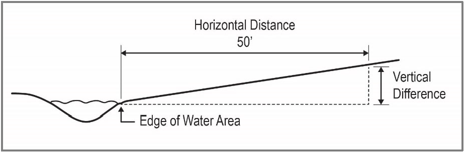
Figure 422-8.1-1 Slope Measurement Adjacent to Water Area
c.
A minimum of three slope measurements along the Water Area, spaced at no more than 100-foot increments, shall be made for each site.
d.
The break in slope shall be determined by measuring 50 feet horizontally from the edge of the Water Area. If the slope is greater than 25%, the measurement shall be continued in 25-foot horizontal increments until either:
i.
A slope is encountered that is less than 25%. In this case, the applicant shall determine the break in slope and add an additional 35 feet to mark the outside boundary of the riparian buffer (see Figure 422-8.1-2); or
ii.
200 feet is reached (all slope measurements >25%) (see Figure 422-8.1-3).
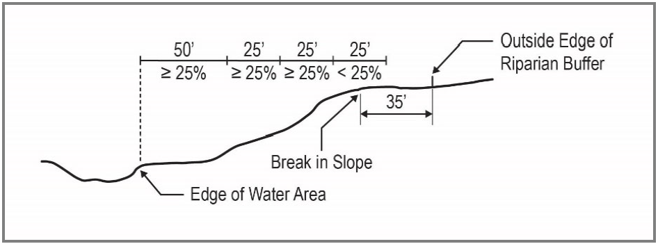
Figure 422-8.1-2 Slope Measurement to Determine Break in Slope
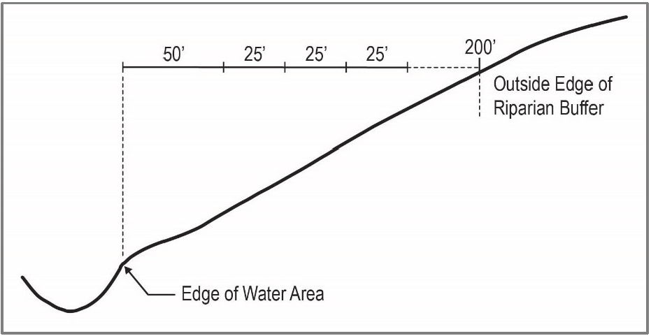
Figure 422-8.1-3 Slope Measurement to Determine Break in Slope
C.
Exception to Methodology 2 for sites that are outside of CWS. Applicants can choose to accept the Riparian Wildlife Habitat boundary shown on the County's SNR Maps as the verified Riparian Wildlife Habitat boundary if the applicant's site plan demonstrates that all proposed grading and improvements, including temporary disturbance areas associated with construction, will be at least 100 feet from the County-mapped Riparian Wildlife Habitat boundary.
422-8.2
No new or expanded alteration of the vegetation or terrain shall be allowed within Riparian Habitat except for the following uses and activities.
A.
Construction, maintenance and repair of public transportation facilities and associated improvements.
B.
Installation, maintenance or construction of the following utilities: sanitary and storm sewer and water lines, electric, communication and signal lines; and gas distribution and transmission lines.
C.
Public wildlife viewing areas and recreation or nature trails.
D.
Bank maintenance, restoration or stabilization, including riprapping for erosion control, of a river or other watercourse or body of water provided there is compliance with the requirements of Section 421-4.6 and with the applicant's CWS' Service Provider Letter or associated permit materials submitted to Oregon Division of State Lands (DSL) and/or the USACE, as applicable.
E.
Detached dwelling or middle housing duplex on a legal lot, provided all required local, state or federal permits and approvals are obtained and the following maximum disturbance area is not exceeded.
1.
The maximum disturbance area (including structures, impervious areas and landscaped areas) permitted within Riparian Habitat equals 5,000 square feet less the buildable area on the site (i.e., 5,000 SF - Buildable Area = maximum disturbance area permitted within Riparian Wildlife Habitat).
2.
Buildable Area for the purposes of this section means land that has a slope of less than 25% and is outside verified Riparian Wildlife Habitat, public rights-of-way, public utility easements, and required setbacks.
F.
An alteration permitted or required by CWS, or permitted or required by DSL or the USACE for areas outside of CWS.
G.
Fencing provided it is split rail or other design that allows for the passage of wildlife by meeting the following design requirements:
1.
The lowest horizontal fence element must be at least 18 inches off the ground.
2.
The highest horizontal fence element must be no more than 42 inches in height.
3.
Fencing shall not include woven wire, cyclone fencing, or contain barbed wire elements.
H.
Chain link fencing and signage around water quality facilities when authorized by CWS.
422-8.3
For development proposals that are within verified Riparian Wildlife Habitat but are outside CWS, the applicant shall demonstrate compliance with either the Tree Inventory and Retention Requirements for Post-2005 UGB Significant Habitat in Section 422-9 or the Detailed Environmental Report Requirements in Section 422-11.
(Ord. No. 902A, § 2.A.(Exh. 1, § 1.), 11-5-24, eff. 12-5-24)
422-9
Tree Inventory and Retention Requirements for Significant Habitat within the UGB
422-9.1
Applicability
The standards in this section apply to development that will impact Regulated Trees located within the Upland Wildlife Habitat, and Riparian Wildlife Habitat outside of CWS.
422-9.2
Definitions
As used in Section 422-9, the words listed below have the following meaning:
A.
Impacted by development. A Regulated Tree is considered impacted by a development proposal when the proposed location of the development will be within the tree's Root Protection Zone.
B.
Multi-stemmed tree. A tree with trunks that are connected above the ground. This does not include individual trees growing close together or from a common rootstock that do not have trunks connected above the ground.
C.
Native tree. A tree listed under Category A on the most recent Native Tree List as adopted by the Washington County Board of Commissioners.
D.
Native understory tree/shrub. A tree or shrub listed under Category B on the most recent Native Tree List as adopted by the Washington County Board of Commissioners.
E.
Regulated Trees. Native trees that are 6 inches or greater in diameter, except as specified in Section 422-9.3.
F.
Root Protection Zone. The area within a circle surrounding the tree with a radius measured from the trunk of the tree at ground level and extending one foot for every inch of tree diameter (DBH) - see Figure 422-9.2-1.
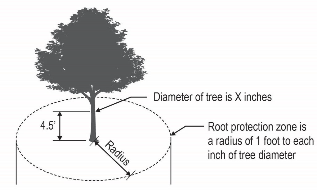
Figure 422-9.2-1 Root Protection Zone
G.
Tree location. A tree's location, for purposes of establishing the applicable requirements of this section, is determined by the location of the trunk at the point where it meets the ground. Surface roots extending from the trunk are not used to determine the tree's location. A tree is considered within the Significant Habitat boundary if any portion of the trunk is within the Significant Habitat boundary at the point where it meets the ground.
422-9.3
Exceptions to Regulated Tree Definition
The following trees are not Regulated Trees and are not subject to the tree preservation requirements of Section 422-9.5.
A.
Trees within a verified Riparian Wildlife Habitat boundary, except as specified in Section 422-8.3.
B.
Trees (native or non-native) that are not identified in the adopted Washington County Native Tree List as Category A or that are less than 6 inches DBH, unless such trees will be retained to meet the requirements of this section.
C.
Hazardous, Diseased or Dying Trees exempt from these regulations pursuant to Section 422-4.C.
D.
Trees approved for removal through a Type I Tree Removal Permit pursuant to Section 422-7.
422-9.4
Tree Inventory
If the proposed development will occur within the Significant Habitat boundary, a tree inventory of all Regulated Trees on the development site is required, except as allowed by Subsection C (for a proposal impacting fewer than 10 Regulated Trees).
The tree inventory must be prepared by an ISA certified arborist, licensed landscape architect, or Qualified Natural Resource Professional, and shall provide the following:
A.
A table listing the Regulated Trees and including the following information for each listed tree:
1.
Identification number
2.
Diameter of tree (DBH)
3.
Status: retain or remove
4.
Common name, genus and species
5.
The Tree Value score (in points) for each Regulated Tree, calculated as follows:
B.
A site plan that includes the following information:
1.
The location and identification number of each Regulated Tree. If the Regulated Tree is to be retained, the location of its Root Protection Zone.
2.
The location of existing and/or proposed public and private utility easements, driveways, and areas of grading or excavation on the development site.
3.
The location of all existing development on the site and the location of development proposed in the land use application that triggers the requirement for a Tree Inventory.
4.
Calculations showing the following:
• The total Tree Value score (points) for the site
• The Tree Value score (points) for the trees to be retained
• The percentage of total points proposed to be retained
5.
Trees to be retained are subject to the tree protection standards in Section 422-9.7. Required tree protection fencing shall be indicated on the site plan.
C.
If the proposed development will impact fewer than 10 Regulated Trees and 100% of the lost Tree Value points will be replaced in accordance with Section 422-9.6, only the Regulated Trees that will be impacted by the proposed development need to be inventoried.
422-9.5
Tree Retention and Replacement Requirements
The minimum percentage of Tree Value Points required to be retained or replaced, based on the location of the site, is shown in the following table. An applicant shall demonstrate through the Tree Inventory (site plan and table) that the required percentage of Tree Value Points are being retained or shall prepare a Tree Replacement Plan in accordance with Section 422-9.6 demonstrating how the required percentage of Tree Value Points will be achieved on the site.
422-9.6
Tree Replacement Plan
A.
If replacement points are required pursuant to Section 422-9.5, the applicant must provide a Tree Replacement Plan, demonstrating how the proposal will achieve the required number of Tree Value Points on the development site either by retaining existing native trees or planting new native trees.
B.
Replacement Tree Value Points are calculated as shown in the table below.
C.
All tree replacement shall occur on-site and outside the verified Riparian Wildlife Habitat boundary except where the replacement is required pursuant to Section 422-8.3.
D.
Trees planted or retained to replace required tree points shall be documented in accordance with the tree inventory requirements in Section 422-9.4. The Tree Replacement Plan shall provide all of the required information and shall also indicate whether these trees are existing trees that will be retained or trees that will be newly planted.
E.
All replacement trees (retained or planted) are considered Regulated Trees and are subject to the tree protection and planting standards in Section 422-9.7.
422-9.7
Tree Protection and Planting Standards
A.
Protective fencing shall be installed by the applicant/property owner to protect the Root Protection Zone of trees retained or planted. Fencing shall be inspected by the County prior to beginning any development activities. All protective tree fencing must remain in place until completion of all construction activities. Any relocation, removal, or modification of the protective fencing shall only occur under the direction of an ISA certified arborist or Qualified Natural Resource Professional and a written explanation of the reason for the relocation, removal, or modification of the protective fencing from the certified arborist must be provided to the County.
B.
No excavation, grading, material storage, staging, vehicle parking or other construction activity shall take place within protective tree fencing areas.
C.
The following standards shall apply to replacement trees to be planted by the applicant, but not to existing trees that are retained.
1.
New native trees (Category A) shall be planted no closer than 8 feet on-center from another tree and no closer than 10 feet from an existing or proposed habitable structure.
2.
A mix of species shall be provided as follows:
3.
Category A replacement trees shall have a minimum rooting size of 2 gallons and a minimum height of 5 feet. Category B native understory trees/shrubs, which shall have a minimum rooting size of 1 gallon and a minimum height of 2 feet.
4.
Replacement planting must be completed prior to the issuance of any certificate of occupancy or the applicant must post a bond to cover 120% of the cost of installation as calculated by Washington County.
D.
Survival of Regulated Trees. The applicant/property owner is responsible for ensuring a minimum of 80% of the trees and shrubs planted remain alive on the second anniversary of the date that the mitigation planting is completed. If this level is not met, replanting is required to meet the 80% survival requirement. In the event a mature Regulated Tree (retained) must later be removed because it is dead, diseased, dying, or hazardous, documentation of the tree's dead, diseased, dying, or hazardous condition by an ISA certified arborist must be provided to the County prior to tree removal. In the event of tree removal, the tree points must be replaced in accordance with Section 422-9.6.
(Ord. No. 902A, § 2.A.(Exh. 1, § 1.), 11-5-24, eff. 12-5-24)
422-10
Tree Canopy Assessment and Protection Requirements for Upland Wildlife Habitat within the UGB
422-10.1
Applicability of Canopy Assessment and Protection Requirements
Applicants proposing development within the Upland Wildlife Habitat boundary may choose to comply with the tree canopy preservation requirements of this section rather than the Tree Inventory and Retention requirements in Section 422-9. This shall be a Type II review process.
422-10.2
Definitions.
As used in Section 422-10, the words listed below have the following meaning:
A.
Abut. To adjoin or border for at least 20 feet.
B.
Canopy cover. The proportion of a fixed area of the ground covered by tree canopy. The area of tree canopy is measured by determining the area surrounding a tree located within the dripline or by other means acceptable to the County.
C.
Dripline. The perimeter measured on the ground at the outermost tree crown by drawing an imaginary vertical line from the circumference of the crown, straight down to the ground below.
D.
Tree Canopy. Branches, leaves, or other foliage from woody vegetation generally exceeding five feet in height.
E.
Tree Crown. The area of the tree above the ground, measured in mass, volume, or area extending from the trunk and including the branches, stems, leaves, and reproductive structures.
422-10.3
Tree Canopy Preservation Area Required
A.
An area within Upland Wildlife Habitat shall be set aside as a Tree Canopy Preservation Area (TCPA).
B.
TCPAs shall comply with the following dimensional requirements:
1.
Minimum area: The total TCPA on a site shall be based on a percentage of the total Upland Wildlife Habitat on the site as specified in the table below or 500 square feet, whichever is greater. The TCPA shall not include any land within a verified Riparian Wildlife Habitat boundary.
2.
Maximum number: If multiple TCPAs are proposed, each TCPA must be at least 10,000 square feet in size.
3.
Minimum width and depth: The width and depth of each TCPA shall be at least 20 feet.
C.
Each TCPA shall be preserved in a non-buildable tract or conservation easement subject to deed restrictions that provide for ownership and maintenance responsibility by a homeowners' association or other property owner(s) or by other means acceptable to the County.
D.
The applicant shall provide documentation demonstrating how the parties responsible for each TCPA will manage the TCPA to ensure the standards in Section 422-10.4 will continue to be met. At a minimum this shall include a plan for monitoring and maintenance.
422-10.4
Tree Canopy Retention and Replacement within TCPAs
Within TCPAs, the following standards shall apply:
A.
Tree canopy shall cover at least 75% of the TCPA.
This standard shall be met by:
1.
Preserving the tree canopy provided by existing trees within the TCPA;
2.
Planting native trees in portions of the TCPA not currently covered by tree canopy; or
3.
A combination of 1 and 2.
B.
If trees are proposed to be planted to meet the canopy standard, the applicant shall submit a planting plan prepared by an ISA certified arborist, Qualified Natural Resource Professional or licensed landscape architect demonstrating the tree canopy standard will be met within 15 years of planting based on the size, species and placement of trees planted.
C.
Only native plants shall be planted within the TCPA. Native plants are those identified on the Washington County Native Tree list or other plants native to Washington County approved by the Director.
D.
Trees shall be planted in accordance with the standards in Section 422-9.7.C. The applicant is responsible for ensuring a minimum of 80% of the trees and shrubs planted remain alive on the second anniversary of the date that the mitigation planting is completed. If this level is not met, replanting is required to meet the 80% survival requirement.
E.
Native understory vegetation shall be retained, and invasive species shall be removed.
(Ord. No. 902A, § 2.A.(Exh. 1, § 1.), 11-5-24, eff. 12-5-24)
422-11
Detailed Environmental Report Requirements for Upland Wildlife Habitat within the UGB
422-11.1
Applicability of Detailed Environmental Report Requirements within Upland Wildlife Habitat
Applicants proposing development within the Upland Wildlife Habitat may choose to comply with the detailed environmental report requirements of this section rather than the Tree Inventory and Retention requirements in Section 422-9. This shall be a Type III review process.
422-11.2
Detailed Environmental Report Contents
A Detailed Environmental Report shall be prepared and signed by a Qualified Natural Resource Professional. The Detailed Environmental Report shall include the following:
A.
A site assessment that identifies the ecological functions provided by the Upland Wildlife Habitat on the project site addressing the following:
1.
Habitat condition including:
a.
Native plant diversity and presence of non-native and invasive species;
b.
Habitat patch size;
c.
Interior habitat;
d.
Connectivity of the habitat to Riparian Wildlife Habitat; and
e.
Connectivity of the habitat to other Upland Wildlife Habitat.
2.
The use and importance of the habitat to invertebrates (pollinators, birds, reptiles, amphibians, and mammals), including the known presence of any Threatened, Endangered, and Candidate Fish and Wildlife Species.
3.
The role of the habitat in providing temperature moderation and carbon sequestration.
B.
An impact evaluation describing the impacts of the proposed development. The full range of impacts must be detailed, including the precise impact areas (both temporary and permanent) as well as impacts to ecological functions provided at the site and any potential impacts on adjacent property(ies).
C.
A mitigation narrative and plan that describes how proposed mitigation will adequately compensate for or offset impacts described in the impact evaluation. The narrative shall include the following:
1.
Documentation of required permits from CWS, USACE, DSL, and Department of Environmental Quality (DEQ) as applicable.
2.
A list of all parties responsible for implementing and monitoring the mitigation plan and, if mitigation will occur off-site, the names of the owners of property where mitigation plantings will occur and documentation of a deed restriction or other means approved by the County.
3.
A site plan and complete list of proposed mitigation plantings including the size, location and amount of each species (only native species are permitted to be planted).
4.
A description of all site preparation and maintenance (mulching, removal of invasive and noxious vegetation, irrigation, wildlife protection, and weed control).
5.
The applicant's mitigation site monitoring, success criteria, and reporting plan which ensures a minimum of 80% of the trees and shrubs planted shall remain alive on the second anniversary of the date that the mitigation planting is completed. If this level is not met, replanting is required to meet the 80% survival requirement.
6.
If off-site mitigation is proposed, a narrative description of why mitigation cannot be completed on-site. Off-site mitigation must be within the same stream basin as the proposed impact unless the applicant provides evidence that there are no properties within the stream basin that are available for purchase and/or could provide the opportunity to offset the project's unavoidable impacts. Off-site mitigation must be within unincorporated Washington County, must be comprised of lands that are not otherwise protected from development, and must be protected in perpetuity.
422-11.3
Detailed Environmental Report: Approval Criteria
The applicant's Detailed Environmental Report shall demonstrate that:
A.
The proposed development will avoid or minimize impacts to ecological functions and loss of habitat to the extent practicable and that the proposed development will be located, designed, and constructed to minimize grading, removal of native vegetation, disturbance and removal of native soils, adverse hydrological impacts on water resources, and impacts on wildlife corridors through the use of the best management practices and habitat-friendly development practices.
B.
For impacts that cannot be avoided or minimized, the proposal mitigates impacts from the proposed development. The mitigation plan shall demonstrate that it adequately compensates for and offsets the detrimental impacts to ecological functions provided by Significant Habitat, after taking into consideration the applicant's efforts to minimize such detrimental impacts.
C.
The mitigation maintenance and monitoring plan provided is sufficient to ensure the success of the planting as required by the standards. Compliance with the plan shall be a condition of development approval.
422-11.4
Financial Guarantee
A financial guarantee in the form of an instrument approved by the County, shall be submitted to the County before building permits are issued, or when no building permit is required, before development within the Significant Habitat boundary commences. It shall be in an amount adequate to cover 120% of the cost of performing the mitigation. The County will release the guarantee at the end of the two-year monitoring period, or before, if it determines that the trees and shrubs have been successfully established.
(Ord. No. 902A, § 2.A.(Exh. 1, § 1.), 11-5-24, eff. 12-5-24)
422-12
Preliminary Habitat Resources Map Modifications within the UGB
422-12.1
An applicant may request a Preliminary Map Modification (preliminary approval for modification of the County-adopted mapped location of a resource) using one or more of the methodologies detailed in Table 422-12.1 below. The Washington County Natural Resources Inventory adopted into Volume IA of the Resource Document shall be used to identify the type(s) of Significant Habitat on the property. Preliminary Map Modification requests made pursuant to this Section may be made in conjunction with another development application or as a standalone application, as applicable. Applications for a standalone map modification request under Issue D., below, shall be processed as a Type II review. All others shall be a Type I review.
With preliminary approval, development may proceed consistent with the revised boundary except where otherwise precluded by State law. The County will conduct a legislative update of the Significant Natural Resource Maps to finalize authorized modification requests on a periodic basis. Where state law does not allow for buildings on land mapped in the comprehensive plan for protection of natural resources, an application involving buildings or parts thereof within such areas cannot proceed until the legislative map update is completed, even if the Preliminary Map Modification has been granted.
TABLE 422-12.1: PRELIMINARY MAP MODIFICATION ISSUES AND METHODOLOGIES
422-12.2
A Preliminary Map Modification request to address Map Modification Issue D in Table 422-12.1, above, may be submitted consistent with this section.
A.
Submittal Requirements:
A report prepared and signed by a Qualified Natural Resource Professional that includes:
1.
A description of the qualifications and experience of all persons that contributed to the report, and, for each person that contributed, a description of the elements of the analysis to which the person contributed;
2.
A detailed description of the requested modification and the reasons for the request;
3.
The following information, if it is relevant to the verification of habitat location on the subject lot or parcel:
a.
Information described in Table 422-12.1;
b.
Aerial photographs, including documentation of the date and process used to take the photos and an expert's interpretation of the additional information they provide;
c.
A map showing the topography of the property shown by 2-foot vertical contours in areas of slopes less than 15%, and at 5-foot vertical contours of slopes 15% or greater; and
4.
Any additional information necessary to address the approval criteria in Subsection B.
B.
Approval Criteria:
A modification of the boundary or classification of a resource under this section shall only be approved if the applicant demonstrates that the location and/or attributes of the inventoried habitat on the site as described in the Washington County Natural Resources Inventory are inaccurate and that natural resources meeting the criteria for inclusion in the County's adopted Natural Resources Inventory were not present as of the following dates:
1.
For pre-2006 habitat, December 5, 2024.
2.
For post-2005 habitat, the effective date of the ordinance adopted by the Metro Council to bring the subject property within the Metro UGB.
(Ord. No. 902A, § 2.A.(Exh. 1, § 1.), 11-5-24, eff. 12-5-24)
422-13
Standards Applicable to Open Space and Significant Natural Areas Inside the UGB
422-13.1
Open Space identified in a community plan is subject to the following standards:
A.
Shall be identified as provided in Section 404-1, Master Planning - Site Analysis;
B.
When located in a park-deficient area as identified on the SNR Maps, the applicant shall notify the appropriate park provider of the proposed development.
422-13.2
Any development requiring a permit from Washington County which is proposed in a Significant Natural Area, as identified on the SNR Maps, shall provide:
A.
Screening and buffering landscaping that meets or exceeds that required by Section 411-6.3, located between the identified significant features and the proposed use on the site; and
B.
A 20-foot setback from the identified significant features to proposed improvements.
(Ord. No. 902A, § 2.A.(Exh. 1, § 1.), 11-5-24, eff. 12-5-24)
422-14—422-19
Reserved for future use
422-20
Intent and Purpose of Significant Natural Resource Standards Outside the UGB
The intent and purpose of these standards is to permit limited and safe development in areas with significant natural resources, while providing for the identification, protection, enhancement and perpetuation of natural sites, features, objects and organisms within the county, here identified as important for their uniqueness, psychological or scientific value, fish and wildlife habitat, educational opportunities or ecological role.
Development within riparian areas, Water Areas and Wetlands, or Water Areas and Wetlands and Fish and Wildlife Habitat shall comply with applicable state and federal regulatory guidelines.
(Ord. No. 902A, § 2.A.(Exh. 1, § 1.), 11-5-24, eff. 12-5-24)
422-21
Lands Subject to this Section
Those areas identified in the Rural/Natural Resource Plan as Significant Natural Resources.
For areas outside the UGB, Significant Natural Resources have been classified by the following categories:
422-21.1
Water Areas and Wetlands. 100-year floodplain, drainage hazard areas and ponds, except those already developed.
422-21.2
Water Areas and Wetlands and Fish and Wildlife Habitat. Water areas and wetlands that are also fish and wildlife habitat.
422-21.3
Wildlife Habitat. Sensitive habitats identified by the Oregon Department of Fish and Wildlife, the Audubon Society Urban Wildlife Habitat Map, and forested areas coincidental with water areas and wetlands.
422-21.4
Significant Natural Areas. Sites of special importance, in their natural condition, for their ecological, scientific, and educational value.
(Ord. No. 902A, § 2.A.(Exh. 1, § 1.), 11-5-24, eff. 12-5-24)
422-22
Criteria for Development
422-22.1
The required master plan and site analysis for a site which includes an identified natural resource shall:
A.
Identify the location of the natural resource(s), except in areas where a Goal 5 analysis has been completed and a program decision adopted pursuant to OAR 660, Division 23 (effective September 1, 1996);
B.
Describe the treatment or proposed alteration, if any. Any alteration proposed pursuant to this subsection shall be consistent with the program decision for the subject natural resource; and
C.
Apply the design elements of the applicable implementing strategies of the Rural/Natural Resource Plan, Policy 10, Implementing Strategy E which states:
"Implement the recommendations of the Oregon Department of Fish and Wildlife Habitat Protection Plan for Washington County and to mitigate the effects of development in the Big Game Range within the EFU, EFC and AF-20 land use designations."
422-22.2
Development within a Riparian Corridor, Water Areas and Wetlands, and Water Areas and Wetlands and Fish and Wildlife Habitat Outside the UGB:
A.
No new or expanded alteration of the vegetation or terrain of the riparian corridor (as defined in Section 106) or a significant water area or wetland (as identified in the Rural/Natural Resource Plan) shall be allowed except for the following:
1.
Crossings for streets, roads or other public transportation facilities.
2.
Construction or reconstruction of streets, roads or other public transportation facilities.
3.
Installation or construction of the following utilities: sewer and water lines, electric, communication and signal lines; and gas distribution and transmission lines.
4.
Wildlife viewing areas and recreation or nature trails.
5.
Bank maintenance, restoration or stabilization, including riprapping for erosion control, of a river or other watercourse or body of water provided there is compliance with the requirements of Section 421-4.6. This use is not subject to Section 422-22.4 or Section 422-22.5.
6.
Detached dwellings and accessory structures on a lot of record, provided there is insufficient suitable, existing buildable land area to permit construction outside the riparian corridor, as defined in Section 106, or a significant water area or wetland (as identified in the Rural/Natural Resource Plan) and all required local, state or federal permits are obtained.
7.
Where it can be demonstrated, with concurrence of the Clackamas District biologist or other applicable district biologist of the Oregon Department of Fish and Wildlife, that a riparian corridor, Water Areas and Wetlands, or Water Areas and Wetlands and Fish and Wildlife Habitat has been degraded, an enhancement of these areas which conforms to the definition and criteria listed in Section 422-22.3 may be permitted through a Type II procedure.
Enhancement or alteration of a non-degraded portion of these areas is permitted when it is in conjunction with and it is needed to support the enhancement of the degraded area. Where development is proposed that would have negative impacts on these areas it is the County's policy to follow state and federal regulatory guidelines for mitigation proposals.
8.
All activities and uses associated with an expansion or alteration of Barney Reservoir and Henry Hagg Lake/Scoggins Dam; including, but not limited to, impoundment structures, water diversion and transmission facilities, road construction and related land alterations. Such activities and uses may be permitted through a Type III procedure.
9.
The following farm and forest activities:
a.
Propagation or harvesting of timber for personal consumption, provided that the use of a caterpillar tractor, yarder, backhoe, grader or similar heavy mechanized equipment is prohibited;
b.
Commercial forestry activities when in compliance with the Oregon Forest Practices Act and Administrative Rules;
c.
Farming or raising of livestock not utilizing a structure; and
d.
Operations for the exploration for and production of geothermal resources, oil and gas.
10.
All public use airport-related uses and activities allowed pursuant to Section 387-4.
11.
Wetland mitigation, creation, enhancement and restoration within public use airport approach surface areas and airport direct impact boundaries shall be allowed upon demonstration of compliance with the requirements of Section 388-9.
B.
Where development or alteration of the riparian corridor is permitted under the above exceptions, the floodplain and drainage hazard area development criteria shall be followed.
C.
Fencing adjacent to stream buffers or other wildlife habitat areas shall be designed to allow the passage of wildlife. Designs must incorporate openings appropriately sized and spaced to accommodate passage of wildlife common to Washington County (common mammals needing access to streams in Washington County include, but are not limited to, deer, beaver, coyote, muskrat, rabbit, raccoon and skunk).
422-22.3
Enhancement of a degraded riparian corridor, Water Areas and Wetlands, or Water Areas and Wetlands and Fish and Wildlife Habitat permitted by Section 422-22.2.A.7 shall meet the following:
A.
For the purposes of Section 422-22.2.A.7 an enhancement is a modification, as a result of which no later than five years after completion of the project, the quality and/or quantity of the natural habitats is measurably improved in terms of animal and plant species numbers, number of habitat types, and/or amount of area devoted to natural habitat.
B.
Proposal Preparation
In order to determine whether a proposed modification will result in an enhancement, preparation of the proposal, as well as construction and planning work, shall be guided by a professional wildlife biologist or ecologist with experience and credentials in water areas/wetlands and riparian areas enhancement and who has reviewed the sources and their relevant references listed in Section 422-22.3.
C.
Submittal Requirements
1.
The proposal shall include detailed information and mapping of the site, including all of the following subjects:
a.
Hydrology, including 100-year flood and 25-year flow events/surface water flow patterns, and groundwater information, if available;
b.
Substrate(s) and existing rates of sedimentation;
c.
Existing vegetation, including species list and community types, with approximate percent coverage, and all trees 6 inches in diameter or larger;
d.
Animal life census (macrofauna species list), preferably based on mid-April to mid-May field observations, but at least conducted during spring, summer and/or early fall.
2.
The proposal shall include a color photographic record (taken sometime between mid-spring and mid-fall) showing the major portion of the site at sufficient detail to compare with the later transformation.
3.
The proposal shall include a map showing the expected outcome of the proposed enhancement, with detailed description of how this is to be accomplished.
a.
To the maximum feasible extent, the overall design of the site shall minimize parking and human activity directly adjacent to the Significant Natural Resource, and where avoidable shall incorporate special design techniques (e.g., thick or thorny vegetation or fencing) to reduce adverse impacts such as littering and harassment of wildlife and damage to vegetation.
b.
A surrounding vegetation buffer of closely spaced (6 feet to 8 feet) trees and shrubs shall be included within the outer 25 feet of the Significant Natural Resource area unless there are special circumstances or design measures.
c.
All plant materials shall be indicated in terms of number and size. Except for the outer perimeter of the buffer area, all plants shall be of a native species unless agreed to by the Clackamas District biologist or other applicable district biologist of the Oregon Department of Fish and Wildlife.
d.
As many existing native trees over 6 inches in diameter as possible shall be preserved.
e.
Vegetation plantings (e.g., trees and shrubs) which overhang standing water are encouraged. (Native vegetation is preferred.)
f.
Measures for the prevention of undesirable monotypic plant dominance, especially Reed Canary Grass and blackberries, shall be included, such as periodic removal or application of herbicides agreed to by the Clackamas District biologist or other applicable district biologist of the Oregon Department of Fish and Wildlife.
g.
Ponds shall have varying open water depth up to a least 3 feet, unless required by the Oregon Department of Fish and Wildlife, DSL or the USACE, and where the natural grade permits shall have gently sloped shores on at least two sides.
h.
Islands are encouraged to be 2 feet above normal water level, flat-topped, spaced every 0.25 acre of open water, and no smaller than 450 square feet where possible.
i.
Rocks and large tree trunks are encouraged to be placed in water areas.
4.
The proposal shall be submitted by Washington County to the biologist for the Clackamas District or other applicable district biologist of the Oregon Department of Fish and Wildlife for review and comment, as well as to other regulating agencies with jurisdiction to review the proposed enhancement, including the DSL and the USACE.
5.
The proposal shall include arrangement to ensure frequent and regular litter or trash clean-up unless dedicated to an agency or jurisdiction.
6.
As an alternative to the submittal requirements identified above, CWS may provide the applicable USACE or DSL permit and/or a Service Provider Letter which demonstrates compliance.
D.
Follow-up Requirements
1.
The County shall require as a condition of approval that a detailed report by a wildlife biologist or ecologist, with map and color photographs, shall be submitted to the County by the current property owner two years after completion of the modification and again after five years. The reports shall document the current condition of the resource. These two follow-up reports shall be submitted by the County to the biologist for the Clackamas District or other applicable district for review and comment. If the approved enhancement plan has not been completed in five years, the current property owner shall submit plans to the County Department of Land Use & Transportation for rectifying any significant deficiencies. Once approved, the amended plan shall be implemented.
2.
The County may modify or revoke the development permit for the enhancement, or take other necessary enforcement measures to ensure compliance with these standards.
3.
As an alternative to the reporting requirements identified in D.1 and D.2 above, CWS may submit applicable USACE or DSL monitoring reports two years after completion of the modification and again after five years.
422-22.4
Significant Natural Areas Outside the UGB
Any development requiring a permit from Washington County which is proposed in a Significant Natural Area, as identified in the Rural/Natural Resource Plan, shall reduce its impact, to the maximum extent feasible, on the unique or fragile character or features of the Significant Natural Area. Appropriate impact reducing measures shall include:
A.
Provision of additional landscaping or open space; and
B.
Relocation of the proposed site of a building, structure or use on the lot.
422-22.5
Significant Natural Resource Area Outside the UGB - Finding
For any proposed use in a Significant Natural Resource Area, there shall be a finding that the proposed use will not seriously interfere with the preservation of fish and wildlife areas and habitat identified in the Washington County Comprehensive Plan, or how the interference can be mitigated. This section shall not apply in areas where a Goal 5 analysis has been completed and a program decision has been adopted that allows a "conflicting use" to occur pursuant to OAR 660-023-0040(5)(c) (effective September 1, 1996).
422-23
State and Federal Regulatory Guidelines for Areas Outside the UGB
Development within a riparian corridor, Water Areas and Wetlands, or Water Areas and Wetlands and Fish and Wildlife Habitat, shall obtain all required local, state and federal permits.
(Ord. No. 902A, § 2.A.(Exh. 1, § 1.), 11-5-24, eff. 12-5-24)
Editor's note— Ord. No. 902A, § 2.A.(Exh. 1, § 1.), adopted Nov. 5, 2024, effective Dec. 5, 2024, amended Sec. 422 in its entirety, in effect repealing and reenacting said Sec. 422 to read as set out herein. The former 422, §§ 422-1—422-5, pertained to similar subject matter and derived from Ord. No. 833, § 2.A.(Exh. 1, § 6), adopted Aug. 7, 2018, effective Sept. 6, 2018; Ord. No. 858A, § 2.A.(Exh. 1, § 3), adopted Oct. 22, 2019, effective Nov. 28, 2019; Ord. No. 885A, § 2.1.(Exh. 1, § 24.), adopted June 28, 2022, effective July 28, 2022; Ord. No. 890A, § 2.A.(Exh. 1, § 1.), adopted Feb. 7, 2023, effective March 9, 2023.
423 - ENVIRONMENTAL PERFORMANCE STANDARDS
The provisions of Section 423 are known as performance standards. All uses and activities shall observe these standards in order to achieve the purpose and objectives of this Code. Continued compliance is required and may be required to be demonstrated by the owner, if the Director has reason to believe incidence of noncompliance has occurred.
423-1
Existing Uses
Activities, uses, equipment and processes existing as of the effective date of this Code that do not meet the standards set forth in this Section are subject to the following requirements:
423-1.1
Building expansions or installations of new uses shall conform to the applicable standards of this Section and are subject to the procedures and regulations of the nonconforming use section of this Code.
423-1.2
All uses not otherwise prescribed by this Section shall conform to applicable federal, state, and local laws and regulations.
423-2
New Uses
Development after the effective date of this Code shall observe the following requirements:
423-2.1
When federal, state and local standards apply, the most restrictive shall govern.
423-2.2
Prior to issuance of a development permit or certificate of occupancy, the Director may require:
A.
Evidence that mandatory federal, state and local permits have been or will be obtained.
B.
Information demonstrating that the proposed development complies with applicable standards set forth in this Section. This information may be required as a report of findings prepared by qualified engineers or other technical consultants.
423-3
Measurements
Accurate and representative measurements, as necessary, shall be made according to accepted engineering practice. Measurements shall be made at or anywhere outside the property lines of the property from which an emission is generated.
423-4
Air Quality
All development shall comply with the State Department of Environmental Quality Air Quality Standards.
423-5
Odor
All development shall comply with the State Department of Environmental Quality Standards pertaining to odor.
423-6
Noise
All development shall comply with Chapter 8.24 of the Washington County Code of Ordinances relating to noise control. Documentation required to demonstrate compliance may include analysis from a registered professional acoustical engineer.
(Ord. No. 855, § 2.A.(Exh. 1, § 23), 8-6-19, eff. 11-28-19)
423-7
Vibration
No development shall generate ground vibration which is perceptible by the Director beyond the property line of origin without use of instruments. Ground vibrations caused by motor vehicles, trains, aircraft, or temporary construction work are exempt from strict application of these standards, but good faith efforts to control such vibrations shall be made by the originator.
423-8
Heat and Glare
Heat and glare shall be limited as follows:
423-8.1
Except for exterior lighting, operations producing heat or glare shall be conducted entirely within an enclosed building.
423-8.2
Exterior lighting shall be directed entirely away from adjacent properties.
423-9
Storage
423-9.1
All materials, including wastes, shall be stored and all grounds maintained in a manner which will not attract or aid the propagation of insects or rodents or create a health hazard.
423-9.2
No open storage of materials and equipment shall be permitted unless contained by a site obscuring fence or landscaped screening.
423-9.3
Fencing will be allowed between the required landscaping and use where necessary to protect the property concerned or to protect the public from a dangerous condition subject to the following provisions:
A.
No fence shall be constructed in the required setback from the public road right-of-way.
B.
Fences shall be constructed as required through development review.
C.
Fencing or sight obscuring screening for storage areas must be at least 6 feet, but no more than 10 feet high.
423-9.4
Storage of Hazardous Materials
Developments which store hazardous materials must comply with state standards, OAR 340-063, and the federal standards, 40 CFR Part 262 and 264 and shall demonstrate such compliance. All hazardous materials must be stored above ground. Transport of and disposal of such materials shall be in conformance with all applicable local, state and federal regulations with such compliance demonstrated.
423-10
Drainage and Waste Water
All development shall comply with the state Department of Environmental Quality Water Quality Standards for all runoff, drainage and waste water.
423-11
Adequate Water Supply
All development shall be required to have an adequate water supply. Adequacy shall include:
423-11.1
Adequate supply for the use prior to issuance of a building permit (see Section 501-7.1, Critical Services).
423-11.2
Outside the UGB, when any Special Use of Article IV will require an amount of water in excess of what would normally be used if the property were developed for rural homesites, the following information:
A.
An explanation of how the water will be supplied; and
B.
An explanation of the potential impact of the proposed water system on the surrounding properties.
C.
Approval of a Standard Subdivision outside the UGB proposing a community water supply shall be subject to the provisions of Section 423-11.2 A. and B.
(Ord. No. 890A, § 2.A.(Exh. 1, § 1.), 2-7-23, eff. 3-9-23)
423-12
Radioactive Materials
The handling and storage of radioactive materials, the discharge of radioactive materials into air or water, and the disposal of radioactive waste in connection with all uses shall be in conformance with all applicable local, state, and federal regulations with such compliance demonstrated.
423-13
Toxic or Noxious Matter
All development shall comply with the state Department of Environmental Quality standards pertaining to omission of toxic or noxious matter and such compliance shall be demonstrated.
423-14
Determination of Violation
Alleged violations of the performance standards set forth in this Section shall be determined and enforced in the following manner:
423-14.1
County Determination:
Where it can be determined by the Director or a state official, the determination shall be so made and an order of compliance requiring correction of the violation within a reasonable time period shall be issued. If necessary to eliminate a violation, the Director shall take or cause to be taken, lawful action as provided for in the Washington County Community Development Code.
423-14.2
Third Party Determination:
Where determination of a violation entails the use of highly skilled personnel or expensive instruments not ordinarily available to the county, and when, in the judgment of the Director, a violation may exist, the Director shall so notify the person who owns or controls the use in question.
423-14.3
Notice:
The notice shall describe the particulars of the alleged violation and state the reasons why the Director believes the violation exists. The notice shall also require a determination of compliance or correction of the alleged violation within a reasonable time limit to be set by the Director. The notice shall further state that if the alleged violation is not corrected, a technical determination based on the performance standards set forth in this Code shall be made by qualified engineers or other technical consultants, and that if a violation as alleged is found, enforcement action shall be taken according to Section 215 of this Code.
423-15
Conflicting Provisions
Where standards set forth in this Section conflict with provisions elsewhere in the law, the more stringent shall govern.
424 - CREATION OF PARCELS IN THE EFU, EFC AND AF-20 DISTRICTS
In order to create a lot or parcel in the EFU, EFC, or AF-20 Districts, the following applicable standards shall be met. In addition to the following standards, in the EFU and AF-20 Districts, the applicable requirements of ORS 215 shall be met, and in the EFC District, the applicable requirements of OAR 660-006-0026 shall be met. Findings shall be made for each of the applicable standards.
424-1
Creation of New Lots or Parcels for Farm Use in the EFU and AF-20 Districts
The creation of new lots or parcels for farm use in the EFU and AF-20 Districts may be approved subject to the following standards:
424-1.1
The minimum lot or parcel size shall be 80 acres unless Section 424-1.2 requires the minimum lot area to be greater;
424-1.2
The proposed division of land shall be appropriate for the continuation of the existing commercial agricultural enterprise with the area. Parcels used or to be used for training or stabling facilities shall not be considered appropriate to maintain the existing commercial agricultural enterprise in an area where other types of agriculture occur;
424-1.3
The minimum lot area requirement shall not be reduced through a variance or adjustment request pursuant to Section 435 or any other Code provision; and
424-1.4
The proposed division of land will not seriously interfere with preservation of fish and wildlife areas and habitats identified in the Washington County Comprehensive Plan or how the interference can be mitigated.
(Ord. No. 889A, § 2.C.(Exh. 3, § 1.), 2-7-23, eff. 3-9-23)
424-2
Creation of Forest Related Parcels of at Least 80 Acres in the EFC District
A forest related parcel of 80 acres or more shall be approved subject to the following standards:
424-2.1
A variance or adjustment request to reduce the minimum lot size below 80 acres shall not be permitted.
424-2.2
The proposed parcels shall meet the applicable standards of Section 428.
(Ord. No. 889A, § 2.C.(Exh. 3, § 1.), 2-7-23, eff. 3-9-23)
424-3
Creation of a Parcel for a Nonfarm Dwelling in the EFU and AF-20 Districts
The creation of new lots or parcels for dwellings not in conjunction with farm use (nonfarm dwelling) may be approved subject to the following standards. For tracts that are predominately high-value farmland, address Sections 424-3.1, 3.3 and 3.4. For tracts that are not predominately high-value farmland, address Sections 424-3.2, 3.3 and 3.4.
424-3.1
On land identified as high-value farmland:
A.
The dwelling has been approved through Section 430-85.1 A., B., D., E. and F. (nonfarm detached dwelling unit);
B.
The originating lot or parcel is at least 100 acres; and all of the following:
(1)
Is not stocked to the requirements under ORS 527.610 to 527.770;
(2)
Is composed of at least 95% Class VI through VIII soils;
(3)
Is composed of at least 95% soils not capable of producing 50 cubic feet per acre per year of wood fiber.
(4)
Any new nonfarm lot or parcel will not be smaller than 20 acres and any residual lot or parcel that is not designated as a nonfarm parcel is at least 80 acres.
424-3.2
On land not identified as high-value farmland:
A.
The dwelling has been approved through Section 430-85.1D and 85.2, nonfarm detached dwelling unit;
B.
The originating lot or parcel is at least 82 acres. Any new nonfarm lot or parcel will not be smaller than two acres and any residual lot or parcel that is not designated as a nonfarm parcel is at least 80 acres.
424-3.3
The lot or parcel is created at the time the dwelling is approved.
424-3.4
The Review Authority shall not approve a subdivision or series partition for a nonfarm dwelling. The requirement regarding a series partition applies only to applications for a Land Division submitted after July 1, 1997. For the purposes of this subsection, "series partition" shall have the meaning given that term in ORS 92.305.
(Ord. No. 890A, § 2.A.(Exh. 1, § 1.), 2-7-23, eff. 3-9-23)
424-4
Creation of a Parcel for a Nonfarm Use (Not Including a Dwelling) in the EFU and AF-20 Districts
424-4.1
The lot or parcel is not larger than the minimum size necessary for the use; and
424-4.2
The parcel is created at the time the use is approved.
424-5
Creation of a Parcel with an Existing Historic Dwelling in the EFU and AF-20 District
To create a parcel with an existing dwelling to be used for historic property:
424-5.1
The dwelling shall be listed on the National Register of Historic Places.
424-5.2
A replacement dwelling to be used in conjunction with farm use may be approved for the vacant parcel at the time the parcel is created if the dwelling has been approved through Subsection 340-4.1 M. or 344-4.1 M., whichever is applicable.
424-5.3
The Review Authority shall not approve the Standard Land Division unless any additional tax imposed for the change in use has been paid.
(Ord. No. 890A, § 2.A.(Exh. 1, § 1.), 2-7-23, eff. 3-9-23)
424-6
Creation of a Parcel with an Existing Dwelling Used as a Residential Home in the EFU and AF-20 Districts
To create a parcel with an existing dwelling to be used as a residential home:
424-6.1
The dwelling shall be used as a residential home as defined in ORS 197.660; and
424-6.2
Before or concurrent with Standard Partition approval, the dwelling shall be approved through Section 340-5.1 D. or 344-5.1 D., whichever is applicable.
424-6.3
The Review Authority shall not approve the Standard Land Division unless any additional tax imposed for the change in use has been paid.
(Ord. No. 855, § 2.A.(Exh. 1, § 24), 8-6-19, eff. 11-28-19; Ord. No. 890A, § 2.A.(Exh. 1, § 1.), 2-7-23, eff. 3-9-23)
424-7
Creation of a Parcel Less Than 80 Acres in the EFC District
424-7.1
A Standard Land Division creating a parcel of less than 80 acres may be approved only for the following uses:
A.
Aids to navigation and aviation - 342-3.2 A.;
B.
Exploration for geothermal, gas, oil, etc. - 342-3.1 C.;
C.
Firearms training facility - 342-4.1 C.;
D.
Log scaling and weigh stations - 342-3.2 F.;
E.
Parks - 342-3.2 I.;
F.
Permanent logging equipment repair and storage - 342-3.2 J.;
G.
Production of geothermal, gas, oil, etc. - 342-3.1 G.;
H.
Reservoirs and water impoundments - 342-3.2 L.;
I.
DEQ-mandated solid waste disposal site - 342-3.1 I.;
J.
Communication facilities and transmission towers - 342-3.2 M.;
K.
Utility facilities for generating power - 342-3.2 R.;
L.
Water intake facilities and related facilities - 342-3.2 S.;
M.
Campground - 342-4.1 B.;
N.
Cemetery - 342-3.2 B.;
O.
Mining and processing of oil, gas and other subsurface resources - 342-4.1 D.;
P.
Fire station - 342-4.1 H.;
Q.
Permanent facility for the primary processing of forest materials - 342-4.1 E.;
R.
Solid waste disposal site - 342-4.1 I.;
S.
Communication facilities and transmission towers - 342-4.1 J.
424-7.2
For a Standard Land Division pursuant to Section 424-7.1, findings and evidence shall be provided that demonstrate compliance with the following:
A.
The use will not force a significant change in, or significantly increase the cost of, accepted farming or forest practices on agriculture or forest lands;
B.
The use will not significantly increase fire hazard or significantly increase fire suppression costs or significantly increase risks to fire suppression personnel;
C.
The parcel is not larger than the minimum size necessary for the use; and
D.
The applicant shall sign and record in agreement form, in the Department of Assessment & Taxation, Recording Division, a statement that recognizes the rights of adjacent and nearby land owners to conduct forest operations consistent with the Forest Practices Act and Rules.
(Ord. No. 890A, § 2.A.(Exh. 1, § 1.), 2-7-23, eff. 3-9-23)
424-8
Creation of a Parcel with an Existing Dwelling in the EFC District
A parcel with an existing dwelling may be approved upon findings that:
424-8.1
The parcel is 5 acres or less, except as necessary to recognize physical factors such as roads or streams, in which case the parcel shall be no larger than 10 acres;
424-8.2
The dwelling existed prior to June 1, 1995;
424-8.3
The configuration of the parcels will allow for the establishment of an alternate septic tank drainfield for the existing dwelling;
424-8.4
The remaining parcel (not containing the dwelling) is at least 80 acres; and
424-8.5
Prior to final approval for a dwelling, the applicant records a restrictive covenant that precludes construction of a dwelling on the remaining parcel (80-acre or larger). The restrictive covenant shall be irrevocable, unless the Director finds that the remaining parcel is no longer subject to Statewide Goal 4 (Forest Lands).
424-9
Division of a Lot or Parcel With at least Two Existing Dwellings in the EFC District
Division of a lot or parcel may be approved upon findings that:
424-9.1
At least two dwellings lawfully existed on the lot or parcel prior to November 4, 1993;
424-9.2
Each dwelling complies with the criteria for a replacement dwelling under Section 430-8;
424-9.3
Except for one lot or parcel, each lot or parcel created under this subsection is between two and five acres, limited to the smallest practicable size;
424-9.4
At least one dwelling is located on each lot or parcel created under this subsection; and
424-9.5
The applicant provides evidence that the landowner of a lot or parcel created under this subsection has recorded with the Department of Assessment & Taxation Recording Division a deed restriction prohibiting the future dividing of the subject lot or parcel. The restriction imposed shall be irrevocable unless a statement of release is placed in the Department of Assessment & Taxation Recording Division. The release shall be signed by the Review Authority and shall state that the applicable comprehensive plan or land use regulations have been changed so that the lot or parcel is no longer subject to Statewide Goal 4 (Forest Lands), or unless the Land Division is subsequently authorized by law or by a change in Statewide Goal 4 (Forest Lands).
424-9.6
A lot or parcel may not be divided under this subsection if approval of an existing dwelling on the lot or parcel specified that the dwelling could not be partitioned from the parent lot; or where eventual removal of the dwelling is required (e.g., temporary dwellings).
(Ord. No. 890A, § 2.A.(Exh. 1, § 1.), 2-7-23, eff. 3-9-23)
424-10
Division of Land for Public Parks or Open Space in the EFC District
A proposed division of land in a forest zone to create two parcels may be approved if the proposed division of land is for the purpose of allowing a provider of public parks or open space, or a not-for-profit land conservation organization, to purchase one of the resulting parcels.
424-10.1
A parcel created by the Standard Land Division that is not sold to a provider of public parks or open space or to a not-for-profit land conservation organization must comply with the following:
A.
If the parcel contains a dwelling or another use allowed under ORS 215, the parcel must be large enough to support continued residential use or other allowed use of the parcel; or
B.
If the parcel does not contain a dwelling, the parcel is eligible for siting a dwelling as may be authorized under ORS 195.120 or as may be authorized under ORS 215.705 to 215.750, based on the size and configuration of the parcel.
424-10.2
Before approving a proposed division of land under this section, a condition of approval shall be required that the provider of public parks or open space, or the not-for-profit land conservation organization record an irrevocable deed restriction prohibiting the provider or organization and their successors in interest from:
A.
Establishing a dwelling on the parcel or developing the parcel for any use not authorized in a forest zone except park or conservation uses; and
B.
Pursuing a cause of action or claim of relief alleging an injury from farming or forest practices for which a claim or action is not allowed under ORS 30.936 or 30.937.
424-10.3
If a proposed division of land under Section 424-10 results in the disqualification of a parcel for a special assessment described in ORS 308A.718 or the withdrawal of a parcel from designation as riparian habitat under ORS 308A.365, the owner must pay additional taxes as provided under ORS 308A.371 or 308A.700 to 308A.733 before the county may approve the division.
424-11
Division of a Lot or Parcel Split by an Urban Growth Boundary in the EFU, AF-20 and EFC Districts
424-11.1
A division of a lawfully established unit of land may occur along an Urban Growth Boundary (UGB) where the parcel remaining outside the UGB is zoned for either agricultural or forest use and is smaller than the minimum parcel size, provided that:
A.
If the parcel contains a dwelling, the parcel must be large enough to support continued residential use. A Standard Land Division that results in a lot or parcel less than two acres shall provide:
(1)
Documentation from the Department of Health & Human Services or the Department of Environmental Quality that property(ies) less than two acres in size can accommodate a subsurface sewage disposal system and/or replacement system; and
(2)
Documentation from the Water Master that property(ies) less than two acres in size can accommodate public water or an on-site water source.
B.
If the parcel does not contain a dwelling, it:
(1)
Is not eligible for siting a dwelling, except as may be authorized under ORS 195.120;
(2)
May not be considered in approving or denying an application for any other dwelling;
(3)
May not be considered in approving a redesignation or rezoning of agricultural or forest lands, except to allow a public park, open space or other natural resource use; and
(4)
The owner of the parcel shall record an irrevocable deed restriction in the Department of Assessment & Taxation Recording Division prohibiting the owner and all successors in interest from pursuing a cause of action or claim of relief alleging injury from farming or forest practices for which a claim or action is not allowed under ORS 30.936 or 30.937.
(Ord. No. 809, § 2.E.(Exh. 5, § 3), 8-16-16, eff. 9-15-16; Ord. No. 890A, § 2.A.(Exh. 1, § 1.), 2-7-23, eff. 3-9-23)
424-12
Prohibited Uses
424-12.1
The County governing body or its designate may not approve a Standard Land Division or property line adjustment of a lot or parcel that separates a temporary hardship dwelling, relative farm help dwelling, home occupation or processing facility from the parcel on which the primary residential or other primary use exists.
424-12.2
The County governing body or its designate may not approve a Standard Land Division of a lot or parcel created before January 1, 1993, on which a nonfarm dwelling was approved pursuant to ORS 215.284(1).
(Ord. No. 809, § 2.E.(Exh. 5, § 3), 8-16-16, eff. 9-15-16; Ord. No. 890A, § 2.A.(Exh. 1, § 1.), 2-7-23, eff. 3-9-23)
425 - DESIGNATION OF MARGINAL LANDS
425-1
Parcel Size Criteria
425-1.1
Lands to be designated marginal must meet one of the following:
A.
At least 50% of the proposed marginal land, plus the lots or parcels at least partially located within one-quarter mile of the perimeter of the proposed marginal land consists of lots or parcels 30 acres or less in size on July 1, 1983; or
B.
Is located within an area not less than 240 acres of which at least 60% is composed of lots or parcels that are 20 acres or less in size on July 1, 1983; or
C.
The proposed marginal land is composed predominantly of soils in capability classes V through VIII in the Agricultural Capability Classification System in use by the United States Department of Agriculture Soil Conservation Service on the effective date of SB 237, 1983 Oregon Laws, and is not capable of producing 50 cubic feet of merchantable timber per acre per year in those counties east of the summit of the Cascade Range and 85 cubic feet of merchantable timber per acre per year in those counties west of the summit of the Cascade Range, as that term is defined in ORS 477.001(21).
425-1.2
For the purposes of Section 425-1.1 A. and 425-1.1 B.:
A.
Lots or parcels located within an urban growth boundary adopted by a city or by the Metropolitan Service District shall not be included in the calculation; and
B.
Only one lot or parcel exists if:
(1)
A lot or parcel included in this area as defined in Section 425-1.1 A. is adjacent to one or more such lots or parcels;
(2)
On July 1, 1983, greater than possessory interests are held in those adjacent lots or parcels by the same person, parents, children, sisters, brothers or spouses, separately or in tenancy in common; and
(3)
The interests are held by relatives described in Section 425-1.2 B. (2) above, and one relative held the interest in the adjacent lots or parcels before transfer to another relative.
C.
For the purposes of Section 425-1.2 B.:
(1)
Lots or parcels are not adjacent if they are separated by a public road; and
(2)
Lot and parcel have the meanings given those terms in ORS 92.010.
425-1.3
Lots or parcels for the purposes of Section 425-1.1 B. shall not be included in the calculation of the 240 acres if they are within an area for which the county has adopted an exception.
425-2
Management Criteria (Income Test)
If the land meets the criteria of 425-1, land may be designated as marginal when it has not been managed during three of five calendar years before January 1, 1983 (1978 through 1982), as part of:
425-2.1
A farm operation that produced $20,000 or more in annual gross income; or
425-2.2
A forest operation capable of producing an average over the growth cycle of $10,000 in annual gross income.
425-2.3
Evidence required to determine compliance with the farm operation income requirements above may include the following:
A.
An affidavit signed by the person generating the farm income, certifying that the income requirements have been met;
B.
Federal income tax returns; or
C.
Sales receipts of products sold from the property or other information as may be necessary to prove income.
The county may, in any event, rely on statistical information compiled by the Oregon State University Extension Service, the Oregon Department of Forestry or other objective criteria to calculate income during the years 1978 through 1982.
425-3
Detached Dwelling
A detached dwelling (one) may be permitted on land designated Marginal, on any size lot or parcel, if the lot or parcel was created prior to July 1, 1983 - Section 344-9 (Marginal Lands).
425-4
Parcels within the Quarter-Mile Test Area
Notwithstanding the fact that only a certain amount of land is proposed to be designated marginal for the purposes of establishing the test area of 425-1, any lot or parcel that is within the test area and meets the income test set out in 425-2 may be designated as marginal land.
425-5
Notification
In addition to the notification required by Article II, Notice shall be sent to:
425-5.1
All property owners of record whose parcels are at least partially located within the one-quarter mile of the proposed marginal land parcel, when the parcels have been used to determine eligibility through Section 425-1.1 A., as well as all property owners of record within 500 feet of the perimeter of the designated quarter mile boundary, or
425-5.2
All property owners within 500 feet of the perimeter of the designated 240 acres when the parcels have been used to determine eligibility through Section 425-1.1 B.
425-6
Notation of Marginal Land Designation Approval
425-6.1
The Director designate shall make a notation on the Land Use Maps used by the Department of Land Use & Transportation which reads either MGL-A (approved) or MGL-D (denied) as appropriate.
425-6.2
All MGL-A notations shall be made known to the Department of Assessment & Taxation for their use.
425-6.3
The Director shall keep a master list of all MGL-A notations for use of the Department of Land Use & Transportation and for purposes of the state reporting requirements.
426 - EROSION CONTROL
426-1
Purpose and Intent
This section is intended to implement the administrative rules of the Oregon Department of Environmental Quality mandating erosion control measures in the Tualatin River and Oswego Lake sub-basins which are to be applied during construction to control and limit soil erosion. These standards are to be applied only during construction to control and limit soil erosion.
426-2
Applicability
426-2.1
Notwithstanding any other provision of this Code, compliance with the following provisions shall be required of all land development, as defined below.
426-2.2
The following subsections shall apply to any new land development within the Tualatin River and Oswego Lake sub-basins, except those developments with application dates prior to January 1, 1990. The application date shall be the date on which a complete application for development approval is received by Washington County in accordance with the provisions of Article II.
426-3
Definitions
426-3.1
Erosion Control Plan. Shall be a plan containing a list of best management practices to be applied during construction to control and limit soil erosion. Erosion control plans shall be prepared in conformance with the Washington County Erosion Control Plans Technical Guidance Book, January 1991, or its successor.
426-3.2
Land Development. Refers to any human induced change to improved or unimproved real estate, including but not limited to construction, installation or expansion of a building or other structure, Land Division, drilling, and site alteration such as that due to land surface mining, dredging, grading, construction of earthen berms, paving, improvements for use as parking or storage, excavation or clearing.
426-3.3
Public Works Project. Means any land development conducted or financed by a local, state or federal governmental body.
(Ord. No. 890A, § 2.A.(Exh. 1, § 1.), 2-7-23, eff. 3-9-23)
426-4
Erosion Control Plan
No preliminary plat, site plan, development permit, building permit or public works project shall be approved unless the conditions of the plat, permit or plan approval include an erosion control plan containing methods and/or interim facilities to be constructed or used concurrently with land development and to be operated during construction to control the discharge of sediment in the stormwater runoff. The erosion control plan shall be prepared in conformance with the Washington County Erosion Control Plans Technical Guidance Book, January 1991, or its successor.
426-5
Review
426-5.1
The erosion control plan shall be reviewed in conjunction with the requested development approval. If the development necessitating an erosion control plan is exempted by Section 201-2 from the requirement to obtain a development permit, the approval of the erosion control plan shall be a Type I approval.
426-5.2
The Department may defer submittal of an erosion control plan for a Land Division if no construction or physical change to the land is to be commenced and the Land Division would not otherwise interfere with future compliance with this section. Approval shall be conditioned to require an approved erosion control plan prior to any physical change or construction.
(Ord. No. 890A, § 2.A.(Exh. 1, § 1.), 2-7-23, eff. 3-9-23)
426-6
Compliance
Failure to obtain or implement an approved erosion control plan shall be deemed a violation of this ordinance and may be enforced by citation or revocation of the relevant permit. Compliance with this section is required in addition to, and not in lieu of, Section 410, Grading and Drainage.
427 - SOLAR ACCESS STANDARDS
427-1
Intent and Purpose
The purpose of this Section is to provide and protect property rights to solar access for urban Single Detached Dwelling Units. Section 427 does not apply to Middle Housing.
A.
The purpose of the Solar Access Standard for New Development, Section 427-3, is to ensure that land is developed so that structures can be oriented to maximize solar access and to minimize shade on adjoining properties from structures and trees.
B.
The purpose of the Solar Balance Point Standard, Section 427-4, is to promote the use of solar energy, to minimize shading of structures by structures and accessory structures, and, where applicable, to minimize shading of structures by trees. Decisions related to Section 427-4 are to be administered at the time of issuance of a building permit.
C.
The purpose of the Solar Access Permit Standard, Section 427-5, is to protect solar access to solar features on lots designated or used for a Single Detached Dwelling Unit or a manufactured dwelling under certain circumstances. It authorizes owners of such lots to apply for a permit that, if granted, prohibits solar features from being shaded by certain future trees and hedges on and off the applicant's site.
(Ord. No. 885A, § 2.1.(Exh. 1, § 25.), 6-28-22, eff. 7-28-22; Ord. No. 890A, § 2.A.(Exh. 1, § 1.), 2-7-23, eff. 3-9-23)
427-2
As used in this Section, the words below have the following meaning:
427-2.1
Crown Cover. The area within the drip line or perimeter of the foliage of a tree.
427-2.2
Development. Any Standard Partition, Standard Subdivision or planned development that is created under the County's Standard Land Division or development regulations.
427-2.3
Exempt tree or vegetation. The full height and breadth of vegetation that is:
A.
A species of deciduous tree identified by the Director as solar friendly. Solar friendly trees are certain types of deciduous trees which cast very little shade in the winter; or
B.
Any vegetation which is identified as exempt on a plat, a document or site plan recorded with a plat, or a Solar Access Permit.
427-2.4
Front lot line. For purposes of the solar access regulations, a lot line abutting a street. For corner lots the front lot line is that with the narrowest frontage. When the lot line abutting a street is curved, the front lot line is the chord or straight line connecting the ends of the curve. For a flag lot, the front lot line is the lot line adjoining the pole portion of the lot, excluding the unbuildable portion of the pole, which is parallel to the front of the dwelling (see Figure 1).
427-2.5
Nonexempt tree or vegetation. Vegetation or trees that are not exempt. Solar unfriendly trees and vegetation are trees and vegetation which cast sufficient shade to affect the performance of a solar feature.
427-2.6
Northern lot line. The lot line that is the smallest angle from a line drawn east-west and intersecting the northernmost point of the lot, excluding the pole portion of a flag lot. If the north line adjoins an undevelopable area other than a required yard area, the northern lot line shall be at the north edge of such undevelopable area. If two lot lines have an identical angle relative to a line drawn east-west, or if the northern lot line is less than 35 feet long, the northern lot line shall be a line 35 feet in length within the lot parallel with and at a maximum distance from the front lot line (see Figure 2).
427-2.7
North-south dimension. The length of a line beginning at the midpoint of the northern lot line and extending in a southerly direction perpendicular to the northern lot line until it reaches a property boundary (see Figure 3).
427-2.8
Protected solar building line. A line on a plat or map recorded with the plat that identifies the location on a lot where the area two feet above grade may not be shaded by structures or nonexempt trees (see Figure 10).
427-2.9
Shade. A shadow cast by the shade point of a structure or vegetation when the sun is at an altitude of 21.3 degrees and an azimuth ranging from 22.7 degrees east and west of true south.
427-2.10
Shade point. The part of a structure or nonexempt tree that casts the longest shadow onto the adjacent northern lot(s) when the sun is at an altitude of 21.3 degrees and an azimuth ranging from 22.7 degrees east and west of true south; except a shadow caused by a narrow object such as a mast or whip antenna, a dish antenna with a diameter of 3 feet or less, a chimney, utility pole, or wire.
The height of the shade point shall be measured from the shade point to either the average elevation at the front lot line or the elevation at the midpoint of the front lot line. If the shade point is located at the north end of a ridge line of a structure oriented within 45 degrees of a true north-south line, the shade point height computed according to the preceding sentence may be reduced by 3 feet. If a structure has a roof oriented within 45 degrees of a true east-west line with a pitch that is flatter than 5 feet (vertical) in 12 feet (horizontal) the shade point will be the eave of the roof. If such a roof has a pitch that is 5 feet in 12 feet or steeper, the shade point will be the peak of the roof (see Figures 4 and 5).
427-2.11
Shade reduction line. A line drawn parallel to the northern lot line that intersects the shade point (see Figure 6).
427-2.12
Shadow pattern. A graphic representation of an area that would be shaded by the shade point of a structure or vegetation when the sun is at an altitude of 21.3 degrees and an azimuth ranging between 22.7 degrees east and west of true south (see Figure 12).
427-2.13
Solar access height limit. A series of contour lines establishing the maximum permitted height for nonexempt vegetation on lots affected by a solar access permit (see Figure 11).
427-2.14
Solar access permit. A permit issued by the county that describes the maximum height that nonexempt vegetation is allowed to grow on lots to which a solar access permit applies.
427-2.15
Solar balance point. The location on the lot where a structure would be an equal distance between the locations required by the maximum shade point height standard in Section 427-4.3 and the standard for allowed shade on a solar feature in Section 427-4.6.
427-2.16
Solar feature. A device or combination of devices or elements that does or will use direct sunlight as a source of energy for such purposes as heating or cooling of a structure, heating or pumping of water, and generating electricity.
Examples of a solar feature include a window or windows that contain(s) at least 20 square feet of glazing oriented within 45 degrees east and west of true south, a solar greenhouse, or a solar hot water heater. A solar feature may be used for purposes in addition to collecting solar energy, including but not limited to serving as a structural member or part of a roof, wall, or window. A south-facing wall without windows and without other features that use solar energy is not a solar feature for purposes of Section 427.
427-2.17
Solar gain line. A line parallel to the northern property line(s) of the lot(s) south of and adjoining a given lot, including lots separated by a street, that intersects the solar feature on that lot (see Figure 7).
427-2.18
South or south facing. True south, or 20 degrees east of magnetic south.
427-2.19
Space. A plot of land within a manufactured dwelling park designed to accommodate one manufactured dwelling.
427-2.20
Sun Chart. One or more photographs that plot the position of the sun between 10:30 a.m. and 1:30 p.m. on January 21, prepared pursuant to guidelines issued by the Director. The sun chart shall show the southern skyline through a transparent grid on which is imposed solar altitude for a 45 degree and 30 minute northern latitude in 10-degree increments and solar azimuth from true south in 15 degree increments.
427-2.21
Undevelopable area. An area that cannot be used practicably for a habitable structure because of:
A.
Natural conditions, such as slopes exceeding 20% in a direction greater than 45 degrees east or west of true south, severe topographic relief, water bodies, or conditions that isolate one portion of a property from another portion so that access is not practicable to the unbuildable portion;
B.
Man-made conditions, such as existing development which isolates a portion of the site and prevents its further development;
C.
Setback or development restrictions that prohibit development of a given area of a lot by law or private agreement; or
D.
Existence or absence of easements or access rights that prevent development of a given area.
(Ord. No. 890A, § 2.A.(Exh. 1, § 1.), 2-7-23, eff. 3-9-23)
427-3
Solar Access Standard for New Development
427-3.1
Applicability
The solar design standard in Section 427-3.2 shall apply to the following development applications, except to the extent the Review Authority finds that the applicant has shown one or more of the conditions listed in Sections 427-3.3 and 427-3.4 exist, and exemptions or adjustments provided for therein are warranted.
A.
Development applications to create lots or parcels for Single Detached Dwelling Units or manufactured dwellings in any urban residential district through a Standard Partition or Standard Subdivision application; and
B.
Development applications for a manufactured dwelling park in any urban residential district.
427-3.2
Solar Design Standard
A.
Requirements for New Lots or Parcels
At least 80% of the lots or parcels in a development subject to Section 427 shall comply with one or more of the alternatives listed in Section 427-3.2, provided, a development may, but is not required to, use the alternatives listed in Sections 427-3.2 A. (2) or 427-3.2 A. (3) to comply with Section 427-3.
(1)
Basic Requirement (see Figure 9). A lot or parcel complies with Section 427-3.2 if it:
(a)
Has a north-south dimension of 90 feet or more; and
(b)
Has a front lot line that is oriented within 30 degrees of a true east-west axis.
(2)
Protected Solar Building Line Alternative (see Figure 10): In this alternative, a lot or parcel complies with Section 427-3.2 if a solar building line is used to protect solar access in the following manner:
(a)
A protected solar building line is designated on the plat or in documents recorded with the plat;
(b)
The protected solar building line is oriented within 30 degrees of a true east-west axis;
(c)
There is at least 70 feet between the protected solar building line and the middle of the north-south dimension of the lot or parcel to the south, measured along a line perpendicular to the protected solar building line; and
(d)
There is at least 45 feet between the protected solar building line and the northern edge of the buildable area of the lot or parcel, or habitable structures are situated so that at least 80% of their south-facing wall will not be shaded by structures or nonexempt vegetation.
(3)
Performance Alternative: In this alternative, a lot or parcel complies with Section 427-3.2 if:
(a)
Habitable structures built on the lot or parcel will have their long axis oriented within 30 degrees of a true east-west axis, and at least 80% of their ground floor south wall(s) will be protected from shade by structures and nonexempt trees using appropriate deed restrictions; or
(b)
Habitable structures built on the lot or parcel will orient at least 32% of their glazing and at least 500 square feet of their roof area to face within 30 degrees east or west of true south, and that glazing and roof area are protected from shade by structures and nonexempt trees using appropriate deed restrictions.
B.
Requirement for Manufactured Dwelling Parks
At least 80% of the manufactured dwellings in a manufactured dwelling park subject to Section 427 shall be oriented with their long axis within 30 degrees of east-west.
427-3.3
Exemptions from the Solar Design Standard
A development is exempt from Section 427-3.2 if the Review Authority finds the applicant has shown that one or more of the following criteria are applicable to the site. A development is partially exempt from Section 427-3.2 to the extent the Review Authority finds the applicant has shown that one or more of the following criteria are applicable to a corresponding portion of the site. If a partial exemption is granted for a given development, the remainder of the development shall comply with Section 427-3.2.
A.
Slopes:
The site, or a portion of the site for which the exemption is sought, is sloped 20% or more in a direction greater than 45 degrees east or west of true south, based on a topographic survey by a licensed professional land surveyor or USGS or other officially recognized topographic information.
B.
Off-site shade:
The site, or a portion of the site for which the exemption is sought, is within the shadow pattern of off-site features which will remain after development of the off-site property subject to compliance with one of the following criteria. Off-site features include but are not limited to structures, topography or nonexempt vegetation.
(1)
Shade from an existing or an approved off-site single-family dwelling or manufactured dwelling in an urban residential district is assumed to remain after development of the site.
(2)
Shade from off-site structures other than those listed in (1) above, is assumed to be the shadow pattern of the existing or approved development thereon or the shadow pattern that would result from the largest structure allowed at the closest setback on adjoining land, whether or not that structure now exists.
(3)
Shade from off-site vegetation is assumed to remain after development of the site if:
(a)
The trees that cause the shade are situated in a required setback or they are part of a developed area, public park, or legally reserved open space;
(b)
The trees are in or separated from the developable remainder of a parcel by an undevelopable area or feature; or
(c)
The trees are part of landscaping required by this Code, a community plan or a prior development action.
(4)
Shade from topographic features is assumed to remain after development of the site.
(5)
Shade from other off-site sources is assumed to be shade that exists or that will be cast by development for which applicable permits have been approved on or before the date an application for the development is submitted.
C.
On-site shade:
The site, or a portion of the site for which the exemption is requested, is:
(1)
Within the shadow pattern of on-site features, including but not limited to structures and topography which will remain after the development occurs; or
(2)
Contains nonexempt trees at least 30 feet tall and more than 6 inches in diameter measured 4 feet above the ground which have a crown cover over at least 80% of the site, or the relevant portion. The applicant can demonstrate such crown cover exists using a scaled survey or an aerial photograph.
If granted, the exemption shall be approved subject to the condition that the applicant preserve at least 50% of the crown cover that causes the shade that warrants the exemption. The applicant shall file a note on the plat or other documents in the Department of Assessment & Taxation Recording Division binding the applicant to comply with this requirement. The county shall be made a party to any covenant or restriction created to enforce any provision of this requirement. The covenant or restriction shall not be amended without written county approval.
D.
Completion of a phased Standard Subdivision which has received preliminary plat approval or a phased manufactured dwelling park which has received preliminary development review approval:
The site is part of a phased Standard Subdivision, or manufactured dwelling park none of which was subject to Section 427-3.
427-3.4
Adjustments to the Solar Design Standard:
The Review Authority shall reduce the percentage of lots or spaces that must comply with Section 427-3.2 to the minimum extent necessary if it finds the applicant has demonstrated it would cause or is subject to one or more of the following conditions.
A.
Adverse impacts upon density, cost or amenities:
(1)
If the design standard in Section 427-3.2 A. is applied, either the resulting density is less than that proposed, or on-site site development costs (e.g., grading, water, storm drainage and sanitary systems, and roads) and solar related off-site site development costs (e.g., more extensive utility lines or street improvements are required due to the solar access requirements) are at least 5% more per lot or space than if the standard is not applied.
The following conditions, among others, could constrain the design of a development in such a way that compliance with Section 427-3.2 A. would reduce density or increase per lot costs as previously described. The applicant shall demonstrate which if any of these or other similar site characteristics apply to a development.
(a)
The portion of the site for which the adjustment is sought has a natural grade that is sloped 10% or more and is oriented greater than 45 degrees east or west of true south based on a topographic survey of the site by a registered professional land surveyor or USGS or other officially recognized topographic information.
(b)
There is a significant natural feature on the site, identified as such in the community plan or this Code, that prevents given streets, lots or spaces from being oriented for solar access, and it will continue to exist after the site is developed.
(c)
Existing road patterns must be continued through the site or must terminate on-site in order to provide adequate circulation, comply with future roadway alignments designated in the Transportation Plan or an adopted study, or to comply with the standards of the Washington County Road Design and Construction Standards in a way that prevents proposed streets, lots or spaces in the development from being oriented for solar access.
(d)
An existing public easement or right-of-way prevents proposed streets, lots or spaces in the development from being oriented for solar access.
(2)
If the design standard in Section 427-3.2 A. applies to a proposed lot(s) or space(s), significant development amenities that would otherwise benefit the lot(s) or space(s) will be lost or impaired. Evidence that a significant diminution in the market value of the lot(s) or space(s) would result from having the lot(s) or space(s) comply with Section 427-3.2 A. is relevant to whether a significant development amenity is lost or impaired.
B.
Impacts from existing shade:
The shadow pattern from nonexempt trees cover at least 80% of the lot or space and at least 50% of the shadow pattern will remain after development of the lot. A scaled survey of nonexempt trees on the site or a current aerial photograph of the site may be used to show the shadow pattern.
(1)
Shade from nonexempt trees is assumed to remain if:
(a)
The trees are situated in a required setback;
(b)
The trees are part of an existing or proposed park, open space, or recreational amenity;
(c)
The trees are separated from the developable remainder of the parcel by an undevelopable area or feature; or
(d)
The trees are part of landscaping required by this Code, a community plan or a prior development action; and
(e)
The trees do not need to be removed for a driveway or other development.
(2)
Also, to the extent the shade is caused by on-site trees or off-site trees on land owned by the applicant, it is assumed to remain if the applicant files a covenant binding the property owner to retain the trees causing the shade on the affected lots or spaces in the Department of Assessment & Taxation Recording Division.
427-3.5
Protection from Future Shade:
Structures and nonexempt vegetation must comply with applicable solar balance point standards on all lots in a development subject to Section 427-3, including lots or spaces for which exemptions or adjustments to Section 427-3.3 have been granted.
The applicant shall file a note on the plat or other documents in the Department of Assessment & Taxation Recording Division binding the applicant and subsequent purchasers to comply with the future shade protection standards in Section 427-3.5. The county shall be made a party of any covenant or restriction created to enforce any provision of Section 427. The covenant or restriction shall not be amended without written county approval.
427-3.6
Application:
An application for approval of a development subject to Section 427-3 shall include:
A.
Maps and text sufficient to show the development complies with the solar design standard of Section 427-3.2, except for lots or spaces for which an exemption or adjustment from Section 427-3.2 is requested, including at least:
(1)
The north-south lot dimension and front lot line orientation of each proposed lot or space.
(2)
Protected solar building lines and relevant building site restrictions, if applicable.
(3)
For the purpose of identifying trees exempt from Section 427-3.5, a map showing existing trees at least 30 feet tall and over 6 inches diameter at a point 4 feet above grade, indicating their height, diameter and species, and stating that they are to be retained and are exempt.
(4)
Copies of all private restrictions relating to solar access.
B.
If an exemption or adjustment to Section 427-3.2 is requested, maps and text sufficient to show that given lots, spaces or areas in the development comply with the standards for such an exemption or adjustment in Section 427-3.3 or 427-3.4, respectively.
(Ord. No. 885A, § 2.1.(Exh. 1), 6-28-22, eff. 7-28-22; Ord. No. 890A, § 2.A.(Exh. 1, § 1.), 2-7-23, eff. 3-9-23)
427-4
Solar Balance Point Standard
427-4.1
Applicability
A.
The solar balance point requirements of this subsection shall apply to the following structures in all urban residential districts:
(1)
All new single-family dwellings, additions to existing single-family dwellings and structures that are accessory to a single-family dwelling; and
(2)
All new manufactured dwellings, additions to existing manufactured dwellings and structures that are accessory to a manufactured dwelling. However, these standards do not apply to manufactured dwellings in a manufactured dwelling park or a manufactured dwelling approved as a temporary use. In the event a manufactured dwelling that is being used as a temporary use is converted to a permanent residence, the manufactured dwelling shall comply with the requirements of Section 427-4.
B.
The Review Authority may grant an exemption or adjustment to the solar balance point standards if the applicant has demonstrated that one or more of the conditions listed in Section 427-4.4 or Section 427-4.5 exists, and exemptions or adjustments provided for these conditions are warranted.
C.
Nonexempt vegetation planted on lots or parcels subject to the requirements of Section 427-4.5 shall comply with the shade point height standards listed in Section 427-4.3 or Section 427-4.4.
D.
The solar balance point requirements shall be administered through the building permit for the proposed structure.
427-4.2
Solar Site Plan Required
An application for a building permit for a structure that is subject to the solar balance point standards shall include a site plan that shows the following:
A.
The maximum shade point height allowed by Section 427-4.3;
B.
The average elevation of the rear property line if the maximum shade point height is adjusted pursuant to Section 427-4.3 A. (2);
C.
The location of the shade point, its height relative to the average elevation of the front lot line or the elevation at the midpoint of the front lot line, and its orientation relative to true south; and, if applicable,
D.
The solar balance point for the structure as provided in Section 427-4.7.
427-4.3
Maximum Shade Point Height Standard
The height of the shade point shall comply with the requirements of either Section 427-4.3 A. or Section 427-4.3 B.
A.
Basic Requirement
(1)
The height of the shade point shall be less than or equal to the height specified in Table A, or it may be computed using the formula listed in Section 427-4.3 A. (2). However, the maximum allowed height of the shade point may be increased 1 foot above the calculated height for each foot that the average grade at the rear property line exceeds the average grade at the front property line. The height of the shade point shall be measured from the shade point to either the average elevation at the front lot line or the elevation at the mid-point of the front lot line. It may be necessary to interpolate between the 5-foot dimensions listed in Table A to determine the shade height when using Table A.
(2)
Formula to Determine the Height of the Maximum Shade Point
H = (2 x SRL) - N + 150
Where:
B.
Performance Alternative Requirements
The applicant shall comply with one of the following alternative requirements to determine the maximum shade point height standard.
(1)
The proposed structure, or applicable nonexempt vegetation, will shade not more than 20% of the south-facing glazing of habitable structure(s); or
(2)
The proposed structure or nonexempt vegetation shall comply with Section 427-3.2 B. or Section 427-3.2 C., whichever is applicable. For Section 427-3.2 B., nonexempt vegetation and the shade point of structures shall be set back from the protected solar building line 2.5 feet for every 1 foot of height of the structure or of the mature height of nonexempt vegetation over 2 feet in height.
427-4.4
Exemption from the Maximum Shade Point Height Standard
The Review Authority may exempt a proposed structure or nonexempt vegetation from the requirements of Section 427-4.2 and Section 427-4.3 if the applicant demonstrates that one or more of the following conditions exist, based upon site plans or plats, corner elevations or other topographical data, shadow patterns, sun charts or photographs, or other substantial evidence submitted by the applicant.
A.
Pre-existing Shade
The structure or applicable nonexempt vegetation will shade an area that is shaded by one or more of the following:
(1)
An existing or approved structure;
(2)
A topographic feature; or
(3)
A nonexempt tree that will remain after development of the site. It is assumed a tree will remain after development if:
(a)
The tree is situated in a required building setback;
(b)
The tree is part of a developed or landscaped area required by this Code, a community plan or a prior development action;
(c)
The tree is part of a public park or landscape strip, or legally reserved open space;
(d)
The tree is in or separated from the developable remainder of a parcel by an undevelopable area or feature;
(e)
The tree is on the applicant's property and not affected by the development; or
(f)
A restrictive covenant, which requires the preservation of tree(s) creating the shade, has been recorded in the Department of Assessment & Taxation, Recording Division.
B.
Slope
The site has an average slope that exceeds 20% in a direction greater than 45 degrees east or west of true south based on a topographic survey by a licensed professional land surveyor or USGS or other officially recognized topographic information.
C.
Insignificant Benefit
The proposed structure or nonexempt vegetation shades one or more of the following:
(1)
An undevelopable area;
(2)
The wall of an unheated space, such as a garage;
(3)
Less than 20 square feet of south-facing glazing; or
(4)
An undeveloped lot or parcel, other than a lot or parcel that was subject to the Section 427-3, where:
(a)
There are at least four single detached or Townhouse dwellings or at least four manufactured dwellings within the same Standard Subdivision that are within 150 feet of the lot; and
(b)
A majority of the homes identified in Subsection (a) above have an average of less than 20 square feet of south-facing glazing.
D.
Public Improvement
The proposed structure is a publicly owned improvement.
427-4.5
Adjustments to the Maximum Shade Point Height Standard
The Review Authority may increase the maximum shade point height necessitated by one of the following conditions to the extent it finds the applicant has demonstrated that one or more of these conditions exist, based upon site plans or plats, corner elevations or other topographical data, shadow patterns, sun charts or photographs, or other substantial evidence submitted by the applicant.
A.
Physical Conditions
Physical conditions preclude development of the site in a manner that complies with Section 427-4.3, due to such things as a public or private easement, a right of way, a floodplain, a drainage hazard area, a Significant Natural Resource Area, slopes of 20% or more, areas designated to be unbuildable by this Code, a community plan or a prior development action, or a lot size less than 3,000 square feet.
B.
Conflict Between the Maximum Shade Point Height and Allowed Shade on the Solar Feature Standards
A proposed structure may be sited to meet the solar balance point standard described in Section 427-4.7, or be sited as near to the solar balance point as allowed by Section 427-4.7, if:
(1)
When the proposed structure is sited to meet the maximum shade point height, its solar feature will potentially be shaded as determined using Section 427-4.6; and
(2)
The applicant signs and records a form provided by the county which:
(a)
Releases the applicant from complying with Section 427-4.3, and stipulates that the proposed structure may shade an area otherwise protected by Section 427-4.3;
(b)
Releases the county from liability for damages resulting from the adjustment; and
(c)
Is signed by the affected property owner(s) of the properties that would be shaded beyond the requirements of Section 427-4.3.
(3)
Prior to the issuance of a building permit for the proposed structure, the applicant shall record the above prescribed form in the Department of Assessment & Taxation Recording Division, indexed by the properties identified in Section 427-4.5 B. (2)(c).
427-4.6
Analysis of Allowed Shade on Solar Feature
An applicant may, but is not required to, perform the calculations in or comply with the standards of Section 427-4.6 unless the solar balance point for the structure must be calculated as required by Section 427-4.7.
A.
Applicants are encouraged, but are not required, to design and site a proposed habitable structure so the lowest height of any solar feature(s) will not be shaded by buildings or nonexempt trees or hedges located on property to the south. The applicant may use the procedure listed in Sections 427-4.6 B. through 427-4.6 D. to determine if a proposed solar feature will be shaded by off-site shade.
B.
To calculate the shade height at the subject property's north property line, the applicant should determine which of the following alternatives best describes the source of shade on adjacent lots or spaces to the south:
(1)
Existing structure(s) or nonexempt trees or hedges; or
(2)
The maximum shade that can be cast from future buildings or nonexempt trees or hedges, based on Table C. If the lot(s) to the south can be further divided, the north-south dimension is assumed to be the minimum lot width required for a new lot in that district.
C.
The height of the lowest point of any solar feature of the proposed structure is calculated with respect to either the average elevation or the elevation at the midpoint of the front lot line of the lot to the south.
D.
The applicant can determine the height of the shadow that may be cast upon the applicant's solar feature by the source of shade selected in Section 427-4.6 C. by using the following formula or Table B.
E.
If the allowed shade height on the solar feature calculated in Section 427-4.6 D. is higher than the lowest height of the solar feature calculated in Section 427-4.6 C., the applicant shall be encouraged to consider changes to the design of the house or its location which would make it practical to locate the solar feature so that it will not be shaded in the future.
427-4.7
Calculation of the Solar Balance Point
If a structure does not comply with the Maximum Shade Point Height Standard in Section 427-4.3 and the standard for allowed shade on a solar feature in Section 427-4.6, the solar balance point of the lot or parcel shall then be calculated (see Figure 8). The solar balance point is the location on the lot or parcel where a structure would be an equal distance between the locations required by the maximum shade point height standard and the standard for allowed shade on a solar feature.
(Ord. No. 885A, § 2.1.(Exh. 1), 6-28-22, eff. 7-28-22; Ord. No. 890A, § 2.A.(Exh. 1, § 1.), 2-7-23, eff. 3-9-23)
427-5
Solar Access Permit
427-5.1
Applicability
A.
An owner of property that is located in an urban residential district, that is or will be developed with a single-family dwelling or a manufactured dwelling, may apply for a solar access permit for a solar feature to protect it from shade from future trees and hedges. If granted, the permit prohibits solar features from being shaded by certain future trees and hedges on and off the applicant's site. For the purposes of Section 427-5, future trees and hedges means the full height and breadth that this vegetation will reach upon maturity.
B.
Property that is located in an urban residential district and that is or will be developed with a single-family dwelling or a manufactured dwelling, may be subject to the requirements of Section 427-5.3 B., as the result of a solar access permit on adjacent or nearby property.
C.
The standards of Section 427-5 shall be administered through a Type II procedure prior to the issuance of a building permit for the proposed solar feature(s).
427-5.2
Approval Standards for a Solar Access Permit
The Review Authority shall approve an application for a solar access permit if:
A.
The applicant demonstrates that existing trees, hedges or structures on the applicant's property do not shade the proposed solar feature(s); and
B.
The applicant demonstrates the proposed solar feature will not be shaded by existing trees, hedges or structures on adjacent or nearby property.
427-5.3
Duties Created by Solar Access Permit
A.
Upon approval of a solar access permit, the applicant shall:
(1)
Record the solar access permit in the Department of Assessment & Taxation Recording Division, indexed by the properties identified in Section 427-5.4 A. The applicant shall pay all filing and recording fees. The solar access permit shall contain the following information:
(a)
Legal description of the affected properties;
(b)
The solar access height limit; and
(c)
The site plan required by Section 427-5.4 C., with any modifications required by the Review Authority.
(2)
Install the solar feature in a timely manner as provided in Section 427-5.7; and
(3)
Maintain trees and hedges on the site so they do not shade the solar feature.
B.
An owner of property affected by a solar access permit shall be responsible for and pay all costs for keeping nonexempt trees and hedges from exceeding the solar access height limit. Trees or hedges which are identified as exempt on the site plan required by Section 427-5.4 C. trees or hedges an affected property owner shows were in the ground on the date an application for a solar access permit is filed, and solar friendly trees are exempt from the requirements of Section 427-5.
427-5.4
Application Contents
In addition to the requirements of Section 203-3, an application for a solar access permit shall contain the following information:
A.
A legal description of the subject property and all affected properties. For the purposes of Section 427-5, affected properties means all property within 150 feet and 54 degrees east and west of true south measured from the east and west corners, respectively, of the subject property's south property line.
B.
An accurate and to scale site plan of the applicant's property showing:
(1)
Trees and hedges in the ground as of the date of the application that when mature, could shade the solar feature;
(2)
The location of all existing structures; and
(3)
The height, above grade, of the solar feature, its location, and its orientation relative to true south.
C.
An accurate and to scale site plan of the properties described in Section 427-5.4 A. showing:
(1)
The dimensions of the properties;
(2)
The approximate location of all existing structures, trees and hedges on each property that could shade the proposed solar feature on the applicant's property; and
(3)
The requested solar access height limit for each affected lot. The solar access height limit is determined by a series of contour lines which establishes the maximum permitted height for nonexempt trees and hedges on lots impacted by a solar access permit (see Figure 11). The contour lines begin at the bottom edge of the proposed solar feature and rise in 5-foot increments at an angle to the south not less than 21.3 degrees from the horizon and extend not more than 54 degrees east and west of true south.
Notwithstanding the preceding, the solar access height limit at the northern lot line of any lot impacted by a solar access permit shall allow nonexempt trees or hedges on that lot when their mature height will not create more shade on the applicant's property than would be created by a structure that complies with the requirements of Section 427-4.
D.
If available, a statement signed by the owner(s) of all or a portion of the properties to which the permit will apply verifying that:
(1)
The property is or will be developed for a single-family dwelling or a manufactured dwelling; and
(2)
The trees and hedges shown on the site plan submitted pursuant to Section 427-5.4 C. accurately represents trees or hedges in the ground on the property on the date of the application.
(3)
The Department shall provide a form for this purpose.
427-5.5
Application Review Process
A.
An application for a solar access permit shall be reviewed through a Type II procedure.
B.
In addition to the requirements of Section 204-3.2, the public notice sent to the owners of affected property identified in Section 427-5.4 A. shall contain:
(1)
The site plan of the applicant's property required by Section
427-5.4 B.
(2)
The proposed solar access height limits;
(3)
A description of the duties created by the solar access permit; and
(4)
The site plan of the owners' properties required by Section
427-5.4 C., if the owner did not verify the accuracy of the site plan of the owner's
property pursuant to Section 427-5.4 D. These property owners shall be asked to:
(a)
Verify the accuracy of the site plan of their property, including the accuracy of nonexempt trees and hedges; and
(b)
Submit written comments during the 14-day comment period describing any inaccuracies in the site plan. If written comments are not received during the comment period, the Review Authority may assume the submitted site plan is accurate.
D.
Upon review of written comments or inspection of the subject property and impacted properties, the Review Authority may modify the site plan(s) of impacted property owners and the solar access permit to be consistent with the additional information.
E.
If the application is approved:
(1)
The Review Authority shall send, with the notice of decision, a copy of the solar access permit and the solar access height limits to the owners of each property impacted by the permit.
(2)
The applicant shall record the following information in the Department of Assessment & Taxation Recording Division with the deeds to the properties impacted by the permit. The solar access permit shall not be effective until this information is recorded.
(a)
The approved solar access permit;
(b)
Associated solar access height limits;
(c)
Legal description of the affected properties; and
(d)
Site plan(s) required by Section 427-5.4 C., with any modifications required by the Review Authority.
427-5.6
Permit Enforcement Process
A.
Enforcement Request
A solar access permittee may request the County to enforce a solar access permit by providing the following information to the Director:
(1)
A copy of the solar access permit and the site plans recorded with the permit;
(2)
A completed complaint form;
(3)
The legal description of the property on which the alleged nonexempt tree or hedge is situated, the address of the owner(s) of that property, and a scaled site plan of the property showing the nonexempt tree or hedge; and
(4)
Evidence that the alleged tree or hedge violates the solar access permit. Evidence may include a sun chart, photograph, shadow pattern, or photographs.
B.
Enforcement Process
If the Director determines the request for enforcement is complete, the Director shall initiate an enforcement action pursuant to Section 215, Code Compliance. However, the Director shall not enforce the requirements of the solar access permit against trees or hedges the owner of which shows were in the ground on the date the application for the solar access permit was filed with the County.
427-5.7
Expiration of a Solar Access Permit
A.
A solar access permit shall automatically expire 180 days from the date of issuance unless one of the following occurs first:
(1)
Development of the protected solar feature has commenced as provided in Section 201-6;
(2)
An application for an extension is filed pursuant to Sections 201-5 and 427-5.8; or
(3)
The permit is revoked as provided for in Section 201-7 or as otherwise invalidated by a body of competent jurisdiction.
B.
If after construction of the solar feature has commenced, construction is suspended or abandoned for a period of 180 days or more, the permit shall automatically expire. A new solar access permit must be obtained before work can begin again.
C.
Upon expiration of a solar access permit, the Director shall record a notice of expiration in the Department of Assessment & Taxation Recording Division with the deeds to the subject site and impacted properties.
427-5.8
Extension of a Solar Access Permit
A.
If an extension is desired, the holder of the solar access permit must file an application for an extension prior to the expiration of the permit pursuant to the requirements of Section 201-5.
B.
An extension may be granted for a maximum of 180 days. No permit shall be extended more than once.
TABLE A - MAXIMUM PERMITTED SHADE POINT HEIGHT (in feet)
TABLE B - MAXIMUM PERMITTED HEIGHT OF SHADOW AT SOLAR FEATURE
(in feet)
TABLE C - MAXIMUM PERMITTED SHADE HEIGHT AT NORTH PROPERTY LINE
(in feet)
See Section 427-4.6 B. (2).
FIGURES:
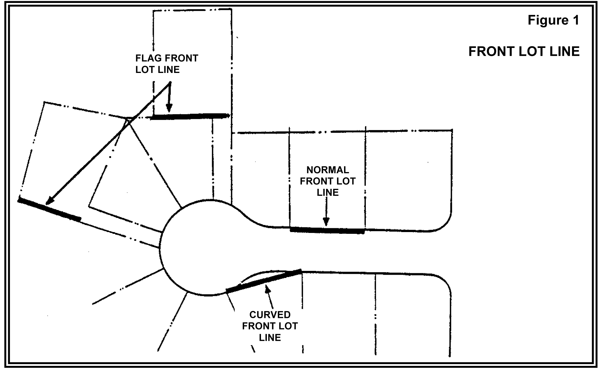
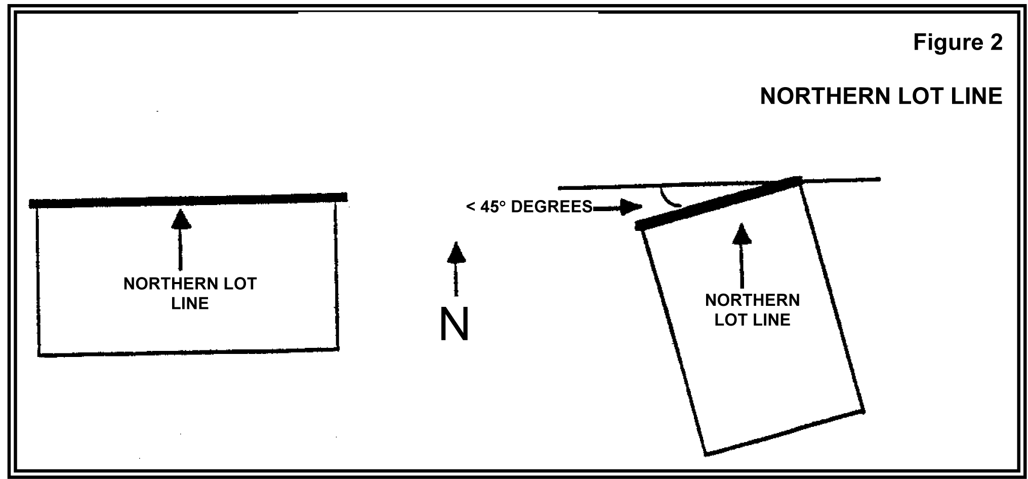
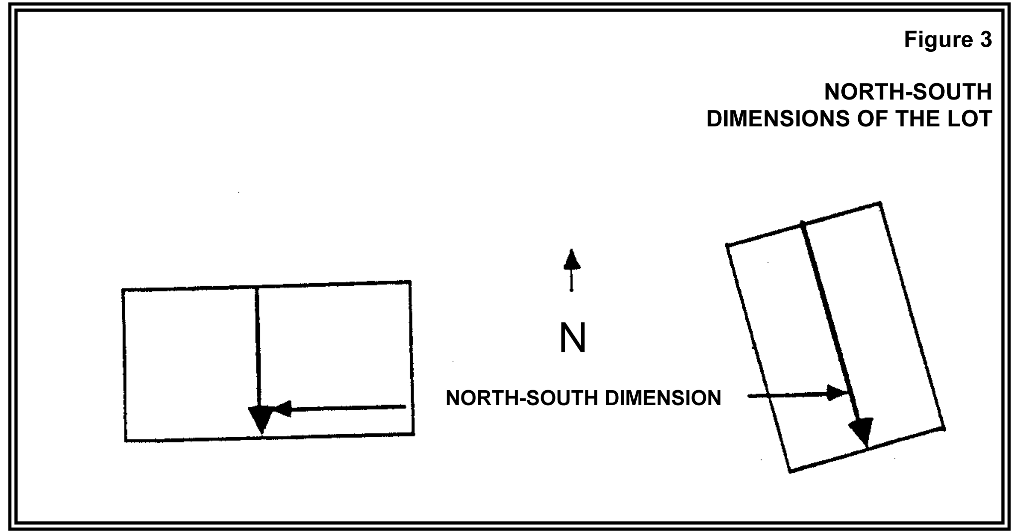
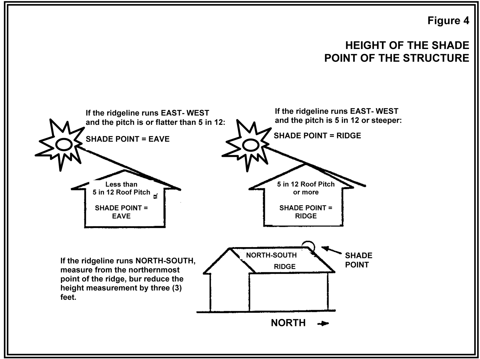
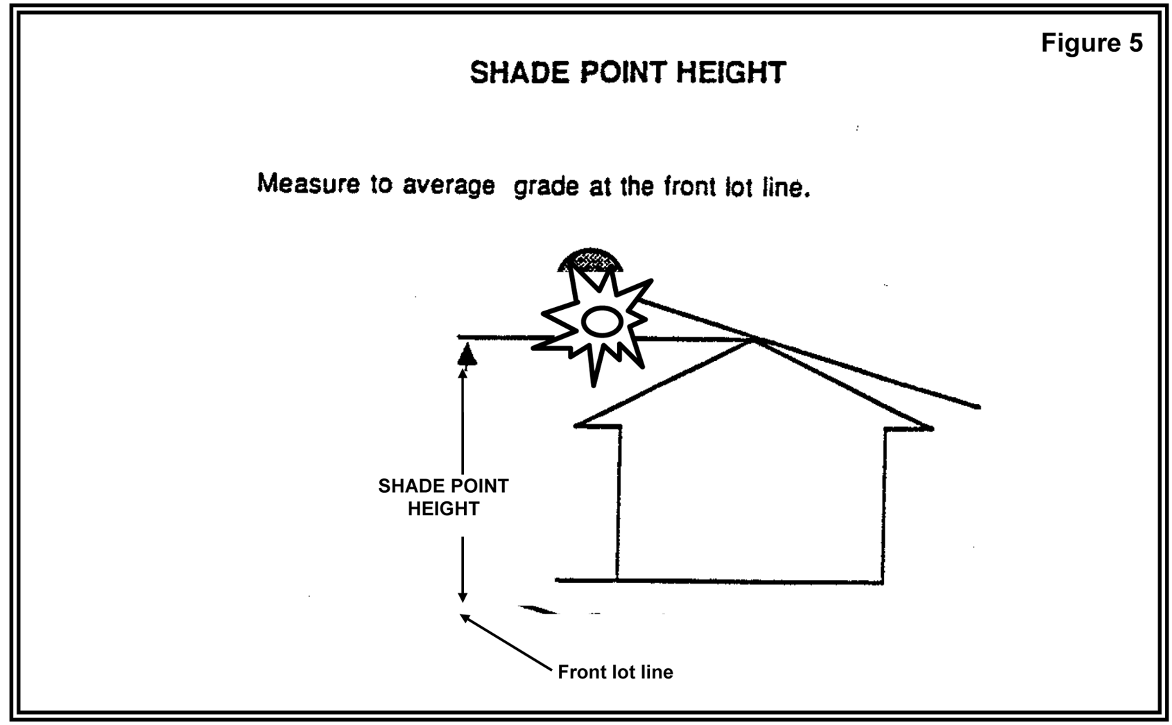
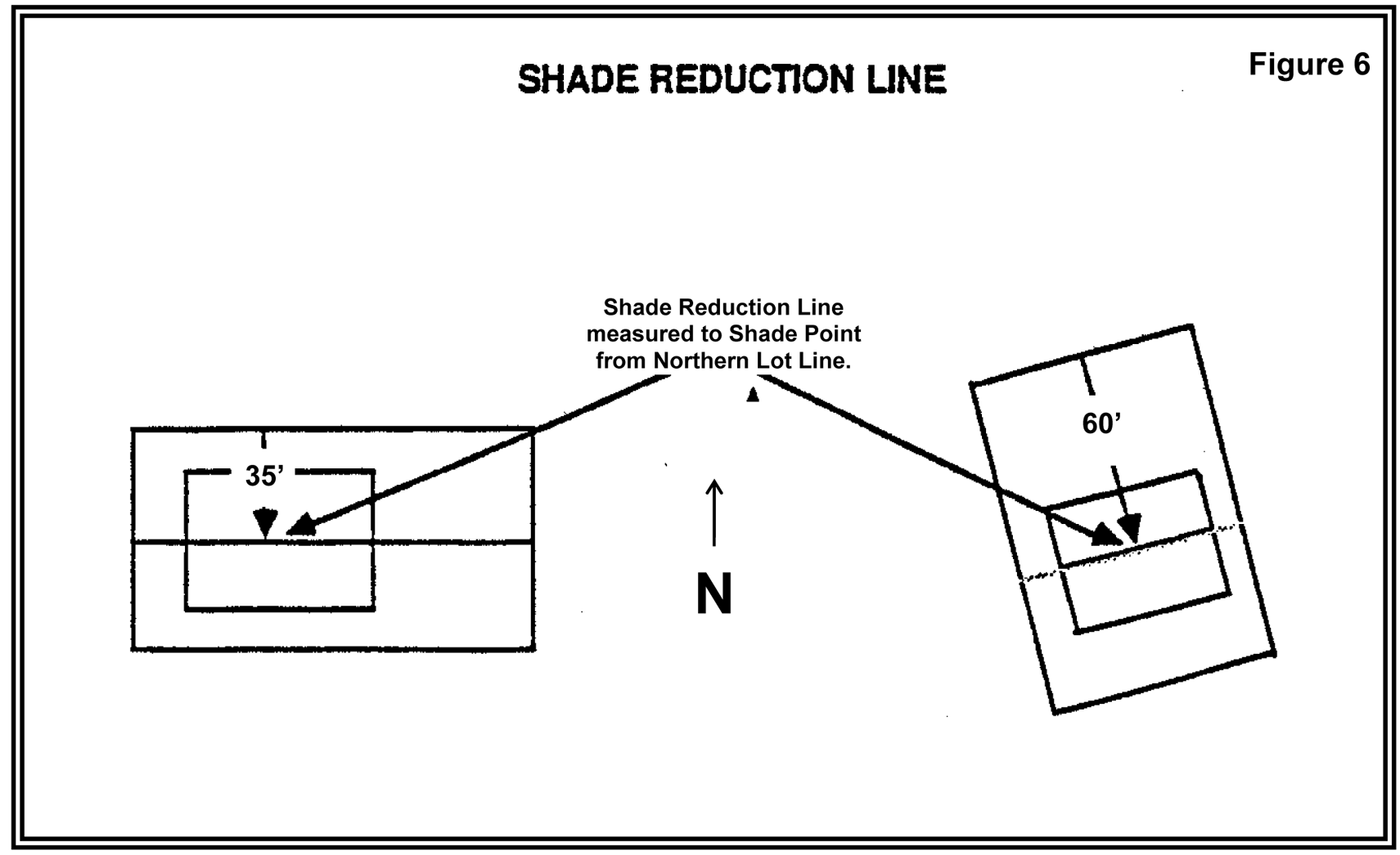
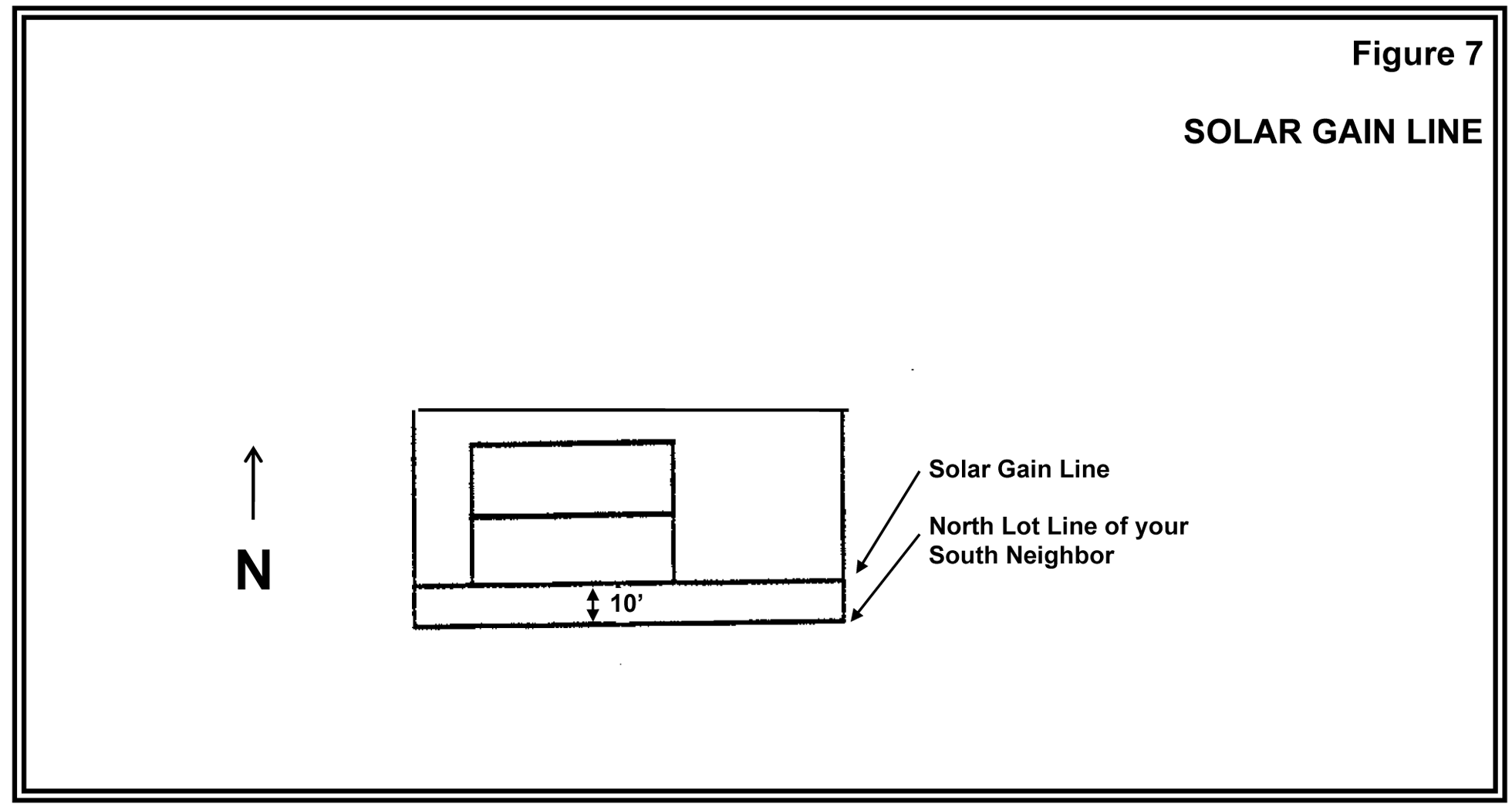
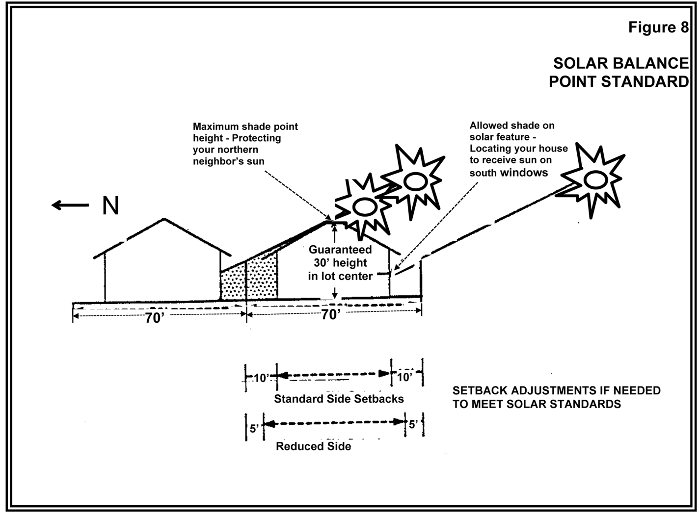
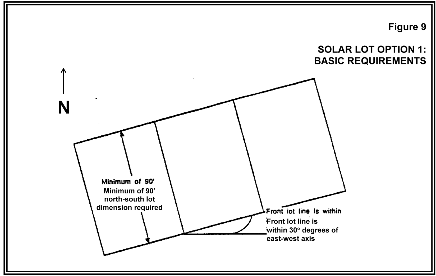
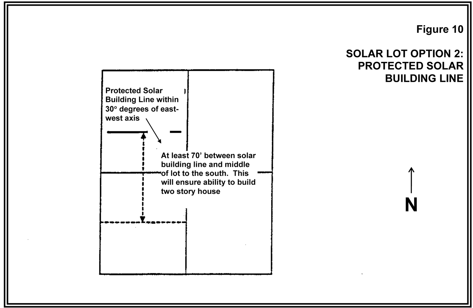
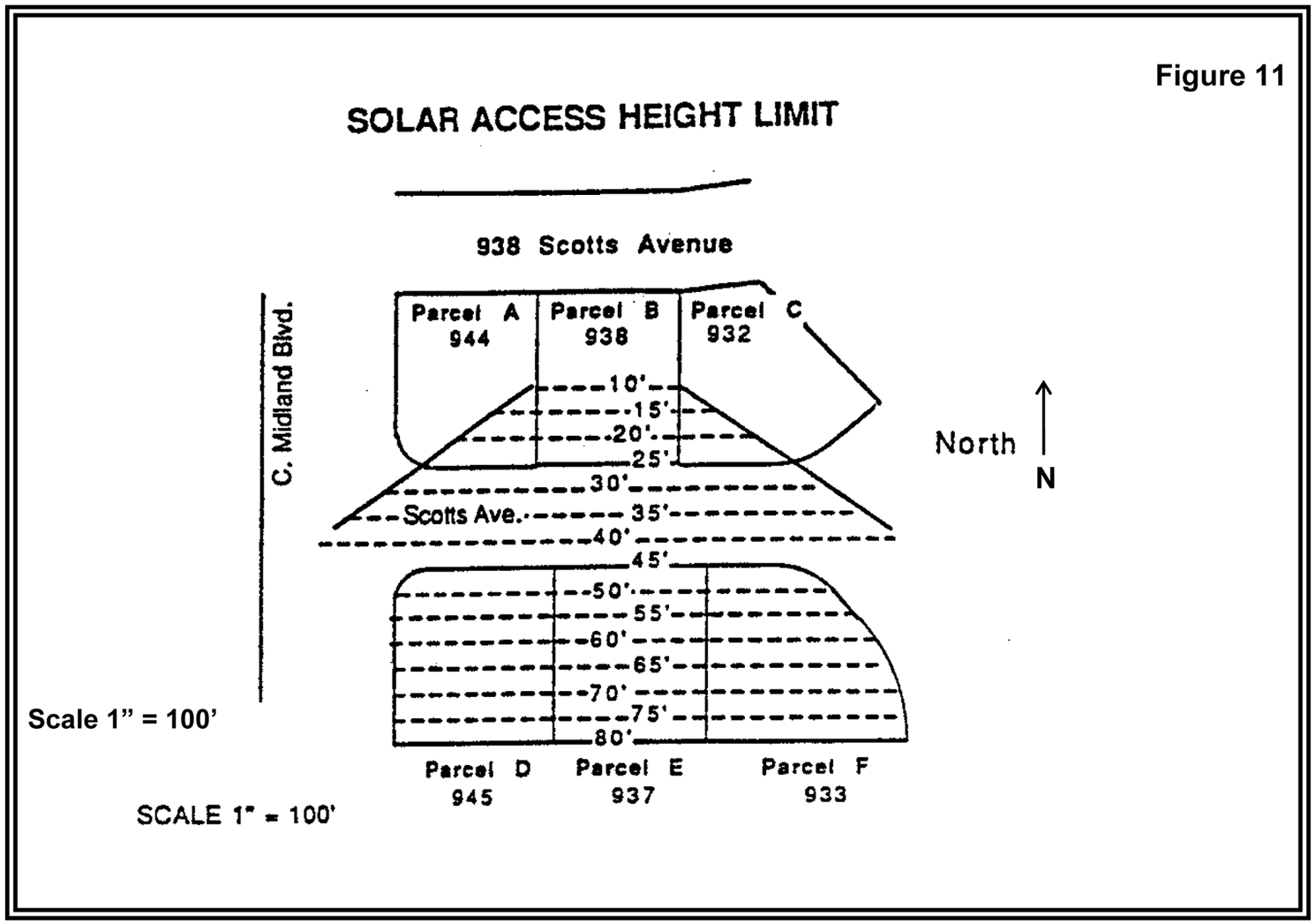
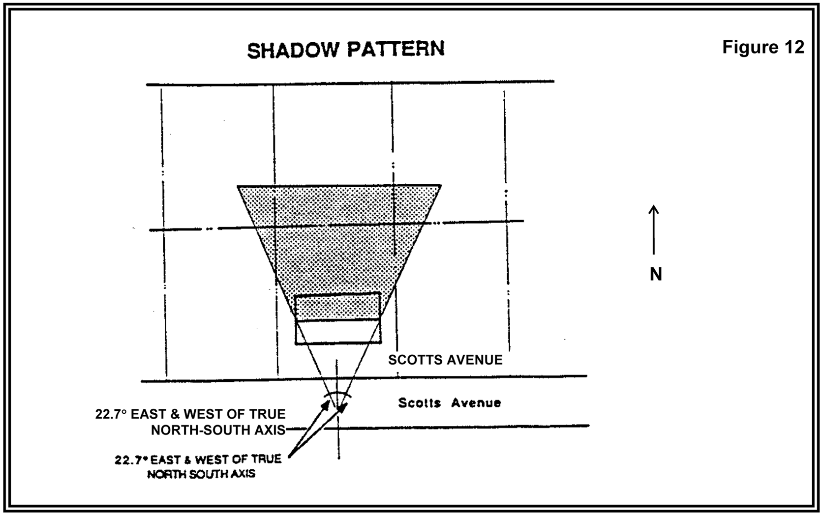
(Ord. No. 828, § 2.C.(Exh. 1, § 11), 9-26-17, eff. 11-24-17)
428 - FOREST STRUCTURE SITING AND FIRE SAFETY STANDARDS
428-1
Intent and Purpose
The following siting standards apply to all new dwellings and structures in the EFC District. The purpose of the following standards is to ensure that structures are sited in a manner compatible with forest operations and agriculture, to minimize wildfire hazards and risks, and to conserve values found on forest lands.
428-2
Applicability
The forest structure siting and the fire safety standards of this section apply to all new dwellings and structures, including but not limited to replacement dwellings and accessory structures (including residential, agricultural, and forestry accessory structures). The standards of this section are not applicable to the restoration of existing dwellings or structures or to building additions. New dwellings and structures which do not meet the Type I standards in Section 428-3 shall be reviewed through a Type II procedure and shall comply with the applicable standards in Section 428-4. A variance or adjustment request to reduce the dimensional standards of Section 428-3 shall not be permitted.
(Ord. No. 889A, § 2.C.(Exh. 3, § 1.), 2-7-23, eff. 3-9-23)
428-3
Standards for Dwellings and Structures, Including Replacement
Dwellings, Reviewed Through a Type I Procedure
Dwellings and structures that are reviewed through a Type I procedure, including replacement dwellings and accessory structures, shall comply with the following standards. When the Type I standards cannot be met on a property, the Type II standards of Section 428-4 shall apply. The property shall be located within the boundaries of a Fire Protection District (does not include Oregon Dept. of Forestry) in order to qualify under the Type I standards below.
428-3.1
Forest Structure Siting Standards for Dwellings and Structures
A.
Dwellings, including replacement dwellings not permitted by Sections 428-3.1 B. or 428-3.1 C., shall comply with the following standards:
(1)
The subject site shall have frontage on a public road and access to the dwelling shall be obtained either directly from the subject property or via a recorded easement from this public road.
(2)
Part or all of the dwelling shall be located within 300 feet of the public road from which access is taken.
(3)
When there are no dwellings within 500 feet of a side, street side or rear property line of the site, the entire dwelling shall be located 200 feet or more from the property line. The dwelling shall be located near the property line that is closest to fire protection services. See Figure 1.
(4)
When there is an existing dwelling located within 500 feet of a side, street side or rear property line of the site, part or all of the dwelling shall be located within 500 feet of the existing dwelling. The dwelling may be located as close to the affected property line as permitted by the setback requirements of the EFC District and the fire break requirements of Section 428-3.4 D. However, in no case shall the dwelling be located more than 300 feet from the public road providing access to the dwelling. See Figure 2.
(5)
The dwelling shall be located at least 125 feet from a riparian corridor as defined in Sections 422-22.2 and 106-185.
B.
A replacement dwelling, that will be sited at the same location as the existing dwelling, shall comply with the following standards:
(1)
Access may continue to be provided from a private road when the existing access is from a private road.
(2)
The dwelling shall meet the primary and secondary fire break area requirements of Section 428-3.4 D. to the extent the existing building setbacks permit.
C.
A replacement dwelling that will not be sited at the same location as the existing dwelling, but part or all of the replacement dwelling will be sited within 200 feet of the location of the existing dwelling, shall meet the following standards:
(1)
Access may continue to be provided from a private road when the existing access is from a private road.
(2)
Part or all of the replacement dwelling shall be located within 300 feet of the public or private access road to the extent the setbacks of the existing dwelling permit. If the existing dwelling is located more than 300 feet from the road, the replacement dwelling shall not be located a greater distance from the access road than the existing dwelling. See Figure 3.
(3)
When there are no dwellings within 500 feet of a side, street side or rear property line of the site, the entire replacement dwelling shall be located 200 feet or more from the property line to the extent permitted by the location of the existing dwelling.
(4)
When there is an existing dwelling located within 500 feet of a side, street side or rear property line of the site, part or all of the replacement dwelling shall be located within 500 feet of the existing nearby dwelling to the extent permitted by the location of the existing nearby dwelling. The replacement dwelling may be located as close to the affected property line as permitted by the setback requirements of the EFC District, the fire break requirements of Section 428-3.4 D., and the setback requirement of (2) above. See Figure 3.
(5)
The dwelling shall be located at least 125 feet from a riparian zone as defined in Sections 422-22.2 and 106-185.
D.
Non-dwelling structures, including accessory structures shall:
(1)
Be located so that part or all of the structure is within 200 feet of the dwelling, and part or all of the structure is located between the dwelling and the public or private road which provides access to the dwelling to the extent permitted by the location of the existing dwelling (see Figure 4); or
(2)
Meet the siting standards for new dwellings in Section 428-3.1 A. (1, 2, 3, and 4).
Structures that do not meet the standards in (1) or (2) above shall be reviewed through a Type II procedure and shall comply with the applicable standards of Section 428-4.
428-3.2
Domestic Water Supply Standards for Dwellings
All dwellings, including replacement dwellings, shall comply with the following standards for domestic water supply:
A.
The applicant shall provide evidence to the Review Authority that the domestic water supply is from a source authorized in accordance with the Oregon Department of Water Resources' Administrative Rules for the appropriation of groundwater or surface water (OAR 690-011) and not from a Class II stream as defined in the Forest Practices Rule OAR 629-024-0101(3).
B.
For the purposes of Section 428-3.2, evidence of a domestic water supply means:
(1)
Verification from a water purveyor that the use described in the application will be served by the purveyor under the purveyor's rights to appropriate water;
(2)
A water use permit issued by the Oregon Department of Water Resources for the use described in the application; or
(3)
Verification from the Oregon Department of Water Resources that a water use permit is not required for the use described in the application. If the proposed water supply is from a well and is exempt from permitting requirements under ORS 537.545, the applicant shall submit the well constructor's report to the County upon completion of the well.
428-3.3
Stocking Requirements for Dwellings
On lots or parcels greater than 10 acres, new dwellings shall comply with the following stocking standard:
Pursuant to ORS 215.730, approval of a dwelling requires the owner of the tract to plant a sufficient number of trees on the tract to demonstrate that the tract is reasonably expected to meet the Oregon Department of Forestry stocking requirements at the time specified in the Oregon Department of Forestry administrative rules.
428-3.4
Fire Siting Standards for Dwellings and Structures
The following fire siting standards shall apply to dwellings and structures, including replacement dwellings and accessory structures:
A.
Residential Fire Protection Requirements For Dwellings, Including Replacement Dwellings
Dwellings, including replacement dwellings, shall be located upon a parcel within a fire protection district (does not include the Oregon Department of Forestry) or be provided with residential fire protection by contract. If the dwelling is not within a fire protection district, the application shall be reviewed via a Type II procedure for forest structure siting and fire safety standards.
B.
If a water supply is required for fire protection, it shall be a swimming pool, pond, lake or similar body of water that at all times contains at least 4,000 gallons or a stream that has a minimum flow of at least 1 cubic foot per second. The applicant shall provide verification from the Oregon Department of Water Resources that any permits or registrations required for water diversion or storage have been obtained or that permits or registrations are not required for the use.
C.
Road access to a water supply shall be provided to within 15 feet of the water's edge for fire-fighting equipment, including pumping units. The road (driveway) access shall accommodate the turnaround of firefighting equipment. Permanent signs shall be posted along the access route to indicate the location of the emergency water source.
D.
Fire Break Area Requirements
The owner(s) of dwellings and structures, including replacement dwellings and accessory structures, shall:
(1)
Maintain a minimum 30-foot primary fuel-free fire break area around the dwelling or structure. As slopes increase, the distance of the primary fire break area shall be increased around the dwelling or structure in accordance with the dimensional requirements in Table A;
(2)
Maintain an additional 100-foot secondary fuel-free fire break area around the primary firebreak encircling the dwelling or structure; and
(3)
Any required fire break shall be on land that is owned or controlled by the owner of the subject property.
(4)
A replacement dwelling permitted by Section 428-3.1 B. shall meet the fire break area requirements in (1) and (2) above to the extent the existing building setbacks permit.
E.
Dwellings and structures shall not be sited on a slope greater than 40%.
F.
Dwellings and structures shall have a fire retardant roof.
G.
If the dwelling or structure has a chimney or chimneys, each chimney shall have a spark arrester.
428-3.5
Fire Safety Design Standards for Roads and Driveways
A.
All public and private roads and driveways, except for private roads and bridges accessing only commercial forest uses, shall be constructed so as to provide adequate access for firefighting equipment. Private roads and driveways shall be approved, developed and maintained in accordance with the requirements of the appropriate fire protection agency (does not include the Oregon Department of Forestry) for the geographical location. Where no fire protection agency has jurisdiction, access roadways shall meet the requirements of the nearest or most likely fire protection jurisdiction to annex the property under consideration. Public roads shall be constructed in accordance with the standards of the Washington County Road Design and Construction Standards.
B.
Prior to the issuance of a building permit or a Development Compliance Permit for a dwelling or structure, including replacement dwellings and accessory structures, an applicant shall provide written confirmation from the appropriate fire protection agency that preliminary construction of the road or driveway is adequate to provide access for firefighting equipment; and
C.
Prior to final building inspection approval or occupancy/use of a dwelling or structure, whichever occurs first, an applicant shall provide written confirmation from the appropriate fire protection agency that final construction of the road or driveway complies with its standards.
D.
If road access to the dwelling is by a road owned and maintained by a private party or by the Oregon Department of Forestry, the United States Bureau of Land Management, or the United States Forest Service, then the applicant shall provide proof of a long-term road access use permit or agreement. The road use permit may require the applicant to agree to accept responsibility for road maintenance.
(Ord. No. 877A, § 2.A.(Exh. 1, § 5.), 10-11-21, eff. 11-10-21; Ord. No. 902A, § 2.B.(Exh. 2, § 37.), 11-5-24, eff. 12-5-24)
428-4
Standards for Dwellings and Structures Reviewed Through a Type II Procedure
Dwellings and structures that do not comply with the standards in Section 428-3, including replacement dwellings and accessory structures, shall be reviewed through a Type II procedure and shall comply with the following standards:
428-4.1
Forest Structure Siting Standards
A.
Dwellings and structures shall be sited on the parcel so that:
(1)
They have the least impact on nearby or adjoining forest or agricultural lands;
(2)
The siting ensures that forest operations and accepted farming practices will not be curtailed or impeded;
(3)
The siting ensures that adverse impact on forest operations and accepted farming practices on the tract will be minimized;
(4)
The amount of forest lands used to site access roads, service corridors, the dwelling and structures is minimized; and
(5)
The risks associated with wildfire are minimized.
B.
Siting considerations satisfying Section 428-4.1 may include setbacks from adjoining properties, clustering near or among existing structures, siting close to existing roads and siting on that portion of the parcel least suited for growing trees.
428-4.2
Domestic Water Supply Standards for Dwellings
All dwellings, including replacement dwellings, shall comply with the following standards for domestic water supply:
A.
The applicant shall provide evidence to the Review Authority that the domestic water supply is from a source authorized in accordance with the Oregon Department of Water Resources' Administrative Rules for the appropriation of groundwater or surface water (OAR 690-011) and not from a Class II stream as defined in the Forest Practices Rule OAR 629-024-0101(3).
B.
For the purposes of Section 428-4.2, evidence of a domestic water supply means:
(1)
Verification from a water purveyor that the use described in the application will be served by the purveyor under the purveyor's rights to appropriate water;
(2)
A water use permit issued by the Oregon Department of Water Resources for the use described in the application; or
(3)
Verification from the Oregon Department of Water Resources that a water use permit is not required for the use described in the application. If the proposed water supply is from a well and is exempt from permitting requirements under ORS 537.545, the applicant shall submit the well constructor's report to the county upon completion of the well.
428-4.3
Stocking Requirements for Dwellings
On lots or parcels greater than 10 acres, new dwellings shall comply with the following stocking standard:
Pursuant to ORS 215.730, approval of a dwelling requires the owner of the tract to plant a sufficient number of trees on the tract to demonstrate that the tract is reasonably expected to meet the Oregon Department of Forestry stocking requirements at the time specified in the Oregon Department of Forestry administrative rules.
428-4.4
Fire Siting Standards for Dwellings and Structures
The following fire siting standards shall apply to all new dwellings and structures, including replacement dwellings and accessory structures:
A.
Residential Fire Protection Requirements for Dwellings
Dwellings, including replacement dwellings, shall be located upon a parcel within a fire protection district or be provided with residential fire protection by contract from a public fire protection district. If the dwelling is not within a fire protection district, the applicant shall provide evidence that the applicant has asked to be included in the nearest such district. If the Review Authority determines that inclusion within a fire protection district or contracting for fire protection is impracticable, the Review Authority may provide an alternate means for protecting the dwelling from fire hazards. The means selected may include a fire sprinkling system, on-site equipment and water storage or other methods that are reasonable, given the site conditions. The applicant shall submit a letter from a professional forestry consultant or from a professional fire protection consultant recommending what alternate means of fire protection should be utilized.
B.
If a water supply is required for fire protection, it shall be a swimming pool, pond, lake or similar body of water that at all times contains at least 4,000 gallons or a stream that has a minimum flow of at least 1 cubic foot per second. The applicant shall provide verification from the Oregon Department of Water Resources that any permits or registrations required for water diversion or storage have been obtained or that permits or registrations are not required for the use.
C.
Road access to a water supply shall be provided to within 15 feet of the water's edge for fire-fighting equipment, including pumping units. The road (driveway) access shall accommodate the turnaround of firefighting equipment. Permanent signs shall be posted along the access route to indicate the location of the emergency water source.
D.
Fire Break Area Requirements
The owner(s) of dwellings and structures, including replacement dwellings and accessory structures, shall:
(1)
Maintain a primary fuel-free fire break area surrounding all structures in accordance with the provisions in Recommended Fire Siting Standards for Dwellings and Structures and Fire Safety Design Standards for Roads, dated March 1, 1991, and published by the Oregon Department of Forestry;
(2)
Clear and maintain a secondary fuel-free break area in accordance with the provisions in Recommended Fire Siting Standards for Dwellings and Structures and Fire Safety Design Standards for Roads, dated March 1, 1991, and published by the Oregon Department of Forestry;
(3)
As an alternative to the fire break provisions recommended by the Oregon Department of Forestry, clear and maintain fire break areas that have received approval by the appropriate Fire Marshal or approval by his designee. This alternate option is only available if the provisions recommended by ODF are not possible because of physical site constraints; and
(4)
Any required fire break shall be on land that is owned or controlled by the owner of the subject property.
E.
Dwellings and structures shall not be sited on a slope greater than 40% and shall be set back at least 30 feet from the top of slopes greater than 40%.
F.
Dwellings and structures shall have a fire retardant roof.
G.
If the dwelling or structure has a chimney or chimneys, each chimney shall have a spark arrester.
428-4.5
Fire Safety Design Standards for Roads and Driveways
A.
All public and private roads and driveways, except for private roads and bridges accessing only commercial forest uses, shall be constructed so as to provide adequate access for firefighting equipment. Private roads and driveways shall be approved, developed and maintained in accordance with the requirements of the appropriate fire protection agency (does not include the Oregon Department of Forestry) for the geographical location. Where no fire protection agency has jurisdiction, access roadways shall meet the requirements of the nearest or most likely fire protection jurisdiction to annex the property under consideration. Public roads shall be constructed in accordance with the standards of the Washington County Road Design and Construction Standards.
B.
Prior to the issuance of a building permit or a Development Compliance Permit for a dwelling or structure, including replacement dwellings and accessory structures, an applicant shall provide written confirmation from the appropriate fire protection agency that preliminary construction of the road or driveway is adequate to provide access for firefighting equipment; and
C.
Prior to final building inspection approval or occupancy/use of a dwelling or structure, whichever occurs first, an applicant shall provide written confirmation from the appropriate fire protection agency that final construction of the road or driveway complies with its standards.
D.
If road access to the dwelling is by a road owned and maintained by a private party or by the Oregon Department of Forestry, the United States Bureau of Land Management, or the United States Forest Service, then the applicant shall provide proof of a long-term road access use permit or agreement. The road use permit may require the applicant to agree to accept responsibility for road maintenance.
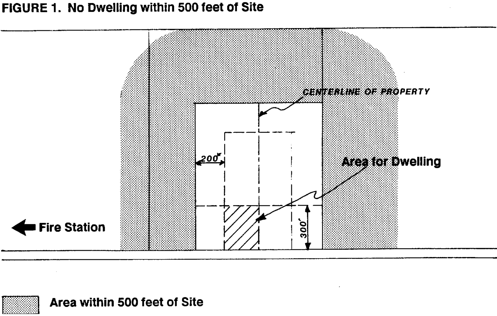
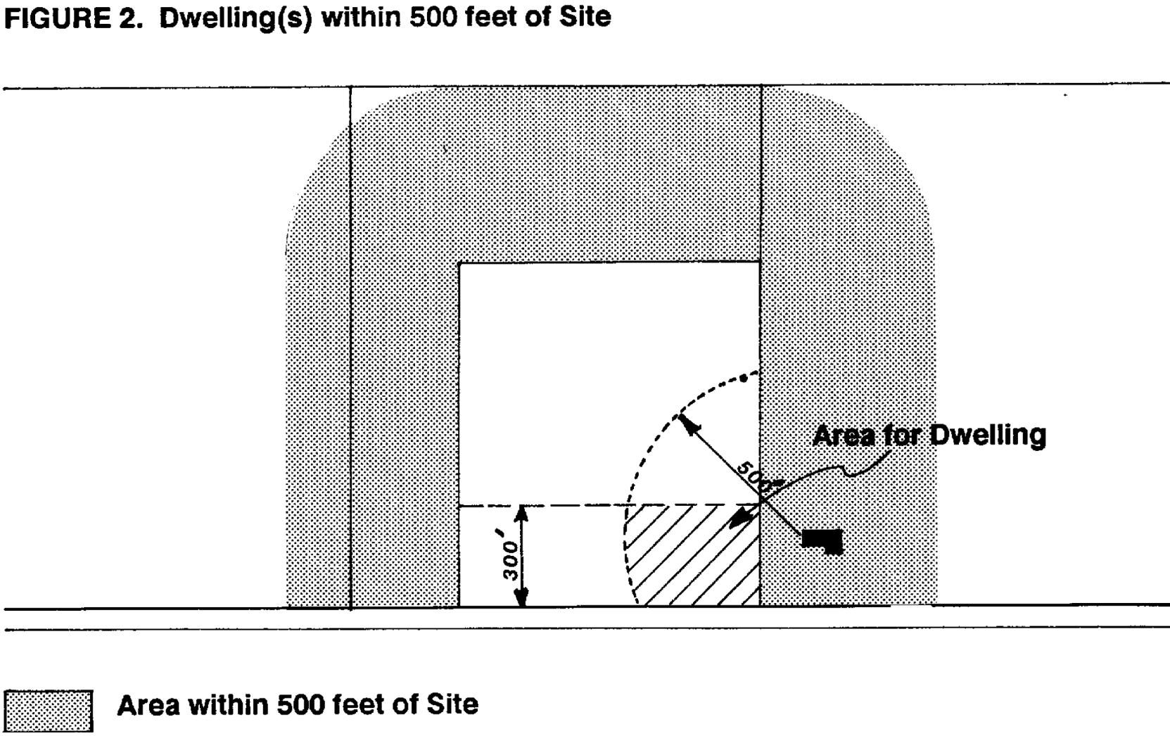
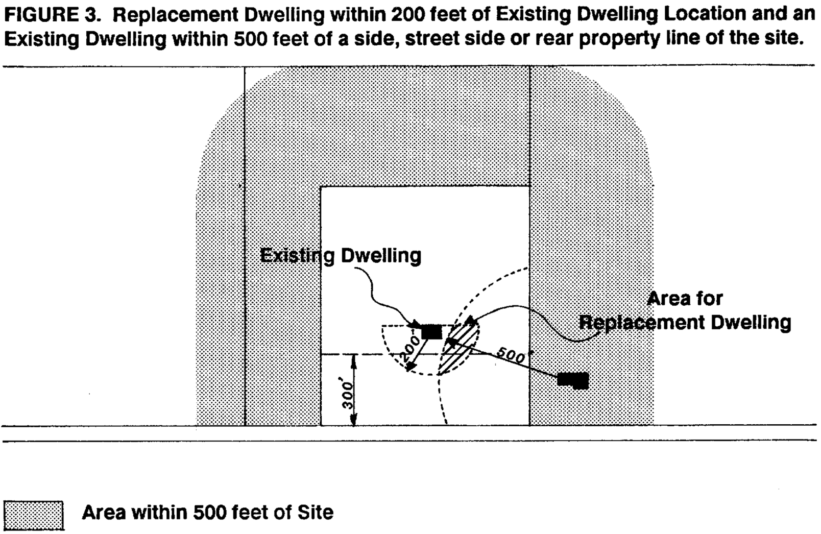
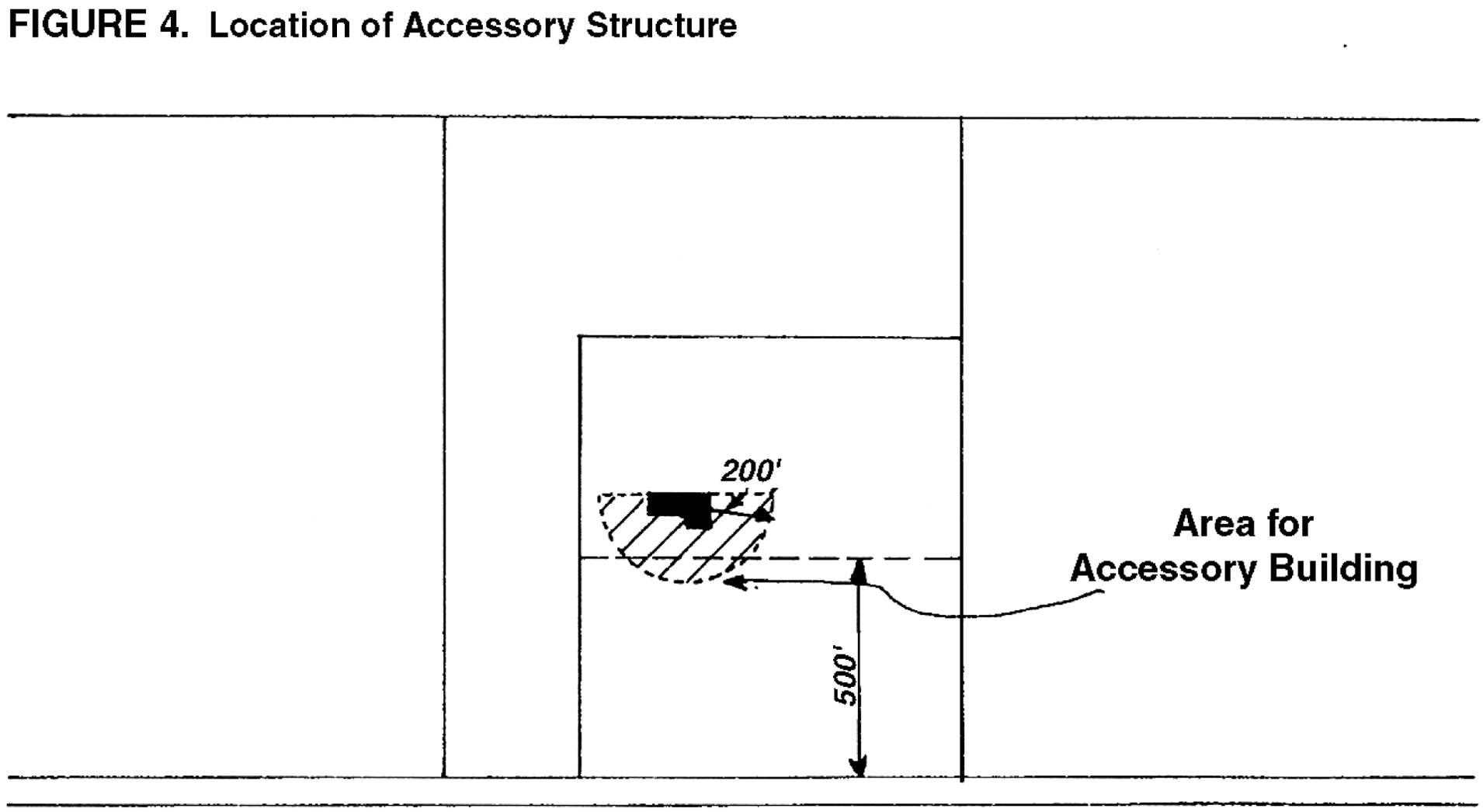
(Ord. No. 877A, § 2.A.(Exh. 1, § 5.), 10-11-21, eff. 11-10-21)
429 - BICYCLE PARKING
429-1
Intent and Purpose
The intent of this Section is to identify those bicycle parking requirements that are necessary to ensure that safe and convenient bicycle parking is available at all new urban development inside the UGB as identified in Subsection 429-2.
429-2
Applicability
The following bicycle parking standards shall apply in all urban districts for the following uses:
A.
Multi-dwelling development of four units or more;
B.
Retail development;
C.
Office development;
D.
Institutional development;
E.
Industrial development;
F.
Transit centers; and
G.
Park and ride lots.
(Ord. No. 885A, § 2.1.(Exh. 1), 6-28-22, eff. 7-28-22)
429-3
General Bicycle Parking Criteria
429-3.1
Bicycle parking requirements shall be provided in amounts specified for the particular use;
429-3.2
Requirements for a use not mentioned shall be the same as the most similar mentioned use, as determined by the Review Authority;
429-3.3
Required bicycle parking spaces shall be available for use by residents, guests, customers, patrons and employees only and shall not be rented, leased or assigned to any other person or organization. No parking of bicycles that are not associated with the legal use of the premises shall be permitted in the required parking areas. Bicycle parking spaces may only be rented or leased where required motor vehicle parking is rented or leased or at Transit Centers and Park and Ride lots.
429-4
General Requirements
429-4.1
Proper maintenance of bicycle parking facilities shall be a continuing obligation of the property owner.
429-4.2
In case of enlargement of a building or a change in the use of a building, the number of parking spaces required shall be based on floor area or capacity of the entire use of the building. If the building is part of a larger existing use with multiple buildings, only the subject building shall meet the parking requirements.
429-4.3
In the event several uses occupy a single structure or parcel of land, the total requirements for bicycle parking shall be the sum of the requirements of the several uses computed separately.
429-4.4
All applications for a development permit shall include a plot plan drawn to scale, showing the bicycle parking facilities to be provided. The required plot plan shall include but not be limited to:
A.
Location of short-term and long-term bicycle parking facilities;
B.
Bicycle parking access to the public right-of-way, existing and proposed bikeways, and well-used building entrances;
C.
Circulation area necessary to serve bicycle parking facilities;
D.
Bicycle parking facility design;
E.
Bicycle parking space dimensions;
F.
Bicycle parking signing; and
G.
Bicycle parking lighting;
429-5
Definitions
As used in this Section, the words listed below have the following meaning:
A.
Short-term bicycle parking. Bicycle parking intended to accommodate visitors, customers, messengers, and other persons that can be expected to depart within two hours.
B.
Long-term bicycle parking. Bicycle parking intended for employees, residents, commuters, and other persons that can be expected to leave their bicycle parked more than two hours.
C.
Gross floor area. The total square footage of a building.
D.
Bikeway. A bikeway is any road, path or way open to bicycle travel regardless of whether such facilities are designated for the preferential use of bicycles or are to be shared with other transportation modes. This includes a shared roadway, shoulder bikeway, bike lane, or bike path.
E.
Well used entrance. For short-term bicycle parking, a well-used entrance to a building is an entrance intended for use by members of the general public, such as customers, clients, and visitors. For long-term bicycle parking, an entrance is well used if it is located such that it is intended for use by those employees, commuters, or residents who intend to leave their bicycles parked more than two hours.
429-6
Number of Bicycle Parking Spaces Required
The minimum number of bicycle parking spaces required for long-term use is specified by land use category and shall be in accordance with Table A. The minimum number of bicycle parking spaces required for short-term use is specified by land use category and shall be in accordance with Table B.
TABLE A
MINIMUM REQUIRED LONG-TERM BICYCLE PARKING SPACES
TABLE B
MINIMUM REQUIRED SHORT-TERM BICYCLE PARKING SPACES
(Ord. No. 832A, § 2.A.(Exh. 1, § 23), 9-18-18, eff. 10-18-18; Ord. No. 840, § 2.B.(Exh. 2, § 2), 9-18-18, eff. 10-18-18; Ord. No. 885A, § 2.1.(Exh. 1, § 26.), 6-28-22, eff. 7-28-22; Ord. No. 890A, § 2.A.(Exh. 1, §§ 1., 22.), 2-7-23, eff. 3-9-23)
429-7
Bicycle Parking Location
A.
Short-term:
Short-term parking must be located on site and within 50 feet of a well-used building entrance. In those instances where motor vehicle parking is adjacent to a use (such as a convenience market), short-term parking shall be located within 30 feet from the entrance. Bicycle parking shall have direct access to public right-of-way, existing and proposed bikeways and the main entrance of the principal use. With the permission of the Director, short-term parking may be located in the public right-of-way. Where no short-term bicycle parking is required, long-term parking spaces shall be made available for short-term bicycle parking.
All other parking requirements identified in Subsections 429-7 C., 1-4 shall also be met for short-term parking.
B.
Long-term:
Long-term parking shall be located in a secure well lighted area no farther from a well-used building entrance than the nearest long-term motor vehicle parking space [with the exception of disabled parking or clustered parking allowed consistent with 429-7 C. (1)]. Bicycle parking may also be provided inside a well-marked area within a building in a secure and accessible location. Outside bicycle parking facilities shall have direct access to public right-of-way and existing and proposed bikeways. All other parking requirements identified in Subsection 429-7 C. (1 - 4) shall also be met for long-term parking.
C.
All Bicycle Parking:
(1)
On property with multiple uses, buildings, building entrances, or parking lots (such as in a commercial center or college) bicycle parking may be clustered in one or more locations. Short-term parking shall be located on site and within 50 feet of a well-used building entrance for which the parking is intended and must meet all other requirements for bicycle parking as found in Subsection 429-7 A. Long-term parking shall be located in a secure well lighted area and have direct access to public right-of-way and existing and proposed bikeways. Such parking shall be located in areas which offer security and convenience to bicyclists.
(2)
Bicycle parking facilities shall be separated from motor vehicle parking and maneuvering areas by a barrier or a minimum of 5 feet. Areas set aside for required bicycle parking must be clearly marked and reserved for bicycle parking only.
(3)
Bicycle parking shall not obstruct pedestrian walkways.
(4)
If a portion of motor vehicle parking spaces are protected from precipitation, the same percentage of bicycle parking spaces must be covered by an awning, eave, overhang, or other means. If a parking structure is provided for motor vehicles, bicycle parking spaces must also be provided for within the parking structure.
429-8
Bicycle Parking Facility Design
A.
Bicycle parking facilities shall offer security in the form of either a lockable enclosure in which the bicycle can be stored or a stationary rack to which the bicycle can be locked.
B.
Bicycle racks must hold bicycles securely by means of the frame. The frame must be able to be supported so that the bicycle cannot be pushed or fall to one side in a manner that will damage the wheels. Bicycle racks shall accommodate:
(1)
Locking the frame and one wheel to the rack with a high-security U-shaped shackle lock;
(2)
Locking the frame and both wheels to the rack with a chain or cable not longer than 6 feet without removal of the front wheel.
C.
Bicycle parking facilities at Transit Centers and Park & Ride Lots shall offer security in the form of either a lockable enclosure in which the bicycle can be stored or in an area where parking would be monitored by a concessionaire or parking lot attendant.
All bicycle racks, lockers, or other facilities shall be permanently anchored to the surface of the ground or to a structure. Pavement surrounding outdoor parking facilities shall consist of a smooth, durable and well-drained surface.
429-9
Bicycle Parking Space Dimensions
Each required bicycle parking space shall be at least 22 inches by 6 feet and, when covered, provide a vertical clearance of 7 feet. An aisle for bicycle maneuvering shall be provided and maintained beside or between each row of bicycle parking. This aisle shall be at least 5 feet wide. Bicycle racks shall also be located so that at least 2 feet shall be provided and maintained in front of and behind each row of bicycle parking spaces so as not to impede the use of the rack (see figure 1).
429-10
Bicycle Parking Signing
Where bicycle parking facilities are not directly visible and obvious from the public right(s)-of-way, entry and directional signs shall be provided to direct bicyclists from the public right-of-way to the bicycle parking facility. Bicycle parking signing shall be in accordance with Subsection 414.
429-11
Bicycle Parking Lighting
Lighting shall be provided in a bicycle parking area so that all facilities are thoroughly illuminated and visible from adjacent sidewalks or motor vehicle parking lots during all hours of use. If lighting for other purposes satisfies the bicycle parking lighting requirements, separate lighting is not required. Bicycle parking lighting shall be in accordance with Section 415.
429-12
Exemptions from the Minimum Bicycle Parking Requirements Standards
A development is exempt from Subsection 429-6 if the Review Authority finds the applicant has shown that one of the following criteria is applicable to the site.
A.
Temporary Uses:
The Review Authority may allow exemptions to required bicycle parking in connection with temporary uses. Uses include but are not limited to firework stands, temporary Park & Rides, and Christmas tree sales.
B.
Lesser Demand for Bicycle Parking:
The Review Authority may reduce the number of required bicycle spaces on a case-by-case basis if the applicant can demonstrate that the proposed use, by its nature, is anticipated to generate a lesser need for bicycle parking. Uses include, but are not limited to drive-in theaters, funeral homes, mini-storage, and retail uses consisting of primarily bulky merchandise such as tire and furniture stores.
Exemptions from the minimum bicycle parking requirements shall be granted by the Review Authority through this process, and not through a variance process.
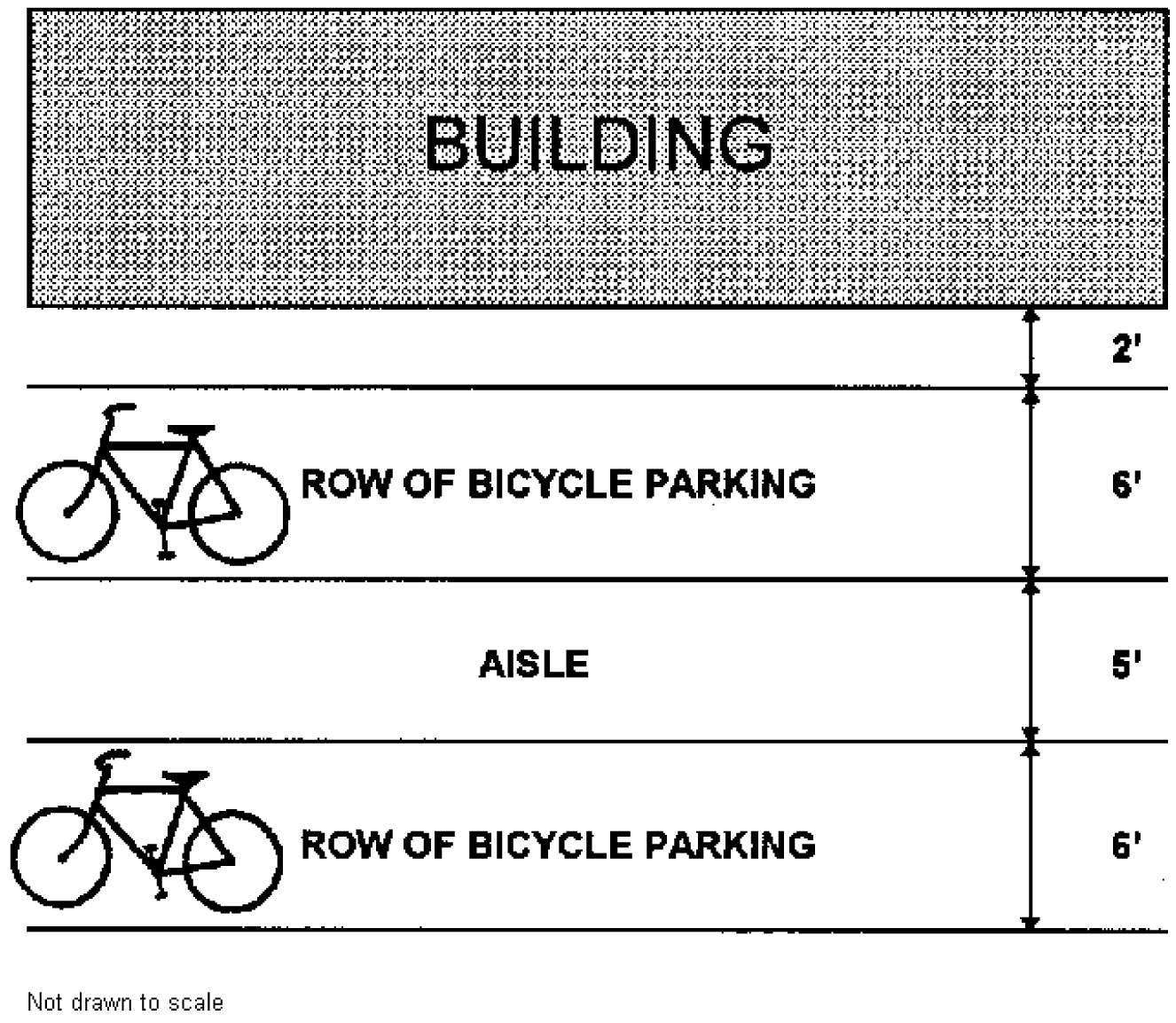
Long-term parking at Transit Centers and Park & Ride Lots shall offer security in the form of either a lockable enclosure in which the bicycle can be stored or in an area where parking would be monitored by a concessionaire or parking lot attendant.
430 - SPECIAL USE STANDARDS
In addition to the requirements of Sections 400 through 425, the following special use standards are provided for specific uses. Additional or amended special use standards that are applicable in the North Bethany Subarea of the Bethany Community Plan are located in Section 390, North Bethany Subarea Overlay District.
431 - TRANSIT ORIENTED DESIGN PRINCIPLES, STANDARDS AND GUIDELINES
431-1
Intent and Purpose
The following design principles, standards and guidelines shall be applied to the review of all development occurring in transit oriented districts, for those uses listed in Section 375. Principles are the broad, fundamental rules upon which the standards and guidelines are based. All Type III applications for development in transit oriented districts shall demonstrate compliance with applicable principles and/or standards of this section. Standards are specific, usually quantitative, rules which development applications must comply with if processed through a Type I or II procedure. Guidelines are advisory statements that should be considered when designing a development in a transit oriented district, but are not mandatory.
Because an application for a development may vary from a standard in this Section when the application demonstrates, through a Type III process, compliance with the related design principle, a variance or adjustment pursuant to Section 435 shall not be granted from any standard in this Section.
431-2
Conflicts
In the event of a conflict between the requirements of this section and requirements of any other provision of the Code or a community plan, the requirements of this section shall control, except Area of Special Concern or Subarea provisions in a Community Plan, any code provisions of Section 375 that apply to a single dwelling, Duplex or Middle Housing, 418-3, 421, 422, 430-84 or 501-8.5 F. Sections 431-5.2 through 431-11 shall not apply to a Single Detached Dwelling Unit or Duplex (when not part of a Standard Land Division), Middle Housing (430-84) or Middle Housing Land Divisions (Article VI) - which are subject to other design requirements of this Code.
(Ord. No. 885A, § 2.1.(Exh. 1, § 28.), 6-28-22, eff. 7-28-22; Ord. No. 890A, § 2.A.(Exh. 1, § 1.), 2-7-23, eff. 3-9-23)
431-3
Definitions
The following definitions apply in transit oriented districts:
431-3.1
Adjacent Building. The location of a building sited on a parcel or lot abutting a pedestrian route or transit station and not separated by an existing or planned intervening building.
431-3.2
Adjoining Buildings. Buildings on abutting sites, not separated by a street or accessway.
431-3.3
Campus Development. A development which meets the following criteria:
A.
Is located on a lot or contiguous lots within the Transit Oriented Employment or Institutional Districts that total at least five acres in size; and
B.
Includes multiple buildings which are interrelated in a common business or educational activity or process, and share a common infrastructure such as pedestrian ways and spaces, parking and vehicular accessways.
431-3.4
Common Open Space. Areas available for active or passive shared use by all occupants of a development, or the general public. Common open space shall not be part of a street, required sidewalk, parking lot or loading area. Significant Natural Resource areas subject to protection, shall not constitute common open space. Common open space may be located on a flat building roof if designed for safe use. Common open space may have an accessway through it. Special recreation uses open to all occupants of a development and meeting the standards of Section 431-7 meet the definition of common open space.
431-3.5
Main Building Entrance. An entrance to a building which is a point of public access during business hours.
431-3.6
Pedestrian Focus Area. A geographically defined area, identified on a community plan map, with dense, mixed-use development and nearby transit service. Walking is promoted as the preferred mode choice by developing a strong pedestrian scale and emphasizing pedestrian access and activities. For guidance on pedestrian amenities that help foster attractive pedestrian environments, see the County's Pedestrian Enhancements Design Guideline Booklet.
431-3.7
Pedestrian Route. Any accessway or greenway, as defined by Section 408-3, and any pedestrian street.
431-3.8
Pedestrian Street. Any public or private street, but not including freeways, alleys, parking lot access drives, and parking lot aisles.
431-3.9
Transit Street. Any street that is an existing public transit route, or any street that is likely to be a public transit route. All public streets with a functional classification of Principal Arterial, Arterial, Special Area Collector or Collector, as defined in the Washington County Transportation System Plan, shall be considered likely to be a public transit route.
431-3.10
Streetscape. Refers to all of the elements that constitute the physical makeup of a pedestrian street and that, as a group, define its character, including building façade, street paving and streetscape amenities. For guidance on pedestrian amenities that help foster attractive pedestrian environments, see the County's Pedestrian Enhancements Design Guideline Booklet.
431-3.11
Streetscape Amenities. Include but are not limited to the following elements: street furniture, landscaping, including trees and other plantings, awnings, signs, and lighting. Guidelines for some of these features are provided in the County's Pedestrian Enhancements Design Guideline Booklet.
431-3.12
Street Frontage. A portion of a lot or parcel fronting on or abutting a street right-of-way, if public, or street tract, if private, and located between either the site's side property lines, as defined by CDC Section 106-113.3 or, if a corner lot, the radius point (Point "B," Section 501-8.5 A.), of a street intersection.
431-3.14
Build to Line. Required linear building frontage.
(Ord. No. 813, § 2.C.(Exh. 3, § 6), 8-23-16, eff. 11-25-16)
431-4
Circulation System Design
The design and location of the circulation system in a community is the key element for determining pedestrian orientation, connectivity and the arrangement of land uses. These principles and standards apply to the design and location of the circulation system in transit oriented districts.
431-4.1
Principles:
A.
Pedestrian routes in a Transit Oriented District shall, to the extent practicable, directly connect major activity centers (concentrations of employment and households, major public buildings and spaces, institutional uses and parks & common open spaces, and shopping areas) and transit stops, particularly light rail stations;
B.
Block dimensions and perimeters shall be at an urban rather than a suburban scale;
C.
Provide accessways and greenways, as needed, to supplement pedestrian routes along pedestrian streets; and
D.
Provide clearly marked and well-designed pedestrian street, driveway, loading area and surface parking lot crossings.
431-4.2
Standards:
A.
In addition to the standards of this subsection, development in a transit-oriented district shall be subject to the requirements of Section 408, Section 409, and Article V. In the event of a conflict between the requirements of Sections 408, 409, and Article V, the requirements of Section 431-4 shall control.
In a transit-oriented district, Sections 408 and 431-4.2 C and E do not apply to a Single Detached Dwelling Unit or Duplex (when not part of a Standard Land Division), Middle Housing (430-84) or Middle Housing Land Divisions (Article VI). For those uses, application of Section 409 is limited as described in Section 409, and:
(1)
Street tree and right-of-way dedication requirements shall not exceed those specified under Section 407-7 and district standards; and
(2)
In a transit-oriented district, public improvements required under Section 431-5 shall not apply to a Single Detached Dwelling Unit or Duplex (when not part of a Standard Land Division), or Middle Housing (430-84).
They may be required for Middle Housing Land Divisions (Article VI) in a transit-oriented district only as follows:
(a)
Any street frontage improvement requirements exceeding "Sufficient Infrastructure" as defined in Section 106 may be required, but only where a resulting lot or parcel abuts the street;
(b)
Sidewalks wider than five feet may be required along the frontage of resulting lots where and at widths specified by community plan special area/special area street provisions or 431-5.1 B (9), to the extent the sidewalks can be accommodated within district-specified right-of-way widths for these uses; and
(c)
Additional sidewalk easement area may be required where such sidewalks would exceed right-of-way limits, but these easements and sidewalk width therein shall be limited as necessary to accommodate the sidewalk.
(d)
Beyond frontage of resulting lots, improvement requirements shall not exceed those necessary to accommodate "Sufficient Infrastructure" as defined in Section 106.
B.
Other Community Development Code provisions that apply to Collectors shall apply to Special Area Collectors; provisions that apply to Neighborhood Routes shall apply to Special Area Neighborhood Routes; and provisions that apply to Local Streets shall apply to Special Area Local Streets and Special Area Commercial Streets. (See limitations for certain uses under A, above). In the case of a conflict, specific Special Area street provisions shall control.
C.
Blocks (not applicable to a Single Detached Dwelling Unit/Duplex when not part of a Standard Land Division, Middle Housing (430-84) or Middle Housing Land Divisions (Article VI) in a transit-oriented district).
(1)
Block perimeters for blocks with more than four sides, as defined by public or private streets, accessways or greenways, shall not exceed 1,600 feet measured along the nearside curb line of the public or private street or the centerline of the defining accessway or greenway. These standards shall not be used to provide direct connections to collector roads where indirect connections are specifically shown in the community plan.
(2)
Block lengths for streets, accessways and greenways shall not exceed 330 feet between public or private streets, accessways or greenways, measured along the nearside curb line of the public or private street or the centerline of the accessway or greenway. These standards shall not be used to provide direct connections to collector roads where indirect connections are specifically shown in the community plan.
(3)
Except for specific transportation facilities identified in the community plan, the Review Authority may modify these standards based on findings that strict compliance with the standards is not reasonably practicable due to:
(a)
Topography;
(b)
The standards of Sections 421 and 422;
Existing development patterns on abutting property which preclude the logical connection of streets or accessways;
(d)
Railroads;
(e)
Traffic safety concerns;
(f)
The functional and operational need to create a large building;
(g)
The provisions of Significant Natural Resources as identified in the Community Plan; or
(h)
Campus Development.
Modifications shall be the minimum necessary to address the constraint.
D.
Design (See A, above, regarding limited application to certain uses).
(1)
Streets complying with the provisions of this Section may be public or private. Where a private street is used to meet the block length and perimeter standards of this Section, documents shall be recorded pursuant to Section 409-4. In addition, private streets shall comply with the applicable design provisions of CDC Section 409-3, except as otherwise regulated by this Section or a Community Plan provision.
(2)
When streets are utilized to meet the block length and block perimeter standards within the TO:R24-40, TO:R40-80, TO:R80-120, TO:EMP, TO:BUS, and TO:RC Districts, the Special Area Commercial Street standards shall be used, except for existing or planned arterials or collectors or other specific street designations in the Community Plan. The Review Authority may permit Special Area Local Streets in these Districts based on findings that vehicle traffic volumes and pedestrian activity are likely to be found on a special area local street. If the Review Authority does permit a Special Area Local Street, it may be utilized to meet block length and block perimeter standards.
(3)
When streets are utilized to meet the block length and block perimeter standards within the TO:R9-12, TO:R12-18, and TO:R18-24 Districts, the Special Area Local Street standards shall be used, except for existing or planned arterials or collectors or other specific street designations in the Community Plan.
(4)
Streets in transit oriented districts shall incorporate the following traffic management elements consistent with the Washington County Road Design and Construction Standards:
(a)
Curb extensions at all intersections of Special Area Local Streets with Special Area Local Streets, Special Area Neighborhood Routes, and Special Area Commercial Streets.
(b)
Landscaped center medians at all Special Area Collector and Special Area Neighborhood Route street intersections.
(c)
In addition to the above requirements, curb extensions, colored and/or textured pavement treatments, or medians may be allowed on any special area public street based on prior approval from the County Engineer and findings that the treatment will be safe, will not result in an unreasonable amount of public maintenance, and will maintain the functional classification of the facility.
(5)
In addition to the requirements of Section 431-4.2 D. (4) above, the Review Authority may approve other traffic management measures on any Special Area street based on prior approval from the County Engineer through the engineering modification process. Any prior engineering approval for such measures is to be considered preliminary and subject to subsequent land use approval.
(6)
The required minimum rights-of-way listed in Table 6, Functional Classification Design Parameters for Special Area streets do not assume the presence of neighborhood traffic management devices that would necessitate a wider curb-to-curb street width, such as a raised median. When neighborhood traffic management devices are used, additional right-of-way shall be required to provide three feet behind the curb face, except when curb extensions are used. When curb extensions are used, the right-of-way shall remain three feet behind the standard curb face extended through the curb extension area.
(7)
Use of the Special Area Local Street standard which provides a 20-foot paved width and parking on one side of the street (SAL-4) may be allowed based on compliance with all of the following criteria:
(a)
Block lengths less than 300 feet;
(b)
The street is expected to carry less than 200 average daily trips;
(c)
The street is signed and striped for no parking on one side consistent with MUTCD standards; and
(d)
Fire Marshal review.
(8)
The Special Area Local Street - Alley (SAL-5) standard may be allowed in any transit-oriented district subject to compliance with all of the following criteria:
(a)
Lots or parcels utilizing an alley must have frontage on a separate street which provides on-street parking and sidewalks;
(b)
Alleys cannot be used to meet the block length or perimeter standards of this Section;
(c)
Alleys cannot directly access a Special Area Collector, Collector or Arterial road; and
(d)
Minimum 4-foot setback to a garage or parking area.
(e)
Fire Marshal review.
(f)
Special Area alley right-of-way needs are to be determined by the Review Authority during development review based on the specific needs and use of the alley. Alley right-of-way width shall not be less than 16 feet.
(9)
Private Streets. In addition to the standards of Section 409, private streets in transit-oriented districts shall meet the following standards:
(a)
Private Streets with sidewalks shall include a minimum 4-foot landscape strip between curb and sidewalk with trees spaced no more than every 30 feet, unless Section 431-5.1 B. (4)(a) and/or (b) applies.
(b)
Local Residential Streets serving five or more units shall have curbs and sidewalks on both sides. Local Residential Streets serving three to four units shall have curbs on one side and a sidewalk on one side.
(c)
When an accessway is provided adjoining to a private street in order to meet the block length and block perimeter standards of this Section, a sidewalk does not need to be provided on the side of the private street that includes the accessway.
(10)
Whether publicly or privately owned, a pedestrian street, accessway or greenway shall conform to the section design specified for its functional classification and remain accessible to the public at all times.
(11)
Pedestrian crossings of streets, driveways, surface parking lots and loading areas shall be designed to be consistent with the provisions of Section 408-10.3 B. In transit oriented districts, striping alone is not an acceptable way to identify connections.
(12)
Special Area Off-Street Pathways (Accessways and Greenways) shall be developed consistent with Section 408. Special Area Off-Street Pathways shall be at least 10 feet in paved, unobstructed width when bicycles are intended to share the Special Area Off-Street Pathway. When bicycle travel is otherwise adequately provided, Special Area Off-Street Pathways shall be at least 5 feet in paved, unobstructed width.
(13)
Special Area Trails shall incorporate all of the following design criteria:
(a)
Minimum 5-foot wide;
(b)
Minimum 8-foot vertical clearance;
(c)
Minimum 2-foot horizontal clearance from edge of pathway;
(d)
Gravel or wood chips, with a compacted subgrade;
(e)
Non-skid boardwalks if wetland construction necessary; and
(f)
At intersections with other pedestrian improvements, a trailhead with a minimum area of 100 square feet. A trail map sign shall be provided at each trailhead.
(14)
Parking Lot Driveways. In transit oriented districts, Parking Lot Driveways that link public streets and/or private streets with parking stalls shall be designed as private streets, unless one of the following is met:
(a)
The parking lot driveway is less than 100 feet long;
(b)
The parking lot driveway serves two or less residential units; or
(c)
The parking lot driveway provides direct access to angled or perpendicular parking stalls.
(d)
Average spacing to perpendicular parking lot aisles off of the parking lot driveway is less than one access for every 80 feet. For example, if the parking lot driveway was 200 feet long, and it provided direct access to three parking lot aisles, it would not need to be designed as a private street.
E.
Circulation/Connections. In a transit-oriented district, not applicable to a Single Detached Dwelling Unit/Duplex when not part of a Standard Land Division, Middle Housing (430-84) or Middle Housing Land Divisions (Article VI).
(1)
Connections shall be provided between existing and planned pedestrian streets, as specified in the applicable community plan or in the Transportation System Plan or Community Development Code.
(2)
When connecting new streets in transit oriented districts to existing local and Neighborhood Route streets pursuant to the community plan, this Section and Section 501-8.1 B. (3), the Review Authority may allow a temporary closure of a street connection when the following criteria are met:
(a)
There are alternative routes serving the site that will operate within their planned function without the connection; and
(b)
Average daily vehicle volumes on the route would significantly exceed normally expected volumes for the functional classification of the facility; or
(c)
The proportion of vehicle traffic without a trip end along the route would be significantly higher than normally expected for the functional classification of the facility.
If the review authority requires a temporary road closure, a pedestrian and bicycle connection shall be made at the location.
A street which is temporarily closed under these provisions may be opened by the Director at any time, based on evidence that the connected road will operate within its expected functional classification. This determination will be made using evidence regarding establishment of alternative routes, traffic volumes and/or proportion of through traffic. A street which is temporarily closed under these provisions shall be connected no later than when all of the planned street connections are made to the transit oriented development community.
(3)
The street alignment corridors shown in the Community Plan allow planned street centerlines to be moved to a limited degree through a Type II process. Where those planned street centerlines also form the boundary between land use districts, those districts may move with the street centerline within the Type II alignment corridors.
Through a Type III process, the planned on-site street network for collector, local and commercial streets may be modified to a greater extent than is allowed on the applicable map in the Community Plan, if the proposed modification meets all of the following criteria:
(a)
The new street pattern does not result in an increase or decrease in planned densities within transit oriented districts;
(b)
The new street network maintains the planned functional classification of new and existing roads in the area; and
(c)
The new street network provides a similar degree of connectivity to existing abutting streets, including:
(i)
Where future street connections identified on an adopted Community Plan to either existing or future abutting streets are shown to be direct, they shall remain direct. Where they are shown to be circuitous, they shall remain circuitous;
(ii)
The connections encourage motor vehicle traffic to go slow, consistent with the road standards for Special Area roads;
(iii)
The proposed circulation system meets station area block length and perimeter requirements; and
(iv)
The proposed circulation system includes off-street pedestrian facilities similar to those identified in the community plan.
It is recognized that the adopted on-site street network in the Community Plan provides a public street network which achieves the state, regional, county, and neighborhood planning objectives in the station area. The review authority shall use the adopted street network as a prototype to apply the above criteria.
(Ord. No. 885A, § 2.1.(Exh. 1, § 28.), 6-28-22, eff. 7-28-22; Ord. No. 890A, § 2.A.(Exh. 1, § 1.), 2-7-23, eff. 3-9-23)
431-5
Streetscapes for Pedestrians
431-5.1
Streetscapes - Transit Oriented Districts
These principles and standards apply to the network of pedestrian streets within transit oriented districts.
A.
Principles:
(1)
Development along pedestrian routes shall be designed to encourage use by pedestrians by providing a safe, comfortable and interesting walking environment. Examples of pedestrian enhancements that help foster such a pedestrian environment can be found in the county's Pedestrian Enhancements Design Guideline Booklet.
(2)
All pedestrian streets shall incorporate pedestrian scale lighting at a level sufficient to provide a safe walking environment. Pedestrian scale lighting guidelines are provided in the county's Pedestrian Enhancements Design Guideline Booklet.
B.
Standards:
(1)
In the TO:BUS and TO:RC Districts along pedestrian streets where on-street parking is allowed, except as provided in Section 431-12 or in an applicable Community Plan provision, buildings shall be built to the sidewalk edge for a minimum of 90% of their site's pedestrian street frontage (excluding street, driveway and accessway intersections). However, where a development site has frontage on two or more pedestrian streets with on-street parking, buildings are not required to meet the frontage requirements on both streets. Notwithstanding the above, a building shall be built to the sidewalk edge of both intersecting streets at their intersection.
Where a development site has frontage on two pedestrian streets with on-street parking on only one of the streets, buildings are required to meet the frontage requirement on the street that allows on-street parking. Notwithstanding the above, a building shall be built to the sidewalk edge of both intersecting streets at their intersection.
Where a development site in a TO:BUS District fronts only on a pedestrian street that does not allow on-street parking, buildings shall be built to the sidewalk edge for a minimum of 75% of the site's pedestrian street frontage (excluding street and accessway intersections). Where a development site in a TO:RC District fronts only on a pedestrian street that does not allow on-street parking, buildings shall be built to the sidewalk edge for a minimum of 50% of their site's pedestrian street frontage (excluding street and accessway intersections).
(2)
Street trees are required on all pedestrian streets with an average spacing of no more than 30 feet on center on both sides and 2 to 4 feet from back of curb. Street trees shall not be spaced or located so as to result in a violation of Section 418-3. Trees in the county right-of-way or in sidewalk easements shall be approved by the county as to size, quality, tree well design if applicable, and irrigation (see Section 407-7).
(3)
All utility lines shall be underground but utility vault access lids may be located in the sidewalk area, provided that they are flush with the sidewalk and provide for a safe pedestrian walking surface during all types of weather.
(4)
Except as limited for certain uses under 431-4.2 A, minimum sidewalk widths in Transit Oriented Districts shall be the widest identified by the Washington County Road Design and Construction Standards for the adjacent Special Area Street (as shown in the Transportation System Plan), except for Special Area Commercial Streets. Special Area Commercial Streets shall have sidewalks that are a minimum of 12 feet in width. On arterials within or adjacent to Transit Oriented Districts and which are designated as 'Streetscape Overlay' on the Pedestrian System Map in the Transportation System Plan, the minimum sidewalk width shall be 12 feet.
(5)
Sidewalks along pedestrian streets adjacent to undeveloped parcels may be temporary.
(6)
Pedestrian scale street lighting, such as that described in the county's Pedestrian Design Guidelines Booklet shall be provided along all pedestrian streets.
(7)
Pedestrian street lights shall be no taller than 20 feet along Special Area Neighborhood Routes, Special Area Commercial Streets, and Special Area Local Streets.
(8)
In designated pedestrian focus areas in a transit-oriented district, except along frontage of a Single Detached Dwelling Unit or Duplex (when not part of a Standard Land Division), Middle Housing (430-84) or Middle Housing Land Divisions (Article VI):
(a)
Sidewalks in front of buildings shall be covered to at least eight feet from building face by one of the following to provide protection from sun and rain: canopies, arcades, or pergolas. Supports for these features shall not impede pedestrian traffic;
(b)
One or more pedestrian-scaled amenities are required every 100 feet in the sidewalk area, including but not limited to street furniture, plantings, distinctive paving, drinking fountains, sculpture. Recommendations for design of pedestrian amenities may be found in the county's Pedestrian Enhancements Design Guidelines Booklet;
(9)
In designated pedestrian focus areas, minimum 12-foot wide sidewalks (eight-foot minimum unobstructed clearance) are required on all public streets.
(10)
Except for a Single Detached Dwelling Unit or Duplex (when not part of a Standard Land Division), Middle Housing (430-84) or Middle Housing Land Divisions (Article VI), in a transit-oriented district - which are subject to other design standards of this Code - the design character of an individual building shall be compatible with its neighbors, but each building shall be unique. Attention shall be paid to similarities and contrasts between the following architectural elements: building forms and massing; building height; rooflines and parapet features; special building features (e.g., towers, arcades, entries, canopies, signs, and artwork); window size, orientation and detailing; materials and color; the buildings' relationship to the site.
431-5.2
Building Entrances
The following principles and standards apply to building entrances in transit oriented districts:
A.
Principles:
Provide for safe, convenient, direct and identifiable access for pedestrians between pedestrian streets, accessways, transit facilities, and adjacent buildings.
B.
Standards:
(1)
Non-residential and mixed-use buildings fronting a pedestrian street where on-street parking is allowed adjacent to the building, shall have at least one main building entrance oriented to the pedestrian street. Such an entrance shall not require a pedestrian to first pass through a garage, parking structure, parking lot or loading area to gain access to the entrance from the pedestrian street, but the entrance may be through a porch, breezeway, arcade, anti-chamber, portico, outdoor plaza or similar architectural features. The entrance shall be visible from the street and no further back from the front of the building than one-half the depth of the building. Entrances set back from the sidewalk shall have a well-demarcated walkway leading to them. If a building has frontage on more than one pedestrian street, the building shall provide a main building entrance oriented to at least one of the pedestrian streets or a single entrance at the corner where both pedestrian streets intersect. A building may have more than one main building entrance oriented to a pedestrian street, and may have other entrances facing off-street parking areas and loading areas.
(2)
Residential buildings fronting on a pedestrian street shall have an entrance to the building oriented on to the pedestrian street. Such an entrance shall open directly to the outside and shall not require passage through a garage or parking structure to gain access to the doorway. Single detached and rowhouse/Townhouse residential units fronting on a pedestrian street shall have separate entries to each dwelling unit directly from the street. Ground floor and upper story dwelling units in a multi-dwelling building fronting a pedestrian street may share one or more building entries accessible directly from the pedestrian street. Entries shall be visible from the pedestrian street. In no case shall the primary entry be accessed through a side yard except for an accessory unit to a Single Detached Dwelling Unit.
(3)
In all transit oriented districts, except the TO:EMP District, building façades over 300 feet in length facing a pedestrian street where on-street parking is allowed adjacent to the building, shall provide two or more main building entrances. In the TO:EMP District, building façades over 400 feet in length facing a pedestrian street shall provide two or more main building entrances.
(4)
If a building fronts on a pedestrian street where on-street parking is not allowed adjacent to the building, a main building entrance does not have to be oriented to the pedestrian street. If the main building entrance is not oriented to the pedestrian street, a well-demarcated, unobstructed, and well-lighted pathway shall be provided to the entrance from the pedestrian street. The pathway shall not be located within or require passage through a garage, parking structure of loading area.
(5)
Minimum lighting levels shall conform to the standards as set forth in Section 415-4.
(6)
For non-residential buildings, or non-residential portions of mixed-use buildings, main building entrances fronting on pedestrian streets shall remain open during normal business hours for that building.
(7)
All entries fronting a pedestrian route shall be sheltered with a minimum 4-foot overhang or shelter.
(8)
An exception to the requirement of 431-5.2 B. (1) shall be allowed upon finding that:
(a)
The slope of the land between the building and the pedestrian street is greater than 1:12 for more than 20 feet and that a more accessible pedestrian route to the building is available from a different side of the building; or
(b)
The access is to a campus development in the TO:EMP District, and identified pedestrian accessways are provided through a parking lot to directly connect the building complex to the most appropriate adjacent pedestrian route(s) via the most safe and direct route(s) practicable.
431-5.3
Building Façades
The following principles, standards and guidelines apply to building façades in transit oriented districts:
A.
Principles:
(1)
The dominant feature of a building frontage shall be the habitable area with its accompanying windows and doors. Parking lots, garages, and solid wall façades (e.g., warehouses) shall not dominate a pedestrian street frontage.
(2)
Developments shall be designed to encourage informal surveillance of pedestrian streets and other public spaces by maximizing sight lines between the buildings and the pedestrian street.
(3)
Ensure compatible building designs along a pedestrian street through similar massing (building façade height and width as well as the space between buildings) and frontage setbacks.
(4)
Avoid building designs that result in a street frontage with a uniform design style, roof line or façade treatment, which results in an uninteresting and unattractive pedestrian environment.
(5)
All new commercial, industrial, office, institutional, mixed use, and multi-dwelling residential buildings shall, on any façade facing a pedestrian route, incorporate discernible architectural features, such as, but not limited to: cornices, bases, fenestration, fluted masonry, bays, recesses, arcades, display windows, unique entry areas or other architectural treatments for visual interest, to create community character and to promote a sense of pedestrian scale. The overall design shall recognize that the simple relief provided by window cutouts or sills on an otherwise flat façade, in and of itself, does not meet the requirements of this subsection.
(6)
Lighting of a building façade shall be designed so that lighting complements the architectural design. Lighting shall not draw inordinate attention to the building.
(7)
All buildings, of any type, constructed within any transit oriented district, shall be constructed with exterior building materials and finishes that are of high quality to convey an impression of permanence and durability.
(8)
To balance horizontal features on longer façades, vertical building elements shall be emphasized.
B.
Standards:
(1)
Ground floor windows shall be provided on building façades facing a pedestrian route or common open space. Garage door windows shall not count towards compliance with this standard.
(2)
Darkly tinted windows and mirrored windows that block two-way visibility are prohibited as ground floor windows.
(3)
Except as provided in Section 431-12, ground floor building façades along a pedestrian street in the TO:RC or TO:BUS Districts must contain unobscured windows for at least 50% of the wall area and 75% of the wall length within the first 10 feet of wall height. Required windows shall allow views in to lobbies or similar areas of activity, building entrances, or merchandise type displays. Lower window sills shall not be more than 3 feet above grade except where interior floor levels prohibit such placement, in which case the lower window sill shall not be more than a maximum of 4 feet above the finished exterior grade.
(4)
In all other transit oriented districts, for any exterior wall which is within 20 feet of and facing onto a pedestrian street or common open space, at least 20% of the ground floor wall area shall be comprised of either display area, windows or doorways. The square footage of garage doors shall not count towards compliance with this standard.
(5)
Ground floor openings in parking structures, except at points of access, must be covered with grills, mesh or lattice that obscure at least 30% of the interior view, (e.g., at least 30% solid material to 70% transparency).
(6)
In all transit oriented districts, building frontages greater than 200 feet in length along pedestrian routes shall break any flat, monolithic façade by including architectural elements such as bay windows, recessed entrances, changes in materials, or other articulation so as to provide pedestrian scale to the ground floor.
(7)
Except as provided in Section 431-12, building façades along a pedestrian route in the TO:RC or TO:BUS Districts shall not have more than 40 linear feet of ground floor wall area without a change in materials or an 8-inch minimum vertical or horizontal wall relief.
(8)
In all transit oriented districts, the exterior walls of building façades along pedestrian routes shall be of suitable durable building materials including the following: stucco, stone, terra-cotta, tile, cedar shakes and shingles, beveled or ship-lap or other narrow-course horizontal boards or siding, vertical board & batten siding, articulated architectural concrete masonry units (CMU), or similar materials which are low maintenance, weather resistant, abrasion resistant and easy to clean. Prohibited building materials include the following: Plain, smooth, untextured concrete; plain, smooth untextured concrete block; corrugated metal; unarticulated board siding (e.g., T1-11 siding, plain plywood, sheet pressboard); and similar quality, non-durable materials.
(9)
No exterior lighting shall be provided above the second floor of buildings for the purpose of highlighting the presence of the building, except for façade sign lighting.
(10)
Buildings and sites shall be organized to group the utilitarian functions away from the public view. Delivery and loading operations, mechanical equipment (HVAC), trash compacting/collection, and other utility and service functions shall be incorporated into the overall design of the building(s) and the landscaping. The visual and acoustic impacts of these functions, along with all wall or ground-mounted mechanical, electrical and communications equipment shall be out of view from adjacent properties and public pedestrian streets. Screening materials and landscape screens shall be architecturally compatible with and not inferior to the principal materials of the building and primary landscaping. The visual and acoustic aspects of roof-mounted equipment, vents and chimneys shall be minimized by placing equipment behind parapets, within architectural screening, roof-top landscaping, or by using other aesthetically pleasing methods of screening and deadening the sound of such equipment.
(11)
The façades of Townhouse and single detached residences (including Duplexes, Triplexes, fourplexes, Townhouses and rowhouses) shall comply with the following standards:
(a)
No more than 40% of the horizontal length of the ground floor front elevation of a single detached or Townhouse dwelling shall be an attached garage door entrance (i.e., garage doorway).
(b)
Front-loaded and street side-loaded garages shall be set back at least 18 feet from the back of the sidewalk.
(c)
Garages shall be recessed at least 5 feet from the ground floor front of the dwelling.
(d)
For all residences with sloped roofs, the roof slope shall be at least 5:12, and no more than 12:12.
(e)
Flat roofs with a parapet and cornice are allowed in all transit oriented residential districts except the TO:R 9-12 District, in which only sloped roofs are allowed.
(f)
Residential building elevations facing a pedestrian route shall not consist of undifferentiated blank walls, but shall be articulated with architectural features such as windows, dormers, porch details, alcoves, balconies or bays. Porches, if provided, shall have clear dimensions of at least 8 feet wide and 6 feet deep, and shall be covered by a roof supported by columns or brackets.
(g)
Windows shall be vertical or square in proportion. Horizontal windows may be created when vertical windows or a mixture or vertical and other shaped windows are grouped together, or there is a row of clerestory windows across the top.
(h)
There must be architectural detailing that varies from unit to unit. Architectural detailing includes but is not limited to the following: the use of different exterior siding materials or trim, shutters, different window types or sizes, varying roof lines, balconies or porches, and dormers.
(i)
Fences or hedges in a front yard shall not be over 4 feet high.
(12)
The façades of multi-dwelling residences shall comply with the following standards:
(a)
Flat roofs with a parapet and cornice are allowed in all transit oriented residential districts except the TO:R 9-12 District, in which only sloped roofs with a minimum slope of 3 inches per foot are allowed.
(b)
Building elevations facing a pedestrian route shall not consist of undifferentiated blank walls, but shall be articulated with architectural features such as windows, balconies, and dormers.
(c)
Windows shall be vertical or square in proportion. Horizontal windows may be created when vertical windows or a mixture or vertical and other shaped windows are grouped together, or there is a row of clerestory windows across the top.
C.
Guidelines:
(1)
Arcades or awnings over sidewalks should be provided to shelter pedestrians from sun and rain.
(2)
Upper stories should be articulated with features such as bays and balconies.
(3)
Ornamental features, such as molding, entablatures, pediments and friezes, are encouraged at the roofline of commercial building façades. Where such ornamentation is present in the form of a linear molding or board, the band should be at least 8 inches wide.
(4)
Where masonry is used for exterior finish, decorative patterns should be employed. These decorative patterns may include multi-colored masonry units, such as brick, tile, stone or cast stone, in a layered or geometric pattern, or multi-colored ceramic tile used in conjunction with materials such as concrete or stucco.
(5)
Key public or civic buildings, such as community centers, religious institutions, schools, libraries, post offices, and museums, should be placed in prominent locations, such as fronting on public squares or where pedestrian street vistas terminate, in order to serve as landmarks and to symbolically reinforce their importance.
(6)
Certain buildings, because of their size, purpose or location, should be given special attention in the form of ornamental building features, such as towers, cupolas or pediments. Examples of these special buildings include theaters, hotels, cultural centers, religious institutions and civic buildings.
(Ord. No. 885A, § 2.1.(Exh. 1, § 28.), 6-28-22, eff. 7-28-22; Ord. No. 890A, § 2.A.(Exh. 1, § 1.), 2-7-23, eff. 3-9-23)
431-6
Parking Areas, Garages and Parking Structures
Automobile parking areas consume significant amounts of land. Their location and design are key determinants of the attractiveness and pedestrian orientation of a community. The principles and standards in Section 431-6 apply to parking areas, garages and parking structures in transit oriented districts.
431-6.1
Location
A.
Principles:
Off-street surface parking lots shall be located to the side or rear of buildings, other than single-family residences, that front on pedestrian streets where on-street parking is allowed. Parking at mid-block or behind buildings is preferred. Exceptions to this principle may be appropriate for uses that require new buildings to be clustered near existing groups of buildings located away from a pedestrian street, such as expansions of a campus development.
B.
Standards:
(1)
Off-street surface parking lots shall not be located between a front façade of a building adjacent to a pedestrian street where on-street parking is allowed, and the pedestrian street.
(2)
Garages and off-street parking areas shall be set back at least 5 feet from adjacent primary building façades.
(3)
Parking lots, garages, including garages serving residential uses, and parking structures shall not be located within 40 feet of a street corner, except when the first floor of the parking structure is developed with (to be occupied by) commercial/retail uses.
(4)
If a building adjoins a pedestrian route on two or more sides, off-street parking may be allowed between the building and the pedestrian route in the following order of priority:
1st. Accessways.
2nd. Pedestrian streets that are non-transit streets and do not allow on-street parking.
3rd. Pedestrian streets that are transit streets and do not allow on-street parking.
4th. Pedestrian streets that are non-transit streets and do allow on-street parking.
5th. Pedestrian streets that are transit streets and allow on-street parking.
(5)
Notwithstanding Sections 431-6.1 A. and 431-6.1 B. (1), off-street surface parking for campus development within the TO:EMP District may be located between an adjacent building and a pedestrian route, a transit street or a light rail station site upon finding that:
(a)
Identified accessways will be provided to connect each building within the campus area and to directly connect the building complex to the most appropriate transit street(s) and/or pedestrian route(s); and
(b)
All accessways between the building complex and adjacent transit facilities:
(i)
Will comply with Section 431-6.2 A. (4);
(ii)
Will be clearly identifiable to a pedestrian through measures such as signage;
(iii)
Will be lighted; and
(iv)
Will be as short as reasonably practicable.
431-6.2
Parking Area and Garage Design:
A.
Principles:
(1)
Garages, parking structures and off-street surface parking areas shall be designed to be as unobtrusive, and as attractive in appearance, as possible.
(2)
There shall be low bushes or a low wall or berm at the perimeter of surface parking lots to reduce their visibility from the surrounding area. Barriers around the perimeter of a parking lot shall not be so high, however, that it becomes a safety or security problem.
(3)
Trees shall be used extensively at the perimeter and in the interior of surface parking lots to break up large parking areas and provide shade.
(4)
Accessways through surface parking lots shall be clearly identified through the use of: different paving materials, grade separation, or landscaping, pedestrian-scale lighting, and be as short as practicable.
B.
Standards:
(1)
Garage doors for single-family dwellings fronting a pedestrian route shall not exceed 16 feet in width nor exceed 8 feet in height.
(2)
Except at access points, parking structure openings on all levels shall be no lower than at least 3 feet from floor level to limit exterior views of vehicle fronts below the windshield.
(3)
Surface parking areas shall provide perimeter parking lot landscaping adjacent to a pedestrian street which meets one of the following standards:
(a)
A 5-foot wide planting strip between the right-of-way and the parking area. The planting strip may be pierced by pedestrian-accessible and vehicular accessways. Planting strips shall be planted with an evergreen hedge. Hedges shall be no less than 36 inches or more than 42 inches in height at maturity. Hedges and other landscaping shall be planted and maintained to afford adequate sight distance for vehicles exiting the parking lot; or
(b)
A solid decorative wall or fence 36 inches to 42 inches in height parallel to and not nearer than two feet from the right-of-way line. The area between the wall or fence and the pedestrian street line shall be landscaped. The required wall or screening shall be designed to allow for access to the site and sidewalk by pedestrians and shall be constructed and maintained to afford adequate sight distance as described above for vehicles exiting the parking lot.
Perimeter landscaping shall not be required where two parking lots using a common driveway are joined by a common circulation aisle or other traffic area. Landscaping may be reduced or eliminated adjacent to landscaped open space in order to transition the open space landscaping into the parking area and afford better access between the two areas.
(4)
Surface parking areas shall provide interior landscaping which meets the following standards:
(a)
Angled or perpendicular parking spaces shall provide, where needed, extruded curbs (tire stops) or widened curbs to prevent bumper overhang into required landscape areas and/or over walkways.
(b)
Landscaping shall be installed within planting bays, and in any other area where parking stalls, circulation aisles, driveways, or pedestrian movements would not be precluded by the landscaping. Landscaping around and within surface parking areas shall not be less than 10% of the total area of the parking area (see Section 407 for additional landscape requirements).
(5)
Except in residential areas, parking associated with new development shall be designed to the extent practicable to connect with auto parking areas on adjacent sites to eliminate the necessity of utilizing the pedestrian street for parallel movements.
(6)
In the TO:BUS and TO:RC Districts, the portion of the first floor of a parking structure fronting on a pedestrian route shall contain space for retail and/or office or other active uses, or shall be designed to allow for conversion to such space at a later time in accordance with an approved phased development.
(7)
Surface parking, garages and carports for apartment developments shall not be located adjacent to a pedestrian street, but shall be located behind apartment buildings adjacent to a pedestrian street, except as noted in Section 431-6.1 B. (4).
(8)
Detached garages or carports shall reflect the architectural style and building materials that are used for the dwelling structures.
431-7
Common Open Space
Provision of common open space in transit oriented communities is critical to create an attractive location for living, working and shopping near transit. The principles, standards and guidelines in Section 431-7 apply to common open space areas in transit oriented districts.
431-7.1
Location
A.
Principles:
(1)
Common open spaces shall be located within walking distance of all those living, working and shopping in transit oriented areas.
(2)
Common open spaces shall be easily and safely accessed by pedestrians and bicyclists.
(3)
For security purposes, common open spaces shall be visible from nearby residences, stores, a pedestrian route and/or pedestrian street or offices.
(4)
Common open space shall be available for both passive and active use by people of all ages.
B.
Standards:
(1)
Common open space shall be located within all residential and all mixed residential/nonresidential developments with four or more dwelling units, as well as all non-residential developments on sites exceeding one-half acre. Alternatively, common open space for a development may be located within 1,300 feet walking distance of the development. However, if common open space for a residential development is located off-site, it shall be unnecessary to cross an arterial street to gain access to the site.
(2)
Common open space in a residential development shall be located so that windows from the living areas (kitchens, family rooms, living rooms but not bedrooms or bathrooms) of a minimum of four residences face on to the common open space.
(3)
Common open spaces for residential developments shall not abut roads classified as an arterial.
431-7.2
Amount and Size
A.
Principles:
(1)
Common open spaces may vary in size depending on their function and location.
(2)
The total amount of common open space provided in a transit oriented community shall be adequate to meet the needs of those projected (at the time of build-out), to live, work, shop and recreate there.
(3)
Developers in station areas shall provide common open space for their project commensurate with the size of the project and the number of residents, workers, shoppers and other users the development is likely to attract.
B.
Standards:
(1)
All residential developments of four or more dwelling units, and all non-residential or mixed-use developments, shall be required to reserve, improve and establish commitments to maintaining common open space.
(2)
Any common open space shall be at least 400 square feet in area, and shall be able to encompass a square area at least 20 feet wide and 20 feet long.
(3)
Residential developers shall provide common open space within or near their developments, consistent with the locational standards in Section 431-7.1 B., according to the following standards:
(a)
For single detached and Townhouse residences, including Duplex units, Townhouses and rowhouses: 100 square feet of common open space shall be provided for each dwelling.
(b)
For apartment units exceeding 500 square feet in floor area: 75 square feet of common open space shall be provided for each dwelling.
(c)
For apartment units equal to or less than 500 square feet in floor area: 50 square feet of common open space shall be provided for each dwelling.
(4)
Common open space in a mixed use and non-residential development shall equal at least 2% of the development site's total acreage after netting out those portions of the site within areas listed under CDC Section 300-3.1.
(5)
In phased developments, common open space shall be provided in each phase of the development consistent with the standards for each land use and development phase.
C.
Guidelines:
(1)
Developers, particularly smaller developers, are encouraged to acquire and improve common open space off-site in combination with such land acquired and improved by other developers in a station community to create larger common open spaces. The assistance and advice of the Tualatin Hills Park and Recreation District and Washington County should be sought in identifying off-site common open spaces that could be cooperatively acquired and improved by station community developers.
431-7.3
Open Space Design
A.
Principles:
(1)
Common open spaces in transit oriented communities shall be designed to accommodate a variety of activities and users ranging from active play by children to passive contemplation by adults, but shall generally be able to accommodate a relatively intensive level of use. They shall be pedestrian-friendly, with amenities such as benches, directional signs, water fountains, and good lighting. They shall be attractive and interesting, with good landscaping and possibly public art or a water feature. And they shall be safe places to be at any time of day.
B.
Standards:
(1)
Common open spaces shall include at least two of the following improvements:
(a)
A bench or benches for seating;
(b)
Public art such as a statue;
(c)
A water feature such as a fountain;
(d)
A children's play structure including a swing and a slide;
(e)
A gazebo;
(f)
Picnic tables with a barbecue;
(g)
An indoor or outdoor sports court for one or more of the following: tennis, basketball, volleyball, badminton, racquetball, handball/paddleball; or
(h)
An indoor or outdoor swimming and/or wading pool suitable for children to use.
(2)
Residential developments that may house children shall provide at least one common open space with a children's play structure.
(3)
For security purposes, all common open spaces shall be adequately illuminated during hours of darkness.
(4)
Required common open spaces within a Standard Subdivision shall be located within a tract(s) and not located within an easement(s) on any portion of a platted residential lot.
(5)
Common open spaces shall be free from all structural encroachments (i.e., roof overhangs, awnings and other architectural features) of structures on abutting properties.
(Ord. No. 885A, § 2.1.(Exh. 1), 6-28-22, eff. 7-28-22; Ord. No. 890A, § 2.A.(Exh. 1, § 1.), 2-7-23, eff. 3-9-23)
431-8
Transitions in Density
A major issue in areas where higher density, attached dwelling development is planned is the impact of that development on existing lower density, single-family dwelling neighborhoods. The following principles, standards and guidelines address this issue.
431-8.1
Principles:
A.
Adequate buffer strips with vegetative screens shall be placed to mitigate the impact of higher density development on adjacent lower density development.
431-8.2
Standards:
A.
Buildings with similar massing and height shall be located on both sides of a pedestrian street. Changes in building massing and height shall occur mid-block, at the rear lot line.
B.
Where the TO:R9-12 District abuts existing R-5 or R-6 neighborhoods:
(1)
There shall be a Type #2 buffer, as specified in CDC Section 411-6;
(2)
New residential units shall be no higher than 35 feet (the maximum building height in the R-5 District) above grade or above the average elevation of the nearest lot occupied by an existing single-family residence, whichever is highest; and
(3)
New residential buildings on lots directly abutting existing single-family dwellings shall be either single detached units, Duplexes, Triplexes or fourplexes.
C.
Where the TO:R12-18 District abuts an existing R-5 or R-6 neighborhood, a Type #3 screening and buffering, as specified in CDC Section 411-6, shall be required. Additionally, new residential buildings within 100 feet of the property line abutting the R-5 or R-6 neighborhood shall be no higher than 35 feet above grade or above the average elevation of the nearest lot occupied by an existing single-family residence, whichever is highest.
D.
Where the TO:R18-24 District abuts an existing R-5 or R-6 neighborhood, Type #4 screening and buffering, as specified in CDC Section 411-6, shall be required. Additionally new residential buildings within 100 feet of the property line abutting the R-5 or R-6 neighborhood shall be no higher than 35 feet above grade or above the average elevation of the nearest lot occupied by an existing single-family residence, whichever is highest.
E.
Where the TO:R24-40 District abuts an existing R-5 or R-6 neighborhood Type #5 screening and buffering, as specified in CDC Section 411-6, shall be required. Additionally, new residential buildings within 100 feet of the property line abutting the R-5 or R-6 neighborhood shall be no higher than 35 feet above grade or above the average elevation of the nearest lot occupied by an existing single-family residence, whichever is highest.
F.
Where the TO:R40-80 District or the TO:R80-120 District abuts an existing R-5 or R-6 neighborhood, Type #6 screening and buffering as specified in CDC Section 411-6, shall be required.
G.
The setback from a proposed attached dwelling unit structure in a Transit Oriented District to the nearest lot line for an existing R-5 or R-6 neighborhood shall be required to be no less than the required rear yard setback for the adjacent district. Any screening and buffering required pursuant to Section 411 may be included within this setback (see Section 411-1.1).
431-8.3
Guidelines:
A.
Dwellings in a transit oriented community should not be grouped by cost range but mixed to encourage interaction among people of varying backgrounds and income levels.
(Ord. No. 885A, § 2.1.(Exh. 1), 6-28-22, eff. 7-28-22; Ord. No. 890A, § 2.A.(Exh. 1, § 1.), 2-7-23, eff. 3-9-23)
431-9
Landscaping
Well-designed and located landscaping can soften the edges of buildings and paving, add aesthetic interest and generally increase the attractiveness of a community. The following principles, standards and guidelines apply to landscaping in transit oriented districts.
431-9.1
Principles:
A.
The size of the landscaped area on a development site in a transit-oriented community shall be in inverse proportion to the density of development on the site.
B.
Landscaping shall primarily be located to serve as a screen or buffer for or to soften the appearance of unattractive structures or uses such as parking lots or large blank walls, or to increase the attractiveness of common open spaces.
431-9.2
Standards:
No minimum landscaping standard shall be set as a percentage of a development site. Landscaping may be required, however, in conjunction with parking lot design (see Section 431-6.2), building design or the provision of common open space.
431-9.3
Guidelines:
A.
Stormwater detention facilities may be incorporated into landscapes (see Section 431-10.1).
431-10
Water Quantity/Quality Facilities
Water quantity/quality facilities are necessary elements of the urban landscape in Washington County, but their location and appearance can influence the attractiveness of a community. The following principles and standards apply to water quantity/quality facilities in transit oriented districts.
431-10.1
Principles:
Stormwater detention and treatment facilities shall be integrated into the design of a development site and, if visible, shall appear as a component of the landscape rather than as a utility element. If practicable and acceptable by to the Clean Water Services, such facilities shall be consolidated to serve multiple developments in a location away from the center of the community.
431-10.2
Standards:
Non-vaulted surface stormwater detention and/or treatment facilities shall not be located between a pedestrian street and the front of an adjacent building.
431-11
Signs
The principles and standards of Sections 431-11.1 and 431-11.2 below shall apply to all permitted signage within transit oriented districts. Exceptions to these standards are designated in Section 431-11.3.
431-11.1
Principles:
A.
Signs in Transit Oriented District communities shall be located and scaled to the function of the pedestrian street on which they front.
B.
Signs within any transit-oriented district shall be consistent with the visual quality and aesthetics of the surrounding neighborhood.
C.
Signage must be of high quality in design and materials.
D.
Signage shall be consistent throughout a development.
E.
Signage attached to a building shall complement the building's character (e.g., wall signs shall avoid covering building columns).
431-11.2
Standards:
A.
In the TO:BUS and TO:RC Districts, the standards of Article IV - Section 414-2 shall apply, except as noted in Section 431-11.3.
B.
In all transit oriented residential districts the standards of Article IV - Section 414-1 shall apply.
C.
In the TO:EMP District, the standards of Article IV - Section 414-3 shall apply.
431-11.3
Exceptions to Sections 414-1 and 414-2
A.
Façade-mounted, nonresidential signs shall not exceed 5% of the area of the façade upon which it is mounted, up to a maximum of 200 square feet per façade or 400 square feet per building.
B.
Ground-mounted monuments or site entry markers up to 15 feet in height may be approved subject to the following:
(1)
Total area and volume of the portion of the monument or marker incorporating sign letters shall not exceed 45 square feet or 90 cubic feet; and
(2)
Position of the monument or marker shall not obscure roadway visibility or result in potential traffic hazard(s) as may be determined by the County Engineer.
C.
Prohibited signs:
(1)
Free-standing signs (e.g., pole-mounted signs) as defined in Section 106-193.4;
(2)
Signs with moving or flashing lights;
(3)
Signs with exposed electrical conduits, ballast boxes, or other equipment;
(4)
Signs incorporating audible or odor-producing elements;
(5)
Roof-mounted signs; and
(6)
Other signs prohibited under Article IV Section 414.
435 - VARIANCES AND ADJUSTMENTS
435-1
Purpose
The purpose of this Section is to provide a remedy from the strict interpretation of this Code where it can be shown that literal interpretation would cause unnecessary hardship.
435-2
Scope
435-2.1
Permitted Variances and Adjustments
Under the provisions of this Section, an applicant may propose a variance or adjustment in accordance with the standards of this Section except when:
A.
The proposed variance or adjustment would allow a use which is not permitted in the applicable land use district;
B.
Another procedure is available in this Code for modifying or waiving the particular standard; or
C.
This Code specifically prohibits a variance or adjustment from a standard (for example, Section 430-1.1 B.(8) prohibits a variance or adjustment to the distance between an accessory structure and a primary structure).
435-2.2
Prohibited Variances and Adjustments
Notwithstanding Section 435-2.1, the following standards of this Code may not be varied by the provisions of this Section:
A.
The minimum and maximum density requirements of a residential land use district;
B.
Definitions;
C.
A standard that implements a federal, state, regional, or local requirement, except where the language of such requirements allows;
D.
A floor area ratio (FAR); or
E.
The sight distance standards of Section 501-8.5 F.
(Ord. No. 857, § 2.D.(Exh. 4, § 8), 8-27-19, 11-28-19; Ord. No. 889A, § 2.C.(Exh. 3, §§ 1., 17.), 2-7-23, eff. 3-9-23)
435-3
Type II Adjustment
435-3.1
Adjustments consistent with Section 435-2 may be requested for:
A.
Reduction of up to 20% from any dimensional standard (as defined by Section 106-61) or any development standard of Section 392 (Pedestrian-Oriented Mixed-Use Districts), or
B.
A 5% reduction in minimum lot area.
435-3.2
The Director shall grant the adjustment only when the Director makes findings, based upon evidence in the record, that all of the following criteria have been met:
A.
The standard imposes a significant economic burden on the applicant; and
B.
Adjustment will not be materially detrimental to other property in the vicinity.
435-3.3
The Director may impose such conditions as are deemed necessary to mitigate any adverse impacts which may result from granting the relief.
(Ord. No. 857, § 2.D.(Exh. 4, § 8), 8-27-19, 11-28-19; Ord. No. 889A, § 2.C.(Exh. 3, § 17.), 2-7-23, eff. 3-9-23)
435-4
Type II Lot Area Variance Outside the UGB
Lot area variances outside the UGB which meet the standards of this Section shall be processed through the Type II procedure.
435-4.1
Notwithstanding the provisions of Sections 346-6, 348-6 or 350-6, a lawfully created lot or parcel in the AF-5, AF-10 or the RR-5 district upon which two or more lawfully established and habitable dwellings exist, may be partitioned into a number of parcels equal to the number of dwellings on the lot or parcel upon findings that:
A.
Each parcel to be created has a habitable dwelling on the parcel.
B.
The configuration of the parcels will allow for the establishment of an alternate septic tank drainfield on each parcel in case the existing drainfield fails.
C.
Any lot less than 2 acres must have a public water supply.
D.
Each lot shall meet the access and dimensional requirements of the District except for the lot size as indicated above.
E.
If the lot or parcel is within 1 mile of the UGB, the resulting parcels shall be sized to promote efficient future urban development by ensuring that one of the parcels is the minimum size necessary to accommodate the residential use of the parcel.
435-4.2
Notwithstanding the provisions of Sections 346-6, 348-6 or 350-6, all lawfully created lots or parcel in the AF-10, AF-5 or RR-5 Districts which are defined as one parcel pursuant to Oregon Laws may be established as separate parcels through the provisions of Article VI upon findings that:
A.
The configuration of the lots of record are not changed.
B.
The lots of record qualify for subsurface sewage systems according to the standards adopted by the DEQ.
(Ord. No. 889A, § 2.C.(Exh. 3, § 17.), 2-7-23, eff. 3-9-23)
435-5
Type III Variance
An applicant may request a variance from a dimensional standard defined in Section 106, a development standard of Section 392 (Pedestrian-Oriented Mixed-Use Districts), the minimum required amount of parking in Section 413, or as otherwise provided in another section of this Code. A variance may be granted only when the Review Authority makes findings, based upon evidence in the record, that the variance is consistent with Section 435-2 and all of the following criteria:
435-5.1
Compliance with the applicable standard of the Code would create an unnecessary hardship due to the following:
A.
The physical characteristics of the land are not typical of the area, including a jurisdictional wetland, or a significant natural resource or historic feature that is identified by a Community Plan or the Rural Natural Resource Plan, resulting in a hardship unique to the property of the applicant and not applying generally to other property in the same vicinity; and
B.
The variance is necessary to permit the property to be developed or enjoyed to an extent comparable with other properties in the same district in the area.
435-5.2
The hardship does not result from actions of the applicant, owner(s) or previous owner(s), or from personal circumstances of the applicant, owner(s) or previous owner(s), such as physical condition, age or financial situation.
435-5.3
The variance is not intended to avoid a standard of this Code to facilitate a particular site design or development when another design or development which meets the standard is available.
435-5.4
Strict adherence to the requirement or standard is unnecessary because the proposed variance will reasonably satisfy both of the following objectives:
A.
Not adversely affect the function or appearance of the development and use of the subject property and surrounding properties; and
B.
Not impose limitations on other properties and uses in the area including uses that would be allowed on adjacent properties.
435-5.5
The Review Authority may impose such conditions as are deemed necessary to mitigate any adverse impacts which may result from granting the relief.
(Ord. No. 889A, § 2.C.(Exh. 3, § 17.), 2-7-23, eff. 3-9-23)
440 - NONCONFORMING USES AND STRUCTURES
440-1
Intent and Purpose
A nonconforming use is a structure or use of land which does not conform to the provisions of this Code or Comprehensive Plan, lawfully in existence on the effective date of enactment or amendment of this Code or Comprehensive Plan. It is the intent of this Section to allow and regulate existing uses and structures that were lawfully established and are not now in conformance with the applicable regulations of this Code.
The purpose of this Section is to generally encourage the discontinuance of nonconforming uses and structures or changing of nonconforming uses and structures to conforming or more conforming uses or structures. However, it is not the purpose of this Section to force all nonconforming uses or structures to be eliminated or brought into conformance with existing standards, or to discourage the continued nonconforming use of land for single-family dwellings. Except in industrial, institutional, and commercial districts other than Neighborhood Commercial (NC), it is the intent of this Section to allow the owner of a structure used as a single-family dwelling to alter or replace the structure consistent with state law, LCDC administrative rules and the applicable provisions of this Code.
Nonconforming uses that have a lesser impact on the immediate area have fewer restrictions than nonconforming uses with greater impacts. Nonconforming commercial and industrial uses in residential and farm or forest districts have more rigorous review criteria than these uses have in commercial and industrial districts in order to protect the livability and character of residential and farm or forest districts. In contrast, nonconforming single dwelling units in residential and farm or forest districts have fewer review standards because residential uses are permitted in these districts and these uses do not represent a major disruption to the immediate area. The intent of this Section in reviewing alterations to nonconforming single dwelling units in the EFU, EFC and AF-20 Districts is to review only those things that adversely affect resource based activities which are the basis for the use restrictions in these districts. See Section 430-145.9 for additional information on wineries and associated activities at wineries that may be nonconforming.
(Ord. No. 815B, § 2.A.(Exh. A, § 10), 9-26-17, eff. 11-24-17; Ord. No. 885A, § 2.1.(Exh. 1, § 29.), 6-28-22, eff. 7-28-22)
440-2
Exemptions
The following improvements or actions are exempt from the provisions of this Section, and pursuant to Section 201-2 do not require a Development Permit. These improvements or actions do not alter or change a nonconforming use but merely allow the use to continue.
440-2.1
Repair or Remodeling of a Single Detached Dwelling Unit or Duplex
Repair or remodeling of a structure that is used as a Single Detached Dwelling Unit or Duplex is exempt from the provisions of this Section if the repair or remodeling does not change or alter their ability to function as modern dwellings or enlarge their square footage.
For the purposes of this Section, the following systems are required for a structure to function as a modern dwelling. The addition of a required system to a structure that lacks such a system, or the replacement of a nonfunctioning system, is not an exempt repair or remodeling. Such addition or replacement is an alteration of a structure and is subject to review pursuant to Section 440-6. Repairs to upgrade a functioning system which result in total replacement of the system are exempt from the provisions of this Section.
Essential Systems Required for a Structure to Function as a Modern Dwelling
A.
Intact exterior walls and roof structure;
B.
Indoor plumbing consisting of kitchen sink, toilet and bathing facilities (shower or bath tub) that is connected to a sanitary waste disposal system;
C.
Interior wiring for interior lights and appliances; and
D.
Heating system.
440-2.2
The addition of decks or porches to a structure that is used as a dwelling provided they are not closed to the elements.
440-2.3
Remodeling of a structure that is used as a dwelling for moving, adding or changing such things as windows, doors, skylights and chimneys.
440-2.4
Maintenance of a nonconforming use or structure for the upkeep of the use or structure, including such things as replacement of shingles, siding and gutters. Maintenance does not include restoration or repair made necessary by fire, other casualty or natural disaster.
440-2.5
Change of ownership or occupancy of a nonconforming use or structure.
440-2.6
Any existing ADU retained as an ADU on a Middle Housing site, as allowed under the applicable district standards (Article III), Section 430-2.2 and Section 430-84 (Middle Housing), shall be considered a nonconforming use and its retention as an ADU will preclude a Middle Housing Land Division of the parent lot or parcel.
Where a lawful existing ADU meets the definition and specifications of this Code for the Middle Housing type proposed on-site, it may be considered as such and will not constitute a nonconforming use.
In either case, the Middle Housing application shall include evidence of lawful establishment for any existing ADU(s) proposed for retention.
(Ord. No. 885A, § 2.1.(Exh. 1, § 29.), 6-28-22, eff. 7-28-22; Ord. No. 890A, § 2.A.(Exh. 1, §§ 1., 24.), 2-7-23, eff. 3-9-23)
440-3
Determination of a Nonconforming Use
In order to proceed with any of the land use actions listed in Sections 440-5 and 440-6, an applicant shall provide evidence that shows the following. Determination of a nonconforming use may be processed independently or concurrently through a Type II procedure with any of the land use actions listed in Section 440-5 and 440-6.
440-3.1
The nonconforming use was lawfully established in accordance with applicable land use standards. Building permits or tax records may be used as evidence to prove when the use was established.
440-3.2
The nature and extent of the nonconforming use at the time it became nonconforming. Sporadic and intermittent nonconforming uses may continue as nonconforming uses provided the continuation of the use continues to be sporadic and intermittent.
A structure that is used as a Single Detached Dwelling Unit or Duplex shall:
A.
Have been used full-time as a dwelling(s) at the time it became nonconforming and used continually since then as a dwelling(s); and
B.
Have, a kitchen, bathroom and sleeping area in each living unit.
(Ord. No. 885A, § 2.1.(Exh. 1, § 29.), 6-28-22, eff. 7-28-22; Ord. No. 890A, § 2.A.(Exh. 1, § 1.), 2-7-23, eff. 3-9-23)
440-3.3
The nonconforming use has continued since it became nonconforming. Utility bills, tax records, business licenses or telephone directory listings may be used as evidence to demonstrate how the use has continued.
440-4
Discontinuance or Abandonment
If a nonconforming use of land or structure is discontinued or abandoned for more than 1 year for any reason except bona fide efforts to market the property or structure, it shall not be resumed unless the resumed use conforms with the applicable requirements of this Code at the time of proposed resumption. Once a nonconforming use has been changed to a conforming use, no structure or land shall be permitted to revert to a nonconforming use. Any future uses shall conform with the applicable requirements of this Code.
A surface mining use shall not be deemed to be interrupted or abandoned for any period after July 1, 1972, provided: the owner or operator was issued and continuously renewed a state or local surface mining permit, or received and maintained a state or local exemption from surface mining regulations; and the surface mining use was not inactive for a period of 12 consecutive years or more. For purposes of surface mining uses, "inactive" means no aggregate materials were excavated, crushed, removed, stockpiled or sold by the owner or operator of the surface mine.
440-5
Restoration or Replacement of a Nonconforming Use or Structure Made Necessary by Fire, Other Casualty or Natural Disaster
The following nonconforming uses or structures may be replaced or restored through either a Type I or a Type II procedure when the replacement or restoration is made necessary by fire, other casualty or natural disaster when in conformance with the following standards.
Restoration or replacement shall begin within 1 year from the occurrence of the fire, casualty or natural disaster.
440-5.1
Restoration or Replacement Permitted Through a Type I Procedure
A nonconforming Single Detached Dwelling Unit or Duplex may be replaced or restored in the following districts regardless of the extent of damage or destruction: R-5, R-6, R-6 NB, R-9, R-9 NB, R-15, R-15 NB, R-24, R-25+, FD-10, FD-20, EFU, EFC, AF-20, AF-10, AF-5, RR-5, TO:R9-12, TO:R12-18, TO:R18-24, TO:R24-40, TO:R40-80, TO:R80-120 and NMU Districts when the following standards are met:
A.
The applicant demonstrates that the dwelling or Duplex was lawfully established by providing:
1.
Documentation from the Department of Assessment & Taxation that the dwelling or Duplex was established prior to April 6, 1959; or
2.
One of the following forms of evidence that the dwelling or Duplex was lawfully established on or after April 6, 1959:
(a)
A development application approval for the dwelling issued on or after April 6, 1959;
(b)
A building permit for the dwelling issued on or after April 6, 1959; or
(c)
A certificate of zoning compliance for the dwelling issued on or after April 6, 1959.
B.
The applicant provides a letter from an insurance company stating that the loss is covered by a valid homeowner's insurance policy (at the time of fire, other casualty or natural disaster) for at least 80% of the replacement cost;
C.
In the EFC District, the replacement dwelling meets the standards in Section 428-3 (forest structure siting and fire safety standards for dwellings reviewed through a Type I procedure).
440-5.2
Restoration or Replacement Permitted Through a Type II Procedure
A.
A nonconforming Single Detached Dwelling Unit or Duplex may be replaced or restored in the following districts regardless of the extent of damage or destruction: R-5, R-6, R-6 NB, R-9, R-9 NB, R-15, R-15 NB, R-24, R-25+, NC, FD-10, FD-20, EFU, EFC, AF-20, AF-10, AF-5, RR-5, TO:R9-12, TO:R12-18, TO:R18-24, TO:R24-40, TO:R40-80, TO:R80-120 and NMU Districts.
B.
A nonconforming manufactured dwelling used as a dwelling unit or Duplex in an urban district permitting detached dwellings may be replaced or restored regardless of the extent of damage or destruction provided there is compliance with the standards set forth in Sections 430-75.1 (Manufactured Dwellings) and 430-72 (Infill).
C.
A structure or use that is nonconforming as a result of the dimensional standards of the district or the standards of Article IV, may be repaired or replaced if damaged or destroyed, provided that the repair or replacement conforms as much as practicable to those standards.
D.
If a nonconforming use or structure, except as permitted by Section 440-5.1, or Section 440-5.2 A., B. or C. is damaged or destroyed by fire or other casualty or natural disaster to an extent not exceeding 70% in value based on an insurance appraisal, the use may be replaced or restored. The Review Authority shall make findings that the restoration or replacement will have no greater adverse impact on the neighborhood than the use and improvements had before the damage or destruction occurred.
E.
If a nonconforming use or structure, except as permitted by Section 440-5.1, or Section 440-5.2 A., B., or C. is damaged or destroyed by fire or other casualty or natural disaster to an extent exceeding 70% in value based upon an insurance appraisal, the nonconforming use or structure shall not be replaced or restored.
(Ord. No. 857, § 2.D.(Exh. 4, § 9), 8-27-19, 11-28-19; Ord. No. 885A, § 2.1.(Exh. 1, § 29.), 6-28-22, eff. 7-28-22; Ord. No. 890A, § 2.A.(Exh. 1, § 1.), 2-7-23, eff. 3-9-23)
440-6
Alterations to a Nonconforming Use or Structure
Alterations to a nonconforming use or structure are permitted through a Type I or II procedure. Alteration includes a change in nonconforming use of a structure or parcel of land; or replacement, addition or modification in construction to a structure.
440-6.1
Alterations Permitted Through a Type I Procedure
Alteration of a nonconforming structure or use of land shall be permitted through a Type I procedure when the alteration is necessary to comply with any lawful requirement, including health and safety requirements. The applicant shall submit with the application written notice from the applicable agency describing the required alteration that must be made and the requirement necessitating the alteration.
440-6.2
Alterations Permitted Through a Type II Procedure
A.
Alterations of Structures used as a Single Detached Dwelling Unit or Duplex
The following alterations to structures used as a Single Detached Dwelling Unit may be approved upon findings by the Review Authority that the proposed alteration is consistent with the following standards.
(1)
Except in the Community Core Mixed-Use (CCMU) District or a commercial, industrial or institutional district, an alteration to replace or relocate, on the same parcel, a structure used as a Single Detached Dwelling Unit or Duplex may be permitted provided:
(a)
If the location of the new dwelling or Duplex is more than 100 feet from the existing dwelling/Duplex in the EFU, EFC and AF-20 Districts the replacement shall not:
(i)
Force a significant change in accepted farm or forest practices on surrounding lands devoted to farm or forest use; or
(ii)
Significantly increase the cost of accepted farm or forest practices on surrounding lands devoted to farm or forest use.
(b)
The alteration will meet all applicable dimensional and access standards of the primary district;
(c)
The alteration will meet all applicable standards of Article IV; and
(d)
A nonconforming manufactured dwelling used as a dwelling unit or Duplex in an urban district permitting detached dwellings, may be replaced provided there is compliance with the standards set forth in Sections 430-75.1 (Manufactured Dwellings) and where applicable 430-72 (Infill).
(2)
Except in the Community Core Mixed-Use (CCMU) District or a commercial, industrial or institutional district, an alteration to repair, remodel or expand a structure used as a Single Detached Dwelling Unit or Duplex may be permitted provided:
(a)
District setback and height standards are maintained;
(b)
District access requirements have been met;
(c)
The alteration will meet all applicable standards of Article IV; and
(d)
A nonconforming manufactured dwelling used as a dwelling unit or Duplex in an urban district permitting detached dwellings, may be expanded, repaired or remodeled provided there is compliance with the standards set forth in Sections 430-75.1 (Manufactured Dwellings) and where applicable 430-72 (Infill).
B.
An alteration to change or expand a lawful nonconforming use, or to change, repair or remodel a structure associated with a lawful nonconforming use other than a Single Detached Dwelling Unit or Duplex, or a structure used as a Single Detached Dwelling Unit or Duplex in a commercial, mixed-use, industrial or institutional district, may be permitted provided:
(1)
Any increase in floor area shall be limited to a one time increase up to 20%;
(2)
Any increase in the area of the nonconforming use, excluding floor area, shall be limited to a one time increase up to 10%;
(3)
For residential uses, there shall be no increase in the number of dwelling units;
(4)
The alteration will meet all applicable standards of the primary district and the standards of Article IV to the extent practicable.
(5)
In addition, alterations to expand a nonconforming use or structure shall address the following in writing and with supporting evidence:
(a)
The alteration is necessary to avoid future deterioration or obsolescence; and
(b)
Relocation would create undue hardship.
(6)
In addition, alterations to change a nonconforming use and structure shall have no greater adverse impact on the neighborhood considering factors such as:
(a)
The comparative numbers and kinds of vehicular trips to the site;
(b)
The comparative amount and nature of outside storage, loading and parking;
(c)
The comparative hours of operation;
(d)
The comparative effect on water drainage;
C.
Notwithstanding Sections 440-6, a structure or use that is nonconforming solely as a result of the dimensional standards of the applicable land use district and standards in Article IV, may expand to any extent provided that the expansion complies with all applicable standards of this Code.
(Ord. No. 857, § 2.D.(Exh. 4, § 9), 8-27-19, 11-28-19; Ord. No. 885A, § 2.1.(Exh. 1, § 29.), 6-28-22, eff. 7-28-22; Ord. No. 890A, § 2.A.(Exh. 1, § 1.), 2-7-23, eff. 3-9-23)
440-7
Signs
Signs are allowed in accordance with the regulations of the primary district in which the nonconforming use is located.
440-8
Lots of Record
440-8.1
Inside the UGB, development which complies with all other standards of this Code shall be permitted on a lot of record, as defined in Section 106, regardless of whether the proposed development complies with the dimensional standards of the District. The development shall be subject to the dimensional requirements in existence at the time the lot or parcel was created. The proposed development shall be subject to all other provisions of this Code unless expressly exempted by this Code.
For lots of record in residential districts inside an urban growth boundary, a single dwelling unit or Duplex may be permitted if there were no applicable street frontage standards at the time the lot of record was created and if the lot of record has access with a minimum continuous width of at least 15 feet for the full length of the access.
Such access shall either be direct frontage or by an easement of record or statutory way of necessity.
440-8.2
Inside the UGB, and in the AF-10, AF-5, RR-5, R-COM, R-IND and MAE Districts, a use lawfully established on a lot of record recognized under the former zoning ordinance shall not be deemed nonconforming due to the lot of record provision of this Code.
(Ord. No. 885A, § 2.1.(Exh. 1, § 29.), 6-28-22, eff. 7-28-22; Ord. No. 890A, § 2.A.(Exh. 1, § 1.), 2-7-23, eff. 3-9-23)
440-9
Access Requirements for Residential Lots or Parcels Created Prior to November 15, 1979
For lots or parcels in residential districts inside an urban growth boundary that were created prior to November 15, 1979, and which do not meet the lot width at the street standard of the primary district, a single dwelling may be permitted if the lot or parcel has access with a minimum continuous width of at least 15 feet for the full length of the access. Such access shall either be by direct frontage or by an easement of record or statutory way of necessity.
(Ord. No. 885A, § 2.1.(Exh. 1, § 29.), 6-28-22, eff. 7-28-22)
440-10
Alteration or Expansion of Uses with an Access Not Conforming to the Access Requirements to Public or County Roads
Approval of an alteration, expansion or change in occupancy of a use on a site whose access does not conform with the requirements of Section 501-8.5 (Access to Public roads) shall require that the access be brought into compliance with these standards when such changes create a 25% or greater increase in the existing Average Daily Trips (ADT). Compliance must be assured prior to the issuance of final approval or building permits for the expansion, addition or alteration. For the purposes of this section, increases in ADT from addition of Accessory Dwelling Units (Section 430-2) do not count toward the 25% threshold.
(Ord. No. 833, § 2.A.(Exh. 1, § 8), 8-7-18, eff. 9-6-18; Ord. No. 866, § 2.C.(Exh. 3, § 23), 9-1-20, eff. 10-1-20)
430-1 - Accessory Uses and Structures
Accessory uses and structures support and are subordinate to the use of a site. Accessory buildings and structures shall serve, primarily, those persons regularly and customarily involved with the use and include buildings and structures customarily incidental to a permitted use located on the same lot. Uses identified elsewhere in this Code are not accessory uses.
430-1.1
Residential:
A.
Residential accessory uses and structures include, but are not limited to, the following:
(1)
Treehouses, playhouses and storage sheds greater than 120 square feet in area;
(2)
Swimming pools, hot tubs and spas with permanent plumbing or electrical connections;
(3)
Detached garages, carports and workshops;
(4)
Greenhouses;
(5)
Pumphouses;
(6)
Gazebos;
(7)
Fenced runs for dogs and other animals;
(8)
Boat houses and docks; and
(9)
Tennis and other game courts.
B.
Development Standards:
No accessory use or structure shall be established prior to the primary use. Detached accessory buildings shall comply with the following, except as modified by other Sections of the Code:
(1)
Shall not occupy more than 25% of a required rear yard;
(2)
Within an urban growth boundary accessory buildings are subject to the following limitations on total square footage:
(a)
For lots up to 12,000 square feet - maximum of 600 square feet.
(b)
For lots larger than 12,000 square feet but less than 24,000 square feet - 5% of total lot area.
(c)
For lots larger than 24,000 square feet but less than 50,000 square feet - 5% of total lot area with no one building larger than 1,200 square feet.
(d)
For lots larger than 50,000 square feet - maximum of 2,500 square feet with no one building larger than 1,200 square feet.
(3)
Buildings less than 120 square feet shall be located at least 3 feet from the side or rear property line, except a street side yard, and as required by (5) below;
(4)
Buildings 120 square feet or larger shall meet the setback requirements of the underlying land use district except as required by (5) below;
(5)
Buildings or other structures for livestock, or buildings or other structures for poultry that are 51 square feet or larger, shall be located in a side or rear yard at least 30 feet from any property line and at least 100 feet from any existing residence, except the owner's dwelling;
(6)
Fenced runs for livestock shall be at least 100 feet from any existing residence, except the owner's residence;
(7)
Shall not exceed the maximum height allowed by the underlying land use district;
(8)
An accessory structure is considered "detached" if:
(a)
The distance between the closest walls of the primary building and the accessory building(s) is greater than 20 feet; or
(b)
When closer than 20 feet, the accessory building is not connected to the primary building by a covered structure such as a breezeway or carport.
(9)
A variance or adjustment to dimensions under Section 430-1.1 B. (8) is prohibited.
430-1.2
Commercial and Institutional:
Commercial accessory uses and structures include, but are not limited to, the following:
(1)
Arbors and trellises
(2)
Loading docks, decks, elevated platforms
(3)
Storage buildings that are clearly subordinate to the primary use
(4)
Trash enclosures
(5)
An accessory structure is considered "detached" if:
(a)
The distance between the closest walls of the primary building and the accessory building(s) is greater than 10 feet; or
(b)
When closer than 10 feet, the accessory building is not connected to the primary building by a covered structure such as a breezeway.
430-1.3
Industrial:
Industrial accessory uses and structures include, but are not limited to, the following:
(1)
Cooling towers, transformers, storage tanks, utility enclosures
(2)
Loading docks, decks, elevated platforms
(3)
Storage buildings that are clearly subordinate to the primary use
(4)
Trash enclosures
(5)
An accessory structure is considered "detached" if:
(a)
The distance between the closest walls of the primary building and the accessory building(s) is greater than 10 feet; or
(b)
When closer than 10 feet, the accessory building is not connected to the primary building by a covered structure such as a breezeway.
430-1.4
Receive-only Satellite Dishes:
Receive-only satellite dishes that exceed 10 feet in diameter, or the center of which is mounted more than 6 feet above grade, are allowed subject to the following standards:
A.
The center of the dish shall not exceed the maximum building height allowed by the underlying land use district.
B.
Within an urban growth boundary, the dish and supporting structure shall be located in a side or rear yard (except a street side yard) and no closer than 3 feet to any property line.
C.
Outside an urban growth boundary, the dish and supporting structure shall be located outside of the required front yard and street side yard and no closer than 3 feet to a side or rear property line.
D.
Satellite dishes mounted on poles or towers greater than 6 feet in height shall be set back from all property lines a distance equal to 60% of the total height of the pole/tower and attached dish.
E.
Dishes may be mounted on the roof of a building only in the NC, OC, CBD, GC, IND, INST, R-COM, R-IND and MAE land use districts.
F.
Guy wires and anchors shall be located outside of required front and street side yards.
G.
No part of a satellite dish and supporting structure shall extend over any adjacent properties not owned or leased by the dish owner unless suitable easements have been obtained from the owner(s) of adjacent property.
H.
All necessary permits shall be obtained prior to construction and installation of the dish and supporting structure. The Building Official may require the submission of documentation to verify compliance with all applicable building codes and requirements.
430-1.5
Agricultural and Forestry:
Agriculture and forestry accessory buildings and structures are located on a farm or tract used for the propagation or harvesting of a forest product and used in the operation of said farm or forest operation for such things as housing of farm animals, forest products or supplies, and storage, maintenance or repair of farm or forest machinery or equipment. Barns, sheds, commercial greenhouses and other farm or forest related accessory structures provided in conjunction with farm or forest uses are allowed, provided:
A.
The building or structure meets the setback requirements of the district in which it is located. There is no maximum floor area limitation.
B.
Within an urban growth boundary, buildings or structures for animal, livestock or poultry use shall be located in a side or rear yard at least 30 feet from any property line and 100 feet from any existing residence, except the owner's dwelling.
C.
Outside an urban growth boundary, buildings or structures for animal, livestock or poultry use shall be located at least 30 feet from any property line and 100 feet from any existing residence, except the owner's dwelling.
430-1.6
Heat Pumps and Air Conditioners:
Heat pumps and air conditioners may be located within a required interior side yard as long as they comply with State Building Code requirements.
430-1.7
Wind Energy Conversion Systems
A.
Commercial
(1)
A Commercial Wind Energy Conversion System is a system that produces a net supply of energy for public consumption or use.
(2)
A Commercial Wind Energy Conversion System utilizing a tower shall not exceed 150 feet in height outside of an urban growth boundary and shall not exceed 100 feet in height inside of an urban growth boundary. Height shall be measured as the distance from ground level (finished grade) to the highest point on the tower, not including the vertical length of any extensions such as the rotor blade.
(3)
The setbacks for a Wind Energy Conversion System shall be the same setbacks required for all other structures in the district; however, a Wind Energy Conversion System tower shall be set back a distance from all property lines equal to at least the height of the Wind Energy Conversion System tower.
B.
Non-Commercial
(1)
A Non-Commercial Wind Energy Conversion System is a system that produces energy primarily for on-site use. These systems may participate in a net-metered program.
(2)
A roof-mounted Wind Energy Conversion System is integrated into the building or is an architectural feature on the building. The system may extend 5 feet above the highest ridge of the building's roof or 15 feet above the highest eave, whichever is higher, and may exceed the height limitation of the district.
(3)
Non-Commercial Wind Energy Conversion Systems utilizing a tower shall not exceed 150 feet in height outside of an urban growth boundary and shall not exceed 70 feet in height inside of an urban growth boundary. Height shall be measured as the distance from ground level (finished grade) to the highest point on the tower, not including the vertical length of any extensions such as the rotor blade.
(4)
The setbacks for a Wind Energy Conversion System shall be the same setbacks required for all other structures in the district; however, a wind tower base shall be set back a distance from all property lines equal to at least the height of the Wind Energy Conversion System tower.
C.
Wind Energy Conversion Systems shall comply with all applicable state construction and electrical codes and the National Electrical Code. All necessary building and electrical permits shall be obtained prior to installation or alteration of the wind energy conversion system.
430-1.8
A Solar Energy Collection System shall mean an accessory structure that is a roof-mounted, wall-mounted or ground-mounted panel, or ground-mounted solar array, the primary purpose of which is to provide for the collection, inversion, storage and private distribution of solar energy for electricity generation, space heating, space cooling or water heating of buildings located on the same property.
A.
Roof-mounted solar panels are not included in height calculations and may exceed the maximum height limit in the applicable District if the following standards are met:
(1)
For flat roofs or the horizontal portion of mansard roofs, roof-mounted solar panels may extend up to 5 feet above the highest point of the roof, measured from the upper side of the solar panel.
(2)
For pitched, hipped or gambrel roofs, roof-mounted solar panels must be mounted no more than 12 inches from the surface of the roof at any point, and may not extend above the ridgeline of the roof. The 12 inches shall be measured from the upper side of the solar panel.
B.
Solar energy collection systems shall comply with the applicable Special Use Standards set forth in Sections 430-1.1 through 430-1.5 and shall comply with all applicable state construction and electrical codes and the National Electrical Code. All necessary building and electrical and plumbing permits shall be obtained prior to installation or alteration of the solar energy collection system.
(Ord. No. 822A, § 2.C.(Exh. 3, § 9), 10-17-17, eff. 11-24-17; Ord. No. 833, § 2.A.(Exh. 1, § 7), 8-7-18, eff. 9-6-18; Ord. No. 889A, § 2.C.(Exh. 3, § 1.), 2-7-23, eff. 3-9-23)
430-2 - Accessory Dwelling Unit
An Accessory Dwelling Unit (ADU), as defined in Section 106, is subject to review and approval through a Type I procedure and shall conform to all standards of Section 430-2.1. The Accessory Uses and Structures standards of Section 430-1 and density requirements of Section 300-2 are not applicable to ADUs. Except as required to meet building code, CDC Sections 430-76, 430-77 and 430-79 are not applicable to prefabricated ADUs when the standards of 430-2.1 are met.
430-2.1
ADUs may be provided in conjunction with a Single Detached Dwelling Unit, as allowed by the underlying district:
A.
Number of ADUs. Up to two ADUs are allowed per legal single-family dwelling when the applicable standard below is met:
(1)
One ADU. When one ADU is provided, the unit may be a detached building, in a portion of a detached accessory building, or attached and/or interior to the primary dwelling.
(2)
Two ADUs. When two ADUs are provided, one unit must be detached or in a portion of a detached accessory building and one unit must be attached and/or interior to the primary dwelling.
B.
Floor Area.
(1)
Attached. An attached ADU shall not exceed 800 square feet of floor area. However, an ADU may occupy up to an entire floor of either the existing primary dwelling or an existing attached garage even if the floor area of the resulting ADU would exceed 800 square feet.
(2)
Detached. A detached ADU shall not exceed 800 square feet of floor area.
(3)
Accessible. An accessible ADU designed to comply with the dwelling unit standards of the Uniform Federal Accessibility Standards (UFAS) may be as large as 920 square feet.
C.
Setbacks.
(1)
A detached ADU shall be located at or behind at least one street-facing wall of the primary dwelling. On corner lots, either the front or street-side lot line may be used for ADU front setback purposes;
(2)
The minimum side yard setback for an ADU shall be 5 feet; and,
(3)
The minimum rear yard setback for an ADU shall be no less than that required by the underlying district. However, when the site abuts a residential district that is not a transit oriented district, the rear yard shall be no less than that required by the abutting district;
D.
An ADU may be occupied prior to the primary dwelling. However, if not proposed and approved concurrently, the first occupied dwelling shall be considered the primary dwelling for purposes of determining System Development Charges (SDC) and Transportation Development Tax (TDT) rates.
E.
The height of an ADU shall not exceed that of the primary dwelling and when located above an existing accessory building shall not cause the height of the combined structure to exceed that of the primary dwelling.
430-2.2
If a building (including all proposed new areas and any areas to be converted) complies with the definition and standards for a Middle Housing Duplex, and also complies with standards for a primary dwelling unit with an Accessory Dwelling Unit (ADU), the submitted application shall specify whether the development is to be considered a Duplex, or a primary dwelling unit with an ADU.
Existing ADU(s) on a proposed Middle Housing site: Except on a site where Middle Housing Townhouses are proposed and/or in areas subject to Section 421 and/or 422-8, up to two existing lawful ADUs may be retained on a Middle Housing parent lot as described in Section 430-84 (Middle Housing). Retention as ADU(s) will preclude a Middle Housing Land Division of the parent lot and the ADUs will be considered nonconforming (Section 440).
Where ADU(s) meet the definition and specification for the Middle Housing type proposed onsite, they may be considered as such and the site may be eligible for a Middle Housing Land Division (Article VI).
(Ord. No. 835, § 2.A.(Exh. 1, § 4), 8-21-18, eff. 9-20-18; Ord. No. 859, § 2.A.(Exh. 1, § 12), 9-17-19, eff. 11-28-19; Ord. No. 866, § 2.C.(Exh. 3, § 22), 9-1-20, eff. 10-1-20; Ord. No. 885A, § 2.1.(Exh. 1, § 27.), 6-28-22, eff. 7-28-22; Ord. No. 890A, § 2.A.(Exh. 1, § 1.), 2-7-23, eff. 3-9-23; Ord. No. 902A, § 2.B.(Exh. 2, § 38.), 11-5-24, eff. 12-5-24)
Editor's note— Ord. No. 859, § 2.A.(Exh. 1, § 12), adopted September 17, 2019, effective November 28, 2019, renumbered former § 430-117 as § 430-2 as set out herein. The historical notation has been retained with the amended provisions for reference purposes.
430-3 - Reserved
Editor's note— Ord. No. 866, § 2.C.(Exh. 3, § 22), adopted September 1, 2020, effective October 1, 2020, repealed § 430-3, which pertained to Adult Book Stores and derived from the 2016 Code as amended by Ord. No. 832A, § 2.A.(Exh. 1, § 24), 9-18-18, eff. 10-18-18.
430-7 - Airports, Personal Use
Personal use airport or heliport facilities, including associated hangers, maintenance and service facilities, may be permitted as a special use in certain districts outside of the airport overlay districts, subject to the following standards.
Facilities in areas that are specifically designated for airport use (i.e., within Public Use Airport Overlay District or Private Use Airport Overlay District) shall be subject to the regulations outlined under those Sections.
Personal use airports and heliports, in addition to appropriate approval of the Federal Aviation Administration (FAA), Oregon Department of Aviation (DOA) and the Department of Environmental Quality (DEQ), shall be subject to applicable standards of the Community Development Code.
430-7.1
The use shall be restricted, except for aircraft emergencies, to the owner, and on an infrequent and occasional basis, to his/her invited guests; commercial aviation activities shall be restricted to those in connection with agricultural operations outside the UGB;
430-7.2
Aircraft based on the site shall be limited to those owned or controlled by the owner of the airstrip;
430-7.3
Exceptions to the activities permitted under Section 430-7 may be permitted through wavier action by the Department of Aviation in specific instances;
430-7.4
A personal use airport lawfully existing as of September 13, 1975 shall be recognized and allowed to continue subject to any applicable regulations of the Department of Aviation, or any conditions stipulated by the County during the airport's review as a special or conditional use;
430-7.5
To avoid noise sensitive areas, limitations may be placed on personal use facilities to reduce negative impacts with regard to such things as frequency of activity, type of operation and aircraft, hours of operation and traffic patterns.
430-8 - Alteration, Restoration or Replacement of a Lawfully Established Dwelling, in the EFU, EFC, AF-20, AF-10, AF-5 and RR-5 Districts
430-8.1
Alteration, restoration or replacement of a dwelling, through a Type I procedure, when the following standards are met:
A.
The applicant shall demonstrate the dwelling was lawfully established on or after April 6, 1959 by submitting the following information:
(1)
A development application approval for the dwelling issued on or after April 6, 1959;
(2)
A building permit for the dwelling issued on or after April 6, 1959; or
(3)
A certificate of zoning compliance for the dwelling issued on or after April 6, 1959; or
B.
The applicant demonstrates the dwelling was lawfully established by providing documentation from the Department of Assessment & Taxation that the dwelling was established prior to April 6, 1959;
C.
The existing dwelling shall have:
(1)
Intact exterior walls and roof structure;
(2)
Indoor plumbing consisting of a kitchen sink, toilet and bathing facilities connected to a sanitary waste disposal system;
(3)
Interior wiring for interior lights; and
(4)
A heating system.
Acceptable documentation for items (1) through (4), above, may include photographic evidence that the given feature or features are present and in working order. In addition, for compliance purposes, the applicant shall submit a photograph that depicts the overall dwelling structure as it appears from the public right-of-way or access drive. Lawful single-family dwellings not containing the intact features itemized in C. 1-4 above may be replaced subject to the criteria in Section 440 of this Code.
D.
In the case of replacement, the existing dwelling structure is removed, demolished, or converted to an accessory structure as specified in G. below, within 90 days of completion of the replacement dwelling.
E.
In the EFC District, the replacement dwelling also meets the standards in Section 428-3 (forest structure siting and fire safety standards for dwellings reviewed through a Type I procedure).
F.
In the EFU and AF-20 Districts, the applicant may request a deferred replacement permit. For required standards, see Section 430-8.4.
G.
To convert to an accessory structure, and render a dwelling uninhabitable, the applicant must complete all of the following, as verified by a site inspection:
(1)
In the kitchen:
a)
Remove all appliances including the stove, oven, refrigerator, dishwasher, and trash compactor;
b)
Remove the sinks, countertops and cabinets;
c)
Remove or terminate all 220-volt electrical circuits to kitchen appliances in a manner conforming to the One & Two Family Dwelling Electrical Code;
d)
Remove fuel supply lines (if any) to kitchen appliances and cap service lines at the supply source in the wall in conformance with the One & Two Family Dwelling Mechanical Code.
(2)
In all bathrooms:
Remove the toilets, sinks, and tub/shower facilities;
(3)
Terminate the water supply into the converted structure and cap off all plumbing fixtures (including those in the kitchen) in a manner conforming to the Oregon Specialty Code;
(4)
The property owner shall record a restrictive covenant in the Department of Assessment & Taxation Recording Division stating the converted dwelling structure is not eligible to be, nor will be used as a dwelling.
Final building inspection approval of the replacement dwelling shall not be granted until the conversion of the existing dwelling structure is complete.
430-8.2
Alteration, restoration or replacement of a lawfully established dwelling that is not permitted by Section 430-8.1, through a Type II procedure, when the following standards are met:
A.
The applicant shall submit evidence which demonstrates the dwelling was lawfully established;
B.
The existing dwelling shall have:
(1)
Intact exterior walls and roof structure;
(2)
Indoor plumbing consisting of a kitchen sink, toilet and bathing facilities connected to a sanitary waste disposal system;
(3)
Interior wiring for interior lights; and
(4)
A heating system.
Acceptable documentation for items (1) through (4), above, may include photographic evidence that the given feature or features are present and in working order. In addition, for compliance purposes, the applicant shall submit a photograph that depicts the overall dwelling structure as it appears from the public right-of-way or access drive. Lawful single-family dwellings not containing the intact features itemized in B. 1-4 above may be replaced subject to the criteria in Section 440 of this Code.
C.
In the case of replacement, the existing dwelling structure shall be:
(1)
Removed or destroyed within 90 days of completion of the replacement dwelling; or
(2)
Converted to an accessory structure that is permitted by the primary district when the following standards are met:
(a)
The accessory structure shall be reviewed in conjunction with the application for replacement of the dwelling and shall be by a Type II procedure if the accessory structure is permitted by a Type III procedure. Replacement of the dwelling shall not be allowed if the accessory structure is not approved. If the existing dwelling structure is not converted to the accessory structure within 90 days of completion of the replacement dwelling the original dwelling structure shall be demolished or removed;
(b)
The existing dwelling structure shall be altered to retain only interior walls, plumbing, wiring and fixtures determined necessary by the Review Authority for the accessory structure;
(c)
The property owner shall record a restrictive covenant in the Department of Assessment & Taxation Recording Division stating the converted dwelling structure is not eligible to be used as a dwelling; and
(d)
Final building inspection approval of the replacement dwelling shall not be granted until the conversion of the existing dwelling structure is complete.
D.
In the EFC District, the replacement dwelling meets the standards in Section 428-3 or 428-4 (Forest Structure Siting and Fire Safety Standards for Dwellings in the EFC District).
E.
In the EFU and AF-20 Districts, the applicant may request a deferred replacement permit. For required standards, see Section 430-8.4.
430-8.3
Standards for Replacement Dwellings in EFU, EFC, and AF-20:
A.
A replacement dwelling may be sited on any part of the same lot or parcel.
B.
A dwelling established under this section shall comply with all applicable siting standards. However, the siting standards shall not be applied in a manner that prohibits the siting of the dwelling.
C.
If the dwelling to be replaced is located on a portion of the lot or parcel not zoned for exclusive farm use, the applicant, as a condition of approval, shall execute and record in the Department of Assessment & Taxation Recording Division, a deed restriction prohibiting the siting of a dwelling on that portion of the lot or parcel. The restriction imposed shall be irrevocable unless a statement of release is placed in the Department of Assessment & Taxation, Recording Division. The release shall be signed by the Review Authority and state that the provisions of this section regarding replacement dwellings have changed to allow the siting of another dwelling. The Review Authority shall maintain a record of the lots and parcels that do not qualify for the siting of a new dwelling under the provisions of this section, including a copy of the deed restrictions and release statements filed under this section.
D.
A temporary residence approved under the standards of Section 430-135.2 A. is not eligible for replacement under these provisions.
430-8.4
Deferred Replacement Permits in the EFU and AF-20 Districts
A.
In the EFU and AF-20 Districts, the applicant may request a deferred replacement permit in conjunction with a development application for a replacement dwelling, or
B.
A deferred replacement permit may be granted through a Type I procedure by applicants that have prior development approval for a replacement dwelling. Applicants must provide evidence that:
(1)
The dwelling exists on the site, and
(2)
The development approval has not expired as prescribed in Section 201-4.
C.
Once approved, through either method described above, the deferred replacement permit allows construction of the replacement dwelling at any time provided the applicant complies with the following requirements:
(1)
The existing dwelling is removed or demolished within 90 days from the date of development approval or the date the deferred replacement permit is issued.
(2)
The deferred replacement permit will become void if the existing dwelling is not removed or demolished within 90 days.
(3)
The replacement dwelling must comply with applicable building codes, plumbing codes, sanitation codes and other requirements relating to health and safety or to siting at the time of construction.
(4)
The deferred replacement permit may not be transferred, by sale or otherwise, except by the applicant to the spouse or child of the applicant.
430-9 - Ambulance Service
430-9.1
Satellite Ambulance Stations:
Satellite ambulance stations provide living quarters for ambulance attendants on call, vehicle storage space and area for the washing and restocking of basic supplies for the ambulance, as well as allowing for incidental paperwork and phone communications with ambulance dispatchers. Satellite Ambulance Stations shall:
A.
Have direct access onto a Collector or Arterial;
B.
When located within the R-5 or R-6 District, or within a single-family residence in the R-9 or R-15 District, have the ambulance housed in a garage or structure enclosed on at least three sides when not in use;
C.
If the ambulance crew is supplied with off-street parking, it shall be in a manner which does not detract from the character of the surrounding area;
D.
Require no remodeling of the exterior of the dwelling or the accessory structure which changes the character of the structure; and
E.
When located in a residential district, prohibit use of special outside lighting or sirens to sound within one block of the site by ambulances stored at the site.
430-9.2
Main Ambulance Stations:
Main ambulance stations include business activities such as office and clerical work, business meetings (public and private), dispatching, vehicle repair and supply storage.
(Ord. No. 903, § 2.M.(Exh. 13, § 20.), 10-15-24, eff. 11-14-24)
430-11 - Amusement Park
An amusement park is an outdoor commercial recreation and entertainment facility, including such uses as theme parks, permanent carnival type uses, skateboard parks, go-cart and miniature auto tracks. Amusement parks shall:
430-11.1
Be located on a Collector or Arterial, no closer than 1,000 feet to a residential district;
430-11.2
Have a minimum lot size of one acre;
430-11.3
Have minimum peripheral setbacks of 25 feet;
430-11.4
Have no less than 25% of the park landscaped. Setback areas shall be landscaped with screening plant materials;
430-11.5
Have the primary amusement area fenced with a 6-foot fence.
430-13 - Attached Dwelling Units (except those that meet the definition of Middle Housing in Section 106)
Two or more units with a common wall on individual lots, commonly known as row houses, town houses, Duplexes or multiplexes or, two or more units which share a common wall or ceiling on a single lot, commonly known as apartments, Duplexes or condominiums. Sections 430-13.1 and 430-13.2 are applicable to new developments in the R-5 and R-6 Districts as noted in these sections below. Section 430-13.3 is only applicable to an existing Duplex on an approved Duplex lot. This Section is not applicable to the North Bethany Subarea Plan.
430-13.1
In the R-5 District:
A.
Attached dwelling units may be permitted only through a Planned Development; and
B.
On sites of two acres or less, attached units shall be limited to Duplexes.
430-13.2
In the R-5 and R-6 Districts:
A.
Buffering shall be pursuant to Section 411-6.1 when attached units are adjacent to a detached R-5 development; and
B.
In developments with attached units, the perimeter setbacks shall be no less than 15 feet.
430-13.3
A Duplex on an Approved Duplex Lot
An existing Duplex on a lot approved for a Duplex ("Duplex lot") by a prior land use approval is a permitted use. (Prior approvals include those made before March 30, 1984 under the former Comprehensive Plan.) These Duplexes are permitted through a Type 1 procedure because of the prior land use approval. The lot area, yard requirements and lot dimensions in effect at the time of the original approval shall continue to be applicable to these buildings. Applications to divide these Duplexes into separate lots must demonstrate compliance with current building code requirements prior to final approval of the Land Division.
(Ord. No. 885A, § 2.1.(Exh. 1, § 27.), 6-28-22, eff. 7-28-22; Ord. No. 890A, § 2.A.(Exh. 1, § 1.), 2-7-23, eff. 3-9-23)
430-15 - Auto Wrecking Yard
Any property where two or more motor vehicles or the parts thereof, not in running condition, are stored in the open; or any land, building or structure used for the wrecking or storing of such motor vehicles or their parts. Wrecking yards shall:
430-15.1
Have a minimum lot size of one acre;
430-15.2
Have 100 feet of lot frontage;
430-15.3
Provide an 8-foot, sight obscuring fence of wood or, if metal, painted one color, to enclose the entire portion of the site used for auto wrecking and storage;
430-15.4
Store all items within the fenced area, and ensure that no items be piled any higher than the fence;
430-15.5
Have a 10-foot setback to the fence. The setback area shall be landscaped;
430-15.6
Include a 40-foot setback to any building, and a 50-foot setback to any crushing equipment;
430-15.7
Abut a Collector or Arterial or a local street serving industrial or commercial uses;
430-15.8
Provide for storage and off-site disposal of oil;
430-15.9
Comply with all State requirements.
430-19 - Boarding House (including Bed and Breakfast Facilities for more than five persons)
A building, other than a hotel or apartment hotel, where for compensation and by pre-arrangement for definite periods, lodging, meals or lodging and meals are provided for more than five persons. A boarding house includes bed and breakfast facilities where room and breakfast may be arranged for periods including overnight occupancy. Bed and breakfast facilities serving five or fewer persons are subject to the Type I home occupation standards of Section 430-63.1. Boarding houses shall:
430-19.1
Be limited to five sleeping rooms to let;
430-19.2
Serve meals to no more than ten boarders;
430-19.3
Comply with all state and county health, fire and building regulations; and
430-19.4
In areas outside of the UGB, provide one additional parking space per sleeping room in such a manner that the residential character of the parcel is not changed.
(Ord. No. 903, § 2.M.(Exh. 13, § 20.), 10-15-24, eff. 11-14-24)
430-21 - Boarding (Stabling) or Training of Horses for Profit
The boarding (stabling) or training of horses for profit may include stables (horse stalls); training tracks; riding arenas; exercising facilities, such as a hot walker or hydro-therapy pool; and riding trails. The boarding or training of horses for profit may be permitted when the following standards are met:
430-21.1
All setbacks to the stable structure (does not include facilities for riding, training or exercising horses, such as a riding arena) shall be at least 30 feet from any property line and 100 feet from any existing residence, except the owner's dwelling(s);
430-21.2
Facilities for riding, training or exercising horses shall be at least 30 feet from any property line and at least 130 feet from any residence, except the owner's dwelling(s). When a building includes both stabling and/or riding, training, or exercising facilities, the setback for the riding, training, and/or exercising facility shall be measured from the perimeter of its area within the building. Riding and training facilities include spectator facilities, and riding arenas and training tracks that are open, covered or enclosed. Riding trails are not considered riding, training or exercising facilities and are not subject to this standard;
430-21.3
The 100 and 130-foot setbacks in Sections 430-21.1 and 430-21.2 may be reduced to not less than 30 feet through a Type III procedure when the Review Authority makes findings that the standards in A., B., and C. below are met. The provisions of this subsection shall not preclude an applicant from requesting a reduction of either setback (100 or 130 feet) up to 20% through Section 435-4 (Type II Adjustment). Any request to reduce either setback to less than 30 feet shall be subject to the requirements of Section 435 (Variances and Adjustments):
A.
The reduced setback will not have a significant impact on surrounding properties;
B.
The reduced setback will not impose limitations on properties or uses in the surrounding area that are permitted by the primary district; and
C.
The standard imposes a significant monetary burden on the applicant.
The Review Authority may impose conditions of approval to mitigate any adverse impacts which may result from granting the reduced setback;
430-21.4
Animal waste management shall comply with state and federal standards;
430-21.5
Traffic management and dust management shall be provided for horse shows at stables with more than 20 stalls. In areas outside the UGB, adequate parking is required.
430-21.6
Public address systems using loud speakers shall not be used between 10:00 p.m. and 7:00 a.m.;
430-21.7
A tack shop may be provided when it is only for the use of owners of horses boarded at the stable; and
430-21.8
Dwellings for stable employees, such as a caretaker's dwelling, are farm-related dwellings which are subject to the primary district's standards for farm-related dwellings.
(Ord. No. 903, § 2.M.(Exh. 13, § 20.), 10-15-24, eff. 11-14-24)
430-23 - Bus Shelter
A sheltered area provided for passengers waiting for a bus at specifically designated bus stops. Bus shelters are subject to approval considering the following:
430-23.1
Site distance from cross streets;
430-23.2
Pedestrian access;
430-23.3
Access to bus doors;
430-23.4
Accessibility for maintenance;
430-23.5
Drainage;
430-23.6
Available right-of-way;
430-23.7
Road or turnout space; and
430-23.8
An agreement, signed by the applicant, which provides for maintenance which will keep the shelter attractive in appearance and repaired in a condition which will not present any hazard to its users.
430-25 - Campground (Camping Areas and Facilities - Public and Private)
An area or tract of land used to accommodate two or more camping parties (including tents, travel trailers, other camping outfits and, except in the EFC, EFU, and AF-20 Districts, cabins). A campground is an area devoted to overnight, temporary use for vacation, recreational or emergency purposes, but not for residential purposes. A Vehicle Camping Site for Homeless Persons (Section 201-2.35) is not considered a campground for purposes of this section.
430-25.1
Campgrounds inside the Urban Growth Boundary:
A.
Must provide public toilets and showers for guests;
B.
Must be connected to public water and sewer facilities. Campgrounds which provide for Recreational Vehicles must provide dumping facilities;
C.
Must have a minimum three acre site;
D.
Must be located with access onto a Collector or Arterial;
E.
Must provide a number two buffer as set forth in Section 411;
F.
Number of campsites shall be determined upon submission by the applicant of a master plan of the campground. This plan shall include but not be limited to campsite envelopes, pedestrian and vehicular traffic circulation, location of public rest rooms and other public facilities, perimeter setbacks and buffering concept. All proposed services and incidental uses must be indicated on the Master Plan;
G.
Access and circulation must be approved by the fire marshal; and
H.
There must be compliance to all applicable Department of Health & Human Services requirements.
I.
Overnight temporary use in the same campground by a camper or camper's vehicle shall not exceed a total of 30 days during any consecutive six-month period.
430-25.2
Campgrounds Outside the Urban Growth Boundary:
A.
There shall be a minimum site area of ten acres in all Districts except the AF-10 and AF-5, where there shall be a minimum of five acres. A camp site shall have a minimum of 1,500 square feet. The campground shall be established on a site or contiguous to lands with a park or other outdoor natural amenity that is accessible for recreational use by the occupants of the campground. The campground shall be designed and integrated into the rural agricultural and forest environment in a manner that protects the natural amenities of the site and provides buffers of existing native trees and vegetation or other natural features between campsites.
B.
The maximum camp sites per acre shall be ten. A campsite may be occupied by a tent, travel trailer or a recreational vehicle. Yurts may be provided on camp sites within private campgrounds in the EFC District pursuant to OAR 660-006-0015(4)(e).
C.
The maximum campground size shall be 35 acres. A campground proposed to be over 35 acres requires that an exception to Goals 3 or 4 be taken.
D.
An adequate system for fire protection, water and sanitary sewer service shall be provided in accord with applicable state, county and fire district regulations. However, in the EFU, EFC and AF-20 Districts, separate sewer, water or electric service hook-ups shall not be provided to individual campsites. The campground, including campsites and other areas within the campground without structures, shall meet the standards of Sections 428-2 and 428-3.
E.
Service uses and facilities incidental and clearly subordinate to the primary use may be permitted as a condition of the Development Permit. Campgrounds in the EFC, EFU and AF-20 Districts shall not include intensively developed recreational uses such as swimming pools, tennis courts, retail stores or gas stations.
F.
Access shall be approved by the fire marshal.
G.
The maximum sign area shall be 35 square feet.
H.
The applicant shall provide the following use analysis:
(1)
What is the purpose of the camp?;
(2)
Is it final destination; or
(3)
Is it ancillary to existing recreation facilities within 2 miles of the site;
(4)
If final destination, what recreation facilities will be provided;
(5)
If ancillary, how will campers reach the recreation facilities;
(6)
What measures will be taken to prevent adverse effects on adjacent forest or farm lands; and
(7)
How large and what type buffer will be provided between the site and adjacent farm and forest uses.
I.
The applicant shall sign and record in the Department of Assessment & Taxation Recording Division, a waiver of the right to remonstrate against customarily accepted farm or forest practices.
J.
Overnight temporary use in the same campground by a camper or camper's vehicle shall not exceed a total of 30 days during any consecutive six-month period.
(Ord. No. 867, § 2.A.(Exh. 1, § 14), 9-1-20, eff. 10-1-20; Ord. No. 903, § 2.M.(Exh. 13, § 20.), 10-15-24, eff. 11-14-24)
430-27 - Cemetery
Land used or intended to be used for the burial of the dead. Cemeteries may include columbariums, crematoria, mausoleums and mortuaries within their boundaries.
430-27.1
The minimum lot area for earthen burial purposes only, shall be two acres;
430-27.2
The minimum lot size when a columbarium, crematorium, mausoleum or mortuary is included in the cemetery shall be five acres;
430-27.3
Cemeteries shall be fenced and there shall be a buffer pursuant to Section 411-6.1;
430-27.4
All yards to any structure shall be a minimum of 45 feet;
430-27.5
A plat of the cemetery must be recorded in accordance with ORS Chapter 92;
430-27.6
No cemetery lots shall be sold prior to development and approval of an irrigation system for grounds maintenance;
430-27.7
The maximum sign area shall be 20 feet; except as provided otherwise in the Institutional District (Section 330-9).
430-27.8
All uses must comply to the applicable State standards.
430-28 - Cider Business
A Cider Business is a facility used primarily for the commercial production, shipping and distribution, wholesale or retail sales, tasting, crushing, making, blending, storage, bottling, administrative functions or warehousing of cider.
As used in Section 430-28:
Agritourism or other commercial events includes outdoor concerts for which admission is charged, educational, cultural, health or lifestyle events, facility rentals, celebratory gatherings and other events at which the promotion of cider produced in conjunction with the cider business is a secondary purpose of the event. Agritourism and other commercial events allowed at EFU/AF-20 cider businesses by ORS 215 differ from provisions that the state allows counties to adopt for agritourism and other commercial events in connection with other farm uses.
Cider means an alcoholic beverage made from the fermentation of the juice of apples or pears. Cider includes but is not limited to flavored cider, sparkling cider and carbonated cider.
Cidermaker means a person who makes cider.
On-site retail sale includes the retail sale of cider in person at the site of the cider business, through a club, or over the internet or telephone.
Orchard means a piece of land planted with apple or pear trees.
430-28.1
In the EFU and AF-20 Districts, a cider business as described by ORS 215.451, may
be established as a permitted use subject to findings and evidence establishing compliance
with A. or B. below, and the standards of
Section 430-28.2:
A.
Produces less than 100,000 gallons of cider annually and;
(1)
Owns an on-site orchard of at least 15 acres;
(2)
Owns a contiguous orchard of at least 15 acres;
(3)
Has a long-term contract for the purchase of all apples or pears from at least 15 acres of an orchard contiguous to the cider business; or
(4)
Obtains apples and pears from any combination of sources described in (1), (2), or (3) of this subsection; or
B.
Produces at least 100,000 gallons of cider annually and;
(1)
Owns an on-site orchard of at least 40 acres;
(2)
Owns a contiguous orchard of at least 40 acres;
(3)
Has a long-term contract for the purchase of all apples or pears from at least 40 acres of an orchard contiguous to the cider business;
(4)
Owns an on-site orchard of at least 15 acres on a tract of at least 40 acres and owns at least 40 additional acres of orchards in Oregon that are located within 15 miles of the cider business site; or
(5)
Obtains apples and pears from any combination of sources described in (1), (2), (3) or (4) of this subsection.
430-28.2
In the EFU and AF-20 Districts, to limit demonstrated conflicts with accepted farming or forest practices on adjacent lands, approval to establish a cider business as described under Section 430-28.1 is subject to findings and evidence demonstrating:
A.
Establishment of a setback of at least 100 feet from all property lines for the cider business and all public gathering places, except as allowed through Section 435 (Variances and Adjustments).
B.
Parking is provided for all activities or uses of the lot, parcel, or tract on which the cider business is established. Parking requirements shall be based on the maximum number of employees at the cider business, the size of the cider business and associated facilities, and the expected number of visitors.
C.
Provision of direct road access for the cider business and all public gathering places, including safety and operational considerations and the standards of Section 501-9.3.
D.
Provision of internal circulation, based upon the maximum number of people at the cider business and associated facilities, including times of special events. Access shall be approved by the appropriate fire district or fire marshal.
E.
Compliance with standards of Section 421 (Floodplain and Drainage Hazard Area Development) and other standards regarding geologic hazards, solar access, and airport safety, when applicable.
F.
Compliance with standards of Section 422 (Significant Natural Resources) and other regulations for resource protections acknowledged to comply with any Statewide Planning Goal respecting open spaces, scenic and historic areas and natural resources, when applicable.
G.
Compliance with regulations of general applicability for the public health and safety, including County Environmental Health (Health and Human Services) requirements and applicable requirements of Section 501-9 (Limited Application of the Public Facility and Service Standards Outside the UGB).
430-28.3
In addition to producing and distributing cider, cider businesses may conduct the following related activities, consistent with A. through E., below, as applicable.
A.
The gross income of the cider business from the sale of incidental items or services provided pursuant to Sections 430-28.3 B.(3) and (4), and D.(1), below, may not exceed 25% of the gross income from the on-site retail sale of cider produced in conjunction with the cider business.
The County may require a written statement, prepared by a certified public accountant, that certifies compliance with this requirement for the previous tax year, with application submittal and/or for periodic submittal as a condition of approval. The gross income of the cider business does not include income received by third parties unaffiliated with the cider business.
B.
A cider business established under the standards of this section may:
(1)
Market and sell cider produced in conjunction with the cider business.
(2)
Conduct operations that are directly related to the sale or marketing of cider produced in conjunction with the cider business, including:
(a)
Cider tastings in a tasting room or other location on the premises occupied by the cider business.
(b)
Cider club activities.
(c)
Cidermaker luncheons and dinners.
(d)
Cider business and orchard tours.
(e)
Meetings or business activities with cider business suppliers, distributors, wholesale customers and cider industry members.
(f)
Cider business staff activities.
(g)
Open house promotions of cider produced in conjunction with the cider business.
(h)
Similar activities conducted for the primary purpose of promoting cider produced in conjunction with the cider business.
(3)
Host charitable activities for which the cider business does not charge a facility rental fee.
(4)
Market and sell items directly related to the sale or promotion of cider produced in conjunction with the cider business, the marketing and sale of which is incidental to on-site retail sale of cider, including food and beverages that are:
(a)
Required to be made available in conjunction with the consumption of cider on the premises by the Liquor Control Act or rules adopted under the Liquor Control Act; or
(b)
Served in conjunction with an activity authorized by
Section 430-28.3 B.(2) or (3).
C.
Subject to submittal and approval of an application for a Type II home occupation permit via Section 430-63, cider businesses established under the standards of this section may operate a bed and breakfast facility in association with the cider business and on the same tract as the cider business, and may:
(1)
Prepare two meals per day for the registered guests of the bed and breakfast facility.
(2)
Serve the meals at the bed and breakfast facility or at the cider business.
As an alternative to the above, the applicant may request bed and breakfast approval through Type II Room and Board provisions of Section 340-4.2 N. or 344-4.2 N.
D.
In addition to activities allowed under 430-28.3 B. and C., above, a cider business established by the standards of this section may:
(1)
Carry out agritourism or other commercial events on the tract occupied by the cider business subject to Section 430-28.4, below.
(2)
Include on-site kitchen facilities licensed by the Oregon Health Authority under ORS 624.010 to 624.121 for the preparation of food and beverages described in Section 430-28.3 B.(4) or D.(1). Food and beverage services authorized under this subsection may not utilize menu options or meal services that cause the kitchen facilities to function as a café or other dining establishment open to the public.
430-28.4
Standards for agritourism or other commercial events on a tract occupied by a cider business described under 430-28.1:
A.
The cider business may carry out up to 18 days of agritourism or other commercial events annually on the tract occupied by the cider business, subject to the following:
(1)
Agritourism or other commercial events and services, including marketing and sale of food, beverages, and incidental items in conjunction with these, are subordinate to the production and sale of cider.
(2)
Income cap requirements described under Section 430-28.3 A. apply, including certification of compliance from a certified public accountant.
(3)
Conditions related to number of event attendees, hours of event operation, access and parking, traffic management, sanitation and solid waste may be applied Section 430-28.4 C.(3).
(4)
A license pursuant to 430-28.4 B. and/or a permit pursuant to 430-28.4 C. is required, whichever is applicable.
B.
Events on the first six days of the 18-day limit per calendar year must be authorized by the County through a renewable license with a term of five years. The County's decision on a license under Subsection 430-28.4 B. is not a land use decision as defined in ORS 197.015.
C.
Events on days seven through the maximum of 18 per calendar year must be authorized by the County via approval of an application for a renewable multiyear permit with a term of five years, subject to:
(1)
Type II land use review to determine conditions necessary to ensure compliance with 430-28.4 C.(3), below.
(2)
Evidence that a license, as required under 430-28.4 B., was obtained for events on the first six days of the 18-day limit.
(3)
As necessary to ensure that agritourism or other commercial events on a tract occupied by a cider business are subordinate to the production and sale of cider and do not create significant adverse impacts to uses on surrounding land, the County may impose conditions related to:
(a)
The number of event attendees.
(b)
The hours of event operation.
(c)
Access and parking.
(d)
Traffic management.
(e)
Noise management.
(f)
Sanitation and solid waste.
(Ord. No. 864, § 2.A.(Exh. 1, § 4), 7-21-20, eff. 8-20-20; Ord. No. 889A, § 2.C.(Exh. 3, § 1.), 2-7-23, eff. 3-9-23)
430-31 - College
A school of higher learning, including but not limited to a community college, university or seminary, giving advanced academic instruction as approved by the Oregon State Board of Education or a recognized accrediting agency. College does not include trade and commercial schools. Residential facilities, provided in conjunction with a college, may be approved as part of a college master plan pursuant to this Section, provided the facilities are for the exclusive use of staff and students affiliated with the college. Residential facilities may include dormitories. Colleges in residential districts shall be subject to the following:
430-31.1
Colleges shall be reviewed as a Type III Planned Development and subject to the standards of Section 330;
430-31.2
The minimum lot size shall be five acres. Additional acreage may be determined to be necessary through the Site Analysis or Planned Development Review Process.
430-33 - Commercial Activities in Conjunction with Farm Use
Commercial activities are limited to providing products and services essential to the practice of commercial agriculture. For wineries that are reviewed under Section 430-33 as commercial activities in conjunction with farm use, see also Section 430-145.9.
A commercial activity in conjunction with farm use includes, but is not limited to, processing facilities which convert harvested agricultural crops from their natural state into new products, i.e., drying, freezing, canning, etc. In addition, the preparation and storage of a product which includes significant amounts of agricultural crops not raised by the operator of the storage facility shall also be considered a commercial activity. The storage, sale and application of farm chemicals used in conjunction with the growing of farm crops necessary to serve nearby farm uses shall also be considered a commercial activity subject to meeting the following standards:
A.
The chemicals shall be limited to those used in conjunction with the growing of farm crops; chemicals used only for other uses, such as forest uses, cannot be stored, sold or applied; and
B.
The sale of farm chemicals shall be limited to quantities purchased by operators of commercial farm enterprises which contribute in a substantial way to the area's existing agricultural economy and help maintain agricultural processors and established farm markets.
Any commercial activity shall:
430-33.1
Be required to have a building permit;
430-33.2
Be subject to the provisions of Section 404-1, Type I Site Analysis;
430-33.3
Have setbacks determined by the Review Authority based on:
A.
Size of the proposed structure;
B.
Surrounding land uses; and
C.
Size and number of vehicles required.
430-33.4
Sign:
A.
Only one sign shall be allowed per use; and
B.
It shall have a maximum area of 35 square feet.
(Ord. No. 815B, § 2.A.(Exh. A, § 9), 9-26-17, eff. 11-24-17)
430-34 - Contractor's Establishment
430-34.1
In the AF-10 and AF-5 Districts only one contractor's establishment per lot or parcel shall be allowed. The combined total square footage of a building(s) or outside storage shall not exceed 3,000 square feet;
430-34.2
In the R-COM District the total square footage of a building (s) or outside storage shall not exceed a combined total of three thousand (3000) square feet for each contractor's establishment;
430-34.3
In the R-IND and MAE Districts the total square footage of a building (s) or outside storage for each contractor's establishment shall meet the following:
A.
The total square footage of a building(s) or outside storage shall not exceed a combined total of 8,000 square feet; or
B.
If the total square footage of a building(s) or outside storage exceeds a combined total of 8,000 square feet, applicants shall provide the following:
(a)
Evidence to illustrate at least 60% of the gross sales are from the rural area; or
(b)
Evidence to illustrate at least 60% of the materials used in the business are farm, forest, or aggregate products originating in the rural area. These materials must contribute significantly (over 50%) to the contractor's business income.
430-34.4
Each Contractor's Establishment approved before the effective date of Section 430-34 (November 27, 2003) may be expanded through the development review process provided the total square footage of a building(s) or outside storage do not exceed the size limitation listed above in 430-34.1, 430-34.2 or 430-34.3. Larger expansions shall be subject to Section 440, Nonconforming Uses. Contractor's Establishments in the R-IND and MAE Districts have option of either meeting the requirements of Section 440 or Section 430-34.3 B.
430-35 - Convenience Grocery
A convenience grocery store is one which sells frequently purchased foods and sundries to residents of an immediate area and/or to the traveling public. Convenience grocery stores may be permitted subject to the following:
430-35.1
Entrances and Exits:
A.
Access shall be determined based upon a site inspection which considers the following:
(1)
Site Size;
(2)
Road Classification;
(3)
Sight distance and allowed m.p.h.; and
(4)
Adjacent development.
B.
Consolidation of access with adjoining uses shall be encouraged.
430-35.2
In consideration of possible negative impact on nearby residential uses, lighting, sign illumination, height and hours of operation may be restricted through the development review process.
430-35.3
When a convenience grocery is located in the R-25+ District, it shall be pedestrian oriented.
430-35.4
When a convenience grocery is located in the Office Commercial District, hours of operation shall be limited to normal hours of operation in the Office Commercial District. Normal hours of operation are 7:00 a.m. to 6:00 p.m.
430-37 - Single Detached Dwelling Unit on Lot of Record, Middle Housing Duplex, and Type II Middle Housing
430-37.1
Urban:
A.
Type I - Plans for a Type I Single Detached Dwelling Unit or Duplex, including Middle Housing Duplex, shall:
(1)
Include windows on each street-facing façade (See Figure 6) of the building as follows:
(a)
Front façade:
(i)
One story building: At least 12.5% of the total area of the street-facing façade.
(ii)
Building that is two stories or more: 15% of the total area of the street-facing façade.
(b)
Street side yard façade: At least 5% of the total area of the street-facing facade.
Entrance doors and/or ½ of the window area in the door of an attached garage may count toward meeting above standards. Plans shall include dimensions and total area of these elements and of the affected wall. For attached units, above percentages are per affected exterior building façade, not per unit. All exterior walls of a building that face the same direction shall be considered part of the same façade. Façades separated from the street property line by a dwelling are exempt from meeting this standard.
(2)
Additionally, each Single Detached Dwelling Unit or Duplex building shall utilize at least five of the following design features:
(a)
The building front shall be parallel (within 30 degrees) to the front lot line (see Figure 1);
(b)
A roof with a pitch that is 4/12 or greater;
(c)
A hip roof;
(d)
A tile or shake roof;
(e)
An attached garage with a gable or hip roof, or with a second story above the garage;
(f)
One or more dormers that are parallel (within 30 degrees) to the front lot line (see Figure 2);
(g)
Three or more gables (see Figure 3);
(h)
A minimum 12-inch offset in the structural exterior façade and roofline of the building. (see Figure 4). In a building containing attached units, the offset applies to the overall building façade, not each unit. All exterior walls of a building that face the same direction shall be considered part of the same façade. On a corner lot, along the street side yard, the building façade shall include at least one feature listed under 430-37.1 A.(2)(h) or (l). This shall count as one of the five design features required by this Section for a Single Detached Dwelling Unit or Duplex building;
(i)
A bay or bowed window that is parallel (within 30 degrees) to the front lot line;
(j)
Window shutters on front and street facing windows;
(k)
Minimum 10-inch eaves (all building eaves);
(l)
A minimum of two types of siding materials and/or siding styles. On a corner lot, along the street side yard, the building façade shall include at least one feature listed under 430-37.1 A.(2)(h) or (l). This shall count as one of the five design features required by this Section for a Single Detached Dwelling Unit or Duplex building;
(m)
Use of brick or stucco on the building façade that is parallel (within 30 degrees) to the front lot line;
(n)
A recessed front entry (minimum 24 inches) which is parallel (within 30 degrees) to the front lot line;
(o)
A covered porch entry (minimum five-foot depth) for the front entrance. When the front entrance is not parallel to the front lot line, the porch shall be visible from the street (see Figure 5);
(p)
Solid wood trim for exterior siding; or
(q)
A masonry or poured-in-place concrete perimeter foundation.
(3)
A Middle Housing Duplex is subject to additional requirements of Section 430-84.
B.
Type II - Plans for a Type II Single Detached Dwelling Unit or Middle Housing shall:
(1)
Demonstrate that proposed development will not preclude feasible future development of the subject lot or parcel to the minimum density of the district.
For purposes of this Section, whether the current application proposes a Single Detached Dwelling Unit or Middle Housing:
(a)
Minimum density shall be calculated based on that specified for residential development that does not meet the definition of Middle Housing in Section 106. For purposes of this Section only, when retention of a lawful existing Single Detached Dwelling Unit and/or lawful existing Accessory Dwelling Unit(s) is proposed on a Middle Housing site, each shall be included in the density calculation as one unit (see 430-84 for details on retention of existing dwellings).
(b)
The calculated minimum is meant to demonstrate feasible development only. It is not intended to require current development to minimum density, or to require that future development follow the plan used to demonstrate feasibility.
(2)
Show:
(a)
Currently proposed building locations;
(b)
Location and identification of any existing building with annotations noting its intended retention or removal, its existing and intended use, and its existing setbacks;
(c)
Existing roads, sidewalks, curbs, driveways and rights-of-way, in and adjacent to the site, and those proposed in or along the site as part of the current application;
(d)
Existing street stubs to property lines of the subject site from adjacent properties, and feasible extension into or through the site;
(e)
Location of any floodplain and any drainage hazard area (see Section 421) based on currently applicable FEMA and County maps;
(f)
Location of any significant natural resource area as mapped within the applicable community plan, labeled as to type (see Section 422);
(g)
New lots or parcels that could feasibly be created within portions of the parent lot or parcel not currently proposed for development, as follows:
(i)
Meeting minimum lot areas and dimensions specified for residential development that does not meet the definition of Middle Housing (Section 106), regardless of the housing type currently proposed;
(ii)
Located such that feasible future property lines are no closer to currently proposed housing than the applicable minimum setback distance for the currently proposed housing type;
(h)
Feasible future access to each of the lots described under (g), above, meeting pavement width and associated improvement requirements of Section 409, and accommodating required setbacks to currently proposed and potential future buildings.
(3)
Prior to issuance of the first building permit for the current proposal, the subject property owner shall sign and submit a waiver of the right to remonstrate against provision of urban services (as specified in Article V).
(4)
Once a site plan is approved through this Type II process, based on proof of feasibility for future development to minimum density:
(a)
The site may be further divided, subject to approval of a Type II Standard Partition or Standard Subdivision application (Article VI) that results in new lots, provided the new lots meet minimum lot area and lot dimension requirements of the district for residential development other than Middle Housing;
(b)
New lots that also meet criteria of the district applicable to Middle Housing will also be eligible for development of Middle Housing, through a new Middle Housing application. A Middle Housing Land Division may also be possible where associated criteria are met.
(5)
When a Single Detached Dwelling Unit or Duplex is approved through the above-described Type II process, the building(s) shall:
(a)
Include windows on each street-facing façade of the building (See Figure 6) as follows:
(i)
Front façade:
• One story building: At least 12.5% of the total area of the street-facing façade.
• Building that is two stories or more: 15% of the total area of the street-facing façade.
(ii)
Street side yard façade: At least 5% of the total area of the street-facing façade.
Entrance doors and/or ½ of the window area in the door of an attached garage may count toward meeting above standards. Plans shall include dimensions and total area of these elements and of the affected wall. For attached units, above percentages are per affected exterior building façade, not per unit. All exterior walls of a building that face the same direction shall be considered part of the same façade. Façades separated from the street property line by a dwelling are exempt from meeting this standard.
(b)
On a corner lot, along the street side yard, the building façade shall include at least one of the features listed under 430-37.1 B(5)(c)(viii) or (xii). This shall count as one of the five total features required below for a Single Detached Dwelling Unit or Duplex building.
(c)
Additionally, each Single Detached Dwelling Unit or Duplex building shall utilize at least five of the following design features:
(i)
The building front shall be parallel (within 30 degrees) to the front lot line (see Figure 1);
(ii)
A roof with a pitch that is 4/12 or greater;
(iii)
A hip roof;
(iv)
A tile or shake roof;
(v)
An attached garage with a gable or hip roof, or with a second story above the garage;
(vi)
One or more dormers that are parallel (within 30 degrees) to the front lot line (see Figure 2);
(vii)
Three or more gables (see Figure 3);
(viii)
A minimum 12-inch offset in the structural exterior façade and roofline of the building (see Figure 4). In a building containing attached units, the offset applies to the overall building façade, not each unit. All exterior walls of a building that face the same direction shall be considered part of the same façade. On a corner lot, 430-37.1 B(5)(c)(viii) or (xii) is required for the street side of the building;
(ix)
A bay or bowed window that is parallel (within 30 degrees) to the front lot line;
(x)
Window shutters on front and street facing windows;
(xi)
Minimum 10-inch eaves (all building eaves);
(xii)
A minimum of two types of siding materials and/or siding styles;
(xiii)
Use of brick or stucco on the building facade that is parallel (within 30 degrees) to the front lot line;
(xiv)
A recessed front entry (minimum 24 inches) which is parallel (within 30 degrees) to the front lot line;
(xv)
A covered porch entry (minimum 5-foot depth) for the front entrance. When the front entrance is not parallel to the front lot line, the porch shall be visible from the street (see Figure 5);
(xvi)
Solid wood trim for exterior siding; or
(xvii)
A masonry or poured-in-place concrete perimeter foundation.
(6)
Middle Housing is subject to additional requirements of Section 430-84.
Figure 1.
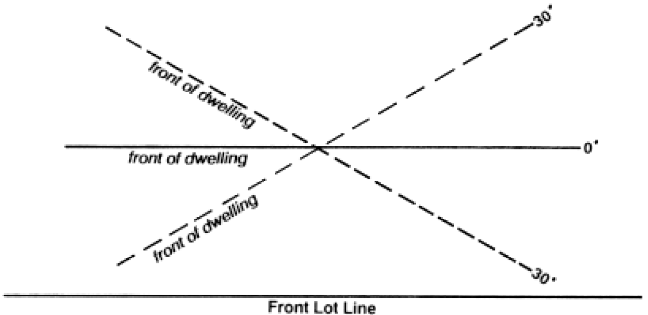
Figure 2.
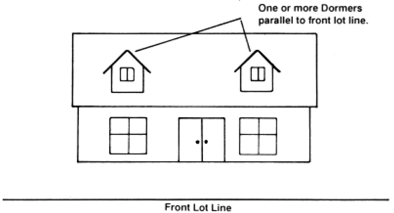
Figure 3.
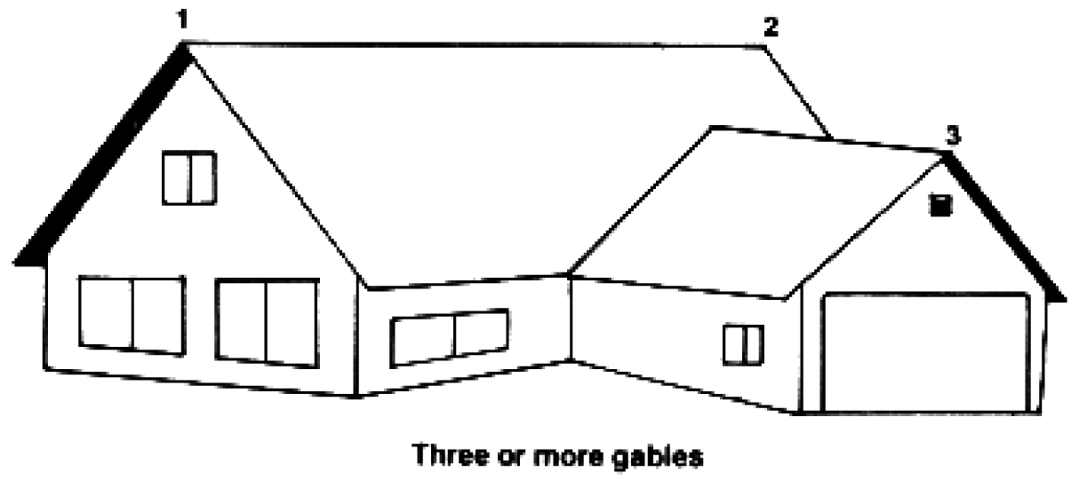
Figure 4. Examples of 12-inch Offset in Building Façade
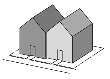 Offset Between Units Offset Between Units | 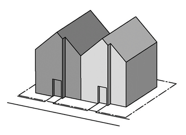 Offset within Unit Façade (Note: While two offsets are shown, minimum offset for attached
homes is one per façade, not per unit) Offset within Unit Façade (Note: While two offsets are shown, minimum offset for attached
homes is one per façade, not per unit) |
Figure 5.
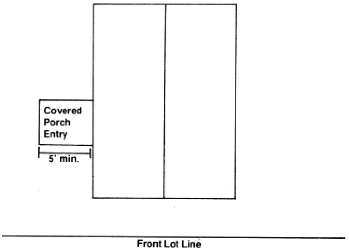
Figure 6. Window Coverage
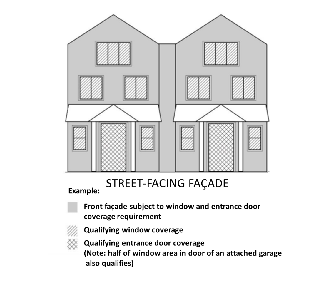
430-37.2
Rural
In the resource districts (EFU, EFC, AF-20) a detached dwelling is allowed in certain circumstances, as identified below. For the purposes of this Section, "tract" means one or more contiguous lots or parcels under the same ownership (ORS 215.010).
A.
Farm Dwelling. In the EFU and AF-20 Districts, a primary dwelling unit customarily provided in conjunction with farm use may be approved when the following standards are met:
(1)
The subject tract is currently employed for farm use, as defined in ORS 215.203, that produced:
(a)
In the EFU and AF-20 Districts on land identified as high-value farmland at least $80,000.00 in gross annual income from the sale of farm products in the last two years, three of the last five years, or based on the average farm income earned on the tract in the best three of the last five years.
(b)
In the AF-20 District on land not identified as high-value farmland at least $20,000.00 in gross annual income from the sale of farm products in the last two years, three of the last five years, or based on the average farm income earned on the tract in the best three of the last five years.
(2)
Except as permitted in Section 340-4.1 A. and 344-4.1 A., there is no other dwelling on the subject tract; and
(3)
The dwelling will be occupied by a person or persons who produced the commodities which grossed the income in Section (1) above.
(4)
In determining the gross income required by Section (1) above, the cost of purchased livestock shall be deducted from the total gross income attributed to the tract. Only gross income from farm land owned, not leased or rented, shall be counted.
(5)
To demonstrate compliance with Section (1) above, an applicant shall submit the following evidence:
(a)
Federal income tax returns, and a list describing where the farmed properties are located, their size, the type of crops or livestock products raised on the properties, and the amount of income produced from the properties and from each farm product; or
(b)
Sales receipts for the sale (retail or wholesale) of products produced from the property; or
(c)
Other information as may be necessary to prove income; and
(d)
An affidavit signed by the person whose income is in question, certifying that income requirements for the parcel have been met.
The Review Authority may consider statistical information compiled by the Oregon State University Extension or other objective criteria, such as average yields per acre and average price per unit, to calculate income to verify an applicant's information.
(6)
If the tract consists of two or more lots or parcels and more than one lot or parcel is used to meet the income standards of this section, the dwelling may be approved if:
Prior to final approval for a dwelling, the applicant records a restrictive covenant that precludes construction of a dwelling on the remainder of the tract. This restriction does not apply to seasonal farm worker housing, accessory farm dwellings and replacement dwellings.
The restrictive covenant shall be irrevocable, unless the Director finds that the tract is no longer subject to Statewide Goal 3 (Agricultural Lands) or, if a dwelling is proposed on another lot or parcel that is part of the tract that was used to meet the income requirements, each parcel meets the income standards of this section.
B.
Woodlot Farm Dwelling. In the EFU and AF-20 Districts, a primary dwelling in conjunction with the propagation or harvesting of a forest product may be approved when the following standards are met:
(1)
The lot or parcel is a woodlot capable of producing an average over the growth cycle of $20,000.00 in gross annual income; and
(2)
The lot or parcel is not high-value farmland as defined by Section 340-2 or 344-2, whichever is applicable.
(3)
The following information establishes standards which an applicant may use in applying for a dwelling approval under (1) above. Applicants are not limited to these standards if the applicant can otherwise demonstrate that the proposed woodlot can meet the $20,000.00 income requirement.
Minimum acreage to produce $20,000.00 annual gross income over the growing cycle [2] for merchantable trees.
SITE INDEX CONVERSION TABLE
C.
Relative Farm Dwelling. A Dwelling Unit located on real property used for farm use occupied by a relative may be approved when:
(1)
The dwelling is located on the same lot or parcel as the dwelling of the farm operator; and
(2)
The relative is a grandparent, step-grandparent, grandchild, parent, step-parent, child, sibling, stepsibling, niece, nephew or first cousin of the farm operator, or the farm operator's spouse, whose assistance in the management and farm use of the existing commercial farming operation is required by the farm operator;
(3)
The farm operator continues to play the predominant role in the management and farm use of the farm. For the purposes of this section, a farm operator is a person who operates a farm, doing the work and making the day-to-day decisions, about such things as planting, harvesting, feeding and marketing; and
(4)
The lot or parcel which receives a building permit under these provisions shall not be partitioned or subdivided unless any residence approved under these provisions is removed. Unless, notwithstanding ORS 92.010 to 92.190 or the minimum lot or parcel size requirements under ORS 215.780, if the owner of a dwelling described in this subsection obtains construction financing or other financing secured by the dwelling and the secured party forecloses in the dwelling, the secured party may also foreclose on the homesite, as defined in ORS 308A.250, and the foreclosure shall operate as a partition of the homesite to create a new parcel.
D.
Accessory Farm Dwelling. In the EFU and AF-20 Districts, Accessory Dwelling Units customarily provided in conjunction with farm use may be approved when:
(1)
Subsequent to or concurrently with the approval of a primary farm related dwelling pursuant to this Code, an Accessory Dwelling Unit(s) may be allowed provided there is a finding that the proposed Accessory Dwelling Unit(s) is customarily required to conduct the proposed farm use considering:
(a)
Size of Parcel and Farm (proposed and/or existing);
(b)
Type of Farm Use (proposed and/or existing);
(c)
Potential Markets (proposed and/or existing);
(d)
Accepted farming practices as that term is defined in ORS Chapter 215;
(e)
A three-year farm management plan which describes the present and proposed farm uses for the farm operation; and
(f)
Other evidence the Director considers necessary (e.g., soil type).
(2)
In addition to (1) above, the applicant shall demonstrate the Accessory Dwelling Unit(s) complies with the applicable requirements of OAR 660-033.
E.
Lot of Record Forest Dwelling. In the EFC District, a primary dwelling unit on a lot or parcel may be approved when the following standards are met:
(1)
The lot or parcel on which the dwelling will be sited was lawfully created and was acquired by the present owner:
(a)
Prior to Jan. 1, 1985; or
(b)
By devise or by intestate succession from a person who acquired the lot or parcel prior to Jan. 1, 1985.
For the purposes of the Lot-of-Record Dwelling Standards, "owner" includes the wife, husband, son, daughter, mother, father, brother, brother-in-law, sister, sister-in-law, son-in-law, daughter-in-law, mother-in-law, father-in-law, aunt, uncle, niece, nephew, stepparent, stepchild, grandparent or grandchild of the owner or a business entity owned by any one or combination of these family members.
(2)
The tract on which the dwelling will be sited does not include a dwelling.
(3)
When the lot or parcel on which the dwelling will be sited is part of a tract, the remaining portions of the tract are consolidated into a single lot or parcel when the dwelling is allowed.
(4)
The tract on which the dwelling will be sited is composed of soils not capable of producing 5,000 cubic feet per year or more of forest tree species as defined in ORS 527.715.
(5)
The tract on which the dwelling will be sited is located within 1,500 feet of a public road as defined under ORS 368.001. The road shall be maintained and either paved or surfaced with rock and shall not be:
(a)
A United States Bureau of Land Management road; or
(b)
A United States Forest Service road unless the road is paved to a minimum width of 18 feet, there is at least one defined lane in each direction and a maintenance agreement exists between the United States Forest Service and landowners adjacent to the road, a local government or a state agency.
F.
Large Tract Forest Dwelling. In the EFC District, a primary dwelling unit may be approved when the following standards are met:
(1)
Lot Area Requirements:
(a)
The dwelling will be sited on a tract of at least 160 contiguous acres zoned for forest use. A tract shall not be considered to consist of less than 160 acres because it is crossed by a public road or waterway; or
(b)
An owner of tracts that are not contiguous but are in the same county or adjacent counties and zoned for forest use may add together the acreage of two or more tracts to total 200 acres or more.
(2)
Prior to issuance of a building permit, the owner shall submit proof that the covenants, conditions, and restrictions form adopted by OAR 660-006, effective March 1, 1994, has been recorded in the deed records for all the tracts that are used to meet the acreage requirement.
(a)
The covenants, conditions, and restrictions shall preclude all future rights to construct a dwelling on the tract(s) or to use the tract(s) to total acreage for future siting of dwellings for present and any future owners unless the tract is no longer subject to protection under the goals for agricultural lands or forestlands. The covenants, conditions, and restrictions are irrevocable, unless a statement of release is signed by the Director.
(b)
The Director shall maintain a copy of the covenants, conditions, and restrictions filed in the Department of Assessment and Taxation Recording Division pursuant to this subsection and a map or other record depicting tracts which do not qualify for the siting of a dwelling under the covenants, conditions, restrictions filed in the Department of Assessment & Taxation Recording Division pursuant to this subsection. The map or other record required by this subsection shall be readily available to the public in the Department of Land Use and Transportation.
(3)
The tract or tracts on which the dwelling will be sited does not include a dwelling.
G.
Template Forest Dwelling. In the EFC District, a primary dwelling unit may be approved when the lot or parcel meets the Template Test and the Additional Standards in (1) and (2) below.
(1)
Template Test. Subsections (a) and (b) below detail how to place the template and the minimum parcel and dwelling requirements. If the data that the county has on record shows that any of the dwellings used to qualify for the template test are within 100 feet of the template, the applicant may be required to provide more accurate information, stamped by a professional surveyor, in order for the Review Authority to determine whether or not the standards can be satisfied. Acceptable forms of information include a survey of the subject parcel, referenced to digital orthographic photographs, including information on the accuracy of the photographs for the subject area.
(a)
Template Location. The template is a 160-acre square or rectangular pattern centered on the subject tract (Figure 1). As used in this Section, "centered on the subject tract" means the mathematical centroid of the tract. After the template position has been selected, the template shall remain fixed while the parcels and dwellings are counted.
The lot or parcel on which the dwelling is to be established shall be within a 160-acre square centered on the center of the subject tract that may be rotated around the centroid to most advantageous position, except that:
(i)
For tracts less than 60 acres, if the tract abuts a road that existed on Jan. 1, 1993, the measurement may be made by creating a 160-acre rectangle that is one mile long and ¼ mile wide centered on the center of the subject tract and that is, to the maximum extent possible, aligned with the road.
(ii)
For tracts 60 acres and larger, if the tract abuts a road or perennial stream, the measurement shall be made by creating a 160-acre rectangle that is one mile long and ¼ mile wide centered on the center of the subject tract and that is, to the maximum extent possible, aligned with the road or perennial stream.
However, one of the three required dwellings under the Parcel and Dwelling Requirements shall be on the same side of the road or stream as the tract and:
(A)
Be located within a 160-acre rectangle that is one mile long and ¼ mile wide centered on the center of the subject tract and that is, to the maximum extent possible, aligned with the road or stream; or
(B)
Be within one-quarter mile from the edge of the subject tract but not outside the length of the 160-acre rectangle, and on the same side of the road or stream as the tract.
(C)
If a road crosses the tract on which the dwelling will be located, at least one of the three required dwellings shall be on the same side of the road as the proposed dwelling.
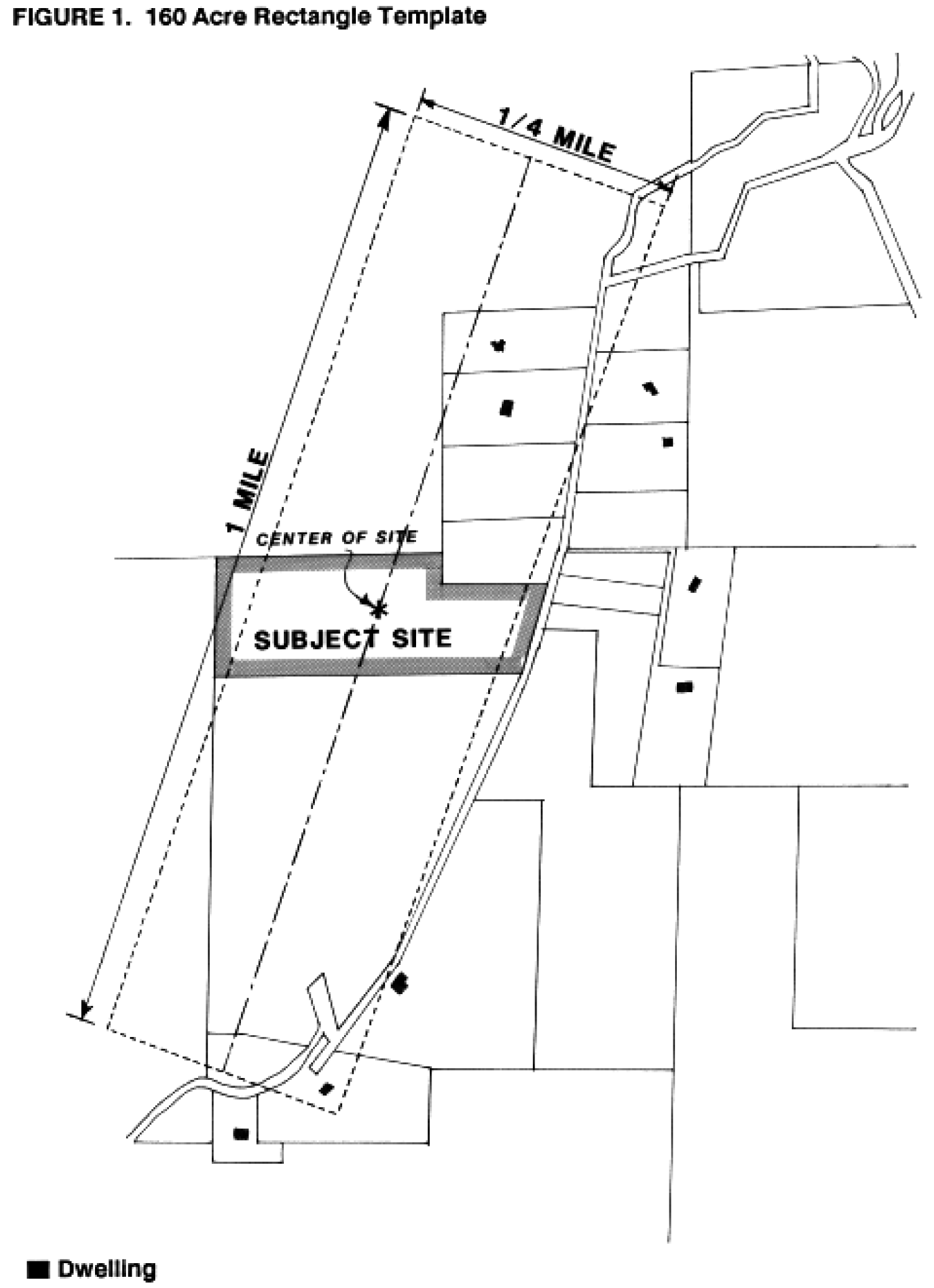
(b)
Parcel and Dwelling Requirements. The minimum number of Parcels and Dwellings required to qualify for a dwelling is based on the parcel's soil production capacity as follows.
If the lot or parcel is predominantly composed of soils that are capable of:
(i)
Producing zero to 49 cubic feet per acre per year of wood fiber, there shall be within the 160-acre template all or part of at least three other lots or parcels, all of which have dwellings. At least one of these three dwellings must be located within the 160-acre template; two may be within 500 feet of the template.
(ii)
Producing 50 to 85 cubic feet per acre per year of wood fiber, there shall be within the 160-acre template all or part of at least seven other lots or parcels, at least three of which have dwellings. At least one of these three dwellings must be located within the 160-acre template; two may be within 500 feet of the template.
(iii)
Producing more than 85 cubic feet per acre per year of wood fiber, there shall be within the 160-acre template all or part of at least 11 other lots or parcels, at least three of which have dwellings. At least one of these three dwellings must be located within the 160-acre template; two may be within 500 feet of the template.
(2)
Additional Standards.
(a)
For the purposes of the parcel requirements in (1)(b) above, all lots, parcels and dwellings must have existed on Jan. 1, 1993, and continue to exist. Lots or parcels within urban growth boundaries shall not be used to satisfy the eligibility requirements of the Parcel Requirements.
(b)
The subject lot or parcel must have been lawfully established.
(c)
Any property line adjustment to the lot or parcel must have complied with the applicable property line adjustment provisions in ORS 92.192.
(d)
Any property line adjustment after Jan. 1, 2019, did not qualify a lot or parcel for a dwelling under this Section.
(e)
The tract on which the dwelling will be sited does not include a dwelling.
(f)
If the lot or parcel on which the dwelling will be sited was part of a tract on Jan. 1, 2019, no dwelling existed on the tract on that date, and no dwelling exists or has been approved on another lot or parcel that was part of the tract.
(g)
Prior to issuance of a building permit, the owner shall submit proof that the covenants, conditions and restrictions form adopted by OAR 660-006, effective March 1, 1994, has been recorded in the deed records for all lots and parcels within the tract used to meet the requirements of this Section.
(i)
The covenants, conditions and restrictions shall preclude all future rights to construct a dwelling on the tract unless the tract is no longer subject to protection under the goals for agricultural lands or forestlands. The covenants, conditions and restrictions are irrevocable, unless a statement of release is signed by the Director.
(ii)
The Director shall maintain a copy of the covenants, conditions and restrictions filed in the Department of Assessment and Taxation Recording Division pursuant to this subsection.
(Ord. No. 813, § 2.C.(Exh. 1, § 5), 8-23-16, eff. 11-25-16; Ord. No. 828, § 2.C.(Exh. 1, § 12), 9-26-17, eff. 11-24-17; Ord. No. 855, § 2.A.(Exh. 1, § 25), 8-6-19, eff. 11-28-19; Ord. No. 877A, § 2.A.(Exh. 1, § 6.), 10-11-21, eff. 11-10-21; Ord. No. 885A, § 2.1.(Exh. 1, § 27.), 6-28-22, eff. 7-28-22; Ord. No. 890A, § 2.A.(Exh. 1, §§ 1., 23.), 2-7-23, eff. 3-9-23)
Based on a 55 to 60 year growth cycle and a small log value of $235.00 in June 1983.
Source: Oregon Department of Forestry, September 1983.
430-41 - Drive-in or Drive-up Establishment
Any establishment or portion of an establishment designed and operated to serve a patron while seated in an automobile (not including drive-in theaters).
430-41.1
Entrances and Exits:
A.
Access shall be determined based upon a site inspection which considers the following:
(1)
Site size;
(2)
Road Classification;
(3)
Sight distance and allowed m.p.h.;
(4)
Adjacent development.
B.
Consolidation of access with adjoining uses shall be encouraged; and
C.
Driveway entrances and exits shall be clearly marked.
430-41.2
Drive-in facilities located in the parking lot or part of a larger commercial center shall not have separate access points to the street and shall utilize the center's access points;
430-41.3
Lighting, sign illumination and height, and hours of operation may be restricted through the development review process to insure compatibility within the Office Commercial District; and
430-41.4
In an Office Commercial District, hours of operation shall be limited to normal hours of operation in the Office Commercial District. Normal hours of operation are 7:00 a.m. to 6:00 p.m.
430-43 - Drive-In Theater
A theater designed and operated to serve a patron seated in an automobile. Drive-in theaters shall:
430-43.1
Be located on a collector, arterial or frontage road at least 1,000 feet from any residential district;
430-43.2
Locate entrance and exit driveways to provide a minimum of 500-foot site distance;
430-43.3
Provide that theater projection screens and perimeter fencing shall be a minimum of 25 feet from any abutting street;
430-43.4
Provide that internal circulation:
A.
Require at least two access gates for the viewing area, with one available for emergency egress at all times;
B.
Provide, on-site, a stacking area for vehicles waiting to purchase tickets. The area shall accommodate a minimum of 15% of the total capacity (parking spaces);
C.
Provide one ticket gate or booth for each 300 car capacity; and
D.
Provide signs to indicate entrance, exits and one-way driveways;
430-43.5
Orient projection screens so that the screen face is not visible at an angle greater than 30 degrees from any street within 1,000 feet of the screen;
430-43.6
Provide screening for the parking and viewing area with a 10-foot solid wood, masonry or nonreflecting metal perimeter fence;
430-43.7
Require that the 25-foot setback required in Section 430-43.3 be landscaped. Landscaping shall include as a minimum, trees capable of exceeding 15-foot height at 50-foot intervals located either inside or outside the perimeter fencing;
430-43.8
Surface all areas used by vehicles with chip seal or better;
430-43.9
Provide drainage facilities as required in Section 410; and
430-43.10
Provide individual loudspeakers for each car or radio system designed to not emanate beyond the perimeter of the site. No central loudspeaker shall be allowed except for an outdoor speaker located at the snack bar when the speaker is operated at a sound level not to exceed 65 decibels.
(Ord. No. 903, § 2.M.(Exh. 13, § 20.), 10-15-24, eff. 11-14-24)
430-44 - Emergency Response/Safety Training Center
An Emergency Response/Safety Training Center is a land use consisting of (1) classroom facilities that may have accompanying dining and sleeping areas for classroom users; and (2) outdoor facilities for simulation of potential emergency situations such as fires, rescues, hazardous materials spills, vehicle pursuits, medical emergencies and disasters.
430-44.1
In addition to complying with the other applicable development standards of this Code, Emergency Response/Safety Training Centers shall:
A.
Have direct access to a paved road;
B.
Comply with Section 411-6.2 of this Code;
C.
For security purposes, provide adequate continuous fencing around the site's perimeter; and
D.
Conduct outdoor training exercises only between the hours of 7:00 a.m. and 11:00 p.m.
430-44.2
Prior to any approval of a development application for this use, the county must adopt findings for any necessary exception to a Statewide Planning Goal pursuant to Goal 2, Part II(c) and OAR 660-004-0020 and 0022. The county's adoption of findings shall be considered through a quasi-judicial plan amendment process initiated by the applicant pursuant to Section 203 of this Code.
430-45 - Farm Brewery
A Farm Brewery is a facility located on or contiguous to a hop farm, used primarily for the commercial production, shipping and distribution, wholesale or retail sales, or tasting of malt beverages made with ingredients grown on the hop farm.
As used in Section 430-45:
Agritourism or other commercial events includes outdoor concerts for which admission is charged; educational, cultural, health or lifestyle events; facility rentals; celebratory gatherings; and other events at which the promotion of malt beverages produced in conjunction with the farm brewery is a secondary purpose of the event. Agritourism and other commercial events allowed at EFU/AF-20 farm breweries by ORS 215 differ from provisions that the state allows counties to adopt for agritourism and other commercial events in connection with other farm uses.
Brewer means a person who makes malt beverages.
Hop farm means a tract of land planted with hops.
Malt beverage means an alcoholic beverage obtained from fermented grain, consistent with the alcohol by volume requirements in ORS 471.001.
On-site retail sale includes the retail sale of malt beverages in person at the farm brewery site, through a club, or over the internet or telephone.
430-45.1
In the EFU and AF-20 Districts, a farm brewery as described by ORS 215.449 may be established as a permitted use subject to findings and evidence establishing compliance with A., B. and C. below, and the standards of Section 430-45.2:
A.
Produces less than 150,000 barrels of malt beverages annually, inclusive of malt beverages produced by the farm brewery's owners or operators at the farm brewery or elsewhere, through any entity owned or affiliated with the farm brewery;
B.
Produces less than 15,000 barrels of malt beverages annually on the farm brewery site; and
C.
(1)
Owns an on-site hop farm of at least 15 acres;
(2)
Owns a contiguous hop farm of at least 15 acres;
(3)
Has a long-term contract for the purchase of all hops from at least
15 acres of a hop farm contiguous to the farm brewery; or
(4)
Obtains hops from a total of
15 acres from any combination of sources described in (1), (2), or (3) of this subsection.
For purposes of this standard, land planted with other ingredients used in malt beverages produced by the farm brewery counts toward the acreage minimums.
430-45.2
In the EFU and AF-20 Districts, to limit demonstrated conflicts with accepted farming or forest practices on adjacent lands, approval to establish a farm brewery as described under Section 430-45.1 is subject to findings and evidence demonstrating:
A.
Establishment of a setback of at least 100 feet from all property lines for the farm brewery and all public gathering places, except as allowed through Section 435 (Variances and Adjustments).
B.
Parking is provided for all activities or uses of the lot, parcel, or tract on which the farm brewery is established. Parking requirements shall be based on the maximum number of employees at the farm brewery, the size of the farm brewery and associated facilities, and the expected number of visitors.
C.
Provision of direct road access for the farm brewery and all public gathering places, including safety and operational considerations and the standards of Section 501-9.3.
D.
Provision of internal circulation, based upon the maximum number of people at the farm brewery and associated facilities, including times of special events. Access shall be approved by the appropriate fire district or fire marshal.
E.
Compliance with standards of Section 421 (Floodplain and Drainage Hazard Area Development) and other standards regarding geologic hazards, solar access, and airport safety, when applicable.
F.
Compliance with standards of Section 422 (Significant Natural Resources) and other regulations for resource protections acknowledged to comply with any Statewide Planning Goal respecting open spaces, scenic and historic areas and natural resources, when applicable.
G.
Compliance with regulations of general applicability for the public health and safety, including County Environmental Health (Health and Human Services) requirements and applicable requirements of Section 501-9 (Limited Application of the Public Facility and Service Standards Outside the UGB).
430-45.3
In addition to producing and distributing malt beverages, farm breweries may conduct activities consistent with A. through D. below, as applicable.
A.
The gross income of the farm brewery from the sale of incidental items or services provided pursuant to Sections 430-45.3 B.(3) and (4), and D.(1), below, may not exceed 25% of the gross income from the on-site retail sale of malt beverages produced in conjunction with the farm brewery.
The County may require a written statement, prepared by a certified public accountant, that certifies compliance with this requirement for the previous tax year, with application submittal and/or for periodic submittal as a condition of approval. The gross income of the farm brewery does not include income received by third parties unaffiliated with the farm brewery.
B.
A farm brewery established under the standards of this section may:
(1)
Market and sell malt beverages produced in conjunction with the farm brewery.
(2)
Conduct operations that are directly related to the sale or marketing of malt beverages produced in conjunction with the farm brewery, including:
(a)
Malt beverage tastings in a tasting room or other location on the premises occupied by the farm brewery.
(b)
Malt beverage club activities.
(c)
Brewer luncheons and dinners.
(d)
Farm brewery and hop farm tours.
(e)
Meetings or business activities with farm brewery suppliers, distributors, wholesale customers and malt beverage industry members.
(f)
Farm brewery staff activities.
(g)
Open house promotions of malt beverages produced in conjunction with the farm brewery.
(h)
Similar activities conducted for the primary purpose of promoting malt beverages produced in conjunction with the farm brewery.
(3)
Host charitable activities for which the farm brewery does not charge a facility rental fee.
(4)
Market and sell items directly related to the sale or promotion of malt beverages produced in conjunction with the farm brewery, the marketing and sale of which is incidental to on-site retail sale of malt beverages, including food and beverages that are:
(a)
Required to be made available in conjunction with the consumption of malt beverages on the premises by the Liquor Control Act or rules adopted under the Liquor Control Act; or
(b)
Served in conjunction with an activity authorized by
Section 430-45.3 B.(2) or (3).
C.
Subject to submittal and approval of an application for a Type II home occupation permit via Section 430-63, farm breweries established under the standards of this section may operate a bed and breakfast facility in association with the farm brewery and on the same tract as the farm brewery, and may:
(1)
Prepare two meals per day for the registered guests of the bed and breakfast facility.
(2)
Serve the meals at the bed and breakfast facility or at the farm brewery.
As an alternative to the above, the applicant may request bed and breakfast approval through Type II Room and Board provisions of Section 340-4.2 N. or 344-4.2 N.
D.
In addition to activities allowed under 430-45.3 B. and C., above, a farm brewery established by the standards of this section may:
(1)
Carry out agritourism or other commercial events on the tract occupied by the farm brewery subject to Section 430-45.4, below.
(2)
Include on-site kitchen facilities licensed by the Oregon Health Authority under ORS 624.010 to 624.121 for the preparation of food and beverages described in Section 430-45.3 B.(4) or D.(1). Food and beverage services authorized under this subsection may not utilize menu options or meal services that cause the kitchen facilities to function as a café or other dining establishment open to the public.
430-45.4
Standards for agritourism or other commercial events on a tract occupied by a farm brewery described under 430-45.1:
A.
The farm brewery may carry out up to 18 days of agritourism or other commercial events annually on the tract occupied by the farm brewery, subject to the following:
(1)
Agritourism or other commercial events and services, including marketing and sale of food, beverages, and incidental items in conjunction with these, are subordinate to the production and sale of malt beverages.
(2)
Income cap requirements described under Section 430-45.3 A. apply, including certification of compliance from a certified public accountant.
(3)
Conditions related to number of event attendees, hours of event operation, access and parking, traffic management, sanitation and solid waste may be applied — Section 430-45.4 C.(3).
(4)
A license pursuant to 430-45.4 B. and/or a permit pursuant to 430-45.4 C. is required, whichever is applicable.
B.
Events on the first six days of the 18-day limit per calendar year must be authorized by the County through a renewable license with a term of five years. The County's decision on a license under 430-45.3 B. is not a land use decision as defined in ORS 197.015.
C.
Events on days seven through the maximum of 18 per calendar year must be authorized by the County via approval of an application for a renewable multiyear permit with a term of five years, subject to:
(1)
Type II land use review to determine conditions necessary to ensure compliance with 430-45.4 C.(3), below.
(2)
Evidence that a license, as required under 430-45.4 B., was obtained for events on the first six days of the 18-day limit.
(3)
As necessary to ensure that agritourism or other commercial events on a tract occupied by a farm brewery are subordinate to the production and sale of malt beverages and do not create significant adverse impacts to uses on surrounding land, the County may impose conditions related to:
(a)
The number of event attendees.
(b)
The hours of event operation.
(c)
Access and parking.
(d)
Traffic management.
(e)
Noise management.
(f)
Sanitation and solid waste.
(Ord. No. 864, § 2.A.(Exh. 1, § 4), 7-21-20, eff. 8-20-20; Ord. No. 889A, § 2.C.(Exh. 3, § 1.), 2-7-23, eff. 3-9-23)
430-46 - Flag Lot
A lot behind a frontage lot, plus a strip (pole) out to the street for an access drive. Creation of a flag lot shall be subject to the following:
430-46.1
Middle Housing and Middle Housing Land Divisions are not subject to provisions of this section, except that any lot(s) to be considered flag lot(s) for Middle Housing purposes shall:
A.
Comply with 430-46.5 A and B or 430-46.6 A and B; and
B.
Comply with 430-46.5 C or 430-46.6 C only to the extent that access provisions apply to Middle Housing under Section 409. Middle Housing Land Division (Article VI) access provisions shall supersede.
430-46.2
Buildings located on flag lots shall be oriented to provide the maximum privacy to surrounding existing and future residential structures; and
The setback requirements of the primary district shall be maintained unless the Review Authority determines, as part of the initial approval, that it is necessary to modify the setbacks to implement the above, to provide more privacy to existing and proposed structures than if the required setbacks were maintained.
430-46.3
Access to all proposed flag lots (including future lots) shall:
A.
Provide for drainage as set forth in Section 410; and
B.
Consolidate access onto public streets wherever possible including consolidation of the access of the parent lot.
430-46.4
Landscaping and fencing (buffering) as required through Development Review to insure that privacy of existing residential structures is maintained.
430-46.5
Single flag lots shall meet the following:
A.
The minimum continuous width of the access strip shall be 15 feet;
B.
The access strip shall be part of the flag lot (the driveway shall not be provided through an easement on the frontage lot); and
C.
Access shall be provided by a paved driveway which meets the private street standards of Sections 409-3, 409-4.4, and 409-4.5.
430-46.6
Double flag lots shall meet the following:
A.
The minimum continuous width of the joint access strip shall not be less than 20 feet;
B.
The joint access strip shall not be provided through an easement on the frontage lot(s); and
C.
Access shall be provided by a common paved driveway which meets the private street standards of Sections 409-3, 409-4.1, 409-4.2, 409-4.4, and 409-4.5.
430-46.7
The minimum lot area requirements of the primary district shall be maintained;
430-46.8
The pole or access portion of the flag lot shall not be included in the calculation of the minimum lot area, and shall not be included in the calculation of the average lot size in the R-5 and R-6 Districts;
430-46.9
The applicant shall provide a plan of complete parcelization of the subject property and potential parcelization of adjacent, vacant parcels; and
430-46.10
Parcelization shall not preclude reasonable development of the site and surrounding properties. Consideration shall include but not be limited to:
A.
Access;
B.
Circulation; and
C.
Building location.
(Ord. No. 864, § 2.A.(Exh. 1, § 1), 7-21-20, eff. 8-20-20; Ord. No. 885A, § 2.1.(Exh. 1, § 27.), 6-28-22, eff. 7-28-22; Ord. No. 890A, § 2.A.(Exh. 1, § 1.), 2-7-23, eff. 3-9-23)
430-47 - Forest Products - Temporary Portable Facility for Primary Processing
Primary processing of a forest product is a temporary installation which uses a portable chipper or stud mill or other similar method of initial treatment of a forest product to enable its shipment to market, subject to the following:
430-47.1
Uses timber grown on the parcel or contiguous land where the processing facility is located. In the case of a log scaling facility, except in the EFU and AF-20 Districts, this use may occur on land not contiguous provided all other requirements are met;
430-47.2
In the EFU and AF-20 Districts, the processing facility is found to not seriously interfere with accepted farming practices and is compatible with farm uses described in ORS 215.203(2).
430-47.3
Is approved for a period of one year. Extensions may be requested and processed in the same manner as the original application when work has not been completed within the one year period;
430-47.4
Except in the EFU and AF-20 Districts, temporary processing facilities which do not require structures, as defined by Section 106-205, shall be processed through a Type I procedure. Temporary processing facilities which require structures shall be processed through a Type II procedure.
430-48 - Firearms Training Facility
For purposes of this section, a firearms training facility is an indoor or outdoor facility that provides training courses and issues certifications required:
A.
For law enforcement personnel;
B.
By the Oregon Department of Fish & Wildlife; or
C.
By nationally recognized programs that promote shooting matches, target shooting and safety.
430-49 - Fuel Dealership
The use of a site for on-site bulk storage of gas or oil for distribution and delivery to off-site locations. Fuel dealerships shall:
430-49.1
Have a minimum lot area of 20,000 square feet;
430-49.2
Be no closer than 500 feet to any residential district for above ground storage;
430-49.3
Have a minimum 50-foot setback to all property lines for any above ground storage; and
430-49.4
Not require special setbacks or locational criteria for underground storage.
430-50 - Golf Course Outside an Urban Growth Boundary
A golf course is an area of land with highly maintained natural turf laid out for the game of golf, generally with a series of nine or more holes, each including a tee, a fairway, a putting green, and often one or more natural or artificial hazards. A golf course may be permitted subject to the standards listed below.
430-50.1
A golf course located outside an urban growth boundary means a nine or 18-hole regulation golf course or a combination nine or 18-hole regulation golf course consistent with the following:
A.
A regulation 18-hole golf course is generally characterized by a site of about 120 to 150 acres of land, has a playable distance of 5,000 to 7,200 yards, and a par of 64 to 73 strokes.
B.
A regulation nine-hole golf course is generally characterized by a site of about 65 to 90 acres of land, has a playable distance of 2,500 to 3,600 yards, and a par of 32 to 36 strokes.
C.
Non-regulation golf courses are not allowed uses within these areas. "Non-regulation golf course" means a golf course or golf course-like development that does not meet the definition of golf course in this section, including but not limited to executive golf courses, par 3 golf courses, pitch and putt golf courses, miniature golf courses and driving ranges.
D.
Accessory uses provided as part of a golf course shall be consistent with the following standards:
(1)
An accessory use to a golf course is a facility or improvement that is incidental to the operation of the golf course and is either necessary for the operation and maintenance of the golf course or that provides goods and services customarily provided to golfers at a golf course. An accessory use or activity does not serve the needs of the non-golfing public. Accessory uses to a golf course may include: parking; maintenance buildings; cart storage and repair; practice range or driving range; clubhouse; restrooms, lockers and showers; food and beverage service; pro shop; a practice or beginners course as part of an 18-hole or larger golf course. Accessory uses to a golf course do not include: sporting facilities unrelated to golfing such as tennis courts, swimming pools, and weight rooms; wholesale or retail operations oriented to the non-golfing public; housing.
(2)
Accessory uses shall be limited in size and orientation on the site to serve the needs of persons and their guests who patronize the golf course to golf. An accessory use that provides commercial services (e.g., food and beverage service, pro shop, etc.) shall be located in the clubhouse rather than in separate buildings.
430-50.2
The minimum setbacks to any primary structure shall be 100 feet).
The minimum setback to all other structures shall be 35 feet.
430-50.3
When driving ranges are to be included as a part of the golf course:
A.
Hours of operation shall be limited so that outdoor lighting is not required; or
B.
The range shall be located in such a manner that the lights do not shine outside the perimeter of the golf course; and
430-50.4
In addition to the requirements of Section 501-9, an application for a golf course shall include a traffic impact analysis which demonstrates the following. The analysis shall be prepared and certified by a traffic or civil engineer registered in the state of Oregon.
A.
Adequacy of traffic safety and traffic operations at the site's access to a public road and within a 10% impact area as defined by Resolution and Order 86-95 as modified or updated and Section 501-8.5. The applicant shall make necessary improvements, if any, to correct identified deficiencies.
B.
Adequacy of the width and structural integrity, including roadway pavement, base and drainage, of the public access road(s) between the site's access and the nearest Arterial or paved Collector. The applicant shall make necessary improvements, if any, to correct identified deficiencies in order to provide adequate access to the golf course.
C.
When applicable, conformance with the Oregon Department of Transportation's traffic/development review requirements, including but not limited to traffic report, access management, level of service, and traffic safety and operations requirements. The applicant shall make necessary improvements, if any, to mitigate identified deficiencies.
D.
Adequate traffic management and parking for special events. Off-site parking areas, if any, shall be approved as part of the development application for the golf course or through a separate Type II or III application.
430-50.5
The maximum sign area shall be 35 square feet.
430-51 - Golf Course Inside an Urban Growth Boundary
A golf course is an area of land with highly maintained turf laid out for the game of golf, generally with a series of nine or more holes, each including a tee, a fairway, a putting green, and often one or more natural or artificial hazards. For the purposes of this section, a golf course includes executive golf courses and par 3 courses. A golf course does not include pitch and putt golf courses, miniature golf courses, and driving ranges. These uses are subject to the standards of Section 430-131 (Special Recreation Use).
Golf courses shall comply with the following standards:
430-51.1
Have a minimum lot size of ten acres;
430-51.2
Require that all yards be a minimum of 35 feet to a structure;
430-51.3
Have a maximum sign area of 35 square feet; except as provided otherwise in the Institutional District (Section 330-9).
430-51.4
Require that minimum setbacks to any primary structure be 100 feet.
430-51.5
When driving ranges are to be included as a part of the golf course:
A.
Hours of operation shall be limited so that outdoor lighting is not required; or
B.
The range shall be located in such a manner that the lights do not shine outside the perimeter of the golf course; and
430-51.6
Accessory uses to a golf course include but are not limited to parking, maintenance buildings, cart storage and repair, pro shop, driving range, and eating and drinking facilities.
430-53 - Group Care
Community based care may include medical and nonmedical care. For the purposes of this section, "care" means services, including but not limited to, assistance with activities of daily living such as bathing, dressing, grooming or eating, management of money, transportation, recreation, and the providing of room and board. Group care may provide care to people living together in a homelike setting, or people living in separate units. The clients and staff may function as a single housekeeping unit. The goal of these facilities is the integration of their residents into society. Group care includes facilities for day care, resident care facilities, and retirement housing communities.
Housing (aside from Retirement Housing Communities) that provides on-site management and/or care that does not require state or federal licensing is not classified or regulated as group care for the purposes of this code, regardless of the population residing or being served at that location.
430-53.1
Day-Care Facility:
Day-Care Facilities, as defined by Section 106-48, are permitted subject to the following:
A.
The minimum front and rear yards shall be 20 feet;
B.
The minimum side yard shall be 10 feet;
C.
All state and county licensing and Department of Health & Human Services requirements must be met;
D.
There shall be a maximum lot coverage of 40%;
E.
The maximum sign area shall be 20 square feet; except as provided otherwise in the Institutional District (Section 330-9).
F.
The minimum lot area for day-care facilities in a residential district or adjacent to a residential district shall be 20,000 square feet;
G.
The Review Authority may require a fenced outdoor play area be provided;
H.
Child care provided at a public or private school for before and/or after school care, exclusively for students affiliated with the school, is not subject to the requirements of this Section. This use is permitted pursuant to Section 201-2.19; and
I.
Day care facilities, located within a religious institution, school or public building, are allowed through a Type II procedure when permitted by the primary district.
430-53.2
Secure Housing Facilities:
An establishment licensed or certified by the state that provides housing and 24-hour supervision and access to services, including care, training, and/or treatment for individuals under judicial detainment, including court-ordered post-incarceration secure housing. The facility shall:
A.
Maintain all applicable state and county licenses; and
B.
Meet and maintain all applicable state, county, and federal requirements.
430-53.3
Resident Care Facility:
An establishment licensed or certified by the state or applicable federal authority that provides housing and 24-hour access to services, including care, training, and/or treatment for individuals who are not in need of hospital care, but who may need assistance with activities of daily living. Residents may live in separate units, or as a single housekeeping unit. Facilities may include accessory uses and amenities, such as areas for shared eating, socializing, recreation, laundry, training, or treatment. Residential units and common facilities, including sleeping areas, kitchens, bathrooms, and other amenities, must meet all applicable state and federal requirements.
Resident care facilities shall:
A.
Not include hospital or treatment facilities otherwise provided in Article IV;
B.
Maintain all applicable licenses required by the state and county; and
C.
Meet and maintain all applicable state and federal requirements.
430-53.4
Family Day Care Provider in the AF-10, AF-5 and RR-5 Districts:
A day care (child care) provider who resides in the home and regularly provides day care (child care) in the provider's home in the family living quarters to fewer than 16 children, including children of the provider, regardless of full-time or part-time status. Family day care providers shall meet the following:
A.
All state licensing and Department of Health & Human Services requirements must be met and maintained;
B.
The requested use is compatible with the surrounding uses or can be made more compatible through conditions of approval; and
C.
The applicant has signed and recorded in the Department of Assessment & Taxation Recording Division, a waiver of the right to remonstrate against customarily accepted farming or forestry practices.
430-53.5
Retirement Housing Community
A residential community where 80% or more of the units are intended to be occupied by at least one person age 55 years or older, that includes a variety of housing options and services. Private dwelling units, including apartments or Townhouse/single detached homes, may be provided for independent residents (independent living) and/or residents requiring a range of supportive personal and health services (assisted living). The community may also include a care facility licensed or certified by the state (as applicable) for the purpose of providing planned treatment and/or care.
A retirement housing community shall meet the following:
A.
The entire community is owned or managed by a single entity and access to community services and facilities is available for all residents;
B.
Both independent and assisted living housing units include kitchen facilities, bathroom facilities, and bedroom(s). For studio units, a sleeping area may replace the requirement for a separate bedroom. If there are common facilities available to residents, units may be provided with kitchenettes and/or shared bathrooms if those facilities meet all applicable state and federal requirements;
C.
The residential care facility meets the following requirements:
(1)
Shall not include hospital or treatment facilities otherwise provided in Article IV;
(2)
Must maintain all applicable licenses required by the state and county; and
(3)
Must meet all applicable state and federal requirements.
D.
Provided services and facilities that are accessory in nature to the primary use of residential housing, are intended to principally serve residents of the retirement housing community, but may also be used by non-residents on a limited basis. Services and facilities may include, but are not limited to, a dining facility, health and fitness facility, administrative or medical offices, craft and hobby rooms, meeting and community rooms, beauty and barber salons, library and guest lodging; and
E.
The community is open to pedestrian and vehicular circulation
F.
In areas outside the UGB, for the purposes of calculating parking, minimum off street parking requirements for individual uses in Retirement Housing Communities should be calculated separately.
(Ord. No. 823, § 2.A.(Exh. 1, § 9), 9-5-17, eff. 10-5-17; Ord. No. 832A, § 2.A.(Exh. 1, § 24), 9-18-18, eff. 10-18-18; Ord. No. 855, § 2.A.(Exh. 1, § 25), 8-6-19, eff. 11-28-19; Ord. No. 866, § 2.C.(Exh. 3, § 22), 9-1-20, eff. 10-1-20; Ord. No. 885A, § 2.1.(Exh. 1), 6-28-22, eff. 7-28-22; Ord. No. 890A, § 2.A.(Exh. 1, § 1.), 2-7-23, eff. 3-9-23; Ord. No. 903, § 2.M.(Exh. 13, § 20.), 10-15-24, eff. 11-14-24)
430-55 - Guest House
A second house on a parcel, used for intermittent occupancy by guests of the occupant of the main residence. A guest house is permitted subject to the following:
430-55.1
The minimum lot size shall be twice the minimum requirement for the primary district, except in the R-5 District, where the minimum lot size to accommodate a guest house must be 14,000 square feet;
430-55.2
The guest house shall be for intermittent or temporary occupancy only;
430-55.3
Placement of a guest house shall allow for future division of the lot to the District standards;
430-55.4
Submission of a plan indicating how a legal lot could be partitioned for the guest house; and
430-55.5
Limitation of one guest house for one main dwelling unit.
430-57 - Heavy Industrial Uses
430-57.1
Heavy Industrial uses include the following:
A.
Acid Manufacture;
B.
Blast furnace;
C.
Cement, lime, gypsum or plaster manufacture;
D.
Distillation of bones;
E.
Dump, rubbish, cinders, slag or sawdust;
F.
Explosives, manufacture or storage;
G.
Fat rendering;
H.
Fertilizer manufacture;
I.
Garbage, offal or dead animal reduction or dumping;
J.
Gas manufacture or storage (artificial), natural, industrial, liquefied or compressed;
K.
Glue manufacture;
L.
Incinerator;
M.
Petroleum refining and reclaiming plants if located more than 1,320 feet from any property classified other than an IND, R-IND or MAE District;
N.
Storage, curing or tanning of raw, green or salted hides or skins; and
O.
Any use which in general is especially hazardous to the public health or safety, damaging to vegetation and discharges extreme air and water pollutants.
430-57.2
Lot Area:
The minimum lot area shall be 5 acres.
430-57.3
Yard Requirements:
A minimum setback of 600 feet from any R or AF District and not less than 300 feet from any other district except Industrial.
430-59 - Heliport
Heliports may be allowed subject to compliance to all federal and state requirements including DEQ noise control regulations for aeronautics. Personal use heliports shall comply with the requirements of Section 430-7.
430-63 - Home Occupation
A home occupation is a lawful activity operated within a dwelling by a member or members of the family who occupy the dwelling, where the occupation is secondary to the use of the dwelling for living purposes and the residential character of the dwelling is maintained. Bed and breakfast facilities serving five or fewer persons are permitted as a Type I Home Occupation in all districts except the Institutional, EFU, EFC and AF-20 Districts (Section 430-63.1 C. does not apply to bed and breakfast facilities). Pursuant to Section 430-145.4 C., a bed and breakfast facility serving five or fewer persons, in association with and on the same tract as a cider business described under Section 430-28.1, a farm brewery described under Section 430-45.1, or a winery described under Section 430-145.1 or 430-145.2, is permitted as a Type II Home Occupation in the EFU and AF-20 Districts (Section 430-63.2 D.(2) does not apply). Bed and breakfast facilities serving more than five persons are subject to the standards of Section 430-19 - Boarding House (including Bed and Breakfast facilities for more than five persons).
There are four types of home occupations: exempt (see Section 201-2.18), Type I (Section 430-63.1), Type II (Section 430-63.2) and Type III (Section 430-63.3). The following summarizes the key differences:
Exempt
• Same as Type I, but no on-site customers
Type I
• Operated within the dwelling
• Limited to five on-site customers or fewer per day
• Allows no employees who do not reside at the home occupation site
• Does not allow any additional parking
• Allows one commuter vehicle with weight limits
• Allows weekly average of one business-related delivery per day
Type II
• Operated within the dwelling or an accessory building
• Limited to nine on-site customers or fewer per day
• Allows one employee who does not reside at the home occupation site
• Allows additional parking
• Allows one commuter vehicle with weight limits
• Allows weekly average of two business-related deliveries per day
Type III
• Same as Type II, but
• Limited outdoor storage allowed
• No weight limit on the allowed commuter vehicle
• Limited to the AF-5 and AF-10 Districts
430-63.1
Home Occupation - Type I (Excluding Type I home occupations that do not require a Development Permit pursuant to Section 201-2.18)
A Type I Home Occupation shall:
A.
Require the applicant to obtain a permit that shall be renewed annually;
B.
Be operated entirely within the applicant's dwelling. Use of outdoor areas is not allowed;
C.
Including storage of materials and products, occupy:
(1)
Not more than 600 square feet or 25% of the dwelling, whichever is greater; or
(2)
An area exceeding the above maximums by up to 10%, when requested by an applicant with a disability.
For purposes of Section 430-63.1 B and C, a "dwelling" includes the basement and attached garage.
D.
In a residential, agricultural, or forest district, limit any external evidence of an occupation to one identification sign not to exceed 2 square feet in area. Business identification on a commuter vehicle is exempt from this requirement;
E.
In a commercial or industrial district, limit any external evidence of a home occupation to one identification sign not to exceed 20 square feet in area;
F.
Not involve the use or storage of vehicles used for the business, other than one commuter vehicle. In the urban area, the commuter vehicle shall not exceed a manufacturer's rating of one ton. In the rural area, the commuter vehicle shall not exceed a gross vehicle weight of 26,000 pounds. Tandem rear axles, tractor trailers or heavy equipment, such as construction equipment used in a business, are prohibited;
G.
Not exceed a weekly average of one business-related delivery or pick-up per day, excluding regular residential deliveries by the U.S. Postal Service;
H.
Not have more than five customers daily entering the premises;
I.
Produce no noise or obnoxious odors, vibrations, glare, fumes, or electrical interference detectable to normal sensory perception outside the structure;
J.
In areas outside the UGB not require any additional parking to comply with Section 413-6.1;
K.
Employ no persons who are not permanent residents of the dwelling. For the purposes of this Section, an "attendant" who is employed by an applicant with a disability for assistance with daily living activities shall not be considered an employee.
430-63.2
Home Occupation - Type II
A Type II Home Occupation shall:
A.
Require the applicant to obtain a permit which shall be renewed annually;
B.
Be operated entirely within the applicant's dwelling, garage, or lawful accessory structure. Use of outside areas is not allowed;
C.
When additional off-street parking is provided, the parking shall not detract from the residential character of the site;
D.
Including storage of materials and products, occupy:
(1)
Inside the UGB
(a)
Not more than 600 square feet or 25% of a dwelling or lawful accessory structure, whichever is greater;
(b)
An area exceeding the above maximums by up to 10%, when requested by an applicant with a disability.
For purposes of Section 430-63.2 D.(1), a "dwelling" includes the basement and attached garage.
(2)
Outside the UGB
(a)
Not more than 1,000 square feet or 25% of a dwelling or lawful accessory structure, whichever is greater; or
(b)
An area exceeding the above maximums by up to 10%, when requested by an applicant with a disability.
For purposes of Section 430-63.2 D.(2), a "dwelling" includes the basement and attached garage. Areas used only for storage of farm equipment or farm vehicles are not considered as part of the maximum allowed home occupation space.
E.
Require no remodeling of the exterior of the dwelling or the accessory structure which changes the residential character;
F.
In a residential, agricultural or forest district, limit any external evidence of an occupation to one identification sign not to exceed 2 square feet in area. Business identification on a commuter vehicle is exempt from this requirement;
G.
In a commercial or industrial district, limit any external evidence of a home occupation to one identification sign not to exceed 20 square feet in area;
H.
Not involve the use or storage of vehicles used for the business, other than one commuter vehicle. In the urban area, the commuter vehicle shall not exceed a manufacturer's rating of one ton. In the rural area, the commuter vehicle shall not exceed a gross vehicle weight of 26,000 pounds. Tandem rear axles, tractor trailers or heavy equipment, such as construction equipment used in a business, are prohibited;
I.
Not exceed a weekly average of two business-related deliveries or pick-ups per day, excluding regular residential deliveries by the U.S. Postal Service;
J.
Produce no noise or obnoxious odors, vibrations, glare, fumes or electrical interference detectable to normal sensory perception outside the structure;
K.
Not have more than nine customers daily entering the premises. The Review Authority may permit additional customers for an applicant with a disability when the increase is necessitated by the applicant's disability;
L.
Employ no more than one person in addition to those who are permanent residents of the dwelling. For the purposes of this Section, an "attendant" who is employed by an applicant with a disability for assistance with daily living activities shall not be considered an employee;
M.
Provide a plan for any additional proposed parking, which shall be approved if:
(1)
The residential character of the parcel is not changed; and
(2)
The parking area does not detract from the visual appearance of the residence;
430-63.3
Home Occupation - Type III
A Type III Home Occupation shall:
A.
Be allowed only in the AF-5 and AF-10 Districts;
B.
Require the applicant to obtain a permit which shall be renewed annually through the Type II procedure. The Type II renewal permit shall be subject to any conditions imposed through the Type III procedure and the conditions shall only be modified via the Type III procedure;
C.
Including storage of materials and products, occupy:
(a)
Not more than 1,000 square feet or 25% of a dwelling or lawful accessory structure, whichever is greater; or
(b)
An area exceeding the above maximums by up to 10%, when requested by an applicant with a disability; and
(c)
Not more than 600 square feet of outdoor area for storage of inventory, equipment, a vehicle, or other items associated with the home occupation;
For purposes of Section 430-63.3 C, a "dwelling" includes any basement and attached garage. Indoor and outdoor areas used only for storage of farm equipment or farm vehicles are not considered as part of maximum allowed home occupation spaces.
D.
Require no remodeling of the exterior of the dwelling or the accessory structure which changes the residential character;
E.
Limit any external evidence of an occupation to one identification sign not to exceed 2 square feet in area. Business identification on a commuter vehicle is exempt from this requirement;
F.
Not involve the use or storage of vehicles used for the business, other than one commuter vehicle;
G.
Not exceed a weekly average of two business-related deliveries or pick-ups per day, excluding regular residential deliveries by the U.S. Postal Service;
H.
Produce no noise or obnoxious odors, vibrations, glare, fumes or electrical interference detectable to normal sensory perception outside the structure;
I.
Have no more than nine customers daily entering the premises. The Review Authority may permit additional customers for an applicant with a disability when the increase is necessitated by the applicant's disability;
J.
Employ no more than one person in addition to those who are permanent residents of the dwelling. For the purposes of this Section, an "attendant" who is employed by an applicant with a disability for assistance with daily living activities shall not be considered an employee;
K.
Provide a plan for any additional proposed parking, which shall be approved if:
(1)
The residential character of the parcel is not changed;
(2)
The parking area does not detract from the visual appearance of the residence; and
(3)
The parking area for a commuter vehicle with a gross vehicle weight more than 26,000 pounds shall be located at least 100 feet from any property line and be screened with at least a 6-foot site-obscuring fence or be located within a permitted accessory structure;
L.
Be located on a lot or parcel that is at least 5 acres in size and with direct access to a public road (use of an easement or shared driveway is prohibited);
M.
Screen outdoor storage areas with a minimum 6-foot site-obscuring fence. These areas shall be located at least 100 feet from all property lines.
(Ord. No. 815B, § 2.A.(Exh. A, § 9), 9-26-17, eff. 11-24-17; Ord. No. 835, § 2.A.(Exh. 1, § 4), 8-21-18, eff. 9-20-18; Ord. No. 859, § 2.A.(Exh. 1, § 12), 9-17-19, eff. 11-28-19; Ord. No. 864, § 2.A.(Exh. 1, § 4), 7-21-20, eff. 8-20-20; Ord. No. 866, § 2.C.(Exh. 3, § 22), 9-1-20, eff. 10-1-20; Ord. No. 903, § 2.M.(Exh. 13, § 20.), 10-15-24, eff. 11-14-24)
430-65 - Hospital
An institution providing health services, primarily for in- patients, and medical or surgical care of sick or injured persons, including as an integral part of the institution such related accessory facilities as laboratories; outpatient departments; training facilities; central service facilities; staff offices; offices and clinics of physicians for private medical practice; residential facilities for patient family members and staff, including nurses' and interns' quarters; and accessory retail facilities for the needs of patients and staff, including gift shop, beauty shop, barber shop, book store, eating facilities, bank, drug store or pharmacy, and other similar retail uses.
430-65.1
The minimum lot size shall be 15,000 square feet plus 1,000 square feet for each bed over 15;
430-65.2
Final lot size and setbacks shall be determined through approval of an overall master plan for the hospital, grounds and ancillary uses, including proposed future expansion of the main building and support uses;
430-65.3
The minimum side yard shall be 20 feet;
430-65.4
The minimum front and rear yards shall be 30 feet;
430-65.5
The maximum lot coverage shall be 50%;
430-65.6
The maximum sign area shall be:
A.
For less than one acre - 35 square feet;
B.
For greater than one acre - 70 square feet; except as provided otherwise in the Institutional District (Section 330-9).
430-65.7
A hospital shall have access onto an arterial and may be required to provide signalization when determined necessary by the county.
430-67 - Housing for Seasonal Farm and Forest Labor
Housing for seasonal farm or forest labor may be allowed provided the requested use meets the following:
430-67.1
The request is for a dwelling customarily required to conduct the proposed farm use after considering:
A.
Size of parcel;
B.
Soil type;
C.
Type of farm use;
D.
Potential markets;
E.
Accepted farming practices as that term is defined in ORS Chapter 215; and
F.
A three-year farm management plan which describes the present and proposed farm uses on the parcel.
430-67.2
The number of units allowed is based on need as determined by the Review Authority.
430-69 - Hunting and Fishing Preserves
Hunting and Fishing Preserves shall meet the following:
430-69.1
The minimum lot size shall be 20 acres; and
430-69.2
All yards shall be a minimum of 200 feet.
430-71 - Industrial Business Park
Any planned industrial development which occurs on a single lot or parcel or contiguous lots or parcels designed as a coordinated environment for a variety of industrial and industrially related activities, having a development plan that ensures internal compatibility as well as compatibility with adjacent uses which occur on a parcel or contiguous parcels under single ownership or development control.
430-71.1
The following planned development-industrial uses are allowed when they meet the definition of Industrial Business Park above and the standards of Section 430-71.2 below.
A.
Offices for administrative, educational or other related activities; professional offices for accounting, auditing and bookkeeping; architectural, engineering and surveying; law; other professional uses; and offices for financial institutions, banks and credit unions, primarily to serve the Industrial Business Park.
B.
Restaurant, delicatessen or cafeteria (which may function as a separate business) primarily for employees within the Industrial Business Park.
C.
Recreation and day-care facilities (which may function as a separate business) primarily for employees within the Industrial Business Park.
D.
Other office and commercial uses related, accessory to or serving the industrial uses, as approved as part of an industrial park.
E.
Multi-tenant office, commercial, industrial and accessory uses as approved as part of the Industrial Business Park.
430-71.2
Standards:
A.
The planned industrial uses occur within an Industrial Business Park developed on a minimum of ten acres.
B.
No more than 50% of the maximum allowable lot coverage within the park may be utilized for the above listed uses.
C.
Restaurants, commercial day-care facilities and recreational uses are:
(1)
At a scale intended primarily to serve persons working in the development; and
(2)
Located with access to an interior street within the Industrial Business Park.
D.
Offices for financial institutions such as banks, savings and loans and credit unions shall have access on interior streets within the Industrial Business Park.
E.
Maximum lot coverage within Industrial Business Parks is 50%.
430-72 - Infill
430-72.1
Intent and Purpose
The intent/purpose of this Section is to buffer existing residences, to the extent required by specific criteria below, from adjacent new residential development (other than Middle Housing) on vacant or underdeveloped lands of two acres or less in the R-5 and R-6 districts. The requirements of this Section shall not apply to Middle Housing development or preclude development of other housing types to the density allowed by the district.
430-72.2
Applicability
The requirements of this Section shall apply to Subdivisions and Partitions (excluding Middle Housing Land Divisions) and development review for attached units (excluding Middle Housing) on all properties designated by the applicable Community Plan as R-5 or R-6 that contain two acres or less, excluding existing rights-of-way.
430-72.3
Development of land required to be processed through the infill provisions shall meet the following:
A.
Complies with the intent and purpose of this Section;
B.
Provides at least one of the following privacy enhancement measures along all side and/or rear lot lines of adjacent properties developed with existing homes (for illustration, see Figure 1). The privacy enhancement measure is not required along the boundary lines of tracts associated with the infill development. The privacy enhancement measure is not required to extend into an infill lot front yard that abuts an existing public or private street. If an infill lot is a flag lot, the privacy enhancement measure is not required to extend into the portion of the flag lot access pole that is within 15 feet of an existing public or private street:
(1)
A landscape buffer consisting of evergreen shrubs having a minimum height of six feet at maturity, planted in a line to form a continuous screen; or
(2)
A site-obscuring fence with a minimum height of six feet.
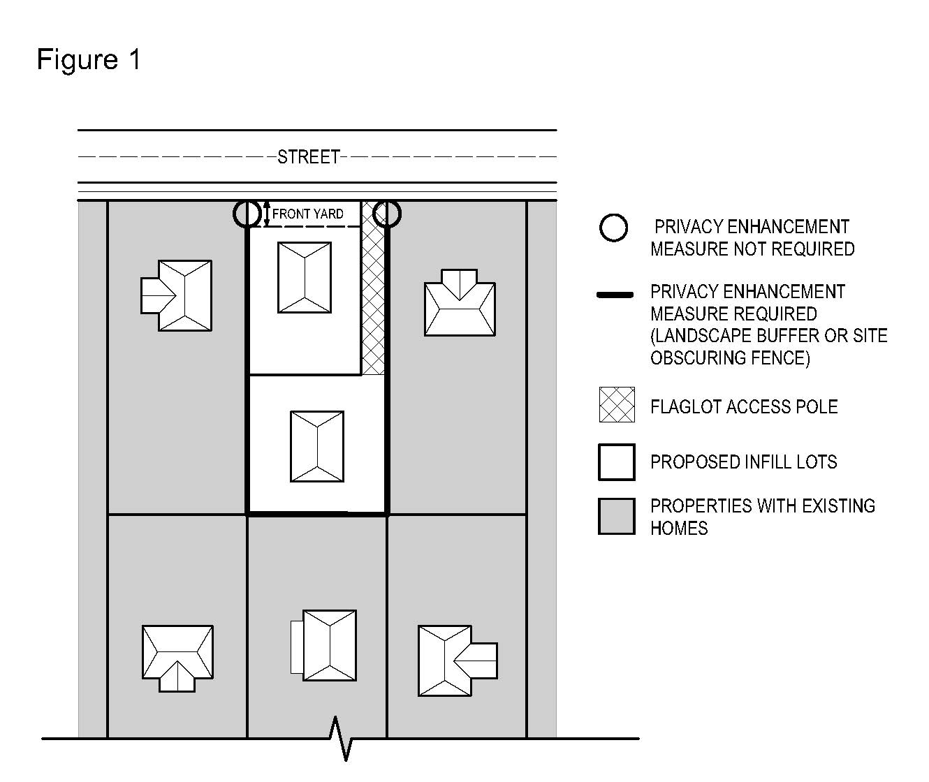
C.
All required landscaping and fencing between the proposed infill dwelling units and adjacent existing dwelling units shall be installed in accordance with the approved development plans prior to building occupancy and/or final building inspection approval. At the time of planting, the size of landscape buffer shrubs shall be such that they will achieve a minimum height of six feet within two growing seasons.
D.
The privacy enhancement measures shall be applied in addition to any screening and buffering required per Section 411. Where a landscape buffer is utilized as a privacy enhancement measure, it can also be used to satisfy requirements for understory trees and shrubs per Section 411-6. Where a site-obscuring fence is utilized as a privacy enhancement measure, it can also be used to satisfy requirements for a S-1 or S-2 fence per Section 411-7.
430-72.4
Submittal Requirements
In addition to all other submittal requirements, applications shall include:
A.
Site plans showing locations and setbacks of each dwelling unit and, if applicable, detached garage on each new lot or parcel;
B.
A screening and buffering plan showing all existing landscaping and buffering and any additional landscaping and buffering, including fencing, needed to maintain the privacy of existing dwellings on adjacent parcels. The screening and buffering plan may be incorporated into the individual site plans described under Section 430-72.4 A. above; and
C.
An Off-Site Analysis as required by Section 404-1 that includes setbacks of the proposed dwelling units on the subject property from existing dwelling units on adjacent parcels.
(Ord. No. 820A, § 2.B.(Exh. 2), 8-22-17, eff. 11-24-17; Ord. No. 885A, § 2.1.(Exh. 1, § 27.), 6-28-22, eff. 7-28-22; Ord. No. 890A, § 2.A.(Exh. 1, § 1.), 2-7-23, eff. 3-9-23)
430-73 - Kennel
A kennel is any premises on which five or more dogs with permanent canine teeth or which are more than six months of age are kept for any purpose whatsoever. Kennels may be allowed provided:
430-73.1
The minimum site area shall be five acres;
430-73.2
All setbacks shall be no less than 100 feet;
430-73.3
There shall be a maximum sign area of 12 square feet;
430-73.4
A kennel license is obtained from Washington County Department of Health & Human Services, Animal Services Division; and
430-73.5
All dog waste shall be disposed of in a sanitary manner (not causing a public health nuisance) as approved by the Department of Health & Human Services.
430-74 - Living History Museum in the EFU and AF-20 Districts
A living history museum is a facility designed to depict and interpret everyday life and culture of some specific historic period using authentic buildings, tools, equipment and people to simulate past activities and events. A living history museum, together with limited commercial activities and facilities that are directly related to the use and enjoyment of the museum and located within authentic buildings of the depicted period or the museum administration building, is permitted in the EFU or AF-20 Districts subject to the standards listed below.
430-74.1
A living history museum shall:
A.
Be related to only resource based activities (farm and forest uses);
B.
Be owned and operated by a governmental agency or a local historic society. For the purposes of this section, local historical society means the local historical society, recognized as such by Washington County and organized under ORS Chapter 65; and
C.
Be permitted if other areas that are not within the EFU or AF-20 Districts cannot accommodate the use or if the museum administration buildings and parking lot are located within one-quarter mile of the metropolitan urban growth boundary.
430-74.2
In addition to the requirements of Section 501-9, an application for a living history museum shall include a transportation/traffic impact analysis which demonstrates the following. The analysis shall be prepared and certified by a traffic or civil engineer registered in the state of Oregon.
A.
Consistency with the following standards based upon existing and planned conditions (planning horizon of the applicable transportation plan or functional plan):
(1)
Washington County's Functional Classification System as shown on the Functional Classification map of the Transportation System Plan;
(2)
Washington County's level of service standard, as defined by Section 501-8.8 I.; and
(3)
The Oregon Department of Transportation (ODOT) functional plans, including The Oregon Highway Plan and the Oregon Transportation Plan.
B.
Consistency with OAR 660-012-0065 (Transportation Improvements on Rural Lands).
C.
Adequacy of traffic safety and traffic operations at the site's access to a public road and within a 10% impact area as defined by Resolution and Order 86-95 as modified or updated and Section 501-8.5. The applicant shall make necessary improvements, if any, to correct identified deficiencies.
D.
Adequacy of the width and structural integrity, including roadway pavement, base and drainage, of the public access road(s) between the site's access and the nearest Arterial or paved Collector. The roadway width and structural integrity of these access roads shall meet county road standards. The applicant shall make necessary improvements, if any, to correct identified deficiencies. These access roads shall be maintained by the applicant to county standards through a maintenance local improvement district or other methods approved by the Director.
E.
Conformance with the Oregon Department of Transportation's traffic/development review requirements, including but not limited to traffic report, access management, level of service, and traffic safety and operations requirements. The applicant shall make necessary improvements, if any, to mitigate identified deficiencies.
F.
Adequate traffic management and parking for special events. Off-site parking areas, if any, shall be approved as part of the development application for the museum or through a separate Type II or III application.
430-74.3
The applicant shall request a periodic review of conditions at ten-year intervals to determine whether additional conditions are needed to lessen the museum's impact on surrounding uses. Periodic review shall be done through a Type II or III procedure. The applicant or Director may initiate a review of conditions at an earlier date if the Director determines there is an unexpected issue(s) which should be addressed sooner.
430-74.4
The maximum sign area shall be 64 square feet.
430-75 - Manufactured Dwelling (General Standards)
430-75.1
Minimum Standards for All Manufactured Dwellings
The following standards are not applicable to manufactured homes that are subject to Section 430-76.
A.
Require set up and installation permits obtained from Washington County;
B.
Shall be sited in compliance with applicable Oregon Manufactured Dwelling Standards;
C.
Shall comply with other applicable state requirements;
D.
Shall be placed on a foundation or footings which meet Code as determined from plans and specifications submitted to obtain a building and siting permit;
E.
Manufactured skirting, treated resistant wood or other approved material shall be placed around the perimeter of the manufactured dwelling unless there is a perimeter foundation; and
F.
Extensions of and attachments to manufactured homes not part of the original factory manufactured dwelling require a building permit.
430-75.2
Manufactured Dwelling Sites (General Standards)
A.
All buildings on a manufactured dwelling site, except accessory structures, shall comply with the dimensional requirements of the primary district except in manufactured dwelling subdivisions approved before December 27, 1983 or in manufactured dwelling parks;
B.
Accessory structures shall be located a minimum of 6 feet from the manufactured dwelling and other accessory buildings, except in manufactured dwelling parks. Accessory structures in manufactured dwelling parks shall comply with Section 430-77.4; and
C.
Access and parking shall be provided in conformance with the applicable requirements of this Code.
430-76 - Manufactured Home, in the R-5, R-6, R-9, R-15, R-24, R-25+, FD-20, and FD-10 Districts
A manufactured home, as defined by Section 106-131.3, may be placed on a lawfully created lot or parcel, that is not within a manufactured dwelling subdivision, in the R-5, R-6, R-9, R-15, R-24, R-25+, FD-20, and FD-10 Districts subject to compliance with the following standards. Manufactured homes subject to the requirements of this Section are not subject to the standards of Section 430-75. Section 430-76 is not applicable to manufactured homes in a manufactured dwelling subdivision.
430-76.1
The manufactured home shall be multi-sectional and enclose a space of not less than 1,000 square feet. A manufactured home shall not be considered multi-sectional by virtue of having a tip-out section;
430-76.2
The manufactured home shall be placed on an excavated and back-filled foundation and enclosed at the perimeter such that the manufactured home is located not more than 12 inches above grade, or shall have a masonry or concrete enclosure backfilled up to 12 inches above grade for at least 50% of the exposed enclosure;
430-76.3
The manufactured home shall have a pitched roof, with no less than a nominal three feet in height for each 12 feet in width;
430-76.4
The manufactured home shall be certified by the manufacturer to have an exterior thermal envelope meeting performance standards which reduce heat loss levels equivalent to the performance standards required of single-family dwellings constructed under the state building code as defined in ORS 455-010;
430-76.5
[Reserved]
430-76.6
The manufactured home shall meet the dimensional requirements of the primary district, including the standards of Section 418 (Setbacks);
430-76.7
The manufactured home, garage or carport shall not have metal siding or roofing, except when the following materials are used:
A.
Aluminum horizontal lap siding;
B.
Metal roofing materials that have the appearance of shingles, shakes or tiles; or
C.
A standing seam metal roof.
430-76.8
The manufactured home shall not be located within or adjacent to a structure which is subject to Section 373 (Historic and Cultural Resource Overlay District).
430-76.9
The manufactured home shall utilize at least five of the following design features:
A.
The front of the dwelling shall be parallel (within 30 degrees) to the front lot line (See Figure 1);
B.
A roof with a pitch that is 4/12 or greater;
C.
A hip roof;
D.
A tile or shake roof;
E.
An attached garage with a gable or hip roof, or with a second story above the garage;
F.
One or more dormers that are parallel (within 30 degrees) to the front lot line (see Figure 2);
G.
Three or more gables (see Figure 3);
H.
Building face or roof offsets (minimum 12-inch offset) that are parallel (within 30 degrees) to the front lot line (see Figure 4);
I.
Two or more windows, each a minimum of 5 7/10 square feet in area, that are parallel (within 30 degrees) to the front lot line;
J.
Bay or bowed windows that are parallel (within 30 degrees) to the front lot line;
K.
Window shutters on front, side and rear windows;
L.
Minimum ten-inch eaves (all house eaves);
M.
One or more of the following types of exterior siding:
(1)
Horizontal lap siding, including simulated horizontal lap siding;
(2)
Vertical cedar siding;
(3)
Beveled siding; or
(4)
Stucco;
N.
Use of brick or stucco on the building facade that is parallel (within 30 degrees) to the front lot line;
O.
A recessed front entry (minimum 24 inches) which is parallel (within 30 degrees) to the front lot line;
P.
A covered porch entry (minimum 5-foot depth) for the front entrance. When the front entrance is not parallel to the front lot line, the porch shall be visible from the street (see Figure 5);
Q.
Solid wood trim for exterior siding; or
R.
A masonry or poured-in-place concrete perimeter enclosure backfilled up to 12 inches above grade for at least 50% of the exposed enclosure.
430-76.10
The site plan for the building permit for the manufactured home shall show all door openings; appurtenances, including carports, garages, porches, steps and landings; and accessory buildings.
(Ord. No. 903, § 2.M.(Exh. 13, § 20.), 10-15-24, eff. 11-14-24)
430-77 - Manufactured Dwelling Park
A Manufactured Dwelling Park is a parcel of land under single ownership on which two or more manufactured dwellings are occupied as residences. The manufactured dwelling sites usually are rented. Manufactured Dwelling Parks shall:
430-77.1
Meet all the general manufactured dwelling requirements of Section 430-75;
430-77.2
Be a minimum of three acres;
430-77.3
Shall maintain the density requirement of the underlying district and in no case shall exceed ten units per acre. If the underlying district would otherwise allow more than ten units per acre, any loss of density that occurs as a result of approving a manufactured dwelling park may be transferred. The following relate to transfer of said density:
A.
Any loss of said density may be transferred to the remainder of the lot or parcel over the required three acres if the park does not occupy an entire site; or
B.
Any loss of said density may be transferred to any contiguous parcels in the same or higher density district; and
C.
If a density transfer occurs, the maximum density for the area approved for the park shall be ten units per acre;
430-77.4
Setbacks and fire separations within manufactured dwelling parks shall be provided in conformance with the Oregon Manufactured Dwelling Standards.
430-77.5
Have minimum exterior perimeter setbacks of 15 feet with planting and screening as required for a Type II buffer (Section 411-6.2);
430-77.6
The site plan for the building permit for the manufactured home shall show all door openings; appurtenances, including carports, garages, porches, steps and landings; and accessory buildings;
430-77.7
Provide a paved driveway, at least 10 feet in width, for each space;
430-77.8
[Reserved]
430-77.9
Provide a minimum of 240 cubic feet of detached storage space for each manufactured dwelling space;
430-77.10
Allow double carports or garages to serve two adjacent manufactured dwellings in conformance with the Oregon Manufactured Dwelling Standards;
430-77.11
Allow only manufactured dwellings for residences and accessory uses, including home occupations. Recreational vehicles may be placed within a manufactured dwelling park if the following standards are met:
A.
The recreational vehicle must be occupied as a residential dwelling, and
B.
The recreational vehicle must be lawfully connected to:
(1)
A water supply system;
(2)
An electrical supply system; and
(3)
A sewage disposal system.
Special conditions may be imposed on the placement of recreational vehicles provided such conditions do not impose a limit on the length of occupancy solely on the grounds that the occupancy is in a recreational vehicle.
430-77.12
Provide an on-site circulation network including streets and pedestrian facilities in conformance with Section 408 (Neighborhood Circulation) and 409 (Private Streets);
430-77.13
Obtain a Manufactured Dwelling Permit from Washington County;
430-77.14
Meet the standards of this Section prior to occupancy;
430-77.15
Expansions of existing parks shall meet the standards of this Section;
430-77.16
Access to a manufactured dwelling park may be provided through an urban commercial or urban industrial district if no other access is available; and
430-77.17
Comply with applicable state requirements, such as requirements for streets, utilities and open space/recreational areas.
(Ord. No. 903, § 2.M.(Exh. 13, § 20.), 10-15-24, eff. 11-14-24)
430-79 - Manufactured Dwelling Subdivision
A Standard Subdivision designed and approved for the sale of lots for residential occupancy in manufactured dwellings. In addition to the requirements of Article VI, Land Divisions, manufactured dwelling subdivisions shall:
430-79.1
Be a minimum of five acres;
430-79.2
Meet all the general manufactured dwelling requirements of Section 430-75;
430-79.3
Meet the lot size and setback requirements of the primary district or as approved through the Standard Subdivision's land use decision;
430-79.4
Provide setbacks and yards as indicated in the table below:
1 The front or street side yard setback shall be measured from the back of the street curb, back of paved street or sidewalk, whichever is closest.
2 The front yard setback may be reduced to 5 feet when the requirements of the Oregon Manufactured Dwelling Standards and the Residential Specialty Code are met, as determined by the Building Official.
3 When the rear yard abuts a designated open space or public non-buildable tract in the Standard Subdivision, the minimum setback may be reduced to 5 feet when the requirements of the Oregon Manufactured Dwelling Standards and the Oregon Residential Specialty Code are met, as determined by the Building Official. For the purposes of this Section, designated open space and public non-buildable tracts may include floodplains, powerline easements or drainage courses.
4 The side yard setback may be less than 5 feet when the requirements of the Oregon Manufactured Dwelling Standards and the Residential Specialty Code are met, as determined by the Building Official.
430-79.5
Each manufactured dwelling site may have a carport or garage (detached or attached). When sided, siding shall be the same as or similar to the manufactured dwelling and shall extend to the ground or foundation;
430-79.6
[Reserved]
430-79.7
[Reserved]
430-79.8
Have a paved driveway, at least 10 feet in width, for each dwelling;
430-79.9
Have at least 10 feet between manufactured dwellings;
430-79.10
Have a minimum 15-foot perimeter setback for all manufactured dwellings with a Type II buffer (Section 411-6.2) when adjacent to an R-5 or R-6 District;
430-79.11
Not park or store tractor trailers, semi-trucks or heavy equipment used in conducting a business activity. This does not include farm equipment used in conjunction with farm use; and
430-79.12
Not allow the outdoor parking or storage of any five or more vehicles on a single lot for more than 48 hours.
430-79.13
The site plan for the building permit for the manufactured home shall show all door openings; appurtenances, including carports, garages, porches, steps and landings; and accessory buildings.
(Ord. No. 822A, § 2.C.(Exh. 3, § 9), 10-17-17, eff. 11-24-17; Ord. No. 903, § 2.M.(Exh. 13, § 20.), 10-15-24, eff. 11-14-24)
430-80 - Marijuana Facilities and Marijuana Production
Marijuana Facilities under this Section include Retail Marijuana Facilities, Marijuana Processing Facilities, Wholesale Marijuana Facilities, and Marijuana Research and Testing Facilities subject to license requirements of the OLCC.
Marijuana Production under this Section applies to Indoor and Outdoor Marijuana Production as defined in Section 430-80.3.
430-80.1
No more than one licensee for each of the following marijuana business activities may be established on the same lot of record:
A.
Marijuana Production (Indoor and Outdoor)
B.
Marijuana Processing Facility, except for Alternating Proprietors as described in Section 430-80.4 C.
C.
Wholesale Marijuana Facility
D.
Retail Marijuana Facility
E.
Marijuana Research and Testing Facility
430-80.2
Retail Marijuana Facility
Retail Marijuana Facilities are limited to Medical Marijuana Dispensaries and Retail Recreational Marijuana Facilities.
A Medical Marijuana Dispensary is a facility, registered by the Oregon Health Authority, that is allowed to receive marijuana or immature marijuana plants and transfer that marijuana to a patient or a patient's caregiver if the patient or caregiver has an Oregon Medical Marijuana Program card.
A Retail Recreational Marijuana Facility is a facility, registered and licensed by the Oregon Liquor Control Commission, that engages in retail sales of marijuana and marijuana-derived products to persons 21 years of age or older.
Retail Marijuana Facilities are permitted subject to the following:
A.
All state requirements must be met;
B.
Hours of operation shall be limited to between 8:00 a.m. and 10:00 p.m.;
C.
Entrances and off-street parking areas for a Retail Marijuana Facility shall be well lit and not visually obscured from public view/right of way;
D.
In the Industrial (IND), General Commercial (GC), and Rural Commercial (R-COM) Land Use Districts, the maximum allowed gross floor area for a Retail Marijuana Facility is 3,000 square feet; and,
E.
In addition to state requirements for location, a Retail Marijuana Facility must be located:
(1)
At least 1,000 feet away from any other Retail Marijuana Facility;
(2)
At least 1,000 feet from a youth-oriented recreational facility owned and operated by Tualatin Hills Park & Recreation District (THPRD).
Distances are measured by a straight line between any point on the boundary line of the real property containing a Retail Marijuana Facility to any point on the boundary line of the real property containing another Retail Marijuana Facility or THPRD youth-oriented recreational facility.
430-80.3
Marijuana Production
Marijuana Production includes the manufacture, planting, cultivation, growing, or harvesting of marijuana subject to a production license requirement from the Oregon Liquor Control Commission.
Indoor Production. Producing marijuana in any manner:
(1)
Utilizing artificial lighting on mature marijuana plants; or
(2)
Other than outdoor production as defined below.
Outdoor Production. Producing marijuana:
(1)
In an expanse of clear or open ground; or
(2)
In a greenhouse, hoop house or similar non-rigid structure that does not utilize any artificial lighting on mature marijuana plants, including but not limited to electrical lighting sources.
Marijuana Production is permitted subject to the following requirements:
A.
For Outdoor Marijuana Production outside the UGB, setbacks shall be a minimum of 50 feet from all property lines.
B.
For odor control, buildings used for Indoor Marijuana Production shall be equipped with a carbon filtration system to ensure that air leaving the building through an exhaust vent first passes through an activated carbon filter. The air filtration system shall be certified by a mechanical engineer licensed in Oregon. The air filtration system shall be maintained in working order and remain in use while marijuana activity is occurring within the building.
C.
An alternative odor control method to a carbon filtration system is permitted if the applicant submits a report by a mechanical engineer licensed in Oregon demonstrating that the alternative system will control odor as well or better than the activated carbon filtration system otherwise required.
430-80.4
Marijuana Processing Facility
A Marijuana Processing Facility is a building and the equipment therein used for marijuana processing activities subject to a processing license requirement from the Oregon Liquor Control Commission (OLCC).
Marijuana Processing is the processing, compounding, or conversion of marijuana into cannabinoid products, cannabinoid edibles, cannabinoid topicals, cannabinoid concentrates, or cannabinoid extracts. Processing does not include packaging or labeling.
Alternating Proprietor is a marijuana processor that is licensed by the OLCC as either a cannabinoid edible or cannabinoid topical processor that shares a marijuana processing facility with another cannabinoid edible, cannabinoid topical or cannabinoid concentrates processor on a shared or alternating basis.
Marijuana Processing Facilities are permitted subject to the following requirements:
A.
For odor control, buildings used for Marijuana Processing shall be equipped with a carbon filtration system to ensure that air leaving the building through an exhaust vent first passes through an activated carbon filter. The air filtration system shall be certified by a mechanical engineer licensed in Oregon. The air filtration system shall be maintained in working order and remain in use while marijuana activity is occurring within the building.
B.
An alternative odor control method to a carbon filtration system is permitted if the applicant submits a report by a mechanical engineer licensed in Oregon demonstrating that the alternative system will control odor as well or better than the activated carbon filtration system otherwise required.
C.
Alternating Proprietors. A cannabinoid edible or cannabinoid topical licensee may share a marijuana processing facility with another cannabinoid edible, cannabinoid topical, or cannabinoid concentrates processor subject to the license requirements of the OLCC.
D.
A cannabinoid edible processor may only process in a facility licensed by the Oregon Department of Agriculture and subject to the endorsement and license requirements of the OLCC.
(Ord. No. 810, § 2.A.(Eh. 1, § 26), 10-25-16; Ord. No. 833, § 2.A.(Exh. 1, § 7), 8-7-18, eff. 9-6-18)
430-81 - Mobile Food Sites (Large)
The standards of this section apply to mobile food sites meeting one or more of the following:
A.
Contains nine or more mobile food units;
B.
Is not located on a developed site. For purposes of this section, a developed site is a lot or parcel or combination of lots or parcels containing a lawfully established parking area, with or without existing buildings or structures;
C.
Contains mobile food units providing drive-in or drive-up service;
D.
Contains buildings and/or structures (excluding tents, canopies, and similar membrane structures);
E.
Otherwise qualifies as a small site, but is requesting an approval that does not require annual renewal.
430-81.1
Development Standards:
A.
Parking and Circulation:
(1)
All mobile food units and associated amenities shall be placed on a paved surface (including pavers). If the mobile food site proposal includes new paving, the paving shall not reduce the required landscaping for the existing development;
(2)
Mobile food units shall not occupy or obstruct pedestrian walkways, loading areas, driveways, drive aisles, or emergency vehicle access;
(3)
Mobile food units shall not be located or oriented in a way that requires customers to queue in a driveway or drive aisle;
(4)
Mobile food units, permitted accessory items and structures, and customer queuing areas may occupy existing off-street automobile parking spaces;
(5)
Parking shall be provided for the mobile food site, consistent with Section 413; and
(6)
Mobile food units providing drive-in or drive-up service shall meet the requirements of Section 430-41.
B.
Accessory Items and Structures:
(1)
Attachments to the mobile food unit, such as awnings or canopies, are permitted only if they are supported entirely by the unit and do not touch the ground;
(2)
All accessory items not used by customers shall be enclosed or screened from view from the public right-of-way and abutting residential districts; and
(3)
Accessory buildings and structures are subject to the dimensional standards of the underlying land use district.
C.
Minimum Setbacks:
(1)
Mobile food units shall comply with minimum yard requirements of the underlying land use district;
(2)
In addition, mobile food units shall comply with the following setback requirements:
(a)
At least 20 feet from any property line abutting a residential district; and
(b)
At least five feet between mobile food units.
D.
Utility and Sanitation:
(1)
Generators are prohibited; and
(2)
Waste and recycling receptacles shall be provided.
430-81.2
Application Submittal Requirements
In addition to the requirements of Section 203-4.2, the application shall include the following:
A.
Documentation from the Washington County Department of Health & Human Services that requirements for sanitation and wastewater disposal will be met;
B.
Documentation from the appropriate fire protection district that fire code requirements will be met;
C.
If applicable, written approval from the Oregon Liquor Control Commission; and
D.
A site plan containing all of the following:
(1)
The proposed boundaries of the mobile food site, and the location of all mobile food units, seating areas, accessory items, and any permitted structures;
(2)
The orientation of service windows and doors on the mobile food units; and
(3)
The location of required on-site parking.
(Ord. No. 831A, § 2.A.(Exh. 1, § 18), 7-17-18, eff. 8-16-18; Ord. No. 903, § 2.M.(Exh. 13, § 20.), 10-15-24, eff. 11-14-24)
430-82 - Neighborhood Commercial (In Conjunction with Resident Care Facility or Retirement Housing Community)
This neighborhood commercial may include a small grocery, postal substation, beauty shop and barbershop and may be allowed in conjunction with a resident care facility or retirement housing community when:
430-82.1
The floor area of the commercial use is limited to 5,000 square feet;
430-82.2
The housing project has been approved for no less than 100 dwelling units;
430-82.3
The project is at least one-quarter mile from an existing planned Neighborhood Commercial or Community Business District area or use;
430-82.4
The commercial use is internal to the project and may be reached only by a local street or pedestrian access;
430-82.5
Signing shall be limited to one identification sign of six square feet; and
430-82.6
The building permits for a neighborhood commercial use shall not be issued until 50% of the dwelling units in the project have been constructed.
(Ord. No. 831A, § 2.A.(Exh. 1, § 18), 7-17-18, eff. 8-16-18; Ord. No. 832A, § 2.A.(Exh. 1, § 24), 9-18-18, eff. 10-18-18)
430-83 - Neighborhood Commercial (In the R-25+ Residential District)
These neighborhood commercial uses provide for the shopping and service needs of an immediate urban area. Neighborhood commercial uses in the R-25+ District shall be allowed only in conjunction with residential development and shall:
430-83.1
Utilize no more than 20% of the floor area of any residential structure, and in no case more than 2,000 square feet;
430-83.2
Require that 60% of the residential structure(s) is (are) occupied prior to issuance of the occupancy permit for the commercial use when separate from the residential structure;
430-83.3
If both Neighborhood Commercial (Section 430-83) and Professional Office (Section 430-101) are proposed, the two together shall not exceed 20% of the floor area of the residential development;
430-83.4
Be at least three-fourths of a mile from any existing neighborhood, community or regional commercial center; and
430-83.5
Be limited to the sign regulations applicable to the R-25+ District.
430-84 - Middle Housing
This Section provides standards for Middle Housing Duplexes, Triplexes, Quadplexes, Cottage Clusters, and Townhouses in the R-5, R-6, R-9, R-15, R-24, R-25+, R-6 NB, R-9 NB, R-15 NB, TO: R9-12, TO: R12-18 and TO: R18-24 districts, that meet the definition of Middle Housing in Section 106 and comply with Middle Housing standards of this Code. For purposes of this Code, development of these housing types in other districts, or that does not comply with the definition and requirements of this Code for Middle Housing, is not Middle Housing.
Additional standards of this Code apply to all or some Middle Housing, to the degree specified herein or in the following:
Article III (Land Use Districts);
Section 403-2 (Master Plan - Minimum Requirements for all Development);
Section 406-6 (Mixed Solid Waste and Recyclables Storage Facilities);
Section 407-7 (Urban Street Tree Standards);
Section 409 (Private Streets);
Section 410 (Grading and Drainage);
Section 413 (Parking and Loading);
Section 416 (Utility Design);
Section 418 (Setbacks);
Section 421 (Floodplain and Drainage Hazard Areas);
Section 422 (Significant Natural Resources);
Section 430-37 (Detached Dwelling Unit (Single) on Lot of Record, Middle Housing Duplex, and Type II Middle Housing);
Section 431 (Transit Oriented Design Principles, Standards and Guidelines);
Article V (Public Facilities and Services);
Article VI (Land Divisions and Property Line Adjustments).
430-84.1
Middle Housing Types (see definitions and examples in Section 106):
A.
Duplex;
B.
Triplex;
C.
Quadplex;
D.
Townhouses;
E.
Cottage Cluster;
F.
Middle Housing Conversion.
430-84.2
Duplex Standards
A.
General Standards
(1)
Where allowed: In the R-5, R-6, R-9, R-15, R-24, R-25+, R-6 NB, R-9 NB, R-15 NB, TO: R9-12, TO: R12-18 or TO: R18-24 district on a lot where a Single Detached Dwelling Unit is allowable.
(2)
Land Use District standards of Article III for Middle Housing shall be met.
(3)
Both units in a Duplex may be on a single lot, or when units are not attached by a common floor/ceiling, the land may be divided into separate lots for each unit through a Middle Housing Land Division meeting applicable provisions of Article VI.
(4)
If a building (including all proposed new areas and any areas to be converted) complies with the definition and standards for both (a) and (b), below, the application shall specify which is intended:
(a)
A Middle Housing Duplex; or
(b)
A primary dwelling unit with an Accessory Dwelling Unit (ADU) - an application for such is not Middle Housing and is not subject to standards of Section 430-84.
(5)
Except in areas subject to Section 421 and/or 422-8, up to one lawful existing Single Detached Dwelling Unit and up to two lawful existing Accessory Dwelling Units (ADUs) may be retained as such on the parent lot, subject to the following:
(a)
When the existing home and/or ADU(s) will not be considered as Middle Housing:
(i)
These units will not count toward plex unit maximums (see district standards, Article III);
(ii)
Middle Housing Land Division is not allowable;
(iii)
Where any lawful ADU(s) will remain as ADU(s) without retention of a Single Detached Dwelling Unit, the ADU(s) may be considered legal nonconforming use(s) pursuant to Section 430-84.
(b)
When the existing home and/or ADU(s) to be retained will all be considered as Middle Housing:
(i)
Any existing dwellings converted to/considered as Middle Housing shall count toward plex unit maximums of the district.
(ii)
A Middle Housing Land Division is allowable subject to compliance with associated requirements of Article VI.
(6)
Where the total of proposed and existing housing units (to be retained) will not meet minimum density for "Other housing" as specified in district standards (Article III), all requirements of 430-37.1 B also apply. Note: Middle Housing is not required to meet minimum density that applies to other housing types. For purposes of 430-37.1 B, that density is used only to address feasibility for additional development in the future.
(7)
Requirements specified as applicable under Section 501 shall be met.
B.
Design Standards: Duplexes shall comply with standards of Section 430-37.1 A (1) and (2) or B (5), except where created by addition to or conversion of an existing Single Detached Dwelling Unit (see 430-84.6).
430-84.3
Triplex and Quadplex Standards
A.
General Standards
(1)
Where allowed: In the R-5, R-6, R-9, R-15, R-24, R-25+, R-6 NB, R-9 NB, R-15 NB, TO: R9-12, TO: R12-18 or TO: R18-24 District on a lot that meets the minimum lot area required for the proposed Middle Housing type (Triplex or Quadplex) as specified in standards of the applicable district (See Article III).
(2)
Land Use District standards of Article III for Middle Housing shall be met.
(3)
Retention of existing Accessory Dwelling Unit(s) (ADUs):
(a)
If conversion into three or four units is proposed for an existing Single Detached Dwelling Unit with existing ADU(s), the applicant shall specify whether the existing ADU(s) is/are:
(i)
To be considered Triplex/Quadplex unit(s) (must meet CDC definition and requirements applicable to that housing type); or
(ii)
To remain as ADU(s), in which case the ADU(s) shall be considered nonconforming (Section 440).
(b)
Where a unit is retained as an ADU, the site is not eligible for a Middle Housing Land Division (Article VI).
(4)
All units in a Triplex or Quadplex may be on a single lot, or where units are not attached by a common floor/ceiling, the land may be divided into separate lots for each unit through a Middle Housing Land Division meeting applicable provisions of Article VI.
(5)
Applications must include evidence that Sufficient Infrastructure (as defined in Section 106) exists or will be completed prior to issuance of the first occupancy permit. (See requirements for service provider confirmation in Sections 409, 410 and 501).
(6)
Except in areas subject to Section 421 and/or 422-3.3, up to one lawful existing Single Detached Dwelling Unit and up to two lawful existing Accessory Dwelling Units (ADUs) may be retained as such on the parent lot or parcel, subject to the following:
(a)
When the existing Single Detached Dwelling Unit and/or ADU(s) will not be considered as Middle Housing:
(i)
These units will not count toward plex unit maximums (see district standards, Article III);
(ii)
Middle Housing Land Division is not allowable;
(iii)
Where any lawful ADU(s) will remain as ADU(s) without retention of a Single Detached Dwelling Unit, the ADU(s) may be considered legal nonconforming use(s) pursuant to Section 430-84.
(b)
When the existing Single Detached Dwelling Unit and/or ADU(s) to be retained will all be considered as Middle Housing:
(i)
Any existing dwellings converted to/considered as Middle Housing shall count toward plex unit maximums of the district.
(ii)
A Middle Housing Land Division is allowable subject to compliance with associated requirements of Article VI.
(7)
Where the total of proposed and existing housing units (to be retained) will not meet minimum density for "Other housing" as specified in district standards (Article III), requirements of 430-37.1 B (1) through (4) also apply.
Note: Middle Housing is not required to meet minimum density that applies to other housing types. For purposes of 430-37.1 B, that density is used only to address feasibility for additional development in the future.
(8)
Requirements specified as applicable under Section 501 shall be met.
B.
Design Standards. This section applies to new Triplexes and Quadplexes created as Middle Housing. Triplexes and Quadplexes created by addition to or conversion of an existing Single Detached Dwelling Unit (430-84.6) are not subject to these requirements.
(1)
Entry Orientation. At least one main entrance for each Triplex or Quadplex structure must meet the standards in subsections (a) and (b) below.
(a)
The entrance must be within eight feet of the longest street-facing wall of the dwelling unit; and
(b)
The entrance must either:
(i)
Face the street (see Figure 1);
(ii)
Be at an angle of up to 45 degrees from the street (see Figure 2);
(iii)
Face a common open space that is adjacent to the street and is abutted by dwellings on at least two sides (see Figure 3); or
(iv)
Open onto a porch (see Figure 4). The porch must:
• Be at least 25 square feet in area; and
• Have at least one entrance facing the street or have a roof.
Figure 1. Main Entrance Facing the Street
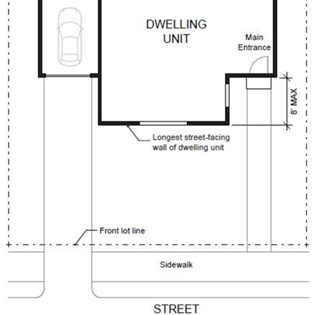
Figure 2. Main Entrance at 45° Angle from Street
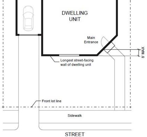
Figure 3. Main Entrance Facing Common Open Space
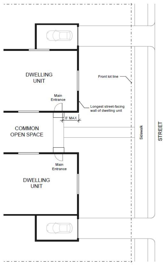
Figure 4. Main Entrance Opening onto a Porch
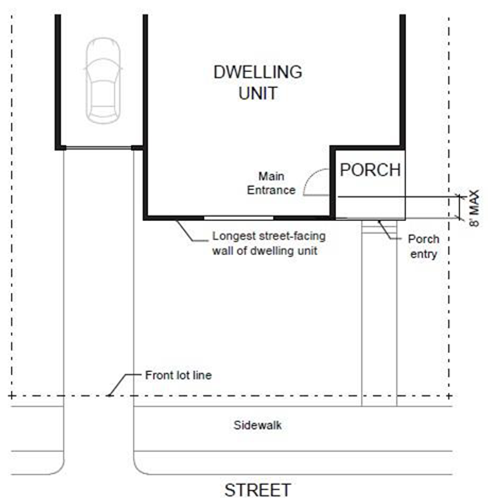
(2)
Windows. Windows must be provided on each street-facing façade as follows:
(a)
Front façade:
(i)
One story building: At least 12.5% of the total area of the street-facing façade.
(ii)
Building that is two stories or more: 15% of the total area of the street-facing façade.
(b)
Street side yard façade: At least 5% of the total area of the street-facing façade.
Entrance doors and/or ½ of the window area in the door of an attached garage may count toward meeting above standards. Plans shall include dimensions and total area of these elements and of the affected wall. For attached units, above percentages are per affected exterior building façade, not per unit. All exterior walls of a building that face the same direction shall be considered part of the same façade. Façades separated from the street property line by a dwelling are exempt from meeting this standard. See Figure 5.
(3)
On a corner lot, along the street-side yard, the building façade shall incorporate at least one of the following features:
(a)
A minimum 12-inch offset in the structural exterior building façade and roofline (see Figure 6). In a building containing attached units, the offset applies to the overall building façade, not each unit. All exterior walls of a building that face the same direction shall be considered part of the same façade;
(b)
A minimum of two types of siding materials and/or siding styles.
Figure 5. Window Coverage
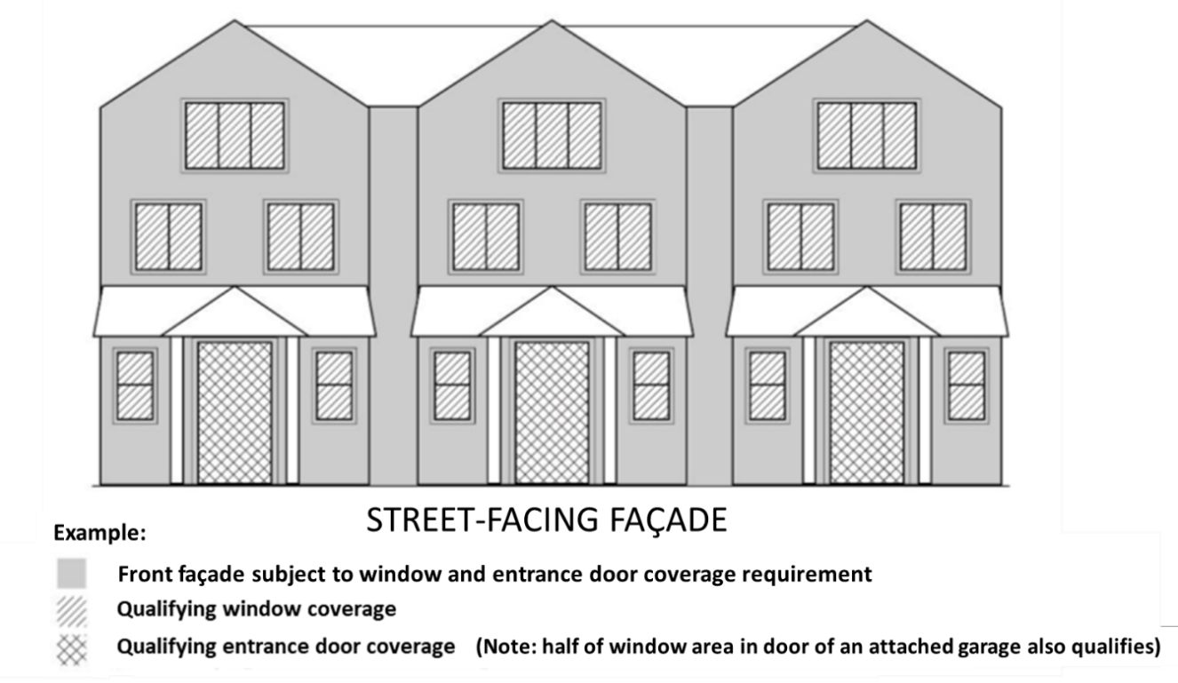
Figure 6. Example of 12-inch Offset in Building Façade
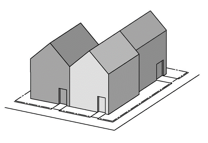
(4)
Driveway Approach. Driveway approaches must comply with the following:
(a)
The total width of all driveway approaches must not exceed 32 feet per total frontage of the parent lot, as measured at the property line (see Figure 7). For lots or parcels with more than one frontage, see Section (4)(c), below.
(b)
Driveway approaches may be separated when located on a local street or neighborhood route (see Figure 7). If approaches are separated, they must meet driveway spacing standards of Section 501-8.5 that apply to the particular road classification.
(c)
In addition, lots or parcels with more than one street frontage must comply with the following:
(i)
For lots or parcels abutting an improved alley (defined as meeting alley width and pavement standards under Section 409-3.3 A), access may be taken from the alley (see Figure 8).
(ii)
A Triplex or Quadplex building on a lot or parcel with frontages only on collector and/or arterial roads must meet access spacing standards of Section 501-8.5 B that apply to the particular road classification.
(iii)
A Triplex or Quadplex building on a lot or parcel with frontages only on local streets and/or neighborhood routes may have either:
• Two driveway approaches not exceeding 32 feet in total width on one frontage (see Figure 9); or
• One maximum 16-foot-wide driveway approach on each frontage (see Figure 9).
(d)
In the event of conflicts between Section 413 and above provisions, this Section shall prevail.
Figure 7. Driveway Approach Width and Separation on Local Street or Neighborhood Route
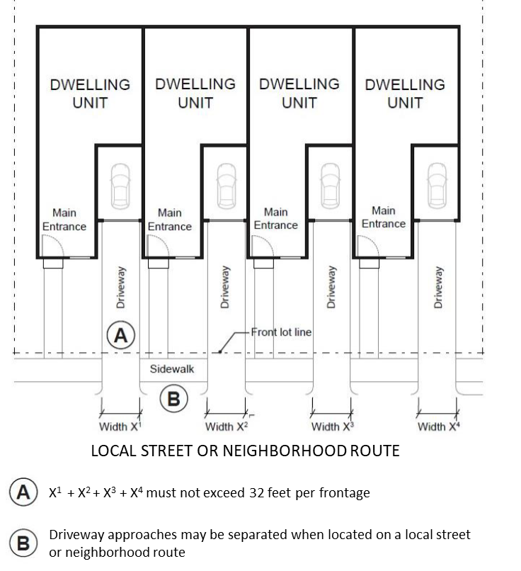
Figure 8. Alley Access
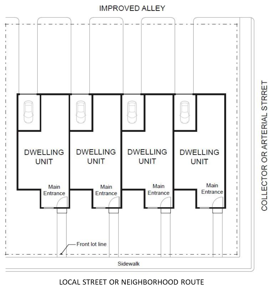
Figure 9. Driveway Approach Options for Multiple Local Street/Neighborhood Route Frontages
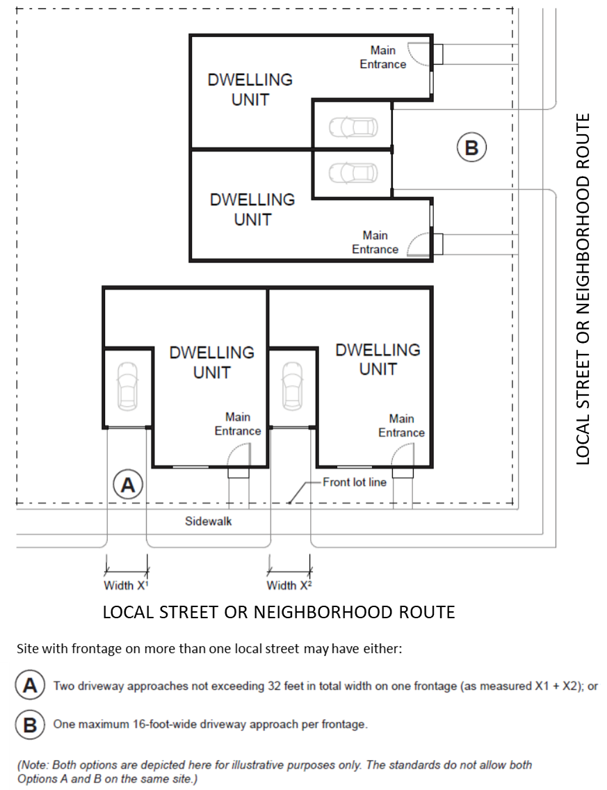
430-84.4
Townhouse Standards
A.
General Standards
(1)
Where allowed: In the R-5, R-6, R-9, R-15, R-24, R-25+, R-6 NB, R-9 NB, R-15 NB, TO: R9-12, TO: R12-18 or TO: R18-24 District on a lot that meets the minimum lot area requirements for Middle Housing Townhouses, provided that minimum required street frontage (15 feet) can be met for each separate Townhouse (See Article III).
(2)
Land Use District standards of Article III for Middle Housing shall be met.
(3)
Each individual Townhouse must be on a separate lot. Separate lots in a Townhouse development may be created through a Middle Housing Land Division meeting applicable provisions of Article VI.
(4)
Townhouses cannot be approved on a site where any existing ADU will remain as an ADU.
(5)
Applications must include evidence that Sufficient Infrastructure (as defined in Section 106) exists or will be completed prior to issuance of the first occupancy permit. (See requirements for service provider confirmation in Sections 409, 410 and 501).
(6)
Areas and improvements owned in common must be maintained by a homeowners association or other legal entity. A legal document providing for shared rights, restrictions and maintenance responsibilities must be recorded and a copy provided prior to issuance of a building permit.
(7)
For consolidated access or shared driveways, evidence of recorded easements to allow vehicular ingress and egress in favor of all lots needing access, and allowing emergency access, shall be provided prior to issuance of the first building permit.
(8)
Where proposed units will not meet minimum density for "Other housing" as specified in district standards (Article III), requirements of 430-37.1 B (1) though (4) also apply.
Note: Middle Housing is not required to meet minimum density that applies to other housing types. For purposes of 430-37.1 B, that density is used only to address feasibility for additional development in the future.
(9)
Requirements specified as applicable under Section 501 shall be met.
B.
Design Standards. New Townhouse buildings are subject to the following standards. A Townhouse building created by addition to or conversion of an existing Single Detached Dwelling Unit (430-84.6) is not subject to the following design standards.
(1)
Entry Orientation. The main entrance of each Townhouse must:
(a)
Be within eight feet of the longest street-facing wall of the dwelling unit if the lot has public street frontage; and
(b)
Regardless of whether the lot has street frontage, either:
(i)
Face the street (see Figure 1);
(ii)
Be at an angle of up to 45 degrees from the street (see Figure 2);
(iii)
Face a common open space or private access or driveway that is abutted by dwellings on at least two sides; or
(iv)
Open onto a porch (see Figure 4). The porch must:
• Be at least 25 square feet in area; and
• Have at least one entrance facing the street or have a roof.
(2)
Unit Articulation. Each Townhouse must include at least one of the following on at least one street-facing façade (see Figure 10):
(a)
A roof dormer a minimum of four feet in width;
(b)
A balcony a minimum of two feet in depth and four feet in width and accessible from an interior room;
(c)
A bay window that extends from the facade a minimum of two feet;
(d)
An offset of the facade of a minimum of two feet in depth, either from the neighboring Townhouse or within the façade of a single Townhouse;
(e)
An entryway that is recessed a minimum of three feet;
(f)
A covered entryway with a minimum depth of four feet; or
(g)
A porch meeting the standards of subsection 430-84.4 B (1)(b)(iv), above and associated setbacks of the district.
Balconies and bay windows may encroach into a required setback area.
Figure 10. Townhouse Unit Articulation
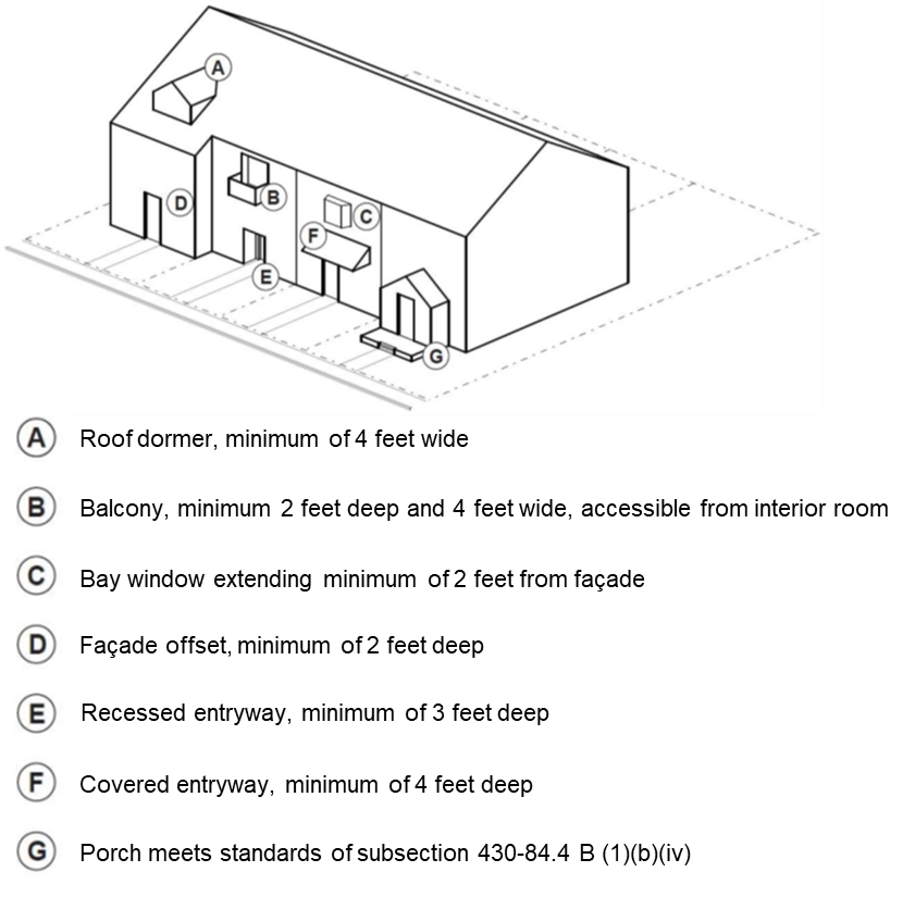
(3)
Windows. Windows must be provided on each street-facing façade as follows (See Figure 5):
(a)
Front façade:
(i)
One story building: At least 12.5% of the total area of the street-facing façade.
(ii)
Building that is two stories or more: 15% of the total area of the street-facing façade.
(b)
Street side yard façade: At least 5% of the total area of the street-facing façade.
Entrance doors and/or ½ of the window area in the door of an attached garage may count toward meeting above standards. Plans shall include dimensions and total area of these elements and of the affected wall. For attached units, above percentages are per affected exterior building façade, not per unit. All exterior walls of a building that face the same direction shall be considered part of the same façade. Façades separated from the street property line by a dwelling are exempt from meeting this standard (See Figure 5).
(4)
On a corner lot:
(a)
Window requirements of (3), above, apply to each street-facing façade; and
(b)
Along the street side yard, the building shall incorporate at least one of the following features:
(i)
A minimum 12-inch offset in the structural exterior façade and roofline (See Figure 6). In a building containing attached units, the offset applies to the overall building façade, not each unit. All exterior walls of a building that face the same direction shall be considered part of the same façade;
(ii)
A minimum of two types of siding materials and/or siding styles.
(5)
Driveway Access on a public street is allowed for Townhouses as follows:
(a)
Along frontage of a local street or neighborhood route:
(i)
A maximum of one driveway approach is allowed for each individual Townhouse lot.
(ii)
Driveway approaches and/or driveways may be shared as shown in Figures 11, 12 and 13.
(iii)
Townhouse developments may take access from an improved alley (defined as meeting alley width and pavement standards under Section 409-3.3 A). (See Figure 8).
Figure 11. Townhouses with Driveway Approaches on Local Street/Neighborhood Route Frontage
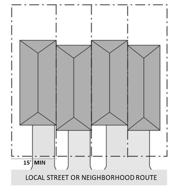
(b)
Where a site has frontage(s) only on collector and/or arterial road(s):
(i)
Access points in a Townhouse development shall be consolidated into a single driveway, except that additional consolidated driveways may be allowed subject to full compliance with spacing standards of 501-8.2 B. Driveway(s) and approach(es) are not allowed in the area directly between the front façade and front lot line of any of the Townhouses. (See Figures 12 and 13).
(ii)
No off-street parking shall be allowed in the front yard of a Townhouse (See Figures 12 and 13).
(iii)
Townhouse developments may take access from an improved alley (defined as meeting alley width and pavement standards under Section 409-3.3 A). (See Figure 8).
Figure 12. Townhouses on Corner Lot with Shared Access in Easement
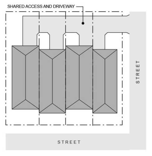
Figure 13. Townhouses with Consolidated Access
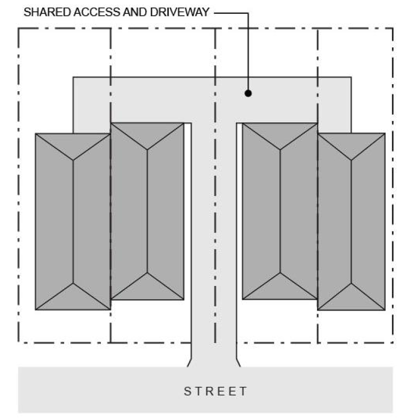
430-84.5
Cottage Cluster Standards
A.
General Standards
(1)
Where allowed: In the R-5, R-6, R-9, R-15, R-24, R-25+, R-6 NB, R-9 NB, R-15 NB, TO: R9-12, TO: R12-18 or TO: R18-24 District on a lot that meets the minimum lot area required for a Cottage Cluster development as outlined in standards of the applicable district (See Article III).
(2)
Land Use Districts standards of Article III for Middle Housing shall be met.
(3)
All units in a Cottage Cluster development may be on a single lot or the land may be divided into separate lots for each unit through a Middle Housing Land Division meeting applicable provisions of Article VI.
(4)
Up to 12 cottage units are allowed per common courtyard.
(5)
Additional courtyard(s) consistent with (4), above, are required when a Cottage Cluster development proposes more than 12 units total.
(6)
Each cottage unit is limited to a maximum building footprint of 900 square feet. The following do not count toward this maximum:
(a)
Up to 200 square feet of an attached garage or carport;
(b)
Detached garages, detached carports, or detached accessory structures;
(c)
Trellises; patios; areas of porch, deck, and balcony less than 30 inches from finished grade; cantilevered covers, porches or projections; ramps and stairways required for access.
(7)
The maximum building height for cottages and community buildings is 25 feet.
(8)
The maximum average floor area for a Cottage Cluster is 1,400 square feet per dwelling unit. Floor area is measured for each floor from the exterior faces of a building or structure. The following do not count toward the maximum average floor area for Cottage Cluster units (see Figure 14):
(a)
Up to 200 square feet of an attached garage or carport;
(b)
Detached garages, detached carports, detached accessory structures and community buildings that do not meet the definition of a dwelling unit under Section 106;
(c)
Areas where the elevation of the floor is four feet or more below the adjacent right-of-way;
(d)
Roof area;
(e)
Roofed porches, exterior balconies, or other similar areas, unless they are enclosed by walls that are more than 42 inches in height for 75% or more of their perimeter.
Figure 14. Areas Excluded from Floor Area Calculation
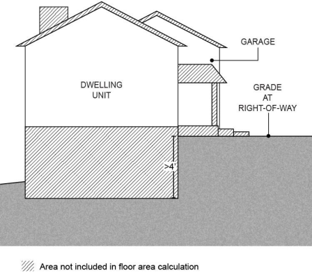
(9)
An existing Single Detached Dwelling Unit, regardless of its size, may remain on a lot or parcel with a Cottage Cluster. It shall count as one cottage in the maximum of units per common courtyard.
(10)
Any existing ADU that is retained shall count toward the maximum number of cottage units per common courtyard; and
(a)
The applicant shall specify whether the existing ADU is:
(i)
To be considered a cottage (must meet CDC definition and requirements applicable to that housing type); or
(ii)
To remain as an ADU, in which case the ADU shall be considered nonconforming (Section 440).
(b)
Where a unit is retained as an ADU, the site is not eligible for a Middle Housing Land Division (Article VI).
(11)
Applications must include evidence that Sufficient Infrastructure (as defined in Section 106) exists or will be completed prior to issuance of the first occupancy permit. (See requirements for service provider confirmation in Sections 409, 410 and 501).
(12)
Where the total of proposed and existing housing units (to be retained) will not meet minimum density for "Other housing" as specified in district standards (Article III), requirements of 430-37.1 B (1) though (4) also apply.
Note: Middle Housing is not required to meet minimum density that applies to other housing types. For purposes of 430-37.1 B, that density is used only to address feasibility for additional development in the future.
(13)
Requirements specified as applicable under Section 501 shall be met.
B.
Design Standards
(1)
Cottage Orientation. Cottage Cluster development must meet the following standards (see Figure 15):
(a)
Cottages must be clustered around a common courtyard. Each cottage within a cluster must either abut the common courtyard or directly connect to it by a pedestrian path.
(b)
A minimum of 50% of cottage units within a cluster must be oriented to the common courtyard and must:
(i)
Have a main entrance facing the common courtyard;
(ii)
Be within 10 feet from the common courtyard, measured from the façade of the cottage to the nearest edge of the common courtyard; and
(iii)
Be connected to the common courtyard by a pedestrian path.
(c)
Cottages within 20 feet of a street property line may have their primary entrance facing the street.
(d)
Cottages not facing the common courtyard or the street must have their primary entrance facing a pedestrian path that is directly connected to the common courtyard.
(2)
Common Courtyard. Each Cottage Cluster must share a common courtyard meeting the following standards (see Figure 15):
(a)
The common courtyard must be:
(i)
A single, contiguous piece.
(ii)
A minimum of 150 square feet for each cottage in the cluster.
(iii)
A minimum of 15 feet wide at its narrowest dimension.
(iv)
Developed with a mix of landscaping, lawn area, pedestrian paths, and/or paved courtyard area, and may also include recreational amenities. Impervious elements of the common courtyard shall not exceed 75% of the total common courtyard area.
(v)
Bordered by cottages on at least two sides.
(b)
Paths that are contiguous to a courtyard shall count toward the courtyard's minimum dimension and area. Parking areas, required setbacks, and driveways do not qualify as part of a common courtyard.
Figure 15. Cottage Cluster Orientation and Common Courtyard Standards
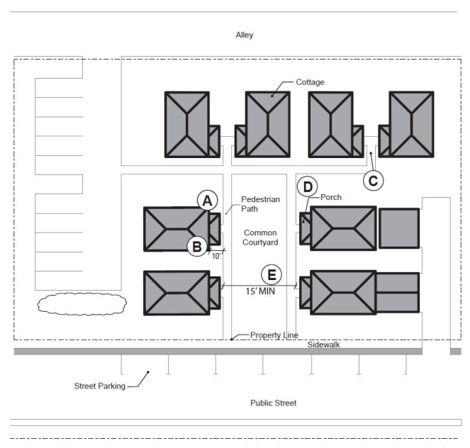
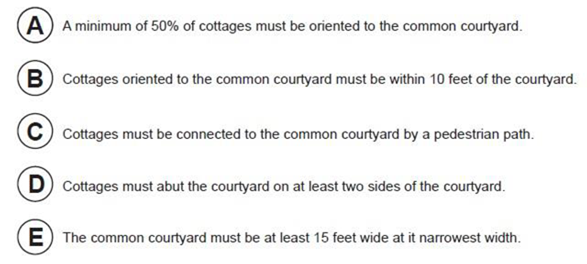
(3)
Community Buildings. Cottage Cluster projects may include community buildings for the shared use of residents, that provide space for accessory uses such as community meeting rooms, guest housing, exercise rooms, day care, or community eating areas. Community buildings must meet the following standards:
(a)
Each Cottage Cluster is permitted one community building;
(b)
A community building that meets the definition of a dwelling unit (Section 106) is limited to the maximum footprint of 900 square feet that applies to a cottage, and counts toward the maximum 1,400 square foot average for cottages, unless a restriction is recorded against the property stating that the structure is not a legal dwelling unit and will not be used as a primary dwelling. A copy of the proposed restriction must be submitted with the development application and evidence of its recordation provided prior to issuance of the first building permit;
(c)
A community building that meets the definition of a dwelling unit (Section 106) shall be counted as one unit in the maximum per common courtyard, unless the restriction noted in (3)(b), above, is recorded. Other community buildings shall not count toward the maximum units per courtyard.
(4)
Pedestrian Access.
(a)
An accessible pedestrian path must be provided that connects the main entrance of each cottage to the following:
(i)
The common courtyard;
(ii)
Shared parking areas;
(iii)
Community buildings; and
(iv)
Sidewalks in public rights-of-way abutting the site; or to rights-of-way if there are no sidewalks.
(b)
The pedestrian path must be hard-surfaced and a minimum of four feet wide.
(5)
Windows. Cottages within 20 feet of a street property line must meet the window coverage requirement that applies to a Single Detached Dwelling Unit or Duplex under 430-37.1 A (1).
(6)
Parking Design (see Figure 16).
(a)
Clustered parking. Off-street parking may be clustered, subject to the following standards:
(i)
Cottage Cluster developments with fewer than 16 cottages are permitted parking clusters of not more than five contiguous spaces.
(ii)
Cottage Cluster developments with 16 cottages or more are permitted parking clusters of not more than eight contiguous spaces.
(iii)
Parking clusters must be separated from each other by at least four feet of landscaping.
(iv)
Clustered parking areas may be covered.
(b)
Parking location and access (see Figure 16).
(i)
Off-street parking spaces and vehicle maneuvering areas shall not:
• Be located within 20 feet of any street property line, except alley property lines. This standard does not apply to an individual or combined driveway on a local street or neighborhood route that serves the garage(s) of up to two cottage units;
• Be located between a street property line and the front façade of cottages located closest to the street property line. This standard does not apply along alley property lines or to an individual or combined driveway on a local street or neighborhood route that serves the garage(s) of up to two cottage units;
• Directly abut a shared courtyard.
(ii)
Off-street parking spaces shall not be located within five feet of any other property line. This standard does not apply along alley property lines or to an individual or combined driveway on a local street or neighborhood route that serves the garage(s) of up to two cottage units. Driveways and drive aisles are permitted within five feet of other property lines.
(c)
Garages, carports and accessory structures.
(i)
Carports (whether shared or individual) must not abut common courtyards.
(ii)
An accessory structure must not exceed 400 square feet in floor area (not applicable to a detached garage or community building).
(7)
An existing Single Detached Dwelling Unit may remain on a lot or parcel with a Cottage Cluster. The existing dwelling:
(a)
May be lawfully nonconforming with respect to standards of this code.
(b)
May be expanded up to the maximum building footprint in Section 430-84.5 A (6) or the maximum height in Section 430-84.5 A (7); however, an existing dwelling that exceeds these maximums may not be expanded.
(c)
Shall be excluded from the calculation required under Section 430-84.5 B (1)(b).
(d)
Shall not count toward the maximum average floor area for cottages.
(e)
Is not subject to design standards of Section 430-84, including any expansions.
Figure 16. Cottage Cluster Parking Design Standards
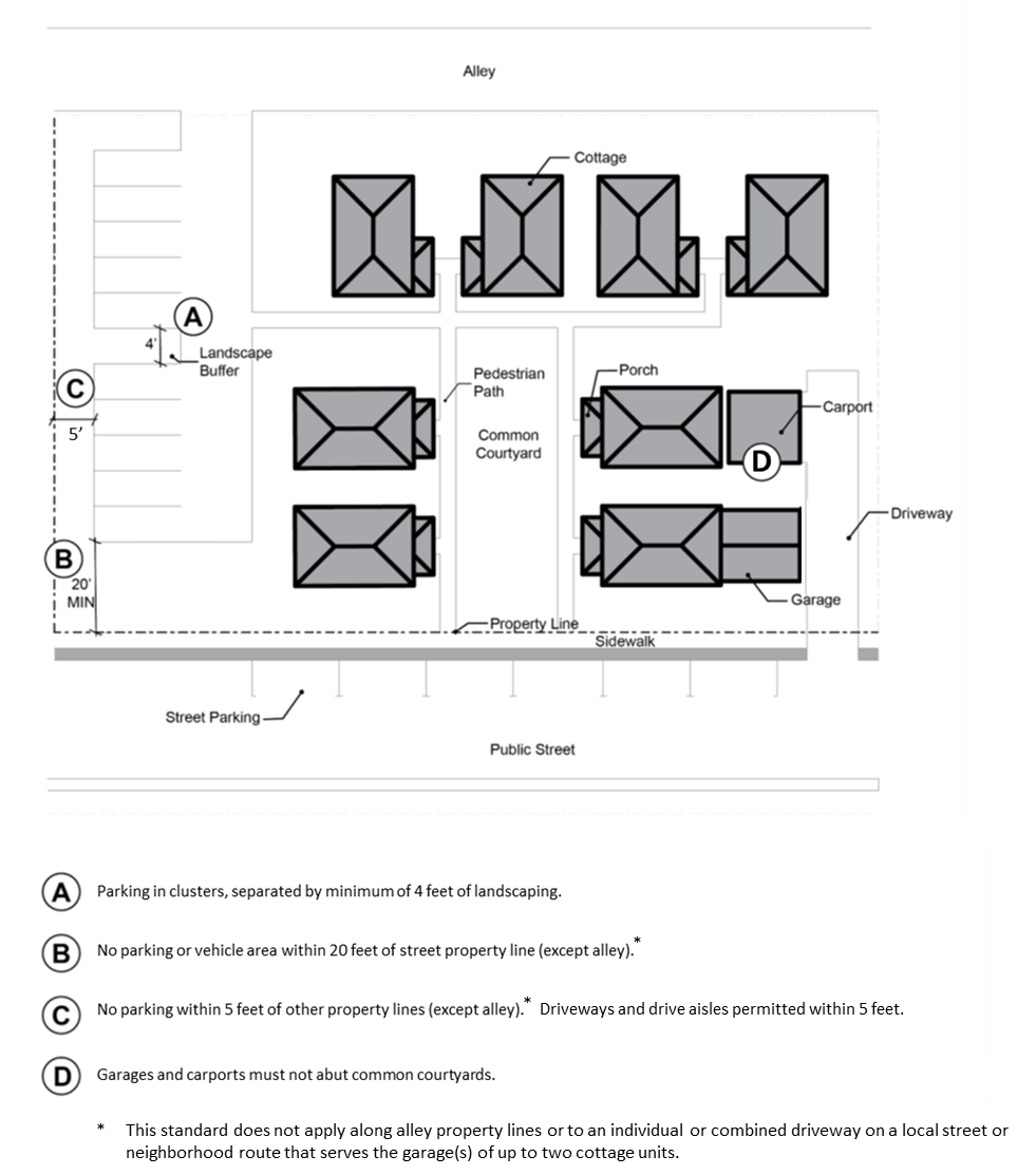
430-84.6
Middle Housing Conversion Standards
A.
General Standards
(1)
Where allowed: Conversions to Middle Housing are allowed in the R-5, R-6, R-9, R-15, R-24, R-25+, R-6 NB, R-9 NB, R-15 NB, TO: R9-12, TO: R12-18 or TO: R18-24 Districts.
(2)
Additions to, or conversions of, an existing Single Detached Dwelling Unit into Middle Housing must not increase nonconformance with applicable clear and objective standards.
B.
Design standards: Not Applicable.
(Ord. No. 885A, § 2.1.(Exh. 1, § 27.), 6-28-22, eff. 7-28-22; Ord. No. 890A, § 2.A.(Exh. 1, §§ 1., 23.), 2-7-23, eff. 3-9-23; Ord. No. 902A, § 2.B.(Exh. 2, § 38.), 11-5-24, eff. 12-5-24)
430-85 - Nonfarm Detached Dwelling Unit
A Nonfarm Dwelling in the EFU or AF-20 District is a dwelling not provided in conjunction with farm use. For tracts that are predominately high-value farmland, address Sections 430-85.1, 85.4 and 85.5. For tracts that are not predominately high-value farmland, address Sections 430-85.2 or 85.3 and 85.4 and 85.5.
430-85.1
On land identified as high-value farmland, a nonfarm dwelling may be established on a lot or parcel upon written findings showing all of the following:
A.
The dwelling or activities associated with the dwelling will not force a significant change in or significantly increase the cost of accepted farming or forest practices on nearby lands devoted to farm or forest use;
B.
The dwelling will be sited on a lot or parcel that is predominantly composed of Class IV through VIII soils that would not, when irrigated, be classified as prime, unique, Class I or II soils;
C.
The dwelling will be sited on a lot or parcel created before January 1, 1993;
D.
The dwelling will not materially alter the stability of the overall land use pattern of the area.
In determining whether a proposed nonfarm dwelling will alter the stability of the land use pattern in the area, the applicant shall provide findings addressing the cumulative impact of possible nonfarm dwellings and parcels on other lots or parcels in the area similarly situated. To address this standard, the applicant shall:
(1)
Identify a study area for the cumulative impacts analysis. The study area shall include at least 2,000 acres, or a smaller area not less than 1,000 acres if the smaller area is a distinct agricultural area based on topography, soil types, land use pattern, or the type of farm or ranch operations or practices that distinguish it from other, adjacent agricultural areas. Findings shall describe the study area, its boundaries, the location of the subject parcel within this area, why the selected area is representative of the land use pattern surrounding the subject parcel and is adequate to conduct the analysis required by this standard. Lands zoned for rural residential or other urban or nonresource uses shall not be included in the study area;
(2)
Identify within the study area the broad types of farm uses (irrigated or nonirrigated crops, pasture or grazing lands), the number, location and type of existing dwellings (farm, nonfarm, hardship, etc.), and the dwelling development trends since 1993. Determine the potential number of nonfarm dwellings that could be approved under Section 430-85, including identification of predominant soil classifications, the parcels created prior to January 1, 1993 and the parcels larger than the minimum lot size that may be divided to create new parcels for nonfarm dwellings under Section 424. The findings shall describe the existing land use pattern of the study area including the distribution and arrangement of existing uses and the land use pattern that could result from approval of the possible nonfarm dwellings;
(3)
Determine whether approval of the proposed nonfarm dwellings together with existing nonfarm dwellings will materially alter the stability of the land use pattern in the area. The stability of the land use pattern will be materially altered if the cumulative effect of the existing and potential nonfarm dwellings will make it more difficult for the existing types of farms in the area to continue operation due to diminished opportunities to expand, purchase or lease farmland, acquire water rights or diminish the number of tracts or acreage in farm use in a manner that will destabilize the overall character of the study area.
E.
The dwelling is situated upon generally unsuitable land for the production of farm crops and livestock, considering the terrain, adverse soil or land conditions, drainage and flooding, location and size of the tract. A lot or parcel shall not be considered unsuitable solely because of its size or location if it can reasonably be put to farm use in conjunction with other land;
F.
Complies with such other conditions as the Review Authority considers necessary.
430-85.2
On land not identified as high-value farmland, a nonfarm dwelling may be established on a lot or parcel with soils predominantly in capability Classes IV through VIII as determined by the Agricultural Capability Classification System in use by the United States Department of Agriculture Soil Conservation Service on October 15, 1983, upon written findings showing all of the following:
A.
The dwelling or activities associated with the dwelling will not force a significant change in or significantly increase the cost of accepted farming practices on nearby lands devoted to farm use;
B.
The dwelling is situated upon generally unsuitable land for the production of farm crops and livestock, considering the terrain, adverse soil or land conditions, drainage and flooding, location and size of the tract. A lot or parcel shall not be considered unsuitable solely because of its size or location if it can reasonably be put to farm use in conjunction with other land; and
C.
Complies with such other conditions as the Review Authority considers necessary.
430-85.3
A Nonfarm Dwelling in the EFU or AF-20 District on a lot or parcel, lawfully created between January 1, 1948, and July 1, 1983 upon written findings showing the following:
A.
Only one lot or parcel exists if a lot or parcel described in this Section is contiguous to one or more lots or parcels described in this Section; and on July 1, 1983, greater than possessory interests are held in those contiguous lots, parcels or lots and parcels by the same person, spouses or a single partnership or business entity, separately or in tenancy in common;
B.
The lot is not larger than three acres;
C.
The dwelling or activities associated with the dwelling will not force a significant change in or significantly increase the cost of accepted farming practices on nearby lands devoted to farm use.
D.
The dwelling complies with other conditions as the Review Authority considers necessary.
E.
Upon receipt of an application for a permit for a dwelling under Section 430-85.2, the Review Authority shall notify:
(1)
Owners of land that is within 250 feet of the lot or parcel on which the dwelling will be established; and
(2)
Persons who have requested notice of such applications and who have paid a reasonable fee imposed by the county to cover the cost of such notice.
F.
The notice required in Subsection 430-85.2 E. of this section shall specify that persons have 15 days following the date of postmark of the notice to file a written objection on the grounds only that the dwelling or activities associated with it would force a significant change in or significantly increase the cost of accepted farming practices on nearby lands devoted to farm use. If no objection is received, the Review Authority shall approve or disapprove the application. If an objection is received, the Review Authority shall set the matter for hearing pursuant to Section 205. The Review Authority may charge the reasonable costs of the notice required by Section 430-85.2 E. to the applicant for the permit requested under Section 430-85.2.
G.
For purposes of this Section, contiguous means lots, parcels or lots and parcels that have a common boundary, including but not limited to lots, parcels or lots and parcels separated only by a public road.
430-85.4
All applicants for nonfarm dwellings shall:
A.
Sign and record, in agreement form, in the Department of Assessment & Taxation Recording Division, a waiver of the right to remonstrate against commonly accepted farm or forest practices which may occur on adjacent lands;
B.
Provide evidence that the lot or parcel upon which the dwelling is proposed has been disqualified for valuation at true cash value for farm use under ORS 308.370 or other special assessment under ORS 308.765, 321.352, 321.730 or 321.815, and has paid the additional tax or penalty, if any, imposed by the County Assessor under ORS 308.399 or 321.960, whichever is applicable.
C.
Record in the Department of Assessment & Taxation Recording Division the following restrictive covenant:
"This parcel is not eligible for a dwelling until the parcel has been disqualified for special tax assessment and the appropriate penalty paid as required by law. This restrictive covenant shall run with the land and may be removed or modified only upon approval of Washington County."
430-85.5
The following special procedure shall apply to all dwellings subject to Section 430-85.
A.
The Director shall not issue a building permit for a lot or parcel which has received approval for a nonfarm dwelling under Section 430-85 for the establishment of a dwelling on a lot or parcel in an exclusive farm use zone that is, or has been, receiving special assessment without evidence that:
(1)
The lot or parcel upon which the dwelling is proposed has been disqualified for valuation at true cash value for farm use under ORS 308.370 or other special assessment under ORS 308.765, 321.352, 321.730 or 321.815; and
(2)
The additional tax or penalty, if any, imposed by the County Assessor under ORS 308.399 or 321.960, whichever is applicable, has been paid.
B.
The owner of a lot or parcel which has received approval for a nonfarm dwelling under Section 430-85 shall, prior to issuance of a building permit:
(1)
Notify the County Assessor that the lot or parcel is no longer being used as farmland; and
(2)
Request that the County Assessor disqualify the lot or parcel for special assessment under ORS 308.370, 308.876, 321.352, 321.730 or 321.815.
C.
A parcel that has been disqualified pursuant to Section 430-85.4.B. shall not requalify for special assessment unless, when combined with another contiguous parcel, it constitutes a qualifying parcel.
D.
When the owner of a lot or parcel upon which the establishment of a dwelling has been approved for a nonfarm dwelling notifies the County Assessor that the lot or parcel is no longer being used as farmland and requests disqualification of the lot or parcel for valuation at true cash value for farm use, the County Assessor shall:
(1)
Disqualify the lot or parcel for valuation at true cash value for farm use under ORS 308.370 by removing the special assessment for farm use as provided by ORS 308.397(1);
(2)
Provide the owner of the lot or parcel with written notice of the disqualification for valuation at true cash value for farm use under ORS 308.370; and
(3)
Impose the additional tax or penalty, if any, provided by ORS 308.399 or 321.960, whichever is applicable.
430-88 - Outdoor Performing Arts Center
An Outdoor Performing Arts Center is a land use consisting of an amphitheater with either fixed, permanent or temporary seating or a combination thereof used on a seasonal basis for musical performance theater or similar productions.
430-88.1
Outdoor Performing Arts Centers shall:
A.
Be within one-quarter mile of a freeway interchange;
B.
Provide own security and traffic control;
C.
Be limited to 5,000 permanent seats. Additional, non-permanent seating may be provided;
D.
Provide appropriate public facilities without extending urban services outside the UGB. Where services are available adjacent to the site, uses may connect to existing facilities; and
E.
There shall be a minimum lot size of 40 acres.
430-88.2
The applicant shall provide written findings that:
The amphitheater or activities associated with it, will not force a significant change in or significantly increase the cost of accepted farming or forestry practices on nearby lands devoted to farm or forest use.
430-88.3
The applicant shall be required to submit findings for exception to LCDC Goals pursuant to LCDC Goal 2, OAR 660-004-0020. Any exception request shall be processed as a quasi-judicial plan amendment. The development review application may be heard and processed in conjunction with the plan amendment.
430-89 - Park and Ride Facility
Privately or publicly owned and operated parking facilities, including parking structures, furnished to support public transit by providing an area for vehicular parking at a convenient distance from transit stations or bus lines. Park and Ride Facilities are built in order to reduce congestion, and to make use of public transit more viable. Applications for park and ride facilities in conjunction with the Transit Corridor or a Timed Transfer Station shall:
430-89.1
The applicant shall submit written material based upon a study of the area served and the transit services provided which:
A.
Justifies the lot area, number of parking stalls and any other facilities being proposed; and
B.
The method of access to the transit vehicle.
430-89.2
The applicant shall submit a site plan which includes at a minimum:
A.
Adequate auto parking areas;
B.
Passenger waiting areas;
C.
Separate drop off area;
D.
Bicycle parking facilities; and
E.
Access to transit vehicle.
430-89.3
Park and ride lots shall meet the standards of Section 413 (Parking and Loading) of the Community Development Code.
430-89.4
Where an existing parking lot is designated for joint use as a park and ride lot, the lot shall be exempt from the standards of Section 430-89.1 through 430-89.3.
430-91 - Parking (not in conjunction with an allowed use) in the Neighborhood Commercial (NC), Community Business (CBD), and General Commercial (GC) Districts.
A parking area is an off-street area containing one or more parking spaces, with passageways and driveways appurtenant thereto. In an NC, CBD, or GC District, a lot or parcel may be used for the parking or storage of cars in conjunction with a permitted use in a different district, provided:
430-91.1
The subject lot or parcel is located within 100 feet of the permitted use;
430-91.2
No buildings or structures shall be allowed in conjunction with the parking;
430-91.3
The area used for parking shall be developed to the standards of Section 413 (Parking and Loading); and
430-91.4
Only directional signs shall be allowed.
(Ord. No. 903, § 2.M.(Exh. 13, § 20.), 10-15-24, eff. 11-14-24)
430-97 - Parks (Public and Private)
A Park, which includes a playground, includes the use of an area set apart for recreation of the public to promote its health, enjoyment and the environment. A Playground is a park with playground equipment.
430-97.1
Type I
Parks are allowed through a Type I procedure when no building permit is required, except for playground equipment, or off-street parking facilities are required and the use is not carried on as a business.
430-97.2
Type II
Where a building permit or parking facilities are required, except as specified in Section 430-97.1, or if the chief activity of the park is carried on as a business, the following standards shall apply:
A.
All side and rear setbacks to any building or swimming pool shall be no less than 45 feet;
B.
The front yard setback shall be the same as the primary district; and
C.
Facilities and structures, except as permitted as a Special Recreation Use (Section 430-131), that are incidental and subordinate to the park may be permitted, including but not limited to service yards, maintenance equipment storage and repair, indoor picnic facilities, and except in the EFU, AF-20 and EFC Districts, caretaker residences. In the EFC District only caretaker residences for public parks may be permitted.
D.
Park approvals shall be conditioned to provide for maintenance.
430-97.3
Parks Identification Signage
Parks Identification Signage which fronts on a street right-of-way is subject to the following:
A.
The maximum sign area shall be 35 square feet per display surface; and
B.
A maximum of five identification signs per park.
430-99 - Membership Organization
A Membership Organization includes buildings and grounds used for and operated by a nonprofit organization, whose membership is by invitation and election according to qualifications in the club's charter or bylaws. The use of the club's facilities is primarily restricted to members and their guests. Membership organizations may be allowed subject to the following:
430-99.1
A minimum lot size of 15,000 square feet;
430-99.2
A minimum front and rear yard of 20 feet;
430-99.3
A minimum side yard of 20 feet;
430-99.4
Where a golf course is included - See Section 430-51 for additional standards; and
430-99.5
Where other sports facilities are involved see Section 430-131 (Special Recreation Use) for additional standards.
430-100 - Private Hunting and Fishing Operations in the EFC District
Private hunting and fishing operations which do not constitute development as defined in Section 106-57 are not subject to these standards.
Any accessory structure or seasonal accommodation shall be incidental to hunting or fishing that occurs primarily on the parcel on which the structure is located and on adjoining parcels owned or leased by the operator.
430-100.1
Accessory structures for private hunting and fishing operations may be allowed subject to the following standards:
A.
The structures shall be incidental and subordinate to the hunting or fishing operation;
B.
The structures shall not be used as a dwelling or for overnight accommodations; and
C.
Only minor and accessory retail sales which serve only users of the hunting or fishing operation shall be permitted.
430-100.2
Private Seasonal Accommodations for Fee Hunting Operations may be allowed subject to the following standards:
A.
No more than 15 units as defined by the Oregon Structural Specialty Code shall be permitted;
B.
The accommodations approved under this Section may be occupied only for the purpose of hunting during game bird and big game hunting seasons as authorized by the Oregon Fish and Wildlife Commission; and
C.
Only minor and accessory retail sales which serve only users of the hunting operation shall be permitted.
430-100.3
Private accommodations for fishing occupied on a temporary basis may be allowed subject to the following standards:
A.
No more than 15 units as defined by the Oregon Structural Specialty Code shall be permitted;
B.
Accommodations shall only be occupied temporarily for the purpose of fishing during fishing seasons authorized by the Oregon Fish and Wildlife Commission;
C.
Accommodations shall be located within one-quarter mile of fish-bearing Class I waters;
D.
Only minor and accessory retail sales which serve only users of the fishing operation shall be permitted; and
E.
The applicant shall sign and record in agreement form, in the Department of Assessment & Taxation Recording Division, a statement which recognizes the rights of adjacent and nearby land owners to conduct forest operations consistent with the Forest Practices Act and Rules.
430-101 - Professional Office (in a Residential District)
A professional office is the office of a person engaged in any occupation, vocation or calling, not purely commercial, mechanical or agricultural, in which a professed knowledge or skill in some department of science or learning is used by its practical application to the affairs of others. When professional office uses are located in a residential district they shall be allowed only in conjunction with residential development and shall:
430-101.1
Occupy no more than 20% of the floor area of a residential structure.
430-101.2
If separate from the residential structure, only 20% of the total floor area of the development may be used for office purposes when:
A.
The building permit for the office use is not issued until 60% of the residential structure(s) is (are) occupied; and
B.
The structure meets the dimensional standards of the primary district.
430-101.3
If both Professional Office (Section 430-101) and Neighborhood Commercial (Section 430-82 or 430-83) uses are proposed, the two uses together shall not exceed 20% of the floor area of the residential development.
430-101.4
In addition to the allowed residential signs, there shall be no more than 12 square feet of sign area.
(Ord. No. 831A, § 2.A.(Exh. 1, § 18), 7-17-18, eff. 8-16-18)
430-102 - Processing Facility for Farm Products
A processing facility for farm products in accordance with Section 340-4.1 D. or Section 344-4.1 D. shall:
A.
Limit total processing area to less than 10,000 square feet of floor area, regardless of the number of buildings on-site. Processing area does not include floor area designated for preparation, storage or other farm use.
B.
Demonstrate compliance with Section 430-80 (Marijuana Facilities and Marijuana Production) when seeking approval for commercial processing of marijuana subject to an OLCC license requirement.
C.
Comply with all applicable siting standards, except that:
(1)
The standards shall not be applied in a manner that prohibits the siting of the processing facility.
(2)
Facilities less than 2,500 square feet are not subject to siting standards.
D.
Remain on the same parcel or lot as the farm operation. A condition of approval shall be applied to ensure compliance with this requirement.
(Ord. No. 877A, § 2.A.(Exh. 1, § 6.), 10-11-21, eff. 11-10-21)
430-103 - Public Building
Public Building: Any building held, used, or controlled exclusively for public purposes by any department or branch of government (Federal, State, County, municipal or special district) and private, nonprofit agency serving the public, including such uses as Art Gallery, Auditorium, Community Building, Governmental Services Structure, Library, or Museum, is subject to the following:
430-103.1
Must submit a total site plan with application which indicates any proposed buildings, parking, landscape concept, and any future phased development proposed for the site as well as a schedule of development;
430-103.2
In Residential Districts (except along property lines abutting a non-residential district) the minimum buffering requirements for public buildings shall be as follows:
A.
Setbacks shall be a minimum of 20 feet; and
B.
Screening and Buffering Type #3 (as described in Section 411-6.3) shall be provided.
430-103.3
Inside the UGB, public buildings (except for police and fire stations) shall have access onto a collector or arterial level street. In order to reduce potential conflicts and ensure compatibility with surrounding uses, police and fire stations accessing a local road or neighborhood route shall demonstrate compliance with the following additional standards:
A.
The site size and dimensions provide:
(1)
Adequate area for the needs of the proposed use; and
(2)
Adequate area to support an overall site design which includes area for required buffering between the proposed use and the surrounding neighborhood;
B.
Except along property lines abutting a non-residential district, Screening and Buffering Type #3 (Section 411-6.3) shall be provided unless the Review Authority requires additional screening and buffering to comply with Section 430-103.3 C.
C.
Site and building designs focused on neighborhood compatibility and mitigation of potential adverse effects on surrounding properties and uses, including consideration of window and entry orientation, building height, landscaping and screening, setbacks, parking lot location, and lighting.
D.
The proposed use can be developed in a manner that is compatible with and would not substantially alter the character of the surrounding area.
430-105 - Public Utility
Any corporation, including municipal or semi-municipal corporation, service district, company, individual, or association that owns or operates any plant or equipment for the conveyance of telegraph or telephone messages, with or without wires; for the transportation of water, gas, or petroleum products by pipeline; for the production, transmission, delivery or furnishing of heat, light, water, or electricity; for the trans-mission and delivery of television pictures and sound by cables; for the transportation of persons or property by street, railroads or other street transportation or common carriers; for the disposal of sewage; or for the disposal of storm water runoff.
430-105.1
A public utility service center includes any buildings or premises used for the administration of public utility repair, maintenance and installation crews including parking for vehicles, but not including warehouses or storage yards.
430-105.2
A public utility service yard includes any buildings or premises used for the office, warehouse, storage yard, or maintenance garage of a public utility including microwave repeater stations when incorporated as part of the service yard use.
430-105.3
A public utility service facility includes buildings, structures, and equipment within a fenced or otherwise enclosed area for the purpose of switching, regulating or controlling public utility services.
430-105.4
Approval of a public utility shall be based upon a study submitted by the applicant which includes:
A.
The need for the facility, present or future; and how the facility fits into the utility's Master Plan; and
B.
The minimum area required for the facility for the present and anticipated expansion.
C.
What measures will be used to minimize damage to paved roads and natural resources or open space.
430-105.5
Site size and yard shall be based upon a site plan submitted by the applicant. The site plan shall consider especially, the compatibility of the facility with existing surrounding uses and uses allowed by the plan designation.
430-105.6
Exemptions from the Requirements of Section 430-105:
Exempted from these regulations are:
A.
Underground pipes and conduits except where such pipes or conduits would introduce an urban service outside the Urban Growth Boundary.
For all sewer lines, there shall be no connections to the line unless approved pursuant to Section 430-105.7.
Individual hookups to community, private or public water systems;
B.
Above ground electric transmission, distribution, communication and signal lines on a single pole system where a single pole system is defined as above ground electrical lines and their supporting concrete, wood or metal poles, but does not include self-supporting steel lattice-type structures;
C.
Public utility facilities in the form of receiving and transmitting antennas and communication towers. These uses are subject to the applicable provisions of Section 430-109; and
D.
Improvements for public transit agencies, including maintenance facilities and track for light rail transit.
430-105.7
Underground pipes and conduits which introduce an urban service outside the Urban Growth Boundary.
Prior to commencing any extension of underground pipes or conduits for urban services into any area outside the Urban Growth Boundary, an applicant shall provide a sworn affidavit that no hookups to the extended line will be allowed outside the UGB except:
A.
Waterlines (Must also comply with OAR 660-011-0065)
(1)
Within the boundaries of a lawfully created community, private or public water system or district, as allowed by Policy 22 of the Rural/Natural Resource Plan; or
(2)
To replace water from an existing water supply that has been documented to be unsafe for human consumption or insufficient to support domestic uses, in the manner described by the Rural/Natural Resource Plan.
B.
Sewerlines (Must also comply with OAR 660-011-0060)
(1)
To relieve an identified health hazard; or
(2)
Once the line is established, to provide for disposal of sewage in connection with:
(i)
A farm labor camp; or
(ii)
A food processing operation.
(3)
Notwithstanding (1) and (2) above, a connection to an existing sewerline may be approved for a residential use pursuant to OAR 660-011-0060(8) and (9).
430-107 - Race Track or Drag Strip (Automobile, Motorcycle, Go-Cart, Horse or Dog)
Race tracks or drag strips may be allowed subject to the following:
430-107.1
The use meets all the requirements of the primary district; and
430-107.2
Additional conditions as to lot size, setbacks, screening, construction standards, parking, maintenance as well as any other requirements deemed necessary to protect adjacent properties and the public interest.
430-109 - Telecommunication Facilities
The standards of this Section apply to all telecommunication facilities except as otherwise provided in Sections 201-2 and 430-109.3.
430-109.1
Intent and Purpose
This Section is intended to promote and protect the public health, safety and welfare; preserve the aesthetic character of the community; and reasonably regulate the development and operation of telecommunication facilities within the county to the extent permitted under state and federal law.
These regulations seek to ensure that telecommunication facilities are designed and located to minimize the number of towers and mitigate visual impacts while providing necessary communication services to the county.
This Section addresses three different types of telecommunication facilities:
A.
Colocation of antennas
B.
Expansion of existing telecommunication facilities
C.
New Telecommunication Facilities:
(1)
With towers using Stealth Design; or
(2)
With towers not using Stealth Design.
430-109.2
Telecommunication Facility Definitions
Terms and definitions that apply throughout the Community Development Code are found in Section 106. Following are definitions for the terms found in Section 201-2.30, 201-2.31 and Section 430-109:
Antenna. A device for transmitting or receiving radio frequency (RF) signals or electromagnetic radiation, such as digital and analog signals, radio frequencies, broadcast signals, such as television and radio signals, and other communication signals. Antennas are typically mounted on a supporting tower, pole or mast, building or other approved structure. Types of antennas include directional antennas such as panel antennas, microwave dishes, and omni-direction antennas such as whip antennas. Antennas do not include domestic satellite dishes. Additionally, some antennas operate as both transmitting and receiving devices.
Broadcast Tower. A tower, pole, or mast whose primary purpose is to elevate an antenna above the surrounding terrain or structures for the transmission of radio or television signals. The actual broadcast tower itself may also function as the antenna, (e.g., for AM broadcast radio) if part of the apparatus is necessary to produce a clear signal or message within the licensee's operating range, as allowed by the Federal Communications Commission. Broadcast towers are often sited within a non-staffed broadcast facility for the transmission of radio or television signals.
Colocation. Mounting or installing an antenna on a preexisting structure, including modifying a structure for the purpose of mounting or installing one or more antennas.
Concealment. When design elements are used to minimize the visual appearance of telecommunication facilities; also known as stealth design.
Eligible Facilities Request. Any request for modification of an existing, lawfully established telecommunication tower or base station that does not substantially change the physical dimensions of such tower or base station, involving colocation of new transmission equipment or replacement of transmission equipment.
Equipment Shelter. An enclosed structure or cabinet usually placed at or near the base of a communication tower where electrical and other equipment necessary for the operation of the facility are housed. Cables connect the shelters to the antenna(s).
Essential Public Communication Service. Emergency communication network for emergency response by public agencies including fire and rescue, medical, law enforcement and other public agencies, including but not limited to water and sanitary and storm sewer providers.
Essential Public Communication Service Facility. All equipment including antennas for the transmission and reception of radio frequency signals (wireless telecommunication, wireless Internet, radio/television broadcast, and other related wireless communications) for essential public communication services. These facilities also include associated towers, equipment shelters, accessory support equipment (generators, fuel sources, HVAC), landscaping, fencing, and parking areas located on the site for the network.
Federal Communications Commission (FCC). An independent government agency established by the Communications Act of 1934 and charged with regulating interstate and international communications by radio, television, wire, satellite and cable.
Minimally Off-set Antenna. Antenna or antenna array mounted to the face of a structure (including a tower or building) and protruding no more than 18 inches from the outermost mounting point.
Non-Residential Land Use Districts. FD-20, FD-10, NC, OC, CBD, GC, IND, INST, SID, TO:RC, TO:EMP, TO:BUS, EFU, EFC, AF-20, R-COM, R-IND, NCC NB, NCMU NB, INST NB and MAE.
Radio Frequency Emission. Electromagnetic radiation that is of low photon energy unable to cause ionization and is generated by a transmitting antenna.
Residential Land Use District. R-5, R-6, R-9, R-15, R-24, R-25+, R-6 NB, R-9 NB, R-15 NB, R-24 NB, R-25+ NB, TO:R9-12, TO:R12-18, TO:R18-24, TO:R24-40, TO:R40-80, TO:R80-120, CCMU, NMU, AF-5, AF-10 and RR-5.
Small Wireless Facility. A low-power telecommunication facility used to provide increased capacity to wireless telecommunication networks or provide infill coverage that meets all of the following:
A.
Mounted on a structure 50 feet or less in height including antennas; or mounted on a structure no more than 10% taller than other adjacent structures; or does not extend an existing structure on which facility is located to a height of more than 50 feet or by more than 10%, whichever is greater;
B.
Each antenna associated with the deployment, excluding associated antenna equipment, is no more than 3 cubic feet in volume;
C.
All other equipment associated with the structure, including any preexisting telecommunications equipment, is no more than 28 cubic feet in volume; and
D.
The facility, including antennas and associated equipment, complies with FCC requirements for registration, radiofrequency emissions and other applicable standards.
Speculation or "Spec" Tower. A tower for the purpose of providing location mounts for future antennas without a binding contractual commitment by a service provider to locate an antenna upon the tower at time of the original application submittal.
Stealth Design. The design of new antennas or towers in a manner that camouflages, conceals, or disguises the facilities so that they are visually compatible with the surroundings as described in Section 430-109.7 A. Examples include an indigenous evergreen tree, flag pole, light post, pole sign, clock or bell tower, steeple, or silo.
Telecom Hotel. A building or structure designed to warehouse telecommunication equipment, including utility hookups and connections to fiber-optic networks.
Telecommunication Facility. All equipment, including: antennas for the transmitting and/or receiving of radio frequency signals or electromagnetic radiation (e.g., wireless telecommunication service and wireless internet/'Wi-Fi'), broadcast signals (e.g., radio and television), and other communication signals; broadcast or telecommunication tower or existing structures used to support antennas; accessory equipment and accessory improvements such as landscaping, fencing and parking areas, located on the site.
Telecommunication Facility Site. A whole or a portion of a parcel, which is owned or leased by one or more broadcast or wireless telecommunications provider where a broadcast or communication tower and its supporting equipment are located. The site also includes the equipment shelter and required site improvements, including landscaping, but does not include site access. When located on a portion of a parcel, these areas are usually fenced off from the remainder of the parcel.
Telecommunication Tower: Any structure built for the sole or primary purpose of elevating any FCC-licensed or authorized antenna above the surrounding terrain, or structures for the transmission and/or receiving of radio frequency (RF) signals or electromagnetic radiation to provide wireless telecommunication service, including wireless internet service. This includes structures that are constructed for wireless communication services (e.g., broadcast and communication). Tower types include:
Guyed tower. A tower that is permanently connected to the ground by cables (guy wires).
Lattice tower. A self-supporting multiple-leg tower comprised of an open framework of either structural steel or diagonal cables or a combination thereof.
Monopole tower. A self-supporting, single, upright pole requiring no guy wires or diagonal cables to stabilize the structure.
430-109.3
Exemptions
The standards of this Section apply to all wireless telecommunication facilities except as otherwise provided herein. The following are exempt from the standards in this Section:
A.
Telecommunication facilities that are exempt from a development permit under Section 201-2;
B.
Reconstruction or replacement of telecommunication facilities lawfully established after November 26, 1992, the effective date of Ordinance No. 402, provided that it:
(1)
Does not increase the height or base diameter of the existing tower or structure as originally approved or constructed;
(2)
Does not expand the existing fenced equipment area around the tower or structure;
(3)
Does not reduce existing landscape buffers unless replaced with vegetation with similar characteristics, plant densities and maturity;
(4)
Does not use colors or lights that make the tower or antenna more visually obtrusive, unless required by either the Oregon Department of Aviation (ODA) or the Federal Aviation Administration (FAA);
(5)
Uses antennas and transmitters that are similar in nature to the antennas and transmitters they are replacing; and
(6)
Does not increase the number of antennas or transmitters.
Reconstruction or replacement of telecommunication facilities, excluding transmitter and antenna replacements pursuant to Section 430-109.3 B., approved before November 26, 1992 is subject to the provisions of Section 440, Nonconforming Uses, and applicable provisions of 430-109 as required by Section 440.
C.
Colocation on lawfully established telecommunication facilities (Eligible Facility Request) provided that:
(1)
For towers outside of the public right-of-way:
a.
The height increase is no more than 20 feet or 10 percent of the existing tower height, whichever is greater;
b.
Antennas and appurtenances do not protrude from the edge of an existing tower by more than 20 feet or the width of the tower structure at the level of appurtenance, whichever is greater; and
c.
If an appurtenance protrudes into the right-of-way, a right-of-way permit shall be obtained.
(2)
For other existing support structures (including towers within the public right-of-way):
a.
The height increase is no more than 10 feet or 10% of the existing height, whichever is greater; and
b.
Antennas and appurtenances do not protrude from the edge of the structure by more than 6 feet.
(3)
The colocation requires installation of no more than four new equipment cabinets on the site;
(4)
Excavation or deployment is not required outside the current telecommunication facility site;
(5)
Design does not defeat concealment elements, if approved with the existing facility; and
(6)
Design complies with the conditions of approval associated with the existing facility, unless non-compliance is due to an increase in height, increase in width, addition of cabinets, or new excavation or deployment that complies with the requirements in subsection (1) through (4) above.
D.
The following telecommunication facilities that are regulated by the Federal Communications Commission (FCC) pursuant to the Code of Federal Regulations:
(1)
Industrial, scientific, and medical equipment;
(2)
Military and government radar antennas and associated communication and broadcast towers used for aviation services; and
(3)
Amateur (ham) and citizen band transmitting and receiving antennas and associated communication and broadcast towers.
E.
A telecommunication facility as a temporary use - Section 430-135.1 H.;
F.
Temporary telecommunication facilities used solely for emergency communications by essential public communication service providers in the event of a natural disaster, emergency preparedness or for public health or safety purposes;
G.
Antennas to provide enhanced 911 (i.e., E911) network coverage when required by the FCC, subject to the following:
(1)
E911 antennas shall not increase existing facility height and shall be painted or otherwise constructed of materials with the same or similar color as the tower; and
(2)
Accessory equipment and related equipment are either located completely within the existing structure (e.g., tower, building or other structure), or are located within an existing fenced site. In the case of a tower that includes stealth design, E911 antennas shall also incorporate stealth design.
Existing 911 antennas may remain for a period not to exceed 6 months in order to accommodate the transfer of service from the existing 911 antennas to the E911 antennas.
430-109.4
Prohibited Uses
A.
The following uses are prohibited in all land use districts and roadway rights-of-way:
(1)
Installation of towers without antennas based on speculation of future antenna installation, also known as speculation ("spec") towers.
(2)
The attachment of any antennas or associated equipment to trees.
B.
Telecommunication facilities not excluded from permit requirements through Section 201-2.30 are prohibited in roadway rights-of-way.
430-109.5
Colocation Requiring Type I Review
Colocations that do not qualify for an Exemption pursuant to Section 430-109.3 shall be processed through a Type I procedure provided that the following requirements are met:
A.
The telecommunication facility shall only be illuminated when required by the ODA, FAA, or other state or federal agency;
B.
The telecommunication facility shall comply with Abandonment - Section 430-109.11;
C.
All visible facility equipment, including but not limited to antennas, cabling, and cabinets, shall be colored or finished similar to structure;
D.
When antennas are attached to a lawfully established tower or structure other than a building (e.g., water tank or electric transmission tower), the facility shall meet the following requirements:
(1)
Antennas do not increase existing facility height by more than 20 feet or 10% of the height of the tower or existing structure, whichever is greater.
(2)
The expansion of site for new accessory equipment is less than 25% of the existing area.
(3)
New equipment shelters comply with the standards in Sections 430-109.8 E. and 430-109.9 A.(2).
E.
Antennas on top of or attached to the side or roof edge of existing buildings shall meet the following requirements:
(1)
Antennas located on top of a building are to be screened from public view by being placed behind a parapet or other architectural feature or being incorporated into an architectural feature of the building, such as a dormer, chimney, clock, or bell tower.
(2)
Antennas located in a residential district do not extend more than 20 feet above the building.
(3)
Antennas located in a nonresidential district do not extend more than 30 feet above the building.
(4)
Antennas attached to the side or roof edge of a building in a residential district include Stealth Design incorporating the type and/or color of the building materials of the wall or roof on which the antennas are proposed to be attached.
(5)
Antennas attached to the side or roof edge of a building in a nonresidential district are colored or painted similar to the exterior building surface and are minimally off-set.
(6)
New accessory equipment is located either completely within the footprint of the existing structure or located within or on top of the building. Equipment located on top of a building is screened from public view or incorporated into an architectural feature of the building.
F.
When antennas are attached to an existing utility pole (defined as a monopole, double pole, or lattice utility structure) or other existing support structure for use as a Small Wireless Facility as defined in Section 430-109.2, the facility shall meet the following requirements:
(1)
To minimize visual impacts, either the Stealth Standards of Section 430-109.7 A. or all of the following design standards:
(a)
The support structure is a neutral nonreflective color;
(b)
Antennas protrude no more than 5 feet from the support structure; and
(c)
Accessory equipment is screened or otherwise hidden from public view and new equipment shelters comply with the standards in Sections 430-109.8 E. and 430-109.9 A.(2).
(2)
The Site Standards for Telecommunication Facilities - Sections 430-109.9 A., B., C., and E.
430-109.6
Expansion of Existing Telecommunication Facilities
Expansion of a lawfully established telecommunication facility, including colocation not otherwise allowed pursuant to Sections 201-2, 430-109.3 and 430-109.5, shall be processed through a Type II procedure and subject to the following:
A.
Telecommunication facilities and related site improvements lawfully in existence after November 26, 1992, are considered conforming uses. However, because these uses may not be designed in accordance with the current development standards (e.g., setbacks, landscaping, screening and fencing, etc.) future expansions, excluding replacement of antennas and transmitters pursuant to Section 430-109.3 B., shall be subject to the development standards in effect at that time, including this Section, to the extent reasonably practicable.
Where the applicant can show that the existing tower design or site configuration is not reasonably practicable to apply a current development standard, a new development action may be requested. The applicant shall provide an alternative development proposal that equally or better meets the purpose of the particular development standard. When the outcome of the proposed expansion results in a use subject to Type III review in another Section, review shall occur through the Type III procedure; otherwise requests subject to this section shall be reviewed through the Type II procedure.
B.
Enclosures shall be screened or otherwise be hidden from public view.
C.
Comply with the standards in Sections 430-109.8 and 430-109.9.
D.
Comply with concealment elements, if approved on a lawfully established facility.
E.
Comply with the conditions of approval associated with the lawfully established facility.
F.
Telecommunication facilities and related site improvements that were lawfully in existence prior to November 26, 1992, are considered nonconforming uses and shall be subject to the provisions of this section as well as the provisions of Section 440, Nonconforming Uses and Structures. However, existing antennas and transmitters replaced pursuant to Section 430-109.3, or colocation consistent with 430-109.5 are not subject to the provisions of this section or Section 440.
430-109.7
New Telecommunication Facilities
A.
Telecommunication Facilities with towers using Stealth Design
Telecommunication facilities with towers using stealth design, excluding those towers exempt pursuant to Sections 430-109.3 and 201-2, may be permitted in all land use districts through a Type I Procedure subject to the following requirements:
(1)
The tower is designed to resemble an object, other than a wireless telecommunication facility, in appearance, physical dimensions, proportion and scale. The object shall be one that exists or would commonly exist on-site or in the surrounding area based on the site's land use designation and natural features.
(2)
The tower design results in a tower that takes into account the site context and surrounding environment, camouflages or hides the antennas from public view;
(3)
The tower shall function in a manner consistent with its design, unless doing so would interfere with the operation of the antennas. For example, a flagpole-designed tower shall be able to function as a flagpole, and accessory attachments, such as flags, are sized in proportion to the tower;
(4)
Roof and ground-mounted accessory equipment (i.e., equipment shelters) shall be completely screened or hidden from public view. Examples of acceptable methods include placement within the interior of the building or structure, behind a roof parapet, or landscaping and a site-obscuring fence, within architectural elements such as a clock or bell tower, or concealed (e.g., placed within a shell made of material resembling a boulder). Alternatively, placement of equipment shelters in underground vaults is encouraged as an acceptable means of concealment; and
(5)
New individual antennas attached to a stealth tower shall be consistent with the stealth design of the tower.
B.
Telecommunication Facilities with towers not using Stealth Design
Telecommunication facilities with towers not using stealth design may be located in land use districts specified in Article III subject to the following requirements:
(1)
New individual antennas attached to a tower, shall be concealed, minimally off-set, or mounted on davit arms extending a maximum of 5 feet from the tower;
(2)
In residential districts, where permitted, analysis is required to show that the tower and antennas meet the following requirements:
(a)
The structures and accessory uses shall be arranged to minimize visual and noise impacts on adjacent developments and surrounding land uses; and
(b)
The structures and uses shall be located and designed in a manner that preserves scenic views or vistas identified in the applicable community plan and viewable from adjacent properties or public thoroughfares, by considering setbacks, building height, bulk and landscaping.
C.
Small Wireless Facilities
Telecommunication facilities utilizing a new structure that meets the definition of a Small Wireless Facility, excluding those facilities exempt pursuant to Sections 430-109.3 and 201-2, may be permitted in all land use districts through a Type I Procedure subject to the following requirements:
(1)
To minimize visual impacts, either the Stealth Standards of Section 430-109.7 A. or all of the following design standards:
(a)
The support structure is a neutral nonreflective color;
(b)
Antennas shall be concealed, minimally off-set or mounted extending a maximum of 5 feet from the support structure; and
(c)
Accessory equipment is screened or otherwise hidden from public view and new equipment shelters comply with the standards in Sections 430-109.8 E. and 430-109.9 A.(2).
(2)
The Site Standards for new Telecommunication Facilities located in Sections 430-109.9 A., B., C., and E.
430-109.8
General Design Standards for Telecommunication Facilities
A.
New towers not using Stealth Design shall be painted or otherwise treated in a manner that blends in with the surrounding area in order to minimize visual impact, unless state or federal regulations require different colors. The exterior color of the tower shall also be non-reflective in nature and make the tower as visually unobtrusive as possible. If there are stands of trees or other site-obscuring vegetation on site or in the immediate area, the tower shall be painted or finished to blend with the landscape;
B.
New towers shall be illuminated only when required by the ODA, FAA or other state or federal agency;
C.
Antennas on towers not using Stealth Design shall be made of a nonreflective material and colored or painted similar to the tower or structure. The antennas shall be minimally off-set, or mounted on davit arms extending a maximum of 5 feet from the tower. In the case of co-locating, the antennas shall match the design of the approved facility;
D.
Cabling and wiring shall be hidden from public view through installation internal to the tower or painted to match the color of the tower;
E.
When ground-mounted equipment shelters extend above site-obscuring fencing, the shelters shall be constructed of materials and/or finished with earth-tone colors that are non-reflective in nature and no taller than 12 feet high;
F.
Accessory equipment shall be screened or otherwise hidden from public view; and
G.
Documentation shall be submitted indicating the telecommunication facility can feasibly comply with the requirements of the FAA, the Oregon Department of Aviation, the FCC and any other applicable state or federal regulation.
430-109.9
Site Standards for Telecommunication Facilities
A.
Setbacks (See 430-109.9 Table B and Illustrations at end of Section 430-109).
(1)
New telecommunication facilities shall comply with the setback provisions of the individual land use districts, unless greater setbacks are required by Table B:
(2)
New ground-mounted equipment shelters shall comply with the setback provisions of the individual land use districts, except as set forth below:
Underground vaults containing equipment cabinets and other associated equipment supportive of wireless telecommunication facilities may be located in a required setback, except as otherwise restricted by the Uniform Building Code (UBC), the Uniform Fire Code (UFC) or subsection C. below.
(3)
Notwithstanding the requirements set forth in (1) and (2) above, the Review Authority may reduce the required setbacks through a Type III adjustment process, provided that the applicant can demonstrate to the Hearings Officer that the proposed site development plan will reduce the impacts on surrounding land uses. The Hearings Officer may approve an adjustment to the setbacks based on findings that:
(a)
The applicant has submitted an alternate siting and/or stealth tower design and development plan which utilizes existing on-site vegetation (e.g., trees) and/or buildings, topography or other site-specific factors or constraints to more effectively screen the tower and accessory equipment; and
(b)
Impacts to surrounding properties are less with the alternate setback as compared to the setbacks required by Table B, and can be mitigated for the benefit of the surrounding property owners by an adjustment to the setbacks.
B.
Access
(1)
In residential districts, when a site fronts a local street and a collector or a local street and an arterial, site access shall be from the Collector or Arterial subject to all applicable County standards. Access may be taken from the local street when access to a Collector or Arterial does not meet the applicable standards.
(2)
In non-residential districts, site access may be from a local street, a collector or arterial, subject to all applicable County standards.
(3)
Access to the site shall be oriented away from existing dwellings.
C.
Landscaping, Screening and Fencing
(1)
Landscaping, screening and buffering, including fencing, shall be provided as required by Sections 407 and 411 to screen the site from public view except when the equipment shelter is hidden from public view, such as when located within an existing building, designed to resemble a natural object, such as a boulder, or when it does not exhibit any visible exterior characteristics, such as cables, of an equipment shelter. However, in no case shall the screening and buffering within or adjacent to a residential district be less than what is required by Section 411-6.3. Tree and shrub species shall be selected that will attain a minimum height of 12 feet at maturity;
(2)
Fencing shall be a minimum 6-foot tall, site-obscuring (e.g., solid wood fence, chain link fence with slat inserts, or other solid material fencing) and installed in accordance with Sections 418 and 419. Barbed or razor wire is not permitted unless required by federal regulations for Essential Public Communication Services Facilities; and
(3)
In lieu of the standards in (1) and (2) above, the Review Authority may approve an alternate detailed landscape, screening and fencing plan through a Type II or III procedure. The plan shall be designed to screen and buffer towers and accessory uses when the plan accomplishes the same degree of screening achieved in (1) and (2) above, except when less screening is required to provide adequate visibility for security purposes or for continued operation of existing agricultural or forest uses.
D.
Clustering
In an urban residential district, a new telecommunication tower cannot be located within 1,000 feet of any existing telecommunication towers, except those exempt pursuant to Sections 430-109.3 and 201-2. This restriction does not apply to the siting of new antennas on existing towers or for Essential Public Communication Services Facilities. The 1,000-foot radius shall be measured from the center of the footprints of the towers, not from property lines or guy wire anchors.
E.
Signs
Notwithstanding the provisions of Section 300 and 414, all telecommunication facilities shall be identified with a sign not exceeding 4 square feet. The sign shall list the owner or operator's name and emergency telephone number and shall be posted in a location visible to the general public. Other signs may be located on the site as allowed by the underlying land use district.
430-109.10
Submittal Requirements for Telecommunication Facilities not otherwise exempt under Sections 430-109.3 and 201-2:
A.
All applications for telecommunication facilities, except as otherwise noted, shall include the following:
(1)
An accurate, scaled site plan and on-site analysis, consistent with Section 404-1, showing the location of the tower(s), guy anchors (if any), equipment shelter(s) and other uses accessory to the telecommunication facility; and
(2)
An accurate, scaled elevation drawing(s) showing the tower design, dimensions, materials and color of the tower and antennas, including the mounting type(s) and locations of all proposed antennas, and other uses accessory to the telecommunication facility.
B.
Applications for new telecommunication facilities shall also include:
(1)
A report demonstrating the need for the new facility, justifying the location of the proposed facility and that the proposed antenna(s) cannot be co-located on an existing or approved tower, building or other suitable structure within the identified search area; and
(2)
Information confirming the facility is designed to accommodate colocation.
(3)
Essential Public Communication Services Facilities shall be exempt from accommodating colocation.
C.
For telecommunication facilities with towers up to 200 feet tall in the EFU and AF-20 districts, the applicant shall demonstrate that the facility is necessary for public service pursuant to ORS 215.213 (1)(c) and OAR 660-033-0130 (16). Applications shall include a report consistent with ORS 215.275.
430-109.11
Abandonment
A.
All antennas and towers shall be considered abandoned when no licensed service provider has operated from the facility site for a period of 1 year. Within 90 days of abandonment, the property owner shall remove all facilities from the site and restore the site to its previous condition. In the event the communication or broadcast facilities are not removed within this time period, Washington County may remove the facilities and restore the site and assess the cost for such actions against the last service provider using the facilities, the owner of the facilities and the property owner.
B.
If any abandoned facilities have not been removed from a site, no new communication or broadcast facility in unincorporated Washington County shall be approved for that site.
(Ord. No. 856A, § 2.A.(Exh. 1, § 28), 10-22-19, eff. 11-28-19; Ord. No. 857, § 2.D.(Exh. 4, § 7), 8-27-19, 11-28-19)
Section 430-109.9 Table B: Setback Provisions
S - Structure-Mounted: The base of the antenna and/or its supporting tower shall maintain setbacks at least equal to the height of the antenna and its supporting tower. Dish or panel antennas shall be located at least 50 feet above grade and meet the minimum yard requirements of the underlying land use district (Figure 1).
R - Residential District: Provide setbacks for the tower/antenna at least equal to the height of the tower/antenna above grade, between the base of the tower and the property line. Provide setbacks of at least 50 feet between any guy anchors and the property line. Provide a setback of at least 25 feet between any accessory structures (except fences) and the property line (Figure 2).
D - District Height: Provide setbacks as required by the underlying land use district. However, in no case shall the setbacks be less than 100% of the height of the tower above grade, between the base of the tower and the boundary of any residential district existing at the time the application is submitted (Figure 3).
NR - Non-Residential District: Provide setbacks for the antenna/tower equal to 30% of the height of the tower above grade between the base of the tower and the property line. In no case shall the setback be less than 100% of the height of the tower above grade, between the base of the tower and the boundary of any residential district existing at the time the application is submitted. Provide setbacks for guy anchors and accessory uses (except fences) in accordance with the provisions of the underlying land use district (Figure 4).
Notwithstanding the provisions of NR above, within the FD-10, FD-20, EFU, AF-20 and EFC land use districts, the setbacks shall also not be less than 100% of the height of the tower above grade between the base of the tower and any dwelling unit in these districts existing at the time the application is submitted.
430-109-9 SETBACK ILLUSTRATIONS
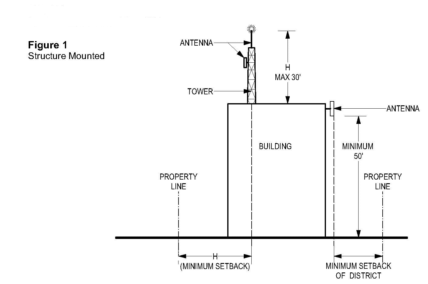
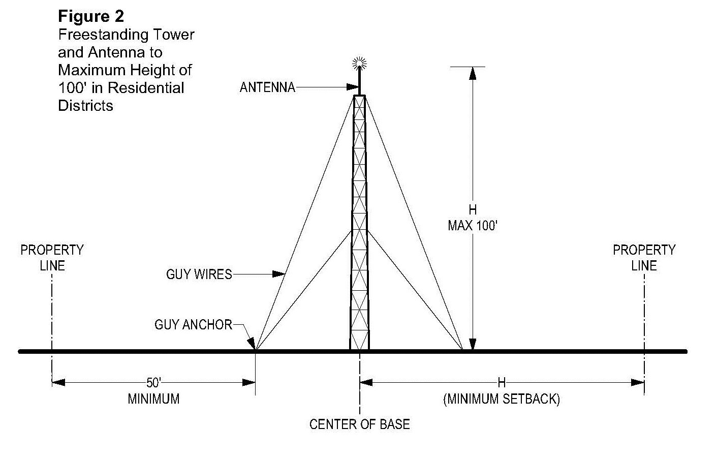
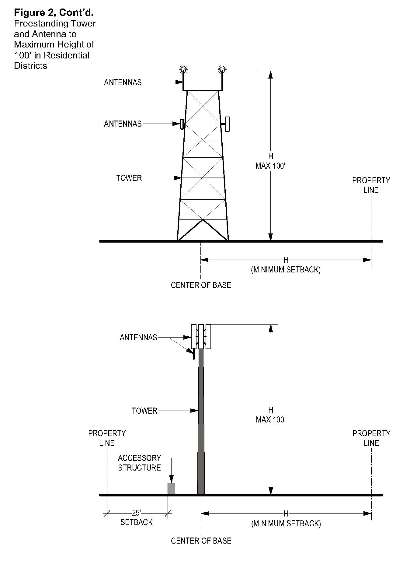
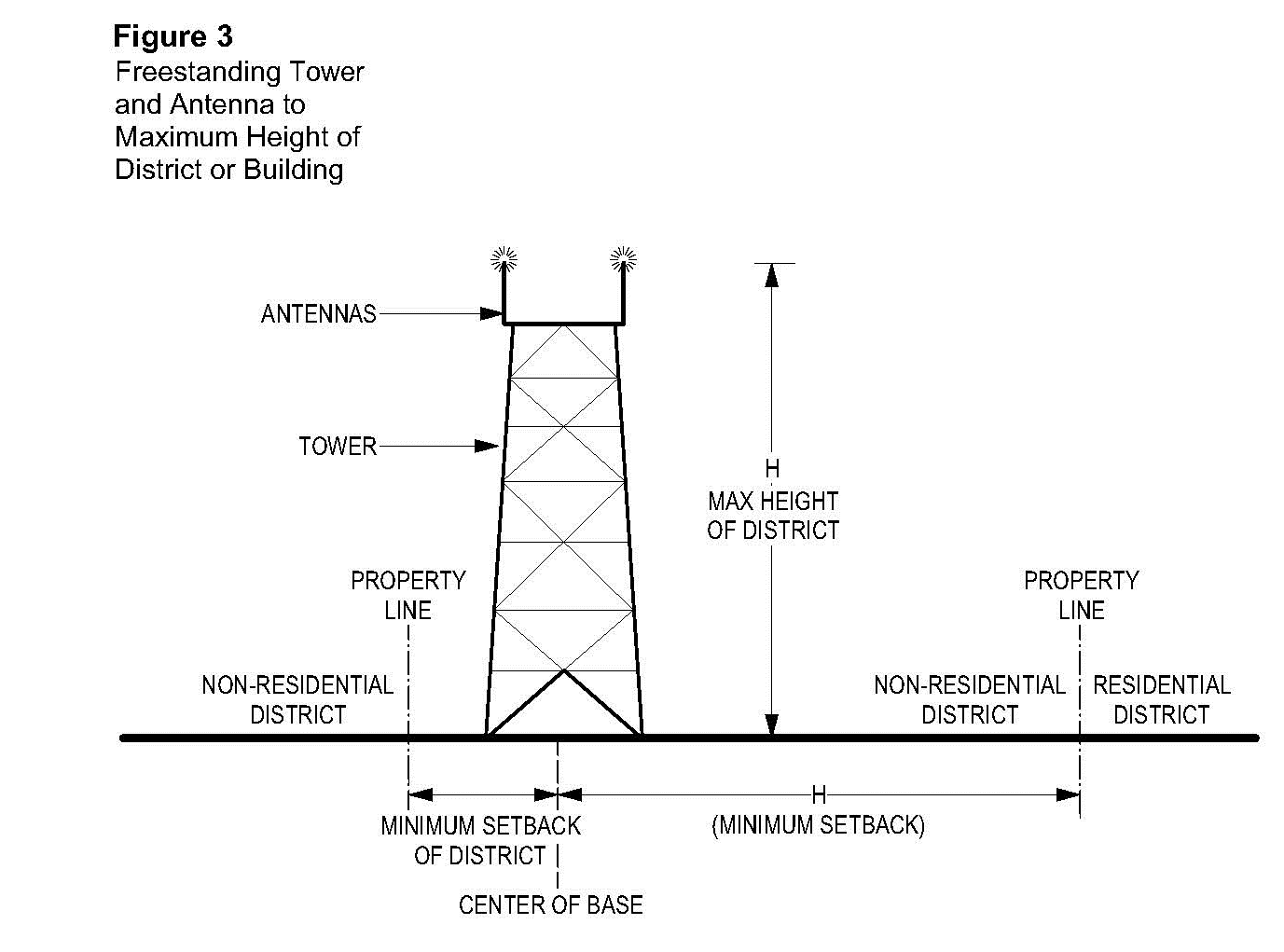
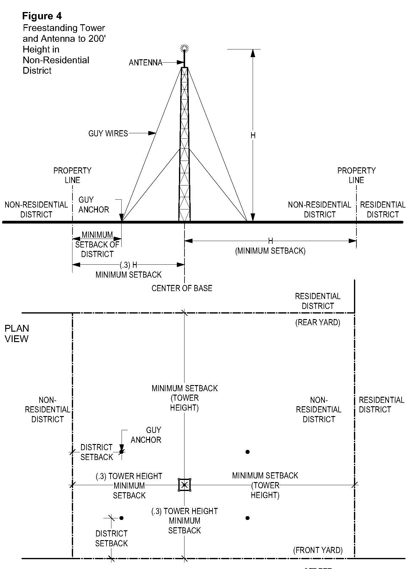
(Ord. No. 826A, § 2.A.(Exh. 1, § 29), 10-24-17, eff. 11-24-17)
430-113 - Recycle Drop Box
Recycle drop boxes including thrift-store drop boxes, shall include receptacles for recyclable materials such as newspapers, glass, clothing and other similar materials but does not include truck trailers stored on property for more than one month.
430-113.1
Drop boxes shall not be larger than 15' x 15' x 10';
430-113.2
Drop boxes shall be painted and maintained in good repair;
430-113.3
All collected items must be fully contained within the drop box;
430-113.4
The maximum sign area shall be 4 square feet.
430-113.5
In residential areas, drop boxes shall be on paved surfaces in conjunction with institutional (school, religious institution, etc.) parking lots.
430-115 - Recycling Center
A recycling center is any lot or portion of a lot greater in size than 300 square feet, used for the purpose of outdoor storage, sorting, handling, processing, dismantling of materials that cannot, without further reconditioning, be used for their original purposes, including such materials as glass, paper, plastic and aluminum, subject to the following:
430-115.1
A minimum site size of 20,000 square feet;
430-115.2
Must be located at least 100 feet from any school, religious institution, hospital, public building, retail and office commercial or residential uses on adjoining lots.
430-115.3
Screening:
All portions of the site used for storage shall be fenced and screened by a solid wood, painted metal or masonry fence a minimum of 6 feet in height, except on a site where:
A.
A portion of the site abuts a railroad right-of-way which is used for loading purposes; and
B.
Surrounding terrain would make fencing ineffective or unnecessary to screen the site from a public road.
430-115.4
The collection area of the center shall:
A.
Provide portable containers, placed within a stationary wood framework, solid fence or bin to prevent the containers from being overturned;
B.
Containers shall be equipped with a lid to prevent access to stored materials by animals or vermin, and to preclude stored paper from being scattered by wind;
C.
The collection area is to be no larger than 1,000 square feet; and
D.
All collection areas are to be provided instructional signing indicating how materials are to be separated and stating any limitations on the types of materials accepted for recycling.
430-115.5
Access to the recycling center shall be from a collector or arterial street.
430-115.6
Four off-street parking places shall be provided adjacent to the collection area.
430-116 - Religious Institution
A building or other development used for a faith-based organization such as a church, mosque, temple or synagogue; together with its accessory uses and buildings, including but not limited to monasteries, offices, schools and living quarters for caretakers.
430-116.1
There shall be a minimum lot area of 20,000 square feet. Additional area may be required based on the extent of the proposal;
430-116.2
Inside the Urban Growth Boundary, when access is proposed to a local street the access shall be located within 300 feet of an intersection with a collector or an arterial.
430-116.3
The minimum front yard for buildings under 45 feet in height shall be 30 feet;
430-116.4
The minimum front yard for buildings over 45 feet in height shall be 45 feet;
430-116.5
The minimum side or rear yards for buildings shall be as follows:
430-116.6
Signage shall be subject to the standards outlined under Section 414-2 (Institutional Districts); except as provided otherwise in the Institutional District (Section 330-9).
430-116.7
Building heights shall be subject to the standards outlined under Section 330 (Institutional District).
430-117 - Reserved
See the editor's note to § 430-2.
430-119 - Sawmill, Lumber Manufacturing
A sawmill is a manufacturing site for the conversion of logs into lumber.
430-119.1
Any structure associated with the sawmill or lumber manufacturing shall:
A.
Be required to have a building permit;
B.
Be subject to the provisions of Section 404-1, Type I Site Analysis;
C.
Have setbacks determined by the Review Authority based on:
(1)
Size of the structure;
(2)
Surrounding land uses;
(3)
Size and number of vehicles required for the use; and
(4)
Required fire protection buffers;
D.
Comply with the requirements of DEQ; and
E.
Comply with the requirements of the appropriate fire marshal;
430-119.2
Signs:
A.
Only one sign shall be allowed per use; and
B.
It shall have a maximum area of 35 square feet.
430-121 - Schools, Including Nursery (Private and Public)
A place for systematic instruction in any branch or branches of knowledge including any of the following: nursery, kindergarten, primary, intermediate and high school or combination thereof, which may be a public school or a private school offering instruction substantially similar to public schools. School does not include trade and commercial schools or day care facilities.
430-121.1
Residential facilities, provided in conjunction with a school, may be approved as part of a school master plan pursuant to this Section, provided the facilities are for the exclusive use of staff and students affiliated with the school. Residential facilities may include dormitories.
430-121.2
Before and/or after school child care provided at a school exclusively for students affiliated with the school is permitted pursuant to Section 201-2.19.
430-121.3
Schools in the EFU and AF-20 Districts shall be small in size, rural in character and not require urban services. Alterations or expansions of existing K-12 schools is allowed for schools established on the subject tract prior to January 1, 2009 when the expansion occurs:
A.
On the same tax lot on which the school is located; or
B.
On a tax lot that is contiguous to the tax lot on which the school is located and, as of Jan. 1, 2015, was in the same ownership as the tax lot on which the school is located.
430-121.4
The minimum setback for all yards shall be 30 feet.
430-121.5
The maximum sign areas shall be:
A.
Less than 1 acre - 12 square feet.
B.
On 1 to 10 acres - 70 square feet.
C.
Greater than 10 acres - 150 square feet.
Except as provided otherwise in the Institutional District (Section 330-9).
(Ord. No. 877A, § 2.A.(Exh. 1, § 6.), 10-11-21, eff. 11-10-21)
430-123 - Service Station and/or Car Wash
A commercial establishment primarily involved with sales and services of motor fuels. In addition, the following may occur: supplying goods and services generally required in the operation and maintenance of automotive vehicles, including sales of petroleum products, sale and servicing of tires, batteries, automotive accessories and replacement items; car washing and lubricating services; the performance of minor automotive maintenance and repair, and the supplying of other incidental customer services and products. No merchandise or incidental items, including prizes or premiums, shall be displayed outside an enclosed building. Major automotive repairs, painting and fender work are excluded. Service Stations and car washes are subject to the following:
430-123.1
Entrances and Exits
A.
Access shall be determined based upon a site inspection which considers:
(1)
Site size;
(2)
Road classification;
(3)
Sight distance and allowed m.p.h.; and
(4)
Adjacent development.
B.
Consolidation of access with adjoining uses shall be encouraged, particularly when the proposed driveway is within 10 feet of the side property line.
430-123.2
Lighting, sign illumination, height and hours of operation may be restricted through the development review process in consideration of possible negative impact on nearby residential uses.
430-123.3
No display of merchandise outside the building except small items such as oil, windshield wiper blades and tires (limited to one rack of 20).
430-123.4
No outside storage or sale of vehicles is permitted for more than 24 hours per vehicle.
430-123.5
Hours of operation shall be limited to normal hours of operation in the Office Commercial District. Normal hours of operation are 7:00 a.m. to 6:00 p.m.
430-125 - Shooting Club
Shooting clubs may be allowed subject to the following:
430-125.1
The minimum lot size shall be 20 acres; and
430-125.2
The minimum front, side and rear yard to any main building or use shall be 200 feet.
430-127 - Solid Waste Disposal Site
430-127.1
Ordered to be established by the Environmental Quality Commission under ORS 459.049; or
430-127.2
A site for the disposal of solid waste approved by the governing body of a city or county or both and for which a permit has been granted under ORS 459.245 by the Department of Environmental Quality, together with equipment, facilities or buildings necessary for its operation.
430-127.3
A lawfully established solid waste disposal site, in existence on the effective date of this ordinance, may have access provided through the R-9 or R-15 District subject to the following:
A.
Review of the proposed access shall be concurrent with the review of the solid waste disposal site through Section 430-127.1 or 430-127.2, whichever is applicable;
B.
Access shall be to an Arterial or Collector road; and
C.
The proposed access and the property which includes all or part of the access shall comply with the applicable standards of Sections 501-2 through 501-8 and Section 502 (Sidewalk Standards), in addition to the standards of Section 501-9.
430-129 - Solid Waste Transfer Station
A transfer station is an enclosed building which serves as a receiving station for solid waste delivered by commercial garbage haulers and/or the general public. The transfer station is an interim storage and transfer point between the collection route and a disposal site. A solid waste transfer station may provide for processing and recycling of solid waste. Solid waste transfer stations may be permitted subject to the following:
430-129.1
There shall be a minimum lot size of 5 acres;
430-129.2
Transfer stations shall be located adjacent to a collector, arterial or limited access highway;
430-129.3
Application for a solid waste transfer station shall include a Master Plan which shall include but not be limited to:
A.
Location, sizes and function of all structures, screening and buffering; and
B.
Street construction and traffic control plan, including access, stacking lanes, circulation and parking;
430-129.4
Written Material indicating:
A.
Measures to be taken to control noise, dust, odor and litter (on-site and off-site litter);
B.
Maximum daily capacity of facility; and
C.
Daily and peak trip generation.
430-129.5
A recycling or processing center included with a solid waste transfer station shall:
A.
Provide maneuvering area to be integrated with traffic flow of transfer station;
B.
Have provisions for temporary storage and containment of recyclable materials; and
C.
Provide parking and maneuvering area which does not interfere with traffic to the solid waste transfer area;
430-129.6
Resource Recovery Facility in Conjunction with a Solid Waste Transfer Station:
A.
A resource recovery facility is a building, equipment, process or combination thereof where or by which useful material or energy resources are obtained from solid waste; and
B.
Where a resource recovery facility is included as part of the transfer station, Sections 430-129.3 through 430-129.4 shall include an explanation of how the recovery facility meets the criteria.
430-130 - Special Mineral/Aggregate Mining and/or Processing in the EFC District
Special Mineral/Aggregate Mining and/or Processing may be approved in the EFC district on a site that does not meet the minimum quantity threshold under OAR 660-023-0180(3)(a) that applies to significant aggregate resource sites in the Willamette Valley.
Section 430-130 provides associated standards intended to protect against undesirable impacts to neighboring properties and to ensure site reclamation for future reuse in a manner compatible with surrounding uses and consistent with provisions of the EFC district.
Standards and protections of CDC Section 379 and Statewide Planning Goal 5 that relate to significant mineral/aggregate resources do not apply to this use.
430-130.1
Exclusions
A land use permit is not required for mining operations meeting exclusion/exemption provisions outlined in OAR 632-030 and ORS 517. An exclusion certificate, issued by the Oregon Department of Geology and Mineral Industries (DOGAMI), is required for mining activity that removes less than 5,000 cubic yards and affects less than 1 acre of land within a 12-month period. Operators of mineral and aggregate operations who do not have a land use permit may be asked to provide evidence of an exclusion certificate. DOGAMI operating permits and County land use approval are required for mining activities that don't meet exclusion requirements noted above.
430-130.2
The following may be permitted through a Type I or II procedure, depending on and subject to criteria under Sections 342-2.8 or 342-3.1 D.:
One detached dwelling unit for a caretaker or watchman and associated residential accessory structures, subject to the Fire Structure Siting and Fire Safety Standards of Section 428.
430-130.3
The following may be permitted through a Type III procedure:
A.
Special Mineral/Aggregate Mining and/or Processing in the EFC District (including mining or quarrying operations for the extraction of rock, clay, soil, sand, gravel or other minerals) subject to the following:
(1)
Evidence from a certified geologist, mining engineer or qualified engineering testing firm verifying that mineral and aggregate supply within the subject site totals two million tons or less;
(2)
Aggregate supply may, but is not required to, meet minimum Oregon Department of Transportation (ODOT) specifications for base rock air degradation, abrasion, and soundness;
(3)
In all cases, mining shall be limited to two million tons of aggregate material over the duration of the operation when approved under a permit for Special Mineral/Aggregate Mining and/or Processing in the EFC District;
(4)
Through review and approval of a permit under 430-130.3 A., the following may be allowed:
(a)
Crushing, washing and screening of mineral and aggregate materials;
(b)
Stockpiling of mineral and aggregate materials and earth products;
(c)
Storage of equipment or machinery and supplies necessary for mineral and aggregate extraction or processing;
(d)
Sale of products produced from a mineral and aggregate extraction and processing operation; and
(e)
An office, shop or other accessory structure used for the management and maintenance of mineral and aggregate extraction and processing equipment.
B.
On a Special Mineral/Aggregate Mining and/or Processing site in the EFC district, but requiring review and approval as an additional land use action, the following may be allowed:
(1)
Batching and/or blending of mineral and aggregate (batch plant), subject to evidence that no planted vineyard is present within a 2-mile radius (ORS 215.301). Batch plants approved on or before October 3, 1989 and renewals of existing batch plant approvals are exempt from this limitation.
Site development and all new buildings, including accessory buildings, allowed through 430-130.3 shall comply with the Fire Structure Siting and Fire Safety Standards of Section 428.
430-130.4
An applicant shall submit plans for Special Mineral/Aggregate Mining and/or Processing in the EFC District that demonstrate compliance with plan requirements of CDC Sections 203-4.2 E., 403 and 404 and the following standards. Plans shall be prepared by a combination of certified professionals qualified to address plan requirements below (such as engineers including mining engineers, engineering testing firms, geologists and surveyors). Where the following standards exceed those of Sections 203-4.2 E., 403 and 404, the following standards shall prevail:
A.
Plan details illustrating subject property boundaries, existing and proposed features on-site and within 1,000 feet of the site, including but not limited to, dwellings, structures and other improvements, easements, driveways, water and sewer lines, wells, septic tanks and drain fields, floodplains and drainage hazard areas subject to Section 421 and all other drainage courses/streams/water areas, and significant natural resources identified by the Rural/Natural Resource Plan and Section 422, and information required under 430-130.4 B. through H., below.
B.
Minimum Setbacks (except as increased by required compliance with Forest Structure Siting and Fire Safety Standards of Section 428)
(1)
For mineral and aggregate extraction
(a)
One hundred feet from the subject site boundary, except as follows:
(i)
Five hundred feet from the nearest existing offsite noise sensitive use (see definition under Section 106-139);
(ii)
Reduction of setbacks specified above may be considered as necessary to accommodate slope, geology, or other conditions of the site or vicinity. Consideration of the reduction shall be based on evidence that the proposed lesser setback is the minimum necessary, will not increase safety risks, and will not increase noise impacts to neighboring noise sensitive uses;
(iii)
When abutting another approved quarry site, no setback is required from the common boundary line within the extraction area.
(2)
For processing of mineral and aggregate materials
(a)
One hundred feet from exterior property lines, except as follows:
(i)
Seven hundred fifty feet from the nearest existing offsite noise sensitive use;
(ii)
For any batch plant, 2 miles from the nearest planted vineyard (ORS 215.301).
(3)
Office, shop or other accessory structure serving the Special Mineral/Aggregate Mining and/or Processing operation
(a)
Fifty feet from exterior property lines;
(b)
One hundred feet from the nearest existing offsite noise sensitive use.
(4)
Detached dwelling unit or manufactured dwelling and related residential accessory structures for a caretaker or security guard: Subject to setbacks as required by CDC Section 342-7.2
(5)
Storage of operational or non-operational equipment for the production and/or processing of mineral and aggregate materials
(a)
Fifty feet from exterior property lines;
(b)
One hundred feet from the nearest existing offsite noise sensitive use.
(6)
Storage of overburden to be saved for reclamation uses may be allowed within setbacks, subject to conformance with a reclamation plan approved by DOGAMI (See 430-130.4 H. below)
(7)
All Special Mineral/Aggregate Mining and Processing, and associated improvements or activities, shall maintain a setback of at least 100 feet from significant natural resource areas identified as Water Areas and Wetlands or Water Areas and Wetlands and Fish and Wildlife Habitat. Where setback requirements of other applicable CDC Sections, departments or agencies exceed this, the larger requirement shall apply.
C.
Maximum Height: For all structures except mineral and aggregate processing equipment, 35 feet.
D.
Maximum Sign Area: 35 square feet per entrance.
E.
Screening and Fencing
(1)
Screening and buffering shall be provided to screen the view of the site and all related equipment from any public road, any neighboring land use district other than EFC, AF-20 or EFU, and any existing noise sensitive use located within 1,000 feet of the site as follows:
(a)
The appropriate screening and buffering type in Section 411 shall be determined by the Review Authority. For the purpose of determining the appropriate type, mineral and aggregate extraction shall be considered an industrial use; and
(b)
Indigenous plantings shall be preserved or established to contribute toward required screening and buffering wherever possible.
(2)
Fencing shall be required to eliminate any safety hazards that Special Mineral/Aggregate Mining and/or Processing uses may create for adjacent land uses. When fencing is required to eliminate a safety hazard, it shall be of cyclone type, a minimum of 6 feet high. The location of fencing to eliminate a safety hazard shall be determined by the Review Authority, and the Review Authority may determine that material, height, and/or design exceeding minimum specifications is required to address particular concerns.
F.
Access
(1)
Plans and plan notes shall show the haul route within the site and between the site and the nearest paved public highway, including but not limited to:
(a)
Identification as to public or private ownerships for all roads and bridges along the route. For any that are private, evidence of recorded easement rights in favor of the subject property is required;
(b)
Width and surface material of existing and proposed roadways, with provisions for maintenance as described in Section 430-130.5 D.(2);
(c)
Locations of all bridges and their weight restrictions;
(d)
Locations of any water areas (including but not limited to rivers, creeks, streams) within 250 feet of the route, and proposed sedimentation controls to protect them. Haul route sedimentation plans may be subject to review and approval by other agencies (including but not limited to DOGAMI or Department of Environmental Quality as part of their review);
(e)
Locations of any Significant Natural Resource areas, as identified on the Rural/Natural Resource Plan, within 250 feet of the route; and
(f)
Compliance with Section 428-4.5, Fire Safety Design Standards for Roads and Driveways.
(2)
Plans are subject to review by the County Operations and Traffic Engineering Divisions to determine whether roads and bridges within haul routes are adequate to support hauling as proposed, and conditions related to associated maintenance and/or repair needs. (See additional requirements under Section 501-9).
G.
Sufficient on-site parking/storage areas, or evidence of alternate Code-compliant off-road storage, for all hauling vehicles and trailers. (See Section 413 for parking standards).
H.
Site Reclamation
A copy of the site reclamation plan, required as part of the application for a surface mining operating permit from Oregon Department of Geology and Mineral Industries (DOGAMI), shall be submitted. The plan shall demonstrate that the site will be reclaimed for land uses specified in the EFC district other than mining. The plan shall be prepared by the applicant or the applicant's agent and approved by the State of Oregon Department of Geology and Mineral Industries pursuant to ORS 517 and the standards and procedures contained in OAR 632-030 or 035, whichever is applicable. If the reclamation plan is not approved by DOGAMI prior to submission of the land use application to Washington County, the applicant shall include in the land use application a preliminary version of the plan, and shall provide Washington County with evidence of DOGAMI's plan approval prior to operation of the Special Mineral/Aggregate Mining and/or Processing use.
DOGAMI reclamation plan requirements generally call for the following at minimum, on a stamped survey, prepared by a professional land surveyor on a topographic base map (consult DOGAMI for complete specifications):
(1)
Tax lot number(s);
(2)
Permit boundary;
(3)
Location of plant, office, and maintenance facilities;
(4)
Locations of all intermittent water courses, perennial streams, springs, wetlands, and wells;
(5)
Present mine areas and future mining blocks;
(6)
Areas for topsoil and overburden storage or spoil locations, including berms;
(7)
Location of all proposed access roads;
(8)
All property lines within 500 feet of the permit boundary;
(9)
Location of processing and stockpile areas, plus visual and sound berms or screens;
(10)
Setbacks from property lines, streams;
(11)
Utility poles, gas line rights-of-way; and
(12)
Storage location of chemicals and petroleum products.
430-130.5
Special Mineral/Aggregate Mining and/or Processing in the EFC District shall be subject to the following:
A.
Hours of Operation
(1)
General business operations, including hauling:
(a)
Limited to 7:00 a.m. to 7:00 p.m. Monday through Sunday, except as indicated in 430-130.5 A.(1)(b) through (5), below;
(b)
Not permitted on Sunday if a noise sensitive use exists within 1,000 feet of the property boundary;
(c)
Not permitted on the following holidays:
(i)
January 1;
(ii)
Memorial Day;
(iii)
July 4;
(iv)
Labor Day;
(v)
Thanksgiving Day;
(vi)
December 25.
(2)
Extraction and processing work, including but not limited to ripping, drilling, crushing, and batching, but excluding blasting:
(a)
Limited to 7:00 a.m. to 7:00 p.m. Monday through Friday;
(b)
Not permitted on Saturday, Sunday, or holidays listed under 430-130.5 A.(1)(c).
(3)
Blasting:
(a)
Limited to 9:00 a.m. to 6:00 p.m. Monday through Friday;
(b)
Not permitted on Saturday, Sunday, or holidays listed under 430-130.5 A.(1)(c):
(4)
The Review Authority may grant exceptions to the restrictions under 430-130.5 A.(1) through (3) via a Type II procedure pursuant to the following:
(a)
There are no noise sensitive uses located within 1,000 feet of the mining site; or
(b)
If noise sensitive uses are located within 1,000 feet of the mining site, the increased activity will not exceed noise standards established by the Department of Environmental Quality; or
(c)
In the case of blasting, the operator shall be responsible for notifying noise sensitive uses within 1,000 feet by first class mail which is mailed at least 96 hours prior to the date and approximate time of the blasting activity for which the operator receives an exception.
(5)
The Review Authority may grant exceptions to the restrictions under 430-130.5 A.(1) through (3) via a Type I procedure when additional hours of operation are needed to accommodate increased production to alleviate a public emergency. A public emergency includes damage to a public road/structure that requires significant amounts of aggregate for repair or rebuilding.
B.
Environmental Standards
(1)
Special Mineral/Aggregate Mining and/or Processing in the EFC District shall conform to the applicable standards as set forth in Section 423 Environmental Performance Standards; and
(2)
The applicant shall submit a report from a certified geologist, engineer or hydrologist examining the potential impact of mineral and aggregate resources on groundwater supplies and wells in the surrounding area.
C.
Safety Standards
(1)
All buildings, structures, and equipment associated with Special Mineral/Aggregate Mining and/or Processing shall be maintained in a manner that assures they will not become hazardous; and
(2)
Access to all Special Mineral/Aggregate Mining/Processing sites shall be gated and locked when not in operation.
D.
Other
(1)
The applicant must provide evidence and findings demonstrating that:
(a)
The proposed use will be compatible with and have minimal impact on the livability and allowable development/use of nearby property;
(b)
A septic system or other means of sewage management will be provided that is acceptable to the Washington County Department of Health & Human Services. Approved septic/sewage management shall be available on-site prior to commencement of mining operations;
(c)
Rights have been obtained for an adequate supply of potable water from an approved water source if needed for the use;
(d)
The site is not located within a mapped geologic hazard area unless it is demonstrated that the proposal can be designed and engineered to comply with accepted hazard mitigation requirements;
(e)
The site is not located within a mapped 100-year floodplain or drainage hazard area unless it is demonstrated that the proposal can be designed and engineered to comply with Section 421; and
(f)
For any proposed use within 250 feet of a Significant Natural Resource Area identified on the Rural/Natural Resource Plan, the proposed use will not seriously interfere with the preservation of fish and wildlife areas and habitat, or how that interference will be mitigated - Section 422.
(2)
The Special Mineral/Aggregate Mining and/or Processing site operator shall ensure that:
(a)
All private access roads from the site to public highways, roads or streets are paved or graveled. If graveled, the site operator shall grade and oil access roads as needed during the period from June to September to minimize dust;
(b)
If access from a Special Mineral/Aggregate Mining and/or Processing site uses graveled public highways, roads or streets, the site operator shall grade and oil these roadways regularly to the extent needed to minimize impacts on adjacent land uses.
(3)
A land use permit does not constitute authorization to proceed without required approval of other agencies, including but not limited to DOGAMI and the Department of Environmental Quality (DEQ). It is the applicant's responsibility to obtain other necessary permits and approvals.
E.
Performance Agreement
(1)
The operator of a Special Mineral/Aggregate Mining and/or Processing site shall provide the County sufficient evidence on an annual basis that the operator has in full force and effect the bond or security deposit required by ORS 517.810 to assure conformance with the state-required reclamation plan.
(2)
A Special Mineral/Aggregate Mining or Processing operation shall at all times carry commercial general liability insurance in dollar amounts of at least one million per occurrence, two million aggregate, and five million excess coverage, or industry standard (whichever is higher). The policy shall be renewed annually with proof of such submitted annually to the Current Planning Section.
(3)
Failure to maintain compliance with (1) and (2), above, shall constitute a violation of the permit for Special Mineral/Aggregate Mining and/or Processing in the EFC District.
F.
Initiation of Mining
(1)
The operator shall initiate mining approved under a permit issued pursuant to Section 430-130 within 2 years of the date the land use permit is issued, unless an application for an extension is approved pursuant to Section 201-5.
(2)
When mining approved via Section 430-130 has not been initiated within the time period set forth in Subsection (1), above, no mining may be initiated unless a new land use application has been submitted and approved.
G.
Periodic Review and Enforcement
(1)
Six-Month Review (Type II)
(a)
Within 6 months of commencing a Special Mineral/Aggregate Mining/Processing operation, the operator shall submit appropriate evidence, prepared by qualified personnel, documenting that the operation conforms to the standards contained in Section 430-130 and other applicable standards imposed by the Review Authority.
(b)
Should the documentation required by (1)(a), above, fail to establish that the operation conforms to the applicable standards, the operator shall be given 60 days in which to make necessary modifications. Should the operator fail to make the necessary modifications within the allotted 60-day period, the Planning Director shall begin revocation proceedings as outlined in Section 201-7.
(2)
Five-Year Reviews (Type II)
(a)
In addition to the review required in Section 430-130.5 G.(1), above, any permit issued for Special Mineral/Aggregate Mining and/or Processing in the EFC District shall be reviewed every 5 years from the date of its initial approval, to determine whether additional conditions are necessary to bring the operation into compliance with applicable land use regulations. The applicant shall submit an application for this review every 5 years, prior to the date of initial approval, including evidence of compliance with conditions of approval.
Notwithstanding this periodic review, the permit may be reviewed by the Director at any time deemed necessary if evidence exists that the operation is not in compliance with conditions of approval or otherwise generates impacts in conflict with standards of Section 430-130. If an operation is determined not in compliance with the conditions of approval, revocation and enforcement proceedings as outlined in Sections 201-7 and 215 apply.
The applicant is responsible for submitting an application prior to expiration of the most recent approval every 5 years.
(b)
The Director shall notify the operator no less than 60 days prior to the date of each scheduled 5-year review.
H.
The Review Authority may, at its discretion, apply additional performance or development standards to the permit and operations associated with this use.
I.
Enforcement
The Director or his/her authorized designee, or a duly authorized peace officer, may issue a Uniform Citation for violation of Section 430-130, as provided for in Section 215, Enforcement.
(Ord. No. 824, § 2.B.(Exh. 2, § 6), 9-5-17, eff. 11-24-17; Ord. No. 858A, § 2.A.(Exh. 1, § 4), 10-22-19, eff. 11-28-19)
430-131 - Special Recreation Use
Special recreation uses are recreation uses commonly carried on as a business where specific standards have not otherwise been provided in Article IV. Uses include such things as athletic or fitness clubs, driving ranges, miniature golf courses, or swimming pools or tennis facilities and uses of a similar character, including major park facilities where a development permit is required. Special recreation uses are subject to the following:
430-131.1
Compliance to the dimensional requirements of the primary district;
430-131.2
Twenty thousand square foot minimum lot size for outdoor special recreation uses;
430-131.3
A 45-foot setback to any outdoor swimming pool;
430-131.4
A maximum sign area of 12 square feet when in any residential district;
430-131.5
Access from a collector or arterial street;
430-131.6
Limitation of height for lighting of 20 feet when in or adjacent to a residential district;
430-131.7
All lighting shall be directed away from adjacent residential districts;
430-131.8
Hours of operation may be limited when the use is located in or adjacent to a residential district; and
430-131.9
Buffering shall be determined by the Review Authority.
430-132 - Stockpiles for Aggregate, Sand and Gravel
A stockpile of aggregate, sand and gravel (independent of a quarry operation) the purpose of which is to provide a convenient and readily accessible location for such materials to be used for road maintenance, shoulder repair and sanding during ice and snow storms:
430-132.1
The minimum lot size shall be 5 acres;
430-132.2
No new stockpile shall be located within 200 feet of an existing dwelling;
430-132.3
The minimum front yard shall be 50 feet;
430-132.4
Fencing may be required to eliminate any safety hazards that use of the site may create for adjacent land uses. When fencing is required to eliminate a safety hazard, it shall be of cyclone type a minimum of 6 feet high. The location of fencing to eliminate a safety hazard shall be determined by the Review Authority; and
430-132.5
Access to the site shall be gated and locked when not in use.
430-133 - Storage Area for Recreation Vehicles
An enclosed area for the purpose of providing storage for individual owners to park campers, travel trailers, boats or motor homes other than such areas provided within the subdivision or development in which the owners reside, subject to the following:
430-133.1
A minimum lot size of 1 acre;
430-133.2
A sight obscuring fence not less than 6 feet in height shall enclose the site;
430-133.3
A maximum sign area of 12 square feet; and
430-133.4
Access to the site shall be from a collector street.
(Ord. No. 890A, § 2.A.(Exh. 1, § 1.), 2-7-23, eff. 3-9-23)
430-135 - Temporary Use
A temporary use is one of an impermanent nature, or one used for a limited time.
430-135.1
Type I:
A.
Temporary uses or structures incidental to construction work may be allowed through a Type I procedure, provided such uses or structures are removed within 30 days of completion or abandonment of the construction work.
B.
The following temporary permits may be approved through a Type I procedure for a period not to exceed 90 days within 1 calendar year in commercial districts and only when conducted on private or semipublic property, except where a street closure permit has been acquired:
(1)
Temporary outdoor uses such as displays, Christmas tree sales lots;
(2)
Open air sales not associated with sales from a principal building; and
(3)
Carnivals are permitted in any Commercial District for 10 days or less without obtaining a development permit. This includes food sales when licensed by the state or county Department of Health & Human Services.
C.
The following temporary permits may be issued through a Type I procedure for a period not to exceed 1 year:
(1)
Real estate office used for the sale of lots or housing within the same development in which the sales office is located;
(2)
Storage of equipment during the construction of roads or developments;
(3)
Temporary storage of structures or equipment, not including relocated dwelling structures;
(4)
Temporary storage of relocated dwelling structures. Approval shall be limited to a single, 1 year temporary permit per structure, with no subsequent temporary permits granted unless the storage site is the subject of an active land use application, in which case the approval shall be valid for the life of the land use decision. If the land use application approval is considered to be expired or abandoned, the relocated dwelling structure shall be removed from the site within 30 days of the date of expiration or the date of determination of abandonment.
(5)
Temporary structures, including manufactured dwellings, may be used for temporary housing of office facilities in commercial, industrial or institutional districts;
(6)
Use of an existing dwelling or manufactured dwelling during the construction period of a new residence on the same lot, where removal and/or conversion of the temporary structure is required upon completion of the new unit;
(7)
Storage of a manufactured dwelling on a lot outside the UGB; and
(8)
Other similar uses of a temporary nature when approved by the Director.
(9)
Farmers Market and Mini Farmers Market (as defined in Section 106-80) may be allowed where the following requirements are met:
(a)
The Farmers Market site abuts a Collector, Arterial, or Principal Arterial roadway as defined in the Washington County Transportation System Plan.
(b)
Mini Farmers Market site is allowed in all Institutional land use plan designations regardless of adjacent roadway classification.
(c)
The site has access to paved or graveled parking.
(d)
Comply with all federal, state, and county laws and regulations relating to the operation, use, and enjoyment of the market premises.
(e)
Receive all required operating and health permits, and these permits (or copies) shall be in possession of the farmers or mini farmers market manager or the vendor, as applicable, on the site of the farmers market or mini farmers market during all hours of operation.
(f)
Have an established set of operating rules addressing the governance structure, maintenance, and security requirements and responsibilities, and appointment of a market manager.
(g)
Have a market manager or designee authorized to direct the operations of all participating vendors on the site of the market during all hours of operation.
(h)
Provide for recycling and waste removal in accordance with all applicable county requirements.
(i)
Provide a litter control program. Trash and recycling receptacles shall be provided on-site. Written verification must be provided that the market manager or designee will conduct at a minimum daily on-site litter pickup and an off-site litter pickup along sidewalks adjacent to the site.
(j)
Provide motorized and non-motorized (e.g., bicycles) parking for their patrons consistent with the requirements of Section 413 and 429.
(i)
In areas outside the UGB, the minimum rate of one off-street motor vehicle parking space for each vendor.
(ii)
In areas outside the UGB, a minimum of one bicycle parking space for each vendor, located in close proximity to the farmers market entrance.
(k)
Comply with the following permitted days and hours of operation:
(i)
No more than twice weekly;
(ii)
Hours of operation: 5:00 a.m. to 8:00 p.m., including set-up and tear-down of booths, canopies, and other temporary structures; and
(iii)
All structures, canopies, product, and other items associated with, or used by, the vendors must be removed by the end of the hours of operation.
(l)
Temporary permits for farmers market and mini farmers market hall be renewed annually.
(10)
Model home (Section 106-138) constructed prior to Subdivision plat recording, or after Subdivision plat recording but prior to completion of conditions of approval required prior to final inspection/certificate of occupancy, that meets the following requirements:
(a)
Located inside the Urban Growth Boundary;
(b)
Proposed Subdivision includes four lots or more (not a Partition);
(c)
Land use approval for the Subdivision has not expired;
(d)
The final plat for the approved Subdivision has been submitted to Current Planning and the County Surveyor for review;
(e)
Prior to final inspection of the model home(s) by Washington County Building Services, all public and private streets serving the model home shall be constructed according to approved engineering plans, with private streets constructed to at least the first lift of asphalt;
(f)
The applicant signs an agreement to hold Washington County harmless from any claims related to the allowance for construction of the model home(s);
(g)
The total number of model homes:
(i)
Does not exceed five per Subdivision plat or phase;
(ii)
Does not exceed 25% of the total number of lots within the Subdivision plat (no rounding up is permitted); and
(h)
The applicant obtains a building permit issued by Building Services.
D.
Temporary fund raising and other civic activities are allowed in any District provided a permit is obtained prior to the commencement of the activity.
E.
Festival Permit:
Festivals may be allowed in conjunction with a permitted use for a period not to exceed 5 days, when:
(1)
The Washington County Sheriff's Office is notified; and
(2)
There is approval from the Department of Health & Human Services for sanitation and food service.
F.
Temporary Permits for any picnic, fair, convention, civic or community enterprise where service of alcoholic beverages requires any financial consideration, for the length of time approved by OLCC when the applicant has obtained permission from:
(1)
The Department of Health & Human Services;
(2)
The Washington County Sheriff's Office; and
(3)
The Oregon Liquor Control Commission.
G.
Temporary Batch Plant:
A temporary batch plant may be allowed in the Industrial District when:
(1)
The site is not in an industrial park or industrial/business park;
(2)
The site is located at least 600 feet from a residential designated area;
(3)
The temporary batch plant is associated with and incidental to a specific construction project;
(4)
The site is reasonably proximate to the specific construction project; and
(5)
The temporary batch plant shall be removed from the site within 30 days of completion of the specific construction project.
H.
Temporary Telecommunication Facilities
(1)
A telecommunication facility for non-emergency communications operating for not more than 30 days within a 6-month period commencing when transmission or receiving begins. The antenna(s) and associated structures must be removed within 30 days after they are no longer used.
The emergency use of a telecommunication facility shall not exceed a period of one year commencing when transmission or receiving begins. The antenna(s) and associated structures must be removed within 30 days after they are no longer used.
(2)
Temporary communication uses, including, but not limited to, wireless telecommunications, mobile services and other types of broadcast towers used solely for emergency communications by non-emergency service providers (i.e., private, for-profit wireless service providers) in the event of a loss of service or communications due to an act of God, natural disaster, or other occurrence that necessitates the re-establishment of services for the public benefit, subject to the following:
(a)
Notification of the placement of the temporary tower is provided to the Director within two days of placement; and
(b)
The emergency use of the broadcast or communication tower shall not exceed a period of one year commencing when transmission or receiving begins. The tower and associated structures must be removed within 30 days after they are no longer in use, unless land use approval is obtained through the appropriate procedure to allow their continued use in accordance with all applicable requirements.
I.
Temporary Religious Institution in the Industrial District (Section 320)
A religious institution may be allowed as a temporary use in the Industrial District when the following standards are met:
(1)
The religious institution is located in an existing building in an Industrial Business Park which has been approved through Section 430-71;
(2)
Religious institution activities shall be limited to:
(a)
Weekend and evening activities; and
(b)
Weekday uses that are permitted uses in the Industrial District; and
(3)
The temporary permit shall be valid for five years. Through a Type I procedure, the temporary permit may be extended once for a period to not exceed three years.
J.
Mobile Food Sites (Small)
Mobile food sites containing no more than eight mobile food units on a single development site may be approved as a temporary use when the following standards are met:
(1)
Qualifying Site: Small mobile food sites shall be located on a developed site. For purposes of this section, a developed site is a lot or parcel or combination of lots or parcels containing a lawfully established parking area, with or without existing buildings or structures.
(2)
Standards: Small mobile food sites shall comply with the following:
(a)
Parking and Circulation:
i.
In areas outside the UGB, mobile food units, permitted accessory items and structures, and customer queuing areas may occupy existing off-street automobile parking spaces only if such spaces are in excess of the minimum number required for existing development;
ii.
All mobile food units and associated amenities shall be placed on a paved (including pavers) or compacted gravel surface, except that public seating and customer access areas shall only be placed on a paved (including paver) surface. If the mobile food site proposal includes new paved or gravel surfaces, these surfaces shall not reduce the required landscaping for the existing development;
iii.
Mobile food units shall not occupy or obstruct pedestrian walkways, loading areas, driveways, drive aisles, or emergency vehicle access;
iv.
Mobile food units shall not be located or oriented in a way that requires customers to queue in a driveway or drive aisle; and
vi.
Drive-thru service is prohibited.
(b)
Accessory Items and Structures:
i.
Portable accessory items such as tables and trash cans are permitted;
ii.
One portable storage facility less than 120 square feet is permitted;
iii.
Structures used to provide shelter to customers shall be limited to tents, canopies, and similar membrane structures. Other structures for customer shelter are not allowed;
iv.
Attachments to the mobile food unit, such as awnings or canopies, are permitted only if they are supported entirely by the unit and do not touch the ground; and
v.
All accessory items not used by customers shall be stored in, on, or under the unit.
(c)
Minimum Setbacks:
i.
Mobile food units shall comply with minimum yard requirements of the underlying land use district;
ii.
In addition, mobile food units shall comply with the following requirements:
•
At least 20 feet from any property line abutting a residential district; and
•
At least five feet between mobile food units.
(d)
Utility and Sanitation:
i.
Generators are prohibited; and
ii.
Waste and recycling receptacles shall be provided.
(3)
Submission Requirements: In addition to the requirements of Section 203-4.2, the application shall include the following:
(a)
Documentation from the Washington County Department of Health & Human Services that requirements for sanitation and wastewater disposal will be met;
(b)
Documentation from the appropriate fire protection district that fire code requirements will be met;
(c)
Documentation from Clean Water Services that sanitary sewer and stormwater requirements will be met;
(d)
If connection to a public water system is proposed, documentation from the applicable water district that their requirements will be met;
(e)
If applicable, written approval from the Oregon Liquor Control Commission; and
(f)
A site plan containing all of the following:
i.
The proposed boundaries of the mobile food site, and the location of all mobile food units, seating areas, accessory items, and any permitted structures;
ii.
The orientation of service windows and doors on the mobile food units; and
iii.
The location of on-site parking.
(4)
Renewal: The mobile food site shall comply with the following permit renewal requirements:
(a)
Temporary permits shall be valid for one calendar year from the date of issuance; and
(b)
The renewal application shall be submitted prior to expiration of the existing permit.
K.
Temporary Homeless Shelter (limited):
The use of a habitable institutional building that is not typically used as a residence as temporary shelter for a limited number of homeless persons and/or households for a limited period of time. For the purposes of this section, a habitable institutional building may include, but is not limited to, a building such as a school, a place of worship, or a recreational or community center, owned and/or operated by a nonprofit organization, a religious institution, a school district, or a parks or community services provider. For the purposes of Article V, temporary homeless shelters are similar to a change of occupancy, and are therefore exempt from Article V.
Type I temporary homeless shelters are subject to the following standards:
(1)
No more than 40 homeless persons hosted at one time.
(2)
Operations are limited to a cumulative total of 70 days per calendar year.
(3)
May include accommodation for any portion of 24 hours. A temporary shelter may include overnight accommodations/sleeping spaces, day use amenities, and/or other care or services.
(4)
Must include accessible restroom facilities, including at least one restroom that meets ADA requirements.
(5)
Temporary shelter that includes overnight accommodations/sleeping spaces must have an accessible emergency exit.
(6)
The permit period shall not exceed 24 months, unless the permit is renewed.
(7)
Applications for renewal of the temporary permit may be submitted prior to expiration of the current permit.
430-135.2
Type II:
A.
The use of one temporary living accommodation, for a period not to exceed two years, where there is a finding of health hardship, which may include conditions resulting from advanced age, which is documented by a physician.
(1)
For the purposes of this provision, the temporary accommodation may be:
(a)
A manufactured dwelling; or
(b)
In the EFU, EFC, AF-20, AF-10 and AF-5 Districts, a recreational vehicle (RV), as described below under item (5); or
(c)
In the EFU, EFC, AF-20, AF-10 and AF-5 Districts, the residential use of an existing building on a lot or parcel with a Dwelling Unit.
(2)
The decision shall be based on demonstration that the temporary accommodation is necessary to provide adequate and immediate health care, as defined below under item (3), for the existing resident or a relative of the resident. Except in the INST, IND, EFU, EFC or AF-20 Districts, the decision may also be based on demonstration that the temporary accommodation is necessary to provide adequate and immediate health care for a person other than a relative of the resident who is dependent upon the resident for day to day care, as defined below under item (3).
(3)
As used in this Subsection, "care" means assistance, required as a result of age and/or poor health, that is given to a specific person in the activities of daily living, which may include but are not necessarily limited to, bathing, grooming, eating, medication management, ambulation and transportation, and/or "care" means daily supervision of a specific person when such supervision is required due to cognitive impairment. As used in this Subsection, "care" does not include assistance with improvement or maintenance of property in the absence of a documented need for assistance with personal activities or a need for personal supervision due to cognitive impairment. "Care" does not include financial hardship alone.
(4)
This need for care shall be documented by a signed statement from a physician, on a form to be provided by the Land Development Services Division. The statement shall be dated within 90 days preceding the date the application is submitted and shall identify the care recipient, generally indicate that an age-related and/or medical condition results in a need for care, and substantiate that the type of assistance required by the patient is consistent with the type of assistance identified in the definition of "care," as described above under item (3).
(5)
Standards for Temporary Accommodations
(a)
Recreational Vehicles
The RV unit must contain an Oregon Insignia of Compliance, pursuant to ORS Chapter 446. For use as a temporary health hardship residence, acceptable models of RVs include motorized or towable RVs only, such as travel trailers, fifth-wheel trailers, converted buses, and motorhomes. Folding camper trailers ("pop-up" campers), slide-in truck campers, and van conversions are not permitted. Park model recreational units are to be processed as manufactured dwellings.
(b)
Manufactured Dwellings or Converted Existing Structures
The applicant must demonstrate that there exists no reasonable alternative care provider. Alternative care providers that shall be considered include other adults who already live with the care recipient, and other relatives of the care recipient who live nearby.
In addition, the applicant must demonstrate that there exists no reasonable housing alternative in the form of adequate housing on the subject lot, parcel or tract. A determination regarding the reasonableness of the care recipient and the care provider occupying the permanent dwelling together shall be made based on the size and floor plan of the permanent dwelling with consideration for maintaining a degree of privacy and independence for both the care recipient and the care provider.
(6)
There shall be findings that the granting of the permit will:
(a)
Not be incompatible with adjacent properties; and
(b)
Not cause adverse environmental conditions in the immediate vicinity and will relate only to property under control of the applicant.
(7)
The permit issued shall clearly set forth the conditions under which the permit is granted and shall state that:
(a)
The permit period shall not exceed 24 months, unless the hardship permit is renewed.
(b)
In the case of a manufactured dwelling or park model recreational unit, the proposed structure is to be vacated and removed within three months of the end of the hardship, or upon expiration of the specified time limit in the development permit.
In the case of an existing building, the building shall be removed, demolished or returned to an allowed nonresidential use within three months of the end of the hardship period.
In the case of a recreational vehicle, the RV shall be removed or placed in a stored condition on the subject lot, parcel or tract when the permit expires or the need for care ceases, whichever occurs first. For the purpose of this provision, an RV shall be deemed to be placed in a stored condition when it ceases to be used for residential purposes and is disconnected from any on-site sewage disposal system and all utilities other than temporary electrical connections for heating necessary to avoid physical deterioration. Storage of an RV shall comply with all other applicable requirements of this Code.
(c)
No permit shall be transferable to any other owner or occupant.
(d)
The property owner shall execute a restrictive covenant which sets forth the requirements of Section 430-135.2 A.(7).
(e)
All necessary services, such as water, natural gas and/or sanitary sewer, for the temporary accommodation shall be extended from the permanent dwelling services. The temporary accommodation shall be allowed to have a separate electrical meter. However, no other separate meters for the temporary accommodation shall be allowed. An exception may be granted if the utility provider substantiates that separate service is required or if more than one legally established service exists on the subject lot, parcel or tract.
(f)
The temporary accommodation shall use the same driveway entrance as the permanent dwelling, although the driveway may be extended. An exception may be granted if more than one lawfully established driveway entrance to the subject lot, parcel or tract exists.
(g)
The temporary accommodation shall be located within 100 feet of the permanent dwelling. This distance shall be measured from the closest portions of each structure. This distance may be increased if the applicant provides evidence substantiating that steep slopes, significant natural features, significant existing landscape, existing structures, other physical improvements or physical constraints prevent compliance with the separation distance standard. The increase shall be the minimum necessary to avoid the constraint. An exception may also be granted if the temporary accommodation will be sited in the same or substantially similar location as a previous, lawfully established temporary health hardship accommodation.
(8)
A temporary residence approved under this Section is not eligible for replacement under Section 430-8 of this Code.
(9)
Renewal
Applications for renewal of the temporary permit shall be submitted prior to expiration of the existing permit. The Review Authority shall renew health hardship permits for the same care recipient upon reapplication and the payment of the required fee, through a Type II procedure, if it is determined that:
(a)
The circumstances that provided the basis upon which the previous permit was granted remain substantially similar. A renewal application shall be accompanied by a signed statement from a licensed healthcare provider, per item (4), above; and
(b)
The use has not had an adverse effect on the neighborhood.
(10)
Up to four vehicles may be permitted in association with the temporary dwelling.
(11)
An application for the renewal of an existing permit which is submitted after the existing permit has expired may be subject to review under the criteria for a new application. Applications for renewal permits issued under this provision will remain effective only for the duration remaining under the original two-year approval cycle.
B.
Temporary Homeless Shelter:
The use of a habitable institutional building that is not typically used as a residence as temporary shelter for homeless persons and/or households. For the purposes of this section, a habitable institutional building may include, but is not limited to, a building such as a school, a place of worship, or a recreational or community center, owned and/or operated by a nonprofit organization, a religious institution, a school district, or a parks or community services provider. For the purposes of Article V, temporary homeless shelters are similar to a change of occupancy, and are therefore exempt from Article V.
Temporary homeless shelters are subject to the following standards:
(1)
Operations are limited to a cumulative total of 90 days per calendar year.
(2)
May include accommodation for any portion of 24 hours. A temporary shelter may include overnight accommodations/sleeping spaces, day use amenities, and/or other care or services.
(3)
Must include accessible restroom facilities, including at least one restroom that meets ADA requirements.
(4)
Temporary shelter that includes overnight accommodations/sleeping spaces must have an accessible emergency exit.
(5)
Findings shall be made that the granting of the permit will not be incompatible with adjacent properties.
(6)
The permit period shall not exceed 24 months, unless the permit is renewed.
(7)
Renewal: applications for renewal of the temporary permit shall be submitted prior to expiration of the existing permit. The Review Authority may renew permits for the same shelter provider upon reapplication and the payment of the required fee, if it is determined that the use has not had an adverse effect on the neighborhood.
(8)
An application for the renewal of an existing permit which is submitted after the current permit has expired may be subject to review under the criteria for a new application.
(Ord. No. 826A, § 2.A.(Exh. 1, § 29), 10-24-17, eff. 11-24-17; Ord. No. 831A, § 2.A.(Exh. 1, § 18), 7-17-18, eff. 8-16-18; Ord. No. 832A, § 2.A.(Exh. 1, § 24), 9-18-18, eff. 10-18-18; Ord. No. 855, § 2.A.(Exh. 1, § 25), 8-6-19, eff. 11-28-19; Ord. No. 890A, § 2.A.(Exh. 1, § 1.), 2-7-23, eff. 3-9-23; Ord. No. 903, § 2.M.(Exh. 13, § 20.), 10-15-24, eff. 11-14-24)
430-137 - Transit Center
A Transit Center functions as a major transfer point for transit passengers between various transportation modes. The Transit Center site provides for the exclusive or priority operations of transit vehicles. Typically, high volumes of transit vehicles pass through the Transit Center and passengers transfer from local transit routes to regional transit trunk routes. A Transit Center is a significant element of the regional transportation system because it increases transit connections between a variety of destinations and reduces transit operating costs.
430-137.1
Physical components of Transit Center may include all or some of the following:
A.
Passenger platform;
B.
Bus bays;
C.
Road bed;
D.
Passenger shelters;
E.
Track (if LRT uses the Center);
F.
Pedestrian walkways;
G.
Bicycle storage facilities; and
H.
Parking lot (Park & Ride facility Section 430-89).
430-137.2
The applicant shall submit written materials which:
A.
Justifies the area required for the use;
B.
The need for the facility at the proposed location; and
C.
Traffic impact with proposed measures to mitigate the impact on surrounding properties and streets or roads.
430-137.3
Transit Centers shall have access to a Collector, Arterial or limited access road.
430-137.4
All parking facilities connected with the Transit Center shall meet the appropriate standards of Section 430-89.
430-141 - Utility Facility for the Generation of Power
430-141.1
A power generation facility located on high-value farmland in the EFU or AF-20 District shall not preclude more than 12 acres from use as a commercial agricultural enterprise unless an exception is taken pursuant to OAR 660, Division 4.
430-141.2
A power generation facility in the EFU or AF-20 District that is not located on high-value farmland shall not preclude more than 20 acres from use as a commercial agricultural enterprise unless an exception is taken pursuant to OAR 660, Division 4.
430-145 - Winery
Wineries are structures where the grapes of the applicant or others may be processed and converted to wine, bottled, blended, stored, sold at wholesale or directly to a consumer for consumption off or on the premises.
Vineyards are fields where grapes are grown.
Wineries that may be established under 430-145.8 in rural districts other than EFU or AF-20 are as described above, except that qualification as a winery may be based on processing and above noted activities using fruits or produce other than grapes.
As used in Section 430-145:
Agritourism or other commercial events includes outdoor concerts for which admission is charged, educational, cultural, health or lifestyle events, facility rentals, celebratory gatherings and other events at which the promotion of wine produced in conjunction with the winery is a secondary purpose of the event.
Agritourism and other commercial events allowed at EFU/AF-20 wineries by ORS 215 differ from provisions that the state allows counties to adopt for agritourism and other commercial events in connection with other farm uses.
On-site retail sale includes the retail sale of wine in person at the winery site, through a wine club, or over the internet or telephone.
430-145.1
In the EFU and AF-20 Districts, a winery as described by ORS 215.452 (considered for the purposes of this Code as a "standard winery") may be established as a permitted use subject to findings and evidence establishing compliance with A or B, below, and the standards of Section 430-145.3:
A.
The winery produces a maximum of less than 50,000 gallons of wine annually and:
(1)
Owns an on-site planted vineyard of at least 15 acres;
(2)
Owns a contiguous planted vineyard of at least 15 acres;
(3)
Has and provides proof of an executed long-term contract for the purchase of all of the grapes from at least 15 acres of a planted vineyard contiguous to the winery; or
(4)
Obtains grapes from any combination of (1), (2), or (3) of this subsection.
B.
The winery produces at least 50,000 gallons of wine annually and:
(1)
Owns an on-site planted vineyard of at least 40 acres;
(2)
Owns a contiguous planted vineyard of at least 40 acres;
(3)
Has and provides proof of an executed long-term contract for the purchase of all the grapes from at least 40 acres of a planted vineyard contiguous to the winery;
(4)
Owns an on-site planted vineyard of at least 15 acres on a tract of at least 40 acres and owns at least 40 additional acres of vineyards in Oregon that are located within 15 miles of the winery site; or
(5)
Obtains grapes from any combination of (1), (2), (3), or (4) of this subsection.
430-145.2
In the EFU and AF-20 Districts, a winery as described by ORS 215.453 (considered for the purposes of this Code as a "large winery") may be established as a permitted use subject to findings and evidence establishing compliance with the following standards and those indicated under 430-145.3:
The winery has produced annually, at the same or a different location, at least 150,000 gallons of wine in at least three of the five calendar years before the winery is established under CDC Section 430-145.2; and
(1)
Owns and is sited on a tract of 80 acres or more, at least 50 acres of which is a planted vineyard; and
(2)
Owns at least 80 additional acres of planted vineyards in Oregon that need not be contiguous to the acreage described under Section 430-145.2 A.(1), above.
430-145.3
In the EFU and AF-20 Districts, to limit demonstrated conflicts with accepted farming or forest practices on adjacent lands, approval to establish a winery as described under either Section 430-145.1 (standard winery) or 430-145.2 (large winery) as a permitted use, is subject to findings and evidence demonstrating:
A.
Establishment of a setback of at least 100 feet from all property lines for the winery and all public gathering places, except as allowed through CDC Section 435 (Variances and Adjustments);
B.
Provision of parking for all activities or uses of the lot, parcel, or tract on which the winery is established. Winery parking requirements shall be based on the maximum number of employees at the winery, the size of the winery and associated facilities, and the expected number of visitors;
C.
Provision of direct road access, including safety and operational considerations and the standards of Section 501-9.3;
D.
Provision of internal circulation, based upon the maximum number of people at the winery and associated facilities, including times of special events. Access shall be approved by the appropriate fire marshal;
E.
Compliance with standards of Section 421 (Floodplain and Drainage Hazard Area Development) and other standards regarding geologic hazards, solar access, and airport safety, when applicable;
F.
Compliance with standards of Section 422 (Significant Natural Resources) and other regulations for resource protections acknowledged to comply with any statewide goal respecting open spaces, scenic and historic areas and natural resources, when applicable; and
G.
Compliance with regulations of general applicability for the public health and safety, including Environmental Health (Health and Human Services) requirements and applicable requirements of Section 501-9 (Limited Application of the Public Facility and Service Standards Outside the UGB).
430-145.4
In addition to producing and distributing wine, wineries may conduct activities consistent with 430-145.4 A through E, below, as applicable.
A.
The gross income of the winery from the sale of incidental items or services provided pursuant to Sections 430-145.4 B(3) and (4), D(1), and E(1) and (2), below, may not exceed 25% of the gross income from the on-site retail sale of wine produced in conjunction with the winery.
The County may require a written statement, prepared by a certified public accountant, that certifies compliance with this requirement for the previous tax year, with application submittal and/or for periodic submittal as a condition of approval.
B.
Through winery establishment under either Section 430-145.1 (standard winery) or 430-145.2 (large winery), a winery may:
(1)
Market and sell wine produced in conjunction with the winery;
(2)
Conduct operations that are directly related to the sale or marketing of wine produced in conjunction with the winery, including:
(a)
Wine tastings in a tasting room or other location on the premises occupied by the winery;
(b)
Wine club activities;
(c)
Winemaker luncheons and dinners;
(d)
Winery and vineyard tours;
(e)
Meetings or business activities with winery suppliers, distributors, wholesale customers and wine industry members;
(f)
Winery staff activities;
(g)
Open house promotions of wine produced in conjunction with the winery; and
(h)
Similar activities conducted for the primary purpose of promoting wine produced in conjunction with the winery.
(3)
Host charitable activities for which the winery does not charge a facility rental fee;
(4)
Market and sell items directly related to the sale or promotion of wine produced in conjunction with the winery, the marketing and sale of which is incidental to on-site retail sale of wine, including food and beverages that are:
(a)
Required to be made available in conjunction with the consumption of wine on the premises by the Liquor Control Act or rules adopted under the Liquor Control Act; or
(b)
Served in conjunction with an activity authorized by Section 430-145.4 B(2) or (3).
C.
Subject to submittal and approval of an application for a Type II home occupation permit via CDC Section 430-63, wineries established under 430-145.1 (standard winery) or 430-145.2 (large winery) may operate a bed and breakfast facility in association with the winery and on the same tract as the winery, and may:
(1)
Prepare two meals per day to the registered guests of the bed and breakfast facility; and
(2)
Serve the meals at the bed and breakfast facility or at the winery.
As an alternative to the above, the applicant may request bed and breakfast approval through Type II Room and Board provisions of Section 340-4.2 N or 344-4.2 N.
D.
In addition to activities allowed under 430-145.4 B and C, above, a winery established under Section 430-145.1 (standard winery) may:
(1)
Carry out agritourism or other commercial events on the tract occupied by the winery subject to Section 430-145.5, below;
(2)
Include on-site kitchen facilities licensed by the Oregon Health Authority under ORS 624.010 to 624.121 for the preparation of food and beverages described in Section 430-145.4 B.(4) or D.(1). Food and beverage services authorized under this subsection may not utilize menu options or meal services that cause the kitchen facilities to function as a cafe or other dining establishment open to the public.
E.
In addition to activities allowed under 430-145.4 B. and C., a winery established under Section 430-145.2 (large winery) may:
(1)
Provide services, including agritourism or other commercial events, hosted by the winery or patrons of the winery, at which wine produced in conjunction with the winery is featured, subject to CDC 430-145.6, below;
(2)
Market and sell items directly related to the sale or promotion of wine produced in conjunction with the winery, the marketing and sale of which is incidental to on-site retail sale of wine, including food and beverages served in conjunction with an activity authorized by Section 430-145.4 E (1), above;
(3)
Operate a restaurant, as defined in ORS 624.010, in which food is prepared for consumption on the premises of the winery, subject to requirements of Section 430-145.7, below.
430-145.5
Standards for agritourism or other commercial events on a tract occupied by a winery described under 430-145.1 (standard winery):
A.
The winery may carry out up to 18 days of agritourism or other commercial events annually on the tract occupied by the winery, subject to the following:
(1)
If the winery conducts agritourism or other commercial events authorized under CDC Section 430-145.5 A. (pursuant to ORS 215.452), the winery may not also conduct agritourism or other commercial events addressed under ORS 215.213 (11);
(2)
Agritourism or other commercial events and services, including marketing and sale of food, beverages, and incidental items in conjunction with these, must be:
(a)
Directly related to the sale or promotion of wine produced in conjunction with the winery;
(b)
Incidental to the retail sale of wine on-site.
(3)
Income cap requirements described under Section 430-145.4 A apply, including certification of compliance from a certified public accountant;
(4)
Conditions related to number of event attendees, hours of event operation, access and parking, traffic management, sanitation and solid waste may be applied;
(5)
A license pursuant to 430-145.5 B and/or a permit pursuant to 430-145.5 C is required, whichever is applicable.
B.
Events on the first six days of the 18-day limit per calendar year must be authorized by the County through a renewable license that has a term of five years. The County's decision on a license under Subsection 430-145.5 B is not a land use decision as defined in ORS 197.015.
C.
Events on days seven through the maximum of 18 per calendar year must be authorized by the Current Planning Section, via approval of an application for a renewable multi-year permit that has a term of five years, subject to:
(1)
Type II land use review to determine conditions necessary to ensure compliance with 430-145.5 C(3), below;
(2)
Evidence that a license, as required under 430-145.5 B, was obtained for events on the first six days of the 18 day limit;
(3)
As necessary to ensure that agritourism or other commercial events on a tract occupied by a winery are subordinate to the production and sale of wine and do not create significant adverse impacts to uses on surrounding land, the County may impose conditions on the license related to:
(a)
The number of event attendees;
(b)
The hours of event operation;
(c)
Access and parking;
(d)
Traffic management;
(e)
Noise management; and
(f)
Sanitation and solid waste.
430-145.6
Standards for agritourism or other commercial events on a tract occupied by a winery described under 430-145.2 (large winery):
A.
Through winery establishment under 430-145.2 (large winery), a winery may:
(1)
On 25 days or fewer per calendar year, provide services including agritourism or other commercial events hosted by the winery or patrons of the winery, subject to the following:
(a)
Wine produced in conjunction with the winery is featured;
(b)
Agritourism or other commercial events and services, including marketing and sale of food, beverages, and incidental items in conjunction with these, must be:
(i)
Directly related to the sale or promotion of wine produced in conjunction with the winery;
(ii)
Incidental to the retail sale of wine on-site;
(c)
Income cap requirements described under Section 430-145.4 A apply, including certification of compliance from a certified public accountant;
(d)
Conditions related to number of event attendees, hours of event operation, access and parking, traffic management, sanitation and solid waste may be applied.
B.
If a winery established under 430-145.2 (large winery) provides for agritourism or other commercial events on more than 25 days in a calendar year, the winery shall obtain approval from the Current Planning Section via application for a permit subject to the following:
(1)
Type III land use review;
(2)
In addition to any other requirements, the County may approve a permit application if the County finds that the authorized activity:
(a)
Is incidental and subordinate to the retail sale of wine produced in conjunction with the winery;
(b)
Does not materially alter the stability of the land use pattern in the area; and
(c)
Complies with all provisions of ORS 215.296, including but not limited to requirements that the proposed use will not force a significant change in or significantly increase the cost of accepted farm or forest practices on surrounding lands devoted to farm or forest use. An applicant's findings may demonstrate that these standards will be satisfied through the imposition of conditions. Any conditions so imposed shall be clear and objective.
(3)
Conditions related to number of event attendees, hours of event operation, access and parking, traffic management, sanitation and solid waste may be applied;
(4)
If the County issues a permit under 430-145.6 B, for operation of agritourism or other commercial events on more than 25 days per calendar year, the County shall review the permit at least once every five years and, if appropriate, may renew the permit.
430-145.7
Standards for a restaurant on a tract occupied by a winery established under 430-145.2 (large winery):
A.
A winery, through establishment under 430-145.2 (large winery), may:
(1)
On 25 days or fewer per calendar year, operate a restaurant as defined in ORS 624.010, in which food is prepared for consumption on the premises of the winery, subject to the following:
(a)
Wine produced in conjunction with the winery is featured;
(b)
Marketing and sale of food and beverages in conjunction with the restaurant is:
(i)
Directly related to the sale or promotion of wine produced in conjunction with the winery;
(ii)
Incidental to the retail sale of wine on-site;
(c)
Conditions related to number of event attendees, hours of event operation, access and parking, traffic management, sanitation and solid waste may be applied.
B.
If a winery established under 430-145.2 (large winery) operates a restaurant that is open to the public for more than 25 days in a calendar year, the winery shall obtain a permit from the Current Planning Section subject to the following:
(1)
Type III land use review;
(2)
In addition to any other requirements, the County may approve a permit application if the County finds that the authorized activity:
(a)
Is incidental and subordinate to the retail sale of wine produced in conjunction with the winery;
(b)
Does not materially alter the stability of the land use pattern in the area; and
(c)
Complies with all provisions of ORS 215.296, including but not limited to requirements that the proposed use will not force a significant change in or significantly increase the cost of accepted farm or forest practices on surrounding lands devoted to farm or forest use. An applicant's findings may demonstrate that these standards will be satisfied through the imposition of conditions. Any conditions so imposed shall be clear and objective.
(3)
A person may not have a substantial ownership interest in more than one winery operating a restaurant under ORS 215.453.
(4)
Conditions related to number of event attendees, hours of event operation, access and parking, traffic management, sanitation and solid waste may be applied;
(5)
If the County issues a permit under 430-145.7 B, for operation of a restaurant on more than 25 days per calendar year, the County shall review the permit at least once every five years and, if appropriate, may renew the permit.
430-145.8
A winery in the AF-10, AF-5, RR-5, Rural Commercial, Rural Industrial and MAE Districts may be established as a permitted use via Current Planning approval of an application subject to the following standards:
A.
Comply with all state and federal requirements;
B.
Have an access based upon the maximum number of people expected at the tasting room, including times of special events. Access shall be approved by the appropriate fire marshal;
C.
Parking requirements shall be based on:
(1)
The maximum number of employees at the winery; and
(2)
The size of the tasting room and expected visitors.
D.
On-site temporary parking shall be available for special winery events; and
E.
A festival permit (Section 430-135.1 E.) shall be required for special events in excess of one day.
430-145.9
Wineries and/or activities at wineries as Commercial Activities in Conjunction with Farm Use (Section 430-33)
A.
The County may authorize the siting of a winery in the EFU or AF-20 District pursuant to the standards that apply to a Commercial Activity in Conjunction with Farm Use (CDC Section 430-33) or other law, via Current Planning approval of a permit application subject to the following:
(1)
The winery:
(a)
Does not qualify for siting under CDC Section 430-145.1 (standard winery) or 430-145.2 (large winery) (ORS 215.452 or 215.453); or
(b)
Seeks to carry out uses or activities that are not authorized by CDC Section 430-145.4 through 7 (or are not otherwise authorized by ORS 215.452 or 215.453).
(2)
The gross income of the winery from any activity other than the production or sale of wine shall not exceed 25% of the gross income from the on-site retail sale of wine produced in conjunction with the winery. The gross income of a winery does not include income received by third parties unaffiliated with the winery;
(3)
Conditions related to number of event attendees, hours of event operation, access and parking, traffic management, sanitation and solid waste may be applied.
B.
The County may authorize a winery described in Subsection 430-145.2 (large winery) to sell or deliver items or provide services not described within 430-145.4 A, 430-145.4 B(4), or 430-145.6 A under the criteria for Commercial Activities in Conjunction with Farm Use (CDC Section 430-33) or other provisions of law, subject to Current Planning approval of a permit application. Conditions related to number of event attendees, hours of event operation, access and parking, traffic management, sanitation and solid waste may be applied.
430-145.10
Lawful continuation of certain winery-related uses or structures in the EFU or AF-20 district
A.
A use or structure that exists on June 28, 2011 may be lawfully continued, altered, restored or replaced pursuant to CDC Section 440 (or as otherwise allowed by ORS 215.130) if the use or structure is located on the same tract as a winery established under ORS 215.213 (1)(p) (a winery described in ORS 215.452 or 453/CDC Section 430-145.1 or 2) that produced more than 250,000 gallons of wine in calendar year 2010.
B.
A winery established under ORS 215.213 (1)(p) (a winery described in ORS 215.452 or 453/CDC Section 430-145.1 or 2) that produced more than 150,000 gallons and not more than 250,000 gallons of wine in calendar year 2010 does not require a permit under CDC Section 430-145.9 A (ORS 215.213 (2)(c)), but must comply with all provisions of CDC Section 430-145 that apply to wineries described under 430-145.1 (standard winery) (ORS 215.452) except the annual production requirements.
C.
A use or structure that is lawfully established at a winery that exists on June 28, 2013, including events and activities that exceed the income limit imposed by CDC Section 430-145.4 A (ORS 215.452), may be continued, altered, restored or replaced pursuant to CDC Section 440 (or as otherwise allowed by ORS 215.130).
D.
Subsections 430-145.10 A and C do not affect the lawful continuation, alteration, restoration or expansion of the winery sited on the same tract.
(Ord. No. 815B, § 2.A.(Exh. A, § 9), 9-26-17, eff. 11-24-17; Ord. No. 889A, § 2.C.(Exh. 3, § 1.), 2-7-23, eff. 3-9-23)
430-147 - Zero Lot Line Development
A zero lot line allows attached or detached dwelling units, which are constructed according to an approved site or development plan, to be built without being required to meet the standard side or rear yard setbacks. The setback requirements of the Land Use District may be modified as a part of the review process for lots within a Standard Subdivision in which all attached and detached dwellings are located in accordance with an approved site plan for the development, subject to the following:
430-147.1
Have a minimum perimeter side and rear yard setback of 15 feet;
430-147.2
The development satisfies the requirements of the Uniform Building Code; and
430-147.3
A copy of the approved site plan shall accompany each application for a building permit in the development.
430-147.4
When a side or rear yard is reduced, the applicant shall demonstrate there is adequate spacing between buildings, and the building and rear property line, to properly maintain the exterior of the dwelling (e.g., painting, siding repair) and to provide adequate access to the rear yard area (e.g., access for a lawn mower).
430-147.5
All other dimensional standards of the primary district (e.g., perimeter setback, outdoor yard area) shall be met.
(Ord. No. 890A, § 2.A.(Exh. 1, § 1.), 2-7-23, eff. 3-9-23)