
Weatherford City Zoning Code
APPENDIX A
LANDSCAPE AND TREE MANUAL
Adopted August 25, 2020
City of Weatherford Landscape and Tree Manual
First version adopted August 25, 2020.
Developed with the participation and review of the following:
City Council Paul Paschall, Mayor
Planning and Zoning Commission - Rachel Pattillo, Chair
Pacheco Koch Nicholas Nelson, Eric Wilhite, Tricia Woliver, Dorothy Witmeyer
For more information regarding landscape and tree preservation,
contact development services.
Phone: 817.598.4284
Email: planning@weatherfordtx.gov
Web: http://www.ci.weatherford.tx.us/192/planning-division
Sec. 1. - Introduction.
The Landscape and Tree Manual provides a general overview of requirements for the installation and maintenance of landscaping and trees. The purpose of this document is to help property owners, developers, and contractors understand and adhere to all requirements to maximize the benefits of all plantings to the quality of life and character of the community.
This Landscape and Tree Manual combines landscape, screening, buffering, and tree related regulations from title XII, zoning regulations, along with administrative rules for implementing such regulations, in one cohesive guide. Provisions contained within the Official City Code of the City of Weatherford shall override any conflicting policies found herein.
The city manager has the authority to amend the administrative rules adopted in this Landscape and Tree Manual pursuant to title I, chapter 8 of the Official City Code of the City of Weatherford without further action by the city council. The planning and zoning commission shall complete an annual review of the Landscape and Tree Manual and administrative procedures and may recommend changes to this manual. The planning director has the authority to administer the Landscape and Tree Manual. Upon request of the planning director, the planning and zoning commission may offer clarification of ambiguities, resolve conflicting requirements, or apply standards to novel situations or other matters requiring interpretation.
Unless stated otherwise, terms in the Landscape and Tree Manual are defined in the definitions section of title XII.
Sec. 2. - Landscape plan standards.
A landscape plan prepared in accordance with the following standards is required when multifamily (five or more dwellings) or nonresidential landscape requirements apply, when a buffer yard is required, or when alternatives to landscape standards are proposed. For residential development (one to four dwellings), landscape may be shown on a general site plan or on a separate landscape plan.
Except where otherwise indicated, the following standards apply to all landscape plans. Refer to Exhibits 3 through 6 for examples. An approved landscape plan is required prior to issuance of construction permits. A landscape plan shall include the following minimum information to determine compliance with all applicable landscape and screening requirements:
(1)
Plans shall be provided at a standard scale on eight and one-half-inch by 11-inch, 11-inch by 17-inch, or 24-inch by 36-inch paper.
(2)
Electronic copies of all plans shall also be provided in a format acceptable to the planning director.
(3)
Plans shall be drawn at a standard engineering scale and include a bar scale and numerical scale and include a directional north arrow.
(4)
When necessary for clarity, the plans shall be detailed separately on multiple sheets.
(5)
Plans shall include the following information:
Site address or other identifying location information.
Location of existing and proposed property lines.
Name and phone number of the person who prepared the plan.
The date on which the plan was prepared.
Label and show all existing and proposed structures and other permanent features
Label all existing and proposed utilities and easements.
Label and locate all proposed plants and other treatments.
Label and show existing trees to be preserved or removed. (Separate plans may be required for tree removal and tree protection; see Section 6 of this manual.)
(6)
Provide a plant schedule with all proposed plant materials (common and scientific name), size at time of planting, spacing, and quantities.
(7)
Provide a master materials schedule for any proposed hardscape elements (including but not limited to paving, outdoor furniture, water features, art, or other features).
(8)
Provide a Landscape Calculation Chart to document how the total landscape requirements (L1, L2, L3) are achieved. Refer to Exhibit 1.
(9)
If applicable, provide a Screening Calculation Chart to document how required screening (S1, S2, S3) is achieved. Refer to Exhibit 2.
(10)
Provide a note referencing the requirement for an irrigation system including rain, moisture, and freeze sensor controls to be installed in all landscaped areas.
Exhibit 1. Landscape Calculation Charts
Exhibit 1A. Landscape Tabulation Chart: Commercial
Exhibit 1B. Landscape Tabulation Chart: Industrial
Exhibit 1C. Landscape Tabulation Chart: One and Two-Family Residential
Exhibit 1D. Landscape Tabulation Chart: Multifamily Residential
Exhibit 2. Screening and Buffering Tabulation Charts
Exhibit 2A. Screening and Buffering Tabulation Chart: Commercial
Exhibit 2B. Screening and Buffering Tabulation Chart: Industrial
Exhibit 2A. Screening and Buffering Tabulation Chart: One and Two-Family Residential
Exhibit 2A. Screening and Buffering Tabulation Chart: Multifamily Residential
Exhibit 3: Example Landscape Plan - Commercial
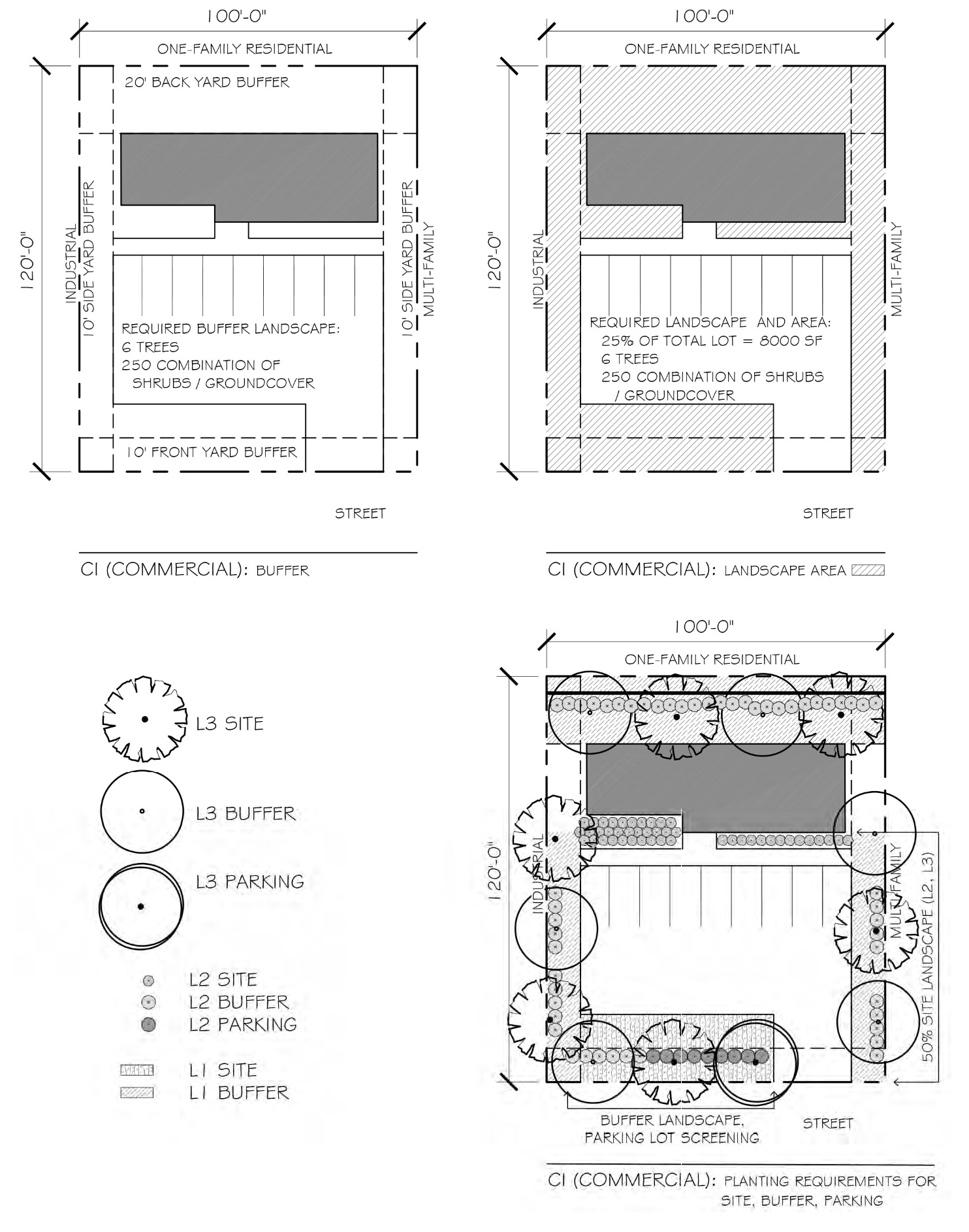
Exhibit 4: Example Landscape Plan - Industrial
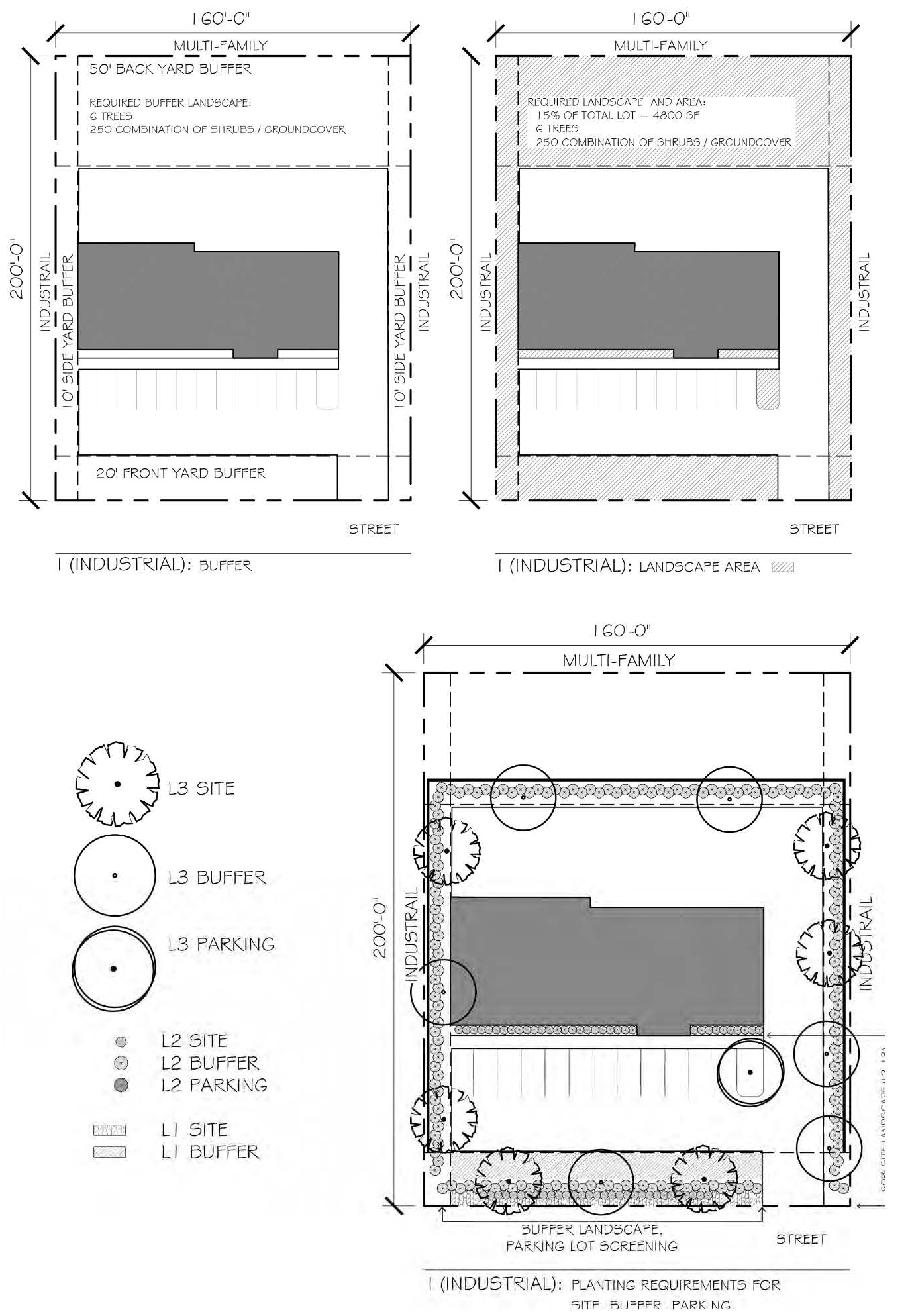
Exhibit 5: Example Landscape Plan - One-Family and Two-Family Residential
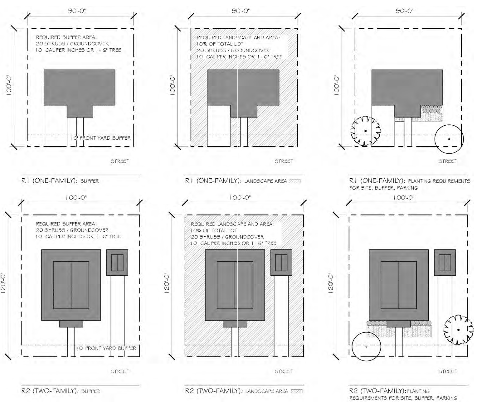
Exhibit 6: Example Landscape Plan - Multifamily Residential
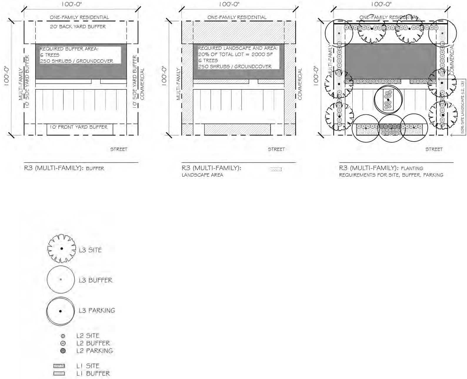
Sec. 3. - Landscape and screening requirements.
Development shall be landscaped, screened, and buffered in accordance with Tables 1-3 on the following page.
The planting and buffer yard requirements are applied to new development and multifamily and nonresidential expansions. In some instances, partial compliance is acceptable. Consult the Zoning Ordinance or contact Development Services to determine whether and to what extent these requirements must be met for a specific project.
The screening requirements must be met for all multifamily and nonresidential new construction, expansions, or changes in use, as well as whenever new trash receptacles or mechanical equipment is installed outside.
Trees used to satisfy parking lot landscape requirements do not count toward other requirements.
All plantings shall meet the planting standards and landscape specifications in Section 4.
Table 1: Planting Requirements
Table 2: Screening Requirements
Table 3: Buffer Yard Requirements
(Ord. No. O2025-15, § 1, 4-22-25)
Sec. 4. - Landscape and screening specifications.
Landscaping and screening shall be designed, installed, and maintained according to the guidelines provided herein. Minimum requirements are determined by land use and zoning district as specified in Section 3 above.
Where possible, applicants shall satisfy all requirements with native and adaptive plant material. Refer to Section 8 of this manual for Preferred Native and Adaptive Plant Materials.
Part 1. Landscape Specifications
L3: Trees - woody perennial plants, typically having a single stem or trunk growing to a considerable height and bearing lateral branches at some distance above the ground. Installed for shade, buffering, aesthetic, or other purposes. To be provided in appropriate quantity and proportion as described herein. Required trees shall be selected from the Preferred Plant List in this manual and shall be no less than three-inch caliper at the time of planting. Refer to Landscape Requirements table for specific requirements and Preferred Native and Adaptive Plant Materials for approved plant materials.
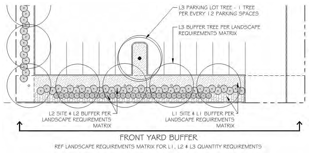
L2: Shrubs and Ornamental Ground Covers - L2 landscape shall be selected from the evergreen shrub, perennial or seasonal flowering plant, or ornamental grass species on the Preferred Plant List in this manual. Shrubs include woody plant material smaller than a tree with several stems rising at or near the ground, installed for buffering, aesthetic, or other purposes. Ornamental ground covers include low growing, spreading plants, ornamental grasses covering open soil for aesthetic, storm water management, or other purposes. At least two species shall be selected for each 20 plants required. Refer to Landscape Requirements table for specific requirements and Preferred Plant List for approved plant materials.
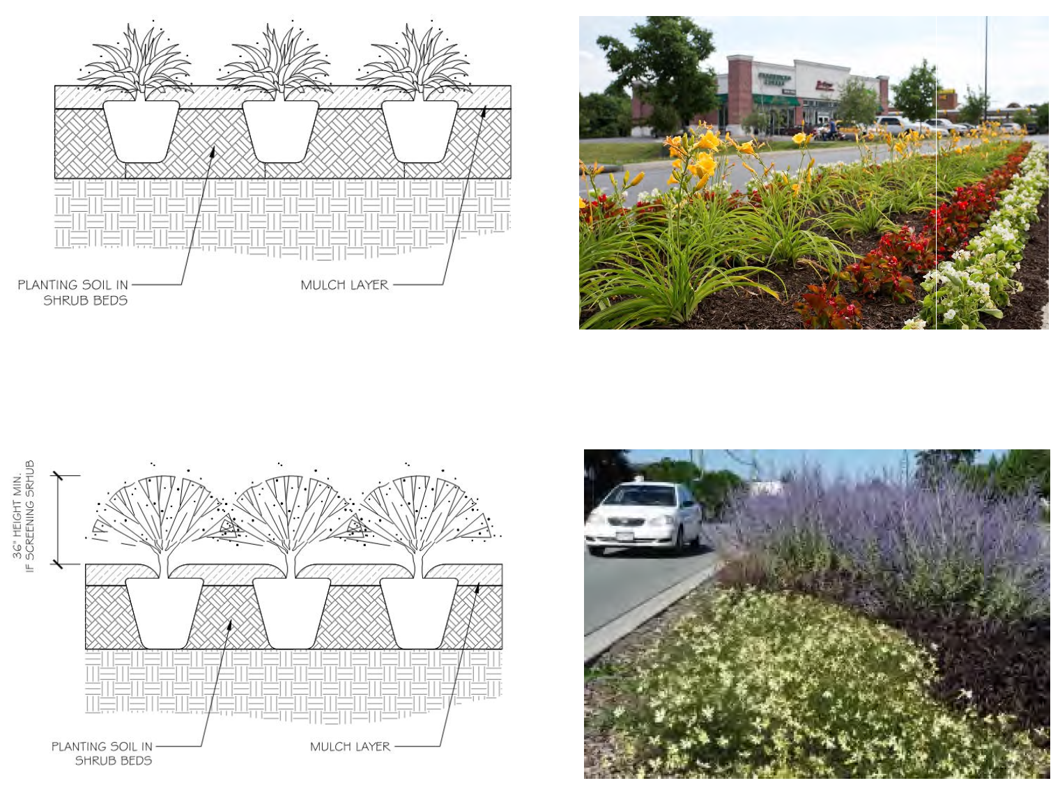
L1: Supplemental Landscape - L1 treatments may include approved L2 ground cover or shrubs, lawn, mulch, bark, decorative rock, outdoor furniture, art installations, and other landscape or hardscape features, and shall present a finished, orderly appearance and reasonably complete coverage of the landscape area. Creativity in combining multiple, complementary elements is encouraged. Except as approved by the Planning Director all landscape areas shall have a minimum area of 200 square feet with a minimum horizontal dimension of seven feet, measured in any direction.
Part 2. Screening Specifications
Applies to all new multifamily and nonresidential construction and expansions, change in use on property zoned for nonresidential uses, installation of exterior mechanical equipment. See section 12-5-5(b)(2).
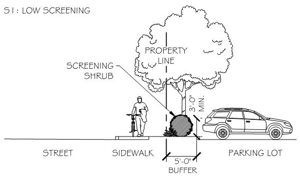
S1: Low Screening - A screen installed for limited sight-obstruction or access control purposes. S1 shall be shrubs, landscape berm, or other plants with minimum height of three feet zero inches, except that screening around parking lots in streetscape areas may be a masonry wall with a height of three feet zero inches to four feet zero inches in height consistent with the architecture of the main building or within a coherent hardscape theme.
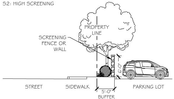
S2: High Screening - A screen installed to eliminate clear sight lines between areas with minimal breaks where necessary for controlled access and to maintain required visibility triangles.
S2 screening shall include a berm or fencing such as wood, masonry, or other materials as approved by the planning director, along with evergreen shrubs densely planted so as to form a solid hedge or living wall.
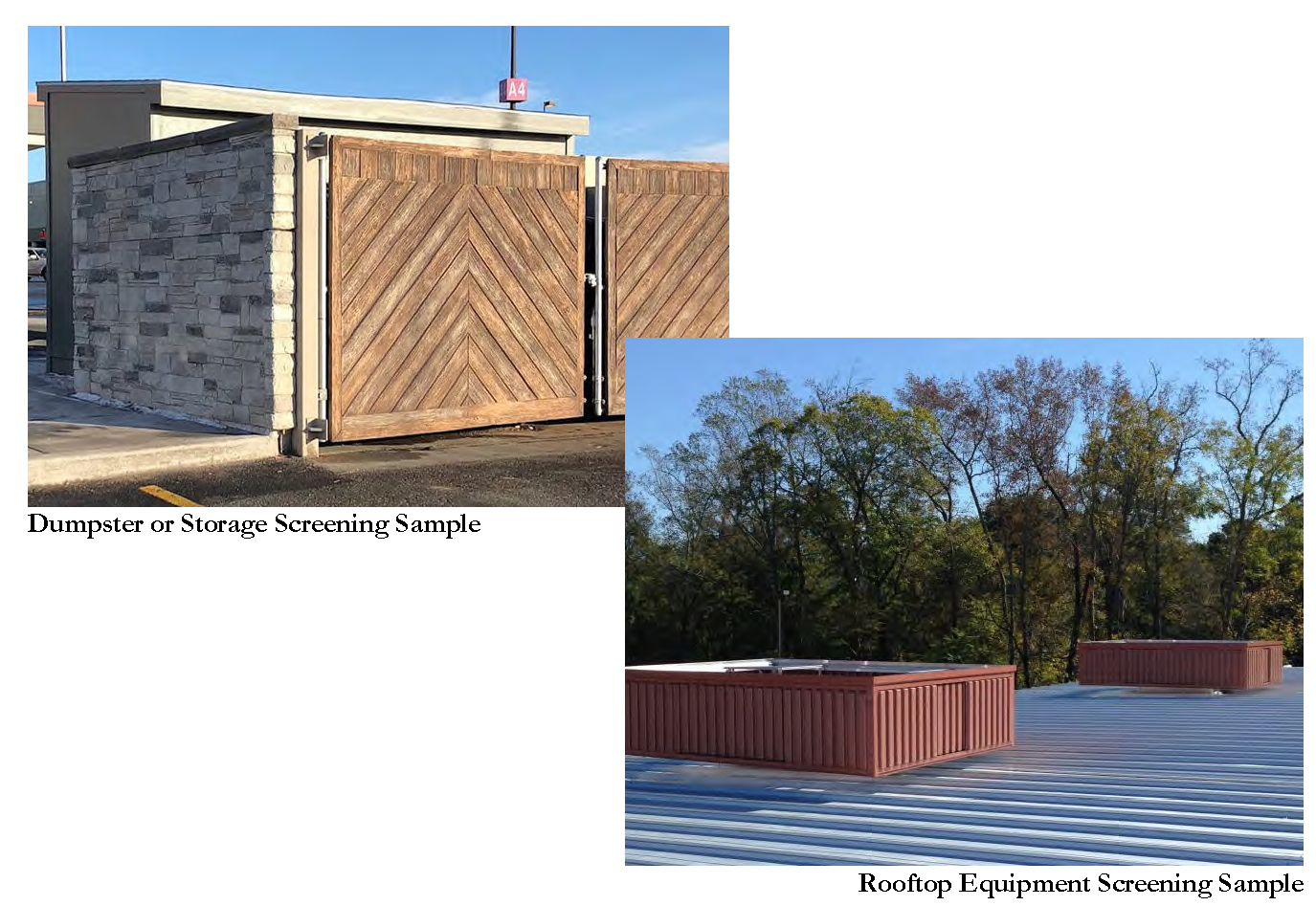
S3: Equipment Screening - A screen installed to eliminate clear sight lines to any mechanical equipment, trash bins, loading areas, or storage areas on all sides. Screening shall be a solid plane which is architecturally consistent with the structure on or adjacent to which it is installed. Screening materials at ground level shall be masonry wall or wood fence material or a combination of the two in keeping with the architectural style of the development.
Screening of rooftop equipment shall be sufficient to conceal all such equipment entirely when viewed from any vantage point at the same or lower elevation and shall be provided with a parapet wall for new construction. A parapet wall or architecturally compatible solid materials will be considered for the addition of new equipment on existing rooftops.
Part 3. Parking Lot Landscape Specifications
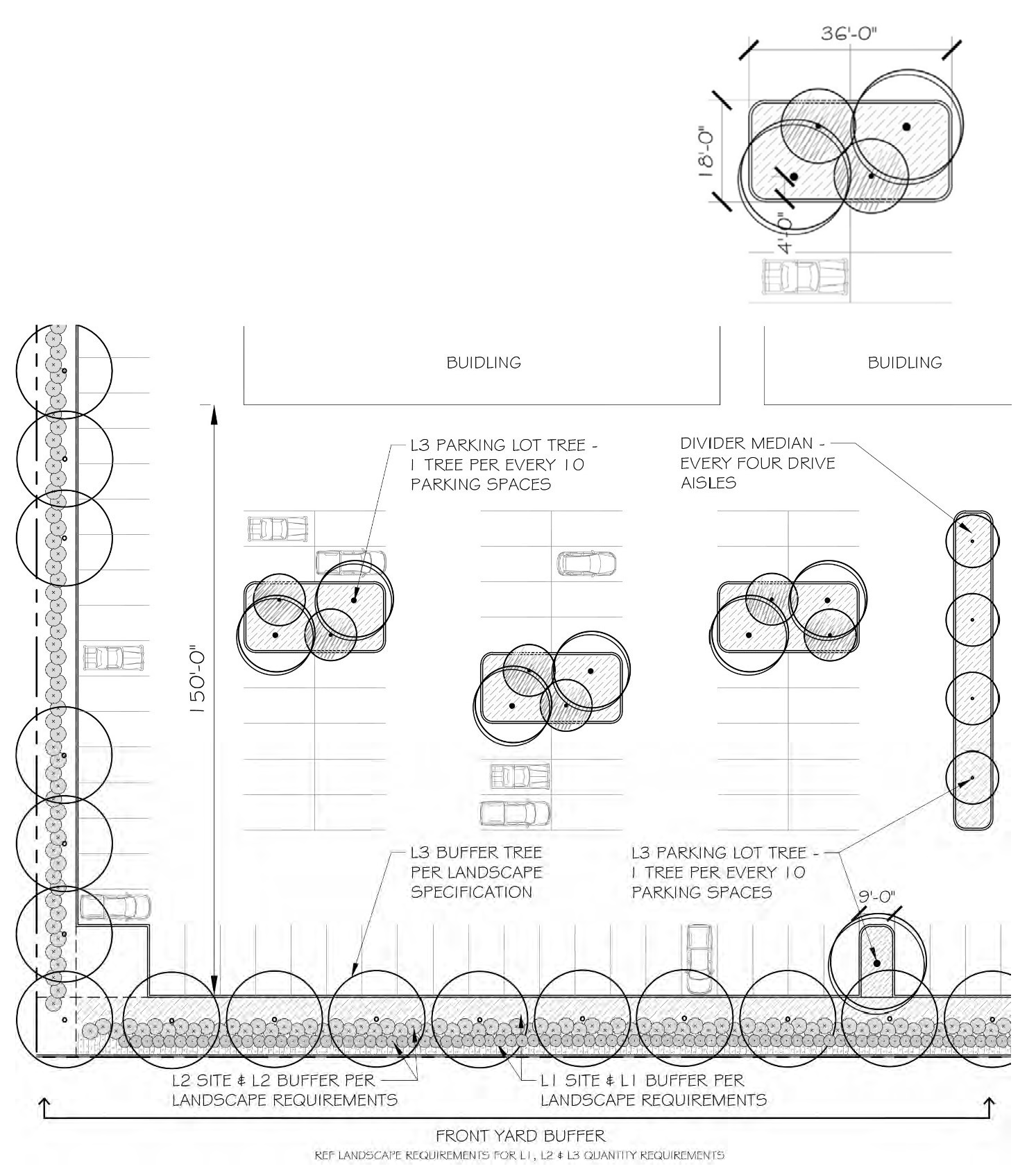
Canopy trees shall be preserved or planted according to the schedule in Section 3 using a combination of interior or endcap islands or divider medians depending on lot dimensions, number of spaces, other site considerations, and the following parking lot landscape specifications.
Islands with two canopy trees and two ornamental trees shall be provided every 150 linear feet of parking area, including any combination of parking stalls, rows, and drive aisles. Island dimensions shall equal four parking spaces. For example, an island adjacent to 90-degree parking spaces will measure 18 feet wide, 36 feet long, and 648 square feet, as shown at right.
Divider medians shall be provided every four drive aisles, have a minimum width of ten feet, and provide canopy trees every 20 feet on center.
Part 4. Credits and Substitutions
The Planning Director may approve credits against the requirements above or allow substitutions for certain plantings to incentivize preservation of existing trees or to facilitate creativity or flexibility on challenging or unique sites. A landscape plan is required whenever credits or substitutions are applied.
The preservation of healthy, mature trees is strongly encouraged. Qualifying trees preserved during development will receive credit against L3 tree planting requirements and, for multifamily and nonresidential uses, against total landscape area requirements. In order to qualify, trees shall meet all of the following criteria:
(1)
The tree is not a nuisance species.
(2)
The tree is a minimum six-inch DBH.
(3)
The tree is located on the subject property, within 75 feet of the public right-of-way.
(4)
The tree meets all planting requirements of this manual.
(5)
The tree is healthy and protected from direct and indirect root damage and truck and crown disturbance prior to, during, and following development.
Table 4: Credit for Preservation of Existing Trees
Minimum parking requirements for multifamily and nonresidential uses may be reduced by ten percent when the minimum L2 and L3 planting requirements are exceeded by at least 15 percent. This may include the preservation of native or adapted ground covers on unimproved (prairie) portions of lots when an inventory of the plants is provided on the landscape plan.
Substitutions are subject to approval by the planning director and may only be applied in the specific situations described:
(1)
Canopy trees may be substituted for shrubs at the rate of one canopy tree for five L2 plants when a cohesive landscape design provides trees exceeding the L3 requirements.
(2)
Ornamental trees may be substituted for shrubs at the rate of one ornamental tree for three L2 plants when a cohesive landscape design provides trees exceeding the L3 requirements.
(3)
Ornamental trees may be substituted for canopy trees at the rate of two ornamental trees for every canopy tree when an overhead utility line prevents planting a canopy tree within a required buffer yard or area where S2 screening is required.
Sec. 5. - Tree plan standards.
Applies to any site development permit or building permit which includes ground disturbance in its scope of work, or when a tree permit for the removal of two or more trees is requested. All such applications shall be accompanied by tree plans which satisfy all the following requirements.
Part 1. General Standards
Except where otherwise indicated, the following standards apply to all tree removal plans and tree protection plans.
(1)
All plans shall be provided at a standard scale on eight and one-half-inch by 11-inch, 11-inch by 17-inch, or 24-inch by 36-inch paper.
(2)
Electronic copies of all plans shall also be provided in a format acceptable to the planning director.
(3)
All plans shall be drawn at a standard engineering scale and include a bar scale and numerical scale and include a directional north arrow.
(4)
All plans shall include the following information:
(a)
Site address or other identifying location information.
(b)
Location of existing and proposed property lines.
(c)
Name and phone number of the person who prepared the plan
(d)
The date on which the plan was prepared.
(5)
When necessary for clarity, the applicable required plans shall be detailed separately on multiple sheets. When few trees are present, the information may be on a single sheet.
(6)
At the discretion of the planning director, aerial photography, with trees proposed for removal marked with an "X" and proposed replacements clearly indicated, may be substituted for plans meeting the requirements in Parts 1 to 3 when any of the following applies to a tree permit application:
(a)
No ground disturbance is proposed except for the removal of trees under permit.
(b)
All trees will be preserved and are located more than 25 feet outside of the development impact area.
(c)
Trees are to be removed for agricultural purpose on property zoned AG Agricultural.
Part 2. Tree Removal Plan
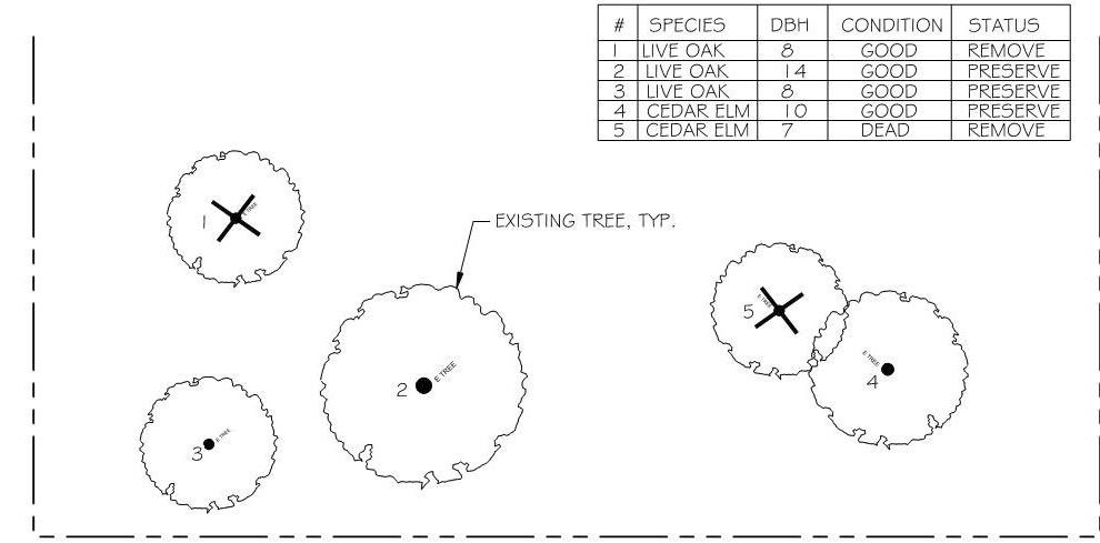
Applies to any tree permit for which the removal of two or more trees is requested. All such applications shall be accompanied by a tree removal plan which includes:
(1)
The subject site and adjacent public rights-of-way.
(2)
All trees proposed for removal (excluding trees which are exempted from permit requirements) marked with an "X" and indicating species and caliper size.
(3)
A table indicating each tree proposed for removal under permit, including species, caliper, condition, and whether mitigation is required. The sum total number of trees and caliper-inches requiring mitigation shall also be shown.
(4)
All tree removal plans associated with new development shall include the location of existing and proposed buildings, utilities, pavement, and other site features.
(5)
Plan and table shall provide sufficient information to determine whether developer has made all reasonable effort to preserve, protect and maintain existing trees and whether all proposed removal meets the approval criteria.
Part 3. Tree Mitigation Plan
Applies to any tree removal for which mitigation is required. All such applications shall be accompanied by a tree mitigation plan which includes:
(1)
The subject site and adjacent public rights-of-way.
(2)
All required mitigation trees proposed, including species and size in caliper at time of planting. For proposed streetscape or parking lot trees, distances to existing trees, buildings, hardscape, and utilities shall be shown.
(3)
A table indicating each proposed mitigation tree, including species and caliper at time of planting, along with a schedule for completion of all plantings required. The sum total number of trees and caliper-inches proposed shall also be shown.
Part 4. Tree Protection Plan
Applies to any grading permit, site development permit, or building permit for which any trees within the development impact area will be preserved. All such applications shall be accompanied by a tree protection plan which includes:
(1)
The subject site and adjacent public rights-of-way.
(2)
The location of existing and proposed buildings, utilities, and hardscape.
(3)
The extent of the development impact area and, specifically, the locations of:
(a)
Construction or demolition of structures and walls.
(b)
Grading and filling.
(c)
Paving.
(d)
Utility and irrigation installation.
(e)
Construction parking.
(f)
Materials and equipment storage.
(g)
Trenching and boring.
(h)
Any other activities requiring excavation or soil disturbance.
(4)
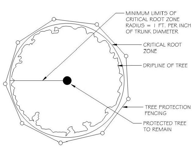
The trunk locations, driplines, and critical root zones for all trees within the development impact area and within 25 feet of the development impact area, except for any trees proposed for removal, which shall be marked with an "X" indicating removal. The critical root zone includes all the area within a radius equal to one foot for every one inch diameter of the tree trunk (as measured at breast height) and is not the same as the dripline. The critical root zone radius is measured outward from the root flare at ground level.
(5)
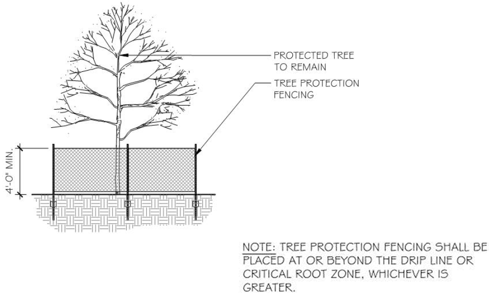
The location and type of tree protection fencing compliant with the requirements in this manual and the figure at right, along with any additional preservation measures determined to be necessary for the continued viability of the trees to be preserved.
(6)
Non-disturbance areas containing trees to be preserved, indicated by shading, and labeling as off-limits to all grading and construction activity.
Sec. 6. - Tree protection measures.
Applies to any permit which includes ground disturbance in its scope of work, or when a tree permit for the removal of two or more trees is requested, on any site which has existing trees which are not proposed for removal within 25 feet of any proposed ground disturbance or tree removal.
Prior to any ground disturbance other than what is necessary for the installation of tree protection measures and erosion, sediment, and pollutant control measures, the applicant shall:
(1)
Mark all trees to be preserved with brightly colored vinyl tape or other uniformly brightly colored marking at a height of approximately four feet, such that the marking is visible to workers on foot or driving equipment.
(2)
Install tree protection fencing such as chain linking fencing, vinyl construction fencing, or other similar fencing, at least four feet in height and supported at intervals of no greater than ten feet, at approximately the drip line around all trees to be preserved within the development impact area or within 25 feet of the development impact area (where tree stands are to be preserved, the fencing shall surround the entire stand), and to remain in place throughout all ground disturbance and construction activities; and
(3)
Perform a site inspection and document compliance or non-compliance with the tree plan and the tree protection measures described herein and send verification to the planning director within one week of the inspection.
Following the completion of items above and throughout all construction activities involving ground disturbance, the following protection measures shall be observed:
(1)
The applicant shall perform a monthly (except as otherwise approved by the planning director) site inspection and document compliance or non-compliance with the tree plan and the tree protection measures described herein and send verification to the planning director within one week of the inspection;
(2)
No materials intended for use in construction or waste materials accumulated due to excavation or demolition shall be placed within the limits of the critical root zone of any tree which is to be preserved.
(3)
No equipment shall be cleaned or other liquids (including, but not limited to paint, oil, solvents, asphalt, concrete, mortar or similar materials) deposited or allowed to flow overland within the limits of the critical root zone of any trees to be preserved;
(4)
No signs, wires or other attachments, other than fencing attachments, shall be placed on trees to be preserved.
(5)
No vehicular and/or construction equipment traffic or parking shall take place within the limits of the critical root zone of any tree to be preserved other than on existing street pavement, except for purposes of clearing underbrush, establishing the building pad and associated lot grading, vehicular traffic necessary for routine utility maintenance, emergency restoration of utility service, and routine mowing operations;
(6)
No grade changes shall be allowed within the limits of the critical root zone of any tree to be preserved unless adequate construction methods are approved by the landscape administrator.
(7)
No paving with asphalt, concrete or other impervious materials that may reasonably be expected to kill a tree shall be placed within the limits of the critical root zone of any tree to be preserved.
(8)
No heavy equipment, including but not limited to trucks, tractors, trailers, bulldozers, bobcat tractors, trenchers, compressors, and hoists, shall be allowed inside the drip-line of any tree to be preserved without the specific approval of the planning director for limited, incidental access.
For all underground utilities, the following construction methods shall be observed:
(1)
Boring of utilities under trees to be preserved shall be required in those circumstances where it is not possible to trench around the critical root zone of the tree. When required, the length of the bore shall be the width of the critical root zone at a minimum and shall be a minimum depth of 48 inches.
(2)
All trenching shall be designed to avoid trenching across the critical root zone of any tree, unless otherwise approved. The placement of underground utility lines such as electric, telecommunications, gas, etc., shall be located outside of the critical root zone of trees to the extent possible. Trenching for an irrigation system shall be placed outside of the critical root zone, except the minimum required single head supply line as allowed to extend into the critical root zone perpendicular to the tree trunk and in the manner that has the least possible encroachment into the critical root zone.
(3)
All roots two inches or larger in diameter which are exposed because of trenching or other excavation shall be cut off square with a sharp medium tooth saw and covered with pruning compound within two hours of initial exposure.
Upon completion of all construction activities and/or site work, the applicant shall perform a final site inspection and document that all trees subject to the tree protection requirements described herein remained protected throughout construction activities and/or site work and remain unaffected by all such work at the time of its completion. Prior to issuance of a certificate of occupancy for a building permit or acceptance of improvements for a site development permit, the applicant shall send verification of the final inspection to the planning director.
Sec. 7. - Planting and maintenance standards.
Applies to all trees, shrubs, living groundcover, or other materials planted to meet the requirements of this manual and the Weatherford Municipal Code.
The quality and quantity of soil, spacing between plants and other features in or on the ground, and adequate maintenance are integral to the long-term life of all planted materials. The following are minimum guidelines to ensure newly planted landscape and trees are successfully established and maintained to meet the intent of all tree and landscape requirements adopted by ordinance.
Part 1. Landscape Planting Standards
(1)
All landscape preserved or planted to meet the requirements of this chapter shall be chosen from the Preferred Plant List provided in this manual unless another species included in the Texas SmartScape plant database is approved by the planning director.
(2)
All trees and shrubs preserved or planted to meet the requirements of this chapter shall have well developed leaders and tops and roots characteristic of the species and shall show evidence of proper nursery pruning. All plant materials shall be free of insects, diseases, mechanical injuries, and other objectionable features at the time of planting.
(3)
Soil for all L2 landscape areas shall be tilled to a depth of eight to 12 inches prior to installation of landscape. All plantings therein shall be mulched to a depth of two inches. Trees planted within these areas shall additionally meet the tree planting standards in Part 3 below.
(4)
Grasses may be sodded, plugged, sprigged, or seeded. In swales, berms, or other areas subject to erosion, solid sod shall be used.
(5)
Shrubs preserved or planted to meet L2 landscape requirements shall be a minimum of 18 inches in height. Shrubs preserved or planted to meet S1 or S2 screening requirements shall achieve the applicable sight obstruction within one year of planting.
(6)
Parking lot landscape areas and any other landscape adjacent to parking or driving surfaces shall be protected from vehicle encroachment by curb or other approved stopping devices.
(7)
All required landscape areas, including landscape islands or tree wells within parking areas, shall be irrigated with an automatic conventional irrigation system equipped with rain and freeze sensor controls. The irrigation system shall be installed by a licensed irrigator or master plumber.
(8)
Irrigation of all landscaped area adjacent to any parking and/or driving surfaces shall be installed such that a minimum amount of water is applied to parking and/or driving spaces.
Part 2. Landscape Maintenance Standards
All landscaping and related maintenance shall be the responsibility of the property owner. The following minimum standards shall be required:
(1)
Landscape areas shall be kept free of trash, litter, weeds, and other such material or plants that are not a part of the landscape.
(2)
All required plant materials shall be watered by an automatic irrigation system with moisture and rain sensors to ensure minimal water waste and runoff. Alternative irrigation methods consistent with nursery industry standards and verified by a landscape professional may be approved by the planning director.
(3)
All plant materials shall be maintained in a healthy and growing condition as appropriate for the season of the year. The property owner is responsible for regular weeding, mowing of grass, irrigation, fertilizing, pruning, and other maintenance of all plantings as needed.
(4)
Landscape, including landscape installed to meet S1 or S2 screening requirements, shall not encroach on the sight visibility triangle at intersecting streets or preclude visibility during ingress or egress of driveways and parking lots. The standard clear sight triangle for private drives will normally be 15 feet and the standard clear sight triangle for intersection of streets is 25 feet.
(5)
Plant materials which exhibit evidence of insects, pests, disease, and/or damage shall be appropriately treated.
(6)
Plant materials which die shall be replaced with healthy plant material meeting all specifications and planting requirements provided herein within six months.
Part 3. Tree Planting Standards
Trees planted to meet any landscape or tree mitigation requirement shall be chosen from the Preferred Plant List in this manual unless another native or adapted species included in the Texas SmartScape plant database is approved by the planning director. Nuisance species identified on the Nuisance Tree List in this manual shall not be preserved or planted in any required landscape area.
Required canopy trees, including any tree required to be planted for mitigation, shall have a minimum height of ten feet and minimum caliper of three inches at the time of planting. Ornamental trees must have a minimum caliper of two inches or 65 gal. container size and eight feet at time of planting.
Trees shall be provided adequate soil volumes to ensure their successful establishment and growth to maturity:
(1)
Canopy trees shall have a soil volume of at least 600 cubic feet.
(2)
Ornamental trees shall have a soil volume of at least 400 cubic feet.
(3)
Topsoil (two inches) shall have four to six percent organic matter by weight.
(4)
To avoid settling issues, no soil mix shall contain more than 15 percent compost by volume.
Trees shall be provided adequate spacing from new and existing trees, structures, hardscape, and utility infrastructure according to the following standards wherever possible:
(1)
Ornamental trees shall be spaced not closer than 15 feet on center from other newly planted trees or any existing tree that has been in the ground for over three years.
(2)
Canopy trees shall be spaced not closer than 30 feet on center from other newly planted canopy trees or any existing tree that has been in the ground for over three years, and not closer than 15 feet of center from other newly planted ornamental trees;
(3)
Trees shall be planted with the center of their trunks not closer than 2.5 feet from any hard surface paving.
(4)
Trees shall be planted with the center of their trunks not closer than 4 feet from any underground utility, utility box, or utility pole.
(5)
Trees shall be planted with the center of their trunks not closer than 15 feet from existing or planned overhead utility lines.
(6)
Trees shall be planted with the center of their trunks not closer than 10 feet from any fire hydrant or streetlight.
(7)
Trees shall be planted with the center of their trunks not closer than ten feet from the furthest protrusion (e.g. roof overhang, wall-mounted equipment) of an existing or proposed single-story building and not closer than 15 feet from the furthest protrusion of any existing or proposed multistory building; and
(8)
Trees shall be planted with the center of their trunks not closer than 35 feet from the intersection of two streets or other rights-of-way.
Where trees are planted within five feet of any hard surface paving or utility box, root barriers extending a minimum of six inches below depth of pavement or utility box shall be installed according to the manufacturer's specifications.
Part 4. Tree Maintenance Standards
Trees shall be maintained so as not to become hazard trees as defined in the tree preservation chapter.
Trees shall be maintained such that their canopies do not impede the safe use of public streets, sidewalks, paths, or parking areas and shall meet the following minimum clearance standards:
(1)
Eight feet above a sidewalk or other pedestrian or multiuse path.
(2)
13 feet above any travel lane or curb of a local street or any parking space or drive aisle.
(3)
15 feet above any travel lane or curb of a collector street; and
(4)
18 feet above any travel lane or curb of an arterial street.
Sec. 8. - Preferred native and adaptive plant materials.
Table 5a: Preferred Native and Adaptive Canopy and Ornamental Tree List
Table 5b: Preferred Native and Adaptive Shrubs, Grasses, Perennials, and Groundcover List
Sec. 9. - Nuisance tree list.
The following species have been selected as nuisance trees for their undesirable characteristics, shall not be planted in the City of Weatherford or counted towards any tree or landscape requirements, and are exempt from replacement requirements when removed under an approved tree permit:
Table 6: Nuisance Tree List
Sec. 10. - Heritage tree designation procedure.
Part 1. Heritage Tree Designation
A tree or stand of trees not already designated as a heritage tree by the definition in the tree preservation chapter may be nominated for heritage tree designation by the property owner. The nomination shall be submitted to the planning director and shall include the following:
(1)
Letter addressed to the planning and zoning commission providing reasons why the tree or stand of trees merit heritage tree designation and describing how such designation may affect proposed or future development of the subject site.
(2)
Site plan showing the location of the tree or trees nominated for heritage tree designation; and
(3)
Any documentation which supports the special significance of the tree or trees.
The planning director shall review the complete nomination submittal and present the provided materials and any appropriate supplemental information to the planning and zoning commission with a recommendation to approve or deny the heritage tree designation.
The planning and zoning commission shall review the nomination and the planning director's recommendation and determine whether the tree or stand of trees are of landmark importance due to age, size, species, horticultural quality, or historic significance.
Any tree determined by the planning and zoning commission to be of landmark importance following the above procedure shall be designated as a heritage tree.
Part 2. Removal of Heritage Tree Designation
Heritage tree designation shall be removed if a tree permit is approved for the removal of the subject tree or trees.
A tree which is designated as a heritage tree following the procedure in Part 1 above may have such designation removed by the planning and zoning commission. The property owner shall petition the planning and zoning commission to remove heritage designation and shall submit the following to the planning director:
(1)
Letter addressed to the planning and zoning commission providing reasons why heritage tree designation is no longer appropriate, describing the circumstances for bringing the petition to remove heritage tree designation, and disclosing any proposed or future development plans for the site.
(2)
Site plan showing the location of the heritage tree or trees; and
(3)
Any documentation which supports the petition to remove heritage tree designation.
The planning director shall review the petition and present the provided materials and any appropriate supplemental information to the planning and zoning commission with a recommendation to approve or deny the removal of heritage tree designation.
The planning and zoning commission shall review the petition and the planning director's recommendation and determine whether removal of heritage tree designation is warranted.