| Agriculture/Forestry |
|
Agricultural uses, buildings, or structures
|
P
|
P
|
P
|
P
|
P
|
P
|
P
|
P
|
P
|
P
|
P
|
P
|
Land used for agricultural purposes, as defined in 55 ILCS 5/5-12001.
|
|
Greenhouse, nursery, and floriculture
| | |
P
|
P
|
P
|
P
|
P
|
P
|
P
|
P
|
P
| |
Land or greenhouses used to raise flowers, trees, shrubs or other plants for sale.
This does not include wholesale greenhouses exempt from zoning regulation by 55 ILCS
5/5-12001.
|
|
Kennel/pet care
| | |
P
| | | | | |
P
|
P
|
P
|
P
|
A facility, either state licensed or not, housing dogs, cats or other household pets,
where grooming, breeding, boarding, training or selling of animals is conducted as
a business. This shall include the breeding of animals for the purpose of sales at
other locations.
|
|
Private stable
| | |
A
|
A
|
A
| | | | | | | |
A structure which is located on a lot on which a dwelling is located and which is
designed, arranged, used or intended to be used for housing of horses or ponies for
the private use of occupants of the dwelling, but in no event for hire.
|
|
Support functions for agriculture
| | |
P
| | | | | | | |
P
|
P
|
Establishments that perform activities associated with production and distribution
of forest and agricultural products, such as spraying and harvesting. Note: farm and
farm labor management is classified under office, above.
|
| Residential |
|
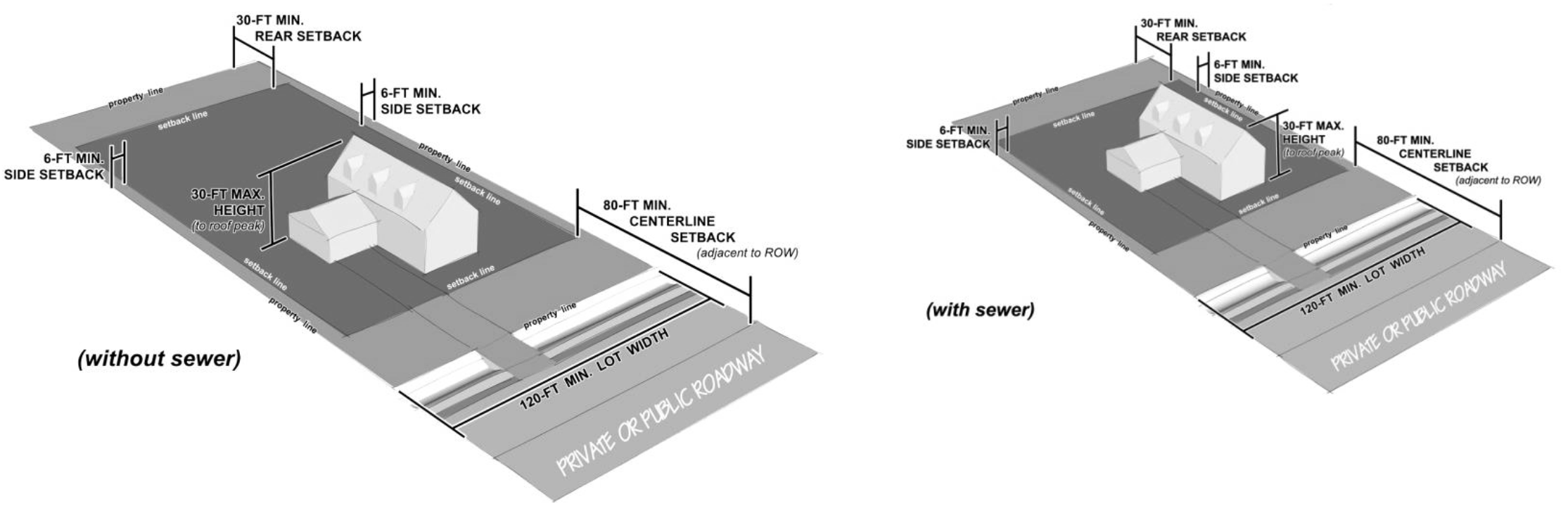
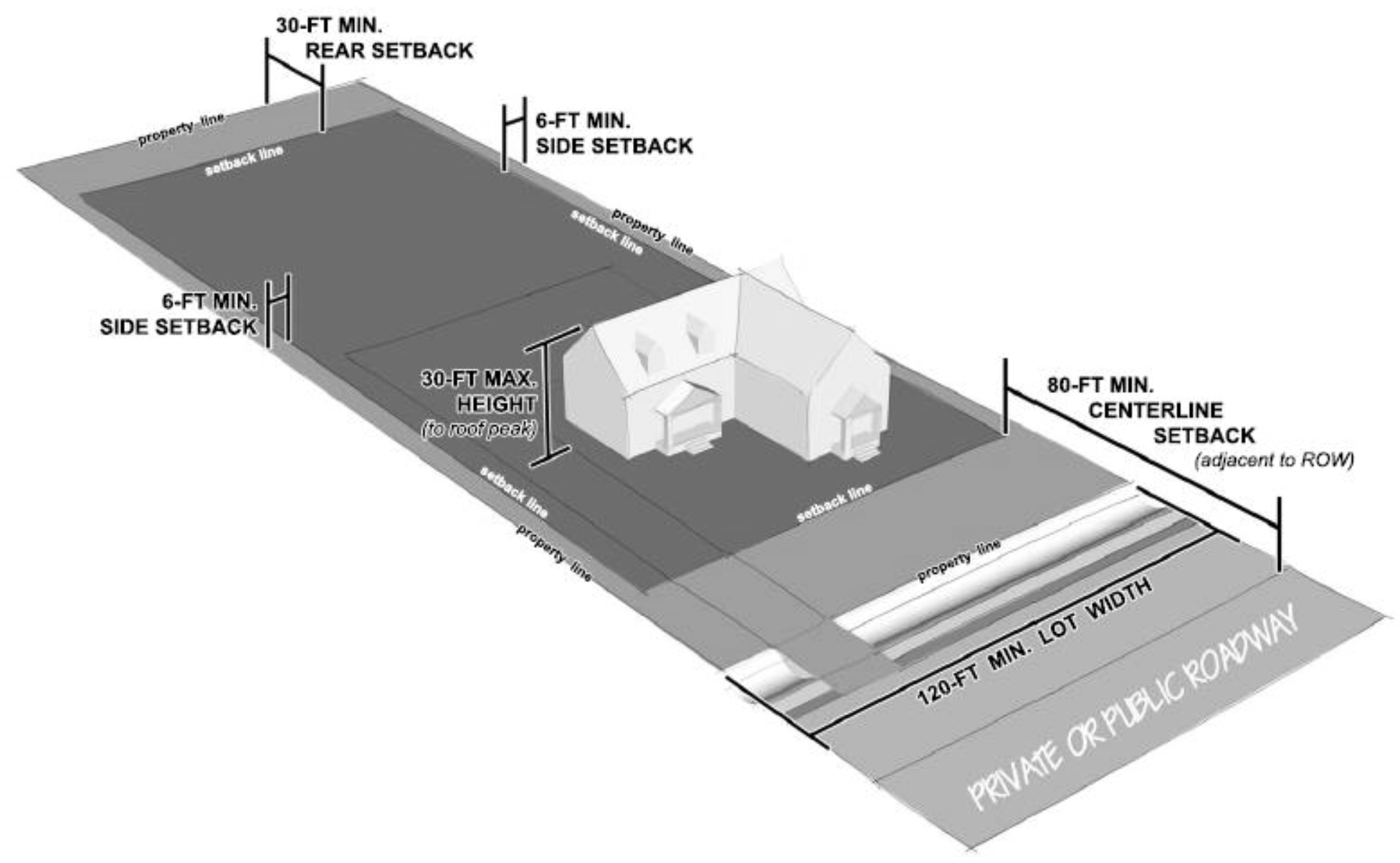
Single-family detached dwelling
| |
P
|
P
|
P
|
P
|
P
|
P
| | | | | |
A detached dwelling unit designed for and occupied only by one family.
|
|
Caretaker dwelling
| |
A
|
A
|
A
|
A
|
A
|
A
|
A
|
A
|
A
|
A
|
A
|
Living quarters of persons employed on the premises.
|
|
Farm dwelling
| |
A
|
A
|
A
|
A
|
A
|
A
|
A
|
A
|
A
|
A
|
A
|
A dwelling unit located on a tract of land for which the principal use is the pursuit
of agriculture, as defined herein, with the dwelling unit being clearly accessory
and subordinate to such agricultural use, subject to the limitation that such dwelling
unit is occupied by or intended for occupancy by the owner of such tract or by a person
whose principal occupation is the pursuit of agriculture on such land.
|
|
Multifamily dwelling
| | | | | | |
P
|
P
|
P
|
P
| | |
A single structure designed for and intended to be occupied by three or more families,
with the number of families in residence not exceeding the number of dwelling units
provided. Included in this definition will be apartments, condominiums and townhouses
or row houses. Each dwelling unit will have a minimum of 720 square feet of livable
space (open porches, garages, breezeways or terraces not included).
|
|
Mixed-use building
| | | | | | |
P
|
P
|
P
|
P
| | |
A building with commercial, artisan or research and development uses, and with dwelling
units on floors above the ground floor or behind storefronts or non-residential floor
space. Examples include lofts and buildings with stores on the ground floor and apartments
above.
|
|
Manufactured home
| | |
P
| | | | | | | | | |
A single-family dwelling that complies with, and is certified by the manufacturer
to comply with, the standards established under the National Manufactured Housing
Construction and Safety Standards Act of 1974, 42 U.S.C. section 5401, et seq. The
term "manufactured home" does not include a structure which otherwise complies with
this chapter but which was built prior to June 15, 1976, which units are classified
as mobile homes.
|
|
Manufactured home (non-complying)
| | |
S
| | | | | | | | | |
A manufactured home that: (1) does not meet the requirements for manufactured homes
in article V of this chapter; or that (2) is placed on property not owned by the owner
of the manufactured home.
|
|
Mobile home
| | |
S
| | | | | | | | | |
Any structure, built before October of 1976, designed for permanent habitation and
so constructed as to permit its transport on wheels, temporarily or permanently attached
to its frame or undercarriage, from the place of its construction to the location,
or subsequent locations, at which it is intended to be a permanent habitation and
designed to permit the occupancy thereof as a dwelling place for one or more persons.
See section 39-252 for additional restrictions.
|
|
Manufactured home land lease community
| | | | | | |
S
| | | | | |
A manufactured home land lease community is a lot upon which two or more occupied
manufactured homes are located either free of charge or for revenue purposes, and
where a space on the lot is leased to the person who owns the manufactured home. This
does not include the use of mobile or manufactured homes on a farm to house farm workers.
|
|
Modular home
| |
P
|
P
|
P
|
P
|
P
|
P
| | | | | |
A building assembly or system of building subassemblies, designed and built in a factory
for the habitation of one or more persons, including the necessary electrical, plumbing,
heating, ventilating and other systems, of closed or open construction, transported
to a building site for installation or assembly and installation on a permanent foundation.
Such units shall be in compliance with the state modular housing code prepared by
the state department of public health. Modular dwellings may be placed by permit alone,
but will not include the placement of two or more mobile or manufactured homes which
were not originally constructed to be a single unit. For purposes of this article,
modular will include panelized, precut, or sectional homes.
|
|
Recreational dwelling
| |
P
| | | | | | | | | | |
See article V of this chapter.
|
|
Rooming house
| | | | | | |
P
|
P
|
P
|
P
| | |
A dwelling occupied by a resident family or resident occupant and three or more rent
paying persons.
|
|
Two family dwelling/duplex
| | | | | |
P
|
P
|
P
|
P
|
P
| | |
A detached residential structure containing two dwelling units designed for occupancy
by not more than two families.
|
| Accommodations |
|
Bed and breakfast
| | |
S
|
S
|
S
|
S
|
S
|
S
|
P
|
P
| | |
An operator-occupied residence providing accommodations for a charge to the public
with no more than five guest rooms for rent in operation for more than ten nights
in a 12-month period. Breakfast may be provided to the guests only and food preparation
facilities must be licensed by the county health department. Bed and breakfast establishments
shall not include motels, hotels, boardinghouses or food service establishments.
|
|
Dormitory, fraternity or sorority
| | | | | | |
P
|
P
|
P
|
P
| | |
A space in a building where group sleeping accommodations are provided with or without
meals for persons not members of the same family group, in one room or in a series
of closely associated rooms under joint occupancy and single management. Examples
include college dormitories, and military barracks. A fraternity or sorority is a
building used as group living quarters for students of a college or university, who
are members of a fraternity or sorority recognized by the college or university.
|
|
Group home (eight or fewer persons)
| |
P
|
P
|
P
|
P
|
P
|
P
|
P
|
P
|
P
| | |
A specialized residential care home, the residents of which do not constitute a family,
that serves persons with disabilities; that is licensed, certified, or accredited
by appropriate governmental entities; and that does not serve persons as an alternative
to incarceration for a criminal offense, persons whose primary reason for placement
is substance or alcohol abuse, or persons whose primary reason for placement is treatment
of a communicable disease. For purposes of this definition, the term "disabilities"
means: any disability (1) attributable to mental, intellectual, or physical impairments
or a combination thereof; (2) likely to continue for a significant amount of time
or indefinitely; (3) resulting in functional limitations in three or more of the following
areas of major life activities: self-care, receptive or expressive language, learning,
mobility, self-direction, capacity for independent living, and economic self-sufficiency;
and (4) reflecting a person's need for a combination and sequence of interdisciplinary
or generic care, treatment, or other services that are of a lifelong or extended duration.
|
|
Group home (more than eight persons)
| | | | |
S
|
S
|
P
|
P
|
P
|
P
| | |
See above.
|
|
Hospice
| | | | | |
S
|
P
|
P
|
P
|
P
| | |
An establishment that provides palliative and supportive services in an inpatient
setting, which provides for physical, psychological, social and spiritual care for
dying persons and their families where services are provided by a medically directed
interdisciplinary team of professionals and volunteers and bereavement care is available
to the family following the death of the person. This includes any facility subject
to the Hospice Program Licensing Act (210 ILCS 60/1 et seq.).
|
|
Hotels or motels
| | | | | | | | |
P
|
P
| | |
A facility with guest rooms or suites designed for transient habitation, where access
to individual units is predominantly through a common lobby that may provide additional
services, such as conference and meeting rooms, restaurants, bars or recreation facilities
available to guests or to the general public. This classification includes motor lodges,
motels, hostels, extended stay hotels and tourist courts, but does not include rooming
houses or residential hotels.
|
|
Nursing home
| | | | | |
S
|
P
|
P
|
P
|
P
| | |
A home, institution, building, residence, or any other place, whether operated for
profit or not, which provides personal care, sheltered care or nursing for persons,
not related to the applicant or owner by blood or marriage. Examples include residential
care facilities, assisted living facilities, intermediate care facilities, or skilled
nursing facilities. This includes any facility not preempted from local regulation
meeting this definition, whether or not those facilities are subject to the Nursing
Home Care Act (210 ILCS 45/1-101 et seq.).
|
| Commercial |
|
Alcohol sales—bar or tavern
| | | | | | | |
S
|
P
|
P
|
P
| |
Establishments primarily engaged in preparing and serving alcoholic beverages for
immediate consumption. These include bars, beer gardens, taverns, nightclubs, and
restaurants where liquor is more than incidental to the business.
|
|
Alcohol sales—retail package liquor
| | | | | | | |
S
|
P
|
P
|
P
| |
Establishments primarily engaged in retailing packaged alcoholic beverages, such as
beer, wine, and liquor.
|
|
Armories
| | | | | | | | |
P
|
P
|
P
|
P
|
Structures enclosing space designed for military training. They may have incidental
storage and office space within the main structure.
|
|
Automatic teller machine (ATM), stand alone
| | | | | | | |
P
|
P
|
P
|
P
|
P
|
An electronic device used by the public to conduct financial transactions such as
withdrawing or depositing cash from a bank, savings, credit union, credit card or
similar account wherein the customer operates the device independently. An ATM in
this category is not attached to or internal to a principal use such as a bank or
retail establishment.
|
|
Automotive parts sales
| | | | | | | | |
P
|
P
|
P
| |
This includes establishments that: (1) retail new, used, and/or rebuilt automotive
parts and accessories (automotive supply stores); (2) automotive supply stores that
repair automobiles accessory to their retail functions; and (3) establishments primarily
engaged in retailing and installing automotive accessories. Examples include automotive
parts and supply stores, truck cap stores, automotive stereo stores, used automotive
parts stores, speed shops, and tire shops.
|
|
Automobile repair, major
| | | | | | | | |
P
|
P
|
P
|
P
|
General repair, rebuilding, replacing or reconditioning of engines, motor vehicles
or trailers; collision service, including body, frame or fender straightening, replacing
or repair; overall painting or paint shop, vehicle steam cleaning.
|
|
Automobile repair, minor
| | |
S
| | | | | |
P
|
P
|
P
| |
Minor repairs, incidental body and fender work, touch-up painting and upholstering,
replacement of parts and motor service to passenger automobiles and trucks, but not
including any operations specified under "automobile repair, major."
|
|
Automotive sales or rental
| | | | | | | | |
P
|
P
|
P
| |
The use of any building, land area, or other premise for the display and sales or
rental of new or used automobiles generally, but may include light trucks or vans,
trailers, or recreational vehicles. This shall also include any vehicle preparation
or repair work conducted as an accessory use, but such use shall be conducted wholly
inside a structure. Automobile sales shall not include the outside storage of vehicles
which do not operate or are being used for the salvage of parts to repair other vehicles.
|
|
Bakery, retail
| | | | | | | |
P
|
P
|
P
|
P
| |
Bakeries whose products are sold at retail on the premises.
|
|
Cannabis dispensing organization
| | | | | | | | |
P
|
P
|
P
| |
See Sec. 39-3.
|
|
Business support services (e.g., print/copy shop)
| | | | | | | |
P
|
P
|
P
| | |
Establishments engaged in performing activities that are ongoing routine business
support functions that businesses and organizations traditionally do for themselves.
Examples include print/copy shops, document preparation services, call centers, telemarketing,
and business service centers.
|
|
Car wash/automobile laundry
| | | | | | | |
P
|
P
|
P
|
P
| |
Establishments primarily engaged in cleaning, washing, and/or waxing automotive vehicles,
such as passenger cars, trucks, and vans, and trailers.
|
|
Catering/food preparation
| | | | | | | | |
P
|
P
|
P
| |
A business that prepares food and beverages for off-site consumption, including delivery
services. This classification includes catering kitchens, bakeries with on-site retail
sales and the small-scale production of specialty foods, such as sweets. This classification
excludes food production of an industrial character.
|
|
Convenience store (with vehicle repair)
| | | | | | | | |
P
|
P
|
P
| |
A convenience store that provides vehicle repair as an accessory use.
|
|
Convenience store (without vehicle repair)
| | | | | | | |
P
|
P
|
P
| | |
Establishments commonly known as convenience stores or food marts primarily engaged
in retailing a limited line of goods that generally includes milk, bread, soda, and
snacks. These establishments can either be in a convenience store (i.e., food mart)
setting or a gasoline station setting.
|
|
Day care center, adult
| | | | | | |
P
|
P
|
P
|
P
| | |
A facility other than the provider's permanent residence, or separate from the provider's
living quarters, where care is provided for adults for part of the 24-hour day.
|
|
Child care facility
| | | | | |
S
|
S
|
P
|
P
|
P
| | |
Includes any day care center (225 ILCS 10/2.09), day care home (as defined by 225
ILCS 10/2.18), or group day care home (as defined by 225 ILCS 10/2.20). This includes
four—16 children in a family home (including the family's natural or adopted children).
|
|
Couriers and messengers
| | | | | | | | | |
P
|
P
|
P
|
Establishments primarily engaged in providing air, surface, or combined mode courier
services, express delivery services of parcels, or local messenger and delivery services
of small items, with local pick-up and delivery. Examples include air courier services,
express delivery services; local delivery services for letters, documents, or small
parcels; grocery delivery services (i.e., independent service from grocery store),
or restaurant meals delivery services.
|
|
Drug store/pharmacy
| | | | | | | |
P
|
P
|
P
| | |
Establishments that retail prescription or nonprescription drugs and medicines.
|
|
Farm feed stores
| | |
S
| | | | |
S
|
P
|
P
|
P
| |
Establishments primarily engaged in retailing farm supplies, such as animal (non-pet)
feed, fertilizers, seeds, pesticides and herbicides.
|
|
Farm implement sales, wholesale and repair
| | | | | | | | | |
P
|
P
|
P
|
Establishments primarily engaged in retailing or wholesaling new outdoor power equipment
for farming. This may include repair services and selling replacement parts.
|
|
Financial institutions
| | | | | | | |
P
|
P
|
P
| | |
An establishment that provides retail banking, credit and mortgage, or insurance services
to individuals and businesses. This classification includes banks and savings and
loan establishments, brokerage firms, check cashing and currency exchange outlets
and stand-alone automated teller machines.
|
|
Flea market/swap meet
| | | | | | | | | |
P
|
P
| |
An occasional or periodic market held in an open area or structure where groups of
individual sellers offer goods for sale to the public
|
|
Food and beverage stores
| | | | | | | |
P
|
P
|
P
|
P
| |
Establishments that retail food and beverage merchandise from fixed point-of-sale
locations. Examples include grocery stores, supermarkets and farmers markets.
|
|
Funeral and interment services
| | | | | | | | |
P
|
P
|
P
|
P
|
An establishment primarily engaged in the provision of services involving the care,
preparation or disposition of human dead. Typical uses include cemeteries, funeral
parlors, crematories, mortuaries or columbaria. The term "cemetery" means a burial
ground for the interment of the human dead, including columbaria and mausoleums.
|
|
Fuel dealers
| | |
S
| | | | | | |
P
|
P
|
P
|
Fuel, fuel oil and liquid petroleum products dealers. Delivery is made directly to
vehicles or to containers for consumption off the premises. No vehicle repair is involved.
|
|
Gas stations
| | |
S
| | | | | |
P
|
P
|
P
|
P
|
A place where minor automobile repair is conducted and where gasoline, diesel oil,
kerosene or any other motor fuel or grease for operating motor vehicles is offered
for sale to the public and deliveries are made directly into motor vehicles, including
greasing and oiling and the sale of automobile accessories on the premises. Convenience
stores are not part of a gas station (compare: convenience stores).
|
|
Hardware/building material/lawn and garden stores
| | | | | | | | |
P
|
P
|
P
| |
Establishments primarily engaged in retailing new building materials and supplies,
such as home centers, paint and wallpaper stores, and hardware stores.
|
|
Lumberyard/building materials (including outdoor display and storage)
| | | | | | | | |
P
|
P
|
P
| |
Establishments primarily engaged in retailing specialized lines of new building materials,
such as lumber, fencing, glass, doors, plumbing fixtures and supplies, electrical
supplies, prefabricated buildings and kits, and kitchen and bath cabinets and countertops
to be installed.
|
|
Manufactured home/modular building and components sales and service
| | | | | | | | | |
P
|
P
| |
Establishments primarily engaged in retailing new and/or used manufactured or modular
homes, parts, and equipment.
|
|
Medical cannabis dispensing facilities
| | | | | | | | |
P
|
P
|
P
| | |
|
Non-store retailers
| | | | | | | | |
P
|
P
| | |
Establishments that retail merchandise through online, mass media, telephone, mail,
or similar methods (infomercials, direct-response advertising, paper and electronic
catalogs, door-to-door solicitation, in-home demonstration, selling from portable
stalls, vending machines, and similar methods). Examples include mail-order houses,
vending machine operators, home delivery sales, door-to-door sales, party plan sales,
electronic shopping, and sales through portable stalls (e.g., street vendors).
|
|
Office
| | | | | | | |
P
|
P
|
P
| | |
A building or facility for a firm or organization that primarily provides professional,
executive, management or administrative services (such as accounting, advertising,
architectural, consulting, planning, computer software consulting, data management,
engineering, medical, dental, chiropractic care, or other health care, environmental
analysis, insurance, interior design, investment, graphic design, landscape design,
law and real estate, drafting), information services (such as print or software publishing,
internet publishing and broadcasting, web search portals), and production of intellectual
property. It includes scientific and technical research services that do not involve
laboratory facilities. It excludes medical offices or clinics, banks/financial services,
and offices that are incidental to retail, production, storage or other activities.
|
|
Personal services
| | | | | | | |
P
|
P
|
P
| | |
The provision of recurrently needed services of a personal nature. This classification
includes barber and beauty shops, nail salons, tanning salons, massage therapy, electrolysis,
seamstresses, tailors, shoe repair, dry cleaners (excluding dry cleaning plants),
self-service laundries and photography studios.
|
|
Photography or photofinishing
| | | | | | | |
P
|
P
|
P
| | |
Establishments primarily engaged in providing still, video, digital photography services,
developing film and/or making photographic slides, prints, and enlargements.
|
|
Plumbing and heating shop
| | | | | | | | |
P
|
P
|
P
| |
Establishments primarily engaged in installing and servicing plumbing, heating, and
air-conditioning equipment.
|
|
Radio and television studios
| | | | | | | |
P
|
P
|
P
|
P
|
P
|
Establishments primarily engaged in operating broadcast studios and facilities for
over-the-air or satellite delivery of radio and television programs.
|
|
Rental and leasing
| | | | | | | |
S
|
P
|
P
|
P
|
P
|
Establishments that lease recreational goods, consumer goods (such as formal wear,
movie media, or digital games), home health equipment, or commercial equipment, industrial
machinery, and equipment. Note: outdoor storage of vehicles or equipment is allowed
in the Industrial districts.
|
|
Repair services, appliance/consumer
| | | | | | | | |
P
|
P
|
P
|
P
|
Establishments primarily engaged in repairing electronic equipment, such as computers
and communications equipment, or home and garden equipment and/or household-type appliances.
|
|
Restaurant
| | | | | | | |
P
|
P
|
P
|
P
| |
A building or premises where food is prepared and served to the public on a commercial
basis. Examples include mobile food services, restaurants and other eating places,
restaurants and other eating places, full-service restaurants, limited-service restaurants,
cafeterias, buffets, snack bars, and nonalcoholic beverage bars. This may include
sale or consumption of liquor only as an incidental part of the business.
|
|
Retail, generally
| | | | | | | | |
P
|
P
|
P
| |
The sale of any tangible personal property for use or consumption, and not for resale.
Examples include furniture and home furnishings, electronics and appliances, clothing
and shoes, jewelry, luggage and leather goods, sporting goods and hobbies, books,
periodicals and music, tobacco, flowers, office supplies and stationary, gifts and
novelties, art work, and pets. Examples include stand alone shops or departments stores,
art galleries, pawn shops, auction houses, consignment stores, and video stores. This
classification includes the retail sale or rental of merchandise not specifically
listed under another use classification.
|
|
Retail, nursery/greenhouse products
| | |
P
| | | | | |
P
|
P
|
P
| |
Establishments that retail flowers or plants grown in a nursery or greenhouse on the
premises.
|
|
Roadside stand
| |
A
|
A
|
A
|
A
|
A
|
A
|
A
|
A
|
A
|
A
|
A
|
Buildings or structures (including greenhouses) to sell or display agricultural products
raised on the premises where agriculture is the principal use.
|
|
Services to buildings and dwellings
| | | | | | | | |
P
|
P
|
P
|
P
|
An establishment providing carpet cleaning, carpentry, roofing, exterminator, glazing,
janitorial services, electrical repair, plumbing, heating and air conditioning, upholstery,
painting and paper hanging, sign painting, locksmith, or packing and crating.
|
|
Landscape contractor
| | |
S
| | | | | |
P
|
P
|
P
| |
A site which houses any buildings and/or equipment, necessary for the operation of
a landscaping business, on which the sale of nursery and other lawn maintenance products
may occur. Such a facility will not be considered a nursery.
|
|
Shopping center
| | | | | | | | |
P
|
P
|
P
| |
Any neighborhood, subcommunity, or community shopping center (see section 39-3).
|
|
Small rural business
| |
A
|
A
|
A
|
A
|
A
|
A
|
A
|
A
|
A
|
A
|
A
|
See section 39-247 of this chapter (home occupations and small rural businesses).
|
|
Truck stop/travel plaza
| | | | | | | | |
P
|
P
|
P
|
P
|
Establishments primarily engaged in one of the following: (1) retailing automotive
fuels (e.g., diesel fuel, gasohol, gasoline, alternative fuels); or (2) retailing
these fuels in combination with activities, such as providing repair services; selling
automotive oils, replacement parts, and accessories; and/or providing food services.
|
|
Used merchandise sales (e.g., antique store)
| | | | | | | |
P
|
P
|
P
|
P
| |
Establishments primarily engaged in retailing or wholesaling used merchandise, antiques,
and secondhand goods (except motor vehicles, such as automobiles, RVs, motorcycles,
and boats; motor vehicle parts; tires; and mobile homes). Examples include antique
stores, used book stores, and used clothing stores.
|
|
Veterinary clinics
| | |
S
| | | | |
P
|
P
|
P
|
P
|
P
|
Licensed veterinary practitioners primarily engaged in the practice of veterinary
medicine, dentistry, animal surgery, or testing services for licensed veterinary practitioners.
Examples include animal hospitals, veterinary clinics, veterinarians' offices, and
veterinary testing laboratories.
|
| Arts/Entertainment/Recreation |
|
Adult use
| | | | | | | | | | |
P
|
P
|
Any adult arcade, adult bookstore, adult cabaret, adult motion picture theater, adult
theater, or massage parlor. These are defined in section 39-3.
|
|
Community service facility
| | | | | | |
S
|
P
|
P
|
P
| | |
A noncommercial facility established primarily for the benefit and service of the
populations of the communities in which they are located, such as YMCA or YWCA facilities,
boy's and girl's clubs and offices of community councils, nonprofit civic, religious,
welfare or philanthropic organizations.
|
|
Community centers
| | | |
S
|
S
|
S
|
S
|
P
|
P
|
P
| | |
A building or place operated by a public entity or neighborhood organization and used
for meetings or activities of neighborhood organizations such as nonprofit corporations;
homeowners associations; condominium associations; or similar entities. In Residential
Districts, special use permits are required only for community centers that are a
principal use. Community centers that are approved as part of a subdivision plat and
accessory to a development, such as a clubhouse that is part of a residential subdivision,
require no separate approval and are considered accessory to the residential uses.
|
|
Cultural facility
| | |
P
|
S
|
S
|
S
|
S
|
P
|
P
|
P
| | |
A nonprofit institution engaged primarily in the performing arts or in the display
or preservation of objects of interest in the arts or sciences that are open to the
public on a regular basis. This classification includes concert halls and performing
arts centers for theater, dance and events, museums, historical sites, art galleries,
zoos, aquariums and observatories.
|
|
Guest ranch
| |
P
|
S
| | | | | | | | | |
A ranch or similar facility where people have transient accommodations for lodging
and food and ride horseback and participate in other recreational activities.
|
|
Gun/shooting club
| |
P
|
S
| | | | | | |
S
|
P
|
P
|
Any building or premises where a business or organization has facilities (such as
indoor or outdoor shooting ranges) for the firing of handguns, rifles, or other firearms
by its customers or members. This may include areas reserved for public or private
hunting of wildlife, fishing, target ranges, trap or skeet shooting, and accessory
structures that support those activities.
|
|
Hunting and fishing resort
| |
P
|
S
| | | | | | | | | |
Areas reserved for public or private hunting of wildlife, fishing, and accessory structures
in support of those activities.
|
|
Marina/docking facility
| |
P
|
S
| | | | | |
P
|
P
|
P
| |
A facility that includes a boat dock, with accessory services to recreational watercraft
and their occupants, including sanitary and other minor servicing and repair to watercraft
while in the water and the sale of fuel and supplies. A marina may provide food, lodging,
goods, beverages, recreation and entertainment as accessory uses. This classification
includes public docks, yacht clubs, boat clubs and boatels.
|
|
Movie theaters
| | | | | | | |
P
|
P
|
P
|
P
| |
Establishments primarily engaged in operating motion picture theaters (except drive-ins)
and/or exhibiting motion pictures or videos at film festivals, and so forth.
|
|
Theaters, drive-in
| | |
S
| | | | |
S
|
S
|
S
|
S
| |
A facility that includes an outdoor movie screen, a projection booth, a concession
stand and a parking area for automobiles, and where customers view movies from their
parked automobiles.
|
|
Open space/natural or conservation areas
|
P
|
P
|
P
|
P
|
P
|
P
|
P
|
P
|
P
|
P
|
P
|
P
|
Natural areas or settings that are preserved for their community values or for public
exhibition. Examples include bird or wildlife sanctuaries, natural wonders (e.g.,
cavern, waterfall), conservation areas, and nature centers or preserves.
|
|
Parks and playgrounds
|
P
|
P
|
P
|
P
|
P
|
P
|
P
|
P
|
P
|
P
|
P
|
P
|
An area, not for commercial use, improved with playground equipment, recreation center
buildings, athletic fields, swimming pools, tennis courts, walking/jogging trails,
or other active recreational facilities. The park may include accessory buildings
and areas of natural quality for outdoor recreation such as viewing, sitting and picnicking,
or other active open space improvements.
|
|
Lake
|
P
|
P
|
P
|
P
|
P
|
P
|
P
|
P
|
P
|
P
|
P
|
P
|
A man-made lake or similar water feature that is not accessible to the general public.
|
|
Recreation, indoor
| |
P
|
S
| | | | |
P
|
P
|
P
|
P
| |
Facilities that provide recreation activities primarily in an enclosed building. Examples
include fitness centers, gymnasiums, handball, racquetball or tennis club facilities,
ice or roller skating rinks; bingo parlors, billiard parlors, bowling centers, poolrooms,
miniature golf courses and amusement arcades.
|
|
Recreation, outdoor
| |
P
|
S
|
S
|
S
| | | |
P
|
P
|
P
| |
See section 39-259 of this chapter (recreational uses).
|
|
Private recreational dwelling
| |
P
| | | | | | | | | | |
A detached building where lodging is provided for transient guests, along with food
and drink.
|
|
Public stable
| |
S
|
S
| | | | | |
S
|
S
|
P
| |
A structure or area used to lodge, feed, sell or rent horses or ponies for compensation.
|
|
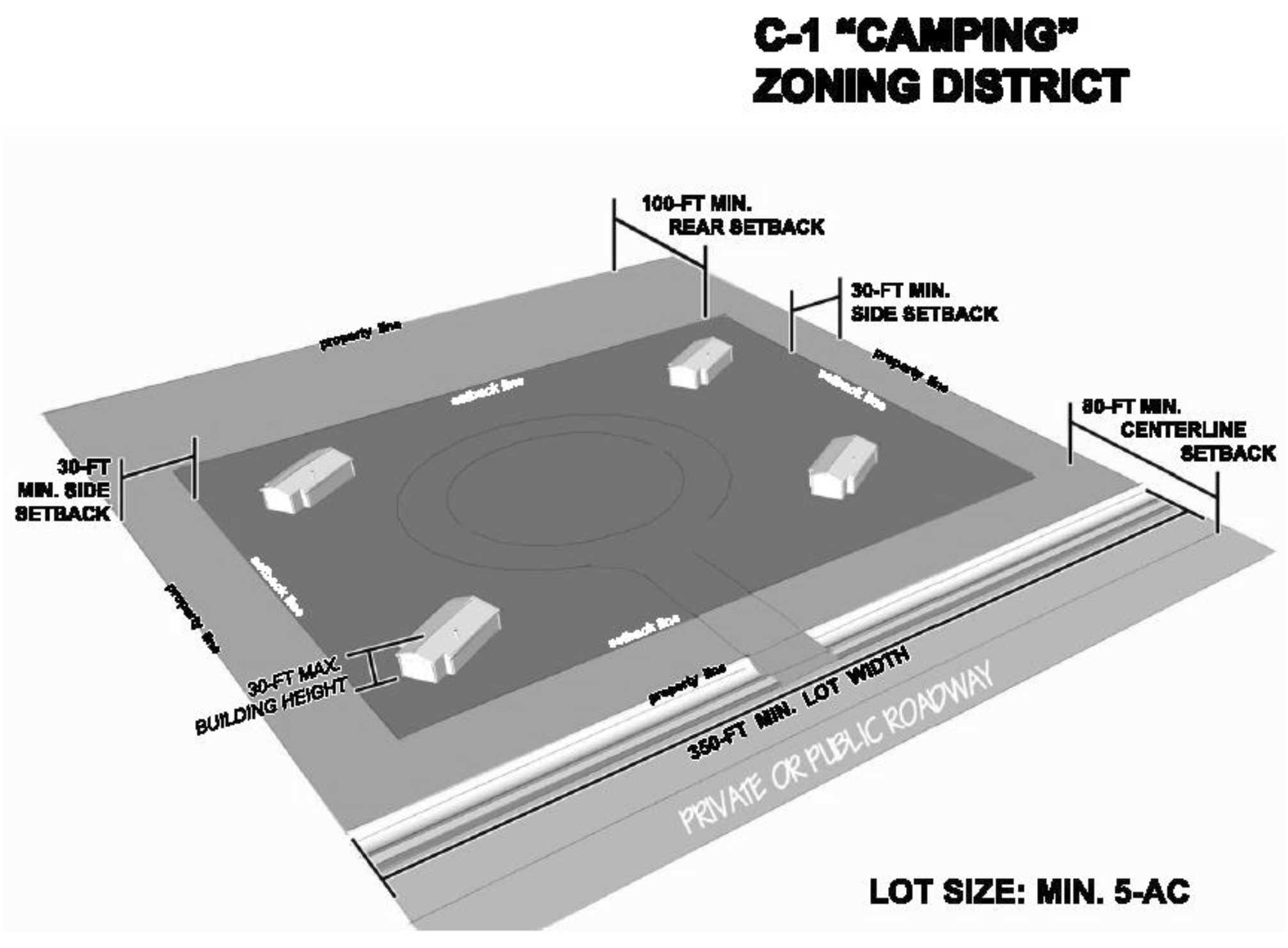
RV park/campground
| |
P
|
S
| | | | | | | | | |
Any area, public or private, whether or not for hire, where three or more campsites
housing tents, cabins, camping trailers, camping vehicles or trailer coaches, motor
homes, travel trailers, recreational vehicles or other permanent or nonpermanent type
shelters are erected and maintained for camping or where space is provided for camping,
temporary parking of recreational vehicles or placing of such tents, cabins, recreational
vehicles or other permanent or non-permanent type shelters of any kind for ten or
more persons for six or more camping days during a calendar year. Includes any campground
as defined by 210 ILCS 95/2. Any such recreational area shall fall under and abide
by regulations of the state department of public health.
|
| Institutional/Civic |
|
Cemetery
| | |
P
|
S
|
S
|
S
|
S
| | | | | |
Property restricted in use for the interment of the human dead by formal dedication
or reservation by deed. A cemetery may include columbaria and mausoleums.
|
|
Club, private
| |
P
| | | | | |
P
|
P
|
P
|
P
| |
A building or premises owned and/or operated by a corporation, association, person
for a social, educational or recreational purpose, but not primarily for profit or
to render a service which is customarily carried on as a business. Examples include
clubs, lodges, meeting rooms, clubhouses, recreational buildings, assembly halls,
and community centers.
|
|
Colleges or universities (public or private)
| | | | | | |
S
|
P
|
P
|
P
| | |
An institution of higher education providing curricula of a general, religious, or
professional nature, typically granting recognized degrees, including conference centers
and academic retreats associated with such institutions. This classification includes
business and computer schools, management training, technical and trade schools, but
excludes personal instructional services.
|
|
Correctional institutions/detention facilities
| | | | | | | | | |
P
|
P
| |
Facilities that are designed for the confinement, correction, and rehabilitation of
adult and/or juvenile offenders sentenced by a court.
|
|
Government office/public building
| | |
P
|
P
|
P
|
P
|
P
|
P
|
P
|
P
|
P
|
P
|
Government administrative or public service buildings or properties, including clerical
or public contact offices of a government agency, along with incidental storage and
maintenance of vehicles. Examples include government administrative offices, libraries
and post offices. This does not include storage yards, warehouses, garages, or other
uses customarily conducted as gainful business.
|
|
Hospital
| | | | | |
S
|
S
|
P
|
P
|
P
| | |
Any institution, place, building, buildings on a campus, or agency, public or private,
whether organized for profit or not, devoted primarily to the maintenance and operation
of facilities or the diagnosis and treatment or care of two or more unrelated persons
admitted for overnight stay or longer in order to obtain medical, including obstetric,
psychiatric and nursing, care of illness, disease, injury, infirmity, or deformity.
This includes any facility not preempted from local regulation that meets this definition,
whether or not it is subject to the Hospital Licensing Act (210 ILCS 85). This definition
includes both hospitals and sanitariums. A heliport/helistop is an accessory to a
principal hospital use.
|
|
Medical clinic
| | | | | | |
S
|
P
|
P
|
P
| | |
A place where patients who are not lodged overnight are admitted for examination or
treatment by a physician and/or practitioners practicing together. Examples include
medical or dental offices, ambulatory or outpatient care services, family planning
and outpatient care centers, medical and diagnostic laboratories, and blood and organ
banks.
|
|
Public safety facility
| | |
S
|
S
|
S
|
S
|
S
|
S
|
S
|
S
|
S
|
S
|
A facility for public safety and emergency services, such as police, fire protection,
police and fire training facilities, and ambulance and emergency services, administrative
facilities for emergency medical care, and blood and organ banks. This includes accessory
transportation services and vehicle maintenance.
|
|
Religious assembly (e.g., church)
| |
P
|
P
|
P
|
P
|
P
|
P
|
P
|
P
|
P
| | |
A building or place used for religious assembly or worship, including accessory uses
or structures such as child care for employees or persons attending worship services,
and education buildings associated with the assembly. Examples include churches, chapels
or parish houses.
|
|
School (trade and miscellaneous)
| | |
S
| | | | | |
P
|
P
|
P
|
P
|
Establishments primarily engaged in providing: (1) vocational and technical training
in a variety of technical subjects and trades, such as graphic arts, aviation and
flight training, computer repair, cosmetology, or truck driving; (2) business, office,
management, and secretarial and stenographic skills; (3) fine arts, dance, sports
and recreation, martial arts, gymnastics, or other athletics; (4) foreign or sign
language instruction; or (5) miscellaneous instruction such as academic tutoring services,
public speaking, automobile driving, speed reading instruction, or exam preparation.
|
|
School (elementary, middle, secondary, trade)
| | |
P
|
P
|
P
|
P
|
P
|
P
|
P
| | | |
A facility for educational purposes that offers a general course of study at primary,
middle, or high school levels and vocational and trade programs that are incidental
to the operation of the schools.
|
|
Social services
| | | | | | | |
P
|
P
|
P
|
P
| |
Establishments that provide social assistance services directly to clients such as
children, elderly persons, disabled persons, homeless persons, or veterans. Social
assistance may include food, medical relief, counseling or training. Examples include
adoption agencies, youth centers (except recreational only), child guidance organizations,
youth self-help organizations, foster care placement services, community action services
agencies, marriage counseling services (except by offices of mental health practitioners),
crisis intervention centers, multipurpose social services centers, family social services
agencies, self-help organizations (except for disabled persons, the elderly, persons
diagnosed with intellectual and, developmental disabilities), family welfare services,
suicide crisis centers, hotline centers, telephone counseling services, community
food services (includes collection, preparation, and delivery of food, clothing and
blankets for needy persons). These services do not include residential or accommodation
services, temporary shelters or community housing (classified separately under transitional
housing, above).
|
|
Social services, accessory
| | |
A
| | | |
A
|
A
|
A
|
A
| | |
Social services such as thrift shops, soup kitchens, or counseling centers that are
accessory to and operated by a religious assembly.
|
| Manufacturing/Industrial |
|
Bakery
| | | | | | | | | | |
P
|
P
|
An establishment primarily engaged in manufacturing fresh and frozen bread, cookies,
crackers, cakes, pies, pasta, tortillas, and other bakery products.
|
|
Cannabis craft grower
| | | | | | | | | | |
P
|
P
|
See Sec. 39-3.
|
|
Cannabis cultivation center
| | | | | | | | | | |
P
|
P
|
See Sec. 39-3.
|
|
Cannabis infuser organization or infuser
| | | | | | | | | | |
P
|
P
|
See Sec. 39-3.
|
|
Cannabis processing organization or processor
| | | | | | | | | | |
P
|
P
|
See Sec. 39-3.
|
|
Data processing, hosting, and related services
| | | | | | | |
P
|
P
|
P
|
P
|
P
|
Establishments that provide infrastructure for hosting or data processing services.
These establishments may provide specialized hosting activities, such as web hosting,
streaming services or application hosting; provide application service provisioning;
or may provide general timeshare mainframe facilities to clients. An example is a
data center.
|
|
Flex space
| | | | | | | | | |
P
|
P
| |
A building that combines office with manufacturing, wholesale, warehousing, or training
facilities that relate to the office uses. Retail or showroom uses that are accessory
to those uses may occupy up to 25 percent of the gross floor area.
|
|
Junkyard
| | | | | | | | | | | |
S
|
An open or fenced-in area where junk, as defined herein, is bought, sold, exchanged,
stored, baled, packed, disassembled, or handled including automobile and building
wrecking yards, but excluding uses located in the applicable industrial district and
properly licensed by the county, engaged exclusively in processing of scrap iron or
other metals to be sold only to establishments engaged in manufacturing of steel or
metal alloys or in the business of selling parts to individuals or businesses.
|
|
Laboratory, testing or experimental
| | | | | | | | | | | |
P
|
Establishments primarily engaged in performing physical, chemical, and other analytical
testing services, such as acoustics or vibration testing, assaying, biological testing
(except medical and veterinary), calibration testing, electrical and electronic testing,
geotechnical testing, mechanical testing, nondestructive testing, or thermal testing.
|
|
Machine shop
| | | | | | | | | | |
P
|
P
|
Establishments primarily engaged in machining metal and plastic parts and parts of
other composite materials on a job or order basis.
|
|
Media production
| | | | | | | | | | |
P
|
P
|
Establishments that produce, manufacture, arrange for the manufacture, or distribute
motion pictures, videos, television programs, television commercials and music and
sound recordings. This includes specialized motion picture or video postproduction
services, such as editing, film/tape transfers, titling, subtitling, credits, closed
captioning, and computer-produced graphics, animation and special effects, and developing
and processing motion picture film. Examples include motion picture film laboratories,
stock footage film libraries, postproduction facilities, teleproduction services,
and sound recording studios
|
|
Medical cannabis cultivation centers
| | | | | | | | | | |
P
| | |
|
Medical research facility, including biological and genetic
| | |
S
| | | | | | |
S
|
P
|
P
|
Establishments primarily engaged in conducting research and experimental development
in the physical, engineering, and life sciences, such as agriculture, electronics,
environmental, biology, botany, biotechnology, computers, chemistry, food, fisheries,
forests, geology, health, mathematics, medicine, oceanography, pharmacy, physics,
veterinary, and other allied subjects.
|
|
Oil and gas extraction
| | |
S
| | | | | | | | |
S
|
Establishments that operate and/or develop oil and gas field properties. Activities
may include exploration for crude petroleum and natural gas; drilling, completing,
and equipping wells; operating separators, emulsion breakers, desilting equipment,
and field gathering lines for crude petroleum and natural gas; and all other activities
in the preparation of oil and gas up to the point of shipment from the producing property.
|
|
Outdoor storage lot
| | | | | | | | | | |
S
|
S
|
Keeping commercial goods, equipment or raw materials in an open lot.
|
|
Pollution control facility
| | |
S
| | | | | | | |
S
|
P
|
See section 39-257 of this chapter.
|
|
Printing, publishing and related trades
| | | | | | | |
P
|
P
|
P
|
P
|
P
|
Establishments that print products, such as newspapers, books, labels, business cards,
stationery, business forms, and other materials, and perform support activities, such
as data imaging, platemaking services, and bookbinding.
|
|
Production, artisan
| | | | | | | | |
S
|
S
|
P
|
P
|
Establishments primarily engaged in on-site production of goods by hand manufacturing,
involving the use of hand tools and small-scale equipment, for sale on the premises.
|
|
Production, general
| | | | | | | | | | |
P
|
P
|
Manufacturing of products, from extracted or raw materials, or recycled or secondary
materials, or bulk storage and handling of those products and materials. These include
food, beverage and tobacco products (including bottling), textiles, apparel, leather
and allied products, wood products, paper, rubber, fabricated metal products, and
transportation equipment. This does not include any activity listed under intensive
high impact production.
|
|
Production, intensive high impact
| | | | | | | | | | |
S
|
S
|
Manufacturing of chemicals, plastics, nonmetallic mineral products, primary metals,
machinery, transportation equipment, acetylene, cement, lime, gypsum or plaster-of-Paris,
chlorine, corrosive acid or fertilizer, insecticides, disinfectants, poisons, explosives,
paint, lacquer, varnish, petroleum products, coal products, plastic and synthetic
resins and radioactive materials. This group also includes smelting, animal slaughtering
and oil refining. Examples include asphalt plants and oil refineries.
|
|
Production, limited
| | | | | | | | | | |
P
|
P
|
Manufacturing of finished parts or products, primarily from previously prepared materials.
This includes: printing and related activities, machinery, computer and electronic
product, electrical equipment, appliance, component manufacturing, furniture and related
product, jewelry and silverware, dolls, toys, games, musical instruments, office supplies,
signs, sporting goods and equipment, and other uses as determined by the zoning administrator.
|
|
Recycling/waste collection
| | | | | | | | | | |
P
|
P
|
A facility where waste material, other than hazardous or infectious waste, is received
and temporarily stored in closed containers without processing or disposition, including,
but not limited to: recycling drop-off point, yard waste depot, charitable drive box
and other similar uses limited in volume and means of storage and posing no nuisance
by reason of odor, noise, runoff, underground seepage or unsightly conditions.
|
|
Research and development
| | | | | | | | | |
S
|
P
|
P
|
An establishment primarily engaged in the research, development and controlled production
of high technology electronic, industrial or scientific products or commodities for
sale. This classification includes biotechnology firms and manufacturers of nontoxic
computer components.
|
|
Waste collection or transfer
| | | | | | | | | | |
S
|
P
|
A facility where waste material, other than hazardous or infectious waste, is received
and processed for transportation to another place for recycling, re-use, incineration
or final disposal, including, but not limited to: biological treatment facility, composting
yard, resource recovery facility, recycling center, buy-back center, tire shredding
facility, tire recycling facility, refuse-derived fuel manufacturing facility, transfer
station and other similar uses, limited by the volume and type of material processed,
or the characteristics of the equipment or methods used to process the waste material.
|
|
Wrecking yard
| | | | | | | | | | | |
S
|
Any area of land where: (1) two or more motor vehicles, not in running condition,
or parts thereof, are stored in the open and are not being restored to operation,
excluding storage of scrap for subsequent manufacturing process on the same premises
or any land, building or structure used for the wrecking or storing of such motor
vehicles, or parts thereof, not in running condition; or (2) industrial metal and
waste salvage operations.
|
| Wholesale/Storage |
|
Warehouse and freight storage
| | | | | | | | | | |
P
|
P
|
Facilities that store general merchandise, refrigerated goods, and other warehouse
products before distribution. These establishments do not sell the goods they handle.
|
|
Wholesale distribution and sales
| | | | | | | | | | |
P
|
P
|
A facility for storage and wholesale distribution of merchandise and bulk goods and
nonretail store sales, including electronic shopping, mail-order houses and other
direct-selling establishments. This use classification excludes retail sale of goods
at discount prices for individual consumption.
|
|
Mini-warehouse
| | |
S
| | | | | | | |
P
|
P
|
Structures containing generally small, individual, compartmentalized stalls or lockers
rented as individual storage spaces and characterized by low parking demand.
|
| Construction |
|
Construction
| | | | | | | | | | |
P
|
P
|
Establishments primarily engaged in the building construction, engineering projects
(e.g., highways and utility systems), and preparing sites for new construction.
|
|
Temporary construction activities
|
P
|
P
|
P
|
P
|
P
|
P
|
P
|
P
|
P
|
P
|
P
|
P
|
See section 40-263 of this chapter.
|
|
Special trade contractors
| | | | | | | | |
P
|
P
|
P
|
P
|
Carpentry, floor, tile, concrete, electrical, glass and glazing, masonry and drywall,
painting, wall covering, roofing, siding, sheet metal, and sign production. These
have no outside storage of materials or equipment.
|
| Transportation and Utilities |
|
Airport/landing field/heliport
| | |
S
| | | | | | | |
P
|
P
|
Any area of land or water used or intended for use for the landing and taking off
of aircraft, and any accessory areas used or intended for use for airport buildings
or other airport facilities or right-of-way, together with all airport buildings and
facilities located on the site. This includes runways, aircraft storage buildings,
public terminal buildings and parking, helicopter pads and support activities such
as airport operations and air traffic control. This may include accessory fueling,
refueling, or service facilities.
|
|
Cannabis transportation organization or transporter
| | | | | | | | | | |
P
|
P
|
See Sec. 39-3.
|
|
Water transportation
| | | | | | | | | | |
P
|
P
|
Facilities for launching, mooring, docking, loading, unloading and servicing river
barges, including backup land for storage and transshipment.
|
|
Bus stations
| | | | | | | | |
P
|
P
|
P
|
P
|
Facilities for passenger transportation operations, holding facilities and maintenance
operations, which includes bus terminals, urban and regional transit stations and
scenic and sightseeing facilities, but does not include airports and heliports.
|
|
Ground passenger transportation (e.g. taxi, charter bus)
| | | | | | | | |
P
|
P
|
P
|
P
|
Establishments that provide passenger transportation by bus, charter bus, automobile,
limousine, van, or shuttle. This also includes scenic or sightseeing transportation
services. Some services (such as taxi) are not operated over regular routes and on
regular schedules. Examples include charter bus, special needs transportation, taxicab
owner/operators, taxicab fleet operators, or taxicab organizations. This does not
apply to publicly operated bus or mass transit systems.
|
|
Hazardous waste collection or disposal
| | | | | | | | | | | |
S
|
Establishments that: (1) operate treatment and disposal facilities for hazardous waste;
(2) combine, collect, or haul hazardous waste materials; (3) remediate and clean contaminated
buildings, mine sites, soil, or ground water; (4) provide mine reclamation activities,
including demolition, soil remediation, waste water treatment, hazardous material
removal, contouring land, and revegetation; or (5) provide asbestos, lead paint, and
other toxic material abatement. The term "hazardous waste" includes any chemical or
substance classified as hazardous under state or federal law.
|
|
Helistop
| | |
S
| | | | | | |
P
|
P
|
P
|
An area used for the landing and taking off of helicopters for the purpose of picking
up or discharging of passengers or cargo. It has no fueling, refueling, or service
facilities.
|
|
Incineration
| | | | | | | | | | | |
S
|
Any use of land or structures engaged in the incineration of hazardous or nonhazardous
wastes.
|
|
Oil or gas pipelines
| | |
S
| | | | | | | | |
P
|
A facility for the distribution of oil, petroleum, or gas energy.
|
|
Parking structures and lots
| | | | | | | | |
P
|
P
|
P
|
P
|
Establishments primarily engaged in providing parking space for motor vehicles, usually
on an hourly, daily, or monthly basis and/or valet parking services.
|
|
Public maintenance facility
| | | | | | | | | |
P
|
P
|
P
|
A governmentally owned facility providing maintenance and repair services for vehicles
and equipment and areas for storage of equipment and supplies. This classification
includes governmentally owned construction yards, equipment service centers and similar
facilities.
|
|
Railroad freight station
| | |
S
| | | | | | | |
P
|
P
|
Railroad switching, storage, or terminal facilities.
|
|
Septic tank services
| | | | | | | | | |
P
|
P
|
P
|
Establishments that: (1) install or pump (i.e., clean) septic tanks and cesspools;
(2) rent or service portable toilets; and (3) provide other waste management services
(except waste collection, waste treatment and disposal, remediation, operation of
materials recovery facilities, and waste management consulting services). No outdoor
storage of equipment or vehicles permitted in the B-3 District.
|
|
Solar farms
| | |
S
| | | | | | |
S
|
S
|
P
|
See Sec. 39-268 |
|
Telecommunications carriers/AM broadcast stations
|
S
|
S
|
S
|
S
|
S
|
S
|
S
|
S
|
P
|
P
|
P
|
P
|
Any telecommunications carriers or AM broadcast station: (1) defined as a qualifying
structure (55 ILCS 5/5-12001.1(c)); or (2) meeting the requirements of 55 ILCS 5/5-12001.1(g)(1).
See section 39-262.
|
|
Towing and other road and ground services
| | | | | | | | | | |
P
|
P
|
Establishments primarily engaged in towing light or heavy motor vehicles, along with
incidental services such as storage and emergency road repair services.
|
|
Truck transportation
| | | | | | | | | | |
P
|
P
|
A facility for the storage of commercial goods within an enclosed building for distribution
by truck. This includes bulk mail handling facilities.
|
|
Utilities, essential services
|
P
|
P
|
P
|
P
|
P
|
P
|
P
|
P
|
P
|
P
|
P
|
P
|
The erection, construction, alteration or maintenance, by public utilities or municipal
or other governmental agencies, of underground or overhead gas, electrical, steam
or water transmission or distribution systems, collection, communication, supply or
disposal systems, including poles, wires, mains, drains, pipes, conduits, cables,
fire alarm boxes, police call boxes, traffic signals, hydrants, and other equipment
and accessories in connection therewith, reasonably necessary for the furnishing of
adequate service by such public utilities or municipal or other governmental agencies
or for the public health or safety or general welfare, but not including buildings.
This includes transformer stations and booster or pressure-regulating stations without
a service yard or storage.
|
|
Utilities, alternative energy sources
| |
S
|
S
|
S
|
S
|
S
|
S
|
S/A
|
S/A
|
S/A
|
S/A
|
S/A
|
Power generation from alternative sources such as solar, or geothermal sources.
|
|
Vehicle storage
| | | | | | | | | | |
P
|
P
|
A building or enclosed area that is used to store: (1) recreational vehicles, campers,
buses, or similar vehicles; or (2) towed, temporarily unused, or inoperable vehicles.
This includes any impoundment lot, recreational vehicle or boat storage lot, bus and
camper storage lot, or wrecked vehicle storage lot.
|
|
Wind energy conversion system (WECS), commercial
| | |
S
| | | | | | | | |
S
|
See section 39-267 of this chapter.
|
|
Wind energy conversion system (WECS), noncommercial and private
| |
S
|
S
|
S
|
S
|
S
|
S
|
S
|
S
|
S
|
S
|
S
|
See section 39-267 of this chapter.
|
| Mining/Extraction |
|
Oil or gas production
| | |
S
| | | | | | | | |
S
|
Oil and gas field and support activities, including exploration for crude petroleum
and natural gas; drilling, completing, and equipping wells; operating separators,
emulsion breakers, desilting equipment, and field gathering lines for crude petroleum
and natural gas; and all other activities in the preparation of oil and gas up to
the point of shipment from the producing property.
|
|
Mine/quarry
| | |
S
| | | | | | | | |
S
|
The extraction, removal and loading of limestone, minerals, sand or gravel, or similar
metallic minerals and nonmetallic minerals. This includes mine site development, beneficiating
(i.e., preparing), and support activities. Activities or structures include equipment,
buildings or structures for screening, crushing, mixing, washing and storage, customarily
done at the mine site.
|
|
Sand and gravel pits
| | |
S
| | | | | | | | |
S
|
A type of open pit mine, or strip mine, from which the mineral removed is restricted
to sand and gravel.
|
| Accessory |
|
Barns/silos accessory to residential or commercial uses (farms are exempt)
| |
A
|
A
|
A
|
A
|
A
|
A
|
A
|
A
|
A
|
A
|
A
|
An accessory building used exclusively to store grain, hay, and other farm products,
or the sheltering of livestock or farm equipment.
|
|
Central laundry facilities
| |
A
|
A
|
A
|
A
|
A
|
A
|
A
|
A
|
A
|
A
|
A
|
An area of a building equipped with washing, drying, and/or ironing machines for the
exclusive use of residents or employees.
|
|
Convenience stores attached to residential development
| | | | | | |
A
|
A
|
A
|
A
| | |
A convenience store (as defined above) located on a single platted lot in a residential
subdivision, and that has direct access and pedestrian connections to the residential
development. Not to include any repairs or gas station.
|
|
Garages
| | |
A
|
A
|
A
|
A
|
A
|
A
|
A
|
A
| | |
An accessory building or structure, or part of a building or structure, used or designed
to be used for the parking and storage of vehicles in conjunction with residential
uses.
|
|
Home occupations
| | |
A
|
A
|
A
|
A
|
A
|
A
|
A
|
A
| | |
Customary home occupations including the professional office or studio of an architect,
artist, dentist, doctor, engineer, lawyer, planner, scientist, teacher, beautician,
barber, or occupations such as handicraft, dressmaking, millinery, laundry, preserving
and home cooking; provided that: (1) such occupations shall be conducted exclusively
by resident occupant; (2) that not more than one-fourth of the area of one floor of
said residence shall be used for such purposes; (3) that no structural alterations
or constructions involving features not customarily found in dwellings are required;
(4) an unlighted sign of not more than one square foot of area, and attached flat
against the building, shall be permitted; (5) no equipment shall be used which creates
offensive noise, vibration, smoke, dust, odor, heat, or glare; and (6) a home occupation
shall not include the operation of a restaurant or auto body shop.
|
|
Irrigation facilities
|
A
|
A
|
A
|
A
|
A
|
A
|
A
|
A
|
A
|
A
|
A
|
A
|
Canals, laterals, ditches, conduits, gates, pumps, and allied equipment necessary
for the supply, delivery and drainage of irrigation water and related construction,
operation, and maintenance.
|
|
Kennel, private
| |
A
|
A
|
A
|
A
|
A
|
A
|
A
|
A
|
A
|
A
|
A
|
Any building or land designed or arranged for the care of dogs and cats belonging
to the owner of the principal use, kept for purposes of show, hunting, or as pets.
|
|
Outdoor display
| | | | | | | |
A
|
A
|
A
|
A
| |
Outdoor merchandise display, as defined in article V of this chapter, which is accessory
to an indoor retail use. Retail uses that customarily occur outdoors, such as flea
markets/swap meets, roadside stands, and farmer's markets, are allowed as a principal
uses where listed under the commercial category above, and may be subject to supplemental
regulations as provided in section 39-256 of this chapter.
|
|
Outdoor storage, accessory
| | | | | | | |
A
|
A
|
A
|
A
|
A
|
An area outside of a building which is used to store usable goods and materials for
sale or for use in the business.
|
|
Parking, on-site
| |
A
|
A
|
A
|
A
|
A
|
A
|
A
|
A
|
A
|
A
|
A
|
An area reserved for parking vehicles for persons living or working on the site, or
for customers of a business on the site.
|
|
Parking, off-site
| | | | | | |
S
|
A
|
A
|
A
|
A
| |
Parking areas accessory to a use in an adjoining less restricted district, when abutting
or directly across an alley.
|
|
Residential development office and maintenance buildings
| | | |
A/S
|
A/S
|
A/S
|
A/S
|
A/S
|
A/S
|
A/S
| | |
Offices or maintenance facilities located in a residential subdivision or a multifamily
building. These are used to support occupants of, or to sell or rent dwelling units
in, the subdivision or building.
|
|
Incidental institutional
| | | | | | | | | | |
A
|
A
|
Schools, clinics and other institutions for human care, except when incidental to
a permitted principal use.
|
|
Signs
| |
A
|
A
|
A
|
A
|
A
|
A
|
A
|
A
|
A
|
A
|
A
|
See section 39-3.
|
|
Storage structures
| | |
A
|
A
|
A
|
A
|
A
|
A
|
A
|
A
|
A
|
A
|
Detached or attached structures that are subordinate to the principal structure in
size, and that store items or equipment used by occupants or employees on the premises.
Storage structures shall not exceed 200 square feet in size in the A-1, A-R, and R-1
districts.
|
|
Outdoor residential swimming pool
| | |
A
|
A
|
A
|
A
|
A
|
A
|
A
|
A
| | |
See section 39-261 of this chapter.
|
|
Temporary construction building
| |
A
|
A
|
A
|
A
|
A
|
A
|
A
|
A
|
A
|
A
|
A
|
Temporary buildings that house offices, equipment storage, or other functions incidental
to construction and development activities.
|