
Winter Garden City Zoning Code
ARTICLE XIV
EAST PLANT STREET CHARACTER AREA
Sec. 118-1636. - Establishment.
In addition to and supplemental to the requirements of this chapter, there is hereby created the east plant street character area ("character area"). The character area contains two overlay zoning districts known as the east plant overlay district and gateway overlay district. The development standards for each overlay district are calibrated to the varied development conditions and desired character for lots and parcels within each overlay district.
(Ord. No. 17-06, § 2(Exh. A), 6-22-17)
Sec. 118-1637. - Purpose.
The general purpose of the character area and the development standards of this article are intended to:
(a)
Create a livable transportation network with people-oriented transportation focusing on a network of street and trail connections rather than a limited system of roads;
(b)
Create a strong sense of place by building on the existing character of the West Orange County communities;
(c)
Create and encourage mixed and multi-use development creating more activity at more times of the day and more days of the week to ensure a vibrant level of exchange;
(d)
Create a robust public realm by linking the community with parks, trails, and open spaces;
(e)
Create a front-door gateway for the downtowns of the City of Winter Garden and City of Ocoee by creating a more inviting urban form that carries a similar character to the rest of downtown Winter Garden;
(f)
Maintain and enhance property values; and
(g)
Encourage high quality and high value economic development.
(Ord. No. 17-06, § 2(Exh. A), 6-22-17)
Sec. 118-1638. - Boundaries of the overlay districts.
The boundaries of the east plant overlay district and gateway overlay district are graphically depicted as the adopted by Ordinance No. 17-06, as may be amended from time to time.
(Ord. No. 17-06, § 2(Exh. A), 6-22-17)
Sec. 118-1639. - Applicability of design and development standards.
The design and development standards for parcels within each overlay district established under this article shall govern new development and redevelopment of parcels of land within the overlay districts. Nothing in this article is intended to amend or supersede the non-conforming use and structure provisions of this chapter. Uses, buildings and structures legally permitted and existing as of the adoption of this article are not required to come into compliance with article unless and until the property upon which such are in use or constructed is redeveloped. To the extent the overlay district design and development standards of this article do not speak to an issue governed by other provisions of this chapter, the other provisions of this chapter still apply. Except for the accessory uses described in sections 118-1645 and 118-1646 desired for new development or redevelopment, all underlying permitted uses, special exception uses and prohibited uses for the underlying zoning district assigned shall remain in full force and effect for each lot and parcel within the character area. For the purposes of this article, a "redevelopment" occurs when: (i) an existing principal structure is or is proposed to be demolished and replaced with a new structure, or (ii) the existing principal structure loses or would lose its legally non-conforming status under this chapter due to the construction or development proposed. In the event of a conflict between this article and other provisions of this chapter, the provisions of this article shall control to the extent of the conflict.
(Ord. No. 17-06, § 2(Exh. A), 6-22-17)
Sec. 118-1640. - Design principles for east plant street character area.
The plant street character area design plan ("design plan") is hereby adopted by reference and incorporated herein. To the extent the provisions of the design plan are not codified in other sections of this article, the design plan shall serve as a guideline for development with the character area.
(Ord. No. 17-06, § 2(Exh. A), 6-22-17)
Sec. 118-1641. - Administrative waiver.
An administrative waiver may be granted by the community development director from those certain development standards of this article as set forth in the Table A (allowable administrative waivers) below upon making the required findings.
Table A - Allowable Administrative Waivers
(Ord. No. 17-06, § 2(Exh. A), 6-22-17)
Sec. 118-1642. - Submittal of landscape plans.
A landscape plan delineating the location, height, and type of all plant and groundcover materials, as well as the irrigation system must be provided with the submittal of a planned unit development rezoning or site plan application for developments subject to this article. Unless otherwise approved by the city community development director, the landscape plan must be prepared by a landscape architect licensed to practice in the State of Florida.
(Ord. No. 17-06, § 2(Exh. A), 6-22-17)
Sec. 118-1643. - Architectural drawings.
Architectural elevations of all facades, buildings and structures subject to this article shall be submitted with applications and a required exhibit for a planned unit development rezoning or site plan approval. Such exhibits shall include colors, materials, building dimensions, elevations of all building sides, location of service areas and mechanical equipment, screening devices, site furnishings, lighting fixtures, all signage and any other information as determined necessary to ensure consistency with the intent of this article by the city. All elevations must be signed and sealed by a licensed architect registered in the State of Florida.
(Ord. No. 17-06, § 2(Exh. A), 6-22-17)
Sec. 118-1644. - Screening of mechanical systems, equipment and facilities.
Equipment and appurtenances mounted on the tops of buildings shall be screened from view. Mechanical systems, equipment and facilities such as, but not limited to, utility, transformers, backflow preventers, condensers, hardware, loading and unloading areas, dumpsters, exterior storage and work areas, shall be screened from public view or located at a location that is not visible from public streets or from the parking area. All screening shall be, at a minimum, the same height as the mechanical systems, equipment, or facility. Screens shall be compatible to the building, proximate properties and reflect or complement the architecture, color, and materials of the building as determined by the city-based upon sound and generally accepted architectural practices and principles. Landscaping is permitted for at-grade screening as long as it provides 100 percent opacity within 12 months. All outside electrical, telephone, cable and gas equipment or facilities shall be placed as close to the building as feasible and screened with landscaping and to the extent practicable such utilities shall be placed underground.
(Ord. No. 17-06, § 2(Exh. A), 6-22-17)
Sec. 118-1645. - Outdoor storage and sales prohibited.
Notwithstanding the underlying zoning district designation of a parcel or lot, within the character area (including within all overlay districts therein), outdoor storage is prohibited. Without limiting the foregoing, outdoor commercial or merchandise sales or display areas, commercial play devices, kiosks, and tents are prohibited.
(Ord. No. 17-06, § 2(Exh. A), 6-22-17)
Sec. 118-1646. - Drive-through.
Notwithstanding the underlying zoning district designation of a parcel or lot, within the character area (including within all overlay districts therein), drive-in or drive-through components of retail and other commercial uses are only allowed with special exception approval.
(Ord. No. 17-06, § 2(Exh. A), 6-22-17)
Sec. 118-1647. - Building types.
There are eight building types within the character area which are identified in the design plan. The overlay district assigned to a parcel of land determines which of the building types are permitted and the maximum stories allowed. Only the building types permitted in each overlay district are allowed for each respective overlay district. Each building type has a maximum story limitation, schematic example, illustrative photos, regulations, and standards that are required within the character area.
(Ord. No. 17-06, § 2(Exh. A), 6-22-17)
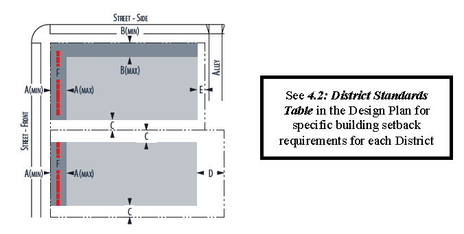
Sec. 118-1648. - Building setbacks.
The placement of buildings on a parcel or lot is dictated by the setbacks and frontage requirements. All setbacks must be landscaped according to the requirements of each building type. In addition to setbacks, a frontage requirement is specified, which defines the percentage of a lot's dimensions adjacent to a street that must have a building's ground floor within the street setback area. A reference diagram of building placement standards is shown below.
(Ord. No. 17-06, § 2(Exh. A), 6-22-17)
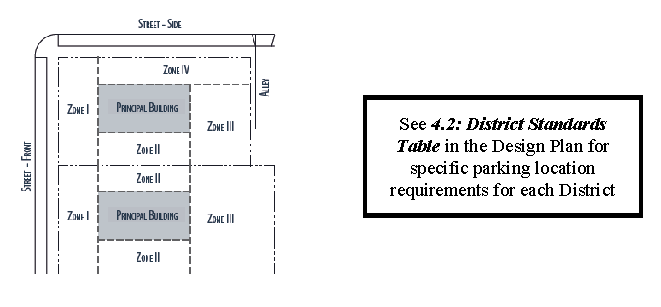
Sec. 118-1649. - Parking placement.
Off-street parking facilities are permitted only in certain zones within a lot or parcel, depending on the overlay district within which the lot or parcel is located. A reference diagram for parking zone location is provided below.
(Ord. No. 17-06, § 2(Exh. A), 6-22-17)
Sec. 118-1650. - Parks.
A minimum of five percent of developable area shall be reserved for park use for all development on all properties that are one acre or more within the character area generally consistent with the park types standards set forth in the design plan.
(Ord. No. 17-06, § 2(Exh. A), 6-22-17)
Sec. 118-1651. - Façade types.
There are five façade types within the character area which are identified in the design plan. The overlay district assigned to a parcel of land determines which of the façade types are required and permitted. Only the façade types permitted in each overlay district are allowed for each respective overlay district. Each façade type also has signage and encroachment standards as set for in the design plan.
(Ord. No. 17-06, § 2(Exh. A), 6-22-17)
Sec. 118-1652. - Planned unit development.
(a)
The character area planned unit development (CAPUD) zoning category is hereby created as an additional mechanism to implement this article. Additional standards governing the character area planned unit development zoning category are set forth in article V of this chapter.
(b)
The use of character area planned unit development zoning is encouraged for the lands within the character area. Character area planned unit development zoning allows for a mixture of permitted uses that a parcel's or lot's current underlying zoning district may not. Further, the character area planned unit development zoning provides some flexibility to allow minor deviations from the strict requirements of this article without the need to meet the requirements of an administrative waiver.
(c)
The city recognizes the constraints of meeting the development standards of this article for an infill development project and the use of character area planned unit development zoning is encouraged to address and approve required deviations for such projects beyond those of which may be granted by administrative waiver.
(d)
In addition to the rezoning criteria, when considering a rezoning to character area planned unit development that incorporates deviations from the development standards of this article, the city shall consider the extent to which the proposed development, taken as a whole:
(1)
Advances the stated vision and principles of the character area, including:
a.
Promotes modes of transportation other than the automobile, including walking and transit;
b.
Creates a built environment that is in scale with pedestrian-oriented activities and provides visual interest and orientation for pedestrians; and
c.
Contributes to a mix of uses in the area that are compatible with each other and work together to support the stated vision.
(2)
Is consistent with the intent of the standards applicable to the sub-district and district in which it is located.
(3)
Is physically and functionally integrated with the built environment in which it is located; and
(4)
The potential impacts of the proposed deviation on surrounding properties and the extent to which any adverse impacts from such deviation can be mitigated.
(e)
A development of lots and parcels within the gateway overlay district or multi-use development (MUD) future land use designated properties within the character area may obtain densities and intensity bonuses up to a maximum density of 30 dwelling units per acre for residential and maximum of 2.0 FAR for commercial and office uses provided that the developer/owner submits an application for and obtains a rezoning to a character area planned unit development designation, complies with the requirements of this article and proves that the proposed development is in substantial compliance with the principles and guidelines set forth in the design plan. The implementation of this subsection is contingent upon and subject to the city commission's adoption of comprehensive plan policies providing for such density bonuses.
(Ord. No. 17-06, § 2(Exh. A), 6-22-17)
_____
Sec. 118-1653. - Plant street streetscape.
Throughout the character area, development fronting Plant Street is required to provide at the developer's/owner's expense streetscape treatments of landscape and hardscape consistent with the following plan.

It is not the intent of this section to mandate the dedication or conveyance of additional public right-of-way along Plant Street from development in order to accomplish the required treatment or optional treatment. The planting zones and walking zones improvements described in this section may be made upon a mixture of public right-of-way and private land subject to non-exclusive public pedestrian and/or landscaping easements. Any on-street parking provided under the optional treatment will need to be located within existing or proposed public right-of-way. The development review committee may grant waivers to the required dimensions set forth herein for development within the east plant overlay district in the event there is inadequate public right-of-way or building setback area upon the property proposed to be developed available to accommodate the required treatment or optional treatment. This section does not apply to properties that were previously developed prior to the adoption of this article unless and until such properties seek to redevelop.
(Ord. No. 17-06, § 2(Exh. A), 6-22-17; Ord. No. 19-39, § 2, 7-25-19)
_____
Sec. 118-1658. - East plant overlay district.
In addition to the provisions of division 1 of this article, the provisions of this division shall govern the development of lands within the east plant overlay district.
(Ord. No. 17-06, § 2(Exh. A), 6-22-17)
Sec. 118-1659. - Building setbacks.
The following building setbacks shall apply within the east plant overlay district:
See 4.1.1: Setback Location Diagram in the Design Plan.
(Ord. No. 17-06, § 2(Exh. A), 6-22-17)
Sec. 118-1660. - Building types.
The following building types are required and permitted within the east plant overlay district:
(Ord. No. 17-06, § 2(Exh. A), 6-22-17)
Sec. 118-1661. - Façade types.
The following façade types are required and permitted within the east plant overlay district:
(Ord. No. 17-06, § 2(Exh. A), 6-22-17)
Sec. 118-1662. - Parking.
The requirements for on-site vehicular parking spaces within the east plant overlay district are as follows:
The parking location on site shall be as follows:
See 4.1.6: Parking Location Diagram in the Design Plan.
(Ord. No. 17-06, § 2(Exh. A), 6-22-17)
Sec. 118-1668. - Gateway overlay district.
In addition to the provisions of division 1 of this article, the provisions of this division shall govern the development of lands within the gateway overlay district.
(Ord. No. 17-06, § 2(Exh. A), 6-22-17)
Sec. 118-1669. - Building setbacks.
The following building setbacks shall apply within the gateway overlay district:
See 4.1.1: Setback Location Diagram in the Design Plan.
(Ord. No. 17-06, § 2(Exh. A), 6-22-17)
Sec. 118-1670. - Building types.
The following building types are required and permitted within the gateway overlay district:
(Ord. No. 17-06, § 2(Exh. A), 6-22-17)
Sec. 118-1671. - Façade types.
The following facades types are required and permitted within the gateway overlay district:
(Ord. No. 17-06, § 2(Exh. A), 6-22-17)
Sec. 118-1672. - Parking.
The requirements for on-site vehicular parking spaces within the gateway overlay district are as follows:
The parking location on site shall be as follows:
See 4.1.6: Parking Location Diagram in the Design Plan.
(Ord. No. 17-06, § 2(Exh. A), 6-22-17)
APPENDIX
Commercial Corridor Plant Material List.
All required landscape materials shall be selected from the Commercial Corridor Plant Materials List. These common plant materials shall be used along streets, buildings, buffers, and parking lots.
All new plant material to be used for material required in division 3 landscape design standards shall be container grown and shall equal the standards for Florida No. 1 as set forth in "Grades and Standards for Nursery Plants", Part I, 1963 and Part II State of Florida Department of Agriculture, and any amendments thereto. Plant material should be evaluated by texture, color, ultimate growth, Xeriscape properties and ease of maintenance.
Decorative plant materials, not included on the list, may be used only with written city approval. All landscape materials shall be allowed to grow in a natural condition and not be pruned back to avoid growth.
Canopy trees may be substituted for understory trees at a rate of three understory trees equal to one canopy tree. Palms may be used as an alternate for canopy tree requirements at a rate of three palms to one canopy tree except along buffers adjacent to residential uses. Understory tree substitution shall not be employed to eliminate 50 percent or more of required canopy trees.
Recreational Vehicles (RV's), Automobile/Truck and Boating Sales.
In the special case of front & side buffers for automobile/truck sale, recreational vehicle sale or boat sale property uses, all canopy trees shall be allowed to be substituted in favor of understory or palm trees in order to protect on site merchandise from leaf/bird droppings. For these uses only, two understory trees or palms may be substituted for one required canopy tree if the understory trees are at least 65-gallon industry standard or palms are at least 12 foot clear trunk height. Understory trees shall not be substituted for canopy trees adjacent to rear buffers or residential uses.
1.
Canopy shade trees. Canopy trees shall be, at minimum: Two-inch to two and one-half-inch caliper, eleven to twelve foot height, five foot clear trunk, five-foot spread, container grown. (30-gallon tree container industry standards)
2.
Understory/ornamental trees. Understory/ornamental trees shall be, at minimum: One and one-half-inch to two-inch caliper, five- to seven-foot height overall, three-foot spread, container grown. (15-gallon tree container industry standards.)
Multi-trunk trees shall have three to four one-inch trunks, minimum.
3.
Understory/ornamental trees (palms). Understory/ornamental palm trees shall be, at minimum: height varies, minimum eight feet clear trunk.
4.
Hedges, shrubs and groundcovers. All hedge, shrub and groundcover landscaped areas shall be planted to achieve 100 coverage of the planting area within one year of installation. All continuous shrub hedges shall be installed at minimum 24″ overall height and maintained at a height of 36″—42″ and 90 percent opacity within one year of planting.
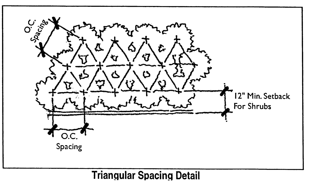
All hedges/shrubs shall be, at minimum: three gallon, container grown, planted 36″ on center maximum spacing. Plant count at 36″ triangular spacing equals planting area x .129.
All groundcover plants shall be, at minimum: one gallon, container grown, planted 24″ on center maximum spacing. Plant count at 24″ triangular spacing equals planting area x .290.
Accents: Limited use, may count toward total landscape area requirement.
5.
Lawns.
a.
All landscape areas not planted with shrubs and groundcovers, mulched, or left in a natural vegetative state shall be sodded with St. Augustine "Floratam" solid sod.
b.
The sod shall be in good condition, free of weeds, two inches in thickness and planted within 24 hours of arrival to the site. The planting method shall avoid continuous running sod joints. All areas where a solid joint is not achieved shall be filled with topsoil or sprigs of grass sod.
6.
Approved aquatic plant material list. Upper littoral zone (six inches above or below the normal water level).
Middle littoral zone (from one inch to three inches below normal water level).
Lower littoral zone (from three inches to five inches below normal water level)
Other aquatic plants may be used from the List of Aquatic Plants Found in Florida, as prepared by the Florida Department of Natural Resources, Bureau of Aquatic Plant Management.
(Ord. No. 03-30, § 2B(App.), 9-17-03)