
Aiken City Zoning Code
CHAPTER 4
DESIGN STANDARDS
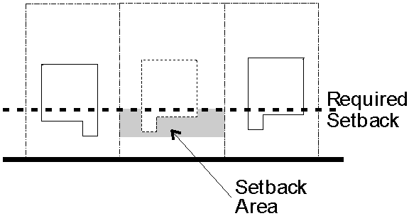
4.1.1. - Side Yard Setbacks for Corner Lots.
In the case of any lot that adjoins two or more streets, yards abutting streets shall be treated as front yards.
4.1.2. - Setback from Horse Track.
Any principal building, accessory building or use, residence, or paddock shall be located a minimum of 75 feet from the outside edge of a track surface where horse racing or training can take place, or from the outside rail of such a track, whichever would result in the maximum separation. This provision shall not apply to buildings located on the same lot as the track, where no minimum separation shall be required.
4.1.3. - Modification of Yard Regulations.
A.
Setback on Residential Infill Lots. New or replacement construction may be located in the required front yard setback to the same extent as the principal structure on the adjacent lot is in the required front yard setback. A lot in the RS-6, RML, or RMH zone not having a lot width of 60 feet may have a side yard setback of 7.5 feet to allow construction of a single-family dwelling unless the Building Official requires a greater setback. (Ord. 04102000C)
B.
Side Yard Waived. Attached residential dwellings with common walls located over the lot line shall not be required to provide side yards.
C.
Projection Into Yards. The following may extend or project into a required yard.
1.
Cornices, sills, eaves, belt courses, chimneys, or other similar architectural feature.
2.
Unroofed platforms, landings, steps, or balconies.
3.
Heating and air conditioning units, transformers, or other similar machinery.
4.1.4. - Fences and Walls.
A.
Location. A fence or wall may be located in accordance with B, C, and D below except where prohibited by corner setbacks for intersection visibility (see 4.1.5 below). (Ord. 02142005)
B.
In Nonresidential Districts. A fence or wall in any nonresidential district shall not exceed eight feet in height.
C.
In Residential Districts. In the area between the plane of the front of the principal building and any street, no fence or wall shall exceed four feet in height except where a higher fence conforming to these regulations exists on a common property line of an adjacent lot in which case the proposed fence may be no higher than that fence. No fence or wall on any other portion of the lot may exceed six feet in height. (Ord. 02142005)
D.
In Historic Districts. The Design Review Board shall have the authority to permit a fence or wall in an Historic District up to a height of twelve feet. (Ord. 02142005)
4.1.5. - Corner Setback and Intersection Visibility.
A.
General. The following standards shall apply at any corner of intersecting streets or driveways, except in the DB District.
1.
Corner setbacks extend within the area formed by the legs of a triangle whose apex is the point of intersection of the rights-of-way of the adjacent streets.
2.
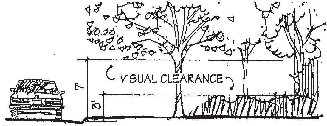
No structure or planting (at mature growth) that exceeds three feet in height shall be permitted within a corner setback. Exceptions are permitted for utility poles, lighting standards, mail boxes, City or State traffic signs, and existing trees if the lower canopy of the trees allow a clear line of sight between three feet and seven feet above the street grade and the trunks of such trees are sufficiently spaced or are so located as to be unlikely to substantially interrupt the line of sight. A sign structure permitted by Chapter 4, Article 4 may be located within the intersection visibility area provided that visual clearance exists between three feet and seven feet above the ground.
B.
Required Corner Setbacks.
1.
The following corner setbacks shall be required.
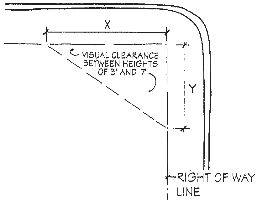
2.
These distances may be reduced by the Building Official upon a showing that no public safety issues exist.
4.1.6. - Exceptions to Height Requirements.
The following structures may extend above the height limits in Articles 2 and 3 of this Chapter, provided that the portion of the structure exceeding the height limit is not used for dwelling purposes.
1.
Chimneys or smokestacks;
2.
Cooling towers, gas containers, elevator penthouses, skylights, stairways, or ventilating fans;
3.
Steeples or spires;
4.
Fire or parapet walls;
5.
Flagpoles;
6.
Communication towers;
7.
Silos, water tanks, or standpipes; and
8.
Any other similar structures.
4.1.7. - Fire Suppression Required.
No building or structure may be erected that exceeds two stories in height, exceeds 15,000 square feet in area, or has more than four dwelling units, unless the building or structure has a sprinkler system approved by the Department of Public Safety.
4.2.1. - Table of Residential Design Standards.
* RS-6 See 4.1.3.A ** RML, RMH See 4.1.3.A
4.2.2. - Minimum Unit Size.
Every new dwelling unit shall have minimum gross floor area of 450 square feet.
4.2.3. - Minimum Building Separation.
Where there is more than one primary structure on a single lot of record, there shall be at least 15 feet between one-story structures and at least 20 feet between two-story or taller structures and any other structure. The Building Official may reduce this required separation where no public safety concerns exist.
4.2.4. - Underground Wiring.
When there is a conflict between the ordinance and an existing franchise agreement, the City Manager or his designee will determine whether the utilities are installed aboveground or belowground. The following applies as long as there is no conflict with an existing franchise agreement between the City and the service provider. Any new electric service lines to multifamily structures or manufactured home parks shall be installed underground. Electric service lines to a new single-family dwelling shall be installed underground. New electric distribution lines shall be placed underground. All new wiring for telephone, cable, or any other purpose shall also be installed underground. In some circumstances, it may not be reasonable, technically feasible, or economically practical to install new wiring underground. In these instances, permission to install the utilities aboveground may be requested. If deemed appropriate, the City Manager or his designee may grant permission to install the utilities aboveground. The undergrounding requirement does not apply to any wiring related to maintenance, repair, or upgrades of existing aboveground facilities, and it does not apply to the placement of any aboveground facilities, such as cabinets and pedestals, that are necessary for provision of service using the underground facilities.
4.2.5. - Parking of Recreational, Oversize, and Emergency Vehicles.
A.
Recreational Vehicles. A recreational vehicle (including motor homes, travel or camper trailers, pickup campers, boats, and boat trailers) may be parked or stored on any lot in a residential zoning district in accordance with the following standards.
1.
On an interior lot, the recreational vehicle is parked in an enclosed building, or in the rear yard, or in the side yard not projecting beyond the front of the roof line of the principal dwelling on the lot.
2.
On a corner lot, the recreational vehicle is parked in an enclosed building, or in the rear yard, or in the side yard not projecting beyond the front of the roof line of the principal dwelling on the lot; if parked in the rear or side yard, the recreational vehicle must be completely screened by evergreen vegetation from view from all streets that run along the rear yard or side yard in which it is parked.
3.
The recreational vehicle is parked or stored entirely on the residential lot in a safe and orderly condition, and if parked or stored on a driveway, it shall not be a hazard to persons or vehicles entering or exiting the driveway, persons passing on the sidewalk, or persons in vehicles passing on any adjoining street.
4.
The combined total number of recreational vehicles and oversized vehicles permitted pursuant to 4.2.5.B so parked or stored on any residential lot shall be limited to three, not including those kept in a garage or other enclosed building.
5.
A recreational vehicle may be parked anywhere on a residential lot for a period not to exceed 24 hours for the purposes of loading and unloading.
6.
A recreational vehicle shall not be used for the purposes of permanent human habitation while parked or stored on any residential lot. Temporary storage or parking of a recreational vehicle for housing of temporary guests shall be permitted for a period not to exceed two consecutive weeks during any one calendar year.
B.
Oversize Vehicles Other Than Recreational Vehicles.
1.
Any vehicle or combination of vehicles exceeding 26,000 pounds Gross Vehicle Weight Rating (GVWR), or any vehicle designed to transport 16 or more passengers including the driver, or any vehicle placarded for hazardous materials shall be prohibited in a residential zone except to allow deliveries or provide services to residents.
2.
Any vehicle which has an overall vehicle length exceeding 22.5 feet in length or 8 feet in height, excluding trailer hitches, winches, handicapped accessories, roof racks, etc. must be located and screened in the same manner as a recreational vehicle as set forth at 4.2.5.A. The total combined number of these oversize vehicles and recreational vehicles permitted pursuant to 4.2.5.A parked or stored on any residential lot shall be limited to three.
3.
No such vehicle may be parked on a lot in a residential zone unless the lot is occupied by a single-family dwelling and the vehicle is operated by the occupant of the dwelling.
4.
This section shall not apply to (1) any vehicle kept in a garage or other enclosed building, or (2) horse-related vehicles in the Horse District or RSS zones.
C.
Emergency Vehicles. One emergency vehicle may be located on a lot occupied by a single-family dwelling as long as the vehicle complies with the standards for recreational vehicles at 4.2.5.A, and the vehicle does not use its siren or flashing lights while on the lot. Emergency vehicles may be located in a multi-family or attached single-family residential project in an area screened from view. For the purposes of this section, an emergency vehicle is an ambulance or a tow truck displaying a decal in a prominent location verifying that it is licensed by the State of South Carolina to provide emergency road service. (Ord. 09102001A) (Ord. 08112003)
4.2.6. - Planned Residential Projects.
A.
Location. Land in the Horse District or listed on the Aiken Historic Register may not be zoned PR.
B.
Approval of Concept Plan.
1.
Concurrent with the zoning of land to PR, a concept plan must be approved by City Council in accordance with 6.2.16 and the design criteria below.
2.
Prior to submission of an application for the concept plan, the potential applicant shall meet at least once with Planning Department staff to review a preliminary proposed concept plan which shall include the following:
a.
existing roads and utilities;
b.
natural features including steep slopes, open areas, wooded areas with a general description of varieties and sizes of trees, location of streams and ponds, wetland areas, and soil types;
c.
the location of proposed structures;
d.
the location and types of dwelling units;
e.
the location and amount of open space;
f.
how the roads, trails, and pathways connect to surrounding areas; and
g.
if the subject property is in the City limits, a description of how the design of the project will relate to the surrounding area.
3.
Staff shall provide written comments to the potential applicant within 10 business days after the meeting.
4.
Each concept plan is subject to detailed review by City Council, and there shall be no entitlement to either the maximum permitted density or minimum required open space. City Council may require additional special conditions to ensure compatibility with surrounding development, preservation of natural or historic features, provision of adequate infrastructure, and creativity of design. Where a use permitted in a PR project is considered a conditional or special exception use, City Council shall consider the specific use standards in Chapter 3, Article 3.
C.
Tract Size. The minimum size of any tract or parcel to be developed for a Planned Residential project shall be four acres and the tract shall have permanent paved access to a paved public road or a road to be paved and dedicated to the public.
D.
Lot Size and Width. There shall be no minimum lot size, no minimum percentage of lot coverage, and no minimum lot width.
E.
Building Setbacks, Separation, and Height.
1.
No building may be closer than 10 feet to the perimeter of the PR project.
2.
Except for accessory buildings, no single-story building shall be erected within 15 feet of any other single-story building, and no multi-story building shall be erected within 20 feet of any other building except for encroachments permitted by 4.1.3.C.
3.
Any accessory building must be at least three feet from any side or rear property line.
4.
There shall be a maximum building height of 50 feet in nonresidential areas and 35 feet in residential areas.
5.
Maximum structure heights and buildable area shall be shown on all subdivision plats submitted for the PR project, and each plat shall be annotated to inform purchasers of the City's requirements for building separation within the PR project.
F.
Streets and Off-Street Parking.
1.
Private streets shall be allowed only if the development would not pose an obstacle to the creation of public roads and may not be permitted if the proposed development would be too large. If internal streets are intended to remain private, City Council may require additional right-of-way (including either additional streets or additional right-of-way width) to ensure that future interconnection with other City streets can be accommodated.
2.
All streets shall conform with the requirements of the Land Development Regulations, and streets shall be acceptable to the City Engineer.
3.
Off-street parking shall be provided for each individual land use in accordance with the requirements set forth in Chapter 4, Article 5.
G.
Design Standards.
1.
General. All PR developments shall be designed to meet or exceed the following criteria.
a.
An arrangement of proposed uses on the site that properly considers significant natural features and drainage patterns, roadway access, and surrounding land uses;
b.
Clustering of development sites so as to preserve natural or historic features and provide usable common open space;
c.
Design and sizing of streets, drainage, and utility systems to accommodate the overall service demand of the Planned Residential project;
d.
Design of buildings and structures that is appropriate and compatible with surrounding development. (Ord. 05142007A)
2.
Land in the City Being Rezoned to PR. For land in the City limits being rezoned to PR, the project should relate appropriately to surrounding development in site and architectural design, dwelling unit density, and the types of buffers, walls, and fences.
3.
Residential.
a.
The maximum dwelling unit density of the PR project shall be 12 units per acre. (Ord. 09122011C)
b.
Every dwelling unit shall have access to a public or private street, common court or walkway, or other area dedicated to public or common use.
c.
City Council may limit the length of any building. (Ord. 04082013)
d.
Measures shall be taken to provide reasonable visual and acoustical privacy for dwelling units.
4.
Commercial and Institutional
a.
A maximum of five percent of the total area of ten acres or larger is permitted to be devoted to uses other than residential and open space, but there is no entitlement to any commercial or institutional use.
b.
Commercial development shall be designed primarily to serve the residents of the Planned Residential project. Location of commercial development should follow one of two possible patterns.
i.
Central to the PR project to provide convenient pedestrian access to goods and services for residents of the PR project.
ii.
On the periphery of the PR project such that residents pass the commercial use as they enter or exit the PR project.
c.
City Council may place restrictions on signs for commercial development at the time of concept plan approval or revision.
5.
Open Space.
a.
All open space areas shall be held in common for the enjoyment of the residents of the development or dedicated to the City for the use and enjoyment of the general public.
i.
A minimum of one-half of the required open space area shall be improved for passive and active recreational use.
ii.
Required open space shall be in addition to any required landscape, buffer, or setback areas required for individual uses with the development.
b.
The portion of the project composed predominantly of detached single-family dwelling units must have at least 20 percent open space. The portion of the project composed predominantly of multifamily residential units must have at least 40 percent open space. The portion of the project composed predominantly of nonresidential development must have at least the open space required in the PC District. City Council may vary the standards of this section to allow for creative design. (Ord. 09122011C)
c.
Common open space required by these regulations shall be developed in accordance with the following.
i.
The amount of open space required shall not include land area devoted to other uses, including buildings, except for recreational structures.
ii.
Common open space shall be used for amenity or recreational purposes. The uses proposed for the common open space must be appropriate to the scale and character of the development considering its size, density, expected population, topography, and the number and type of dwellings to be provided.
iii.
Common open space is intended to serve as a community amenity, providing focal points for the development (including squares, plazas, or greenways), as well as passive and active recreational space that serves the needs of the residents. Residential development within the PR project is intended to have a close visual relationship to the provided open space.
iv.
Common open space must be suitably improved for its intended use, but common open space containing natural features, existing trees, and groundcover worthy of preservation may be left unimproved.
v.
The site planning of the PR project shall provide open space which provides for internal connectivity and is useable by the residents. For the purposes of this Section, parcels under 25 feet in width or located without access by residents shall not be counted as open space.
vi.
Open space should connect with similar open spaces on adjacent properties in order promote an interconnected network of greenways and trails.
vii.
The buildings, structures, and improvements proposed in the common areas shall conserve and enhance the amenities of the common open space.
viii.
Proposed development staging shall provide for coordination of the improvement of the common open space and the construction of dwelling units in the PR project.
ix.
Legal instruments as provided under the Horizontal Property Act of South Carolina shall govern the permanent retention and maintenance of any common open space not dedicated to the City. A description of such lands shall be recorded with the proper authorities.
H.
Public Uses. City Council may require the PR project to reserve land for the location of public uses including, but not limited to, Public Safety stations, parks, and regional detention/ retention ponds.
I.
Buffers. City Council may require buffers or other open space wherever necessary to protect nearby property. Council may require the buffer to be left in its natural state or to have additional vegetation and may restrict encroachments into it. This buffer may be included as part of the required open space, and the City shall inspect the buffer prior to issuance of a Certificate of Occupancy for each section or phase.
J.
Revision of Plans after Final Approval. Changes to an approved concept plan not considered significant may be approved by the Planning Director. Any change in the approved concept plan that affects the intent and character of the development, the density or land use pattern, or similar changes shall require approval by City Council after receipt of the recommendation of the Planning Commission regarding the changes. A request for a revision of the concept plan shall be supported by a written statement explaining why the revisions are necessary or desirable and shall follow the approval procedure at 6.2.16. Review of a concept plan may be required if no building permits have been issued in the previous five years. (Ord. 11082004A) (Ord. 02132006A)
4.2.7. - Manufactured Home Subdivisions (RSM District).
A.
A manufactured housing subdivision shall contain a minimum of ten acres.
B.
All housing located in any subdivision in the RSM District shall meet the following standards.
1.
The unit shall be the only habitable structure upon the lot on which it is placed.
2.
The roof shall be pitched with a minimum vertical rise of 2½ feet for every 12 feet of horizontal run.
3.
The roof shall have eaves that project a minimum of 12 inches from the exterior wall.
4.
The home shall have a label or documents certifying that it is constructed in compliance with the National Manufactured Housing Construction and Safety Standards Act of 1974.
5.
The wheels, axles, tongue, towing apparatus, and transporting lights shall be removed prior to final installation of the unit.
6.
The unit shall be placed on a permanent foundation consisting of masonry or concrete and constructed to local building code standards.
7.
Skirting or a curtain wall, unpierced except for required ventilation and access door, shall be installed and maintained so that it encloses the area under the structure. The skirting or foundation must be a continuous, complete, opaque, and rigid surface that lends permanency to the appearance of the unit and totally screens the crawl space under the unit. The foundation skirting or curtain wall shall be of brick or stucco only. Material used for the skirting shall be erected so as not to create a fire hazard and maintained in a good state of repair.
8.
Crawl space shall be provided under each unit with access and ventilation as required by the Council of American Building Officials (CABO) Code, latest edition as adopted by the City of Aiken.
9.
The unit shall be located so that its longer dimension is parallel to the street upon which the lot fronts.
10.
Steps to the ground level with handrails and a permanent landing shall be provided at each outside doorway in compliance with the requirements of the Council of American Building Officials (CABO) Code, latest edition as adopted by the City of Aiken.
11.
All electrical service equipment shall be mounted on the structure in compliance with the conditions imposed by Exceptions No. 1 and No. 2 under Section 550-23(a) of the National Electric Code (NEC), latest edition, as adopted by the City of Aiken.
4.2.8. - Manufactured Home Parks (RMP District).
Any construction or alteration of a Manufactured Home Park shall meet the following requirements.
A.
Manufactured Housing Construction. No home without a label or documents certifying that it is constructed in compliance with the National Manufactured Housing Construction and Safety Standards Act of 1974 shall be admitted to any Manufactured Home Park unless it can be demonstrated that it meets the requirements of the Mobile Home Manufacturers Association Mobile Home Standards for Plumbing, Heating and Electrical Systems, or of any state or locally administered code insuring equal or better plumbing, heating, or electrical installations.
B.
Hazardous Conditions. No Manufactured Home Park shall be so located as to be subjected to hazardous conditions, including, but not limited to, flooding, poor soil conditions, and poor drainage.
C.
Water Supply and Sewage Disposal. Every Manufactured Home Park created after the effective date of this Ordinance shall be connected to a public water supply and a public sewage disposal system.
D.
Site Design.
1.
Streets. Streets shall be privately owned, constructed, and maintained. Alignment and gradient shall be properly adapted to topography, to safe movement of traffic, and to adequate control of surface water, ground water, and drainage. All streets shall conform to the Land Development Regulations.
2.
Pedestrian Access. Pedestrian walkways, three feet wide for individual lots and four feet wide for common space, shall be provided for safe pedestrian access between individual homes and between homes and service buildings within the Park. No walkway shall be so constructed as to be inundated or isolated during heavy rainfall or storms. Such walkways shall be surfaced with asphalt, concrete, or gravel, and shall be graded to prevent standing water.
3.
Manufactured Home Spaces.
a.
Spaces for single-wide manufactured home units shall have an area of not less than 3,600 square feet with a minimum width at all points of 40 feet.
b.
Spaces for double-wide manufactured home units shall have an area of not less than 6,000 square feet with a minimum width at all points of 60 feet.
c.
Each space shall have all corners clearly marked.
d.
Each space shall be directly accessible from an approved internal Park street. No direct access to spaces from public streets shall be permitted.
e.
Homes shall be separated from each other by not less than 15 feet end-to-end, 20 feet side-to-side, and 36 feet on opposite sides of an internal street.
f.
No home shall be located less than 50 feet from the Park boundary.
g.
Each space shall be provided with a concrete patio, wooden deck, or similar structure of at least 100 square feet which shall be convenient to the entrance of the manufactured home. An awning may be placed over such patio, but no structure shall be placed thereon. This requirement may be waived in consideration of special design alternatives proposed by Park developers and approved by the Building Official.
h.
All homes shall be completely skirted.
i.
All steps providing access to homes shall be permanent and include a handrail.
j.
Expandable rooms on homes shall be deemed an integral part of the home and shall meet all requirements stated herein.
k.
Each space shall provide closed, watertight, weatherproof storage facilities, exclusive of space within the home, of not more than 70 square feet. No storage shall be permitted on the space other than in closed storage facilities, in completely skirted and closed spaces beneath homes, or within homes.
4.
Parking. Off-street parking shall be provided at the minimum rates of 1½ spaces for each home space. Such parking shall be conveniently located to spaces for which it is so provided. Each parking space shall be at least 9 feet by 18 feet. Parking may be on the space or in off-street parking bays.
5.
Illumination. Adequate illumination on all streets and sidewalks shall be provided to insure the safe movement of pedestrians and vehicles at night. Such illumination shall create no direct glare into surrounding residential areas.
E.
Open Space Standards. Common open space as required at 4.2.1 shall be developed in accordance with the following.
1.
The amount of open space required shall not include land area devoted to other uses including buildings except for recreational structures.
2.
Common open space shall be used for amenity or recreational purposes. The uses proposed for the common open space must be appropriate to the scale and character of the development considering its size, topography, and the number of dwellings to be provided.
3.
Common open space must be suitably improved for its intended use, but common open space containing natural features, existing trees, and groundcover worthy of preservation may be left unimproved.
4.
The site planning of the development shall provide open space which provides for internal connectivity and is useable by the residents of the park. Parcels under 25 feet in width or located without access by residents shall not be counted as open space.
5.
The buildings, structures, and improvements proposed in the common areas shall conserve and enhance the amenities of the common open space.
6.
Where a manufactured home park abuts land that is zoned or used for residential purposes, a permanent open space at least 25 feet wide, or greater if deemed necessary by City Council, shall be provided along the property lines. City Council may require such open space along all property lines if it is deemed desirable. This open space area shall be left in its natural state or additional vegetation may be required; and no driveway or off-street parking shall be permitted in such open space. This buffer may be included as part of the required open space, and the City shall inspect the buffer prior to issuance of a Certificate of Occupancy for each section or phase to ensure there is adequate vegetation to create an effective perimeter buffer. The required perimeter buffer shall be appropriately landscaped and planted so as to provide a pleasing appearance to surrounding property.
7.
Ground cover in the form of grass or other vegetation shall be provided throughout every manufactured home park so as to provide pleasant, and, insofar as practicable, dust-free conditions.
8.
Legal instruments as provided under the Horizontal Property Act of South Carolina shall govern the permanent retention and maintenance of the commonly-owned open space not dedicated to the City. A description of such lands shall be recorded with the proper authorities.
F.
Recreation. Not less than ten percent of the total area of every Manufactured Home Park shall be reserved and developed for a recreation area. Such area shall be conveniently located within each Park and shall contain individual areas which shall be equipped for passive adult recreation, children's play, and a fenced tot lot. If a swimming pool is furnished, it shall be separated from all other uses by a fence having a latched gate. Required setbacks shall not be counted as part of the required recreation area.
G.
Building Code Standards.
1.
Electrical Installation. All new electrical service shall be located underground. All electrical installations external to manufactured homes shall meet all requirements of the latest locally adopted codes. All transformers and other equipment shall be ground-mounted and screened from public view.
2.
Plumbing Installation. All plumbing external to homes shall be installed in accordance with the latest locally adopted codes.
3.
Gas Installation. All natural or liquefied petroleum gas installations shall be installed in accordance with the latest locally adopted codes or codes enforceable by the South Carolina State Fire Marshal, whichever are more stringent.
4.
Fuel Oil System.
a.
All fuel oil supply systems provided for homes, service buildings, and other structures shall be properly installed and maintained.
b.
All piping from outside fuel storage tanks or cylinders to homes shall be properly installed and securely fastened in place.
c.
All fuel storage tanks or cylinders shall be securely fastened in place and shall not be located inside or beneath the home or less than five feet away from any home exit.
d.
Storage tanks located in areas subject to traffic shall be protected against physical damage.
5.
Utility Connections. All lot utility ground connections shall be rodent and vermin proof.
6.
Buildings. All buildings of whatever kind constructed in a Manufactured Home Park that are not manufactured homes shall be constructed in accordance with the Southern Standard Building Code, latest edition adopted by the City of Aiken.
7.
Fire Protection.
a.
All Parks shall be equipped with fire protection equipment as required by the latest locally adopted codes.
b.
Park areas shall be kept free of litter, rubbish, and other flammable materials.
c.
Portable fire extinguishers of an approved type shall be kept in service buildings and at all other appropriate locations and shall be maintained in good operating condition.
d.
Standard fire hydrants shall be located within 500 feet of each home or service building unless waived by the Building Official.
e.
Fires shall be ignited only in stoves and other equipment intended for such purposes.
H.
Refuse Disposal.
1.
The storage, collection, and disposal of refuse in a Manufactured Home Park shall be so managed as to eliminate health hazards, rodent harborage, insect breeding areas, accident or fire hazards, or air pollution.
2.
All refuse shall be stored in flytight, watertight, rodent-proof containers, which shall be located within 100 feet of every home space unless an alternative arrangement is approved by the City Engineer. Containers shall be provided in sufficient number and capacity to properly store all refuse.
I.
Insect and Rodent Control.
1.
Grounds, buildings, and structures shall be maintained free of vermin and rodent harborage and infestation. Extermination methods and other measures to control vermin and rodents shall conform with the requirements of the Aiken County Health Department.
2.
Parks shall be maintained free of accumulations of debris which may provide rodent harborage or breeding places for flies, mosquitoes, and other pests.
3.
Storage areas shall be so maintained as to prevent rodent harborage. Lumber, pipe, and other building materials shall be stored at least four inches above ground.
4.
Where the potential for rodent or vermin infestation exists, all exterior openings in or beneath any structure shall be appropriately screened with wire mesh or other suitable materials.
5.
The growth of brush, weeds, and grass shall be controlled. Parks shall be so maintained as to prevent the growth of noxious weeds considered detrimental to health. Open areas shall be maintained free of heavy undergrowth of any description.
J.
Common Storage Facilities.
1.
Storage facilities shall be provided in a centralized common facility located convenient to the home spaces. Not less than five percent of the total area of every Manufactured Home Park shall be reserved for a common storage area.
2.
Such storage facilities shall be completely screened from view of all homes and from view of public streets.
3.
Such facilities shall be located within a fence having a gate that is capable of remaining closed. Each home shall have a designated storage space within this area of not less than 300 square feet.
K.
Recreational Vehicles. Travel trailers, campers, motor homes, or other recreational vehicles shall not be permitted on any manufactured home space or area reserved for manufactured home usage.
L.
Transfer of Parks. A Manufactured Home Park owner shall give notice in writing to the City within 30 days after having sold, transferred, given away, or otherwise disposed of interest in or control of any such Park. Such notice shall include the name and address of the new owner of such Park.
4.2.9. - Attached Single-Family Residential Projects.
A.
Approval of a Concept Plan. Prior to issuance of a building permit for any attached single-family residential units, a concept plan including a site plan and architectural elevations must be approved by City Council in accordance with 6.2.16 and the design standards below. Council may impose conditions on the approval of a concept plan. Council may also waive any provisions of the Zoning Ordinance through approval of a concept plan.
B.
Street Layout, Off-Street Parking, and Driveways.
1.
Street Layout and Off-Street Parking. If off-street parking and driveways are to be accessed directly from the primary street, one of the following must be provided as determined by City Council: (1) a landscaped median at least 20 feet in width, or (2) open space in excess of the minimum of 20 percent required by 4.2.9.D to be used as a recreation area. Otherwise, off-street parking spaces shall be accessed from an alley off of the primary street; such parking may not be closer to the primary street than the wall of any residential building and shall be screened from view from the principal street in accordance with 4.6.7.B.2. Required off-street parking does not have to be on the same lot as the dwelling unit but shall be within a reasonable distance. Any parking structure shall have the same architectural style as the dwelling units.
2.
Driveways. Where driveways from the primary street are allowed, there shall be no more than one driveway per lot. Any driveway on a lot of 30 feet or less in width may not exceed 12 feet in width. Any driveway on a lot of more than 30 feet may have a driveway no more than 18 feet in width.
C.
Design Standards for Buildings. The following are intended to promote variation in appearance of the units from the primary street on which the unit fronts.
1.
Façade Variation.
a.
No building may be longer than 150 feet or appear to consist of more than six units.
b.
Façades should be varied to avoid long, flat building fronts by using such features as projections, porches, bay windows, and dormers, and by staggering the front walls so that no more than two abutting units are substantially the same and no more than four units in a group are substantially the same.
c.
There may be no more than three dwelling units in a row without a variation in the front façade of at least one foot in depth.
2.
Roofline Variation. There may be no more than three dwelling units in a row without a variation in the roofline of at least one foot in height.
3.
Roof Pitch and Eaves. Each one-story building must have a minimum roof pitch of 7:12 except that a building of at least two stories may have a flat roof. Eaves shall project a minimum of one foot from the exterior wall.
4.
Garages. No more than 30 percent of the units may have a garage facing the primary street, and such a garage may not project beyond the front wall closest to the street.
5.
Building Materials. Materials shall be those commonly used in single-family detached dwellings in the Aiken area.
6.
Building Setback. Setbacks shall be as determined by City Council through approval of the concept plan except that no building shall be closer than 10 feet to a property line on the perimeter of the project excluding a street right-of-way.
7.
Building Separation. Except for accessory buildings, no single-story building shall be erected within 15 feet of any other single-story building, and no multi-story building shall be erected within 20 feet of any other building except for encroachments permitted by 4.1.3.C. Attached dwelling units shall be considered one building.
8.
Building Height. The maximum building height shall be 35 feet in the RSA zone.
D.
Open Space. A minimum of 20 percent of the gross area of the project shall be in open space held in common by the property owners. City Council may require that open space above the minimum be provided including, but not limited to, that provided in lieu of a landscaped median pursuant to 4.2.9.B.1.
E.
Tree Preservation, Buffers, and Landscaping.
1.
Tree Preservation. The project must comply with the tree provisions at 4.6.4.
2.
Landscaping. Trees and shrubbery shall be provided between driveways along the primary street.
3.
Buffers. The project must comply with the buffer provisions at 4.6.7.E where it abuts land occupied by single-family dwellings or zoned in a single-family category. The buffer must be owned and maintained by the homeowners association. This provision shall not apply to land abutting a street right-of-way.
(Ord. 06112007A; Ord. No. 04252016 , § 1, 4-25-2016)
4.3.1. - Table of Nonresidential Design Standards.
4.3.2. - Nonresidential Development in LP and LB Districts.
A.
Applicability of Standards.
1.
The standards in this Section shall not apply to new or expanded detached single-family residential development.
2.
For the purposes of this Section, the term "new construction" shall include expansion of existing, conforming nonresidential structures. Nonconforming structures shall be subject to the provisions in Chapter 8.
B.
Maximum Building Footprint. All new construction in the LP and LB Districts shall result in a maximum building footprint that does not exceed 20 percent of the total lot size.
C.
Maximum Building Size. All new construction on a lot in the LP and LB Districts shall not result in a total floor area exceeding 5,000 square feet.
D.
Minimum Open Space. All nonresidential construction in the LP and LB Districts shall provide minimum open space in accordance with 4.3.1.
E.
Required Buffer. Landscaped buffers adjacent to any property zoned or used residentially shall be provided in accordance with 4.6.7.E.
F.
Off-Street Parking. Off-street parking for any use other than detached single-family residential shall not be permitted in any front yard.
G.
Expansion of Existing Buildings. No expansion of an existing building in the LP or LB District shall cause the standards of this Section to be exceeded.
H.
Residential Character Required. All nonresidential construction, expansion, or renovation in the LP or LB Districts shall be residential in character, including such architectural features, bulk, and scale as are commonly found in the surrounding area. Architectural details include roof pitch, window size and shape, and exterior materials.
I.
Hours of Operation. All nonresidential development in the LP or LB Districts shall limit the hours of public operation during which customers or clients are present on the site to the hours between 6:00 a.m. and 10:00 p.m.
4.3.3. - Outdoor Storage.
A.
Screening Fence or Wall Required. Outdoor storage of merchandise, equipment or materials (excluding vehicle, boat, and similar sales) that is essential or incidental to the use and is not on temporary display for the purpose of being immediately available for sale to the public, and all outdoor storage in loading dock areas, shall be screened by a solid wall or fence at least seven feet high located to prevent visibility of the area from adjacent residential areas or the public right-of-way. Such fence or wall shall not be used for advertising purposes.
B.
Prohibited Storage. Outdoor storage not essential or accessory to the principal use shall not be permitted. No container primarily included for the shipment of freight or other materials on a boat, truck, or other vehicle may be used for storage except in the LI, LM, and I zones. (Ord. 10242005B)
C.
Temporary. Trailers, storage containers, or temporary portable buildings, collectively referred to herein as "temporary storage units," may be conditionally permitted in writing by the Planning Director for a period not to exceed three days in a calendar year except that shipping containers may be conditionally permitted by the Planning Director for the entire period of November 1 to January 15 each year in a total number determined appropriate for the proposed space and after approval by the Director of Public Safety.
Additionally, shipping containers may be permitted in writing by the Planning Director for the entire period of September 1 to October 31 within the General Business (GB), Light Industrial (LI), Industrial (I), and Limited Manufacturing (LM), and within the commercial components of Planned Commercial (PC) or Planned Residential (PR) zoning districts, subject to the following conditions:
1.
Businesses with 20,000 square feet or less conditioned space may be permitted no more than one shipping container.
2.
Businesses in excess of 20,000 square feet or less conditioned space may be permitted one shipping container per 20,000 square feet of conditioned space; however the maximum number of temporary storage units may not exceed ten units from August 1 to October 31 annually;
3.
Temporary storage units utilized from September 1 to October 31 must be screened to the maximum extent feasible from public right-of-way;
4.
The number and location of shipping containers must be approved by the Director of Public Safety.
A site plan depicting the type, number, and exact location of the units shall be submitted to the Planning Director. Such shipping containers may not be stacked more than two high and, if so, must be interlocked. Temporary storage units shall be sited in such a way as to not create a negative impact on parking or circulation on the subject property as determined by the Planning Director.
(Ord. 06242013C; Ord. No. 07102017 , § 1(Exh. A), 7-10-2017)
4.3.4. - Commercial Trailer Parking.
The overnight parking of commercial trailers, except those trailers actively delivering goods, shall be prohibited in all districts except for the LI, LM, and I Districts.
4.3.5. - Above-Ground Storage Tanks.
Above-ground tanks that are accessory to a permitted use and have a capacity exceeding 660 gallons for the storage of flammable or combustible liquids or chemicals are prohibited in all districts except LI and I. All such above-ground storage tanks, regardless of capacity or location, shall comply with all applicable federal and State laws and regulations and all City ordinances, regulations, and codes, including the Standard Fire Prevention Code, latest edition as adopted by the City of Aiken.
4.3.6. - Underground Wiring.
When there is a conflict between the ordinance and an existing franchise agreement, the City Manager or his designee will determine whether the utilities are installed aboveground or belowground. The following applies as long as there is no conflict with an existing franchise agreement between the City and the service provider. Any new electrical service lines to nonresidential structures shall be installed underground. New electric distribution lines shall be placed underground. All new wiring for telephone, cable, or any other purpose shall also be installed underground. In some circumstances, it may not be reasonable, technically feasible, or economically practical to install new wiring underground. In these instances, permission to install the utilities aboveground may be requested. If deemed appropriate, the City Manager or his designee may grant permission to install the utilities aboveground. The undergrounding requirement does not apply to any wiring related to maintenance, repair, or upgrades of existing aboveground facilities, and it does not apply to the placement of any aboveground facilities, such as cabinets and pedestals, that are necessary for provision of service using the underground facilities. Any disputes arising with underground wiring will be resolved by the City Manager.
4.3.7. - Vehicle Repair or Service Facilities.
Secondary use activities such as wrecker service or storage of inoperable vehicles may be included on the same site as vehicle repair or service activity, provided such secondary uses are conducted within an area no greater than one acre in size. Landscaped buffers shall be provided in accordance with 4.6.7.E along all property lines. Only currently registered and licensed vehicles awaiting repair or service shall be permitted on the site.
4.3.8. - Planned Commercial Projects.
A.
Approval of Concept Plan. Concurrent with the annexation of land to be zoned Planned Commercial (PC), or a rezoning to PC, (Ord. 09122011C) a concept plan must be approved by City Council in accordance with 6.2.16 and the following design criteria. Each concept plan is subject to detailed review by City Council, and there shall be no entitlement to the use (Ord. 09122011C), the intensity of use, density, signage, (Ord. 09122011C) or minimum required open space. City Council may require additional special conditions to ensure compatibility with surrounding development, preservation of natural or historic features, provision of adequate infrastructure, and creativity of design and may waive any provision of the Zoning Ordinance excluding anything in 4.3.8 or the Use Table at 4.3.1. (Ord. 09122011C)
B.
General Design Criteria. Commercial projects in the PC District shall meet the following design standards to the maximum feasible extent.
1.
The proposed arrangement of uses on the site properly considers significant natural features and drainage patterns, roadway access, and surrounding land uses.
2.
A completely interconnected circulation system integrated with surrounding access and circulation patterns is provided. The project should rely on a limited number of major access points to adjacent arterials. Project outparcels should share these access points and be connected internally to the remainder of the project. Similarly, curb cuts may be limited, and shared parking is encouraged, provided it meets the standards of 4.5.2.
3.
Circulation patterns should be designed to minimize conflicts between pedestrian, vehicular, and service traffic.
4.
Streets, drainage, and utility systems should be designed to accommodate the overall service demand of the PC.
5.
There must be provision for the ownership and maintenance of common space.
C.
Area Limitations.
1.
Minimum Size of Tract. The minimum size of any tract or parcel to be developed for a Planned Commercial development shall be five acres and the tract shall have permanent paved access to a paved public road or a road to be paved and dedicated to the public.
2.
Maximum Residential Component. Residential development incorporated in the design of a Planned Commercial development shall not exceed the maximum amount determined by City Council in approval of the Concept Plan.
3.
Open Space. A minimum of 25 percent of any tract or parcel of five acres or more to be developed shall be open space not covered by buildings or pavement of any type. Any lot less than five acres may have a minimum of 20 percent open space.
D.
Lot and Building Size Requirements. The following requirements shall apply in a PC.
1.
Structure Separation. No structure or encroachment of any kind shall be erected within 15 feet of any other single-story structure or group of structures and no multi-story structure or encroachment of any kind, except roof overhangs, shall be erected within 20 feet of any other structure or group of structures.
2.
Building Length. City Council may limit the length of any building. (Ord. 04082013)
E.
Development Requirements.
1.
Projects shall be subject to review for issues related to building design and orientation, building spacing, and general site layout. (Ord. 05142007A)
2.
Waste containers and utilities shall be appropriately located and screened from public view.
3.
Buildings do not need to be set back from internal property lines unless required by City Council as part of the approved concept plan. (Ord. 09122011C)
4.
Landscaped buffers adjacent to any property zoned or used residentially shall be provided in accordance with 4.6.7.E.
5.
Planting strips along internal property lines are not required unless they are part of the approved concept plan. (Ord. 09122011C)
6.
The project including outparcels may be treated as one entity for the purpose of determining off-street parking. (Ord. 09122011C)
7.
A traffic study shall be submitted if required by the Traffic Management Ordinance. (Ord. 04232012A)
F.
Outdoor Lighting.
1.
General. All lighting shall be designed to minimize the amount of ambient light perceptible from adjacent properties or that would impair the vision of motorists.
2.
Fixture Design.
a.
Each fixture shall be a full cut-off, down-directional lighting fixture whose source is recessed within an opaque housing.
b.
Each fixture under a building canopy shall be flush-mount with a flat lens.
c.
Electricity levels per fixture shall not exceed the following:
i.
on a pole, 420 watts.
ii.
in a wall-pack, 250 watts.
iii.
under a canopy, 400 watts.
d.
The cone of light from any fixture shall not be directed at a property line.
e.
Only incandescent, fluorescent, metal halide, mercury vapor, high-pressure sodium, LED or other sources approved by the Director of Engineering and Utilities may be used generating either white or off-white light.
3.
Pole Height. No pole may exceed 42 feet in height including the base except that no pole within 100 feet of any property zoned or used residentially shall exceed 25 feet.
4.
Maximum Lighting Levels. Maximum lighting levels in footcandles shall not exceed the following:
5.
Maximum Spillover. Light intensity shall not exceed two footcandles at the property line adjacent to a street right-of-way or property zoned to allow commercial use and .5 footcandle at the property line adjacent to any property zoned or used residentially.
6.
Underground Connections. All wiring and service connections for lighting must be underground.
7.
Site Lighting Plan. A plan depicting the proposed lighting shall be submitted in conjunction with the concept plan at a minimum scale of 1" = 20' and include the following:
a.
the location, design, type of lamp, distribution, manufacturer's photometric data (including number of lumens and wattage), and mounting information for each light fixture including those under a canopy;
b.
the location and height of each light standard;
c.
light intensity levels in footcandles at points on a ten-foot grid and the minimum average and maximum footcandle calculations excluding the area of any buildings;
d.
a notation that all requirements of the lighting provisions will be met.
8.
Reduced Lighting After Closing. Lighting levels shall be reduced to 50 percent of the full operational levels within 30 minutes after the close of business but no later than 11:00 p.m., whichever is earlier, by turning off and/or dimming lights except that a business open 24 hours a day shall not be subject to this provision. However, security lighting shall be maintained at night on the grounds of any property at a minimum of .2 footcandle measured horizontally at the surface of the ground whether the structures on the property are occupied or not.
9.
City Council Discretion. City Council may limit the extent and intensity of lighting to any degree through the approval of a concept plan for a project in the Planned Commercial or Planned Residential zoning districts.
10.
Zoning Official Discretion. After the issuance of a Certificate of Occupancy for a project, the Zoning Official may require changes to fixtures to bring the lighting levels into compliance with these provisions or to alleviate particular impacts on residential areas or motorists.
11.
Compliance by Existing Projects. Any existing Large Retail Project shall come into compliance with these provisions if the cost of any renovation or expansion in any one-year period exceeds 50 percent of the appraised value of the development as set by the Aiken County Tax Assessor, the South Carolina Tax Commission, or any other State or local government entity or official with authority to do so, or by the Building Official for developments that are tax-exempt. For a development composed of individual lots, the determination of whether the aforesaid limit has been exceeded shall be based on the appraised value of the individual lot or lots on which the proposed improvement or improvements will be located and not on the appraised value of the entire development.
12.
Lights from Vehicles. To prevent vehicle lights from affecting adjacent property zoned or used residentially, parking areas and driveways shall be screened from such property by evergreen shrubbery planted at least five feet on center and three feet high at the time of planting after pruning or by a berm at least three feet high. The Planning Director may waive this provision if it is not necessary because of topography or other reasons.
13.
Lights Intended to Attract Attention. Searchlights, flashing lights, or other lights used to attract attention to a site are prohibited except for lights used for emergency purposes approved by the Department of Public Safety.
14.
Lighting During Construction. All site lighting during construction must be full cut-off or directionally shielded fixtures that are aimed and controlled so the directed light is substantially confined to the object intended to be illuminated. A building is considered no longer under construction once exterior walls and windows are installed and permanent lighting replaces temporary lighting as the primary source of lighting for the building.
15.
Exemptions. Holiday lighting displays and neon lighting used to outline a structure are exempt though such lighting may not extend above the roofline.
16.
Variances. Where appropriate, a request for a variance from the lighting provisions shall be accompanied by a report from a qualified engineer explaining the additional impact the granting of the variance would have on surrounding properties.
G.
Revision of Plans after Final Approval. Changes to an approved concept plan not considered significant may be approved by the Planning Director. Any change in the approved concept plan that affects the intent and character of the development, the density or land use pattern, or similar changes shall require approval by City Council after receipt of the recommendation of the Planning Commission. (Ord. 02132006A) A request for a revision of the concept plan shall be supported by a written statement explaining why the revisions are necessary or desirable and shall follow the approval procedure at 6.2.16. Review of a concept plan may be required if no building permits have been issued in the previous five years. (Ord. 02132006A)
H.
Redevelopment of Sites Constructed Prior to Creation of Planned Commercial. Changes to a development in the Planned Commercial zone constructed prior to creation of that zoning classification require approval of a concept plan in accordance with this section. (Ord. 09122011C)
(Ord. No. 05122014B , § 1(Exh. A), 5-12-2014; Ord. No. 06222015C , § 1(Exh. A), 6-22-2015)
4.3.9. - Planned Institutional Projects.
A.
Approval of Concept Plan. Concurrent with the annexation of land to be zoned Planned Institutional (PI), a concept plan must be approved by City Council in accordance with 6.2.16 and the following design criteria. Each concept plan is subject to detailed review by City Council, and there shall be no entitlement to either the intensity of uses, density, or minimum required open space. City Council may require additional special conditions to ensure compatibility with surrounding development, preservation of natural or historic features, provision of adequate infrastructure, and creativity of design. Where a use permitted in a PI is considered a conditional or special exception use, City Council shall consider the specific use standards in Chapter 3, Article 3 in approving the PI and any accompanying site plans.
B.
General Design Criteria. Nonresidential projects in the PI District shall meet the following design standards to the maximum feasible extent.
1.
The proposed arrangement of uses on the site properly considers significant natural features and drainage patterns, roadway access, and surrounding land uses.
2.
A completely interconnected circulation system integrated with surrounding access and circulation patterns is provided. The project should rely on a limited number of major access points to adjacent arterials. Project outparcels should share these access points and be connected internally to the remainder of the project. Similarly, curb cuts may be limited, and shared parking is encouraged, provided it meets the standards of 4.5.2.
3.
Circulation patterns should be designed to minimize conflicts between pedestrian, vehicular, and service traffic.
4.
Streets, drainage, and utility systems should be designed to accommodate the overall service demand of the PI.
5.
There must be provision for the ownership and maintenance of common space.
C.
Area Limitations.
1.
Minimum Size of Tract. There shall be no minimum size.
2.
Maximum Residential Component. Residential development incorporated in the design of a Planned Institutional development shall not exceed 50 percent of the total gross land area of the project.
3.
Open Space. A minimum of 25 percent of any tract or parcel of five acres or more to be developed shall be open space not covered by buildings or pavement of any type. Any lot less than five acres may have a minimum of 20 percent open space. Portions of the development used for single-family residential purposes shall not be counted in meeting this requirement unless the land is in common ownership to be preserved as open space.
D.
Lot and Building Size Requirements. The following requirements shall apply in a PI.
1.
Structure Separation. No building or encroachment of any kind shall be erected within 15 feet of any other single-story buildings or group of buildings and no multi-story building or encroachment of any kind, except roof overhangs, shall be erected within 20 feet of any other building or group of buildings.
2.
Building Length. City Council may limit the length of any building. (Ord. 04082013)
E.
Development Requirements.
1.
Projects shall be subject to review for issues related to building design and orientation, building spacing, and general site layout.
2.
Waste containers and utilities shall be appropriately located and screened from public view.
3.
Landscaped buffers adjacent to any property zoned or used residentially shall be provided in accordance with 4.6.7.E.
4.
If a traffic study is not required by the Traffic Management Ordinance, the Planning Commission or City Council may require a study.
F.
Outdoor Lighting. A project in the PI zone shall comply with the lighting provisions for the Planned Commercial zone at 4.3.8.F.
G.
Revision of Plans after Final Approval. Changes to an approved concept plan not considered significant may be approved by the Planning Director. Any change in the approved concept plan that affects the intent and character of the development, the density or land use pattern, or similar changes shall require approval by City Council after receipt of the recommendation of the Planning Commission. A request for a revision of the concept plan shall be supported by a written statement explaining why the revisions are necessary or desirable and shall follow the approval procedure at 6.2.16. Review of a concept plan may be required if no building permits have been issued in the previous five years.
4.3.10. - Planned Mixed-Use Industrial.
A.
Eligible Properties. For rezoning to the Planned Mixed-Use Industrial District, all or a portion of the subject property must be zoned Light Industrial.
B.
Approval of Concept Plan. Concurrent with the zoning of land to Planned Mixed-Use Industrial (PMI), a concept plan must be approved by City Council in accordance with 6.2.16 and the following design criteria. Each concept plan is subject to detailed review by City Council, and there shall be no entitlement to either the intensity of uses, density, or minimum required open space. City Council may require additional special conditions to ensure compatibility with surrounding development, preservation of natural or historic features, provision of adequate infrastructure, and creativity of design. The uses permitted in a PMI shall be consistent with and inclusive of two or more uses permitted in the Light Industrial (LI) District. Where a use permitted in a PMI is considered a conditional or special exception use, City Council shall consider the specific use standards in Chapter 3, Article 3 in approving the PMI and any accompanying site plans.
C.
General Design Criteria. Projects in the PMI District shall meet the following design standards to the maximum feasible extent.
1.
The proposed arrangement of uses on the site properly considers significant natural features and drainage patterns, roadway access, and surrounding land uses.
2.
A completely interconnected circulation system integrated with surrounding access and circulation patterns is provided. The project should rely on a limited number of major access points to adjacent arterials. Project outparcels should share these access points and be connected internally to the remainder of the project. Similarly, curb cuts may be limited, and shared parking is encouraged, provided it meets the standards of 4.5.2.
3.
Circulation patterns should be designed to minimize conflicts between pedestrian, vehicular, and service traffic.
4.
Streets, drainage, and utility systems should be designed to accommodate the overall service demand of the PMI.
5.
There must be provision for the ownership and maintenance of common space.
6.
There shall be sufficient buffering, mitigation, or other design features sufficient to provide appropriate transition to established residential or other low-intensity uses.
D.
Area Limitations.
1.
Minimum Size of Tract. There shall be no minimum size.
2.
Maximum Residential Component. Residential development incorporated in the design of a PMI development shall not exceed 50 percent of the total gross land area of the project.
3.
Open Space. A minimum of 20 percent of any tract or parcel of five acres or more to be developed shall be open space not covered by buildings or pavement of any type. Any lot less than five acres may have a minimum of ten percent open space. Portions of the development used for single-family residential purposes shall not be counted in meeting this requirement unless the land is in common ownership to be preserved as open space.
E.
Lot and Building Size Requirements. The following requirements shall apply in a PMI.
1.
Structure Separation. No building or encroachment of any kind shall be erected within 15 feet of any other single-story buildings or group of buildings and no multi-story building or encroachment of any kind, except roof overhangs, shall be erected within 20 feet of any other building or group of buildings.
2.
Building Length. City Council may limit the length of any building. (Ord. 04082013)
F.
Development Requirements.
1.
Projects shall be subject to review for issues related to building design and orientation, building spacing, and general site layout.
2.
Waste containers and utilities shall be appropriately located and screened from public view.
3.
Landscaped buffers adjacent to any property zoned or used residentially shall be provided in accordance with 4.6.7.E.
4.
If a traffic study is not required by the Traffic Management Ordinance, the Planning Commission or City Council may require a study.
G.
Outdoor Lighting. A project in the PI zone shall comply with the lighting provisions for the Planned Commercial zone at 4.3.8.F.
H.
Revision of Plans after Final Approval. Changes to an approved concept plan not considered significant may be approved by the Planning Director. Any change in the approved concept plan that affects the intent and character of the development, the density or land use pattern, or similar changes shall require approval by City Council after receipt of the recommendation of the Planning Commission. A request for a revision of the concept plan shall be supported by a written statement explaining why the revisions are necessary or desirable and shall follow the approval procedure at 6.2.16. Review of a concept plan may be required if no building permits have been issued in the previous five years.
(Ord. No. 02102020C , § 1(Exh. A), 2-10-2020)
4.4.1. - Applicability.
The regulations of this Article shall apply only to signs visible from any point on a street right-of-way in all zoning districts.
4.4.2. - Signs Not Requiring a Permit.
A permit shall be required for the erection, alteration, or reconstruction of any sign, except the following.
1.
Any legal notice or public traffic directional/safety sign issued and required to be posted by any federal, State, county or municipal government or an official sign as so designated by resolution of City Council.
2.
Any private street name sign or an on-site traffic directional/safety sign where the sign face does not exceed four square feet per sign face, has no more than 25 percent of the sign face devoted to commercial copy or graphics, and is no greater than three feet in height.
3.
Seasonal decorations which do not cause glare hazardous to pedestrians or vehicle drivers or create a nuisance to adjacent properties.
4.
Permanent signs in residential areas that advertise a security company provided they do not exceed one square foot in size and are located no further than five feet from the primary entrance to the structure.
5.
A banner conforming with 4.4.8.B.
6.
Signs required for insurance purposes, providing they do not exceed five square feet in size.
7.
Any sign that, in the Planning Director's opinion, is to be viewed from the inside of a building only.
8.
Temporary signs at 4.4.9. (Ord. 05102010)
4.4.3. - Design Standards.
A.
All signs shall conform to the provisions for Signs and Outdoor Displays, Southern Standard Building Code, and ordinances of the City.
B.
No sign or sign structure shall be erected, constructed, or maintained so as to obstruct any fire escape, window, door, opening, or any means of ingress and/or egress used for fire-fighting purposes.
C.
Illuminated signs shall be so placed and so shielded that glare from the sign does not adversely affect any residential district or use nor interfere with the operation of a vehicle on any public right-of-way.
D.
No sign shall exceed the building height limit of the Zoning District in which it is located.
4.4.4. - Sign Measurement.
A.
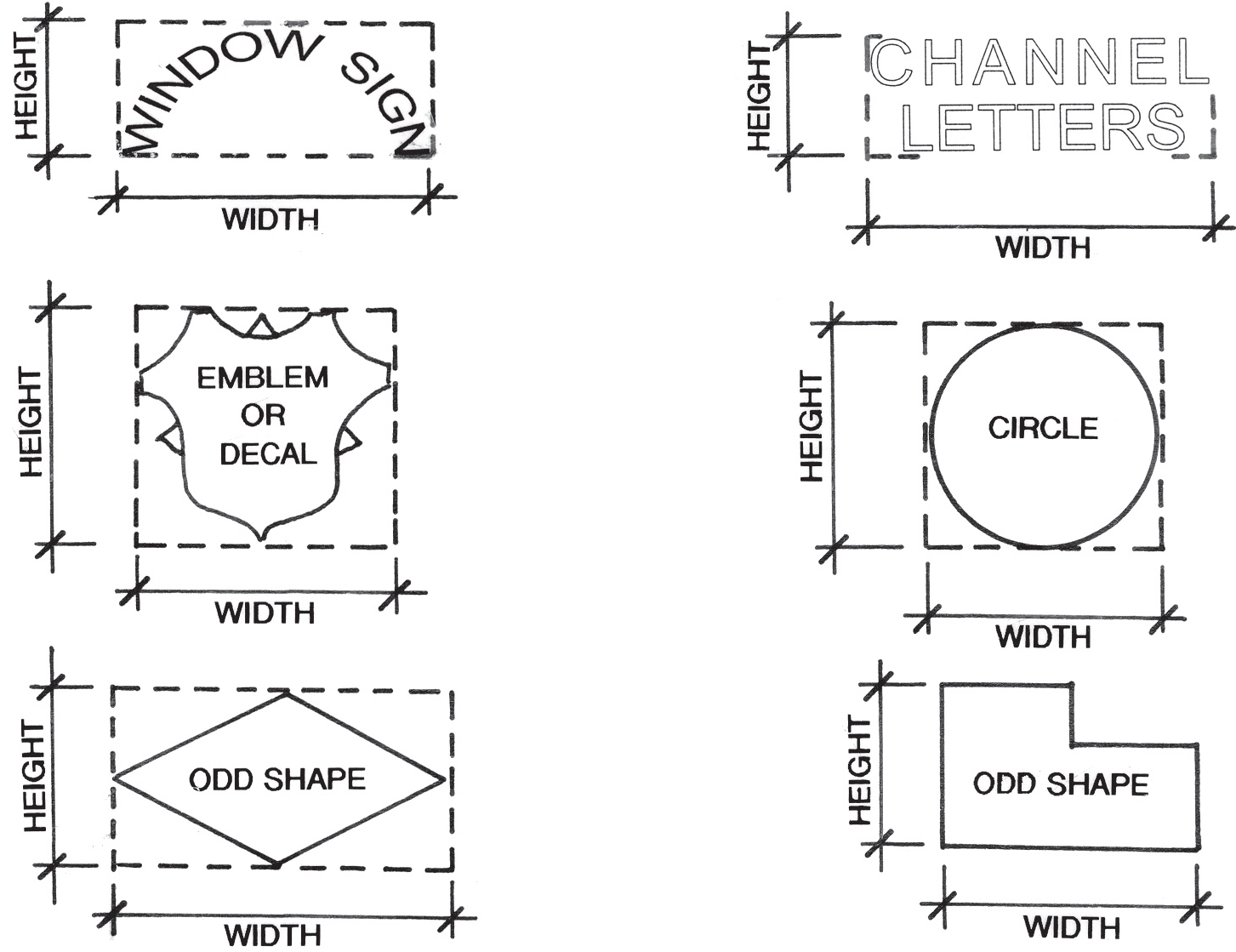
Sign Area. The square footage of a sign face shall be the area enclosed within a perimeter consisting of a series of straight lines at right angles enclosing all parts of the sign face. The area of a freestanding sign includes the area of the sign face on one side only. The certification of measurements by a licensed professional engineer, the sign manufacturer, or other professional may be accepted for irregularly shaped or uniquely shaped signs, subject to review and approval by the Planning Director.
B.
Height. The height of a sign shall be measured from the edge of the pavement of the street abutting or closest to the sign structure to the top of the sign or sign structure, whichever is higher.
C.
Federal or State Mandated Requirements. Signs or components of signs that are expressly mandated to be of a specific required minimum size by federal or State laws or regulations are exempt from the sign area limitations, but only to the extent of such minimum requirements.
4.4.5. - Prohibited Signs and Exceptions.
The following signs are prohibited in any district.
1.
Off-Site Signs. No sign identifying or advertising a business or use shall be permitted other than on the premises of such building or use, except as permitted by 4.4.9.I. (Ord. 05102010)
2.
Electronic Signs Except Readerboards. An electronic sign shall not be permitted except as readerboard on a freestanding sign pursuant to 4.4.7.E.
3.
Signs Imitating Warning Signals. No sign shall display intermittent lights resembling the flashing lights customarily used in traffic signals or in police, fire, ambulance, or rescue vehicles, nor shall any sign use the words "stop", "danger", or any other word, phrase, symbol, or character in a manner that might mislead or confuse any vehicle driver, except for temporary construction signs and lights indicating a hazard.
4.
Certain Attached and Painted Signs. Signs painted on or attached to trees, fence posts, and telephone or other utility poles; signs painted on or attached to rocks or other natural features; or signs painted on the roofs of buildings.
5.
Flashing, Pulsating, and Moving Signs. Signs which blink, flash, pulsate, fluctuate, animate, or have moving panels.
6.
Mobile or Portable Signs. Signs and sign structures which are not attached to a permanent foundation, except those banners permitted in 4.4.8.B. and portable signs in the DB zone as permitted by 4.4.9.I.
7.
Ribbons, Streamers, and Similar Materials or Devices. Any ribbon, streamer, pennant, spinner, or similar object or material, whether moving or not.
8.
Signs Within Street or Highway Right-of-Way. No sign, sign structure, or obstruction of any character shall be erected in the street right-of-way except:
a.
One newspaper box per family.
b.
Standard highway signs and markers that the South Carolina State Department of Transportation and the City may authorize.
c.
Historical, commemorative and other monuments and memorials approved by City Council with recommendation from the Design Review Board. (Ord. 10242005C)
d.
Temporary signs and banners for public events and projects provided they are approved by City Council and placed so as not to interfere with traffic circulation and public safety (see 4.4.9.F).
e.
Subdivision Entrance or Identification Signs, including those at the entrance to a Planned Residential or Planned Commercial development, which meet the standards of 4.4.8.A and are approved by the City Engineer.
f.
Portable Signs in the DB zoning district as allowed by 4.4.9.I.
(Ord. No. 04142014B , § 1(Exh. A), 4-14-2014)
4.4.6. - Wall or Projecting Signs.
A.
Wall Signs. Signs on the walls of a building (including signs attached flat against the wall, painted wall signs, and projecting signs) shall meet the following requirements.
1.
Signs on the Front Surface of a Building. The total area of signs on the exterior front surface of a building shall not exceed 20 percent of that surface.
2.
Signs on the Side and Rear Surface of a Building. The total area of signs on the exterior side or rear surface of a building shall not exceed 25 percent of that surface.
3.
Depth of Wall Signs. Wall signs attached flat against a wall may extend not more than 18 inches from the wall.
B.
Projecting Signs. A projecting sign perpendicular to the wall of a building may be substituted for a wall sign. A projecting signs shall be placed a minimum of eight feet above any sidewalk and may project a maximum of six feet. Total area of projecting signs shall not exceed 10 percent of front surface area of building.

4.4.7. - Freestanding Signs.
A.
General.
1.
A freestanding sign is a sign not attached to a building and containing a sign face on one or more sides.
2.
Freestanding signs shall not project into any street or highway right-of-way.
B.
Number of Signs.
1.
Not more than one freestanding sign shall be permitted per lot, except where the lot fronts on two major arterials as determined by the Planning Director, in which case an additional freestanding sign may be permitted with no more than one such sign located along each arterial.
2.
In the DB District, one freestanding sign shall be permitted per street frontage. A building on a corner lot may have an additional freestanding sign on its second frontage if that frontage is at least 50 feet and has a building setback of at least five feet.
C.
Monument Signs. The structure supporting a ground-level, freestanding monument sign shall not be included in calculating the area of the sign permitted by this Article. The area of the supporting structure shall not exceed 50 percent of the total combined area of the sign and supporting structure. Any pedestal on which a sign rests shall be at least 67 percent of width of the entire sign.
D.
Pole Signs in the DB District. A decorative, fluted, tapered, or turned pole shall be used to support any freestanding pole sign in the DB District. A shingle cantilevered from a pole may be substituted for a pole sign in the DB District.
E.
Readerboards.
1.
Up to 60 percent of the area of a freestanding sign may be a readerboard (with changeable copy).
2.
Electronic readerboards are subject to the following:
a.
Such signs are allowed in the GB, LI, I, LM zones by right and in the Planned Commercial, Planned Institutional, and Planned Residential zones through approval of a Concept Plan by City Council. A school, church, government entity, or tax-exempt entity in any residential zone may have one electronic readerboard as long as the sign is on a major arterial and complies with 4.4.7.C.
b.
The message may not change more than once every ten seconds in an instantaneous manner with no flashing, scrolling, animation, or movement of any sort.
c.
Each electronic sign must have a photocell to automatically adjust the brightness of the lights to no more than 0.3 foot-candle above ambient light as measured using a foot-candle meter at a distance from the sign derived by taking the square root of the product of the area of the sign times 100.
d.
Each electronic sign must contain a mechanism to turn the sign off in the event of a malfunction.
e.
An electronic readerboard may not be added to a nonconforming sign.
F.
Shopping Center Signs.
1.
Signs identifying the name of the shopping center as well as the individual stores shall be consolidated on one monument sign standard.
2.
Not more than one such sign standard shall be permitted per shopping center except where a shopping center fronts on two major arterials as determined by the Planning Director. If a shopping center fronts on two major arterials with more than 150 feet of frontage on each, one additional sign standard shall be permitted with no more than one such standard being placed on each such arterial.
(Ord. No. 04142014B , § 1(Exh. A), 4-14-2014)
4.4.8. - Miscellaneous Sign Types.
A.
Entrance, Identification or Institutional Signs. For subdivision entrance or identification signs or institutional signs for such uses as schools and churches, one single or double sign shall be permitted for each entrance to the project or use. If a double sign is proposed, the total area of the faces of both signs shall not exceed the maximum permitted sign area for a single sign. All such signs shall be ground-mounted, monument-type signs. If erected as an institutional sign, no additional freestanding sign shall be permitted. Where approved by the Planning Director, such signs may be located in a landscaped median in the right-of-way (see 4.4.5.7.e).
B.
Miscellaneous Sign Types.
1.
Commercial Banners.
a.
Location. Each business may have one banner per street frontage on the lot on which the business is located. The banner may be installed only on the building, canopy, or fence attached to the main building. The banner shall not extend above the roof line of the structure to which it is attached and may not be attached to a freestanding sign, between a freestanding sign and a canopy, or between a canopy and a building.
b.
Size. The banner may not exceed 60 square feet.
c.
Text. The banner may include the name of the business as long as it is not the only text.
d.
Duration. A banner may stay up indefinitely as long as it is in good condition, as determined by the Planning Director, unless it promotes a specific event, in which case it must be removed within 48 hours of the end of the event. If a special event banner is not removed within 48 hours, the Zoning Official may remove the banner and bill the business owner for the cost.
e.
Condition of the Banner. The banner must be securely fastened and remain in good condition, as determined by the Planning Director. The banner shall not flutter except to allow minor movement by the wind.
2.
Banners for Governmental or Civic Organizations. Banners for governmental or civic organizations are allowed at the entity's main location or at the location of the activity promoted on the banner. Such banners at other locations including street rights-of-way may be approved by City Council (see 4.4.5.7.d.) (Ord. 10242005C)
C.
Flags. A maximum of three flags may be displayed on each lot of record zoned any category other than single-family residential. There are no restrictions on flags displayed on a lot zoned for single-family residential use unless the lot is used for another purpose.
D.
Canopy or Awning Signs. Canopy or awning signs in place of wall or projecting signs are allowed in the LP, LB, O, GB, PC, PI, DB, LI, and I Districts and commercial areas within a PR in accordance with the following provisions.
1.
Canopies or awnings extending over the sidewalk or walkway may display one business identification sign at each building entrance with a combined area not to exceed 20 percent of the surface of the awning or canopy.
2.
Canopy or awning signs shall not project beyond the curb line of the adjacent street or alley.
3.
One business identification sign not exceeding 1½ square feet is permitted to hang underneath the awning or canopy, in addition to the sign displayed on the canopy.
4.4.9. - Temporary Signs.
A.
Signs on New Projects Under Construction. One non-illuminated sign, not exceeding 32 square feet in nonresidential areas and 16 square feet in residential areas, displaying the name of the building, the contractors, the architects, the engineers, the owners, and the financial, selling, and development agencies, is permitted upon the premises of any project under construction, alteration, or relocation. Such sign shall be removed from the site within 30 days after substantial completion of the project.
B.
Subdivision Signs. Temporary signs not exceeding 16 square feet in area announcing a land subdivision development are permitted only on the premises of the land subdivision. They shall be set back not less than ten feet from the right-of-way of any street or from any boundary line of the subdivision. Such signs shall be spaced not less than 300 feet apart and shall be removed when 75 percent of the lots have been conveyed.
C.
Infill Construction, Remodeling and Other Signs. Signs not exceeding 5 square feet in size identifying the contractor involved in new residential construction on a single lot, remodeling, re-roofing, landscaping or other similar service are permitted provided they are removed within 10 days after substantial completion of the project.
D.
Real Estate Signs. Any real estate sign advertising a property for sale or lease is permitted provided it conforms to each of the following standards.
1.
Size shall not exceed 5 square feet in any residential district or for a single-family residential unit in a PR and 16 square feet in any other district, including all peripheral attachments;
2.
Copy shall be limited to: (1) the name of the owner or the listing agent, (2) the real estate company, (3) the type of offering, and (4) telephone numbers;
3.
The quantity shall be limited to one per street frontage of the affected premises;
4.
A freestanding sign shall be mounted so that its top edge is no higher than four feet above grade, and the top of a facade-mounted sign shall be mounted no higher than eight feet above grade;
5.
The sign shall not be illuminated;
6.
A second sign announcing an open house that is no larger than the primary sign or a smaller sign attached to the primary sign may be erected for a period not to exceed 48 hours on the subject property; and
7.
Signs offering tenant space shall not be freestanding, but may be placed as a tenant panel on a permitted directory sign or in the window of the tenant space being offered.
E.
Political Signs. Political signs in residential districts and the PR, PI, LP and LB Districts shall not exceed three square feet in area. Political signs in all other districts shall not exceed 32 square feet in area. Such signs shall be removed within 15 days after the election to which they pertain, or the sign will be removed by City at the candidate's expense.
F.
Temporary Signs and Banners for Public Events or Public/Civic Projects. Temporary signs and banners for public events or public projects may be approved by City Council provided they are placed so as not to interfere with traffic circulation and public safety. City Council shall set a time limit on such signs. Council may also adopt a list of entities for which the Planning Director may approve such signs. (Ord. 10242005C)
G.
Other Temporary Signs. The Planning Director may approve other temporary signs not in a street right-of-way for events sponsored by (1) public or non-profit entities or (2) for-profit organizations dedicated to public service or culture on a case-by-case basis. Depending on the character of the surrounding area, the maximum size of such signs shall be 5 square feet in area and 5 feet in height in residential areas and 16 square feet in area and 6 feet in height elsewhere. Such signs may only be up one week before the event and must be removed the day after the end of the event. The Planning Director may also approve temporary signs for emergency purposes. (Ord. 10242005C)
H.
Grand Opening Signs. A banner is permitted in addition to the banners referred to in 4.4.8.B for the grand opening of a retail establishment for a period not to exceed 21 days. One banner not to exceed 75 square feet in size may be allowed on the facade of the building. Additionally, there may be a non-illuminated balloon or balloons on the business property so long as the size of the balloon or balloons does not exceed 50 feet in total diameter. This regulation shall not be construed to regulate the use of small balloons.
I.
Portable Signs in the Downtown Business Zone. For each business in the Downtown Business (DB) zone, one portable sign may be located either on (1) the lot on which the business is located or (2) the public sidewalk immediately in front of the building in which the business is located in compliance with the following.
1.
When placed on the public sidewalk, no part of this sign shall be further than 28 inches from the exterior wall of the building in which the business is located.
2.
The sign must
a.
be freestanding and not attached to another structure or have attachments;
b.
be limited to two sides;
c.
be no taller than four feet including legs, no wider than two feet, and no more than six square feet in area;
d.
contain the name of the business;
e.
be heavy enough or otherwise weighted to prevent being blown over; and
f.
not be illuminated.
3.
The width of the open walking space of the sidewalk shall be at least four feet, and no exit discharge from any doorway shall be obstructed in violation of the International Fire Code.
4.
All signs must be brought inside when the business is closed.
A sign allowed by this section shall not be regulated by other provisions of this Article regarding freestanding signs. Enforcement of the provisions regarding signs in the right-of-way permitted by this section shall be the responsibility of the Department of Public Safety.
4.4.10. - Signs Permitted in Residential Districts.
A.
Locations. All signs shall be located on the subject premises.
B.
Sign Types Allowed Without a Permit. The following sign types shall be allowed in residential districts without a permit.
1.
Signs exempt from permit requirements in accordance with 4.4.2.
2.
For a Type 2 Home Occupation, one home occupation sign not exceeding 1.5 square feet in area for each lot of record in a residential district mounted against the wall of the principal building.
3.
For a Type 2 Home Occupation in a Bed and Breakfast Inn or Bed and Breakfast Meeting Facility, one sign not exceeding 1.5 square feet in area mounted against the wall of the principal building.
4.
Temporary signs in accordance with 4.4.9.A through G.
C.
Sign Types Requiring a Permit. Subdivision entrance or identification signs in accordance with 4.4.8.A and the table below.
D.
Illumination. Signs in residential districts shall be illuminated only by external incandescent lighting except for an electronic readerboard included in a PR Concept Plan approved by City Council or for a school, church, governmental or tax-exempt entity as permitted by 4.4.7.E.2.
(Ord. No. 04142014B , § 1(Exh. A), 4-14-2014)
4.4.11. - Signs Permitted in Nonresidential Districts.
A.
Locations. All signs shall be located on the subject premises.
B.
Sign Types Allowed Without a Permit. The following sign types shall be permitted in the all of the nonresidential districts, except the HD District (see paragraph F below).
1.
Signs exempt from permit requirements in accordance with 4.4.2.
2.
Temporary signs in accordance with 4.4.9.
3.
Banners and Flags in accordance with 4.4.8.B and 4.4.8.C.
C.
Sign Types Requiring a Permit.
1.
Subdivision entrance or identification signs in accordance with 4.4.8.A and the table below. If a double sign is proposed, the total area of the faces of both signs shall not exceed the maximum permitted sign area for a single sign. Entrance signs in the LP and LB Districts shall be permitted only in place of, not in addition to, a freestanding sign.
2.
Wall or projecting signs in accordance with 4.4.6.
3.
Canopy or awning signs in place of wall or projecting signs in accordance with 4.4.8.D are permitted in the LP, LB, O, GB, PC, PI, DB, LI, and I Districts and commercial areas within a PR only.
4.
Freestanding signs in accordance with 4.4.7 and the following table.
D.
Signs Permitted in Planned Commercial (PC) and Planned Institutional (PI) Districts. Signs allowed for each Planned Commercial and Planned Institutional development shall be based on the signs that would be permitted for a similar district and use as provided above, as determined by the Planning Director except that each sign shall be a ground-mounted monument sign. (Ordinance 05102004B) See also 1. City Council shall have the authority to modify any proposed signage as part of the concept plan approval. Electronic readerboard signs may be allowed through approval of the Concept Plan by City Council and shall comply with 4.4.7.E.
E.
Signs Permitted in the Planned Residential (PR) District. Signs allowed for each use in a PR shall be based on the sign that would be permitted for a similar (Ordinance 05102004B) district and use as provided above, as determined by the Planning Director except that each sign shall be a ground mounted monument sign. The entrance identification signs allowed for a PR shall be based on the signs allowed for the district or use that corresponds with the predominant use of the PR as determined by the Planning Director. City Council shall have the authority to modify any proposed signage as part of the concept plan approval. Electronic readerboard signs may be allowed through approval of the Concept Plan by City Council and shall comply with 4.4.7.E.
F.
Signs Permitted in the Horse District (HD) and Open Space (OS) District.
1.
Freestanding signs shall have wooden faces. For each lot, the combined area of all freestanding signs visible from a street shall not exceed 24 square feet. The top of any part of a freestanding sign, including its face and supporting structure, must not be more than eight feet from the surface of the ground.
2.
On each lot, wooden signs with a maximum combined area of 24 square feet may be attached to buildings, fences, and gates. Signs not visible from a public street right-of-way shall not be considered when determining whether signage exceeds the limit.
3.
No internal illumination shall be permitted.
G.
Signs for Unlisted Uses. Signs for uses permitted in zoning districts not expressly provided for above shall be governed by the provisions in those paragraphs most suitable for that use and area as determined by the Planning Director.
H.
Illumination.
1.
Except for the LP, LB, and DB Districts, signs in nonresidential districts may be illuminated, subject to requirements contained in this Ordinance, and other applicable City codes, ordinances, and regulations.
2.
Signs in the LP, LB, and PI Districts shall be illuminated only by external incandescent lighting.
3.
In the DB District, externally illuminated signs are preferred; however, if an internally illuminated sign is used, then one of the following types of signs is required.
a.
Individual back-lit letters silhouetted against a softly illuminated wall;
b.
Individual letters with translucent faces with soft lighting elements within each letter; or
c.
Metal-faced box signs with cut-out letters and soft glow internal lighting.
If an internally illuminated, plastic-face sign is to be used, the light source must use cool white or soft-glow bulbs and not exceed 60 watts.
(Ord. No. 04142014B , § 1(Exh. A), 4-14-2014)
4.5.1. - Parking Spaces to be Provided.
A.
Spaces Required. Off-street parking in the City of Aiken for all structures and uses of land shall conform to the requirements shown in the table below. The Planning Director may accept a different number of spaces in accordance with 4.5.2.
* See also 4.5.3, Off-Site Parking for Religious Institutions.
B.
Calculation of Off-Street Parking Requirements.
1.
When calculating the minimum number of off-street parking spaces in accordance with the table above, calculations shall be rounded to the nearest whole number.
2.
Calculation of required off-street parking for any eating establishment shall include all seating areas located outdoors.
3.
The City may limit parking to not more than 110 percent of the amount required where necessary to maximize the number of replacement trees on a site in accordance with 4.6.4.B.2.c.v.
4.
For Shopping Center, Discount Store, Department Store, Superstore, Power Center or Single-Use Retail uses exceeding 20,000 square feet of gross leasable floor area, off-street parking shall not exceed 4.5 spaces per 1000 square feet of leasable floor area unless documentation is provided clearly demonstrating that additional parking is essential to the proposed use in which case the Planning Director may allow up to 5.5 spaces per 1000 square feet of gross leasable floor area. (Ord. 11252002A)
C.
Parking for Uses not in Table. Parking for uses not expressly provided for above shall be governed by the provisions in those paragraphs most suitable for that use as determined by the Planning Director.
D.
Exemption for DB District.
1.
Off-street parking is not required for uses located in the Central Business District of the DB Zone District.

2.
On-street parking in the vicinity of the use may count toward the required parking as determined by the Planning Director.
3.
Off-street parking is not required for religious institutions located in any Historic District listed on the Aiken Historic Register.
4.5.2. - Developer-Submitted Parking Data.
1.
The Planning Director may accept a higher or lower number of parking spaces than required in 4.5.1 (or a specific number of spaces for a use not listed) based on developer-submitted parking data such as a shared parking analysis or appropriate standards from another accepted source. (See 4.5.1.B.4) (Ord. 11252002A)
2.
If the Planning Director accepts a lower number of parking spaces than is required in 4.5.1, the site may be required to accommodate the higher number of spaces in case of future need. The design and location of these additional parking spaces shall meet the site design standards at 4.5.4 and the following.
a.
The area necessary to accommodate these spaces shall not be included as part of the site's minimum open space requirement.
b.
The area necessary to accommodate these spaces shall be included in the impervious coverage for the site and accounted for in the drainage design.
c.
Until or unless such spaces are needed, as determined by the Planning Director, the area shall be maintained as open space, and the clearing of trees in that area and subsequent tree replacement shall not occur until or unless such additional parking is required to be constructed.
3.
Any shared parking analysis shall follow the guidelines of the Urban Land Institute's SHARED PARKING or an acceptable alternative source approved by the Planning Director. Any off-site parking to be utilized shall require the recording of a perpetual easement, in form and substance acceptable to the Planning Director, in the office of the Registrar of Mesne Conveyance of Aiken County.
4.5.3. - Off-Site Parking for Religious Institutions.
A.
Written Authorization Required. Parking spaces on privately owned land located within 1500 feet of the nearest portion of the main assembly room building of a religious institution may be counted in meeting up to 50 percent of the parking requirement of this Article where either of the following is provided.
1.
Written authorization is provided by the owner of property on which the off-site parking is located stating the number of parking spaces that may be used during the time of the main services and the duration of such authorization; or
2.
An easement or other document is recorded with the Registrar of Mesne Conveyance for Aiken County by the owner of the private property on which such spaces are located granting a permanent easement or permission for such parking meeting the requirements of this provision.
B.
Expiration of Authorization. A written commitment must be provided by the church that should such authorization, easement, or permission expire or be withdrawn, adequate off-street parking complying with this Article will be provided within 180 days.
4.5.4. - Off-Street Parking Design Standards.
A.
General Design Standards. Every parcel of land developed as or changed to a parking area shall be developed in accordance with the following design standards.
1.
Any public parking area shall be paved or have equivalent surfacing subject to the approval of the Director of Engineering/Public Works.
2.
Driveways and parking areas shall be designed to limit the removal of Significant and Grand trees to the maximum extent feasible. See 4.6.4.
3.
Landscaped buffers adjacent to any property zoned or used residentially shall be provided in accordance with 4.6.7.E. No parking shall be permitted in required side yards adjacent to any residential district or use. Any light used to illuminate said parking area shall be directed away from any property zoned or used residentially.
4.
All off-street parking facilities shall be designed with appropriate means of access to street, alley, or maneuvering area.
5.
Each required parking space shall be at least 9 feet in width by 18 feet in length.
B.
Parking Fronting Arterials. All off-street parking in conjunction with development fronting on an arterial street shall be designed so that vehicles can turn around within the parking facility without backing into the street.
C.
Driving Aisle Width. The width of all driving aisles between individual parking spaces shall be in accordance with the requirements specified below. Only one-way traffic shall be permitted in driving aisles serving single-row parking spaces placed at an angle other than 90 degrees.
D.
Wheel Stops Required.
1.
Secured wheel stops shall be provided in all parking facilities without curbing. The vehicle side of the wheel stop shall be no less than 18 inches from the end of the parking space.
2.
Where sidewalks or other walkways occur in parking facilities, parked vehicles shall not overhang or extend over the sidewalk. In these parking facilities, wheel stops shall be provided even if the parking facility has curbing.
4.5.5. - Driveway Standards.
1.
All driveways shall comply with South Carolina Department of Transportation standards for separation.
2.
No driveway or curb cuts into a public parking area in any district shall exceed 30 feet in width. For the purposes of this paragraph, the width of any landscaped median shall not be included in determining driveway width.
3.
No driveway serving a nonresidential use shall be permitted through a residential district or use, and no driveway serving a multifamily use shall be permitted through a single-family district or use.
4.
Detailed plans shall be submitted to the Director of Engineering/Public Works for approval of all driveway openings or curb cuts before a permit may be obtained.
4.5.6. - Off-Street Loading Space.
A.
General. Whenever the normal operation of any development requires that goods, merchandise, or equipment be routinely delivered to or shipped from that development, a sufficient off-street loading and unloading area must be provided in accordance with this Section to accommodate the delivery or shipment operations in a safe and convenient manner. Determination of the applicability of this Section shall be made by the Planning Director.
B.
Exemption for DB District. This Section shall not apply in the Downtown Business (DB) District.
C.
Typical Loading Area Requirements. The following table indicates the number and size of spaces that normally shall satisfy the standard set forth in this subsection. However, the Planning Director may require more or fewer spaces if necessary to satisfy the intent of this standard, upon evaluation of adequate data submitted by the applicant.
D.
Design Standards.
1.
Minimum dimensions for each space shall be 12 by 40 feet. Additional length or width may be required by the Planning Director if deemed necessary for a given expected type of vehicle use. An overhead clearance of 14 feet from pavement grade shall be required.
2.
Loading areas shall be so located and designed that the vehicles intended to use them can maneuver safely and conveniently to and from a street right-of-way and complete loading and unloading operations without obstructing or interfering with any public right-of-way, parking space, or parking lot aisle. No backing into the street shall be permitted.
3.
No area allocated to loading and unloading facilities may be used to satisfy the area requirements for off-street parking, nor shall any portion of any off-street parking area be used to satisfy the area requirements for loading and unloading facilities. Detached single-family dwellings are not subject to this requirement.
E.
Exceptions. Whenever there exists a lot that meets all of the requirements below, then the developer need only comply with this Section to the extent reasonably possible.
1.
One or more structures on the lot were constructed before the effective date of this Ordinance; and
2.
A change in use is proposed that does not involve any enlargement of a structure; and
3.
The loading area requirements of this Section cannot be satisfied because there is insufficient area available on the lot that can practically be used for loading and unloading.
4.6.1. - Purposes.
This Article is intended to promote the preservation and installation of high quality trees and other plant material for the purposes of implementing the policies of the Comprehensive Plan and protecting public safety, health, and welfare through the benefits such vegetation provides, including, but not limited to the following.
1.
Absorbing carbon dioxide and returning oxygen.
2.
Precipitating unwanted particles from the air, thereby reducing air pollution.
3.
Providing shade and making outdoor areas more habitable in summer.
4.
Reducing soil erosion and increasing infiltration.
5.
Reducing noise levels.
6.
Improving City appearance and retaining its character, promoting civic pride, emotional health, and the local economy, including property values and tourism.
7.
Providing wildlife habitat, thus helping to control insects.
4.6.2. - Jurisdiction.
This Article shall apply to all lands within the corporate limits of the City of Aiken, and may apply, as required or approved by City Council, to land outside the City limits granted City water, sanitary sewer, or other services by the City. The Planning Director may waive any provision in this article that would conflict with a requirement of the Public Safety Department.
4.6.3. - Removal of Existing Trees on Land Not Being Developed.
A.
The natural landscape, including existing trees, shall be preserved wherever possible. On land zoned to permit any use other than single-family residential (except land zoned Planned Residential for which a concept plan depicting single-family residential use has been approved), no Significant or Grand Tree may be removed unless one or more of the following can be demonstrated to the satisfaction of the Planning Director after consultation with appropriate city staff members including but not limited to the City Horticulturist.
It is in the interest of good forestry management.
The tree is diseased, dying, or dead.
The tree causes a safety hazard to nearby buildings or pedestrian or vehicular traffic.
The tree is a Pine, Pecan, or Magnolia that is dropping debris or sap that is significantly affecting vehicles in a parking lot though any such tree removed will have to be replaced with an equal number of caliper inches or, if there is not room, an amount placed into the Tree Fund in accordance with 4.6.4.B.2.d.
The tree is causing significant structural damage to a building or other structure that reasonable maintenance cannot prevent.
The tree is interfering with an existing underground utility line or overhead wiring.
It is necessary to allow construction of a road essential for access to the site, subject to the requirement that the inches of Grand and Significant trees removed therefore shall be replaced when the site is developed.
B.
If trees are removed on land zoned single-family residential, no application for rezoning to a commercial or multifamily residential zoning classification will be considered for two years after City staff determines that such removal has occurred.
(Ord. No. 12142015C , § 1(Exh. A), 12-14-2015)
4.6.4. - Removal of Trees Associated With Development.
Prior to issuance of a building permit for a nonresidential or multifamily residential project, a landscape plan must be approved in accordance with 6.2.10 and the following provisions. Prior to issuance of a building permit for any portion of a project consisting of attached single-family or duplex residential units, the following provisions must be met. (Ord. 12122005A) Issuance of a building permit for a detached single-family dwelling in a commercial or multifamily residential zone shall be conditioned on a stipulation that, if Significant or Grand Trees are removed, no building permit for a permitted use other than detached single-family residential shall be issued for three years from the date of issuance of the permit. (Ord. 03132006)
A.
Tree Survey.
1.
For every project one of the following shall be submitted.
a.
A detailed tree survey of the entire site depicting the DBH, variety, and location of all Significant and Grand trees including the information listed in 6.2.10.D; or
b.
A detailed tree survey depicting the DBH, variety, and location of the Grand Trees on the entire site and the Significant Trees in the yard including the information listed in 6.2.10.D and a listing of all Significant Trees in the buildable area including DBH and variety, and, if required by the Planning Director, a tree survey of selected areas or other additional information where it is necessary to make a determination about the feasibility of saving Significant Trees.
2.
Information required by paragraph 1 shall be prepared by a licensed engineer, surveyor, landscape architect, forester, arborist or other person with demonstrated experience in preparing accurate tree surveys as determined by the Planning Director. Such information shall not be more than two years old on the date of submission of the application for landscape plan approval.
B.
Tree Protection Areas.
1.
Planting Strip Along Street Rights-of-Way.
a.
Depth. A planting strip shall be provided parallel and adjacent to each street right-of-way the depth of which shall be based on the following table. The maximum required depth under this provision shall be 25 feet, but a deeper planting strip may be provided.
b.
Protection of Significant and Grand Trees. Within the planting strip, all Grand and Significant trees shall remain unless their preservation would prevent the installation of a necessary driveway, sidewalk, permitted sign, or essential utility. All such driveways, sidewalks, signs, and utilities shall be located so as to preserve the maximum number of Grand and Significant Trees as determined by the Planning Director. To insure tree survival, a protected area pursuant to 4.6.5.B shall be provided around each tree as required by the Planning Director.
c.
Minimum Number of Trees. Existing trees may be counted in meeting the requirement for trees in the planting strip at 4.6.7.B. To be counted, a tree must have a DBH of two inches. The type and condition of such trees are subject to approval by the Planning Director for that purpose and must be depicted on the landscape plan. If existing trees do not satisfy the requirement, a sufficient number must be planted to comply with 4.6.7.B.
2.
Entire Site.
a.
Removal. No Grand Tree may be removed unless the Planning Director determines there is absolutely no alternative because of unavoidable grading or because of the required configuration of paving, essential utilities, or buildings. No more than 80 percent of the DBH inches of Significant Trees may be removed unless the Planning Director determines there is absolutely no alternative because of unavoidable grading or because of the required configuration of paving, essential utilities, or buildings.
b.
Location of Saved Trees. No more than 25 percent of saved trees may be located in the rear yard unless there are not enough trees on other parts of the site to meet this requirement.
c.
Replacement.
i.
Grand and Significant DBH inches removed shall be replaced, except for trees removed (1) pursuant to the requirements of City ordinances and regulations, (2) after determination by the City Horticulturist to be diseased, dying, or dead, or (3) in conjunction with construction of athletic fields at a public or private school required by the South Carolina State Department of Education or other licensing or accreditation organizations for such schools.
ii.
The cumulative caliper of replacement trees shall at least equal the cumulative DBH of the Grand and Significant Trees removed except that the DBH of any Grand or Significant Trees on the Approved Tree List saved or approved trees newly planted may count as double replacement inches under this provision.
iii.
Trees planted to meet other requirements of this Article may be counted as replacement trees. The minimum caliper for a replacement tree shall be two inches and be from the Approved Tree List.
iv.
The Planning Director shall approve the type, size, and location of each replacement tree.
v.
Where the Planning Director determines that planting the required number of trees on the site will result in an unacceptable density of trees based upon good forestry management, the Planning Director may reduce that number; provided, however, that off street parking shall be limited to no more than ten percent over the minimum number of parking spaces required by 4.5.1 if necessary to maximize the number of replacement trees to be planted on the site.
d.
Tree Fund. If there is not sufficient room on the site to plant the required replacement DBH inches, a payment-in-lieu-of-planting shall be made to the Tree Fund to be used for the planting of trees on City property. The amount shall be determined by the City Horticulturist based on the retail value of the trees, but in no case shall the total amount exceed $500 per acre of the site.
4.6.5. - Tree Protection During and After Development.
A.
Standards. Trees that are to remain or are planted shall be protected in accordance with standards provided in paragraph B below and the Tree Protection and Landscaping Manual. The standards in the Manual shall provide for protective barriers around trees, the prevention of compaction or other disturbance within the protected area as set forth at 4.6.5.B, and the installation of utilities.
B.
Protected Areas. During grading and construction, a protected area equal to one foot radius for every inch of DBH of each tree shall be provided within which paving, grading, or the storage of dirt, building materials, debris, or any other materials or any other equipment shall not be allowed. Each protected area shall be enclosed by a barrier constructed in a manner required and approved by the Planning Director prior to issuance of a grading permit. Failure to maintain barriers may result in revocation of the building and/or grading permit. For projects not requiring a grading permit, installation of the required barriers shall be approved by the Planning Director prior to issuance of a building permit. Protective barriers shall be maintained until issuance of a Certificate of Occupancy. The protected area shall be permanent and maintained by the property owner. No pavement shall be installed in the protected area. The Planning Director may reduce the protected area or allow intrusions into it if such actions would not adversely affect the survival and health of the tree.
C.
Tree Maintenance. The following tree maintenance provisions shall apply to all trees on the subject site included in the Protected Tree List or Approved Tree List in the Tree Protection and Landscaping Manual (Ord. 11222010A), not just those planted pursuant to this Article except for trees on a lot occupied by a dwelling unit in an attached single-family or duplex residential project. (Ord. 12122005A) No matter what pruning methods are used, no more than one-fourth of the crown should be removed in any one growing season.
1.
Where necessary to improve visibility for public safety purposes, suckers or limbs below seven feet in height may be removed through proper crown raising or elevating.
2.
Maintenance of trees shall take their natural shape and growth patterns into account. Trees that are intended to grow full to the ground, such as Magnolias, shall not be limbed up.
3.
No topping or heading back shall be permitted which involves the cutting of limbs back to a stub, bud, or lateral branch not large enough to assume the terminal role. Crown reduction shall be used to reduce the size of a tree and is best accomplished by cutting limbs back to laterals that are at least one-third the diameter of the parent limb.
D.
Approved Landscape Plan To Be On Site. During construction and until issuance of a Certificate of Occupancy, a copy of the approved landscape plan must be kept on the site.
4.6.6. - Removal of Trees After Development.
A.
After issuance of a Certificate of Occupancy for a commercial or multifamily residential project located in a zoning district, no Significant or Grand Tree may be removed unless it can be demonstrated to the satisfaction of the Planning Director after consultation with appropriate city staff members including but not limited to the City Horticulturist that one or more of the conditions at 4.6.3.A(1—7) exists.
B.
The Planning Director may also allow the removal of a Significant or Grand tree that has been planted as a requirement of this ordinance, or a supplementary tree planted after development, if it can be demonstrated that the tree is affecting the primary approval use of the subject property.
The cumulative caliper of the trees removed shall be replaced on-site from the Approved Tree List if possible as determined by the City Horticulturist. If applicable, a revised landscape plan may be required to be submitted to the Planning Department for review.
C.
This provision shall also apply to the common areas of an attached single-family or duplex residential project in any zoning district. (Ord. 12122005A) Portions of any golf course associated with play such as fairways, tee boxes, greens, rough, and practice areas shall be exempt from this provision. (Ord. 09272004) Public parks and recreational facilities are also exempt from this provision.
(Ord. No. 07142014D , § 1(Exh. A), 7-14-2014; Ord. No. 10132014B , § 1(Exh. A), 10-13-2014; Ord. No. 12142015C , § 1(Exh. A), 12-14-2015)
4.6.7. - Landscaping Requirements.
A.
Area Required to be Landscaped. Where not expressly set forth in 4.2.1 or 4.3.1, the minimum required landscaped area shall be 20 percent of the site for commercial uses and 40 percent of the site for multifamily residential uses. The planting strip may be included in calculating the required landscaped area. Where a portion of a larger undeveloped tract is being developed, only landscaped area reasonably associated with the project as determined by the Planning Director shall be counted in meeting the requirements of this provision.
B.
Plantings in Strip Along the Street Frontage.
1.
Trees.
a.
Number, Size and Spacing. With respect to the approval of a site/landscape plan for a new development, the maximum number of trees must be planted in the planting strip, required by 4.6.4.B.1, as determined by the Planning Director taking into account the size of the trees at maturity except, to allow for the location of a freestanding sign, there may be a gap of no more than 40 feet where Small Trees are planted and 60 feet where Large Trees are planted (Ord. 11222010A). The Planning Director shall approve the type, size, and location of replacement trees. Subject to the approval of the Planning Director, any combination of large and small trees may be planted to meet the minimum required number. Any area in the planting strip beyond the minimum required by this Article shall not be included in determining the number of trees required to be planted. Each tree planted in the planting strip shall have a minimum caliper of two inches and be selected from the Approved Tree List. Where necessary, trees may be limbed up to allow visibility for motorists in accordance with 4.6.5.C.1. The Planning Director may allow a smaller tree to be planted in the planting strip where overhead power lines would interfere with the growth of a larger tree.
b.
Existing Trees. As provided in 4.6.4.B.1.c, an existing tree may be counted towards meeting the requirements of this Article provided that the tree has a DBH of at least two inches and the type and condition of the tree are approved for that purpose by the Planning Director. Such trees must be depicted on the landscape plan.
2.
Shrubbery or Planted Berms. Evergreen shrubbery or a planted berm is required in the planting strip to screen the fronts of vehicles. The shrubbery must be at least three feet high after pruning at the time of planting and be planted no more than five feet on center. A berm must be at least three feet high and be planted with ground cover.
C.
Planting Areas along Side and Rear Property Lines. Planting areas at least five feet in depth shall be provided along the entire side and rear property lines or site boundaries not located adjacent to a street right-of-way. The maximum possible number of trees must be planted therein as determined by the Planning Director taking into account the size of the trees at maturity based on the required minimum depth of five feet. The Planning Director shall approve the type, size, and location of the trees. Existing trees may be counted towards meeting the requirements of this provision in the same manner as provided in 4.6.4.B.1.c and 4.6.7.B.1.b. Trees on adjacent property that may conflict with planting new trees should be depicted on the landscape plan. These planting areas are required in addition to the planting strip along the street frontage and shall be considered part of the yard area. Where a joint driveway is proposed to serve two lots which would reduce the number of curb cuts, the Planning Director may modify the provisions of this section.
D.
Landscaping in Vehicular Use Areas.
1.
Perimeter Planting Areas. Each parking area should be defined by linear landscaped areas to delineate driveways and control traffic flow. Such linear landscaped areas should be at least eight feet in width and include canopy trees as determined by the Planning Director unless such trees would interfere with traffic movement in which case other types of trees may be used.
2.
Islands Between Parking Spaces. In a parking area with more than one double bay of parking spaces, no more than 10 spaces are allowed in a row without a landscaped island of at least 300 square feet excluding curbing and having a minimum width of eight feet. Each such island shall have at least one canopy tree allowed in parking lots as set forth in the Approved Tree List. Such islands must be offset so that they are evenly distributed in the parking area and are not in straight lines.
3.
Islands at End of Row. A landscaped island of at least 100 square feet in area shall be provided at the end of each single row of parking spaces closest to a building; each such island shall have a berm two feet high planted with ground cover, or, where there are two such islands together totaling at least 200 square feet, at least one small tree allowed in parking lots as set forth in the Approved Tree List. A landscaped island of at least 150 square feet shall be provided at the end of each single row of parking spaces nearest the street frontage; where there are two such islands together totaling at least 300 square feet, there shall be at least one canopy tree. The islands shall be designed and maintained so as not to obstruct visibility for motorists. The Planning Director may modify or waive this provision if compliance would not be practical.
4.
Trees in Islands. Islands shall be located to preserve the maximum number of existing trees. The maximum number of trees must be planted as determined by the Planning Director taking into account the size of the trees at maturity. The Planning Director shall approve the size, type, and location of the trees. Any combination of large and small trees may be planted to meet the minimum number required by this provision with the approval of the Planning Director.
5.
Screening of Dumpsters. Dumpsters, utility boxes, and similar structures must be screened by evergreen shrubbery at least three feet high after pruning at the time of planting.
E.
Buffer or Screening Device. A landscaped buffer strip shall be required for any nonresidential or multifamily residential use where it abuts an area zoned or used residentially or for any attached single-family or duplex residential project where it abuts land occupied by single-family dwellings or zoned in a single-family residential category. (Ord. 12122005A) The buffer strip shall be a minimum of 10 feet in depth and be undisturbed. Additional evergreen vegetation shall be planted to form an effective screen; such vegetation shall be at least three feet high after pruning at time of planting and a height of at least seven feet at maturity with spacing as required by the City. Where deemed necessary by the Planning Director, additional measures may be required to provide an effective screen. Any screening buffer area shall be maintained in good order at all times by the owner of the property.
F.
Detention Ponds and Lakes. A detention pond may be counted as landscaped area unless it is unable to support healthy trees as determined by the City Engineer and Planning Director. Each detention pond shall be screened for aesthetic purposes pursuant to the standards in the Tree Protection and Landscaping Manual provided for by 4.6.9 or as otherwise directed by the Planning Director to accomplish the purposes of this Article. A lake shall be counted as landscaped area if approved by the City Engineer and Planning Director as effecting the purposes of this Article.
G.
Design of Project Landscaping. Landscaping installed during development should meet the following design guidelines.
1.
Landscaping should be designed for the long term; the size of plants at maturity should be considered when selecting plant material and designing its installation.
2.
Landscaping should continue thematic elements, if any, found in the surrounding area, including plant types and planting patterns.
3.
Landscaping should be designed to be functional (reducing the heat island effect of impervious surfaces, helping to control runoff, etc.), as well as beautiful.
4.
Crape Myrtles may not be planted along street rights-of-way unless necessitated by overhead wiring or other reason associated with the particular location as approved by the Planning Director.
H.
Irrigation. An automatic irrigation system must be installed to water all new landscaped areas. The system must remain operational and have a timer set to water plantings to keep them alive.
4.6.8. - Completion and Maintenance of Landscaping.
A.
Completion.
1.
All landscaping shall be installed in accordance with the approved landscape plan unless substitutions are approved by the Planning Director and noted in writing on the plan. A Certificate of Compliance, Certificate of Occupancy or business license for any business or use on a site with such an approved plan shall not be issued until the installation of the required landscaping is approved by the Planning Director or a cash or equivalent performance guarantee is posted with the Planning Director in the minimum amount of 110 percent of the total cost of the required uncompleted landscaping, including the labor, as determined by the Planning Director. A site not requiring a Certificate of Occupancy may not be used until the required landscaping is installed or a guarantee posted.
2.
The guarantee shall be in a form approved by the Planning Director and shall be released and returned to the party posting the guarantee upon installation of all required landscaping and acceptance by the Planning Director of such installation. The landscaping shall be installed within three months of the posting of the performance guarantee with the Planning Director. However, the Planning Director may extend the time period for installation of landscaping for a maximum of an additional three months if weather conditions are not suitable for such installation or trees are not available during the initial three-month period. If the landscaping is not installed within the required period, the guarantee shall be forfeited to and used by the City to complete the approved landscaping with any remaining funds being returned to the party who posted the guarantee. For a project in an unincorporated area receiving City services and for which a landscape plan has been approved, the use of those services may not commence until the requirements of this Article are met.
B.
Maintenance. The property owners, occupants, and tenants or their agents shall be jointly and severally responsible for the maintenance of all landscaping. All landscaping required by or installed pursuant to landscaping plans approved under this Article or prior ordinances shall be maintained in good condition so as to present a healthy, neat and orderly appearance; shall be kept free of refuse, debris, and dead, diseased, or severely damaged plants or vegetation; and shall contain at all times the number, variety, and location of plants and trees required thereby.
4.6.9. - Tree Protection and Landscaping Manual.
The City Horticulturist shall promulgate mandatory standards for the installation, maintenance, survival, health and protection of trees and landscaping required to be retained, planted, installed, or maintained by this Article or prior ordinances. Those standards shall promote and effect the purposes set forth in 4.6.1 and be compiled in a Tree Protection and Landscaping Manual including compliance with the most recent version of the American National Standards Institute (ANSI). (Ord. 11222010A) The Manual shall also establish an Approved Tree List setting forth trees allowed to be planted including those permitted in parking lots.
4.7.1. - Plan and Permit Required.
A grading permit shall not be issued for a nonresidential or multifamily residential development until a site plan, including landscaping, has been given final approval by the City. The surface of land in the City shall not be disturbed or changed for any purpose, except as expressly exempted below, unless both of the following criteria are met.
1.
The City Engineer has approved a plan for the control of erosion, sedimentation, and surface drainage, and, where required, such plan has been approved by the Conservation District Office.
2.
The City Engineer has issued a grading permit.
4.7.2. - Exemptions.
The provisions of this Article shall not apply to the following.
1.
Agricultural land management and cultural practices, or to the construction of on-farm buildings and structures used in a farming operation.
2.
Construction of single-family residences or their accessory buildings which are not part of a residential subdivision which has an approved sediment control plan; a single-family property owner may make land improvements on his single lot without an approved erosion control plan or without obtaining a grading permit; nor shall such provisions apply to emergency repairs or maintenance of existing structures and facilities which require ground to be broken.
4.7.3. - Guidelines for Plan Preparation.
Section 3-3.1 of the Aiken Sediment Control Ordinance provides guidelines for plan preparation.
4.7.4. - Procedures for Plan Approval and Grading Permit.
Article 4 of the Aiken Sediment Control Ordinance provides procedures for plan approval and issuance of a grading permit.
4.7.5. - Design Standards.
Article 5 of the Aiken Sediment Control Ordinance provides standards and specifications for designing, installing, and maintaining erosion and sediment control practices.
4.7.6. - Inspection and Enforcement.
The City Engineer shall have the authority to inspect all work and otherwise enforce the provisions of this Article and the Aiken Sediment Control Ordinance.
4.8.1. - Purpose.
The purpose of this article is to establish standards and criteria for the number, location, design, construction, and maintenance of driveways, acceleration/deceleration lanes, and interparcel connections in the City limits of Aiken.
4.8.2. - Applicability.
A.
New Development. This article applies to new development in the City limits.
B.
Changes to Existing Development. This article applies to any development in the City limits for which the cost of renovation or expansion in any one-year period exceeds 50 percent of the appraised value of the development as set by the Aiken County Tax Assessor, the South Carolina Tax Commission, or any other State or local government entity or official with the authority to do so, or by the Building Official for developments that are tax-exempt. For a development composed of individual lots, the determination of whether the 50 percent level has been exceeded shall be based on the appraised value of the individual lot or lots on which the proposed improvement or improvements will be located and not on the appraised value of the entire development. Existing driveways may be closed pursuant to 4.8.8.A.
4.8.3. - Permit Required.
A.
General. No curb cut, driveway, new street, acceleration/deceleration lane, or similar project serving an existing or proposed development shall be constructed, reconstructed or altered unless approved by the Director of Engineering/Public Works. The Planning Director shall not grant approval for a site plan without written approval of the access plan from the Director of Engineering/Public Works.
B.
Application Process. An application for a permit shall be submitted to the Planning Department as part of a site plan application. Where approval of proposed work is required by SCDOT, submission to the City of a copy of the permit application to SCDOT shall be sufficient except that the Director of Engineering/Public Works may request additional information. Where there is a conflict between the requirements of the City and SCDOT, the more restrictive shall apply.
4.8.4. - Compliance With Standards of the South Carolina Department of Transportation.
Except where there would be a conflict with any provision of this Article, any driveway, street, acceleration/deceleration lane, or similar project shall be designed to conform to SCDOT standards.
4.8.5. - Limits on Number of Access Points.
A.
General. A project or development shall be limited to the minimum number of access points required for the safe and efficient flow of traffic to, from, and within the site. Any lot created after the effective date of this article may not be entitled to its own access if it would not meet the requirements.
B.
Multiple Lots or Uses. A project having multiple lots or land uses but functioning as a planned unit shall be considered to occupy one lot for the purpose of determining the number of access points.
C.
Outparcels. Outparcels associated with a larger development shall be considered as part of that development and have access only internally from that development.
D.
Maximum Numbers of Access Points Allowed. Generally, one access point will be allowed per lot per street frontage. However, additional access points may be allowed according to the following table with the approval of the Director of Engineering/Public Works and the Director of the Department of Public Safety. The number of driveways shown on the table may be further limited by other provisions of this section.
* On frontages of less than 100 feet, no access will be allowed without special approval by both the Director of Engineering/Public Works and the Planning Director unless no other access is possible and the lot was existing at the time of adoption of these regulations.
E.
Limitations Based on Type of Street.
1.
Local Streets. Any residential use may have direct access to a local street. Nonresidential uses shall not have direct access to local streets except that any lot located within a nonresidential subdivision or any parcel adjacent to a street within a nonresidential subdivision may have direct access to the local street internal to the subdivision, and provided that any corner lot abutting a local street and an arterial or collector street may take access to the local street if such access is required by the City or SCDOT.
2.
Major or Minor Arterial Streets. No single-family dwelling or duplex shall have direct access to an arterial street.
F.
Limit for Lots with Double Frontage. Access to a double-frontage lot occupied by a detached single-family dwelling shall be allowed only from the street with the lower functional classification.
G.
Existing Lot with Width Less Than the Minimum Spacing. An existing lot with street frontage less than the minimum driveway spacing may not have access to that street if access is available on another street.
The following are required standards for the location, spacing, design, construction, and maintenance of driveways and access points on major and minor arterial and collector streets. Any issues not addressed by the following will be covered by the Access and Roadside Management Standards of SCDOT.
A.
Location.
1.
Driveways shall be located where there are no sharp horizontal curves or steep vertical grades and where the provisions of the SCDOT Access and Roadside Management Standards regarding points of access are met.
2.
Driveways shall not be located on auxiliary (acceleration/deceleration lanes) or their tapers.
B.
Spacing.
1.
Driveways, roads, and other points of access shall have the following separation at the street right-of-way line: on a major arterial, 200 feet; on a minor arterial, 150 feet; and on a collector, 100 feet.
2.
No driveway, road, or other point of access shall be closer than the following to a side property line except to allow a joint driveway serving two lots: on a major arterial, 100 feet; on a minor arterial, 75 feet; and on a collector, 50 feet.
3.
In determining compliance with this section, the measurement shall be made between the closest points of pavement and/or curbing.
C.
Width. Each lane of a driveway shall have a maximum width of 15 feet. A landscaped median shall not be included in determining width.
D.
Configuration. A driveway may consist of either a single two-way access or a pair of one-way accesses divided by a landscaped median or a circular driveway except that this provision shall not prevent turn lanes.
E.
Alignment. Each driveway or road or other point of access on an arterial or collector should align with a driveway, road, or other point of access on the opposite side of the street or be offset by at least 150 feet except where a divided median prevents compliance. Intersections of collector or arterial streets should be at least 800 feet apart.
F.
Sight Distance. Sight distances for a driveway shall meet SCDOT standards unless the Director of Engineering/Public Works allows a different distance.
4.8.7. Acceleration/Deceleration Lanes.
Acceleration and deceleration lanes shall be designed in accordance with SCDOT standards.
4.8.8. Changes to Existing Driveways.
A.
Traffic Safety. City Council may direct the closure, removal, consolidation, or revision of any driveway or access which exhibits an inordinate traffic safety problem as determined by the Director of Engineering/Public Works or the Director of Public Safety because it has caused or has the potential for causing crashes. City Council shall hold a public hearing on the proposed action; notice of the time and place shall be given to the owner of the subject property by a letter sent no fewer than 30 days prior to the scheduled date of the hearing.
B.
Assembly of Existing Lots and Redevelopment. The Director of Engineering/Public Works may require the consolidation of access points in conjunction with a subdivision, combination of existing lots, and/or redevelopment of property in order to bring the overall site into compliance with the provisions of this code.
4.8.9. Interconnections Between Lots.
A.
Cross-Access Easement. On a major or minor arterial, a perpetual cross-access easement shall be provided by the property owner to adjoining properties that front on the same street and are or may be developed as nonresidential land uses. Cross-access easements shall be situated parallel to the street right-of-way line abutting both parcels and shall be developed and designed to ensure future connection to the neighboring properties. No permanent structures or parking that would interfere with the proposed access shall be permitted in the cross-access easement. Some improvements such as medians and landscaped islands may be constructed within an access easement if it has been demonstrated that adequate circulation and cross access will not be affected and that all applicable City standards have been met.
B.
Construction of Driveway Connection. Prior to issuance of a Certificate of Occupancy, a driveway connection within the cross-access easement shall be constructed to the property line or a performance guarantee shall be provided to pay for the cost of construction in an amount determined by the Director of Engineering/Public Works. If the driveway is not constructed within two years of site plan approval, the City may use the performance guarantee to construct the driveway or may use the proceeds to construct another connecting driveway elsewhere within the City limits.
4.8.10. Frontage or Service Road.
For a development having more than 1,000 feet of frontage on a major or minor arterial, a frontage or service road separated from the main road by a landscaped median of sufficient width to promote the safe and efficient movement of traffic shall be required unless waived by the Director of Engineering/Public Works.
4.8.11. Traffic Management Study and Required Mitigation.
A Traffic Management Study may be required as provided in City of Aiken Code Section 11. A mitigation plan which may include the installation of acceleration/deceleration lanes, roadway improvements, and/or traffic control devices may be required for approval as the result of a Traffic Management Study.
The provisions of this ordinance shall not apply to an existing lot-of-record approved before the effective date of this ordinance if the application would deprive the owner of all direct access to an abutting street. The Director of Engineering/Public Works may waive any provisions of this article deemed to be impractical because of design constraints.
Any permit granted pursuant to this Article may be revoked and the driveway closed by City Council after a public hearing if the Director of Engineering/Public Works or the Director of Public Safety determines that the provisions of this Article are being violated or that the driveway constitutes a hazard because it has caused or has the potential for causing traffic crashes. The owner of the subject property shall be notified of the time and place of the hearing by a letter sent no fewer than 20 days prior to the scheduled date of the hearing.
An application for approval of a subdivision plat which would create a lot unable to meet the requirements of this Article shall be denied. Approval of a subdivision plat for a shopping center or similar planned development which would create out-parcels fronting on a road shall be conditioned on access to such out-parcels being only from within the shopping center. A subdivision recorded without City approval shall be subject to these regulations.
4.8.6. - Standards for Driveways on Arterial and Collector Streets.
The following are required standards for the location, spacing, design, construction, and maintenance of driveways and access points on major and minor arterial and collector streets. Any issues not addressed by the following will be covered by the Access and Roadside Management Standards of SCDOT.
A.
Location.
1.
Driveways shall be located where there are no sharp horizontal curves or steep vertical grades and where the provisions of the SCDOT Access and Roadside Management Standards regarding points of access are met.
2.
Driveways shall not be located on auxiliary (acceleration/deceleration lanes) or their tapers.
B.
Spacing.
1.
Driveways, roads, and other points of access shall have the following separation at the street right-of-way line: on a major arterial, 200 feet; on a minor arterial, 150 feet; and on a collector, 100 feet.
2.
No driveway, road, or other point of access shall be closer than the following to a side property line except to allow a joint driveway serving two lots: on a major arterial, 100 feet; on a minor arterial, 75 feet; and on a collector, 50 feet.
3.
In determining compliance with this section, the measurement shall be made between the closest points of pavement and/or curbing.
C.
Width. Each lane of a driveway shall have a maximum width of 15 feet. A landscaped median shall not be included in determining width.
D.
Configuration. A driveway may consist of either a single two-way access or a pair of one-way accesses divided by a landscaped median or a circular driveway except that this provision shall not prevent turn lanes.
E.
Alignment. Each driveway or road or other point of access on an arterial or collector should align with a driveway, road, or other point of access on the opposite side of the street or be offset by at least 150 feet except where a divided median prevents compliance. Intersections of collector or arterial streets should be at least 800 feet apart.
F.
Sight Distance. Sight distances for a driveway shall meet SCDOT standards unless the Director of Engineering/Public Works allows a different distance.
4.8.7. - Acceleration/Deceleration Lanes.
Acceleration and deceleration lanes shall be designed in accordance with SCDOT standards.
4.8.8. - Changes to Existing Driveways.
A.
Traffic Safety. City Council may direct the closure, removal, consolidation, or revision of any driveway or access which exhibits an inordinate traffic safety problem as determined by the Director of Engineering/Public Works or the Director of Public Safety because it has caused or has the potential for causing crashes. City Council shall hold a public hearing on the proposed action; notice of the time and place shall be given to the owner of the subject property by a letter sent no fewer than 30 days prior to the scheduled date of the hearing.
B.
Assembly of Existing Lots and Redevelopment. The Director of Engineering/Public Works may require the consolidation of access points in conjunction with a subdivision, combination of existing lots, and/or redevelopment of property in order to bring the overall site into compliance with the provisions of this code.
4.8.9. - Interconnections Between Lots.
A.
Cross-Access Easement. On a major or minor arterial, a perpetual cross-access easement shall be provided by the property owner to adjoining properties that front on the same street and are or may be developed as nonresidential land uses. Cross-access easements shall be situated parallel to the street right-of-way line abutting both parcels and shall be developed and designed to ensure future connection to the neighboring properties. No permanent structures or parking that would interfere with the proposed access shall be permitted in the cross-access easement. Some improvements such as medians and landscaped islands may be constructed within an access easement if it has been demonstrated that adequate circulation and cross access will not be affected and that all applicable City standards have been met.
B.
Construction of Driveway Connection. Prior to issuance of a Certificate of Occupancy, a driveway connection within the cross-access easement shall be constructed to the property line or a performance guarantee shall be provided to pay for the cost of construction in an amount determined by the Director of Engineering/Public Works. If the driveway is not constructed within two years of site plan approval, the City may use the performance guarantee to construct the driveway or may use the proceeds to construct another connecting driveway elsewhere within the City limits.
4.8.10. - Frontage or Service Road.
For a development having more than 1,000 feet of frontage on a major or minor arterial, a frontage or service road separated from the main road by a landscaped median of sufficient width to promote the safe and efficient movement of traffic shall be required unless waived by the Director of Engineering/Public Works.
4.8.11. - Traffic Management Study and Required Mitigation.
A Traffic Management Study may be required as provided in City of Aiken Code Section 11. A mitigation plan which may include the installation of acceleration/deceleration lanes, roadway improvements, and/or traffic control devices may be required for approval as the result of a Traffic Management Study.
4.8.12. - Exemptions.
The provisions of this ordinance shall not apply to an existing lot-of-record approved before the effective date of this ordinance if the application would deprive the owner of all direct access to an abutting street. The Director of Engineering/Public Works may waive any provisions of this article deemed to be impractical because of design constraints.
4.8.13. - Revocation.
Any permit granted pursuant to this Article may be revoked and the driveway closed by City Council after a public hearing if the Director of Engineering/Public Works or the Director of Public Safety determines that the provisions of this Article are being violated or that the driveway constitutes a hazard because it has caused or has the potential for causing traffic crashes. The owner of the subject property shall be notified of the time and place of the hearing by a letter sent no fewer than 20 days prior to the scheduled date of the hearing.
4.8.14. - Subdivisions.
An application for approval of a subdivision plat which would create a lot unable to meet the requirements of this Article shall be denied. Approval of a subdivision plat for a shopping center or similar planned development which would create out-parcels fronting on a road shall be conditioned on access to such out-parcels being only from within the shopping center. A subdivision recorded without City approval shall be subject to these regulations.