
Alachua County Unincorporated
City Zoning Code
City Zoning Code
CHAPTER 410
DEFINITIONS
ARTICLE II. - ABBREVIATIONS
AASHTO:
American Association of State Highway and Transportation Officials
ADT:
Average daily traffic
BOA:
Board of Adjustment
BOCC:
Alachua County Board of County Commissioners
DRC:
Development Review Committee
EPD:
Alachua County Environmental Protection Department
FDEP:
Florida Department of Environmental Protection
GMD:
Alachua County Growth Management Department
TDR:
Transfer of development rights
TND:
Traditional Neighborhood Development
TOD:
Transit Oriented Development
VPH:
Vehicles per hour
WB30':
30-foot wheel base
(Ord. No. 05-10, § 2, 12-8-05; Ord. No. 12-09, § 2(Exh. A), 10-9-12; Ord. No. 2020-25, § 2(Exh. A), 11-10-20)
ARTICLE III. - DEFINED TERMS
10-year storm event: A rainfall event having a ten-percent probability of occurrence during any given year.
25-year storm event: A rainfall event having a four-percent probability of occurrence during any given year.
100-year storm event: A rainfall event having a one-percent probability of occurrence during any given year.
100-year floodplain: See "Flood hazard area."
Abandoned tower: Any tower or PWSF facility that is not operational for a continuous period of eighteen (18) months.
Access point: A driveway or other opening for vehicles to enter from or exit to a right-of-way. An access point may include multiple ingress and egress lanes and a divider median provided that all features utilize the same apron.
Accessory dwelling unit: An additional dwelling unit, including a separate entrance and permanent provisions for living, sleeping, eating, cooking and sanitation, attached or detached from the primary residential unit, on a single-family lot. Accessory dwelling units are subordinate in size and location to the primary unit.
Accessory structure: For the purpose of floodplain administration, means a structure on the same parcel of property as a principal structure and the use of which is incidental to the use of the principal structure. For floodplain management purposes, the term includes only accessory structures used for parking and storage.
Accessory structure or building: A building or structure that is customarily incidental and subordinate to the principal building located on the same lot. Accessory structures or buildings include, but are not limited to sheds, detached garages and carports, swimming pools, tennis courts, docks, gazebos, ground mounted photovoltaics, screen enclosures, and accessory dwelling units.
Accessory use: A use, customarily incidental and subordinate to the principal use of the lot or building.
Accommodations, overnight: Any hotel, motel, bed and breakfast, rooming house, RV park or campground that is intended to be used for overnight lodging, rented for a period of no more than thirty (30) days.
Activity center: Area designated on the Future Land Use Map where higher intensity and density land uses are concentrated.
Addition: An extension or increase in floor area or height of a building or structure.
Administrative permit: Any permit that may be granted by Alachua County staff without a public hearing before a development review body, including but not limited to building permits, construction permits, sign permits, and tree removal permits.
Adult day care facility: Any building, buildings, or part of a building, whether operated for profit or not, in which is provided through its ownership or management, for a part of a day, basic services to three (3) or more persons who are eighteen (18) years of age or older, who are not related to the owner or operator, and who require such services.
Advanced waste treatment: That treatment which will provide a reclaimed water product that:
(a)
Contains not more, on an annual average basis, than the following concentrations:
(1)
Biochemical Oxygen Demand (CBOD5): Five (5) mg/l
(2)
Suspended Solids: Five (5) mg/l
(3)
Total Nitrogen, expressed as N: Three (3) mg/l
(4)
Total Phosphorus, expressed as P: One (1) mg/l
(b)
Has received high level disinfection, as defined in F.S. § 403.086.
Adverse impact (upon a natural resource): Direct contamination, alteration, or destruction, or that which contributes to the contamination, alteration, or destruction of a natural resource, or portion thereof, to the degree that its environmental benefits are or will be eliminated, reduced or impaired.
Adverse stormwater impacts: Runoff from heavy precipitation that can result in flooding outside of normal floodplains, erosion and loss of property or life.
Adverse visual impact: As used in Chapter 404, Article XII, the negative visual effect of a PWSF on its surroundings. Being able to see a PWSF does not necessarily equate to a negative visual effect. Whether the visual effect of a PWSF is adverse is based on the existence of relevant negative factors for that facility, the number of those negative factors, and the degree that the facility evidences those negative factors. Relevant negative factor may include: a large amount of the PWSF is visible from normal views; the PWSF is of a design, material, location, or size that readily catches and holds a viewer's eye when viewed from normal views; the PWSF is in the normal view of a person in a moving vehicle for more than a short period of time; the PWSF is to be lighted and in an area with few or no other lights; the PWSF is readily identifiable as a PWSF by the average viewer; the PWSF, when viewed from normal views, appears out of place in the area; there is an absence of existing visual impact from other uses in the area surrounding the PWSF; there is an absence of vegetation, structures or other screening between the PWSF and normal views; the scale (height and bulk) of the PWSF is significantly greater than other uses existing or allowed in the surrounding area; the facility is proposed in an area visually protected by adopted view protection corridors or generally applicable aesthetic regulations that heighten the protection of the overall aesthetics of the area; and a large amount of the available view is occupied by the PWSF, relative to all available views.
Aeronautical study: A Federal Aviation Administration study, conducted in accordance with the standards of 14 C.F.R. Part 77, Subpart C, and Federal Aviation Administration policy and guidance, on the effect of proposed construction or alteration upon the operation of air navigation facilities and the safe and efficient use of navigable airspace
Affordable housing: Affordable means that monthly rents or monthly mortgage payments including taxes and insurance do not exceed thirty (30) percent of that amount which represents the percentage of the median annual gross income for the households as indicated as low-income, moderate income, or very-low-income. However, it is not the intent to limit an individual household's ability to devote more than thirty (30) percent of its income for housing, and housing for which a household devotes more than thirty (30) percent of its income shall be deemed affordable if the first institutional mortgage lender is satisfied that the household can afford mortgage payments in excess of the thirty (30) percent benchmark.
Affordable housing development: A development where at least fifty (50) percent of the units meet the definition for affordable housing for low-income households, or where at least twenty (20) percent of the units meet the definition for affordable housing for very low-income households. This definition includes developments funded with low-income housing tax credits allocated by the Florida Housing Finance Corporation.
Aggrieved or adversely affected party: Any person or local government that will suffer an adverse effect to an interest protected or furthered by the local government comprehensive plan, including interests related to health and safety, police and fire protection service systems, densities or intensities of development, transportation facilities, health care facilities, equipment or services and environmental or natural resources. The alleged adverse interest may be shared in common with other members of the community at large but shall exceed in degree the general interest in community good shared by all persons. The term includes the owner, developer or applicant for a development order.
Agriculture: The use of land predominantly for the cultivation of crops and livestock including: cropland, pastureland, orchards, vineyards, nurseries, ornamental horticulture areas, groves, confined feeding operations, specialty farms, silviculture, aquaculture, floriculture, viticulture, forestry, dairy, poultry, bees, and any and all forms of farm products and farm production.
Agriculture, bona fide: Good faith commercial agricultural use of the land, provided the land is classified for assessment purposes by the property appraiser as "agricultural" pursuant to F.S. Ch. 193.
Agriculture, intensive: Includes off-premises agricultural processing, agricultural warehousing and distribution, and concentrated animal density generally associated with milking barns, feed lots, chicken houses, or holding pens.
Agricultural processing, offsite: A facility that processes, packages and sells agricultural products or byproducts (such as compost) that are not produced on the property or as part of the same farming operation.
Agricultural services: Service industries supporting agricultural production and processing, including, but not limited to, landscape materials and service, tree-trimming and horticultural services, irrigation services, veterinary and other animal services; soil preparation services, crop services, farm labor and management services; well-drilling services, and related retail sales for permitted agricultural services only.
Agricultural structure: For the purposes of floodplain administration, a walled and roofed structure used exclusively for agricultural purposes or uses in connection with the production, harvesting, storage, raising, or drying of agricultural commodities and livestock, including aquatic organisms. Structures that house tools or equipment used in connection with these purposes or uses are also considered to have agricultural purposes or uses.
Agricultural supply: Materials, goods, and equipment directly related to agricultural activities and services, such as animal feed and supplies, fertilizers, landscape materials, farm equipment and supplies, and horticultural or garden items.
Agricultural uses: Activities including silviculture, livestock and poultry raising, cattle and animal grazing, cultivation crops and other commercial production for sale to others, including apiculture, aquaculture, floriculture, groves and orchards, horticulture, pasturing of animals, training or instruction of animals, sod farming, tree farming, viticulture, on-farm composting and similar activities. Preparation and sale of value added goods made using products produced onsite shall be considered an agricultural use.
Agricultural warehousing or distribution: Any activity that provides for the warehousing, storage, or distribution of agricultural supplies and equipment, including such items as animal feed and supplies, fertilizers, farm equipment and farm supplies, horticultural or gardening items, and bulk food products.
Agritourism activity: Any agricultural related activity consistent with a bona fide farm, livestock operation, or ranch or in a working forest which allows members of the general public, for recreational, entertainment, or educational purposes, to view or enjoy activities, including farming, ranching, historical, cultural, civic, ceremonial, training and exhibition, or harvest-your-own activities and attractions. An agritourism activity does not include the construction of new or additional structures or facilities intended primarily to house, shelter, transport, or otherwise accommodate members of the general public. An activity is an agritourism activity regardless of whether the participant paid to participate in the activity.
Agroecology: The integrative study of the ecology of the entire food system, encompassing ecological, economic, and social dimensions. Agroecological production practices harness, maintain, and enhance biological and ecological processes in agricultural production, and include diversification, mixed cultivation, intercropping, cultivar mixtures, habitat management techniques for crop-associated biodiversity, biological pest control, improvement of soil structure and health, biological nitrogen fixation, and recycling of nutrients, energy and waste.
Airport elevation: The highest point of an airport's usable landing area measured in feet above mean sea level.
Airport hazard: An obstruction to air navigation which affects the safe and efficient use of navigable airspace or the operation of planned or existing air navigation and communication facilities.
Airport hazard area: Any area of land or water upon which an airport hazard might be established.
Airport obstruction: Any existing or proposed object, terrain, or structure construction or alteration that exceeds the federal obstruction standards contained in 14 C.F.R. Part 77, Subpart C. The term includes:
(a)
Any object of natural growth or terrain;
(b)
Permanent or temporary construction or alteration, including equipment or materials used and any permanent or temporary apparatus; or
(c)
Alteration of any permanent or temporary existing structure by a change in the structure's height, including appurtenances, lateral dimensions, and equipment or materials used in the structure.
Alley: A right-of-way providing a secondary means of access and service to abutting property.
All-terrain vehicle (ATV): Any motorized off-highway vehicle fifty-five (55) inches or less in width which has a dry weight of one thousand five hundred (1,500) pounds or less, is designed to travel on three (3) or more nonhighway tires, and is manufactured for recreational use by one or more persons. "All-terrain vehicle" also includes a "two-rider ATV".
Two-rider ATV: Any ATV that is specifically designed by the manufacturer for a single operator and one (1) passenger.
Alteration: Human-caused activity that modifies, transforms, or otherwise changes the land and/or vegetation, including, but not limited to: removal, displacement, mowing, or disturbance (severe pruning, hatracking or internodal cutting, or poisoning) of vegetation excluding permitted prescribed burns; removal, displacement, demucking or disturbance of soil, rock, minerals or water within a plant's root zone; introduction of livestock; placement of vehicles, structures, debris, fill or other material objects thereon, including introduction or injection of water and other substances; use of mechanical equipment, including vehicle rutting, within a plant's root zone; dredging or excavation of land; construction of new structures or expansion of existing structures; installation of utilities, roads, stormwater management systems, septic tanks, bulkheading, fencing, agricultural activities, site preparation, land clearing, tree cutting, mechanized vegetation removal, contouring, placement of bridges or culverts, extraction of stumps or submerged logs, and the disposal of solid or liquid waste.
Alteration of a watercourse: For the purposes of floodplain administration, a dam, impoundment, channel relocation, change in channel alignment, channelization, or change in cross-sectional area of the channel or the channel capacity, or any other form of modification which may alter, impede, retard or change the direction and/or velocity of the riverine flow of water during conditions of the base flood.
Alternative structure or tall structures: In relation to PWSFs, means a structure that is not primarily constructed for the purpose of holding antennas but on which one (1) or more antennas may be mounted, including buildings, water tanks, pole signs, billboards, church steeples, and electric power transmission towers.
Amateur radio facility: Any tower used for amateur radio transmissions consistent with the FCC Part 97 Rules and Regulations for amateur radio towers.
Ancillary equipment: Components subordinate to, but necessary for the operation of, personal wireless service faciality. Such components include, but are not limited to, cabinets and electrical. This term shall not be interpreted to include structures designed and constructed to support antennas.
Ancillary structure: In relation to PWSF and for the purposes of F.S. § 153.115(B), any form of development associated with a communications facility, including foundations, concrete slabs on grade, guy anchors, generators, and transmission cable supports, but excluding equipment cabinets.
Animal sanctuary: A place of refuge where one or more non-domestic animals, excluding agricultural animals, are kept for the purposes of protection, rehabilitation, and/or care.
Antenna: Communications equipment that transmits or receives electromagnetic radio frequency signals used in providing wireless services.
Antenna array: An antenna array is one or more whips, panels, discs, or similar devices used for the transmission or reception of radio frequency signals, which may include omni-directional antennas (whips), directional antennas (panels), and parabolic antennas (discs).
Antenna element: Any antenna or antenna array.
Appeal: For the purposes of floodplain administration, a request for a review of the Floodplain Administrator's interpretation of any provision of this ordinance.
Aquifer: A geologic formation, group of formations, or part of a formation that contains sufficient saturated, permeable material to yield significant quantities of water to wells and springs.
Aquifer, Floridan system: The thick carbonate sequence which includes all or part of the Paleocene to early Miocene Series and functions regionally as a water-yielding hydraulic unit. Where overlaid by either the intermediate aquifer system or the intermediate confining unit, the Floridan contains water under confined conditions. Where overlaid directly by the surficial aquifer system, the Floridan may or may not contain water under confined conditions, depending on the extent of low permeability materials in the surficial aquifer system. Where the carbonate rocks crop out, the Floridan generally contains water under unconfined conditions near the top of the aquifer system; but, because of vertical variations in permeability, deeper zones may contain water under confined conditions. The Floridan Aquifer system is present throughout the County and is the deepest part of the active ground water flow system. The top of the aquifer system generally coincides with the absence of significant thicknesses of clastics from the section and with the top of the vertically persistent permeable carbonate section. For the most part, the top of the aquifer system coincides with the top of the Suwannee Limestone, where present, or the top of the Ocala Group. Where these are missing, the Avon Park Limestone or permeable carbonate beds of the Hawthorn Formation form the top of the aquifer system. The base of the aquifer system coincides with the appearance of the regionally persistent sequence of anhydrite beds that lie near the top of the Cedar Keys Limestone.
Aquifer, intermediate system: All rocks that lie between the overlying surficial aquifer system and the underlying Floridan Aquifer system. These rocks in general consist of fine-grained clastic deposits interlayered with carbonate strata belonging to all or parts of the Miocene and younger series. In places, poorly water-yielding to non-water-yielding strata mainly occur; there the term "intermediate confining unit" applies. In other places, one or more low- to moderate-yielding aquifers may be interlayered with relatively impermeable confining beds; there the term "intermediate aquifer system" applies. The aquifers within this system contain water under confined conditions. The top of the intermediate aquifer system or the intermediate confining unit coincides with the base of the surficial aquifer system. The base of the intermediate aquifer is the top of the vertically persistent permeable carbonate section that comprises the Floridan Aquifer system, or, in other words, that place in the section where clastic layers of significant thickness are absent and permeable carbonate rocks are dominant. Where the upper layers of the persistent carbonate section are of low permeability, they are part of either the intermediate aquifer system or intermediate confining unit, as applicable to the area.
Aquifer, surficial system: The permeable hydrogeologic unit contiguous with land surface that is comprised principally of unconsolidated to poorly indurated clastic deposits. It also includes well-indurated carbonate rocks, other than those of the Floridan Aquifer system where the Floridan is at or near land surface. Rocks making up the surficial aquifer system belong to all or part of the upper Miocene to Holocene series. It contains the water table and water within it is under mainly unconfined conditions; but beds of low permeability may cause semi-confined or locally confined conditions to prevail in its deeper parts. The lower limit of the surficial aquifer system coincides with the top of laterally extensive and vertically persistent beds of much lower permeability. Within the surficial aquifer system, one or more aquifers may be designated based on lateral or vertical variations in water-bearing properties.
Aquifer, unconfined: An aquifer that has no impermeable layer between the zone of saturation and water table.
Arterial: A high-capacity urban road. The primary function of an arterial road is to deliver traffic from collector roads to freeways or expressways, and between urban centers at the highest level of service possible.
Art gallery: An establishment engaged in the display and sale or loan of paintings, sculpture or other works of art.
Artifact: Any object manufactured or altered by human workmanship with intrinsic historical or archaeological value. Generally, this term shall apply to objects equal to, or greater than, fifty (50) years in age.
ASCE 24: For the purposes of floodplain administration, a standard titled Flood-resistant Design and Construction that is referenced by the Florida Building Code. ASCE 24 is developed and published by the American Society of Civil Engineers, Reston, VA.
Assisted living facility: Any building or buildings, section or distinct part of a building, private home, boarding home, home for the aged, or other residential facility, regardless of whether operated for profit, which through its ownership or management provides housing, meals, and one or more personal services for a period exceeding twenty-four (24) hours to one or more adults who are not relatives of the owner or administrator.
Average daily traffic (ADT): The number of vehicles traveling in all directions over a segment of a road during a 24-hour period.
Bald eagle nesting zone: The area of eagle habitat situated immediately around the nest. The boundary for this zone is a 660-foot radius around the nest tree.
Base flood: For the purposes of floodplain administration, a flood having a one-percent chance of being equaled or exceeded in any given year. [Also defined in Florida Building Code, B, Section 202.] The base flood is commonly referred to as the "100-year flood" or the "1-percent-annual chance flood."
Base flood elevation (BFE): For the purposes of floodplain administration, the elevation of the base flood, including wave height, relative to the National Geodetic Vertical Datum (NGVD), North American Vertical Datum (NAVD) or other datum specified on the Flood Insurance Rate Map (FIRM). [Also defined in Florida Building Code, B, Section 202.]
Basement: For the purposes of floodplain administration, the portion of a building having its floor subgrade (below ground level) on all sides. [Also defined in Florida Building Code, B, Section 202; see "Basement (for flood loads)".]
Beacon: Any light with one or more beams directed into the atmosphere or directed at one or more points not on the same development site as the light source; also, any light with one or more beams that rotate or move.
Bed and breakfast: An owner-occupied dwelling unit licensed and operating as a business where lodging, and generally provision of at least one (1) meal, is provided for compensation, and including customary accessory uses in connection with the principal use. This does not include rentals in private dwellings defined as short-term rentals.
Best management practices (BMPS): A series of guidelines or minimum standards adopted for areawide application, typically associated with agricultural, silvicultural, golf course, and similar operations, designed primarily to prevent soil erosion and water pollution, and to protect certain wildlife habitat values in riparian and wetland areas.
Best management practices (BPS) for the purposes of stormwater management: Structural and non-structural control techniques used for a given set of site conditions that, based on research, field-testing, and expert review, have been determined to be effective and practicable for improving water quality, preventing erosion and sedimentation, conserving water supplies and protecting natural resources. Best management practices include, but are not limited to, site planning, turf and landscape practices, structural stormwater management facilities, maintenance procedures, prohibitions of practices, spill and leak control and other good housekeeping measures for pollution prevention. Best management practices may be implemented individually or as a combination of practices such as a stormwater treatment train.
Bicycle lane: A bicycle lane is a lane dedicated for the use of bicycles. A bicycle lane shall be a minimum of four (4) feet wide and shall be measured from the edge of a vehicular traffic lane to the beginning of the shoulder or gutter line. The shoulder or gutter shall not be used in calculating the four-foot dimension. Bicycle lanes shall be striped and marked according to AASHTO Standards.
Biodiversity (biological diversity): The variety, distribution and abundance of living organisms in an ecosystem. Maintaining biodiversity is believed to promote stability, sustainability and resilience of ecosystems.
Biosolids: The solid, semisolid, or liquid residue generated during the treatment of domestic wastewater in a domestic wastewater treatment facility or domestic septic tank. Not included is the treated effluent or reclaimed water from a domestic wastewater treatment plant. Also not included are solids removed from pump stations and lift stations, screenings and grit removed from the preliminary treatment components of domestic wastewater treatment facilities, Class AA residuals as defined in Rule 62-640, F.A.C., other solids as defined in Rule 62-640.200(24), F.A.C., and ash generated during the incineration of residuals.
Block: Includes tier or group and shall mean a group of lots existing with well-defined and fixed boundaries, usually being an area surrounded by streets or other physical barriers and having an assigned number, letter, or other name through which it may be identified.
Block face: Any segment of a block fronting a public street.
Borrow pit: Subsurface excavation of earth materials such as sand, clay or limerock for use as fill material in any type of construction activity.
Broadcast facilities: Towers, antennas, and/or antenna arrays for AM/FM/TV/HDTV broadcasting transmission facilities that are licensed by the Federal Communications Commission.
Buffer: An area of planted or natural vegetation or Open Space maintained for various purposes, including reduction of erosion and siltation along surface waters and wetlands, reduction of poaching and wind erosion along roads and field edges, provision of wildlife travel corridors and habitat, and for separation of adjacent land uses or properties from one another.
Building: A structure designed or built for support, enclosure, shelter or protection of persons, animals or property of any kind. Building shall include any structure constructed or used for a residence, business, industry or other private or public purpose, including buildings that are accessory to such uses, provided such buildings are in compliance with the Florida Building Code. "Building" or "structure" includes parts thereof and these terms may be used interchangeably.
Building, accessory: A subordinate building, the use of which is incidental to that of the principal building on the same lot. Accessory screened enclosure structures, whether or not attached to the principal building, shall be considered an accessory building if the roof and all sides of the enclosure not attached to the principal building are made of the screening material. In such cases the accessory building setback for the respective zoning district shall apply.
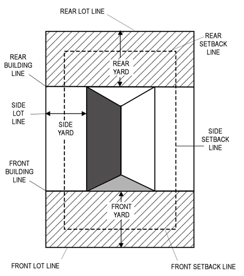
Building area: That area within and bounded by the building setback lines.
Building coverage: The gross area of a lot or parcel of land occupied by the ground floor of a building (principal and accessory) which is under roof. As a percentage, the relationship between ground floor area of the building under roof and the total area of the site.
Building height: The height of a building with a gabled or hip roof shall be the vertical distance measured from the average elevation of the finished building site to the eve line of the principal portion of the uppermost story. The height of a building with a flat or nearly flat roof shall be measured from the footing as stated above to the highest point of the roof. A flat roof shall be considered a roof that has a slope of less than seven (7) degrees with the horizontal. No projection in excess of ten (10) feet above the roof line shall be permitted for any building.
Building line: A line formed by the face of a building that is used to establish a yard for a building or structure. Building lines may be defined as front, rear, interior side, or street side.
Building permit: Any permit, which authorizes the commencement of construction in accordance with the construction plans or site plans approved by the County under the provisions of this ULDC and other applicable federal, state, and local regulations.
Building, principal: A building within which is conducted the principal use of the lot or property upon which the building is situated. An accessory building or structure attached by a roof system that is compatible to the principal building may be considered part of the principal building as determined by the Alachua County Building Official.
Building wall: An exterior load-bearing or non-load-bearing vertical building component that is used as an enclosing wall for a building, other than a party wall or fire wall, including a parapet wall (as defined by the Florida Building Code), extending to a height necessary for screening of rooftop mechanical equipment but not more than twenty-five (25) feet above the roof.
Bulb-out: Curb extensions that reduce roadway width curb to curb and provide for a shorter crossing distance for pedestrians.
Bus shelter: A structure used as a shelter for the convenience of passengers of a transportation system.
Business services: Any commercial activity primarily conducted in an office, not involving the sale of goods or commodities available in the office, and not dispensing personal services, but including such businesses as insurance agencies, stockbrokers, counselors, consultants, accountants, collection agencies, title and abstract companies, income tax services, travel agencies, advertising agencies, and any similar office-type use.
Cannabis: All parts of any plant of the genus Cannabis, whether growing or not; the seeds thereof; the resin extracted from any part of the plant; and every compound, manufacture, salt, derivative, mixture, or preparation of the plant or its seeds or resin. The term does not include "marijuana," as defined in F.S. § 381.986, if manufactured, possessed, sold, purchased, delivered, distributed, or dispensed, in conformance with F.S. § 381.986. The term does not include hemp as defined in F.S. § 581.217 or industrial hemp as defined in F.S. § 1004.4473. The term does not include a drug product described in F.S. § 893.03(5)(d).
Cannabis (Medical): A plant of the genus, Cannabis, whether growing or not; the resin extracted from any part of such a plant; or any compound, manufacture, salt derivative, mixture or preparation of such plant or its seeds that is dispensed only from a dispensing organization for medical use by an eligible patient as defined in F.S. § 499.0295.
Capital improvements element: The capital improvements element in the Comprehensive Plan or its most recent amendment.
Capital improvements program: The list of capital projects updated annually and adopted in the capital improvement element by the BOCC that is used to identify capital improvements that will contribute to the maintenance of level of service standards adopted in the capital improvements element for each public facility.
Cartway: A roadway generally designed for two-way traffic that has no center stripe.
Certificate of level of service compliance (CLSC): A statement from the County that the public facilities required to serve the proposed development are or will be available with adequate capacity based on adopted level of service standards when the impacts of the development occur.
Certified recovery residence: As defined in F.S. § 397.311.
Change of occupancy: A change in the purpose or level of activity within a building that involves a change in application of the requirements of the Florida Building Code.
Child care facility: Shall include child care centers, day nurseries, kindergartens, and any child care arrangement, other than a family day care home, which provides child care for more than five (5) children unrelated to the operator, and which receives a payment, fee, or grant for any of the children receiving care, wherever operated, and whether or not operated for profit. Childcare facilities shall be licensed and operated in accordance with all applicable requirements of the Florida Department of Children and Families and Section 24-152 of the ULDC.
Church: See "Place of worship."
Civic organization: A private, non-profit entity existing to serve one or more community functions, including educational, cultural, social, service, and religious activities.
Clean debris: Any solid waste which is virtually inert and which is not a pollution threat to groundwater or surface waters and is not a fire hazard and which is likely to retain its physical and chemical structure under expected conditions of disposal or use. The term includes uncontaminated concrete, including embedded pipe or steel, brick, glass, ceramics, and other wastes designated by the FDEP.
Close-mount: Antenna arrays mounted within three (3) feet of the mounting structure.
Closed system: An enclosed stormwater conveyance system associated with roadways constructed with curb and gutter.
Cocktail lounge, bar, tavern, or nightclub: A commercial establishment dispensing alcoholic beverages for consumption on the premises in which the service of food is merely incidental defined as the establishment deriving no more than fifty (50) percent of its gross revenue from the sale of food consumed on the premises. Alcoholic beverages may also be produced for consumption on the premises. Dancing and musical entertainment may be permitted. The term nightclub may also include facilities in which dancing and musical entertainment are permitted whether or not alcoholic beverages are served.
Co-housing: A planned residential community that offers an affordable, cooperative living arrangement in which multi-family units or a cluster of single-family houses are built around a common area for shared kitchen facilities, guest rooms and other amenities and services.
Collapse zone: The area surrounding a freestanding facility, which, in the event of a structural failure of all, or part, of the freestanding facility, would result in the freestanding facility falling or collapsing within the boundaries of the property on which the freestanding facility is placed. The collapse zone must equal at least one hundred (100) percent of the freestanding facility height.
Collector: Refer to collector roads as shown on the Future Roadway Classification Map of the Comprehensive Plan.
Collocation: To install, mount, maintain, modify, operate, or replace one or more wireless facilities on, under, within, or adjacent to a wireless support structure or utility pole. The term does not include the installation of a new utility pole or wireless support structure in the public rights-of-way.
Colonnade: A roof or building structure, extending over the sidewalk, open to the street and sidewalk except for supporting columns or piers.
Combined antenna: An antenna or an antenna array designed and utilized to provide services for more than one (1) wireless provider, or a single wireless provider utilizing more than one (1) frequency band or spectrum, for the same or similar type of services.
Commencement of construction: Issuance of a construction or building permit by Alachua County and commencement of infrastructure or building construction activities.
Commercial animal boarding facility: A facility that provides the service of temporary care of domestic animals.
Commercial animal raising: A commercial activity whose principal use is the breeding of non-domestic animals, both native and exotic, and which are not considered livestock by the Florida Department of Agriculture, for wholesale and/or retail sales.
Commercial mobile radio services (CMRS): Per Section 704 of the Telecommunications Act of 1996, any of several technologies using radio signals at various frequencies to send and receive voice, data and video. According to the FCC, these services are "functionally equivalent services." Section 704 of the Telecommunications Act prohibits unreasonable discrimination among functionally equivalent services.
Common ownership or control: The same or overlapping ownership or control, in that one or more person in a position of ownership or control is overlapping (i.e. owners, shareholders, directors, partners, principals, and other individuals that make up the corporations, partnerships, limited liability companies, professional associations, joint ventures, and other legal entities that own, that hold options to purchase, or that develop property).
Community gardens: Collaborative non-intensive agriculture on common Open Space primarily for consumption and use of residents.
Community residential home, large: A dwelling unit licensed to serve residents who are clients of the Department of Elderly Affairs, the Agency for Persons with Disabilities, the Department of Juvenile Justice, or the Department of Children and Families or licensed by the Agency for Health Care Administration which provides a living environment for seven (7) to fourteen (14) unrelated residents who operate as the functional equivalent of a family, including such supervision and care by supportive staff as may be necessary to meet the physical, emotional, and social needs of the residents.
Community residential home, small: A dwelling unit licensed to serve clients of the Department of Children and Family Services, which provides a living environment for six (6) or fewer unrelated residents who operate as the functional equivalent of a family, including such supervision and care by supportive staff as may be necessary to meet the physical, emotional, and social needs of the residents.
Community services: Governmental or private uses that provide a function for the community, including nonprofit or voluntary organizations and clubs engaged in civic, charitable, and related activities.
Comprehensive Plan: The Alachua County Comprehensive Plan, adopted in 2019, as amended. Pursuant to the Community Planning Act pursuant to F.S. Ch. 163, and which serves as the legal guideline for the future development of the County. Pursuant to F.S. § 163.3194(1)(b), in the case of any inconsistency between the provisions of this ULDC and the Comprehensive Plan, the Comprehensive Plan shall prevail.
Concealed PWSF: A PWSF that is not readily identifiable as such and that is not aesthetically incompatible with nearby uses. There are two (2) types of concealed PWSFs:
(a)
Concealed PWSF tower: A style of PWSF tower designed to obscure from view the antennas and the ancillary appurtenances that directly relate to the antennas. Concealed PWSF towers include, but are not limited to, structures that are or look like the following: a church steeple, a bell tower, spire, clock tower, cupola, light standard, flagpole with or without a flag, tree, etc.
(b)
Concealed PWSF antenna: Antenna either located wholly within the structure so as not to be visible, located behind screening, or otherwise locating them in such a manner that the antenna and ancillary appurtenances are not readily identifiable as such.
Concentrated animal feeding operation: A lot or building or combination of lots and buildings intended for the confined feeding, breeding, raising or holding of animals and specifically designed as a confinement area in which manure may accumulate, or where the concentration of animals is such that a vegetative cover cannot be maintained within the enclosure. Pastures shall not be considered concentrated animal feeding operations.
Concurrency management official (CMO): The Director of Growth Management, or designee.
Concurrency management system: The procedures and/or process that Alachua County will utilize to assure that development orders and permits are not issued unless facilities will be available concurrent with the impacts of development.
Concurrent: That the public facilities necessary to maintain the level of service standards adopted in this Chapter will be available when the impacts of development occur on the public facilities affected by the development.
Connection: Driveways, streets, turnouts, or other means of providing for the right of reasonable access to or from the State or County Roadway Network.
Connectivity: An interlinked system of transportation paths providing multiple routes, based on principles of efficient land use and transportation infrastructure.
Conservation areas: Natural resources that, because of their ecological value, uniqueness and particular sensitivity to development activities, require stringent protective measures to sustain their ecological integrity, including wetlands, surface waters, 100-year floodplains, listed species habitat, significant geologic features, and strategic ecosystems.
Conservation easement: Conservation easement shall mean a perpetual, undivided interest in real property as described in F.S. § 704.06.
Conservation management area: An area that contains the entire regulated natural or historic resources, as well as additional areas such as buffers, setbacks and linkages that preserve natural system functions.
Construction and demolition debris: Discarded materials generally considered to be not water-soluble and non-hazardous in nature, including but not limited to steel, glass, brick, concrete, asphalt roofing material, pipe, gypsum wallboard, and lumber, from the construction or destruction or demolition of a structure as part of a construction or demolition project or from the renovation of a structure and including rocks, soils, tree remains, trees, and other vegetative matter that normally results from land clearing or land development operations for a construction project, including such debris from construction of structures at a site remote from the construction or demolition project site. The term also includes: clean cardboard, paper, plastic, wood and metal scraps from a construction project; except as provided in F.S. § 403.707(12)(j), relating to recycling, waste reduction, and resource recovery, non-treated wood scraps from facilities manufacturing materials used for construction of structures or their components and unpainted, non-treated wood pallets provided the wood scraps and pallets are separated from other solid waste where generated and the generator of such wood scraps or pallets implements reasonable practices of the generating industry to minimize the commingling of wood scraps or pallets with other solid waste; and de minimums amounts of other non-hazardous wastes that are generated at construction or destruction or demolition projects, provided such amounts are consistent with best management practices of the industry.
Continuing in good faith: The final development order for a project has not expired, and no period of one (1) year passes without the occurrence, on the land, of development activity which significantly moves the proposed development toward completion of construction. However, a one-year lapse in development activity due to factors beyond the developer's control shall not constitute a failure to continue in good faith.
Convenience store: An establishment engaged in the retail sale of a variety of merchandise and food, such as canned and dry goods, beverages, dairy products, and bakery products not produced on the premises.
Corner clearance: At an intersecting street or highway, the dimension measured along the edge of the travelled way between the return radius point and the nearest point of the driveway.
Corridor design manual: Alachua County Corridor Design Manual, adopted November 2002.
County: Alachua County, a charter county and political subdivision of the State of Florida.
County Engineer: The Alachua County Engineer or their designee.
County facility: Any public street, sidewalk, place or building owned or controlled by or under the jurisdiction of the County, located throughout Alachua County, and includes, but is not limited to, County parks and recreation facilities.
County Growth Management Area: The area established by County Home Rule Charter Section 1.5.B as such may be amended from time to time.
Courtyard: A common open space surrounded wholly or partly by walls or buildings where people may congregate.
Critical-duration: The duration of a specific storm event (i.e., 100-year storm) which creates the largest volume or highest rate of net stormwater runoff (post-development runoff less pre-development runoff) for typical durations up through and including the ten-day duration event (one-hour, two-hour, four-hour, eight-hour, 24-hour, three-day, seven-day and ten-day events). The critical duration is determined by comparing various durations of the specified storm and calculating the peak rate and volume of runoff for each. The duration resulting in the highest peak rate or largest total volume is the "critical-duration" storm.
Cul-de-sac: A street terminated at the end in a vehicular turnaround.
Dairy, commercial: An area of land on which cows are kept for the purpose of producing dairy products in commercial quantities.
Dam: Any artificial or natural barrier, with appurtenant works, raised to obstruct or impound, or which does obstruct or impound, any of the surface waters.
Decision height: The height at which a decision must be made during an instrument landing system instrument approach to either continue the approach or to execute a missed approach.
Density: The ratio and intensity of land use over a given area of land. Density may be defined by ratios such as the number of units per given area of land. An example of this ratio would be twenty (20) dwellings per acre.
Density, gross: The measure of density against the broader area including streets, sidewalks, and other infrastructure.
Density, net: The measure of density against a specific parcel of land excluding public infrastructure.
De minimis impact: An impact of not more than ten (10) average daily trips on the affected transportation facility. A de minimis impact shall not exceed a cumulative impact of ten (10) average daily trips for an existing parcel of record, contiguous commonly held parcels or per development proposal. Further, no impact shall be de minimis if it exceeds the adopted level of service of a designated hurricane evacuation route.
Design flood: For the purposes of floodplain administration, the flood associated with the greater of the following two (2) areas: [Also defined in Florida Building Code, B, Section 202.]
(a)
Area with a floodplain subject to a one-percent or greater chance of flooding in any year; or
(b)
Area designated as a flood hazard area on the community's flood hazard map, or otherwise legally designated.
Design flood elevation: For the purposes of floodplain administration, the elevation of the "design flood," including wave height, relative to the datum specified on the community's legally designated flood hazard map. In areas designated as Zone AO, the design flood elevation shall be the elevation of the highest existing grade of the building's perimeter plus the depth number (in feet) specified on the flood hazard map. In areas designated as Zone AO where the depth number is not specified on the map, the depth number shall be taken as being equal to two (2) feet. [Also defined in Florida Building Code, B, Section 202.]
Detention: The collection and temporary storage of stormwater in such a manner as to provide for treatment through physical, chemical or biological processes with subsequent gradual release of stormwater.
Developed area: That portion of a plot or parcel upon which a building, structure, pavement, gravel, landscaping or other improvements have been placed.
Developed recreation: Facilities designed to provide for active recreation as their primary use, including swimming pools, playing fields, paved courts and skating areas, etc.
Developer: Any person, including a governmental agency, undertaking any development as defined in this ULDC.
Developer's agreement: An enforceable agreement entered into between Alachua County and a developer to provide for exactions or implementation of mitigation strategies or other provisions necessary to address impacts caused by development.
Development: Any new subdivision or expansion of an existing subdivision, or any new residential, commercial, industrial, institutional or mixed use project, or expansion of such an existing project, where approval is required by the development review committee and/or the BOCC.
Development: For the purposes of floodplain administration, any man-made change to improved or unimproved real estate, including but not limited to, buildings or other structures, tanks, temporary structures, temporary or permanent storage of equipment or materials, mining, dredging, filling, grading, paving, excavations, drilling operations or any other land disturbing activities.
Development activity: Any dredging, filling, excavation, construction of new structures, expansion of existing structures, installation of utilities, roads, personal wireless service facilities, stormwater management systems, septic tanks, bulkheading, land clearing, tree cutting, mechanized vegetation removal and the disposal of solid or liquid waste.
Development agreement: An enforceable agreement between Alachua County and a developer which meets the requirements of F.S. §§ 163.3220, 163.3243 and 163.3177(10)(h).
Development order: Any order granting, denying, or granting with conditions a building permit, construction permit, rezoning, subdivision approval, special use permit, special exception, variance, or any other official action by Alachua County having the effect of permitting the development of land.
Development order, final: The approval by the County of a proposal containing a specific plan for development, including the densities and intensities of the proposed development. It includes the final approval given by the DRC in accordance with the requirements of the land development regulations or other permits such as excavation permits which have an impact on one or more public facilities that are subject to concurrency.
Development plan, minor: A final development plan requiring approval by the development review committee including limited uses, change of use, and similar development plans not requiring extensive engineering as deemed by the Director of Growth Management.
Development review committee (DRC): A committee, established for the review and approval process for development in the unincorporated area of Alachua County.
Development, zero lot line: A residential or mixed use development where the buildings, either attached or detached, are positioned on a lot in such a manner that one or more of the building's sides rest directly on a lot line and that all buildings utilize the same side of the lot.
Developments of regional impact: Any development which, because of its character, magnitude, or location, would have a substantial effect upon the health, safety, or welfare of citizens of more than one (1) county and which was required to undergo development of regional impact review in accordance with the standards and guidelines adopted by the state land planning agency pursuant to F.S. § 380.06(2).
Diameter at breast height (dbh): The diameter of a tree measured at four and one-half (4.5) feet above the naturally occurring ground level.
(a)
Trees that fork at or within six (6) inches of grade are treated as separate trees and measured separately.
(b)
Trees that fork at or above six (6) inches and below four and one-half (4.5) feet are measured below the ford and recorded as a single trunk.
Distance between driveways: The distance measured along the right-of-way line between the tangent projection of the inside edges of adjacent driveways to the same frontage.
DNL: A metric used by the Federal Aviation Administration to quantify aircraft noise exposure in the vicinity of an airport, as provided in the Code of Federal Regulations Title 14, Part 150. DNL generally measures day/night 24-hour average sound levels and is expressed in decibels.
Documented: The existence of a scientifically credible occurrence record, including surveys, scientific publications, or other information from a developer or landowner, local, regional, state or federal agencies, or other credible source.
Dormitory: A structure used for sleeping accommodations related to an educational facility.
Domestic animals: A dog, cat, or other animal that is domesticated and may be kept as a household pet. The term does not include livestock or other farm animals.
Drainage: Where appropriate, shall include, but not be limited to, swales, ditches, storm sewers, seepage basins, culverts, side drains, retention or detention basins, cross drains and canals.
Dwelling unit: A single unit providing complete independent living facilities for one (1) single housekeeping unit as defined herein, including permanent provisions for living, sleeping, eating, cooking and sanitation.
Dwelling, multi-family: A residential building designed for or occupied exclusively by three (3) or more families, with the number of families in residence not exceeding the number of dwelling units provided.
Dwelling, single-family attached: A building and accessories that is principally used, designed, or adapted for use by a single household, containing all the essential elements of a single housekeeping unit, and that is constructed in a series, row, or group with one or more other dwelling units, which share not less than fifty (50) percent of one or more exterior walls and are located on separately platted lots.
Dwelling, single-family detached: A principal building and customary accessory structures that are used, designed, or adapted for use by a single household, containing all the essential elements of a single housekeeping unit, and that is constructed on a lot of record.
Dwelling, zero lot line: A dwelling unit, either attached or detached, positioned on a lot in such a manner that one or more of the building's sides rest directly on a lot line or within a required setback and that all buildings utilize the same side of the lot.
Easement: A grant from a property owner for public or private utilities, ingress, egress, drainage, sanitation, or other specified uses having limitations, the fee simple title to which shall remain in the name of the property owner.
Eaves: The extension or overhang of a roof measured from the outer face of the supporting wall or column to the farthest point of the overhanging structure.
Ecological integrity: The condition of an ecosystem having the biotic communities and physical environment with structure, composition, and natural processes that are resilient, self-sustaining, and able to accommodate stress and change. Its key ecosystem processes, such as nutrient cycles, succession, water levels and flow patterns, and the dynamics of sediment erosion and deposition, are functioning properly within the natural range of variability.
Ecological value: The value of functions performed by uplands, wetlands, and other surface water to the abundance, diversity, and habitats of fish, wildlife, and listed species. These functions include, but are not limited to, providing cover and refuge; breeding, nesting, denning, and nursery areas; corridors for wildlife movement; food chain support; and natural water storage, natural flow attenuation, and water quality improvement, which enhances fish, wildlife, and listed species utilization.
Ecosystem: A community of all plants and animals and their physical environment, functioning together as an interdependent unit.
Ecosystem management: The conservation, restoration or enhancement of, and planning for the maintenance of, parts or whole natural systems inter-related or associated with particular resources. Ecosystem management is an approach to natural resources that integrates ecological, economic, and social principles to manage biological and physical systems in a manner that safeguards the ecological sustainability, natural diversity, and productivity of the landscape. Examples of ecosystem management practices include using fire to restore longleaf pine forests, leaving buffer zones to protect water quality, and using harvesting techniques that enhance forest productivity and provide critical wildlife habitat.
Ecotourism activities: Activities involving travel to areas of natural or ecological interest to observe wildlife and support conservation efforts such as nature tours, birding activities, ecological workshops, canoeing, hiking, biking, and other ecological education activities.
Edge clearance: The distance measured along the edge of the travelled way between the frontage boundary line of adjacent properties and the nearest point of the connection, flare or radius.
Educational facilities: The buildings and equipment, structures, and special educational use areas that are built, installed, or established to serve primarily the educational purposes and secondarily the social and recreational purposes of the community and which may lawfully be used as authorized by the Florida Statutes and approved by boards.
Educational facility, private: A non-public elementary, secondary, business, technical, or trade school below college level serving students in grades Kindergarten through twelfth. These institutions may also include early learning opportunities for students three (3) years of age or older provided the programs are staffed by the school and meet age-appropriate standards. A school that includes only grades below kindergarten shall be considered a "childcare center." This shall also include charter schools that are not considered "conversion charter school" by Florida Statute.
Educational facility, public: A public elementary or secondary school serving students in grades Kindergarten through 12th with an academic course of study approved by the Florida Department of Education. These institutions may also include early learning opportunities for students three (3) years of age or older provided the programs are staffed by the school and provide and meet age-appropriate standards. This shall also include "conversion charter schools" as defined in Florida Statute.
Educational facility, vocational: A specialized instructional establishment that provides on-site training or professional, commercial, and/or trade skills. Incidental instructional services in conjunction with another primary use shall not be considered a business and trade school. Indoor training and instruction for professional sports shall be considered an "indoor sports training facility."
Electric substation:, as defined in F.S. § 163.3208, including accessory administration or maintenance buildings and related accessory uses and structures, takes electricity from the transmission grid and converts it to another voltage or lower voltage so it can be distributed to customers through one or more lines.
Element: Any exemplary or rare component of the natural environment, such as a species, natural community, bird rookery, spring, sinkhole, cave, or other ecological feature.
Element occurrence: A single extant habitat that sustains or otherwise contributes to the survival of a population or a distinct, self-sustaining example of a particular element.
Encroachment: The part of a structure that intrudes into a setback.
Encroachment: For the purposes of floodplain administration, the placement of fill, excavation, buildings, permanent structures or other development into a flood hazard area which may impede or alter the flow capacity of riverine flood hazard areas
Engineer: Includes the terms "professional engineer" and "licensed engineer" and means a person who is licensed to engage in the practice of engineering.
Enhanced specialized mobile radio (ESMR): Private land mobile radio with telephone and data services.
Entertainment and recreation: Uses that include amusement arcades, movie theaters, pool halls, bowling lanes, skating rinks, miniature golf, and carnival-type concessions and rides. Coin-operated amusement machines (excluding motion picture viewers or video arcades) of ten (10) or fewer machines shall be allowed as an accessory use to a restaurant in those zoning districts where restaurants are permitted and shall not be considered commercial recreation and entertainment, provided that the machines are authorized by the Florida Department of Revenue and an amusement machine certificate is posted in a conspicuous place at the machine location.
Environmental quality: The character or degree of excellence or degradation in the total essential natural resources of the area as measured by the findings and standards of the physical, natural, and social sciences, the arts and technology, and the quantitative guidelines of federal, state and county governments.
Equipment cabinet/shelter/compound: An unoccupied, enclosed structure at the base of the mount within which is housed the equipment for the PWSF such as batteries and electrical equipment.
Exactions: A requirement of a developer to dedicate land or construct or pay for all or a portion of the costs of capital improvements needed for public facilities as a condition of development approval. This does not include improvements on the site of the development or to provide safe access to and from the development to meet the needs of the occupants or users of the development, except for those improvements provided for a public purpose. These improvements may include transit enhancements, public sidewalks or public parks. The CMO shall have the authority to make the final determination of the public purpose associated with any exaction.
Excavation: The removal and transport of earth materials (sometimes referred to as "borrow" activities). This definition excludes commercial mining operations (such as limerock and sand mining operations), excavation associated with construction of storm water management facilities, excavation activities governed by the Alachua County Subdivision Regulations, and excavation associated with sod farming and removal activities, and tree farming activities.
Excavation and fill operation: An operation that involves the removal of surface and subsurface materials, including but not limited to earth, gravel, materials, minerals, peat, sand and soil, and replacing such material with clean debris or construction and demolition debris.
Existing building and existing structure: For the purposes of floodplain administration, any buildings and structures for which the "start of construction" commenced before December 14, 1982. [Also defined in Florida Building Code, B, Section 202.]
Existing deficiency: A deficiency in a public facility caused when the existing and reserved demand (from approved development through the issuance of a CLSC) exceeds the capacity of said facility at the adopted LOS standards.
Extraction: The removal of soil, sand, minerals, etc., from the earth through mining or excavation (borrow) activities.
Facade: The exterior wall of a building, parallel at the frontage line.
Fall zone: The area on the ground within a prescribed radius from the base of a PWSF, broadcasting or communications towers. The fall zone is the area within which there might be a potential hazard from falling debris or collapsing material.
Family: One or more persons occupying a living unit as a single, nonprofit housekeeping unit.
Family homestead exception: A family homestead exception is an exception to the density or intensity of a parcel in certain zoning districts as specified in Article XXIII, Family Homestead Exceptions, in Chapter 402.
Farmworker housing: Residential dwellings constructed or installed to provide housing for farmworkers and their families when employed on a fulltime basis by the owner or operator of an intensive agricultural activity occurring on the property on which the housing is located.
Federal Communications Commission (FCC): An independent federal agency charged with licensing and regulating wireless communications at the national level.
Federal Emergency Management Agency (FEMA): For the purposes of floodplain administration, the federal agency that, in addition to carrying out other functions, administers the National Flood Insurance Program.
Fill: Raising the surface level of the land with suitable soil or other material as specifically permitted for the site.
Filtration system: The temporary storage of stormwater and the subsequent gradual release of the stormwater through at least two (2) feet of suitable fine textured granular media such as porous soil, uniformly graded sand, or other natural or artificial fine aggregate, which may be used in conjunction with filter fabric and/or perforated pipe or storage vaults.
Fitness center: A place or building where passive or active exercises and related activities are performed for the purpose of physical fitness, improved circulation or flexibility, and/or weight control. Fitness center may also include incidental accessory uses such as child care for patrons, professional physical therapy services, and incidental food and beverage sales.
Fixture, cutoff: Intensity at eighty (80) degrees from nadir does not exceed one hundred (100) candela per one thousand (1,000) lamp lumens, nor at ninety (90) degrees from nadir does intensity exceed twenty-five (25) candela per one thousand (1,000) lamp lumens.
Fixture, full cutoff: A luminaire light distribution where no candlepower occurs at or above an angle of ninety (90) degrees from nadir. Additionally, the candela per one thousand (1,000) lamp lumens does not numerically exceed one hundred (100) at a vertical angle of eighty (80) degrees above nadir. This applies to all lateral angles around the luminaire.
Fixture, fully shielded: Constructed in such a manner that all light emitted by the fixture, either directly from the lamp or a diffusing element, or indirectly by reflection or refraction from any part of the luminaire, is projected below the horizontal.
Fixture, partially shielded: Shielded in such a manner that more than zero but less than ten (10) percent of the light emitted directly from the lamp or indirectly from any part of the fixture is projected above the horizontal.
Fixture, semi-cutoff: Intensity at eighty (80) degrees from nadir does not exceed two hundred (200) candela per one thousand (1,000) lamp lumens, nor at ninety (90) degrees from nadir does intensity exceed fifty (50) candela per one thousand (1,000) lamp lumens.
Flagpole: A pole on which to raise a flag.
Flood or flooding: For the purposes of floodplain administration, a general and temporary condition of partial or complete inundation of normally dry land from: [Also defined in Florida Building Code, B, Section 202.]
(1)
The overflow of inland or tidal waters.
(2)
The unusual and rapid accumulation or runoff of surface waters from any source.
Flood damage-resistant materials: For the purposes of floodplain administration, any construction material capable of withstanding direct and prolonged contact with floodwaters without sustaining any damage that requires more than cosmetic repair. [Also defined in Florida Building Code, B, Section 202.]
Flood hazard area: For the purposes of floodplain administration, the greater of the following two (2) areas: [Also defined in Florida Building Code, B, Section 202.]
(1)
The area within a floodplain subject to a one-percent or greater chance of flooding in any year.
(2)
The area designated as a flood hazard area on the community's flood hazard map, or otherwise legally designated.
Flood hazard area (variance): For the purposes of Chapter 406, Article VII, a grant of relief from the requirements of this ULDC, or the flood-resistant construction requirements of the Florida Building Code, which permits construction in a manner that would not otherwise be permitted by this ordinance or the Florida Building Code.
Flood insurance rate map (FIRM): For the purposes of floodplain administration, the official map of the community on which the Federal Emergency Management Agency has delineated both special flood hazard areas and the risk premium zones applicable to the community. [Also defined in Florida Building Code, B, Section 202.]
Flood insurance study (FIS): For the purposes of floodplain administration, the official report provided by the Federal Emergency Management Agency that contains the flood insurance rate map, the flood boundary and floodway map (if applicable), the water surface elevations of the base flood, and supporting technical data. [Also defined in Flood Building Code, B, Section 202.]
Floodplain: Lowland adjoining the channels of rivers, streams or other watercourses, or lakes or other bodies of standing water. Includes the floodway and floodway fringe.
Floodplain administrator: For the purposes of floodplain administration, the office or position designated and charged with the administration and enforcement of this ordinance (may be referred to as the Floodplain Manager).
Floodplain development: For the purpose of Chapter 406, Article VII, any man-made change to improved or unimproved real estate, including but not limited to, buildings or other structures, tanks, temporary structures, temporary or permanent storage of equipment or materials, mining, dredging, filling, grading, paving, excavations, drilling operations or any other land disturbing activities.
Floodplain development permit or approval: For the purposes of floodplain administration, an official document or certificate issued by the community, or other evidence of approval or concurrence, which authorizes performance of specific development activities that are located in flood hazard areas and that are determined to be compliant with this ordinance.
Floodway: The channel of a river or other riverine watercourse and the adjacent land areas that must be reserved in order to discharge the base flood without cumulatively increasing the water surface elevation more than one (1) foot. [Also defined in Florida Building Code, B, Section 202.]
Floodway encroachment: For the purposes of Chapter 406, Article VII, the placement of fill, excavation, buildings, permanent structures or other development into a flood hazard area which may impede or alter the flow capacity of riverine flood hazard areas.
Floodway encroachment analysis: For the purposes of floodplain administration, an engineering analysis of the impact that a proposed encroachment into a floodway is expected to have on the floodway boundaries and base flood elevations; the evaluation shall be prepared by a qualified Florida licensed engineer using standard engineering methods and models.
Floor area ratio: The ratio of a building's total floor area (gross floor area) to the size of the lot or parcel upon which it is built.
Florida Building Code: For the purposes of floodplain administration, the family of codes adopted by the Florida Building Commission, including: Florida Building Code, Building; Florida Building Code, Residential; Florida Building Code, Existing Building; Florida Building Code, Mechanical; Florida Building Code, Plumbing; Florida Building Code, Fuel Gas.
Florida Greenbook: Most recent adopted version of the Florida Manual of Uniform Minimum Standards for Design, Construction and Maintenance
Flush-mounted: Any antenna or antenna array attached directly to the face of the support structure or building such that no portion of the antenna extends above the height of the support structure or building. Where a maximum flush-mounting distance is given, that distance shall be measured from the outside edge of the support structure or building to the inside edge of the antenna.
Fraternity or sorority house: A structure used as group living quarters for students of an educational facility who are members of a fraternity or sorority that has been officially recognized by the educational facility.
Front building elevation area: The area found by multiplying the length of the front wall of the principal building on a lot or parcel of record by the distance between the entry level and the eave line of this building.
Frontage: The distance or width of a parcel of land abutting a public right-of-way and as measured upon such right-of-way. Corner property at a highway intersection has a separate frontage along each highway.
Frontage road: A street or road auxiliary to and normally located alongside and parallel to a highway for purposes of maintaining local road continuity and for control of access.
Functionally dependent use: For the purposes of floodplain administration, a use which cannot perform its intended purpose unless it is located or carried out in close proximity to water, including only docking facilities, port facilities that are necessary for the loading and unloading of cargo or passengers, and ship building and ship repair facilities; the term does not include long-term storage or related manufacturing facilities.
Functionally equivalent services: Cellular, PCS, enhanced specialized mobile radio, specialized mobile radio and paging. Section 704 of the Telecommunications Act prohibits unreasonable discrimination among functionally equivalent services.
Garage: A detached accessory structure or portion of the principal building, to which there is legal vehicular access from a public right-of-way, for the storage of motor vehicles and personal property belonging to the occupants of the principal building.
Geodetic marker: Any second order Class I geodetic control corner monument or third order Class I traverse point established by the Alachua County Horizontal Control Densification Survey of 1988/89 or any marker that is established and accepted by the National Geodetic Survey and/or Florida Department of Environmental Protection. Information on geodetic markers may be obtained from the property appraiser's office and/or the County Engineer's office.
Geologic features: A prominent or conspicuous characteristic of earth materials in the landscape. In Alachua County, prominent geologic features include sinkholes, caves, stream bluffs, escarpments, outcroppings, and springs.
Good cause: Impediments to submission of final development plan such as delays in securing permits from other agencies in a timely manner. Good cause does not include adverse market conditions, delays in securing financing, or self-imposed hardships resulting from the actions, or inaction, of the developer.
Greenspace: Pervious open spaces designed as active or passive recreation areas intended primarily for recreational or pedestrian use, such as community fields, greens, and pervious areas of plazas or squares.
Greenway: A corridor of protected greenspace that is managed for conservation and recreation purposes. Greenways follow natural land or water features, road rights-of-way or abandoned railroad corridors or canals, and link natural reserves, parks, cultural and historic sites; often through multiuse paths.
Green roof: A roof of a building that is partially or completely covered with vegetation and a growing medium, planted over a waterproofing membrane. It may also include additional layers such as a root barrier and drainage and irrigation systems.
Gross floor area: The sum of the area of all floors of a building, measured from the exterior faces of all exterior walls or from the centerline of walls separating two (2) buildings. Open porches, balconies, and carports are specifically excluded from the calculation.
Groundcover: A low-growing herbaceous or woody plant other than turf, not over two (2) feet high, intended to cover the ground.
Group home: Any properly licensed dwelling, building or other place, whether operated for profit or not, where adult (age eighteen (18) or older) or elder care for a period exceeding twenty-four (24) hours is provided and involves one or more personal services for persons not related to the owner or administrator by law, blood, marriage or adoption, and not in foster care, but who require such services. The personal services, in addition to housing and food services may include, but not be limited to, personal assistance with bathing, dressing, housekeeping, adult supervision, emotional security, and other related services but not including medical services other than distribution of prescribed medicines.
Groundwater: Water occurring beneath the surface of the ground or in the zone of saturation, whether or not flowing through known or definite channels.
Ground truthing: Verification on the ground of conditions on a site.
Guyed tower: A type of mount that is anchored to the ground or to another surface by diagonal cables.
Gym: See "Fitness center."
Habitat: The natural abode of a plant or animal that contains the arrangement of food, water, cover and space required to meet the biological needs of a given species. Different species have different requirements, and these requirements vary over the course of a year.
Habitat corridors: A naturally-vegetated transportation route for plants and animals that connects larger natural areas. Wild plants and animals typically require avenues for dispersal to different feeding and breeding sites in order to survive.
Habitat diversity: The variety of habitat features and types in a specific area. Habitat diversity takes many forms: the variety of plants and animals on a site; structural diversity or the vertical arrangement of vegetation from canopy to forest floor; horizontal diversity or the distribution of habitat types across the landscape; and temporal diversity or habitat changes over time. Generally, areas with substantial habitat diversity will support more wildlife species than areas with less habitat diversity.
Handoff candidate: A wireless communication facility that receives call transference from another wireless facility, usually located in an adjacent first tier surrounding the initial wireless facility.
Hard core [pornography]: Depictions of specified sexual activities that include one or more of the following: erect male organ; contact of the mouth of one person with the genitals of another; penetration of a finger or male organ into any bodily orifice in another person; open female labia; penetration of a sex toy or other device into a bodily orifice of any person, sometimes assisted by another person; actual male ejaculation; or the aftermath of male ejaculation.
Hardscape features: Hardscape or hardscaping consists of the inanimate elements of landscaping, especially any masonry work or woodwork. For example, stone walls, concrete or brick patios, tile paths, walkways, wooden decks and wooden arbors shall be considered part of the hardscape.
Hazardous material: The liquid, solid, and gaseous materials designated in Section 353.26, "Materials regulated," of the Hazardous Materials Management Code. This includes but is not limited to:
(1)
Petroleum products as defined in Section 353.23, "Definitions." Aboveground petroleum product storage tank systems are subject to the provisions of the County Hazardous Materials Management Code.
(2)
Wastes listed or characterized as hazardous wastes by the Administrator of the United States Environmental Protection Agency pursuant to the Solid Waste Disposal Act, as amended. This list is provided in Title 40 (Protection of the Environment) of the Code of Federal Regulations, Part 261, Identification and Listing of Hazardous Waste.
(3)
Pesticides registered by the Administrator of the United States Environmental Protection Agency pursuant to the Federal Insecticide, Fungicide, and Rodenticide Act (FIFRA).
(4)
Substances for which a material safety data sheet is required by the United States Department of Labor, Occupational Safety and Health Administration, pursuant to Title 29 of the Code of Federal Regulations, Part 1910.1200; however, only insofar as they pose a hazard to human health or the environment.
(5)
Any material not included above which may present similar or more severe risks to human health or the environment. Such determination must be based upon competent testing or other objective evidence provided by the department.
Hazardous waste: Any solid waste as defined in 40 CFR, Section 261.1, which is considered a hazardous waste pursuant to 40 CFR, Section 261.3, and exhibits the characteristics identified in 40 CFR, Part 261, Subpart C, or is listed in 40 CFR, Part 261, Subpart D, or designated as provided in Section 353.03.
Heavy machinery and equipment: Machinery and equipment used for commercial, industrial and agricultural operations, including vehicles used for construction and demolition.
Height AGL (above ground level): For personal wireless services facilities, this is the distance measured from ground level to the highest point of a PWSF, broadcast including the antenna array. For purposes of measuring height, all antennas, lightning rods, or other attachments mounted on a structure shall be included in the measurements to determine overall (i.e. combined) height.
High aquifer recharge areas: Those areas where stream-to-sink surface water basins occur, and those areas where the Floridan Aquifer system is vulnerable or highly vulnerable as depicted in the Alachua County Floridan Aquifer High Recharge Area Map adopted in the Alachua County Comprehensive Plan (COSE Map 2).
Highest adjacent grade: For the purposes of floodplain administration, the highest natural elevation of the ground surface prior to construction next to the proposed walls or foundation of a structure.
Historic preservation: The identification, evaluation, recordation, documentation, analysis, recovery, interpretation, curation, acquisition, protection, management, rehabilitation, restoration, stabilization, maintenance, or reconstruction of historic resources or properties.
Historic resourceor historic property: Any prehistoric or historic district, site, building, object, or other real or personal property of historical, architectural or archaeological value, and folklife resources. These properties or resources may include, but are not limited to: monuments, memorials, Indian habitations, ceremonial sites, abandoned settlements, sunken or abandoned ships, engineering works, treasure troves, artifacts, or other objects with intrinsic historical or archaeological value, or any part thereof, relating to the history, government, and culture of the State and Alachua County.
Historic structure: For the purposes of floodplain administration, any structure that is determined eligible for the exception to the flood hazard area requirements of the Florida Building Code, Existing Building, Chapter 12 Historic Buildings.
Holiday: Legal holidays recognized by Alachua County.
Home-based business: Any use conducted entirely within a dwelling and carried on by an occupant thereof, which use is clearly incidental and secondary to the principal use of the dwelling for residential purposes and does not change the residential character thereof.
Homeless shelter: A supervised publicly or privately operated shelter designed to provide temporary living accommodations, including welfare hotels, congregate shelters, and transitional housing for the mentally ill, or a public or private building not ordinarily used for residential purposes, including accessory uses of places of worship or civic organizations.
Homeowners' association: A Florida corporation responsible for the operation of a community or a mobile home subdivision in which the voting membership is made up of parcel owners or their agents, or a combination thereof, and in which membership is a mandatory condition of parcel ownership, and which is authorized to impose assessments that, if unpaid, may become a lien on the parcel. The term "homeowners' association" does not include a community development district or other similar special taxing district created pursuant to statute.
Hospital: Any institution or clinic, which maintains and operates facilities registered, licensed and operated as a hospital in accordance with the State of Florida regulations, for overnight care and treatment of two (2) or more unrelated persons as patients suffering mental or physical ailments, but not including any dispensary or first-aid treatment facilities maintained by a commercial or industrial plant, educational institution, convent or convalescent home, or similar institutional use.
Hotel or motel: A building, or portion of a building, containing individual guest rooms or guest accommodations for which rental fees are charged for daily, weekly, or monthly lodging, properly licensed and operated in accordance with State of Florida regulations.
Hotel, motel, resort rental, or bed and breakfast: A building, or portion of a building, containing individual guest rooms or guest accommodations for which rental fees are charged for daily, weekly, or monthly lodging, properly licensed and operated in accordance with State of Florida regulations. This definition shall not include private homes leased for periods exceeding ninety (90) days.
Household: A family whose relationship is of a permanent and distinctly domestic character, rather than resort or seasonal (occupancy of a dwelling for purposes of attending a college or university shall not be considered seasonal).
Hunting camp: A recreational facility established for the purposes of hunting and/or fishing which may provide overnight accommodations, food, transportation, guides, and other customary accessory uses and facilities.
Hydroperiod: Period of time in which soils, waterbodies and sites are wet.
Imminent deficiency: An approaching deficiency in a public facility caused when the existing demand and capacity reserved for approved development through the issuance of a CLSC reaches ninety-five (95) percent of the capacity of said facility at the adopted LOS standards.
Impervious surface: Those surfaces that prevent the entry of water into the soil. Common impervious surfaces include, but are not limited to, rooftops, sidewalks, patio areas, driveways, parking lots, and other surfaces made of concrete, asphalt, brick, plastic, or any surfacing material with a base or lining of an impervious material.
Income, extremely low: Extremely low-income means one or more natural persons or a family that has a total annual adjusted gross income for the household that does not exceed thirty (30) percent of the median annual gross income for households, adjusted for family size, within the metropolitan statistical area.
Income, very-low income person or very-low-income household: One or more natural persons or a family that has a total annual gross household income that does not exceed fifty (50) percent of the median annual income adjusted for family size for households within the metropolitan statistical area, the County, or the nonmetropolitan median for the state, whichever is greatest. With respect to rental units, the very-low-income household's annual income at the time of initial occupancy may not exceed fifty (50) percent of the area's median income adjusted for family size. While occupying the rental unit, a very-low-income household's annual income may increase to an amount not to exceed one hundred forty (140) percent of fifty (50) percent of the area's median income adjusted for family size.
Incidental food and beverage sales: Sales, storage, preparation, and service of food and/or beverages that occurs as an accessory use to an established commercial or industrial use, which may or may not be directly associated with that use.
Indoor sports training facility: An indoor facility that provides training of amateur or professional athletes in a particular sport. These facilities typically operate on a by-appointment basis and provide very small student-instructor ratios. Programs at these facilities are designed to enhance the skills necessary to succeed in a particular sport rather than for general exercise as at a "gym" or "fitness center".
Industry: Industrial developments are characterized by the fabrication, manufacturing, transporting, warehousing or distribution of goods. Any activity involving the manufacturing or treatment of any commodity including the assembly, packaging, canning, bottling, or processing of any item. To change any commodity in composition, form, size, shape, texture, or appearance is deemed to be an industrial process.
Industry, heavy: Manufacturing or other enterprises with significant external effects, or which pose significant risks due to the involvement of explosives, radioactive materials, poisons, pesticides, herbicides, or other hazardous materials in the manufacturing or other process.
Industry, light: Research and development activities, the manufacturing, compounding, processing, packaging, storage, assembly, and/or treatment of finished or semi-finished products from previously prepared materials, which activities are conducted wholly within an enclosed building and do not generate a noticeable amount of noise, dust, odor, smoke, glare or vibration outside the building in which they are conducted.
Infrastructure Capacity Report for Alachua County: The report issued once each quarter as a supplement to the Alachua County Monthly Development Report and assessing the impacts of the approved development listed in the Alachua County Monthly Development Report upon the adopted level of service standards for those public facilities subject to concurrency management.
Inside radius: The inside or smaller curve radius connecting the edge of the driveway to the travelled way when the driveway angle is less than ninety (90) degrees.
Invasive, nonnative vegetation: Any plant not indigenous to Florida, which exhibits, or has the potential to exhibit, noncontrolled growth and invasion or alteration of the natural qualities and functions of any native habitat.
Irrigation, high volume: An irrigation system with a minimum flow rate per emitter of more than thirty (30) gallons per hour or higher than one-half (0.5) gallons per minute.
Irrigation, low volume: Any emitter or sprinkler that applies less than thirty (30) gallons per hour (gph) or one-half (0.5) gallons per minute (gpm).
Irrigation, micro: The frequent application of small quantities of water directly on or below the soil surface or plant root zone, usually as discrete drops, tiny streams, or miniature sprays through emitters placed along the water delivery pipes (laterals). Micro-irrigation encompasses a number of methods or concepts, including drip, subsurface, bubbler and micro-spray irrigation, previously known as trickle irrigation.
Island: A physical barrier or separation to direct the flow of traffic and/or to separate highway traffic from the activity on the adjacent property.
Junk: Any litter, debris, waste materials of any kind, dead or decaying vegetation or vegetative refuse, dead animals, used or unserviceable vehicle and machinery parts, used and nonfunctional furniture and appliances, and used and nonfunctional tools, equipment, and implements, but shall not include compost piles for normal, personal, noncommercial use.
Karst: Landforms that have been modified by dissolution of soluble rock (limestone or dolostones), and which may be characterized by sinkholes, sinking streams, closed depressions, subterranean drainage, and caves.
Karst areas: Areas where limestone and/or dolostone occur at or near the land surface, and sand overburden, confining clays, or other confining cover material is absent or discontinuous and where karst is the dominant landform.
Keystone plant species: A native plant species that is critical to the food web and necessary for many wildlife species to complete their life cycle.
Land application: The act of disposing of sewage effluent and/or sludge on the earth's surface. There are three (3) primary types of land application: (1) overland flow, which includes depository sludge in landfills, (2) rapid rate infiltration, such as in percolation ponds, and (3) slow rate infiltration such as spray irrigation.
Landfill: Any solid waste land disposal area for which a permit, other than a general permit, is required by F.S. § 403.707 and which receives solid waste for disposal in or upon land.
Landfill, Class I: A landfill facility that receives an average of 20 tons or more of solid waste per day.
Landfill, Class III: A landfill facility that receives only yard trash, construction and demolition debris, waste tires, asbestos, carpet, cardboard, paper, glass, plastic, furniture other than appliances, and other materials approved by the Florida Department of Environmental Protection (FDEP) which are not expected to produce leachate which poses a threat to public health or the environment. Class III landfills do not accept putrescible household waste.
Landscape materials: Horticultural items such as plants, shrubs and trees, and accessory materials such as fertilizer, sod, pots and liners, mulch, wood chips, and irrigation systems.
Large-scale Comprehensive Plan amendment: An amendment to Comprehensive Plan that does not meet the criteria of a small-scale Comprehensive Plan amendment pursuant to F.S. § 163.3187.
Lattice tower: A type of PWSF mount that consists of multiple legs and cross-bracing of structural steel.
Letter of map change (LOMC): For the purposes of floodplain administration, an official determination issued by FEMA that amends or revises an effective flood insurance rate map or flood insurance study. "Letters of map change" include:
Letter of map amendment (LOMA): An amendment based on technical data showing that a property was incorrectly included in a designated special flood hazard area. A LOMA amends the current effective flood insurance rate map and establishes that a specific property, portion of a property, or structure is not located in a special flood hazard area.
Letter of map revision (LOMR): A revision based on technical data that may show changes to flood zones, flood elevations, special flood hazard area boundaries and floodway delineations, and other planimetric features.
Letter of map revision based on fill (LOMR-F): A determination that a structure or parcel of land has been elevated by fill above the base flood elevation and is, therefore, no longer located within the special flood hazard area. In order to qualify for this determination, the fill must have been permitted and placed in accordance with the community's floodplain management regulations.
Conditional letter of map revision (CLOMR): A formal review and comment as to whether a proposed flood protection project or other project complies with the minimum NFIP requirements for such projects with respect to delineation of special flood hazard areas. A CLOMR does not revise the effective flood insurance rate map or flood insurance study; upon submission and approval of certified as-built documentation, a letter of map revision may be issued by FEMA to revise the effective FIRM.
Level of service (LOS) standard: The LOS standard adopted in the Alachua County Comprehensive Plan that will be used to determine whether adequate capacity will be available for a particular public facility to accommodate the impacts of a proposed development on the facility.
Light-duty truck: For the purposes of floodplain administration, as defined in 40 C.F.R. 86.082-2, any motor vehicle rated at eight thousand five hundred (8,500) pounds gross vehicular weight rating or less which has a vehicular curb weight of six thousand (6,000) pounds or less and which has a basic vehicle frontal area of forty-five (45) square feet or less, which is:
(a)
Designed primarily for purposes of transportation of property or is a derivation of such a vehicle; or
(b)
Designed primarily for transportation of persons and has a capacity of more than twelve (12) persons; or
(c)
Available with special features enabling off-street or off-highway operation and use.
Lighting, outline: A style of lighting that outlines the roofline of a building used to call attention to the building.
Listed species: Those species of plants and animals listed as endangered, threatened, rare, or species of special concern by an official state or federal plant or wildlife agency, or the Florida Natural Areas Inventory (FNAI), includes species ranked as S1, S2, or S3). These species are targeted for protection for a number of reasons, e.g. they are in imminent danger of extinction, are rapidly declining in number or habitat, or have an inherent vulnerability to habitat modification, environmental alteration, or human disturbance which puts them at risk of extinction.
Littoral zone: In reference to stormwater management systems, that portion which is designed to contain rooted aquatic plants.
Livestock: Includes all animals of the equine, bovine, or swine class, including goats, sheep, mules, horses, hogs, cattle, ostriches, and other grazing animals.
Living area: Heating/cooled space within a dwelling unit utilized for living, sleeping, eating, cooking, bathing, washing, and sanitation purposes.
Lot: A tract or parcel of land and shall also mean the least fractional part of subdivided lands having limited fixed boundaries, and an assigned number, letter, or other name through which it may be identified.
Lot, corner: A lot abutting two (2) or more streets, or at a street intersection or at a street corner having an interior angle not greater than one hundred thirty-five (135) degrees. Unless conflicting with the prevailing development pattern of the adjacent lots, the exterior lot line of the narrowest side of the lot adjoining the street shall be considered the front of the lot, and the exterior lot line of the longest side of the lot abutting the street shall be considered as a side of the lot. The opposite side yard and the rear yard shall conform to the minimum yard requirements of the zoning district in which the property is located.
Lot coverage: That percentage of the plot area covered or occupied by buildings or roofed portions of structures.
Lot line: The legal boundary of a lot as established by a certified land survey, plat, or recorded deed.
Lot of record:
(a)
A lot that is part of a documented subdivision, the map of which has been recorded in the office of the clerk of the circuit court;
(b)
A lot or parcel of land described by metes and bounds, the description of which has been recorded in the office of the clerk of the circuit court, consistent with and in compliance with land development regulations in effect at the time of said recording;
(c)
A lot created by a separate legal description where a building permit has been issued for residential purposes; or
(d)
Lots created by either the county commission or board of adjustment of Alachua County.
Low impact design (LID): An approach to land development and stormwater management that preserves and protects natural-resource systems and water resources using various site planning and stormwater management approaches and technologies to simultaneously conserve and protect natural resource systems and to reduce the average annual stormwater pollutant loading discharged off-site. The approach uses site planning to minimize runoff and a suite of engineered small-scale hydrologic controls distributed throughout the site and integrated as a BMP Treatment Train to replicate the natural hydrolic functioning of the landscape through infiltrating, filtering, storing, evaporating, and detaining runoff close to its source.
Low-income person or low-income household: One or more natural persons or a family that has a total annual gross household income that does not exceed eighty (80) percent of the median annual income adjusted for family size for households within the metropolitan statistical area, the County, or the nonmetropolitan median for the state, whichever amount is greatest. With respect to rental units, the low-income household's annual income at the time of initial occupancy may not exceed eighty (80) percent of the area's median income adjusted for family size. While occupying the rental unit, a low-income household's annual income may increase to an amount not to exceed one hundred forty (140) percent of eighty (80) percent of the area's median income adjusted for family size.
Lowest floor: For the purposes of floodplain administration, the lowest floor of the lowest enclosed area of a building or structure, including basement, but excluding any unfinished or flood-resistant enclosure, other than a basement, usable solely for vehicle parking, building access or limited storage provided that such enclosure is not built so as to render the structure in violation of the non-elevation requirements of the Florida Building Code or ASCE 24. [Also defined in Florida Building Code, B, Section 202.]
Management plan: A plan which addresses conservation and management of native vegetation occurring within a specific area, as approved by the landowner or applicant on behalf of the landowner, the Alachua County Office of Environmental Protection, the Florida Department of Natural Resources or other public entity with maintenance responsibility for the adjacent preservation lands, and the Florida Game and Fresh Water Fish Commission in cases where listed species are present or affected.
Manufactured building, modular building, or factory-built building: A closed structure, building assembly, or system of subassemblies, which may include structural, electrical, plumbing, heating, ventilating, or other service systems manufactured in manufacturing facilities for installation or erection as a finished building or as part of a finished building, which shall include, but not be limited to, residential, commercial, institutional, storage, and industrial structures. The term includes buildings not intended for human habitation such as lawn storage buildings and storage sheds manufactured and assembled offsite by a manufacturer certified in conformance with this part. This part does not apply to manufactured homes or mobile homes.
Manufactured home: For the purposes of floodplain administration, a structure, transportable in one or more sections, which is eight (8) feet or more in width and greater than four hundred (400) square feet, and which is built on a permanent, integral chassis and is designed for use with or without a permanent foundation when attached to the required utilities. The term "manufactured home" does not include a "recreational vehicle" or "park trailer." [Also defined in 15C-1.0101, F.A.C.] This includes a mobile home fabricated on or after June 15, 1976, in an off-site manufacturing facility for installation or assembly at the building site, with each section bearing a seal certifying that it is built in compliance with the federal Manufactured Home Construction and Safety Standard Act.
Manufactured home park or subdivision: For the purposes of floodplain administration, a parcel (or contiguous parcels) of land divided into two (2) or more manufactured home lots for rent or sale.
Mobile home park: A use of land in which lots or spaces are offered for rent or lease for the placement of manufactured homes and/or mobile homes and in which the primary use of the park is residential.
Marina: A recreational facility established for the purposes of fishing or boating, which may provide in-water or dry storage of boats, food services, transportation, guides, boat rentals, and other customary accessory uses and facilities. Overnight accommodations may be provided at these facilities only by special exception.
Market value: For the purposes of floodplain administration, the price at which a property will change hands between a willing buyer and a willing seller, neither party being under compulsion to buy or sell and both having reasonable knowledge of relevant facts. As used in this ordinance, the term refers to the market value of buildings and structures, excluding the land and other improvements on the parcel. Market value may be established by a qualified independent appraiser, Actual Cash Value (replacement cost depreciated for age and quality of construction), or tax assessment value adjusted to approximate market value by a factor provided by the Property Appraiser.
Marquees and canopies: Any shelter, cover, or protection extending beyond the outer face of the building wall, of either rigid or nonrigid construction, designed and intended to be used for the purpose of shelter or protection for entrances and walkways.
Massage: Touch, stroking, kneading, stretching, friction, percussion and vibration, and includes holding, positioning, causing movement of the soft tissues and applying manual touch and pressure to the body (excluding an osseous tissue manipulation or adjustment).
Massage therapy: The profession in which the practitioner applies massage techniques with the intent of positively affecting the health and well-being of the client, and may adjunctively (i) apply allied modalities, heat, cold, water and topical preparations not classified as prescription drugs, (ii) use hand held tools or devices designed as t-bars or knobbies, and (iii) instruct self-care and stress management. "Manual" means by use of hand or body.
Materials recovery facility: A solid waste management facility that provides for the extraction from solid waste of recyclable materials, materials suitable for use as a fuel or soil amendment, or any combination of such materials.
Maximum service volume: The maximum capacity of a public facility based on the adopted LOS standard. For the purposes of roadway capacity, maximum service volume shall be determined by the latest Florida Department of Transportation (FDOT) generalized tables, a more detailed analysis such as FDOT's Arterial Planning software, or the Highway Capacity Manual. Any such detailed analysis shall be subject to acceptance/approval by the Alachua County Public Works Department.
Media: Anything printed or written, or any picture, drawing, photograph, motion picture, film, videotape or videotape production, or pictorial representation, or any electrical or electronic reproduction of anything which is or may be used as a means of communication. Media includes but shall not necessarily be limited to books, newspapers, magazines, movies, videos, sound recordings, CD ROMs, other magnetic media, and undeveloped pictures.
Median: The portion of a road separating the travel lanes for traffic.
Medical clinic or lab: An institution providing out-patient health-related care services including but not limited to medicine, dentistry, osteopaths, chiropractors, or opticians.
Medical marijuana dispensary: A facility licensed and operated for the purpose of dispensing medical marijuana, in accordance with F.S. § 381.986, and all other applicable local and state rules, regulations and statutes.
Mineral resource: All solid minerals, including, but not limited to, clay, gravel, phosphate rock, lime, shells (excluding live shellfish), stone, sand, heavy minerals, and any rare earths which have heretofore been discovered or may be discovered in the future, which are contained in the soils or waters of this state.
Minimal impact activities: Activities that will have no significant adverse impact on the resource. Such activities may include installation of navigational aids marked consistent with the requirements of F.S. § 327.40; construction and maintenance of public or private nature trails not more than ten (10) feet in width; installation of docks not in excess of one (1) one thousand (1,000) square feet in size, subject to performance standards, and other similar activities.
Minimum descent altitude: The lowest altitude, expressed in feet above mean sea level, to which descent is authorized on final approach or during circling-to-land maneuvering in execution of a standard instrument approach procedure for which no electronic glide slope is provided.
Minimum obstruction clearance altitude: The lowest published altitude in effect between radio fixes on very high frequency omni directional range station (VOR) airways, off-airway routes, or route segments which meet obstruction clearance requirements for the entire route segment, and which assures acceptable navigational signal coverage only within twenty-two (22) miles of a VOR. Mining: The extraction of natural deposits from the earth which are regulated by the State of Florida under F.S. Ch. 211, Pt. II and F.S. Ch. 378, and by Alachua County Ordinance 68, as may be amended or superseded by this ULDC.
Mining operation: A collective term referring to all aspects of the proposed mining scheme, including the plant, processing areas and total land area for which the applicant is applying for a permit.
Mining permit: A valid operating permit for the conduct of mining operations.
Mining unit: Specified areas of land from which minerals are extracted in a specified period of time.
Mitigation: An action or series of actions that offsets adverse environmental impacts. Mitigation may consist of any one or a combination of monetary compensation, or acquisition, restoration, enhancement, or preservation of wetlands, other surface waters or uplands.
Mixed use: A building or an area that contains a mix of uses. This may include uses such as retail, office, and residential.
Mobile farmers market: A mobile vehicle or trailer, licensed by the Department of Motor Vehicles, from which uncut perishable fruits, vegetables, and herbs are sold.
Mobile home: A structure, transportable in one or more sections, which is eight (8) feet or more in width and which is built on an integral chassis and designed to be used as a dwelling when connected to the required utilities including plumbing, heating, air conditioning, and electrical systems.
Moderate-income person or moderate-income household: One or more natural persons or a family that has a total annual gross household income that does not exceed one hundred twenty (120) percent of the median annual income adjusted for family size for households within the metropolitan statistical area, the County, or the nonmetropolitan median for the state, whichever is greatest. With respect to rental units, the moderate-income household's annual income at the time of initial occupancy may not exceed one hundred twenty (120) percent of the area's median income adjusted for family size. While occupying the rental unit, a moderate-income household's annual income may increase to an amount not to exceed one hundred forty (140) percent of one hundred twenty (120) percent of the area's median income adjusted for family size.
Monitoring wells: Strategically located wells from which groundwater samples are drawn for water quality analysis.
Monopole: One type of self-supporting mount consisting of a single shaft of wood, steel or concrete and antennas at the top and/or along the shaft.
Mount: The structure or surface to which antennas are attached.
Motion picture arcade: Any booth, cubicle, stall or compartment which is smaller than five hundred (500) square feet in floor area, which is designed, constructed or used to hold or seat customers, and which is used for presenting motion pictures or viewing publications for a fee by any photographic, electronic, magnetic, digital or other means or medium (including, but not limited to, film, video or magnetic tape, laser disc, CD-ROM, books, magazines or periodicals) for observation by customers therein.
Multi-family dwelling: See "Dwelling, multi-family".
Museum: A public or private not-for-profit agency or institution located in Florida and organized on a permanent basis for primarily educational, scientific, or aesthetic purposes, which owns or utilizes tangible objects, cares for them, and exhibits them to the public on a regular basis.
Native vegetation: Vegetation occurring naturally in the north central Florida region without the influence of humans. Native vegetation is a comprehensive term that encompasses all plant life, including groundcover, grasses, herbs, vines, shrubs and trees that, based on current knowledge, are known to have been present regionally before the time of documented European contact (about 1500 A.D.).
Natural forest management: Forestry operations designed to preserve, enhance and restore the natural resource values of a forest with objectives that include, but are not limited to, improving the health and diversity of forested communities, restoring or maintaining the natural community structure and species composition, and establishing a natural community specific fire interval.
Natural ground: The surface of the earth as it exists prior to initiation of mining operations and includes the surface of any land previously mined in earlier operations, whether reclaimed or not.
Natural resources: Alachua County's biological, physical, geological and hydrological components of the environment.
Neighborhood convenience centers: A planned commercial center consisting of a store or group of stores or shops under single ownership or management, not exceeding twenty thousand (20,000) square feet of gross leasable floor area, with common parking facilities, ingress and egress, loading and unloading facilities.
New construction: For the purposes of floodplain administration, and the flood-resistant construction requirements of the Florida Building Code, structures for which the "start of construction" commenced on or after December 14, 1982 and includes any subsequent improvements to such structures.
Newspaper: When used to refer to published notice for any official action by the Board of County Commissioners, Planning Commission, or Development Review Committee, or any other action or notice required under the Alachua County Unified Land Development Code, "newspaper" means a newspaper of general circulation in which legal notice may be published pursuant to Florida law and also includes a publicly accessible website designated by the County for the publication of legal notices and advertisements that is accessible to the public via the Internet, pursuant to F.S. ch. 50.
Non-concealed: A wireless communication facility that is readily identifiable as such and can be either freestanding or attached.
Non-native vegetation: Vegetation not natural to the north central Florida region, including prohibited non-native vegetation listed in F.A.C. 62C-52.011, Florida Prohibited Aquatic Plants List, and F.A.C. Rule 5B-57, Florida Noxious Weed List, as well as discouraged non-native vegetation listed in Table 406.08.4.
Nonconforming building: Any building or structure which existed lawfully at the time it was permitted, but that does not comply with the current regulations of the zoning district or the Comprehensive Plan land use designation in which it is located.
Nonconforming legal lot of record: A lot of record containing less than the minimum site area, site dimensions or other site requirements of the applicable zoning district, or which is not otherwise in compliance with the provisions of other currently effective land development regulations, as may be lawfully amended, but which was in compliance with all applicable regulations at the time such lot was legally recorded and documented in the public records of Alachua County, Florida prior to the effective date of such land development regulations.
Nonconforming structure: A structure or building or portion thereof, which does not conform with the land development regulations applicable to the zoning district in which the structure is located, but which was legally established prior to the effective date of such land development regulations.
Nonconforming use: The use of a structure or building or portion thereof, or land or portion thereof, which does not conform with the land development regulations and/or Comprehensive Plan future land use map designation applicable to the lands in which the use is located, but which was legally established prior to the effective date of such land development regulations or Comprehensive Plan.
Nonconforming use of land: The lawful use of any land other than a use specifically permitted in the zoning district in which the lot or parcel of land is located or specifically authorized by the Comprehensive Plan.
Nonprecision instrument runway: A runway having a nonprecision instrument approach procedure utilizing air navigation facilities with only horizontal guidance, or area-type navigation equipment for which a straight-in, nonprecision instrument approach procedure has been approved or planned, and for which no precision approach facilities are planned or indicated on a Federal Aviation Administration (FAA) planning document or military service's military airport planning document.
Non-profit conservation organization: Any private organization, existing under the provisions of Section 501(c)(3) of the Internal Revenue Code, which has among its principal goals the conservation of natural resources or protection of the environment.
Notice of activity: Written or oral communication to the Department of Growth Management regarding the commencement of certain silviculture activities.
Nudity: The showing of the human male or female genitals, pubic area, or buttocks with less than a fully opaque covering; or the showing of the female breast with less than a fully opaque covering of any portion thereof below the top of the nipple; or the depiction of covered male genitals in a discernibly turgid state. A mother's breastfeeding of her baby does not under any circumstance constitute "nudity," irrespective of whether or not the nipple is covered during or incidental to feeding.
Nursing home facility: Any facility which provides nursing services as defined in F.S. Ch. 464, Pt. I and which is licensed according to F.S. Ch. 400.
OHM or off-highway motorcycle: Any motor vehicle used off the roads or highways of this state that has a seat or saddle for the use of the rider and is designed to travel with not more than two (2) wheels in contact with the ground, but excludes a tractor or a moped.
Old Florida heritage highway: Roads designated as a scenic highway pursuant to F.S. § 335.093, which provides that the purpose for such designation is to preserve, maintain, and protect a part of Florida's cultural, historical, and scenic routes for vehicular, bicycle and pedestrian travel.
Off-site: Any premises not located within the area of the property to be subdivided or otherwise developed, whether or not in the common ownership of the applicant for subdivision approval.
Office use: Customary administrative functions associated with a business and uses involving professional services conducted within the business that do not involve on-premises production, manufacture, storage or retail sale of products.
One-stop permitting: The ability to obtain a single permit from the County and other appropriate agencies as a result of an inter-local agreement for the permitting and construction of stormwater management facilities associated with new development or modification to existing facilities.
Open Space: Any natural, recreational, or common open areas, either publicly or privately owned, set aside, dedicated, designated, or reserved for the private use or enjoyment of owners or occupants of land adjoining such Open Space, or for the public at large.
Open system: An open stormwater conveyance system associated with roadways constructed with roadside swales.
Outside radius: The outside or larger curve radius connecting the edge of the driveway to the edge of the travelled way.
Outstanding Florida Springs Priority Focus Areas (PFAs): Those areas identified in the Alachua County Comprehensive Plan, COSE Map 6 titled "Devil's, Hornsby, and Poe Springs Conceptual Priority Focus Areas (PFA)."
Outstanding Florida Waters (OFWS): Surface waters that have been determined to be worthy of special protection as identified in Section 62-302.700, Florida Administrative Code. In Alachua County, these surface waters include Lochloosa Lake (including Little Lochloosa Lake, Lochloosa Lake Right Arm, and Lochloosa Creek upstream to County Road 20A); Orange Lake up to the U.S. Highway 301 bridge, the River Styx up to Camps Canal, and Cross Creek; and the Santa Fe River System (consisting of the Santa Fe River, Lake Santa Fe, Little Lake Santa Fe, Santa Fe Swamp, Olustee Creek, and the Ichetucknee River south of S.R. 27, but excluding all other tributaries). Also included are waters within state parks and preserves, such as Devil's Millhopper State Geological Site, the Marjorie Kinnan Rawlings State Historic Site, O'Leno State Park, Paynes Prairie Preserve State Park, River Rise Preserve State Park, and San Felasco Hammock Preserve State Park.
Overburden: A collective term for all earth materials overlying a subsurface mineral resource deposit, including topsoil, sand, clay, limestone, etc.
Owner: A person who is the owner of any legal or equitable interest in real property, which interest can be sold by legal process, and who enters into a contract for the improvement of the real property. The term includes a condominium association pursuant to F.S. Ch. 718 as to improvements made to association property or common elements.
Package treatment plant: Any wastewater treatment facility having a permitted capacity of less than one hundred thousand (100,000) gallons per day. Essentially, this is a small treatment system consisting of a treatment plant and disposal system.
Parent parcel: A lot of record that existed on October 2, 1991, the date of the Alachua County Comprehensive Plan adoption, or a parcel of land fronting on a public road and divided by an easement road approved by variance to Road Ordinance 18 prior to May 7, 1992.
Park, public: A piece of land that is owned by the State of Florida, Alachua County, or an incorporated municipality within Alachua County, that is developed and operated for active and/or passive recreational purposes, and that is open to the public on a regular schedule.
Park trailer: For the purposes of floodplain administration, a transportable unit which has a body width not exceeding fourteen (14) feet and which is built on a single chassis and is designed to provide seasonal or temporary living quarters when connected to utilities necessary for operation of installed fixtures and appliances. [Defined in F.S. § 320.01.]
Parking, shared: Public or private parking that serves more than one (1) use.
Parking space: An area specifically and permanently designated for the off-street parking or storage of vehicles that complies with the parking design standards.
Paved vehicular use area: Any paved ground surface area (excepting public rights-of-way) used for the purpose of driving, parking, storing or displaying of vehicles, boats, trailers and mobile homes, including new and used car lots and other open-lot uses. Parking structures, covered drive-in parking areas to the drip line of the covering or garages shall not be considered as paved vehicular use areas.
Pedestrian friendly: A quality of access that includes a logical, unobstructed, comfortable path to a useful destination along frontages that are spatially defined and interesting, and safe from traffic.
Pedestrian pathways: Interconnected, paved walkways that provide pedestrian passage through blocks running from street to street or within Open Space lots.
Permanent foundation: Any structural system for transposing loads from a structure to the earth by means of a poured-in-place foundation without exceeding the safe bearing capacity of the supporting soil and which is installed in accordance with and meets the requirements of the manufacturer's specifications or, in their absence, American National Standards Institute (ANSI) standards, or, in their absence, provisions of the Standard Building Code.
Person: Any natural person, business, corporation, limited liability company, partnership, limited partnership, association, club, organization, and/or any group of people acting as an organized entity.
Personal communication services (PCS): Mobile telephone service operating in the 1900 MHZ spectrum.
Personal services: Beauty parlor, shop or salon, barber shop, tanning salon, health and fitness facility, spa, weight control establishment, funeral homes, banquet halls or any similar use.
Personal wireless service facility (PWSF): Facility for the provision of personal wireless services, as defined by Section 704 of the Telecommunications Act of 1996. A PWSF is any facility for the transmission and/or reception of personal wireless services, which may consist of an antenna array, transmission cables, equipment shelter or building, access road, mount, and a guy system.
Personal wireless services: Any personal wireless service defined in the Federal Telecommunications Act which includes Federal Communications Commission (FCC) licensed commercial wireless telecommunications services including cellular, personal communications services (PCS), specialized mobile radio (SMR), enhanced specialized mobile radio (ESMR), paging as well as unlicensed wireless services, and common carrier wireless exchange access services.
Pet rescue organization: A structure that is owned, operated or maintained by a private or nonprofit organization that provides for the welfare and sale or adoption of domestic animals to private households, excluding overnight boarding.
Phased development plan: A plan which has been submitted to the County by a landowner for phased development which shows the type and intensity of use for a specific parcel or parcels with a lesser degree of certainty than the plan determined by the ty to be a final site plan.
Place of worship: Churches and ecclesiastical or denominational organizations or established physical places for worship in this state at which nonprofit religious services and activities are regularly conducted and carried on, and also means church cemeteries.
Planned development: An area of land developed as a single entity for a number of dwelling units and/or commercial and industrial uses, in accordance with a plan which does not necessarily comply with zoning district regulations for lot size, lot coverage, setbacks, off-street parking, height, bulk or type of dwelling, etc.
Planned development, transfer of development (PD-TDR): A planned development that facilitates the transfer of development rights, by allowing units of density to be transferred from one or more parcels (sending area) to one or more parcels (receiving area).
Planning parcel: The parcels included within the entire contiguous land area under common ownership or control as of May 2, 2005, even if the project proposal or application includes only a portion of such lands.
Planting area: Any area designed for landscape planting having a minimum of ten (10) square feet of actual plantable area and a least inside dimension on any side of eighteen (18) inches.
Planting strips: The strips of grass between the curb and sidewalk parallel to the street.
Plat or replat: A map or delineated representation of the subdivision of lands, being a complete exact representation of the subdivision and other information in compliance with the requirement of all applicable sections of F.S. Ch. 177, Pt. I and of any local ordinances.
Poultry. Poultry is any domesticated bird used for food. Varieties include chicken, turkey, goose, duck, Rock Cornish hens, and game birds such as pheasant, squab, quail and guinea fowl. Poultry does not include large birds such as ostrich, emu and rhea (ratites).
Precision instrument runway: A runway having an instrument approach procedure utilizing an instrument landing system (ILS) or a precision approach radar (PAR) or other approach procedure defined by the FAA as "Precision" whereby both horizontal and vertical guidance information is provided. It also means a runway for which a precision approach system is planned and is so indicated on a FAA-approved airport layout plan, a military service's approved military airport layout plan, any other FAA planning document, or a military service's military airport planning document.
Preliminary plat: A map or delineated representation of the subdivision of lands that is a complete and exact representation of the residential subdivision or planned community and contains any additional information needed in compliance with the requirements of all applicable sections of F.S. § 177.073 and any local ordinances.
Premises: The extent of any lot, plot, parcel, or tract of land, with or without any buildings or structures thereon.
Primary building line: Measured from the frontage line, the line from which the primary building begins.
Primary live entertainment: That entertainment which characterizes the establishment, as determined (if necessary) from a pattern of advertising as well as actual performances.
Principal use: The primary use of land, as distinguished from an accessory use.
Private animal shelter: A structure that is owned, operated or maintained by a private or nonprofit organization used for the care of ten (10) or more lost, abandoned, or neglected domestic animals, including pet rescue organizations, with overnight boarding.
Professional engineer: A professional engineer registered to practice engineering by the state who is in good standing with the state board of engineer examiners.
Professional service: Any type of service to the public which requires as a condition precedent to the rendering of such service the obtaining of a license or other legal authorization.
Propagation map: A predictive model of coverage showing signal strength at different distances from the subject antenna. Propagation maps should be clearly labeled, include a legend, and show and account for each of the different frequency bands that will be used by the facility.
Property owners association: An association or organization, whether or not incorporated, which operates under and pursuant to recorded covenants or deed restrictions, through which each owner of a portion of a subdivision—be it a lot, parcel site, or any other interest—is automatically a member as a condition of ownership and each such member is subject to a charge or assessment for a pro-rata share of expense of the association which may become a lien against the lot, parcel, units, or other interest of the member.
Public body: Includes counties, cities, towns, villages, special tax school districts, special road and bridge districts, bridge districts, and all other districts in this State.
Public facility: One of the facilities for which a level of service standard or is adopted in the Alachua County Comprehensive Plan.
Public safety communications equipment: All communications equipment utilized by a public entity for the purpose of ensuring the safety of the citizens of the county and operating within the frequency range of seven hundred (700) MHZ and one thousand (1,000) MHZ and any future spectrum allocations at the direction of the FCC.
Public use: The use of any land, water, or building by a municipality, public body or board, commission, or authority, county, state, or the federal government, or any agency thereof, for a public service or purpose.
Public-use airport: An airport, publicly or privately owned, licensed by the state, which is open for use by the public. ("Airport" means any area of land or water, or any manmade object or facility located therein, which is used, or intended for public use, for the landing and takeoff of aircraft, and any appurtenant areas which are used, or intended for public use, for airport buildings or other airport facilities or rights-of-way.)
Public water supply: A natural or artificial system for the provision of water to the public for human consumption which includes public water supply systems, multi-family water systems, and springs.
Publicly accessible website: means the County's official website or other private website designated by the County for the publication of legal notices and advertisements that is accessible to the public via the Internet, pursuant to F.S. ch. 50.
Published notice: As used in the Alachua County Unified Land Development Code, "published notice" includes publication in a newspaper of general circulation in which legal notice may be published pursuant to Florida law or publication on a publicly accessible website designated by the County for the publication of legal notices and advertisements that is accessible to the public via the Internet, pursuant to F.S. ch. 50.
Radio frequency emissions: The electromagnetic energy radiated from an antenna or antenna array. These emissions are the means by which information is transported without wires by PWSFs.
Radio frequency engineer: Someone with a background in electrical engineering or microwave engineering who specializes in the study of radio frequencies.
Rapid infiltration basin: An artificial impoundment similar to a holding pond for which the design and operation provides for fluid losses through percolation/seepage in addition to evaporative losses, also called a "percolation pond."
Real property: Land, buildings, fixtures, and all other improvements to land. The terms "land," "real estate," "realty," and "real property" may be used interchangeably.
Receiving area (transfer of development rights): A property which may receive development rights from a sending area.
Reclaimed water: Wastewater that has received at least secondary treatment and basic disinfection and is reused after flowing out of a domestic wastewater treatment facility.
Reclamation: The filling, backfilling, restructuring, reshaping, and/or revegetation of lands within a mining or excavation and filling site to a safe and aesthetic condition in which lands may be beneficially used.
Reclamation plan: A plan which sets forth a procedure for reclamation of lands affected by a mining or excavation and fill operation.
Reconstruction: Rehabilitation or replacement of a structure or structures on property which either have been damaged, altered or removed or shall be altered to an extent exceeding ninety (90) percent of the assessed valuation of such structure or structures or ninety (90) percent of the combined assessed valuation of such structure and land as shown on the most recent tax roll of Alachua County, Florida.
Recovered materials processing facility: A facility engaged solely in the storage, processing, resale, or reuse of recovered materials. Such a facility is not a solid waste management facility if it meets the conditions of F.S. § 403.7045(1)(e).
Recreational off-road vehicle (ROV): Any motorized recreational off-highway vehicle eighty (80) inches or less in width which has a dry weight of two thousand five hundred (2,500) pounds or less, is designed to travel on four (4) or more nonhighway tires, and is manufactured for recreational use by one or more persons. The term does not include a golf cart as defined in F.S. §§ 316.003 and 320.01 or a low-speed vehicle as defined in F.S. § 320.01.
Recreation, outdoor: Outdoor recreation uses include public or private golf courses, tennis courts, ball courts, ball fields and similar outdoor sports and uses that are not in completely enclosed buildings. This shall also include any accessory uses, such as snack bars, pro shops, clubhouses, country clubs, maintenance buildings or similar uses that are designed and intended primarily for the use of patrons of the principal recreational uses or for the maintenance and servicing of the facilities. This definition shall not include entertainment and recreation uses such as amusement parks, miniature golf, race car tracks or motocross facilities or similar motorized sports.
Recreation, resource-based: Recreational activities that are essentially dependent upon the natural, scenic, or historic resources of the area provided the associated activities do not have significant adverse impacts on the ecological integrity or ecological or historical values of the resources in these areas.
Recreational camp: One or more buildings or structures, tents, trailers, or vehicles, or any portion thereof, together with the land appertaining thereto, established, operated, or used as living quarters for five (5) or more resident members of the public and designed and operated for recreational purposes.
Recreational vehicle: For the purposes of floodplain administration, a Recreational Vehicle is a vehicle, including a park trailer, which is [see in F.S. § 320.01].
(1)
Built on a single chassis;
(2)
Four hundred (400) square feet or less when measured at the largest horizontal projection;
(3)
Designed to be self-propelled or permanently towable by a light-duty truck; and
(4)
Designed primarily not for use as a permanent dwelling but as temporary living quarters for recreational, camping, travel, or seasonal use.
Recycling: Any process by which solid waste, or materials that would otherwise become solid waste, are collected, separated, or processed and reused or returned to use in the form of raw materials or intermediate or final products.
Regenerative agriculture: A system of farming principles and practices that increases biodiversity, enriches soils, improves watersheds, and enhances ecosystem services.
Rehabilitation: Any work, as described by the categories described in the Florida Building Code, undertaken in an existing building.
Remote parking: A parking lot on a site other than the property that it serves, usually at a substantial distance, and often connected by a shuttle bus.
Repair: The patchment, restoration and/or minor replacement of materials, elements, components, equipment and/or fixture for the purposes of maintaining such materials, elements, components, equipment and/or fixtures in good or sound condition, but not including alteration of the shape or size of any portion.
Research or development: The term "research or development" does not include ordinary testing or inspection of materials or products used for quality control, market research, efficiency surveys, consumer surveys, advertising and promotions, management studies, or research in connection with literary, historical, social science, psychological, or other similar nontechnical activities. Research which has one of the following as its ultimate goal:
(a)
Basic research in a scientific field of endeavor.
(b)
Advancing knowledge or technology in a scientific or technical field of endeavor.
(c)
The development of a new product, whether or not the new product is offered for sale.
(d)
The improvement of an existing product, whether or not the improved product is offered for sale.
(e)
The development of new uses of an existing product, whether or not a new use is offered as a rationale to purchase the product.
(f)
The design and development of prototypes, whether or not a resulting product is offered for sale.
Restaurant: Any establishment where food is prepared onsite and served for consumption on the premises within an enclosed structure or building or elsewhere on the premises.
Restaurant, with drive-through: Any place or premises where provision is made on the premises for the selling, dispensing, or serving of food, refreshments or beverages in automobiles from a walk-up or drive-through window on the premises, including those establishments where customers may serve themselves and may eat or drink the food, refreshments, or beverages in automobiles on the premises.
Re-subdivision: Any change in a map of a recorded subdivision plat or map legally recorded prior to adoption of any regulations controlling subdivision that affects (1) any street layout on the map; or (2) any area reserved thereon for public use. For existing platted properties, a replat must be filed or the existing plat must be vacated in accordance with Chapter 402, Article XII.
Retail sales and services: Those businesses that provide goods for the surrounding community including, but not limited to, the sale of lumber, hardware, building materials, sporting goods, hobby supplies, pet supplies, home furnishings, and office equipment as well as low intensity retail establishments.
Retention: The prevention of the discharge of a given volume of stormwater runoff by complete on-site storage.
Right-of-way: Land dedicated, deeded, used, or to be used for a street, alley, walkway, boulevard, drainage facility, access for ingress and egress, or other purpose by the public, certain designated individuals, or governing bodies whether established by prescription, easement, dedication, gift, purchase, eminent domain, or other lawful means.
Right-of-way line: A property line which bounds the right-of-way set aside for a road, utility service, or other special use. All setback requirements provided in these regulations shall be measured from said right-of-way line, except as may otherwise be provided.
Road: A way open to travel by the public, including, but not limited to, a street, highway, or alley. The term includes associated sidewalks, the roadbed, the right-of-way, and all culverts, drains, sluices, ditches, water storage areas, waterways, embankments, slopes, retaining walls, bridges, tunnels, and viaducts necessary for the maintenance of travel and all ferries used in connection therewith.
Road centerline: The line midway between the road right-of-way lines, or the surveyed and platted centerline of a road, which may or may not be the line midway between the existing right-of-way lines.
Roof line: The top edge of the roof which forms the top line of the building silhouette or, for flat roofs with or without a parapet, the top of the roof.
Rooftop photovoltaic solar system: A system which uses one or more photovoltaic panels installed on the surface of a roof, parallel to a sloped roof or surface- or rack-mounted on a flat roof, to convert sunlight into electricity.
Rooming house: A building designed to provide accommodations for persons for temporary residence for compensation, with or without meals, providing for no more than ten (10) sleeping rooms, and which does not maintain a restaurant or cafeteria on the premises, including customary accessory uses in connection with the principal use.
Root paths: Narrow trenches under pavement filled with root zone media, which are used to guide roots out of confined planting areas.
Root zone: The area of soil that is provided for the growth of tree roots. The root zone shall consist of root zone media except under structural paved surfaces, where a variety of techniques are suitable, including but not limited to structural soil, structural root box cells, root paths, and soil trenches.
Root zone media: The appropriate soil structure and texture to accommodate healthy root growth for required landscaping. The minimum components of rootzone media are uncompacted soil (bulk density less than 1.50 g/cc in loam, 1.70 g/cc sand, or 1.40 g/cc clay soil) devoid of seeds of invasive exotic species and of pH 5.5 to 6.5, composted leaf mold or peat moss, and well-graded, medium angular sand (0.50 to 0.25 mm). The natural topsoil of the site qualifies if the above qualities exist.
Root zone volume: A measurement of the cubic feet amount of root zone soil provided for the growth of tree roots. The soil volumes shall be accessible to the tree roots to be considered part of the root zone volume.
Roundabout: A raised circular area constructed at the center of a three-way or four-way street intersection around which automobile traffic circulates.
Rural kennel or cattery: An establishment not meeting the definition of a private animal shelter or animal sanctuary where more than ten (10) dogs, ten (10) cats or ten (10) ferrets are kept on premises for any purpose, commercial or otherwise, excluding any agricultural animals.
Sadomasochistic abuse: Flagellation or torture by or upon a person or animal, or the condition of being fettered, bound, or otherwise physically restrained, for the purpose of deriving sexual satisfaction, or satisfaction brought about as a result of sadistic violence, from inflicting harm on another or receiving such harm oneself.
Sanitary hazard: A physical condition which involves or affects any part of a drinking water system or raw water source, and that creates an imminent or potentially serious risk to the health of any person who consumes water from that system. Examples of sanitary hazards include drainage wells; commercial applications of pesticides or fertilizers, such as golf courses, nurseries and crop production sites; animal feeding operations; improperly abandoned wells; active or abandoned phosphate mines; pipelines carrying industrial chemicals; railroad yards; domestic wastewater; cemeteries; stormwater retention/detention basins; tanks or lagoons used to store, treat, or dispose of liquid wastes; cattle dipping vats; tomato or egg wash wastewater land application areas; or waste transfer stations.
Scenic corridor: A visual opening along a traveled route, such as a road, waterway, bike path, or pedestrian trail, that allows either glimpses or extended views of built or natural resources having historical or cultural significance or scenic beauty.
Scenic road: Any presently existing or future public roadway in the County system having historical or cultural significance or natural beauty as designated in Chapter 405, Article X.
School, private: See "Educational facility, private."
School, public: See "Educational facility, public."
Screening: The method by which a view of one site from another site is shielded, concealed or hidden. Screening techniques may include one or a combination of the following: fences, walls, hedges, berms, existing natural vegetation, or other features.
Search area: In relation to PWSF, means the geographic area in which a personal wireless service provider's antenna is intended to be located to provide the personal wireless service provider's designed service.
Security: A letter of credit, cash escrow or surety agreement provided by the applicant to secure its promises to complete the required public paving and drainage improvements associated with the subdivision within a specified time period following the final subdivision plat recording.
Security quarters: A manufactured home or single-family dwelling on the site of a nonresidential use, occupied by a guard or caretaker.
Seepage slope: Seepage slopes are wetlands characterized as shrub thickets or boggy meadows on or at the base of slopes. They often occur where water percolating through sands encounter an impermeable layer of clay or rock. These communities are usually dominated by hydrophytic shrubs or herbs such as fetterbush, titi, male berry, wax myrtle, ferns, grasses, and grass-likes. Seepage slopes most closely resemble bog communities but occur on slopes rather than flat land.
Self-service storage facilities: Any real property designed and used for the purpose of renting or leasing individual storage space to tenants who are to have access to such space for the purpose of storing and removing personal property. No individual storage space may be used for residential purposes. A self-service storage facility is not a "warehouse" as that term is used in F.S. Ch. 677. If an owner issues any warehouse receipt, bill of lading, or other document of title for the personal property stored, the owner and the tenant shall be subject to the provisions of F.S. Ch. 677, and the provisions of this act shall not apply.
Semi-public body: Includes churches and organizations operating as a nonprofit activity serving a public purpose or service and includes such organizations as noncommercial clubs and lodges, theater groups, recreational and neighborhood associations, and cultural activities.
Sending area (transfer of development rights): A property from which development rights may be transferred to a receiving area.
Sensitive karst areas (SKAs): The areas designated as "high vulnerability" or "vulnerable" zones of the Floridan Aquifer as defined by the Comprehensive Plan's Florida Aquifer High Recharge Map (Conservation and Open Space Element Map Series - Map 2), and with soil types classified as "excessively drained", "somewhat excessively drained", or "well drained" as defined by the U.S. Department of Agriculture (USDA) Soils Map (Conservation and Open Space Element Map Series - Map 3).
Septage: All solid waste containing human feces or residuals of such which is generated by any industrial or domestic wastewater treatment plant, water supply treatment plant, air pollution control facility, septic tank, grease trap, portable toilet or related operation, or any other such waste having similar characteristics.
Septic system: An onsite sewage treatment and disposal system that contains a standard subsurface, filled, or mound drainfield system; an aerobic or anaerobic treatment unit; a graywater system tank; a laundry wastewater system tank; a grease interceptor; a dosing tank; a solids or effluent pump; a sanitary pit privy that is installed or proposed to be installed beyond the building sewer on land of the owner or on other land to which the owner has the legal right to install a system. This term does not include package sewage treatment facilities and other treatment works regulated under F.S. Ch. 403.
Septic system, alternative: An onsite sewage treatment and disposal system that provides advanced treatment of effluent.
Service station: Any business engaged primarily in the servicing of automotive vehicles, including the sale and delivery of fuel, lubricants, and other products necessary to the operation of automotive vehicles, including the sale and installation of accessories, tires, batteries, seat covers, tire repair, minor engine tune-up, wheel balancing and aligning, and brake service, but not including mechanical or body repair facilities, or the sale or major repair of vehicles or trailers.
Settling pond: An area surrounded by dams, dikes or masses of earth into which fluids are introduced for the intended purpose of separating suspended solid material from water.
Setback: The required minimum distance between the lot line and the exterior vertical wall of a building or structure.
Sex shop: A retail sales and services establishment that meets any of the following tests:
(a)
It offers for sale items from any two (2) of the following categories: sexually oriented media; lingerie; leather goods marketed or presented in a context to suggest their use for sadomasochistic practices, and the combination of such items make up more than ten (10) percent of its stock in trade or occupies more than ten (10) percent of its floor area; or
(b)
More than five (5) percent of its stock in trade consists of sexually-oriented toys or novelties; or
(c)
More than five (5) percent of its gross public floor area is devoted to the display of sexually-oriented toys or novelties.
Sexual conduct: The engaging in or the commission of an act of sexual intercourse, oral-genital contact, masturbation, or the touching of the sexual organs, pubic region, buttock or female breast of another person for the purpose of arousing or gratifying the sexual desire of another person.
Sexually explicit media: Magazines, books, videotapes, movies, slides, CD-ROMs or other devices used to record computer images, or other media which are distinguished or characterized by their emphasis on matter depicting, describing or relating to "sexual conduct" or "specified anatomical areas" (separately defined).
Sexually oriented business: An inclusive term used to describe collectively: sexually oriented cabaret; sexually oriented motion picture theater; motion picture arcade; massage parlor or shop unless operated by a massage therapist licensed by the State of Florida; retail sales and services falling into the category of sex shop or sexually oriented media shop. This collective term does not describe a specific land use and shall not be considered a single use category for purposes of the zoning code or other applicable ordinances.
Sexually oriented cabaret: A building or portion of a building regularly featuring dancing or other live entertainment if the dancing or entertainment which constitutes the "primary live entertainment" is distinguished or characterized by an emphasis on the exhibiting of "sexual conduct" or "specified anatomical areas" for observation by customers therein. The fact that an establishment does not serve alcoholic beverages shall not remove it from classification as a "sexually oriented cabaret" if it otherwise falls under this definition.
Sexually oriented media store: A retail sales and services establishment that rents and/or sells media, and that meets any of the following three (3) tests:
(1)
More than thirty (30) percent of the gross public floor area is devoted to sexually oriented media; or
(2)
More than thirty (30) percent of the stock in trade consists of sexually oriented media; or
(3)
It is advertised, marketed, or holds itself out in any forum as "XXX," "adult," "sex" or otherwise as a sexually-oriented business.
Sexually oriented motion picture theater: A cinema or motion picture theater which shows hard-core features on more than one-half (½) of the days that it is open, or which is marketed as or offers features described as "adult", "XXX", or sexually oriented.
Shared parking: See "Parking, shared".
Shrub: A self-supporting woody perennial plant characterized by multiple stems and branches continuous from the base naturally growing to a mature height between two (2) and twelve (12) feet.
Sight triangle: The areas along intersection approach legs and across their common corners that should be clear of visual hindrances. Dimensions of clear sight triangles are based on design speed, design vehicle, and the type of traffic control used at the intersection.
Sign: Any identification, description, illustration, or device illuminated or nonilluminated, which is visible from any outdoor place, open to the public and which directs attention to a product, service, place, activity, person, institution, or business thereof, including any permanently installed or situated merchandise; or any emblem, painting, banner, pennant, placard, designed to advertise, identify, or convey information, with the exception of customary window displays, official public notices and court markers required by federal, state or local regulations; also excepting, newspapers, leaflets and books intended for individual distribution to members of the public, attire that is being worn, badges, and similar personal gear. Sign shall also include all outdoor advertising displays as described within Section 3108.1.1, Florida Building Code, and all signs shall conform to the requirements of Section 3108 of the Florida Building Code.
Significant adverse impact (upon a natural resource): Direct contamination, alteration, or destruction, or that which contributes to the contamination, alteration, or destruction of a natural resource, or portion thereof, to the degree that its environmental benefits are or will be eliminated, reduced or impaired, such that the activity will cause long term negative impacts on the natural resource.
Significant geologic features: Geologic features such as sinkholes, springs, caves, stream bluffs, escarpments, outcroppings, and other karst features.
Significant habitat: Contiguous stands of natural upland plant communities which have been documented to support, and which have the potential to maintain, healthy and diverse populations of plants or wildlife.
Silviculture: The art and science of producing and tending a forest by manipulating its establishment, composition and growth to best fulfill the objectives of the owner. This may, or may not, include timber production.
Single-family attached dwelling: See "Dwelling, single-family attached."
Single-family detached dwelling: See "Dwelling, single-family detached."
Single housekeeping unit: An interactive group of persons jointly residing in a single dwelling unit exercising joint responsibility for and use of the dwelling's common areas, jointly sharing household expenses, jointly sharing household activities and responsibilities such as meals, chores, and household maintenance.
Sinkhole: A landform created by subsidence of soil, sediment or rock as underlying strata are dissolved by ground water. Sinkholes may be directly or indirectly connected to the aquifer or disconnected by the presence of a confining layer of soil (clay) or rock that no longer allows water to permeate below this layer. The latter may be expressed as a relic sinkhole or lake, depression in the land surface, or loose soils in the subsurface.
Slime: A waste product consisting of a mixture of water and fine solid particles and usually characterized by a high percentage of clay and clay-size particles.
Small-scale alcoholic beverage production facility: A facility that produces no more than fifteen thousand (15,000) barrels (four hundred sixty-five thousand (465,000) U.S. gallons) of beer and/or cider per year (microbrewery/cidery), one hundred thousand (100,000) U.S. gallons of wine and/or mead per year (winery/meadery). or fifteen thousand (15,000) U.S. gallons of spirits per year (distillery). Tasting or tap rooms and retail sales of merchandise related to the alcoholic beverage may also be allowed.
Small-scale Comprehensive Plan amendment: A small scale development amendment may be adopted under the following conditions:
(a)
The proposed amendment involves a use of fifty (50) acres or fewer and:
(b)
The proposed amendment does not involve a text change to the goals, policies, and objectives of the local government's comprehensive plan, but only proposes a land use change to the future land use map for a site-specific small scale development activity. However, text changes that relate directly to, and are adopted simultaneously with, the small scale future land use map amendment shall be permissible under this Section.
(c)
The property that is the subject of the proposed amendment is not located within an area of critical state concern, unless the project subject to the proposed amendment involves the construction of affordable housing units meeting the criteria of F.S. § 420.0004(3), and is located within an area of critical state concern designated by F.S. § 380.0552 or by the Administration Commission pursuant to F.S. § 380.05(1).
Soil bulk density: A measure of soil compaction expressed as the mass of soil per unit of volume.
Soil compaction: Compression of the soil resulting in a reduction of the total pore space, especially the macropores (air-filled spaces between soil particles) and micropores (which fill with water).
Soil trenches: Trenches under reinforced structural slabs filled with root zone media compacted to a maximum eighty (80) percent proctor, which are used to guide roots out of confined planting areas.
Solar facility: A production facility for electric power which uses photovoltaic modules to convert solar energy to electricity that may be stored on site, delivered to a transmission system, and consumed primarily offsite. A solar facility consists principally of photovoltaic modules, a mounting or racking system, power inverters, transformers, collection systems, battery systems, fire suppression equipment, and associated components. Solar facilities may include accessory administration or maintenance buildings, electric transmission lines, substations, energy storage equipment, and related accessory uses and structures. Photovoltaic modules mounted on buildings or that are accessory to an otherwise developed property are not considered solar facilities. This definition includes solar facilities located on wastewater treatment ponds, abandoned limerock mine areas, stormwater treatment ponds, reclaimed water ponds, or other water storage reservoirs.
Solid waste: Sludge unregulated under the federal Clean Water Act or Clean Air Act, sludge from a waste treatment works, water supply treatment plant, or air pollution control facility, or garbage, rubbish, refuse, special waste, or other discarded material, including solid, liquid, semisolid, or contained gaseous material resulting from domestic, industrial, commercial, mining, agricultural, or governmental operations. Recovered materials as defined in F.S. § 403.703(28) and post-use polymers as defined in F.S. § 403.703(24) are not solid waste.
Solid waste transfer station: An intermediate waste facility in which solid waste collected from any source is temporarily deposited to await transportation to the final disposal site or facility.
Solution pipe: A naturally occurring vertical cylindrical hole attributable to dissolution, often without surface expression and much narrower circumference than a sinkhole.
Special exception: A use that would not be appropriate generally or without restrictions in a zoning district, but which, if controlled as to number, area, location, appearance, character or relation to the surrounding neighborhood and uses, would not adversely affect the public health, safety, or welfare.
Special use permit: A zoning approval that may be granted for a use not generally allowed within the unincorporated area of Alachua County but that, if controlled as to number, area, location, intensity, or relation to a neighborhood, would not be detrimental to the public health, safety, or general welfare. Such special use permits may be granted in accordance with the Comprehensive Plan and the requirements of this ULDC.
Special flood hazard area: For the purposes of floodplain administration, an area in the floodplain subject to a one (1) percent or greater chance of flooding in any given year. Special flood hazard areas are shown on FIRMs as Zone A, AO, A1—A30, AE, A99, AH, V1—V30, VE or V. [Also defined in Florida Building Code, B, Section 202.]
Specialized mobile radio (SMR): A form of dispatch or two-way communication used by companies that rent space or time from an SMR carrier. Used primarily for data, delivery vans, truckers or taxis within a small, definable geographic area.
Spoil: Any displaced overburden, whether resulting from material dumped by dragline excavation or water-deposited material from hydraulic dredging.
Spring: A point where ground water emerges onto the earth's surface, including under any surface water of the state, as well as seeps. The term spring shall include karst windows, which are depression openings that reveal portions of a subterranean flow or the unroofed portion of a cave. It shall also include spring runs, whose flow is predominantly composed of spring discharge.
Springshed or spring recharge basin: The areas within the groundwater and surface water basins which contribute, based upon all relevant facts, circumstances, and data, to the discharge of a spring as defined by potentiometric surface maps and surface watershed boundaries.
Square: An open space surrounded by a minimum of seventy-five (75) percent of its perimeter by streets, totaling at least one-half (½) acre in area.
Standards: Guidelines or measures provided in these regulations by which acceptability of a use is determined.
Start of construction: For the purposes of floodplain administration, the date of issuance of permits for new construction and substantial improvements, provided the actual start of construction, repair, reconstruction, rehabilitation, addition, placement, or other improvement is within one hundred eighty (180) days of the date of the issuance. The actual start of construction means either the first placement of permanent construction of a building (including a manufactured home) on a site, such as the pouring of slab or footings, the installation of piles, or the construction of columns. Permanent construction does not include land preparation (such as clearing, grading, or filling), the installation of streets or walkways, excavation for a basement, footings, piers, or foundations, the erection of temporary forms or the installation of accessory buildings such as garages or sheds not occupied as dwelling units or not part of the main buildings. For a substantial improvement, the actual "start of construction" means the first alteration of any wall, ceiling, floor or other structural part of a building, whether or not that alteration affects the external dimensions of the building. [Also defined in Florida Building Code, B, Section 202.]
Steep slope: Any topography having a slope of greater than or equal to five (5) percent.
Stormwater runoff: The portion of the stormwater that flows from the land surface of a site either naturally, in manmade ditches, or in a closed conduit system.
Strategic ecosystems: Sites that are identified in the KBN/Golder Associates report, "Alachua County Ecological Inventory Project" (1996).
Street: Any public or private access way such as a street, road, lane, highway, avenue, boulevard, alley, parkway, viaduct, circle, court, terrace, place, or cul-de-sac, and also includes all of the land lying between the right-of-way lines as delineated on a plat showing such streets, whether improved or unimproved, but shall not include those access ways such as easements and rights-of-way intended solely for limited utility purposes, such as for electric power lines, gas lines, telephone lines, water lines, drainage and sanitary sewers.
Street, major: Any street with a functional classification of collector or higher.
Street, publicly-maintained: Any street maintained and operated by a governmental entity (state, county or city) whether there is deeded ownership or not.
Street, private: A street that is privately owned and maintained.
Street right-of-way line: The dividing line between a lot or parcel of land and the contiguous street.
Structural root box cells: Fiberglass-reinforced polypropylene structures including frames and decks designed to support pavement loads and hold root zone media for the purpose of supporting tree growth.
Structural soil: A designed medium that can meet or exceed pavement design and installation requirements while remaining root penetrable and supportive of tree growth.
Structure: Anything constructed, installed, or portable, and which is over thirty (30) inches in height or requires a building permit, the use of which requires a location on a parcel of land. It includes a movable structure while it is located on land which can be used for housing, business, commercial, agricultural, or office purposes either temporarily or permanently. "Structure" also includes fences, billboards, swimming pools, poles, pipelines, transmission lines, tracks, and advertising signs. "Building" or "structure" includes parts thereof and these terms may be used interchangeably.
Stub street or stub-out street: A street that terminates at the edge of a proposed site for development and that is intended for future extension and connection to adjacent development or redevelopment.
Subdivision: The division of land into three (3) or more lots tracts, tiers, blocks, sites, units, or any other division of land; and may include establishment of new streets and alleys, additions, and resubdivisions; and, when appropriate to the context, relates to the process of subdividing or to the lands or area subdivided.
Substantial change: In relation to a PWSF, and per FCC 47 C.F.R. § 1.40001(b)(7)(i), a substantial change is defined as increasing the height of an existing wireless tower by more than ten (10) percent, or by a height exceeding twenty (20) feet, whichever is greater.
Substantial construction: All required permits necessary to continue the development have been obtained; permitted clearing and grading has been completed on a significant portion of the development subject to a single final development order; and the actual construction of buildings or water and sewer lines, streets, or the stormwater management system has been completed on a significant portion of the development or is progressing in a manner that significantly moves the entire development toward completion of construction.
Substantial damage: For the purposes of floodplain administration, damage of any origin sustained by a building or structure whereby the cost of restoring the building or structure to its before-damaged condition would equal or exceed fifty (50) percent of the market value of the building or structure before the damage occurred. [Also defined in FBC, B, Section 202.]
Substantial improvement: For the purposes of Chapter 406, Article VII, any combination of repair, reconstruction, rehabilitation, alteration, addition, or other improvement of a building or structure taking place during a five-year period, the cumulative cost of which equals or exceeds fifty (50) percent of the market value of the building or structure before the improvement or repair is started. The period of accumulation begins when the first improvement or repair of each building is permitted subsequent to January 1, 2021. If the structure has incurred "substantial damage," any repairs are considered substantial improvement regardless of the actual repair work performed. The term does not, however, include either: [Also defined in Florida Building Code, B, Section 1612.2.]
(1)
Any project for improvement of a building required to correct existing health, sanitary, or safety code violations identified by the Building Official and that are the minimum necessary to assure safe living conditions.
(2)
Any alteration of a historic structure provided the alteration will not preclude the structure's continued designation as a historic structure and the alteration is approved by variance issued pursuant to Chapter 406, Article VII, Section 406.57.2.
Surface mining: The extraction of mineral resources from the earth by any process involving the removal of overburden materials to provide access from the surface to the mineral deposit.
Surface parking: A ground-level parking area for motor vehicles where there is no building or structure above the parking. Surface waters: Water on the surface of the ground whether or not flowing through definite channels, including the following:
(a)
Any natural or artificial pond, lake, reservoir, or other area which ordinarily or intermittently contains water and which has a discernible shoreline;
(b)
Any natural or artificial stream, river, creek, channel, ditch, canal, conduit culvert, drain, waterway, gully, ravine, street, roadway, swale or wash in which water flows in a definite direction, either continuously or intermittently and which has a definite channel, bed or banks; or
(c)
Any wetland.
Survey, boundary: A survey, the primary purpose of which is to document the perimeters, or any one of them, of a parcel or tract of land by establishing or re-establishing corners, monuments, and boundary lines for the purposes of describing the parcel, locating fixed improvements on the parcel, dividing the parcel, or platting.
Survey, topographic: A survey of selected natural and artificial features of a part of the earth's surface to determine horizontal and vertical spatial relations.
Surveyor: A land surveyor registered under F.S. Ch. 472 who is in good standing with the Florida State Board of Engineer Examiners and Land Surveyors.
Swale: A manmade trench which:
(a)
Has a top width-to-depth ratio of the cross-section equal to or greater than 6:1, or side slopes equal to or greater than three (3) feet horizontal to one (1) foot vertical;
(b)
Contains contiguous areas of standing or flowing water only following a rainfall event;
(c)
Is planted with or has stabilized vegetation suitable for soil stabilization, stormwater treatment, and nutrient uptake; and
(d)
Is designed to take into account the soil erodibility, soil percolation, slope, slope length, and drainage area so as to prevent erosion and reduce pollutant concentration of any discharge.
Swallet or swallow hole: A place where water disappears underground in a limestone fissure or opening at or near the surface. A swallow hole generally implies water loss in a closed depression or sinkhole, whereas a swallet may refer to water loss from a disappearing stream or streambed, even though there may be no depression.
Temporary and portable buildings and structures: Any building or structure constructed or erected to not require permanent location on the ground.
Temporary personal wireless service facility, also referred to as a "carrier on wheels" ("COW"): A portable personal wireless service facility that is designed for use during declared emergency by the County and can typically be mounted on or towed by a vehicle or trailer.
Theater, sexually-oriented: A cinema or motion picture theater which shows hard-core features on more than one-half (½) the days that it is open, or which is marketed as or offers features described as "adult", "XXX", or sexually oriented.
Thickening pond: An area surrounded by dams, dikes or masses of earth into which fluids are introduced for the purpose of reducing the water content of mineral deposits during processing of mining operations.
Tower: Any staffed or unstaffed location for the transmission and/or reception of radio frequency signals or other wireless communications, and usually consisting of an antenna or group of antennas, transmission cables, equipment cabinets, and may include a tower. The following developments shall be deemed a communications facility: new, mitigated, or existing towers; public towers; replacement towers; co-location on existing towers; attached wireless communications facilities; concealed wireless communication facilities; and non-concealed wireless communication facilities. Towers do not include any device used to attach antennas to an existing building, unless the device extends above the highest point of the building by more than twenty (20) feet. Types of support structures include "guyed tower", "lattice structure", and "monopole structure".
(a)
Concealed: A tower, ancillary structure, or equipment compound that is not readily identifiable as such and is designed to be aesthetically compatible with existing and proposed building(s) and uses on a site. There are two types of concealed facilities:
(1)
Antenna attachments including painted antenna and feed lines to match the color of a building or structure, faux windows, dormers, or other architectural features that blend with an existing or proposed building or structure; and
(2)
Freestanding. Freestanding concealed towers usually have a secondary, obvious function which may include church steeple, water tower, windmill, bell tower, clock tower, light standard, flagpole with or without a flag, or tree.
(b)
Tower, guyed: A style of tower consisting of a single truss assembly composed of sections with bracing incorporated. The sections are attached to each other, and the assembly is attached to a foundation and supported by a series of wires that are connected to anchors placed in the ground or on a building.
(c)
Tower, lattice structure: A tapered style of tower that consists of vertical and horizontal supports with multiple legs and cross bracing, and metal crossed strips or bars to support antennas.
(d)
Tower, monopole structure: A style of freestanding tower consisting of a single shaft usually composed of two (2) or more hollow sections that are in turn attached to a foundation. This type of tower is designed to support itself without the use of guy wires or other stabilization devices. These facilities are mounted to a foundation that rests on or in the ground or on a building's roof. All feed lines shall be installed within the shaft of the structure.
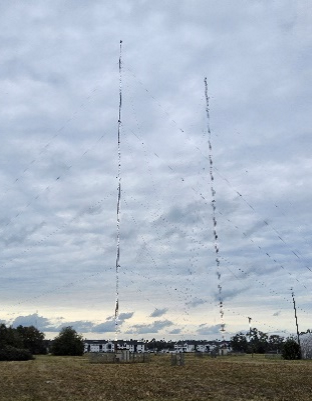 | 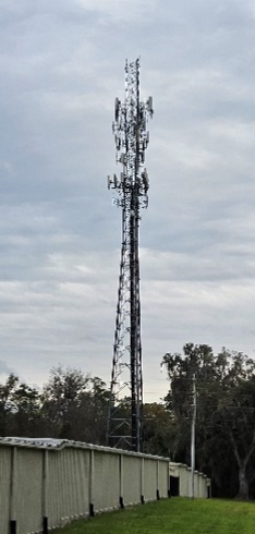 | 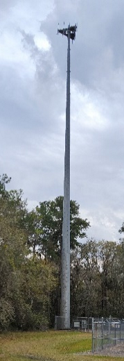 |  |
| Guyed Tower | Lattice Tower | Monopole Tower | Concealed Tower |
Tower base: The foundation, usually concrete, on which the tower and other support equipment are situated. For measurement calculations, the tower base is that point on the foundation reached by dropping a line perpendicular from the geometric center of the tower.
Tower height: The vertical distance measured from the grade line to the highest point of the tower, including any antenna, lighting, or other equipment affixed thereto.
Tower site: The land area that contains, or will contain, a proposed tower, support structures, collapse zone, and other related buildings and improvements.
Trailer: A conveyance drawn by other motive power and used for transporting a boat, animal, equipment or general goods.
Transfer of development rights: A device by which the development potential of a property is severed from its title and made available for transfer to another location.
Transferee: The owner of a property within a receiving area that purchases or otherwise acquires transferable development rights from another property.
Transferor: The owner of a property within a sending area that transfers rights to develop to another property.
Transit, public: The transporting of people by conveyances, or systems of conveyances, traveling on land or water, local or regional in nature, and available for use by the public. Public transit systems may be either governmentally owned or privately owned. Public transit specifically includes those forms of transportation commonly known as "paratransit."
Traveled way: The portion of the roadway for the movement of vehicles exclusive of shoulders and auxiliary lanes (travel lanes).
Tree, abundant species: Common species that are widely planted or are short lived, regardless of condition:
(a)
Laurel Oaks;
(b)
Water Oaks;
(c)
Loblolly pine;
(d)
Slash pine;
(e)
Pecan; and
(f)
Sweetgum.
Tree canopy: The area of the property that contains coverage by trees and consists of the total crown spreads or drip-lines of all trees existing on-site.
Tree, champion: Those trees that have been identified by the Florida Forest Service being the largest of their species within the State of Florida or by American Forests as the largest of their species in the United States.
Tree, heritage: All native tree species twenty (20) inches dbh or greater, except for water or laurel oaks, which are heritage trees when measured at thirty (30) inches or greater in diameter.
Tree, landmark live oak: live oaks 45-inches dbh or greater and rated four (4) or greater.
Tree Protection Zone (TPZ): The area surrounding a tree calculated as a radius of one (1) foot for every one (1) inch of dbh.
Tree root plate: The below-ground area adjacent to the trunk where major buttress roots and support roots occur. The area is calculated as a radius of four (4) times the diameter of the tree trunk. (e.g., a two-foot diameter trunk has a root plate radius of eight (8) feet).
Trees, specimen: Trees of notable interest or high value because of their age, size, species, condition, historic habitat association, and/or uniqueness. Specimen status applies to all trees defined in Table 406.16.4.
Unauthorized materials: Materials not normally associated with an approved mining or excavation and fill operation that pose a threat to water or natural resources located on or adjacent to the area where such operations are being conducted.
Unincorporated area: Any land in Alachua County not lying within the boundaries of a duly incorporated village, town, or municipality.
Urban cluster: An area designated on the future land use map for urban development, which includes residential densities ranging from one (1) unit per acre to twenty-four (24) units per acre or greater, non-residential development, and is generally served by urban services.
Use: The purpose for which land or water or a structure thereon is designed, arranged, or intended to be occupied or utilized or for which it is occupied or maintained. The use of land or water in the various zoning districts is governed by these land development regulations and the Comprehensive Plan.
Utilities, major: Facilities such as electric generation plants, high power transmission lines, major gas distribution lines, water purification plants and sewage treatment and disposal plants.
Utilities, minor: Facilities such as pumping and switching stations.
Utility runway: A runway that is constructed for and intended to be used only by propeller-driven aircraft of twelve thousand five hundred (12,500) pounds maximum gross weight and less.
Utility structure: A relay station, wastewater lift station with a flow capacity of two million (2,000,000) gallons per day (MGD) or greater, substation, and similar structures, transmitter tower, or transmission line designed to carry in excess of one hundred (100) kv of electricity. This term does not include the transmission or reception of television or radio signals in conjunction with the use of a residential dwelling.
Value-added good: A product derived from the processing of a raw agricultural product or products that changes its physical state or form so as to enhance its value, such as milling wheat into flour or turning berries into jam.
Variance: A modification of the zoning regulations when such will not be contrary to the public interest and when, due to conditions peculiar to the property and not the result of the actions of the applicant, a literal enforcement of the regulations would result in unnecessary and undue hardship. Establishment or expansion of a use otherwise prohibited shall not be allowed by variance nor shall a variance be granted because of the presence of nonconformities in zoning districts or classifications.
Variance: For the purposes of floodplain administration, a grant of relief from the requirements of this ordinance, or the flood-resistant construction requirements of the Florida Building Code, which permits construction in a manner that would not otherwise be permitted by this ordinance or the Florida Building Code.
Vehicle:
(1)
An automobile, motorcycle, truck, trailer, semitrailer, truck tractor and semitrailer combination, or any other vehicle operated on the roads of this state, used to transport persons or property, and propelled by power other than muscular power, but the term does not include traction engines, road rollers, motorized scooters, micro-mobility devices, personal delivery devices and mobile carriers as defined in F.S. § 316.003, special mobile equipment as defined in F.S. § 316.003, vehicles that run only upon a track, bicycles, swamp buggies, or mopeds.
(2)
Recreational Vehicle means, for all other purposes in the ULDC (excluding its use in Chapter 406, Article VII), a vehicle-type unit, mounted on wheels, including but not limited to a motor home, travel trailer, or tiny house on wheels, that is of such a size or weight as to not require special highway movement permit, and which is:
a.
Built on a single chassis or a trailer that is registered with the Florida Department of Motor Vehicles; and
b.
Four hundred (400) square feet or less when measured at the largest horizontal projection; and
c.
Which either has its own motive power or is mounted on or drawn by or towable by another vehicle, truck, bumper hitch, frame-towing hitch, or fifth-wheel connection; and
d.
Designed primarily not for use as a permanent dwelling but as temporary living quarters for recreational, camping, travel, or seasonal use or for transient occupancy.
Vehicle sales and service: The sale and storage or new and used motor vehicles, recreational vehicles, and boats.
Visual runway: A runway intended solely for the operation of aircraft using visual approach procedures with no straight-in instrument approach procedure and no instrument designation indication on an FAA approved airport layout plan, a military service's approved military airport layout plan, or by any planning document submitted to the FAA by competent authority.
Wastewater: The combination of liquid and water-carried pollutants from residences, commercial buildings, industrial plants, and institutions together with any ground water, surface runoff or leachate that may be present.
Wastewater treatment facilities: Any or all of the following: the collection/transmission system, the treatment plant, and the reuse or disposal system.
Water consumption: The total quantity of water utilized during a specified period of time by a mining or excavation operation, including that water required for mineral extraction, processing and chemical processing.
Water management district: Any flood control, resource management, or water management district operating under the authority of F.S. Ch. 373. Unless otherwise stated, water management district shall refer to either or both, the St. Johns River Water Management District or the Suwannee River Water Management District.
Water table: That surface in an unconfined water body at which the pressure is atmospheric. It is defined by the levels at which water stands in wells that penetrate the water body just far enough to hold standing water.
Watercourse: For the purposes of floodplain administration, a river, creek, stream, channel or other topographic feature in, on, through, or over which water flows at least periodically.
Waterfront: Any site shall be considered as waterfront property provided that any portion of such property physically abuts any body of water, including creeks, canals, rivers, lakes, or any other body of water, natural or artificial, but excluding swimming pools and drainage facilities which do not permit any type of sport or recreational pursuit.
Watershed: The land area which contributes to the flow of water into a receiving body of water.
Watershed resources: Natural functions or systems that affect stormwater discharge characteristics within a specific watershed.
Well: Any excavation that is drilled, cored, bored, washed, driven, dug, jetted, or otherwise constructed when the intended use of such excavation is to conduct groundwater from an aquifer or aquifer system to the surface by pumping or natural flow, to conduct waters or other liquids from the surface into any area beneath the surface of land or water by pumping or natural flow, or to monitor the characteristics of groundwater within an aquifer system(s). For the purposes of this Chapter, geotechnical borings greater than twenty (20) feet in depth shall be included in the definition of "well."
Well, private potable: A water system that provides piped water for one (1) or two (2) residences, one (1) of which may be a rental residence. This does not include wells used only for irrigation.
Well, public water supply: A system for the provision to the public of water for human consumption through pipes or other constructed conveyances if such system has at least fifteen (15) service connections or regularly serves at least twenty-five (25) individuals daily at least sixty (60) days out of the year. A public water system is either a community water system or a noncommunity water system. The term "public water system" includes:
(a)
Any collection, treatment, storage, and distribution facility or facilities under control of the operator of such system and used primarily in connection with such system.
(b)
Any collection or pretreatment storage facility or facilities not under control of the operator of such system but used primarily in connection with such system.
(1)
Community water system: A public water system which serves at least fifteen (15) service connections used by year-round residents or regularly serves at least twenty-five (25) year-round residents.
(2)
Nontransient noncommunity water system: A noncommunity water system that regularly serves at least twenty-five (25) of the same persons over six (6) months per year.
Well, non-community public: A public water system that is not a community water system. A noncommunity water system is either a non-transient noncommunity water system or a transient noncommunity water system.
Well, limited use: A public water system not covered or included in the Florida Safe Drinking Water Act, which serves one or more nonresidential establishments and provides piped water. A public water system not covered or included in the Florida Safe Drinking Water Act, which serves five (5) or more residences or two (2) or more rental residences, and provides piped water.
Wellfield protection areas: Identified areas surrounding public water supply wells which are potential critical aquifer recharge areas or surface and groundwater areas with significant risk of contamination of public water supply from overlying land uses within the area.
Wetlands: Those areas that are inundated or saturated by surface water or ground water at a frequency and a duration sufficient to support, and, under normal conditions do support, a prevalence of vegetation typically adapted for life in saturated soils. Soils present in wetlands generally are classified as hydric or alluvial, or possess characteristics that are associated with reducing soil conditions. The prevalent vegetation in wetlands generally consists of facultative or obligate hydrophytic macrophytes that are typically adapted to areas having soil conditions described above. These species, due to morphological, physiological, or reproductive adaptations, have the ability to grow, reproduce or persist in aquatic environments or anaerobic soil conditions. Florida wetlands generally include swamps, marshes, bayheads, bogs, cypress domes and strands, sloughs, wet prairies, riverine swamps and marshes, hydric seepage slopes, tidal marshes, mangrove swamps and other similar areas. Florida wetlands generally do not include longleaf or slash pine flatwoods with an understory dominated by saw palmetto.
Wholesaling, warehousing, storage, and distribution: A use engaged in storage, wholesale, and distribution of manufactured products, supplies, and equipment, but excluding bulk storage of flammable materials or hazardous wastes.
Wildfire: Any vegetative fire that threatens to destroy life, property, or natural resources.
Wildlife refuge: An undeveloped, officially designated area that preserves and provides natural habitat for native animal species.
Wireless communication device: Any handheld device used or capable of being used in a handheld manner, that is designed or intended to receive or transmit text or character-based messages, access or store data, or connect to the Internet or any communications service as defined in F.S. § 812.15 and that allows text communications.
Wireless services carrier: A company licensed by the Federal Communications Commission (FCC) that provides wireless services. A tower builder or owner is not a carrier unless licensed to provide personal wireless services.
Wood processing facility: A facility that processes, assembles and sells wood products or byproducts. Products produced from a wood processing facility may include products such as compost, wood chips, lumber, fuel, or soil amendment or any combination of such materials.
Xeriscape landscaping: Water conserving landscape design utilizing native or drought tolerant vegetation and water efficient irrigation systems.
Yard: An area on the same lot with a building, unoccupied and unobstructed from the ground upward, except by trees or shrubbery, landscape elements and uncovered steps, decks, balconies or porches.
Yard, front: The yard extending across the full width of the lot, extending from the front lot line to the front building line.
Yard, rear: The yard extending across the full width of the lot, extending between the rear lot line and the rear building line.
Yard, side: The yard extending between a side lot line and the side building line.
Zoning administrator: The term "Zoning Administrator" shall mean the Director of the Growth Management Department or their designee.
Zoning district: Any unincorporated area of Alachua County, Florida, as an area subject to zoning, and identified on the Zoning Map of Alachua County, Florida, assigned a zoning classification as indicated on said map, consisting of any one of the several zoning districts as set forth and established in these regulations. Reference to the word "district" shall mean zoning district.
(Ord. No. 05-10, § 2, 12-8-05; Ord. No. 06-12, § 2, 7-11-06; Ord. No. 06-14, § 2(Exh. A), 7-20-06; Ord. No. 07-01, § 10, 1-23-07; Ord. No. 07-07, § 2(Exh. A), 4-27-07; Ord. No. 08-06, § 2(Exh. A), 4-22-08; Ord. No. 08-24, § 2(Exh. A), 10-14-08; Ord. No. 09-01, § 2(Exh. A), 2-24-09; Ord. No. 09-05, § 2(Exh. A, 9-8-09; Ord. No. 10-13, § 2(Exh. A), 6-8-10; Ord. No. 12-09, § 2(Exh. A), 10-9-12; Ord. No. 13-13, § 2(Exh. A), 8-27-13; Ord. No. 13-14, § 2(Exh. A), 8-27-13; Ord. No. 2014-08, § 2(Exh. A), 5-13-14; Ord. No. 2014-17, § 2, 9-23-14; Ord. No. 15-06, § 2(Exh. A), 4-14-15; Ord. No. 2015-07, § 2(Exh. A), 6-9-15; Ord. No. 2016-10, § 2(Exh. A), 6-28-16; Ord. No. 2016-15, § 2(Exh. A), 8-9-16; Ord. No. 2016-16, § 3, 8-9-16; Ord. No. 2016-19, § 2(Exh. A), 10-11-16; Ord. No. 2017-08, § 2(Exh. A), 7-11-17;Ord. No. 2017-17, § 2(Exh. A), 10-10-17; Ord. No. 2018-23, § 2(Exh. A), 10-9-18; Ord. No. 2020-09, § 2(Exh. A), 3-10-20; Ord. No. 2020-25, § 2(Exh. A), 11-10-20; Ord. No. 2021-12, § 2(Exh. A), 9-28-21; Ord. No. 2021-13, § 2(Exh. A), 8-24-21; Ord. No. 2021-18, § 2(Exh. A), 12-14-21; Ord. No. 2023-09, § 2(Exh. A), 4-25-23; Ord. No. 2023-14, § 8, 9-24-23; Ord. No. 2023-16, § 2(Exh. A), 10-24-23; Ord. No. 2024-10, § 2(Exh. A), 5-14-24; Ord. No. 2024-07, § 2(Exh. A), 9-10-24; Ord. No. 2024-11, § 2(Exh. A), 5-28-24; Ord. No. 2024-15, § 2(Exh. A), 10-8-24; Ord. No. 2024-16, § 2(Exh. A), 11-12-24; Ord. No. 2025-04, § 2(Exh. A), 3-11-25; Ord. No. 2025-06, § 2(Exh. A), 3-25-25; Ord. No. 2025-11, § 2(Exh. B), 6-24-25; Ord. No. 2025-14, § 2(Exh. A), 8-12-25; Ord. No. 2025-19, § 2(Exh. A), 9-23-25; Ord. No. 2025-21, § 3(Exh. B), 12-9-25; Ord. No. 2025-22, § 2(Exh. A), 12-9-25)
Sec. 410.01. - Construction of words and phrases.
(a)
Terms not defined in this Chapter shall be construed in accordance their customary usage and meaning.
(b)
The following general rules of construction shall govern the interpretation of words and phrases used in this ULDC.
(1)
May. The term "may" is permissive.
(2)
Shall and will. The terms "shall," "will" and "must" are mandatory.
(3)
Singular and plural. The singular word or number includes the plural, and the plural word or number includes the singular.
(4)
Tenses. The present tense includes the future tenses.
(Ord. No. 05-10, § 2, 12-8-05; Ord. No. 2020-25, § 2(Exh. A), 11-10-20)