
Alachua County Unincorporated
City Zoning Code
City Zoning Code
CHAPTER 405
SPECIAL DISTRICTS AND ACTIVITY CENTERS
ARTICLE III. - RESERVED[5]
Editor's note— Ord. No. 12-09, § 2, adopted Oct. 9, 2012, repealed former Art. III of Chapter 405, §§ 405.08—405.13 in its entirety. Former Art. III pertained to the Springhills design guidelines overlay district and derived from Ord. No. 05-10, § 2, adopted Dec. 8, 2005.
ARTICLE VII. - AIRPORT ZONING REGULATIONS[6]
Editor's note— Ord. No. 2017-08, § 2(Exh. A), adopted July 11, 2017, amended former Art. VII, §§ 405.24—405.32, in its entirety to read as herein set out. Former Art. VII pertained to similar subject matter and derived from Ord. No. 05-10, § 2, 12-8-05; Ord. No. 07-15, § 3, 9-11-07.
Sec. 405.01. - General.
(a)
Intent.
(1)
Activity centers. The intent of the urban activity centers is to provide for the concentration of mixtures of higher intensity and density land uses through designation of activity centers, with standards to ensure pedestrian-friendly compact centers connected to multi-modal transportation systems and integrated with surrounding uses in the urban area.
(2)
Special area studies. The intent of the special area studies is to provide specific policies, standards, and guidelines that address significant cultural, historic, and environmental resources and characteristics of unique areas and communities within Alachua County.
(b)
Establishment of activity center plan and special area study overlay districts. The following activity center and special area study overlay districts have been established in the Comprehensive Plan to implement policies in the Future Land Use Element:
(Ord. No. 05-10, § 2, 12-8-05; Ord. No. 12-09, § 2(Exh. A), 10-9-12; Ord. No. 2020-25, § 2(Exh. A), 11-10-20)
Sec. 405.02. - General.
(a)
This Article shall apply to all new development and redevelopment within activity centers as designated on the Future Land Use Map.
(b)
The intent of this Section is to implement the activity center policies of the Comprehensive Plan by providing standards to ensure pedestrian-friendly compact activity centers that are connected to a multi-modal transportation system and integrated with surrounding land uses.
(Ord. No. 05-10, § 2, 12-8-05; Ord. No. 12-09, § 2(Exh. A), 10-9-12; Ord. No. 2020-25, § 2(Exh. A), 11-10-20)
Sec. 405.03. - New and expanded activity centers.
New activity centers may be established, or existing centers' boundaries expanded, through the Comprehensive Plan amendment process as described in Article VII of Chapter 402 of this ULDC.
(a)
All new activity centers shall have a level designation.
(1)
High intensity activity centers are intended for commercial, employment, institutional, light industrial, and visitor-related uses of a scale and type that typically serve a regional or larger market. High activity centers shall also contain higher density residential uses which are phased and interconnected with the non-residential uses in the activity center. High intensity activity centers attract commercial customers or employees from within Alachua County and surrounding cities or counties; are generally greater than two hundred (200) total acres in area; are located proximate to major interstate transportation corridors; have access to at least two (2) arterial roadways; and are near existing or planned rapid transit corridors.
(2)
Low intensity activity centers are intended for commercial, employment, institutional, and light industrial uses of a scale and type that typically serve a community or group of neighborhoods. Low activity centers shall also contain residential uses which are phased and interconnected with the non-residential uses in the activity center. Low intensity activity centers attract commercial customers or employees primarily from within Alachua County; are generally less than two hundred (200) total acres in area; have access to at least one (1) arterial and one (1) collector roadway, and are near existing or planned bus, express transit, or rapid transit routes.
(Ord. No. 05-10, § 2, 12-8-05; Ord. No. 12-09, § 2(Exh. A), 10-9-12; Ord. No. 2020-25, § 2(Exh. A), 11-10-20)
Sec. 405.04. - Permitted uses and development requirements for activity centers.
(a)
Those uses permitted by the Comprehensive Plan, the Future Land Use Map designation, and the underlying zoning district, consistent with this Article.
(b)
All developments within activity centers have the option of providing a mix of uses. Mixed-use development within activity centers shall develop consistent with the TND standards in Chapter 407, Article VII, notwithstanding the acreage requirements of Subsection 407.64(c)(1).
(c)
Any new development on twenty-five (25) or more acres or including one hundred fifty (150) or more residential units shall be required to develop as either a TND or TOD consistent with the standards in Chapter 407, Article VII.
(d)
Any new development proposing one thousand (1,000) or more new dwelling units or three hundred fifty thousand (350,000) square feet or more of non-residential uses and located on a planned rapid transit corridor shall be required to develop as a TOD consistent with the standards in Chapter 407, Article VII.
(e)
A planned development approved by the BOCC prior to October 9, 2012 that has not expired shall be allowed to develop consistent with their existing zoning master plan. The zoning master plan may be amended notwithstanding the requirements in Subsections (c) and (d) above, provided the following is met:
(1)
The amendment to the zoning master plan does not change the types of non-residential use and/or increase or decrease the total square footage of non-residential use or number of residential units; or
(2)
For amendments that change the type of non-residential use and/or include an increase or decrease of up to twenty-five (25) percent of the total square footage of non-residential use or number of residential units, the planned development shall develop consistent with the design standards for TND in Chapter 407, Article VII, Sections 407.68, 407.69, 407.70, and 407.71.
(Ord. No. 05-10, § 2, 12-8-05; Ord. No. 12-09, § 2(Exh. A), 10-9-12; Ord. No. 2020-25, § 2(Exh. A), 11-10-20)
Sec. 405.05. - General design standards for activity centers.
The following standards shall serve as a framework for development plan applications and redevelopment within activity centers.
(a)
Compact center. Activity centers shall contain vital, walkable centers with diverse residential, retail, office, and civic uses organized in close proximity, and interconnected through a network of streets, sidewalks, and paths.
(b)
Definable edges. Buildings and pedestrian amenities shall give definition to the streetscape, individual blocks, and the perimeter of the site.
(c)
Parking. Parking shall be designed in the center of blocks to the greatest extent possible.
(d)
Interconnected street network. A diverse network of streets will provide multiple routes of access that are interconnected with the existing street network. The interconnected network shall also establish a framework for the development of compact, identifiable blocks.
(e)
Walkable, human-scaled streets. Effective street design is integral to the identity and success of an activity center. Narrow road widths are encouraged in order to reduce travel speeds and, in conjunction with adjacent streetscape, produce a quality of spatial enclosure.
(f)
Mix of uses. Mixed-use development is encouraged in order to provide a wide range of services and opportunities within walking distance of residential areas.
(Ord. No. 05-10, § 2, 12-8-05; Ord. No. 12-09, § 2(Exh. A), 10-9-12; Ord. No. 2020-25, § 2(Exh. A), 11-10-20)
Sec. 405.06. - Reserved.
Editor's note— Ord. No. 12-09, § 2(Exh. A), adopted Oct. 9, 2012, repealed former § 405.06 in its entirety which pertained to permitted uses in activity centers and derived from Ord. No. 05-10, § 2, adopted Dec. 8, 2005.
Sec. 405.07. - Design standards for developments other than TNDs or TODs in activity centers.
(a)
Blocks and streets. All blocks and streets shall meet the requirements of Article XIII, Access Management and Street Network Standards, of Chapter 407, the Alachua County Corridor Design Guidelines, and the following regulations:
(1)
The street and roadway network within an activity center shall be designed to conform to existing natural features and shall provide for logical and orderly mobility throughout the activity center.
(2)
Provisions shall be made for the reservation or dedication of all rights-of-way needed for the improvement of existing streets or the construction of new streets within or surrounding the activity center.
(3)
New development and redevelopment within activity centers shall allow for new streets that connect existing public roadways, or that are designed to facilitate future roadway connections.
(4)
New development and redevelopment shall provide multimodal cross access to adjacent existing or future development. Cross access facilities shall be covered with appropriate cross access easement.
(5)
The arrangement, character, and location of all blocks and streets shall be designed to create a cohesive internal street network that connects individual parcels within the activity center.
(6)
The layout and types of streets, sidewalks, shared-use paths, and bicycle lanes on individual sites shall provide for the continuation or appropriate projection into adjacent areas unless topography, traffic volume, or other conditions make continuance impractical.
(7)
Private streets and roadways within an activity center shall remain privately owned and maintained and shall not be accepted by the County for maintenance unless the streets are designed and inspected to all applicable public road standards. Public access easements shall be provided on all streets, roadways and alleys, and pedestrian pathways. Alleys shall be constructed to a structural standard and geometric configuration that will accommodate service delivery vehicles.
(8)
In order to provide for pedestrian oriented design along existing corridors, streets that are proposed parallel to existing roadways, without intervening buildings, shall be restricted to a cross section width of forty-eight (48) feet from curb face to curb face. In no such case shall angled parking be provided on both sides of a new two-way street.
(b)
Stormwater facilities.
(1)
The design and construction of stormwater facilities shall be in accordance with Article IX, Stormwater Management, of Chapter 407 and other applicable regulations, ordinances, resolutions, and rules. The stormwater management system shall also be consistent with applicable activity center Master Plans, special area studies and the standards herein.
(2)
A stormwater plan will be required as part of an activity center master plan. The stormwater plan shall provide data on the stormwater retention needs for the entire master plan area (minimum of one (1) quadrant within the activity center) at build out conditions, and provide a mechanism for shared stormwater facilities, where feasible.
(3)
Surface stormwater facilities shall be designed to provide a physical or visual amenity within an activity center or as an aesthetic feature to resemble natural areas with native landscaping, consistent with Article IV, Landscaping, and Article IX, Stormwater Management, of Chapter 407 of this ULDC.
(4)
The use of shared stormwater facilities to accommodate multiple developments within the activity center is encouraged.
(c)
Parking.
(1)
A parking plan shall be prepared for the entire master plan area at build out conditions and shall include the locations for parking facilities and the types of parking facilities (e.g., surface, structure, or on-street).
(2)
Buildings and land uses within activity centers may utilize shared parking areas to serve complementary uses and activities. Provisions for shared parking may be addressed through the development of an activity center master plan. Where a master plan has not been adopted or is not required, development plan applications that will include shared parking facilities shall be in accordance with Section 407.17 of this ULDC.
(3)
Reductions in the required number of paved parking spaces may be permitted in accordance with Section 407.18 of this ULDC, or through the master plan process.
(4)
Parking design standards. Off-street parking and loading areas shall be provided in accordance with Article II, Parking, Loading and Stacking, of Chapter 407 of this ULDC. In addition, the following shall apply:
a.
Surface parking shall be located to the rear or sides of building sites, unless otherwise specified in an adopted master plan.
b.
All surface-parking areas shall be located in the interior of blocks.
c.
Parking structures on sites that abut a public street shall have at least 50 percent of the ground floor street frontage developed for office, commercial, or civic uses.
(d)
Transit facilities. Transit facilities include bus stops (school, public, or private), pull-out lanes, benches, transit-related signage, shelters, and bicycle racks for transit users.
(1)
Any development plan with required parking of more than two hundred (200) spaces shall be required to provide on-site transit facilities if such facilities are not located within one-quarter (0.25) mile of the development site, unless otherwise specified in an adopted master plan.
(2)
Where transit facilities are required, transit easements shall be provided on the development plan.
(3)
Transit facilities shall be located so as to minimize conflict with vehicular, bicycle, or pedestrian traffic.
(4)
Transit facilities should be oriented to the entrance of the primary or anchor building on sites within the activity center and/or to the central core of the activity center. The placement of transit facilities should not be limited only to the edges of the activity center.
(5)
Signage shall clearly indicate the location of transit stops.
(6)
In order to be consistent with County-wide public transportation, the size, design, and location of transit facilities shall be determined in coordination with the Gainesville Regional Transit System and the Alachua County Transportation Planning Staff.
(e)
Pedestrian circulation and amenities. Activity center roadways shall be designed to accommodate pedestrians in a safe, comfortable, and convenient manner, as follows:
(1)
Commercial retail, office, civic, and multiple-family buildings shall provide pedestrian walkways that connect all buildings at their primary entrances.
(2)
Pedestrian walkways connecting buildings within an activity center shall minimize crossing of vehicular areas.
(3)
Pedestrian walkways, not less than six (6) feet in width, shall be provided where a lot abuts a public right-of-way.
(4)
At least one (1) continuous pedestrian walkway must be provided from any public right-of-way to the primary entrance of all commercial retail, office, and multiple-family buildings. Pedestrian connections shall also be provided between adjacent parcels and uses, with exceptions for instances where:
a.
The adjacent use is an individual single-family lot;
b.
There are topographic or other physical limitations preventing a connection; or
c.
A connection would not be consistent with the protection of natural or historic resources.
(5)
All pedestrian crosswalks shall be distinguished from all parking and vehicle maneuvering areas through the use of contrasting surface materials such as pavers, brick or scored concrete, striping using high durability paints, or other techniques approved by the DRC or provided in a master plan.
(f)
Bicycle circulation and amenities.
(1)
Bicycle lanes shall be provided on primary public roads within an activity center. These bicycle lanes shall provide continuous connection between existing bicycle lanes on surrounding public streets and any commercial, office, multiple-family residential, or civic uses within activity center sites.
(2)
Where bicycle lanes are required, they shall be at least five (5) feet in width.
(3)
Bicycle parking shall be provided at all structures within activity centers, and the parking requirements shall apply to all land uses except single-family detached residential uses, in accordance with Section 407.15.
(g)
Open Space.
(1)
Open Space shall be provided on an activity center site in accordance with Article V, Open Space, of this ULDC. The required Open Space may be provided on a site-by-site basis through the development review process, or on an overall activity center basis through the use of the activity center master planning process.
(2)
Land designated for Open Space shall be accessible from all areas of the activity center.
(h)
Civic space.
(1)
A minimum of five hundred (500) square feet of civic space per acre of land must be provided within an activity center. This requirement may be met through the provision of one or more centrally located spaces within the activity center using the master plan process, or on an individual development basis through the development plan review process.
(2)
Where civic space is required, it may be in the form of police stations, libraries, day cares, fire stations, meeting halls, governmental buildings, museums, schools, performing arts centers, religious buildings, community centers, amphitheaters, public squares, parks, landscaped plazas, courtyards, or similar elements approved by the DRC or BOCC.
(3)
Civic space shall provide linkages between buildings and land uses within the activity center.
(4)
Civic uses should be located on prominent sites throughout the activity center and serve as focal points and landmarks for the community.
(Ord. No. 05-10, § 2, 12-8-05; Ord. No. 09-01, § 2(Exh. A), 2-24-09; Ord. No. 12-09, § 2(Exh. A), 10-9-12; Ord. No. 2020-09, § 2(Exh. A), 3-10-20; Ord. No. 2020-25, § 2(Exh. A), 11-10-20; Ord. No. 2022-01, § 2(Exh. A), 1-11-22)
Sec. 405.14. - Cross Creek.
(a)
Purpose. The purpose of the Cross Creek Village Special Area Study is to establish general policies and development guidelines for future development in this study area so that future land development is designed to place the environmental integrity of this area in the forefront of all development proposals. These development regulations have the purpose of guiding and accomplishing the coordinated, adjusted, and harmonious development called for in the Cross Creek Special Area Study. These regulations shall apply to all real property lying within the boundaries of the Cross Creek Special Area Study as defined by the map found in Section 8.2 of the Comprehensive Plan and attached to this ULDC.
(b)
Preexisting conditions. It is specifically the policy of this Article that existing land uses, buildings, and structures not be required to be removed or otherwise modified as a result of the standards or requirements set forth in this Section. The destruction or discontinuation of any such use, building, or structure shall not prohibit the renewed use or reconstruction of the building or structure in its preexisting form. This policy shall not, however, affect the operation of other Sections of the adopted Comprehensive Plan or of duly adopted development regulations. The burden shall be on the property owner to demonstrate that existing land uses, buildings, and structures qualify as preexisting conditions.
(c)
Valid existing rights. The special area study and these development regulations shall not apply to deny valid existing rights of landowners to continue the current use of land in the study area. If the provisions of the Cross Creek plan and these development regulations restrict valid existing rights of landowners, such landowners may be eligible to preserve valid existing rights through the general vested rights provisions contained in Article XXVII of Chapter 402 of this ULDC.
(d)
Cross Creek special area study zones. The Cross Creek Special Area Study has been divided into six (6) resource protection zones: Wetlands, exceptional upland habitat, hammocks, active use, lake buffer, historic preservation area, and specific guidelines for bald eagle nesting areas. In addition, the Cross Creek Special Area Study has established two (2) development areas: the village center and village periphery.
(e)
Transfer of density.
(1)
Residential densities and transfer of density.
a.
Except for the village center area, a maximum residential density of one (1) dwelling unit per five (5) acres shall be permitted in the study area.
b.
A property owner may transfer permitted density in a resource protection area to appropriate contiguous property under the same ownership through the development plan review process. The densities that may be transferred are established in Table 405.14.1.
c.
A property owner may transfer permitted density in a resource protection area to appropriate adjoining property not under the same ownership if all of the affected properties are presented for development as a planned development (PD). The densities that may be transferred are established in Table 405.14.1.
d.
In the village periphery area, a maximum density of one (1) dwelling unit per acre shall be permitted where the development involves a transfer of permitted density from a resource protection area.
(2)
Transfer of density from the Cross Creek area. Transfer of density from property in the Cross Creek Special Area Study to appropriate noncontiguous property not under the same ownership in the unincorporated area of the County shall be subject to development agreement approved by the BOCC, in accordance with the Florida Local Government Development Agreement Act, F.S. § 163.3220, et seq', and the County's implementing ordinance.
(f)
Site clearing and tree removal.
(1)
Development plan approval required.
a.
In the Cross Creek Study Area, except as specifically provided herein, all site clearing, tree removal, and removal of the existing indigenous vegetation, including clearing and removal for forestry and agricultural purposes in areas identified as wetlands, exceptional upland habitat, hammocks, lake buffer zones, historic preservation areas, and bald eagle nesting zones, shall be prohibited without development plan approval as provided in Article X, Development Plan Review, of Chapter 402. Any violations to regulated natural resources shall require corrective action as provided in Chapter 406, Section 406.115.
b.
All applications for development plan approval shall specify the location and extent of the site proposed for clearing, tree removal, and removal of indigenous vegetation, and the reasons for the proposed site clearing, tree, and vegetation removal.
c.
In all cases involving site clearing and tree and vegetation removal, the burden shall be on the applicant to demonstrate that the clearing or removal is for bona fide agricultural purposes or associated with an approved development plan or building permit.
(2)
Exemptions from requirement for development plan approval.
a.
For purposes of this Section, normal tree farming activity or clear cutting and replanting in the active use zone, where the owner has signed an agreement with the Florida Division of Forestry to utilize best management practices and to reforest the parcel for the purpose of silviculture, shall not require development plan approval.
b.
In addition, site clearing for valid agricultural purposes in the active use zone, not exceeding one-half (½) acre per calendar year and not involving removal of trees with a diameter at breast height (DBH) equal to or exceeding two (2) inches, shall not require development plan approval.
(Ord. No. 05-10, § 2, 12-8-05; Ord. No. 12-09, § 2(Exh. A), 10-9-12; Ord. No. 2020-25, § 2(Exh. A), 11-10-20)
Sec. 405.15. - Resource protection regulations.
(a)
Delineation of zones in Cross Creek Special Area Study. Each zone within the Cross Creek Special Area Study requires special protective regulations dictated by its unique characteristics, as follows:
(1)
Wetlands zone. This zone includes a variety of shore zone and interior wetland areas that are distributed throughout the study area and comprise approximately twenty-four (24) percent of the total land area. Because of the important functions performed by wetlands, including, but not limited to functions related to water quality and drainage, they should be left undisturbed. The following regulations shall apply in this zone.
a.
A gross density of one (1) dwelling unit per five (5) acres shall apply to all land in the wetland zone.
b.
The permitted density shall be transferred to appropriate contiguous property under the same ownership, or as set forth in Section 405.14(e).
c.
Minor accessory uses such as boat docks shall be permitted by special use permit provided that the natural function of the zone is not altered.
(2)
Exceptional upland habitats zone.
a.
Exceptional upland habitats zone shall mean that part of the study area which supports essentially complete natural associations of plants and animals native to uplands in the area (natural upland communities).
b.
This zone is characterized by large areas of relatively undisturbed associations of native vegetation generically called hammocks or pine flatwoods.
c.
This zone serves important habitat functions for a variety of animals in the study area. The following regulations shall apply:
1.
Residential densities for this zone are permitted at a rate of one (1) dwelling unit per five (5) acres. Where development of these areas occurs, building impact areas shall be reduced to no more than one (1) acre and major portions of the area thereby protected in their natural state.
2.
Residential density may be transferred to appropriate contiguous property under the same ownership at a rate of two (2) dwelling units per five (5) acres, or as set forth in Subsection 405.14(e).
(3)
Hammock zone. Hammock zone shall mean that part of the study area which retains a predominance of the natural hardwood hammock vegetation that is characteristic of the uplands of the Cross Creek area. The hammock zone represents that portion of the study area that retains a predominance of the hammock vegetation but does not meet other criteria for classification as an exceptional upland habitat zone. The following regulations shall apply within this zone.
a.
In the village center area, a maximum residential density of one (1) dwelling unit per two (2) acres shall be permitted on a gross basis.
1.
However, in order to preserve the character of the zone, building impact area of all future residential development shall occur on a maximum of one-half (½) acre.
2.
Development shall be clustered in such a fashion as to preserve the most sensitive or unique areas of the property under consideration.
b.
In the village periphery area, a maximum residential density of one (1) dwelling unit per five (5) acres shall be permitted on a gross basis.
1.
However, in order to preserve the character of the zone, building impact areas shall be a maximum of one (1) acre.
2.
Development shall be clustered in such a fashion as to preserve the most sensitive or unique areas of the property under consideration.
(4)
Active use zone. This zone represents that portion of the study area that has been most significantly altered from its natural state and includes all areas in the study not classified as wetlands, exceptional upland habitats, and hammocks. The following regulations shall apply within this zone.
a.
In the village center area, a maximum residential density of two (2) dwelling units per acre shall be permitted. All residential development shall occur on a minimum of one-half (½) acre lot per unit.
b.
In the village periphery area, a maximum residential density of one (1) dwelling unit per five (5) acres shall be permitted.
(b)
Water quality. Orange Lake, Lochloosa Lake, and Cross Creek have been designated as Outstanding Florida Waters. The County recognizes the sensitivity of these waters to pollution. The following regulations shall apply:
(1)
Activity within lakeshore buffer area.
a.
No filling, tree removal, clearing, or building construction shall be permitted within seventy-five (75) feet of the creek or within the lakeshore buffer area without development plan approval.
b.
Development plan approval shall require minimum standards for development consistent with State regulations regarding Outstanding Florida Waters.
(2)
Lake buffer zone. The lake shore buffer varies in width depending on the characteristics, including slope, soil, vegetation, etc., of the land along the shoreline. The following regulations shall apply within this zone.
a.
The width of the buffer shall be determined on a case-by-case basis; however, the average width of the buffer shall be one hundred fifty (150) feet, with a minimum width not less than one hundred (100) feet. The BOCC shall consider four (4) factors to determine buffer width. These four (4) factors are:
1.
Wildlife habitat requirements;
2.
Soil erodibility;
3.
Depth to water table; and
4.
Other site specific considerations such as aesthetics and water quality.
b.
A jurisdictional line separating sovereign lands of the State and private property shall be determined. In addition to the determination of sovereign lands of the state, the jurisdictional line for demarcation of the landward extent of waters of the state shall also be determined and the lake buffer area shall be measured landward from this jurisdictional line.
c.
Within this area, principal buildings shall not be constructed.
1.
Accessory structures that are necessarily constructed only adjacent to a lake, such as boardwalks or docks, may be permitted subject to development plan review.
2.
Disturbance of natural vegetation shall be prohibited, except as may be necessary to construct approved facilities, and only subject to development plan approval.
(c)
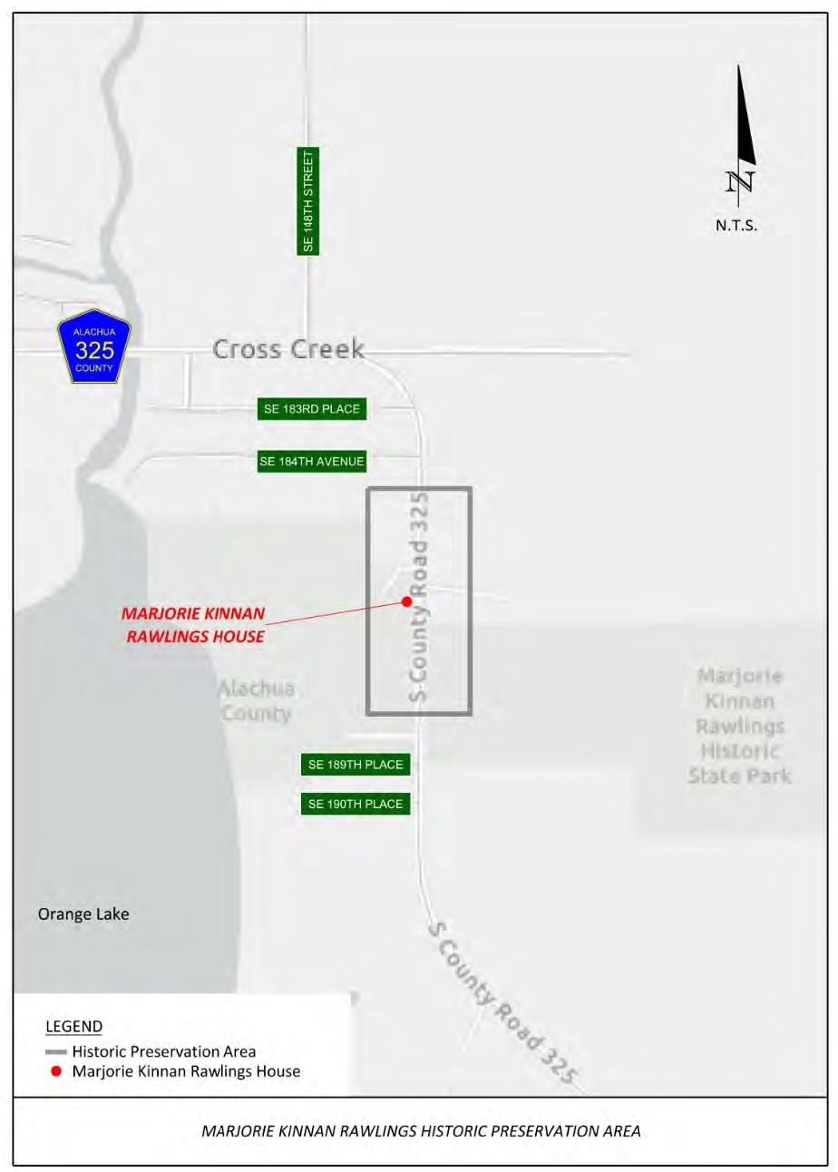
Historic preservation area. The house of Marjorie Kinnan Rawlings is listed as a national historic site. In order to preserve the area surrounding this site, a historic area is established and shall include all land one-eighth (⅛) mile north and south of the Rawlings House property and within three hundred (300) feet of the centerline of County Road 325. A map of the historic area is attached hereto as Exhibit 405.15.2. The following regulations shall apply in this historic area.
(1)
Construction, reconstruction, and similar improvements. No new construction, exterior reconstruction, exterior remodeling, or exterior repair shall be permitted within the historic preservation area until a plan for such work has been reviewed and approved by the BOCC.
(2)
Review criteria.
a.
The BOCC should consider materials, signage, and landscaping, and the compatibility of these factors with the architectural and cultural heritage of the historic site, as well as that of the historic district in general.
b.
The review should also consider the practical effect of any regulation and the potential for such a regulation to create a hardship for the individual seeking approval of an activity within the historic area.
c.
Demolition of an historic building or a building or facility that is integrally related to an historic building shall not be permitted until after the property is offered for sale at assessed value or fair market value to a governmental unit or to an organization committed to the preservation and restoration of the building. Any such offer should permit a minimum of one hundred eighty (180) days for acceptance by the governmental unit or other organization.
d.
These policies will not affect the use of land, but may affect the arrangement of uses, the arrangement of vehicular and pedestrian circulation, landscaping, screening, and buffering, as well as the height, style, and character of buildings and other structures, including signs.
e.
These policies shall not be applicable to mobile homes and shall not be interpreted as affecting the replacement of a mobile home that exists on the date of adoption of this Section.
(d)
Bald eagle nesting zones. The purpose of these regulations is to maintain and/or improve environmental conditions existing in the study area and required for the survival and well-being of bald eagles in the study area. The purpose of these regulations also is to avoid or minimize detrimental human-related impacts on bald eagles, particularly during the nesting season, and to preserve and enhance the present population. The following regulations are designed to establish protection for eagles, eagle nests, and eagle habitat.
(1)
Intent. The regulations are designed to establish protection for eagles, eagle nests, and eagle habitat. Some flexibility may be available in the implementation of these regulations, under the federal guidelines, and may be considered by the BOCC on a case-by-case basis.
(2)
Deviation from standards. Any deviation from the standards contained in this Section should only be considered where the property is proposed for development under the planned development zoning category and only after consultation with the Florida Fish and Wildlife Conservation Commission.
(3)
Extent of bald eagle nesting zone. Except under unusual circumstances, the nesting zone should encompass an area extending approximately six hundred sixty (660) feet outward from the nest tree.
a.
The precise radius distance will be dependent upon the proximal and spatial configuration of the critical elements, including but not limited to nest trees, feeding area, roost trees, etc., within a particular nesting area or other compelling factors.
b.
The exact radius distance, area, and contours of the nesting zone shall be determined prior to development approval or a transfer of density.
(4)
Bald eagle nesting zone restrictions.
a.
Excluding existing bona fide agricultural use of land in the nesting zone, the following land uses shall be prohibited in the nesting zone without a special use permit issued by the BOCC consistent with Article VIII, Special Use Permits, of Chapter 402:
1.
Logging;
2.
Land clearing;
3.
Construction;
4.
Seismographic activities employing explosives;
5.
Mining;
6.
Well drilling;
7.
Residential subdivisions, commercial, or industrial development;
8.
Tree cutting;
9.
Use of chemicals toxic to wildlife such as herbicides and pesticides; and
10.
Helicopter or fixed-wing aircraft operation within five hundred (500) feet vertical distance or one thousand (1,000) feet horizontal distance from an eagle's nest.
b.
The special use permit may further limit specific activities as necessary and appropriate to protect the function and value of bald eagle nesting zones, including but not limited to additional restrictions during the eagles' nesting period, usually from October 1 to May 15.
c.
An individual single-family residence on a lot of record, including associated well, septic system, land clearing, and tree removal shall be exempt from the special use permit requirement provided in paragraph a above. Alternatively, such development shall be required to obtain development plan approval from the DRC prior to application for a building permit. Mailed and posted notice shall be provided in accordance with Article IV, Notice of Hearings, of Chapter 402.
Exhibit 405.15.2
(Ord. No. 05-10, § 2, 12-8-05; Ord. No. 12-09, § 2(Exh. A), 10-9-12; Ord. No. 2020-25, § 2(Exh. A), 11-10-20)
Sec. 405.16. - Alternative compliance.
Except as otherwise provided in this Article, requests for alternative compliance from any provision of this Article may be made as follows:
(a)
An applicant may submit a proposal that varies from the strict application of the requirements of the provisions of this Article in order to accommodate unique site features or characteristics, utilize innovative design, prevent extraordinary hardship, promote the overriding public interest or general public welfare, or because the provisions of this Article do not apply or are unnecessary. Diminished value or inconvenience is not considered extraordinary hardship.
(b)
The applicant shall have the burden of demonstrating the existence of the necessary conditions or reasons for alternative compliance. In any case where alternative compliance is granted, the alternative compliance shall be the minimum necessary to permit reasonable use or access. Mitigation measures may be required as a condition of granting the alternative compliance.
(c)
Requests for alternative compliance shall be submitted as part of an application for development plan approval and shall be received and approved, approved with conditions, or denied by the DRC or BOCC.
(d)
An alternative compliance plan shall be approved only upon a finding that it fulfills the purpose and intent of this Article as well as, or more effectively than, would adherence to the strict requirements.
(Ord. No. 05-10, § 2, 12-8-05; Ord. No. 2020-25, § 2(Exh. A), 11-10-20)
Sec. 405.17. - Intent.
It is the intent of these regulations to establish development regulations in the Idylwild/Serenola area so that future land development adequately addresses environmental, archaeological, and historical issues as a part of the development process. These regulations shall apply to all real property lying within the boundaries of the Idylwild/Serenola special area as defined in the Future Land Use Element of the Alachua County Comprehensive Plan, and attached hereto as Exhibit B.
(Ord. No. 05-10, § 2, 12-8-05; Ord. No. 06-14, § 2(Exh. A), 7-20-06; Ord. No. 2020-25, § 2(Exh. A), 11-10-20)
Sec. 405.18. - Barriers for environmental resources protection.
Where these regulations require the protection of an environmental resource, the following standards shall be used:
(a)
Construction of barriers. Barriers shall be constructed of nominal two-inch by four-inch or larger wooden posts, two (2) inches or larger diameter pipe, or other post material of equivalent size and strength and shall be implanted deep enough in the ground to be stable, with at least three (3) feet of the post visible above the ground.
(b)
Tree protection barriers. Barrier posts shall be placed at the drip line of any tree to be protected or an area based on a ratio of two (2) feet for each inch of tree diameter measured at breast height (DBH).
(c)
Posts and fencing. All protective posts shall be linked together by lumber fencing at a height of three (3) feet. Each section shall be clearly flagged with flagging tape or other readily visible markers. The substitution of 36-inch-wide reusable polyethylene barrier fencing for the lumber fencing is acceptable.
(d)
Installation of barriers. Required barriers shall be erected prior to the construction of any structure, utility service, or other improvement and shall remain in place until such time as completion of construction dictates that removal will not harm the resource.
(e)
Waiver of barrier requirement. The DRC may grant a waiver to the barrier requirement provided that reasonable alternatives are taken.
(Ord. No. 05-10, § 2, 12-8-05; Ord. No. 2020-25, § 2(Exh. A), 11-10-20)
Sec. 405.19. - Environmental resources.
The Idylwild/Serenola area contains numerous environmentally sensitive areas. These areas have been generally identified on the Environmental Resources Map in the Future Land Use Element. Each area requires special protective regulations as indicated in the study. Where site specific analysis or verification is required to determine the presence of environmental resources protected herein, the cost of such analysis or verification shall be borne by the applicant. Environmentally sensitive areas may overlap, and all applicable regulations shall apply.
(a)
Significant uplands habitat. These provisions shall apply to the development of all lands identified as significant uplands after determination of designation in accordance with the Conservation policies of the Alachua County Comprehensive Plan.
(1)
Upland habitat. Uplands habitat shall be indicated on all development plans and subdivisions.
(2)
Maximum lot coverage for nonresidential development. Each nonresidential development shall be designed so that the total mass of all buildings, parking, and loading areas shall not occupy in excess of fifty (50) percent of the total site area. The remainder of each development site shall retain the existing undisturbed vegetation.
(3)
Residential development requirements. Each residential development shall use planned development zoning or cluster development that retains fifty (50) percent of the area as common Open Space. The common Open Space shall retain the existing undisturbed vegetation. The selection of the common Open Space shall be based upon:
a.
Retention of sinkholes, surface waters, and wetlands; and
b.
Proximity to other upland habitats.
(4)
Protection of undisturbed vegetation. The undisturbed vegetation shall be protected during construction by barriers.
(5)
Violations. Violations of significant uplands habitat regulations shall require corrective action as provided in Chapter 406, Section 406.115 of this ULDC.
(b)
Wetlands. Connected and isolated wetlands shall be protected in accordance with the provisions of Chapter 406 of this ULDC.
(c)
Bald eagle nesting zones. These provisions shall apply to any property located within a bald eagle nesting zone in order to maintain and improve the environmental conditions required for the survival of bald eagles. These regulations shall apply to apparently "abandoned" nests for a period extending through five (5) consecutive breeding seasons of non-use after notification to the United States Fish and Wildlife Service, the Florida Fish and Wildlife Conservation Commission and the Alachua County Environmental Protection Department.
(1)
Development plans. All development plans and subdivisions shall show the location of the property in relation to the eagle nesting zone during the eagle's nesting period, usually from October 1 to May 15.
(2)
Development standards.
a.
There shall be no development activity within the nesting zone.
b.
Land use within the nesting zone shall be limited to passive recreation, farming, grazing, nurseries, or gardening.
1.
The use of property for any other activity shall require a special use permit.
2.
The burden shall be on the applicant to demonstrate that the proposed use will not weaken the integrity of the nesting zone.
3.
The special use permit may further limit specific activities as necessary and appropriate to protect the function and value of bald eagle nesting zones, including but not limited to additional restrictions during the eagle's nesting period, usually from October 1 to May 15.
4.
Development within the nesting zone shall cluster units away and shall not include buildings in excess of thirty-five (35) feet in height or the construction of new roads providing increased access to the nest.
(d)
Paynes Prairie. The State of Florida's Paynes Prairie State Preserve shall be protected from activities on adjacent lands through the review of all activities within six hundred sixty (660) feet of the preserve, in accordance with Article VIII of this Chapter.
(e)
Tree preservation.
(1)
Purpose. The purpose of this Section is to preserve and retain areas containing extensive tree canopies. Due to the exceptional quality of the tree canopy found within the study area, where these provisions are more restrictive than those found in Article II, Trees and Native Vegetation, of Chapter 406 relating to tree protection, these restrictions shall be applicable and shall apply to all real property, including publicly owned lands, lying within the active use residential, tree canopy or significant upland habitats identified on the environmental resources map of the Idylwild/Serenola Special Area Study.
(2)
Definitions. For the purposes of this Section, the following definitions shall apply.
a.
Initial canopy means the tree canopy of the regulated trees on the property prior to any development.
b.
Regulated tree means any self-supporting woody plant of a species which normally grows to an overall minimum height of fifteen (15) feet in the Alachua County area and which has attained a diameter of eight (8) inches or more at a point four and one-half (4.5) feet above the existing grade. In order to retain smaller native trees, the definition shall also include the species listed in Table 405.19.1 that have attained a diameter of six (6) inches as measured at a height of four and one-half (4.5) feet above the existing grade.
c.
Tree canopy means the aerial extent of the tree as determined by a perpendicular line from the ground to the outer edge of the tree's foliage.
(3)
Removal permit required. A regulated tree shall not be removed without a removal permit as provided for hereinafter and in Chapter 406.
(4)
Development plan approval requirements.
a.
Tree survey required. At the time of permit application, a tree survey shall be submitted to the department. The survey shall locate all regulated trees, specifying species, to be protected or removed and the location and extent of initial canopy.
b.
Tree removal permit issuance. Issuance of a permit for tree removal and/or relocation shall be based upon the criteria:
1.
That the tree is an immediate safety hazard, either to persons or to domestic animals, or to buildings, or to other constructions, or to motor, or bicycle, or pedestrian traffic.
2.
That the tree is infected with an infestation of harmful insects or fungi that are not generally present on other trees of the species and may reasonably be expected to spread to trees not so infested.
3.
That the tree by its location prevents reasonable use or development of the site, and that no other reasonable alternative to such use or development is possible. In determining the reasonable use or development of the site, the following criteria shall be considered:
A.
The need for driveway and site access;
B.
Locating the proposed structures and parking areas to minimize tree removal;
C.
Location of utilities and surface water drainage; and
D.
Essential grade changes; or
4.
That the tree, by the normal growth of its branches and roots, is causing progressive damage to existing buildings or other facilities, and that no reasonable correction or prevention is possible other than removal of the tree.
c.
As a condition of the granting of a permit, in order to meet canopy requirements, the DRC may require the relocation of trees proposed for removal or replacement of the removed trees with other trees planted elsewhere on the site. Replacement trees may be required on a more than one-for-one basis if the replacement trees are smaller than the tree being removed. The tree list established in Table 405.19.2 shall be used as a reference for selecting replacement trees.
d.
Regulated trees shall not be removed after the issuance of a certificate of occupancy without securing another permit.
e.
All replacement trees or additional required trees shall be in place prior to the issuance of a certificate of occupancy.
f.
The Department may conduct periodic inspections of the site prior to and during clearing and construction to ensure compliance.
g.
Selective harvesting of regulated trees or tree removal for agricultural purposes, excluding bona fide commercial forestry operations with a forest management plan in effect as required in Chapter 406, Article II regarding tree removal permits, shall be prohibited without development plan approval from the DRC.
1.
Not more than five (5) percent of the initial tree canopy may be removed in any given year.
2.
All applications for selective harvesting shall include a management plan that includes a replanting schedule and buffering provisions.
h.
All applications for development plan approval shall specify the reason for the tree removal and demonstrate that the tree removal is necessary.
(5)
Canopy requirements in single-family residential districts. These requirements shall apply to any property located within a single-family residential zoning district.
a.
Retention of regulated trees. All regulated trees shall be retained within the front, side, and rear yard setback areas; except as provided for in Subsection 405.19(e)(4).
b.
Development location. Development shall be located on a site in such a way to maintain as many regulated trees as possible.
(6)
Canopy requirements for multi-family and nonresidential districts. These requirements shall apply to any development located within a multi-family or business/commercial district.
a.
All developments shall be designed so as to retain at least forty (40) percent of the initial canopy.
b.
All development shall be designed so that, in twenty (20) years' time, fifty (50) percent of the property will be underneath tree canopy. In areas identified as significant uplands habitat, this canopy requirement can be satisfied by the fifty (50) percent Open Space requirement in Subsection (a)(2). In other areas, existing trees may be relocated, or additional trees planted in the appropriate areas to meet this criterion.
c.
The additional trees shall conform to the characteristics "specified by the publication" "Standards for Nursery Stock" available from the State of Florida Department of Agriculture and Consumer Services. All replacement trees shall be Florida Nursery Grade No. 1 or better and shall have a minimum height of eight (8) feet and a minimum tree caliper of three-fourths (¾) inch at the time of planting. Acceptable tree species are listed in the Table 405.19.2.
d.
Other tree species may be added to this list based upon whether or not the species is a naturally occurring tree in the Idylwild/Serenola area.
(7)
Protection of existing trees.
a.
Protection of trees during construction.
1.
The DRC shall determine during development plan review whether existing trees will require protection during construction. This decision shall be based upon the proximity of the area of construction activity and the location of the trees relative to the structure and other facilities. All trees approved for removal shall be exempt from protection requirements.
2.
Existing regulated trees may be required to be protected by barriers as provided for in Section 405.18.
3.
Grade changes shall not be made within the protective barriers without prior approval by the DRC. Where roots greater than one (1) inch in diameter are damaged or exposed, the roots shall be cut cleanly and covered with soil.
4.
Landscape preparation within the protective barriers shall be limited to hand clearing or shallow disking in the area. Disking shall be limited to a depth of two (2) inches unless specifically approved otherwise by the Director.
5.
Attachments or wires other than those of a protective or non-damaging nature shall not be attached to any protected tree.
6.
Trees that have been destroyed or received major damage during construction shall be replaced prior to the issuance of the certificate of occupancy. Replacement trees may be required on a more than one-for-one basis if the replacement trees are smaller than the tree being removed.
(f)
Archaeologically significant areas.
(1)
Purpose and intent. A number of archaeologically significant areas have been identified within the Idylwild/Serenola study area. These areas are not mapped but have been generally located during field surveys by representatives of the State of Florida, Division of Historical Resources.
(2)
Archaeological survey required. If archaeologically significant areas are present on a site, then the exact location and extent of the archaeologically significant site shall be surveyed by a professional archeologist and coordinated with the State of Florida Division of Historical Resources.
(3)
Historical resources preservation criteria. In order to preserve these important historical resources, the criteria listed below shall apply to the development of parcels containing archaeologically significant areas.
a.
In-situ preservation of a site is the preferred method of avoiding damage to an archeological resource.
b.
Preserving the site is more important than preserving the artifacts alone because the relationship of the artifacts to each other in the site provides valuable information that can be lost when artifacts are removed. Further, preserving the site keeps it available for more sophisticated future research techniques.
c.
When a residential parcel contains an archaeologically significant site, any development on that site shall be located and designed in such a way that preserves the archaeologically significant areas as common Open Space.
d.
When a nonresidential parcel contains an archaeologically significant site, construction shall avoid damage to the site by planning construction to avoid the site. If development planning constraints preclude avoiding the site altogether, then easily removed facilities such as parking lots, tennis courts, or other similar nonpermanent construction may be allowed above the site provided there is "capping" or covering of the archeological site first with a layer of soil to protect the site. Capping may be used where:
1.
The soils to be covered will not suffer serious compaction;
2.
The covering materials are not chemically active;
3.
The site is one in which the natural processes of deterioration have been slowed; and
4.
The site has been recorded.
e.
A buffer may be required between the development and the archeological site. The width of the buffer shall be determined on a case-by-case basis by the professional archeologist after consultation with representatives of the State of Florida Division of Historical Resources.
f.
The archeological site, if preserved in-situ, shall be protected from construction activity by the use of barriers, as provided for in Section 405.18.
g.
If deemed appropriate after consultation with representatives of the State of Florida Division of Historical Resources, the site may be mitigated through data recovery.
h.
If, during the construction phase of a development, an archeological find is made on a parcel not previously identified as an archaeologically significant site, the developer shall cease work within twenty (20) feet in all directions of the find and within five (5) working days shall notify by writing the Department and representatives of the State of Florida. The developer shall engage a professional archeologist to have an archeological and historical survey prepared. Within ten (10) working days, the archeologist shall determine, after consultation with the State of Florida Division of Historical Resources, whether or not the find is significant and, if so, the actual dimensions of the site. A significant archeological find is one which:
1.
Is associated with an event or person of recognized significance in Florida or American history or recognized scientific importance in prehistory;
2.
Can provide information which is both of demonstrable public interest and useful in addressing scientifically consequential and reasonable archeological research questions;
3.
Has a special or particular quality such as oldest, best example, largest, or last surviving example of its kind;
4.
Possesses substantial stratigraphic integrity; or
5.
Involves important research questions that historical research has shown can be answered only with archeological methods.
i.
If the find is not determined to be significant, the developer may resume construction without amendment to the development plan.
j.
If the find is determined to be significant, the developer shall have the option of revising the development plan so as to comply with this Section or mitigating through data recovery.
k.
If a determination is not made within the ten-working-day time period, then the find shall not be considered significant and the developer may resume construction without amendment to the development plan.
(g)
Scenic roads. Crown Road (56th Avenue and 17th Terrace) has been identified as a scenic road. Development activities occurring along Crown Road shall be consistent with the Chapter 405, Article IX, Scenic Road Corridors Overlay of this ULDC.
(Ord. No. 05-10, § 2, 12-8-05; Ord. No. 06-14, § 2(Exh. A), 7-20-06; Ord. No. 09-01, § 2(Exh. A), 2-24-09; Ord. No. 12-09, § 2(Exh. A), 10-9-12; Ord. No. 2020-25, § 2(Exh. A), 11-10-20)
Sec. 405.20. - Land use.
(a)
Density. Within the boundaries of the Idylwild/Serenola Special Area Study, the limitations listed below on allowable residential density shall apply to properties that are adjacent to parcels designated as residential 0—2 units per acre or 2—4 units per acre on the Idylwild/Serenola Future Land Use Map.
(b)
Parcels within one hundred fifty (150) feet.
(1)
For that portion of those adjacent properties within one hundred fifty (150) feet of parcels so designated, the residential density shall not exceed two (2) units per acre above the maximum zoned density of the designated parcel.
(2)
The one hundred fifty (150) feet shall be measured from the boundary of the zoning district of the parcels so designated, referred to henceforth as the zoned boundary.
(3)
Adjacent properties shall mean abutting properties or properties that are separated by a private or County right-of-way or easement, but properties that are separated by an arterial road shall not be considered adjacent.
(4)
Within those one hundred fifty (150) feet, the character of the proposed development shall be the same as the character of development in that adjacent residential zone with regard to the building height and housing type.
(5)
The density may be increased by an additional two (2) units per acre for every additional setback of one hundred fifty (150) feet from the zone boundary.
(6)
Increases in density may be permitted for development of a planned unit development shown to be sufficiently similar in character and intensity so that compatibility is maintained.
(7)
The planned unit development shall use such techniques as screening and buffering and building height and design restrictions.
(Ord. No. 05-10, § 2, 12-8-05; Ord. No. 2020-25, § 2(Exh. A), 11-10-20)
Sec. 405.21. - Infrastructure.
Any new development, subdivision, or PD shall be connected to a public water supply and a centralized sewer facility.
(a)
Application. This Section shall not apply to the development of single-family lots of more than three (3) acres in size or existing lots of record of less than three (3) acres in size, either of which receive approval by the Health Department for well or septic permits.
(b)
Burden of proof.
(1)
The burden shall be on the property owner to demonstrate that a lot of record was existing prior to February 7, 1989.
(2)
In both cases, the well and/or septic permits shall be considered temporary and shall be valid only until such time as central water and/or sewer capacity is made available. Such development shall then be required to tie into the central system(s).
(Ord. No. 05-10, § 2, 12-8-05; Ord. No. 2020-25, § 2(Exh. A), 11-10-20)
Sec. 405.22. - Alternative compliance.
Except as otherwise provided in this Article, requests for alternative compliance from any provision of this Article may be made as follows:
(a)
An applicant may submit a proposal which varies from the strict application of the requirements of this Article in order to accommodate unique site features or characteristics, utilize innovative design, prevent extraordinary hardship, promote the overriding public interest, or general public welfare, or because the provisions of this Article do not apply or are unnecessary. Diminished value or inconvenience is not considered extraordinary hardship.
(b)
The applicant shall have the burden of demonstrating the existence of the necessary conditions or reasons for alternative compliance. In any case where alternative compliance is granted, the alternative compliance shall be the minimum necessary to permit reasonable use or access. Mitigation measures may be required as a condition of granting the alternative compliance.
(c)
Requests for alternative compliance shall be submitted as part of an application for development plan approval and shall be received and approved, approved with conditions, or denied by the DRC.
(d)
An alternative compliance plan shall be approved only upon a finding that it fulfills the purpose and intent of this Article as well as, or more effectively than, would adherence to the strict requirements.
(Ord. No. 05-10, § 2, 12-8-05; Ord. No. 2020-25, § 2(Exh. A), 11-10-20)
Sec. 405.23. - Design standards for non-residential construction.
(a)
Purpose.
(1)
These standards are intended to ensure that proposed non-residential development, change of use, new sign, or any proposed redevelopment requiring development plan review within the 13th Street Corridor is integrated into the community through design that is human-scaled, that provides for efficient and safe vehicular and non-vehicular access and that contributes to the quality of life in Alachua County. These standards include guidelines for creating safer, efficient, pedestrian friendly projects that will benefit the citizens of Alachua County, improve the visual appearance and character of the area and provide for efficient land use and promote choice in transportation and access within the 13th Street Corridor.
(2)
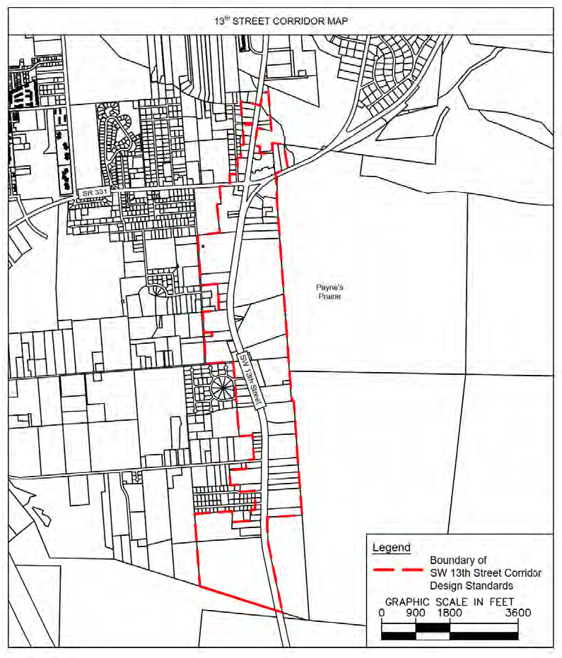
The boundaries for the 13th Street Corridor design standards are depicted in Exhibit 405.23.1 and are generally described as those lands abutting SW 13th Street from the Gainesville City limit (north boundary) to Paynes Prairie (south boundary).
(b)
Development standards.
(1)
Building design.
a.
Facades and exterior walls. Primary facades (those that face SW 13th Street or Williston Road (Main Street) shall incorporate wall plane projections and recesses for architectural relief. In no case shall a primary facade have an uninterrupted length greater than twenty (20) feet.
1.
Primary facades shall have a minimum transparency requirement of twenty-five (25) percent of their horizontal length. Where multiple structures are built that face SW 13th Street or Williston Road, each structure shall have a designated primary facade that meets the requirements of this Section. This may be achieved through the use of windows or glazed entry areas. Entry areas for non-residential structures shall be clearly delineated and include at least two (2) of the following features:
(A)
Canopies/porticoes;
(B)
Overhangs;
(C)
Recesses/projections;
(D)
Raised above the doorway cornice parapets;
(E)
Arches;
(F)
Peaked roof forms;
(G)
Integrated architectural details such as tile work, moldings, planters, wing walls, and/or landscaped seating areas;
b.
Roofs.
1.
All roof-mounted heating, ventilating and air conditioning (HVAC), and mechanical equipment shall be located so as to be screened from public view at ground level. In addition, roofs shall have at least one of the following features:
(A)
Parapets concealing flat roofs and roof-mounted equipment. The height of such parapets shall not at any point exceed one-third (⅓) of the overall wall height measured from the finished floor line to the roof line. Such parapets shall feature a three-dimensional cornice treatment;
(B)
Sloping roofs shall have an average slope greater than or equal to 4:12 but not to exceed 12:12.
c.
Materials and colors.
1.
Primary facades shall have one of the following as their primary building material: brick, sandstone, limestone, other native stones, tined/textured concrete masonry units (e.g. "split-face block"), exterior insulation systems, or stucco surfaces. Exterior building materials on primary facades shall not include exposed smooth-faced concrete block.
2.
The use of metallic, black, or fluorescent colors for facades shall be prohibited.
3.
Building trim and accent areas may feature contrasting colors that complement those of the rest of the building.
(2)
Site design and relationship to the surrounding community.
a.
Adjacency to residential uses. Connectivity between non-residential development and adjacent residential uses shall be encouraged except where not appropriate based on safety concerns. Where these connections occur, safe pedestrian crossings shall be provided as part of the overall development plan.
b.
Fencing. Fencing shall be screened by vegetation directly in front of the fence on the side of the right-of-way.
(3)
Pedestrian circulation.
a.
Sidewalks. Sidewalks at least five (5) feet in width shall be provided along all sides of lots that abut a public right-of-way.
b.
Crosswalks. All pedestrian crosswalks shall be distinguished from driving lanes through one of the following methods to enhance pedestrian safety: use of contrasting surface materials such as pavers, brick, or scored concrete or crosswalks painted using high durability paints. All crosswalks shall be subject to the requirements of the American with Disabilities Act (ADA).
(4)
Landscaping. In addition to the landscaping requirements found in this ULDC, the following landscaping standards shall apply:
a.
Vehicular access driveways. Primary access driveways from the public rights-of-way into the proposed development shall be completely separated from any parking area and/or pedestrian walkway provided such separation does not constitute a safety hazard. Such separation shall consist of a landscaped island, berms, or vegetation.
b.
Stormwater management. Stormwater management areas shall be incorporated into the overall landscaping plan for the development and shall be designed to take on a natural appearance.
c.
Trash and recycling receptacles. All solid waste and recycling containers shall be placed at the rear or side of the building. The container shall be enclosed with screening so that it is not visible from the street or adjacent property from ground level. The enclosing screening shall be painted and/or finished with the same material as is used on the building. The enclosing screening shall also be fitted with an opaque sliding or hinged door and working latch.
d.
Ground mounted HVAC equipment. All ground mounted exterior HVAC equipment shall be placed at the rear or side of the building. All HVAC equipment shall be screened from ground level public view by one of the following methods:
1.
A vegetative screen; or
2.
A walled enclosure whose materials complement the main building.
(5)
Signs. Signs shall be designed to be integrated with the character of the building architecture and shall be reviewed and approved as part of the overall development plan approval process by the DRC. In addition to other sign requirements found within the Article III, Signs, Chapter 407, the following standards shall apply:
a.
Free standing signs. Site identification signs shall be monument ground mounted signs no taller than eight (8) feet above the natural grade. Free standing identification signs may be externally illuminated provided the surface of the sign is a non-glare material such as wood, stucco, or textured surface. Any external above ground light source shall be located and hidden within a planter bed or in a burial fixture. Sign lights shall be focused, directed and arranged as to prevent glare or cause a traffic hazard. Light from illuminated signs shall not spill over onto adjoining properties or roads. No flashing or pulsating lights or internally illuminated signs shall be permitted.
b.
Building signs. Building signs may be externally illuminated provided the surface of the sign is a non-glare material such as wood, stucco, or is textured. Building signs may also be internally illuminated only if they consist of individually cut letters that do not exceed twenty-four (24) inches in height.
c.
Design and color. Building signs shall be consistent with the architecture, design, and color of their respective building. The use of contrasting colors that are not consistent with the overall development shall be limited to corporate logo building signs (in the case of non-residential development) that identify individual tenants.
d.
Neon lighting. Except for channel letter building signs, neon signs, and neon accent features on structures shall be prohibited.
e.
Application procedures for sign permits. When applying for a sign permit within the 13th Street Corridor, the applicant shall submit, in addition to their application, two (2) copies of all sign elevations at a scale of ½" = 1' with one (1) copy showing dimensions and specifications and one (1) copy showing the sign only with a human and automobile scale figure.
(6)
Development review submittal. In addition to the requirements of this code, colored elevation drawings of all primary facades at a scale of ⅛ = 1'0" shall be included with all DRC applications to ensure compliance with these development standards.
(7)
Alternative compliance. An applicant may submit site or building plans that vary from the requirements of this Section in order to accommodate unique site features or utilize innovative design. The applicant shall provide a justification statement as to why such an alternative is warranted. The DRC will approve alternative plans only if it finds that the alternative plans are needed to accommodate unique site features or utilize innovative design, and fulfill the purpose and intent of this Section more effectively than strict adherence to the requirements of this Section.
13th Street Corridor
(Ord. No. 05-10, § 2, 12-8-05; Ord. No. 2020-25, § 2(Exh. A), 11-10-20)
Sec. 405.24. - Purpose.
The purpose of this Article is to:
(a)
Provide for airport protection zoning regulations and airport land use compatibility zoning regulations as required by F.S. Ch. 333, as amended;
(b)
Protect the public health, safety, and welfare in the vicinity of public use airports by minimizing the exposure to airport hazards and noise levels generated by aircraft operations;
(c)
Regulate and restrict the height of structures and otherwise regulate the use of property in the vicinity of public use airports within Alachua County by creating airspace protection zones and establishing the boundaries thereof;
(d)
Prevent airport hazards and provide for the elimination, removal, alteration, mitigation, and/or marking and lighting of airport hazards and obstructions;
(e)
Provide a process for permitting of airport obstructions; and
(f)
Regulate and restrict the use of land and certain proposed construction or alteration in the vicinity of public use airports within Alachua County by creating appropriate noise zones and establishing the boundaries thereof.
(Ord. No. 2017-08, § 2(Exh. A), 7-11-17; Ord. No. 2020-25, § 2(Exh. A), 11-10-20)
Sec. 405.25. - Airport protection zones.
There are hereby created and established the following airspace protection zones and related height restrictions, which are based on the "Standards for Determining Obstructions to Air Navigation or Navigational Aids or Facilities" in Title 14, Code of Federal Regulations ("CFR") Part 77, Subpart C, as amended. The airspace protection zones include all areas in the unincorporated portions of Alachua County lying within or beneath the "Civil Airport Imaginary Surfaces" as defined in Section 77.19, CFR as amended, as they apply to existing runways and air navigation facilities at public use airports, and planned runways and air navigation facilities identified in an FAA-approved airport master plan. Any area located in more than one (1) of such zones is considered to be in the zone with the more restrictive height limitation. Except as otherwise provided herein, no structure will be erected, altered, or maintained, nor any terrain altered, nor any object or item of natural growth be allowed in any zone created by this Section in excess of the applicable height limits for such zones.
(a)
Primary zone. The primary zone is an area longitudinally centered on a runway, extending to each end for turf or sod runways or extending two hundred (200) feet beyond each end of a hard-surface runway, with the width so specified for each runway for the most precise approach existing or planned for either end of the runway. No structure or obstruction will be permitted within the primary zone that is not part of the landing and take-off area or is of a greater height than the nearest point on the runway centerline. The width of the primary zone is as follows:
(1)
One thousand (1,000) feet for precision instrument and nonprecision instrument runways.
(2)
Five hundred (500) feet for nonprecision instrument runways having visibility minimums greater than three-quarters (¾) statute mile.
(3)
Five hundred (500) feet for visual runways having only visual approaches.
(4)
Two hundred fifty (250) feet for utility runways having only visual approaches.
Horizontal zone. The horizontal zone is the area around each airport identified herein with an outer boundary, the perimeter of which is constructed by swinging arcs of specified radii from the center of each end of the primary zone to each airport's runway and connecting the adjacent arcs by lines tangent to those arcs. The radius of each arc is as follows:
(5)
Ten thousand (10,000) feet for all runways not designated as utility or visual.
(6)
Five thousand (5,000) feet for all runways designated as utility or visual.
(7)
No structure or obstruction will be permitted in the horizontal zone at a public use airport that has a height greater than one hundred fifty (150) feet above the airport elevation.
(b)
Conical zone. The conical zone is the area extending outward and upward from the periphery of the horizontal zone for a distance of four thousand (4,000) feet. Height limitations for structures in the conical zone are one hundred fifty (150) feet above airport elevation at the inner boundary of the conical zone, with permitted height increasing one (1) foot vertically for every twenty (20) feet of horizontal distance measured outward from the inner boundary to a height of three hundred fifty (350) feet above airport elevation at the outer boundary.
(c)
Approach zone. An approach zone is the area longitudinally centered on the extended runway centerline and extending outward and upward from each end of the primary zone. An approach zone is designated for each runway based upon the type of approach available or planned for that runway end.
(1)
Inner edge. The inner edge of the approach is the same width as the primary zone, and it expands uniformly to a width of:
a.
Sixteen thousand (16,000) feet for precision instrument runways.
b.
Three thousand five hundred (3,500) feet for nonprecision instrument runways.
c.
One thousand five hundred (1,500) feet for that end of a runway other than a utility runway with only visual approaches.
d.
One thousand two hundred fifty (1,250) feet for that end of a utility runway with only visual approaches.
(2)
Approach surface. The approach surface extends for a horizontal distance of:
a.
Fifty thousand (50,000) feet for all precision instrument runways.
b.
Ten thousand (10,000) feet for all nonprecision instrument runways other than utility runways.
c.
Five thousand (5,000) feet for all utility or visual runways.
(3)
Permitted height. Permitted heights within the approach zones are the same as the runway end height at the inner edge of each approach zone, and increase with horizontal distance outward from the inner edge as follows:
a.
Permitted height increases one (1) foot vertically for every fifty (50) feet horizontal distance for the first ten thousand (10,000) feet and then increases one (1) foot vertically for every forty (40) feet horizontal distance for an additional forty thousand (40,000) feet for all precision instrument runways.
b.
Permitted height increases one (1) foot vertically for every thirty-four (34) feet horizontal distance for all nonprecision instrument runways other than utility runways.
c.
Permitted height increases one (1) foot vertically for every twenty (20) feet horizontal distance for all utility and visual runways.
(d)
Transitional zone. The transitional zone is the area extending outward and upward from the sides of the primary zones and approach zones. Height limits within the transitional zone are the same as the primary zone or approach zone at the boundary line where they adjoin and increase at a rate of one (1) foot vertically for every seven (7) feet horizontally, with the horizontal distance measured at right angles to the runway centerline and extended centerline, until the height matches the height of the horizontal zone or conical zone or for a horizontal distance of five thousand (5,000) feet from the side of the part of the approach zone that extends beyond the conical zone.
(Ord. No. 2017-08, § 2(Exh. A), 7-11-17; Ord. No. 2020-25, § 2(Exh. A), 11-10-20)
Editor's note— Ord. No. 2020-25, § 2(Exh. A), adopted November 10, 2020, repealed the former Section 405.25 in its entirety, which pertained to definitions and derived from Ord. No. 2017-08, § 2(Exh. A), adopted July 11, 2017. Subsequently, Ord. No. 2020-25 redesignated the former Sections 405.26—405.31 as Sections 405.25—405.30. The historical notation for these Sections has been preserved for reference purposes.
Sec. 405.26. - Exception to height limitations.
Except as required in Section 405.25 nothing in this Article shall be construed as prohibiting the construction or maintenance of any structure to a height of forty-five (45) feet above ground level at the site of the structure.
(Ord. No. 2017-08, § 2(Exh. A), 7-11-17; Ord. No. 2020-25, § 2(Exh. A), 11-10-20)
Note— See editor's note at Section 405.25.
Sec. 405.27. - General height restriction.
Structures or obstructions shall not be permitted within the unincorporated area of Alachua County outside of the zones created by Section 405.25 that would cause a minimum obstruction clearance altitude, a minimum descent altitude or a decision height to be raised, or impose either the establishment of restrictive minimum climb gradients or nonstandard takeoff weather minimums for any runway at a public use airport. Structures or obstructions not exceeding seventy-five (75) feet in height above ground level shall be excluded from the provisions of this Subsection only.
(Ord. No. 2017-08, § 2(Exh. A), 7-11-17; Ord. No. 2020-25, § 2(Exh. A), 11-10-20)
Note— See editor's note at Section 405.25.
Sec. 405.28. - General use restrictions.
In addition to other provisions of this Article, the following requirements shall apply to the entire unincorporated area of Alachua County.
(a)
Lights and illumination. All lights or illumination used in conjunction with streets, parking, signs, or use of land and structures shall be arranged and operated in such a manner that it is not misleading or dangerous to aircraft operating from a public airport or in vicinity thereof.
(b)
Visual hazards. No operations from any type of use shall produce smoke, glare, or other visual hazards within three (3) statute miles of any usable runway of a public airport.
(c)
Electronic interference. No operations from any type of use shall produce electronic interference with navigational signals or radio communication between the airport and aircraft.
(d)
Marking and lighting. Any owner of any nonconforming structure or airport obstruction is hereby required to permit the installation, operation, and maintenance thereof of such markers and lights as shall be deemed necessary by the County, in accordance with "FAA Advisory Circular 70/7460-1 entitled "Obstruction Marking and Lighting," as incorporated by 14 CFR, Part 77, Subsection 77.5(c)(3), as amended, to indicate to the operators of aircraft in the vicinity of airports the presence of such airport hazards or obstructions. Such markers and lights shall be installed, operated, and maintained at the expense of the owner or operator of such structure or airport obstruction.
(e)
Landfills in the vicinity of public use airports.
(1)
New landfills shall not be located:
a.
Within ten thousand (10,000) feet of the nearest point of any runway used or planned to be used by turbine aircraft; or
b.
Within five thousand (5,000) feet of the nearest point of any runway used by only non-turbine aircraft.
(2)
Any proposed new landfill located outside the perimeters described in Subsections (1)a. and (1)b. above, but within the lateral limits of the civil airport imaginary surfaces defined in Section 77.19, CFR, as amended, shall be reviewed to determine the extent to which it would potentially attract or sustain hazardous bird movements from feeding, water, or roosting areas into or across the runways or approach and departure patterns of aircraft.
(3)
Where any landfill is located or constructed in such a manner that attracts or sustains hazardous bird movements from feeding, water, or roosting areas into or across the runways or approach and departure patterns of aircraft, the landfill operator shall incorporate bird management techniques or other practices to minimize bird hazards to airborne aircraft.
(Ord. No. 2017-08, § 2(Exh. A), 7-11-17; Ord. No. 2020-25, § 2(Exh. A), 11-10-20)
Note— See editor's note at Section 405.25.
Sec. 405.29. - Airport noise compatibility standards.
(a)
Purpose. The purpose of this Subsection is to restrict the use of land in this overlay district to those uses that are compatible with the high ambient noise levels created by low flying aircraft following prescribed flight paths in landing or takeoff from public use airports, in order to:
(1)
Protect public use airports against encroachment of land uses which might affect the operational capacity of the airports; and
(2)
Limit new or redeveloped land uses to those uses that are compatible with the noise environment around the airports.
(b)
Noise contour (DNL) lines for Gainesville Regional Airport. The noise contour lines for Gainesville Regional Airport shall be those delineated in the noise compatibility study for Gainesville Regional Airport that was completed in accordance with 14 CFR Part 150 and determined to be compliant by the Federal Aviation Administration on April 20, 2009 (see map below). Such noise contour lines are hereby established and adopted as a part of this ULDC.
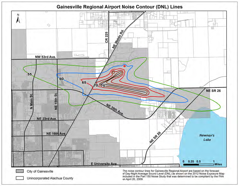
(c)
Restrictions and standards. All new dwelling construction shall comply with the standards, requirements, and guidelines on noise abatement and control, as set forth in 24 CFR Part 51, Subpart B, Environmental Criteria and Standards, of Title 24 CFR, as existing or amended, and shall also conform with The Noise Guidebook (U.S. Department of Housing and Urban Development, Office of Community Planning and Development), where applicable.
(d)
Prohibited uses.
(1)
The following shall be prohibited within the 65 DNL line or higher for Gainesville Regional Airport:
a.
Residential structures;
b.
Educational facilities (not including aviation schools); and
c.
Outdoor music shells and amphitheaters.
(2)
Where an airport authority or other governing body operating a public-use airport has not conducted a noise study in accordance with 14 CFR Part 150, or established noise contours pursuant to another public study approved by the Federal Aviation Administration, residential construction and educational facilities, with the exception of aviation school facilities, shall be prohibited within the area contiguous to the airport measuring one-half (½) the length of the longest runway on either side of and at the end of each runway centerline.
(e)
Uses requiring attenuation of noise.
(1)
Uses within the 65-70 DNL area. The following uses located within the 65-70 DNL area shall be required to incorporate noise level reductions of twenty-five (25) decibels (dB) in the design and construction of enclosed structures:
a.
Hospitals and nursing homes.
b.
Churches, auditoriums, and concert halls.
(2)
Uses within the 70-75 DNL area.
a.
The following uses located within the 70-75 DNL lines shall be required to incorporate noise level reductions of twenty-five (25) dB in the design and construction of enclosed structures:
1.
Commercial;
2.
Manufacturing;
3.
Recreation (those portions where the public is received, office areas; or where the normal noise level is low); and
4.
Governmental services.
b.
The following uses located within the 70-75 DNL lines shall be required to incorporate noise level reductions of thirty (30) dB in the design and construction of enclosed structures:
1.
Hospitals and nursing homes.
2.
Churches, auditoriums, and concert halls.
(Ord. No. 2017-08, § 2(Exh. A), 7-11-17; Ord. No. 2020-25, § 2(Exh. A), 11-10-20)
Note— See editor's note at Section 405.25.
Sec. 405.30. - Permitting of airport obstructions.
(a)
Permit required for airport obstructions. Any person proposing to construct, alter, or allow an airport obstruction shall be required to apply for a permit from Alachua County. Such permit may not be issued if it would allow the establishment or creation of an airport hazard or if it would permit an existing obstruction to become a greater hazard to air navigation than it is when the application for a permit is made.
(b)
Permit application. In addition to the common development application elements in Chapter 402, Article II, permit applications under this Section shall include documentation showing compliance with the federal (FAA) requirement for notification of proposed construction or alteration of structures in 14 CFR, Part 77, Subpart B, as amended, and a valid aeronautical study where required by the Federal Aviation Administration.
(c)
Review criteria. The following criteria shall be considered when determining whether to issue or deny a permit under this Article:
(1)
The safety of persons on the ground and in the air;
(2)
The safe and efficient use of navigable airspace;
(3)
The nature of the terrain and height of existing structures;
(4)
(The effect of the construction or alteration on the state licensing standards for a public-use airport contained in F.S. Ch. 330, as amended, and rules adopted thereunder;
(5)
The character of existing and planned flight operations and developments at public-use airports;
(6)
Federal airways, visual flight rules, flyways, and corridors, and instrument approaches as designed by the Federal Aviation Administration;
(7)
The effect of the construction or alteration of the proposed structure on the minimum descent altitude or the decision height at the affected airport; and
(8)
The cumulative effects on navigable airspace of all existing structures and all other known proposed structures in the area.
(d)
Florida Department of Transportation review. Upon receipt of a complete permit application by the County, a copy of the application shall be provided to the Florida Department of Transportation, Aviation Office by certified mail, return receipt requested, or by a delivery service that provides a receipt evidencing delivery. Pursuant to F.S. § 333.025(4), the Department of Transportation shall have fifteen (15) days to review the application and provide comments, to the County, said time running concurrently with the review of the application by the County.
(Ord. No. 2017-08, § 2(Exh. A), 7-11-17; Ord. No. 2020-25, § 2(Exh. A), 11-10-20)
Note— See editor's note at Section 405.25.
Sec. 405.33. - Description.
The preservation buffer overlay district includes all real property within six hundred sixty (660) feet of lands that are designated as preservation according to the Future Land Use Map of Alachua County, or an equivalent category designated on the Future Land Use Map of any adjacent jurisdiction or any other public park or preserve established for the purpose of preserving natural habitats.
(a)
Intent. The intent of the preservation buffer overlay district is to protect the quality and integrity of preservation lands from impacts of adjacent development on wildlife, including listed species, wildlife habitat, water quality and quantity, native vegetation, and human use and enjoyment of preservation lands, while protecting the rights of property owners. The intent is also to provide the appropriate management entities of the identified Preservation areas an opportunity to review and provide recommendations on development activities within the overlay district.
(b)
Application and administration.
(1)
Development plan review required.
a.
Development plan review, as provided in Article X of Chapter 402, shall be required for all development activity within the preservation buffer overlay district.
b.
The construction or alteration of a single-family residence on an individual lot of record that otherwise meets the requirements of this Article shall not require development plan review.
(2)
Notification of affected agencies.
a.
The Florida Department of Environmental Protection; the applicable water management district; or any other relevant state, regional, or local public agencies with management responsibility for the adjacent preservation lands shall be notified of each development application within the district and requested to provide written comments and recommendations regarding:
1.
The recommended width of the buffer area to be established based on the proposed development activity and on the standards and criteria contained in this Article; and
2.
The development limitations which should apply within such buffer area.
b.
Where listed species are identified on lands within the preservation buffer overlay district proposed for development, or on adjacent preservation lands, the Florida Fish and Wildlife conservation commission shall be notified of a development application and requested to provide written comments and recommendations.
(3)
Development location. All development on lands within the preservation buffer overlay district shall be located on the portion of the site that results in the least adverse impact on adjacent preservation lands.
(4)
Required buffer width. A minimum buffer width of one hundred (100) feet shall be required from the boundary of any preservation lands, unless otherwise provided in this Subsection.
a.
A buffer width of less than one hundred (100) feet may be approved, in conjunction with the construction of a public park, single-family residence, or accessory structure on an individual lot of record, through the development plan review process. The DRC may approve buffers below the thresholds of Subsection 405.33(b)(4)c. of this ULDC if the applicant can show that the provisions of that Section cannot be met or that strict adherence to the buffer standards of that Section would result in the complete loss of the economic beneficial use of the property or the creation of an undue burden on the property. In granting a reduced buffer below those set forth in Subsection 405.33(b)(4)c. of this ULDC, the DRC must find that the approved reduction only allows impacts in accordance with Subsection 405.33(b)(3), above. The DRC or BOCC may include conditions to ensure that the reduced buffer width is consistent with the intent of the preservation buffer overlay district regulations and the recommendations of the managing entity for the adjacent preservation lands.
b.
A buffer width of more than one hundred (100) feet may be required through the development plan review process if scientific evidence indicates it is necessary to protect habitat of listed species whose range includes any lands within the preservation buffer overlay district and adjacent preservation lands, or to address water quality or quantity concerns.
c.
For existing lots of record less than or equal to three (3) acres in size, or with three (3) acres or less of buildable area outside of conservation management areas or other protected resources, the Environmental Protection Department Director may grant a reduction in buffer width as it applies to placement of single-family residential structures, accessory structures, and related improvements only, according to the following provisions. If the following provisions cannot be met, or the applicant can show that strict adherence to the provisions below will prohibit all economically beneficial use of the property or create an undue burden on the property, then an applicant may request a reduction from the DRC in accordance with Subsection a. above.
1.
For lots smaller than one (1) acre in size, or with less than one (1) acre of buildable area outside of conservation management areas or other protected resources, the buffer width for placement of single-family residential structures, accessory structures, and related improvements may be no less than twenty-five (25) feet. Activities listed in Subsection 405.33(c)(3) are still prohibited activities within the entire 100-foot buffer area, with the exception of the activities listed in Subsection 405.33(c)(3)b. and the placement of any fill necessary for construction of the residential structure.
2.
For lots one (1) acre in size to three (3) acres in size, or with one (1) to three (3) acres of buildable area outside of conservation management areas or other protected resources, the buffer width for placement of single-family residential structures, accessory structures, and related improvements may be no less than fifty (50) feet. Activities listed in Subsection 405.33(c)(3) are still prohibited activities within the entire 100-foot buffer area, with the exception of the activities listed in Subsection 405.33(c)(3)b. and the placement of any fill necessary for construction of the residential structure.
3.
For lots with a pre-existing single-family residence and existing impacts and encroachments within the preservation buffer overlay at the time the Preservation Buffer Overlay District became applicable, new activities or encroachments within these impacted areas may be authorized by the Environmental Protection Department Director upon meeting the requirements of Subsection 405.33(b)(2) and on a determination that the proposed activity will not create a new adverse impact on adjacent preservation lands based on factors listed in Subsection 405.33(b)(4)d.
d.
The determination for a reduction or increase in the width of the buffer shall be based on the following general factors:
1.
Type of development proposed and associated potential for adverse site-specific impacts;
2.
Type of development proposed and associated potential for adverse off-site impacts;
3.
Natural community type and associated hydrologic or management requirements of the adjacent preservation lands;
4.
Characteristics of the overlay zone, such as vegetation, soils, and topography;
5.
Required buffer function (e.g., water quality protection or wildlife habitat requirements); and
6.
Presence of rare, threatened, or endangered species of plants and animals; and vii. Recommendations of the managing entity of the adjacent Preservation area.
7.
The loss of all economically beneficial use of the property, or creation of an undue burden on the property, due to strict adherence to the buffers set forth above.
(c)
Development standards for buffer area. Within the buffer area, the standards listed below shall apply:
(1)
Maintenance in natural state. The buffer area shall be maintained in its natural undisturbed state. No activity shall occur within the required buffer area, except as expressly provided in this Article or as approved by Alachua County. The above shall not be interpreted to prohibit the removal of non-native, dead, or fallen vegetation or the planting of non-invasive native vegetation that is compatible with site characteristics and with the vegetation and wildlife requirements of adjacent properties.
(2)
Firewise. If the required buffer is located in an area identified as a high wildfire hazard, selective thinning or clearing of dead, diseased, and fire-prone vegetation may be permitted within the buffer area in order to comply with the Firewise Requirements identified in Subsection 407.43(i) of this ULDC. A landowner must receive administrative approval from the County prior to such thinning or clearing of vegetation. The following information must be submitted with a request for administrative approval:
a.
An analysis of the wildfire hazards as influenced by existing vegetation and topography;
b.
A map showing the location of the areas to be cleared of dead, diseased, or fire-prone vegetation or trees;
c.
A map showing the location of areas where vegetation or trees will be thinned to reduce the interlocking canopy; and
d.
Proposed methods of clearing or removal.
(3)
Prohibited activities. The following activities shall be prohibited within the buffer area:
a.
Septic tanks and drainfields;
b.
Placement of any roads, utilities, or structures except as provided in Subsection (e) of this Section;
c.
Planting of invasive, nonnative vegetation;
d.
Excavation or fill;
e.
Maintaining livestock, except as specifically allowed by an approved management plan;
f.
Storage or parking of equipment, supplies, materials, machinery, and portable or temporary buildings; and
g.
Application, use, or storage of herbicides, pesticides, fertilizers, or chemical agents, except any application of herbicides which may be specifically allowed by an approved management plan for the purpose of controlling the spread of existing invasive vegetation onto preservation lands.
(4)
Permitted activities. Within the setback area, the following uses are permitted:
a.
Elevated walkways and stairs;
b.
Elevated decking, not to exceed a total of two hundred (200) square feet;
c.
Post and rail fencing not to exceed four (4) feet in height and not to have opacity greater than ten (10) percent; and
d.
Public trails.
(5)
Protective barriers. Prior to the commencement of any construction activity within the developable area, placement of temporary barriers may be required to protect existing vegetation within the setback area.
(6)
Damage to buffer area. Any damage resulting from development activities to existing vegetation, soils, or topographic features within the buffer area shall be repaired using equivalent native materials. Any damage shall be repaired prior to the issuance of a certificate of occupancy for any portion of the development site.
(7)
Compliance with management plan. Any other conditions contained in an approved management plan, other than continuing maintenance responsibility, shall be carried out prior to issuance of a certificate of occupancy for any portion of the development site.
(d)
Management plan. A management plan may be required in order to provide for protection of natural and historic resource values and characteristics in the buffer and adjacent preservation areas, in accordance with Article XX, Management Plans, of Chapter 406.
(e)
Exemptions. The following sites and activities shall be exempt from the provisions of this Article:
(1)
All exemptions identified in Chapter 406 of this Code, Natural and Historic Resources Protection, Section 406.06.
(2)
Upon notice to the County, emergency repairs on public or private projects necessary for the preservation of life, health, or property.
(3)
Maintenance of publicly or privately owned portions of a structural stormwater or drainage control system that does not constitute major construction or rebuilding.
(Ord. No. 05-10, § 2, 12-8-05; Ord. No. 07-01, § 7, 1-23-07; Ord. No. 09-01, § 2(Exh. A), 2-24-09; Ord. No. 09-05, § 2(Exh. A), 9-9-09; Ord. No. 19-20, § 2(Exh. A), 10-8-19; Ord. No. 2020-25, § 2(Exh. A), 11-10-20)
Sec. 405.34. - Objectives of article.
The objectives of this Article are as follows:
(a)
To promote the convenience and enjoyment of public travel on the highways, roadways, and other travel corridors of the County.
(b)
To protect the natural and cultural heritage scenic road corridors of the County and to enhance their resource values for the enjoyment of future generations.
(c)
To protect the public investment in scenic road corridors from activities, land uses, signs, etc., which impair both the integrity of the corridor, its capacity for traffic, and its visual qualities.
(d)
To provide safe facilities for leisure driving, hiking, and biking.
(e)
To provide access to and protect outstanding visual experiences representative of the County's variety of landscape resources and cultural attractions.
(f)
To contribute to the environmental and historical appreciation of the County and education of the residents and visitors.
(g)
To attract visitors to the County by preserving natural beauty along the scenic road corridors.
(h)
To expose scenic views and vistas along the travel corridor.
(Ord. No. 05-10, § 2, 12-8-05; Ord. No. 2020-25, § 2(Exh. A), 11-10-20)
Sec. 405.35. - Guidelines for designation.
To measure the significance of the scenic, historical, and cultural value of scenic road corridors, the following guidelines shall apply:
(a)
The quality of its scenic, historic, or cultural resources is unique and/or of sufficient magnitude to merit regional or County recognition;
(b)
A variety and diversity of visual experience created by land form, changes in terrain, natural vegetation, type of landscape, and/or land use activity is provided;
(c)
Access between or to recreation areas or points of scenic, cultural, historical, or scientific interest occur as part of the system;
(d)
The immediate roadside or corridor is relatively free of commercial or other development restrictive of scenic quality; and
(e)
The scenic road corridor's natural, scenic, and cultural resources are not damaged beyond their recognition and it is relatively easy to restore their initial resource value.
(Ord. No. 05-10, § 2, 12-8-05; Ord. No. 2020-25, § 2(Exh. A), 11-10-20)
Sec. 405.36. - Specific criteria for designation.
To receive the designation of scenic road corridor, one or more of the following criteria must apply:
(a)
Scenic resource significance.
(1)
Interesting geomorphic formations.
(2)
Type of natural vegetation.
(3)
Presence or nearness of water bodies (by type).
(4)
Overall landscape composition.
(b)
Archaeological resource significance. Area of archaeological importance.
(c)
Historical resource significance.
(1)
Road developed prior to era of interstate development.
(2)
Sites of historical importance.
(d)
Cultural resource significance.
(1)
Unspoiled character of resource (no adverse land uses and structures).
(2)
Amenability for multiple recreational uses for pedestrian, equestrian, or bicycle paths, and passive recreation.
(e)
Priority of criteria.
(1)
Scenic quality.
(2)
Variety of recreation experience.
(3)
Compatibility with other corridor users.
(4)
Harmony with other land use.
(5)
Access to parks and other recreation.
(6)
Popular demand.
(7)
Degree of urgency if the corridor is to be protected.
(8)
Protection of ecology.
(9)
Suitability for use by other transportation modes (bus, pedestrian, equestrian, bicycles).
(10)
Type of developmental possibilities.
(11)
Resource vulnerability to incompatible land use.
(Ord. No. 05-10, § 2, 12-8-05; Ord. No. 2020-25, § 2(Exh. A), 11-10-20)
Sec. 405.37. - Protected area along scenic road corridors.
The area within one hundred (100) feet of the right-of-way lines or the limits of the County's prescriptive use on any road designated as a scenic road corridor shall be the protected area of the corridor.
(Ord. No. 05-10, § 2, 12-8-05; Ord. No. 2020-25, § 2(Exh. A), 11-10-20)
Sec. 405.38. - Restrictions along scenic road corridors.
The BOCC may designate by resolution or ordinance scenic road corridors for purposes of preservation. In preserving a scenic road corridor, the BOCC shall have the power to impose restrictions along the corridor, including, but not limited to, the following:
(a)
Providing and erecting markers designating scenic road corridors.
(b)
Prohibition of outdoor advertising signs within the protected area except small (seven and one-half (7.5) square-foot maximum) signs advertising residential development or homes for sale on lots or parcels of property immediately adjacent to the corridor and subdivision entryway signs constructed in accordance with Article III of Chapter 407.
(c)
The setting and posting of speed limits.
(d)
The setting and posting of maximum weight limits and classes of vehicular travel.
(e)
Prohibiting the removal of trees which have attained a diameter of eight (8) inches or more at a point four and one-half (4.5) feet above average ground level within the protected area except under circumstances where trees have died or the over-grown trees have hindered sight lines and safety factors creating traffic hazards in accordance with the requirements of Subsection 406.12(b) of this ULDC, or where no access to the property is available without removal of such trees.
(f)
Providing for preservative maintenance to protect and enhance scenic quality in accordance with Section 405.05.
(g)
Prohibiting structures within the protected area except for the following:
(1)
Fences with opacity of not more than fifty (50) percent when viewed along a line of sight perpendicular to the fence shall be permitted with an approved administrative permit.
(2)
Traffic signals shall be permitted.
(3)
Streetlights shall be permitted within twenty-five (25) feet of intersecting right-of-way lines.
(4)
Subdivision entryway signs, decorative walls, and fences built as entryway features and permitted in accordance with this ULDC shall be permitted according to the following:
a.
The line of sight is to be viewed as perpendicular to the centerline of the scenic roadway;
b.
The entryway structure is not to exceed six (6) feet in height except for columns and posts, which may not exceed eight (8) feet in height. Structures may be allowed to extend to eight (8) feet in height and columns and posts to ten (10) feet in height at pedestrian and bicycle access points;
c.
The width of the entryway structure is not to exceed fifty (50) feet in a perpendicular direction from the entrance road edge of pavement;
d.
The entryway structure shall be designed in a manner that is consistent with the intent of this Chapter and blend with the natural surroundings and aesthetics of the scenic road corridor. Materials and colors utilized shall be in earth tones or natural woods;
e.
Landscaping shall be provided and maintained along those areas that are visible from the scenic road corridor line of sight to "soften" the appearance of the entryway structure; and
f.
The use of high-intensity lighting for any of these features is prohibited.
(h)
Prohibiting any commercial activity within the protected area.
(i)
Prohibiting overhead utilities within the protected area, except for the following:
(1)
Utility drops may be installed to previously existing buildings within the protected area.
(2)
Primary electrical transmission lines carrying twenty-five thousand (25,000) volts or more may be exempted from this restriction by the BOCC after development plan approval when such transmission lines propose to cross the protected area perpendicular to the scenic road corridor.
(3)
Utility lines carrying less than twenty-five thousand (25,000) volts shall be installed underground when making a perpendicular crossing to service new development; however, the installation of an attractively landscaped electric transformer to the buildings or structures in such new development from an underground electric connection shall be permitted within the protected area.
(j)
Providing for the mapping and description of all designated scenic road corridors in the Comprehensive Plan as part of the Conservation and Open Space Element.
(k)
Nothing herein shall be construed as otherwise denying the use of the protected area as yard space.
(Ord. No. 05-10, § 2, 12-8-05; Ord. No. 2020-25, § 2(Exh. A), 11-10-20)
Sec. 405.39. - Maintenance of corridors and scenic quality.
The County Engineer shall implement the following guidelines for scenic road corridor maintenance:
(a)
Conserve and restore the high quality of natural resources and unique features such as tree canopy, ground cover, animals, and geological features in their natural state.
(b)
Preserve cultural and historical character.
(c)
Clear cutting of vegetation in the scenic road corridor right-of-way shall not be permitted, except as authorized in Subsection (c) of this Section, and except under such circumstances where the sight lines are obstructed and contributing to traffic hazards after fulfilling procedures in Subsection 405.41(c)(3); provided, however, that one (1) annual clear cutting shall be permitted, if necessary, to restore scenic vistas along a corridor.
(d)
Selective vegetation cutting may be permitted to open up and enhance views and vistas within the scenic road corridor right-of-way upon recommendation of the staff and approval of the BOCC.
(e)
Where proper permits have been obtained controlled burning may be practiced where necessary to encourage vegetation growth and control insect and pest occurrence.
(f)
Mowing shall be permitted in drainage ditches to prevent clogging and overflow.
(g)
Trees and other vegetation damaged beyond the restoration stage, either by natural causes or accidents, should be removed. Attempts should be made to replant such areas to bring them to their original state.
(h)
In cases where recreation access and/or facilities (scenic overlook, picnic areas, multi-purpose trails, unpaved parking) are provided, they shall be maintained on a regular basis.
(Ord. No. 05-10, § 2, 12-8-05; Ord. No. 09-01, § 2(Exh. A), 2-24-09; Ord. No. 2020-25, § 2(Exh. A), 11-10-20)
Sec. 405.40. - Variances.
The BOCC may grant variances from the terms of this Chapter if serving the public interest and where, due to special conditions, a literal enforcement of the provisions would result in unnecessary and undue hardship or a safety hazard. Public notice shall be provided in accordance with Article IV in Chapter 402 of this ULDC. In granting variances, the BOCC shall make a finding that:
(a)
Special conditions and circumstances exist which are peculiar to the land, such as size, shape or topography, which are not applicable to other lands in the protected area;
(b)
The special conditions and circumstances do not result from the actions of the applicant;
(c)
The variance, if granted, is the minimum variance that will make possible the reasonable use of the land, building, or structure; and
(d)
The variance is necessary to promote public safety.
(Ord. No. 05-10, § 2, 12-8-05; Ord. No. 2020-25, § 2(Exh. A), 11-10-20)
Sec. 405.41. - Procedure for designation.
(a)
Method of designation.
(1)
Once a request has been received to designate a particular road as a scenic road corridor, staff will review the proposal and prepare a report and recommendation to be presented to the BOCC.
(2)
Should staff's report be favorable, the BOCC shall give public notice of a hearing to consider designation as a scenic road corridor, in accordance with the requirements of Article IV, Chapter 402 of this ULDC. The notice shall include the following:
a.
Description and location of the corridor and popular name;
b.
Maximum weight limit to be set, if any;
c.
Speed limit to be set, if any;
d.
Description of the protected area; and
e.
Any other special limitation, restriction or use not covered above which may be imposed along the scenic road corridor.
(b)
Modification or revocation of designation.
(1)
Addition of right-of-way width. The addition of right-of-way width along a designated scenic road corridor shall have no effect upon the reservation and protection of the full designated protected area unless and until the BOCC approves an improvement plan that encroaches into the full designated protected area and financing of construction for the reclassified designated scenic road corridor has been established. In such instance, the scenic nature of the road shall be preserved to the maximum extent possible. This may include replanting of similar types of vegetation, including native vegetation, if available.
(2)
Change in character. In the event of change in character of a designated scenic road corridor, whether due to natural disaster or degradation, except for man-made disaster or degradation, the same procedure specified in Subsection (a) of this Section shall be utilized to consider continuing designation of the road as a scenic road corridor. In no case shall a change in character, where due to natural or man-made causes (such as incorporation in municipal limits), result in revocation unless a study report of the staff clearly shows that restoration to the original character of the scenic road corridor is impracticable. The same procedures specified in Subsection (a) of this Section shall be used to modify designated scenic road corridors.
(3)
Revocation. No designated scenic road corridor shall be revoked for any reason whatsoever except by the procedure specified in Subsection (a) of this Section. A designated scenic road corridor may be revoked by the procedures specified in Subsection (a) of this Section when:
a.
Its character has been adversely altered by natural causes, rendering it irretrievable as a scenic road corridor; or
b.
Imminent construction due to reclassification as provided in Paragraph (1) above, when such construction irrevocably destroys the scenic character of the protected area.
c.
Public hearing.
1.
At the time of hearing, the proof of publication of the required notice shall be filed with the BOCC.
2.
Mailed notice shall be provided to all property owners located along the proposed corridor no later than fifteen (15) days prior to the public hearing.
3.
At the hearing, the BOCC shall hear all interested parties and, should it determine that a road should be designated, modified, or revoked as a scenic road corridor, it shall adopt an appropriate resolution or ordinance stating the same.
4.
Each such resolution or ordinance by the BOCC shall have the effect of designating, modifying, or revoking, as the case may be, a road as a scenic road corridor.
5.
Such designation, modification, or revocation as a scenic road corridor shall become effective when a certified copy of such resolution or ordinance has been filed by the BOCC in the Office of the Clerk of the Circuit Court and duly recorded in the public records of the County.
(Ord. No. 05-10, § 2, 12-8-05; Ord. No. 09-01, § 2(Exh. A), 2-24-09; Ord. No. 2020-25, § 2(Exh. A), 11-10-20)
Sec. 405.42. - Eastside Activity Center overlay district.
(a)
Description of district. This district includes all properties within the Eastside Activity Center boundaries as shown on Map 12 (Eastside Activity Center Master Plan—Future Land Use) in the map series of the Future Land Use Element, Alachua County Comprehensive Plan.
(b)
Intent. The intent of this district is to implement the Eastside Activity Center Master Plan as well as the objectives, goals, and policies for the activity center as provided in Policy 2.5.10 of the Comprehensive Plan's Future Land Use Element. The Eastside Master Plan is intended to create a mixed-use activity center with neighborhood-oriented retail, institutional, residential and office uses.
(c)
Zoning. The following zoning districts shall be implemented as shown on Map 12 (Eastside Activity Center Master Plan) of the Future Land Use Element and shall supersede all existing zoning designations found within the activity center:
(1)
Mixed use (four (4) to fourteen (14) du/acre).
(2)
Mixed use—Neighborhood convenience center.
(3)
Mixed use employment.
(4)
Mixed use residential (four (4) to eight (8) du/acre).
(5)
Mixed use residential (four (4) to fourteen (14) du/acre).
(6)
Institutional.
(d)
Permitted uses. The following permitted uses shall be allowed within each of the Activity Center zoning districts:
(e)
Development standards. The following development standards shall be allowed within each of the activity center zoning districts:
(f)
Public civic uses. Public civic uses that are open to the general public shall be permitted in all zoning districts within the activity center. Permitted uses shall include educational facilities, cultural, social, active recreation, community centers, and libraries. A density bonus of one (1) dwelling unit per five hundred (500) square feet of indoor public civic use and one (1) dwelling unit per five thousand (5,000) square feet of outdoor public civic use shall be permitted.
(g)
Transportation and traffic circulation. An internal traffic circulation system shall be implemented in coordination with Future Land Use Policy 2.5.10.4 and the East Side Activity Center Community Facilities Map. All transportation corridor and traffic circulation improvements shall be made as conditions of development plan approval. All improvements shall connect to existing roads and rights-of-way except where this is precluded by existing development or environmental features.
(h)
Natural resource protection. New development within the Activity Center shall take into account the Eastside Greenway Strategic Ecosystem as identified on the Eastside Activity Center Community Facilities Map. The primary purpose of the Strategic Ecosystem Wildlife Corridor identified on the Facilities Map is to preserve the integrity of the Eastside Greenway Strategic Ecosystem. Therefore, all proposed development activity shall be designed to ensure the continued viability of the ecosystem as well as providing for a wildlife corridor within the ecosystem with an average width of three hundred (300) feet. This shall include, but is not limited to, providing an appropriate set aside for the corridor that is integrated into all proposed development plans. Where the requirements in this Section exceed those found under the general policies and requirements for strategic ecosystems found elsewhere in the plan and this ULDC, these requirements shall prevail.
(i)
Urban design. Development within the activity center shall employ a mix of uses, both vertically and horizontally. No minimum setbacks for the activity enter are established. Projections into public rights-of-way and easements may be permitted for porches, stoops, balconies, and bay windows with approval by the DRC. On street parking shall be accommodated and shall be counted toward required parking provided the space is within three hundred (300) feet of the supported use.
(1)
Design of streets and public rights-of-way shall accommodate mass transit as well as bicycle and pedestrian corridors.
(2)
Buildings shall front major streets and primary entrances shall open to the street. Sidewalks, signage, street trees, and street furniture shall be used to promote the pedestrian character of the activity center.
(3)
Development in the activity center shall be in the form of streets and blocks.
(4)
Parking structures shall be permitted in all zoning districts.
(5)
On street parking spaces shall be counted toward parking requirements provided the space is within three hundred (300) feet of the supported use. On-street parking shall count toward only one (1) required space except in those instances where shared parking is approved.
(Ord. No. 10-08, § 2, 3-23-10; Ord. No. 12-09, § 2(Exh. A), 10-9-12; Ord. No. 2020-25, § 2(Exh. A), 11-10-20)
Sec. 405.43. - Applicability.
This Article is applicable to all properties within the Urban Cluster as designated on the Future Land Use Map.
(Ord. No. 12-09, § 2(Exh. A), 10-9-12; Ord. No. 2020-25, § 2(Exh. A), 11-10-20)
Sec. 405.44. - Design standards.
(a)
All new development and redevelopment within the Urban Cluster shall develop, at a minimum, consistent with the design standards for a TND in Chapter 407, Article VII. New development shall not be required to meet the standards in Subsection 407.64(d) and Subsection 407.64(c)(1).
(1)
Single-family residential development shall meet the standards for outside the transit supportive area.
(2)
All development other than single-family residential shall meet the standards for the transit supportive area.
(b)
Any new nonresidential development on twenty-five (25) or more acres or including one hundred fifty (150) or more residential units shall be required to develop as either a TND or TOD consistent with the standards in Chapter 407, Article VII.
(c)
Any new development proposing one thousand (1,000) or more new dwelling units or three hundred fifty thousand (350,000) square feet or more of non-residential uses and is located on a planned rapid transit corridor shall be required to develop as a TOD consistent with the standards in Chapter 407, Article VII.
(d)
Notwithstanding the acreage requirements of Subsection 407.64(c)(1), all development within the Urban Cluster shall have the option of developing consistent with the TND standards in Chapter 407, Article VII.
(Ord. No. 12-09, § 2(Exh. A), 10-9-12; Ord. No. 2020-25, § 2(Exh. A), 11-10-20)
Sec. 405.45. - Exceptions to design standards for certain development types.
(a)
Parcels less than five (5) acres. Where it can be demonstrated that development on parcels less than five (5) acres cannot strictly adhere to the urban design standards in Chapter 407, Article VII, those parcels shall develop consistent with the design standards in Section 405.05 and Section 405.07.
(b)
Institutional uses. The following types of institutional development when developed outside a TND or TOD, shall not be required to meet the design standards for a TND or TOD. However, these uses shall meet as many TND/TOD design standards as practicable:
(1)
Public and private educational facilities.
(2)
Community services as identified in the Use Table in Chapter 404.
(3)
Public utility, communications, or infrastructure services.
(4)
Assisted living facilities and nursing homes.
(c)
Industrial development. Industrial development within the ML, MS, MP, or BW zoning districts shall not be required to meet the standards for a TND or TOD. However, these developments shall continue to provide for an interconnected multi-modal transportation system consistent with the standards in Chapter 407.
(Ord. No. 12-09, § 2(Exh. A), 10-9-12; Ord. No. 2017-14, § 2(Exh. A), 8-22-17; Ord. No. 2020-25, § 2(Exh. A), 11-10-20)
Sec. 405.46. - Other development.
(a)
Any new development that is not explicitly required to comply with Section 405.44 or explicitly exempted under the requirements of Section 405.45 shall not be required to meet the standards of a TND or TOD.
(b)
Any new development that is not explicitly required to comply with Section 405.44 or explicitly exempted under the requirements of Section 405.45 shall have the option of developing under TND or TOD standards.
(Ord. No. 2020-25, § 2(Exh. A), 11-10-20)
Editor's note— Ord. No. 2020-25, § 2(Exh. A), adopted November 10, 2020, repealed and reenacted Section 405.46 in its entirety to read as herein set out. Formerly, Section 405.46 pertained to developments of regional impact and derived from Ord. No. 12-09, § 2(Exh. A), adopted October 9, 2012.
Sec. 405.47. - Applicability.
Rural Commercial-Agriculture includes those parcels designated within the Comprehensive Plan Future Land Use Map as Rural Commercial-Agriculture, outside of the rural clusters. All new development and redevelopment within these areas is subject to this Article. The standards of this Article are supplemental and additional to all other applicable standards of the ULDC.
(Ord. No. 2020-25, § 2(Exh. A), 11-10-20; Ord. No. 2024-07, § 2(Exh. A), 9-10-24)
Sec. 405.48. - Purpose.
This Article implements Policy 3.11.1 of the Future Land Use Element of the Comprehensive Plan. The intent of this Article is to ensure compatibility between residential and commercial uses in rural areas outside of Rural Clusters with less intensive uses. and surrounding communities.
(Ord. No. 2020-25, § 2(Exh. A), 11-10-20; Ord. No. 2024-07, § 2(Exh. A), 9-10-24)
Sec. 405.49. - Access.
Development shall be required to minimize access from arterials and collectors. Whenever possible, driveways shall use common access points to reduce potential turn movements. Provision shall be made for cross access between other adjacent non-residential zoning and/or uses.
(Ord. No. 2020-25, § 2(Exh. A), 11-10-20; Ord. No. 2024-07, § 2(Exh. A), 9-10-24)
Sec. 405.50. - Uses.
Uses allowed permitted within the Rural Commercial-Agriculture land use designation shall be consistent with Subsection 404.72(a) except that no drive-through restaurants are allowed limited to single family residential development or agricultural uses. Uses allowed by special exception shall be limited to local grocery stores consistent with Policy 3.11.1(c) of the Future Land Use Element, small markets and produce stands, rural medical and veterinary clinics, sales and service of farm equipment and supplies, farmer's markets, agricultural products distribution and agricultural services as defined in the Alachua County Unified Land Development Code (ULDC) to serve the rural area.
(Ord. No. 2020-25, § 2(Exh. A), 11-10-20; Ord. No. 2024-07, § 2(Exh. A), 9-10-24)
Sec. 405.51. - Design.
(a)
New non-residential development shall be limited to three thousand (3,000) square feet of gross leasable area. Parcel splits shall not have the effect of authorizing any additional square footage without meeting the requirement of the special exception.
(b)
All new non-residential structures shall demonstrate architectural design with a focus on local historic vernacular architectural features. These features shall include the following on all facades facing public rights-of-way or entrances:
(1)
If a pitched roof is employed, a minimum 4/12 pitch with standing seam metal or shingled finishes is required. A metal panel five-seam or metal shake roof is acceptable as are a five-tab 25-year dimensional shingle roof or manufactured equivalent of a wood shake roof. Three-tab shingles or barrel-vaulted tiles shall not be permitted. Low sloped or flat roof systems are permissible when screened by a parapet wall meeting the design requirements.
(2)
Articulated porches at primary entrances using columns or other visible means of support. The front porch must be greater than fifty (50) percent of the length of front facade and must be a minimum sixty (60) inches in depth. Porch railings, posts and columns shall have the appearance of light wood frame construction.
(3)
The following wall finishes shall be permitted: manufactured brick or materials that have the appearance of brick, horizontally struck stucco, exterior insulated finish system (EIFS) panels, painted board and batten, wood or vinyl lap siding, or stained hardwood panels. Split face concrete block shall be permitted as an accent material only. Smooth-face concrete block or metal panel finishes shall not be allowed. The use of metallic, black or fluorescent colors for facades shall be prohibited.
(4)
There shall be a minimum of fifty (50) percent glazing between three (3) feet and eight (8) feet above finished grade on all facades viewed from a public right-of-way. Glazing shall consist of divided light windows with a minimum twenty-five (25) percent transparency.
(5)
There shall not exist any singular facade that has greater than fifty (50) linear feet of run without a minimum 16-inch break, by using a directional or material change.
(6)
Trim colors shall be white or light colors contrasting with the main wall color. (Trim shall be considered railings, columns, door and window surrounds, soffits, shutters, gutters and downspouts, and other decorative elements.) Trim finishes shall be of a contrasting lighter color than that of the primary building color with the exception of white as a primary building color.
(c)
All signage shall be of similar materials and colors as the primary building and be consistent with the standards in Section 407.34 for signs in the agriculture (A) district. Signs shall not be internally illuminated but may be separately illuminated by external, direct, white light, which shall not flash or move, and which shall not result in glare at the nearest property line.
(d)
The applicant shall submit a copy of all building elevations as part of the development plan review submittal package. Elevations shall illustrate how the requirements of this Section are being met including glazing calculations, wall and roof finishes; roof pitches, color selections and dimensional requirements. The submittal of renderings is not required but encouraged to aid in review for consistency with the requirements of this section.
(Ord. No. 2020-25, § 2(Exh. A), 11-10-20; Ord. No. 2024-07, § 2(Exh. A), 9-10-24)
Sec. 405.52. - Parking.
Parking shall be consistent with Chapter 407, Article 2. For retail sales and service parking shall be limited to five (5) vehicular spaces per one thousand (1,000) square feet.
(Ord. No. 2020-25, § 2(Exh. A), 11-10-20; Ord. No. 2024-07, § 2(Exh. A), 9-10-24)