
Alachua County Unincorporated
City Zoning Code
City Zoning Code
CHAPTER 407
- GENERAL DEVELOPMENT STANDARDS
ARTICLE III.- SIGNS[9]
Editor's note— Ord. No. 2016-16, § 2, adopted Aug. 9, 2016, repealed former Art. III, §§ 407.24—407.35, 407.38—407.39.5, in its entirety and enacted new provisions as herein set out. Former Art. III pertained to similar subject matter and derived from Ord. No. 08-06, § 2(Exh. A), adopted Apr. 22, 2008; Ord. No. 08-24, § 2(Exh. A), adopted Oct. 14, 2008; Ord. No. 09-01, § 2(Exh. A), adopted Feb. 24, 2009; Ord. No. 09-05, § 2(Exh. A), adopted Sept. 8, 2009; Ord. No. 10-16, § 2(Exh. A), adopted Aug. 10, 2010; Ord. No. 12-09, § 2(Exh. A), adopted Oct. 9, 2012 Ord. No. 13-13, § 2(Exh. A), adopted Aug. 27, 2013; Ord. No. 13-14, § 2(Exh. A), adopted Aug. 27, 2013; Ord. No. 2014-04, § 2, adopted Jan. 28, 2014; Ord. No. 2014-06, § 2(Exh. A), adopted Mar. 11, 2014, and Ord. No. 15-06, § 2(Exh. A), adopted Apr. 14, 2015.
ARTICLE IV.- LANDSCAPING[10]
Editor's note—Ord. No. 2024-15, § 2(Exh. A), adopted October 8, 2024, amended Article IV in its entirety to read as herein set out. Former Article IV, §§ 407.40—407.50, pertained to similar subject matter, and derived from Ord. No. 05-10, § 2, 12-8-05; Ord. No. 06-14, § 2(Exh. A), 7-20-06; Ord. No. 07-07, § 2(Exh. A), 4-27-07; Ord. No. 09-01, § 2(Exh. A), 2-24-09; Ord. No. 09-05, § 2(Exh. A), 9-8-09; Ord. No. 10-16, § 2(Exh. A), 8-10-10; Ord. No. 12-09, § 2(Exh. A), 10-9-12; Ord. No. 15-06, § 2(Exh. A), 4-14-15; Ord. No. 2016-10, § 2(Exh. A), 6-28-16; Ord. No. 2018-23, § 2(Exh. A), 10-9-18; Ord. No. 2020-09, § 2(Exh. A), 3-10-20; Ord. No. 2020-25, § 2(Exh. A), 11-10-20.
ARTICLE VII.- TRADITIONAL NEIGHBORHOOD AND TRANSIT ORIENTED DEVELOPMENTS[11]
Editor's note— Ord. No. 10-16, § 2(Exh. A), adopted Aug. 10, 2010, repealed former Art. VII, §§ 407.62—407.71, in its entirety which pertained to traditional neighborhood developments and village centers and derived from Ord. No. 05-10, § 2, adopted Dec. 8, 2005; Ord. No. 06-14, § 2(Exh.A), adopted July 20, 2006, and Ord. No. 09-01, § 2(Exh. A), adopted Feb. 24, 2009.
Sec. 407.01.- Dwelling units on lot.
Where a single lot or parcel of land is used for a single-family attached or detached dwelling unit, only one (1) dwelling unit shall be allowed on the lot, except as otherwise provided for in this ULDC. Accessory buildings such as sheds and garages may not be constructed prior to construction of a principal building.
(Ord. No. 05-10, § 2, 12-8-05; Ord. No. 12-09, § 2(Exh. A), 10-9-12; Ord. No. 2020-25, § 2(Exh. A), 11-10-20; Ord. No. 2025-14, § 2(Exh. A), 8-12-25)
Sec. 407.02. - Permitted building area.
(a)
The principal building or buildings on any lot or parcel of land shall be erected within the area bounded by the setback requirements. Accessory structures, and similar structures as determined by the Zoning Administrator may be erected within the side or rear buildable area as established by the zoning district. Accessory structures may be erected within front yards subject to the following:
(1)
On lots less than one (1) acre:
a.
A single accessory structure is allowed.
b.
Must not encroach in any required buffer, easement, sidewalk, sight triangle or right-of-way of any public road.
c.
Not exceed four hundred (400) square feet.
d.
Not higher than fifteen (15) feet.
e.
Compliant with the Florida Building Code.
(2)
On lots greater than one acre:
a.
Two accessory structures are allowed.
b.
Must not encroach in any required buffer, easement, sidewalk, sight triangle or right-of-way of any public road.
c.
Must be at least twenty-five (25) feet from the front property line.
d.
Not higher than fifteen (15) feet.
e.
Compliant with the Florida Building Code.
(b)
Accessory structures placed on lots in a previously approved platted subdivision where accessory setbacks were not provided may meet the least restrictive standard of either the platted setback or the accessory setback of the zoning district.
(Ord. No. 05-10, § 2, 12-8-05; Ord. No. 07-01, § 8, 1-23-07; Ord. No. 12-09, § 2(Exh. A), 10-9-12; Ord. No. 2016-10, § 2(Exh. A), 6-28-16; Ord. No. 2018-23, § 2(Exh. A), 10-9-18; Ord. No. 2020-25, § 2(Exh. A), 11-10-20; Ord. No. 2025-14, § 2(Exh. A), 8-12-25)
Sec. 407.03. - Setbacks from major road centerlines, section, and half-section lines.
Within the Urban Cluster, no new building or structure shall be erected closer than seventy-five (75) feet from the centerline of any route designated and officially adopted for a major road as shown on the future transportation circulation map unless a waiver is approved by the reviewing entity. Such waivers may be based on the presence of parallel transportation corridors, environmental features, or existing development patterns.
(a)
Outside of the Urban Cluster, no new building or structure shall be erected closer than seventy-five (75) feet from any section line or half-section line unless a waiver is approved by the reviewing entity. Such waivers may be based on the presence of parallel transportation corridors, environmental features, or existing development patterns.
(b)
Approval of a plat by the BOCC shall constitute approval of a waiver for Subsection (a) above, and no further waiver shall be required.
(Ord. No. 05-10, § 2, 12-8-05; Ord. No. 09-01, § 2(Exh. A), 2-24-09; Ord. No. 12-09, § 2(Exh. A), 10-9-12; Ord. No. 2016-10, § 2(Exh. A), 6-28-16; Ord. No. 2020-25, § 2(Exh. A), 11-10-20)
Sec. 407.04. - Setback encroachment prohibited.
The minimum setbacks required by these regulations shall not be encroached upon, except in accordance with Section 407.05.
(Ord. No. 05-10, § 2, 12-8-05; Ord. No. 2020-25, § 2(Exh. A), 11-10-20)
Sec. 407.05. - Allowable projections.
Every part of a required setback shall be open from its lowest point to the sky, unobstructed, except that certain building features and structures are allowed to project into required setbacks, provided that such structures do not require the placement of fill for foundations or for frame adjustments that will encroach across adjacent property lines or result in the creation of or diversion of stormwater runoff that adversely affects adjacent properties except as provided below.
(a)
In any non-residential district, in mixed-use or commercial portions of traditional neighborhood development and transit oriented developments or for zero-lot-line buildings, architectural features such as marquees, canopies, and awnings that are not completely enclosed may extend over a sidewalk up to two-thirds (⅔) of the way between the face of a building and the curb, but no closer than four (4) feet from the vertical extension of the curb, into an adjacent right-of-way, lot, common area, or setback, provided all of the following conditions are met.
(1)
The architectural feature must meet all requirements of the Florida Building Code and maintain a clear height above the sidewalk of at least nine (9) feet. No support for the feature may extend below this clear height.
(2)
The feature must be designed to not conflict with existing utilities at the site.
(3)
Where the feature extends into a County-owned right-of-way, the applicant must receive a right-of-way use permit from the Public Works Department, or, if the right-of-way is not County-owned, written approval from the entity with jurisdiction over the right-of-way.
(4)
Where the feature extends into a lot or common area under separate ownership, the owner of the common area or lot shall provide written acceptance of the feature. Appropriate maintenance agreements shall be established by the responsible entity in a form acceptable to the County Attorney's office at the time of development plan approval or building permit. A copy of such maintenance agreements shall be filed with the application for development plan or building permit approval submitted to the Department and recorded in the public record.
(5)
The property owner shall be responsible for removing the feature at the property owner's expense upon notice that a road or right-of-way project requires it to be removed. If the property owner does not remove it, the entity with jurisdiction over the right-of-way shall remove it and bill the property owner for the cost of removal.
(6)
If the feature projects into an adjacent right-of-way that belongs to the County, the property owner shall enter into an agreement with the County indemnifying and holding harmless the County, its officers, agents, and employees, from any property damage, including loss, and any personal injury, including death, caused in any way by the projection of the marquee, canopy, or awning over the right-of-way, and containing such other provisions as deemed necessary by the County Attorney to protect the interests of the County.
(7)
Planned developments approved prior to the adoption of this ULDC on January 30, 2006, that contained zero-lot line units and have received final development plan approval may be allowed to develop in accordance with this Subsection provided it can be demonstrated that the necessary maintenance agreements were recorded in the public record as part of the development approval process. If the necessary agreements have not been recorded, a revised development plan must be submitted for review by the appropriate reviewing body.
(b)
Porches, open or closed fire escapes, outside stairways, or balconies shall not extend into any required setback, except that uncovered ingress/egress improvements such as steps or ramps may project not more than four (4) feet into any required setback.
(c)
Sills, cornices, ornamental features, chimneys and flues, eaves, and gutters may extend up to thirty-six (36) inches into a required setback.
(d)
Driveways and similar concrete slabs may project into the setback.
(e)
Patios and similar pads may project into the setback provided they are made of removeable materials so as to not be permanent in nature.
(Ord. No. 05-10, § 2, 12-8-05; Ord. No. 06-14, § 2(Exh. A), 7-20-06; Ord. No. 07-01, § 9, 1-23-07; Ord. No. 12-09, § 2(Exh. A), 10-9-12; Ord. No. 2020-25, § 2(Exh. A), 11-10-20; Ord. No. 2025-14, § 2(Exh. A), 8-12-25)
Sec. 407.06. - Administrative exception for vacant lots.
An administrative exception to the minimum front setback requirements established in Chapter 403 may be granted by the Director for vacant lots of developed platted residential subdivisions existing prior to January 1, 1995, in accordance with the following provisions:
(a)
The minimum front setback of the vacant lot granted as an administrative exception shall not be less than the smallest front setback for residences which have already been constructed in the platted subdivision and shall not be less than necessary to make possible the reasonable use of the lot.
(b)
The Director shall not approve such exception if significant exposure to noise, smoke, dust, fumes, traffic dangers, or other hazards affecting health, safety and welfare would result from the residence's proximity to the street.
(Ord. No. 05-10, § 2, 12-8-05; Ord. No. 12-09, § 2(Exh. A), 10-9-12; Ord. No. 2020-25, § 2(Exh. A), 11-10-20)
Sec. 407.07. - Property boundary fences in residential districts.
(a)
No fence or wall in a residential district shall exceed six feet in height, except for a subdivision boundary fence or wall or a fence or wall on a residential lot greater than one acre may be up to eight feet in height. In addition, an exception may be granted for architectural features up to 12 feet in height when located adjacent to a subdivision entrance having a minimum width of 100 feet and set back at least 50 feet from the property boundary. Fence height shall be computed as the distance from the highest point of the fence structure, not including any architectural features as allowed above, to the elevation of the centerline of the adjacent street or highway from which the principal access is provided, or the ground elevation at the base of the fence, whichever distance is less. The centerline elevation shall be taken at a point that is defined by extending a horizontal line from the fence that is perpendicular to the centerline of the street or highway.
(b)
To prevent fences from interfering with visibility for drivers and pedestrians, no individual property boundary or subdivision boundary fence shall be installed within an area defined by the Florida Department of Transportation as a sight triangle, as outlined in the FDOT Design Standards for Design, Construction, Maintenance and Utility Operations on the State Highway System.
(Ord. No. 05-10, § 2, 12-8-05; Ord. No. 06-14, § 2(Exh. A), 7-20-06; Ord. No. 07-07, § 2(Exh. A), 4-27-07; Ord. No. 07-15, § 5, 9-11-07; Ord. No. 09-05, § 2(Exh. A), 9-9-09; Ord. No. 12-09, § 2(Exh. A), 10-9-12; Ord. No. 2020-25, § 2(Exh. A), 11-10-20)
Sec. 407.08. - Retaining walls.
Nothing in these regulations shall be construed to prohibit or to prevent the erection of a retaining wall on any property provided that such retaining wall does not adversely affect the natural flow of surface water or create any other adverse effect upon adjacent or adjoining properties.
(Ord. No. 05-10, § 2, 12-8-05; Ord. No. 12-09, § 2(Exh. A), 10-9-12; Ord. No. 2020-25, § 2(Exh. A), 11-10-20)
Sec. 407.09. - Reserved.
Sec. 407.09.5. - Rooftop photovoltaic solar systems.
Rooftop photovoltaic solar systems shall be permitted on conforming and legally nonconforming buildings and structures in all zoning categories. Nothing contained in this ULDC, including design standards or guidelines included or referenced herein, shall be deemed to prohibit the installation of rooftop photovoltaic solar systems as accessory equipment to conforming and legally nonconforming buildings, including buildings containing nonconforming uses.
(a)
Height. The height of rooftop photovoltaic solar systems shall not exceed the roof line as defined in Chapter 410. For flat roofs with or without a parapet, the rooftop photovoltaic solar system shall not be greater than five feet above the roof.
(b)
Permits. Prior to the issuance of a building permit, the property owner(s) must acknowledge, as part of the permit application, that:
(1)
If the property is located in a homeowners' association, condominium association, or otherwise subject to restrictive covenants, the property may be subject to additional regulations or requirements despite the issuance of a permit by the County; and
(2)
The issuing of said permit for a rooftop photovoltaic solar system does not create in the property owner(s), its, his, her or their successors and assigns in title, or create in the property itself a right to remain free of shadows and/or obstructions to solar energy caused by development adjoining on other property or the growth of any trees or vegetation on another property.
(c)
Maintenance. The rooftop photovoltaic solar system shall be properly maintained and be kept free from hazards, including, but not limited to, faulty wiring, loose fastenings, being in an unsafe condition or detrimental to public health, safety, or general welfare.
(Ord. No. 2014-17, § 2, 9-23-14; Ord. No. 2020-25, § 2(Exh. A), 11-10-20)
Sec. 407.10. - Solid waste facilities.
Multiple-family developments containing more than ten dwelling units in total and all commercial, mixed-use, and industrial developments shall provide garbage and recycling collection bins or dumpsters consistent with Section 75.302 of the Alachua County Code.
(a)
Location. All garbage and recycling bins or dumpsters shall be located within designated areas in a principal building or within a rear or interior side setback. For multiple-family developments, recycling bins or dumpsters shall be located adjacent to the commercial service container for the collection of garbage, or at an alternate location approved by the DRC.
(b)
Screening. All garbage and recycling collection bins or dumpsters shall be fully enclosed and screened as follows:
(1)
Screening may be achieved by designating an enclosed space for solid waste facilities within a principal building or within an accessory structure.
(2)
Where solid waste storage areas are not enclosed within a principal building or accessory structure, they must be completely screened on all sides, with an opaque, lockable gate on one side. Screening shall be constructed of masonry walls or wood fencing with a minimum height of six feet.
(Ord. No. 05-10, § 2, 12-8-05; Ord. No. 12-09, § 2(Exh. A), 10-9-12; Ord. No. 2020-25, § 2(Exh. A), 11-10-20)
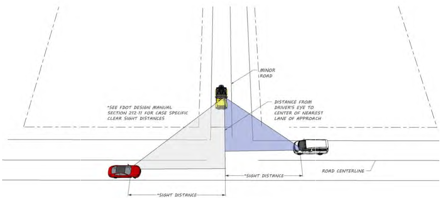
Sec. 407.11. - Use of public rights-of-way and obstruction to vision at road intersections.
(a)
Use of public rights-of-way. The sale, storage, or display of merchandise or goods within any public right-of-way is prohibited.
(b)
Obstruction to vision at road intersections. In order to minimize accidents caused by obstruction to vision at road intersections, the following regulations shall apply in all districts:
(1)
Within the area formed by the rights-of-way lines of intersecting roads and a straight line connecting points on such rights-of-way lines there shall be a clear space with no obstruction to vision between the height of three (3) feet and a height of eight (8) feet above the average grade of each road as measured at the centerline that is consistent with criteria outlined in the Florida Department of Transportation's Manual of Uniform Minimum Standards for Design, Construction and Maintenance for Streets and Highways.
(2)
The requirements of this Section shall not be deemed to prohibit any necessary retaining wall.
(3)
Trees, either existing or newly planted, shall be permitted in the clear space, provided that foliage is cut away within the prescribed heights.
(Ord. No. 05-10, § 2, 12-8-05; Ord. No. 06-14, § 2(Exh. A), 7-20-06; Ord. No. 15-06, § 2(Exh. A), 4-14-15; Ord. No. 2020-25, § 2(Exh. A), 11-10-20; Ord. No. 2021-12, § 2(Exh. A), 9-28-21)
Sec. 407.12.- Purpose.
The purpose of this Article is to provide standards to reduce traffic congestion and require parking and loading facilities in proportion to the parking demand for each use in order to ensure functionally adequate, aesthetically pleasing, and secure off-street parking and loading facilities.
(Ord. No. 05-10, § 2, 12-8-05; Ord. No. 2020-25, § 2(Exh. A), 11-10-20)
Sec. 407.13. - Applicability.
Every use of a building or land hereafter established shall provide parking and loading spaces as required by this Article in addition to the Florida Accessibility Code and the Fair Housing Act. Re-striping or re-paving of spaces shall comply with Florida Accessibility Code and The Fair Housing Act.
(Ord. No. 05-10, § 2, 12-8-05; Ord. No. 2020-25, § 2(Exh. A), 11-10-20; Ord. No. 2025-06, § 2(Exh. A), 3-25-25)
Sec. 407.14. - Parking schedule.
In all districts, the number of parking spaces shall be provided in accordance with Table 407.14.1. The number of spaces may be exceeded or reduced by up to ten (10) percent. Applicants proposing greater than ten (10) percent variation must comply with Section 407.18.
(a)
Motorcycle parking. One (1) motorcycle space shall be required per forty (40) vehicle spaces required by this Section. Motorcycle spaces are optional if less than forty (40) vehicle spaces are required. Motorcycle stalls shall be clearly labeled as such.
(b)
Unlisted uses. For uses not listed in Table 407.14.1, the number of required spaces shall be based on a study prepared by the applicant that addresses:
(1)
Type of use or uses and estimated total number of trips generated during peak conditions;
(2)
Estimated parking duration per vehicle trip (turnover rates); and
(3)
Estimated number of employees.
(Ord. No. 05-10, § 2, 12-8-05; Ord. No. 06-14, § 2(Exh. A), 7-20-06; Ord. No. 09-01, § 2(Exh. A), 2-24-09; Ord. No. 09-05, § 2(Exh. A), 9-8-09; Ord. No. 12-09, § 2(Exh. A), 10-9-12; Ord. No. 2020-25, § 2(Exh. A), 11-10-20; Ord. No. 2025-06, § 2(Exh. A), 3-25-25)
Sec. 407.15. - Bicycle parking.
Bicycle parking shall be provided by all educational facilities (as well as vocational, business, or technical schools), multiple-family dwellings, commercial, institutional, and industrial uses.
(a)
Spaces. Bicycle parking spaces are comprised of Class I, Class II, or Class III facilities.
(1)
Class I. Bicycle lockers are generally rectangular enclosures, each holding one (1) or two (2) bicycles.
(2)
Class II. Bicycle parking racks which allow all three (3) major components of the bicycle, back wheel, frame, and front wheel, to be locked, without removal of the front wheel.
(3)
Class III. Stands and racks such as hitching posts, rails, and inverted "U" racks. Common properties in a Class III facility include its support of the bicycle with or without the front wheel removed, its attractiveness and post or pipe dimensions which allow the use of the popular U-locks. Class III facilities are recommended for short-term parking, although, in combination with shelter, they may be adequate for long-term storage.
(b)
Number of spaces.
(1)
A minimum of one (1) bicycle parking space shall be provided for every ten (10) required vehicular spaces or two (2) spaces for each public and employee entrance, whichever is greater. The DRC may require additional spaces for educational facilities, libraries, and recreational facilities.
(2)
For multiple-family dwellings, a minimum of twenty-five (25) percent of the required spaces shall be Class I bicycle lockers or sheltered Class II or III facilities to provide for long term storage.
(3)
For nonresidential developments requiring twenty (20) or more spaces, a minimum of twenty-five (25) percent of the required spaces shall be Class I bicycle lockers or sheltered Class II or III facilities.
(4)
New retail, office, institutional and industrial buildings of more than fifty thousand (50,000) square feet in area shall provide employee showers, lockers, and changing areas to facilitate bicycle and pedestrian commuting. Buildings with a single shower shall have a secure unisex facility. Buildings with multiple showers shall have gender specific facilities.
(c)
Location of facilities. All bicycle parking facilities shall be located to provide for convenient bicycle parking which shall be separated from automobile parking by a physical barrier or by a minimum of five (5) feet. Bicycle parking facilities shall be located on the same lot or parcel of land as the use for which such facilities are required and as close to the public and employee entrances as possible without interfering with the flow of pedestrian and vehicular traffic. For nonresidential developments, any sheltered spaces required shall be connected to the building where possible without interfering with the flow of pedestrian and vehicular traffic.
(d)
Surfacing. The minimum parking area shall be provided with a hard-surface, all-weather pavement of asphalt or concrete, and shall be so graded and drained as to provide for the adequate runoff and disposal of surface water. Supplemental parking may be on alternative surfaces.
(e)
Access to facilities. Convenient access to bicycle parking facilities shall be provided and shall minimize travel distances from adjoining sidewalks and pathways to the bicycle parking facilities. Where access is via a sidewalk or pathway, curb ramps shall be installed as appropriate.
(Ord. No. 05-10, § 2, 12-8-05; Ord. No. 07-07, § 2(Exh. A), 4-27-07; Ord. No. 2020-25, § 2(Exh. A), 11-10-20)
Sec. 407.16. - Signage and marking.
All required parking areas shall be striped or marked to show parking spaces and driving aisles. Spaces for motorcycles, persons with disabilities, and bicycles shall be clearly marked. Parking lot signage and marking shall conform with the Manual of Uniform Traffic Control Devices and the Americans with Disabilities Act and shall contain no commercial messages.
(Ord. No. 05-10, § 2, 12-8-05; Ord. No. 2020-25, § 2(Exh. A), 11-10-20)
Sec. 407.17. - Reserved.
Sec. 407.18. - Parking increases.
Applicants for development plan review may exceed the off-street parking schedule in Table 407.14.1 by greater than ten (10) percent by providing sufficient documentation that demonstrates increased parking demand. Applicants seeking an increase in parking shall provide a parking study consistent with Subsection 407.14(b). In all cases, the applicant shall provide sufficient documentation to the appropriate reviewing body to clearly establish that parking needs shall be accommodated.
(Ord. No. 05-10, § 2, 12-8-05; Ord. No. 07-07, § 2(Exh. A), 4-27-07; Ord. No. 09-01, § 2(Exh. A), 2-24-09; Ord. No. 12-09, § 2(Exh. A), 10-9-12; Ord. No. 2020-25, § 2(Exh. A), 11-10-20; Ord. No. 2025-06, § 2(Exh. A), 3-25-25)
Sec. 407.19. - Parking area design standards.
(a)
Parking lot layout. Parking lots may be in different configurations with regard to the angle of the space with the direction of travel of traffic in the aisles. Parallel parking has a zero angle while perpendicular parking has a 90-degree angle. Angled parking is generally laid out at 30-, 45-, 60-, or 75-degree angles.
(b)
Minimum stall and aisle dimensions.
(1)
Parking spaces shall have a minimum width of eight and one-half (8.5) feet except where otherwise provided in this Article;
(2)
The other dimensions of parking spaces and the aisles providing access to such spaces shall meet the dimensional requirements provided in Table 407.19.1.
(3)
For parking spaces at a 90-degree angle to the aisle (perpendicular parking) and with a width of nine (9) feet or more, the aisle width may be reduced to twenty-two (22) feet.
(c)
Other space sizes.
(1)
Parallel spaces shall be a minimum of twenty-two (22) feet long by a dimension between seven (7) and nine (9) feet wide. A line of parallel parking spaces will not require marking in 22-foot intervals unless the parking is to be metered.
(2)
Motorcycle spaces shall be a minimum of eight (8) feet long by six (6) feet wide.
(d)
Conformance with Americans with Disabilities Act. The design of all parking areas shall conform with current standards under the Americans with Disabilities Act (ADA), including the required number of reserved spaces for person with disabilities and van accessible spaces. ADA compliant parking space details, signage and accessible routes shall be provided on the final development plan to ensure compliance with all applicable standards.
(e)
Wheel stop requirement. Parking wheel stops are required if the adjacent sidewalk width is less than six (6) feet. Wheel stops shall not be required for grassed parking except where necessary for protection of natural resources or stormwater management facilities.
(Ord. No. 05-10, § 2, 12-8-05; Ord. No. 09-05, § 2(Exh. A), 9-8-09; Ord. No. 12-09, § 2(Exh. A), 10-9-12; Ord. No. 2020-25, § 2(Exh. A), 11-10-20)
Sec. 407.20. - Location of off-street parking.
(a)
No parking space or vehicle overhang shall encroach upon the required landscape or sidewalk area, or the right-of-way of any public road, street, alley, or walkway.
(b)
There shall be no off-street parking in the front setbacks of residential districts except as normally exists in driveways.
(c)
Parking spaces for all uses shall be located on the same parcel as the principal building, except where parking is provided on another parcel under the same ownership or management as the principal use, and meets the following criteria:
(1)
Parking areas for nonresidential uses shall be provided not more than eight hundred (800) feet from the principal building, as measured along the nearest pedestrian walkway.
(2)
Parking areas for residential uses shall be provided not more than three hundred (300) feet from the principal building, as measured along the nearest pedestrian walkway.
(d)
The applicant for a building permit who proposes to use another parcel for off-street parking in order to meet the requirements of these regulations shall submit evidence of a restrictive covenant running with the land to be used for off-street parking purposes stating that such land shall not be encroached upon, used, sold, leased or conveyed for any other purpose until such time as the principal building ceases to be required to provide such off-street parking facilities.
(e)
No parking space shall be located within thirty (30) feet travel distance of the nearest right-of-way lines of a local collector roadway or within fifty (50) feet travel distance of the nearest right-of-way line of an arterial roadway.
(Ord. No. 05-10, § 2, 12-8-05; Ord. No. 09-05, § 2(Exh. A), 9-8-09; Ord. No. 2020-25, § 2(Exh. A), 11-10-20)
Sec. 407.21. - Off-street parking requirements.
Any off-street parking lot serving any use other than dwellings of three (3) units per building or less shall meet the following off-street parking lot requirements:
(a)
Screening. The parking area shall be screened in accordance with Subsection 407.43.1(c), Landscaping in paved surface areas.
(b)
Surfacing. A minimum of ten (10) percent of off-street parking areas shall be provided with a hard-surface, all-weather pavement of asphalt or concrete, and shall be so graded and drained as to provide for the adequate runoff and disposal of surface water. Alternative surfaces for parking may be proposed pending approval of the DRC. Supplemental parking shall be stabilized. Any parking spaces in excess of the amount suggested in Table 407.14.1 shall be pervious or semi-pervious. All requests for non-standard parking facilities shall be accompanied by sufficient documentation for the reviewing body to clearly establish the expected usage and suitability of the stabilized or alternative surface.
(c)
Lighting. Lighting of off-street parking areas shall be in compliance with the regulations established in Article XIV of Chapter 407.
(d)
Landscaping. Parking facilities shall meet the landscaping requirements of Article IV of this Chapter.
(Ord. No. 05-10, § 2, 12-8-05; Ord. No. 07-15, § 6, 9-11-07; Ord. No. 09-01, § 2(Exh. A), 2-24-09; Ord. No. 12-09, § 2(Exh. A), 10-9-12; Ord. No. 2020-25, § 2(Exh. A), 11-10-20)
Sec. 407.22. - Off-street loading requirements.
(a)
Every hospital, institution, commercial, or industrial building or similar use having a floor area of twenty thousand (20,000) square feet or more, and requiring the receipt or distribution by vehicle of materials or merchandise, shall have a minimum of one (1) permanent off-street loading space for each twenty thousand (20,000) square feet of gross floor area or fraction thereof. The loading area shall be located immediately adjacent to the principal building.
(b)
Retail operations, wholesale operations and industrial operations with a gross floor area of less than twenty thousand (20,000) square feet shall provide sufficient space for loading and unloading operations in order that the free movement of vehicles and pedestrians over a sidewalk, street, or alley shall not be impaired.
(c)
Every off-street loading and unloading space shall have direct access to a public street or alley, and shall have the following minimum dimensions: length, thirty (30) feet; width, twelve (12) feet; height, fourteen (14) feet.
(Ord. No. 05-10, § 2, 12-8-05; Ord. No. 2020-25, § 2(Exh. A), 11-10-20)
Sec. 407.23. - Off-street stacking requirements.
(a)
Stacking requirements. In addition to meeting the off-street parking standards, drive-through facilities shall provide a minimum of five (5) stacking spaces for each drive-through lane. Such spaces shall be designed so as to not create conflicts between pedestrian or vehicular circulation on the site or on any abutting street.
(b)
Circulation requirements. A vehicle pass-by lane may be required to be constructed to provide for complete, unimpeded circulation throughout the site.
(Ord. No. 05-10, § 2, 12-8-05; Ord. No. 09-01, § 2(Exh. A), 2-24-09; Ord. No. 2020-25, § 2(Exh. A), 11-10-20; Ord. No. 2025-06, § 2(Exh. A), 3-25-25)
Sec. 407.24.- Purpose.
It is the purpose of this Article to promote the health, safety, and welfare of the citizens of Alachua County by achieving balance among the following goals:
(a)
To encourage the effective use of signs as a means of communication within Alachua County;
(b)
To provide a means of wayfinding in the community, thus reducing traffic confusion and congestion;
(c)
To protect the safety and welfare of the public by minimizing hazards and distractions to pedestrian, bicycle, and vehicular traffic;
(d)
To maintain and enhance the aesthetic beauty of Alachua County by regulating, among other things, the appearance and design of signs;
(e)
To encourage economic development and growth in the community;
(f)
To ensure that signage within Alachua County is compatible with the zoning district and land use category for the property on which the sign is placed;
(g)
Foster the integration of signage with architectural and landscape designs;
(h)
Establish sign size in relationship to the scale of the lot and building on which the sign is to be placed;
(i)
To the extent allowed, ensure that signs are properly constructed, installed, and maintained in a safe and satisfactory manner, and protect the public from unsafe signs;
(j)
To allow for traffic control devices or signs that conform with the Manual of Uniform Traffic Control Devices and promote highway safety and efficiency;
(k)
To provide broadly for the expression of individuals through the use of signs on private property.
(Ord. No. 2016-16, § 2, 8-9-16; Ord. No. 2020-25, § 2(Exh. A), 11-10-20)
Sec. 407.25. - Definitions.
(a)
Animated sign: Any sign that uses movement or change of lighting to depict action or to give the impression of action, whether animated or otherwise, including, but not limited to, signs held or worn by a person. "Electronic message center sign" is specifically excluded from this definition.
(b)
Banner sign: A temporary sign made of wind and weather resistant cloth or other lightweight material, intended to hang either with or without frames or in some other manner as not to be wind activated, and possessing characters, letters, illustrations, or ornamentations applied to paper, plastic, or fabric of any kind. Flags shall not be considered banners for the purpose of this definition.
(c)
Building sign: Any sign attached parallel to and extending not more than eighteen (18) inches from the facade of any building to which it is attached, painted on the wall surface or erected and confined within the limits of an outside wall of any building, which is supported by such wall or building, and which displays only one (1) sign surface.
(d)
Changeable copy sign: The portion of a sign designed so that letters or numbers attached to the sign can be periodically changed to indicate a different message. Changeable copy includes letters or numbers that are changed manually as well as electronically.
(e)
Driveway sign: Signs placed at driveways or entrances to properties, excluding individual residential lots.
(f)
Electronic message center sign: A changeable copy sign with a variable message that utilizes computer-generated messages or some other electronic means of changing copy, including but not limited to incandescent lamps, LEDs, LCDs or a flipper matrix.
(g)
Feather sign: A freestanding temporary sign typically constructed with a plastic or metal shaft driven in the ground and an attached pennant typically in the shape of a feather, teardrop or rectangle that is vertically elongated and attached to the shaft.
(h)
Flag: A temporary sign affixed to a flagpole or bracket consisting of a piece of cloth, fabric, or other non-rigid material that is horizontally elongated or square.
(i)
Flagpole: A pole on which to raise a flag.
(j)
Flashing sign: A sign, the illumination of which does not have constant intensity at all times when in use, and which exhibits sudden or marked changes in lighting effects, including any sign with a strobe light or strobe-like effect.
(k)
Freestanding sign: Any sign supported by upright structural members or by braces on or in the ground and not attached to a building.
(l)
Illuminated sign: A sign or advertising structure in which a source of light is used in order to make the message visible, and shall include internally or externally lighted signs.
(m)
Monument sign: A sign constructed on the ground with a continuous footing or foundation with the base at grade.
(n)
Multifaced sign: A sign or advertising structure containing more than one (1) sign face.
(o)
Pennant sign: Any lightweight plastic, fabric, or other material suspended on both sides from a rope, wire, or string, usually in series, designed to move in the wind.
(p)
Off-site sign: A sign or advertising structure that directs attention to a business, product, service, or entertainment conducted, sold, or offered at a location other than the premises on which the sign is located.
(q)
Pole or pylon sign: A freestanding sign supported permanently upon the ground by a single pole or brace and not attached to any building.
(r)
Portable sign: Any sign not permanently attached to the ground or other permanent structure or a sign to be transported, including, but not limited to, signs designed to be transported by means of wheels; signs made as A-frames or T-frames; balloons used as signs.
(s)
Portico or entry sign: A free-hanging sign mounted underneath a portico, awning, or entryway.
(t)
Projecting sign: A sign attached perpendicular to a building or other structure.
(u)
Sign: Any attention-attracting device, fixture, placard, or structure, that communicates information of any kind to the public, including those held or worn by a person. For the purposes of this ULDC, the term "sign" shall not include the following objects: graveyard and cemetery markers, vending machines, gas pumps, on-site umbrellas, mail drop-off boxes, seasonal decorations left up no more than sixty (60) days, a building's architectural features, or a manufacturer's markings on machinery or equipment.
(v)
Sign area: The area enclosed by the perimeter of the sign faces.
(w)
Sign face: The part of the sign that is or can be used for communication purposes.
(x)
Temporary sign: Any sign made of a material that is not of a durable nature or intended for permanent use, such as vinyl, corrugated plastic, fabric or plywood.
(Ord. No. 2016-16, § 2, 8-9-16; Ord. No. 2020-25, § 2(Exh. A), 11-10-20)
Sec. 407.26. - Applicability.
Unless otherwise provided, this Article shall apply to all signs erected, placed, constructed, painted, installed, or maintained. However, this Article does not apply to the following:
(a)
Certain architectural features to buildings in non-residential zoning districts, regardless of the fact that such features may be in part representational and may for some purposes be considered "attention attracting devices" and thus fall under the definition of "sign." Features to which this Article is not applicable are features which meet all of the following criteria:
(1)
The feature is an architectural part of the building;
(2)
The surface area of any portion of the feature that is distinctly separate from adjoining elements of the building walls or roof by color, material or texture, shall not be larger than fifteen (15) percent of each of the building elevations from which it is being viewed; if the feature is three-dimensional, for this purpose the area of the feature shall be measured as though it is two-dimensional when viewed from the side of the building from which the feature is most clearly visible and only the actual area of the feature will be used in computing the fifteen (15) percent;
(3)
The feature contains no words, numbers or symbols, although the feature itself may be considered a symbol;
(4)
The feature may be internally illuminated, provided such illumination does not violate the prohibitions of Section 407.28 of this ULDC.
(b)
The outdoor display of products where allowed under Chapter 404 of this ULDC. This Article shall, however, apply to any sign, banner, pennant, or other attention-attracting device affixed to a product displayed outdoors. For example, the label "Chevrolet" on an automobile or "John Deere" on a tractor shall not be considered a sign for purposes of this Article, but a separate sign attached to such a product shall be considered a sign and be subject to regulation.
(c)
Signs located entirely inside the premises of a building or enclosed space provided that such signs cover less than fifty (50) percent of the surface area of any window.
(d)
A sign on a serviceable vehicle otherwise used in the day-to-day operations of a business. For the purposes of this Section, a serviceable vehicle shall mean any vehicle not meeting the definition of an unserviceable vehicle in Chapter 74 of the Alachua County Code.
(Ord. No. 2016-16, § 2, 8-9-16; Ord. No. 2020-25, § 2(Exh. A), 11-10-20; Ord. No. 2021-12, § 2(Exh. A), 9-28-21)
Sec. 407.27. - Construction and interpretation.
(a)
All signs erected, placed, constructed, painted, installed, or maintained shall require a sign permit unless otherwise exempted by this Article. In all applications for permits where a matter of interpretation under this Article arises, the most restrictive interpretation shall prevail in order to carry out the purpose of this Article. This Article shall otherwise be interpreted liberally in order to carry out and accomplish its purpose.
(b)
Where other federal, state, or county sign or outdoor advertising regulations are in effect and are more restrictive than the provisions of this Article, the more restrictive provisions shall prevail, including, but not limited to, the following:
(1)
13th Street Corridor Design Standards, Subsection 405.23(b)(5) of this ULDC;
(2)
Scenic Road Corridors Overlay, Subsection 405.38(g)(4) of this ULDC.
(c)
The area of a sign face shall be computed by means of the smallest square, circle, rectangle, triangle, or combination thereof that will encompass the extreme limits of the writing, representation, emblem, or other display, together with any material or color forming an integral part of the background of the display or used to differentiate the sign from the backdrop or structure against which it is placed, but not including any supporting framework, bracing, or decorative fence or wall that otherwise meets the regulations of the zoning code and is clearly incidental to the display itself. The sign areas of painted wall signs or flat signs, when composed of letters only (whether script or printed letters), shall be the sum of the areas of the smallest contiguous rectangles each capable of containing one such letter.
(d)
For signs with two (2) or more parallel sides where the greatest distance between the faces is three (3) feet or less, only one (1) display face shall be measured in computing sign area. If the faces of a multifaced sign are of unequal area, the area of the sign shall be the area of the larger face. In all other cases, the areas of all faces of a multifaced sign shall be added together to compute the area of the sign.
(e)
The height of a sign shall be computed as the vertical distance from the highest point of the sign structure to the elevation of the centerline of the adjacent street or highway from which the principal access is provided, or the ground elevation at the base of the sign, whichever distance is less. The centerline elevation shall be taken at a point which is defined by extending a horizontal line from the sign, which is perpendicular to the centerline of the street or highway.
(f)
Determination of visibility or legibility.
(1)
Where this Article requires a determination of "visibility" or "legibility," the standard shall be based on the eyesight of an adult eligible to receive a Florida driver's license (wearing any corrective lenses required by such license). Where the height of the person is material to the determination, the person shall be presumed to be six (6) feet tall.
(2)
In determining visibility of a sign from a residential property, it shall be assumed that a two-story residence will occupy the property with second-story windows facing toward the sign.
(g)
Limits on the number of freestanding signs allowed on a site shall apply to permanent, freestanding signs only; signs exempt from permit requirements or exempt from this Article under Section 407.29 shall not be considered in determining the number of signs allowed on a site. The lot or site to which numerical limits are applicable under this Article shall be the larger of the following:
(1)
A platted lot or other separately owned parcel; or
(2)
A site for which a preliminary development plan has been approved.
(h)
Notwithstanding anything contained in this Article to the contrary, any sign erected pursuant to the provisions of this Article may, at the option of the owner, contain a non-commercial message in lieu of a commercial message and the non-commercial copy may be substituted at any time in place of the commercial copy. The non-commercial message may occupy the entire sign face or any portion thereof. The sign face may be changed from a commercial message to a non-commercial message or from one non-commercial message to another non-commercial message; provided, however, that there is no change in the size, height, setback, or spacing criteria contained in this Article.
(Ord. No. 2016-16, § 2, 8-9-16; Ord. No. 2020-25, § 2(Exh. A), 11-10-20; Ord. No. 2021-12, § 2(Exh. A), 9-28-21)
Sec. 407.28. - Prohibited signs.
(a)
The following signs and sign types listed below are prohibited within the County and shall not be erected, operated, or placed on any property:
(1)
Off-site signs;
(2)
Animated signs.
(3)
Building signs that extend more than eighteen (18) inches from the wall of the building to which the sign is attached, or above the eave line of the wall to which it is attached, except that signs mounted to architectural elements extended above the eave line may be allowed.
(4)
Changeable copy signs on which the message changes more than one (1) time in a five-minute period that are legible from a public way or private property other than the site on which the sign is located.
(5)
Flashing signs.
(6)
Floodlights and beacon lights, except when required by the Federal Aviation Administration.
(7)
Holographic display signs.
(8)
Streamers, ribbons, balloons, wind signs, wind activated banners, cold air inflatables, pennants, and other fixed aerial signage, except that this prohibition shall not apply to flags conforming with Section 407.36 of this Article.
(9)
Permanent pole or pylon signs, excluding driveway signs, except where the sign is supported by a pole with a pole cover that has a width greater than or equal to fifty (50) percent of the sign face.
(10)
Portable signs, including, but not limited to, A-frames and trailer signs, except as provided for sidewalk signs under Subsection 407.31(a)(5).
(11)
Signs located on a roof or that impair access to the roof.
(12)
Signs that obstruct a clear view of pedestrian, bicycle, or vehicular traffic.
(13)
Signs in, on, or over the public right-of-way, unless otherwise provided for in Section 407.39.5 of this Article.
(14)
Signs affixed to utility poles, other than signs placed there by the pole owner or operator.
(15)
Signs nailed, fastened, affixed to, or painted on any tree or other vegetation, or part thereof (living or dead), or rocks or other natural features.
(16)
Signs that are not effectively shielded as to prevent beams or rays of light from being directed at any portion of the traveled public rights-of-way, thereby creating a potential traffic or pedestrian hazard or a nuisance to inhabitants of an adjacent neighborhood.
(17)
Signs that obstruct or interfere with ventilation openings.
(18)
Signs that are illuminated in a way that interferes with the effectiveness of, or obscures, an official traffic sign, device, or signal.
(19)
Signs that in any way simulate emergency vehicles.
(20)
Signs that simulate traffic control signs and devices, directional, information, and warning signs.
(21)
Signs that obstruct any fire escape or any door or opening used as a means of ingress or egress for a building or structure.
(22)
Signs on public property, unless expressly allowed by the public entity that owns the land.
(23)
Signs that emit sound, vapor, smoke, odor, or gaseous matter.
(24)
Signs that obstruct, conceal, hide, or otherwise obscure from view any traffic control device sign or official traffic signal.
(25)
Signs on unserviceable vehicles as defined in Chapter 74 of the Alachua County Code.
(b)
Any lawfully existing permanent sign structure or sign type that is among the prohibited signs listed above shall be deemed a non-conforming sign, pursuant to Section 407.39 of this Article.
(Ord. No. 2016-16, § 2, 8-9-16; Ord. No. 2020-25, § 2(Exh. A), 11-10-20)
Sec. 407.29. - Exemptions.
(a)
The following signs shall be exempt from the permit requirements and other standards of this Article but shall, to the maximum extent allowed by law, be subject to the other standards of this ULDC:
(1)
Signs conforming with the Manual of Uniform Traffic Control Devices.
(2)
Signs required by a state or federal statute, or local regulation.
(3)
Signs required by an order of a court of competent jurisdiction.
(4)
Signs installed by public utilities in their rights-of-way or on their facilities.
(5)
Signs installed by a transit company with a franchise or other right to operate in Alachua County, where such signs are installed along its routes;
(6)
Signs approved as part of a temporary use permit in accordance with Subsection 402.154(a).
(7)
Signs for outdoor recreation facilities mounted on an interior wall, fence, or building and facing into the facility not toward a public way, provided such signs are not independently illuminated.
(8)
Any sign that is not visible from a public way or from private property other than the site on which the sign is located, except that an electrical permit is still required, if applicable.
(9)
Any outdoor lighting or strings of lights used as a light source in an outdoor area.
(10)
Any freestanding architectural features meeting the definition of a sign under this Article that do not exceed ten (10) feet in height and is not illuminated by internal or external illumination.
(b)
The following signs shall be exempt from the permit requirements of this Article but shall be subject to all other standards of this Article.
(1)
Signs installed by or on behalf of County employees or officials of Alachua County and not falling under one of the broader exemptions of Subsection (a) above;
(2)
Building signs up to two (2) square feet in area;
(3)
Temporary signs allowed in accordance with this Article;
(4)
Signs where only the face or other surface is altered or replaced and the size, height, and location are not changed, excluding any change where an electrical permit is required;
(5)
Sidewalk signs, as allowed in this Article;
(6)
Driveway signs, as allowed in this Article;
(7)
Outline lighting on principal buildings allowed in accordance with Subsection 407.31(d) of this ULDC; and
(8)
Banner signs on private property that meet the following standards:
a.
A banner may be attached to a light pole or other pole structure serving another purpose on the site and not installed simply to hold the banner;
b.
Each banner must be affixed to a permanent frame at the top and bottom, preventing significant movement in the wind;
c.
Banners, once installed, must be repaired or replaced as necessary, to maintain them in good condition;
d.
No banner shall be larger in area than a number of square feet computed by dividing the height of the pole by three (3) and rounding the result up to the nearest whole number. This area limit shall be measured on one (1) side, but the banner may have messages or images on both sides; and
e.
There shall be no more than two (2) banners attached to each pole.
(Ord. No. 2016-16, § 2, 8-9-16; Ord. No. 2020-25, § 2(Exh. A), 11-10-20)
Sec. 407.30. - Signs in residential developments (excluding agriculture zoning).
(a)
Permanent signs in residential developments.
(1)
Permanent freestanding signs at external entrances to single-family and multi-family developments or subareas within those developments shall comply with the following:
a.
One (1) sign is allowed for each point of ingress or egress, except as provided herein;
b.
The maximum surface area of the sign shall be thirty-two (32) square feet;
c.
The maximum height shall be eight (8) feet;
d.
The thirty-two (32) square feet of sign area may be split equally to allow for one (1) sign located on each side of the entry or exit street;
e.
The sign(s) shall be located on a landscaped island or lawn area in a manner that does not obstruct vehicular, bicycle, or pedestrian traffic and does not encroach into any corner sign visibility; and
f.
The sign may be externally illuminated.
g.
Where such signs are located within the public right-of-way, a right-of-way use permit must be obtained in accordance with Section 407.39.5 of this Article.
(2)
Driveway signs are allowed internal to single-family and multi-family residential developments at driveways and entrances in accordance with the following:
a.
One (1) sign is allowed for each point of ingress or egress, except that no such signs are allowed on single-family residential lots;
b.
The maximum surface area of the sign shall be six (6) square feet; and
c.
The maximum height shall be four (4) feet.
(3)
Single-family dwellings are each allowed a single building sign that is a maximum of two (2) square feet in area.
(4)
Multi-family dwellings are allowed one (1) building sign per building, not to exceed six (6) square feet. For buildings in which access to units is from common hallways, one (1) permanent building sign is allowed for each public entrance to such building.
(b)
Temporary signs in residential developments. Temporary signs in residential developments shall comply with the following:
(1)
At the time a property is under development, one (1) temporary sign up to thirty-two (32) square feet in area and eight (8) feet in height may be placed at each entrance to the development, or the thirty-two (32) square feet may be split into two (2) separate signs up to eight (8) feet in height.
(2)
In addition, up to six (6) feather signs are allowed at each entrance to a residential development. Such signs may not exceed twelve (12) feet in height and sixteen (16) square feet in area, may not be placed in the right-of-way, and must be removed upon the transfer of title to ninety (90) percent or more of the available lots, dwellings, or dwelling units included in the approved plat.
(3)
At any time three (3) additional temporary signs up to sixteen (16) square feet and eight (8) feet in height may be placed at each entrance to a development.
(4)
A total of three (3) temporary signs per dwelling are allowed in single-family residential developments and a total of three (3) temporary signs per driveway are allowed in multi-family residential developments. Each such sign may be up to six (6) square feet and four (4) feet in height.
(Ord. No. 2016-16, § 2, 8-9-16; Ord. No. 2020-25, § 2(Exh. A), 11-10-20)
Sec. 407.31. - Signs in nonresidential developments.
(a)
Permanent signs in nonresidential developments.
(1)
Freestanding signs.
a.
On an individual site with a single tenant a single freestanding sign is allowed.
b.
On a site with multiple tenants in one or more buildings, one (1) permanent freestanding sign per four hundred (400) feet of street frontage shall be allowed. The computation for "street frontage" in this paragraph shall include frontage along any nonresidential or mixed-use streets internal or external to the development that are dedicated to the County or State as public streets or are private streets built to County standards, In no case shall there be more than three (3) freestanding signs on a single street frontage external to the site.
c.
The maximum sign area for freestanding signs shall be fifty (50) square feet.
d.
Sign height shall not exceed ten (10) feet.
(2)
Building, projecting and awning signs.
a.
The maximum sign area for all building, projecting and awning signs shall not exceed one-fourth (¼) of the front building elevation area of the principal building(s) or individual storefront where there are multiple tenants per building.
b.
For multi-tenant buildings, the total number of building, projecting, and awning signs shall not exceed the number of public entrances on the principal building(s) plus two (2). There is no limit on the number of building, projecting or awning signs for single tenant buildings.
c.
For projecting signs, the height of the top edge of the sign shall not exceed the height of the wall from which it projects.
d.
For buildings with a front elevation of five thousand (5,000) square feet or less, individual signs shall not exceed three hundred (300) square feet in size. For buildings with a front elevation greater than five thousand (5,000) square feet, individual signs shall not exceed six hundred (600) square feet.
e.
Building signs shall not extend above the principal portion of the building to which they are attached. For the purposes of this Section, the principal portion of the building includes architectural elements no greater than ten (10) feet in height above the eave line of the principal building in non-residential areas other than TODs, and no greater than twenty (20) feet above the eave line of the principal building for non-residential areas within TODs.
(3)
Portico and entry signs. For portico or entry signs, the distance from the nearest edge of the sign to the ground shall be a minimum of seven and one-half (7.5) feet. Portico or entry signs shall not exceed six (6) square feet per side.
(4)
Window or door signs. Signs attached to windows or doors are allowed subject to the following.
a.
The maximum sign area shall be fifty (50) percent of the transparent portion of the window or door.
b.
Signs shall be silk-screened, painted, vinyl, or etched.
(5)
Sidewalk signs. Sidewalk signs shall be allowed on sidewalks on private property but not on public sidewalks, subject to the following standards:
a.
Signs shall not exceed six (6) square feet in area per side. There shall be a maximum of one (1) such sign per storefront.
b.
The sign location shall not interfere with pedestrian or vehicular circulation or sightlines.
c.
Sidewalk sign placement shall leave a minimum of five (5) feet of sidewalk clearance.
d.
All sidewalk signs shall be located in front of the building.
e.
Sidewalk signs shall only be set out while the business is open and must be taken indoors when the business is closed.
(6)
Driveway signs. Driveway signs are allowed internal to nonresidential developments at driveways and entrances in accordance with the following:
a.
One (1) sign is allowed for each point of ingress or egress;
b.
The maximum surface area of the sign shall be six (6) square feet;
c.
The maximum height shall be four (4) feet.
(7)
Drive-through lane signs. For a drive-through establishment, an additional sign is allowed for each drive-through lane provided that such sign does not exceed forty (40) square feet in size and does not exceed eight (8) feet in height. The additional sign may be internally illuminated and may emit sounds, so long as the sounds comply with Chapter 110 of the Alachua County Code.
(b)
Permanent freestanding signs in transit-oriented developments (TOD).
(1)
TOD developments may provide the following signage for nonresidential uses:
a.
Along external roadways, one (1) permanent freestanding sign is allowed per four hundred (400) feet of exterior street frontage. The computation of "street frontage" shall include frontage along all external streets.
b.
One or more of the permanent freestanding signs allowed by the calculation in Subsection 407.31(a)(1) may be located at primary project entrances from external streets, even if such entrances do not front an external street.
c.
In no case shall there be more than three (3) permanent freestanding signs along an individual street frontage external to the site, except where such frontage is separated by an arterial roadway or by Interstate 75.
d.
All permanent freestanding signs along external roadways shall be multi-tenant signs, except that an anchor tenant with a building seventy-five thousand (75,000) square feet or greater in size may be allowed to utilize one of the permanent freestanding signs allowed along I-75 in accordance with this Section.
e.
Internal to the site, single use buildings are allowed a permanent freestanding monument sign that does not exceed twenty-four (24) square feet in area and four (4) feet in height.
f.
Those freestanding signs exempted under Section 407.29 shall not count toward the number of freestanding signs allowed on the site.
g.
Signs allowed under this Subsection shall be monument signs as defined in this ULDC.
h.
The copy area of signs allowed under this Subsection shall not exceed 40 percent of the total sign area.
i.
Permanent freestanding signs along external roadways allowed under this Subsection are subject to the following dimensional standards provided in Table 407.31.1.
(2)
A freestanding signage plan shall be submitted to the Department for review and approval. This plan shall be consistent with and cover the entire area of an approved preliminary TOD master plan. The freestanding signage plan shall detail the height, size, and location of all proposed freestanding signs permitted or allowed under this Subsection as determined by the calculations and allowances for such signs and the dimensional standards in this Subsection. All subsequent sign permit applications for permanent freestanding signs within the development must be consistent with an approved freestanding signage plan.
(c)
Temporary signs in nonresidential developments. Two (2) temporary freestanding signs up to thirty-two (32) square feet in area and up to eight (8) feet in height may be allowed on a nonresidential development site. For properties with more than twenty-five (25) acres of non-residential development, one (1) additional temporary sign is allowed for every additional twenty-five (25) acres of nonresidential uses. Such signs shall not be illuminated.
(d)
Illumination of signs in nonresidential developments (excluding A-RB).
(1)
Signs in nonresidential developments may be illuminated by direct, indirect, or internal lights. Outline lighting may be allowed for any building in a nonresidential development along the edge of a roofline, not to exceed six (6) inches in width, provided such lighting is a single color and does not violate the prohibitions of Section 407.28.
(2)
Permanent freestanding signs, except those located along the Interstate 75 corridor, may contain internally illuminated electronic message centers, subject to the following standards:
a.
The electronic message center shall occupy no more than twenty (20) percent of a sign's total square footage or ten (10) square feet, whichever is less.
b.
The electronic message center shall consist of a dark background, with monochromatic lettering that does not flash or move.
c.
The message displayed in an electronic message center shall not change more than once in a five-minute period.
(e)
Illumination of signs in the A-RB zoning district. A sign in the A-RB zoning district may be separately illuminated by external, direct, white light, which shall not flash or move, and which shall not result in glare at the nearest property line.
(Ord. No. 2016-16, § 2, 8-9-16; Ord. No. 2020-25, § 2(Exh. A), 11-10-20)
Sec. 407.32. - Signs in mixed-use developments.
In mixed-use developments, the residential portions of the development, including the residential portion above any nonresidential area, shall adhere to the requirements of Section 407.30, Signs in residential developments. The nonresidential portions of a mixed-use development, excluding the residential portion above any nonresidential area, shall adhere to the requirements of Section 407.31, Signs in nonresidential developments.
(Ord. No. 2016-16, § 2, 8-9-16; Ord. No. 2020-25, § 2(Exh. A), 11-10-20)
Sec. 407.33. - Signs in conservation and preservation areas.
Designated conservation and preservation areas, whether publicly or privately owned, may have the following signs on the property:
(a)
Up to three (3) permanent freestanding signs may be allowed. One (1) such sign may be up to fifty (50) square feet in area and up to ten (10) feet in height, and the two (2) additional signs may be up to sixteen (16) square feet in area and up to eight (8) feet in height.
(b)
Each building or structure on the property may have one (1) wall or building sign up to six (6) square feet in area.
(c)
Each property may have one (1) temporary sign up to thirty-two (32) square feet and eight (8) feet in height, or the thirty-two (32) square feet may be split to allow two (2) separate signs.
(d)
Each property may have one (1) driveway sign per entrance, up to six (6) square feet in area and up to four (4) feet in height.
(e)
Illumination of signs in conservation and preservation areas is prohibited.
(Ord. No. 2016-16, § 2, 8-9-16; Ord. No. 2020-25, § 2(Exh. A), 11-10-20)
Sec. 407.34. - Signs in the agriculture (A) district.
(a)
Permanent signs in the agriculture (A) district.
(1)
Permanent freestanding signs at external entrances to single-family and multi-family developments or subareas within those developments in the agriculture district shall comply with the following:
a.
One (1) sign is allowed for each point of ingress or egress, except as provided herein;
b.
The maximum surface area of the sign shall be thirty-two (32) square feet;
c.
The maximum height shall be eight (8) feet;
d.
The thirty-two (32) square feet of sign area may be split equally to allow for one (1) sign located on each side of the entry or exit street;
e.
The sign(s) shall be located on a landscaped island or lawn area in a manner that does not obstruct vehicular or pedestrian traffic and does not encroach into any corner sight visibility; and
f.
The sign may be externally illuminated.
(2)
In addition, up to six (6) feather signs may be allowed at each entrance to a residential development. Such banners may not exceed twelve (12) feet in height and sixteen (16) square feet in area, may not be placed in the right-of-way, and must be removed upon the transfer of title to ninety (90) percent or more of the available lots, dwellings, or dwelling units included in the approved plat.
(3)
On any other property in the agriculture district, one (1) 32-square foot permanent freestanding sign is allowed, or the thirty-two (32) square feet of sign area may be split to allow two (2) separate signs. Such signs shall not exceed eight (8) feet in height.
(4)
For nonresidential uses in the agriculture district, in lieu of placing a freestanding sign or signs on the property, the thirty-two (32) square feet may be allocated to be used as building signage. The total number of building signs allowed shall be one (1) per public entrance plus two (2).
(5)
Driveway signs are allowed internal at driveways and entrances in the agriculture district in accordance with the following:
a.
One (1) sign is allowed for each point of ingress or egress;
b.
The maximum surface area of the sign shall be six (6) square feet;
c.
The maximum height shall be four (4) feet;
(b)
Temporary signs in the agriculture (A) district. Temporary signs in the agriculture district shall comply with the following:
(1)
At the time a property is under development, one (1) temporary sign up to thirty-two (32) square feet in area and eight (8) feet in height may be placed at each entrance to the development, or the thirty-two (32) square feet may be split into two (2) separate signs up to eight (8) feet in height.
(2)
At any time, one (1) additional temporary sign, up to sixteen (16) square feet in area, may be placed at each entrance to a development, or the sixteen (16) square feet may be split into two (2) separate signs. Such signs shall not exceed eight (8) feet in height.
(Ord. No. 2016-16, § 2, 8-9-16; Ord. No. 2020-25, § 2(Exh. A), 11-10-20)
Sec. 407.35. - Signs for institutional uses in residential or agriculture districts.
(a)
Permanent signs for institutional uses in residential or agriculture zoning districts. For any educational institution, religious institution or other institutional use located in a residential or agriculture zoning district, the following permanent signs shall be allowed in lieu of the permanent signs otherwise allowed in such districts:
(1)
For each principal institutional use; one freestanding sign not more than 50 square feet in area and not more than eight feet in height, which may include an electronic message center, subject to the illumination standards in Subsection (c) of this Section;
(2)
One building sign for each public entrance to the institution, each of which shall be no more than 32 square feet in area;
(3)
Onefence, wall, or building mounted sign per on-site use for those institutional uses that consist primarily of open uses of land including, but not limited to, recreation and preservation areas, each of which shall be no more than 32 square feet in area.
(b)
Temporary signs for institutional uses in residential or agriculture zoning districts.
(1)
At the time a property is under development, one temporary sign up to 32 square feet in area and eight feet in height may be placed at each entrance to the use, or the 32 square feet may be split into two separate signs up to eight feet in height.
(2)
At any time one other temporary freestanding or building sign up to 32 square feet in area and eight feet in height.
(3)
Such temporary signs shall not be separately illuminated.
(c)
Illumination of permanent institutional signs.
(1)
A permanent sign located on the site with an institutional use in an agriculture or residential zoning district may be illuminated by external direct, white light, which shall not flash or move, and which shall not result in glare at the nearest property line.
(2)
Permanent freestanding signs, except those located along the Interstate 75 corridor, may contain internally illuminated electronic message centers, subject to the following standards:
a.
The electronic message center shall occupy no more than 20 percent of a sign's total square footage or ten square feet, whichever is less.
b.
The electronic message center shall consist of a dark background, with monochromatic lettering that does not flash or move.
c.
The message displayed in an electronic message center shall not change more than once in a five-minute period.
(Ord. No. 2016-16, § 2, 8-9-16; Ord. No. 2020-25, § 2(Exh. A), 11-10-20)
Sec. 407.36. - Flags and flagpoles.
The display of flags on flagpoles or flag brackets shall be subject to the following limitations:
(a)
In residential developments and in the agriculture (A) zoning district, there shall be no more than one flagpole on a lot, and no flagpole shall exceed 20 feet in height, and no flag shall exceed the maximum dimensions of four feet high by six feet wide;
(b)
In nonresidential developments, there shall be no more than three flagpoles per principal building on any development site, and no flagpole shall exceed 30 feet in height, with a maximum dimension per flag of five feet high by eight feet wide, except that one flagpole may be up to 50 feet in height when placed at least 100 feet from any property line with a maximum dimension per flag of eight feet high by 12 feet wide. Each flagpole must be within 30 feet of the principal entrance to the building to which it is oriented;
(c)
All flagpoles shall be set back at least five feet from any property line;
(d)
No rooftop flagpoles shall be allowed in any zoning district;
(e)
No flagpole shall contain more than two flags;
(f)
For each principal structure on a parcel, up to two flag brackets may be attached or placed for the display of one flag per bracket.
(Ord. No. 2016-16, § 2, 8-9-16; Ord. No. 2020-25, § 2(Exh. A), 11-10-20; Ord. No. 2022-10, § 2(Exh. A), 5-10-22)
Sec. 407.37. - Sign permits.
(a)
Unless otherwise provided in this Article, the use, placement, construction, painting, or installation of signs requires a permit from Alachua County.
(b)
Applications for sign permits shall be submitted in accordance with Chapter 402 of this ULDC. In addition, two copies of the following shall be submitted along with the application describing and setting forth:
(1)
The type of sign;
(2)
The value of the sign or advertising structure;
(3)
All documents required by the applicable provisions of the Florida Building Code and the related National Electrical Code;
(4)
A copy of the approved development plan for the site, and a copy of the approved TOD freestanding signage plan, if applicable, pursuant to Subsection 407.31(b) of this Article, showing existing and proposed buildings and existing and proposed signs requiring permits on the site;
(5)
For building signs, the total area of the front building elevation of the principal building(s) and calculations of allowable sign area and the total number of public entrances per building or storefront where applicable for multi-tenant buildings;
(6)
For freestanding signs, all dimensions shown at a scale of ½" = 1';
(7)
The sign area of the sign or advertising structure;
(8)
Type of lighting proposed;
(9)
For signs with an electronic message center, the calculation showing the area of the electronic message center and the percentage of overall sign area; and
(10)
Written approval by the utility provider that the location of a freestanding sign meets the utility provider's requirements.
(Ord. No. 2016-16, § 2, 8-9-16; Ord. No. 2020-25, § 2(Exh. A), 11-10-20)
Sec. 407.38. - Sign construction, installation, and maintenance.
(a)
Minimum lot area. No sign shall be allowed on any lot or parcel of record which does not meet the minimum lot area requirements of the applicable provision of this ULDC.
(b)
Building and electrical codes. All signs and sign structures shall be constructed in compliance with the applicable provisions of the Florida Building Code and the related National Electrical Code.
(c)
Illumination. Illuminated signs shall be designed and constructed so that there shall be no direct glare visible from any residential district caused by unshielded floodlights or other sources of high intensity lighting, and in accordance with the other requirements of this Article.
(d)
Interference with visibility. To prevent signs from interfering with visibility for drivers and pedestrians, no sign shall be installed within an area defined by the Florida Department of Transportation sight triangle, as outlined in the FDOT Design Standards for Design, Construction, Maintenance and Utility Operations on the State Highway System.
(e)
Maintenance. All signs shall be maintained by the property owner or his designee as follows:
(1)
Weeds shall be kept cut in front of, underneath and around the base. No rubbish or debris shall be permitted to collect such that the same shall be unsightly or constitute a fire hazard;
(2)
All signs and sign structures shall be maintained in a safe and attractive condition; and
(3)
The sign and sign structure shall be kept clean, neatly painted and free from all hazards such as, but not limited to, faulty wiring and loose fastenings and shall be maintained at all times in such safe condition so as not to be detrimental to the public health, safety, and welfare.
(f)
Other standards.
(1)
All signs shall be mounted and/or applied true, square, level, and plumb.
(2)
All conduits, ballasts, transformers, circuit breakers, etc. are to be concealed from public view.
(3)
After installation of the sign or signs, the installation sites are to be cleaned of all debris and prepared for landscape installation.
(Ord. No. 2016-16, § 2, 8-9-16; Ord. No. 2020-25, § 2(Exh. A), 11-10-20)
Sec. 407.39. - Nonconforming signs.
(a)
All lawful nonconforming signs may continue as nonconforming uses with the following limitations:
(1)
On-site signs.
a.
Neither the overall size nor the sign area of a nonconforming sign may be increased, nor may the location be changed, nor may illumination be added to the nonconforming sign or the type of illumination be changed, unless the sign is made to conform to the current requirements of this ULDC. The face of a nonconforming sign may be changed in accordance with Subsection 407.29(b).
b.
A nonconforming sign, now or hereafter existing, shall be taken down and removed by the owner, agent, or person having beneficial use of the building, structure, or land upon which such sign shall be found, within thirty (30) days upon written notice by the department, if the property on which the sign is located is vacant for more than thirty (30) days.
(2)
Off-site signs. A sign which is a lawful nonconforming off-site sign or billboard shall be allowed to continue if located within six hundred sixty (660) feet of a federal aid primary road.
(b)
Whenever any revision or modification is made to a building or site that requires review of a development plan or a revised development plan by the DRC, all signs and sign structures on the parcel of land in question shall be made to conform with the current requirements of this ULDC, or shall be removed, except for signs meeting the off-site provisions of this Section.
(Ord. No. 2016-16, § 2, 8-9-16; Ord. No. 2020-25, § 2(Exh. A), 11-10-20)
Sec. 407.39.5. - Signs in the right-of-way.
(a)
Except as provided in this Section, no sign shall be placed or maintained within any public right-of-way or on any tree, pole, post, meter, or similar object found within the public right-of-way.
(b)
Permanent freestanding signs at external entrances to residential developments, as provided for in Section 407.30 and 407.34 of this Article, may be installed within the public County road right-of-way with the following conditions:
(1)
The sign must be associated with the issuance of a Class IV access connection permit as outlined in Article XIII of this Chapter.
(2)
The applicant for the sign must own or have the authority to represent the owners of at least fifty (50) percent of the land area within the area to be identified; and
(3)
The applicant for the sign must apply for a right-of-way use permit from the Public Works Department and must comply with all of the standards for issuance of such permit, including those related to maintenance and financial responsibility.
(c)
Any freestanding sign allowed on a lot or parcel under this Article where the lot or parcel is separated from the nearest public street or road by a public utility right-of-way that is one hundred (100) or more feet in width, may be erected in the utility right-of-way if all of the following conditions are met:
(1)
The person seeking a sign permit or erecting a sign that does not require a sign permit has written permission from the utility that controls the right-of-way to erect the sign on the right-of-way;
(2)
The sign number, size, height, numbering, and other limitations applicable to the zoning district in which the subject lot or parcel is located shall control the sign, regardless of the zoning of the land underlying the utility right-of-way;
(3)
Signs in the utility right-of-way shall be set back from the right-of-way by at least the minimum required setback for the zoning district in which the subject lot or parcel is located;
(4)
Such sign or signs may be erected only in the portion of the utility rights-of-way lying directly between the subject lot or parcel owned by the person seeking the sign permit and the road right-of-way;
(5)
Such sign(s) shall be deemed for purposes of this Article to be located on the subject lot or parcel owned by the person seeking the sign permit; and
(6)
The effect of this Section shall not be construed to allow an increase in the total number of signs allowed on a lot or parcel.
(7)
All signs relocated or erected pursuant to this Section shall be in compliance with all sections of this Article. Any nonconforming sign that is relocated must be brought into conformance with this Article.
(d)
Any sign placed or maintained in the public right-of-way in violation of this provision shall be deemed to be abandoned and may be removed immediately by an officer of the sheriff's department, a codes enforcement officer or other authorized County personnel. Any sign so removed may be disposed of without notice or compensation. Removal of the sign shall not preclude prosecution or imposition of penalties for a violation of this Article through the installation of the sign.
(Ord. No. 2016-16, § 2, 8-9-16; Ord. No. 2020-25, § 2(Exh. A), 11-10-20)
Sec. 407.40.- Applicability.
(a)
The standards established in this Article are the minimum requirements for the design, plant selection, installation, and maintenance of landscape elements and site improvements and shall apply to all new development, except for family homestead subdivisions approved in accordance with Section 407.75. Except as specifically exempted in Chapter 407 Article VII, TNDs or TODs shall comply with the provisions of this Article.
(b)
The requirements of this Article shall also apply to the redevelopment, reconfiguration, expansion or change of use of a previously developed site, unless any of the following exemptions apply:
(1)
Development, redevelopment, reconfiguration, or expansion of paved vehicular use area of less than two thousand (2,000) square feet is exempt from the requirements of Section 407.43.2(d).
(2)
The following are exempt from the requirements of Section 407.43.2(a):
a.
Subdivisions with no more than nine (9) lots in the rural agricultural area as provided in Section 407.76.
b.
Family homestead subdivisions.
c.
Solar facilities as defined in Chapter 410.
d.
Personal wireless service facilities.
e.
Developments established prior to 2006 that maintain the existing use and either:
1.
Redevelop, reconfigure, or expand less than five thousand (5,000) square feet of impervious area.
2.
Redevelop or reconfigure a site less than one (1) acre.
(3)
If at any time during a five-year period, expansions exceed the aggregate of the allowable exemptions listed above, the permit for construction that exceeds the exempted amount shall require full compliance with this Article.
(c)
Prior to the installation of any landscaping within public rights-of-way, a right-of-way use permit shall be obtained through the County Public Works Department.
(d)
In the event that a principal use and some or all of the parking area (required or otherwise) serving the principal use are located on separate parcels, as permitted by this ULDC, landscape required by this Article may be apportioned among all parcels in complementary use as depicted on the landscape or planting plan and approved by the DRC.
(Ord. No. 2024-15, § 2(Exh. A), 10-8-24)
Sec. 407.41. - Landscape and planting plan objectives.
Landscape and planting plans shall be designed to provide green infrastructure that contributes to a healthy, safe, resilient, livable community through the following objectives:
(a)
Enhance natural areas and diverse native plant communities.
(b)
Conserve and protect water resources through resilient landscaping that requires little to no supplemental irrigation or additional inputs (fertilizer, pesticides, herbicides) once established.
(c)
Contribute to urban forest tree canopy that mitigates the urban heat island effect.
(d)
Reduce stormwater pollution, temperature, and rate of flow from developed areas, and disconnect impervious surfaces to mimic natural site hydrology through low impact design/green stormwater infrastructure.
(e)
Calm traffic and increase the comfort and safety of walking and biking as alternative forms of transportation.
(f)
Facilitate continuity of on-site and off-site open space and greenway systems.
(g)
Promote local food systems through the use of edible landscaping.
(h)
Protect visual and acoustical privacy, and attenuate noise and glare.
(Ord. No. 2024-15, § 2(Exh. A), 10-8-24)
Sec. 407.42. - Application requirements.
(a)
Types of plans. All development that requires development plan approval requires submittal and approval of one of the following:
(1)
Landscape plan. For all uses requiring the installation of two thousand (2,000) or more square feet of new planted areas or eight (8) or more trees, a landscape plan shall be submitted and prepared by a state registered landscape architect.
(2)
Planting plan. For all uses requiring the installation of less than two thousand (2,000) square feet of new planted areas or eight (8) trees, a planting plan may be submitted by either a landscape designer or a state registered landscape architect.
(b)
Minimum submittal criteria.
(1)
All landscape and planting plans shall be drawn to scale, have a north arrow, and accurately depict all buildings, pavement, on-site facilities, utilities, and lighting systems. The landscape or planting plan or accompanying development plan shall identify the permitted use of adjacent parcels and provide the total square footage of all pavement and permeable area on-site as defined in Section 77.03.
(2)
Stormwater basins shall be identified as either wet or dry.
(3)
A plant schedule shall be provided showing the botanical name, size, spacing and number of all required plant materials.
(4)
Landscape notes and details shall be provided consistent with the requirements of Section 407.45, Subsection 407.44(d)(5), and Subsection 407.46(a).
(5)
Tabular calculations shall be provided demonstrating quantity-based requirements including:
a.
Buffer materials per Section 407.43.1.
b.
Site tree canopy coverage per Subsection 407.43.2(a).
c.
Paved vehicular area landscape islands with canopy trees per Subsection 407.43.2(d).
d.
Basin trees and landscaping per Subsection 407.43.2(e).
e.
Species diversity per Subsection 407.44(a).
f.
Native species composition per Subsection 407.44(b).
(6)
Architectural symbols depicting trees to be installed shall show the estimated canopy crown diameter in twenty (20) years as identified in Table 407.50.1.
(7)
Sight triangles shall be provided for each quadrant of each intersection approach controlled by stop signs, unless the intersection is all-way stop-controlled, demonstrating that street trees and landscaping comply with the FDOT Manual of Uniform Minimum Standards for Design, Construction and Maintenance for Streets and Highways (commonly known as the Florida Greenbook).
(Ord. No. 2024-15, § 2(Exh. A), 10-8-24)
Sec. 407.43. - Landscaping design principles.
(a)
Resilient landscaping. Resilient landscaping is a type of quality landscaping that does not require the ongoing application of chemical inputs and permanent supplemental irrigation, conserves water and protects the environment, is adaptable to local conditions, and is drought tolerant. Resilient landscaping techniques minimize water use with site appropriate plants, an efficient temporary watering system, proper planning and design, soil analysis, the use of soil amendments, the protection of native soils and vegetation, and proper maintenance. The following water efficient principles shall be applied to the landscape or planting plan:
(1)
In order to provide soil protection and reduce the need for establishment irrigation, the preservation of existing vegetation should be prioritized.
(2)
Permanently irrigated turf grass shall be limited to functional areas that are designed for pedestrian or recreational uses. Preference should be given to drought tolerant turf grass species such as bahiagrass, centipedegrass, mixed species lawns, or alternative groundcovers that can function without irrigation and fertilizer.
(3)
No turf shall be used in paved vehicular use area landscape islands and strips nor in any planting area less than four (4) feet wide in any direction.
(4)
Groundcovers are encouraged wherever possible as an alternative to turf due to their lower maintenance requirements.
(5)
Plant material shall be selected that is best adapted to the particular site and environmental conditions in which they are proposed.
(6)
Landscaped areas may be depressed to accommodate stormwater runoff and provide additional rainwater to plants.
(b)
Firewise. Landscape or planting plans within wildfire hazard areas should incorporate firewise landscaping techniques to help reduce the risk of wildfire, including:
(1)
Creating a thirty (30) feet wide defensible space zone around buildings. Such zones shall provide space for fire suppression equipment in the event of an emergency and progressively limit plantings near structures to carefully spaced fire resistant species.
(2)
Placing low growing species and groundcovers beneath canopy trees and rooflines to avoid creating a continuous fuel source from ground to tree or roof.
(3)
Utilizing driveways, lawn areas, and walkways to provide firebreaks between large areas of dense vegetation.
(4)
Selective thinning of fire prone plant species in existing vegetation areas to reduce fuel loads. A list of fire prone species shall be available from the Environmental Protection Department.
(c)
Landscaping in utility service areas.
(1)
Proposed overhead or underground utility service facilities shall be designed to provide utility providers' separations from all trees and landscaping.
(2)
Proposed trees and landscaping shall be designed to provide utility providers' separations from existing overhead or underground utility service facilities.
(3)
Any vegetation within a public utility easement shall conform to accepted vegetation management standards. In all cases the minimum requirements of this Article shall be met.
(Ord. No. 2024-15, § 2(Exh. A), 10-8-24)
Sec. 407.43.1. - Required buffers.
(a)
General provisions for required buffers.
(1)
Buffers on residential developments shall be designated as common areas and shall not be included within lots.
(2)
Buffers on nonresidential sites may count toward setback requirements.
(3)
The following are permitted in buffers:
a.
Fire hydrants, concrete valve markers, underground utility markers, switches.
b.
Bus shelters or benches.
c.
Incidental signs not exceeding two (2) square feet in area.
d.
Screening.
e.
Portions of above-ground stormwater management systems provided the character and intent of the buffer is not diminished. At a minimum, the buffer shall include all the required plantings at the normal grade of the site at the property line.
f.
Pedestrian access through a buffer to adjacent uses.
g.
Utility line crossings provided that the amount of buffer compromised is minimized and the specified number of plantings required in Table 407.43.2 is provided.
h.
Trails provided the character and intent of the buffer is not diminished.
(4)
The following are not permitted in buffers:
a.
Structures, except those specified above in (a)(3)a.—d.
b.
All parking.
(5)
Existing non-invasive vegetation may be used to fulfill buffering and screening requirements if it is of sufficient height and opacity or can be augmented to reach a sufficient height and opacity to provide an effective visual and acoustical buffer giving consideration to the existing and proposed uses.
(b)
Required project boundary buffers.
(1)
Project boundary buffers shall be located along the outer perimeter of the parcel to be developed extending inward from the parcel boundaries.
(2)
Minimum buffer types required on property boundaries between zoning districts are shown in Table 407.43.1.
(3)
The Board of County Commissioners may require additional project boundary buffers as part of a special use permit, special exception, or planned development zoning.
Table 407.43.1
Project Boundary Buffer Standards
(4)
Minimum width and planting specifications for required project boundary buffers are shown in the table below:
Table 407.43.2
Project Boundary Buffer Minimum Width and Planting
(5)
An approving body may reduce the required buffer width by up to fifty (50) percent where it can be shown by the applicant that the reduction is warranted by unique site features or characteristics. This may include, but is not limited to, situations where the buffer area would be located adjacent to a water body or open space area or if a permanent buffer exists on the adjacent property.
(6)
An approving body may approve the placement of a buffer at an adequate distance from the parcel boundary when it can be shown to provide an effective visual and acoustical buffer giving consideration to the existing and proposed uses or that a conflict exists with an existing utility easement or to accommodate unique site features or characteristics provided the character and intent of the buffer is not diminished.
(c)
Project boundary buffer—Landscaping and screening.
(1)
Appropriate tree species for planting in buffers are listed in Table 407.50.1.
(2)
The required planting shall generally be in an irregular line, spaced or grouped to provide a natural appearance, and occupy the entire width of the buffer so as to provide an effective visual buffer when plants and trees achieve mature growth.
(3)
The plant materials specified in Table 407.43.2 are separate and distinct components required in each one hundred (100) linear feet of buffer. The total quantity of materials required shall be determined based on the total length of the buffer.
(4)
Canopy trees shall be planted no closer than three (3) feet from any property line.
(5)
Where screening is required or proposed in conjunction with a project boundary buffer as indicated in Table 407.43.1, the location of the wall, fence, or berm within the buffer strip shall be subject to the determination of the development review body and it shall consist of one or a combination of the following:
a.
A minimum six-foot tall masonry wall such as brick, stone, granite, concrete block or concrete panels;
b.
A minimum six-foot tall opaque fence, such as vinyl or wood (no chain link);
c.
Existing dense vegetation (Subsection 407.43.1(a)(5)); or
d.
A berm three (3) feet in height, located entirely within the buffer and planted with materials that at maturity shall reach a combined minimum height of six (6) feet, shall have a stabilized slope of one to three (1:3) rise/run, and shall be completely covered with shrubs, sod, or ground covers.
(6)
Where a wall or fence is used to satisfy the screening requirements of Table 407.43.1, the following requirements apply:
a.
Pedestrian connections through walls or fences that can provide access to adjacent neighborhoods or other uses may be required based on greenways, trails, public parks, or open space on adjoining parcels.
b.
Wildlife connections through walls or fences that can provide ecopassage may be required based on the presence of open space or natural areas on adjoining parcels.
c.
Walls and fences more than one hundred (100) feet long and fronting a public right-of-way shall have varying wall alignments, use appropriate scale/massing for planted materials, and include decorative features and sound absorbing or scattering materials.
d.
Walls and fences fronting a public right-of-way shall provide any required shrub material on the side of the right-of-way. Where a buffer does not front a public right-of-way and a fence or wall is provided, the number of shrubs required in the buffer may be reduced by fifty (50) percent.
(d)
Required roadway buffers. The following types of roadway buffers shall be required (road classifications are provided in the transportation mobility element of the Comprehensive Plan). Publicly accessible multi-use trails, bike paths and/or sidewalks and walkways may be provided within a roadway buffer provided the character and intent of the buffer is not diminished.
(1)
Interstate I-75 buffers.
a.
All development within urban residential future land use designations shall provide a high density buffer, as described in Table 407.43.2, along the entire project boundary adjacent to the I-75 right-of-way. This buffer shall not be reduced in width.
b.
All other development shall provide a medium density buffer, as described in Table 407.43.2, along the entire project boundary adjacent to the I-75 right-of-way. This buffer shall not be reduced in width.
(2)
Arterial or collector street buffers. All developments located along either an arterial or a collector street shall be required to provide one of the following buffers along the entire street frontage. Arterial and collector street buffers shall average ten (10) feet in width provided that no portion of the street buffer shall be less than five (5) feet in width. The plant materials specified below are separate and distinct components required in each one hundred (100) linear feet of buffer.
a.
Three (3) canopy trees per one hundred (100) linear feet of property frontage, located within a ten-foot wide landscape buffer; or
b.
Two (2) canopy trees and two (2) understory trees per one hundred (100) linear feet of property frontage, located within a ten-foot wide landscape buffer; or
c.
Under utility lines only, four (4) understory trees per one hundred (100) linear feet of property frontage, located within a ten-foot wide landscape buffer.
(3)
Measurements.
a.
Driveway widths (measured at the inside edge of the buffer) shall be subtracted from the linear feet of street frontage length for the purpose of calculating the plant material required.
b.
All buffers shall be measured from the future right-of-way line determined during development plan review, unless additional public utility easement is required between the right-of-way line and the buffer to provide utility clearance.
c.
If a street is platted but has not been constructed, it shall be buffered and treated as a street, even where no pavement currently exists.
(Ord. No. 2024-15, § 2(Exh. A), 10-8-24)
Sec. 407.43.2. - Landscaping requirements.
(a)
Site tree canopy.
(1)
Development plans shall be designed such that thirty (30) percent of the overall site will be under mature tree canopy within twenty (20) years.
a.
This requirement shall be fulfilled using any existing tree canopy retained in accordance with Chapter 406, Article II, and new tree canopy proposed in accordance with this Article. For calculating proposed new tree canopy, the estimated 20-year tree canopy diameters in Table 407.50.1 shall be used.
b.
A residential development may count up to four hundred (400) square feet of new tree canopy coverage per platted lot consistent with Chapter 406, Subsection 406.12(a)(5), where it can be demonstrated that:
1.
A homeowner's association will require the planting and maintenance of trees on lots.
2.
The development plan includes a list of trees that may be planted to satisfy the requirement.
(2)
Deciduous tree canopy shall be concentrated along the southern and western exposures of buildings to enhance shading and energy conservation where possible.
(b)
Streetscapes.
(1)
Street trees shall be provided along both sides of streets and roads and in medians, consistent with Table 407.141.1.
(2)
Street trees shall be provided between the street and the sidewalk whenever space permits to protect pedestrians and calm traffic.
(3)
Street trees shall be provided within planting strips or sidewalk tree wells per the following:
a.
Tree species appropriate for use as street trees are indicated in Table 407.50.1.
b.
Street trees shall be spaced so that the distance between two (2) adjacent trunks is no less than one-half (½) the sum of their 20-year canopy diameters and no more than the sum of their 20-year canopy diameters as listed in Table 407.50.1.
c.
Where planting strips are used, on-street parking spaces may be located between street trees provided the above spacing is maintained. Such parking spaces may be parallel or angled.
d.
Requirements for tree root zone volume and depth, pervious surface planting area and dimensions, and distance from impervious surfaces are specified in Table 407.45.1., including for constrained areas where alternative planting systems are required to prevent damage to surrounding infrastructure.
(4)
Planting strips, medians, roundabouts, islands, bulb-outs, or other planting areas may be required to accommodate stormwater runoff to meet the performance standards of Chapter 77, Article I.
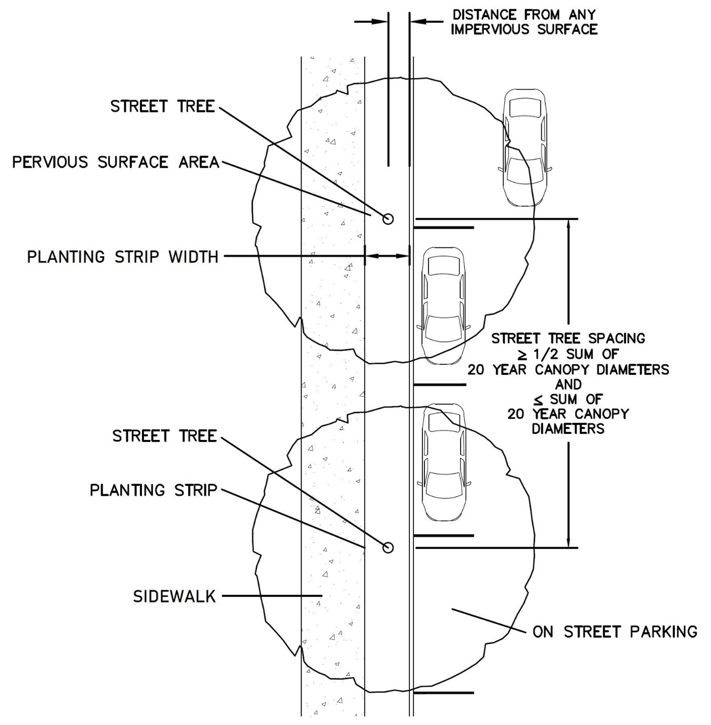
Street Trees in Planting Strip
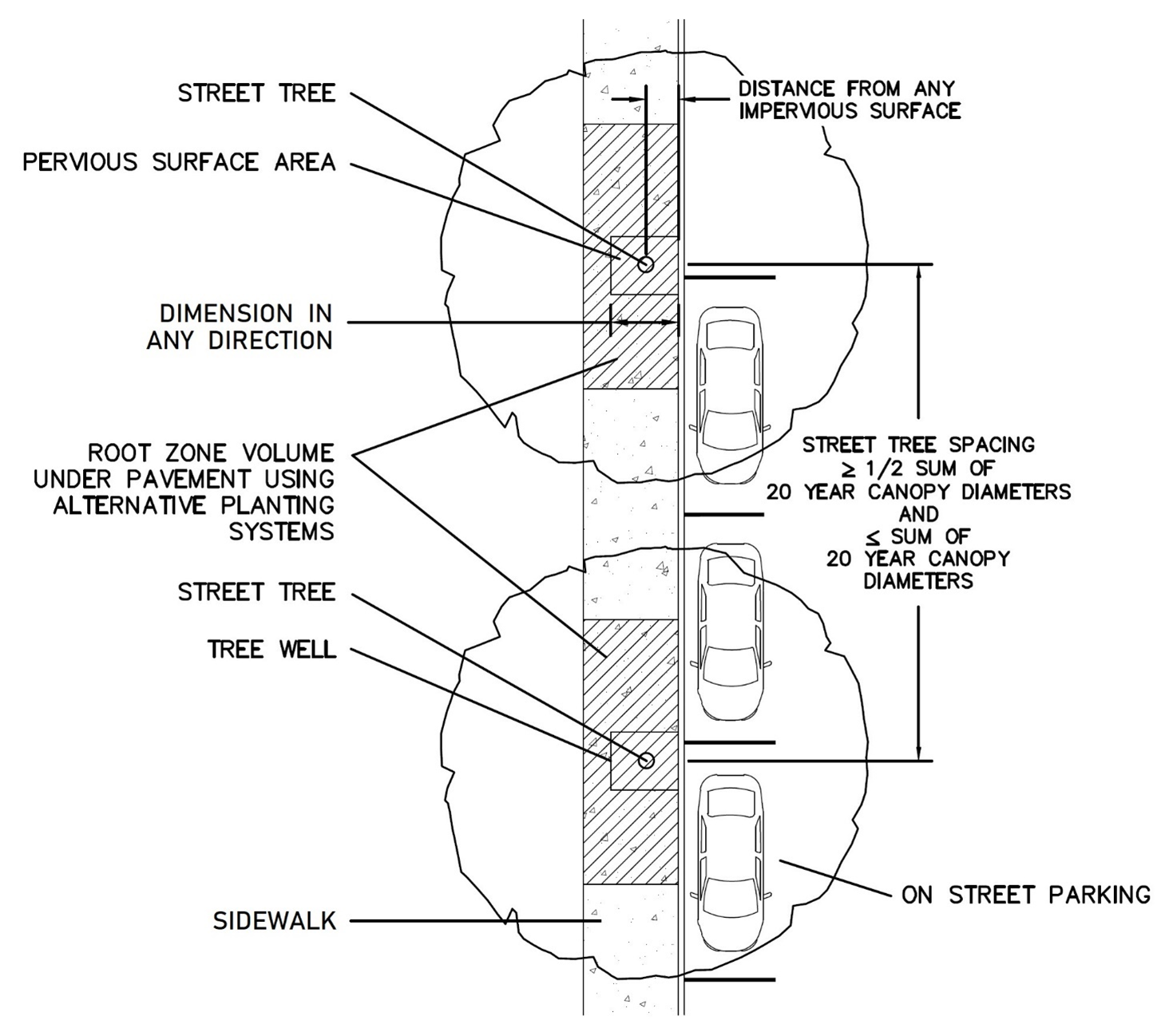
Street Trees in Tree Wells
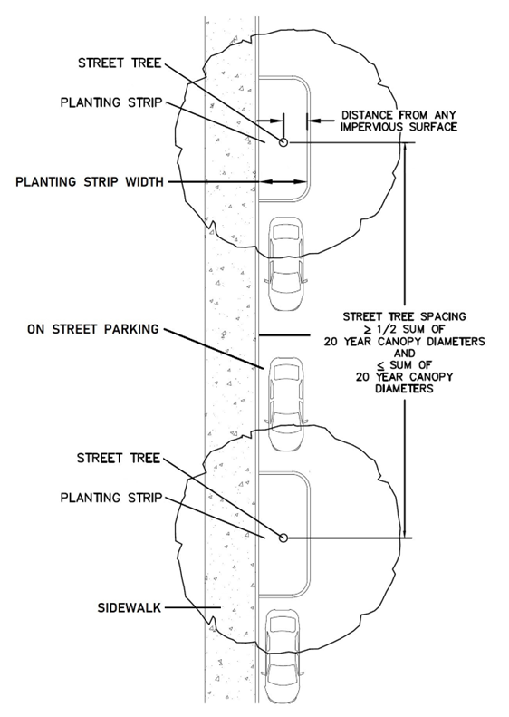
Street Trees in Planting Strips with On-street Parking Spaces
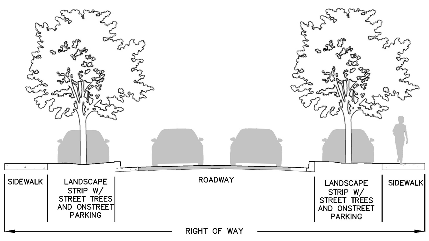
On-street Parking Spaces Between Street Trees in Planting Strips
(c)
Pedestrian circulation and paved activity areas.
(1)
Areas dedicated to pedestrian circulation that are not coincident with a street or in a right-of-way shall have:
a.
Canopy trees on alternating sides of the walkway. Where adequate space is available on only one side of the walkway, the trees shall all be provided on that side.
b.
Landscape screening from above ground utilities.
(2)
Paved areas dedicated to pedestrian activity, including but not limited to plazas and squares, shall have canopy trees around the entire perimeter, except where they abut buildings. Additional canopy trees interior to the paved area may be required for paved areas over two-thousand (2,000) square feet.
(3)
The above walkway and perimeter trees shall be spaced so that the distance between two (2) adjacent trunks is one-half (½) the sum of their 20-year canopy diameters and shall be located to maximize the shading of the pedestrian areas. Canopy tree species and 20-year canopy diameters are identified in Table 407.50.1.
(d)
Paved vehicular use areas.
(1)
Tree species appropriate for meeting the requirements of paved vehicular use areas are indicated in Table 407.50.1. Appropriate Tree Species.
(2)
Screening shall be provided where a paved vehicular use area lies within twenty-five (25) feet of, and is visible from, any street right-of-way. The screening shall consist of sufficient shrubs to provide a visual screen of seventy-five (75) percent opacity. The shrubs shall achieve a minimum height of three (3) feet within three (3) years. Shrubs shall be planted in a strip no less than five (5) feet in width and may be planted within any required street buffer.
(3)
Landscape islands with canopy trees shall be located at an average of every ten (10) parking spaces. At no time shall a row of parking have landscape islands greater than one hundred twenty (120) feet apart or closer than thirty (30) feet apart. Additionally, terminal landscape islands with trees shall always be required at the end of a row of parking spaces.
(4)
Paved vehicular use areas with two (2) or more rows of interior parking shall provide landscape strips between the rows allowing for two-foot vehicle overhangs on each side.
a.
Landscape strip widths shall be according to the standard planting strip widths in Table 407.45.1. Widths shall not be reduced below the standard widths except in TNDs and TODs where off-street parking is provided interior to blocks. Reduced width strips shall not allow vehicle overhangs.
b.
As an alternative, every other row of head-to-head parking may provide a landscape strip of double the standard planting strip widths. These wider landscape strips shall not be reduced below the Standard widths and may contain sidewalks.
c.
Canopy trees within these landscape strips shall be spaced so that the distance between two (2) adjacent trunks is one-half (½) the sum of their 20-year canopy diameters.
(5)
Paved vehicular use area perimeters that do not contain parking spaces, truck loading areas, or abut buildings shall provide canopy trees around the entire perimeter, excluding the width of driveways. Trees shall be spaced so that the distance between two (2) adjacent trunks is one-half (½) the sum of their 20-year canopy diameters as listed in Table 407.50.1.
(6)
Canopy trees shall be located to maximize the shading of the pavement. Flexibility shall be provided for tree locations and spacing where solar facilities are proposed on covered parking spaces; however, in all cases the required number of trees shall be provided.
(7)
Requirements for tree root zone volume and depth, pervious surface planting areas and dimensions, and distance from impervious surfaces are specified in Table 407.45.1, including for constrained areas where alternative planting systems such as root barriers and structural soils are required to prevent damage to surrounding infrastructure.
(8)
Required landscape islands and strips shall contain landscaping materials only and shall not contain utilities, utility lines, or other infrastructure equipment such as fire hydrants, parking lot lights, transformers, air conditioning units, or water meters, however:
a.
Required landscape islands and strips exceeding the criteria of Table 407.45.1 may include utilities, utility lines, or other infrastructure equipment provided it does not occupy or encroach on the minimum required criteria. No reduction of such islands and strips below the standard pervious surface minimum criteria shall be allowed.
b.
Additional islands may be added for placement of utilities, utility lines, or other infrastructure equipment.
c.
In both cases, shrubs shall be provided to screen the equipment when feasible.
(9)
Vehicular use area landscape islands or strips shall be landscaped with alternative groundcovers, excluding turf grass.
(10)
As part of a comprehensive Low Impact Design (LID) approach, developments with more than forty (40) parking spaces shall pre-treat at least twenty-five (25) percent of the parking area stormwater runoff before discharge to the master stormwater system using LID techniques/green stormwater infrastructure technologies including but not limited to:
a.
Landscape islands and landscape strips designed to accommodate stormwater management and minimize nutrient, sediment, and runoff. Curbs separating landscaped areas from parking areas may have curb cuts or be perforated to allow stormwater runoff to pass through them. Stormwater overflow must be accommodated.
b.
Parking spaces of pervious materials such as pavers or pervious pavement.
c.
Bioswales, ecovaults, and other technologies listed in the County Stormwater Manual.
(11)
When vehicular use areas intersect a public right-of-way, landscaping shall be used to define the intersection.
(12)
The following additional buffering shall be provided where off street loading exists:
a.
Off street loading areas shall be screened from any residential district. Screening shall be consistent with the requirements of Subsection 407.43.1(c)(6).
b.
Screening of off-street loading areas may be waived by the reviewing body if the adjacent use will not be adversely impacted, such as in the event both uses have facing loading bays.
c.
In the ML district off-street loading areas shall be screened from any public right-of-way or office use. Screening shall be consistent with the requirements of Subsection 407.43.1(c)(6).
(e)
Stormwater management facilities. Stormwater management facilities and landscaping shall be designed to:
(1)
Be an integral part of the overall development as a physical or visual amenity that provides either:
a.
An aesthetic focal point or feature that resembles a natural area, such as a pond or creek, utilizing curvilinear shapes and a diversity of appropriate plant species; or
b.
For basin designs that resemble geometric shapes or that include corners, fences, or walls, provide human scale design features that break up large volumes, provide usable space, and stimulate pedestrian activity. Human scale design features include but are not limited to terracing, walkways, overlooks, bridges, plazas, greens, and pocket parks.
(2)
Preserve existing tree groupings, consistent with Chapter 406, Article II.
(3)
Provide native canopy trees spaced no more than an average of every thirty-five (35) linear feet around the basin perimeter. Spacing of trees may be closer when trees are planted in groups for aesthetic effect.
(4)
Provide native landscape plantings, excluding turf grass, on at least twenty-five (25) percent of the area of the basin, including the shoulders and maintenance area. Any plantings on bank slopes should consist of fast-growing species with rhizomatous roots for stabilization.
(5)
Basins that use chain-link fencing shall provide an additional five-foot wide area outside the fence landscaped with at least three (3) shade trees, two (2) understory trees, eight (8) large shrubs, and thirteen (13) small shrubs for every one hundred (100) feet or part thereof of fencing.
(6)
Provide access for basin maintenance.
(Ord. No. 2024-15, § 2(Exh. A), 10-8-24)
Sec. 407.44. - Plant material requirements.
(a)
Diversity. New plantings of any of the following shall not include more than fifty (50) percent of any one (1) genus nor twenty-five (25) percent of any one (1) species:
(1)
Eight (8) or more trees.
(2)
Sixteen (16) or more shrubs.
(3)
Thirty-two (32) or more groundcovers.
(b)
Native species. At least seventy-five (75) percent each of new tree, shrub, and groundcover plantings shall be native species. Cultivars of native species are considered native species.
(1)
Up to ten (10) percent of these requirements may be met with edible species identified in Table 407.50.1. and Table 407.50.2.
(2)
Preference should be given to keystone species as identified in Table 407.50.1. and Table 407.50.2.
(c)
Plant quality. Plant materials shall meet the following minimum standards:
(1)
All nursery plants, including trees, shrubs and groundcovers shall conform to standards for Florida Grade #1 or better according to the current, most recent edition of "Grades and Standards for Nursery Plants" published by the Florida Department of Agriculture and Consumer Services, Division of Plant Industry, and available from the Florida Nursery, Growers, and Landscape Association (FNGLA). Nursery invoices or labels shall clearly specify that Grade #1 or better plants were purchased for installation.
(2)
All turf shall be certified apparently free of noxious weeds by the Florida Department of Agriculture and Consumer Services, Division of Plant Industry.
(d)
Trees.
(1)
All trees shall be selected from Table 407.50.1 Appropriate Tree Plantings, which specifies the appropriate planting locations for each species including street trees, tree wells, paved vehicular use areas, basin areas, common areas, and buffers. Any variation from this list shall be approved by the County forester/landscaping inspector.
(2)
Trees shall meet the minimum size standards shown in Table 407.44.1.
Table 407.44.1
Tree Size Standards
(3)
A maximum of five (5) percent of new proposed trees may exceed four (4) inches caliper size with County Forester/Landscaping Inspector approval.
(4)
A maximum of ten (10) percent of new proposed trees may be specimen native species that are not generally available in the required minimum size.
(5)
Lethal Bronzing Disease in palms. A maximum of ten (10) percent of new proposed trees may be palm species that are confirmed by UF-IFAS to be hosts of Lethal Bronzing Disease (LBD) provided that each of these palms shall be:
a.
Verified at certificate of occupancy to be inoculated against LBD; and
b.
Included in a management plan prepared by a certified arborist or other qualified professional and submitted for review and approval concurrent with submittal of the landscape or planting plan. The management plan shall provide for protection and maintenance of the palms against LBD in perpetuity. The existence of the management plan shall be noted on plans, plats, and covenants and restrictions as appropriate to the type of development. The parcel owner shall maintain the palms in accordance with the management plan.
c.
Palm species in Table 407.50.1 that have been confirmed by UF-IFAS to be hosts of LBD include Butia odorata (pindo palm), Phoenix spp. (date palms), and Sabal palmetto (cabbage palm).
d.
The requirements of this Subsection (5) shall apply only to palms that are proposed to meet the requirements of this Article as part of development plan applications.
(e)
Shrubs.
(1)
Shrubs shall consist of woody evergreen and/or non-deciduous plants a minimum of two (2) feet in height in a minimum three-gallon container. When planted as a hedge, the maximum spacing for 24-inch high shrubs shall be thirty-six (36) inches on center.
(2)
Shrub species that are significantly larger than the required minimum in paragraph (1) above may be counted as two (2) or more shrubs, on a case-by-case basis, if approved by the DRC. Spacing for the larger size shrubs shall be determined by the County forester/landscaping inspector.
(f)
Ground covers. All groundcovers shall be selected from Table 407.50.2 Appropriate Groundcover Plantings. Ground covers shall be planted in such a manner as to present a finished appearance and reasonably complete coverage within one (1) year after planting.
(g)
Synthetic plants. Synthetic or artificial turf, trees, shrubs, ground covers, or vines shall not be used in lieu of the plant requirements in this Article.
(h)
Prohibited plants.
(1)
Those plants listed in Florida Administrative Code Section 62c-52.011, Prohibited Aquatic Plants, shall be prohibited. This list of prohibited aquatic plants is available online and copies are also available from the County Environmental Protection Department.
(2)
Those plants listed in Florida Administrative Code Section 5B-57.007, "State Noxious Weed List" shall be prohibited. This list of prohibited noxious weeds is available online and copies are also available from the County.
(i)
Credit for existing plants.
(1)
Credit is permitted for existing plant material provided such material meets the minimum standards of this Article.
(2)
Credit shall be determined based on information documenting the following characteristics as applicable:
a.
Species;
b.
Approximate opacity;
c.
Approximate height;
d.
Diameter at breast height (DBH) of trees.
(j)
Substitutions. Substitutions of tree or plant material on an approved plan may be made with prior County staff approval based on the site conditions, and insofar as the required or approved amounts of species diversity, tree canopy coverage, basin plantings, tree mitigation, street trees, etc. are met.
(Ord. No. 2024-15, § 2(Exh. A), 10-8-24)
Sec. 407.45. - Installation.
All landscape materials shall be installed according to sound horticultural principles. All installations shall be performed specific to type, species, soils, environmental conditions, and include establishment through water and maintenance to ensure maximum survivability.
(a)
Trees.
(1)
Installation of trees shall conform to Table 407.45.1.
Table 407.45.1
Tree Installation Minimum Criteria
(2)
In constrained tree planting areas:
a.
Reduction of the pervious surface minimum criteria standards in Table 407.45.1 shall be permitted to the amounts shown using alternative planting systems. No further reduction below these amounts shall be permitted.
b.
The required root zone volumes and widths shall not be reduced and shall consist of root zone media. However, portions of the root zone volume may be located beneath proposed adjacent pavement using alternative planting systems as shown in tree planting in constrained areas plan and section views.
c.
Alternative planting systems include but are not limited to pervious pavement, reinforced concrete, root aeration systems, root barriers, root paths, soil trenches, structural root box cells, and structural soil.
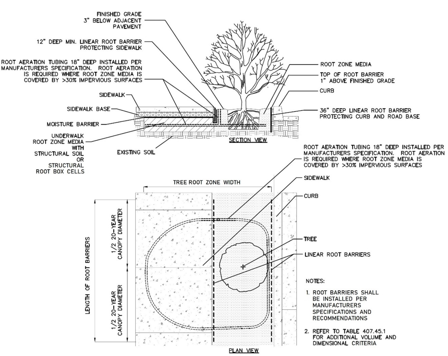
Tree Planting in Constrained Areas
(3)
Matted or circling roots shall be removed from all trees prior to planting.
(4)
The planting hole for trees shall be two (2) to three (3) times the widest dimension of the rootball, sloped outward, and backfilled with root zone media.
(5)
A three (3) foot diameter round-topped soil berm four (4) inches high and eight (8) inches wide shall be constructed around the root ball periphery.
(6)
After planting and watering in, the top of the rootball shall be two (2) inches above existing grade.
(7)
Trees shall be plumb and staked and guyed as needed. Only biodegradable stakes and guys shall be used. All tape, straps, stakes, and guys shall be removed prior to the final landscaping inspection or certification.
(8)
All installed trees shall have minimum 12-inch length by six-inch width trunk protectors to protect the base of the trunk from mower and string trimmer damage. Trunk protectors shall be split lengthwise to ensure they do not become embedded.
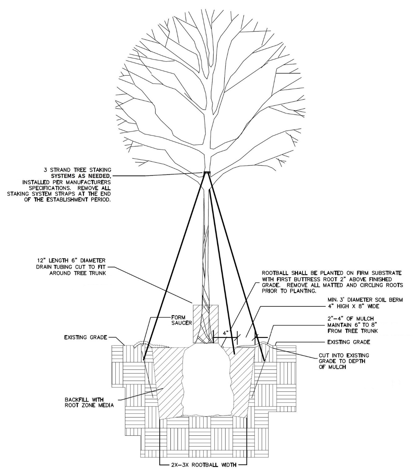
Tree Installation
(b)
Shrubs and groundcovers. Shrubs and groundcovers shall be grouped in masses by species, with exceptions for large specimen plants.
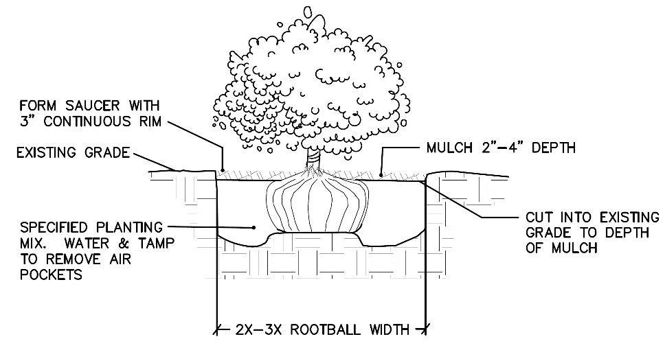
Shrub Installation
(c)
Turf grass.
(1)
Turf grass areas may be sodded, plugged, sprigged, or seeded except that solid sod shall be used in swales, slopes, berms, or other areas subject to erosion.
(2)
Any netting contained within sod shall be certified by the manufacturer to be biodegradable within a period of three (3) months from installation in conformance with FDOT Section 981 and shall be cut even with the sod edge and not left exposed.
(d)
Mulch.
(1)
Planting areas shall be mulched to a minimum depth of two (2) inches and a maximum depth of four (4) inches.
(2)
Trees shall be mulched to a minimum radius of three (3) feet from the trunk or to the outer extent of the branch spread, whichever is greater. Mulch shall not be placed within a radius of six (6) to eight (8) inches from the trunk.
(3)
All landscaped areas not covered with vegetation shall be covered with mulch.
(4)
All mulch shall be organic material, with hardwood, pine bark, or pine straw recommended. Cypress or rocks shall not be used as mulch.
(5)
Mulch shall be placed directly on soil or landscape fabric and be properly edged to retain mulch. No plastic or other non-biodegradable weed cloth or surface covers shall be used in any landscaped areas.
(Ord. No. 2024-15, § 2(Exh. A), 10-8-24)
Sec. 407.46. - Establishment irrigation and soil amendments.
(a)
Establishment irrigation plans.
(1)
A temporary irrigation system is required for all required landscaping to ensure successful establishment. A Temporary Irrigation Guidance Document is maintained by the Environmental Protection Department. Temporary irrigation systems must be removed once the plants are established or within one (1) year, whichever occurs first.
(2)
Irrigation plans for landscaped areas greater than two thousand (2,000) square feet, excluding single family lots, shall be designed by a landscape architect, a Florida Water Star Accredited Professional, or a Florida Irrigation Specialty Contractor.
a.
The plans shall clearly identify the permeable area of the project, as defined in Section 77.03, Water Quality Code, and demonstrate compliance with Article VI, Landscape Irrigation and Maintenance Standards of the Alachua County Code.
b.
Irrigation systems must be approved by the Alachua County Environmental Protection Department prior to installation, in accordance with Chapter 77, Aticle VI, which limits permanent irrigation to fifty (50) percent of the permeable area as defined in Chapter 410, Article III, Defined Terms.
c.
The irrigation system shall be installed according to the manufacturer's specifications and in compliance with the above referenced Article VI.
(3)
All irrigation systems must have a functioning rainfall shutoff device set to active even during establishment.
(4)
Where available, reclaimed water shall be used for landscape irrigation. Use of harvested rainwater or stormwater reuse for irrigation is encouraged. Landscape irrigation wells are discouraged. Abandoned irrigation wells shall be properly plugged by a licensed water well contractor within thirty (30) days of removal of the temporary irrigation system.
(5)
All irrigation systems shall be designed to promote water conservation by employing methods such as individual low-flow or micro-irrigation supplies for newly planted trees and landscape beds. Trees shall be equipped with individual bubblers and be separate from other zones to ensure adequate watering is maintained for establishment. Permanent irrigation systems must be equipped with flow-based leak detection technology.
(6)
The irrigation system shall be inspected monthly during the establishment period to ensure the landscape is properly watered for establishment. A log of the monthly inspections and actions taken shall be maintained by the entity charged with inspecting the system and submitted to the County upon request. Irrigation schedules shall be adjusted after sixty (60) days to comply with restrictions. Subsequent watering shall be adjusted according to season and as the landscape matures so it can gradually adapt to survive on rainfall once the establishment period ends.
(7)
Prior to the installation of any irrigation systems within a public right-of-way, a right-of-way use permit shall be obtained from the County Public Works Department. Such system installation shall meet the construction and inspection standards of the Public Works Department.
(b)
Soil amendments. Soil augmentation plans are encouraged for all proposed new landscaped areas, including single family lots. The following standards are recommended:
(1)
Soil amendments should be incorporated to a depth of at least six (6) inches at a rate of four (4) cubic yards of amended soil per one thousand (1,000) square feet.
(2)
Soil amendments should use compost certified by the U.S. Composting Council.
(Ord. No. 2024-15, § 2(Exh. A), 10-8-24)
Sec. 407.47. - Maintenance.
(a)
The property owner or association shall be responsible for the maintenance of all landscape areas in accordance with the approved landscape or planting plans.
(b)
Upon determination by the County, or County-designated qualified specialist, that a required tree or plant is dead or severely damaged or diseased, the tree or plant shall be replaced by the property owner or association with the same or equivalent plant material as approved by the County, in accordance with the standards specified in this Article. Irrigation shall be in accordance with Section 407.46, Establishment Irrigation and Soil Amendments.
(c)
All landscaped areas required as part of a development plan, including buffers, whether in common or private ownership, shall be the responsibility of that development's property owners' association. Where there is no property owners' association, such landscaped areas shall be the responsibility of the property owner.
(d)
Pruning.
(1)
All trees may be pruned to promote their health and structure, and to remove diseased or dying portions in areas where falling limbs could be a hazard to people or property.
(2)
Lower limbs may be removed to provide clearance for pedestrians and vehicles only to avoid potential injury or damage where conflicts exist. Such pruning shall only be allowed after the trees have adapted to the site, for a maximum seven-foot clearance from ground level. Pruning to allow the passage of emergency vehicles may exceed the maximum seven-foot clearance from ground level.
(3)
Excessive pruning, pollarding, lion tailing, or reduction of shade to allow sunlight to reach turfgrasses or sun loving plants shall be prohibited.
(4)
All pruning shall be done following the current, most recent edition of International Society of Arboriculture (ISA) Best Management Practices - Pruning.
(5)
Tree pruning that is inconsistent with this Subsection may be subject to mitigation at up to double the rate identified in Chapter 406, Article II, Section 406.13.
(Ord. No. 2024-15, § 2(Exh. A), 10-8-24)
Sec. 407.48. - Alternative compliance.
The provisions of this Article shall be liberally construed to effectively carry out the purpose and the intent of the County Comprehensive Plan and of this Article in the interest of the health, safety, and welfare of the residents of the County.
(a)
An applicant may submit a landscape or planting plan which varies from the strict application of the requirements of this Article in order to accommodate unique site features or characteristics or to utilize innovative design.
(b)
An alternative compliance landscape or planting plan may be approved only upon a finding that it fulfills the purpose and intent of the County Comprehensive Plan and of this Article as well as or more effectively than would adherence to the strict requirements.
(c)
In evaluating proposed alternative compliance landscape or planting plans, considerations shall be given to proposals which preserve native vegetation, incorporate low impact development and stormwater reuse, and use resilient and other low water use landscape design principles and where the design ensures the maximum preservation of existing vegetation on the site.
(Ord. No. 2024-15, § 2(Exh. A), 10-8-24)
Sec. 407.49. - Certificate of compliance.
(a)
Nonresidential developments.
(1)
No final certificate of occupancy shall be issued until the County has granted final approval and acceptance of the installed landscape as well as the protection of existing native vegetation. Final approval shall include as-built landscape plan certification from a registered landscape architect certifying that:
a.
The landscaping is installed and functioning as intended,
b.
Prohibited and discouraged non-native vegetation listed in Table 406.16.2 has been removed,
c.
All of the provisions of this Chapter have been met, and
d.
The temporary irrigation system has been registered with the County and removed as appropriate, or a permanent system has received proper approval, is maintained free of leaks and in compliance with Article VI.
(2)
The landowner shall submit a certificate of compliance, in a form acceptable to the County, as a condition of issuance of a certificate of occupancy. For blocks within TODs/TND's, a phasing of landscaping installation may be approved as an element of the final development plan, or administratively after DRC approval, in order to allow the issuance of a certificate of occupancy for each building separately.
(b)
Residential and mixed use developments.
(1)
No certificate of completion of the construction permit shall be issued until the County has granted final approval and acceptance of the installed landscape as well as the protection of existing native vegetation. Final approval shall include inspection and approval by the County Forester and Landscaping Inspector that:
a.
The landscaping is installed and functioning as intended,
b.
Prohibited and discouraged non-native vegetation listed in Table 406.16.2 has been removed,
c.
That all of the provisions of this Chapter have been met, and
d.
The temporary irrigation system has been registered with the County and removed as appropriate, or a permanent system has received proper approval, is maintained free of leaks and in compliance with Article VI, Landscape Irrigation and Maintenance Standards of the Alachua County Code.
(2)
No final acceptance of public infrastructure shall be granted until the County has granted final approval and acceptance of the installed landscape as well as the protection of existing native vegetation. Final approval shall include as-built landscape plan certification from a registered landscape architect certifying that:
a.
The landscaping is installed and functioning as intended,
b.
The temporary irrigation system has been properly removed if after the one-year establishment period,
c.
Prohibited and discouraged non-native vegetation listed in Table 406.16.2 has been removed, and
d.
All of the provisions of this chapter have been met. The landowner shall submit a certificate of compliance, in a form acceptable to the County, as a condition of issuance of a certificate of occupancy.
(c)
A temporary certificate of occupancy may be issued in those instances where all other site improvements except landscape have been completed, and when weather conditions are not conducive to planting. Such temporary issuance is subject to the developer certifying in writing and posting of an appropriate surety in the amount of one hundred ten (110) percent of the certified estimated cost of completion that the required landscaping, as depicted on the approved plan, will be installed within a time period acceptable to the County.
(d)
Failure to install or maintain landscaping according to the terms of this Article or any approved plan shall constitute a violation of this Article and subject to the remedies and penalties set forth in Chapter 409 of this ULDC.
(Ord. No. 2024-15, § 2(Exh. A), 10-8-24)
Sec. 407.50. - Appropriate plantings.
(a)
The list of trees identified in Table 407.50.1 below includes all those appropriate to Alachua County that shall be used to meet the requirements of this Article.
(b)
The list of groundcovers identified in Table 407.50.2 below includes all of those appropriate to Alachua County that shall be used to meet the requirements of this Article.
(c)
The planting of non-native vegetation listed in F.A.C. 5B-64.011, Prohibited Aquatic Plants, and F.A.C. 5B-57.007, Noxious Weed List, or those species listed in Chapter 406, Article II, Table 406.16.2 Prohibited Non-Native Vegetation List shall be prohibited.
Table 407.50.1
Appropriate Tree Plantings
LEGEND:
Table 407.50.2
Appropriate Groundcover Plantings
(Ord. No. 2024-15, § 2(Exh. A), 10-8-24)
Sec. 407.51.- Purpose.
This Article implements the open space policies contained in the future land use and conservation and open space elements of the comprehensive plan and provides for permanently preserved public open space areas designed to protect natural resources, provide recreation, and augment the community network of bicycle and pedestrian infrastructure.
(Ord. No. 2020-09, § 2(Exh. A), 3-10-20; Ord. No. 2020-25, § 2(Exh. A), 11-10-20; Ord. No. 2025-11, § 2(Exh. B), 6-24-25)
Sec. 407.52. - Minimum open space requirement.
At least ten (10) percent of the area of any development shall be designated as open space and delineated on development plans and plats except as provided for in Subsections (a) and (b) below. Multiphase developments shall designate the required open space for all phases with the first final development plan or an instrument acceptable to the County Attorney that details timing of improvements and management of the open space. Open space shall not be contained on lots except as provided in Subsection (b) below. No provision of this Article shall be interpreted to reduce the protection of conservation areas or significant habitats as provided for in Chapter 406.
(a)
Rural/agriculture clustered subdivisions, as addressed in Section 407.77 of this chapter, shall include open space on at least fifty (50) percent of a development and shall meet all provisions of that section.
(b)
Nonresidential developments, family homestead subdivisions as addressed in Section 407.75, and rural residential subdivisions with no more than nine (9) lots as addressed in Section 407.76 shall not be required to include open space beyond the conservation management areas identified in Subsection 407.54(a). Nonresidential developments not required to include open space shall still provide pedestrian and bicycle connections to adjacent open space, parks, and bicycle and pedestrian facilities. Open space provided under this Section is not required to comply with Sections 407.56 and 407.57 and may be contained on a single lot under the ownership and maintenance responsibility of a single property owner.
(Ord. No. 2020-09, § 2(Exh. A), 3-10-20; Ord. No. 2020-25, § 2(Exh. A), 11-10-20; Ord. No. 2025-11, § 2(Exh. B), 6-24-25)
Sec. 407.53. - Open space identification process.
Prior to the submittal of a preliminary development plan or planned development rezoning, an applicant shall consult with County staff to identify the most appropriate portion of the development to be designated as open space.
(Ord. No. 2020-09, § 2(Exh. A), 3-10-20; Ord. No. 2020-25, § 2(Exh. A), 11-10-20; Ord. No. 2025-11, § 2(Exh. B), 6-24-25)
Sec. 407.54. - Open space areas.
(a)
When land development involves a parcel that contains regulated historic and natural resources, the open space requirement shall first be fulfilled with these areas.
(b)
After the requirements of Subsection (a) above have been met, any additional required open space shall be located to minimize the fragmentation of a development project's open space areas. Open space designated per this section shall have an average width of no less than fifty (50) feet and shall be located within the development in a location that best meets the following goals:
(1)
Augments protected regulated natural and historic resources.
(2)
Promotes preservation of other tree canopy to meet the requirements of Article II, Chapter 406.
(3)
Promotes connectivity to greenways, trails, public parks, and existing or potential open space on adjoining parcels.
(Ord. No. 2020-09, § 2(Exh. A), 3-10-20; Ord. No. 2020-25, § 2(Exh. A), 11-10-20; Ord. No. 2025-11, § 2(Exh. B), 6-24-25)
Sec. 407.55. - Exceptions to open space areas.
The following criteria may be considered for deviation from the requirements of Subsection 407.54(b):
(a)
There is an opportunity for the open space to link to a designated greenway.
(b)
Open space in cottage neighborhoods shall be provided per Section 407.155.
(c)
Mixed Use TND/TODs approved per Chapter 407, Article VII that have a minimum density of six (6) units per acre may have open space(s) in multiple locations so long as the minimum width of any individual space is not less than twenty-five (25) feet and that all designated open space conforms with the uses in Section 407.56.
(d)
Notwithstanding the requirements in Subsection 407.54(b), developments with a valid preliminary development plan or planned development that identifies open space and was approved prior to July 28, 2025 may provide open space consistent with the approved preliminary development plan or planned development.
(Ord. No. 2020-09, § 2(Exh. A), 3-10-20; Ord. No. 2020-25, § 2(Exh. A), 11-10-20; Ord. No. 2025-11, § 2(Exh. B), 6-24-25)
Sec. 407.56. - Open space uses.
(a)
Open space shall either be left in a natural condition or provide accessible spaces such as community gardens, community fields, greens, or pocket parks.
(b)
Open space shall be primarily pervious except for limited impervious surfaces associated with bicycle/pedestrian paths and unconditioned structures that augment the open space such as gazebos and picnic pavilions. Impervious surfaces associated with hardscaped civic space are an allowable open space use within a TND or TOD approved per Article VII of this Chapter.
(c)
Open space shall not include stormwater retention or detention areas constructed per Article IX of this Chapter. The integration of low impact design (LID) best management practices to manage stormwater runoff shall not eliminate an otherwise qualifying open space within a TND or TOD approved per Article VII of this Chapter.
(d)
Open space shall not include spoil piles or berms.
(Ord. No. 2020-09, § 2(Exh. A), 3-10-20; Ord. No. 2020-25, § 2(Exh. A), 11-10-20; Ord. No. 2025-11, § 2(Exh. B), 6-24-25)
Sec. 407.57. - Access to open space.
Required open space shall be accessible from the development. Access to open space areas shall be provided in the form of Americans with Disabilities Act compliant hard surfaced paths that connect the open space to the transportation network and adjacent open spaces, parks and bicycle and pedestrian facilities. Impassable fences or obstacles that impede connectivity between adjacent open space or greenspace are not allowed. These paths shall be shown clearly on the development plan, maintained, and marked. The level and type of access to a conservation management area, will be determined by the adopted conservation management plan. Any pedestrian facilities proposed near Champion Trees, Landmark Live Oaks, or other tree canopy will be required to meet the standards outlined Article II of Chapter 406.
(Ord. No. 2020-09, § 2(Exh. A), 3-10-20; Ord. No. 2020-25, § 2(Exh. A), 11-10-20; Ord. No. 2025-11, § 2(Exh. B), 6-24-25)
Sec. 407.58. - Protection and maintenance of open space areas.
(a)
All open space shall be maintained and remain in a condition consistent with uses in Section 407.56 and accessibility requirements of Section 407.57. An open space management plan shall be approved with any final development plan that includes open space. It shall be a condition of all development approval that such open spaces shall remain as shown on the development plan or plat, shall remain accessible as required by this Article, and shall be maintained according to the approved management plan. Any failure to abide by this condition shall be deemed a violation of the development plan or plat. Open space shall be protected by appropriate barricades where necessary to prevent vehicular damage during construction.
(b)
All conservation management areas, except for Champion Trees and Landmark Live Oaks, shall be identified and protected in accordance with Article XVII, Chapter 406 of this ULDC.
(c)
A responsible entity, which may include the owner, a property owner's association, the County, another public agency or a non-profit organization, shall be designated to be responsible for maintaining the open space in a manner that is consistent with all applicable County requirements and the purpose for which it was created.
(Ord. No. 2020-09, § 2(Exh. A), 3-10-20; Ord. No. 2020-25, § 2(Exh. A), 11-10-20; Ord. No. 2025-11, § 2(Exh. B), 6-24-25)
Sec. 407.59. - Alternative compliance.
(a)
The provisions of this Article shall be liberally construed to effectively carry out the purpose and the intent of the comprehensive plan and of this Article in the interest of the health, safety and welfare of the residents of the County.
(b)
An applicant may submit an open space plan which varies from the strict application of the requirements of this Article in order to accommodate unique site features or characteristics or to take advantage of innovative design. In no event, however, shall there be variation from the requirement to provide a minimum of ten percent of the development site as open space area.
(c)
An alternative compliance open space plan may be approved only upon a finding that it fulfills the purpose and intent of the comprehensive plan and of this Article as well as or more effectively than would adherence to the strict requirements.
(Ord. No. 2020-09, § 2(Exh. A), 3-10-20; Ord. No. 2020-25, § 2(Exh. A), 11-10-20; Ord. No. 2025-11, § 2(Exh. B), 6-24-25)
Sec. 407.60.- Nonresidential performance standards.
These performance standards shall apply to all nonresidential uses:
(a)
Fumes, vapors and gases. There shall be no emission of any fumes, vapors or gases of a noxious, toxic or corrosive nature which can cause damage or irritation to health, animals, vegetation or to any form of property or which results in the violation of any applicable federal, state or local requirements or creates a public nuisance.
(b)
Waste discharge. There shall be no discharge of any wastes into any private sewage disposal system, surface water body, stormwater management system or into the ground of a kind or nature which can contaminate any water supply or otherwise cause the emission of dangerous elements or conditions or results in the violation of any applicable federal, state or local requirements or creates a public nuisance. There shall be no accumulation of uncontained solid wastes conducive to the breeding of rodents or insects.
(c)
Heat, cold, dampness or movement of air. Activities which shall produce any adverse effect on the temperature, motion or humidity of the atmosphere beyond the lot line shall not be permitted.
(d)
Odor. There shall be no emission of odorous gases or other odorous matter in such quantities as to be offensive or obnoxious or which results in the violation of any applicable federal, state or local requirements or creates a public nuisance beyond the property line on which the principal use is located. Any process, including the preparation of food, which may involve the creation and emission of any such odors shall be provided with both a primary and a secondary safeguard system so that odor control may be maintained in the event of failure of the primary safeguard system.
(e)
Glare. There shall be no direct glare visible from any residential district caused by unshielded floodlights or other sources of high intensity lighting.
(f)
Noise. Noise from any activity or from any permissible use of property shall not exceed the standards set forth in Section 110.04 of the Alachua County Code.
(Ord. No. 05-10, § 2, 12-8-05; Ord. No. 2020-25, § 2(Exh. A), 11-10-20)
Sec. 407.61. - Industrial performance standards.
(a)
All uses in industrial districts shall comply with the standards set forth in this Subsection regulating the emission or existence of dangerous, detrimental and objectionable elements, unless allowed through an approved special use permit.
(b)
Measurement at the point of emission shall be determined for the following items:
(1)
Radioactive elements. There shall be no radiation emitted from radioactive materials or by-products exceeding a dangerous level of radioactive emission at any point. Radiation limitations shall not exceed quantities established as safe by the United States Bureau of Standards.
(2)
Electromagnetic interference.
a.
For the purpose of these regulations, electromagnetic interference shall be defined as disturbances of an electromagnetic nature which are generated by the use of electrical equipment, other than planned and intentional sources of electromagnetic energy, which would interfere with the proper operation of electromagnetic radiation for such purposes as communication, experimentation, entertainment, broadcasting, heating, navigation, therapy, vehicle velocity measurement, weather survey, aircraft detection, topographical survey, personal pleasure or any other use directly or indirectly associated with these purposes which does not comply with the current regulations of the Federal Communications Commission regarding such sources of electromagnetic radiation. Further, said operations, in compliance with the Federal Communications Commission regulations, shall be unlawful if such radiation causes an abnormal degradation of performance of other electromagnetic radiators or electromagnetic receptors of quality and proper design because of proximity, primary field, blanketing, spurious re-radiation, conducted energy in power or telephone systems or harmonic content. The determination of "abnormal degradation of performance" and of "quality and proper design" shall be made in accordance with good engineering practices as defined in the latest principles and standards of the American Institute of Electrical Engineers, the Institute of Radio Engineers and the Radio Manufacturers' Association. In case of any conflict between the latest standards and principles of the above groups, the following precedence of interpretation of the standards and principles shall apply:
1.
American Institute of Electrical Engineers;
2.
Institute of Radio Engineers; and
3.
Radio Manufacturers' Association.
b.
It shall be unlawful for any person to operate or maintain any planned or intentional source of electromagnetic energy, the radiated power from which exceeds one thousand (1,000) watts.
(3)
Smoke, dust and dirt.
a.
There shall be no emission of visible smoke, dust, dirt, fly ash or any particulate matter from any pipes, vents or other openings or from any other source, into the air. which can cause damage or irritation to health, animals, vegetation or to any form of property or which results in the violation of any applicable federal, state or local requirements or creates a public nuisance.
b.
There shall be no discharge at any point of liquid or solid wastes into any public sewage disposal system that would overload such system or create detrimental effects in the flow and treatment of public sewage. There shall be no discharge of any industrial wastes into any private sewage disposal system, surface water body, stormwater management system or into the ground which can contaminate any water supply or otherwise cause the emission of dangerous elements or conditions or which results in the violation of any applicable federal, state or local requirements or creates a public nuisance. There shall be no accumulation of uncontained solid wastes conducive to the breeding of rodents or insects.
c.
Measurements of the emission at the property line on which the principal use is located shall be determined for the following items:
1.
Vibration. There shall be no perceptible earth vibration. All stamping machines, punch presses, press brakes, hot forging, steam, board hammers or similar devices shall be placed on shock absorption mountings and on suitable reinforced concrete footings. No machine shall be loaded beyond the capacity as described by its manufacturer.
2.
Heat, cold, dampness or movement of air. Activities which shall produce any adverse effect on the temperature, motion or humidity of the atmosphere beyond the lot line shall not be permitted.
3.
Noise. The permitted level of noise or sound emission at the property line of the lot on which the principal use is located shall not exceed the values given in the following table in any octave band of frequency. The sound pressure level shall be measured with a sound level meter and an octave band analyzer that conforms to specifications published by the American Standards Association.
(4)
Odor. There shall be no emission of odorous gases or other odorous matter in such quantities as to be offensive at the points of measurement. Any process which may involve the creation or emission of any such odors shall be provided with both a primary and a secondary safeguard system so that control may be maintained in the event of failure of the primary safeguard system.
(5)
Glare. There shall be no direct or sky-reflected glare, whether from floodlights, high temperature processing, combustion, welding or otherwise so as to be visible at the specified points of measurement.
(6)
Fire and explosion hazards. All activities and all storage of inflammable and explosive materials at any point shall be provided with adequate safety devices against the hazards of fire and explosion, including adequate firefighting and suppression equipment.
(Ord. No. 05-10, § 2, 12-8-05; Ord. No. 2020-25, § 2(Exh. A), 11-10-20)
Sec. 407.62.- Purpose.
(a)
TND. The TND is intended to provide flexibility in development, encourage a mix of residential housing types, and create the sense of community common in neighborhoods planned in accordance with traditional design principles and the policies of the Comprehensive Plan. Additionally, the design of TNDs allow for mixed-use centers integrated into new residential neighborhoods or combinations of new and existing residential neighborhoods.
(b)
TOD. The TOD is intended to provide for compact, mixed-use, pedestrian and bicycle friendly communities designed with the densities and intensities needed to support transit service, reduced per capita greenhouse gas emissions and enable an individual to live, work, play and shop in a community without the need to rely on a motor vehicle for mobility.
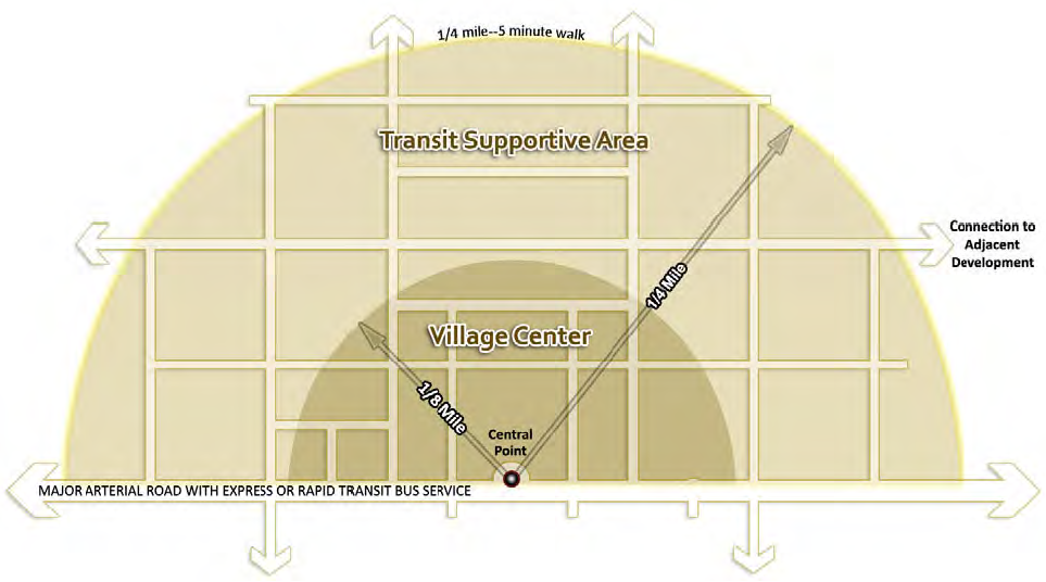
(Ord. No. 10-16, § 2(Exh. A), 8-10-10; Ord. No. 2020-25, § 2(Exh. A), 11-10-20)
Sec. 407.63. - Development concepts.
(a)
Central point. Each TND or TOD shall have a defined central point. The central point should be located in a plaza, square, or Open Space, or be denoted by an architecturally significant feature. Measurements of the size of village centers and transit supportive areas shall be measured from the central point.
(b)
Village center. Each TND or TOD shall be designed to include a village center that contains the highest densities and intensities of use. The village center shall generally extend one-eighth (⅛) mile from the central point and contain a mixture of uses. The village center should be designed to provide multiple destinations and to a scale that is comfortable for pedestrians and cyclists.
(c)
Transit supportive area. The transit supportive area shall generally extend one-fourth (¼) mile from the central point and include the village center. The transit supportive area shall provide a scaling of density and intensity from the village center to surrounding land uses.
(d)
Common areas. Each TND or TOD shall be designed to provide common areas in the form of plazas, squares, parks, or other open areas. Common areas shall be dispersed throughout the development and shall be designed to a scale appropriate for the surrounding development. The integration of low impact design techniques to manage stormwater runoff shall be required in the sensitive karst areas and encouraged within common areas.
(e)
Transportation network. The transportation network shall be designed to provide circulation for transit vehicles, automobiles, bicycles, and pedestrians. Priority shall be given to the design of roadway, transit, bicycle, pedestrian facilities, and required landscaping in the allocation of space within the right-of way. Where location of utilities conflicts with the priority considerations, utilities shall be located outside the right-of-way. The transportation network shall provide for multiple points of ingress and egress from developments, provide for connection to adjacent developments, and allow for multiple route choices between locations.
(Ord. No. 10-16, § 2(Exh. A), 8-10-10; Ord. No. 12-09, § 2(Exh. A), 10-9-12; Ord. No. 2020-09, § 2(Exh. A), 3-10-20; Ord. No. 2020-25, § 2(Exh. A), 11-10-20)
Sec. 407.64. - Traditional neighborhood development.
(a)
Where permitted. TNDs may be located on property with any zoning designation except A, C-1, RE, RM-1, MS, MP, ML, MB and C-TDR. The property must also have an urban residential land use designation within the Urban Cluster or be located in an activity center in accordance with the comprehensive plan.
(b)
Uses allowed. Allowable Uses shall be those listed in the use table in Article II of Chapter 404.
(c)
Other general standards.
(1)
Each TND shall be designed to accommodate a range of housing types, lots sizes and civic, office, and commercial uses.
(2)
The TND is created to promote development with well-defined centers and edges, with public, civic, and commercial spaces as organizing elements around which other development is located.
(3)
Multi-family residential and other high density residential uses shall be located in or near the village center or transit supportive area. Lower density residential uses shall be located along the perimeter of the development to provide a transition to surrounding development.
(4)
TNDs shall be required to provide a compact, mixed-use village center that promotes pedestrian and bicycle circulation and provides multiple destinations.
(d)
Density and intensity.
(1)
Within a TND, allowable residential densities shall be calculated as shown in Table 407.64.1.
(2)
Within TNDs, allowable non-residential intensities shall be calculated as listed below:
a.
Each TND shall include a base amount of at least ten thousand (10,000) square feet non-residential development.
b.
In addition to the base amount, each TND shall also include a minimum of fifty (50) square feet and a maximum of two hundred fifty (250) square feet per dwelling unit.
c.
Each TND may optionally include up to an additional ten thousand (10,000) square feet of non-residential development for achieving the maximum allowable density of the Future Land Use designation of the property.
d.
Each TND may optionally include up to an additional ten thousand (10,000) square feet of non-residential development per dwelling unit above four (4) dwelling units per acre.
e.
Each TND may optionally include up to an additional twenty-five thousand (25,000) square if located contiguous to a Rapid Transit or Express Transit Corridor.
f.
Existing non-residential square footage may be included within or in addition to the above requirements. Civic uses (such as places of worship, libraries, schools, etc.) and live-work studios within the Transit Supportive Area that are functionally integrated into surrounding development and allow for shared parking during hours of non-use may be excluded from the calculation of non-residential uses.
g.
A minimum of twenty-five (25) percent and maximum of seventy-five (75) percent of non-residential uses shall be retail-commercial uses.
h.
The number of rooms in a hotel may be used in calculating allowable non-residential square footage.
(Ord. No. 10-16, § 2(Exh. A), 8-10-10; Ord. No. 2013-09, § 1(Exh. A), 7-9-13; Ord. No. 2020-25, § 2(Exh. A), 11-10-20)
Sec. 407.65. - Transit oriented developments.
(a)
Where permitted. TODs may be located on property with any zoning designation except A, C-1, RE, RM-1, MS, MP, ML, MB. The property must also have an urban residential land use designation within the Urban Cluster or be located in an activity center in accordance with the comprehensive plan.
(b)
Uses allowed. Allowable uses shall be those listed in the use table in Article II of Chapter 404.
(c)
Other general standards.
(1)
TODs shall be at least fifteen (15) acres in size.
(2)
TODs shall be served by express transit service and be contiguous to a rapid transit or express transit corridor, consistent with the transportation mobility element of the Comprehensive Plan.
(3)
TODs shall be required to provide a compact, mixed-use village center that promotes pedestrian and bicycle circulation and provides multiple destinations. The village center shall have a transit station with access to a rapid transit or express transit corridor.
(4)
Funding for express transit service shall be provided in accordance with Subsection 407.65(e).
(d)
Density and intensity.
(1)
Within a TOD, allowable residential densities shall be calculated as shown in Table 407.65.1.
(2)
Within TODs, allowable non-residential intensities shall be calculated as listed below:
a.
Each TOD shall include a base amount of at least ten thousand (10,000) square feet non-residential development.
b.
In addition to the base amount, each TOD shall also include a minimum of one hundred (100) square feet and a maximum of five hundred (500) square feet per dwelling unit.
c.
Existing non-residential square footage may be included within or in addition to the above requirements. Civic uses (such as places of worship, libraries, schools, etc.) and live-work studios within the transit supportive area that are functionally integrated into surrounding development and allow for shared parking during hours of non-use may be excluded from the calculation of non-residential uses.
d.
A minimum of twenty-five (25) percent and maximum of seventy-five (75) percent of non-residential uses shall be retail-commercial uses.
e.
The number of rooms in a hotel and the number of bedrooms in student housing with separately rented rooms and shared living space may be used in calculating allowable non-residential square footage.
(e)
Funding of transit operations and maintenance. Express transit service shall be provided by TODs from the development to a central transit hub within the main University of Florida campus consistent with the express transit corridors map. The peak hour headways to be funded are fifteen (15) minutes for two (2) hours in the a.m. and two (2) hours in the p.m. consistent with the requirements of the transportation mobility element of the comprehensive plan. The express transit service shall be funded for a 15-year period in a manner that is proportional to the distance of the development from the proposed terminus of the line and to the density and intensity of the development. The employees, employers and residents of the development that contribute towards the express transit service shall be provided with a mechanism that ensures they ride fare-free so long as the development funds transit. The funding mechanism, details, and cost to provide express transit service shall be memorialized in an enforceable developer agreement between the developer and the County in consultation with the regional transit system. Annexation into a municipality shall not absolve the development's requirement to fund express transit service.
(Ord. No. 10-16, § 2(Exh. A), 8-10-10; Ord. No. 2013-09, § 2(Exh. A), 7-9-13; Ord. No. 2020-25, § 2(Exh. A), 11-10-20)
Sec. 407.66. - Village center and transit supportive area standards for TNDs and TODs.
(a)
Location. The central point of a village center shall generally be located at least one-half (½) mile from adjacent village centers and activity centers. Villages centers may be located on opposite sides of a major roadway or rapid transit or express transit corridor, or within one-half (½) mile of the intersection of two (2) or more rapid transit corridors. Village centers may also be closer than one-half (½) mile when required per Section 403.02.5 of this ULDC.
(b)
Designation.
(1)
The village center shall generally be defined as the area up to one-eighth (⅛) mile from the central point of the development.
(2)
The transit supportive area shall generally be defined as the area up to one-quarter (¼) mile from the central point of the development.
(3)
The entire block for which a portion of the block falls within the specified extent of a village center or transit supportive area may be designated as being within the village center or transit supportive area.
(c)
Mix of uses.
(1)
A minimum of fifty (50) percent of non-residential square footage of a development shall be provided within the village center.
(2)
A maximum of fifty (50) percent of non-residential square footage allowed within a development may be located outside the village center and within the TSA.
(3)
A minimum of twenty-five (25) percent of the total approved non-residential square footage must be in multistory buildings containing multiple uses. Ten (10) percent of this non-residential requirement may be met where residential development at least three (3) stories in height is located directly adjacent to retail - commercial development. In this case, the maximum square footage counted towards the requirement shall be limited by the building footprint of the adjacent residential use.
(d)
Dimensional standards.
(1)
The following dimensional standards shall apply within the village center and transit supportive area portions of development.
(2)
A single-tenant retail building may be allowed to exceed fifty thousand (50,000) square feet by providing one of the following:
a.
Separate liner buildings oriented towards the street on at least three (3) sides of the building, with parking to the rear of the building or the rear of the building lined by other liner buildings; or
b.
Vertical mixture of uses with at least one (1) story above the ground floor; or
c.
Multiple floors with a maximum of fifty thousand (50,000) square feet per floor; or
d.
Parking on the top or completely enclosed within the building; or
e.
Parking in front of the building so long as all off-street surface parking and the side and rear of the building are screened from adjacent streets by liner buildings.
(Ord. No. 10-16, § 2(Exh. A), 8-10-10; Ord. No. 2013-09, § 2(Exh. A), 7-9-13; Ord. No. 2020-25, § 2(Exh. A), 11-10-20)
Sec. 407.67. - Areas outside the transit supportive area in TNDs and TODs.
(a)
Mix of uses.
(1)
A maximum of ten (10) percent of the total approved non-residential square footage, not to exceed one hundred thousand (100,000) square feet, may be located outside the transit supportive area (TSA).
(2)
Civic uses (such as places of worship, libraries, schools, etc.) and live-work studios located outside the TSA shall be counted towards the maximum non-residential square footage of a development and towards the ten (10) percent allowed outside the TSA.
(b)
Dimensional standards. The following dimensional standards shall apply within the residential area portion of a TND or TOD.
(Ord. No. 10-16, § 2(Exh. A), 8-10-10; Ord. No. 2013-09, § 2(Exh. A), 7-9-13; Ord. No. 2018-23, § 2(Exh. A), 10-9-18; Ord. No. 2020-25, § 2(Exh. A), 11-10-20)
Sec. 407.68. - Transit supportive area design standards.
(a)
Block perimeter.
(1)
The TSA in TND and TOD developments shall be designed with a regular block pattern. Blocks within the TSA shall have a maximum perimeter consistent with this Section. The perimeter of a block shall be measured from the back of curb. Conservation areas, topographic constraints and property boundary lines can form the sides of a block.
(2)
The extended maximum block perimeter in Table 407.68.1 may be used if the block contains parking interior to the block.
(3)
In addition to the extended block, an additional seven hundred (700) feet of block perimeter may be allowed where a continuous ten-foot multi-use path with limited vehicular crossings and with shade trees alternating forty (40) feet on center is provided. This path forms an internal bicycle and pedestrian block that does not exceed the extended perimeter blocks length.
(4)
For projects of one hundred (100) acres or more, maximum block perimeter may be extended up to three thousand (3,000) feet if the block contains:
a.
A parking structure with at least one (1) level above surface parking; or
b.
A single tenant retail use greater than twenty-five thousand (25,000) square feet with parking interior to the block.
(b)
Building orientation and design. In addition to the standards in this section, all non-residential, mixed-use and multifamily buildings must meet the requirements in Section 407.105 of Article X Building Design.
(1)
Orientation and location.
a.
The front of buildings shall be oriented toward the more primary adjacent street. Where a building is not adjacent to a street, the front of the building shall be oriented toward a greenspace or civic space.
b.
Primary pedestrian entrances to buildings shall be provided and accessible on the front of a building with limited exceptions allowed for residential or lodging uses that have units fronting a parking area located interior to a block. Primary pedestrian entrances shall be designed for access by the public.
c.
Shade along the building frontage shall be provided for pedestrians through architectural features such as covered walkways, terraces, balconies, awnings and street trees.
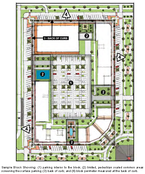
(2)
Garages. Garages serving single-family or multi-family uses shall provide entries from alleys or side streets with anticipated daily traffic volumes of less than one thousand two hundred (1,200) AADT wherever practicable. Front-entry garages shall be set back a minimum of ten (10) feet behind the primary building line.
(3)
Parking structures. Parking structures shall be designed to allow for commercial, office, civic or residential uses lining the structure on the ground floor where the parking structure abuts a street. The parking structure shall be designed to integrate seamlessly with surrounding development and shall provide pedestrian oriented design on the ground floor abutting a street.
(4)
Colonnades. Roof or overhangs supported by colonnades at or within seven (7) feet of a sidewalk shall have a minimum clearance height of nine (9) feet (excluding signage or lighting).
(5)
Existing buildings. Every effort shall be made to meet the TND requirements by appropriately incorporating existing buildings into the design of the neighborhood.
(6)
Trash collection facilities. All recycling and trash collection facilities shall be located to the rear of buildings or within buildings or parking facilities. All recycling and trash collection facilities shall be screened as required by Subsection 407.10(b) of this ULDC.
(7)
Utilities. Above ground utilities, except for life safety, should be located to the rear and side of buildings. All above ground utility access, transfer and conveyance points such as panels, boxes, meters, and valves shall be screened from the street and sidewalks through architectural features and/or landscaping.
(c)
Parking.
(1)
Off-street surface parking. Off-street surface parking is not required. Where provided, off-street surface parking shall meet the standards of the parking schedule in Table 407.68.2. These maximums shall not apply to structured parking, park-and ride, and on-street parking.
(2)
Parking spaces may be pooled and utilized anywhere within the development.
a.
Off-street surface parking shall be located to the rear of buildings and interior to the block. A minimum of seventy-five (75) percent of the perimeter block length shall be lined by buildings, excluding access to off-street surface parking. Along any portion of a block not lined by buildings, off-street surface parking shall be located at least twenty-five (25) feet from the back of curb. To screen the parking, between the back of curb and off-street parking, there shall be a sidewalk and a plaza with lighting, seating, architectural features, landscaping, and low impact design techniques.
b.
Up to two (2) driveways may be provided per block face. However, no block shall have more than six (6) driveways.
c.
Off-street surface parking areas adjacent to a conservation area, topographical constraint, or property boundary and not lined by buildings shall provide a minimum of a ten-foot wide multi-use path with shade trees alternating forty (40) foot on center. The perimeter block length along a conservation area, topographical constraint, or property boundary may exceed twenty-five (25) percent of the total block perimeter; however the remainder of the block shall be lined by buildings, excluding access to off-street parking.
d.
Off-street parking shall clearly delineate routes for pedestrians and bicycles through parking areas to accommodate safe and convenient pedestrian and bicycle circulation between uses and create a park-once environment.
e.
A single transitional off-street surface parking area may be allowed per development. The perimeter block length shall not exceed the perimeter block length requirements of this Article. Plans shall be submitted demonstrating how liner buildings will be provided at a future date along with justification why the additional parking is needed and why it cannot be provided elsewhere. Within this block, off-street surface parking shall not be located closer than twenty-five (25) feet to the back of curb and off street surface parking shall be lined by a sidewalk and a plaza with lighting, seating, architectural features, and landscaping.
f.
In addition to the single transitional lot, a TOD more than one hundred (100) acres in size is allowed one (1) block with parking interior per every one hundred (100) acres where the block face is lined by buildings on fifty (50) percent or greater of the block so long as there are buildings on three (3) sides of the block face and at least one (1) of the structures on the block is multistory. Off-street surface parking shall be setback at least twenty-five (25) feet from the back of curb. To screen the parking, within the setback there shall be a sidewalk and a plaza with lighting, seating, architectural features, and landscaping.
g.
Single occupant retail uses greater than twenty-five thousand (25,000) square feet per floor may have parking in front of buildings provided all surface parking and the side and rear of the building are screened from adjacent streets by liner buildings. The rear of the building for single occupant retail uses between twenty-five thousand (25,000) and fifty thousand (50,000) square feet per floor may front a street as long as a functional entrance is provided and the architecture of the building provides a pedestrian friendly environment in compliance with all design requirements for buildings fronting a street.
h.
Off-street surface parking areas shall be landscaped to reduce heat-island effects, stormwater pollution and rate of flow from developed areas, minimize glare, and limit noise impacts from automobile uses in accordance with Section 407.43.2(d) Paved vehicular use areas.
(3)
Vehicular use areas, other than off-street surface parking, shall be located to the rear of buildings. Limited exceptions may be allowed for loading areas separated from through traffic by a physical barrier.
(d)
Roadway network design.
(1)
In order to provide for pedestrian oriented design along existing corridors, streets that are proposed parallel to existing roadways, without intervening buildings, shall be restricted to a cross section width of forty-eight (48) feet from curb face to curb face. In no such case shall angled parking be provided on both sides of the a new two-way street.
(2)
Notwithstanding the requirements in Subsection 407.68(d)(1), developments with a valid preliminary development plan or planned development that identifies street and block locations and was approved prior to November 10, 2020 may provide street and block locations consistent with the approved preliminary development plan or planned development.
(3)
Roadways within the transit supportive area shall be considered functionally classified as local roadways and shall be designed consistent with Table 407.141.1 and the standards in Article XIII, Access Management and Street Network Standards.
(4)
Cross access and stub streets shall be provided in order that the general block pattern of the development can be continued on adjacent properties upon development or redevelopment.
(5)
On-street parking.
a.
Defined on-street parking shall be provided on the majority of block faces within the transit supportive area, and is allowed throughout the rest of the development. Bulb-outs and curb extensions shall be provided at a maximum interval of two hundred (200) feet. For block faces less than two hundred (200) feet, a bulb-out shall be provided at both ends of the block face.
b.
The use of semi-pervious materials, such as pavers or porous pavement, is encouraged within on-street parking areas to reduce stormwater runoff and delineate parking areas.
(6)
External connectivity. Street stubs shall be provided to adjacent open land and adjacent developed parcels other than platted subdivisions to provide for future connections. Signs shall be posted, at the expense of the developer, advising residents of the intent and purpose of the stubbed street. Culs-de-sac shall be permitted only where environmental concerns or existing platted development makes a street connection impracticable. Culs-de-sac shall not exceed two hundred fifty (250) feet in length and shall be accessed from a street providing internal or external connectivity.
(7)
Utilities.
a.
Underground utilities are to be compressed to minimize right-of-way width, allow adequate space for street trees and provide for the visual definition of the street. Appropriate utilities shall be allowed to be placed in joint trenches.
b.
All above ground utility access, transfer and conveyance points such as panels, boxes, meters, and valves shall be screened from the street and sidewalks through architectural features and/or landscaping.
c.
Pressurized lines are allowed to be placed under roadways not shown on the Future Highway Functional Classifications Map of the Comprehensive Plan and on roadways projected to carry less than fifteen thousand (15,000) daily trips.
(e)
Transit network design.
(1)
For developments contiguous with a rapid transit corridor, dedicated transit lane(s) for use by transit vehicles or fixed guide-way rail lines for streetcars or light rail shall be provided within or adjacent to the development consistent with the rapid transit corridor map. Dedicated transit lanes for buses shall be designed as concrete ribbon drives with raised curbs in a median or in right-of-way separated from motor vehicle travel lanes, except on bridges. Dedicated transit lanes shall be designed and constructed in such a manner that they cannot be used for motor vehicle travel, other than transit vehicles. Multi-lane roadways in-lieu of dedicated lanes may be provided within the transit supportive area for developments that can demonstrate future transit headways of ten (10) minutes can be maintained and feature either block lengths that average one thousand two hundred (1,200) perimeter feet or less or include fixed guide-way rail lines. Regional transit system (RTS) shall be a reviewing entity along with the County and FDOT along state roadways.
(2)
Developments contiguous with the portion of the express transit corridor along Tower Road shall provide either site related turn out facilities (bus bays) or dedicated lane(s). Regional transit system (RTS) shall be a reviewing entity along with the County and FDOT along state roadways.
(3)
For developments contiguous with a rapid transit corridor, a park and ride facility shall be provided within or adjacent to the development in close proximity to the transit station consistent with the rapid transit corridor map. Park and ride facilities shall be designed for shared evening and weekend use by the development. Park and rides shall be designed in accordance with block, street tree and pedestrian facility requirements of this ULDC and are encouraged to be screened by liner buildings. The size of the park and ride facility shall be based on projected demand as the relative to the size and location of the development. Park and ride facilities shall be coordinated and jointly planned where developments are directly adjacent. Regional transit system (RTS) shall be a reviewing entity along with the County and FDOT along state roadways.
(4)
For developments contiguous with a rapid transit corridor, a principal transit station shall be provided adjacent to the corridor within the village center. The transit station shall be of sufficient size and scale to accommodate the projected ridership from the development. Transit stations shall feature solid roofs and protection from the elements along the perimeter of the station through architectural features. The transit station shall be architecturally integrated with the development. The transit station shall provide lighting, seating, waste receptacles, kiosk with maps and route information, a route map, a digital display indicating arrival times and a means to provide air circulation and cooling within the station. The station shall include a facility for purchasing transit passes. The transit station should be integrated with retail uses or provide adequate space for future retail uses.
(5)
For developments contiguous with a rapid transit corridor, smaller transit stations which feature solid roofs, some protection from the elements, lighting, seating, route maps and a digital display indicating arrival times are encouraged to be located along the corridor and are required if more than a one-quarter (0.25) mile from the principal transit station. The transit station should be integrated with retail uses or provide adequate space for future retail uses.
(Ord. No. 10-16, § 2(Exh. A), 8-10-10; Ord. No. 12-09, § 2(Exh. A), 10-9-12; Ord. No. 2013-09, § 2, 7-9-13; Ord. No. 2014-04, § 2, 1-28-14; Ord. No. 15-06, § 2(Exh. A), 4-14-15; Ord. No. 2020-09, § 2(Exh. A), 3-10-20; Ord. No. 2020-25, § 2(Exh. A), 11-10-20; Ord. No. 2022-01, § 2(Exh. A), 1-11-22; Ord. No. 2024-04, § 2(Exh. A), 2-27-24; Ord. No. 2024-07, § 2(Exh. A), 9-10-24; Ord. No. 2024-15, § 2(Exh. A), 10-8-24; Ord. No. 2025-12, § 2(Exh. A), 6-24-25)
Sec. 407.69. - Standards for development areas outside the transit supportive area.
(a)
Single-family residential development outside the transit supportive area shall be subject to the subdivision regulations of Article VIII Chapter 407 and Article XIII Chapter 407 with the following additional standards.
Development outside the transit supportive area shall have a maximum block perimeter of two thousand (2,000) linear feet.
(Ord. No. 10-16, § 2(Exh. A), 8-10-10; Ord. No. 2020-25, § 2(Exh. A), 11-10-20; Ord. No. 2025-12, § 2(Exh. A), 6-24-25)
Sec. 407.70. - Open space and landscaping.
(a)
Open space. Open space shall be provided consistent with Article V of this Chapter.
(b)
Landscaping.
(1)
All TNDs and TODs shall submit a landscape plan consistent with Article IV Landscaping of this Chapter, with the following exceptions:
(2)
Project boundary buffers.
a.
Where new TND or TOD development abuts existing single-family detached residential development the following shall apply:
1.
For proposed development that abuts a portion of an existing development of lots in excess of twenty thousand (20,000) square feet, the minimum size for abutting lots shall be twenty thousand (20,000) square feet with a minimum lot width of one hundred ten (110) feet.
2.
For proposed development that abuts a portion of an existing development of lots between ten thousand (10,000) and twenty thousand (20,000) square feet, the minimum size for abutting lots shall be ten thousand (10,000) square feet with a minimum lot width of eighty (80) feet.
3.
For proposed development that abuts a portion of existing single-family detached lots of less than ten thousand (10,000) square feet, the TND or TOD shall provide buffer uses and lot sizes consistent with the R-1a zoning district.
4.
In lieu of providing the minimum lot size or width for the abutting lots as stated above in i, ii and iii, a minimum of a 50-foot wide medium density landscaped buffer, as provided in Section 407.43 of this Chapter may be utilized.
b.
Where new development in a TND or TOD abuts existing industrial development, the new development shall provide a 45-foot high density buffer as defined in Table 407.43.2 of this Chapter.
c.
Project boundary buffers shall not be located on individual lots. No structures are permitted in project boundary buffers except fire hydrants, concrete valve markers, underground utility markers, switches, bus shelters or benches, incidental signs not exceeding two (2) square feet in area, and screening. No parking is allowed in project boundary buffers.
d.
Project boundary buffers may include portions of the stormwater management system so long as the character and intent of the buffer is not diminished. At a minimum, the buffer shall include all of the required plantings at the normal grade of the site at the property line.
e.
Pedestrian access through a buffer to adjacent uses may be permitted. Trails within a buffer may be permitted provided the character and intent of the buffer is not diminished.
f.
Utility lines may cross the buffer provided that the amount of buffer compromised is minimized while maintaining the specified number of plantings required in Table 407.43.2 of this Chapter.
g.
No internal buffers shall be required within TODs and TNDs. Where the potential for adverse impact exists, landscaping, building separation and lot layout shall be utilized to minimize impacts by adjacent uses.
(3)
Roadway buffers. The following types of roadway buffers shall be required (road classifications are provided in the transportation mobility element of the Comprehensive Plan). Any vegetation planted near driveway and road intersections shall be selected so that the area defined by the FDOT sight triangle shall remain clear.
a.
Interstate I-75 buffers. All TNDs and TODs shall provide a 25-foot wide medium density buffer along the entire project boundary adjacent to the I-75 right-of-way consistent with Subsection 407.43(a). Screening shall not be required. Existing natural vegetation and street trees provided within an adjacent roadway or along a multi-use trail may be used to fulfill the landscaping requirement where such existing natural vegetation is of sufficient height or can be augmented to reach a sufficient height and opacity to provide an effective visual buffer.
b.
Arterial street buffers. All developments located along an arterial street shall be required to provide one of the following buffers along the entire street frontage:
1.
Three (3) canopy trees per one hundred (100) linear feet of property frontage, located within a ten-foot wide landscape buffer; or
2.
Two (2) canopy trees and two (2) understory trees per one hundred (100) linear feet of property frontage, located within a ten-foot wide landscape buffer; or
3.
Under utility lines only, four (4) understory trees per one hundred (100) linear feet of property frontage, located within a ten-foot wide landscape buffer.
4.
Arterial street buffers may average ten (10) feet in width provided that no portion of the street buffer shall be less than five (5) feet in width.
5.
Where the fronts of buildings are oriented towards an arterial street the buffer requirements are as follows:
(A)
A 15-foot buffer from the back of curb along arterials with landscaping as required in Subsections 1., 2., [and] 3. above;
(B)
A buffer based on clear recovery areas from the edge of pavement along rural section arterial streets with landscaping as required in Subsections 1., 2., [and] 3. above.
(C)
Sidewalks shall be located between the buffer and the front of the building. Existing sidewalks more than six hundred sixty (660) feet in length shall be relocated between the buffer and the front of buildings where the required buffer widths do not presently exist.
(D)
Parallel on-street parking or angled parking accessed by a drive-aisle separated from through traffic by a landscaped median is allowed and encouraged so long as it can be done in a safe manner that does not negatively impact the operations of the arterial or collector.
(E)
Buildings shall be set-back between twenty-five (25) and forty (40) feet from the back of curb on urban section streets and edge of pavement on rural section streets.
c.
Measurements.
1.
All roadway buffers excluding Subsection 407.70(c)(3)b.v. shall be measured from the future right-of-way line determined during development plan review, unless additional public utility easement is required between the right-of-way line and the buffer to provide utility clearance.
2.
If a street is platted but has not been constructed, it shall be buffered and treated as a street, even where no pavement currently exists.
3.
Vehicular access easements shall not be treated as a street, but shall be buffered as a project boundary buffer outside the easement area. The buffer may be provided on either side of the easement.
(Ord. No. 10-16, § 2(Exh. A), 8-10-10; Ord. No. 12-09, § 2(Exh. A), 10-9-12; Ord. No. 2013-09, § 2(Exh. A), 7-9-13; Ord. No. 2020-09, § 2(Exh. A), 3-10-20; Ord. No. 2020-25, § 2(Exh. A), 11-10-20; Ord. No. 2024-15, § 2(Exh. A), 10-8-24; Ord. No. 2025-12, § 2(Exh. A), 6-24-25)
Sec. 407.71. - Alternative compliance.
It is the intent of these regulations to implement the requirements for TNDs and TODs in the Alachua County Comprehensive Plan. Where an applicant can demonstrate that an alternative design concept will produce superior results while maintaining consistency with the comprehensive plan, the reviewing board may approve an alternative compliance implementation.
(Ord. No. 10-16, § 2(Exh. A), 8-10-10; Ord. No. 2020-25, § 2(Exh. A), 11-10-20)
Sec. 407.72.- Purpose.
It is the purpose of this Article to provide criteria for the subdivision of land for residential purposes and to implement policies of the Comprehensive Plan.
(Ord. No. 05-10, § 2, 12-8-05; Ord. No. 07-07, § 2(Exh. A), 4-27-07; Ord. No. 2020-25, § 2(Exh. A), 11-10-20)
Sec. 407.73. - General provisions.
(a)
All subdivision applicants are required to file a plat in accordance with Article XII of Chapter 402 except as provided for below in Subsection (f) and in Section 407.75.
(b)
All subdivisions located within areas designated rural/agriculture on the Future Land Use Map 2040 and containing ten (10) or more lots shall be designed as a clustered rural residential subdivision consistent with Sections 407.77 and 407.78 of this Article.
(c)
For subdivisions located within areas designated rural/agriculture and not designed as a clustered rural residential subdivision as provided in Section 407.77, no more than one hundred fifty (150) lots smaller than eight (8) acres in size, shall be authorized in a calendar year.
(d)
No subdivision may be created without paved public road access and all subdivisions created must have internal paved roads that meet County standards, except as provided in Section 407.75, Section 407.76 and Section 407.154. Paved public road access does not include alternative surface treatments.
(e)
No person may divide a lot of record, which does not meet the definition of parent parcel unless they comply with these subdivision regulations.
(f)
A parent parcel may be divided once without complying with these subdivision regulations provided all of the conditions below are met:
(1)
Both newly created lots shall have frontage along a local public road or two hundred fifty (250) feet of frontage on a public collector or arterial road except as provided for in this Section:
a.
When the newly created lot will be located on a County-maintained collector or arterial road and have less than two hundred fifty (250) feet of frontage, a shared driveway shall be utilized for both newly created lots subject to approval by the Public Works Department.
b.
Parcels separated from a public street by a utility right-of-way shall be considered to have frontage on the street.
c.
If the parcel utilizes access to a privately-maintained road, the private road may be used in lieu of a driveway connection to the public road if that road meets minimum width, stabilization, and maintenance requirements as determined by the Public Works Department and the applicant provides proof of legal access.
(2)
The new lots created meet all other relevant requirements of this ULDC.
(3)
The lot split must be memorialized in a document recorded in the public record. For purposes of these regulations, lots created by a plat recorded in a deed book and/or government lots established prior to June 1, 1960 may be divided once provided they meet the public road frontage requirements and shall not be subject to the replat requirements or full compliance with this Article but must be memorialized in a document recorded in the public record.
(4)
Any further division of a parent parcel shall be deemed a subdivision and shall comply with relevant regulations of this ULDC.
(5)
A parent parcel that was created by means of a variance granted by the Board of Adjustment, or a variance granted by the Board of County Commissioners may not be split, unless the variance was approved prior to October 2, 1991 and the purpose of the split is for a family homestead exception in accordance with Article XXIII of Chapter 402 or the purpose of the split is for an immediate family member as defined in Article XXIII of Chapter 402 and shall be subject to the occupancy requirements of Subsection 402.142(b)(5).
(g)
Parent parcels heretofore divided into parcels may be re-configured; provided, however, that the sale, exchange or reconfiguration of lots to or between adjoining property owners of the re-subdivided lots meet all of the following:
(1)
Does not create additional lots or the potential for additional lots per Subsection (f) above;
(2)
Does not alter rights-of-way or other areas dedicated for public use;
(3)
The reconfigured lots and any residual land meets the requirements of the Alachua County ULDC;
(4)
The reconfiguration of any legally nonconforming lot does not increase the extent of the nonconformity; and
(5)
Lots previously created by the recordation of a plat shall require a replat and compliance with this Article, except as provided in Subsection (f)(3).
(h)
Lots previously approved by variance may be reconfigured where the minimum lot size and dimensional standards of the zoning district can still be met, or if nonconforming, the reconfiguration shall not increase the extent of the nonconformity.
(i)
No building shall be erected on a lot or parcel of land within the area of the County subject to this Article, nor shall any building permit be issued, unless:
(1)
The street giving access to the lot or parcel on which such dwelling is proposed to be placed has been accepted and opened as a public street or has otherwise received the legal status of a public street, or such street is shown on a legally recorded subdivision plat, or an approved subdivision plan or unless a waiver has been obtained from the Director.
(2)
Such street has been improved to an extent which, under the circumstances of the particular situation is adequate to serve the needs of such dwelling and to protect the public under the provisions of this Article; provided that, if so authorized by subdivision regulations adopted under the provisions of this Article, a building permit may be issued for construction of a building concurrently with the installation of required street improvements, but no such permit shall express or imply any right of occupancy and use of such building. No such building shall be occupied or used until the installation of such street improvements has been completed to the satisfaction of the County Engineer.
(j)
Fire suppression water supply. As needed for structural fire suppression rural water supplies shall be provided in all subdivisions that are not served by central water. These onsite water supply facilities shall be readily accessible by fire-fighting apparatus and meet the applicable standards for location, construction, installation, access, and fire department connections contained in NFPA 1, Uniform Fire Code, NFPA 1142, Standard for Water Supplies for Suburban and Rural Fire Fighting, and NFPA 22, Standard for Water Tanks for Private Fire Protection. Onsite water supplies shall be maintained by a responsible entity such as a home owners association or the development project owner/developer consistent with the requirements of NFPA 25, Standards for the Inspection, Testing, and Maintenance of Water-based Fire Protection Systems. Should the onsite water supply become unsuitable as to water quality or quantity as determined by Alachua County Fire Rescue or otherwise unserviceable for any reason the responsible entity shall repair or replace the onsite water supply in a timely manner.
(Ord. No. 05-10, § 2, 12-8-05; Ord No. 06-14, § 2(Exh. A), 7-20-06; No. 07-07, § 2(Exh. A), 4-27-07; Ord. No. 08-06, § 2(Exh. A, 4-22-08; Ord. No. 09-01, § 2(Exh. A), 2-24-09; Ord. No. 09-05, § 2(Exh. A), 9-8-09; Ord. No. 12-09, § 2(Exh. A), 10-9-12; Ord. No. 2018-23, § 2(Exh. A), 10-9-18; Ord. No. 2020-25, § 2(Exh. A), 11-10-20; Ord. No. 2021-13, § 2(Exh. A), 8-24-21; Ord. No. 2025-06, § 2(Exh. A), 3-25-25)
Sec. 407.74. - Subdivision design process and development plan requirements.
(a)
The submittal requirements and review procedure for all subdivision development plans shall be in accordance with Chapter 402. In addition to these requirements, all rural/agriculture clustered subdivisions shall meet the requirements in Section 407.77.
(b)
The design process for all subdivisions should occur in the following sequence: identify Open Space, identify permitted uses and developable area, locate streets and locate individual lots and improvements. It is recognized that the subdivision design process is dependent upon the interplay of such factors as Open Spaces to be preserved, areas that can be developed for residential purposes, roads to serve the residences and a careful location of lot lines to preserve natural features and resources.
(Ord. No. 05-10, § 2, 12-8-05; Ord. No. 06-14, § 2(Exh. A), 7-20-06; Ord. No. 2020-09, § 2(Exh. A), 3-10-20; Ord. No. 2020-25, § 2(Exh. A), 11-10-20)
Sec. 407.75. - Family homestead subdivisions.
The DRC may approve a subdivision of up to six (6) lots including the residual in the rural/agriculture area, as defined by the Future Land Use Element of the Comprehensive Plan, for lots created for family members in accordance with Article XXIII of Chapter 402 or for lots being created for family members in which the density provisions of the land use designation are being met. For lots where the density provisions are being met, the standards of Article XXIII, Subsections 402.142(a) and (b) and Section 402.143 shall apply. Such subdivisions may be located on a paved or unpaved road in the rural/agriculture area upon the following conditions:
(a)
Such subdivision shall not require platting, but shall be documented by the recording in the public record of a registered survey with the following information:
(1)
Legal description of each lot with the name and relationship of each family member for whom the FHE certificate was issued or each family member that will be living on each lot.
(2)
A declaration that the roadway is a private road which is neither dedicated to nor accepted by the County and that the maintenance of the road is not the responsibility of the County, regardless of use by public service vehicles, and that the applicant shall maintain the road in a manner to make it accessible for service delivery as determined by the Fire Rescue and Public Works Departments.
(3)
Location of any natural or historic resources present on the site.
(4)
A notation in the title block that the subdivision is a family homestead subdivision.
(5)
A notation that the family homestead lots shall not be further split or subdivided.
(6)
A notation that each family homestead exception lot is not transferable for a period of five (5) years from the date a certificate of occupancy is issued for the residence, except to another individual meeting the definition of an immediate family member as provided in Subsection 402.142(b)(3) of Chapter 402 of this ULDC.
(b)
No further division of the lots shall be allowed under the provisions of this Section. Any further division would require full compliance with the provisions of this Article and all other provisions of this ULDC.
(c)
A private easement road internal to the subdivision may be utilized where such internal subdivision road must provide a direct connection to a paved or unpaved County maintained public road with a minimum of forty (40) feet of right-of-way. The internal road shall be subject to the following standards:
(1)
Those lots fronting on an existing public road shall be restricted to access to the internal road.
(2)
The internal subdivision roads must meet the following standards for minimum width, stabilization requirements, and maintenance:
a.
Sufficient stability of road surface for service delivery as determined by the Public Works Department.
b.
Minimum 20-foot horizontal and 14-foot vertical clearance unless a waiver is approved consistent with the Florida Fire Prevention Code Chapter 18.
(3)
In cases where the minimum right of way of the County maintained public road is less than forty (40) feet, the applicant for a family homestead subdivision may be required to dedicate an amount of right-of-way that is roughly proportional to the impact of the development along the frontage of the property.
(d)
The applicant for a family homestead subdivision may be required to dedicate an amount of right-of-way that is roughly proportional to the impact of the development along the frontage of the property.
(e)
Family homestead subdivisions shall not be subject to the requirements of Article IV, Landscaping, of Chapter 407.
(f)
Family homestead subdivisions shall be exempted from the requirements for stormwater management systems in Article IX, Stormwater Management, of Chapter 407, in accordance with Subsection 407.89(b), where clearing and drainage does not adversely impact adjacent properties by diverting runoff.
(g)
The registered survey shall be recorded within one (1) year of the DRC approval of the subdivision. The family homestead subdivision shall expire without further action by the DRC if the survey is not recorded within this timeframe.
(Ord. No. 07-07, § 2(Exh. A), 4-27-07; Ord. No. 09-01, § 2(Exh. A), 2-24-09; Ord. No. 12-09, § 2(Exh. A), 10-9-12; Ord. No. 15-06, § 2(Exh. A), 4-14-15; Ord. No. 2016-10, § 2(Exh. A), 6-28-16; Ord. No. 2020-25, § 2(Exh. A), 11-10-20; Ord. No. 2025-06, § 2(Exh. A), 3-25-25)
Sec. 407.76. - Subdivisions with no more than nine lots in the rural agricultural area.
Subdivisions, including clustered rural residential subdivisions meeting the requirements of Section 407.77 and 407.78 of this Article, with no more than nine (9) lots in the rural/agricultural area as defined by the future land use element of the comprehensive plan may be approved provided they meet the following conditions:
(a)
Such subdivisions shall be platted and approved by the BOCC.
(b)
A parent parcel, existing as of October 2, 1991, shall not be divided into more than nine lots, including the residual, without having internal paved roads throughout the subdivision. Only one such subdivision shall be allowed per parent parcel.
(c)
An internal road shall be provided for the lots in the subdivision to access a paved or unpaved public road, except as provided in Subsection (d) below. The internal road shall be subject to the following standards:
(1)
Where an internal private easement road is proposed, it must meet the requirements of Subsection 407.141(b).
(2)
The private easement road must provide a direct connection to a paved or unpaved County maintained public road with a minimum of forty (40) feet of right-of-way. The internal private road may be paved or unpaved, but must meet the minimum requirements in Subsection (g) below.
(3)
Lots fronting the internal private easement road shall not have direct access to public roadways.
(4)
In cases where the minimum right of way of the County maintained public road is less than forty (40) feet the applicant for a subdivisions with no more than nine (9) lots may be required to dedicate an amount of right-of-way that is roughly proportional to the impact of the development along the frontage of the property.
(d)
Two direct access connections to public road, including internal roads and individual or shared driveways, in accordance with Subsection (c) may be allowed subject to the standards of Article XIII of this Chapter and the following:
(1)
Such direct access is required to avoid impacts to conservation resources, tree canopy preservation areas, natural drainage features, agricultural lands, or other landscape features.
(2)
Subdivisions of three (3) lots or less that have frontage on a public roadway may provide direct connection to the roadway utilizing individual or shared driveways.
(e)
Unpaved roads created prior to May 2, 2005 shall not be required to be paved with the development of the remainder of the parent parcel unless that road is used for access to the newly created lots.
(f)
The applicant shall provide and have recorded in the public records of the County a document, in such form as the BOCC may require, setting forth deed restrictions for the entire property for which the subdivision is approved. Such document shall include, at a minimum, the following:
(1)
No further subdivision of any lot shall be permitted without full compliance with all County regulations.
(2)
A declaration that the deed restrictions shall be binding on all parties, their heirs, personal representatives, successors, grantees and assigns and shall run with the land.
(3)
If an internal private easement road is proposed:
a.
The road shall be set aside for common ownership and maintenance.
b.
The maintenance and financial responsibility for the road shall be borne by the owners in the subdivision.
c.
The roadway shall be accessible to and subject to all emergency, public service, utility and refuse vehicles and all other similar vehicles deemed necessary to pass and repass over such roadway and use the same to protect the safety and welfare of all residents served by the roadway and such right to use the roadway shall not be subject to revocation.
d.
A declaration that the roadway is a private road which is neither dedicated to nor accepted by the County and that the maintenance of the road is not the responsibility of the County, regardless of use by public service vehicles.
(g)
A development plan consistent with Subsection 407.141(b) is required, including:
(1)
Centerline survey of the easement road with curve data.
(2)
A typical cross-section.
(3)
Plan and profile cross-sections of the roadway, prepared by a professional engineer, registered in the State of Florida, for the roadway and drainage improvements.
(4)
A stormwater management plan with accompanying calculations and supporting soils and topographical data. If the internal easement road is paved, stormwater requirements in Article IX shall apply.
(5)
Any entrance culvert, where appropriate, shall be reinforced concrete pipe with mitered ends.
(6)
Any turnout shall have a minimum radius of thirty (30) feet and be paved within the public right-of-way, if the public roadway is paved.
(Ord. No. 05-10, § 2, 12-8-05; Ord. No. 2020-25, § 2(Exh. A), 11-10-20; Ord. No. 2021-13, § 2(Exh. A), 8-24-21; Ord. No. 2025-06, § 2(Exh. A), 3-25-25)
Editor's note— Ord. No. 2021-13, § 2(Exh. A), adopted August 24, 2021, changed the title of Section 407.76 from "Subdivisions with unpaved roads in the rural agricultural area" to "Subdivisions with no more than nine (9) lots in the rural agricultural area." The historical notation has been preserved for reference purposes.
Sec. 407.77. - Clustered rural residential subdivision.
Clustering of rural residential development is encouraged, and required in subdivisions of ten (10) or more lots, in order to protect natural and historical resources, retain viable agriculture, minimize land use conflicts, provide for recreational and habitat corridors through linked Open Space networks and achieve flexibility, efficiency and cost reduction in the provision of services and infrastructure.
(a)
Establishment. All clustered rural residential subdivisions shall comply with the requirements of this Section and Section 407.78. The submission requirements and review procedure for clustered rural residential subdivision development plans shall be in accordance with Chapter 402, Chapter 406, and Section 407.74.
(b)
Key concepts for clustered rural residential subdivisions.
(1)
Clustering. Each clustered rural residential subdivision shall group principal buildings and structures together on a portion of the site and save the remaining land area for Open Space consisting of natural resource conservation areas, agriculture, recreation and other shared uses.
(2)
Design sequence. Each clustered rural residential subdivision shall be designed following a specific sequence of steps that prioritizes Open Space in accordance with Subsection (3) below and ensures development components such as houses and roads achieve a fit with the land based on the physical characteristics that are present onsite.
(3)
Open Space. The design of each clustered rural residential subdivision shall begin with inventory and analysis of natural, agricultural, and physical features and characteristics of the site to identify and design a cohesive Open Space area. Conservation areas shall receive top priority for inclusion as part of the designated Open Space, followed by agricultural areas with viable soils and effective land masses. Historic and paleontological resources shall also be included when appropriate. The Open Space shall be designed as a single contiguous area with logical, straightforward boundaries to eliminate or minimize fragmentation, and shall form linked Open Space networks with existing or potential Open Space areas on adjacent properties, other developments, or greenways consistent with the Conservation and Open Space Element Section 6.3. The Open Space shall be permanently protected and act as the overall organizing element of the development.
(4)
Developed area. The developed area of each clustered rural residential subdivision shall be located outside of the Open Space on the least sensitive and agriculturally viable portion of the site and designed in accordance with design standards and requirements in Section 407.78.
(c)
Design process. The design process for each clustered rural residential subdivision shall occur in the following sequence: identify Open Space giving priority to conservation and agricultural areas in accordance with Subsection 407.77(b)(3), identify developed area, locate streets and locate individual lots and improvements.
(d)
Open Space requirements. A minimum of fifty (50) percent Open Space shall be provided in all clustered rural residential subdivisions. Open Space areas shall be established consistent with Article V, Open Space, of this Chapter.
(1)
Uses.
a.
Permitted uses in the Open Space area may include:
1.
Natural resource conservation areas;
2.
Non-intensive agriculture for food production, including community gardens, that employs agroecological practices and diversified farming systems (including associated crop rotation such as flower or fiber production) for:
i.
Residents of the development, or
ii.
Sales through means such as UPick, farm stand, community-supported agriculture (CSA), local farmers markets, restaurants, or other means that contribute to the local food economy of the County;
This may include structures and service areas incidental to permitted agriculture such as greenhouses, storage sheds, and compost management areas. If septic systems are to be utilized for these uses then that shall be addressed in the management plan with provisions for protection of natural resource areas and agriculture areas.
Activities associated with the agricultural uses such as farm-to-table, education, and demonstrations shall be addressed in the management plan.
3.
Non-intensive silviculture employing natural forest management practices;
4.
Open Space as defined in Chapter 410;
5.
Resource-based recreation uses which maintain the undeveloped area in a natural state; this may include horses and associated pastures and trails for personal recreation use;
6.
Up to one-half (½) of the required Open Space area may include:
i.
Stormwater facilities;
ii.
Common water supply systems and common septic system drainfields consistent with Article XI, Water and Wastewater Service, of this Chapter;
iii.
Common renewable energy systems;
b.
Prohibited uses in any clustered rural residential subdivision include:
1.
The more intensive agriculture uses such as concentrated animal density generally associated with milking barns, feed lots, chicken houses, or holding pens.
2.
Intensive silviculture uses of planted monoculture "plantation" forests, with intensive management regimes that include practices that are adverse to the natural resource values and functions of a natural forest system, shall not be allowed in any clustered rural residential subdivision.
(2)
Permanent protection of the Open Space areas.
a.
All Open Space shall be maintained and remain undeveloped in perpetuity using a legal instrument that runs with the land to set forth conditions and restrictions on use, such as provisions for maintaining areas designated for conservation and agricultural areas in their approved uses.
b.
All Open Space area and lots shall be restricted from further subdivision through an instrument in a form acceptable to the County and duly recorded in the public record which assures the preservation and continued maintenance of the Open Space.
c.
The boundaries of designated Open Space areas shall be clearly delineated on plans, including record plats, and marked in the field to distinguish these areas from developed areas.
(3)
Ownership and maintenance of the Open Space areas. Ownership and maintenance of Open Space shall be by one or a combination of the following:
a.
Original landowner at the time of plat recording with provision for transition of ultimate ownership and control to one of the entities below;
b.
Homeowners association;
c.
Established land trust;
d.
Non-profit conservation or agricultural organization;
e.
Alachua County, with County approval;
f.
Other public agency (e.g. water management district).
The ownership entity or entities listed above may arrange for an independent farm business to manage agriculture in the Open Space consistent with Subsection 407.77(d)(1) pursuant to a lease or other agreement. Such a lease or agreement shall require that management of the agriculture be done consistent with the requirements of the management plan identified in Subsection (4) below, and shall incorporate the pertinent provisions of the management plan by reference. A copy of such lease or agreement shall be filed with the County.
If the Open Space is not properly maintained, the County may assume responsibility of maintenance and charge the property owner or homeowners association a fee which covers maintenance and administrative costs.
(4)
Management plan. A final development plan for a clustered rural residential subdivision shall include an Open Space management plan.
a.
The management plan shall establish management objectives consistent with Conservation and Open Space Element objectives and policies for preservation, enhancement, and restoration of natural and water resource values, protection of public health and safety, outline procedures, and define the roles and responsibilities for managing the Open Space.
Timing of transfer of ownership and maintenance from original landowner or developer to the homeowners association shall occur no later than the events specified in F.S. § 720.307, or if transfer is to occur upon an event earlier than required by Florida law such as a lower percentage of lots conveyed, then it shall occur as specified in the governing documents for the homeowners association.
b.
Where agriculture and silviculture operations are proposed, the management plan shall identify protection of natural and water resource values according to the following standards:
1.
Agriculture or silviculture operations shall not occur within surface waters and wetlands and their buffers, significant plant and wildlife habitat, listed species habitat, or significant geologic features and their buffers. Existing operations shall demonstrate restoration of these resources if previously impacted.
2.
Agriculture and silviculture operations shall employ agroecological and diversified farming systems practices that promote water conservation, soil conservation and organic matter enhancement, and biodiversity. Farms will ensure nutrient management minimizes nutrient leaching and runoff and that an integrated pest management plan is developed to ensure the least toxic methods for weed and pest control are employed. For animal operations, rotational grazing techniques and minimum stocking densities will be used to ensure healthy pasture. Operations shall also employ the latest technology to minimize water use to the greatest extent possible. All such considerations shall be detailed in the management plan.
3.
Any existing or proposed forestry/silviculture operations shall apply natural forest management practices to restore or maintain the natural community structure and species composition of a natural forest community. Provisions for the restoration or management of the natural forest community, including the timing and type of activities to accomplish this goal (such as selective harvesting, prescribed fire) shall be included in the management plan.
4.
Certified naturally grown or organic standards and principles of regenerative agriculture shall be permitted to the extent they are consistent with policies in the Comprehensive Plan for natural resource protection. Additionally, sources such as University of Florida Institute of Food and Agricultural Sciences (UF IFAS), USDA, and the Wallace Center can be utilized regarding recommended practices for certain agricultural activities, such as animal stocking and crop planting rates, provided they are protective of natural and water resource values.
c.
Management shall include wildfire mitigation. Existing silviculture operations shall be managed to minimize fire risk and must transition to natural forest management.
d.
The Open Space shall remain usable and accessible to the residents of the subdivision. Access to the Open Space shall be provided according to standards in Chapter 407, Article 5. For agricultural areas, access may be limited in the management plan to specified hours and/or events. However, residents shall have access to a minimum of ten (10) percent of the Open Space area at all times.
(Ord. No. 05-10, § 2, 12-8-05; Ord. No. 12-09, § 2(Exh. A), 10-9-12; Ord. No. 2020-09, § 2(Exh. A), 3-10-20; Ord. No. 2020-25, § 2(Exh. A), 11-10-20; Ord. No. 2021-13, § 2(Exh. A), 8-24-21)
Editor's note— Ord. No. 2021-13, § 2(Exh. A), adopted August 24, 2021, changed the title of Section 407.77 from "Rural/agriculture clustered subdivision" to "Clustered rural residential subdivision." The historical notation has been preserved for reference purposes.
Sec. 407.78. - Clustered rural residential subdivision design process for developed area.
In addition to the design process described in Section 407.74 and 407.77, the following steps shall be taken in the design of a clustered rural residential subdivision.
(a)
Identify developable area and locate lots. The following standards shall apply to all developable areas within clustered subdivisions.
(1)
The developable area shall be located outside the designated Open Space area.
(2)
Within the developable area, development of residences and infrastructure shall accommodate, to the extent possible, existing natural features, including site topography, tree and vegetation lines and similar natural resources.
(3)
Developable area and lot locations shall be identified in accordance with Table 407.78.1.
(4)
The developed area of any rural/agriculture clustered subdivision shall be designed to minimize the visibility of structures from public roadways located at the perimeter of the subdivision through the use of one or more of the following techniques:
a.
If consistent with the protection of Open Space, locate the developed area toward the interior of the property;
b.
Use of extensive setbacks from the perimeter of the subdivision to any developed area;
c.
Use of roadway alignments that minimize visibility;
d.
Use of buffering, including the planting of additional trees and vegetation;
e.
Retention of trees and understory on individual lots.
(b)
Buffering of conservation and preservation areas. When located adjacent to a conservation or preservation area, a clustered rural residential subdivision shall provide a buffer as indicated in Chapter 405 and 406 of this ULDC.
(c)
Location of roads. Within a clustered rural residential subdivision, the location and construction of roads shall be dependent upon the location of designated Open Space areas, the identification of most appropriate developed areas, and the anticipated location of individual lots based upon location criteria for such sites. Criteria applicable to the location of roads to serve a rural/agriculture clustered subdivision are listed below.
(1)
Construction specifications. The roads within a clustered rural residential subdivision shall be designed to meet the narrowest road profile contained in Table 407.140.1 that shall be adequate to carry projected traffic, considering required connections to roads serving other residential development, and connections to public roads located along the perimeter of the development.
(2)
Location criteria. All roads shall be located so as to minimize alteration of existing terrain, and shall comply with the criteria listed below.
a.
Use of existing topography. Roads shall be located to follow the natural topography and terrain, rather than to be located so as to require extensive alteration by cut and fill or other construction methods.
b.
Use of existing natural features. In addition to following existing topography, roads shall be located adjacent to field edges or tree lines, to avoid excessive removal of natural trees and vegetation.
c.
Use of existing paths or trails. The use of existing vehicular access roads, paths or trails is encouraged consistent with protection of conservation and agricultural resources.
d.
Connectivity. Connections shall be provided to adjacent residential development, except for developments of nine (9) lots or less utilizing the provisions of Section 407.76.
(3)
Road improvements. All internal roads shall comply with applicable county standards for width and paving, including paved public road access, except as provided under Subsection (c). In addition, all roads shall comply with the following criteria:
a.
The roads shall be dedicated for maintenance purposes to an entity approved by the DRC, and may include the County, a homeowners' association, other public agency or similar entity, and
b.
The roads shall be designed to minimize the number of driveways or similar connections to rural collector and arterial streets.
c.
For clustered subdivisions of nine (9) or less lots the requirements and limitations of Section 407.76 shall also apply.
Emergency access. When required, access for emergency service vehicles shall be designed consistent with the requirements of Subsection 407.140(a)(6).
(d)
Protection of agricultural activities.
(1)
Buffering required.
a.
When located adjacent to agricultural activities that exist either on an adjacent property or within all or part of the Open Space area of the clustered rural residential subdivision, buffering shall be provided. The width and type of buffer, is to be determined on an individual basis for each clustered rural residential subdivision and in no case shall be less than forty (40) feet in width. A minimum buffer width of two hundred (200) feet shall be provided when the developed area is adjacent to intensive agricultural uses. Determination of the width and type of buffer shall be based on the following factors:
i.
The location, type and scale of agricultural activities;
ii.
The location of the developed area in relation to the agricultural activities;
iii.
The absence of trees and understory vegetation in the proposed buffer area to provide an opaque screen of agricultural activities on abutting properties;
iv.
The absence of topographic features in the proposed buffer area to provide an opaque screen of agricultural activities on abutting properties; or
v.
The presence of other significant structures used for large scale commercial or industrial activities permitted by the Comprehensive Plan or this ULDC.
(2)
Fencing permitted. Where useful or necessary for the protection of the agricultural activity, agricultural lands included in permitted Open Space in such a subdivision may be fenced. The fencing, if any, shall be in addition to the required buffers.
(e)
Potable water and wastewater. A final development plan for a clustered rural residential subdivision shall include an overall plan for furnishing water and wastewater services consistent with Article XI of this chapter and including the method for providing potable water and wastewater treatment to individual residences. Any potable or wastewater systems located in the Open Space must be identified in the management plan with provisions to ensure they will not interfere with the operations of agricultural areas. If septic systems are to be utilized for these uses then that shall be addressed in the management plan with provisions for protection of natural resource areas and agriculture areas.
(f)
Stormwater management plan. A final development plan for a clustered rural residential subdivision shall include a detailed engineering plan for stormwater management consistent with article IX of this Chapter. Stormwater management should be designed to maximize overland flow through natural drainage systems and grassed overland (roadside and lot line) swales. The use of plants and natural land forms shall be required to slow, hold, and treat runoff from development. Water quality treatment provided by roadside and lot line swales contribute to meeting the stormwater treatment performance standards in Chapter 77, Article 3, Section 77.27, including low impact design requirements, and should be included in the calculations required by Chapter 77, Article 3. Untreated stormwater may not be directed to agricultural areas.
(g)
Dimensional standards for rural/agricultural clustered subdivisions. Dimensional standards for rural/agriculture clustered subdivisions are set forth in Table 407.78.1 below:
(1)
Reduction of property development regulations. As part of a final development plan approval, the DRC may reduce the minimum property development standards in Table 407.78.1 above for front setback, rear setback, lot width and lot depth by no more than twenty-five (25) percent, upon a determination that the reduction shall:
a.
Allow preservation of heritage, champion or desirable mature trees;
b.
Preserve or enhance existing natural drainage features;
c.
Enhance one or more features associated with Open Space; or
d.
Allow maximum use of and minimum alteration to topographical features;
e.
Allow the use of topographic features in establishing the exact location of roads or individual lot lines.
(2)
Variances to property development regulations prohibited. The DRC shall not grant a variance to reduce any property development regulation established by this Section.
(h)
Density incentives for clustered rural residential subdivisions. Maximum density as provided in Table 407.78.1 above may be increased in accordance with Table 407.78.2 for a parent parcel established prior to October 2, 1991.
(Ord. No. 05-10, § 2, 12-8-05; Ord. No. 06-14, § 2(Exh. A), 7-20-06; Ord. No. 08-06, § 2(Exh. A), 4-22-08; Ord. No. 09-01, § 2(Exh. A), 2-24-09; Ord. No. 12-09, § 2(Exh. A), 10-9-12; Ord. No. 2018-23, § 2(Exh. A), 10-9-18; Ord. No. 2020-09, § 2(Exh. A), 3-10-20; Ord. No. 2020-25, § 2(Exh. A), 11-10-20; Ord. No. 2021-13, § 2(Exh. A), 8-24-21; Ord. No. 2025-06, § 2(Exh. A), 3-25-25)
Editor's note— Ord. No. 2021-13, § 2(Exh. A), adopted August 24, 2021, changed the title of Section 407.78 from "Rural/agriculture clustered subdivision design process" to "Clustered rural residential subdivision design process for developed area." The historical notation has been preserved for reference purposes.
Sec. 407.79. - Traditional neighborhood and transit oriented development standards.
Traditional neighborhood and TODs shall be developed in accordance with the street and design standards contained in Article VII. Where the subdivision standards of this Article would result in a different standard of design, the standards in Article VII shall prevail for TND or TOD development.
(Ord. No. 05-10, § 2, 12-8-05; Ord. No. 10-16, § 2(Exh. A), 8-10-10; Ord. No. 2020-09, § 2(Exh. A), 3-10-20; Ord. No. 2020-25, § 2(Exh. A), 11-10-20)
Secs. 407.80, 407.81. - Reserved.
Editor's note— Ord. No. 09-01, § 2(Exh. A), adopted Feb. 24, 2009, repealed former §§ 407.80 and 407.81 in their entirety. Former § 407.80 pertained to minimum design and construction standards for streets and drainage systems and derived from Ord. No. 05-10, § 2, adopted Dec. 8, 2005; Ord. No. 06-14, § 2(Exh.A), adopted July 20, 2006; Ord. No. 07-15, §§ 7, 8, adopted Sept. 11, 2007. Former § 407.81 pertained to minimum design and construction standards for pedestrian networks and derived from Ord. No. 05-10, § 2, adopted Dec. 8, 2005.
Sec. 407.82. - Minimum design and construction standards for other capital improvements.
The purpose of this Section is to identify design and construction standards for capital improvements other that streets and pedestrian networks.
(a)
Street trees, landscaping and irrigation and subdivision entry signs. All subdivision entry signs, landscaping and irrigation that are proposed within County right-of-way shall require a right-of-way use permit from the Alachua County Public Works Department. Specifications are available from the County engineer. Where required by the County, street trees must be installed within the public right-of-way in accordance with Article IV, Landscaping, of this Chapter.
(b)
Signs.
(1)
Street name and regulatory signs shall be furnished and installed, at the applicant's expense, by the County for all streets to be maintained by the County. For private streets, the regulatory signs shall be purchased from the County; however, the applicant shall be responsible for the installation. All street name and regulatory signs shall comply with the Manual of Uniform Traffic Control Devices.
(2)
All signs shall be installed prior to final acceptance or release of the streets.
(c)
Fire suppression/protection. All subdivisions in the Urban Cluster designated on the Future Land Use Map 2040, shall provide a water supply served by hydrants and the fire/suppression protection service level shall be at the ISO (insurance service office) class protection of four (4) or better and shall be at six (6) or better for subdivisions in the Urban Cluster.
(d)
Water supply and sanitary sewer systems. Provision of potable water supply and sewer services shall comply with Article XI of this Chapter. All mains and laterals constructed beneath pavement shall be constructed prior to the pavement installation. Fire hydrants shall be installed in all subdivisions where a public water supply is available.
(e)
Easement requirements. Easements are required along or across lots or where necessary for proper drainage of street rights-of-way and utility construction. For right-of way widths less than sixty (60) feet, a utility easement five (5) feet in width shall be required on each side of the right-of-way.
(f)
Erosion control measures.
(1)
All erosion control measures identified on the development plans and water management permit shall be installed at the start of construction.
(2)
The applicant shall be responsible for ensuring that all erosion control measures are properly maintained until the completion and acceptance of the capital improvements.
(3)
The applicant shall be responsible for ensuring that erosion/siltation off-site, as a result of the construction, is immediately removed and measures taken to prevent further erosion/sedimentation.
(Ord. No. 05-10, § 2, 12-8-05; Ord. No. 13-14, § 2(Exh. A), 8-27-13; Ord. No. 2020-25, § 2(Exh. A), 11-10-20)
Sec. 407.83. - Plat document requirements.
(a)
All plats submitted for recording shall comply with F.S. Ch. 177, and any other applicable statutes, regarding the platting of land.
(b)
A letter of credit, cash escrow or surety agreement in the amount of one hundred ten (110) percent of the anticipated cost of construction must be provided by the applicant to secure its promises to complete the required public paving and drainage improvements associated with the subdivision within a specified time period following the final subdivision plat recording. Appropriate documentation in the form of a signed and sealed engineering certification and a copy of an executed contract must be provided with the surety.
(c)
All plats shall include the following:
(1)
Sheet layout.
a.
The plat shall be an original drawing made with black permanent ink on a 24"×36" sheet of bonded paper.
b.
The scale used to draw the plat cannot be smaller than 1"=100'. A scale of 1"=80' or 1"=90' is not permitted. The scale shall be stated and graphically shown on each sheet.
c.
The first sheet of the plat shall contain a vicinity map showing the location of the subdivision relative to major roadways and adjoining properties.
d.
If more than one (1) sheet is required for the map, the plat shall contain an index map on sheet one (1) showing the entire subdivision and indexing the area shown on each succeeding sheet. Each sheet shall contain an index delineating that portion of the subdivision shown on that sheet in relation to the entire subdivision. When more than one (1) sheet must be used to accurately portray the lands subdivided, each sheet shall show the particular number of that sheet and the total number of sheets included, as well as clearly labeled match lines between map segments.
e.
All required and provided notes shall be shown on sheet one (1).
f.
The plat shall have a name acceptable to the County. When the plat is a new subdivision, the name of the subdivision shall not duplicate or be phonetically similar to the name of any existing subdivision.
g.
When the plat is an addition to a recorded subdivision, it shall carry the same name as the existing subdivision followed by a suitable phase designation or similar modifier, when applicable.
h.
Title name, Section, Township, Range or land grant in title, along with city, county and state, under the subdivision name.
(2)
Plat description and plat notes.
a.
The boundary dimensions, bearings and legal calls contained in the legal description shall be labeled along the exterior plat boundary line.
b.
The legal description shall include the total acreage on the platted land.
c.
The plat description shall match, exactly, the legal description contained in the title opinion.
d.
The following statement shall be placed on the plat in a prominent place: "NOTICE: There may be additional restrictions that are not recorded on this plat that may be found in the public records of this County."
e.
A note shall be added to the plat, pursuant to F.S. § 177.091(28), stating: "All platted utility easements shall provide that such easements shall also be easements for construction, installation, maintenance, and operation of cable television services; provided however, no such construction, installation, maintenance, and operation of cable television services shall interfere with the facilities and services of an electric, telephone, gas, or other public utility. In the event a cable television company damages the facilities of a public utility, it shall be solely responsible for the damages. This Section shall not apply to those private easements granted to or obtained by a particular electric, telephone, gas, or other public utility. Such construction, installation, maintenance, and operation shall comply with the National Electrical Safety Code as adopted by the Florida Public Service Commission."
f.
Plats that contain private roadways shall have the following note: "PRIVATE ROADWAYS: All roads designated hereon as private roads are hereby specifically set aside for use of abutting property owners only, and in no way constitute a dedication to the General Public or the County of Alachua, it being specifically understood that no obligation is imposed upon the County, nor shall any request be ever entertained by the County to maintain or improve said private streets or roads."
g.
Plats that contain private rights-of-way, private stormwater tracts and private drainage easements shall have the following note: "An ingress and egress easement is hereby dedicated to Alachua County over all private drainage easements, private stormwater tracts, and private roadways for emergency access and emergency maintenance. This easement in no way obligates Alachua County to take any action and any action voluntarily taken by Alachua County does not create a permanent or continuing obligation to maintain an easement."
(3)
Adjoining property.
a.
Platted adjoining properties shall be identified by subdivision name, plat book and page, together with a graphic depiction and labeling of lots, tracts, easements and rights-of-way adjoining the plat boundary.
b.
If the adjoining land is unplatted, the plat shall so state and provide the parcel number and instrument record number (deed book or official record book and page numbers).
c.
Gaps/hiatus, deed/plat gaps occurring along the perimeter of the plat shall be resolved prior to the final plat submittal. If this cannot be achieved due to circumstances beyond the control of the owner, then the gap/hiatus shall be graphically shown and labeled.
d.
Boundary overlaps are not acceptable and shall be resolved prior to submittal of the plat for review.
e.
Encroachments of permanent improvements are not acceptable and shall be resolved prior to submittal of the plat for review.
(4)
The boundary lines of the area being subdivided with distance and bearings along with the land description of the property.
(5)
The right-of-way lines of all streets with their widths and assigned numbers and names.
(6)
The outline of any portions of the property intended to be dedicated for public use, such as for schools, parks, etc.
(7)
The location of natural Open Space and conservation management areas and conservation easements.
(8)
The right-of-way lines of adjoining streets with their widths and names.
(9)
All lot lines, together with the identification system for all lots and blocks, and the square-foot area of each lot equal to or less than one (1) acre and the acreage value of each lot greater than one (1) acre.
(10)
The location of all easements provided for public use, service, public and private drainage and utilities, should be shown graphically. When easements cannot be shown graphically due to space requirements they may be established by a general note.
(11)
For any lots located within the conservation management areas, the building area as required by Subsection 406.03(b)(3).
(12)
All dimensions, both linear and angular, for locating the boundaries of the Subdivision lots, streets, easements and any other area for public or private use. Linear dimensions are to be given to the nearest 1/100 of a foot. Boundaries of subdivisions shall close within 1:10,000, and such notation shall be shown on the plat.
(13)
Curvilinear lots and streets and rounded lot corners shall show the radii, arc distance, central angle, chord and chord bearing. Radial lines shall be so designated.
(14)
The location and identity of all survey monuments, either found or placed.
(15)
The certificate of the surveyor as to the correct representation of the plat in accordance with F.S. Ch. 177 and this ULDC.
(16)
Dedications and acceptance.
a.
Dedication of public improvements. All public improvements or property designated for public purpose on any approved final plat, including, but not limited to, all streets, alleys, easements, rights-of-way and public areas, shall be expressly dedicated on the face of the final plat by the owner as indicated on the certificate of ownership. In addition, such final plat shall contain a statement of dedication to the County, other appropriate government units or public utilities for all water lines, gravity sewer lines, pressure lines, cable television, pumping stations and appurtenances located within the tract as provided.
b.
Dedication of private improvements. All private improvements or property designated for public purpose on any approved final plat, including, but not limited to, all streets, alleys, easements, rights-of-way and private areas, shall be expressly dedicated on the face of the final plat by the owner as indicated on the certificate of ownership. In addition, such final plat shall contain a statement of dedication to the County, other appropriate government units or public utilities for all water lines, gravity sewer lines, pressure lines, cable television, pumping stations and appurtenances located within the tract as provided.
c.
Acceptance of public improvements. Approval of such final plat shall be deemed accepted by the County upon dedication of the public improvements, water lines, gravity sewer lines, pressure lines, pumping stations, appurtenances, streets, alleys, easements, rights-of-way, recreational areas, ponding areas, water recharge areas, canals, drainage facilities and other public areas dedicated to the County. The BOCC's acceptance of dedications for public purposes shall be affixed to the face of the plat.
d.
Acceptance of private improvements. Approval of such final plat shall be deemed accepted by the County upon dedication of the private improvements, water lines, gravity sewer lines, pressure lines, pumping stations, appurtenances, streets, alleys, easements, rights-of-way, recreational areas, ponding areas, water recharge areas, canals, drainage facilities and other private areas dedicated to the County. The BOCC's acceptance of dedications for public and private purposes shall be affixed to the face of the plat.
(17)
Certifications and signatures of County representatives shall be included on the plat in a form acceptable to the County Surveyor.
(d)
A copy of the document demonstrating the establishment of a corresponding MSBU, CDD, or other state recognized special district responsible for the maintenance and operation of the dedicated improvements shall be provided. If the MSBU option is selected by the developer, it shall be established to provide maintenance, upkeep and improvements for roads, and related infrastructure and improvements, such as, but not limited to, street lighting, street trees, and sidewalks.
(Ord. No. 05-10, § 2, 12-8-05; Ord. No. 09-01, § 2(Exh. A), 2-24-09; Ord. No. 12-09, § 2(Exh. A), 10-9-12; Ord. No. 15-06, § 2(Exh. A), 4-14-15; Ord. No. 2016-10, § 2(Exh. A), 6-28-16; Ord. No. 2020-09, § 2(Exh. A), 3-10-20; Ord. No. 2020-25, § 2(Exh. A), 11-10-20; Ord. No. 2022-16, § 3, 10-25-22)
Sec. 407.84. - Vacating plats.
Plats shall be vacated in accordance with Article XII, Platting, of Chapter 402.
(Ord. No. 05-10, § 2, 12-8-05; Ord. No. 2020-25, § 2(Exh. A), 11-10-20)
Sec. 407.85. - Monuments.
Any subdivision boundary that is within a one-half-mile radius of any horizontal geodetic control monument established by the Alachua County Control Densification Survey, National Geodetic Survey Horizontal or Vertical Control Network bearing confirmed coordinate values related to the 1983 and the 1990 North American Datum Adjustment, shall conform to the following requirements:
(a)
Final plats shall identify all horizontal and vertical geodetic control monuments, meeting the above requirements within five hundred (500) feet of the plat boundary.
(b)
All plats shall have a minimum of three (3) permanent reference monuments per forty (40) acres of platted subdivision which shall have state plane coordinates established from the 1983 North American Datum Adjustment delineated on the plat and shall be within or upon the plat boundaries.
(c)
All plats shall have a minimum of two (2) benchmarks located and described within or upon the plat boundary and which shall be projected from North American Vertical Datum of 1988 or National Geodetic Vertical Datum of 1929 with a conversion note to North American Vertical Datum of 1988.
(d)
The basis of bearings for all plats shall be grid north as established from the State Plane Coordinate System or National Geodetic Survey Horizontal Control Network.
(e)
The method for establishing the State Plane Coordinates and bearing basis shall be by conducting a self-closing traverse(s) between two (2) Horizontal Geodetic Control monuments as referred to above. The traverse shall be performed to third order class 1 standards of accuracy as described in the most updated version of the Standards and Specifications for Geodetic Control Network (SSGCN) as set forth by the Federal Geodetic Control Committee. On large developments with multiple units a major control traverse tied to two (2) Horizontal Geodetic Control monuments may be submitted with the first phase, with subsequent units being tied to this control traverse.
(f)
All geodetic monuments, including traverse stations set for the Alachua County Control Densification Survey, that fall within the limits of a development shall be shown on the development plan and construction plans. Any geodetic monument that is in danger of being disturbed or destroyed shall be referenced by a Florida registered land surveyor prior to the start of construction and reset by the surveyor after the construction is complete. If it is not practical to reset the geodetic monument in its original position, an offset monument may, with the County Surveyor's approval, be set. The referencing and resetting of any geodetic monument shall be in accordance with the specifications as set forth in Article 4.15d of the SSGCN; traverse stations shall require an accuracy of third order Class I and primary stations and their azimuth marks shall require second order Class I accuracy standards. The surveyor who resets the geodetic monument shall be responsible for the preparation and submittal of all documents necessary for the notification to the Florida Department of Environmental Protection, the County Surveyor, the Alachua County Property Appraiser's Office and any other appropriate governmental agency. This notification shall include, a signed and sealed affidavit with a complete description of the geodetic monument with all its accessories, an accurate how to reach description, date of last station recovery, name of the person recovering monumentation and the address of the recovery party. This work shall all be performed prior to the final inspection and acceptance of the development.
(g)
Should anyone disturb or destroy a geodetic monument, the person(s) responsible shall be fully responsible for the expense of having the monument reset by a Florida registered land surveyor. The County may, at the expense of the person responsible for disturbing the monument, have the County Surveyor reset the geodetic monument in accordance with the specifications set forth in Article 4.15d of the SSGCN.
(Ord. No. 05-10, § 2, 12-8-05; Ord. No. 2016-10, § 2(Exh. A), 6-28-16; Ord. No. 2020-25, § 2(Exh. A), 11-10-20)
Sec. 407.86. - Inspection and acceptance of required improvements.
(a)
Inspection of work.
(1)
All construction shall be performed in accordance with the "Construction and Inspections Standards and Procedures of the Public Works Department."
(2)
The County may have an inspector on the project when deemed necessary during the construction period and said inspector shall be authorized to enforce the construction of said work in accordance with the approved plans and specifications. If any changes are required in the approved plans or specifications during the period of construction, such changes shall be subject to approval by the County Engineer prior to construction of the change. The County Engineer shall have the authority to issue a "stop work" order for work not constructed in accordance with approved plans.
(3)
The applicant shall have available a registered engineer or professional surveyor and mapper for the purpose of setting all line and grade stakes when required by the County Engineer for purposes of verifying adequate horizontal and vertical control.
(4)
The applicant shall retain a commercial testing laboratory, which shall provide a certification by a professional engineer to the County Engineer that all materials and density requirements are in accordance with these regulations.
(5)
Asphaltic concrete plant mix shall meet Florida Department of Transportation (FDOT) specifications. Extraction, gradation or stability tests may be required if there is any doubt as to the quality of the mix.
(6)
Roadway embankment shall be tested for field density in accordance with "Construction and Inspection Standards of the Public Works Department."
(7)
Driveway turnouts shall be made only after permitting by the County Engineer in accordance with article XIII, Access Management and Street Network Standards, of this Chapter.
(8)
All utility crossings shall be installed, subject to embankment and subgrade requirements, prior to placement of pavement.
(b)
Irrevocable letter of credit.
(1)
Before issuance of a certificate of completion, the applicant shall submit to the County Engineer an irrevocable letter of credit or other form of surety acceptable to the County Attorney as a maintenance bond. The financial institution shall be on the State of Florida approved "qualified public depositories" list for local governments, as identified in F.S. Ch. 280. Should the financial institution be removed from the approved "qualified public depositories" list during the duration of the letter of credit, the County shall notify the applicant of such removal in writing by certified mail. The applicant shall, within ten (10) business days of the mailing date by the County, replace the letter of credit with another from an approved depository meeting the criteria stated herein. In the event of non-replacement within the deadline as stated above, the County shall draw immediately upon the letter of credit. The letter of credit shall be payable to the BOCC in the amount of ten (10) percent of the estimated construction cost of all the required public improvements which are to be eventually owned and maintained by the County. The letter of credit shall have an expiration date of one (1) year from the date of issuance of the certificate of completion. The financial institution shall be responsible for notifying the County Engineer in writing of the expiration date no less than thirty (30) days before the expiration date. (The letter of credit shall be renewed for an additional ninety (90) days upon the written request of the County Engineer.)
(2)
The purpose of the irrevocable letter of credit is to guarantee the materials, workmanship, structural integrity, functioning and maintenance of the required public improvements during the one-year period following issuance of the certificate of completion.
(3)
If the County Engineer determines after issuance of the certificate of completion that the materials, workmanship, structural integrity, functioning or maintenance of any of the required public improvements is unacceptable, he or she shall so notify the applicant by registered mail of the unacceptable condition, and, subject to Subsection (4) below, he or she shall allow the applicant a reasonable period of time in which to correct the unacceptable condition. If the County Engineer thereafter determines that the unacceptable condition has not been corrected, the County may present to the local financial institution a sight draft demanding payment on the irrevocable letter of credit.
(4)
The reasonable period of time referenced in Subsection (3) above may be shortened or waived at the discretion of the County Engineer if the irrevocable letter of credit will expire before the end of a reasonable period of time, unless the letter of credit is renewed for an additional ninety (90) days before the expiration date, or if the unacceptable condition poses a risk or danger to the health, safety or welfare of the people of the County.
(c)
Approval and acceptance for maintenance of right-of-way.
(1)
The applicant shall be responsible for the maintenance and operation associated with the capital facilities until approval for maintenance is issued.
(2)
After successful completion of all improvements, and after receipt of the required documents, the County shall provide a certificate of completion verifying the satisfactory construction of all required project improvements. The required documents shall include the following:
a.
A signed and sealed design engineer of record's certification of completion of all infrastructure improvements and construction in substantial compliance with approved design in a form approved by the County Engineer. A copy of the as-built certification to the appropriate water management district shall also be provided.
b.
An irrevocable letter of credit or acceptable surety per Subsection (b) above.
c.
Electronic Computer aided design (CAD) files of all roads including linework for the right-of-way, sidewalks/paths, stormwater piping, and roadways.
(3)
After one (1) year of maintenance by the applicant and verification by the County of satisfactory performance of all public improvements, the County Engineer shall issue a letter of acceptance for maintenance, thereby releasing the applicant from further responsibilities or liabilities, except that when a public improvement has a latent defect, the applicant's responsibilities and liabilities shall not be released until one (1) year from the date the defect was discovered, but in no event shall the applicant be responsible or liable more than five (5) years after the County issues an approval for maintenance.
(d)
Approval of stormwater management facilities.
(1)
After successful completion of improvements, and after receipt of the required documents, the County shall provide a certificate of completion verifying the satisfactory construction and function of all stormwater management facilities. The required documents shall include the following:
a.
A signed and sealed design engineer of record's certification of completion of stormwater management facilities construction in substantial compliance with the approved design. A copy of the as-built certification to the appropriate water management district shall also be provided.
b.
A signed and sealed by a Florida professional surveyor and mapper topographic as-built survey of the stormwater management facilities including all basins, structures, and conveyances as part of the request for a certificate of completion.
c.
An irrevocable letter of credit or acceptable surety per Subsection (b) of this Section.
d.
Electronic CAD files of all stormwater management facilities.
(Ord. No. 05-10, § 2, 12-8-05; Ord. No. 09-05, § 2(Exh. A), 9-8-09; Ord. No. 12-09, § 2(Exh. A), 10-9-12; Ord. No. 2016-10, § 2(Exh. A), 6-28-16; Ord. No. 2020-25, § 2(Exh. A), 11-10-20; Ord. No. 2025-19, § 2(Exh. A), 9-23-25)
Sec. 407.87. - Flood hazard area criteria.
The following additional regulations shall apply to plats which include property within any flood hazard area in accordance with the requirements of Chapter 406, Article VII, Flood Hazard Areas:
(a)
All building lots shall have buildable area above the base flood elevation and shall have appropriate building setback lines established at that elevation.
(b)
Base flood elevation data shall be included with all new subdivision proposals greater than fifty (50) lots or five (5) acres, whichever is lesser.
(c)
The plat shall contain a prominent notation that the lowest floor of any residential structure adjacent to an established flood hazard area or stormwater facility shall be elevated a minimum of one (1) foot above the 100-year elevation.
(d)
The plat shall reflect the appropriate flood zone designations as indicated on the Federal Emergency Management Agency's (FEMA) Flood Insurance Rate Maps and the effective date of said FIRM map. Where flood zone designations conflict with established base flood elevations, the applicant shall apply to FEMA for a letter of map revisions. Any requests for map revisions needed as a result of the subdivision shall also be submitted to the County Engineer's office prior to recording the plat. A note indicating that such request has been made shall be included on the plat.
(e)
The pavement of all roads shall be elevated to or above the ten-year floodplain elevation. Roads or driveways, which provide the only means of ingress/egress to a lot, shall be elevated to the base flood elevation.
(f)
The subdivision shall be designed such that all public utilities and facilities are located and constructed to be protected from flood damage.
(Ord. No. 05-10, § 2, 12-8-05; Ord. No. 2018-23, § 2(Exh. A), 10-9-18; Ord. No. 2020-25, § 2(Exh. A), 11-10-20)
Sec. 407.88.- Intent and purpose.
It is the intent and purpose of this Article to implement the goals, objectives, and policies of the Comprehensive Plan of Alachua County by providing standards for the design, construction, and operation of stormwater management systems in conformance with the best overall management practices for the control of runoff volume and treatment of stormwater runoff for the protection of surface water and groundwater quality, and for the control and prevention of erosion, sedimentation, and flooding. It is further the intent of this Article to provide flexibility in meeting the design standards in an effort to encourage the construction of stormwater management systems that are an amenity to the development.
(Ord. No. 05-10, § 2, 12-8-05; Ord. No. 2020-25, § 2(Exh. A), 11-10-20)
Sec. 407.89. - Exemptions.
The following activities shall be exempt from the requirements of this Article:
(a)
The clearing of land which is to be used solely for agriculture, provided no disruption of natural surface waters will result. Also exempt is the construction, maintenance, and operation of self-contained agricultural drainage systems, provided there is no off-site diversion of runoff. This exemption will not apply where clearing and drainage may directly or indirectly impact areas defined as conservation areas pursuant to the Comprehensive Plan.
(b)
The construction, alteration, or maintenance of a single-family residence and accessory structures or a group of such residences and accessory structures constructed as part of a family homestead subdivision in accordance with the requirements of Section 407.74.5 where clearing and drainage does not adversely impact adjacent properties by diverting runoff.
(c)
Development of roadway modifications within existing County road rights-of-way may request an exemption from stormwater requirements provided that the cross-sectional volume capacity of the existing roadside swale is not reduced and provided that there are no downstream impacts.
(Ord. No. 05-10, § 2, 12-8-05; Ord. No. 07-07, § 2(Exh. A), 4-27-07; Ord. No. 12-09, § 2(Exh. A), 10-9-12; Ord. No. 2020-25, § 2(Exh. A), 11-10-20)
Sec. 407.90. - Waivers.
(a)
A waiver from particular requirements of this Article may be granted by the County Engineer where a proposed development will not result in significant detrimental impacts to stormwater quantity or quality, the environment, or public health, safety, or welfare or state other appropriate criteria. It is the property owners' burden to demonstrate that a waiver is warranted.
(b)
A waiver shall not be granted where the existing site is in violation of water quantity or quality standards. This waiver shall not relieve the property owner of the need to obtain any permits required by other agencies.
(c)
If the alteration results in less than a one (1) percent increase in the overall imperviousness of the site, a waiver may be granted. It is the property owner's or his agent's responsibility to show that a waiver is warranted. The appropriateness of a waiver will be determined by the County Engineer. This waiver will not negate the need for obtaining permits required by other agencies. A waiver will not be granted in cases where it is determined that the existing site is violating current water quality or quantity criteria.
(Ord. No. 05-10, § 2, 12-8-05; Ord. No. 2020-25, § 2(Exh. A), 11-10-20)
Sec. 407.91. - Standards.
(a)
Permit required. No person shall initiate any construction activity, or construct a stormwater management system, without complying with the provisions of this Article. The following activities shall require a construction permit from the County Engineer prior to the initiation of any project:
(1)
Clearing and/or draining of land for development purposes.
(2)
Clearing and/or draining of nonagricultural land.
(3)
Converting agricultural lands to nonagricultural uses.
(4)
Subdivision of land where road improvements are required.
(5)
Alteration of land and/or the construction of a structure or other impervious surfaces or a change in the size of one or more structures.
(b)
Supplemental standards. All stormwater management systems must be designed and implemented to meet the performance criteria outlined in this Article. In addition, the following documents are incorporated herein as part of this Code by reference, for supplemental standards and methodologies for use in designing, implementing and maintaining stormwater management systems and erosion and sediment control systems to meet the intent of this Article:
(1)
Chapter 62-330, Florida Administrative Code (F.A.C.), Environmental Resource Permitting;
(2)
Chapter 40B-4, Florida Administrative Code (F.A.C.), Suwannee River Water Management District, Works of the District Permits;
(3)
Chapter 62-4, F.A.C., Department of Environmental Protection, Permits;
(4)
Chapter 62-25, F.A.C., Department of Environmental Protection, Regulations of Stormwater Discharge (repealed);
(5)
Chapter 62-302.700, F.A.C., Department of Environmental Protection, Special Protection, Outstanding Florida Waters, Outstanding Natural Resource Waters;
(6)
Chapter 62-621, F.A.C., Department of Environmental Protection, Generic Permits;
(7)
Chapter 62-624, F.A.C., Department of Environmental Protection, Municipal Separate Storm Sewer Systems;
(8)
Chapter 77, Code of Ordinances, Alachua County, Florida, Water Quality Standards and Management Practices;
(9)
Chapter 353, Code of Ordinances, Alachua County, Florida, Hazardous Waste;
(10)
Chapter 406, Article VI, Surface Waters and Wetlands;
(11)
The Florida Stormwater, Erosion and Sedimentation Control Inspector's Manual, State of Florida Department of Environmental Protection;
(12)
Florida Development Manual: A Guide to Sound Land and Water Management, and Drainage Manual, State of Florida Department of Transportation.
(13)
A Policy on Geometric Design of Highways and Streets, American Association of State Highway and Transportation Officials (AASHTO); and
(14)
MTPO Urban Design Policy Manual, prepared for the Metropolitan Planning Organization for the Gainesville Urbanized Area by the North Central Florida Regional Planning Council.
(c)
Standards. Innovative approaches to stormwater management shall be encouraged and the concurrent control of erosion, sedimentation, flooding, and water quality shall be mandatory. The County Engineer has authority to approve alternate methods of meeting the objectives of these technical guidelines and regulations on a demonstration by the applicant that results equivalent to the following design standards can be achieved by the proposed alternate method. For sites containing or in close proximity to wetlands and creek systems, stormwater management facilities should be designed as closely as possible to mimic pre-development hydrologic conditions.
(1)
For projects that discharge to a stream or open lake basin, the stormwater management system must be designed such that the peak rate of discharge does not exceed the predevelopment peak rate of discharge for storm events up to and including the 100-year storm. If this criteria cannot be met and it can be shown that no downstream detrimental effects will take place, the County Engineer may approve other measures.
(2)
For projects that discharge to a closed lake basin, the stormwater management system must be designed such that the increased volume of runoff for the 100-year critical duration storm event is retained and that only the predevelopment volume of runoff is discharged at rates not to exceed the predevelopment rates for storm events up to and including the 100-year storm.
(3)
For projects that have no positive outfall or serve a land use that manufactures, stores, or refines hazardous or toxic substances, the stormwater management system shall be designed to retain the total volume of stormwater runoff from the contributing watershed for the 100-year critical duration storm event.
(4)
All stormwater management systems located within karst areas should be designed to provide treatment of the stormwater runoff prior to discharging to the aquifer and to preclude the formation of solution pipe sinkholes in the system. In addition, the following minimum design features are required:
a.
A minimum of three (3) feet of unconsolidated soil material between the surface of the limestone bedrock and the bottom and sides of the basin. Excavation and backfill with suitable material may be required to provide reasonable assurance of adequate treatment of stormwater before it enters the Floridan aquifer.
b.
Stormwater basin depth should be as shallow as possible with a horizontal bottom;
c.
Maximum stormwater basin depth of ten (10) feet; and
d.
Fully vegetated basin side slopes and bottoms.
e.
More stringent requirements may apply for some industrial and commercial sites. These can include, but are not limited to:
1.
More than three (3) feet of soil material between limestone bedrock surface and the bottom and sides of the stormwater basin.
2.
Basin liners—clay or geotextile.
3.
Sediment sumps at stormwater inlets.
4.
Off-line treatment.
5.
Paint/solvent and water separators.
6.
Trash traps.
7.
Hydrodynamic separators.
f.
Utility line shall not be installed beneath stormwater basins in karst areas. Any line for temporary irrigation of vegetation in and around stormwater management systems shall be installed to minimize excavation in karst areas.
(d)
Compliance with article. All stormwater management systems shall be designed and maintained in accordance with the provisions of this Article.
(e)
General engineering and environmental standards.
(1)
No site alteration shall cause siltation and/or violate the Alachua County Water Quality Standards and Management Practices (Chapter 77, Code of Ordinances) or state of downstream surface waters or reduce the natural retention or filtering capabilities of downstream surface waters.
(2)
No stormwater management system shall cause water to become a health hazard as determined by the County Engineer, the Environmental Protection Department and/or the Health Department.
(3)
All storage volumes in detention or retention systems shall be calculated above the seasonal high water table or normal pool elevations.
(4)
Documentation of unsaturated-vertical and saturated-horizontal soil permeability/hydraulic conductivity estimates/test results and other aquifer characteristics used in the design of a stormwater management system shall be submitted for review and consideration. Acceptable methods for estimating unsaturated-vertical and saturated-horizontal soil permeability/hydraulic conductivity and other aquifer characteristics are presented in the St. John's River Water Management District (SJRWMD) Applicant's Handbook: Regulation of Stormwater Management Systems Chapter 40C-42, F.A.C. The design engineer must take into account confining layers, soil profile, and apparent water table depths when choosing a design permeability rate. The maximum allowable rate in the perforated and confined zones shall be six (6) feet per day. The maximum allowable rate in the unconfined zones shall be twenty (20) feet per day. A safety factor of two (2) shall be applied.
(5)
Following determination of vertical-conductivity and horizontal conductivity, post-development hydrologic conditions must be similar to pre-development hydrologic conditions in terms of flow and rate of surface and sub-surface flow at the project boundary. This can be accomplished by calibrating geotechnical data from onsite field/lab parameters within a stormwater model for pre-development and post-development. Design alterations and innovations to the system shall be incorporated to ensure location of discharge from stormwater management facilities will not adversely impact hydrology of onsite wetland and creek systems.
(6)
Retention basin recovery calculations shall include a mounding analysis if the seasonal high water table is within six (6) feet of the pond bottom. Acceptable methodologies and design procedures for retention basin recovery are presented in the SJRWMD Applicant's Handbook: Regulation of Stormwater Management Systems Chapter 40C-42, F.A.C., as amended from time to time.
(7)
Stormwater management systems shall not significantly alter contributing areas or watershed boundaries of any watershed or basin not wholly contained within the project area, except as approved by the County Engineer.
(8)
Runoff from off-site areas which drain to or across a site proposed for development shall be accommodated.
(9)
Water quality treatment volumes for retention basins must be recovered within seventy-two (72) hours following the end of the storm event, assuming average antecedent moisture conditions. For open lake and closed lake dry basins, total retention/detention volumes for storm events up to the 100-year, 24-hour, storm event, must be recovered within fourteen (14) days, following the end of the storm event, assuming average antecedent moisture conditions. For dry basins with no outfall, the above criteria for recovery shall apply or sufficient retention volume shall be provided above the stage of recovery at the end of fourteen (14) days for a subsequent 100-year, 24-hour storm event.
(10)
All stormwater basins that are created by damming or berming must be designed with a minimum freeboard of six (6) inches from the basin design high water elevation to the top of the basin. These basins must provide an emergency overflow. The design submittal should provide a structural integrity analysis of the dam or berm.
(11)
All structures adjacent to stormwater management facilities shall be designed with a minimum finished floor elevation of one (1) foot above the design high water elevation of the basin and shown as such on all related development plans and plats, except as approved by the County Engineer.
(12)
Reasonable maintenance access to all stormwater management facilities must be provided. This accessway shall have a minimum width of five (5) feet, except as provided for in Section 407.95 or in cases where the side slopes are no steeper than 8H:1V. A minimum of twenty-five (25) feet shall be provided on all sides of all retention/detention basins as measured outward from the basin bottom. Within this area, a minimum landscaped area of no less than nine (9) feet shall be provided.
(13)
Filtration systems are generally discouraged as a stormwater treatment technique. Where these types of systems are proposed, complete technical data regarding their specifications, operation and maintenance will be required and all criteria of this ULDC shall be met. Underground storage and recovery systems shall be inspected by the Public Works Department, prior to earthwork backfilling, for verification that proper volume capacities are accomplished. An engineer shall provide signed and sealed certification that the construction is in accordance with the approved plans prior to the final inspection of the Alachua County Public Works Department.
(14)
All storm sewers must be designed to convey a three-year/ten-minute storm event. Safe conveyance of all flow in excess of storm sewer capacity must also be included in the design.
(15)
In no case shall the discharge rates of a stormwater management system exceed the capacity of the outfall conveyance facility.
(16)
The reuse of stormwater runoff in irrigation systems is encouraged so long as no health or environmental threats are presented.
(17)
The only wetlands which may be considered for use to provide stormwater treatment are those which are isolated wetlands and those which would be isolated wetlands, but for a permitted hydrologic connection to other wetlands or surface waters via another watercourse that was excavated through uplands. Wetland systems shall be designed to provide for drawdown of one-half (½) of the specified treatment volume between sixty (60) and seventy-two (72) hours following the storm event. If the wetland alone cannot provide the treatment volume, then other best management practices should be incorporated upstream and outside of the wetland to store the proper level of runoff. Utilization of other best management practices must not adversely affect the ability of the wetlands stormwater management system to meet the requirements of Section 407.91.
(18)
The rainfall volumes in Table 407.91.1 shall be used for all stormwater calculations.
(19)
Any excavation in the stormwater management facility that would allow exposure of Hawthorn Group sediments or other phosphorus rich materials such that phosphorus may be mobilized shall be avoided or mitigated to prevent phosphorous leaching into surface water or groundwater. Testing and submission of the resulting data may be required to substantiate the determination that the phosphorus is not leachable or the source of phosphorus has been mitigated.
(20)
The fill materials used in the construction of stormwater management facilities shall be free of leachable phosphorus. Testing and submission of the resulting data may be required to substantiate the determination.
(21)
All roadways proposed to be connected to a stormwater management basin must be designed so that the edge of pavement is at or above the basin's design high water elevation for the 100-year critical storm event up to the 100-year 24-hour storm event.
(f)
Stormwater management within existing County road rights-of-ways. Stormwater management shall be provided for additional travel lanes, paved or unpaved shoulders, sidewalks or multi use paths to be constructed within existing County road rights-of-way and shall comply with the requirements of Section 406.57, 407.91, 407.94 and 407.141 of this ULDC.
(Ord. No. 05-10, § 2, 12-8-05; Ord. No. 06-14, § 2(Exh. A), 7-20-06; Ord. No. 12-09, § 2(Exh. A), 10-9-12; Ord. No. 2016-10, § 2(Exh. A), 6-28-16; Ord. No. 2020-25, § 2(Exh. A), 11-10-20; Ord. No. 2021-12, § 2(Exh. A), 9-28-21; Ord. No. 2023-16, § 2(Exh. A), 10-24-23)
Sec. 407.92. - Relationship to project design.
(a)
General. Stormwater areas shall be designed in the context of the site design for the entire subdivision or other development. Careful consideration shall be given to the layout of basins and stormwater management areas to optimize treatment, aesthetics, and groupings of trees. Basins and stormwater management systems shall be designed to blend into public greenspaces and shall resemble natural areas to the greatest extent possible.
(b)
General design criteria.
(1)
When possible, the inflow and outflow locations of basins must be located on opposite ends of the basin to provide for optimal treatment. Flow paths and mixing within basins shall be maximized. For wet-detention systems, the length to width ratio shall be two to one (2:1), which may be accomplished through the use of a diversion structure.
(2)
Erosive velocities shall be reduced through the use of adequate controls.
(3)
Drainage easements provided for swales that convey stormwater runoff between two (2) privately owned lots shall be designed and be of sufficient width to adequately convey runoff to the stormwater master basin. Stormwater conveyance swales must be located entirely within these easements.
(c)
Fenced basins.
(1)
The following basin design conditions will require fencing:
a.
Basins with a depth greater than four (4) feet, as measured from the basin bottom to the control elevation, with slopes steeper than 6H:1V.
b.
Basins without a controlled outfall, if the design high-water elevation for the design storm is greater than four (4) feet and the side slopes are steeper than 6H:1V, except where the side slopes are shallower than 6H:1V to a depth that is at least four-foot lower than the design high-water elevation.
c.
Wet detention basins with a normal pool depth six (6) feet or greater, except where the side slopes are shallower than 6H:1V to a depth that is at least four-foot lower than the permanent-pool elevation.
d.
All fences must be a minimum height of four (4) feet and have a 14-foot-wide gate that allows easy access for maintenance equipment.
(2)
Basins that require a fence will require a minimum 12-foot maintenance path between the fence and the basin. Maintenance strips shall have a maximum slope of 8H:1V.
(3)
Fencing will be aesthetically pleasing and meet all safety requirements as put forth by the Florida Department of Transportation's Design Standards for Design, Construction, Maintenance and Utility Operations on the State Highway System.
(4)
The following basin design conditions do not require fencing:
a.
Basins with a depth less than or equal to four (4) feet, as measured from the basin bottom to the control elevation.
b.
Basins designed to be "dry" with side slopes no steeper than 6H:1V, regardless of basin depth.
c.
Wet detention basins with a maximum pool depth less than six (6) feet and side slopes no steeper than 6H:1V to a depth of four (4) feet below the control elevation. From this elevation to the basin bottom a maximum side slope of 2H:1V is permissible.
(Ord. No. 05-10, § 2, 12-8-05; Ord. No. 09-05, § 2(Exh. A), 9-8-09; Ord. No. 2020-09, § 2(Exh. A), 3-10-20; Ord. No. 2020-25, § 2(Exh. A), 11-10-20; Ord. No. 2024-15, § 2(Exh. A), 10-8-24)
Sec. 407.93. - Alternatives to on-site control.
A regional stormwater management facility may be provided, in lieu of on-site storage, particularly in areas where individual properties cannot meet the established criteria on-site because of soil limitations or other constraints that may exist. All flow that is routed to regional facilities must be conveyed in a safe manner and in compliance with the provisions provided in this Article.
(Ord. No. 05-10, § 2, 12-8-05; Ord. No. 2020-25, § 2(Exh. A), 11-10-20)
Sec. 407.94. - Water quality criteria.
All stormwater management systems must be designed to meet the following applicable minimum treatment criteria:
(a)
Retention, underdrain and/or exfiltration.
(1)
Off-line treatment. One-half (0.5) inches of runoff or one and one-fourth (1.25) inches times impervious area, whichever is greater.
(2)
On-line treatment. One-half-inch additional treatment volume over that required in off-line.
(b)
Wet detention. On-line treatment: One (1.0) inch of runoff or two and one-half (2.5) inches times impervious area, whichever is greater. Wet detention basins should also contain a permanent pool of water that is sized to provide an average residence time of fourteen (14) days during the wet season (June—October) with a littoral zone or an average residence time of twenty-one (21) days with no littoral zone. The littoral zone shall also be designed and established per SJRWMD requirements.
(c)
Swale. On-line treatment: Eighty (80) percent of the runoff from the three-year, one-hour storm.
(d)
Wetland treatment.
(1)
On-line treatment: One (1.0) inches of runoff or two and one-half (2.5) inches times impervious area, whichever is greater.
(2)
All stormwater management systems with a discharge to an FDEP Class I, Class II, and Outstanding Florida Water (OFW) receiving waterbodies must be designed to meet the following minimum treatment criteria:
a.
Detention with underdrain and/or exfiltration.
1.
Off-line treatment. Fifty (50) percent additional treatment volume over the FDEP Class III off-line treatment criteria.
2.
On-line treatment. Runoff from the three-year, one-hour storm or fifty (50) percent additional treatment volume over FDEP Class III on-line, whichever is greater.
b.
Wet detention.
1.
Off-line. Pretreatment pursuant to FDEP Class III retention, exfiltration, or underdrain criteria in addition to Class III wet detention criteria.
2.
On-line. Fifty (50) percent more treatment volume over FDEP Class III criteria.
c.
Swale. On-line: Runoff from the three-year, one-hour storm.
d.
Wetland treatment. On-line: Fifty (50) percent additional volume over FDEP Class III treatment criteria.
(e)
All stormwater management systems must meet the stormwater treatment performance standards of Chapter 77, Water Quality Standards and Management Practices, Article III, Stormwater Treatment Code. Treatment volume provided in Low Impact Design best management practices to meet the requirements of Article III may be counted towards the treatment volumes required by Subsections (a) through (e) of this Section.
(f)
For any stormwater management system with a discharge to an active sinkhole or located in a stream to sink watershed, the system must be designed to provide treatment for the first two (2) inches of runoff from the design storm in accordance with Section 77.27.
(g)
All retention basins with overflow structures and detention basins shall include a baffle, skimmer, grease trap or other mechanism to ensure that discharges meet the applicable water quality standards; specific design is subject to approval by the County Engineer.
(Ord. No. 05-10, § 2, 12-8-05; Ord. No. 15-06, § 2(Exh. A), 4-14-15; Ord. No. 2020-25, § 2(Exh. A), 11-10-20)
Sec. 407.95. - Erosion and sedimentation control.
(a)
The erosion and sedimentation control plan shall be prepared by a certified sediment and erosion control specialist, a registered civil engineer, registered architect, licensed landscape contractor, resource conservation district, or USDA Natural Resource Conservation Service Specialist and conform to the general standards of the Florida Department of Environmental Protection Erosion and Sedimentation Control Manual.
(b)
The development and implementation of an erosion and sedimentation control system is essential to minimizing the adverse impacts of soil erosion and sediment transport. The system shall be designed according to the following principles:
(1)
The development plan must be compatible with the existing topography, soils, waterways, and natural vegetation of the site.
(2)
The smallest possible area shall be exposed for the shortest possible time during construction.
(3)
On-site control measures shall be applied to reduce erosion. Stockpiling and storage of materials shall not be located in a manner to impede flow or cause materials to be eroded by stormwater runoff.
(4)
The erosion and sedimentation control plan shall identify permanent stormwater conveyance structures, final stabilized conditions of the site, provisions for removing temporary control measures, stabilization of the site when temporary measures are removed, and maintenance requirements for any permanent measures. All sedimentation control structures to be used during construction shall be installed prior to any construction activity and shall be maintained in an effective condition until such time as the completion of the permanent system or other erosion control measures can assure adequate erosion and sediment control.
(5)
All stormwater management facilities shall be stabilized with either grass or sand-based sod. When used, sod shall be certified apparently weed-free sod. The following minimum requirements shall be met:
a.
All dry basin bottoms must be seeded. The seeding mix must provide both long-term vegetation and rapid growth seasonal vegetation. A topsoil mixture may be required in excessively drained sandy soils. Side slopes steeper than 3H:1V must have the sod stapled or pegged. Basin side slopes flatter than 3H:1V may be seeded and mulched or sodded.
b.
Erosion protection at the outlet of all drainage structures shall be provided. For outlet velocities less than three (3) feet per second, pegged or stapled sod must be provided. For velocities in excess of three (3) feet per second, an energy dissipation device shall be installed, such as riprap, baffles, or stilling basins.
c.
Sod shall be placed around the full perimeter of all head walls, end walls, and mitered end installations in accordance with the Florida Department of Transportation's Design Standards for Design, Construction, Maintenance and Utility Operations on the State Highway System.
d.
During construction, provisions shall be made to minimize disturbance to and compaction of soils in the basin bottom.
(6)
Dewatering and pumping activities shall be permitted for construction purposes provided the dewatering activities shall not cause flooding or adverse impacts to downstream conditions. Permission from adjacent property owners must be obtained for discharge to privately owned properties. A permit must be obtained from the Alachua County Public Works Department for any off-site discharge to the County right-of-way.
(Ord. No. 05-10, § 2, 12-8-05; Ord. No. 12-09, § 2(Exh. A), 10-9-12; Ord. No. 2020-25, § 2(Exh. A), 11-10-20)
Sec. 407.96. - Special criteria for systems within residential subdivisions.
(a)
A homeowners' association must be established to provide routine maintenance and associated landscape management responsibilities for the stormwater management system within the residential subdivision. However, the developer or the homeowners' association may opt to have the County implement a stormwater management benefit assessment in accordance with the provisions of F.S. § 403.0893. When the streets within the subdivision are to be dedicated to the County, the County will be responsible for maintaining the structures associated with the system.
(b)
Retention/detention basins shall not be located within platted building lots, unless the lot is one (1) acre or greater in size, the soils are well drained and have no confining layers (for retention basins only), and the basin is designed with slopes 4H:1V or flatter. Low Impact Design (LID) best management practices including, but not limited to, rain gardens, bioretention, bioswales, may be located on platted lots. Maintenance of LID features on individual lots are the maintenance responsibility of the individual lot owner.
(c)
Reasonable maintenance access to all stormwater management facilities must be provided. This accessway must also be outside the limits of platted building lots and have a minimum width of twelve (12) feet, except in cases where the side slopes are no steeper than 8H:1V. A minimum of twenty-five (25) feet shall be provided on all sides of all retention/detention basins as measured outward from the basin bottom. Within this area, a minimum landscaped area of no less than nine (9) feet shall be provided.
(Ord. No. 05-10, § 2, 12-8-05; Ord. No. 2020-25, § 2(Exh. A), 11-10-20)
Sec. 407.97. - Plan review.
The following information, plans and supporting data must be included with the applicant's final development plan; the County Engineer may grant waivers to this Section in accordance with Section 407.90:
(a)
An aerial photograph delineating the project area and the watershed boundaries in which the project is located.
(b)
A map of the project that shows the following information:
(1)
Project boundary;
(2)
A topographic survey of the area subject to development impact certified to the appropriate entity that meets the technical standards of Florida Administrative Code 5J-17.052 and is signed and sealed by a Florida Professional Surveyor mapper (PSM). The survey shall depict the existing topography of the project at one-foot contour intervals and existing spot elevations with the existing drainage patterns clearly established;
(3)
Additional off-site topographical information may be needed to adequately identify drainage patterns;
(4)
The drainage boundary of the area of any lands outside the project limits contributing runoff to the project for both pre-development and post-development;
(5)
Existing and proposed (or post development) 100-year floodplains and/or floodways;
(6)
A plan of the proposed land use and land cover, including acreage and percentage of impervious surfaces;
(7)
Description of vegetative cover, locations of any wetlands, surface waters or other known conservation areas;
(8)
Proposed construction phases;
(9)
Rights-of-way, common areas, and/or easement locations;
(10)
Location of existing and proposed stormwater retention and/or detention facilities, including size, design capacity, 100-year flood elevation, side slopes, depth of pond, retained and/or detained runoff volumes, and treatment volumes;
(11)
Detailed grading plan with sufficient spot elevations to determine the direction of flow;
(12)
Certified erosion and sedimentation control plan. See Section 407.95 for requirements; and
(13)
Stormwater pollution prevention plan (SWPPP). A SWPPP should be submitted for all projects. This plan shall be included in the erosion and sedimentation control plan.
(c)
Certified hydrologic and hydraulic calculations that must include:
(1)
A complete description of the stormwater management plan, including, but not limited to, information for all affected drainage areas, drainage divides, existing, proposed, previously permitted and future impervious areas, water quality treatment criteria, proposed conveyance and treatment plan, stormwater-related electronic CAD files when utilized, structural analysis for dams and berms and supporting electronic stormwater modeling files;
(2)
Hydrologic and hydraulic model input and output for pre-development and post-development conditions;
(3)
Pipe-sizing calculations;
(4)
Calculations used to size all treatment facilities;
(5)
Identification of the classification of the receiving watershed and/or municipal separate storm sewer system (MS4); and
(6)
The name of any water body or stream to which the project discharges.
(d)
Soils report that includes borings, water table encountered, estimation of seasonal high water table, and estimated soil permeability/hydraulic conductivity of each soil stratum included in the analysis. Soil borings must be performed to a depth of at least ten (10) feet below the proposed basin bottom and at a frequency of one (1) borings per one-quarter (0.25) of an acre of basin area as calculated by an average of the basin top and bottom area at the toe of the basin slope. For systems that contain multiple basins, there shall be at least one (1) boring per basin.
(e)
A statement designating the entity that will be responsible for the operation and maintenance of the stormwater management system. A copy of the restrictive covenants for the establishment of a homeowners' association must be submitted, if applicable. The restrictive covenants shall contain a statement indicating that, upon the homeowners' association's written request, Alachua County will inspect the stormwater management system prior to the developer transferring responsibility for the maintenance of the system to the association.
(f)
A statement, certified by the engineer responsible for the design, that will read as follows:
"I hereby certify that the design of the stormwater management system for the project known as _______ meets all of the requirements and has been designed substantially in accordance with the Alachua County Stormwater Management Ordinance."
(g)
A proposed maintenance plan for the stormwater management system. This plan, along with the estimated annual maintenance costs, shall be incorporated into the restrictive covenants required by this Chapter.
(h)
Off-site easements for stormwater management facilities will be required when either of the following conditions exist:
(1)
The discharge is into any man-made facility for which Alachua County does not have either drainage easements or rights-of-way.
(2)
The discharge is into a natural system such that the rate or character (i.e., sheet flow versus concentrated flow) of the flow at the property line has been changed. The easement will be required to a point at which natural conditions are duplicated.
(3)
Prior to the issuance of a construction permit, a copy of all other applicable state, water management district, or city permits must be submitted.
(Ord. No. 05-10, § 2, 12-8-05; Ord. No. 12-09, § 2(Exh. A), 10-9-12; Ord. No. 15-06, § 2(Exh. A), 4-14-15; Ord. No. 2020-25, § 2(Exh. A), 11-10-20)
Sec. 407.98. - Inspections.
The Public Works Department will provide inspection services during the construction activities of all approved stormwater management systems. Any duly authorized representative of the County at any reasonable time may enter and inspect property on which a stormwater management system is located, in order to determine compliance of proposed or constructed stormwater management systems with this Chapter or any applicable County ordinances, or consistency with any development application or development approval. The duly authorized representative of the County may collect water quality samples and obtain other information necessary to determine compliance of the stormwater management system. No person shall refuse reasonable entry or access to any authorized representative of the County who requests entry for purposes of inspection and who presents appropriate credentials.
(Ord. No. 05-10, § 2, 12-8-05; Ord. No. 2020-25, § 2(Exh. A), 11-10-20)
Sec. 407.99. - Maintenance.
All stormwater management systems require periodic maintenance. The entity designated in the application will be responsible for implementing the maintenance plan. If a system is not functioning as designed, the owner or permittee will be responsible for taking corrective measures to ensure the applicable criteria of this Chapter are met.
(Ord. No. 05-10, § 2, 12-8-05; Ord. No. 2020-25, § 2(Exh. A), 11-10-20)
Sec. 407.100. - Enforcement.
This Chapter shall be enforced in accordance with procedures outlined in Chapter 409, Violations, Penalties, and Enforcement.
(Ord. No. 05-10, § 2, 12-8-05; Ord. No. 2020-25, § 2(Exh. A), 11-10-20)
Sec. 407.101. - Article to be liberally construed.
This Article shall be liberally construed in order to effectively carry out the purposes hereof, which are deemed to be in the best interest of the public health, safety, and welfare of the citizens and residents of Alachua County, Florida.
(Ord. No. 05-10, § 2, 12-8-05; Ord. No. 2020-25, § 2(Exh. A), 11-10-20)
Sec. 407.102.- Purpose.
This Article is intended to promote the implementation of appropriate, context-sensitive design strategies, as determined by the design professional, which create architectural character, generate aesthetic appeal of individual buildings. Example strategies include the use of geometry, proportion and scale of building elements that relate to human-scale and perception, incorporating pedestrian-oriented architectural elements at ground level, and specifying building materials and colors that are commensurate with the existing context.
(Ord. No. 05-10, § 2, 12-8-05; Ord. No. 2020-25, § 2(Exh. A), 11-10-20)
Sec. 407.103. - Applicability.
The building design standards here are applicable to the following new development projects:
(a)
Non-residential and mixed-use developments; and
(b)
Multiple-family residential developments.
(c)
TND or TOD developments must meet the requirements of Section 407.105 in addition to the transit supportive area design standards of Article VII.
(Ord. No. 05-10, § 2, 12-8-05; Ord. No. 10-16, § 2(Exh. A), 8-10-10; Ord. No. 2020-25, § 2(Exh. A), 11-10-20; Ord. No. 2024-04, § 2(Exh. A), 2-27-24)
Sec. 407.104. - General provisions.
(a)
Similar architectural composition, materials, and treatment must be provided on each building facade that is accessed by the public, or that faces a public street or a residential zoning district.
(b)
Buildings constructed on out parcels, accessory buildings, and parking structures within a development must be constructed of compatible materials, colors and character as the principal building.
(Ord. No. 05-10, § 2, 12-8-05; Ord. No. 2020-25, § 2(Exh. A), 11-10-20)
Sec. 407.105. - Required design elements.
All non-residential, mixed use, and multi-family buildings that are part of a new development plan must meet the standards outlined in this Section. Building elevations, prepared by a Florida registered architect, must be submitted during the development review process in order to demonstrate that these standards are met.
(a)
Building Design Standards.
(1)
Scale and massing.
a.
Individual buildings must use human-scaled, pedestrian-oriented architectural features, such as windows, balconies, porches, awnings and arcades, and must clearly articulate the first story and primary entrances. Decorative, pedestrian scale lighting must be provided at the entrance of all buildings.
b.
Any building with a single frontage of more than one hundred (100) feet must be designed to create the visual impression of a series of smaller buildings or sections. These treatments may include, but are not limited to: windows, doors, shutters, columns, masonry detailing, variations in the front roofline, recessed building walls and variations in colors and materials to break up the mass of a single wall plane.
c.
Buildings within a block shall reflect a continuity of building scale at the building line.
d.
Buildings shall avoid uninterrupted walls or roof planes. Windowless walls are prohibited along street frontages. Walls shall be broken up using a variety of articulation techniques and areas of transparency.
(2)
Building articulation and materials.
a.
No more than twenty-five (25) feet of horizontal distance of a wall shall be provided without articulation or architectural relief for building walls facing a street or greenspace.
b.
At least twenty-five (25) percent of the exterior wall treatment must vary from the primary facade treatment, except for brick and stone.
(3)
Glazing.
a.
Glazing must be provided on front and side building walls for all facades that front a street, civic space such as plaza or square, or directly adjacent pedestrian walkway.
b.
Glazing percentages for the first floor shall be calculated based upon the facade area between three (3) feet above grade and eight (8) feet above grade. Glazing percentages for floors above the first shall be calculated based upon the full facade area.
1.
Front building walls shall have windows covering at least fifty (50) percent of the first floor facade. Front building walls above the first floor shall have at least twenty (20) percent glazing.
2.
Side building walls shall have windows covering at least thirty (30) percent of the first floor facade. Side building walls above the first floor shall have at least ten (10) percent glazing.
d.
Windows or glazed areas facing a sidewalk on the first story of a commercial or mixed-use building shall use glass which is at least eighty (80) percent transparent.
(4)
Utilities.
a.
All roof-mounted mechanical equipment such as HVAC units must be enclosed within the building or screened from pedestrian view at street level.
(Ord. No. 05-10, § 2, 12-8-05; Ord. No. 09-01, § 2(Exh. A), 2-24-09; Ord. No. 12-09, § 2(Exh. A), 10-9-12; Ord. No. 2020-25, § 2(Exh. A), 11-10-20; Ord. No. 2024-04, § 2(Exh. A), 2-27-24)
Sec. 407.106. - Alternative compliance.
(a)
The provisions of this Article shall be liberally construed to effectively carry out the purpose and the intent of the Comprehensive Plan and of this Article in the interest of the health, safety and welfare of the residents of the County.
(b)
An applicant may submit a development plan which varies from the strict application of the requirements of this Article in order to accommodate unique site features or characteristics or to utilize innovative design.
(c)
Such a development plan may be approved only upon a finding that it fulfills the purpose and intent of the Comprehensive Plan and of this Article as well as or more effectively than would adherence to the strict requirements.
(Ord. No. 05-10, § 2, 12-8-05; Ord. No. 07-07, § 2(Exh. A), 4-27-07; Ord. No. 2020-25, § 2(Exh. A), 11-10-20)
Sec. 407.107.- Purpose.
This Article is intended to:
(a)
Protect and conserve the quality and quantity of groundwater resources;
(b)
Reduce the use of well water and potable water for irrigation and other non-potable uses by providing reclaimed water to properties where it is feasible and in a manner that is responsible and does not cause surface water degradation from elevated levels of nutrients;
(c)
Provide an adequate, safe, efficient, economical, reliable and environmentally sound system of potable water supply and sanitary sewer collection consistent with the Comprehensive Plan;
(d)
Maximize the use of existing facilities in order to discourage urban sprawl and provide an adequate, safe, and environmentally sound system of potable water supply and sanitary sewer collection, treatment, and disposal; and
(e)
Establish requirements for connection to potable water, sanitary sewer and reclaimed water facilities, including standards and criteria for determining exceptions to these requirements.
(Ord. No. 05-10, § 2, 12-8-05; Ord. No. 12-09, § 2(Exh. A), 10-9-12; Ord. No. 2020-25, § 2(Exh. A), 11-10-20)
Sec. 407.108. - Centralized potable water and sanitary sewer system requirements.
Connection to a centralized potable water and sanitary sewer system is required for all new development or redevelopment within the Urban Cluster. Development shall be timed to occur when both centralized potable water and sanitary sewer systems are available for connection. The following types of development within the Urban Cluster are required to connect to centralized potable water and sanitary sewer system:
(a)
New subdivisions;
(b)
Expansion of an existing subdivision;
(c)
Multi-family development;
(d)
New non-residential or mixed-use development;
(e)
Expansion of any non-residential or mixed-use development.
(Ord. No. 05-10, § 2, 12-8-05; Ord. No. 2020-25, § 2(Exh. A), 11-10-20)
Sec. 407.109. - Exception from connection to centralized potable water and sanitary sewer system requirement.
The DRC may provide an exception from the requirement to connect to a centralized potable water or sanitary sewer system for certain non-residential uses, and for new residential development in areas designated as estate residential on the future land use map for which connection is infeasible because of engineering factors that would prevent operation and maintenance of the system connection.
(a)
Request for exception. A request for such an exception shall be submitted to the County with the application for the associated development plan.
(b)
Documentation. The request shall include letters from the utility provider and the Alachua County Health Department that address the infeasibility of the potable water and/or sanitary sewer system and the appropriateness of the use of on-site systems. The application shall document all of the factors supporting a determination that a connection is infeasible due to engineering. These supporting factors may include:
(1)
The minimum flow necessary for adequate pipe velocity as determined by the following factors;
a.
The maximum distance between the proposed development or connection point and the centralized system; and
b.
The relationship between flow and distance; or
(2)
The inability to secure connection without adverse environmental effects; or
(3)
The inability to obtain rights through adjacent properties necessary for connection.
(c)
Analysis. An applicant for such an exception shall also provide detailed analysis of the potential to overcome engineering impediments to connection through coordination with adjacent property owners and the utility provider.
(d)
Granting of exception. The DRC may grant the request for an exception and approve the development plan only if it is determined that there is no current opportunity for connection. Conditions to such an approval shall include:
(1)
A conceptual plan for providing connection once it becomes feasible;
(2)
Assurance of future connection to a centralized system when feasible through the recording of a deed restriction prior to issuance of a construction permit and the abandonment of any on-site private wells and septic systems in accordance with Florida Statutes and Administrative Codes;
(3)
The development shall utilize low-flow or ultra low-flow plumbing fixtures; and
(4)
The development shall use the St John's River Water Management District's Water Star SM standards as the minimum standard for water use.
(Ord. No. 05-10, § 2, 12-8-05; Ord. No. 07-07, § 2(Exh. A), 4-27-07; Ord. No. 12-09, § 2(Exh. A), 10-9-12; Ord. No. 15-06, § 2(Exh. A), 4-14-15; Ord. No. 2020-25, § 2(Exh. A), 11-10-20)
Sec. 407.110. - Residential lot requirements for private well and septic systems.
Private well and septic systems are permitted on residential lots according to the lot size requirements in Table 407.110.1 below, provided that installation meets state standards and receives approval from the local health department.
(Ord. No. 05-10, § 2, 12-8-05; Ord. No. 06-14, § 2(Exh. A), 7-20-06; Ord. No. 07-07, § 2(Exh. A), 4-27-07; Ord. No. 08-06, § 2(Exh. A), 4-22-08; Ord. No. 12-09, § 2(Exh. A), 10-9-12; Ord. No. 2020-25, § 2(Exh. A), 11-10-20)
Sec. 407.111. - Replacement of individual wells or septic systems.
Replacing existing individual wells or septic systems by connection to existing municipal systems shall be required within municipal service areas where there has been evidence of septic system failure or well water contamination, provided no alternative technological remedy will be undertaken that provides for correction of the problem. Registration requirements and construction standards for wells and septic tanks are located in Chapter 406, Article XI, Wells and Septic Tanks.
(Ord. No. 05-10, § 2, 12-8-05; Ord. No. 2020-25, § 2(Exh. A), 11-10-20)
Sec. 407.112. - New water supply systems.
New public water systems (community or non-community) may be approved by the DRC in order to provide potable water to residential uses only in those areas designated on the Future Land Use Map 2040 as Rural Cluster or Rural Employment Centers. In instances where it is shown that the public health is at risk, a new community water system may be approved outside of these areas. All providers of potable water shall meet or exceed applicable federal, state, regional, water management districts, and local water quality standards.
(Ord. No. 05-10, § 2, 12-8-05; Ord. No. 13-14, § 2(Exh. A), 8-27-13; Ord. No. 2020-25, § 2(Exh. A), 11-10-20)
Sec. 407.113. - Existing water supply systems.
Existing water supply systems located within areas designated on the future land use map as rural/agriculture, rural cluster or rural employment center may continue to operate provided the requirements of Chapter 406 are being adhered to. The County shall have the authority to require correction, where possible, or remove from service and properly close existing public water supply systems in the County where there is a failure to consistently meet minimum primary and secondary drinking water standards or to properly maintain and operate the system. The County shall address issues such as:
(a)
Availability of a centralized system and connection requirements;
(b)
Funding mechanisms may include, but are not limited to, grants from water management districts, special funds from centralized service providers, economic development funds, and establishment of a special taxing district over the affected customer base; and
(c)
Intergovernmental coordination with centralized system providers to support their connection programs where consistent with the County's objectives.
(Ord. No. 05-10, § 2, 12-8-05; Ord. No. 2020-25, § 2(Exh. A), 11-10-20)
Sec. 407.114. - New package wastewater treatment plants.
New package treatment plants shall require a special use permit, according to the process outlined in Chapter 402, Article XVIII. Approval shall be granted only for package treatment plants that meet the following requirements.
(a)
Location.
(1)
Outside Urban Cluster. New package wastewater treatment plants may be considered outside the Urban Cluster for the following areas:
a.
Within a rural employment center;
b.
Where specialized uses (institutional, tourist/entertainment, material-oriented industrial, resource-based recreational uses) are appropriate; or
c.
For residential uses, but only as a last resort to remedy a public health or environmental problem associated with septic tanks.
(2)
Within Urban Cluster. New package wastewater treatment plants may be considered within the Urban Cluster, new package wastewater treatment plants may be considered only as a last resort to remedy an existing public health problem or remove a risk to the public health or surface water or groundwater quality from failed septic systems.
(b)
Demonstration of need. All new package treatment plants shall demonstrate that other systems for wastewater disposal are not feasible.
(c)
Maintenance, monitoring, and corrective actions. Any application for a special use permit for a new package treatment plant shall outline plans for:
(1)
Long term operation and maintenance, including groundwater monitoring, by an entity that demonstrates financial and organizational capacity.
(2)
Monitoring and inspection by the applicable federal, state, regional, water management districts, and local agencies to be assured that the plant is in compliance with provisions of the permit.
(3)
Corrective actions to be taken by the owner or operator in the event of failure including, but not limited to; changes in plant operation and maintenance, system repair or replacement, suspension or termination of a package treatment plant operation.
(d)
Provisions for connection. Provisions for connection to a larger centralized wastewater service within one (1) year from the date the service becomes available.
(e)
Ground and surface waters. All new package treatment plants shall demonstrate that there shall be no adverse impacts to groundwater or surface water quality resulting from the installation and operation of the plant.
(f)
High aquifer recharge areas. Within high aquifer recharge areas (Chapter 406, Article VIII) or in the highly vulnerable or vulnerable portions of Alachua County, advanced treatment including nutrient removal prior to discharge shall be required.
(g)
Construction. Construction shall occur at a scale that is compatible with the natural hydroperiod and the assimilative and hydraulic loading capacities of receiving surface waters, groundwater and associated wetlands in accordance with applicable state and federal requirements.
(h)
Bond or surety requirements. As a condition of special use permit approval, the BOCC shall require posting of posting bond or similar financial guarantee to ensure payment for corrective actions. The bond shall be maintained in perpetuity or until the package treatment plant is properly closed.
(Ord. No. 05-10, § 2, 12-8-05; Ord. No. 12-09, § 2(Exh. A), 10-9-12; Ord. No. 2020-25, § 2(Exh. A), 11-10-20)
Sec. 407.115. - Existing package wastewater treatment plants.
Existing wastewater treatment plants located within areas designated on the future land use map as rural/agriculture, rural cluster or rural employment center may continue to operate provided the applicable requirements of this ULDC are adhered to. Existing wastewater treatment plants located in high aquifer recharge areas shall be encouraged to upgrade to provide for advanced treatment. The County shall have the authority to require improvement of existing package wastewater treatment plants, or where possible, the removal from service and proper closure of such facilities. The County shall address issues such as:
(a)
Availability of a centralized system and connection requirements;
(b)
Funding mechanisms that may include, but are not limited to, grants from water management districts, special funds from centralized service providers, economic development funds, and establishment of a special taxing district over the affected customer base; and
(c)
Intergovernmental coordination with centralized system providers to support their connection programs where consistent with the County's objectives.
(Ord. No. 05-10, § 2, 12-8-05; Ord. No. 2020-25, § 2(Exh. A), 11-10-20)
Sec. 407.116. - Extensions of potable water and sanitary sewer.
(a)
Inside the Urban Cluster boundary. Proposed extensions of potable water or sanitary sewer lines within areas designated on the future land use map as the Urban Cluster boundary may be approved by the DRC with an associated development plan provided there are no adverse impacts on environmentally-sensitive lands.
(b)
Outside of the Urban Cluster boundary. Proposed extensions of potable water and sanitary sewer lines outside of the Urban Cluster boundary designated on the future land use map shall be subject to approval by the BOCC in accordance with Article XXI of Chapter 402.
(Ord. No. 05-10, § 2, 12-8-05; Ord. No. 06-14, § 2(Exh. A), 7-20-06; Ord. No. 2020-25, § 2(Exh. A), 11-10-20)
Sec. 407.116.5. - Reclaimed water systems.
(a)
Reclaimed water system requirements.
(1)
Within the GRU reclaimed water service area. All new developments within the GRU reclaimed water service area (RCWSA) shall provide reclaimed water distribution systems to serve areas that will be irrigated, including service to individual lots and common areas.
(2)
Outside the GRU reclaimed water service area. Developments not located within the GRU RCWSA shall also be required to include reclaimed water distribution systems as described above if deemed feasible by the utility provider providing water and/or wastewater service to the development.
(3)
Connection of distribution system.
a.
Any installed reclaimed water distribution system must be connected to the utility provider's reclaimed water system if there is an existing reclaimed water main that is deemed suitable for connection by the utility provider and is located within one-quarter (0.25) mile of the development at the time of construction.
b.
If there is not a suitable existing reclaimed water main located within one-quarter (0.25) mile of the development at the time of construction, the reclaimed water distribution system may be temporarily connected to the potable water system or other water supply (subject to the policies of the utility provider). The development will be required to connect once reclaimed water is available at the connection point to the reclaimed water distribution system.
(4)
Design requirements. All reclaimed water users shall be required to install and maintain backflow prevention on the potable water service, and meet all requirements, standards and ordinances applicable to the utility service provider and the Florida Department of Environmental Protection (FDEP).
(b)
Exception from reclaimed water system requirements. The DRC may approve an exception from the reclaimed water system requirements for certain cases where connection is infeasible due to engineering factors or where the development will not include outdoor irrigation.
(1)
Request for exception. A request for such an exception shall be submitted to the County with the application for the associated preliminary development plan.
(2)
Documentation. The request shall include a letter from the utility provider addressing the availability of reclaimed water. The application shall document all of the factors supporting a determination that reclaimed water system installation is infeasible. The supporting factors may include:
a.
The development will have minimal or no outdoor irrigation. Deed restrictions and homeowner's covenants (where applicable) banning the installation of in-ground irrigation systems will be required in this instance.
b.
Installation of lines is infeasible due to engineering factors including: inability to secure connection without adverse environmental impacts; inability to obtain necessary land rights.
c.
A determination by the utility provider that there is not adequate capacity or that there is no intention to make reclaimed water available to the development at the present or in the foreseeable future.
(c)
Irrigation wells.
(1)
In the portions of Alachua County regulated by the St. Johns River Water Management District, where a reclaimed water system is available it must be used in place of higher quality water sources as provided in Rules 40C-2.042(2) and (8) and 40C-2.301(4), F.A.C. A reclaimed water system is deemed available when reclaimed water is provided by a utility through a point of connection to the lot.
(2)
Although irrigation with reclaimed water is allowed by water management district rules anytime, Alachua County encourages the efficient use of reclaimed water to promote water conservation.
(Ord. No. 12-09, § 2(Exh. A), 10-9-12; Ord. No. 2020-25, § 2(Exh. A), 11-10-20)
Sec. 407.117.- Purpose.
The purpose of this Article is to implement the Comprehensive Plan's adopted level of service standards for transportation facilities, potable water, sanitary sewer, parks, solid waste, stormwater management, and public school facilities.
(Ord. No. 05-10, § 2, 12-8-05; Ord. No. 08-25, § 2(Exh. A), 10-28-08; Ord. No. 11-03, § 2(Exh. A), 4-12-11; Ord. No. 2020-25, § 2(Exh. A), 11-10-20; Ord. No. 2024-05, § 2(Exh. A), 2-27-24)
Sec. 407.118. - Applicability.
This Article shall apply to all development requiring a final development order except for development that is defined as exempt or vested pursuant to this Chapter. No final development order shall be issued unless it is determined that adequate capacity to meet the level of service standards adopted in the Comprehensive Plan for each public facility will be available concurrent with the impacts of the proposed development. The burden of meeting this concurrency requirement will be on the applicant requesting a final development order. The following Article identifies the criteria that will be used to determine whether adequate capacity in the public facilities affected by the development will be available:
(a)
For potable water, sanitary sewer, solid waste, and stormwater management facilities, the requirement for public facility availability can be met through any of the following
(1)
The required facilities and services are in place at the time a development permit is issued; or
(2)
A development permit is issued subject to the condition that the required facilities will be in place when the impacts of development occur; or
(3)
The required facilities are under construction at the time a development permit is issued and will be in place when the impacts of development occur; or
(4)
The required facilities and services are guaranteed in an enforceable development agreement that includes the provisions in Subsections 407.118(a)(1), (2), or (3) above. An enforceable development agreement may include, but is not limited to: (1) development agreements pursuant to F.S. § 163.3220, or (2) an agreement or development order issued pursuant to F.S. Ch. 380. Any such agreement must guarantee that the necessary facilities and services will be in place when the impacts of development occur.
(b)
For parks and recreational facilities, in addition to meeting one of the criteria defined under Subsection 407.118(a) above, the requirement for public facility availability may be met if:
(1)
At the time the development order is issued, the required facilities and services are the subject of a binding executed contract which provides for the commencement of actual construction of the required facilities or the provision of services within one (1) year of the issuance of the development order; or
(2)
The required facilities and services are guaranteed in an enforceable development agreement which requires commencement of construction of the facilities within one (1) year of the issuance of the applicable development order. Such enforceable development agreements may include, but are not limited to, development agreements pursuant to F.S. § 163.3220.
(c)
For public school facilities, the requirement for concurrency, in accordance with F.S. § 163.3180(6)(h)2, shall be met if:
(1)
Adequate school capacity in the affected school concurrency service area (SCSA) is available or will be in place or under construction within three (3) years, as provided in the School Board of Alachua County 5-Year District Facilities Work Program, after the issuance of the final development order for residential development; or
Adequate school capacity in an adjacent SCSA is available, and when adequate capacity at the adopted LOS standards will be in place or under construction in the adjacent SCSA within three (3) years, as provided in the School Board of Alachua County 5-Year District Facilities Work Program, after the issuance of the final development order; or
(2)
The developer executes a legally binding commitment to provide mitigation proportionate to the demand for public school facilities to be created by development of the property subject to the final development order, as described in Section 407.125.2; or
(3)
The requirements listed in Subsections 407.118(d)(1)—(3) shall not apply to the following types of residential development, which are exempt from concurrency requirements for public school facilities:
a.
Single-family lots of record that received final subdivision or plat approval prior to October 3, 2008, or single-family subdivisions or plats actively being reviewed on or before June 28, 2008 that received preliminary development plan approvals and the development approval has not expired.
b.
Multi-family residential development that received final site plan approval prior to October 3, 2008, or multi-family site plans that were actively being reviewed on or before June 28, 2008 that received preliminary development plan approvals and the development approval has not expired.
c.
Amendments to subdivisions or plat and site plan for residential development that were approved prior to October 3, 2008, and which do not increase the number of students generated by the development.
d.
Age restricted developments that prohibit permanent occupancy by persons of school age. Such restrictions must be recorded, irrevocable for a period of at least thirty (30) years and lawful under applicable state and federal housing statutes. The applicant must demonstrate that these conditions are satisfied.
e.
Group quarters that do not generate students in public school facilities, including residential facilities such as local jails, prisons, hospitals, bed and breakfast, motels and hotels, temporary emergency shelters for the homeless, adult halfway houses, firehouse dorms, college dorms exclusive of married student housing, and non-youth facilities.
(Ord. No. 05-10, § 2, 12-8-05; Ord. No. 06-36, § 1, 11-14-06; Ord. No. 08-25, § 2(Exh. A), 10-28-08; Ord. No. 11-03, § 2(Exh. A), 4-12-11; Ord. No. 12-09, § 2(Exh. A), 10-9-12; Ord. No. 2014-10, § 2(Exh. A), 5-27-14; Ord. No. 2020-25, § 2(Exh. A), 11-10-20; Ord. No. 2024-05, § 2(Exh. A), 2-27-24)
Sec. 407.119. - Information and methodology.
(a)
The information and methodology to be used by the County as the basis for public facility availability determinations are as follows:
The maximum service volume of each public facility affected by the proposed development based on the adopted level of service standards.
(1)
The existing demand on each public facility affected by the proposed development.
(2)
Any reservation of capacity on each affected public facility for approved development.
(3)
Proposed development impacts (the projected or estimated portion of the capacity of the affected public facility to be used by the proposed development).
(b)
The necessary public facilities will be deemed available concurrent with the impacts of the proposed development if the sum of proposed development impacts when added to the existing demand and the capacity reservation is less than the maximum service volume on the affected facilities.
(c)
Public school concurrency review and determination shall be in accordance with the provisions of the Interlocal Agreement for Public School Facility Planning (ILA) including the maps of the school concurrency service areas (SCSAs). Public school concurrency determinations shall be conducted for all development plan applications subject to school concurrency by one of the following methods:
(1)
The determination of adequate public school capacity shall be based on findings and recommendations of the School Board of Alachua County staff; or
(2)
For developments that do not exceed the threshold established by the School Board of Alachua County in accordance with the Interlocal Agreement, County staff may determine that there is adequate public school capacity.
(Ord. No. 05-10, § 2, 12-8-05; Ord. No. 08-25, § 2(Exh. A), 10-28-08; Ord. No. 11-03, § 2(Exh. A), 4-12-11; Ord. No. 2014-10, § 2(Exh. A), 5-27-14; Ord. No. 2020-25, § 2(Exh. A), 11-10-20; Ord. No. 2024-05, § 2(Exh. A), 2-27-24)
Sec. 407.120. - Preliminary certificate of level of service compliance.
An applicant must apply for a preliminary certificate of level of service compliance (CLSC) no later than the time of application for preliminary development plan approval. The preliminary CLSC application shall be submitted with an application for preliminary development plan approval, consistent with the requirements of Article III, Chapter 402 of this ULDC. If the application is determined to be complete, an assessment of whether the concurrency requirements are met for each public facility affected by the proposed development will be provided by the appropriate reviewing body with its review of the preliminary development plan.
(a)
Public schools.
(1)
Development applications must include the number and type of units, and projection of students by type of school based on the student generation rates established by the school board.
If the development application requires review by the school board, the school board staff will review the projected student generation associated with the development application and report its findings and recommendations in writing to County staff as to whether adequate school capacity exists for each school type to accommodate the proposed residential development in all applicable school concurrency service areas adopted as part of the interlocal agreement, and based on the LOS standards adopted in the public school facilities element.
(2)
If the development does not exceed the threshold for determination by the County as provided in Subsection 407.119(c)(2), separate review and written recommendation by the school board staff is not required.
In the event that the findings and recommendations from the school board staff state that there is not sufficient school capacity to meet the adopted LOS standards in the affected school concurrency service area or an adjacent school concurrency service area to address the impacts of a proposed development, the following standards shall apply. Either (1) the final development plan must provide capacity enhancement sufficient to meet its impacts through proportionate share mitigation in accordance with Public School Facilities Element Objective 2.5 and Section 407.125.2; or (2) the final development plan may not be approved until sufficient capacity enhancement to meet the level of service can be assured.
(b)
Based on review and approval by the DRC, the concurrency management official (CMO) will issue a preliminary CLSC determination within five (5) working days of DRC action on the preliminary development plan. The preliminary CLSC determination will indicate if the proposed developments' impacts are considered de minimis impacts or if the requirements for concurrency will be met, subject to any limitations indicated by the public facility provider, based on the preliminary development plan. The CLSC will also indicate any additional information or items that are required to be submitted with final plan application. Projects determined to have de minimis impacts shall not be required to meet roadway concurrency requirements, or if the requirements will not be met based on the preliminary development plan, the preliminary CLSC will indicate what deficiencies will have to be addressed in the final development plan in order for a final CLSC to be issued. A preliminary CLSC is valid for one (1) year from the date of assessment by the DRC. If there are changes to a proposed development's timing, the proposed density or intensity increases, or if the preliminary CLSC expires, then an amended CLSC must be obtained through the appropriate DRC process. An amended preliminary CLSC is valid for one (1) year from the date of reassessment by the DRC.
(Ord. No. 05-10, § 2, 12-8-05; Ord. No. 06-36, § 1, 11-14-06; Ord. No. 08-25, § 2(Exh. A), 10-28-08; Ord. No. 11-03, § 2(Exh. A), 4-12-11; Ord. No. 2014-10, § 2(Exh. A), 5-27-14; Ord. No. 2020-25, § 2(Exh. A), 11-10-20; Ord. No. 2024-05, § 2(Exh. A), 2-27-24)
Sec. 407.121. - Concurrency reservations for projects with phasing schedules.
(a)
Planned developments. For projects associated with a phased planned development (PD), the preliminary CLSC may be issued for time periods established by the phasing schedule of the PD provided that the applicant demonstrates that LOS standards can be met for the time frames established with the PD phasing plan. Any preliminary or final CLSC and associated reservation of public school capacity for such a planned development must be in accordance with an agreement as provided in the ILA between the County and the school board as detailed in Subsection 407.125.2(f) below. A CLSC for a phased PD shall not exceed a ten-year time frame, except a longer period may be considered in conjunction with an agreement involving the reservation of public school capacity consistent with the ILA between the County and the school board as detailed in Subsection 407.125.2(f) below.
(b)
Affordable housing developments. For affordable housing developments, as defined in Chapter 410 of this ULDC, the preliminary CLSC may be issued for time periods established by the phasing schedule associated with an approved preliminary development plan. The applicant shall demonstrate that LOS standards can be met for the each of the time frames established with the approved preliminary development plan. Any preliminary or final CLSC and associated reservation of public school capacity for such an affordable housing development must be in accordance with a development agreement as provided in the ILA between the County and the school board as detailed in Subsection 407.125.2(f) below. A CLSC for a phased PD shall not exceed a five-year time frame, except a longer period may be considered in conjunction with a development agreement involving the reservation of public school capacity consistent with the ILA between the County and the school board as detailed in Subsection 407.125.2 below.
(c)
Traditional neighborhood and TODs. For TND and TOD (Chapter 407, Article 7) the preliminary CLSC may be issued for time periods established by the phasing schedule associated with an approved preliminary development plan. The phasing schedule shall specify, as a percentage, that portion of the project that will be completed at the end of each calendar year. Any preliminary or final CLSC and associated reservation of public school capacity for such a TND or TOD must be in accordance with a development agreement as provided in the ILA between the County and the school board as detailed in Subsection 407.125.2(f) below. A CLSC for a TND or TOD shall not exceed a ten-year time frame, except a longer period may be considered in conjunction with a development agreement involving the reservation of public school capacity consistent with the ILA between the County and the school board as detailed in Section 407.125.2 below.
(Ord. No. 05-10, § 2, 12-8-05; Ord. No. 08-25, § 2(Exh. A), 10-28-08; Ord. No. 11-03, § 2(Exh. A), 4-12-11; Ord. No. 2014-10, § 2(Exh. A), 5-27-14; Ord. No. 2020-25, § 2(Exh. A), 11-10-20; Ord. No. 2024-05, § 2(Exh. A), 2-27-24)
Sec. 407.122. - Final certificate of level of service compliance.
(a)
The preliminary CLSC determination issued by the CMO may be submitted with an application for final development order as the basis for a final CLSC which shall be issued by the CMO provided all of the following conditions are met:
(1)
The final development order is submitted and determined to be complete by the DRC prior to the expiration date of a valid preliminary CLSC.
(2)
Any conditions identified in the preliminary CLSC are adequately addressed and are contained in the final development order application.
(3)
The intensities and densities requested for the final development order approval do not exceed those approved for the preliminary development plan, unless the applicant has applied for and been issued an amended preliminary CLSC addressing the impacts of the increased densities or intensities requested and finding that adequate capacity will be available for each affected public facility. In order to obtain an amended preliminary CLSC, the applicant must submit the proposed increases in densities or intensities and relevant information to the DRC for an amended preliminary CLSC to be issued. The amended preliminary CLSC approval must be obtained by the applicant prior to application for final development plan approval by the DRC. If the DRC determines that revised preliminary review is not required, an amended preliminary CLSC is not required for final development order approval.
(b)
The final CLSC shall be valid for a period of one (1) year from date of issuance by the DRC, unless otherwise specified for a phased PD, affordable housing project or TND with a village center, after which it shall be void unless construction has commenced prior to expiration of the one-year period, or other period specified for a phased PD, affordable housing project or TND with a village center, or an extension of no more than one (1) year has been granted by the CMO for good cause (defined in Chapter 410) shown by the applicant. Any such extension will be issued only if no imminent or existing public facility deficiencies exist at the time of the application for extension. Denial of an extension by the CMO may be appealed in accordance with this ULDC. Provided that construction has commenced within the allowable period, the project shall have reserved capacity for a period of no more than two (2) years from commencement of construction. After that two-year period, or any period otherwise specified in the final CLSC, the public facility capacity required to accommodate the impacts of the unconstructed portions of the development may be made available to other proposed developments applying for CLSCs. Once the County approves a final CLSC reserving the required public school capacity in accordance with the interlocal agreement and the final development order, the capacity necessary to serve the development shall be reserved by the school board for a period not to exceed three (3) years or until completion of construction of development infrastructure, whichever occurs first.
(c)
The County shall notify the school board within fifteen (15) working days of the approval or expiration of a concurrency reservation for a residential development.
(Ord. No. 05-10, § 2, 12-8-05; Ord. No. 08-25, § 2(Exh. A), 10-28-08; Ord. No. 09-01, § 2(Exh. A), 2-24-09; Ord. No. 2014-10, § 2(Exh. A), 5-27-14; Ord. No. 2020-25, § 2(Exh. A), 11-10-20; Ord. No. 2024-05, § 2(Exh. A), 2-27-24)
Sec. 407.123. - Development orders requiring certificate.
The following development orders and permits are subject to a determination that the proposed development will not cause levels of service to fall below the County's adopted standards for potable water, sanitary sewer, stormwater management, parks, solid waste and public schools:
(a)
An application for a final development order issued by the Alachua County DRC, where the proposed final development order would authorize any change in the density, intensity, location, land uses, capacity, size, or other aspects of the proposed development that could be expected to result in additional impacts on public facilities; or
(b)
An application for a mining, land excavation permit, or other permits for development that do not undergo review by the DRC, that will affect one or more of the public facilities that are subject to concurrency. Concurrency determinations for such permits will be limited to those public facilities which the DRC or Public Works Department determines will be impacted by the proposed activity.
(Ord. No. 05-10, § 2, 12-8-05; Ord. No. 08-25, § 2(Exh. A), 10-28-08; Ord. No. 2020-25, § 2(Exh. A), 11-10-20; Ord. No. 2024-05, § 2(Exh. A), 2-27-24)
Sec. 407.124. - Exemptions from requirement for certificate.
Issuance of the following development orders shall be exempt from the requirements for obtaining a determination of capacity and a certificate of level of service compliance:
(a)
Projects determined to be vested from pertinent concurrency requirements pursuant to Chapter 402, Article XXVII, Vested Rights;
(b)
A demolition permit;
(c)
The initial permit for a temporary use;
(d)
A floodplain development permit;
(e)
A facility which by state or federal law is not subject to the concurrency requirements of local land development regulations. This shall include projects that create a special part-time demand located within areas designated as either urban infill and redevelopment areas under F.S. § 163.2517, existing urban service, or downtown revitalization areas. A special part-time demand is one that does not have more than two hundred (200) scheduled events during any calendar year and does not affect the one hundred (100) highest traffic volume hours;
(f)
Additions to existing single-family or duplex residential structures;
(g)
Ancillary facilities to existing residential structures including pools, screen enclosures, and utility sheds;
(h)
Permits to bring existing structures into code compliance, including re-roofs; and
(i)
Individual single-family residences and accessory building permits on existing lots of record.
(Ord. No. 05-10, § 2, 12-8-05; Ord. No. 12-09, § 2(Exh. A), 10-9-12; Ord. No. 2018-23, § 2(Exh. A), 10-9-18; Ord. No. 2020-25, § 2(Exh. A), 11-10-20; Ord. No. 2024-05, § 2(Exh. A), 2-27-24)
Sec. 407.125. - Denial of certificate.
If it is determined that the requirements for concurrency cannot be met for any public facility impacted for a proposed development, an initial CLSC denial notice identifying the facilities that were determined not to be concurrent, the level of service deficiency and the impact assessment that was the basis for that determination will be issued by the concurrency management official and provided to the applicant.
(a)
Request for reconsideration. Upon receipt of an initial CLSC denial notice, the applicant may submit a request for reconsideration of initial CLSC denial to the concurrency management official with a proposed alternative impact assessment demonstrating that impacts will not violate concurrency management requirements. Any such request for reconsideration and the accompanying documentation shall be submitted within forty-five (45) days of the issuance of the initial CLSC denial notice and reviewed by the concurrency management official and approved or denied within forty-five (45) days of the receipt of the request for reconsideration.
(b)
Proposal to address denial. Upon receipt of an initial CLSC denial notice, the applicant may submit a proposal to address an initial CLSC denial to the concurrency management official. Such proposal will identify proposed options to remedy the deficiency or deficiencies identified by the County as the basis for the initial CLSC denial. These options may include:
(1)
Modification of the density, intensity, or timing of the proposed development with identification of how the modifications will remedy the deficiency that was the basis for the initial CLSC denial; or
(2)
Measures to mitigate the deficiency, including an action plan to reduce the impacts of the proposed development on the affected public facilities that were determined not to be concurrent; such action plans may include special demand management measures to be incorporated as conditions of the final development order; or
(3)
Proposed improvements to the affected public facility that will be sufficient to offset the impacts of the proposed development resulting in the failure to meet concurrency. Such improvements may be included by the applicant as part of a development agreement or proposed as an amendment to the Comprehensive Plan in the form of projects to be included in the capital improvement program of the Comprehensive Plan or amendments to adopted level of service standards; or
(4)
Pay a proportionate fair-share contribution for transportation facilities as defined in Section 407.125.1 of this Chapter, or provide proportionate share mitigation for public school facilities as defined in Section 407.125.2 of this Chapter.
(c)
Response to proposal. The CMO shall respond to the proposal within forty-five (45) days of receipt with an indication of whether the proposal, if implemented, would allow the proposed development to meet the concurrency requirement. If the proposal would require further action by the DRC or by the BOCC, the applicant will be informed of the process to be followed to apply for such approval.
(Ord. No. 05-10, § 2, 12-8-05; Ord. No. 06-36, § 1, 11-14-06; Ord. No. 08-25, § 2(Exh. A), 10-28-08; Ord. No. 2020-25, § 2(Exh. A), 11-10-20; Ord. No. 2024-05, § 2(Exh. A), 2-27-24)
Sec. 407.125.1. - Proportionate share mitigation for public school facilities and phased reservations.
Purpose and intent. The purpose of this Section is to establish a method whereby the impacts of development on public school facilities can be mitigated by the cooperative efforts of the public and private sectors. Alachua County, in coordination with the School Board of Alachua County, shall provide for mitigation options that are determined by the SBAC to achieve and maintain the adopted LOS standard consistent with the adopted SBAC's Five-Year District Facilities Work Program.
Mitigation options. Mitigation may be allowed for those developments that cannot meet the adopted LOS standards. Mitigation options shall include options listed below for which the SBAC agrees to assume operational responsibility through incorporation in the adopted SBAC's Five-Year District Facilities Work Program and which will maintain adopted LOS standards.
(1)
The donation, construction, or funding of school facilities or sites in accordance with costs determined by the school board sufficient to offset the demand for public school facilities created by the proposed development;
(2)
The creation of mitigation banking within designated areas based on the construction of a public school facility in exchange for the right to sell capacity credits; and
(3)
The establishment of a charter school with facilities constructed in accordance with the state requirements for educational facilities (SREF).
Mitigation must enhance program capacity. Mitigation must be directed toward a program capacity improvement identified in the SBAC's 5-Year District Facilities Work Program that satisfies the demands created by the proposed development consistent with the adopted LOS standards.
Mitigation shall be directed to projects on the SBAC's 5-Year District Facilities Work Program that the SBAC agrees will satisfy the demand created by that development approval. Such mitigation proposals shall be reviewed by the SBAC, the County and any affected municipality. If agreed to by all parties, the mitigation shall be assured by a legally binding development agreement between the SBAC, the County, and the applicant which shall be executed prior to the County's issuance of the final development order. In order to agree to the mitigation, the SBAC must commit in the agreement to placing the improvement required for mitigation in its 5-Year District Facilities Work Program.
Calculating proportionate share. The applicant's total proportionate share obligation to resolve a capacity deficiency shall be based on the following:
Number of Student Stations (by School Type) = Number of Dwelling Units by Housing Type × Student Generation Multiplier (by Housing Type and School Type)
Proportionate Share Amount = Number of Student Stations (by School Type) × Cost Per Student Station for School Type.
The above formula shall be calculated for each housing type within the proposed development and for each school type (elementary, middle or high) for which a capacity deficiency has been identified. The sum of these calculations shall be the proportionate share amount for the development under review.
The SBAC average cost per student station shall only include school facility construction and land costs, and costs to build schools to emergency shelter standards when applicable.
The applicant's proportionate-share mitigation obligation shall be credited toward any other impact or exaction fee imposed by local ordinance for the same need, on a dollar-for-dollar basis, at fair market value.
Phased reservations. Phased projects consistent with Section 407.121 may be approved, provided the development order is in accordance with an agreement entered into by the school board, Alachua County, and the developer, which may include a phasing schedule or other timing plan for development plan approvals, capacity reservation fees, capacity enhancement agreements, or other requirements as determined by the school board. Any modifications to a phased project shall be pursuant to the agreement and in accordance with the ILA.
(Ord. No. 08-25, § 2(Exh. A), 10-28-08; Ord. No. 12-09, § 2(Exh. A), 10-9-12; Ord. No. 2014-10, § 2(Exh. A), 5-27-14; Ord. No. 2020-25, § 2(Exh. A), 11-10-20; Ord. No. 2024-05, § 2(Exh. A), 2-27-24)
Editor's note— Ord. No. 2024-05, § 2(Exh. A), adopted February 27, 2024, repealed the former § 407.125.1, and renumbered former § 407.125.2 as § 407.125.1. Former § 407.125.1 pertained to proportionate fair share contribution for transportation facilities and derived from Ord. No. 06-36, § 1, 11-14-06; Ord. No. 08-25, § 2(Exh. A), 10-28-08; Ord. No. 11-03, § 2(Exh. A), 4-12-11; Ord. No. 12-09, § 2(Exh. A), 10-9-12; Ord. No. 2020-25, § 2(Exh. A), 11-10-20.
Sec. 407.125.3. - Reserved.
Editor's note— Ord. No. 2024-05, § 2(Exh. A), adopted February 27, 2024, repealed § 407.125.3, which pertained to multi-modal transportation mitigation program and derived from Ord. No. 11-03, § 2(Exh. A), 4-12-11; Ord. No. 12-09, § 2(Exh. A), 10-9-12; Ord. No. 2020-25, § 2(Exh. A), 11-10-20.
Sec. 407.126. - Appeals.
Any person with legal standing who wishes to challenge a final CLSC or a proportionate share final determination may do so in accordance with the procedures outlined in Chapter 402, Article XXVIII, Appeal Procedures.
(Ord. No. 05-10, § 2, 12-8-05; Ord. No. 06-36, § 1, 11-14-06; Ord. No. 08-25, § 2(Exh. A), 10-28-08; Ord. No. 2020-25, § 2(Exh. A), 11-10-20; Ord. No. 2024-05, § 2(Exh. A), 2-27-24)
Sec. 407.127. - Reserved.
Editor's note— Ord. No. 2024-05, § 2(Exh. A), adopted February 27, 2024, repealed § 407.127, which pertained to enforcement and derived from Ord. No. 05-10, § 2, 12-8-05; Ord. No. 06-36, § 1, 11-14-06; Ord. No. 08-25, § 2(Exh. A), 10-28-08; Ord. No. 12-09, § 2(Exh. A), 10-9-12; Ord. No. 2020-25, § 2(Exh. A), 11-10-20.
Sec. 407.128.- Purpose.
It is the purpose of this Chapter to provide criteria for the management of access onto public streets in the unincorporated portions of Alachua County, within the County Growth Management Area consistent with Section 400.03.5, and on County roads within the municipalities. It is not the intent of this Chapter to conflict with or duplicate the access management permitting program for state highways as outlined in the FDOT Access Management Classification System and Standards as established in Chapter 14-97, Florida Administrative Code, for connections to the state highway system. References to arterial and collector roadways in this Article include future arterial and collector roadways on the Future Highway Functional Classification Map. It is further the purpose of this Chapter to implement the following policies contained in the transportation mobility element of the Comprehensive Plan: Policy 1.1.3, 1.1.9, 1.2.2, and 1.2.3.
(Ord. No. 05-10, § 2, 12-8-05; Ord. No. 15-06, § 2(Exh. A), 4-14-15; Ord. No. 2020-25, § 2(Exh. A), 11-10-20; Ord. No. 2021-12, § 2(Exh. A), 9-28-21)
Sec. 407.129. - Connection classifications.
Roadway connections will be classified according to the expected traffic volume using the connection, the type of property and land use served and the type of connection. The expected traffic volume is the primary factor and shall be determined using the most current issue of the Institute of Transportation Engineer's Trip Generation Manual. The design standards for construction will be based on the classification, as determined by the County Engineer.
(a)
Class I: Noncommercial driveway or sidewalk, low volume traffic generator. Provides access to a single-family dwelling, a duplex or a multiple-family dwelling of four (4) units or less. The term shall also apply to driveways used as access to agricultural land, including field entrances, and to all sidewalk and bikeway connections.
(b)
Class II: Minor commercial driveway, medium volume traffic generator. Provides access to property being used for other than nominal residential and agricultural uses (estimated ADT less than or equal to one thousand two hundred (1,200)). Drainage connections shall be considered a Class II permit.
(c)
Class III: Major commercial driveway, high volume traffic generator. Provides access to facilities which generate high traffic volumes such as shopping centers, industrial parks, office parks, schools, apartment or condominium complexes, etc. (estimated ADT greater than one thousand two hundred (1,200)).
(d)
Class IV: Public/private roads. All new public or private streets or roads.
(Ord. No. 05-10, § 2, 12-8-05; Ord. No. 10-16, § 2(Exh. A), 8-10-10; Ord. No. 2020-25, § 2(Exh. A), 11-10-20)
Sec. 407.130. - Connection permit required.
A permit shall be required from the County Engineer prior to constructing or modifying, as defined below, any connection to the County road system. A connection permit shall be required for each of the following:
(a)
All new connections onto a County road, regardless of whether the development served by the connection is new or existing. This shall include evaluation of existing driveway connections for replacement of existing residential structures or the redevelopment of non-residential uses;
(b)
All modifications to existing driveways, desired by the property owner, that will result in a change in the driveway's dimensions, location, profile, or the movement of vehicular or pedestrian traffic or in the manner in which stormwater is routed at the connection; changes in or replacement of storm drain pipes; construction to bring existing driveways into compliance with codes or ordinances;
(c)
All modifications to the driveway required by the County Engineer due to changes on-site that affect the safe and efficient operation of traffic at the connection, or paving of an existing driveway;
(d)
All new public or private roads, or modifications to private roads desired by the property owner;
(e)
All sidewalk or bikeway connections to the County road system;
(f)
All transit facilities and connections to the County road system.
(Ord. No. 05-10, § 2, 12-8-05; Ord. No. 10-16, § 2(Exh. A), 8-10-10; Ord. No. 2020-25, § 2(Exh. A), 11-10-20)
Sec. 407.131. - Filing of permit application.
All applications for connections, including Class I connections to the County road system located within a municipality, shall file an application with the Public Works Department. An application for a Class I connection on the County road system in the unincorporated area may alternatively be filed with the building department at the time of application for a building permit.
(Ord. No. 05-10, § 2, 12-8-05; Ord. No. 2020-25, § 2(Exh. A), 11-10-20)
Editor's note—
Ord. No. 2020-25, § 2(Exh. A), adopted November 10, 2020, repealed the former Section 407.131 in its
entirety, which pertained to exemptions from permit requirement, and derived from
Ord. No. 05-10, § 2, adopted December 8, 2005; Ord. No. 10-16, § 2(Exh. A), adopted
August 10, 2010, and Ord. No. 2016-10, § 2(Exh. A), adopted June 28, 2016.
Subsequently, the former Sections 407.132 and 407.133 were redesignated as Sections
407.131 and 407.132. The historical notation of these Sections has been preserved
for reference purposes.
Sec. 407.132. - Required information for all connections.
The following information is required for all connection classifications:
(a)
Location. The location of the property shall be identified clearly enough to allow the proposed site to be located in the field.
(b)
Identification of property owner and applicant. Complete names, addresses and telephone numbers of the property owner and the applicant shall be given on the application.
(c)
Property use. The proposed land use, along with the number of units or square footage.
(Ord. No. 05-10, § 2, 12-8-05; Ord. No. 07-15, § 10, 9-11-07; Ord. No. 10-16, § 2(Exh. A), 8-10-10; Ord. No. 12-09, § 2(Exh. A), 10-9-12; Ord. No. 15-06, § 2(Exh. A), 4-14-15; Ord. No. 2020-25, § 2(Exh. A), 11-10-20)
Editor's note— The provisions of the former Section 407.132 were split into Sections 407.132, 407.133 and 407.133.5. The historical notation of the former Section 407.132 has been included in each of these Section.
Note— See editor's note at Section 407.131.
Sec. 407.133. - Additional information for Class II, III and IV connections.
Class II, III, and IV connections shall also submit a development plan for the entire development. The plan shall include the following information:
(a)
Street address, connection dimensions, including distance from property lines, location of street centerline and right-of-way line, proposed driveway surface, adjacent upstream and downstream drainage pipes or structures and the size, elevation and grade of the proposed pipe;
(b)
Existing highway pavement widths and median widths;
(c)
Proposed and/or existing driveway approaches including the proposed turning radii and widths, driveway angle to highway, distance between double drives, distance from driveway to property lines and intersecting right-of-way and other dimensions as appropriate;
(d)
Design profile along the centerline of the driveway and typical cross section of the driveway showing the proposed pavement design.
(1)
Class II connections and improvements with an ADT less than or equal to one thousand two hundred (1,200) shall be constructed with a minimum pavement thickness of one and one-half (1.5) inches, a minimum base thickness of eight (8) inches, and a minimum subgrade bearing ratio (LBR) of forty (40). All pavement widening shall include the milling and resurfacing of the entire width of pavement. Deceleration and acceleration tapers for Class II driveways must match these same criteria.
(2)
Class III connections and improvements with an ADT between one thousand two hundred (1,200) and two thousand five hundred (2,500) shall be constructed with a minimum pavement thickness of two (2) inches of structural asphalt, a minimum base thickness of ten (10) inches and a minimum subgrade LBR of forty (40). All pavement widening shall include the milling and resurfacing of the entire width of pavement. Deceleration and acceleration tapers for Class III and IV driveways must match these same criteria.
(3)
Class III connections and improvements with an ADT greater than two thousand five hundred one (2,501) shall be constructed with a minimum pavement thickness of two (2) inches of structural asphalt and one and one-half (1.5) inches of friction course, a minimum base thickness of ten inches and a minimum subgrade LBR of forty (40). All pavement widening shall include the milling and resurfacing of the entire width of pavement. Deceleration and acceleration tapers for Class III and IV driveways must match these same criteria.
(4)
Class IV improvements shall be constructed in accordance with the applicable standards for that facility.
(e)
Proposed and existing drainage pipe, or other drains, including pipe size and type of material. Also include significant existing and proposed grading or contouring that affects the natural drainage pattern or runoff toward the roadway and the driveway connection, drainage calculations and pertinent data;
(f)
Existing or proposed retaining walls, poles, sidewalks, bikepaths, drainage structures, utilities, and any other physical features which may affect the driveway location;
(g)
The location of all existing and proposed buildings that may be served by the connection;
(h)
All parking and interior drives that may impact the connection;
(i)
Distance from the proposed connection to intersecting roads, streets, railroads, median crossovers, and adjacent existing connections within three hundred (300) feet on both sides of the road;
(j)
Distance from the right-of-way line to gasoline pumps;
(k)
The location of all trees, within the road right-of-way, specifying those trees that must be removed to construct the connection and provide adequate sight distance;
(l)
All parcels intended to use the connection;
(m)
Traffic control devices and lighting;
(n)
The actual sight distance from the connection along the public street in the direction(s) of approaching traffic.
(Ord. No. 05-10, § 2, 12-8-05; Ord. No. 07-15, § 10, 9-11-07; Ord. No. 10-16, § 2(Exh. A), 8-10-10; Ord. No. 12-09, § 2(Exh. A), 10-9-12; Ord. No. 15-06, § 2(Exh. A), 4-14-15; Ord. No. 2020-25, § 2(Exh. A), 11-10-20; Ord. No. 2025-19, § 2(Exh. A), 9-23-25)
Note— See editor's notes at Sections 407.131 and 407.132.
Sec. 407.133.5. - Additional traffic data for larger developments.
The following information shall be included for all Class III and IV connections, and may be required by the County Engineer for Class II connections. Any data requiring collection shall be dated within one (1) year of submittal of a connection application.
(a)
Methodology memo detailing analyses to be performed, locations of studies and background information for the site;
(b)
The estimated average daily trips and the peak hour trips for all land uses on the site. Trip generation shall be based on the latest edition of the Institute of Traffic Engineers Trip Generation. Any deviations or modification shall be documented in a methodology letter;
(c)
Vehicle turning movement data for present conditions and future conditions when fully developed;
(d)
Evaluation of connection to adjacent vacant parcels to evaluate potential of future collector classification;
(e)
Amount and type of traffic that will be generated by the proposed development;
(f)
Traffic control (signal, round-a-bout, stop control) warrant analysis and design if warranted; and
(g)
Left and right turn lane warrant analysis.
(Ord. No. 05-10, § 2, 12-8-05; Ord. No. 07-15, § 10, 9-11-07; Ord. No. 10-16, § 2(Exh. A), 8-10-10; Ord. No. 12-09, § 2(Exh. A), 10-9-12; Ord. No. 15-06, § 2(Exh. A), 4-14-15; Ord. No. 2020-25, § 2(Exh. A), 11-10-20)
Note— See editor's notes at Sections 407.131 and 407.132.
Sec. 407.134. - Connection design requirements.
(a)
Location of connections. All connections shall be located at a point along the frontage that will provide acceptable sight distance, as determined by the Manual of Uniform Minimum Standards for Design, Construction and Maintenance for Streets and Highways, and avoid any unreasonable interference with the free and safe movement of traffic.
(1)
Existing or proposed roadway features, such as median openings, turning lanes, intersections, drainage, traffic signals, pedestrian traffic and utilities shall be considered in accordance with guidelines in the Manual of Uniform Minimum Standards for Design, Construction and Maintenance for Streets and Highways in determining the location of driveways;
(2)
In the interest of public safety and/or in an effort to maintain the level of service of the road, the County Engineer has the authority to restrict the placement of a connection to a particular location along the frontage, or to require alternative access to other public roads, if available, where direct access to a road may be unsafe or cause improper traffic operations;
(3)
No connection shall be allowed within the radius return of intersecting roadways. In addition, no connection shall be allowed within two hundred fifty (250) feet of the radius return of major intersecting roadways. Major intersecting roadways are defined as roadways functionally classified as collector or higher. A variance for existing developments or existing lots of record may be considered when properties are redeveloped and this requirement cannot be met.
(b)
Operational characteristics of connections. All connections should be constructed so that all entering and exiting movements can be accomplished with minimum disruption to traffic flow on the intersecting roadway. For developments having drive-in services, the service area should be far enough from the roadway to ensure adequate vehicle storage space within the property limits. No connection shall be constructed along acceleration or deceleration lanes and tapers connecting to interchange ramps, intersecting roadways, bus bays or other driveways, unless access is unreasonably denied and the connection can be designed to function safely and efficiently.
(c)
Spacing requirements. Class III and IV connections along arterial and collector roadways shall be located at a minimum of two hundred seventy-five (275) feet apart with distance measured between the nearest edges of the two (2) connections, and shall be no closer than two hundred fifty (250) feet to the right-of-way line of any intersecting roadway. The extent and placement of connections on arterial and major collectors shall be subject to the approval of the County Engineer.
(d)
Number of connections. All connections are subject to the approval of the County Engineer. The minimum number of connections should be allowed that will adequately serve the needs of the proposed land use. For Class I connections, there shall be no more than one (1) connection to a collector or arterial road for any single property unless the frontage width exceeds two hundred seventy-five (275) feet. For Class II connections and above, there shall be no more than one (1) connection to a collector or arterial road for any single property unless the frontage width exceeds one thousand (1,000) feet. Additional connections may be permitted when one (1) or two (2) connections will not provide adequate access due to topographic or safety conditions. Additional connections may be permitted or required only upon submittal of an approved traffic engineering study that indicates additional connections are warranted and do not cause operational concerns. Multiple Class I connections to a single lot shall require separate permits for each connection. Where practicable, joint use driveways need to be considered. Landscaped islands, if provided, shall be located so as not to interfere with any required sight distance.
(e)
Widths of connections. The actual width of the connection shall be subject to internal and external traffic flow considerations. Consideration should be given to the number of lanes, driveway geometrics, internal obstructions, and traffic safety. In no case shall a Class I connection be less than ten (10) feet. All other classifications shall be a minimum width of twenty (20) feet for two-way connections. The maximum width of any connection shall be based on a maximum lane width of twelve (12) feet with a maximum of three (3) lanes for connections without landscaped islands and four (4) lanes for connections with landscaped islands.
(f)
Length of connections. The length of connections shall be subject to providing for an uninterrupted traffic flow on the County road. This will require that the entering vehicles not be confronted with maneuvering vehicles at the immediate point of entry, thus requiring other entering vehicles to stop in the through traffic flow. The length, therefore, will be subject to the anticipated required stacking length of entering vehicles during the peak period. Class III connections should provide a minimum length of one hundred (100) feet.
(g)
Joint connections and frontage roads. Joint connections or frontage roads should be given consideration and promotion where there are several adjacent developments with limited frontage, where there is probability of such developments, and when the County Engineer determines such features are necessary and feasible in promoting the safe and efficient operation of the road.
(h)
Grades. The profiles of all connections shall be constructed in accordance with Indexes 515 and 516 of the latest edition of the Florida Department of Transportation Design Standards.
(i)
Culverts. When a side drain pipe is required, rural turnouts shall require a minimum pipe size of eighteen (18) inches in diameter, or equivalent, with mitered ends and concrete collars. Class I driveways for replacement homes will be verified after the home installation or construction to verify the integrity of the driveway connection.
(j)
Right-of-way. The development shall dedicate right-of-way along the entire frontage of the development adjacent to public roadways where the development has an access connection to the public roadway to provide for adequate travel lane width, turn lanes, paved shoulders, multi-use path, stormwater, clear recovery area, existing or planned utilities serving the development and landscaping and streets trees required to be provided by the development. An easement contiguous to the right-of-way may be provided by the developer for stormwater, utilities, and a multi-use path where existing or proposed vegetation is located between the path and the edge of roadway pavement.
(k)
Class I connection requirements. All Class I connections to a paved or surface treated roadway shall require a minimum pavement thickness of one and one-half (1.5) inches and a minimum base thickness of four (4) inches OR minimum concrete thickness of six (6) inches with 6x6 welded wire mesh or one and one-half (1.5) pound of polypropylene fiber mesh per cubic yard OR equivalent as approved by the County Engineer. Radius returns and apron shall be constructed in accordance with Alachua County Public Works Construction and Inspections Standards.
(Ord. No. 05-10, § 2, 12-8-05; Ord. No. 10-16, § 2(Exh. A), 8-10-10; Ord. No. 2020-25, § 2(Exh. A), 11-10-20)
Sec. 407.135. - Traffic control devices.
The installation of regulatory signs and pavement markings at Class II, III and IV connections shall be required in order to provide for safe and efficient movement of traffic. All traffic control devices shall be installed in accordance with the Manual on Uniform Traffic Control Devices (MUTCD), and FDOT roadway and traffic design standards.
(Ord. No. 05-10, § 2, 12-8-05; Ord. No. 2020-25, § 2(Exh. A), 11-10-20)
Sec. 407.136. - Other access management considerations.
(a)
Medians. New openings shall be permitted only when a specific need is justified based on a traffic engineering study of the area involved. A median opening shall be installed only when it can be documented as being acceptable, benefiting the overall traffic flow, safety and efficiency of the roadway. Protected left turn storage should be provided in the median when openings are constructed for left turn movements from divided highways.
(b)
Auxiliary lanes. Auxiliary lanes refers to acceleration, deceleration and storage lanes. The need for auxiliary lanes shall be given consideration on all access connections to collector and arterial facilities.
(1)
Acceleration lanes shall be considered on any facility where there is a large percentage of truck traffic.
(2)
All auxiliary lanes shall be constructed in accordance with FDOT Standard Plans.
(3)
A development with fifty (50) or more total peak hour trips connecting to a collector or arterial roadway with an operating speed of fifty (50) miles per hour or greater shall require a left turn storage lane on the collector or arterial roadway. All other developments connecting to collector or arterial roadways shall require a left turn storage lane on the collector or arterial roadway if warranted within twenty (20) years of build-out. This shall include the construction of a left turn storage lane on any collector or arterial that provides access to the development via a local road that is within one-half (½) mile of the development.
(4)
Class III and IV connections to a collector or arterial roadway with a design speed of fifty (50) miles per hour or greater shall require a deceleration taper; if a right turn lane is warranted, a deceleration lane. Class II connections may require a deceleration lane or taper. Final determination on Class II tapers will be determined by the County Engineer and based on proposed land use and safety and operational characteristics at the proposed location.
(5)
All left-turn storage lanes, at a minimum must include the addition of paved shoulders and a full-width asphalt overlay.
(c)
Intersection analysis. Off-site intersections shall be evaluated by the developer to determine operational and safety improvements attributable to the development. The intersections to be evaluated and the timing of the analysis shall be established during development of a methodology memo. The analysis shall be submitted with the development plans per the timing established in the methodology memo. The development shall be responsible for the construction of necessary improvements including turn lanes, turn lane storage, traffic control devices and transit, bicycle and pedestrian facilities.
(1)
Developments which generate more than one thousand (1,000) cumulative daily trips shall be required to evaluate intersections of collectors and arterials with all roadways providing access to the development.
(2)
Developments which generate more than two thousand five hundred (2,500) cumulative daily trips shall be required to evaluate intersections of collectors and arterials with all roadways providing access to the development and significant intersections within one-quarter (0.25) mile of the development or the first major significant intersection if greater than one-quarter (0.25) mile.
(3)
Developments which generate more than five thousand (5,000) cumulative daily trips shall be required to evaluate intersections of collectors and arterials with all roadways providing access to the development and significant intersections within one-half (½) mile of the development or the first major significant intersection if greater than one-half (½) mile.
(Ord. No. 05-10, § 2, 12-8-05; Ord. No. 10-16, § 2(Exh. A), 8-10-10; Ord. No. 12-09, § 2(Exh. A), 10-9-12; Ord. No. 15-06, § 2(Exh. A), 4-14-15; Ord. No. 2020-25, § 2(Exh. A), 11-10-20)
Sec. 407.137. - Expiration of permit.
A permit shall expire within one (1) year of the application date if construction of the connection has not commenced. Incomplete construction may also cause permits to be considered null and void and subject to removal of partially constructed access if not completed within the one-year period.
(Ord. No. 05-10, § 2, 12-8-05; Ord. No. 2020-25, § 2(Exh. A), 11-10-20)
Sec. 407.138. - Use of permitted access.
Construction required for permit approval shall be completed prior to approval by the County Engineer for public use and related building occupancy.
(Ord. No. 05-10, § 2, 12-8-05; Ord. No. 2020-25, § 2(Exh. A), 11-10-20)
Sec. 407.139. - Exceptions.
Exceptions from connection requirements included in Sections 407.134 through 407.136 may be granted by the County Engineer in writing and in advance of construction. Projects that are reviewed through the County's development review process shall submit a request to the County Engineer in writing along with the application for development plan review. An exception for existing development may be considered when connections are reconstructed as a part of redevelopment and where compliance with these standards will place extreme hardship on the property owner. Exceptions may also be granted if the resulting connection will result in an improved condition, such as landscaping or stormwater management, without sacrificing the safety and efficiency of the traffic operations.
(Ord. No. 05-10, § 2, 12-8-05; Ord. No. 2016-10, § 2(Exh. A), 6-28-16; Ord. No. 2020-25, § 2(Exh. A), 11-10-20)
Sec. 407.140. - Street network standards.
All streets shall be designed to the specific requirements of this ULDC and the Florida Greenbook.
(a)
External connectivity.
(1)
No direct access shall be permitted from any lots in subdivisions or outparcels in retail centers to any street or highway on the County or state system, which is functionally classified in accordance with F.S. § 335.04 at a level of major collector or higher except where the construction of an internal street is not technically feasible as determined by the DRC or the development creates only two (2) lots fronting on the street and the lots have frontage greater than two hundred fifty (250) feet and are served by a common access driveway.
(2)
All new lots in subdivisions and new non-residential developments shall be accessed via a paved public street or a private paved street constructed to County specifications. Access to and within a development project shall be in place prior to the accumulation of combustible materials (such as building materials) on the development site. Temporary access can be used prior to the completion of the final paved roadway network. All access routes must meet the minimum criteria specified in Subsection 407.140(a)6.
(3)
No lot shall access an unpaved road except for lots meeting the requirements in Sections 407.75 and 407.76.
(4)
All developments with frontage on a public road shall access the public road except where infeasible due to original tract dimensions or topography.
(5)
For developments containing twenty-five (25) or more residential units or generating two hundred fifty (250) or more non-residential daily trips, there shall be a minimum of two (2) functional access points located on different sides of the subdivision except where infeasible due to original tract dimensions, topography or existing development patterns.
For a development containing only one (1) access, an emergency service access shall be provided and maintained in addition to the primary access, unless a waiver is granted in Subsection (a)(7) below. The emergency service access shall be available prior to the issuance of the first certificate of occupancy in the development, have a clear zone of 20-foot horizontal area and 14-foot vertical area, and shall be stabilized to a limerock bearing ratio of thirty-five (35).
(6)
In addition, an emergency service access may: be grassed or landscaped with traversable vegetation. The County shall have the right to clear the emergency service access when needed. A gate may be provided when equipped with a system acceptable to the Alachua County Fire/Rescue Department for access by emergency service vehicles.
(7)
The DRC may grant a waiver from the requirement for a secondary emergency access in Subsection (a)(6) above when not feasible due to original tract dimensions, topography, or existing development patterns, provided that a full disclosure statement is placed as a notation on the plat by the applicant, and provided to the initial buyer (and subsequent buyers) informing them that a waiver was granted from the requirement and could potentially prevent the response of fire service, emergency medical service, and emergency management at this location. Buyers shall sign attesting that they understand the impact of this waiver.
(8)
The layout and types of streets in a development must provide for the continuation or appropriate projection of stub streets and sidewalks to adjacent properties by constructing the improvement as close to the property line as is practicable. Signs shall be posted, at the expense of the developer, advising residents of the intent and purpose of the stubbed street. In addition, where a proposed development abuts an existing development with a stub street, the street system in the proposed development must connect to the existing stub street. The continuation of existing streets shall be designed in such a manner to discourage cut-through traffic through existing or planned development, while providing for convenient movement of traffic, effective fire protection and other public service providers and efficient provision of utilities. The requirement to extend streets or provide a secondary access may be waived by the reviewing body where the topography, development patterns or other regulated natural features make continuance or conformance to existing streets impractical or undesirable and provision for pedestrian and bicycle interconnectivity between the developments is provided. In the event a waiver is obtained, a cul-de-sac turnaround shall be provided at the end of an existing dead-end street.
(9)
If street construction is to be phased, appropriate provision for drainage and temporary or permanent turnarounds shall be provided on all temporary dead-end streets.
(10)
All streets, drive aisles, and pedestrian facilities that provide cross access to adjacent properties shall provide an appropriate legal instrument to ensure public access.
(b)
Layout of lots and streets. The ideal street pattern is internally connected and may be in a gridiron, curvilinear, organic, radial, or any other style that provides for internal connections and external linkages. Examples of these street network pattern types are shown in Illustration 407.140.1 below:
Illustration 407.140.1: Street Network Design Patterns
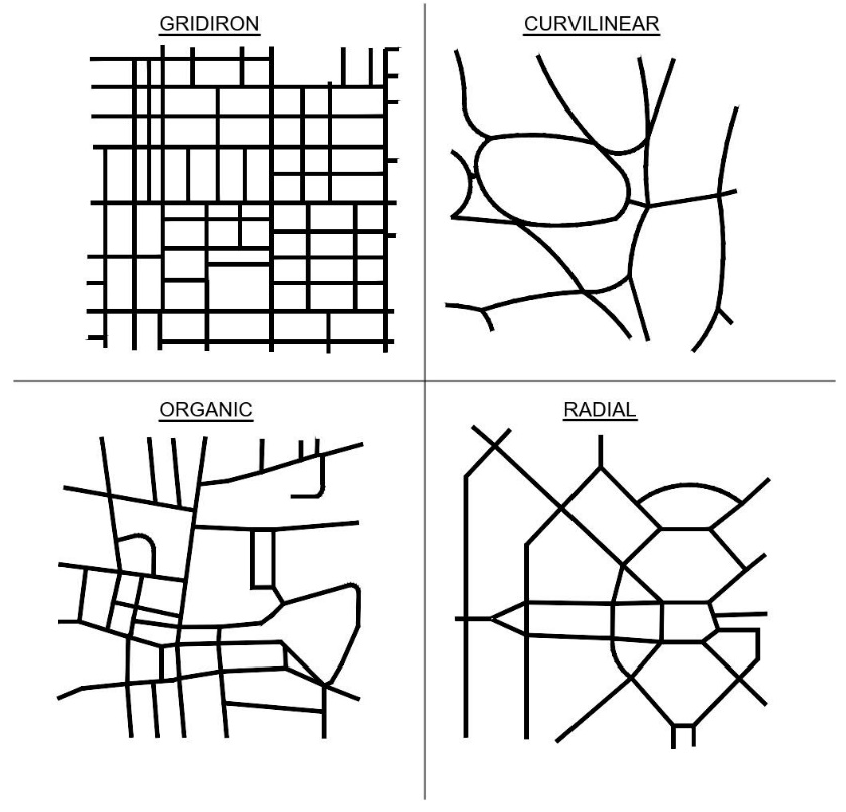
(1)
The arrangement, character and location of all lots and streets in a development shall be designed to make advantageous use of existing and planned streets, topographical conditions, public convenience and safety, and mature trees and other natural physical features. All street layouts shall be designed in compliance with the State of Florida Manual of Uniform Standards for Design, Construction, Maintenance for Streets and Highways or criteria contained in this ULDC, unless an exception to these standards is granted in writing by the County Engineer prior to preliminary development plan approval.
(2)
Dead-end streets shall not exceed two hundred fifty (250) feet in length except where a turn-around or cul-de-sac is provided. In no case, shall a dead-end street or cul-de-sac exceed one thousand (1,000) feet in length except for unpaved roads developed in accordance with Section 407.75. Turning radii of a cul-de-sac shall reflect the minimum required for 90-degree turns for WB30' design vehicles.
(3)
An intersection shall occur on every street a minimum of every one thousand (1,000) feet.
(4)
Street layouts shall provide for intersecting streets at right angles, ninety (90) degrees, but under no circumstances shall streets intersect at less than seventy-five (75) degrees, unless a roundabout or traffic circle is adequately designed. Street intersections shall be adequately spaced to prevent conflict or mutual interference of traffic flow. Generally, centerline offsets of less than one hundred fifty (150) feet shall be prohibited.
(5)
On streets with designated on-street parking, bulb-outs shall be provided at the street ends. The resulting bulb-out shall be landscaped with a street tree. No parking space shall be located within fifty (50) feet of the nearest right-of-way line of a collector roadway or one hundred (100) feet of the nearest right-of-way line of an arterial roadway.
(6)
Appropriate design speeds shall be identified by the applicant's engineer and agreed to by the County Engineer in conjunction with the street and lot layout of the development and shall be designed to meet the specific requirements of this ULDC and the Florida Greenbook. The selection of an appropriate design speed shall be based upon a rational prediction of the probable maximum operating speed on the street. The topography, general roadway geometry, surrounding land use, degree of access, use of traffic calming techniques, and desired posted speed limits shall be considered.
(c)
Dedication of future rights-of-way. All developments located adjacent to or along an existing or future alignment of a collector or arterial roadway, as identified on the future highway functional classification map adopted by Alachua County, shall provide dedication of right-of-way for the alignment that is roughly proportional to the impact of the development. The County Engineer may waive the dedication requirement, if there is a substitute dedication that would serve the same purpose, if due to the location and layout of the development, there is no public need for a dedication.
(d)
Waiver of requirement for dedication of roads. The BOCC's, upon recommendation of the DRC, may waive the requirement for the dedication of public streets and allow the streets to remain privately maintained upon finding that by reason of its location and anticipated use, the road will not serve a public purpose or provide connectivity to other platted or unplatted lands. However, the street to be privately owned shall be designed and constructed in accordance with the provisions of this chapter. All streets to be privately owned shall be dedicated to a property owners association or other maintenance entity acceptable to the County for ownership and maintenance.
(Ord. No. 09-01, § 2(Exh. A), 2-24-09; Ord. No. 10-16, § 2(Exh. A), 8-10-10; Ord. No. 2016-10, § 2(Exh. A), 6-28-16; Ord. No. 2018-23, § 2(Exh. A), 10-9-18; Ord. No. 2020-25, § 2(Exh. A), 11-10-20; Ord. No. 2025-12, § 2(Exh. A), 6-24-25)
Sec. 407.141. - Minimum design and construction standards for streets and drainage systems.
The purpose of this section is to identify street design and construction standards required as a condition of final subdivision approval, consistent with the Manual of Uniform Minimum Standards for Design, Construction and Maintenance for Streets and Highways (Florida Greenbook), the Federal Highway Administration's (FHWA's) Separated Bike Lane Planning and Design Guide, and the North American City Transportation Officials' (NACTO's) Urban Bikeway Design Guide.
(a)
Determination of street types. Street types shall be determined on the basis of the number of vehicle trips per day generated by each type of land use contemplated for the development. The number of vehicle trips generated shall be calculated based on the most recent Edition Trip Generation Manual published by the Institute of Transportation Engineers. A trip generation and distribution analysis shall be performed by a transportation professional in accordance with generally accepted engineering practices and shall require approval by the County Engineer. The average daily traffic volumes shall be shown at each approach of every street intersection within the development.
(1)
The lane width of the proposed streets shall be based upon the projected average daily trips and the standards outlined in Table 407.141.1 and the Florida Greenbook.
(2)
All streets, whether public or private shall be designed and constructed in accordance with the State of Florida Manual of Uniform Minimum Standards For Design, Construction and Maintenance For Streets and Highways, the "Construction and Inspection Standards of the Public Works Department", and these regulations. Typical street section drawings may be obtained from the County Engineer.
(b)
Excluded facilities. Access ways, alleys and driveways leading to on-site parking in common areas or to individual lots and private easement roads in rural residential subdivisions with no more than nine (9) lots may be excluded from the definition of a street, provided that the following occur:
(1)
Estimated average daily traffic does not exceed four hundred (400) trips at full development for multiple-family or one hundred twenty-five (125) trips for single-family detached lots.
(2)
Appropriate provisions are made for the private maintenance of these areas.
(3)
These areas serve only those lots adjacent to the common areas or easements.
(4)
The maximum distance from the public street road to the most distant lot or parking space in the common area or easement as measured along the centerline of the access way or driveway is no greater than one thousand (1,000) feet.
(5)
For private roads in rural residential subdivisions with no more than nine (9) lots, if the maximum distance from the public road to the most distant parking space in the common area or easement as measured along the centerline of an access way or driveway is greater than one thousand (1,000) feet, the Board will take action on a Preliminary Development Plan in compliance with Article X Development Plan Review. In addition to the requirements in Article X and Section 407.76 the Board may apply the conditions below, as applicable:
a.
Deed restriction(s) that no further subdivision or clustering of any lot(s) shall be permitted.
b.
Not further than five (5) road miles from a fire hydrant/station to the most distant lot or if beyond that distance provide a note on the plat stating: "DUE TO THE RURAL LOCATION OF THIS PARCEL AND DEPENDING ON THE STATE OF MAINTENANCE OF ACCESS WAYS, EMERGENCY RESPONSE TIMES MAY BE ADVERSELY AFFECTED, FIRE HYDRANTS ARE NOT AVAILABLE FOR FIRE SUPPRESSION".
c.
Hard-surfaced material for access way or driveway longer than one thousand (1,000) feet to mitigate deterioration.
(6)
Such access ways, alleys, driveways and associated parking areas shall meet the existing off-street parking requirements of Alachua County, as well as criteria established in this Article. The minimum width of pavement for this access shall be ten (10) feet for ADT less than two hundred (200) and sixteen (16) feet for ADT greater than two hundred (200).
(7)
Private internal easement roads in rural residential subdivisions with no more than nine (9) lots shall have a traveled width of eighteen (18) feet with a minimum LBR of thirty-five (35), two-foot stabilized shoulders and a minimum depth of six (6) inches for the stabilized area. Private roads may be paved. The internal road must have a minimum twenty (20) foot horizontal and 14-foot vertical clearance unless a waiver is approved consistent with the Florida Fire Prevention Code Chapter 18. Private internal roads shall be in an easement or common area not less than forty (40) feet in width. Drainage for private roads shall be designed to meet the requirements of this ULDC.
(c)
Minimum street design specifications.
(1)
All streets shall be designed in accordance with the following minimum specifications, as depicted in Table 407.141.1. The numerous graphics included herein are intended to give clear direction as to the intent of the street cross-section requirements. The graphic images are intended to supplement and clarify the written text. In the event a graphic image conflicts with written text, the written text shall prevail.
(2)
The street design specifications are typical, and thus may be modified to accommodate special circumstances. Such modifications shall be reviewed and subject to approval by the County Engineer.
(3)
Alternative street designs may be approved by the County Engineer where the design is found to be consistent with the intent of the zoning district and is found to further the design standards included herein.
(d)
Street surfaces.
(1)
Street surfaces shall be standard Florida DOT approved asphaltic concrete mixes as approved by County Engineer. Placement of street surfaces shall conform to the Alachua County Public Works Department Construction and Inspection Standards.
(2)
Other types of construction or materials may be utilized for the surface and base of the roadway, if equal or greater strength requirements are met, and if approved by the County Engineer (i.e. colored concrete; brick pavers).
(e)
Pavement thickness.
(1)
Streets with a projected ADT of less than or equal to one thousand two hundred (1,200) shall have a minimum pavement thickness of one and one-half (1.5) inches, a minimum base thickness of eight (8) inches, and a minimum 12-inch subgrade with a limerock bearing ratio (LBR) of forty (40).
(2)
Streets with a projected ADT between one thousand two hundred one (1,201) and two thousand five hundred (2,500) shall have a minimum pavement thickness of two (2) inches of structural asphalt, a minimum base thickness of eight (8) inches, and a minimum 12-inch subgrade with a limerock bearing ratio (LBR) of forty (40).
(3)
Streets with a projected ADT between two thousand five hundred one (2,501) and seven thousand five hundred (7,500) shall have a minimum pavement thickness of two (2) inches of structural asphalt and one (1) inch of friction course, a minimum base thickness of ten (10) inches, and a minimum 12-inch subgrade with a limerock bearing ratio (LBR) of forty (40). The friction course surface shall be placed ninety (90) days prior to the expiration of the one-year warranty period as outlined in Section 407.86 of this Code.
(4)
Streets with a projected ADT greater than seven thousand five hundred one (7,501) shall have a minimum pavement thickness of two (2) inches of structural asphalt and one and one-half (1.5) inches of friction course, a minimum base thickness of ten (10) inches, and a minimum 12-inch subgrade with a limerock bearing ratio (LBR) of forty (40). The friction course surface shall be placed ninety (90) days prior to the expiration of the one-year warranty period as outlined in Section 407.86 of this Code.
(5)
The County Engineer has the authority to approve alternate designs meeting the objectives of technical guidelines and regulations upon demonstration by the applicant that result in sufficient design to meet the minimum requirements for that particular scenario.
(f)
Roadway base and subgrade.
(1)
Roadway base shall be constructed of Ocala limerock, or its equivalent, with a minimum Limerock Bearing Ratio (LBR) of one hundred (100) and compacted to ninety-eight (98) percent of maximum density in accordance with AASHTO Method T-180.
(2)
Roadway subgrade shall be stabilized to a minimum depth of twelve (12) inches and be compacted to ninety-five (95) percent of maximum density in accordance with AASHTO Method T-180, except arterial and collector streets shall be compacted to ninety-eight (98) percent maximum density.
(3)
Where soils classified as AASHTO soil groups A-6, A-7 or A-8 are encountered in the subgrade, such materials shall be removed to a minimum depth of twenty-four (24) inches below the base and replaced with AASHTO soil groups A-1, A-2 or A-3.
(4)
An additional six (6) inches of limerock meeting the requirements of Subsection 407.141(f)(1) may be substituted for twelve (12) inches of subgrade meeting the requirements of Subsection 407.141(f)(2) provided that the criteria of Subsection 407.141(f)(3) is met.
(g)
Drainage systems.
(1)
All street classifications may be constructed with a closed (curb and gutter) drainage system. Where a closed drainage system is used, standard curb and gutter (FDOT Type F) shall be constructed. Drop-type (Miami) curb and gutter may only be constructed on streets where profile vertical alignment is less than three (3) percent and the curvature of the centerline alignment is less than one hundred (100) feet. The use of drop-type curb in any other location requires special approval from the County Engineer.
(2)
All drainage pipe shall have adequate capacity to carry the runoff resulting from a rainfall intensity, which has a return period of once in three (3) years with a minimum time of concentration of ten (10) minutes. The FDOT rainfall intensity curve for Alachua County shall be used.
(3)
Where storm sewers are used, the maximum length of gutter flow shall be governed by the street grade and inlet capacities. Minimum grade for curb and gutter shall be three-tenths (0.3) percent, except in extreme cases where two-tenths (0.2) percent may be used; however, one-half (0.5) percent shall be held insofar as practical.
(4)
All drainage pipe and culvert material shall be in accordance with current FDOT Standard Specifications for Road and Bridge Construction, latest edition, or as approved by County Engineer. If polyethylene material is utilized, a pipe inspection and video report shall be provided in accordance with the current FDOT Standard Specifications for Road and Bridge Construction, latest edition. For closed drainage systems, minimum pipe size shall be fifteen (15) inches in diameter or equivalent on private roads and eighteen (18) inches in diameter or equivalent on public roads. For all open drainage systems the minimum pipe size shall be eighteen (18) inches in diameter or equivalent.
(5)
All inlet grates shall be cast iron or steel with minimum size of two (2) square feet net open area.
(6)
Roadside swales. Open (roadside swales) drainage systems may be permitted for the street classifications indicated in Table 407.141.1, if the following requirements are met; provided, however, that the County Engineer shall have final approval authority for roadside swales.
a.
Based on the ten-year storm, one-hour storm, the flow velocity shall not exceed three (3) feet per second without paved inverts and the swale flow shall not encroach on the pavement. Roadside swales shall typically have no front slopes steeper than 4:1. Any back slopes greater than 3:1 shall be sodded.
b.
Additional right-of-way may be required to meet design conditions for swale section streets.
c.
The applicant shall provide supporting hydrologic, soils, topographic and erosion control data deemed necessary by the County Engineer in order to determine whether roadside swales are permissible.
d.
Roadside swales shall not be permitted where the estimated wet-season groundwater is within three (3) feet of the final profile of the street. Particular caution shall be used in areas where the soils encountered are predominately of Soil Conservation Service Types 7B, 7C, 10, 11, 12, 13, 14, 15, 16, 17, 18, 19, 21, 22, 23, 25, 26, 31B, 31C, 32B, 32C, 32D, 34, 44B, 48, 51, 52, 53, 54, 56, 57B, 60 and 61.
e.
Documentation of unsaturated vertical infiltration and saturated horizontal soil conductivity estimates/test results and other aquifer characteristics shall be used in the design of a swale stormwater management system and shall be submitted for review and consideration. Following determination of vertical and horizontal infiltration, post hydrologic conditions must be similar to pre-development hydrologic conditions. A minimum of one (1) boring per improvement shall be required to verify infiltration rates.
f.
For existing roadside swales that discharge to a stream or open lake basin, the stormwater management system must be designed such that the peak rate of discharge does not exceed the predevelopment peak rate of discharge for storm events up to and including the 25-year critical duration storm. If these criteria cannot be met and it can be demonstrated that no downstream detrimental effects will occur, the County Engineer may approve other measures.
g.
For existing roadside swales that discharge to a closed depression, the stormwater management system must be designed such that the peak rate of discharge and peak volume discharge does not exceed the predevelopment peak for storm events up to and including the 100-year critical storm. If these criteria cannot be met and it can be demonstrated that no downstream detrimental effects will occur, the County Engineer may approve other measures.
(7)
The County Engineer, after consultation with the applicant, may require installation of underdrains parallel to and along one or both sides of the paved surface to prevent the free ground water table from rising within twelve (12) inches of the bottom of the base material.
(8)
Non-paved right-of-way of the streets shall be provided with suitable vegetative cover to prevent erosion; this includes a sod strip along the edge of pavement on swale section streets and sodding between the back of curb and on edges of sidewalks, where sidewalks are provided.
(h)
Street design specifications.
(1)
Table 407.141.1 identifies the required specifications for all streets in the County.
a.
Applicability. All new privately developed and redeveloped roads shall comply with the specifications of Table 407.141.1. Where feasible, County-built roads shall endeavor to comply with the specifications of Table 407.141.1 within existing rights-of-way.
Table 407.141.1
Street Design Specifications
2.
Roadway plans may be proposed that calm traffic, reduce impervious surface, provide safe and convenient travel for all modes of transportation, and preserve existing natural features and tree canopy.
3.
Where AADT changes across a given corridor, the County maintains the right to generalize across segments - within reason - to maintain a consistent, legible, and safe corridor.
4.
Table 407.141.1, above, does not preclude the development of one-way streets or streets with dedicated transit lanes. One-way streets and streets featuring dedicated transit lanes shall be reviewed on a case by case basis. One-way streets shall have a pavement width between twelve (12) and sixteen (16) feet.
5.
For urban roadways under one thousand five hundred (1,500) ADT, street section shall be accompanied by mitigating traffic calming measures placed every two hundred sixty (260) to five hundred (500) feet.
6.
If transit or heavy freight are projected to run on general purpose travel lanes, then the lane width shall be eleven (11) feet.
7.
Turning lane widths shall be ten (10) foot wide per Florida Greenbook.
8.
In Table 407.141.1, "Direct" access means that individual uses may utilize a driveway to the road. "Limited" means that individual uses must utilize a shared separate roadway, driveway or alley, located to the rear of buildings.
9.
Where roadside swales are provided, they shall be designed in accordance with Article XIII, Section 407.141(g)(6) and F.S. § 403.803(14).
10.
Where Table 407.141 indicates a sidewalk or multi-use path is required, those facilities shall be provided on both sides of roadway, unless otherwise noted in the table. Where one side multi-use paths are proposed, the location must be justified, and appropriate crossing treatments to all major destinations must be provided.
11.
Street trees are required wherever there is an adjacent sidewalk or multiuse path per this table and shall be located between the sidewalk or multi-use path and the vehicular travel lanes. Planting areas and specifications, including root barrier requirements, shall determined by ULDC Table 407.45.1. Tree wells may be used, so long as seven (7) feet minimum clear width (on local streets) and ten (10) feet minimum clear width (on collector roads) is maintained. Clear width may include flush, ADA-compliant tree grates.
12.
Where Table 407.141.1 requires two-foot shoulders, the entirety shall be paved. Where eight-foot shoulders are required, please build eight-foot shoulder, including five-foot paved shoulder and three-foot grass shoulder.
13.
Where on-street parallel parking is provided it must be marked at the width indicated in the table or greater. The gutter pan of curbs shall be used to meet the minimum on-street parking widths. In TODs and TNDs, on-street parking is optional, but must be provided on the majority of streets. Provision of on-street parking shall be adequate to serve the proposed intensity of development in order that the required clearances for public safety vehicles are maintained. Angled parking is allowed on roadways where parallel parking is allowed. Angled parking spaces shall be designed to meet the stall depth requirements of Table 407.19.1 with a minimum width of eight and one-half (8.5) feet.
14.
Where medians are provided in urban contexts, they must be raised (curb and gutter). In rural contexts, they may be flush. In all contexts, medians shall be landscaped.
15.
For roads to be dedicated to the public, the right-of-way width must be sufficient to include all required and proposed cross-section elements, plus an additional two (2) feet. to accommodate maintenance activities on either side of the section.
16.
Specifications for rural collector roadways shall apply to roadway projects only, not to limited-scale developments permitted in areas outside the urban cluster per Alachua County's ULDC.
17.
Where separated bicycle facilities are required, raised bike lanes may be provided. They shall be designed in accordance with the Florida Design Manual, 223.2.4.2., including an additional two-foot buffer separating the bike lane from pedestrian walkways.
18.
Developments with a valid preliminary development plan or planned development that identifies street cross sections and was approved prior to June 24, 2025 may provide street sections consistent with the approved preliminary development plan or planned development.
(i)
Intersection design. The design of intersections shall balance the needs of all street users, including pedestrians and bicyclists. Safe pedestrian crossings shall be included on every arterial and collector. The following design features are required as applicable:
(1)
Dedicated turning lanes.
a.
On street types with medians, the median shall be narrowed to allow the left-turn lane without disrupting on-street parking and bulb-outs.
b.
On street types without medians and with on-street parking, on-street parking shall cease a safe distance from the intersection, and travel lanes shall shift to allow for a dedicated left-turn lane.
(2)
Bulb-outs. Bulb-outs are curb extensions at intersections that reduce roadway width curb to curb, depicted in Illustration 407.141.2. Bulb-outs are encouraged where possible. At a safe distance from the intersection, on-street parking shall cease and the curb shall be extended to the travel lane.
(3)
Medians. On street types with medians, a median is permitted at intersections after a left-turn lane had been provided. Construction and landscaping of these medians shall provide a mid-intersection pedestrian refuge.
(4)
Roundabouts. A roundabout is a raised circular structure constructed at a three-way or four-way intersection, depicted in Illustration 407.141.2. Urban single lane roundabouts may be installed in all areas; mini-roundabouts may be constructed on local roads and local roads with parking only. Roundabout design shall comply with current as approved by the County Engineer.
a.
Urban single lane roundabouts on collector and arterial roads and future collector or arterial roads as shown the Future Highway Functional Classification Map shall be designed to accommodate a WB-50 class vehicle in the travel lane. Urban single lane roundabouts on all other road types shall be designed to accommodate a WB-40 class vehicle in the travel lane. Truck aprons shall be provided to accommodate the next highest class vehicle. (WB-40 and WB-50 refer to the American Association of State Highway and Transportation Officials (AASHTO) vehicle classification schemes.) Turning vehicle template drawings shall be submitted as verification that design vehicles are accommodated. Electronic CAD files shall also be submitted.
b.
A roundabout justification study and operational analysis per current state and federal guidelines as approved by the County Engineer shall be provided for all roundabouts proposed for collector roads or higher. The study shall compare the roundabout to a stop-controlled and signalized intersection. The study shall show that the proposed roundabout operates at an acceptable level of service over at least a 20-year lifespan.
c.
Raised splitter islands shall be provided on all approaches to the roundabout in order to channelize traffic and provide deflection.
d.
On roads with sidewalks, pedestrian crossings shall be provided at the roundabout on each approach where a sidewalk exists. A six-foot by six-foot pedestrian refuge shall be provided in the splitter island.
e.
Pedestrian crossings shall be located at least twenty (20) feet back from the yield line to provide storage room for vehicles entering and leaving the roundabout.
f.
On roads with an on-street bikeway, a ramp shall be provided ahead of the roundabout to allow bicyclists access to the sidewalk.
g.
An appropriate combination of street lighting and landscape lighting shall be provided to light all approaches and the center island. At a minimum, one (1) street light shall be provided on each approach to the intersection.
h.
Mini-roundabouts shall be designed to accommodate an S-BUS-36 (Standard for School Bus) within the travel lane. A fully traversable central island may be used to accommodate larger vehicles.
i.
All roundabouts shall be signed and marked in accordance with the latest MUTCD and other applicable state and federal guidelines.
(5)
Signals. When a signal is proposed a detailed traffic study shall be submitted with the preliminary development plan approval. The traffic study shall include:
a.
A signal warrant analysis per the MUTCD and MUTS; and
b.
A roundabout justification per current state and federal guidelines as approved by the County Engineer; and
c.
A comparison of the two (2) intersection types on the basis of capacity, multi-modal considerations, safety and long-term maintenance costs to the public; and
d.
An operational analysis based on designs that operate at an acceptable level of service over at least a 20-year lifespan.
Illustration 407.141.2:
(6)
For guidance and standards regarding intersection treatments for separated bike lanes, refer to the Florida Design Manual, 223.2.5.2 Intersections and Driveways.
(j)
Traffic calming. Traffic calming measures described in Illustration 407.141.3 may be used to modify vehicle speeds and other driver behavior. An asterisk (*) means that the device is permitted, while a blank cell means that the device is not permitted. Other traffic calming devices may also be used subject to approval of the County Engineer. References to arterial and collector roadways in this include future arterial and collector roadways on the Future Highway Functional Classification Map.
(1)
The choice, design and installation of traffic calming measures on any collector or arterial road shall be balanced with its regional vehicle traffic-carrying role.
(2)
The planning and installation of traffic calming measures shall respect the presence of driveways.
| Traffic Calming Measures | ||
|---|---|---|
| Street Narrowing | 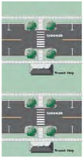 | Mid-Block Bulb-Outs Mid-block bulb-outs reduce the width of the roadway for a mid-block section. They shorten crossing distances for pedestrians and draw attention to pedestrians via raised peninsulas. Bulb-outs can be built within the marked on-street parking area or on residential roadways over 20 feet in width. |
 | Restriping Street can be restriped to narrow the lanes to the minimum for that classification. The excess space can be used to create bike lanes or marked on-street parking on one or both sides. Bicycle lanes shall be 4 feet wide minimum, and on-street parking shall be 7 feet wide minimum. The parking can be staggered to create a weaving path on the roadway, further informing drivers that caution should be used in the neighborhood. | |
 | Gateways Gateways appear to narrow the street, and also serve as highly visible entryways into neighborhoods. Gateway features can also double as transit waiting areas. | |
| Vehicle Deflection |  | Chicanes A chicane changes the physical characteristics of a roadway section from an existing straight alignment to a series of horizontal curves. Trees can be planted in the slow point to restrict the driver's vision down the street, creating the feeling of a "closed" street. |
| Pavement Sharing |  | Mid-Block Yield Point The mid-block single-lane yield point reduces the street width to a single lane for a short section at some point between intersections. A variety of designs are possible for the remaining single lane of traffic: centered on the existing street, offset to one side or aligned in a curve from one side of the street to the other. |
 | Unmarked On-Street Parking Allowing on-street parking on streets without designated on-street parking areas will create a series of single-lane yield points wherever parked cars are present. This "informal" single-lane yield point occurs when the street width is narrow enough to prevent simultaneous passing of two moving vehicles past a parked vehicle. For streets up to 30 feet in width, allowing parking on both sides of the street is necessary to create a yield point. | |
| Pavement Surface Treatments |  | Brick Pavement Brick streets are also an effective traffic calming measure. The advantages of a brick street are that it is aesthetically pleasing and it calms traffic better as it ages as the surface wears out. Installation costs are higher than those for asphalt roadways, but long-term maintenance costs are lower. However, brick pavement can be loud. |
 | Raised Intersections Raised intersections slow cars down throughout an entire intersection, providing an extra level of safety for pedestrians crossing an intersection. This improvement may be most appropriate for commercial areas where both vehicular and pedestrian traffic volumes are high. Textured pavement can also be part of this improvement. |
(Ord. No. 09-01, § 2(Exh. A), 2-24-09; Ord. No. 09-05, § 2(Exh. A), 9-8-09; Ord. No. 10-16, § 2(Exh. A), 8-10-10; Ord. No. 12-09, § 2(Exh. A), 10-9-12; Ord. No. 2016-10, § 2(Exh. A), 6-28-16; Ord. No. 2018-23, § 2(Exh. A), 10-9-18; Ord. No. 2020-09, § 2(Exh. A), 3-10-20; Ord. No. 2020-25, § 2(Exh. A), 11-10-20; Ord. No. 2021-13, § 2(Exh. A), 8-24-21; Ord. No. 2024-04, § 2(Exh. A), 2-27-24; Ord. No. 2025-06, § 2(Exh. A), 3-25-25; Ord. No. 2025-12, § 2(Exh. A), 6-24-25)
Sec. 407.142. - Minimum design and construction standards for pedestrian networks.
The purpose of this Section is to identify pedestrian access design and construction standards.
(a)
Pedestrian network standards.
(1)
A sidewalk or a multi-use path, as required by Table 407.141.1, shall be provided along the entire property frontage with all external streets within the Urban Cluster. The specific facility type provided shall correspond to the adopted capital improvements element. If no specific facility type is specified in the capital improvements element, the default facility shall be consistent with Table 407.141.1 The width of the multi-use path may be decreased to eight (8) feet for limited segments where existing environmental, topographic, right-of-way and utility constraints exist. A multiuse path shall run roughly parallel and within three hundred (300) feet of the street right-of-way. Multiuse paths and sidewalks may be provided within a public use easement.
(2)
Each development shall include a pedestrian network that shall provide direct pedestrian and bicycle pathways between other developments and within the development, and subsequent phases of the development, and adjacent neighborhood type uses such as public and private schools, parks, activity centers and other recreational areas.
(3)
The pedestrian network shall be in a connected block pattern throughout the development. Intersections of pedestrian facilities shall occur on every pedestrian facility at least every six hundred (600) feet.
(4)
The following elements qualify as a pedestrian facility and may form a side of a block provided they meet ADA accessibility requirements: Continuous sidewalks along roadways, alleys less than or equal to five hundred (500) feet in length, pass-throughs located at mid-block locations or at cul-de-sac heads, boardwalks and multi-use trails.
(5)
The following elements do not qualify as pedestrian facilities and may not form a side of a block: Recreational or Open Space without a designated pedestrian or multi-use path, alleys greater than five hundred (500) feet in length and trails, sidewalks and boardwalks that dead-end.
(6)
Pedestrian network standards may be modified where the DRC finds that the following circumstances exist: continuation of the pedestrian network at a particular location would require encroachment on regulated natural features; boardwalks for such crossings not practicable or not consistent with protection of the resource; and other available alternatives would have undue and avoidable impacts on wetlands, or native habitat, or other regulated natural features.
(7)
Multi-use paths and sidewalks shall be located at the back of the right-of-way. Multi-use paths and sidewalks shall be located behind existing or planned vegetation. Where existing vegetation is located at the back of the right-of-way, the multi-use path or sidewalk should be located in either additional right-of-way or an easement. The multi-use path or sidewalk may be located closer to the roadways due to environmental, topographical, utility or right-of-way constraints or where the County Engineer deems safety issues exist.
(b)
Sidewalks.
(1)
Sidewalks shall be constructed to a minimum width as shown in Table 407.141.1, four (4) inches in thickness, and constructed of a minimum two thousand five hundred (2,500) psi concrete. An alternative may be substituted if approved by the County Engineer.
(2)
Sidewalks shall be designed to comply with the Americans with Disabilities Act and Florida Accessibility Code standards.
(3)
When pedestrian crossings are provided at mid-block locations, raised crosswalks (or other traffic-calming measure(s) identified in Subsection 407.141(j)) shall be located at all points where the pedestrian crossing traverses the lane of vehicle travel. When pedestrian crossings are provided at intersection locations, the requirements in intersection design and traffic calming, as outlined in Subsection 407.141(j), shall be followed.
(4)
In special areas designed as permanent or occasional plaza areas, curbs between on-street parking and sidewalk are optional.
(5)
Sidewalks are required along both sides of internal streets within Activity Centers and shall conform to the following minimum standards: Single-family attached/multi-family/nonresidential excluding commercial (eight-foot sidewalks), Commercial/mixed use (ten-foot sidewalks). Single-family detached shall provide either six-foot sidewalks or a ten-foot multiuse path if the front of the homes are oriented to the path. Sidewalk widths shall be clear of any obstructions.
(c)
Multi-use paths. Multi-use paths shall be constructed parallel to and up to three hundred (300) feet from the roadway in an Open Space or common area. A multi-use path may satisfy the pedestrian facility requirement for two (2) parallel roadway facilities. Multi-use paths are intended to provide safe and convenient bicycle and pedestrian transportation to major attractors within a development and between developments. Multiuse paths can be placed behind homes or homes can be oriented to front multiuse paths. Appropriate access management, site distance and intersection treatments must be used wherever a multiuse path crosses an intersecting driveway or street. Development plans shall be designed to provide for safe pedestrian and bicycle circulation. The County Engineer may require deviations from this requirement due to public safety concerns. In no instance shall a pedestrian facility be eliminated entirely from a street corridor. Multi-use paths shall conform to the following standards.
(1)
Vehicle/path separation. Where multi-use paths are parallel and adjacent to a driveway or street (public or private), they shall be raised six (6) inches and curbed, or separated from the driveway or street by a five-foot minimum strip within bollards, a landscape berm or other physical barrier. If a raised path is used, the ends of raised portions shall be equipped with curb ramps.
(2)
Housing and path separation. Multi-use paths shall be separated a minimum of five (5) feet from all residential living areas on the ground floor, except at building entrances. Separation is measured from the path edge to the closest dwelling unit.
(3)
Crosswalks. Where paths cross a parking area, driveway or street ("crosswalk"), they shall be clearly marked with contrasting paving material, humps, raised crossing or painted striping. An example of contrasting paving material is the use of a concrete crosswalk through an asphalt driveway. If painted striping is used, it shall consist of thermo-plastic striping or similar type of durable application. Neighborhood streets do not require crosswalk striping except when the street width is greater than thirty-six (36) feet or at the intersection of roadways that have AADTs greater than one thousand five hundred (1,500).
(4)
Path surface. Path surfaces shall be concrete, asphalt, brick/masonry pavers or other durable surfaces, and shall comply with the Americans with Disabilities Act (ADA) requirements. Multi-use paths shall be constructed to a minimum width as shown in Table 407.141.1 and with a surface of one (1) inch in thickness and constructed with SP 9.5 asphaltic concrete and four (4) inches limerock base with LBR one hundred (100) and ninety-eight (98) percent maximum density using modified proctor and six (6) inches stabilized subgrade with LBR thirty (30) and ninety-eight (98) percent maximum density using modified Proctor. An alternative may be substituted if approved by the County Engineer.
Illustration 407.142.1 Multiuse Path Examples
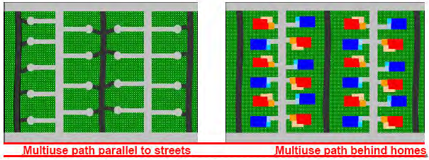
(Ord. No. 09-01, § 2(Exh. A), 2-24-09; Ord. No. 09-05, § 2(Exh. A), 9-8-09; Ord. No. 10-16, § 2(Exh. A), 8-10-10; Ord. No. 12-09, § 2(Exh. A), 10-9-12; Ord. No. 2020-25, § 2(Exh. A), 11-10-20; Ord. No. 2025-12, § 2(Exh. A), 6-24-25)
Sec. 407.143.- Intent.
It is the intent of this Article to:
(a)
Provide for adequate outdoor lighting for safety and security;
(b)
Prevent inappropriate, poorly designed or installed outdoor lighting; and
(c)
Minimize the impact of light trespass from one property onto the next by establishing standards for outdoor lighting.
(Ord. No. 12-09, § 2(Exh. A), 10-9-12; Ord. No. 2020-25, § 2(Exh. A), 11-10-20)
Sec. 407.144. - Applicability.
The provisions of this Article are applicable to all outdoor lighting for development and redevelopment in Alachua County. All development that requires the submittal of a development plan shall demonstrate compliance with the provisions of this Article.
(Ord. No. 12-09, § 2(Exh. A), 10-9-12; Ord. No. 2020-25, § 2(Exh. A), 11-10-20)
Sec. 407.145. - Exemptions.
The following outdoor lighting is exempt from the requirements of this Article:
(a)
Lighting for signs that is allowed in Chapter 407, Article II, Signs;
(b)
Light fixtures for single-family homes mounted greater than three (3) feet above grade that generate less than two thousand two hundred fifty (2,250) lumens;
(c)
Seasonal displays and landscape ornamental lighting;
(d)
Lighting that is installed as a requirement of any public safety agency for the purposes of traffic control;
(e)
Lighting that is installed as a requirement of federal or state regulations for airports;
(Ord. No. 12-09, § 2(Exh. A), 10-9-12; Ord. No. 2020-25, § 2(Exh. A), 11-10-20)
Sec. 407.146. - Prohibitions.
No person shall install any of the following types of outdoor lighting:
(a)
Mercury vapor lamps;
(b)
Blinking, flashing, moving, revolving, flickering, changing intensity or color, and chase lighting, except temporary seasonal displays, lighting for public safety or required for air traffic safety;
(c)
Any light fixture that may be confused with or construed as a traffic control device;
(d)
Any fixture oriented such that light is emitted at an angle more than 85 degrees from nadir;
(e)
Searchlights, beacons, and laser source light fixtures;
(f)
Any lamp or bulb that is visible beyond the property line on which it is located, except as provided in Section 407.145 or as provided for in this Article.
(Ord. No. 12-09, § 2(Exh. A), 10-9-12; Ord. No. 2020-25, § 2(Exh. A), 11-10-20)
Sec. 407.147. - Photometric plan required.
A photometric plan is a required element of development plans for all commercial, industrial, institutional, and multi-family residential developments. Where a single-family subdivision proposes non-residential facilities, such as community centers or parks, a photometric plan shall be included for those areas. Photometric plans shall include the following:
(a)
Maintained light levels to at least thirty (30) feet on each side of property lines or project boundaries;
(b)
Data points calculated on no greater than a ten-foot by ten-foot grid;
(c)
Fixture location, mounting height, and pole height for each fixture location; and
(d)
Fixture catalog numbers and manufacturer's cut sheets for the specified fixtures.
(Ord. No. 12-09, § 2(Exh. A), 10-9-12; Ord. No. 2020-25, § 2(Exh. A), 11-10-20)
Sec. 407.148. - Lighting standards.
(a)
General.
(1)
All lighting, regardless of location, shall be designed to prevent direct glare, light spillage and hazardous interference with automotive, bicycle and pedestrian traffic on adjacent streets and properties.
(2)
Except as may be allowed below, all acceptable outdoor luminaries shall employ IESNA "semi-cutoff", "cutoff" or "full cutoff" light distribution designations and shall be either partially shielded fixtures or fully shielded fixtures to reduce glare or spillage.
(3)
Any deviation(s) from these standards shall be noted at the time of final development plan review along with a statement explaining the purpose of and reason for the deviation(s). The DRC shall make a determination whether to accept such deviation(s).
(b)
Parking areas.
(1)
Where lighting is to be provided for a parking area, it shall be designed to provide safe, convenient and efficient ingress and egress for pedestrians and vehicles. Lighting shall be designed such that light levels and uniformity ratios are in compliance with the minimum standards proscribed by the Illuminating Engineering Society of North America (IESNA).
(2)
Lighting design shall be consistent and coordinated for the entire site.
(3)
Mounting heights for exterior luminaries shall not exceed thirty-five (35) feet in height within a parking lot and eighteen (18) feet within adjacent non-vehicular pedestrian areas (with the height being measured from the finished grade to the bottom of the luminous opening of the luminary).
(4)
Maximum maintained illumination levels measured at finished grade on adjoining property within twenty-five (25) feet of the property line of the project in question shall be no more than one (1.0) footcandles (fc) if the adjoining property is zoned non-residential and no more than one-half (0.5) fc when the adjoining property is zoned residential or agriculture or is an existing residential use within one hundred (100) feet of the property line.
(c)
Pedestrian use areas.
(1)
Where lighting is to be provided for a pedestrian use area, it shall be designed to provide safe use of the area by pedestrians. Lighting shall be designed such that light levels and uniformity ratios are in compliance with the minimum standards proscribed by the Illuminating Engineering Society of North America (IESNA).
(2)
Pedestrian scale lighting design shall be consistent and coordinated for the entire site.
(3)
Mounting heights for exterior luminaries shall not exceed fifteen (15) feet within pedestrian use areas (with the height being measured from the finished grade to the bottom of the luminous opening of the luminary).
(4)
Maximum maintained illumination levels measured at finished grade on adjoining property at the property line of the project in question shall be no more than one-half (0.5) footcandles (fc).
(d)
Athletic fields.
(1)
Where lighting is to be provided for athletic fields, it shall be designed to provide the minimum lighting necessary for safe activity on the fields. Lighting shall be designed such that light levels and uniformity ratios are in compliance with the minimum standards proscribed by the Illuminating Engineering Society of North America (IESNA).
(2)
Mounting heights for exterior luminaries that are located within one hundred (100) feet of the property line shall not exceed the maximum building height allowed within the adjacent zoning district (with the height being measured from the finished grade to the bottom of the luminous opening of the luminary)and shall be aimed to point away from the property line.
(3)
Exterior luminaries located more than one hundred (100) feet from the property line shall be designed such that maximum modeled initial measured candela value from any luminaire measured at five (5) feet above grade at the property line shall not exceed twelve thousand (12,000) candela.
(4)
Maximum maintained illumination levels measured at finished grade at the property line of the project in question shall be no more than one (1.0) fc if the adjoining property is zoned for non-residential use and no more than one-half (0.5) fc when the adjoining property is zoned residential or there is an existing residential use within one hundred (100) feet of the property line.
(5)
Acceptable outdoor luminaries shall be designed to reduce glare or spillage onto adjacent properties and to the open sky. The unique necessity of lighting athletic fields requires the allowance of fixtures that may not have a "cutoff" designation or be shielded. However, lighting solutions provided for athletic fields shall be required to meet the other standards of this Section.
(6)
Scoreboards or timer clocks that are separately illuminated shall be oriented such that, in the case of externally illuminated boards, the illumination source is pointed away from the closest adjacent property line, or, in the case of internally illuminated boards, the illuminate face is oriented away from the closest adjacent property line.
(Ord. No. 12-09, § 2(Exh. A), 10-9-12; Ord. No. 2020-25, § 2(Exh. A), 11-10-20)
Sec. 407.149.- Purpose.
It is the intent of this Article to provide for orderly and efficient redevelopment of properties within the Urban Cluster in order to promote efficient use of land, provide flexibility in design, promote walkable communities, and to discourage greenfield development and sprawl.
(Ord. No. 2017-17, § 2(Exh. A), 10-10-17; Ord. No. 2020-25, § 2(Exh. A), 11-10-20)
Sec. 407.150. - Applicability.
Sec. 407.151. - Flexible design standards.
All development shall meet applicable requirements of this ULDC. However, recognizing the difficulty in redeveloping sites the BOCC may consider deviations from certain development standards, such as buffers, landscaping, and stormwater, as may be necessary to promote redevelopment. Applicants shall provide a final redevelopment plan with a description of the deviation requested and a justification that explains why the current standard is not feasible based on the conditions of the site. Any requested deviations will be evaluated by staff and described in the staff report and presented with justification as a recommendation to the BOCC. The BOCC shall make a finding that the deviation is the minimal possible and that approval of such deviation generally meets the intent of this ULDC and would not hinder the public health, safety and general welfare of the residents and property owners of Alachua County. When no deviations are requested, a final development plan shall be submitted for review by the DRC.
(Ord. No. 2017-17, § 2(Exh. A), 10-10-17; Ord. No. 2020-25, § 2(Exh. A), 11-10-20)
Sec. 407.152.- Purpose.
Cottage neighborhoods are intended to:
(a)
Provide opportunities for creative, diverse and high-quality infill development within the Urban Cluster.
(b)
Promote a variety of housing types and sizes available within the community by providing small, detached individual dwelling units to meet the needs of a population diverse in age, income, and household composition.
(c)
Provide for more efficient use of land.
(d)
Encourage the creation of more usable Open Space for residents of the development.
(e)
Maximize resident and pedestrian oriented outdoor spaces while minimizing the impact of automobile traffic and parking.
(Ord. No. 2018-10, § 2(Exh. A), 3-13-18; Ord. No. 2020-09, § 2(Exh. A), 3-10-20; Ord. No. 2020-25, § 2(Exh. A), 11-10-20; Ord. No. 2023-06, § 2(Exh. A), 3-28-23)
Sec. 407.153. - Applicability.
Cottage neighborhoods are allowed as a limited use within urban residential land use designations, subject to the following standards.
(Ord. No. 2018-10, § 2(Exh. A), 3-13-18; Ord. No. 2020-25, § 2(Exh. A), 11-10-20; Ord. No. 2023-06, § 2(Exh. A), 3-28-23)
Sec. 407.154. - General requirements.
(a)
Cottage homes. A cottage home is a principal residential dwelling constructed within a neighborhood built consistent with the standards in this Article. The homes may be located on individually platted lots or on a common ownership lot that is not platted. Individual cottage homes may not exceed one thousand four hundred (1,400) square feet of conditioned enclosed space. Cottage homes shall consist of detached individual dwelling units only. No attached multi-family dwelling units shall be permitted.
(b)
Size of neighborhood. Cottage neighborhoods shall be on lots a minimum of two (2) acres in size unless otherwise approved by a special exception. A minimum of four (4) homes and a maximum of fifteen (15) homes are allowed around any common green in a cottage neighborhood. Cottage neighborhoods may also be incorporated within larger subdivisions of land developed consistent with Article VIII of this Chapter. Cottage neighborhoods shall not be permitted inside a subdivision platted prior to March 28, 2023 unless otherwise approved by a special exception.
(c)
Common buildings. One (1) community building per neighborhood is allowed. Community buildings may contain, but are not limited to, a club house, a common dining area, kitchen, bathroom, laundry facilities, one (1) sleeping quarters for guests and/or storage. The maximum size of a community building is two thousand five hundred (2,500) square feet.
(d)
Density. Per Policy 1.8.3 of the Future Land Use Element, cottage neighborhoods may develop at two (2) times the maximum units per acre of the zoning district designation.
(e)
Access. Cottage neighborhoods must have direct access to a paved, publicly maintained street. Private roads, drives or alleys within the neighborhood that are connected to a public street and access either the individual homes or common parking lots are allowed consistent with Subsection 407.141(b) multi-family requirements. All private road, drives or alleys shall have a clear width of twenty (20) feet.
(f)
Emergency access. For neighborhoods with common parking areas, stabilized access shall be provided such that the farthest distance from a structure to the stabilized surface is one hundred fifty (150) feet. The stabilized access shall be a minimum of ten (10) feet wide and have a clear width of twenty (20) feet.
(g)
Setbacks. All zoning district setbacks shall be applicable from the property boundaries and not from internal individual platted lots. Required buffers may be located within the setback.
(h)
Project boundary buffers. A 15-foot wide low density buffer, consistent with Section 407.43, shall be required along property lines adjacent to existing platted subdivisions or lots in excess of six thousand (6,000) square feet with an existing single-family residence.
(i)
Landscaping. Landscaping shall be consistent with Section 407.43.1, Required tree plantings and landscaping of this Chapter.
(j)
Open Space. Open Space shall be provided per Article V, Open Space, of this Chapter.
(k)
Stormwater. Stormwater management provision shall be consistent with Article IX, Stormwater Management of this Chapter.
(l)
Maintenance of Open Space, common areas and utilities. The applicant shall ensure that joint use and maintenance of public Open Space, community facilities, private roads and drives, and all other commonly owned and operated property is guaranteed through a maintenance plan, covenants, deeds and/or homeowners' association by-laws.
(Ord. No. 2018-10, § 2(Exh. A), 3-13-18; Ord. No. 2020-09, § 2(Exh. A), 3-10-20; Ord. No. 2020-25, § 2(Exh. A), 11-10-20; Ord. No. 2023-06, § 2(Exh. A), 3-28-23)
Sec. 407.155. - Design.
(a)
Common green. Each cottage neighborhood shall have at least one common green with multiple common greens allowed. The common green may be counted toward the Open Space required consistent with Section 407.52 and shall be designed to meet the following:
(1)
Each common green shall include at least four hundred (400) square feet unit fronting that common green.
(2)
The common green may include stormwater management facilities incorporating low impact design as long as a minimum of four hundred (400) square feet per dwelling unit is usable by the residents for active or passive recreation.
(3)
Amenities such as community gardens, benches, and pavilions are allowed in the common green.
(b)
Porches. All homes shall include at least one (1) open air covered front entry porch oriented toward the common green. Porches shall be a minimum of seventy (70) square feet. The minimum square footage may be reduced to sixty (60) square feet on cottage homes less than six hundred (600) total gross square feet of conditioned space.
(c)
Parking. Parking may be provided in lot or garage. Parking may alternately be co-located with the cottages when accessed by drive aisles. All parking must meet the following standards:
(1)
A minimum of one and one-half (1.5) spaces per unit shall be provided.
(2)
All common parking areas and associated drive aisles adjacent to neighboring residential property must be screened in addition to the required low-density buffer.
(d)
Pedestrian access. A system of interior walkways shall be provided to connect all homes parking areas, Open Space and any sidewalks along the public street(s) bordering the Cottage Neighborhood. Interior walkways shall meet applicable ADA accessibility requirements.
(e)
Fencing. Fencing within the development is limited to a maximum of fifty (50) percent opacity and no greater than four (4) feet in height may be used to delineate private yards, gardens or other areas. Solid fencing may be allowed along external borders not bordering streets.
(Ord. No. 2018-10, § 2(Exh. A), 3-13-18; Ord. No. 2020-09, § 2(Exh. A), 3-10-20; Ord. No. 2020-25, § 2(Exh. A), 11-10-20; Ord. No. 2023-06, § 2(Exh. A), 3-28-23)