
Allen City Zoning Code
ARTICLE VIII
SUBDIVISION REGULATIONS1
State Law reference— Municipal regulation of subdivisions and property development, V.T.C.A., Local Government Code § 212.001 et seq.; minimum requirements for subdivisions, 31 Tex. Admin. Code § 364.91.
Sec. 8.01.- Purpose.
The purpose of this article is:
1.
To protect and provide for the public health, safety, and general welfare of the community.
2.
To guide the future growth and development of the city, in accordance with the comprehensive plan.
3.
To guide public and private development in order to provide adequate and efficient transportation, water, sewage, and other public and private requirements and facilities.
4.
To establish reasonable standards of design and procedures for subdivision and resubdivision and to further the orderly layout and use of land.
5.
To ensure safety from fire, flood and other danger, and to prevent overcrowding of the land and undue congestion of population.
6.
To provide for the circulation of traffic and pedestrians required for the beneficial use of land and buildings and to avoid congestion throughout the city.
7.
To ensure that adequate public facilities and services are available and will have sufficient capacity to serve the proposed subdivision or addition and that the community will be required to bear no more than its fair share of the cost of providing facilities and services.
8.
To prevent the pollution of streams and ponds; to ensure the adequacy of drainage facilities; to safeguard the water table and to encourage the wise use and management of natural resources and enhance the stability and beauty of the community and the value of the land.
9.
To provide for open spaces through the most efficient design and layout of the land.
10.
To remedy the problems associated with inappropriately platted lands, including the premature subdivision, incomplete subdivision and scattered subdivision.
(Ord. No. 3697-8-19, § 1.H, 8-27-2019)
Sec. 8.02.1. - Jurisdiction.
1.
Pursuant to the authority granted in V.T.C.A., Local Government Code Ch. 212, the planning and zoning commission shall exercise the power and authority to administer standards established by this Code and to review, approve, or disapprove plats and development plans for subdivision of land and for any development within the corporate limits of the city and the unincorporated areas lying within the extraterritorial jurisdiction which show lots, blocks, or sites with or without new streets or highways or any lot improvement activities as defined by the ordinance.
2.
Any person wishing to divide land inside the city or within the city's extraterritorial jurisdiction shall submit to the commission a plan of the subdivision which shall conform to the requirements set forth in these regulations. A division of land under this section does not include a division of land into parts greater than five acres where each part has access and no public improvement is being dedicated.
3.
Except as provided in section 8.03.9, no subdivision plat shall be filed or recorded and no lot in a subdivision inside of the city or within the city's extraterritorial jurisdiction shall be improved or sold until the final plat shall have been approved by the commission or, when authorized, the director of community development, as set forth in this article.
4.
The city shall not accept streets or public rights-of-way, nor provide city services, including but not limited to the furnishing of sewage facilities and water service, and solid waste collection, unless or until a final plat conforming to the requirements of this article has been approved and filed for record in the map records of Collin County, Texas.
5.
Prior to the issuance of any building permit, the property for which the permit is being issued shall have been platted and all required public improvements accepted by the city, or shall exist as an official lot or tract of record.
6.
Except as provided above, no land may be subdivided or platted through the use of any legal description other than with reference to a plat approved by the commission in accordance with these regulations.
7.
Except as provided above or as provided in section 8.03.9, and lots of record established prior to the effected date of this code, no land shall be sold, leased or transferred until the property owner has obtained approval of a final plat from the commission or, when authorized, the director of community development, as required under these regulations.
8.
The city shall withhold all public improvements and utilities, including the maintenance of streets and the provision of sewage facilities and water service, from all tracts, lots and additions, the platting of which has not been officially approved by the director of community development or the commission and for which a certificate of compliance has not been issued.
9.
The commission will consider special exceptions from the subdivision regulations in this article upon written request from the owner stating the grounds for such variance. Where the commission finds that extraordinary hardships or practical difficulties may result from strict compliance with these regulations, and/or the purposes of these regulations may be served to a greater extent by an alternative proposal, the commission may approve a special exception to these subdivision regulations, provided that such special exception does not have the effect of nullifying the intent and purpose of these regulations; and further provided that the commission shall not approve a special exception unless it shall make findings based upon the evidence presented to it in each specific case that:
a.
The conditions upon which the request for a special exception is based are unique to the property and are not applicable generally to other properties; or
b.
A tract has peculiar physical surroundings, severe topographical conditions, or unique environmental qualities worthy of protection; or
c.
Where a literal application of the regulations of this article will result in a hardship to the owner because of the shape, size or topography of the applicable lot or tract of land; and the hardship is not self-imposed, financial or the result of frustrated development plans; and
d.
The special exception will not have an adverse effect on the intent of these provisions or the comprehensive plan.
(Ord. No. 1939-5-01, 5-3-2001; Ord. No. 3697-8-19, § 1.H, 8-27-2019; Ord. No. 3964-10-22, § 1.A, 10-25-2022)
Sec. 8.02.2. - Applicable law.
All applications for plat approval, including final plats, pending on the effective date of these regulations and which have not lapsed shall be reviewed under the regulations in effect immediately preceding the date of adoption of this Code.
(Ord. No. 3697-8-19, § 1.H, 8-27-2019)
Sec. 8.02.3. - Superseding regulations.
Upon adoption of this Code according to law, all subdivision regulations of the city previously in effect are hereby superseded, except as provided in section 8.02.2.
(Ord. No. 3697-8-19, § 1.H, 8-27-2019)
Sec. 8.02.4. - Administrative approval of certain amending plats, minor plats and replats.
1.
The director of community development is authorized to approve the following:
a.
Minor plats described in section 8.03.6;
b.
Replats described in section 8.03.7; and
c.
Amending plats described section 8.03.8.
2.
The director of community development may for any reason elect to present the minor plat, replat or amending plat to the commission for action.
3.
Any minor plat, replat, or amending plat which the director of community development fails or refuses to approve shall be submitted to the commission for action.
(Ord. No. 1939-5-01, 5-3-2001; Ord. No. 3562-3-18, § 5.A, 3-27-2018; Ord. No. 3697-8-19, § 1.H, 8-27-2019; Ord. No. 3754-6-20, § 1.J, 6-9-2020)
Sec. 8.03.1. - General plat regulations.
1.
Review steps. The submission, review and approval of a general development plan in accordance with section 8.03.2 shall be required prior to the submission and approval of any application for a plat. The preparation, submission, review, and approval of all subdivision plats shall proceed through the following two steps:
a.
Preliminary plat.
b.
Final plat.
2.
Official submission date. For the purpose of these regulations, the date on which a completed application is first filed shall constitute the official submission date for the plat, after which the statutory period required for approval or disapproval of the plat shall commence to run. Applications for plats shall be accepted only on submittal dates as published by the city.
3.
Approval criteria. Applications for plat approval shall be evaluated for compliance with these regulations and the requirements contained in the city's adopted design standards, and with any other criteria, policies, rules and plans which are referenced elsewhere in these regulations.
4.
Statutory compliance procedure. The director of community development shall place any plat application on a scheduled meeting of the commission prior to the expiration of 30 days following the official submission date. At the meeting, the commission shall approve, approve with conditions or disapprove the application. If the commission fails to approve or disapproves (disapproval to include the identification of requirements to be satisfied prior to approval) an application within 30 days of the official submission date, the application shall be deemed approved. However, if any requirements remain to be satisfied prior to plat approval, the application for plat approval shall be disapproved for purposes of statutory compliance only. Unless the commission unconditionally disapproves the plat application within such period, the city will continue to process the application. The commission may not table the consideration of any plat. The applicant may elect to withdraw the application at any time prior to the action of the commission and may resubmit the project with no additional fees if the project is resubmitted within 60 days. Any resubmission will be treated as an original application.
(Ord. No. 1939-5-01, 5-3-2001; Ord. No. 2900-3-10, § 14, 3-23-2010; Ord. No. 3697-8-19, § 1.H, 8-27-2019)
Sec. 8.03.2. - General development plan.
1.
Purpose. The purpose of a general development plan is to review and approve a general plan for the development of property, including the layout of streets, lots, open space, sites for public facilities and utilities. The general development plan is not a plat.
2.
Applicability. Approval of a general development plan is required as a condition precedent to the filing and acceptance of any application for a plat, except where the director of community development determines that:
a.
The subdivision will result in no more than one new street and sufficient information exists to begin preparation of the preliminary plat; or
b.
A concept plan or final site plan for the property provides sufficient information for the preparation of a preliminary plat. A concept plan submitted for the purpose of securing zoning approvals may be accepted as a general development plan if it meets the requirements of this section.
3.
Contents. An application for a general development plan shall not be deemed complete, and shall not deemed to be filed, unless and until the applicable application fee has been paid and the application, inclusive of the proposed general development plan drawing and required supporting documents includes all of the following:
a.
Boundary description.
i.
Letter size (8½ x 11) copy of the boundary description (metes and bounds) of the property to considered in the request signed and sealed by a surveyor with labeling at top of the document indicating "Boundary Description".
ii.
Digital copy of the boundary description in the Microsoft Word suitable for editing and copying the description digitally.
b.
General development plan.
i.
A title block with:
(1)
"General Development Plan."
(2)
Project name.
(3)
Acreage.
(4)
Proposed subdivision name, lot and block, or survey name, abstract number.
(5)
City of Allen, Collin County.
(6)
Submission date.
ii.
A proposed layout drawn to a scale of one inch = 200 feet or larger.
iii.
North arrow, scale bar, and scale ratio.
iv.
Site data summary table, including:
(1)
Proposed use(s) (with type, number, and acreage).
(2)
Existing zoning district.
(3)
Proposed base zoning district.
(4)
Gross site area (acres and square feet).
(5)
Lot coverage.
(6)
FAR.
(7)
Maximum height (in feet and stories).
(8)
Required landscape area (acres and percentage).
(9)
Provided landscape area (acres and percentage).
(10)
Parking ratio by use.
(11)
Parking required.
(12)
Parking provided.
v.
Location/vicinity map showing the location of the proposed zoning. Indicate scale or not to scale (NTS) and provide north arrow.
vi.
The names of adjacent additions or subdivisions or the name of record of owners adjoining parcels of unplatted land.
vii.
For all recorded instruments referenced on the general development plan, the recording information (e.g., volume/page; book/page; cabinet/slide; instrument no.); identified as being filed in the deed records, Collin County, Texas (DRCCT), plat records, Collin County, Texas (PRCCT), map records, Collin County, Texas (MRCCT), or official public records, Collin County, Texas (OPRCCT).
viii.
General location and size of school sites, park and recreation areas, and other public areas.
ix.
Arrangement and connection of streets with adjacent properties.
x.
All shown streets to be labeled and include an abbreviated suffix and no directional prefix.
xi.
Existing driveways within 200 feet of the property.
xii.
Existing and proposed median openings within 500 feet of the property.
xiii.
Location of proposed shopping centers, multifamily residential, and other land uses.
xiv.
Proposals for water, sewer, and drainage systems in relation to master plans where they exist for these facilities.
xv.
Identification of any flood prone areas and general proposals for such areas.
xvi.
Identification of any tree cover containing six or more trees with a caliper of six inches or more that is outside the floodplain that may be disturbed by proposed streets or alleys in order to reduce the destruction of trees.
xvii.
Hike and bike trails with widths dimensioned and labeled as existing or proposed.
xviii.
Landscape buffers.
c.
Tree survey. A tree survey must be presented as an overlay to the general development plan in order to demonstrate the impact of the street and alley system on the existing tree cover. Any credit policies established by agreement or contract prior to the adoption of this Code shall remain in force and effect. If there are no trees located on the site or in a fence row adjacent to the site, the property owner or his authorized agent shall submit a sworn affidavit attesting to the fact. A tree survey will not be required for property within open space or floodplain areas to be dedicated to the city or within any conservation easement. The submitted tree survey/mitigation plan shall include the following:
i.
Property boundary description.
ii.
Date of preparation.
iii.
North arrow.
iv.
Name, address, and phone number of owner.
v.
Name, address, and phone number of preparer.
vi.
Caliper of all trees with a trunk diameter of six inches in caliper or larger, and any tree for which tree preservation credits will be requested.
vii.
Location and common name of tree species.
viii.
Identification of all trees to be removed.
ix.
Identification of caliper, common name of species, and location of trees that are to be used as replacement trees.
x.
Identification of caliper, common name of species, and location of existing trees that are to be used for credits.
xi.
Zoning of property.
xii.
Documentation of agricultural/open space tax status if exemption is requested.
xiii.
Tree loss mitigation plan which identifies species, location, and schedule for planting replacement trees.
4.
Standards for approval. No general development plan shall be approved by the commission unless it conforms to the comprehensive plan and development regulations of the city.
5.
Acceptance of general development plan.
a.
The commission shall review the general development plan for consistency with the comprehensive plan, the major thoroughfare plan, zoning regulations and other requirements of this Code. The commission may permit the development to be platted in phases, provided each phase satisfies the requirements of this Code. The commission may also impose conditions such as temporary street and alley connections or temporary culs-de-sac to assure orderly development.
b.
The commission shall approve, conditionally approve or disapprove a general development plan. The approval of a general development plan constitutes authorization by the city for the property owner to submit application for a preliminary plat (or final plat, if a preliminary plat is not required), subject to compliance with any conditions attached to the approval of the general development plan.
6.
Lapse of approval. The approval of any phase or phases of a general development plan shall automatically expire unless such phase or phases have been submitted and approved by the commission as a preliminary plat within 18 months.
7.
Extension or reinstatement of approval. Applicant may request one extension of approval provided such application is filed not less than 60 days prior to the expiration of the general development plan. Any extension shall not extend beyond six months from the time that the general development plan would otherwise have expired. The request for extension shall be filed with the department of planning and development and presented to the commission at its next regular meeting. The application for extension shall include an explanation for the reasons for the delay. In determining whether to approve the extension, the commission shall consider reasons for the delay, the effect of any new regulations on the proposed general development plan, and the ability of the property owner to comply with the original conditions. The commission's disapproval of an extension for a general development plan shall be final.
(Ord. No. 2900-3-10, § 15, 3-23-2010; Ord. No. 3697-8-19, § 1.H, 8-27-2019)
Sec. 8.03.3. - Preliminary plat.
1.
Zoning. The subdivision shall be designed to conform to the requirements of the specific zoning district within which it is located. Any change in zoning required in relation to the preliminary plat shall have been enacted by the city council prior to consideration of an application for the preliminary plat by the commission.
2.
Preliminary plat submission.
a.
Contents. An application for preliminary plat shall not be deemed complete, and shall not deemed to be filed, unless and until the applicable application fee has been paid and the application, inclusive of the proposed preliminary plat drawing and required supporting documents, includes all of the following information:
i.
A title block with the following:
(1)
"Preliminary Plat".
(2)
Proposed subdivision name, lot, block.
(3)
Acreage.
(4)
Number of lots (if residential project, residential and HOA lots).
(5)
Survey name and abstract.
(6)
City of Allen, Collin County.
(7)
Submission date.
ii.
North arrow, scale ratio, and scale bar, drawn to a scale of one-inch equals 100 feet or larger.
iii.
Drawn to a scale of one-inch equals 100 feet or larger.
iv.
Four or more control points tied to the State Plane Coordinate System, North Central Texas, Zone 5351, Datum NAD83.
v.
Location/vicinity map indicating scale or not to scale (NTS) and provide north arrow.
vi.
The name or names, address, and phone number of the owner, developer, and surveyor.
vii.
The outline of the tract that is proposed to be subdivided, with boundary dimensions.
viii.
Land contours at not more than two-foot (2'-0") intervals.
ix.
The names of subdivisions; lot patterns; location, widths, and names of existing or planned streets and intersections, driveways, median openings (within 500 feet), and any blocks, lots, alleys, easements, building lines, water courses, floodplain, or other natural features, with principal dimensions; and any other significant information on all sides for a distance of not less than 200 feet.
x.
The proposed plan of subdivision, showing streets, blocks, lots, alleys, easements (including landscape buffers), building lines, parks, existing and proposed sewers, water mains, culverts, or other underground structures with pipe sizes, grades, and locations indicated.
xi.
For all recorded instruments referenced on the general development plan, the recording information (e.g. volume/page; book/page; cabinet/slide; instrument no.); identified as being filed in the deed records, Collin County, Texas (DRCCT), plat records, Collin County, Texas (PRCCT), map records, Collin County, Texas (MRCCT), or official public records, Collin County, Texas (OPRCCT).
xii.
All shown streets to be labeled and include an abbreviated suffix and no directional prefix.
xiii.
Trails and trail crossings of creeks, tributaries and ravines.
xiv.
The location of the nearest existing sewers, water and gas mains, and other public utilities, if any.
xv.
The location of any existing or proposed school site or other public facility.
xvi.
The names of proposed streets. The use of the words North, South, East, and West shall be consistent with the city's block numbering system.
(1)
All through streets shall have a suffix such as "Street", "Drive", "Lane", or "Way." All suffixes shall have abbreviations limited to not more than four letters.
(2)
New streets shall be named so as to provide continuity of name with existing or stubbed out streets and to prevent conflict with identical or similar names in other parts of the city or within the same zip code.
(3)
Street names are subject to the approval of the city. The city may require the name of a street to change in some locations to avoid confusion in addressing.
(4)
Street names, not including directional information or suffix, shall not be longer than 13 characters, including spaces.
xvii.
A table of lot sizes for all single-family residential plats (on the plat or on a separate document).
xviii.
The proposed plan of subdivision, showing streets, blocks, lots, alleys, easements (including landscape easements), building lines, parks, existing and proposed sewers, water mains, culverts, or other underground structures with pipe sizes, grades, and locations indicated.
xix.
The proposed plan of improvements and utilities to be constructed in the subdivision, prepared by a registered professional engineer, shall be shown with indication of street widths and utility line sizes. The accurate location of any existing utilities within the subdivision will be shown on the preliminary plat.
xx.
A proposed plan for drainage, to include approximate delineation of the ultimate 100-year storm event. The proposed drainage plan shall include a topographical map in sufficient detail showing all abutting drainage areas either contributing to the storm water flows within the proposed subdivisions or receiving storm water flows from the proposed subdivision.
xxi.
Copies of all deed restrictions, restrictive covenants, homeowner's association requirements, or any other limitation or requirement governing the use of the property.
xxii.
A note on the plat stating, "Only lots classified as Block X are considered open space. All open space and common properties shall be owned and maintained by a property/homeowners' association established in accordance with Allen Land Development Code Sections 8.20.2 and 8.20.4."
b.
Filing fees. No application shall be accepted without payment of all fees.
3.
Preliminary plat review. Upon receipt of an application requesting approval of a preliminary plat, the city staff shall review the application to determine its completeness and for compliance with public objectives, giving special attention to design principles and standards; to streets and thoroughfares identified in the thoroughfare plan, and the comprehensive plan, the consolidated alternative transportation and recreational trail plan, and for the adequacy of neighborhood circulation; to existing and proposed zoning and land use of the tract and adjacent tracts; and to sites required for schools, parks, and other public facilities.
4.
Standards for approval. No completed application for preliminary plat shall be approved unless is complies with the following standards:
a.
The preliminary plat conforms with the approved general development plan, if required;
b.
Provision has been made for the installation and dedication of public improvements;
c.
The preliminary plat conforms to applicable zoning and other regulations; and
d.
The preliminary plat meets all other requirements of this Code.
5.
Preliminary plat approval. The commission shall approve, approve with conditions, or disapprove the preliminary plat within 30 days after the application for preliminary plat is complete and filed. The approval with conditions of a preliminary plat by the commission does not constitute approval until the conditions have been satisfied. Failure to comply with the conditions required by the preliminary plat shall constitute disapproval of the preliminary plat.
6.
Expiration of approval. Commission approval of a preliminary plat expires one year after the date of commission action on the application unless a final plat is submitted and approved for the property or any phase identified in the general development plan approved for the property, within such period. If no application for final plat is filed for the property described in the preliminary plat (or a phase of said property, as applicable), the preliminary plat shall become void and a new application for preliminary plat for the same property must be submitted and approved prior to making an application for final plat for all or part of said property. The new preliminary plat shall be subject to the development regulations in existence at the time of the new submittal. The developer may request, and commission, at its discretion, may grant an extension of time not to exceed 60 days, provided that an application for extension is filed not less than 15 days prior to the expiration of the preliminary plat.
(Ord. No. 1939-5-01, 5-3-2001; Ord. No. 2293-6-04, § 1, 6-8-2004; Ord. No. 2593-2-07, § 1(Exh. A), 2-13-2007; Ord. No. 3697-8-19, § 1.H, 8-27-2019; Ord. No. 3754-6-20, § 1.K, 6-9-2020; Ord. No. 3846-8-21, § 4.A, 8-10-2021)
Sec. 8.03.4. - Final plat.
1.
Final plat application. An application for final plat shall be filed with the community development department in accordance with the published schedule of submittal dates. The final plat submittal shall include:
a.
Application form signed by the existing owner or his authorized representative.
b.
Documents establishing the mandatory homeowners' association, and any proposed declarations, covenants, conditions or restrictions.
c.
Final plat copies that shall be clearly legible.
d.
The original plat shall be drawn to a scale of one inch equals 100 feet or larger in ink on bluelines or other acceptable permanent material, with all figures and letters legible with four or more control points tied to the State Plane Coordinate System, North Central Texas, Zone 5351, Datum NAD83.
e.
Payment of fees.
2.
Required information. An application for final plat shall not be deemed complete, and shall not deemed to be filed, unless and until the applicable application fee has been paid and the application, inclusive of the proposed final plat drawing and required supporting documents, includes all of the following information in addition to the information required on the related preliminary plat:
a.
A title block with the following:
i.
"Final Plat/Replat".
ii.
Subdivision name, lot, block.
iii.
Acreage.
iv.
Number of lots (if residential project, residential and HOA lots).
v.
Right-of-dedication (square feet and acreage).
vi.
Survey name and abstract.
vii.
City of Allen, Collin County.
viii.
Submission date.
b.
North arrow, written and bar graph scale, less than or equal to one inch = 100 feet are shown.
c.
North arrow shall be oriented to the top or right side of the sheet.
d.
Submittal log including dates of submittals/revisions.
e.
Four or more control points tied to the State Plane Coordinate System, North Central Texas, Zone 5351, Datum NAD83.
f.
The name or names, address, and phone number of the owner, developer, and surveyor.
g.
Location/vicinity map indicating scale or not to scale (NTS) and provide north arrow.
h.
Property boundary is indicated by a heavy solid line, intermittent with two dashed lines; dimensioned with bearing and distance.
i.
The length and bearing of all straight lines, radii, arc lengths, tangent length and central angles of all curves are indicated along the lines of each lot. The curve data pertaining to block or lot boundary may be placed in a curve table at the base of the plat and prepared in a tabular form with the following information:
i.
Curve number.
ii.
Delta.
iii.
Radius.
iv.
Tangent length.
v.
Tangent offset.
vi.
Arc length.
vii.
Chord.
viii.
Chord direction.
j.
An accurate outline description, and area to the nearest hundredth of an acre, of all parcels of land which is offered for dedication or reserved for public use or reserved in the deeds for the use of all property owners in the proposed subdivision, or reservations for other uses, together with the purpose and conditions or limitations of such reservations and/or dedications, if any.
k.
All survey monuments.
l.
Standard plat language, including owner's certificate, surveyor's certificate and signature blocks for appropriate approval authority.
m.
Location of property lines, owner or subdivision name(s) and recording information of abutting properties within 200 feet.
n.
For all recorded instruments referenced on the general development plan, the recording information (e.g. volume/page; book/page; cabinet/slide; instrument no.); identified as being filed in the deed records, Collin County, Texas (DRCCT), plat records, Collin County, Texas (PRCCT), map records, Collin County, Texas (MRCCT), or official public records, Collin County, Texas (OPRCCT).
o.
All shown streets to be labeled and include an abbreviated suffix and no directional prefix.
p.
Existing right-of-way, dimensioned from property line to property line and property line to centerline of adjacent right-of-way.
q.
A table of lot sizes for all single-family residential plats on a separate document.
r.
The systematic assignment of numbers to lots and letters to blocks. All open space and common area lots should be identified as block "X".
s.
The location of floodplain boundaries and state or federally protected areas, such as wetlands are indicated.
t.
Any reservation for future public school sites or rights-of-way dedication shall be platted in accordance with the approved preliminary plat.
u.
Copy of documents approved by the city attorney that establish the mandatory homeowner's association, and any proposed declarations, covenants, conditions or restrictions.
v.
Original tax certificates from each taxing entity, signed by the city tax assessor, stating that all taxes and assessments then due and payable on the land described in the final plat application have been paid.
w.
The following information shall be required only for application for replats:
i.
All requirements for the final plat, above.
ii.
A statement of the proposed revisions in numerical format on 8½-inch × 11-inch sheet of letterhead. Statement shall include verification that proposed revisions are limited to those identified and that no other modifications to the plat are taking place.
iii.
A separate redline drawing of the proposed changes on an 11-inch × 17-inch page(s).
iv.
A purpose statement, on the plat, that summarizes the proposed revisions.
v.
Proposed revisions shall be shown on the replat with the final plat configuration ghosted in.
x.
Final engineering drawings for all public improvements and all utility and access easements and all fire lanes have been approved by the city Engineer;
y.
A note on the plat stating, "Only lots classified as Block X are considered open space. All open space and common properties shall be owned and maintained by a property/homeowners' association established in accordance with Allen Land Development Code Sections 8.20.2 and 8.20.4."
3.
Standards for approval. No completed application for final plat shall be approved unless the application complies with the following:
a.
The final plat substantially conforms with the approved preliminary plat;
b.
All fire lanes have been approved by the fire marshal;
c.
Adequate provision has been made for adequate public improvements;
d.
The plat conforms to applicable zoning and other regulations; and
e.
The plat meets all other requirements of this Code.
4.
Final plat approval. The commission shall approve, approve with conditions, or disapprove the final plat within 30 days of submittal of a complete application.
5.
Expiration of approval. Not later than 90 days after commission approval of an application for final plat, the planning department shall record the final plat with Collin County map records. Should the developer fail to pay all applicable development and/or construction fees within said 90-day period, then the final plat shall be rendered void. The commission may approve an extension of time, not to exceed 60 days, for the recording of a final plat, provided a request for extension of time is made not less than 15 days prior to the expiration of the final plat.
(Ord. No. 3562-3-18, § 5.B, 3-27-2018; Ord. No. 3697-8-19, § 1.H, 8-27-2019; Ord. No. 3754-6-20, § 1.L, 6-9-2020; Ord. No. 3846-8-21, § 4.B, 8-10-2021)
Sec. 8.03.5. - Combination plat approval.
The owner may submit an application for a combination plat if:
1.
The tract is to be subdivided into no more than three lots;
2.
No change of street locations would be required; and
3.
The application satisfies the same standards for completeness required for a final plat application and all the requirements for the preliminary and final plat are satisfied.
(Ord. No. 3697-8-19, § 1.H, 8-27-2019)
Sec. 8.03.6. - Minor plats.
1.
The purpose of a minor plat is to simplify divisions of land under certain circumstances outlined in state law. An application for approval of a minor plat may be filed only in accordance with state law, when all of the following circumstances apply:
a.
The proposed division results in four or fewer lots;
b.
All lots in the proposed subdivision front onto an existing public street and the construction or extension of a street or alley is not required to meet the requirements of this Code; and
c.
Except for right-of-way widening and easements, the plat does not require the extension of any municipal facilities to serve any lot within the subdivision.
2.
Unless otherwise specified, application and all related procedures, including recordation, shall be the same as specified for a final plat. Review and approval shall be in accordance with section 8.02.4 and other applicable provisions of this Code.
(Ord. No. 3562-3-18, § 5.C, 3-27-2018; Ord. No. 3697-8-19, § 1.H, 8-27-2019)
Sec. 8.03.7. - Replatting without vacating preceding plat.
1.
The purpose of a replat is to re-subdivide part or all of any property for which a final plat has been previously approved and recorded and which does not require the vacation of the entire preceding plat. Replats shall apply only if a property owner seeks to change any portion of a final plat that has been previously recorded in the map or plat records of Collin County.
2.
A Replat of all or a portion of a recorded plat may be approved in accordance with state law without vacation of the recorded plat if the replat:
a.
Is signed and acknowledged by only the owners of the property being replatted;
b.
Does not propose to amend or remove any covenants or restrictions previously incorporated in the recorded plat.
3.
In addition to compliance with subsection 2. above, a replat without vacation of the preceding plat must conform to the requirements of this section if:
a.
During the preceding five years, any of the area to be replatted was limited by an interim or permanent zoning classification to residential use for not more than two residential units per lot; or
b.
Any lot in the preceding plat was limited by deed restrictions to residential use for not more than two residential units per lot.
4.
If a proposed replat described by subsection 3. above, requires a variance or exception, a public hearing must be held by the commission or city council prior to approval of the replat application.
5.
If the conditions described in subsection 4. of this section exist, then the following is required:
a.
Notice of the hearing shall be given 15 days before the day of the hearing by:
i.
Publication in the city's officially designated newspaper; and
ii.
By written notice, with a copy of the specific language contained in the following subsection (b) attached thereto, forwarded by the commission to the owners of property in the original subdivision located within 200 feet of the property upon which the replat is requested, as such owners are indicated on the most recently approved city tax roll or, in the case of a subdivision within the extraterritorial jurisdiction of the city, the most recently approved county tax roll. The written notice may be delivered by depositing the notice, properly addressed with the postage prepaid, in a post office or postal depository within the municipal boundaries of the city.
b.
If the proposed replat requires a variance and is protested in accordance with this subsection, the proposed replat must receive, in order to be approved, the affirmative vote of at least three-fourths of the members of the commission present and voting. For a legal protest, written instruments signed by the owners of at least 20 percent of the area of the lots or land immediately adjoining the area covered by the proposed replat and extending 200 feet from that area, but within the original subdivision, must be filed with the commission prior to the close of the public hearing.
c.
In computing the percentage of land area under subsection 4.b. of this section, the area of streets and alleys shall be included.
d.
Compliance with subsections 5.b. and 5.c. of this section is not required for approval of a replat of part of a preceding plat if the area to be replatted was designated or reserved for other than single or duplex family residential use by notation on the last legally recorded plat or in the legally recorded restrictions applicable to the plat.
6.
If a proposed replat described by subsection 2. above does not require a variance or exception, not later than the 15th day after the date the replat is approved, written notice by mail of the approval of the replat will be provided to each owner of a lot in the original subdivision that is within 200 feet of the lots to be replatted according to the most recent city or county tax roll. This subsection does not apply to a proposed replat if the commission or city council holds a public hearing and gives notice of the hearing in the manner provided by subsection 5.
7.
The notice of replat approval required by subsection 6. above must include:
a.
The zoning designation of the property after the replat; and
b.
A telephone number and e-mail address that an owner of a lot may use to contact the city about the replat.
(Ord. No. 3562-3-18, § 5.D, 3-27-2018; Ord. No. 3697-8-19, § 1.H, 8-27-2019)
Sec. 8.03.8. - Amending plats.
1.
The purpose of an amending plat shall be to provide an expeditious means of making minor revisions to a recorded plat consistent with provisions of V.T.C.A., Local Government Code § 212.016. Procedures for an amending plat shall apply only if the sole purpose of the amending plat is to achieve one or more of the following:
a.
Correct an error in a course or distance shown on the preceding plat;
b.
Add a course or distance that was omitted on the preceding plat;
c.
Correct an error in a real property description shown on the preceding plat;
d.
Indicate monuments set after the death, disability or retirement from practice of the engineer or surveyor responsible for setting monuments;
e.
To show the location or character of a monument that has been changed in location or character or that is shown incorrectly as to location or character on the preceding plat;
f.
To correct any other type of scrivener or clerical error or omission previously approved by the municipal authority responsible for approving plats, including lot numbers, acreage, street names, and identification of adjacent recorded plats;
g.
To correct an error in courses and distances of lot lines between two adjacent lots if:
i.
Both lot owners join in the application for amending the plat;
ii.
Neither lot is abolished;
iii.
The amendment does not attempt to remove recorded covenants or restrictions; and
iv.
The amendment does not have a material adverse effect on the property rights of the other owners in the plat;
h.
To relocate a lot line to eliminate an inadvertent encroachment of a building or other improvement on a lot line or easement;
i.
To relocate one or more lot lines between one or more adjacent lots if:
i.
The owners of all those lots join in the application for amending the plat;
ii.
The amendment does not attempt to remove recorded covenants or restrictions; and
iii.
The amendment does not increase the number of lots;
j.
To make necessary changes to the preceding plat to create six or fewer lots in the subdivision or a part of the subdivision covered by the preceding plat if:
i.
The changes do not affect applicable zoning and other regulations of the municipality;
ii.
The changes do not attempt to amend or remove any covenants or restrictions; and
iii.
The area covered by the changes is located in an area that the municipal planning commission or other appropriate governing body of the municipality has approved, after a public hearing, as a residential improvement area; or
k.
To replat one or more lots fronting on an existing street if:
i.
The owners of all those lots join in the application for amending the plat;
ii.
The amendment does not attempt to remove recorded covenants or restrictions;
iii.
The amendment does not increase the number of lots; and
iv.
The amendment does not create or require the creation of a new street or make necessary the extension of municipal facilities.
2.
Unless otherwise specified, application and all related procedures, including recordation of an amending plat shall be the same as specified for a final plat. Review and approval shall be in accordance with section 8.02.4 and other applicable provisions of this Code.
(Ord. No. 3562-3-18, § 5.E, 3-27-2018; Ord. No. 3697-8-19, § 1.H, 8-27-2019)
Sec. 8.03.9. - Conveyance plats.
1.
General. A conveyance plat is a boundary survey drawn as a plat. Easements, dedications and reservations may be recorded on a conveyance plat. Engineering plans are not required to process a conveyance plat unless the applicant intends to construct limited improvements on the property. Development fees are not collected at the time of conveyance plat approval.
2.
Purpose. The purpose of a conveyance plat is to subdivide land and to provide for recordation of same, solely for the purpose of conveying title to the property without developing it. A conveyance plat may be used to convey title to the property or interests therein; however, a conveyance plat does not constitute approval for any type of development on the property. A conveyance plat is not the first step in the development of a project as it does not provide any detail regarding a project. As such, the submission and approval of a conveyance plat does not vest any rights in the owner of the property with respect to development of the property described in the conveyance plat.
3.
Applicability. A conveyance plat may be used in lieu of a final plat to record the subdivision of property in the following instances:
a.
To record the remainder of a parent tract that is larger than five acres, and that is created by the record platting of a portion of the parent tract, provided that the remainder is not intended for immediate development and that the remainder has adequate access to an existing public right-of-way via frontage on said right-of-way or via the dedication of access easements; or
b.
To record the subdivision of a property into parcels larger than five acres in area, provided that each parcel has adequate access to an existing public right-of-way via frontage on said right-of-way or via the dedication of access easements; or
c.
To record the subdivision of a property into parcels, five acres or smaller in area, that are not intended for immediate development, provided that each parcel has direct access to all required public improvements (water, sanitary sewer, storm sewer) via dedicated easements or direct adjacency to existing infrastructure, and each parcel has frontage on an existing public right-of-way or via the dedication of access easements as required in this Code.
4.
Certification. The conveyance plat shall contain a certification note on the plat face, as follows:
"This conveyance plat shall not convey any rights to development of the property described herein or guarantee of public utilities, public or private access, or issuance of addressing and permits, without compliance with all applicable provisions of the Allen Land Development Code and the approval and recording of a final plat. A conveyance plat is filed for record in the plat records of Collin County upon approval."
5.
Conveyance plat application. An application for conveyance plat shall be filed with the community development department in accordance with the published schedule of submittal dates and shall include:
a.
Application form signed by the current record owner or the owner's authorized representative;
b.
Clearly legible copies of the drawings of the proposed conveyance plat;
c.
The proposed conveyance plat drawn to a scale of one inch equals 100 feet or larger in ink on bluelines or other acceptable permanent material, with all figures and letters legible with four or more control points tied to the State Plane Coordinate System, North Central Texas, Zone 5351, Datum NAD83; and
d.
Payment of an application fee and filing fee adopted from time to time by resolution of the city council.
6.
Required information. An application for a conveyance plat shall not be deemed complete, and shall not deemed to be filed, unless and until the applicable application fee has been paid and the application, inclusive of the proposed conveyance plat drawing and required supporting documents, includes all of the following information:
a.
A title block with the following:
i.
"Conveyance plat";
ii.
Subdivision name, lot, block;
iii.
Acreage;
iv.
Number of lots;
v.
Right-of-dedication (square feet and acreage);
vi.
Survey name and abstract;
vii.
City of Allen, Collin County; and
viii.
Submission date.
b.
North arrow oriented to the top or right side of the sheet, written and bar graph scale, less than or equal to one inch = 100 feet are shown;
c.
Submittal log including dates of submittals/revisions;
d.
Four or more control points tied to the State Plane Coordinate System, North Central Texas, Zone 5351, Datum NAD83;
e.
The name or names, address, and phone number of the owner, developer, and surveyor;
f.
Location/vicinity map indicating scale or not to scale (NTS) and provide north arrow;
g.
Property boundary indicated by a heavy solid line, intermittent with two dashed lines; dimensioned with bearing and distance;
h.
The length and bearing of all straight lines, radii, arc lengths, tangent length and central angles of all curves are indicated along the lines of each lot. The curve data pertaining to block or lot boundary may be placed in a curve table at the base of the plat and prepared in a tabular form with the following information:
i.
Curve number;
ii.
Delta;
iii.
Radius;
iv.
Tangent length;
v.
Tangent offset;
vi.
Arc length;
vii.
Chord; and
viii.
Chord direction.
i.
An accurate outline description, and area to the nearest hundredth of an acre, of all parcels of land which are offered for dedication or reserved for public use or reserved in the deeds for the use of all property owners in the proposed subdivision, or reservations for other uses, together with the purpose and conditions or limitations of such reservations and/or dedications, if any;
j.
All survey monuments;
k.
Standard plat language, including owner's certificate, surveyor's certificate and signature blocks for appropriate approval authority;
l.
The conveyance plat certification required by section 8.03.9.4;
m.
Location of property lines, owner or subdivision name(s) and recording information of abutting properties within 200 feet;
n.
For all recorded instruments referenced on the general development plan, the recording information (e.g., volume/page; book/page; cabinet/slide; instrument no.); identified as being filed in the deed records, Collin County, Texas (DRCCT), plat records, Collin County, Texas (PRCCT), map records, Collin County, Texas (MRCCT), or official public records, Collin County, Texas (OPRCCT);
o.
All shown streets to be labeled and include an abbreviated suffix and no directional prefix;
p.
Existing right-of-way, dimensioned from property line to property line and property line to centerline of adjacent right-of-way;
q.
The systematic assignment of numbers to lots and letters to blocks; and
r.
Original tax certificates from each taxing entity, signed by the city tax assessor, stating that all taxes and assessments then due and payable on the land described in the conveyance plat application have been paid.
7.
Standards for approval. No completed application for a conveyance plat shall be approved unless the application complies with the following:
a.
No final plat processed and approved in association with a conveyance plat shall be filed without the concurrent or prior filing of the associated approved conveyance plat for the remainder of the subject property for applications as outlined in subsection 8.03.9.3.a;
b.
Executed copies of the conveyance plat have been delivered to the director of community development;
c.
Adequate provisions for access to an existing public right-of-way via frontage on said right-of-way or via the dedication of access easements have been made;
d.
If a parcel is to be created adjacent to a right-of-way shown on the city's master thoroughfare plan or another existing roadway with insufficient right-of-way based on its classification type, the appropriate amount of right-of-way based on its roadway classification, as defined by the engineering design manual, shall be dedicated to the city via the proposed conveyance plat; and
e.
If a parcel is to be created adjacent to a hike and bike trail, water line, sewer line or some other public infrastructure as shown by the comprehensive plan, easements of adequate size to accommodate said infrastructure shall be dedicated to the city via the proposed conveyance plat.
8.
Conveyance plat approval. The commission shall be the authority for approval of applications for conveyance plats; provided, however, the director of community development shall have the authority to approve applications for conveyance plats described in subsection 8.03.9.3.a and, all other applications for conveyance plats that will result in the creation of four or fewer tracts. An application for conveyance plat shall be approved, approved with conditions, or disapproved not later than 30 days after an application for conveyance plat, including all accompanying submittals, is determined to be complete.
9.
Effect of approval.
a.
Approval of a conveyance plat does not relieve the owner from obligations, including payment of fees, required by other applicable sections of this code or other city ordinances relating to the improvement of the property described in the conveyance plat or extension of services as required to make the property suitable for development.
b.
Neither reservation nor dedication of rights-of-way shall relieve the property owner from obligations for street construction or assessments associated with public street improvement programs. Easements for access, utilities and drainage may be recorded on conveyance plats.
c.
Final platting requirements.
i.
No building permits shall be issued nor permanent utility service provided for land which has only received approval as a conveyance plat.
ii.
A conveyance plat may be superseded by a preliminary plat or final plat in total or in part through compliance with the procedures and requirements of this Code.
(Ord. No. 3964-10-22, § 1.B, 10-25-2022)
Sec. 8.04. - Permits required.
1.
Clearing and grading permit. A clearing and grading permit shall be required prior to the clearing, grading, filling, or dredging of property within the city or its extraterritorial jurisdiction only after approval of the preliminary plat and tree removal permit, subject to the following conditions:
a.
All grading completed prior to the final plat is at the risk of the developer/applicant and is subject to change based on the approval of the final plat by the city planning and zoning commission.
b.
No utility work can take place under a grading permit.
c.
All work must be in conformance with the approved tree removal permit, tree protection plan and tree mitigation plan.
d.
All erosion control and tree protection devices must be in place and properly maintained.
e.
The placement of fill shall be in strict conformance to the plans and specifications approved for the project.
f.
The city engineer has reviewed the construction plans and released them for grading only.
g.
No construction activity shall take place in the 100-year floodplain.
2.
Development permit. A development permit will allow for the construction of public streets, utilities, drainage, or other improvements. All plans accompanying permits for any work within a floodplain shall be certified by a registered professional engineer and signed by the city engineer. The development permit may be issued by the city engineer only after approval of the final plat.
3.
Tree removal permit. Trees shall not be removed prior to the issuance of a tree removal permit approved in accordance with the provisions of this Code.
4.
Permit fees. No clearing and grading, development or tree removal permit shall be issued until all allocable fees specified in the fee schedule adopted by resolution of the city council have been paid.
(Ord. No. 1939-5-01, 5-3-2001; Ord. No. 3125-11-12, § 10, 11-27-2012; Ord. No. 3251-9-14, § 5, 9-9-2014; Ord. No. 3697-8-19, § 1.H, 8-27-2019)
Sec. 8.05. - Subdivision standards.
1.
Construction plans.
a.
Construction plan and profile sheets for all public improvements shall be reviewed prior to construction and prior to submittal of the final plat. Construction plans and profiles shall be drawn on sheets measuring 24 inches by 36 inches and shall include:
i.
North arrow.
ii.
Scale.
iii.
Date.
iv.
A minimum of two benchmark descriptions to sea level datum shall be included with the plans. Each sheet shall show the seal and signature of the registered professional engineer licensed by the State of Texas who prepared the plans and shall include the following:
(1)
A plan and profile of each street with top of curb grades shown. Scale shall be one inch equals 50 feet horizontally, and appropriate vertical scale.
(2)
The cross section of proposed streets, alleys, and sidewalks, showing the width and type of pavement, base and subgrade, and location within the right-of-way. city standards shall not be shown on the construction plans.
(3)
A layout plan for hike and bike trails, showing trail alignment, grading and creek crossings, bridges and/or culverts.
(4)
A plan and profile of proposed sanitary sewers, with grades and pipe sizes indicated and showing locations of manholes, cleanouts, and other appurtenances, and a cross section of embedment.
(5)
Erosion control plan to be provided to include federal, state and city requirements for best management practices.
(6)
A plan of the proposed water distribution system showing pipe sizes and location of valves, fire hydrants, fittings, and other appurtenances, with a section showing embedment.
(7)
A plan to scale of all areas contributing stormwater runoff or drainage within and surrounding the proposed subdivision. Such plan shall indicate size of areas, storm frequency and duration data, amounts of runoff, points of concentration, and other data necessary to adequately design drainage facilities for the area.
(8)
A plan and profile of proposed storm sewers, showing hydraulic data, pipe grades and sizes, manholes, inlets, pipe connections, culverts, outlet structures, bridges, and other structures.
(9)
Profile views of individual improvements shall have no more than two improvements on one sheet unless specifically approved by the city engineer. The engineer of record is responsible for the accuracy, completeness, and conformance to city standards.
(10)
The purpose of the city review is to assure conformance to city policies and standards. However, the city review is limited to facts as presented on submitted plans. The city takes no project engineering responsibility. The engineer of record certifying the plans is responsible for the accuracy and completeness of the documents submitted for review and actual construction.
(11)
The city reserves the right to require plan corrections when actual conditions in the field are found to be contrary to or omitted from the previously submitted plan.
(12)
The cover sheet of the construction plans will include a statement that states "All construction shall conform to the North Central Texas Council of Governments Standard Specifications as amended by the city."
b.
Given the variety of subject matter involved in any given engineering design and construction plan submitted for review and given the varying character and complexity of each project, there is no listing of plan requirements that can possibly be all-encompassing (in substitution of engineering judgement). As a result, construction plans, submitted to the engineering department shall not be considered approved for construction until the director of engineering (or his/her designee) has determined that the quality and detail of such plans is sufficient or comprehensive to satisfy all requirements illustrated in City of Allen details, design manuals, or established, reasonable and prudent engineering practice. All construction plans shall be signed by the director of engineering (or his/her designee by way of official stamp) if they have been approved for construction.
c.
The developer or a general contractor shall provide a maintenance bond (no segregated bond will be accepted) in the amount of ten percent of the total amount of the contract guaranteeing the work in accordance with the plans and specifications for a period of two years after acceptance by the City of Allen. This bond shall provide for repair and/or replacement of all defects due to faulty material and workmanship that appear within a period of two years from the date of completion and acceptance of each work order by the City of Allen. The two-year maintenance bond shall be singular in ownership and the bond shall be uniform and encompassing of all aspects of the project (rather than have a separate bond for each trade). Said bond may either be initiated by the developer/owner or the general contractor, as long as the bond is for the entire project.
(Ord. No. 2293-6-04, § 1, 6-8-2004; Ord. No. 2593-2-07, § 1(Exh. A), 2-13-2007; Ord. No. 3697-8-19, § 1.I, 8-27-2019)
Sec. 8.05.1. - Street design standards.
1.
Street alignment.
a.
The alignment of thoroughfares and collectors shall conform generally to the comprehensive plan and the major thoroughfare plan adopted by the city council, as it may be amended from time to time, and section 8.05.2, thoroughfare design standards.
b.
The alignment of local streets and street patterns shall be approved by the planning and zoning commission using the following guidelines:
i.
Streets shall be stubbed out as necessary to provide connections between adjacent neighborhoods and to ensure access to schools and community facilities;
ii.
Street dimensions shall be adequate to serve proposed land uses without creating traffic congestion during peak periods;
iii.
Street patterns shall be designed to minimize cut-through traffic;
iv.
Traffic calming strategies should be considered adjacent to schools and traffic intensive activities which affect neighboring residential areas;
v.
Street patterns may be varied to meet the land use and development objectives outlined in the comprehensive plan.
c.
Single-loaded streets shall be required adjacent to public greenbelts and city parks.
d.
The planning and zoning commission may require alignments which minimize tree loss.
e.
Residential subdivisions with more than 24 lots shall have two or more points of access.
f.
Additional collector streets may also be required where access to 125 or more residential lots is proposed.
g.
All intersections (local to local) shall be designed to allow a minimum stopping sight distance of 200 feet for streets, alleys, and driveways.
2.
Street right-of-way. Abutting property owners shall dedicate street right-of-way adequate to provide access to their development and sufficient additional right-of-way along collectors and thoroughfares to meet the requirements of the thoroughfare plan.
3.
Street alignment. The maximum deflection in alignment permitted without use of curve shall be five degrees.
4.
Reverse curves. Reverse curves on thoroughfares and collector streets shall be separated by a minimum tangent of 100 feet.
5.
Street intersections.
a.
Except where existing conditions will not permit, all streets shall intersect at a 90-degree angle. Variations of more than ten degrees on residential or local streets and more than five degrees on collectors and thoroughfares must have the approval of the planning and zoning commission.
b.
Acute angle intersections approved by the planning and zoning commission shall have a radius of not less than 25 feet.
c.
Each new street intersecting with or extending to meet an existing street shall be tied to the existing street on centerline with dimensions and bearings to show relationship.
6.
Partial or half-streets. Partial or half-streets are prohibited.
7.
Driveway cuts.
a.
Driveway cuts or entrances to single-family or two-family uses shall not be allowed along thoroughfares, unless a siding street, or an alley with approved screening, is provided outside the pavement of the thoroughfare.
b.
Driveway cuts shall be located as to provide spacing of at least ten feet for adjacent single-family and two-family uses and at least 20 feet for all other uses, as measured from driveway edge to the edge of the property line. The director of engineering may approve spacing less than stated above. Shared residential driveways are prohibited.
c.
No property shall have more than two driveway cuts onto any facing street. Separate driveways located on the same property shall be no closer than 35 feet from each other, measured from driveway edge to driveway edge. No driveway cut shall be located closer than 20 feet from an intersection, measured from the ends of the curb radius returns.
d.
No curb cut shall be permitted for any property with garage access from a rear alley, except curb cuts that:
i.
Create a circular drive in the front yard utilizing two separate curb cuts;
ii.
Comply with the separation requirements set forth in paragraph c., above; and
iii.
Provide for no garage access through the front yard.
e.
No residential property shall be allowed curb cuts on two different public streets.
f.
No alley access driveway shall be permitted for any property with existing garage access to the front or side yard.
g.
Storm inlet structures shall have a minimum of ten-foot clearance from the end of driveway radius.
h.
All driveway cuts requiring curb removal shall be full depth saw-cut.
i.
Curb removal and driveway construction within any public right-of-way shall require the written approval of the director of engineering.
j.
Once a curb abutting a thoroughfare has been saw-cut and removed, the contractor must replace the concrete with a new pour (i.e. driveway) within 14 calendar days of completion of the removal of the curb. A penalty will be assessed at $500.00 per day for each calendar day in excess of 14 calendar days. Payment shall be made prior to acceptance or issuance of a certificate of occupancy.
8.
Culs-de-sac and dead-end streets.
a.
The maximum length of a cul-de-sac or dead-end street with a permanent turnaround shall be 600 feet, except the length of culs-de-sac may exceed 600 feet provided that the fire marshal has determined that emergency access is available to all units to be served by the cul-de-sac. In no case shall a cul-de-sac length exceed 1,000 feet, except those permitted for estate lot subdivisions.
b.
Minimum right-of-way width (diameter) and pavement width of turnarounds shall be as follows:
c.
Temporary dead-end streets shall be approved by the city engineer.
d.
The minimum slope for cul-de-sacs and eyebrows will be 0.75 percent with a valley gutter to facilitate the drainage.
9.
Street names.
a.
New streets shall be named so as to provide continuity of name with existing streets and to prevent conflict with identical or similar names in other parts of the city.
b.
New street names shall not duplicate street names in the same zip code.
c.
The city may require the name of a street to change in some locations to avoid confusion in addressing.
10.
Private streets guidelines. Private streets shall be prohibited except in planned development zoning districts approved by the city council.
a.
Qualifying criteria.
i.
The area may not impede the current or future development of a thoroughfare.
ii.
Area may not disrupt an existing or proposed city public pedestrian pathway, hike and bike trail or park.
iii.
Area must have direct access to a three-lane undivided collector thoroughfare (C2U) with a minimum 60-foot right-of-way.
b.
General requirements.
i.
The private street system must comply with the design standards of this land development code. All references in this land development code to "public right-of-way" shall apply to private street lots.
ii.
The private street system must provide access for emergency vehicles, public and private utility maintenance and service personnel, the United States Postal Service, and government employees in pursuit of their official duties.
c.
Specific requirements.
i.
Each private street development plat shall contain the following wording on the face of the plat: "The streets have not been dedicated to the public, for public access, nor have been accepted by the city as public improvements, and the streets shall be maintained by the homeowners' association within the subdivision, and the streets shall always be open to emergency vehicles, public and private utility maintenance and service personnel, the United States Postal Service, and governmental employees in the completion of their official duties." The type of gate or controlled access mechanism is subject to the approval of the city fire marshal.
ii.
All private street permits will be adhered to in conjunction with the approval of the final plat. All building lines as required by zoning shall, in the case of private streets, be measured from the public utility and storm sewer easement.
iii.
Private streets and alleys shall be located in a public utility and storm sewer easement. The width of the easement shall be the same as the required right-of-way for a public street.
iv.
Easements. Private street developments shall provide the following easements:
a)
Public utility and storm sewer easements containing private streets and public utilities.
b)
Additional public utility easements required by public agencies.
c)
Preexisting easements unaffected by the platting process.
d)
Such private service easements, including, but not limited to, utilities, fire lanes, street lighting, government vehicle access, mail collection and delivery access, and utility meter reading access, as may be necessary or convenient.
v.
Access. All private street developments shall be required to have a minimum of one point of access to a public street with a right-of-way width of at least 60 feet.
vi.
Site plan. For each private street development, a site plan shall be submitted to the city council, and the following shall be submitted:
a)
Illustration of fencing, the guard house or security station (if any) and entryway, and the location of any other items within the private street development;
b)
Illustration of items outside the private street development such as, but not limited to, entrance area, entry turnaround, barriers, perimeter walls, exterior landscaping, and other elements as required by city staff.
d.
Conversion of public streets to private streets. For existing developments to become private:
i.
The homeowners' association must submit a petition signed by at least 70 percent of its members (or a greater number of signatures if required by the articles of incorporation of the homeowners' association).
ii.
An applicant must purchase installed infrastructure and right-of-way from the city, and establish a reserve fund in accordance with subsection 10.e. of this section.
e.
Homeowners' association.
i.
Homeowners' association required. Subdivisions with private streets must have a homeowners' association.
ii.
Reserve fund. The homeowners' association documents must establish a reserve fund for the maintenance of private streets and other improvements such as common greenbelts, security station structures and equipment, and other significant homeowners' association infrastructure. This reserve fund shall not be commingled with any other homeowners' association fund. The balance of the fund shall be equal to the total replacement cost of the private streets and other improvements divided by the average life expectancy of those improvements times the age of the improvements. The homeowners' association shall be an annual review performed by a certified public accounting firm verifying the amount in the reserve fund. The replacement cost will be updated each year to current costs. A copy of this review shall be provided to the city. If the private street permit is revoked or the private streets converted to public streets, the reserve fund shall become the property of the city.
iii.
Membership requirements. Every owner of a lot within the private street development must be a member of the homeowners' association.
iv.
Required disclosures. The homeowners' association documents shall address, but shall not be limited to, the following paragraphs:
a)
The homeowners' association documents must indicate that the streets within the development are private, owned and maintained by the homeowners' association, and that the city has no obligation to maintain or reconstruct the private streets.
b)
The homeowners' association documents shall include a statement indicating that the city may, but is not obligated to, inspect private streets and require repairs necessary to ensure that the same are maintained to city standards.
c)
The homeowners' association may not be dissolved without the prior written consent of the city. Nor may it stop collection of fees without this consent.
d)
The section called mandatory conversion of these regulations shall be included in the homeowners' association documents, to increase the opportunity for awareness of mandatory conversion of private streets to public streets.
e)
Assessment for repairs. Assignment of homeowners' association lien rights: The homeowners' association declaration shall provide that should the homeowners' association fail to carry out its duties as specified in these regulations, the city or its lawful agents shall have the right and ability, after due notice to the homeowners' association, to perform the responsibilities of the homeowners' association if the homeowners' association fails to do so in compliance with any of the provisions of these regulations or of any applicable city codes, regulations or agreements with the city and to assess the homeowners' association or the lot owners for all costs incurred by the city in performing said responsibilities if the homeowners' association fails to do so, and the city shall further have any and all liens and lien rights granted to the homeowners' association to enforce the assessments required by the declaration; and/or to avail itself of any other enforcement actions available to the city pursuant to state or city codes and regulations. No portion of the homeowners' association documents pertaining to the maintenance of the private streets may be amended without the written consent of the city.
f)
Services not provided. The homeowners' association documents shall note that certain city services shall not be provided on private streets. Among the services which will not be provided include: routine police patrols, enforcement of traffic and parking ordinances, and preparation of accident reports. Depending on the characteristics of the proposed development other services may not be provided.
g)
Access required. The homeowners' association documents shall contain a provision that requires access to emergency vehicles, utility personnel, the United States Postal Service, and governmental employees in completion of their official duties.
f.
Conversion of private streets to public streets.
i.
Voluntary conversion. The city may, but is not obligated to, accept private streets for public access and maintenance. The procedure must conform to all of the following provisions:
a)
The homeowners' association must submit a petition signed by at least 70 percent of its members (or a greater number of signatures if required by the articles of incorporation of the homeowners' association).
b)
All of the infrastructure must be in a condition that is acceptable to the city.
c)
All security stations and other structures not consistent with a public street development must be removed.
d)
All monies in the reserve fund must be delivered to the city.
e)
The subdivision plat shall be submitted as a replat and upon approval shall be refiled to dedicate the public utility and storm sewer easement to the public.
f)
The homeowners' association documents must be modified and refiled to remove requirements specific to private street subdivisions.
ii.
Mandatory conversion. The city will notify the homeowners' association of violations of the private street regulations. Failure to bring the subdivision into compliance with the regulations may cause the city to revoke the private street permit for the private streets. If the private street permit is revoked, the city may correct all remaining violations, remove the security stations and unilaterally refile the subdivision plat, thereby dedicating the streets to the public. All monies in the reserve fund will become the property of the city and will be used to offset any costs associated with converting the private streets to public streets. In the event the balance is not sufficient to cover all expenses, the homeowners' association and/or the homeowners will be responsible for the amount of unpaid work.
g.
Design standards. The design and construction of the infrastructure within a private street subdivision shall conform to the same rules, regulations, standards, and specifications established for public subdivisions. The city council is hereby authorized to promulgate rules, regulations, standards, and specifications for the design and construction of improvements unique to a private street subdivision. No such rules, regulations, standards or specifications shall conflict with this or any other ordinances of the city.
i.
Structures:
a)
Project perimeter fences at project entry access points, entry monuments, and security stations may be erected within the public utility and storm sewer easement(s), provided they do not impede the installation, maintenance, repair, or replacement of public utilities and storm sewers within the easement.
b)
Where security stations are a part of a larger, multipurpose structure, only that portion of the structure which functions as a security station may encroach the building line adjacent to the private street.
h.
Maintenance.
i.
The homeowners' association shall be responsible for periodic inspection and maintenance of all infrastructure except utilities (water, sanitary sewer, storm sewer, gas, cable, telephone, and electric lines).
ii.
The city has no obligation to inspect or maintain a private street, but the city must approve repair plans, and inspection fees will apply on the repair work.
iii.
In the event that the homeowners' association fails to make repairs required by the city, the city shall have the right, but not the obligation, to cause the repairs to be completed and collect the cost of the same from the homeowners' association for said work.
iv.
If the homeowners' association fails to maintain access as required in this policy, the city may enter the subdivision and remove any gate or device which is a barrier to access, at the sole expense of the homeowners' association.
i.
Miscellaneous. All references to ordinances shall also refer to all amendments to, substitutions or codifications thereof.
11.
Estate subdivisions. In zoning districts R-1.5 and R-1 the following standards apply:
a.
Culs-de-sac length may be up to 1,200 feet with approval from the fire marshal.
b.
Right-of-way for streets with underground storm sewers may be reduced to 50 feet with a pavement width of 24 feet.
c.
Right-of-way where no underground storm drainage system is provided shall be 70 feet. Paving width shall be 24 feet with two-foot shoulders.
d.
Sidewalks are only required on one side of the street, and may be located within a pedestrian easement on private property where no underground storm sewers are provided.
e.
Alleys are not permitted.
12.
Neo-traditional subdivisions. In planned development districts designated by the city council, a pavement width of 27 feet with curbs is allowed within a 50-foot right-of-way.
13.
Traffic calming strategies. The planning and zoning commission may approve the following as traffic calming devices:
a.
Modified intersection design to facilitate pedestrian movements;
b.
Chicanes;
c.
Integral curb/sidewalk construction;
d.
Pedestrian access easements outside the public right-of-way.
14.
Responsibility for paving of internal and adjacent roadways.
a.
The developer shall be responsible for construction of all internal and adjacent roadways and infrastructure in accordance with the city thoroughfare design standards, incorporated herein and made a part hereof for all purposes.
b.
Developer shall be responsible for the escrow of funds for median landscaping, irrigation, and street lighting consistent with city standards. If development occurs on only one side of the thoroughfare, then only one-half of these costs shall be escrowed.
c.
The city may require developer to enter into a facilities agreement for the escrow of funds in lieu of construction. This agreement shall be a legally binding agreement between the city and the developer that identifies the responsibilities of both parties. Such facilities agreements may also provide for pro rata payments, escrow deposits, park land dedications, or payments for other facilities or infrastructure. The developer shall hold the city harmless against any claim against the developer's subdivision or any actions taken therein.
d.
Developer construction of thoroughfares and roadways for which impact fees are assessed as specified in article XI of this Code shall receive credit for those fees.
15.
Sight visibility triangles.
a.
Sight visibility triangles shall be established on all corners of an intersection between a street and another street, alley or driveway.
b.
No fence, wall, screen, sign, structure, foliage, hedge, tree, bush, shrub, berm, or any other item, either man-made or natural shall be erected, planted, or maintained in a position that will obstruct or interfere with sight lines. However, a single tree, traffic control devices, street lights, and other utility elements that cannot reasonably be placed elsewhere, may be placed within a given visibility triangle. The director of engineering shall have the authority to make a final determination on the presence of any obstruction and the allowance of any items within the visibility triangle.
c.
Lines of sight at all intersections shall be clear at elevations between 30 inches and nine feet above the average gutter elevation within the corner visibility triangle.
d.
The city has the right to prune or remove any vegetation within city right-of-way, including within sight line triangles.
e.
The director of engineering shall have the authority to interpret the application of sight visibility requirements where unique circumstances exist.
f.
The values presented in the following table are minimum sight distances for views in both directions such that an exiting vehicle can accelerate to the operating speed of the street in turning left (far side applies) or right (near side applies) from any driveway, alley or street intersecting a public street. Where a driveway intersects a street with a median barrier that prevents left turns, only the near side sight distance requirement is applicable.
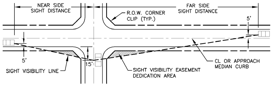
(Ord. No. 2112-11-02, 11-26-2002; Ord. No. 2293-6-04, § 1, 6-8-2004; Ord. No. 2425-7-05, § 1, 7-26-2005; Ord. No. 2593-2-07, § 1(Exh. A), 2-13-2007; Ord. No. 3125-11-12, § 7, 11-27-2012; Ord. No. 3488-6-17, § 4, 6-27-2017; Ord. No. 3562-3-18, § 5.F, 3-27-2018; Ord. No. 3976-1-23, § 1.L, 1-10-2023)
Sec. 8.05.2. - Thoroughfare design standards.
*
Data in these tables are to be considered quidelines. The data may be modified for specific and unique situations as outlined in a traffic study approved by the City Engineer.
1
— Dual left turn lanes are required at arterial-to-arterial intersections.
2
— Left turn storage from arterial-to-arterial may be reduced traffic study approved by the City Engineer.
3
— Acceleration lane may be required by the City Engineer.
4
— City Engineer approval needed for driveways within the right turn lane storage area.
5
— Driveway spacing is measured edge to edge. City Engineer may allow up to a 35% reduction in spacing.
6
— All median opening spacing is measured nose to nose. City Engineer may allow a 35% reduction in spacing. Hooded median openings may be approved by the City Engineer at 400-foot spacing to any opening. City Engineer approval needed for any median opening.
7
— Hourly service volumes are at level of service (LOS) "E": Design LOS is "C"
8
— 40-foot radii between streets will be increased to 70-foot radii if channelization is provided.
9
— These distances assume level terrain.
****
— City Engineer approval required
P8D
— Eight lane principal divided arterial
P6D
— Six lane principal divided arterial
M6D
— Six lane minor divided arterial
M4D
— Four lane minor divided arterial
M4U
— Four lane minor undivided arterial
C4U
— Four lane undivided collector
C2Uc
— Two lane undivided commercial collector
C2Ur
— Two lane undivided residential collector
R2U
— Two lane undivided residential local with 30-foot paving section
R2U7
— Two lane undivided residential local (24' pav sec & 70' ROW)
R2U5
— Two lane undivided residential local (24' pav sec & 50' ROW)
Neo
— Neo-traditional as defined in Section 8.05.1.12 on page 8.20
Com
— Commercial
Res
— Residential
FL30
— 30-foot fire lane
FL24
— 24-foot fire lane
(Ord. No. 1939-5-01, 5-3-2001; Ord. No. 2293-6-04, § 1(8.05.2), 6-8-2004; Ord. No. 2593-2-07, § 1(Exh. A), 2-13-2007)
Sec. 8.05.3. - Thoroughfare design standards 2 [deleted].
(Ord. No. 2293-6-04, § 1(8.05.3), 6-8-2004)
Sec. 8.05.4. - Design detail variances.
1.
The city engineer may approve variances to the median opening standards if:
a.
A physical impossibility prevents use of the median opening at its required location; or
b.
Reasonable access to zoned nonresidential property is otherwise denied as a result of regulatory requirements; and
c.
Based on sound engineering practice, the applicant can demonstrate that safety, based on the proper design and speed of the roadway, is not compromised; and
d.
Roadway capacity and level of service (LOS) is not compromised.
2.
Variances to section 8.05.2, thoroughfare design standards, shall be limited as follows:
a.
At the intersection of any two arterials classified as P8D, P6D, M6D or M4D, the variance shall not exceed 35 percent.
b.
Mid-block variances on streets of any classification shall not exceed 35 percent.
c.
The city engineer may require "hooded" median openings, directional islands, the addition or elimination of dedicated turn lanes, increase in storage length, left turn prohibitions or other reasonable restrictions.
d.
Unless extended by the city engineer for a period not to exceed 12 months, the approval of any variance to the location of a median opening shall expire unless the median opening is constructed within 24 months after the date of approval.
(Ord. No. 2593-2-07, § 1(Exh. A), 2-13-2007
Sec. 8.05.5. - Sidewalk and trail standards.
1.
Sidewalk construction. Sidewalks shall be constructed on both sides of all streets in accordance with the standard construction details—paving of the city and in conformance with the requirements of the Americans with Disabilities Act. Sidewalks or hike and bike trails may be required in other areas where necessary. Sidewalk construction in residential subdivisions may be delayed until house construction is complete except as necessary to connect areas not adjacent to lots or adjacent to open space, or to link bridges and culverts. Otherwise, sidewalks shall be constructed with other improvements to the subdivision or addition. Sidewalks adjacent to screening walls shall be constructed adjacent to a concrete mow strip located between such screening wall and sidewalk. Rerouting or elimination of sidewalks for safety reasons and the avoidance of poles, landscaping, or other obstacles shall be subject to the approval of the city.
2.
Pedestrian access. The commission may require pedestrian access to schools, parks, playgrounds, or other nearby streets with perpetual, unobstructed easements at least 15 feet in width. Easements shall be indicated on the plat.
3.
Hike and bike trails.
a.
Trails shall be constructed in accordance with American Association of State Highway and Transportation Officials (AASHTO) standards by the developer along both sides of all major creeks and tributaries unless waived by the planning and zoning commission upon the recommendation of the director of parks and recreation.
b.
Sidewalks and hike and bike trails shall be required at the time of development. Sidewalks adjacent to residential streets interior to a subdivision may be delayed and built with residential structures provided a 25 percent cash escrow bond is submitted. All sidewalks must be completed within two years of the acceptance of the development by the city.
c.
All sidewalks and hike and bike trails shall comply fully with the Texas Accessbility Standards of the Architectural Barriers Act, administered by the Texas Department of Licensing and Regulation.
Sec. 8.05.6. - Alleys.
1.
Commercial and industrial areas. Service alleys shall be provided in commercial and industrial areas. The minimum width of the alley right-of-way shall be 20 feet and the minimum pavement width shall be 16 feet.
2.
Residential areas. The minimum alley right-of-way shall be 16 feet and the minimum pavement width shall be 12 feet.
3.
Alley length and design.
a.
Alleys shall not be greater than 1,200 feet in length. Except as approved by the planning and zoning commission, alleys shall access a local street.
b.
Dead-end alleys shall be prohibited.
c.
When alleys are parallel and adjacent to thoroughfares, an additional ten-foot easement provided with irrigation and maintained by a homeowners' association is provided for a maximum of ten lots.
Sec. 8.05.7. - Cross access and median cuts.
1.
General. This section shall establish requirements for parking areas open to the public, such that these areas are designed to be interconnected to allow for the safe efficient flow of traffic.
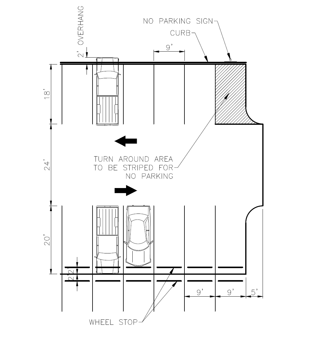
2.
Comprehensive plan. The requirement for cross connectivity is consistent with the mobility policies set forth in the comprehensive master plan.
3.
Design. Unless it is determined by the director of engineering that safety issues may result or that topographical constraints exist, all non-residential development shall be designed to allow for cross-access to adjacent properties to provide shared ingress and egress to public or private streets. Parking lots and vehicular circulation areas shall be designed to facilitate cross access directly to adjacent parcels. Parking areas directly adjacent to other parking areas in the same project shall also have cross access.
4.
Easement dedication. Shared driveways, cross-access drives, and service drives shall be located within a public access easement that permits traffic circulation between lots, that is dedicated by plat or separate instrument and recorded in the real property records of Collin County.
5.
Median cuts. Non-residential lots adjacent to a median divided street should have access to a median opening. Direct access should be provided where possible. If direct access is not available, a public access easement between the lot that does not have direct access to the median cut and the lot that has such access shall be required as set forth in subsection 4 of this section.
6.
Multiple points of access. Where cross access between parcels is not a practical alternative for the purpose of providing multiple access points to a development, including, but limited to, when the developer of a property is unable to obtain an easement providing cross-access over an adjacent property owned by others, the director of engineering may approve a single, median-divided entrance from the public right-of-way to a tract upon a finding that such means of access will not compromise public safety or impede emergency access, and that the stacking distance will comply with section 7.04.1.3.d.
7.
Alternatives. When cross-access is deemed impractical by the director of engineering on the basis of topography, the presence of natural features, or vehicular safety factors, the requirement for establishment of cross-access between properties may be waived provided that appropriate bicycle and/or pedestrian connections are provided between adjacent developments or land uses.
8.
Appeal. If the director of engineering does not grant an exception as provided in Subsection 6 of this section or a waiver pursuant to subsection 7 of this section as requested by the owner or developer of property, such applicant may, not later than ten days after receipt of written notification from the director of engineering that such exception or waiver has been denied, request in writing that the request for exception or waiver, as applicable, be considered by the commission. The owner or developer of the property shall be required to present evidence relating to the inability to obtain the access easement that would otherwise be required by this section, including evidence of efforts made to obtain such access easement from adjacent property owners, and present the alternatives to the required access to which the owner or developer is willing to agree. The commission may grant, deny, or modify the alternative access requirement requested or grant or deny the requested waiver. If the commission modifies or denies the alternative access requested or denies the requested waiver, such applicant may, not later than ten days after the date of the action by the commission, request in writing that the request for exception or waiver, as applicable, be considered by the city council. The city council may uphold the original decision of the director of engineering, grant as requested or modify the alternative access requested, or grant or deny the requested waiver, as applicable.
(Ord. No. 2593-2-07, § 1(Exh. A), 2-13-2007; Ord. No. 3754-6-20, § 1.M, 6-9-2020)
Editor's note— Ord. No. 3754-6-20, § 1.M, adopted June 9, 2020, changed the title of § 8.05.7 from "Median cuts" to read as herein set out, "Cross access and median cuts."
Sec. 8.05.8. - Fire lanes.
1.
Fire lanes shall be required for all nonresidential property where any portion of the structure(s) or proposed structure(s) is more than 150 feet from a public street.
2.
Fire lane easements shall be a minimum of 24 feet in width with a 30-foot inside turning radius, or 30 feet in width with a ten-foot radius; shall have a height clearance of 14 feet; and shall be within 150 feet of all exterior walls unless adequately protected pursuant to the adopted fire codes and approved by the fire marshal.
3.
Fire lanes shall be maintained by the property owner; shall be marked with signs and pavement or curb markings pursuant to the adopted fire codes.
4.
Fire lanes shall remain unobstructed at all times.
(Ord. No. 1939-5-01, 5-3-2001)
Sec. 8.06. - Lot design.
1.
Lot arrangement. All lots shall have frontage on a dedicated public street or public way. Driveway access shall be provided to buildings on the lots from an improved street, alley, or public way.
a.
Corner lots.
i.
The lot lines at the intersection of two local streets shall run along the hypotenuse of the triangle measured 15 feet from the intersection adjacent to the street along the front and side of the lot.
ii.
The lot lines at the intersection of a local street and a collector or thoroughfare shall run along the hypotenuse of the triangle measured 25 feet from the intersection adjacent to the street along the front and side of the lot.
iii.
Corner lots located at right angles to adjacent interior lots are discouraged. Where right angle lots are necessary, the side yard setback shall be equal to the rear yard setback of the adjacent right angle lot.
iv.
The side building setback line of any lot located across the street from any front yard shall be equal to that of the front yard.
v.
A five-foot by five-foot corner clip at all alley and street intersections shall be provided.
b.
Lot dimensions.
i.
Lot dimensions shall comply with the minimum standards of the zoning regulations. The width of a lot shall be measured at the building setback line. No lot shall have less than 30 feet of frontage on a public street or way.
ii.
Flag lots are prohibited. Reverse flag lots providing access to alleys or amenities located to the rear of the property are permitted.
iii.
In general, side lot lines shall be at right angles to street lines or radial to curving street lines.
iv.
Where the minimum building setbacks required by zoning regulations vary within a single block, the building setback line of the least restrictive district shall be increased to align with that of the more restrictive zoning district.
v.
Lots with side yards abutting a collector or thoroughfare shall have a side yard of not less than 25 feet. This applies to corner lots and lots located on culs-de-sac abutting collectors or thoroughfares.
c.
Double frontage residential lots.
i.
Double frontage and reverse frontage lots shall be avoided except where necessary to separate residential development from arterial roadway or to overcome specific disadvantages of topography and orientation.
ii.
Lots backing to major thoroughfares require an additional fifteen feet of minimum lot depth from those established by zoning regulations.
iii.
When lots back to thoroughfares, a screening device shall be installed on the lot(s) limiting visibility between the thoroughfare and the adjoining lots. Screening materials and design shall be approved by the commission.
d.
[Construction across lot lines.] No building, except buildings designed and constructed as two-family dwellings or one-family attached dwellings, shall be constructed on or across existing lot lines. Where buildings are designed and constructed on or across lot lines, the building shall be located so that the common wall separating the individual living units are located on and along the common lot lines of the adjoining lots.
(Ord. No. 2425-7-05, § 1, 7-26-2005; Ord. No. 2900-3-10, § 16, 3-23-2010)
Sec. 8.07. - Blocks.
1.
Block length. Blocks shall not exceed 1,600 feet except as provided in the zoning regulations for estate lots, unless the planning and zoning commission determines that, based on unique characteristics associated with the land such as creeks, woods, or parks, a variance is justified.
2.
Block numbering. Blocks shall be identified in sequential alphabetical order.
Sec. 8.08. - Water utilities standards.
1.
Adequate water facilities.
a.
Water systems serving the subdivision or addition shall connect with the city's water supply and distribution system and shall be looped unless alternative fire protection measures are approved by the fire marshal.
b.
Design, materials and construction shall be in accordance with the city standard construction details—water and sewer and 30 Tex. Admin. Code § 290.44, water distribution.
2.
Fire hydrants.
a.
Fire hydrants and valves shall be required for all subdivisions and additions and meet the requirements of the fire marshal in accordance with the water and standard construction details—water and sanitary sewer and the adopted fire codes.
b.
All underground utilities for fire hydrants, together with the fire hydrants themselves, and all other supply improvements, shall be installed before any final paving of a street shown on the subdivision plat.
c.
Reflective fire hydrant spotters shall be installed in all streets at a point adjacent to fire hydrants. At corner locations, spotters shall be installed in both streets.
Sec. 8.09. - Wastewater utility standards.
Wastewater facilities serving the subdivision or addition shall connect to the city's wastewater system, and shall conform to the standard construction details—water and sanitary sewer and 30 Tex. Admin. Code ch. 317 for wastewater collection. In the case of residential development, the developer shall provide the engineering department a video inspection of each wastewater service line prior to acceptance of the subdivision infrastructure. A separate video of the service shall be completed by the permit applicant and submitted to the building and code department prior to plumbing final inspection for the structure. All video inspections (by developer, builder, or permit applicant) shall require the introduction of water into the line, as required to positively confirm the service line is without sags or areas that hold water. Any deficiencies discovered as a result of the initial video inspection, or subsequent video inspections, shall be repaired at the expense of the developer, builder, or permit applicant prior to a certificate of final acceptance being issued by the building and code department.
(Ord. No. 2978-12-10, § 16, 12-14-2010)
Sec. 8.10. - Extensions of water and wastewater mains.
1.
When oversized water and wastewater mains are required by the system, the city will participate in the cost of line extension on a pro rata basis.
2.
Extensions of water and wastewater mains required to serve new subdivisions and other developments:
a.
Required extensions. All development shall be required to extend across the full width of the subdivision in such an alignment that it can be extended to the next property in accordance with the master water and sewer plans for the city.
b.
Properties already served by water and sewer shall not be required to install additional facilities unless:
i.
The current lines are not of adequate capacity to serve the proposed development; in which case the developer will be required to install adequate facilities; or
ii.
The current lines are not of adequate capacity to serve the zoning of a property that has been rezoned to a more intense use since the time of the original utility installation.
3.
Utility easement requirements.
a.
The property owner shall be required to furnish all easements and rights-of-way designed to serve the development. Where reasonable, utilities shall be located within streets or alley rights-of-way, or other utility corridors identified by the city engineer. All existing and proposed easements shall be shown on the preliminary plat.
b.
Municipal easements for water, sanitary and storm sewer shall be a minimum of:
• Ten feet in width for lines measuring eight inches in diameter or less.
• Fifteen feet in width for lines measuring more than eight inches and less than or equal to 12 inches in diameter.
• Twenty feet in width for lines exceeding 12 inches in diameter.
Wider easements may be required by the community services director, depending on the depth and size of mains, and the existence of other utilities within the same easement.
4.
Underground utilities.
a.
All new residential utility installations, including but not limited to electrical, gas, television, and telephone/telecommunication, shall be placed underground.
b.
All new nonresidential utility installations, including but not limited to electrical, gas, television, and telephone/telecommunication, shall be placed underground where service is provided adjacent to public street or right-of-way. Where electrical service is provided from an alley or rear easement not located adjacent to a public street, primary electrical service may be provided overhead along the property line. Primary and secondary electrical service routed on the site shall be placed underground.
c.
All new construction within the public street rights-of-way shall be located underground. Where a street is scheduled for reconstruction, new development may be required to provide an escrow of the difference between overhead and underground service.
d.
Nothing herein shall prevent temporary service during construction from being located overhead.
e.
New development shall assume responsibility for all expense related to the underground placement of utilities.
f.
All communication and electrical support equipment (transformers, amplifiers, switching devices, etc.) necessary for underground installation shall be pedestal- or pad-mounted or placed underground.
g.
All service drops must be underground and equipment shall be pad-mounted and properly screened.
h.
Electrical transmission lines 59 kilovolts or more may be located overhead on galvanized steel and/or concrete structures.
i.
A five-foot easement, in addition to the right-of-way (ROW) dedication, shall be provided in the front of all lots that are not served by alleys for the installation of dry utilities (electric, gas, phone, cable, etc.).
j.
Existing overhead electrical, television, and/or telephone/telecommunication utilities located on the developing property or adjacent right-of-way shall be excluded from the requirement to be placed underground.
5.
Pro rata reimbursement.
a.
Upon application and payment of applicable fees and charges, the water and sewer department will permit connection to existing water and sewer lines in the city. If a person, corporation, property owner, developer or other entity (collectively referred to in this section as the "developer") has oversized or constructed an off-site water or sewer main or line to which the applicant desires to connect, a pro rata line charge, as set forth in the fee schedule of this Code, shall be made against each lot or tract of land that fronts or abuts such main or line in order to recover lot or tract fees to be placed in trust for the purpose of reimbursement of the developer.
b.
The city manager, or designee, on behalf of the city may enter into a pro rata agreement with an individual, corporation, property owner, developer or other legal entity that has oversized and/or constructed an extension of an off-site water and/or sewer main or line to reimburse, such person or entity, the cost of such oversize or extension from pro rata charges collected by the city and placed in trust for such developer. The developer shall be reimbursed such costs solely from the collection of pro rata charges. The term or length of reimbursement of a developer under a pro rata agreement shall begin on the date of final acceptance of the facilities by the city, and shall continue for a period not to exceed ten years. Any sums of money collected as a pro rata charge shall be credited to the water and sewer fund of the city for reimbursement to the developer on the submission of an invoice to the city.
(Ord. No. 1939-5-01, 5-3-2001; Ord. No. 1984-9-01, 9-6-2001; Ord. No. 2020-1-02, § 2, 1-17-2002; Ord. No. 2112-11-02, 11-26-2002; Ord. No. 2137-1-03, 1-28-2003; Ord. No. 2151-3-03, § 1, 3-25-2003; Ord. No. 2339-9-04, § 1, 9-28-2004; Ord. No. 2844-7-09, § 2, 7-14-2009)
Sec. 8.11. - Street lights.
The city requires street lighting to improve the safety and usability of all roadways. The following requirements are to establish the minimum standards regarding the design and installation of street lighting, but should be considered flexible. Modifications to the standards will be considered by the director of engineering if the modifications incorporate new safety designs, achieve desired aesthetic treatment, or are shown to be more energy efficient. All new street light installations shall meet the approval of the director of engineering and may be reviewed by the Allen Police Department.
1.
Thoroughfare street lights. This section applies to all streets identified on the City of Allen Thoroughfare Plan as arterials or divided collectors. Thoroughfare street light elements shall become the property of the City of Allen upon final acceptance of the subdivision or project. The elements (from the light sources to the meter) include all items necessary to provide such illumination. Thoroughfare street lighting shall conform to the following requirements:
a.
All thoroughfare lighting poles shall have the following attributes:
i.
Thirty-foot height.
ii.
Installation location shall be in the median.
iii.
Dual fixtures installed, if located in the median. Single fixtures are acceptable in situations that require parkway installation or the median width makes the installation of dual fixtures impractical.
iv.
Capable of withstanding a 100 mph wind, with 30 percent gust factor.
v.
Mounted on a cast-in-place pole-base, as illustrated in the Engineering Standard Details, using a 14-inch bolt pattern for the anchor bolts. Mounting bolts shall be a breakaway type bolt.
vi.
Powder-coated medium bronze, seven-inch × seven-inch, and straight (for shoebox fixtures). Galvanized finish, round, and tapered (for cobra-head fixtures).
vii.
Square, steel base cover, powder-coated or galvanized to match the finish of the pole.
b.
All thoroughfare fixtures shall have the following attributes:
i.
Light emitting diode (LED) lamps, 250 watt equivalent. LEDs shall be a color of 3000K.
ii.
The use of cut-off optics is required to achieve a fully shielded (as defined in articles of this Code) light source. This requirement shall not be modified.
iii.
Photometrics that minimize light pollution onto private property (at the ROW line) and provide an average intensity of one footcandle within the right-of-way. In the case of parkway installed lighting, forward-throw photometrics will be required. A photometric plan, signed and sealed by a licensed professional engineer, is required and shall be submitted to the engineering department for review.
iv.
For shoebox installation, the fixture shall be powder-coated medium bronze and shall be Trastar Duralight JXM-ST Shoebox or approved equivalent.
v.
In the case of cobra-head installation, finish shall be grey and shall be GE Evolve Series or equivalent.
vi.
Light spacing shall be determined by Texas Licensed Professional Engineer.
c.
Service and circuitry:
i.
Power to the street lighting system in the City of Allen can come from a variety of utility providers (TXU, CoServ, GCEC, etc.). Regardless of utility provider, the service line must be separated by the primary feed by an electric meter. The City of Allen will make application for service once a permit has been requested, an address assigned, and the meter pedestal has been installed.
ii.
Circuit voltage shall be 480V, to maximize the number of lights per circuit. Designer shall confirm with local utility provider for availability.
iii.
Main line conduit shall be located no closer than three feet behind the median curb. Placement in the center of the median should also be avoided, in the event landscaping and trees are installed.
iv.
Pull boxes shall be located at every change in conduit direction greater than 45 degrees and shall be spaced at even intervals with consideration given to pull distances for specified wire gage. All pull boxes shall be located behind the radius point of median noses. All pull-box lids shall read "CITY OF ALLEN LIGHTING."
v.
The meter pedestal may either be stand-alone or mounted to the controller cabinet for the street lighting system. Consult with utility company for height and mounting requirements for the meter socket.
vi.
All service transformers and wiring must be within the pole or underground.
vii.
The control panel and all secondary service connections shall be fully enclosed in a vandal-proof controller cabinet (i.e., no Kindorff racks, where the components are exposed to the elements, will be permitted, in consideration of aesthetics and security). The controller cabinet shall have the following attributes:
(1)
Illustrated on the construction drawings by a line diagram, signed and sealed by a licensed professional electrical engineer.
(2)
Utilize a master photocell controller and relay-switch override.
(3)
NEMA 3R enclosure, with drip edge and hinged door with lock. Lock shall match City of Allen standard key pattern.
(4)
Mounted on an appropriate reinforced, concrete pad.
(5)
If TXU or Oncor is the provider, the enclosure must include a Oncor or TXU-provided trans-socket. The trans-socket must remain intact when installed/integrated into the enclosure.
(6)
The controller cabinet must be powder-coated green unless otherwise approved by the director of engineering.
2.
Residential street lights. This section applies to all streets identified on the City of Allen Thoroughfare Plan as undivided collectors or local streets. Residential streetlight elements shall become the property of the City of Allen upon final acceptance of the subdivision or project. The elements (from the light sources to the disconnect device) include all items necessary to provide such illumination. Residential street lighting shall conform to the following requirements:
a.
Street lights are required at all intersections, in cul-de-sacs, major street curves, and in other locations determined by the director of engineering. Developers shall furnish satisfactory easements for the installation of services to street lights, normally ten feet in width.
b.
Residential lighting shall utilize the "shoebox" style fixture. Homeowners' associations may enter into agreements with the City of Allen to install, maintain, and replace residential street lights that differ aesthetically from what is required in the section.
c.
All residential lighting poles shall have the following attributes (unless approved in writing by the director of engineering):
i.
Height and spacing are based on pavement widths and are prescribed below.
ii.
Single-fixture mounting.
iii.
Capable of withstanding a 100 mph wind, with 30 percent gust factor.
iv.
Mounted on a cast-in-place pole-base, as illustrated in Engineering Standard Detail, SD-P59, using a 14-inch bolt pattern for the anchor bolts. Mounting bolts shall be a breakaway type bolt.
v.
Powder-coated medium bronze, five-inch × five-inch, and straight (i.e. not tapered).
vi.
Square, steel base cover, powder-coated to match the finish of the pole.
d.
All residential fixtures shall have the following attributes (unless approved in writing by the director of engineering):
i.
Light emitting diode (LED) lamp intensity is based off pavement width as prescribed below. LEDs shall have a color of 3000K.
ii.
The use of cut-off optics is required to achieve a fully shielded (as defined in articles of this Code) light source. This requirement shall not be modified.
iii.
Forward-throw photometrics should be considered to reduce light pollution onto private lots or property. A photometric plan, signed and sealed by a licensed professional engineer, is required when the street lighting plan is submitted for engineering department review.
iv.
For shoebox installation, the fixture shall be powder-coated medium bronze and shall be Trastar Duralight JXM-ST Shoebox or approved equivalent.
e.
Service and circuitry:
i.
Power to the street lighting system will come from the electric utility provider for the subdivision. Regardless of utility provider, the service line should come from the nearest electric transformer and be isolated by a disconnect switch or in-line barrel fuse located at the base of the pole (in the hand-hole). Secondary service lines shall be contained within a ten-foot utility easement (UE) illustrated on the plat. All service lines shall be underground. The director of engineering may require that residential street lights be on metered circuit similar to the thoroughfare street lighting.
ii.
Circuit voltage shall be 120/240V. Designer shall confirm with local utility provider for availability.
iii.
A photocell is required at the top of the pole unless powered by a controller and will have a master photocell at the controller.
f.
Developer cost: All residential street lighting shall be installed at the sole expense of the developer. Developers shall pay a fee to the City of Allen Engineering Department, which is estimated to be equal to the first two years (24 months) power consumption cost. The amount of the fee to be paid shall be determined by the following formula:
FA = 24 × M × F
Where:
FA = Fee amount.
M = Monthly charge per fixture (as determined by the director of engineering).
F = Number of light fixtures.
(Ord. No. 2593-2-07, § 1(Exh. A), 2-13-2007; Ord. No. 3125-11-12, § 8, 11-27-2012; Ord. No. 3614-9-18, § 9, 9-25-2018; Ord. No. 3846-8-21, § 4.C, 8-10-2021)
Sec. 8.12. - Landscape irrigation systems.
A fully automatic irrigation or sprinkler system of a type and design approved by the city shall be provided within all completed street medians or other landscaped areas. Connections under the street and between median cuts shall be provided to all unfinished medians for future development of the irrigation system. Irrigation system plans and their approval shall be accomplished in accordance with section 7.05.5 of this Code and be consistent with the city water conservation ordinance.
(Ord. No. 2338-9-04, § 1, 9-28-2004)
Sec. 8.13. - Drainage requirements.
1.
General requirements. All storm sewer systems shall conform to the city's standard construction details—storm drainage.
2.
Design of storm drainage facilities. All storm drainage facilities in the city shall be designed in accordance with the city design manual for storm drainage facilities based on ultimate watershed development for the 100-year frequency design storm and all facilities shall accommodate runoff from the entire drainage area, whether inside or outside the subdivision or addition.
3.
Floodplain delineation and dedication. If any portion of the property contains a drainage course, lies within 100 feet from the top of a high bank, or contains Federal Emergency Management Agency (FEMA) floodplain, then the drainage basin area shall be determined. If that area is 160 acres or more, then the 100-year floodplain shall be established. All floodplain calculations shall be approved by the floodplain administrator. The floodplain shall be delineated on the plat and shall be dedicated to the city, at the city's option.
4.
Staking of floodplain. The floodplain shall be staked using materials specified by the city engineer at 200-foot intervals at the cross section of the floodplain study. Stakes shall remain in place until the construction in the subdivision is completed.
5.
Watercourse or drainage easement. In other cases, where a subdivision or addition is traversed by a watercourse, drainageway, channel, or stream, a stormwater or drainage easement conforming substantially to the line of such watercourse shall be provided and shall be of sufficient width to be adequate for a 100-year design storm frequency flow.
6.
Properties to be maintained in natural state. All properties located in the 100-year floodplain shall be maintained in a natural state. Any deviations or modifications to the natural state shall require review and approval of the commission.
7.
Drainage.
a.
Lots shall be graded to provide a minimum slope of one percent to drain storm and irrigation water to the public right-of-way in addition to the requirements of section 3.01.
b.
Unobstructed swales of minimum three-foot width and one percent slope for a total of six feet with two lots combined will be provided on side lot lines for lots with alleys and also on rear lot lines where alleys are not provided. Maintenance of the swales is to be performed by the property owner. No permanent structures, including driveways, are permitted within this or any drainage area. Fences may be permitted as long as the flow of water is not obstructed. Utility boxes and poles less than one square foot in diameter may be permitted.
c.
Other design configurations that will provide equivalent drainage must be approved by the city engineer or chief building official.
8.
Maintenance easements.
a.
The property owner must provide a 15-foot easement on each side of and parallel to creeks or drainageways for maintenance purposes. The access easement shall be above the base flood elevation and accessible to vehicles and equipment.
b.
Access easements must also be provided at 1,200-foot intervals along streets or alleys. The location and size of the access easement shall be determined by the city engineer. The minimum width of the access easement shall be 15 feet.
c.
Permanent monuments, the type and location of which are to be determined by the city engineer, shall be placed along the boundaries of the access easement and private property. Access easements shall be included in the dedication noted on the plat.
9.
Accommodation of upstream drainage areas. A drainage structure shall accommodate runoff from its entire upstream drainage area, whether inside or outside the subdivision or addition.
10.
Effect on downstream drainage areas. If adequate capacity is not available immediately downstream, a drainage system, a detention facility, or parallel system to mitigate the deficiency shall be required. The commission shall withhold approval of the plat until such mitigation has been provided.
11.
Stormwater detention facilities. Stormwater detention facilities constructed in association with development of property shall be subject to the following:
a.
Concurrently with the submission of plans for the design of the public improvements in the city, the developer shall provide to the engineering department a written engineering analysis prepared and sealed by a Texas Registered Professional Engineer and satisfactory to the director of engineering indicating that all required stormwater detention facilities are designed to reduce outflows from the detention pond following each storm event to pre-developed flows for a five-year, ten-year, 25-year, 50-year, and 100-year frequency storm event.
b.
All stormwater detention facilities required for the development of all phases of a proposed subdivision must be constructed at the time of development of the first phase of development, and shall be built for the ultimate condition at the time of initial construction unless otherwise approved by the director.
c.
Section 8.20 of this Code shall govern the establishment of a homeowners' association or property owners' association and the perpetual operation, maintenance and supervision of a stormwater detention facility constructed as required by this section.
d.
In the event a stormwater detention facility is designed and/or constructed to receive stormwater from properties, which, at the time of construction of the facility, are under different ownership, the director shall have the authority to approve a drainage facility maintenance agreement between or among the property owners that establishes the operational and financial obligations of the respective property owners relative to the perpetual operation, maintenance and supervision of the facility. Such agreement must be submitted to and approved by the director (i) prior to approval of a final plat, if the property to be served by the facility is not yet platted, (ii) prior to issuance of a building permit if the property served by the facility is platted but no development has occurred on the property, or (iii) prior to issuance of a certificate of occupancy for any structure on the property to be served by the facility when construction on the property has commenced when the requirement for the construction of the facility arises. Any drainage facility maintenance agreement approved pursuant to this paragraph d. must provide that:
(1)
All property owners' associations or homeowners' associations who own the common areas of the subdivision or which will succeed to such ownership from the owner or developer of the property in accordance with the provisions of the required restrictive covenants are parties to the agreement; and
(2)
Notwithstanding the allocation of costs and responsibilities regarding the operational and financial obligations of the respective property owners relative to the perpetual operation, maintenance and supervision of the facility, all owners shall be jointly and severally liable for maintaining the facility in the manner required by the city; and
(3)
No amendment to the agreement shall be effective without the approval of the city manager; and
(4)
The city shall be a third party beneficiary to the agreement with the right, but not the obligation, to require specific performance of the agreement by the parties; and
(5)
The agreement shall be a covenant running with the land with respect to all properties served by the stormwater detention facility, recorded in the Real Property Records of Collin County, Texas, and enforceable against all subsequent owners of the properties served by the facility.
(Ord. No. 1984-9-01, 9-6-2001; Ord. No. 2293-6-04, § 1, 6-8-2004; Ord. No. 2593-2-07, § 1(Exh. A), 2-13-2007; Ord. No. 3157-6-13, § 4, 6-11-2013)
Sec. 8.14. - Monuments and markers.
1.
Markers. Lot markers shall be a one-half inch reinforcing bar, 18 inches long, or approved equal, and shall be placed at all corners flush with the ground or below ground if necessary in order to avoid being disturbed.
2.
Monuments. Monuments shall be set at any angle point in the perimeter boundary of the subdivision. Monuments shall be a concrete post four inches in diameter and three feet in length, or other such type of monument as may be approved by the city engineer. Monuments must contain either a steel rod or a magnet. The precise point of intersection shall be indented on top of the monument. The top of the monument shall not be located greater than six inches below the surface.
3.
Benchmarks. A benchmark will be established on a boundary corner of the subdivision and within the subdivision at a ratio of one for every 100 acres. Such benchmarks shall be established to a NAD83, State Plane Coordinate, North Central Texas, Zone 5351, datum. The benchmark shall be established upon a permanent structure, or may be set as a monument, and shall be readily accessible and identifiable on the ground as well as on the subdivision plat.
Sec. 8.20. - Mandatory homeowners' association.
1.
Applicability. Any subdivision creating an area or amenity to be owned in common by the owners of lots within the subdivision shall require the establishment of a property owners' association prior to the approval of the final plat. When a subdivision contains streets, sewers, sewage treatment facilities, water supply systems, drainage systems or structures, parks, landscaping systems or landscape elements or features (including fountains and statues), landscape irrigation systems, screening walls, living screens, buffering systems, subdivision entryway features (including monuments or other signage), or other physical facilities or grounds held in common and necessary or desirable for the welfare of the area or subdivision, or that are of common use or benefit and that are not or cannot be satisfactorily maintained by the city or another public agency, the city may require the establishment and creation of a mandatory homeowners' association to assume and be responsible for the continuous and perpetual operation, maintenance and supervision of such facilities, structures, improvements, systems areas or grounds.
2.
Responsibilities. Such mandatory homeowners' associations shall be responsible for the continuous and perpetual operation, maintenance and/or supervision of landscape systems, features or element located in parkways, common areas, between screening walls or living screens and adjacent curbs or street pavement edges, adjacent to drainageways or drainage structures, or at subdivision entryways. Subdivision entryway treatments or features shall not be allowed unless a mandatory homeowners' association as required herein is established and created. The city shall be responsible for all median maintenance and all paving maintenance (except for private streets or roads) and the repair of landscape systems, features or elements damaged by city-initiated utility work in dedicated easements. Other damage occurring during utility repairs will be the responsibility of the appropriate utility company.
3.
Purpose. A homeowners' association shall be established and created to assume and be responsible for the continuous and perpetual operation, maintenance and supervision of landscape systems, features or elements located in parkways, common areas between screening walls or living screens and adjacent curbs or street pavement edges, adjacent to drainageways or drainage structures or at subdivision entryways, open space common areas or properties, including but not limited to: landscape features and irrigation systems, subdivision entryway features and monuments, private amenity center, playgrounds, pavilions, ponds, detention ponds, off-street parking for the private amenity center, swimming pool, exercise trail, private neighborhood park and related amenities.
4.
Dedications to homeowners' association. All open space and common properties or areas, facilities, structures, improvements systems, or other property that are to be operated, maintained and/or supervised by the homeowners' association shall be dedicated by easement or deeded in fee simple ownership interest to the homeowners' association after construction and installation as applicable by the owner and shall be clearly identified on the record final plat of the property.
5.
Approval. A copy of the agreements, covenants and restrictions establishing and creating the homeowners' association must be approved by the city attorney prior to the approval of the final plat of the subdivision and must be filed of record with said record plat in the map and plat records of the county. The record final plat shall clearly identify all facilities, structures, improvements systems, areas or grounds that are to be operated, maintained and/or supervised by the homeowners' association.
6.
Contents of homeowners' association agreements. At a minimum, the agreements, covenants and restrictions establishing and creating the homeowners' association required herein shall contain and/or provide for the following:
a.
Definitions of terms contained therein;
b.
Provisions acceptable to the city for the establishment and organization of the mandatory homeowners' association and the adoption of bylaws for said homeowners' association, including provisions requiring that the owner(s) of any lot or lots within the applicable subdivision and any successive purchase(s) shall automatically and mandatorily become a member of the homeowners' association;
c.
The initial term of the agreement, covenants and restrictions establishing and creating the homeowners' association shall be for a 25-year period and shall automatically renew for successive ten-year periods, and the homeowners' association may not be dissolved without the prior written consent of the city;
d.
Provisions acceptable to the city to ensure the continuous and perpetual use, operation, maintenance and/or supervision of all facilities, structures, improvements, systems, open space or common areas that are responsibility of the homeowners' association and to establish a reserve fund for such purposes;
e.
Provisions prohibiting the amendment of any portion of the homeowners' association's agreements, covenants or restrictions pertaining to the use, operation, maintenance and/or supervision of any facilities, structures, improvements, systems, area or grounds that are the responsibility of the homeowners' association without the prior written consent of the city;
f.
The right and ability of the city or its lawful agents, after due notice to the homeowners' association, to remove any landscape systems, features or elements that cease to be maintained by the homeowners' association; to perform the responsibilities of the homeowners' association and its board of directors if the homeowners' association fails to do so in compliance with any provisions of the agreements, covenants or restrictions of the homeowners' association or of any applicable city codes or regulations; to assess the homeowners' association for all costs incurred by the city in performing said responsibilities if the homeowners' association fails to do so; and/or to avail itself of any other enforcement actions available to the city pursuant to state law or city codes or regulations; and
g.
Provisions indemnifying and holding the city harmless from any and all costs, expenses, suits, demands, liabilities or damages including attorney's fees and costs of suit, incurred or resulting from the city's removal of any landscape systems, features or elements that cease to be maintained by the homeowners' association or from the city's performance of the aforementioned operation, maintenance or supervision responsibilities of the homeowners' association due to the homeowners' association's failure to perform said responsibilities.
7.
Notice to purchasers. Builders are required to post notice in a prominent place in all model homes, sales offices and on all open space areas larger than 20,000 square feet stating that a property association has been established and membership is mandatory for all property owners. The notice shall state at a minimum that the builder shall provide any person upon their request the association documents and a five-year projection of dues, income and association expenses.
8.
Maintenance reserve fund. Prior to the transfer of the association to the lot owners, the developer must provide a reserve fund equivalent to two months' dues based on full association membership.
9.
Property association activation. Concurrent with the transfer of the association, the developer must transfer to the association control over all utilities related to property and amenities to be owned by the association. The developer must also disclose to the association the total cost to date related to the operation and maintenance of common property and amenities.
Sec. 8.25. - Escrow policies and procedures.
1.
Deposit with city. Whenever the city agrees to accept escrow deposits in lieu of construction by the owner of the property under these regulations, the property owner or developer shall deposit an amount equal to his share of the costs of design and construction in escrow with the city. Such amount shall be paid prior to release of construction plans by the city engineer. In lieu of such payment at such time, the city may permit the property owner to contract with the city and shall agree in such contract that no building permit shall be issued for any lot included within said plat, or increment thereof, until the full amount of the escrow is paid, or a pro rata part thereof for the full increment if developed incrementally. The obligations and responsibilities of the property owner shall become those of property owner's transferees, successors and assigns; and the liability therefor shall be joint and several.
2.
Determination of escrow amount. The amount of the escrow shall be determined by using the average of the comparable bids awarded by the city in the preceding six months or, if none exists, then in the preceding year or, if none exists current market value of construction as determined by an estimate by the city engineer. Such determination shall be made as of the time the escrow is due hereunder.
3.
Termination of escrow. Escrows which have been placed with the city under this section which have been held for a period of ten years from the date of such preparation of plans and specifications for construction of such roadway facilities for which the escrow was made shall upon written request be returned to the property owner, with accrued interest. Such return does not remove any obligations of the owner for construction of the required facilities if a building permit has not been issued on the subject lot or if a new building permit is applied for.
4.
Refund. If any street or highway for which escrow is deposited is constructed, or is reconstructed by another governmental authority at no cost to the city, the escrowed funds and accrued interest shall be refunded to the property owner or developer after completion and acceptance of the public improvements. In the event that a portion of the cost is borne by the city and the other portion of the cost by another governmental authority, the difference between the owner's actual proportionate cost and the escrowed funds, including accrued interest, if any, shall be refunded after completion and acceptance of the improvements.
Sec. 8.26. - Payment of fees, charges and assessments.
As a condition of plat approval, the developer shall pay all fees, charges, and assessments as may be imposed or required under this Code or other ordinances or regulations of the city.