
Angier City Zoning Code
Appendix A
DEFINITIONS
Section A.1.- Purpose.
For the purpose of interpreting this ordinance, certain words, concepts, and ideas are defined herein. Except as defined herein, all other words used in this ordinance shall have their everyday meaning as determined by their dictionary definition.
Section A.2. - Interpretation.
A.
Words used in the present tense include the future tense.
B.
Words used in the singular number include the plural, and words used in the plural number include the singular.
C.
Any word denoting gender includes the female and the male.
D.
The word "person" includes a firm, association, organization, partnership, corporation, trust and company as well as an individual.
E.
The word "lot" includes the word "plot" or "parcel" or "tract".
F.
The word "shall" is always mandatory and not merely directory.
G.
The word "structure" shall include the word "building."
H.
The term "street" shall include the word "road".
I.
The term "Zoning Map," shall mean the Official Zoning Map of Angier, North Carolina.
J.
The term "Town Board of Commissioners" shall mean the "Town Board of Commissioners of the Town of Angier, North Carolina."
K.
The term "Planning Board" shall mean the "Planning Board of the Town of Angier, North Carolina."
L.
The term "Administrator" shall mean the "Zoning Administrator, Subdivision Administrator, Floodplain Administrator, or Unified Development Ordinance Administrator of the Town of Angier, North Carolina."
M.
The terms "Planning Department" and "Planning Staff" shall mean the "Planning Department of the Town of Angier, North Carolina."
N.
The terms "Ordinance", "Code", and "Unified Development Ordinance" shall be synonymous and refer to the "Town of Angier Unified Development Ordinance."
Section A.3. - Acronyms.
Below is a list of acronyms (other than zoning districts) and their meanings found throughout the ordinance:
Section A.4. - Definitions.
Abandonment. A use shall be deemed to be abandoned when:
A.
The use is discontinued (other than in association with the settlement of an estate or for any use which is seasonal in nature); or
B.
The premises are devoted to another use; or
C.
When the characteristic equipment and furnishings of a nonconforming nonresidential use have been removed from the premises and have not been replaced by the same or similar equipment within 30 days; or
D.
Failure to take all positive action to resume the nonconforming use with reasonable dispatch, including the failure to advertise the property for sale or for lease.
Accessory dwelling. A single-family residential unit that is subordinate to the principal dwelling located on the same property.
Accessory structure. A structure that is subordinate to and serves a principal use or structure; is clearly subordinate in area, extent, or purpose to the principal use or structure served; and is located on the same lot as the principal use or structure. In no event shall "accessory structure" be construed to authorize a principal use or structure not otherwise permitted in the district in which the use is located. Accessory structures include but are not limited to detached garages, storage buildings, pools and pool houses, piers and other water related structures.
Accessory use. A use customarily incidental and subordinate to the principal use or structure and located on the same lot with such principal use or structure.
Addition. An extension or increase in the footprint or floor area of building or structure.
Adjacent. Having common property boundaries or lot lines, including those which are separated by a street right-of-way or alley or railroad or body of water.
Administrative decision. Decisions made in the implementation, administration, or enforcement of development regulations that involve the determination of facts and the application of objective standards set forth in this chapter or local government development regulations. These are sometimes referred to as ministerial decisions or administrative determinations.
Administrative hearing. A proceeding to gather facts needed to make an administrative decision.
Administrator. The appointed town staff member that administers this ordinance, typically the town manager.
Adult establishment. Any principal structure or use of land which meets the definition of adult establishment as set forth in N.C.G.S. § 14-202.10, including topless bars. Notwithstanding the definition of "adult bookstore" provided in N.C.G.S. § 14-202.10(1), for purposes of this ordinance "adult bookstore" means a retail establishment:
A.
Which receives a majority of its gross income during any calendar month from the sale or rental of:
1.
"Publications" which are distinguished or characterized by their emphasis on matter depicting, describing, or relating to "specified sexual activities", as defined in N.C.G.S. § 1-202.10(10), or "specified anatomical areas", as defined in N.C.G.S. § 1-202.10(11); and/or
2.
Merchandise that are "sexually oriented devices", as defined in N.C.G.S. § 1-202.10(9); or
B.
Having as a preponderance of its publications and/or merchandise:
1.
"Publications" which are distinguished or characterized by their emphasis on matter depicting, describing, or relating to "specified sexual activities", as defined in N.C.G.S. § 1-202.10(10), or "specified anatomical areas", as defined in N.C.G.S. § 1-202.10(11), and/or
2.
Merchandise that comprises "sexually oriented devices", as defined in N.C.G.S. § 1-202.10(9).
Adult establishment may consist of, include, or have the characteristics of any or all of the following:
A.
Adult or sexually oriented bookstore sales and distribution.
B.
Adult or sexually oriented paraphernalia sales and distribution.
C.
Adult or sexually oriented cabaret.
D.
Adult or sexually oriented mini motion picture theater.
E.
Adult or sexually oriented motion picture theater.
Alley. A public or private right-of-way which affords only a secondary means of access to abutting property and is not intended for general traffic circulation.
Alteration. A change in the size, configuration, or location of a structure; or a change in the use of a structure or lot from a previously approved or legally existing size, configuration, location, or use.
Amendment types.
Text amendment. A change to any text of the Angier Unified Development Ordinance.
Zoning map amendment (rezoning). A change of the zoning designation of a property or properties on the Angier Zoning Map.
Amusement arcade. A commercial facility providing recreational activities that typically include coin-operated amusement machines such as but limited to pinball machines, electronic video games, and skeet ball machines. A facility shall be deemed an amusement arcade if it has eight or more of such machines.
Animal services. A public or private facility for medical or surgical treatment, grooming, breeding, selling, or boarding of animals. Unless outdoor kennels are specifically allowed, all facilities associated with animal services shall be located indoors.
Appeal. A request by an applicant for the board of adjustment to review a decision or interpretation by the administrator.
Assembly halls, community centers, and similar structures. Places of gathering for community events, sporting events, performing arts events, or similar events.
Assembly and packaging. Typically a manufacturing and processing related use, including but not limited to: the fitting together of parts and/or the processing and packaging of manufactured products.
Auction house. A use, whether conducted primarily indoors or outdoors, where objects of art, furniture, equipment, and other goods are offered for sale to persons who bid on the object in competition with each other.
Automobile, abandoned. A motor vehicle which is left on private property without the consent of the owner(s), occupant, or lessee of the property.
Automobile services. Any building, premises, and land, in which or upon the primary use of land is a business which involves the maintenance, or servicing of automobiles, including but not limited to: auto body shops, auto service stations, car washes, gas stations, and oil/lube servicing. This does not include the sale of parts or related products (i.e. auto parts store) or storage of junked or abandoned vehicles.
Awning. A structure made of cloth, metal, or other material affixed to a building in such a manner that the structure may be raised or retracted from a building to a flat position against the building, but not to include a canopy.
Bar. An establishment, also referred to as a pub, tavern, saloon, beer garden, tap room or sports bar, that serves alcoholic beverages such as beer, liquor, wine and cocktails, for consumption on the premises, and where 51 percent or greater of the net sales is from alcohol and not food sales.
Bed and breakfast inn. A use, that takes place within a single-family dwelling, which consists of renting one or more rooms on a daily basis to tourists, vacationers, and business people, where provision of meals is limited to the breakfast meal, available only to guests. The homeowner shall reside on site and employment shall not exceed two full-time employees, not including the owner(s).
Block. A unit of land bounded by streets or by a combination of streets and public land, waterways, or any other barrier to the continuity of development.
Boarding house. See rooming house.
Bona fide farm and agricultural uses. As defined in N.C.G.S. § 106-581.1, for purposes of this ordinance, the terms, "bona fide farm" "agriculture", "agricultural", and "farming" refer to all of the following:
A.
The cultivation of soil for production and harvesting of crops, including but not limited to fruits, vegetables, sod, flowers, and ornamental plants.
B.
The planting and production of trees and timber.
C.
Dairying and the raising, management, care, and training of livestock, including horses, bees, poultry, and other animals for individual and public use, consumption, and marketing.
D.
Aquaculture as defined in N.C.G.S. § 106-758.
E.
The operation, management, conservation, improvement, and maintenance of a farm and the structures and buildings on the farm, including building and structure repair, replacement, expansion, and construction incident to the farming operation.
F.
When performed on the farm, "agriculture", "agricultural", and "farming" also include the marketing and selling of agricultural products, agritourism, the storage and use of materials for agricultural purposes, packing, treating, processing, sorting, storage, and other activities performed to add value to crops, livestock, and agricultural items produced on the farm, and similar activities incident to the operation of a farm.
Uses which shall not be deemed as "agricultural uses", for the purposes of this ordinance include zoos, kennels, and equestrian facilities.
Bottle shop. A retail establishment that primarily sells alcoholic beverages for off premise consumption. Alcoholic beverage consumption areas may be allowed on the premises as an accessory use.
Brewery/winery/distillery. A manufacturing use that produces alcoholic or non-alcoholic beverages, including ales, beers, wine, liquor and/or similar beverages, on-site. Breweries are classified as a use that primarily manufactures such beverages and may or may not include on site alcoholic beverage consumption areas.
Buffer. A dedicated area of land with natural or planted vegetation that may include any required screening for the site.
Build out. The completed construction of all phases of a development as allowed by all ordinances which regulate an area. The scale of build out can be from a single lot to the entire planning and development regulation jurisdiction.
Buildable area. The area of a lot remaining after the minimum yard and open space requirements of this ordinance have been met.
Building. Any structure used or intended for supporting or sheltering any use or occupancy.
Building envelope. The three-dimensional space within which a structure is permitted to be built on a lot and that is defined by maximum height regulations, and minimum yard setbacks or build-to lines, buffers, easements, or other applicable regulations.
Building footprint. The land area on which a building is located or proposed for location.
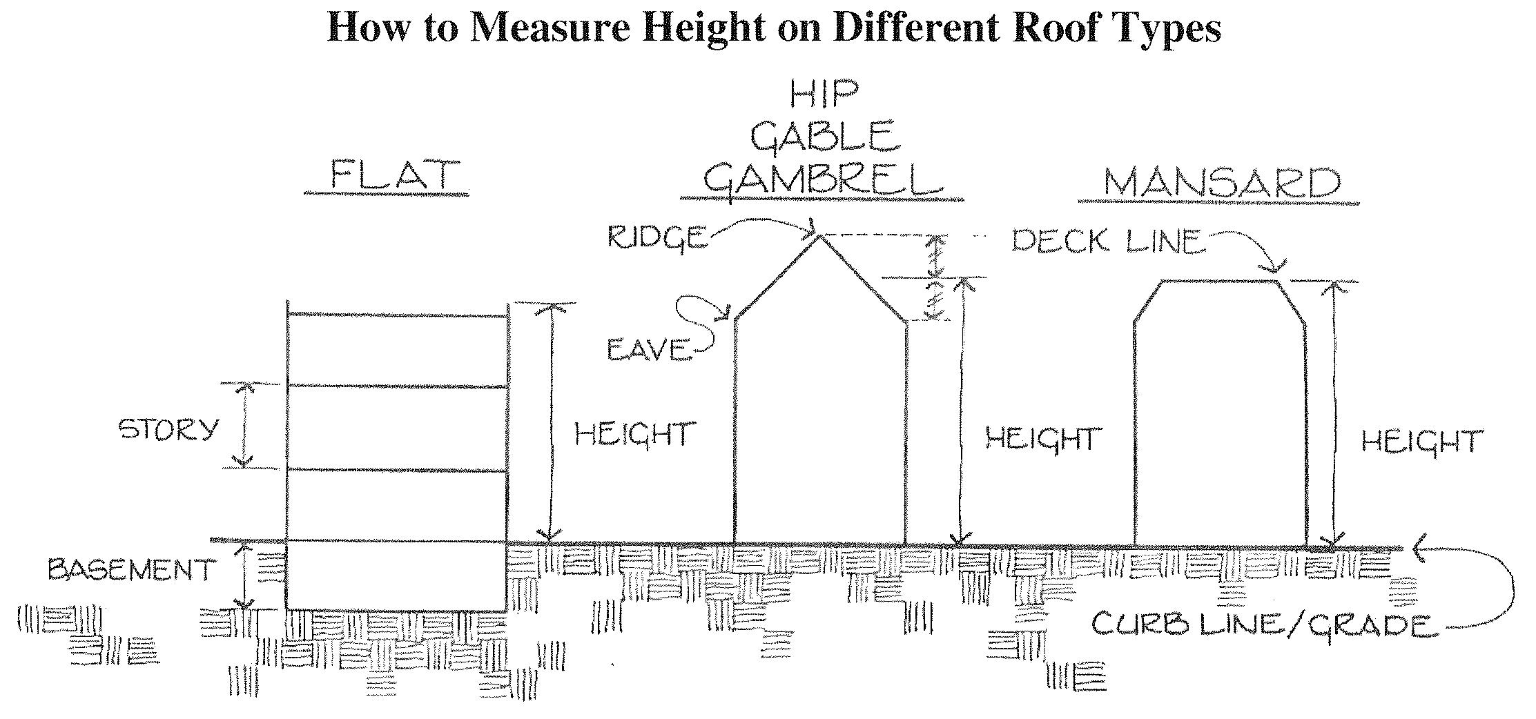
Building height. The vertical distance from the mean grade elevation taken at the fronting street side of a structure to the parapet or roofline of a flat roof, the eaves of a pitched roof, or the deck line of a mansard roof. Towers, spires, steeples, and enclosed rooftop mechanical equipment are not counted in height measurements.
Building line. The line formed by the front façades of buildings and extending to the property lines of the site on which the buildings are located.
Building permit. A permit obtained from the Town of Angier Inspections Department which sets the inspection schedule and construction techniques for a project.
Building setback line. See building envelope.
Caliper. The size of tree's trunk diameter as measured six inches above the ground.
Campsite. Any plot of ground within a campground intended for the exclusive occupancy by a cabin, recreation vehicle, or tent.
Canopy. A permanent structure, other than an awning, made of cloth, metal, or other material attached or unattached to a building for the purpose of providing shelter to patrons or automobiles, or as a decorative feature on a building wall. A canopy is not a completely enclosed structure.
Carport. Prefabricated, roofed structure without any foundation, footings, enclosed walls, or sides, providing space for the parking of motor vehicles.
Cemetery. Property used for the interment of the dead, which use may include the commercial sale and location of burial lots, crypts, or vaults for use exclusively on the subject property. A cemetery shall not be used for the preparation or embalming of bodies or the cremation of bodies. Setback for cemeteries shall be measured from the nearest structure or gravesite. This definition shall be construed to include pet cemeteries.
Certificate of occupancy (CO). A certificate allowing the occupancy or use of a building and certifying that the structure or use has been constructed or will be used in compliance with this ordinance and all other applicable regulations.
Change of use. Any use of a building or land that differs from the previous use.
Church (house of worship). See religious institution.
Civic uses. Uses intended to serve as public gathering places. Such uses include governmental offices, schools, post offices, and nonprofit or charitable clubs and organizations.
Close familial relationship. A spouse, parent, child, brother, sister, grandparent, or grandchild. The term includes step, half, and in-law relationships.
Columbarium. A structure of vaults lined with recesses for cinerary urns.
Commercial use. All retail sales establishments, office uses (i.e.: medical and financial), service industry uses (i.e.: restaurants, hotels/motels/inns), and general business (i.e.: mini-storage, automotive repair).
Common open space. Land and/or water areas within a site, designated for development and not individually owned, which are designed and intended for the common use of the residents of the development or town, but not including lands occupied or used for any other purposes.
Common open space, improved. Common open space which has been improved with recreational areas and amenities, such as but not limited to: ball fields, tennis courts, swimming pools, nature trails, clubhouses, etc. Not all of these uses may be appropriate in developments which lie in a water supply watershed where there are restrictions on the amount of impervious surface area.
Communications offices. Newspaper, internet, telephone, and similar communications businesses with no retail sales or visible towers or transmission equipment.
Conditional zoning district. A district created through the approval of a zoning map amendment with a site specific plan in which the uses are limited to those in the base zoning district and are subject to conditions imposed by the town board of commissioners.
Construction trailer. A structure standing on wheels towed or hauled by another vehicle and used for neither overnight nor year-round occupancy at the construction site on a temporary basis for office purposes.
Contiguous. See adjacent.
Convenience store. Any retail establishment offering for sale gasoline and motor fuel, prepackaged food products, household items, or other goods commonly associated with the same and having a gross floor area of less than 5,000 square feet. Automobile services shall not be permitted or performed as part of or as an accessory to this use.
Correctional facility. A facility operated by the Town of Angier, Harnett County, or the State of North Carolina (or a private contractor thereof) used for the temporary incarceration of persons after arrest or pending hearing or trial or for the incarceration and or housing of persons serving sentences or incarceration or housing of persons serving criminal sentences. For purposes of this ordinance, this definition shall also include jail, prison, detention facility, or other terms commonly associated with the same.
Country club. A private or public recreational facility open to members and their guests. Uses at a country club include but are not limited to: golf courses, swimming pools, and club-houses. Meal service may be available, but is generally limited to members and their guests. A country club may be developed as a free-standing entity or as part of a residential community or planned residential development. For purposes of this ordinance, this definition shall also include golf club.
Cul-de-sac. The turn around at the end of a dead-end street and meeting the definition and standards of such by NCDOT.
Day care center. A place where care is provided to more than five children, handicapped persons, or senior citizens unrelated by blood or marriage.
Density. A ratio expressed as the number of dwelling units per acre (DUA). The ratio is derived by dividing the total number of dwelling units by the total land area (in acres) used or proposed to be used for purposes such as buildings, right(s)-of-way, public facilities, and open spaces.
Determination. A written, final, and binding order, requirement, or determination regarding an administrative decision.
Developer. A person, including a governmental agency or redevelopment authority, who undertakes any development and who is the landowner of the property to be developed or who has been authorized by the landowner to undertake development on that property.
Development. Any of the following:
A.
The construction, erection, alteration, enlargement, renovation, substantial repair, movement to another site, or demolition of any structure.
B.
The excavation, grading, filling, clearing, or alteration of land.
C.
The subdivision of land as defined in N.C.G.S. 160D-802.
D.
The initiation or substantial change in the use of land or the intensity of use of land. This definition does not alter the scope of regulatory authority granted by this chapter.
Development approval. An administrative or quasi-judicial approval made pursuant to N.C.G.S. 160D that is written and that is required prior to commencing development or undertaking a specific activity, project, or development proposal. Development approvals include, but are not limited to, zoning permits, site plan approvals, special use permits, variances, and certificates of appropriateness. The term also includes all other regulatory approvals required by regulations adopted pursuant to N.C.G.S. 160D, including plat approvals, permits issued, development agreements entered into, and building permits issued.
Development plan types.
Phased development plan. A plan which has been submitted to the administrator for the gradual development of land over a period of time, which shows the type and intensity of use for a specific parcel or parcels with a lesser degree of certainty than the plan determined by the administrator to be a site specific development plan.
Site specific development plan. A plan which has been submitted to the town describing the type and intensity of a use for a specific parcel(s) of property, including: planned development plan, subdivision plat, preliminary development plan, special use permit, conditional zoning district plan, or other land-use approval such as a land use application.
Development regulation. A unified development ordinance, zoning regulation, subdivision regulation, erosion and sedimentation control regulation, floodplain or flood damage prevention regulation, mountain ridge protection regulation, stormwater control regulation, wireless telecommunication facility regulation, historic preservation or landmark regulation, housing code, State Building Code enforcement, or any other regulation adopted pursuant to N.C.G.S. 160D, or a local act or charter that regulates land use or development.
Drip line. An imaginary vertical line extending from the outer most portion of the tree canopy to the ground.
Drive-through use. A facility designed to enable a person to transact business while remaining in a motor vehicle. This includes drive-in facilities in which vehicles pull into a designated parking spot to transact business.
Driveway. A means of ingress/egress from a public or private right-of-way to a specific parcel of land.
Dwelling. A building that contains one or two dwelling units used, intended or designed to be used, rented, leased, let or hired out to be occupied for living purposes.
Dwelling unit. A single unit providing complete, independent living facilities for one or more persons, including permanent provisions for living, sleeping, eating, cooking and sanitation.
Emergency services. Police, fire, rescue, emergency medical, ambulatory, or similar services that respond in the event of an emergency.
Encroachment. The intrusion into an easement, dedicated right-of-way, or required setback.
Engineering drawings. The drawings necessary to prepare a site for construction, guide the construction of improvements, and complete the site following construction of improvements. These plans may include an overall site plan, grading plan, soil and erosion control plan, landscaping plan, lighting plan, utilities plan, site details, street cross sections, stormwater detention details, etc.
Entertainment use. Any establishment which provides active recreational opportunities including but not limited to: miniature golf, batting cages, carnival games, waterslides, or passive recreation such as movie theaters.
Equestrian facilities. Businesses that specialize in the boarding of horses, horse riding, riding lessons, equestrian competition, or similar equestrian uses.
Evidentiary hearing. A hearing to gather competent, material, and substantial evidence in order to make findings for a quasi-judicial decision required by a development regulation adopted under this chapter.
Extraterritorial jurisdiction (ETJ). An area outside and surrounding the Town of Angier corporate limits, extending from the municipal boundary, where the town exercises planning zoning, and subdivision regulations.
Façade. The vertical surface of a building which is set along a building line. The elevation of a façade is the vertical surface area. Façades are subject to visual definition by building height and setback lines.
Family campgrounds. Land containing two or more campsites which are located, established, or maintained for occupancy by people in temporary living quarters, such as tents, recreation vehicles, or travel trailers which are used for recreation or vacation purposes and are not intended as permanent living facilities.
Family care home. A home with support and supervisory personnel that provides room and board, personal care, and habilitation services in a family environment for not more than six resident handicapped persons, as defined by N.C.G.S. § 168-21(2). This does not include adult care homes, group homes, residential care homes, child or adolescent care homes, and health care homes that do not care for handicapped persons.
Farm and livestock. A farming use which meets the general definition of a bona fide farm (as included herein) but does not qualify as such.
Farmer's market. An outdoor market open to vendors at which locally grown fruits and vegetables are sold on a retail basis.
Final plat. A map depicting a subdivision (in its entirety or a phase thereof) intended for recordation at the register of deeds.
Flag. A piece of durable fabric of distinctive design attached to a permanent pole that is used as a symbol or decorative feature.
Flat roof. Flat roof lines infer a roof with no pitch. The actual roof structure is required to have a slope for drainage purposes. This is separate from the roof line which can be stepped or flat in appearance through architectural elements such a cornices, mansards, and parapets; or pitched as with residential homes.
Footcandle. A unit measuring the illuminance from a light source. Though not an SI unit, footcandles are widely used to set lighting levels.
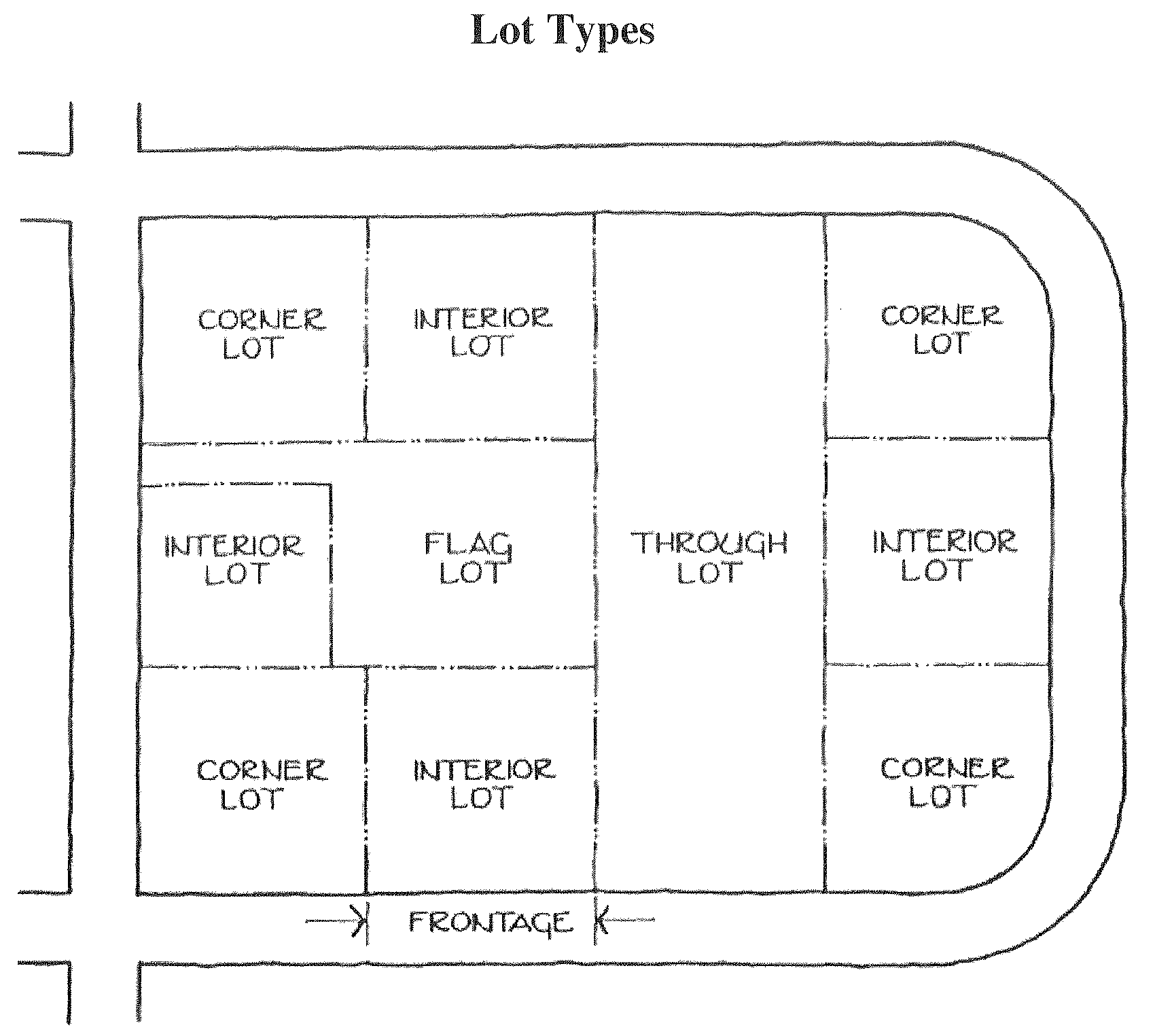
Frontage. The lot boundary along a public or private right-of-way.
Game center. A business enterprise, whether principal or accessory, where persons utilize electronic machines or devices, including but not limited to computers and gaming terminals or other amusement devices, where cash, merchandise, or other items of value are redeemed or otherwise distributed, whether or not the value of such distribution is determined by electronic games played.
Golf club. See country club.
Government buildings. A structure or group of structures intended to carry out the necessary day-to-day functions of federal, state, county, or local governments including government offices and public works facilities. This shall not include uses defined separately herein.
Ground cover. Low growing plants such as grasses, ivies, creeping bushes, and similar decorative plantings. Ground cover shall have the capability of soil stabilization and erosion control.
Group home. See residential care home.
Habitable. A space in a building for living purposes, which includes working, sleeping, eating or cooking. Bathrooms, toilet rooms, closets, halls, storage or utility spaces and similar areas are not considered habitable space.
Handicapped. A person with a temporary or permanent physical, emotional, or mental disability including but not limited to mental retardation, cerebral palsy, epilepsy, autism, hearing and sight impairments, emotional disturbances, and orthopedic impairments but not including mentally ill persons who are dangerous to others as defined in N.C.G.S. § 122C-3(11)b.
Hazardous material. Any substance or material that by reason of its toxic, caustic, corrosive, abrasive, or otherwise injurious properties, may be detrimental or deleterious to the health of any person handling or otherwise coming into contact with such material or substance.
Home occupation. Any use conducted for gain entirely within a dwelling and carried on by the occupants thereof, which use is clearly incidental and subordinate to the residential use and which does not change the character thereof, and in connection with which there is no display. When observed from beyond the lot on which it is located, the home occupation does not give visual, audible, sensory, or physical evidence that the property is used for any nonresidential purpose.
Hospital. An institution providing physical and mental health services primarily for human in-patient medical or surgical care for the sick or injured, including related facilities such as laboratories, out-patient services, training facilities, central service facilities, emergency services, and staff offices.
Hotel. A facility offering transient lodging accommodations to the general public which may provide additional services such as restaurants, meeting rooms, and recreation facilities.
Impervious surface. Any material which reduces and prevents absorption of storm water into previously undeveloped land. This includes but is not limited to, buildings, roads, pavement, gravel surfaces, etc. Items not considered to be "impervious" include the water area of a swimming pool and wooden slatted decks.
Impervious surface ratio. The gross area of all impervious surfaces on a lot divided by the lot area.
In-home day care. A type of home occupation in which the occupant of a home cares for children in addition to his or her own children during day time hours, as regulated by the state and the special requirements included herein.
Infill. The development of new buildings on vacant sites in a primarily built-up area.
Inn. See hotel.
Institutional use. A use of a semi-public nature that typically serve community needs including but not limited to daycares, colleges, private schools, hospitals, research facilities, museums, residential care facilities, and other long-term medical care facilities.
Instructional school. A private business that instructs students on skills that may include but are not limited to dance, gymnastics, martial arts, art, and music, and shall not include truck driving or driver training schools.
Intense use. A use of land that typically has more of an impact on adjacent properties than most other uses.
Internet gaming, sweepstakes, and/or other gambling establishments. A commercial facility, whether as a primary or accessory use, providing activities that include, but not limited to, internet sweepstakes gaming machines, Keno, gambling rooms or facilities, and other similar games and activities. An accessory use would be a facility with three or less machines; a primary use would be four or more.
Junk. Scrap copper, brass, rope, rags, batteries, paper, trash, rubber, debris, waste, or junked, dismantled, or wrecked automobiles, or parts thereof, iron, steel, or other scrap ferrous or nonferrous material and dismantled or used white goods or parts thereof.
Junk motor vehicles. An unregistered and/or nonfunctional, dismantled, wrecked, or abandoned motor vehicle.
Legislative decision. The adoption, amendment, or repeal of a regulation under this Chapter or an applicable local act. The term also includes the decision to approve, amend, or rescind a development agreement consistent with the provisions of Article 10 of N.C.G.S. 160D.
Legislative hearing. A hearing to solicit public comment on a proposed legislative decision.
Live/work development. A minimum of a two-story building in which the ground floor contains one or more commercial or nonresidential enterprises and at least one of the floors above contains residential units.
Loading space, off-street. An off-street space or berth on the same lot with a building or contiguous to a group of buildings for the temporary parking of commercial vehicles while loading or unloading merchandise or materials.
Lot. A parcel of land whose boundaries have been established by some legal instrument such as a recorded deed or a recorded map and which is recognized as a separate legal entity for purposes of transfer of title.
Lot area. The total area circumscribed by the boundaries of a lot, except that when the legal instrument creating a lot shows the boundary of the lot extending into a public street right-of-way, then the lot boundary for purposes of computing the lot area shall be the street right-of-way line, or if the right-of-way line cannot be determined, a line running parallel to and thirty feet from the center of the traveled portion of the street.
Lot types.
Corner lot. A lot located at the intersection of two or more streets. A lot abutting on a curved street or streets shall be considered a corner lot if straight lines drawn from the foremost points of the side lines to the lot meet at an interior angle of less than 135 degrees.
Double frontage lot. A continuous (through) lot that is accessible from both streets upon which it fronts (see through lot), but which streets do not intersect one another.
Flag lot. An irregularly shaped lot where the building portion of the lot is connected to its street frontage by an arm or "pole" of the lot.
Interior lot. A lot other than a corner lot with frontage on only one street.
Nonconforming lot. A parcel of land held in separate ownership, occupied, or intended to be occupied by a principal building or structure together with accessory buildings, and uses, having insufficient size to meet the lot width, lot area, yard, off-street parking areas, or other open space provisions of this ordinance.
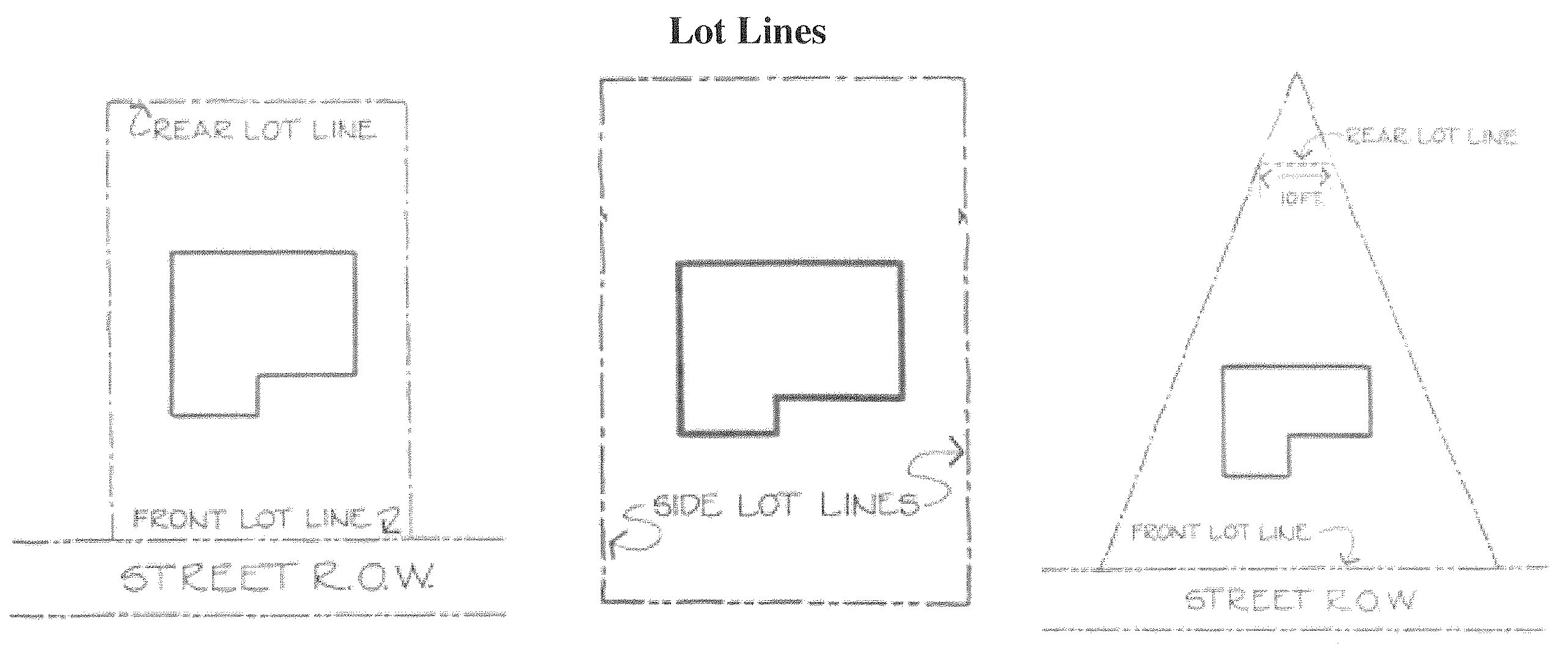
Lot line. A line bounding a lot that divides one lot from another or from a street or any other public or private space.
Front lot line. In the case of an interior lot, the lot line separating said lot from the street; in the case of a corner lot or through lot, the lot line separating said lot from the street that is designated as the front street in the request for a permit.
Rear lot line. A lot line which is opposite and most distant from the front lot line, and in the case of an irregular or triangular-shaped lot, a line ten feet in length within the lot parallel to and at the maximum distance from the front lot line.
Side lot line. Any lot line that is not a front lot line or rear lot line; a lot line separating a lot from a side street is an exterior lot line, while a lot line separating a lot from another lot, or lots, is an interior lot line.
Zero lot line. The location of a building on a lot in such a manner that one or more of the building's sides rests directly on a lot line.
Lot width. The distance from side lot line to side lot line measured at the required minimum front yard setback parallel to the front property line.
Manufactured home. A dwelling unit that:
A.
Is not constructed in accordance with the standards set forth in the North Carolina State Building Code but that is constructed to HUD standards; and
B.
Is composed of one or more components, each of which was substantially assembled in a manufacturing plant and designed to be transported to the home site on its own chassis; and
C.
Exceeds 40 feet in length and eight feet in width (commonly called a mobile home).
Manufactured home lot. A manufactured home lot is a piece of land within a manufactured home park whose boundaries are delineated in accordance with the requirements of the ordinance, and that is designed and improved in accordance with the requirements of the ordinance to accommodate a single manufactured home.
Manufactured home park. Any site or parcel of land under single ownership where land is rented, and utilities are provided for the installation or placement of two or more manufactured homes.
Manufacturing types.
Heavy/industrial manufacturing. The assembly, fabrication, production, or processing of goods and materials using processes that ordinarily have greater than average impacts on the environment, or that ordinarily have significant impacts on the use and enjoyment of other properties in terms of noise, smoke, fumes, odors, glare, health or safety hazards, or uses that otherwise do not constitute "light manufacturing,". "Heavy manufacturing" shall include, but not be limited to, the following: enameling, lacquering, or the plating or galvanizing of metals; foundries or mills producing iron and steel products; industrial chemical manufacture; meat packing plants; mixing plants for concrete or paving materials, and manufacture of concrete products; oxygen manufacture and/or storage; pottery, porcelain, and vitreous china manufacture; poultry dressing for wholesale; pressure treating of wood; stonecutting; tire recapping and retreading; tobacco products manufacture. This shall not include resource extraction and recycling and salvage operations.
Light manufacturing. All operations involved in textile manufacturing currently conducted within the Town of Angier, and all industrial processes of less intensity than such operations including the assembly, fabrication, production, or processing of goods and materials using processes that ordinarily do not create noise, smoke, fumes, odors, glare, or health or safety hazards outside of the building or lot where such assembly, fabrication, production or processing takes place, where such processes are housed entirely within a building. This shall not include uses that constitute "heavy manufacturing", resource extraction, or recycling and salvage operations.
Massing. The shape and form buildings assume through architectural design. There are ten architectural design elements which create urban space. A specific project may not need to incorporate all ten elements.
Building silhouette. Similar pitch and scale to a roof line.
Spacing between building façades. Setbacks or notches between primary façades which frame the structure.
Proportion of windows, bays, and doorways. Vertical or horizontal elements tied together in bands across façade lengths.
Proportion of primary façade. Size of façades similar in area and height to width ratios.
Location and treatment of entryways. Important visual commonality between structures.
Exterior materials used. Similar materials and treatment add to detail and monumentality of a building.
Building scale. Similarity of building height and configuration.
Landscaping. Ties together buildings and defines space.
Shadow patterns form decorative features. The light and dark surfaces from materials used and projections from window bays and setbacks create visual breaks.
Mausoleum. A large tomb, usually a stone building, with spaces and used for the entombment of the deceased above ground.
Mini-warehouse. A structure or structures containing separate storage spaces of varying sizes leased or rented on an individual basis that may also include outdoor storage.
Mining. The extraction of minerals, including solids, liquids, and gases and/or the excavating and removing material from the surface and/or subsurface.
Mobile home. See manufactured home.
Modular home. A manufactured building designed to be used as a single family dwelling unit which has been constructed and labeled indicating compliance with the North Carolina State Building Code for residential structures.
Motel. See hotel.
Motor vehicles. A self-propelled device licensed, registered, and functional as a motor vehicle and used for transportation of people or goods; or any device attached to a self-propelled vehicle.
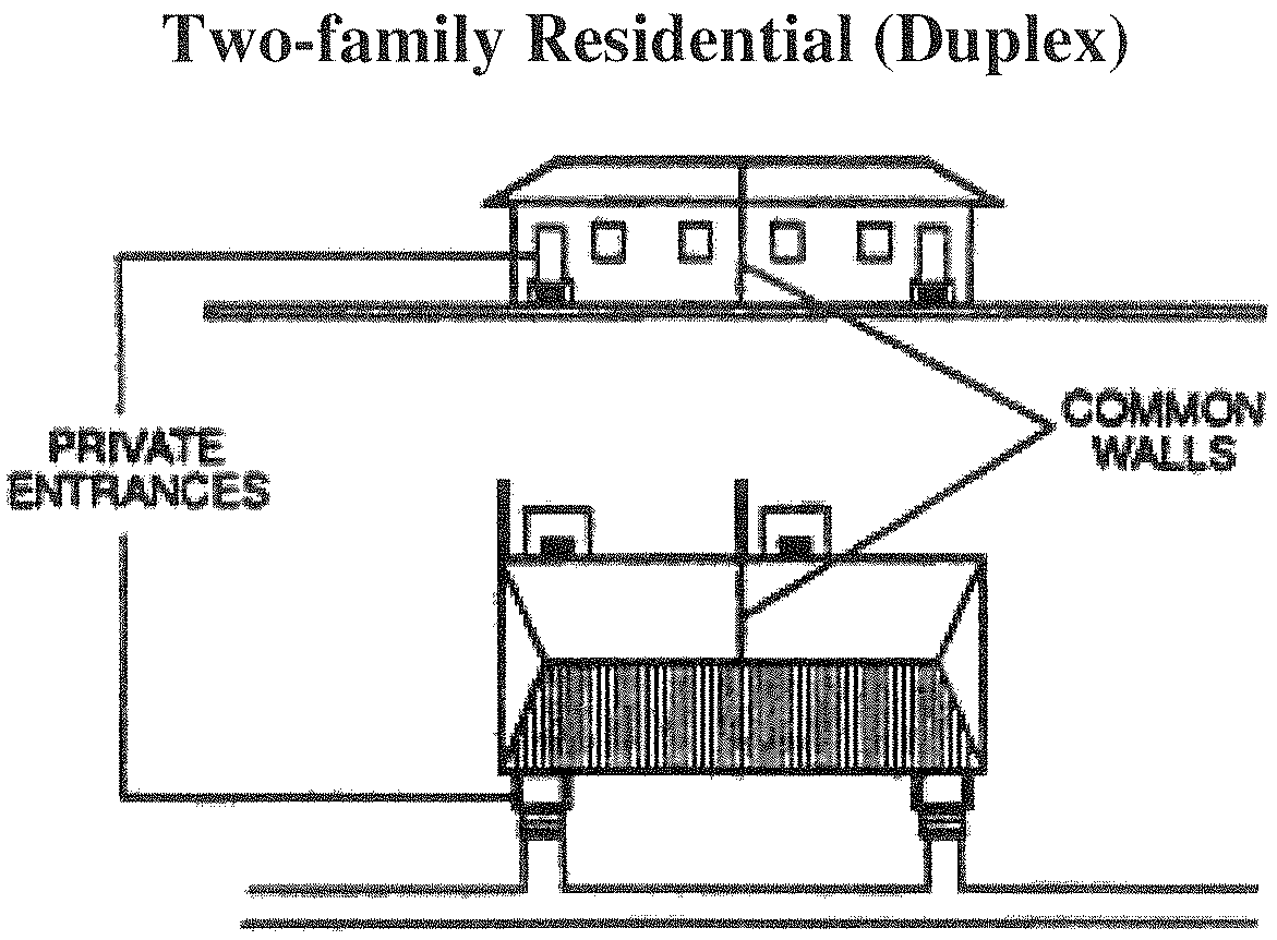
Multifamily residential. The development of three or more attached dwelling units. This includes condominiums, townhomes, apartments, quadraplexes, triplexes, and more than one duplex (two-family dwelling) constructed as part of a single project.
Apartments. One or more one- or two-story multifamily structures, with each structure containing three or more dwelling units, including related off-street parking, and which units share means of ingress and egress and other essential facilities.
Condominiums. A building, or group of buildings, in which dwelling units, or other floor area, are owned individually and the structure, common areas, and facilities are owned by all the owners on a proportional, undivided basis.
Townhome. A single-family dwelling unit constructed in a series of at least three attached units separated by property lines, and in which no unit is located over another unit.
Two-family attached (duplex). A building arranged or designed to be occupied by two families in units separated from each other by an unpierced wall, and the structure having only two dwelling units located on the same lot of record.
Nightclub. An establishment that is either public or private in which people gather for dancing and/or listening to recorded or live music, and which may include the sale and consumption of alcoholic beverages on premises.
Noncommercial copy. A sign message through pictures, illustrations, symbols and/or words, or any combination thereof, which does not contain any reference to a business or product but displays a substantive message, statement, or expression that is protected by the First Amendment to the Constitution of the United States.
Nonconforming use. Any use lawfully being made of any land, building, or structure on the effective date of this ordinance or on the effective date of any amendment thereto rendering such use nonconforming, which does not comply with all the regulations of this ordinance or any amendment thereto, whichever might be applicable.
Nonconforming lot. Any lot of record which does not meet the minimum yard or area requirements established in these regulations at the time of this ordinance's adoption or any amendment thereto.
Nonconforming sign. A sign that, on the effective date of this ordinance or the date of any subsequent amendment thereto, does not conform to one or more of the regulations set forth in this ordinance.
Nonconforming structure. Any structure lawfully existing on the effective date of these regulations, or any amendment to it rendering such structure nonconforming, which does not comply with all of the standards and regulations of these regulations or any amendment thereto.
Nonprofit organization. An organization that does not distribute its surplus funds to owners or shareholders, but instead uses them to help pursue its goals, and that has obtained proper State approval to operate as such.
Nursery. A commercial enterprise conducted on land where flowers, shrubs, and similar horticultural products are raised and sold to the general public. Nurseries may include the use of greenhouses for growing purposes.
Office use. Professional occupations within a building or buildings which do not generally involve the on-site sale of goods to customers.
Open space. Any area which does not consist of buildings, streets, right(s)-of-way, parking, or easements, and serves as a passive or active recreational area, as conservation land, or as pervious area for watershed requirements. This area provides, or has the potential to provide, environmental, social, and/or economic benefits to the community whether direct or indirect.
Outdoor kennel. A commercial enterprise that involves the containment of animals outside of a building.
Outdoor storage. The storage of goods, products, or vehicles as an ancillary use by their owner or on a commercial basis outside of a permanently constructed building.
Outparcel. A parcel of land associated with and located within a shopping center or multi-tenant nonresidential development, which is designated on an approved site plan as a location for a structure with an intended use.
Overlay district. A set of regulations which add an additional layer of provisions to an underlying, regulating zoning district, and implemented when necessary due to special circumstances including protection of special environmental features.
Parapet. That portion of a building wall that extends above the roof line.
Parking bay. A parking module consisting of one or more sets of one or two rows of parking spaces and the aisle from which motor vehicles enter and leave.
Parking space, off-street. An area located outside of any street right-of-way which is designed to accommodate the parking of vehicles which meets all area requirements contained in chapter 8 of this ordinance.
Pedestrian-oriented development. Development which accommodates the needs of the pedestrian. Such development will have parking to the side or rear of a building, will mix uses and provide them in proximity to one another, will allow the pedestrian the option or choice of not having to use a car to accomplish certain trips, and will provide a variety of interesting and detailed streetscapes which balance the need of the pedestrian and car equally.
Permit types.
Building permit. Written permission by the Town of Angier Inspections Department issued for the construction, repair, alteration, or addition to a structure.
Land use (zoning) permit. Written permission issued by the administrator or his designee for the construction, or enlargement of a structure, including signs, or the grading or excavation of a site in preparation of construction or for the installation of underground utilities.
Personal service uses. Services provided by licensed professional stylists, aestheticians, and therapists including but not limited to hair care, nail care, waxing, massage therapy, and similar spa services.
Photometric. Data regarding the luminous intensity of light sources on a particular site.
Pitch. The slope of a roof expressed as rise over run. (i.e. for a roof that rises four inches vertically for every 12 inches it runs horizontally the pitch is 4:12)
Planning and development regulation jurisdiction. The geographic area defined in N.C.G.S. ch. 160D, art. 2 within which a city or county may undertake planning and apply the development regulations authorized by N.C.G.S. ch. 160D.
Plat. A map representing a tract of land, including boundaries and location of individual properties and streets; and/or a map of a subdivision or site plan.
Construction plat. A map of the infrastructure and improvements required as part of a subdivision.
Final plat. A map of all or a portion of a subdivision that is the legal instrument for recordation. Final plats shall be consistent with the approved preliminary plat and be reviewed and recorded following engineering document and/or construction plat approval.
Preliminary plat. A map indicating the layout of a subdivision submitted, sometimes after sketch plan approval, prior to or simultaneously with construction plat.
Principal structure. A building in which is conducted the principal use on the lot on which said building is situated. In any residential zoning district, any structure containing a dwelling unit shall be deemed to be the principal building on the lot where it is located.
Principal use. The primary or predominant use of any lot. Also known and referred to as the primary use.
Privately owned public utility structures and facilities. Any structures and facilities owned or operated by a privately owned electric, telephone, gas, cable, or water and waste water company
Produce stand. The sale of any form of agricultural or horticultural products at a retail stand located on the same site where the products are grown. Off-site produce stands shall be considered separately and regulated as such.
Produce/arts and crafts market. A parcel of land which is used for the display and sale of locally grown fruits and vegetables, as well as locally hand crafted items which include but are not limited to: art work, pottery, jewelry, seasonal decorations and similar items. For interpretational purposes, locally shall be defined as within 50 miles of Town Hall.
Protest petition. A formal written objection to a zoning change filed by the property owners most directly affected by the proposed amendment. If a qualifying petition is filed as least two working days prior to the day of the legislative hearing on a proposed zoning amendment, the amendment can only be adopted if approved by a three-fourths majority of the governing board. A protest petition shall be deemed qualifying if signed by the owners of 20 percent or more of the subject area or five percent of the surrounding property extending 100 feet from the subject area. Where the subject area abuts a street right-of-way, the 100 feet shall be measured starting from the opposite side of the street right-of-way unless the right-of-way is greater than 100 feet.
Publicly owned utility structures and facilities. Any structures and facilities owned by Harnett County or its agencies, or any other local government entity, including, but not limited to: water lines, waste water lines, stormwater facilities, water treatment plants, waste water treatment plants, lift stations, pumping stations, booster stations, water tanks, and associated facilities.
Quasi-judicial decision. A decision involving the finding of facts regarding a specific application of a development regulation and that requires the exercise of discretion when applying the standards of the regulation. The term includes, but is not limited to, decisions involving variances, special use permits, certificates of appropriateness, and appeals of administrative determinations.
Recreational facility types.
Private recreational facility. A privately owned area of land that is developed for active and/or passive recreational pursuits with various manmade features and is designed to serve the immediate neighborhood or community in which it is located, or can be regional in scope, serving several neighborhoods.
Public recreational facility. A publicly owned area of land that is developed for active and/or passive recreational pursuits with various manmade features and is designed to serve the immediate neighborhood or community in which it is located, or can be regional in scope, serving several neighborhoods.
Quasi-judicial decision. A decision involving the finding of facts regarding a specific application of a development regulation and that requires the exercise of discretion when applying the standards of the regulation. The term includes, but is not limited to, decisions involving variances, special use permits, certificates of appropriateness, and appeals of administrative determinations.
Recreation vehicle. A vehicular-type unit without a permanent foundation, which can be towed, hauled, or driven and primarily designed as temporary living accommodation for recreational, camping, and travel use and including but not limited to travel trailers, truck campers, camping trailers, and self-propelled motor homes. A recreation vehicle shall not be considered as being a single-family dwelling. Also refer to the North Carolina State Building Code.
Recycling center. A facility or portion thereof, or tract of land or portion thereof, used only for the drop-off and temporary storage of recyclables and specifically excluding onsite recycling operations or processing.
Religious institution. A building or structure, or group of buildings or structures, which by design and construction are primarily intended for conducting organized religious services whose site may include an accessory area for the interment of the dead. Day care centers and/or schools operated by the church on the facilities of the religious institution shall be considered separate principal uses when there is an enrollment capacity in excess of 25 enrollees.
Repair services. The repair of any item, typically of household or personal goods, that takes place entirely within an enclosed structure with no outdoor storage.
Residential care home. An institutional home in which supervision, personal care, social services, counseling services, transportation, and/or therapeutic services are provided for six or more persons in a residential capacity to serve special needs in addition to providing food and shelter. Also known as a group home, halfway home, or boarding home for sheltered care.
Residential care facility. An institutional facility in which supervision, care, therapeutic, or medical services are provided for more than six persons in a residential capacity. This includes nursing homes, transitional medical care homes, and similar residential care services that do not meet the definition of residential care home.
Residential sales office. Structures, whether temporary or permanent, located in a subdivision containing 25 or more lots, and used as sales offices for the subdivision development in which it is located.
Restaurant. A commercial establishment where food and drink are prepared, served, and consumed primarily within the principal building.
Retail uses. Establishments engaged in selling goods or merchandise to the general public for personal or household consumption and rendering services incidental to the sale of such goods.
Community retail uses. A retail establishment in which certain low-intensity retail trade are accessible by pedestrians from and serve the daily convenience needs of surrounding neighborhoods, and is 15,000 square feet or less in size.
Neighborhood retail uses. A retail establishment which has provisions to serve the community as a whole, and ranging in size up to 50,000 square feet.
Regional retail uses. A retail establishment, as defined herein, of 50,000 or more square feet in size, which has the ability to serve a region surrounding the community.
Rezoning. See amendment, zoning map.
Right-of-way. An area of land occupied or intended to be occupied by a public street, for such purpose, areas claimed by a municipality or the State of North Carolina for such purposes, or actually used for such purposes, or privately held and maintained.
Roof line. The highest point of a flat roof and mansard roof and the lowest point of a pitched roof, excluding any cupolas, chimneys or other minor projections.
Rooming house. A building or portion thereof which contains not more than five rooms designed or intended to be used for residential occupancy by not more than ten individuals for compensation. It may also serve meals for compensation to the boarders.
Screening. A fence, wall, hedge, landscaping, earth berm, buffer area or any combination of these provided to create a visual and/or physical separation between certain land uses. Screening may be located on the property line or elsewhere on the site.
Service uses. Uses that include the provision of work that does not typically result in ownership of physical goods and that create benefits by facilitating a change in customers, a change in their physical possessions, or a change in their intangible assets (i.e. beauty shops, dry cleaning, appliance repair, check cashing, etc.). This does not include automotive/boat/heavy equipment/manufactured home services.
Setback. A distance measured inward from a property line which shall remain unoccupied by structures and parking areas except as permitted by this ordinance.
Front setback. The required distance from the fronting or primary street right-of-way to a structure.
Rear setback. The required distance from the rear property line to a structure.
Side setback. The required distance from the side property line to a structure.
Side corner setback. The required distance from the nonfronting or nonprimary street right-of-way to a structure.
Sign setback. The required distance from the property line or right-of-way to the nearest point of the sign or its supporting member.
Sewer, public. Any package treatment plant or other sewage treatment facility serving two or more sources not connected to individual or public systems and having a design capacity of greater than 3,000 gallons daily and/or a discharge to surface water, as permitted by the State of North Carolina. In addition the definition shall include all connections to such a system.
Shopfront. A business or retail use. The façade of a shopfront is aligned directly on the building line with the entrance at grade. This is typical for sidewalk retail. Shopfronts often have awnings or a colonnade.
Shopping center. A group of three or more retail establishments constructed and developed in one or more phases with customer and employee parking and merchandise and other loading facilities provided on-site. A shopping center may be located and developed on one or more lots and may include one or more principal buildings.
Shrub. An ornamental plant that is at least two feet tall above the highest root at the time of planting.
Sight distance triangle. The triangular area formed by a diagonal line connecting two points located on intersecting property lines (or a property line and the curb or a driveway) within which no planting, structure, sign, fence, wall, or obstruction greater than two feet in height shall be placed or maintained.
Sign. Any object, display or structure, or part thereof, situated outdoors, which is used to advertise, identify, display, direct, or attract attention to an object, person, institution, organization, business, product, service, event or location by any means, including words, letters, figures, design, symbols, fixtures, colors, illumination, or projected images. The term "sign" does not include the flag or emblem of any nation, organization of nations, state, political subdivision thereof, or any fraternal, religious or civic organization; works of art which in no way identify a product or business; scoreboards located on athletic fields; or religious symbols.
Accessory use sign. Signs which are located on the same premises with a principal permitted use and which are clearly incidental, secondary and/or supportive of the principal use.
Advertising sign. A sign, other than a directional sign which directs attention to or communicates information about a business, commodity, service, or event that exists or is conducted, sold, offered, maintained or provided at a location other than the premises where the sign is located. Any advertising sign allowed under this ordinance may display either a commercial or noncommercial copy.
Banner sign. Temporary signs advertising a special sale, event, or feature that are made of vinyl, fabric, or similar material.
Billboard sign. Large off-premises advertising signs.
Building marker sign. A sign etched into masonry, bronze or similar material on a building that identifies the name of the building, designer, year constructed, or provides similar information.
Canopy and awning sign. Signs attached to or painted or printed onto a canopy or awning. For the purposes of the ordinance, the permitted size of a canopy or awning sign will be calculated on the basis of the size of the building wall to which the canopy is attached. It will, for measuring purposes, be considered a wall sign.
Civic signs (off-premises). Signs which denote the location of religious, charitable, fraternal, military or service organizations.
Construction/contractor's or subdivision project sign. Signs that identify future tenants, home builders, contractors, and architectural or engineering designers during the period of construction.
Directional sign (on-premises). Signs that are located on the premise/property to provide directions for entrances and exits to the property. Such signs contain no copy other than directional information.
Directory sign. A sign on which the names and locations of occupants or the use of a building or property is identified.
Flashing sign. Signs that use an intermittent or flashing light source or windblown and/or mechanical moved reflective material to attract attention.
Ground (free-standing) sign. Signs that are not affixed to a building and is securely and permanently mounted in the ground.
Government (civic) sign. Signs posted or authorized by various local, state, and federal agencies in the performance of their duties including providing community information and facilitating economic development. Such signs include regulatory signs, traffic signs, welcome signs, bulletin boards, and wayfinding signs.
Illuminated sign. Signs lit from either internal or external light sources.
Incidental sign. Signs used in conjunction with equipment or other functional elements for a use or operation that cannot be read from the street right-of-way which inform or instruct customers or visitors on-site (i.e. drive-through menu boards, gas pump signs, bulletin boards).
Legal or warning sign. Signs erected to warn of danger or hazardous conditions such as signs erected by public utility companies or construction companies; signs required for or specifically authorized for a public purpose by any law, statute or ordinance.
Monument sign. Free-standing permanent ground signs in which the bottom of the signs are no than three feet from the ground.
Neighborhood identification sign. Signs which display only the name of recognizable communities or subdivisions.
Occupant/street number sign. Signs affixed to structures, mailboxes, decorative light posts, driveway entrances, etc., which serve to identify the address of the structure or occupant.
Off-premises sign. Signs that draw attention to or communicate information about businesses, services, commodities, that exist or are conducted, sold, offered, maintained or provided at locations other than the premises where the signs are located. This includes billboards.
On-premises sign. Signs that draw attention to or communicate information about businesses, services, commodities, that exist or are conducted, sold, offered, maintained or provided on the premises where the signs are located.
Placard sign. A small sign attached to a wall face near the building entrance which displays only the name, address, and/or crest, or insignia, trademark, occupation or profession of the occupant or building.
Pole sign. A detached sign erected and maintained on a free-standing frame, mast, or pole and not attached to any building but not including ground-mounted or monument signs. The bottom of such sign is more than three feet from the ground.
Political sign. Temporary signs displayed during a period prior to an election, primary, or referendum to advocate or denounce a particular candidate or cause.
Portable sign. Any sign not permanently attached to the ground or other permanent structure, or a sign designed to be transported, including, but not limited to, signs designed to be transported by means of wheels; signs converted to A- or T-frames; or umbrellas used for advertising.
Principal use sign. A sign which constitutes the sole and/or principal use of land.
Projecting sign. Any sign other than a wall, awning, canopy, or marquee sign, which is affixed to a building and is supported only by the wall on which the sign is mounted and has two sign faces perpendicular or close to perpendicular to the wall face.
Real estate sign. Temporary signs that advertise the sale or lease of a property. Signs shall be removed within seven days of the sale or lease of the property. Signs advertising lots for sale within an approved subdivision may be posted at the entrance to the subdivision and shall be allowed until 75 percent of the lots are sold within the subdivision.
Roof sign. A sign erected or maintained in whole or in part upon or over the roof or parapet of a building.
Special event sign. Temporary signs erected by public or non-profit organizations such as schools and churches for promoting public events such as fund drives, fairs, festivals, sporting events, etc.
Stadium sign. Signs located within a stadium intended to be read only by persons seated within the stadium.
Vehicular sign. Signs on parked vehicles visible from the public right-of-way where the primary purpose of the vehicle is to advertise a product or to direct people to a business or activity located on the same or nearby property, and said vehicles are not used in the normal day to day operations of said business. For the purposes of this ordinance vehicular signs shall not include business logos, identification or advertising on vehicles primarily used for other transportation purposes.
Wall sign. Any sign directly attached to an exterior wall of a building or dependent upon a building for its support and is parallel to the wall face. Signs directly painted on walls shall be considered wall signs.
Wayfinding sign (town-sponsored). Signs that direct travelers and tourists to points of interest including the central business district, government facilities, cultural arts facilities, galleries, accommodations, restaurants, and shops. This shall not include signs installed and maintained by NCDOT.
Window sign (temporary). Signs temporarily attached or temporarily painted to a window or door, announcing sale or special features.
Yard sale sign. Temporary signs displayed for the purpose of advertising yard sales.
Sign area. The entire face of a sign including the advertising surface and any framing, trim, or molding, but not including the supporting structure. In computing area, only one side of a double-faced sign shall be considered.
Single-family residential. A separately owned residence for use by one family as a housekeeping unit with space for eating, living, cooking, and sanitation (Source: N.C.G.S. § 87-15.5) where the dwelling unit is on a separate lot of record, no lot contains more than one dwelling unit, no dwelling unit shares a wall with another dwelling unit (detached), and each dwelling unit is surrounded on all sides by yard.
Skilled trade shops. Establishments used for the purposes of cabinet making, machining, sheet metal work, and woodworking, or other similar type uses.
Skirting. A weather-resistant material designed expressly for a manufactured home and used to enclose the space from the bottom of the manufacture home to grade.
Sleeping unit. A room or space in which people sleep, which can also include permanent provisions for living, eating, and either sanitation or kitchen facilities but not both. Such rooms and spaces that are also part of a dwelling unit are not sleeping units.
Solar collector. A device or combination of devices, structure, or part of a device or structure that transforms direct solar energy into usable energy.
Solar energy facility. A complete design or assembly for the purpose of transforming solar energy into usable energy, consisting of a solar energy collector, an energy storage facility (where used), and components for the distribution of transformed energy.
Solar energy system. A complete design or assembly for the purpose of transforming solar energy into electricity or for heating water, used exclusively for accessory purposes only.
Special use. A use that is permitted in a zoning district subject to the issuance of a special use permit by the town board of adjustment.
Special use permit. A special authorization for a special use which may be subject to any specific restrictions or conditions on its size, location, intent, character of use, etc. as determined by the town board of adjustment.
Storage yard. An establishment or place of business which is maintained, operated, or used for storing, keeping, buying, or selling vehicle parts. Any lot containing more than three unregistered and nonfunctional motor vehicles shall constitute a storage yard for the purpose of this ordinance.
Stormwater runoff. Rain which falls onto impervious surfaces and is not absorbed into the ground immediately. Stormwater runoff carries pollutants from paved surfaces into streams and rivers and causes flooding by speeding up the rate of water flow into streams and rivers.
Street, private. Any right-of-way used for purposes of motor vehicle travel which has not been accepted for maintenance or ownership purposes by a public entity.
Street, public. A public right-of-way set aside for public travel and either which has been accepted for maintenance by NCDOT or the town, has been established as a public road prior to the date of adoption of this ordinance, or which has been dedicated to the NCDOT or the town for public travel by the recording of a plat of a subdivision with the county register of deeds office.
Street orientation. The direction of the architectural front façade of a building in relation to the street.
Street yard. The area of land along the front property line parallel to a right-of-way reserved for tree planting and landscaping.
Structure. A combination of materials to form a construction for use, occupancy, or ornamentation whether installed on, above, or below the surface of land or water. Anything constructed or erected, the use of which requires more or less permanent location on the ground or which is attached to something having a more or less permanent location on the ground.
Subdivision. For the purposes of this ordinance in accordance with N.C.G.S. § 160A-376, "subdivision" shall mean all divisions of a tract or parcel of land into two or more lots, building sites, or other divisions when one or more of those divisions are created for the purpose of sale or building development (whether immediate or future) and shall include all divisions of land involving the dedication of a new street or a change in existing streets; but the following shall not be included within this definition nor be subject to the regulations of this ordinance; provided, however, that any document or plat to be recorded pursuant to any such exclusion shall bear the notation "no approval required" and the signature of the administrator or his designated agent before being presented for certification by the county review officer:
A.
The combination or recombination of portions of previously subdivided and recorded lots where the total number of lots is not increased and the resultant lots are equal to or exceed the standards of this ordinance.
B.
The division of land into parcels greater than ten acres where no street right-of-way dedication is involved.
C.
The public acquisition by purchase of strips of land for the widening or opening of the streets or for public transportation system corridors.
D.
The division of a tract in single ownership whose entire area is no greater than two acres into not more than three lots or tracts, where no street right-of-way dedication is involved or proposed, and where the resultant lots are equal to or exceed the standards of this ordinance.
Major subdivision. A major subdivision is defined as a subdivision where any one or more of the following conditions exist:
A.
Dedication of public right-of-way or other public tracts; or,
B.
The resultant subdivision will produce more than five lots.
Minor subdivision. A minor subdivision is defined as a subdivision where all of the following conditions exist:
A.
No public right-of-way dedication; and,
B.
The resultant subdivision will produce five or fewer lots.
Subdivision administrator. See administrator.
Taxicab. A vehicle driven or propelled by gasoline, other than motor buses, operating in and through the town, which shall be used for the purpose of carrying, transporting, or conveying any person from one place to another, for which services a charge or fee is made.
Technical review committee (TRC). A group of appointed town staff members and agencies that review sketch plans, subdivision plats, and site plans for proposed developments and make recommendations on design and approval criteria during the development review process.
Temporary emergency residence. A temporary dwelling unit used following the destruction or severe damage of a permanent dwelling unit following fire or other natural disaster while the permanent dwelling is being repaired or rebuilt.
Temporary structures. Buildings placed on a lot for a specific purpose which are to be removed within a specified time period. Examples of temporary structures include monitoring stations, mobile classrooms or office space, and produce stands. The duration permitted for a temporary structure is established by this ordinance.
Temporary uses. Uses which are established on a non-permanent basis, such as construction trailers and guard houses for development projects or manufactured housing placed on a lot for temporary housing while principle home renovations are being done.
Tree types.
Large maturing tree (canopy). A tree, either single or multi-stemmed (i.e., in clump form) which has a height of at least ten feet and is of a species which, at maturity, can be expected to reach a height of more than 35 feet under normal growing conditions in the local climate. If the tree is single-stemmed, it shall have a caliper of at least two and one-half inches at the time of planting measured six inches up from the highest root of the tree. Also known as a canopy tree.
Small maturing tree (ornamental). A tree, either single or multi-stemmed (i.e., in clump form) which has a height of at least eight feet and is of a species which at maturity, can be expected to reach a height less than 35 feet under normal growing conditions in the local climate. If the tree is single-stemmed, it shall have a caliper at the time of planting of at least two inches measured six inches up from the highest root of the tree. Also known as an ornamental or understory tree.
Underpinning. Skirting or curtain walls installed in good workmanships-like manner along the entire base of a manufactured home, except for ventilation and crawl space requirements, and consisting of one of the following:
A.
Metal with a baked-on finish of uniform color;
B.
Uniform design and color vinyl, including artificial stone; or
C.
Brick and stone masonry.
Utility facilities. Structures, specifically new utility infrastructure, either publicly or privately owned used for the transfer, distribution, and/or storage of gas, electricity, steam, water, communications, or other public services.
Variance. Permission granted on the basis of proof of physical hardship by the board of adjustment following quasi-judicial proceedings to depart from or relax the literal requirements of this ordinance relating to dimensional requirements such as setbacks, side yards, street frontage, and lot size that, if applied to a specific lot, would significantly interfere with the use of the property.
Vehicle. See motor vehicle.
Vehicle sales. Sales of automobiles, manufactured homes, recreational vehicles, boats, farm equipment, and other similar products, typically in an open area, used for the display, sale, or rental of new or used vehicles in operable condition where no repair work is done. Small equipment shall not be considered a vehicle herein.
Vehicle storage. The outdoor storage of vehicles for an automobile service use. This does not include inoperable vehicles (junk vehicles) which would constitute a junkyard.
Vested right. The right to undertake and complete a development or use of property under the terms and conditions of an approved site specific development plan currently in effect or as otherwise allowed by law.
Vocational school. A center for higher education that teaches specific job skills.
Warehouse, mini. A structure containing separate storage spaces of varying sizes leased or rented on an individual basis that may include outdoor storage when specifically provided for throughout the approval process.
Warehouse use. A building or group of buildings for the storage of goods or wares belonging either to the owner of the facility or to one or more lessees of space in the facility or both, with access to contents only through management personnel. This does not include mini-warehousing or mini-storage.
Wholesale. A place of business primarily engaged in selling merchandise to retailers, to industrial, commercial, institutional or professional business users, or to other wholesalers. The majority of all sales of such businesses shall be for resale purposes. Wholesale clubs and similar membership warehouses, where membership is easily available to the consuming public, and similar businesses shall not be deemed "wholesale sales operations".
Wind energy facility. A system designed to provide energy, wherein the power is generated from wind turbines, towers, and associated control or conversion electronics.
Wind energy system. A single system designed to supplement other electricity sources as an accessory use to existing buildings or facilities wherein the power generated is used primarily for on-site consumption. Such facilities consist of a single wind turbine, tower, and associated control or conversion electronics.
Wind turbine. A wind energy conversion system that converts wind energy into electricity through the use of a wind turbine generator, and may include a nacelle, rotor, tower, guy wires, and pad transformer. Also known as a "windmill."
Yard. A land area immediately adjacent to a building. Yards are broken into front, rear, and side. Front yards extend from the architectural front of a building to the fronting street or right-of-way. Side yards extend from the sides of a building to the property lines or a street right-of-way. Rear yards extend from the back of a building to a property line or a right-of-way. Yard configurations establish building typologies. There are four typologies into which most buildings can be classified: perimeter yard buildings, side yard buildings, rear yard buildings, and courtyard buildings.
Front yard. An area measured between the edge of the public street right-of-way line, and the front of a building, projected to the side lot lines. On corner lots, the front yard shall be measured perpendicular from the street lot line having the shortest linear footage. If both street lot lines have equal linear footage, the property owner shall determine the location of the front yard where no principal structure is located. If a principal structure is located on such a lot, the front yard shall be based on the architectural orientation of the house. In instances where the street right-of-way line goes to the centerline of the street, the front setback shall be measured at a point 30 feet from the centerline.
Rear yard. An open, unoccupied space extending the full width of the lot and situated between the rear line of the lot and the rear line of the building projected to the side lines of the lot.
Side yard. A space extending from the front yard to the rear yard between the principal building and the side lot line as measured perpendicular from the side lot line to the closest point of the principal building.
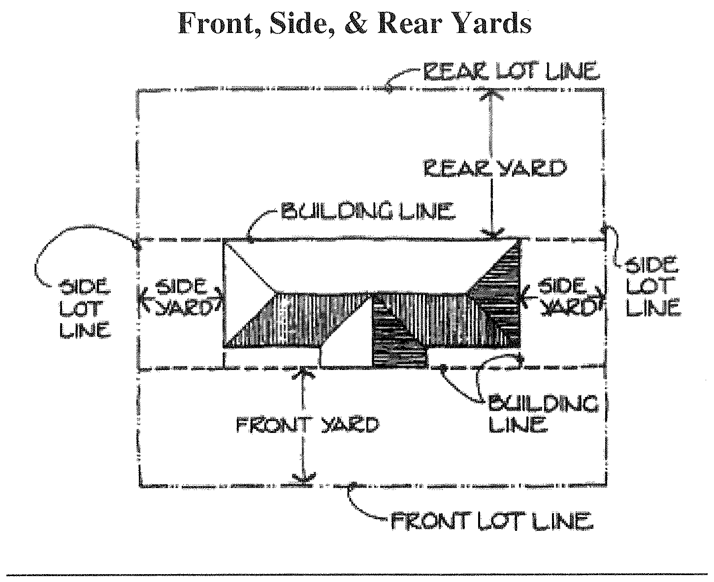
Yard sale. An outdoor sale of merchandise conducted entirely upon a residentially or institutionally developed lot by one or more households or civic groups where goods sold are limited primarily to used merchandise donated by the yard sale participants.
Zoning administrator. See administrator.
(Ord. No. 2012.01, 6-5-2012; Ord. of 5-7-2013(1); Ord. of 5-7-2013(2); Ord. of 2-2-2016; Ord. of 3-5-2019; Ord. of 6-1-2021; Ord. of 5-17-2022(1))
Section A.5. - Flood damage prevention overlay district definitions.
Accessory structure (appurtenant structure). Means a structure located on the same parcel of property as the principal structure and the use of which is incidental to the use of the principal structure. Garages, carports and storage sheds are common urban accessory structures. Pole barns, hay sheds and the like qualify as accessory structures on farms, and may or may not be located on the same parcel as the farm dwelling or shop building.
Addition. An extension or increase in the floor area or height of a building or structure to an existing building.
Appeal. A request for a review of the floodplain administrator's interpretation of any provision of the FDP-O.
Area of shallow flooding. A designated Zone AO on a community's flood insurance rate map (FIRM) with base flood depths determined to be from one to three feet. These areas are located where a clearly defined channel does not exist, where the path of flooding is unpredictable and indeterminate, and where velocity flow may be evident.
Area of special flood hazard. See special flood hazard area (SFHA).
Base flood. The flood having a one percent chance of being equaled or exceeded in any given year.
Base flood elevation (BFE). A determination of the water surface elevations of the base flood as published in the flood insurance study. When the BFE has not been provided in a special flood hazard area, it may be obtained from engineering studies available from a federal, state, or other source using FEMA approved engineering methodologies. This elevation, when combined with the freeboard, establishes the regulatory flood protection elevation.
Basement. Any area of the building having its floor subgrade (below ground level) on all sides.
Building. See structure.
Chemical storage facility. A building, portion of a building, or exterior area adjacent to a building used for the storage of any chemical or chemically reactive products.
Development. Any manmade change to improved or unimproved real estate, including, but not limited to, buildings or other structures, mining, dredging, filling, grading, paving, excavation or drilling operations, or storage of equipment or materials.
Disposal. As defined in N.C.G.S. § 130A-290(a)(6), the discharge, deposit, injection, dumping, spilling, leaking, or placing of any solid waste into or on any land or water so that the solid waste or any constituent part of the solid waste may enter the environment or be emitted into the air or discharged into any waters, including groundwater.
Elevated building. A non-basement building which has its lowest elevated floor raised above ground level by foundation walls, shear walls, posts, piers, pilings, or columns.
Encroachment. The advance or infringement of uses, fill, excavation, buildings, structures or development into a floodplain, which may impede or alter the flow capacity of a floodplain.
Existing manufactured home park or manufactured home subdivision. A manufactured home park or subdivision for which the construction of facilities for servicing the lots on which the manufactured homes are to be affixed (including, at a minimum, the installation of utilities, the construction of streets, and either final site grading or the pouring of concrete pads) was completed before the initial effective date of the floodplain management regulations adopted by the community.
Flood or flooding. A general and temporary condition of partial or complete inundation of normally dry land areas from:
A.
The overflow of inland or tidal waters; and/or
B.
The unusual and rapid accumulation or runoff of surface waters from any source.
Flood boundary and floodway map (FBFM). An official map of a community, issued by the Federal Emergency Management Agency, on which the special flood hazard areas and the floodways are delineated. This official map is a supplement to and shall be used in conjunction with the flood insurance rate map (FIRM).
Flood hazard boundary map (FHBM). An official map of a community, issued by the Federal Emergency Management Agency, where the boundaries of the special flood hazard areas have been defined as Zone A.
Flood insurance. The insurance coverage provided under the National Flood Insurance Program.
Flood insurance rate map (FIRM). An official map of a community, issued by the Federal Emergency Management Agency, on which both the special flood hazard areas and the risk premium zones applicable to the community are delineated.
Flood insurance study (FIS). An examination, evaluation, and determination of flood hazards, corresponding water surface elevations (if appropriate), flood hazard risk zones, and other flood data in a community issued by the Federal Emergency Management Agency. The flood insurance study report includes flood insurance rate maps (FIRMs) and flood boundary and floodway maps (FBFMs), if published.
Flood prone area. See floodplain.
Flood zone. A geographical area shown on a flood hazard boundary map or flood insurance rate map that reflects the severity or type of flooding in the area.
Floodplain. Any land area susceptible to being inundated by water from any source.
Floodplain administrator. The individual appointed to administer and enforce the floodplain management regulations.
Floodplain development permit. Any type of permit that is required in conformance with the provisions of the FDP-O, prior to the commencement of any development activity.
Floodplain management. The operation of an overall program of corrective and preventive measures for reducing flood damage and preserving and enhancing, where possible, natural resources in the floodplain, including, but not limited to, emergency preparedness plans, flood control works, floodplain management regulations, and open space plans.
Floodplain management regulations. The FDP-O and other zoning overlays, subdivision regulations, building codes, health regulations, special purpose overlays, and other applications of police power. This term describes federal, state or local regulations, in any combination thereof, which provide standards for preventing and reducing flood loss and damage.
Flood proofing. Any combination of structural and nonstructural additions, changes, or adjustments to structures which reduce or eliminate flood damage to real estate or improved real property, water and sanitation facilities, structures, and their contents.
Floodway. The channel of a river or other watercourse and the adjacent land areas that must be reserved in order to discharge the base flood without cumulatively increasing the water surface elevation more than one foot.
Freeboard. The height added to the base flood elevation (BFE) to account for the many unknown factors that could contribute to flood heights greater than the height calculated for a selected size flood and floodway conditions, such as wave action, blockage of bridge openings, and the hydrological effect of urbanization of the watershed. The base flood elevation (BFE) plus the freeboard establishes the regulatory flood protection elevation.
Functionally dependent facility. A facility which cannot be used for its intended purpose unless it is located in close proximity to water, limited to a docking or port facility necessary for the loading and unloading of cargo or passengers, shipbuilding, or ship repair. The term does not include long-term storage, manufacture, sales, or service facilities.
Hazardous waste management facility. As defined in N.C.G.S. 130A, Article 9, a facility for the collection, storage, processing, treatment, recycling, recovery, or disposal of hazardous waste.
Highest adjacent grade (HAG). The highest natural elevation of the ground surface, prior to construction, immediately next to the proposed walls of the structure.
Historic structure. Any structure that is:
A.
Listed individually in the National Register of Historic Places (a listing maintained by the U.S. Department of Interior) or preliminarily determined by the Secretary of Interior as meeting the requirements for individual listing on the National Register;
B.
Certified or preliminarily determined by the Secretary of Interior as contributing to the historical significance of a registered historic district or a district preliminarily determined by the Secretary to qualify as a registered historic district;
C.
Individually listed on a local inventory of historic landmarks in communities with a "Certified Local Government (CLG) Program"; or
D.
Certified as contributing to the historical significance of a historic district designated by a community with a "Certified Local Government (CLG) Program". Certified Local Government (CLG) Programs are approved by the U.S. Department of the Interior in cooperation with the North Carolina Department of Cultural Resources through the State Historic Preservation Officer as having met the requirements of the National Historic Preservation Act of 1966 as amended in 1980.
Lowest adjacent grade (LAG). The elevation of the ground, sidewalk or patio slab immediately next to the building, or deck support, after completion of the building.
Lowest floor. The lowest floor of the lowest enclosed area (including basement). An unfinished or flood resistant enclosure, usable solely for parking of vehicles, building access, or limited storage in an area other than a basement area is not considered a building's lowest floor, provided that such an enclosure is not built so as to render the structure in violation of the applicable non-elevation design requirements of the FDP-O.
Manufactured home. A structure, transportable in one or more sections, which is built on a permanent chassis and designed to be used with or without a permanent foundation when connected to the required utilities. The term "manufactured home" does not include a "recreational vehicle".
Manufactured home park or subdivision. A parcel (or contiguous parcels) of land divided into two or more manufactured home lots for rent or sale.
Market value. The building value, not including the land value and that of any accessory structures or other improvements on the lot. Market value may be established by independent certified appraisal; replacement cost depreciated for age of building and quality of construction (Actual Cash Value); or adjusted tax assessed values.
Mean sea level. For purposes of the FDP-O the National Geodetic Vertical Datum (NGVD) as corrected in 1929, the North American Vertical Datum (NAVD) as corrected in 1988, or other vertical control datum used as a reference for establishing varying elevations within the floodplain, to which base flood elevations (BFEs) shown on a FIRM are referenced. Refer to each FIRM panel to determine datum used.
New construction. Structures for which the start of construction commenced on or after the effective date of the initial floodplain management regulations and includes any subsequent improvements to such structures.
Nonencroachment area. The channel of a river or other watercourse and the adjacent land areas that must be reserved in order to discharge the base flood without cumulatively increasing the water surface elevation more than one foot as designated in the flood insurance study report.
Post-FIRM. Construction or other development for which the start of construction occurred on or after the effective date of the initial flood insurance rate map.
Pre-FIRM. Construction or other development for which the start of construction occurred before the effective date of the initial flood insurance rate map.
Principally above ground. At least 51 percent of the actual cash value of the structure is above ground.
Reference level. The top of the lowest floor for structures within special flood hazard areas designated as Zone A1-A30, AE, A, A99 or AO.
Regulatory flood protection elevation. The base flood elevation plus the freeboard. In special flood hazard areas where base flood elevations (BFEs) have been determined, this elevation shall be the BFE plus two feet of freeboard. In special flood hazard areas where no BFE has been established, this elevation shall be at least two feet above the highest adjacent grade.
Remedy a violation. To bring the structure or other development into compliance with State and community floodplain management regulations, or, if this is not possible, to reduce the impacts of its noncompliance. Ways that impacts may be reduced include protecting the structure or other affected development from flood damages, implementing the enforcement provisions of the FDP-O or otherwise deterring future similar violations, or reducing federal financial exposure with regard to the structure or other development.
Riverine. Relating to, formed by, or resembling a river (including tributaries), stream, brook, etc.
Salvage yard. Any nonresidential property used for the storage, collection, and/or recycling of any type of equipment, and including but not limited to vehicles, appliances and related machinery.
Solid waste disposal facility. Any facility involved in the disposal of solid waste, as defined in N.C.G.S. § 130A-290(a)(35).
Solid waste disposal site. As defined in N.C.G.S. § 130A-290(a)(36), any place at which solid wastes are disposed of by incineration, sanitary landfill, or any other method.
Special flood hazard area (SFHA). The land in the floodplain subject to a one percent or greater chance of being flooded in any given year.
Start of construction. Includes substantial improvement, and means the date the building permit was issued, provided the actual start of construction, repair, reconstruction, rehabilitation, addition placement, or other improvement was within 180 days of the permit date. The actual start means either the first placement of permanent construction of a structure on a site, such as the pouring of slab or footings, the installation of piles, the construction of columns, or any work beyond the stage of excavation; or the placement of a manufactured home on a foundation. Permanent construction does not include land preparation, such as clearing, grading, and filling; nor does it include the installation of streets and/or walkways; nor does it include excavation for a basement, footings, piers, or foundations or the erection of temporary forms; nor does it include the installation on the property of accessory buildings, such as garages or sheds not occupied as dwelling units or not part of the main structure. For a substantial improvement, the actual start of construction means the first alteration of any wall, ceiling, floor, or other structural part of the building, whether or not that alteration affects the external dimensions of the building.
Structure. A walled and roofed building, a manufactured home, or a gas, liquid, or liquefied gas storage tank that is principally above-ground.
Substantial damage. Damage of any origin sustained by a structure during any one-year period whereby the cost of restoring the structure to its before damaged condition would equal or exceed 50 percent of the market value of the structure before the damage occurred. See definition of substantial improvement. Substantial damage also means flood-related damage sustained by a structure on two separate occasions during a ten-year period for which the cost of repairs at the time of each such flood event, on the average, equals or exceeds 25 percent of the market value of the structure before the damage occurred.
Substantial improvement. Any combination of repairs, reconstruction, rehabilitation, addition, or other improvement of a structure, taking place during any one-year period for which the cost equals or exceeds 50 percent of the market value of the structure before the "start of construction" of the improvement. This term includes structures which have incurred substantial damage, regardless of the actual repair work performed. The term does not, however, include either:
A.
Any correction of existing violations of state or community health, sanitary, or safety code specifications which have been identified by the community code enforcement official and which are the minimum necessary to assure safe living conditions; or
B.
Any alteration of a historic structure, provided that the alteration will not preclude the structure's continued designation as a historic structure.
Threat to public safety and/or nuisance. Anything which is injurious to the safety or health of an entire community or neighborhood, or any considerable number of persons, or unlawfully obstructs the free passage or use, in the customary manner, of any navigable lake, or river, bay, stream, canal, or basin.
Variance. A grant of relief from the requirements of the FDP-O.
Violation. The failure of a structure or other development to be fully compliant with the community's floodplain management regulations. A structure or other development without the elevation certificate, other certifications, or other evidence of compliance is presumed to be in violation until such time as that documentation is provided.
Water surface elevation (WSE). The height, in relation to mean sea level, of floods of various magnitudes and frequencies in the floodplains of coastal or riverine areas.
Watercourse. A lake, river, creek, stream, wash, channel or other topographic feature on or over which waters flow at least periodically. Watercourse includes specifically designated areas in which substantial flood damage may occur.
Section A.6. - Watershed protection overlay district definitions.
Best management practices (BMP). A structural or nonstructural management-based practice used singularly or in combination to reduce non-point source inputs to receiving waters in order to achieve water quality protection goals.
Buffer, vegetative (watershed buffer or riparian buffer). An area of natural or planted vegetation through which stormwater runoff flows in a diffuse manner so that the runoff does not become channelized and which provides for infiltration of the runoff and filtering of pollutants. The buffer is measured landward from the normal pool elevation of impounded structures and from the bank of each side of streams or rivers.
Built-upon area. Built-upon areas shall include that portion of a development project that is covered by impervious or partially impervious cover including buildings, pavement, gravel roads, recreation facilities (e.g., tennis courts), etc. (Note: Wooden slatted decks and the water area of a swimming pool are considered pervious).
Critical area. The area adjacent to a water supply intake or reservoir where risk associated with pollution is greater than from the remaining portions of the watershed. The critical area is defined as extending either one-half mile from the normal pool elevation of the reservoir in which the intake is located or to the ridge line of the watershed (whichever comes first); or one-half mile upstream from the intake located directly in the stream or river (run-of-the-river), or the ridge line of the watershed (whichever comes first). Major landmarks such as highways or property lines may be used to delineate the outer boundary of the critical area if these landmarks are immediately adjacent to the appropriate outer boundary of one-half mile.
Development. Any land disturbing activity which adds to or changes the amount of impervious or partially impervious cover on a land area or which otherwise decreases the infiltration of precipitation into the soil.
Existing lot (lot of record). For the purpose of watershed protection, a lot which is part of a plat that has been recorded in the office of the register of deeds prior to October 1, 1993 of this ordinance, or a lot described by metes and bounds, the description of which has been so recorded prior to October 1, 1993.
Family. An individual, or two or more persons related by blood, marriage or adoption living together as a single housekeeping unit, exclusive of household servants; or a group of not more than six persons who need not be related by blood, marriage, or adoption living together as a single housekeeping unit.
Industrial development. Any nonresidential development that requires an NPDES permit for an industrial discharge and/or requires the use or storage of any hazardous material for the purpose of manufacturing, assembling, finishing, cleaning or developing any product or commodity.
Residential development. Buildings for residence such as attached and detached single-family dwellings, apartment complexes, condominiums, townhouses, cottages, etc. and their associated outbuildings such as garages, storage buildings, gazebos, etc. and customary home occupations. For definitions of specific types of residential development, see the specific use, as listed in the permitted uses table.
Watershed. The entire land area contributing surface drainage to a specific point (e.g. the water supply intake).
Section A.7. - Wireless telecommunications towers definitions.
Antenna array. One or more rods, panels, discs or similar devices used for the transmission or reception of radio frequency signals, which may include omni-directional antenna (rod), directional antenna (panel) and parabolic antenna (disc). The antenna array does not include the support structure.
Attached wireless communication facility. An antenna array that is attached to an existing building or structure (attachment structure), which structures shall include but not be limited to utility poles, signs, water towers, rooftops, towers with any accompanying pole or device (attachment device) which attaches the antenna array to the existing building or structure and associated connection cables, and an equipment facility which may be located either inside or outside of the attachment structure.
Collocation/site sharing. Use of a common wireless communication facility or common site by more than one wireless communication license holder or by one wireless license holder for more than one type of communications technology and/or placement of an antenna array on a structure owned or operated by a utility or other public entity.
Equipment facility. Any structure used to contain ancillary equipment for a wireless communication facility that includes cabinets, shelters, a building out of an existing structure, pedestals, and other similar structures.
Federal Aviation Administration—FAA
Federal Communications Commission—FCC
Federal Telecommunications Act of 1996—FTA
Height. The vertical distance measured from the base of the tower to the highest point on the wireless communication facility, including the antenna array and other attachments.
Setback. The required distance from the property line of the parcel on which the wireless communication facility is located to the base of the support structure and equipment shelter or cabinet where applicable, or, in the case of guy-wire supports, the guy anchors.
Support structure. A structure designed and constructed specifically to support an antenna array, and may include a monopole, self-supporting (lattice) tower, and other similar structures. Any device (attachment device) which is used to attach an attached wireless communication facility to an existing building or structure (attachment structure) shall be excluded from the definition of and regulations applicable to support structures.
Temporary wireless communication facility. A wireless communication facility to be placed in use for 90 or fewer days.
Tower and antenna use application (TAA). A form provided to the applicant by the town for the applicant to specify the location, construction, use and compliance with the development standards of a proposed wireless communications facility.
Wireless communications. Any personal wireless services as defined in the Telecommunications Act of 1996, which include FCC licensed commercial wireless telecommunications services including cellular, personal communication services (PCS), specialized mobile radio (SMR), enhanced specialized mobile radio (ESMR), paging, and similar services that currently exist.
Wireless communication facility. Any un-staffed facility for the transmission and/or reception of wireless telecommunications services, usually consisting of an antenna array, connection cables, an equipment facility, and a support structure to achieve the necessary elevation.