
Angier City Zoning Code
CHAPTER 4
SPECIAL REQUIREMENTS
Section 4.1.- Purpose.
A.
The Town of Angier finds that there are certain uses that exist which may be constructed, continued, and/or expanded provided they meet certain mitigating conditions specific to their design and/or operation. Such conditions ensure compatibility so that different uses may be located in proximity to one another without adverse affects to either. This chapter specifies the additional requirements for specific uses as indicated in the Permitted Uses Table in chapter 3.
B.
Each use shall be permitted in compliance with all conditions listed for the use in this chapter. Certain uses are also classified as special uses and require approval by the town board of adjustment as outlined in chapter 11.
Section 4.2. - Residential uses.
4.2.1 Accessory dwellings. Accessory dwellings may be located in a building separate from the principal dwelling subject to the following requirements:
A.
The accessory dwelling shall not exceed one-half of the total area of the principal dwelling.
B.
Accessory dwellings shall be built to North Carolina Building Standards.
C.
Accessory dwellings shall be similar in appearance to and compatible with the primary structure.
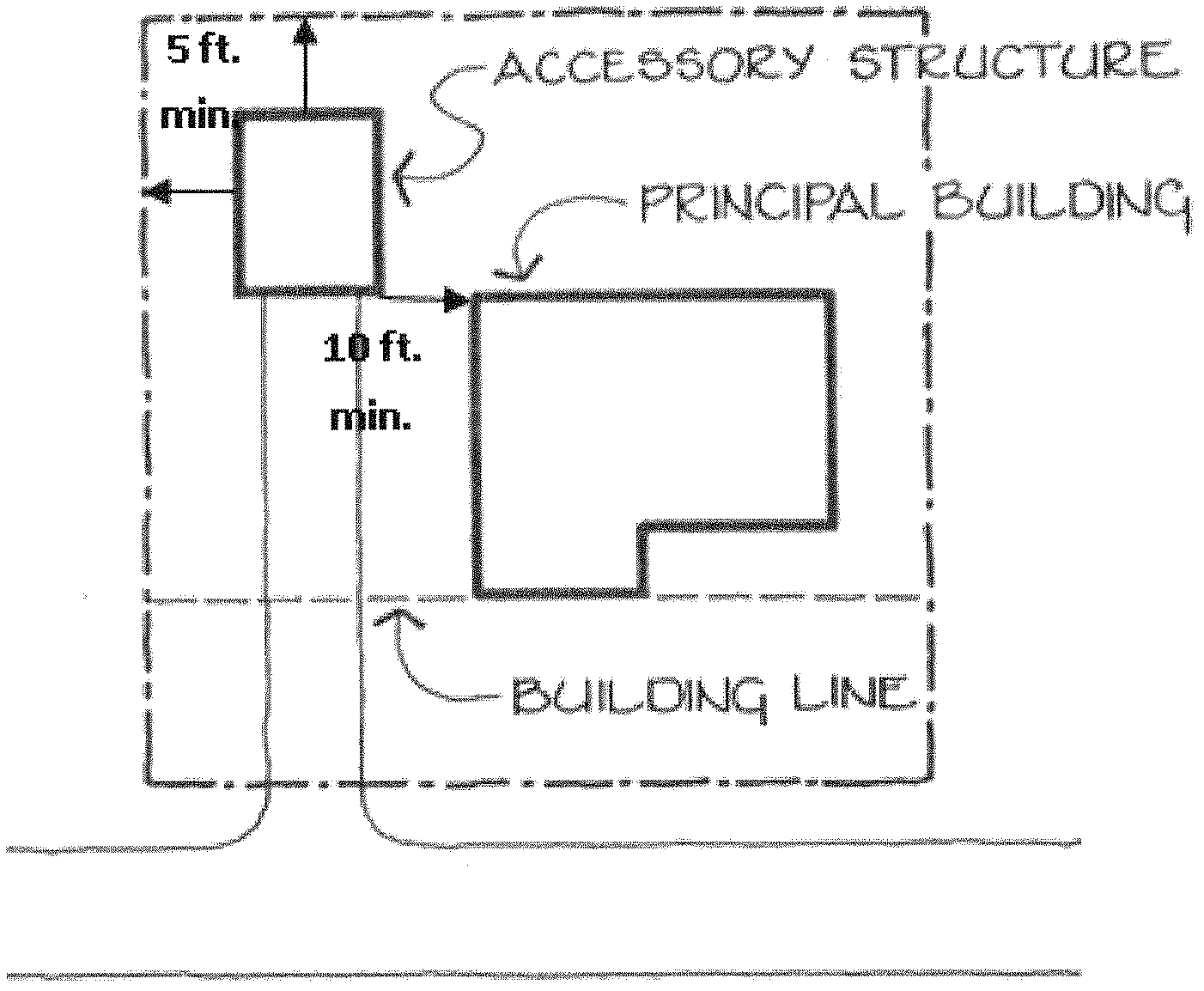
4.2.2 Accessory structures (residential).
A.
There shall be a principal residential structure on any lot for which there is an accessory structure.
B.
Accessory structures shall be constructed in the side or rear yard and shall be similar in appearance to and compatible with the primary structure. An accessory structure may be constructed in the front yard in the RA-30 district where the accessory structure is setback a minimum of 150 feet from the street right-of-way. Accessory structures with a total area exceeding 500 square feet shall be constructed using materials and features similar to the principal structure.
C.
Recreation vehicles shall not be considered an accessory dwelling or structure and the connection of such vehicle to utility services (other than for periodic maintenance and/or repair purposes) shall be prohibited unless the vehicle is located in a camping and recreational vehicle park so designed to accommodate recreation vehicles or proper connection is provided on private property for a period not to exceed 14 days in a calendar year.
D.
Any structure not typically intended for residential purposes shall not be allowed.
E.
The following dimensional requirements shall apply to all accessory structures:
F.
No accessory structure shall be permitted that involves or requires any external features which are not primarily residential in nature or character.
G.
Under no circumstances may a vehicle, trailer, or manufactured home be used as an accessory structure.
H.
The area of a pool shall include all structures and walks or patio areas of cement, stone, or wood, at or above grade, built for, and used in conjunction with the pool.
I.
Fences for pools shall be in accordance with the N.C. Building Code requirements for fencing pools. All pools shall have security fencing.
J.
Patio areas that are less than 200 square feet, uncovered, and at grade have no setback requirements from rear and side lot lines.
K.
Satellite dishes less than 39.37 inches in diameter may be located anywhere. All other satellite dishes shall adhere to the following standards:
6.
Satellite dishes shall be no larger than eight feet in diameter.
7.
The maximum height shall be 15 feet unless the applicant can prove:
a.
A less intrusive location is not possible; and
b.
A higher location will improve reception.
8.
Satellite dishes may not be located in front or side yards and shall meet all setbacks applicable to accessory structures.
9.
Satellite dishes shall be screened from view with dense landscaping materials, fences, or other solid materials, to the extent that it does not impair reception.
10.
Satellite dishes with a reflective surface shall be painted a subdued or natural color.
11.
Roof-mounted satellite dish antennas shall not exceed five (5) feet above the peak of the roof of the maximum building height, whichever is less.
4.2.3 Boarding and rooming houses.
A.
Single-family homes used as a rooming/boarding house may not subdivide existing rooms.
B.
The rooming/boarding house shall be owner-occupied or shall be occupied by a resident manager which occupies the structure as a primary residence.
C.
No more than one person or couple may inhabit a single room.
D.
No more than five renters/boarders shall be permitted at any one time.
E.
Guest rooms shall be accessed internally, except for emergency exits, and shall not have kitchen facilities.
F.
All parking shall be to the rear of the home. Where on-street parking is permitted, the length of the street in front of the lot may be counted as parking. On-street parking shall be limited to two spaces.
4.2.4 Family care homes. In accordance with N.C.G.S. Chapters 122C, 131D, and 168, these uses are deemed residential uses and are permitted in all residential districts subject to the following conditions:
A.
No more than six residents other than the homeowner and the homeowner's immediate family are permitted to live in a family care home as defined by N.C.G.S. 168-21.
B.
A family care home must be licensed with the N.C. Department of Health and Human Services Division of Facility Services before operating.
C.
No family care home may be located within a one-half mile radius of any other residential care home.
D.
No exterior signage is permitted.
E.
The owner or operator must provide documentation of the closet licensed family care home and its proximity to the proposed family care home.
4.2.5 Home occupations.
4.2.5.1 Customary home occupations.
A.
Such business shall not change the character of the dwelling. The home occupation shall be clearly incidental and subordinate to the residential use of the dwelling.
B.
No outdoor storage associated with the home occupation is permitted.
C.
No more than 25 percent of the home square footage shall be used in connection with the home occupation. The home's square footage includes any attached garage or basement.
D.
A maximum of one outside employee is permitted.
E.
No display or advertising is permitted.
F.
Only vehicles used primarily as passenger vehicles shall be permitted in connection with the home occupation.
G.
Chemical, mechanical, or electrical equipment that creates a hazard, odors, light emission, noises, or interference in radio or television reception detectable outside the subject property shall be prohibited.
H.
Customary home occupations may be in operation at any time between the hours of 7:00 a.m. and 8:00 p.m.
I.
If the residence is a rental unit, the tenant shall provide written consent from the property owner.
4.2.5.2 In-home daycare. In addition to the requirements for a customary home occupation (except hours), the following requirements shall apply to an in-home daycare:
A.
The in-home daycares shall be limited to a maximum of four children in addition to any children of the owner(s). All outdoor play areas shall be fenced to a minimum height of four feet and screened with evergreen plantings, as defined herein. Front yards shall not be used as playground areas.
B.
In-home daycares shall not be conducted within a manufactured home.
C.
The structure shall be the primary residence of the business owner.
D.
If the residence is a rental unit, then the tenant shall provide written consent from the property owner.
E.
An in-home daycare shall not be operated between the hours of 7:00 p.m. and 6:30 a.m.
F.
Parking areas shall not abut fenced play areas without provisions for ballasts or curbing.
4.2.6 Infill residential (reserved).
4.2.7 Live/work development.
A.
Live/work developments shall be permitted only when located in the town center land use classification.
B.
A declaration establishing a condominium development must be submitted with the special use application if more than one residential unit is proposed. This declaration shall be prepared which satisfies the requirements of the N.C. Unit Ownership Act (N.C.G.S. 47A-1 et seq.).
C.
Each residential unit shall have a minimum of 600 square feet of usable floor space.
D.
Residential and nonresidential uses shall not be located on the same story of a structure and nonresidential uses shall not be located above residential uses.
E.
Permissible nonresidential uses shall include the following as listed in the "Permitted Uses Table" and must be conducted wholly within the structure:
1.
Office and services uses.
2.
Retail uses.
F.
No outside storage or display of items associated with the use shall be permitted.
4.2.8 Manufactured homes on individual lots.
A.
All manufactured homes shall:
1.
Meet or exceed the construction standards promulgated by the U.S. Department of Housing and Urban Development that were in effect at the time of construction.
2.
Be set up in accordance with the standards set by the North Carolina Department of Insurance and a continuous, permanent masonry foundation or masonry curtain wall, unpierced except for required ventilation and access, is installed under the perimeter of the manufactured home;
3.
Have stairs and a porch, the porch being at least four feet by six feet in size. Stairs, porches, entrance platforms, ramps, and other means of entrance and exit to and from the home shall be installed or constructed in accordance with the North Carolina State Building Code; and
4.
Remove or landscape the hitch, wheels, axles, and transporting lights.
B.
Multi-Section Manufactured Homes shall:
1.
The manufactured home shall have a length not exceeding four times its width, with length measured along the longest axis and width measured at the narrowest part of the other axis;
2.
The manufactured home shall have a minimum of 1,200 square feet of enclosed and heated living area;
3.
The pitch of the roof of the manufactured home shall have minimum vertical rise of three and two tenths feet for each twelve feet of horizontal run (3.2 feet and 12 feet) and the roof is finished with a type of composition shingle that is commonly used in standard residential construction; and
4.
The exterior siding shall consist predominantly of vinyl or aluminum horizontal lap siding (whose reflectivity does not exceed that of gloss white paint), wood, or hardboard, comparable in composition, appearance, and durability to the exterior siding commonly used in standard residential construction;
4.2.9 Manufactured home parks.
A.
All existing and new manufactured home parks must apply for a business license. A business license shall be valid for a period of one year subject to the provisions of this section and upon a yearly inspection performed under the direction of the administrator. All manufactured home parks shall maintain a valid business license. The business license issued to the owner shall constitute the authority to operate the manufactured home park in accordance with this section. All permits shall be withheld without a valid business license. The park owner(s) business license fee shall be a base inspection on the park and its lots. Whether occupied or vacant, each lot shall be charged if it is the intent of the park owner(s) to continue the use of the whole park. Therefore, failure to maintain a valid business license, or to obtain a business license within six months from the adoption date of this section, shall be subject to the enforcement provisions of chapter 15 of this ordinance.
B.
Eligibility.
1.
A complete application and site plan shall be submitted to the Town of Angier.
2.
Application shall be for three or more manufactured homes on one parcel of land.
3.
Upon receipt of a complete application, the town shall conduct a manufactured home park inspection. All applicable requirements listed below shall be met. Failure to meet said requirements shall result in the forfeiture of their business license.
4.
New manufactured home parks shall only be developed within the RA-30 zoning district via a special use permit.
C.
General requirements for existing manufactured home parks
1.
All manufactured homes shall have the entire perimeter underpinned at all times so as to enclose the space from the bottom of the manufactured home to ground grade.
2.
All manufactured homes and accessory structures shall follow the setbacks of the zoning district in which it is located.
3.
The towing hitch on all manufactured homes shall be removed or completely landscaped from view.
4.
Each lot shall clearly display the approved number with a minimum of four inches in size and shall be composed of reflective materials of contrasting colors.
5.
The owner(s) shall install and maintain mailboxes in good condition to allow for postal delivery service for each resident, in accordance with local, State, and Federal regulations.
6.
The park operator(s) will operate or provide for the operation of a solid waste disposal system, including providing park tenants with appropriate containers. Individual containers shall be waterproof and rodent proof. The method of garbage disposal shall be noted on the plan and approved by the board of adjustment. Disposal of all large bulky items, such as furniture, shall be the responsibility of the tenant and/or park owner(s).
7.
Every manufactured home park owner shall maintain an accurate register containing a record of all occupants, owner(s) of manufactured homes, and a description of each home in the park. The register shall be available for inspection at all times by authorized county representatives. In accordance with N.C.G.S. § 105-316(a)(1), park owner(s) shall furnish to the county tax supervisor a copy of the register before January 1 st of each calendar year.
8.
The owner(s) shall be required to provide a park sign, that shall
a.
Meet the requirements of chapter 10;
b.
Identify the name of the park and a telephone number at which the park owner(s) or operator(s) may be contacted;
c.
Be constructed of weather-resistant material designed expressly for signs.
9.
Fences or walls shall not be permitted unless approved as part of the park plan.
a.
This excludes temporary pet containment areas that do not exceed 80 square feet.
b.
The fence or wall shall be made of any suitable and durable material that is intended for such use.
10.
No living compartment or structure other than that of a prefabricated structure specifically designed for manufactured home use or extension shall be added to any manufactured home parked. This excludes front and rear uncovered porches and decks not exceeding 100 square feet.
11.
One accessory building is allowed per lot.
a.
Such building shall not exceed 120 square feet in size.
b.
Shall be located in the rear yard.
c.
Shall be compatible to the principal dwelling in terms of exterior building material and color.
d.
Existing structures authorized by permit and structurally sound, prior to the establishment of this section shall be allowed to remain.
e.
Temporary carports that are a prefabricated structure without any footings or foundations, and compatible to the principal dwelling in terms of exterior building material and color
12.
No manufactured home park shall permit a recreational vehicle or travel trailer to locate within its boundaries for periods greater than one (1) week.
13.
Parks shall not be allowed to expand the number of lots or acreage unless the park receives approval from the Town of Angier. The transfer of a manufactured home space or spaces either by sale or by any other means within a manufactured home park is prohibited
D.
New manufactured home park development standards. New manufactured home parks shall comply with the above requirements as well as the below development standards.
1.
Minimum lot size shall be no less than 6,000 square feet with both public water and sewer.
2.
Only one manufactured home shall be located on any manufactured home space at any one time.
3.
Maintenance of all internal streets and corresponding drainage facilities shall be the responsibility of the owner(s) of the park. All streets shall paved, and maintained in a manner to remain free of pot holes, breaks in pavement, rough surfaces, standing water, and associated problems which would impede or cause hazards to motor vehicles.
4.
Setbacks.
a.
The manufactured home and accessory structures shall be located not less than 25 feet from the park boundary and at least ten feet from planting or landscape areas.
b.
Each manufactured home shall be located not less than 30 feet from any other manufactured home.
c.
Accessory structures shall be located not less than ten feet from a manufactured home.
5.
Each manufactured home lot shall have at least two paved parking spaces.
6.
Buffers shall be maintained around the entire perimeter of the manufactured home park as per chapter 7.
7.
No manufactured home park shall permit a recreational vehicle or travel trailer to locate within its boundaries for periods greater than one (1) week.
8.
Adequate lighting shall be provided to illuminate streets, common driveways, walkways, and dead end streets for the safe movement of vehicles and pedestrians at night. The minimum size street light shall be a 175 watt Mercury-vapor (approximately 7,000 lumen class) or its equivalent, spaced at intervals of not more than 300 feet.
9.
The park owner(s) and occupants shall keep all park owned facilities, manufactured home spaces, improvements, equipment, open space, recreational and all common areas in good repair and maintained in such a manner as to prevent the accumulation or storage of material which would constitute a fire hazard or would cause insect or rodent breeding and harborage. The county shall have the authority to remove, abate, or remedy everything that is dangerous or prejudicial to the public health. The expense of the action shall be paid by the park owner(s) in default, and, if not paid, shall be a lien upon the land or premises where the nuisance arose, and shall be collected as unpaid taxes.
10.
Parks shall not be allowed to expand the number of lots or acreage unless the park receives approval from the Town of Angier. The transfer of a manufactured home space or spaces either by sale or by any other means within a manufactured home park is prohibited.
11.
Termination of a manufactured home park shall consist of a signed termination affidavit and removal of manufactured homes and other associated structures.
4.2.10 Temporary emergency residences. Recreational vehicles (RVs) or travel trailers may be allowed on a temporary basis in a zoning district in which such use is not listed as a permitted use, if a disaster occurs which results in an occupied, single-family dwelling being destroyed (i.e., it receives damage greater than 60 percent of its tax value as indicated on the most current tax listings or if the home is deemed uninhabitable by the building inspector). In this instance, a travel trailer or RV may be placed on the lot containing the dwelling unit which was destroyed on a temporary basis.
A.
Temporary emergency residences shall not be placed in the front yard and setbacks shall be determined by the zoning administrator.
B.
The zoning administrator shall be given the authority to issue a zoning permit for such temporary residence on a one-time basis only for a period of up to nine months. Such permit may be renewed on a one-time only basis [for a period of no greater than nine months] by the board of adjustment if it is determined that construction of a new dwelling unit is proceeding in a diligent manner.
4.2.11 Two-family (duplex) residential.
A.
The minimum lot size for a duplex shall be two times that of the zoning district requirement.
B.
No building shall exceed a length of 150 feet.
C.
All sanitary containers shall be completely screened from view of the street and adjacent properties with fencing and/or landscaping.
(Ord. of 5-7-2013(1); Ord. of 1-3-2016(1); Ord. of 6-1-2021; Ord. of 5-7-2024(1))
Section 4.3. - Civic and government uses.
4.3.1 Cemeteries, mausoleums, and columbariums.
A.
Cemeteries shall not include embalming or cremation facilities.
B.
Setbacks to a wall or grave shall be a minimum of ten feet for secondary rights-of-way and 50 feet from designated thoroughfares.
C.
Crypts and mausoleums shall be set back from all street rights-of-way a minimum of 20 feet or as required by the dimensional standards of the zoning district, whichever is greater.
4.3.2 Civic and religious uses.
A.
Religious and civic uses shall be placed on a lot so as to front on the street.
B.
Building(s) incidental to the principal structure shall be setback a minimum of 20 feet from the front façade of the primary structure, and if more than one, shall be arranged to create secondary gathering spaces within the subject property, unless it is not feasible as determined by the administrator.
C.
Parking shall be located towards the interior of the lot. Parking may not occur within a front setback or corner side setback, unless it is not feasible as determined by the administrator.
D.
Shared parking with adjacent nonresidential uses that typically do not operate during the same hours is encouraged when permissible. Signage denoting such is required and should be shown on the required site plan.
E.
These uses when located within the CB zoning district shall have a minimum of three acres of land and shall provide 90 percent of their required parking on site.
4.3.3 Emergency services.
A.
All public safety and emergency services buildings shall be similar in architectural design to adjoining residential structures when located in a residential zoning district.
B.
Parking shall be to the side or rear of the building unless it is not feasible or practical as determined by the administrator.
4.3.4 Schools.
A.
Ball fields and play areas should be located near the interior portions of the property to avoid nuisances attributed to noise lighting, and traffic.
B.
All fenced areas shall be screened, at a minimum, with evergreen shrubs.
Section 4.4. - Institutional uses.
4.4.1 Day care centers. The following shall apply to child day cares, not including those operated as a home occupation:
A.
Day care centers shall conform in architecture to surrounding residential structures when located in a residential zoning district.
B.
Outdoor play areas shall be fenced to a minimum height of four feet. All play equipment shall be located in the fenced area. Front yards shall not be used as playground areas.
C.
Parking areas shall not abut fenced play areas without provisions for ballasts or curbing.
D.
All day care centers shall provide a parking plan to illustrate provisions for loading and unloading of children in addition to the site plan requirements.
4.4.2 Residential care facilities.
A.
A minimum of 300 square feet of total land area per enrollee/resident.
B.
All structures shall be similar in architectural appearance to and compatible with the surrounding structures when located in residential zoning districts.
4.4.3 Residential care homes.
A.
Residential care homes must be licensed with the State of North Carolina before operating.
B.
No residential care home may be located within a one-half mile radius of any other residential care home.
C.
Residential care homes shall not be permitted on nonconforming lots of record.
D.
All fencing shall be six feet in height and shall screen the area from view.
E.
No exterior signage is permitted.
F.
The owner or operator must provide documentation of the closest licensed residential care home and its proximity to the proposed residential care home.
Section 4.5. - Animal services.
4.5.1 Animal services. All uses included with the animal services category, as listed in the permitted uses table, that include outdoor kennels or other outdoor facilities for animals shall meet the following requirements:
A.
In no case shall any animal service, other than equestrian facilities and riding/boarding stables and government-owned animal shelters, be permitted to board more than 50 animals at one time.
B.
No outdoor containment of animals shall be located less than 100 feet from any residentially zoned property, dedicated open space, or Open Space and Recreation (OSR) zoning district, and less than 25 feet from any other adjacent property line.
C.
Kennel areas must be surrounded by an opaque fence of not less than six feet in height and enclosed as to prevent escape.
D.
Kennels shall be designed to effectively buffer noise audible to surrounding properties, including soundproofing of structures when necessary to minimize loud and disturbing noises that may have an adverse impact on adjoining structures.
4.5.2 Equestrian facilities and riding/boarding stables.
A.
Common barns, stables, and manure storage areas shall be located a minimum of 100 feet from any adjacent residentially used or zoned property.
B.
All unpaved areas shall be maintained in a manner to prevent dust from adversely impacting adjacent properties.
C.
Outdoor lighting structures shall be located, angled, shielded, or limited in intensity so as to cast no direct light on adjacent property and to avoid the creation of a visual safety hazard to any adjacent right-of-way.
Section 4.6. - Office and service uses.
4.6.1 Automobile services.
A.
Gas station pumps or other appliances shall be set back at least 15 feet from the property line, and all service, storage, or similar activities connected with such use shall be conducted entirely within the premises.
B.
Automobile services shall meet the requirements for "Junked Motor Vehicles" of the "Junkyards, Junked Motor Vehicles, Salvage Operations and Similar Uses" section of this chapter, as applicable.
4.6.2 Bed and breakfast inns.
A.
Bed and breakfast inns shall have a minimum heated floor area of 1,500 square feet and shall be located in a single-family, detached home that was originally constructed as a residential structure.
B.
Single-family homes used as bed and breakfast inns may not subdivide existing rooms into less than 100 square feet.
C.
No changes shall be made to the exterior of the structure which would alter the residential appearance and character of the home.
D.
The bed and breakfast inn shall be owner-occupied or shall be occupied by a resident manager which occupies the structure as a primary residence.
E.
Meals served on the premise shall be for guests of the facility and no kitchen facilities shall be provided in guest rooms.
F.
All parking shall be to the rear of the home. Where on-street parking is permitted, the length of the street in front of the lot may be counted as parking. On-street parking shall be limited to two spaces.
4.6.3 Hotels, motels, and inns.
A.
In no case shall rental units be offered on an hourly basis.
B.
All parking shall be to the side and rear of the principal structure, except for that which is provided on a short-term basis for access to the lobby of the structure.
C.
Hotels, motels, and inns that include an accessory use that requires a special use permit in the zoning district in which the use is located shall be required to obtain such prior to approval of the primary use.
Section 4.7. - Retail uses.
4.7.1 Auction house.
A.
Any outdoor auction house or outdoor storage related to the same use shall be limited to 30 days prior to and seven days after the date of the auction. In a case where this requirement cannot be met, the outdoor storage shall be screened in accordance with chapter 7.
B.
Shared parking with adjacent uses not typically in operation during the same hours is encouraged.
4.7.2 Farmers' market (town-sponsored).
A.
All structures shall be constructed to meet building code.
B.
A farmers' market shall be limited to the sale of locally grown produce (within 50 miles of the Town of Angier).
C.
Adequate restroom facilities shall be provided. These facilities shall not be located within 50 feet of a street right-of-way.
D.
Trailers for delivery or pick-up may be stored temporarily on-site for not more than three days at a time and shall be to the rear of the permanent structure.
When the farmers' market is not open for business, all items shall be removed.
4.7.3 Restaurants. Any outdoor seating shall meet the following requirements:
A.
The required site plan shall delineate any outdoor seating and circulation around such.
B.
Outdoor seating shall not obstruct the sidewalk and shall only be covered by retractable awnings or umbrellas where permitted. Seating shall be considered part of the structure if this requirement cannot be met.
C.
No outdoor sound system shall be permitted which can be heard beyond the boundaries of the property.
D.
Restaurants with drive-through service must have a minimum cueing lane length to accommodate eight vehicles. Said cuing lane shall not interfere with any required drive isles.
4.7.4 Retail uses, community.
A.
Dimensional requirements for community retail uses shall be as follows:
B.
All outdoor lighting shall be cut-off fixtures, shall not exceed 35 feet in height, and shall not exceed ten footcandles at the property line. A photometric plan shall be submitted for review with the site plan.
C.
All requirements shall apply if this use is included as part of another type of use herein.
4.7.5 Retail uses, neighborhood.
A.
Dimensional requirements for neighborhood retail uses shall be as follows:
B.
All outdoor lighting shall be cut-off fixtures, shall not exceed 35 feet in height, and shall not exceed ten footcandles at the property line. A photometric plan shall be submitted for review with the site plan.
C.
All requirements shall apply if this use is included as part of another type of use herein.
4.7.6 Retail uses, regional.
A.
Dimensional requirements for regional retail uses shall be as follows:
B.
All outdoor lighting shall be cut-off fixtures, shall not exceed 35 feet in height, and shall not exceed ten footcandles at the property line. A photometric plan shall be submitted for review with the site plan.
C.
All outdoor storage and trash containers shall be located to the rear of the site.
D.
Any regional retail use that has an average trip generation rate of 2,000 trips per day or greater, according to the most current version of the ITE trip generation informational report, a traffic impact analysis shall be provided to the TRC for review as part of the site plan approval process. The TRC shall use the analysis to determine what, if any traffic improvements need to be made subject to development approval to either maintain or provide adequate level of service for affected roadways. The analysis shall be prepared by a North Carolina licensed engineer qualified to perform such studies and shall include the following information:
1.
Site description;
2.
Study area;
3.
Existing traffic conditions including traffic counts and level of service for roadways and intersections;
4.
Horizon year(s) and background traffic growth for the year after the development is completed and ten years after the development is completed;
5.
Trip generation, reduction, and distribution summarizing peak a.m. and p.m. projections;
6.
Traffic assignment for horizon years;
7.
Impact analysis; and
8.
Mitigation and alternatives.
D.
All requirements shall apply if this use is included as part of another type of use herein.
4.7.7 Vehicle and manufactured home sales.
A.
A permanent structure built in accordance with North Carolina Building Code with permanent restroom facilities shall be located on the premises.
B.
No outdoor sound system shall be permitted which can be heard beyond the boundaries of the property.
C.
No vehicle, boat, equipment, or manufactured home shall be stored or displayed within the right-of-way of any public street.
D.
No storage of trade-in manufactured homes shall be permitted. All manufactured homes stored on site shall adhere to the minimum building setback and separation requirements established by the zoning district in which the use is located.
E.
All outdoor display areas shall be paved.
F.
A North Carolina auto manufacturer dealership license shall be obtained prior to issuance of a certificate of occupancy (CO), as applicable.
G.
All sales and display areas and structures shall be located a minimum of 50 feet from any residentially zoned or used lot.
H.
All outdoor lighting shall be cut-off fixtures, shall not exceed 35 feet in height, and shall not exceed ten footcandles at the property line. A photometric plan shall be submitted for review with the site plan.
4.7.8 Produce/arts and crafts market (non-town-sponsored).
A.
All permanent structures shall be constructed to meet Building Code.
B.
Adequate restroom facilities shall be provided. These facilities shall not be located within 50 feet of a street right-of-way.
C.
When the market is not open for business, all items, temporary shelters, tents, etc. shall be removed.
D.
In addition to any conditions that may be placed on such use by the Board of Adjustment, the use shall comply with all U.D.O. requirements such as but not limited to setbacks, parking, signage, outdoor lighting, etc.
E.
The location of the sales use and its required amount of parking spaces shall not interfere with any existing business that may occupy the same parcel.
(Ord. of 2-2-2016)
Section 4.8. - Recreational and entertainment uses.
4.8.1 Adult establishments.
4.8.1.1 Purpose and intent. Adult establishments, because of their nature, are recognized as having characteristics which may be objectionable to nearby residential districts and certain other uses considered to be sensitive, specifically religious institutions, schools, parks, libraries, day care centers, residential care facilities, and medical centers. The board of commissioners determines that regulation of these uses is necessary to ensure that these adverse effects do not contribute to the blighting or downgrading of nearby residential districts and to protect the integrity of those sensitive uses listed above.
4.8.1.2 Requirements.
A.
Adult establishments shall be located a minimum of 1,000 feet from a school, religious institution, day care center, or residential use; and 500 feet from any other adult establishment uses.
B.
No printed material, slide, video, photograph, written text, live show, or other visual presentation format shall be visible from the exterior of the structure other than permitted signage.
C.
No neon signage or lighting shall be permitted on the exterior of the structure, on the permitted sign, or on exterior windows and doors.
D.
No outdoor sound system shall be permitted.
E.
All parking shall be in the side or rear yards.
F.
Except for an adult motel or hotel, no adult establishment use shall have sleeping quarters.
4.8.2 Country clubs and golf courses.
A.
Loud outside noise, associated with club activities, shall be prohibited between the hours of 10:00 p.m. and 7:00 a.m.
B.
All outdoor lighting shall be cut-off fixtures, shall not exceed 35 feet in height, and shall not exceed ten footcandles at the property line. A photometric plan shall be submitted for review with the site plan. Lighting shall not be on between the hours of 11:00 p.m. and 7:00 a.m.
4.8.3 Family campgrounds.
A.
All spaces for camping and recreational vehicles shall be located at least 100 feet from any right(s)-of-way.
B.
Each recreational vehicle parking area shall be connected to a public water supply system and public sewer system which provide an accessible, adequate, safe and potable supply of water. These and all other utilities provided shall be installed underground.
C.
Each recreational vehicle parking area or campsite shall be a minimum of 20 feet wide and shall be accessed internally.
D.
A central service building containing all necessary toilets, bathhouses, and other plumbing fixtures specified in the most current edition of the North Carolina State Plumbing Code, as amended, shall be provided. The service building shall be conveniently located within a radius of 300 feet to spaces which it serves.
E.
A trash disposal and containment area shall be provided.
F.
No person, recreational vehicle, or tent may occupy the campground for a period in excess of 30 days unless otherwise stated herein. A register of all occupants, the space occupied, and the time of arrival and departure shall be maintained.
G.
The owner-occupant or resident manager may occupy the site with his/her immediate family permanently within a residential structure built to the standards of the North Carolina Building Code.
H.
Internal access and connection roads and driveways created as part of the site shall be constructed with either asphalt, screening, or crush and run gravel.
1.
Width shall be a minimum of 18 feet.
2.
Minimum depth shall be three inches.
4.8.4 Internet gaming, sweepstakes, or other gambling establishments.
A.
The following standards shall apply to game centers, as defined in section A.4, which comply with N.C.G.S. 14306(b).
B.
Game centers shall be permitted only in the General Commercial district and require a special use permit issued by the board of adjustment regardless of the number of machines proposed.
C.
The use shall not be located within a one-half-mile radius of any other game centers, or within 1,000 feet of any school, religious institution or day care center.
(Ord. No. 2012.01, 6-5-2012; Ord. of 3-5-2019)
4.8.5 Bars and alcohol related businesses.
A.
No bar shall be allowed within a 500-foot radius of radius of any school, religious institution, or day care center except within the Central Business district.
B.
Outdoor seating regulations for "restaurants," located in this chapter, shall be met if applicable.
C.
Alcoholic beverage consumption areas may be allowed on the premises of a brewery/winery/distillery and a bottle shop as an accessory use. This accessory use shall occupy 30 percent or less of the square footage of the total area occupied by these establishments. Alcoholic beverages may not be consumed on the premises after 10:00 p.m.
(Ord. of 3-5-2019)
Editor's note— Renumbered from section 4.8.4 per Ord. UDO 2012.01, adopted June 5, 2012.
4.8.6 Recreational facilities.
A.
No intercom, loudspeaker, or other similar items that can be heard off of the property shall be permitted.
B.
All outdoor lighting shall be cut-off fixtures, shall not exceed 35 feet in height, and shall not exceed ten footcandles at the property line. A photometric plan shall be submitted for review with the site plan. Lighting shall not be on between the hours of 11:00 p.m. and 7:00 a.m.
C.
Adequate parking must be provided so as not to interfere with the surrounding properties.
1.
This shall hereby prohibit the use of on-street parking for overflow parking.
2.
No parking signs shall be posted along property line(s) adjacent to the public right(s)-of-way in accordance with NCDOT standards and must be shown on the required site plan.
3.
Parking spaces shall be a minimum of 50 feet from all residential structures.
D.
All unpaved areas shall be maintained in a manner that prevents dust from adversely impacting adjoining properties and right(s)-of-way.
E.
No outdoor recreational facilities, including fields, shall be permitted in required setback.
F.
A permanent structure built in accordance with North Carolina Building Code with permanent restroom facilities shall be located on the premises.
Editor's note— Renumbered from section 4.8.5 per Ord. UDO 2012.01, adopted June 5, 2012.
4.8.7 Shooting range.
A.
Shooting ranges shall be permitted as an indoor use only. No outdoor use or accessory use shall be permitted as part of any shooting range.
B.
The amount of noise generated shall not disrupt the activities of the adjacent land uses.
C.
Structures or facilities shall be constructed a minimum of 50 feet from any residentially zoned or used lot.
D.
Adequate, handicap accessible restroom facilities must be provided.
Editor's note— Renumbered from section 4.8.6 per Ord. UDO 2012.01, adopted June 5, 2012.
4.8.8 Swimming pools (principal use).
A.
All pools shall have security fencing and shall be in accordance with the North Carolina Building Code requirements for fencing pools. Fencing shall be screened, at a minimum, with evergreen shrubs.
B.
A permanent structure built in accordance with North Carolina Building Code with permanent restroom facilities shall be located on the premises.
Section 4.9. - Industrial, manufacturing, warehousing, wholesale, distribution and transportation uses.
4.9.1 Assembly and packaging.
A.
Any outdoor storage shall be completely screened from view from public right-of-way and adjacent property when not adjacent to commerce park zoning district.
B.
The amount of noise generated shall not disrupt the activities of adjacent land uses.
Editor's note— Renumbered from section 4.8.7 per Ord. UDO 2012.01, adopted June 5, 2012.
(Ord. No. 2012.01, 6-5-2012)
4.9.2 Hazardous material storage.
A.
Such material shall be listed and made known to the Angier and Black River Fire Department and the Harnett County Fire Marshal. A containment plan shall be provided to the Harnett County Fire Marshal and to the administrator at the time of site plan review. Said containment plan shall be in compliance with all local, state, and federal requirements.
B.
Outdoor storage shall be in the rear yard only and shall be completed screened from view.
C.
Indoor and outdoor storage areas shall meet all state and federal regulations.
4.9.3 Storage yards, junked motor vehicles, salvage operations and similar uses. Storage yards, salvage operations, and similar uses shall comply with the following requirements. Storage yards, salvage operations, and automobile repair services existing at the date of adoption of this ordinance shall be brought into compliance with the requirements included herein within four months after the date of notification by the administrator.
4.9.4 Taxicab stand and office. See Town Code of Ordinances for regulations related to taxicab stands and offices.
4.9.5 Warehouse, mini.
A.
All outdoor storage shall be completely screened from view by an opaque fence and/or evergreen plantings.
B.
All proposed storage, in units and in outdoor areas, shall be identified on the required site plan.
C.
Any mini warehouse facility existing at the time of adoption of this ordinance shall be brought into compliance with the screening requirements of this ordinance within six months of the effective date of this ordinance.
(Ord. of 5-17-2022(1))
Section 4.10. - Agricultural uses.
4.10.1 Bona fide farm.
A.
Bona fide farms in the town's extraterritorial jurisdiction are exempt from the city's zoning regulation to the same extent bona fide farming activities are exempt from county zoning pursuant to N.C.G.S. 160D-903.
B.
Bona fide farms in the town's planning and development regulation jurisdiction shall be permitted to use manufactured homes used for farm labor or migrant housing as follows:
1.
The manufactured home shall be set up in accordance with the standards set by the North Carolina Department of Insurance and a continuous curtain wall, unpierced except for required ventilation and access, is installed under the perimeter of the manufactured home.
2.
The manufactured home shall be set up in accordance with the standards set by the North Carolina Department of Insurance and a continuous curtain wall, unpierced except for required ventilation and access, is installed under the perimeter of the manufactured home.
3.
The moving hitch, wheels, axles, and towing lights shall be removed.
4.10.2 Farm and livestock.
A.
Structures for the storage of farm equipment and supplies, maintenance equipment and supplies, livestock, and similar items associated with farms are permitted subject to the issuance of a zoning permit. No livestock or fowl shall be kept, maintained or stabled within 100 feet of any structure located on adjacent property.
B.
Swine are not permitted.
C.
No cattle, goats, horses, or other livestock shall be on a lot of less than one acre and shall be contained in a secured, fenced area.
D.
The following shall apply to fowl, including, but not limited to: chickens, ducks, geese, turkeys, and guineas:
1.
No fowl shall be permitted to run at large outside of a secured, fenced area.
E.
Bona fide farms in the town's extraterritorial jurisdiction are exempt from the above requirements.
4.10.3 Produce stands (permanent).
A.
A permanent produce stand shall be allowed as an accessory use to an agricultural use only. All produce sold shall be grown on a lot under the same ownership as the lot upon which the produce stand is located. All other produce stands shall be considered temporary uses and shall follow the special requirements for temporary uses.
B.
A produce stand shall not be located closer than ten feet to any side lot line unless a greater setback is required for the zoning district in which it is located.
C.
Signs for a produce stand shall not be illuminated, nor have flashing lights, nor shall they exceed four square feet in area. Off-premises signs are not permitted.
D.
During the times of the year in which the produce stand is not in operation, the stand shall be properly closed up and maintained.
E.
Paved parking and drive-isles shall not be required. All unpaved areas shall be maintained in a manner that prevents dust from adversely impacting adjoining properties and right(s)-of-way.
(Ord. of 5-7-2013(1); Ord. of 6-1-2021)
Section 4.11. - Other uses.
4.11.1 Accessory structures (nonresidential).
A.
Any nonresidential accessory structure shall be subject to the zoning district dimensional requirements, and the exterior materials of the accessory structure shall substantially match the materials of the principal structure.
B.
All utilities must be screened.
C.
Stand alone ATMs, ice machines, coffee shops, and drive-through uses may be permitted as accessory uses (i.e. in a shopping center parking lot).
D.
Vehicle storage for drive-throughs shall be located outside of and physically separated from the right-of-way of any street or internal access drive-isle. This area shall not interfere with the efficient internal circulation of traffic on the site, adjacent property, or adjacent street right-of-way. There shall be adequate vehicular stacking area so that vehicles waiting for the drive-through do not back up into the street.
E.
Portable carports and the like shall be permitted as an accessory structure in any nonresidential zoning district in the rear yard only.
4.11.2 Alternative energy production. For the purposes of this section, no construction, or any type of alternative energy production shall commence in the Town of Angier's planning and development regulation jurisdiction until a special use permit has been approved by the board of adjustment. All applicants for such a special use permit shall submit to the Town of Angier's Planning Department two copies of all documents required by the State of North Carolina, as well as any maps and charts accompanying these documents. These documents shall be reviewed by the Town of Angier Board of Adjustment and town staff.
If approved, a facility shall not be within a one-half mile radius of any other alternative energy facility, as measured from the edge of the property line. In addition to other site plan standards further described elsewhere within this ordinance, a six foot tall security fence and a visual screen of evergreen plantings shall be established and maintained around the site. All storage must be located indoors, and any equipment producing noise or sound shall be setback at least 100 feet from any property line. Also, decommissioning plans that describe the anticipated life of the facility, estimated decommissioning costs in current dollars, and the anticipated manner in which the facility will be decommissioned with the site being restored to predevelopment conditions shall be required. To ensure that funds will be available for decommissioning and restoration, an agreement shall be signed with the town and a surety bond or cash equivalent submitted as per the standards with chapter 9, section 9.7.
A.
Ethanol diesel and biofuel production.
1.
Storage tanks shall be located inside an above-ground containment area made of concrete that can hold 100 percent of the tank size located within it. The containment area may be constructed of other materials upon approval by the Harnett County Fire Code Official.
2.
Acceptable storage tank materials include aluminum, steel, fluorinated polyethylene, fluorinated polypropylene, Teflon, and other similar durable, noncorrosive materials. Copper, brass, lead, tin, and zinc are prohibited.
3.
Fuel shall be dispensed from either a gravity flow or vacuum flow pump.
4.
Facility and all accessory structures (storage tanks, buildings, etc.) shall be setback a minimum of 500 feet from the public right(s)-of-way and all property lines.
B.
Solar energy facility.
1.
Solar power electric generation structures shall not exceed ten feet in height.
2.
Active solar structures shall meet the minimum setback for the zoning district in which it is located or be setback a minimum of 25 feet from all property lines or right(s)-of-way, whichever is greater.
3.
Applications for all solar energy facilities shall include a site plan with those items required elsewhere by this ordinance, as well as the following:
i.
Elevation drawings of all solar energy structures;
ii.
Location of all solar energy structures on the property; and
iii.
Distance of all solar energy structures to property lines.
4.
Applications for grid-intertie photovoltaic systems or facilities shall include evidence that the owner(s) or operator(s) has been approved by the appropriate utility company to install an interconnected customer-owned generator. Installation of systems or facilities shall not occur until this evidence has been supplied. Off-grid systems are exempt from this requirement.
5.
Electric components of solar structures shall have an Underwriters Laboratories (UL) listing.
6.
All photovoltaic systems shall comply with the most recent edition of the National Electrical Code.
C.
Wind energy facility.
1.
Wind energy facility structures shall be setback from all property lines and public right(s)-of-way a distance equal to one linear foot for every foot of height of the highest structure that is part of the facility or the minimum setback for the zoning district in which it is located, whichever is greater.
2.
Shadow flicker onto any occupied building on a nonparticipating property caused by a wind energy facility located within 2,500 feet of the occupied building shall not exceed 30 hours per year.
3.
The maximum height of wind turbines is 80 feet unless evidence is submitted otherwise showing approval for additional height from the Harnett County Fire Code Official.
4.
Attachment of structures for the collection of wind energy to a building of any kind shall be prohibited.
5.
Applications and/or site plans for wind energy facilities shall include the following items, in addition to those items required elsewhere by this ordinance.
i.
The approximate generating capacity of the facility;
ii.
The representative type and height of the wind turbines to be constructed, including dimensions, manufacturer, generator capacity per turbine, and a description of any ancillary facilities or structures;
iii.
An environmental assessment for wind energy facilities shall be provided for review by the town and the state clearinghouse for distribution. Certification of distribution of the environmental assessment shall also be provided; and
iv.
Evidence of compliance with applicable FAA regulations.
v.
Location of all wind turbines and wind energy collection related structures;
vi.
Access easement necessary for the use and maintenance of the facility and related structures; and
vii.
The distance of wind turbines and wind energy collection related structures to the nearest property lines.
viii.
Evidence that the owner(s) or operator(s) has been approved by the appropriate utility company to install an interconnected customer-owned generator. Such evidence shall be in the form of written verification that the plans have been reviewed, and if built to plans, the facility will be accepted by the utility company. Installation of systems or facilities shall not occur until this evidence has been supplied.
6.
The visual appearance of wind energy facilities shall, at a minimum:
i.
Be a non-obtrusive color such as white, off-white, or gray;
ii.
Not be artificially lighted, except to the extent required by the FAA; and
iii.
Not display advertising (including flags, streamers, or decorative items), except for identification of the turbine manufacturer, facility owner(s), and operator.
7.
Installation and design of a wind energy facility shall conform to the applicable industry standards, including those of the American National Standards Institute.
8.
Any onsite collector system shall, to the maximum extent possible, be placed underground.
9.
The noise emitted from such facility shall be not disturbing to adjacent properties. Evidence of such shall be furnished with the application for a wind energy system.
4.11.3 Infill nonresidential.
A.
Infill nonresidential shall be located only within the town center land use classification.
B.
Redevelopment shall be in the same building footprint, for retail and service uses, as the previous structure when applicable.
C.
Front and side yard setbacks shall be equal to the average primary structure setback on the same side of the street right-of-way and within the same zoning district within 300 feet of either side of the site. In cases where the average setback is located within existing or required right-of-way, the structure shall not be located therein.
D.
In addition to the site plan submitted for the special use permit process, the following information shall be included:
1.
Proposed uses;
2.
Traffic circulation;
3.
Delineation of units or phases;
4.
Impact on public services;
5.
Stormwater plan;
6.
Utilities plan.
4.11.4 Mining activities.
A.
No mining shall commence in the Town of Angier's planning and development regulation jurisdiction until a special use permit has been approved by the board of adjustment.
B.
Special use approval granted by the board of adjustment shall not become effective until a mining permit is issued by the North Carolina Department of Environment and Natural Resources, Division of Land Resources (DENR), Land Quality Section, or successor agency.
C.
The operation will not constitute a substantial physical hazard to a neighboring dwelling house, school, religious structure, hospital, commercial, or industrial building, public street, or public property.
D.
The operation will not have a significantly adverse effect on the purposes of a publicly-owned park, forest, or recreational open space area.
E.
A special use permit shall automatically expire if at any time after its issuance the state mining permit is revoked or terminated.
F.
Definitions. Definitions as listed in the N.C.G.S. and The Mining Act of 1971, both of North Carolina and as amended, shall apply to this Subsection.
G.
Permit application.
1.
Applicants for a special use permit shall submit to the Town of Angier's Planning Department two copies of all documents required by the State of North Carolina for a mining permit application, the reclamation plan, and any maps and charts accompanying these documents. These documents shall be reviewed by the Angier Board of Adjustment and town staff.
H.
Buffer and screening standards.
1.
A visual screen of evergreen plantings shall be established and maintained around that portion of the mining site that is being excavated or being used for the storage of minerals, as required elsewhere by this ordinance. When excavated areas have been reclaimed in accordance with the following: The Mining Act of 1971, of North Carolina and as amended, and Chapter 5 of the North Carolina Administrative Code, Title 15 "Environment & Natural Resources," any artificial screening may be removed.
2.
The visual screening requirements may be exempted when:
a.
The planning department determines that existing vegetative cover will fulfill these requirements. Such natural screening may consist of existing vegetative cover including, but not limited to, trees and shrubs, not less than 50 percent of which shall be evergreen. Screening may also consist of earthen berms or other artificial screens used individually or in combination with each other and existing vegetation to achieve a screening effect required by this section. Screening materials and vegetation may be located in required buffer areas. All berms and other artificial screens requiring extensive land disturbance shall comply with the North Carolina General Statutes.
b.
It is determined that due to topographic, or other circumstances where, through no fault of the permittee, that the requirements of this section cannot be provided. In such case, an alternative plan shall be submitted to the planning department.
I.
Vibration standards. All mining activities in the Town of Angier shall conform to the vibration policy adopted by the Land Quality Section of the North Carolina Department of Environment and Natural Resources (DENR).
4.11.5 Outdoor storage (nonresidential).
A.
Outdoor storage, when permitted, shall be located in the rear yard and screened from view so that it is not visible from right(s)-of-way or adjacent property.
B.
Screening shall be in the form of vegetation, fencing, or a combination thereof, and shall completely shield from view the goods that are stored outside.
C.
This subsection shall not apply to the outdoor display of goods or services that are for sale.
4.11.6 Temporary uses. Temporary structures and uses, when in compliance with all applicable provisions of this ordinance, and all other ordinances of the Town of Angier shall be allowed. The following temporary structures and uses shall be permitted:
4.11.6.1 Construction trailers. Construction trailers used in conjunction with construction projects provided that the following requirements are met:
A.
Such construction trailers may be located at a building site where there is a valid building permit for the construction project, or, in the case of a residential subdivision, a valid building permit for at least one of the residential units being constructed.
B.
All construction trailers shall be located at least ten feet off any street right-of-way and shall not be placed in any required rear or side yard setback.
C.
All construction trailers shall be removed from the construction site not more than 30 days following the issuance of the certificate of occupancy for the project or, in the case of a residential subdivision, for the final residential unit.
D.
In addition to construction trailers, at any construction site for a construction project, one security guard house may be installed. Use of such structures may include overnight stay provided adequate sanitary facilities are provided and the same conditions for construction trailers are met.
4.11.6.2 Residential sales offices.
A.
Any temporary structure used as a sales office shall be located on a lot which is in compliance with the regulations of this ordinance and shall meet all yard requirements for the applicable zoning district.
B.
A minimum of three off-street parking spaces shall be provided on the lot to accommodate persons using the sales office.
C.
If a permanent residential structure is used as the sales office, future use of said structure shall be for residential purposes. Said "future use" shall be initiated within 30 days of issuance of a certificate of occupancy for the final residential unit.
D.
A trailer may be used as a temporary sales office, provided that the following conditions are met:
1.
The trailer shall be provided with underpinning, from the bottom of the walls to the ground, made of masonry, vinyl, pre-painted aluminum material, or other similar material.
2.
Landscaping shall be provided around the base of the trailer.
3.
At the completion of the sales in a tract, or two years from the date the temporary sales office began operation, whichever is sooner, said sales office shall cease operation unless the administrator determines that substantial progress is being made in the selling and/or marketing of the lots and/or homes in the subdivision. In such case, one extension (not to exceed one year in duration) may be so authorized by the administrator. Further extension shall be reviewed and approved by the board of adjustment and shall not exceed one year in duration. If a temporary structure is used as the sales office, it shall be removed after its use as a sales office is terminated. Within 30 days after the structure is removed, the lot shall be returned to a natural state. Any paved or graveled driveway and/or parking area associated with the sales office shall also be removed. All bare soil areas on the lot shall be returned to a natural vegetative state (reseeded or sodded) immediately after removal of the sales office and driveway/parking area.
4.11.6.3 Portable storage containers.
A.
Up to two portable storage containers may be permitted on a site as a temporary use for a period of 30 days for storage of household items during renovations and moving. A one time extension of an additional 30 days may be granted by the administrator if the applicant demonstrates that progress is being made towards completing the project that makes the portable storage container necessary.
B.
Portable storage containers shall not be located closer than 20 feet from the front property line or five feet from any other property line.
C.
Portable storage containers shall not impede the ability to meet minimum parking requirements for a site.
4.11.6.4 Temporary sales and events.
A.
Certain uses of a temporary nature which would not otherwise be permitted in a particular zoning district may be issued a temporary permit as herein provided.
B.
The following salespersons or representatives are exempt from the bond requirements and permit application fee required by this section; however, must comply with other permit requirements as set forth in this section:
1.
Churches, civic organizations, and nonprofit organizations that are tax exempt under the provisions of the Internal Revenue Code are exempt for activities involving craft fairs, flea markets, and yard sales; provided that such activities will not be held on more than four days in any 12-month period.
2.
Vendors at special events such as Christmas Parade, Crepe Myrtle Festival, etc., selling goods only for that event. Food vendors will need to obtain necessary permits from the state and county health departments.
3.
Seasonal sales of Christmas trees, pumpkins, or locally grown produce.
C.
The following shall be prohibited for temporary sales conducted by itinerant merchants:
1.
It shall be unlawful for any person to do business as an itinerant merchant without first receiving a temporary use permit issued by the administrator or his designee.
2.
It is unlawful for any itinerant merchant to conduct any business any closer to a public street than 20 feet from the edge of the pavement. Such edge shall be maintained as a buffer and no tables, merchandise, items, parking, or any other obstructions, shall be allowed within said 20-foot buffer. It shall be the responsibility of the permit holder to maintain the buffer area clear of all vehicles and any other items at all times.
3.
All itinerant merchants shall provide to the Town of Angier in the application for a permit, a plan for parking which shall provide areas outside of the above-mentioned buffered area.
4.
It shall be unlawful for itinerant merchants to conduct business during the hours between 5:00 p.m. and 9:00 a.m. Monday through Saturday and at no time on Sunday.
5.
Itinerant merchant activity shall be allowed only in the O&I, CB, GB, and CP districts or on the property of a permitted civic use as listed in the "Permitted Uses Table." The activity shall be allowed only on premises owned or controlled by the itinerant merchant or with the written permission of the property owner.
6.
Itinerant merchant activities shall not be allowed on town property except for town-sponsored events and with invitation of the town. The town property includes, but is not limited to: sidewalks, parking lots, streets, parks, or any other town-owned or controlled property.
D.
Additionally temporary sales conducted by itinerant merchants:
1.
Shall comply with the sign regulations set forth in chapter 10;
2.
Shall not impede vehicular or pedestrian traffic; and
3.
Shall not occupy designated parking spaces of the town.
E.
All parking of vehicles shall be done in compliance with all applicable laws and town ordinances. Further, the police department may enforce such temporary controls to alleviate any special hazards and/or congestion created by any itinerate merchant sale activities.
F.
The duration for operating as an itinerant merchant shall not be excess of ten consecutive days and not more than three permits per year may be issued to any one itinerant merchant or business whether or not said permit is obtained by a different individual, it shall be limited to three per business. Upon termination of the permit, all temporary buildings erected for the purpose of such use and all trash and debris generated in connection with said use shall be removed by the applicant or owner of the premises by the close of the sale or by the end of daylight, whichever first occurs.
G.
Upon expiration of the permit due to time, the applicant may apply for a renewal of the permit upon a form designated by the administrator, which shall indicate what changes, if any, have occurred since the date that the original application was completed and said renewal is within the calendar year and furthermore, there shall be no more than one original and two renewals allowed per calendar year as stated above.
H.
The itinerant merchant selling or providing any unprepared food or consumable items shall comply and provide proof of compliance with regulations of the North Carolina Department of Agriculture. The itinerant merchant selling or providing prepared food shall obtain a permit from the Harnett County or Wake County Environmental Health Department.
I.
Each person requesting a permit under this section shall file with the administrator a written application, which shall contain the following information:
1.
The name and address of the individual filing the application.
2.
The name and address of the principal or employer if the applicant is an agent or employee.
3.
A complete physical description of the applicant including height, weight, sex, race, date of birth, and any distinguishing characteristics.
4.
A description of the goods or services to be sold or offered.
5.
A statement as to whether the applicant intends to receive payment or deposit for goods or services to be delivered or rendered in the future.
6.
The inclusive dates which the applicant wishes to have a permit to carry on business within the town.
7.
A statement as to which days of the week the applicant wishes to conduct business within the town.
8.
A complete description of the vehicle or method of transportation the applicant intends to use for business purposes while in the town including license number.
9.
A statement as to whether the applicant, his principal or employer, or other person having management or supervisor function in the applicant's business, has been convicted of a criminal offense, and if so, the name of the person convicted, the nature of the offense, the punishment assessed and when and where the offense occurred.
10.
A statement as to the exact location in the town the applicant intends to conduct business along with any necessary permission from the owner and a diagram showing designated parking to be provided for said business as it may apply to itinerant merchants.
11.
A list of all persons, other than the applicant, who would be authorized by the applicant to engage in soliciting in the applicant's behalf.
J.
Each person filing an application for issuance of a permit to solicit, peddle or be an itinerant merchant in the town shall present a valid driver's license or an approved state-issued identification card with a photograph, at the time of filing the application.
K.
At the time of filing the application, the applicant shall present proof of a current town privilege license evidencing that the business or organization has paid the required privilege license tax for the current fiscal year if same applies.
L.
A fee as set forth in the town's schedule of fees made payable to the town, will be collected at the time application is made. The fee is for processing of the application and is nonrefundable.
M.
A permit issued under this section is not transferable.
N.
Before any permit shall be issued under the provisions of this section, the applicant shall furnish a bond in the penal amount of $5,000.00 to the town signed by the applicant and as surety by some surety company authorized to do business in this state, conditioned upon the final delivery of goods, wares, merchandise, services, photographs, magazines, and newspapers in accordance with the terms of any and all purchasers or customers for any and all defects in material and workmanship that may exist in the article sold by the principal on such bond, at the time of delivery, and that may be discovered by such purchaser or customer within 30 days after delivery. Such bond shall be for the use and benefit of all persons that may make any purchase or give any order to the principal on such bond, or to any agent or employee of the principal. The principal shall be in effect for 180 days from expiration of this permit. Only one bond shall be required of each applicant, even though such applicant shall have one or more agents or employees, provided such bond shall be made to cover the activities of all such agents or employees. Applicants soliciting for recognized charitable organizations, churches, schools, civic organizations, and similar neighborhood associations performing fundraising activities for their organization are exempt from such bond.
O.
The administrator or his designee shall issue a permit to the applicant within five working days of filing the application, if it is determined that the applicant has complied with the provisions of this article and proposes to engage in a lawful commercial or professional enterprise.
P.
The applicant must carry the signed original of this permit along with an approved state identification card with a photograph at all times while engaged in business. Certified copies of the letter will be provided by the administrator for each agent or employee doing business with or for the applicant for a charge of $1.00 each. The employee or agent's name must appear on the initial application and will be included on the permit. Each agent or employee must carry the signed certified copy of this permit along with an approved state identification card with a photograph at all times while engaged in business. The permit and identification must be displayed upon demand of any police officer or code enforcement officer. Failure to produce the required permit and identification may result in the revocation of all copies and the original permit issued for the applicant and the listed agents or employees.
Q.
Photograph identification used by a private company or organization will not be accepted as a substitute for an official state-issued identification card with photograph. The issuing state; however, is not mandated to be North Carolina.
R.
Any applicant denied a permit will be mailed a letter within five working days after making application, stating the reason for denial. Denial will be made it is determined that provisions of this article have not been met or the applicant does not propose to engage in a lawful commercial or professional enterprise. Conviction of criminal offenses by the applicant or principals in the business, which indicate a propensity for violence, theft, fraud, or similar offenses, may be cause for denial of a permit. The administrator or his designee may revoke a permit issued under this section when there is a reasonable factual basis that doing so would in the best interest of the health, safety, welfare or morals of the public. The administrator shall mail a letter to the address listed for the applicant on the application notifying them of the reason for the revocation. The administrator or his designee upon observing violation of the safety provisions contained herein may revoke the permit of the operator to cease operations until such time as the violations are corrected and furthermore, may cite the permit holder for violation and penalties shall be applicable.
4.11.6.5 Yard sales.
A.
For the purposes of this section, the following terms, phrases, words and their derivations shall have the meaning given herein:
1.
Personal property shall mean property, which is owned, utilized and maintained by an individual or members of his or her residence and acquired in the normal course of living in or maintaining a residence. It does not include merchandise which was purchased for resale or obtained on consignment.
2.
Yard sale shall mean and include all general sales, open to the public, conducted from or on a residential zone, as defined by this ordinance, for the purpose of disposing of personal property including, but not limited to, all sales entitled "garage," "lawn," "yard," "attic," "porch," "room," "backyard," "patio," "flea market," or "rummage" sale. This definition shall not include a situation where not more than five specific items are held out for sale and all advertisement of such sale specifically names those items to be sold.
B.
No yard sale shall be conducted unless and until the individual or group desiring to conduct such sale shall obtain a permit therefore from the administrator or his designee. Members of more than one residence may join in obtaining a permit for a yard sale to be conducted at the residence of one of them.
C.
The provisions of this section shall not apply to or affect the following:
1.
Persons selling goods pursuant to an order or process of a court of competent jurisdiction.
2.
Persons acting in accordance with their powers and duties as public officials.
D.
Any bona fide charitable, eleemosynary, educational, cultural or governmental institution organization when the proceeds from the sale are used directly for the institution or organization's charitable purposes and the goods or articles are not sold on a consignment basis.
E.
Prior to the issuance of any yard sale permit, the individuals conducting such sale shall file a written statement with the administrator or his designee setting forth the following information:
1.
Full name and address of applicant.
2.
The location at which the proposed yard sale is to be held.
3.
The date when the sale shall be held.
4.
An affirmative statement that the property to be sold was owned by the applicant as his own personal property and was neither acquired nor consigned for the purpose of resale.
F.
There may be an administrative processing fee for the issuance of such permit, established from time to time by the town board of commissioners.
G.
The permit shall set forth and restrict the time and location of such yard sales. No more than three such permits for no more than two consecutive days only for each permit may be issued to one residence and/or family household during any calendar year. If members of more than one residence join in requesting a permit, then such permit shall be considered having been issued for each and all such residences.
H.
Such yard sales shall be limited in time to no more than the daylight hours of the day for which the permit is granted.
I.
If a yard sale is not held on the date for which the permit is issued or is terminated during the day of the sale because of inclement weather conditions, and an affidavit by the permit holder to this effect is submitted, a representative of the code enforcement department may issue another permit to the applicant for a yard sale to be conducted at the same location within 30 days from the date when the sale was to be held. No additional permit fee will be required.
J.
A fourth yard sale shall be permitted in a calendar year if satisfactory proof of a bona fide change in ownership of the real property is first presented to the administrator or his designee.
K.
Before issuing a permit, a representative of the code enforcement division may conduct an investigation as may reasonably be necessary to determine if there is compliance with this section.
L.
Any permit in possession of the holder or holders of a yard sale shall be posted on the premises in a conspicuous place so as to be seen by the public and the town code enforcement officer or his/her designee.
M.
Only the following signs may be displayed in relation to a pending yard sale:
1.
A yard sale shall be allowed one sign on the lot of the yard sale, provided the sign does not exceed 42 inches in height, four square feet per side, and eight square feet total aggregate.
2.
A yard sale shall be allowed two additional directional signs located off-premises provided written permission to erect said signs is received from the property owners upon whose property such signs are to be placed and the signs to not exceed 42 inches in height, four square feet per side and eight square feet total aggregate.
3.
No sign or other form of advertisement shall be exhibited for more than three days prior to the day such sale is to commence. Signs must be removed at the close of the yard sale activities or by the end of daylight, whichever first occurs.
N.
The individual to whom such permit is issued and the owner or tenant of the premises on which sale of activity is conducted shall be jointly and severally responsible for the maintenance of good order and decorum on the premises during all hours of such sale or activity. No such individual shall permit any loud or boisterous conduct on said premises nor permit vehicles to impede the passage of traffic on any streets in the area of such premises. All such individuals shall obey the reasonable orders of any member of the police or fire department of the city in order to maintain the public health, safety and welfare.
O.
A police officer or any other official designated by the Code of Ordinances to make inspections under the licensing or regulating ordinance or to enforce the same, shall have the right of entry of any premises showing evidence of a yard sale for the purpose of enforcement or inspection and may close the premises from such a sale, or arrest any individual who violates the provisions of this section.
P.
All parking of vehicles shall be done in compliance with all applicable laws and ordinances. Further, the police department may enforce such temporary controls to alleviate any special hazards and/or congestion created by any yard sale.
Q.
Any permit issued under this article may be revoked or any application for issuance of a permit may be refused by the administrator or his designee if the application submitted by the applicant or permit holder contains any false, fraudulent or misleading statement.
R.
If any individual is convicted of an offense under this section, the code enforcement department is not to issue such individual another yard sale permit for a period of two years from the time of conviction.
S.
Every article sold and every day of a sale conducted in violation of this section shall constitute a separate offense.
4.11.7 Wireless telecommunications towers. The following development standards for planning and development regulation jurisdiction of the Town of Angier shall:
A.
Apply to the installation, construction, attachment, removal, and alteration of facilities to accommodate wireless communication facilities;
B.
Provide the criteria for evaluating such proposed activities;
C.
Provide a procedure for the suitability certification and accomplishing related purposes.
4.11.7.1 Purpose.
A.
The Town of Angier desires to encourage the orderly development of wireless communication technologies for the benefit of the town and its citizens. The town also recognizes the character of the different entities of the town.
B.
As a matter of public policy the town aims to encourage the delivery of new wireless technologies throughout the town while controlling the proliferation of communication towers. Such development activities will promote and protect the health, safety, prosperity and general welfare of persons living in the Town of Angier.
C.
Specifically, the wireless communication facility development standards are designed to achieve the following:
1.
Provide a range of locations for wireless communication facilities throughout the town; and
2.
Encourage the location of wireless communication facilities onto existing structures to reduce the number of new communication towers needed within the Town of Angier; and
3.
Encourage collocation and site sharing of new and existing wireless communication facilities; and
4.
Control the type of tower facility constructed when towers are permitted; and
5.
Establish adequate development and design criteria to enhance the ability of providers of telecommunications services to provide service to the community quickly, effectively, and efficiently; and
6.
Protect residential, historic preservation areas, and scenic corridors from the uncontrolled development of wireless communications facilities by requiring reasonable siting conditions; and
7.
Promote the use of suitable lands for the location of wireless antennae, towers, and/or wireless communications facilities; and
8.
Insure the harmonious, orderly and efficient growth and development of wireless communications facilities within the town; and
9.
Enhance the economy of the town through the continued use of the town's public resources; and
10.
Provide development standards for the development of wireless communication facilities which are consistent with the requirements of the Federal Telecommunications Act of 1996 and in the best interest of the future of the Town of Angier; and
11.
Provide clear performance standards addressing the siting of wireless communication facilities; and
12.
Streamline and expedite the permitting procedures to effect compliance with the Federal Telecommunications Act of 1996.
4.11.7.2 Certain uses not covered by this section. Nothing in this ordinance shall reduce any of the permitted uses within the Town of Angier. Nothing in this section shall affect the right of a property owner to use or develop their property as would be consistent with this ordinance and land use plan. Nothing in this ordinance shall affect the right of a property owner to continue any legal nonconforming use.
4.11.7.3 Interpretation and definitions.
A.
To the extent these development standards conflict with other ordinances regarding wireless communications technology for the Town of Angier, these development standards shall control.
B.
For the purposes of this section, words used in the present tense include the future tense; words in the singular number include the plural number, and words in the plural number include the singular number; the word "shall" is mandatory; the word "may" is permissive; the word "used" includes "designed" and "intended" or arranged to be used or occupied; and the word "person" includes a firm, association, organization, partnership, trust, foundation, company or corporation as well as an individual.
C.
For the purpose of this section certain words, phrases and terms used herein shall be interpreted as shown in Appendix A, Definitions and below. The administrator or designee shall define any word, phrase or term not defined herein. The interpretation shall be based upon its common and ordinary usage in the region.
1.
Federal Aviation Administration—FAA
2.
Federal Communications Commission—FCC
3.
Federal Telecommunications Act of 1996—FTA
4.11.7.4 Preferred locations for wireless communication facilities and applicability. The following wireless communication facilities may be allowed within the Town of Angier's planning and development regulation jurisdiction according to the following priority:
A.
Antenna attachments. Antenna attachments onto existing support structure or onto an attached wireless communication facility shall be permitted by administrative approval subject to the development criteria of this section.
B.
Lands owned by the Town of Angier.
C.
All land identified in Table A. Antenna attachments or wireless communication facilities with support structures shall be permitted by special use permit approval subject to the development criteria of this section of this ordinance and Table A.
D.
Other lands. Wireless communication facilities with support structures shall only be permitted on all other lands not identified in Table A by means of approval of a special use permit. Prior to applying for a special use permit, the applicant shall provide the town with adequate information to establish that lands included in Table A above, cannot be made suitable for wireless communication facility locations.
4.11.7.5 Development standards.
A.
Height standards. The following height standards shall apply to installation of all wireless communications facilities:
1.
Attached wireless communications facilities. Attached wireless communication facilities shall not add more than 20 feet to the height of the existing building or structure to which it is attached (attachment structure). However, antenna attachments to existing communication towers shall not increase the height of tower above the maximum original permitted height of that tower.
2.
Wireless communication facilities with support structures identified in Table A shall have a maximum height of 199 feet.
3.
Height for wireless communication facilities with support structures on other lands not meeting the requirements in 1 or 2 above shall be reviewed on a case-by-case basis as part of the special use permit process. The height of the proposed wireless communication facility should be consistent with the height standards indicated in this ordinance for similar properties in similar locations; and considering ground elevations, topographical conditions, and other site development criteria within this ordinance.
B.
Setback standards. The following setback standards shall apply to all wireless communication facility installations:
1.
Attached wireless communication facilities. Attached wireless communication facilities shall meet the setback provisions of the underlying zoning district in which they are located. However, an attached wireless communication facility antenna array may extend up to 30 inches horizontally beyond the edge of the attachment structure so long as the antenna array does not encroach upon an adjoining parcel or right-of-way.
2.
Wireless communications facilities with support structures wireless communications facilities with support structures shall meet the setback requirements noted in Table A.
3.
Setback standards for wireless communication facilities with support structures on other lands not meeting the requirements in 1 or 2 above shall be reviewed on a case-by-case basis as part of the special use permit process. The distance setbacks of the proposed wireless communication facility should be consistent with the setback standards indicated in this ordinance for similar properties in similar locations; and considering ground elevations, topographical conditions, and other site development criteria within this ordinance.
C.
Landscaping standards. The following landscaping requirements shall be maintained by the tower owner and shall apply to all wireless communications facility installations:
1.
New construction. New wireless communication facilities with support structures and attached wireless communication facilities with new building construction shall be landscaped with a minimum landscaped area of 60 feet around the perimeter of the opaque security fence. Monopole type structures shall have a minimum of 30 feet around the perimeter of the security fence meeting the following standards:
a.
One row of drought tolerant, nondeciduous trees with a minimum caliper of 1.75 inches shall be installed with a maximum spacing of 25 feet.
b.
Drought tolerant, nondeciduous shrubs capable of creating a continuous hedge and obtaining a height of at least five feet shall be planted with a maximum spacing of five feet. Plants shall be at least three-gallon container plants and at least 24 inches tall at the time of planting.
2.
Land form preservation. Existing mature tree growth and natural land form on the site shall be preserved to the extent feasible; provided however, that vegetation that causes interference with the antennas or inhibits access to the equipment facility may be trimmed or removed.
3.
Existing vegetation. Existing vegetation on a wireless communication facility site may be used in lieu of required landscaping where approved by the zoning administrator or designee.
4.
Minimum site disturbance. Grading for the new wireless communication facility shall be minimized and limited only to the area necessary for the new facility.
D.
Aesthetics, placement, materials and colors. The following standards shall apply to all new antenna arrays and new wireless communications facilities:
1.
Antenna array attachments shall be designed so as to be compatible with the wireless communication facility to which it is to be affixed; including, but not limited to, matching the proposed array with existing structural design, façade colors, and camouflage technology.
2.
New wireless communication facilities shall be designed to be compatible with existing structures and surroundings to the extent feasible. For all new facilities' locations; including, but not limited to, considerations of scale and space of the immediate vicinity of the new facility, placement in a location which is consistent with proper functioning of the wireless communications facility, the use of compatible or neutral colors, and camouflage technology.
E.
Lighting standards. The following lighting requirements shall apply to all wireless communications facility installations. Wireless communications facilities shall not be artificially illuminated, directly or indirectly, except for:
1.
Security and safety lighting of equipment buildings if such lighting is appropriately down shielded to keep light within the boundaries of the site; and
2.
Such illumination of the wireless communications facility as may be required by the FAA or other applicable authority installed in a manner to minimize impacts on adjacent residences.
3.
Unless otherwise required by the FAA or other applicable authority, the required night lighting shall be red and a type of lens used to reduce ground lighting when the site is within 300 feet of a residential dwelling.
F.
Signage. Wireless communications facilities shall not display any signage, logos, decals, symbols or any messages of a commercial or noncommercial nature, except for a small message containing provider identification and emergency telephone numbers and such other information as may be required by local, state, or federal regulations governing wireless communications facilities.
G.
Fencing. Wireless communications facilities with support structures shall be enclosed by an opaque fence not less than six feet in height and approved by the zoning administrator. Security features may be incorporated into the buffer and landscaping requirements for the site. All fencing shall meet the requirements of state or federal agencies.
H.
Radio frequency emissions/sound. The following radio frequency emissions standards shall apply to all wireless communications facility installations:
1.
Radio frequency impact. The FTA gives the FCC jurisdiction of the regulations of radio frequency (RF) emissions, and wireless communications facilities that do not exceed the FCC standards shall not be conditioned or denied on the basis of RF impact.
2.
FCC compliance. In order to provide information to its citizens, copies of ongoing FCC information concerning wireless communications facilities and RF emissions standards may be requested from time to time. Applicants for wireless communications facilities shall be required to provide information with the application on the measurement of the effective radiated power of the facility and how this meets the FCC standards.
3.
Sound prohibited. No unusual sound emissions such as alarms, bells, buzzers or the like are permitted.
I.
Structural integrity. Wireless communication facilities with support structures shall be constructed to the Electronics Industries Association/Telecommunications Industries Association (EIA/TIA) 222 Revision F Standard entitled "Structural Standards for Steel Antennas Towers and Antenna Support Structures" (or equivalent), as it may be updated and amended. Each support structure shall be capable of supporting multiple antenna arrays.
J.
Collocation support structure design. All wireless communication facilities with a support structure up to a height of 150 feet shall be engineered and constructed to accommodate at least three antenna array. All wireless communication facilities with a support structure up to a height of 199 feet or greater shall be engineered and constructed to accommodate at least four antenna array.
K.
Collocation agreement. All applicants for wireless communication facilities are required to submit a statement with the application agreeing to allow and reasonably market collocation opportunities to other wireless communications facility users. The statement shall include the applicant's policy regarding collocation of other providers and the methodology to be used by the applicant in determining reasonable rates to be charged other providers. The collocation agreement shall be considered a condition of issuance of a special use permit. A special use permit shall not be issued unless the applicant complies with the collocation policy outlined in this ordinance.
4.11.7.6 Review process. The applicable development criteria referred to herein are those set forth in this section:
A.
Permitting procedures. Attached wireless communications facilities without new building construction that meet the development criteria may be permitted by administrative review, or antenna array attachments onto existing structures may also be permitted by administrative review. All other proposed wireless communication facilities shall be subject to the special use permit process.
B.
Wireless communications facilities as a part of a coordinated development approval. Wireless communications facilities as part of a proposed "major" residential or nonresidential subdivision, planned unit development, conditional rezoning, or other coordinated development approval shall be reviewed and approved through those processes.
C.
Temporary wireless communications facilities may be permitted by administrative approval for a term not to exceed 90 days. Once granted, a temporary wireless communication facility permit may be extended for an additional 90 days upon evidence of need by the applicant. In case of emergency, (e.g., storm damage to an existing tower or other circumstances resulting in the interruption of existing service) the administrative review shall be expedited to the extent feasible.
4.11.7.7 Approval process.
A.
Proposals. A new wireless communication facility shall not be approved unless the board of adjustment finds that the equipment planned for the proposed tower cannot be accommodated on existing or approved towers, buildings, or alternative structures within a qualified search ring of the proposed wireless communications facility due to one or more of the following reasons:
1.
The planned equipment would exceed the structural capacity of the existing or approved tower, building or structures, as documented by a qualified or licensed North Carolina Professional Engineer, and the existing or approved tower, building or structure cannot be reinforced, modified, or replaced to accommodate planned or equivalent equipment at a reasonable cost.
2.
The planned equipment would cause interference materially impacting the usability of other existing or planned equipment at the tower, building, or other structure as documented by a qualified or licensed North Carolina professional engineer and the interference cannot be prevented at a reasonable cost.
3.
Existing or approved towers, buildings, or other structures within the qualified search ring, or combinations thereof, cannot accommodate the planned equipment at a height necessary to function reasonably as documented by a qualified or licensed North Carolina professional engineer.
4.
Other unforeseen reasons that make it infeasible to locate the planned telecommunication equipment upon an existing or approved tower, building, or other structure.
B.
Special use application required. No person, firm or corporation shall install or construct any wireless communication facility unless and until a special use permit has been issued pursuant to the requirements of this ordinance.
C.
Pre-existing wireless communications facility. Wireless communications facilities which were installed prior to the effective date of this ordinance shall be considered as nonconforming.
D.
Amateur radio exclusion. This section shall not govern the installation of any amateur radio facility that is owned and operated by a federally licensed amateur radio station operator.
E.
Relationship to other ordinances. This section shall supersede all conflicting requirements of other ordinances regarding the locating and permitting of wireless communication facilities.
F.
Building codes. Construction of all wireless communication facilities shall comply with the requirements of the North Carolina State Building Codes and permitting process in addition to the requirements of this section.
G.
Application submission. All applications, regardless of wireless communication facility type shall include all of the requirements contained in this section:
1.
Application contents. Each applicant requesting a special use permit under this ordinance shall submit a sealed complete set of drawings prepared by a licensed architect or engineer that will include a site plan, elevation view, and other supporting drawings, calculations, and other documentation showing the location and dimensions of the wireless communications facility and all improvements associated therewith, including information concerning specification, antenna locations, equipment facility and shelters, landscaping, parking, access, fencing and, if relevant as determined by staff, topography, adjacent uses, and existing vegetation.
a.
A "zone of visibility map" map which shall be provided in order to determine locations from which the tower may be seen.
b.
Pictorial representations of "before and after" views from key viewpoints both inside and outside of the town as may be appropriate, including, but not limited to, state highways and other major streets; local parks; other public lands; and historic sites normally open to the public.
c.
Applications proposing to collocate on an existing wireless communication facility shall include a radio frequency intermodulation study with their application.
2.
Submission requirements. Application for a special use permit shall be submitted to the town on forms prescribed by the town. The application shall be accompanied by a site plan containing the information described above and a SHPO report showing no adverse effects. If review is required, the application and site plan shall be placed on the next available board of adjustment agenda in accordance with the agenda deadlines established by the town.
3.
Application fees. A wireless communication application fee shall accompany each application. Please refer to the current approved rate and fee schedule as approved by the Town of Angier Board of Commissioners.
H.
Administrative review. The following administrative review process shall apply to all wireless communications facility collocation applications eligible for administrative review:
1.
Review authority. Review of the attachment and collocation of antenna under this section shall be conducted by the zoning administrator or the designee upon filing an application.
2.
Review criteria. Each application shall be reviewed for compliance with the development criteria specified in this section.
3.
Timing of decision. The zoning administrator or designee shall render a decision on the wireless communication facility application by written response to the applicant within 20 business days after receipt of the complete application, except that an extension may be agreed upon by the applicant.
4.
Application denial. If administrative approval is not obtained or is denied due to noncompliance with the development criteria, the applicant may appeal the denial by applying for board of adjustment review.
5.
Application approval. If the application together with all required addenda are in compliance with the development criteria and otherwise meets the requirements of this section, the zoning administrator or designee may approve the application and authorize issuance of the proper permits.
I.
Board of adjustment review. The following shall apply to all special use permit applications requiring submission to the board of adjustment:
1.
Review authority. The board of adjustment shall be the review authority for special use permit applications not eligible for administrative review.
2.
Notice. Notice of the application and the evidentiary hearing for the special use permit by the board of adjustment shall be in accordance with this ordinance.
3.
Evidentiary Hearing. The board of adjustment shall review and consider the TAA application at an evidentiary hearing. At the evidentiary hearing, interested persons may appear and offer information in support of or opposition to the proposed application. The board of adjustment shall consider the following in reaching a decision:
a.
Development criteria. The complete special use permit application shall be reviewed for compliance with the development criteria set forth in this section.
b.
Tower siting conditions. The board of adjustment may recommend alternative development criteria, impose conditions, or add restrictions on the application as it deems necessary to reduce or minimize any adverse effects and to enhance the compatibility of the wireless communication facility with the surrounding property, in accordance with the purposes and intent of this ordinance, provided the alternative development criteria, conditions, or restrictions are reasonable and capable of being accomplished. The inclusion of additional conditions, development criteria, or restrictions shall be by specific inclusion in a motion for approval.
c.
The special use permit shall be granted when each of the following findings of fact has been made by the board of adjustment:
i.
The wireless communication facility will not materially endanger the public health or safety if located where proposed and developed according to the plan submitted;
ii.
The wireless communication facility meets all required conditions, specifications, and development standards of this ordinance;
iii.
The wireless communication facility will not substantially injure the value of adjoining or abutting property, or that the use is a public necessity;
iv.
The location and character of the use, if developed according to the plan submitted, will be in harmony with the area in which it is to be located and in general conformity with the plan of development of the planning and development regulation jurisdiction and its environs;
v.
If applicable, additional development conditions are based upon the purpose and goals of this ordinance; and
vi.
If applicable, additional development conditions are reasonable and capable of being accomplished.
d.
Action. Following the evidentiary hearing and presentation of evidence, the board of adjustment shall take one of the following actions:
i.
Approve the application as submitted; or
ii.
Approve the application with conditions or modifications; or
iii.
Refer the application for additional information or neighborhood input; or
iv.
Deny the application in writing.
4.
Findings. All quasi-judicial decisions rendered by the board of adjustment concerning a special use permit application shall be supported by written findings of fact and conclusions of law based upon substantial evidence of record.
5.
Timing of quasi-judicial decision. The board of adjustment shall hold an evidentiary hearing within 60 days or less of the final submission of all required application documents and technical review, however, this time may be increased due to deferrals by either the applicant or the board of adjustment.
6.
Appeals. An appeal shall be filed no later than 30 days after the final action by the zoning administrator or the board of adjustment. Only the applicant and those who registered an objection to the special use permit application in the record of the board of adjustment shall have standing to appeal.
4.11.7.8 Shared facilities and collocation policy. All new wireless communication facilities shall be engineered, designed, and constructed to be capable of sharing the facility with other applicants, to collocate with other existing wireless communication facilities, and to accommodate the future collocation of other wireless communication facilities. A special use permit shall not be issued until the applicant proposing a new wireless communications facility shall demonstrate that it has made a reasonable good faith attempt to locate its wireless communication facility onto an existing structure. Competitive conflict and financial burden alone are not deemed to be adequate reasons against collocation.
4.11.7.9 Removal of abandoned support structures. Any support structure that is not operated for a continuous period of one year shall be considered abandoned, and the town, at its election, may require the support structure owner to remove the support structure within 90 days after notice from the town to remove the support structure. If there are two or more users of a single support structure, this provision shall not become effective until all providers cease to use the support structure. If the owner of an abandoned support structure cannot be located or is no longer in business, the requirements of this section shall be the responsibility of the landowner on whose property the support is located.
4.11.7.10 Nonconforming. Wireless communication facilities in existence on the date of the adoption of this ordinance which do not comply with the requirements of this ordinance (nonconforming wireless communications facility) are subject to the following provisions:
A.
Expansion. Nonconforming wireless communication facilities may continue in use for the purpose now used, but may not be expanded without complying with this ordinance except as further provided in this section.
B.
Additions. Nonconforming wireless communication facilities may add additional antennas (belonging to the same provider or other providers) subject to administrative review under this ordinance.
C.
Repairs or reconstruction. Nonconforming wireless communication facilities which become damaged due to any reason or cause, may be repaired and restored to its former use, location, and physical dimensions subject to the provisions of this ordinance. Provided, however, that if the damage to the wireless communication facility exceeds 50 percent of replacement cost, said wireless communication facility may only be reconstructed or repaired in compliance with this ordinance.
D.
Non use. Any nonconforming wireless communication facility not in use for six months shall be deemed abandoned and all rights as a nonconforming use shall cease.
4.11.7.11 Revocation of special use permits. The approval of any special use permit issued pursuant to this ordinance may be revoked after an evidentiary hearing as provided hereinafter. If the zoning administrator or designee finds that any permit holder has violated any provision of this ordinance, or the conditions, restrictions, or additional development standards of an approved special use permit; or has failed to make good faith reasonable efforts to provide or seek collocation, the zoning administrator or designee shall notify the permit holder in writing that the special use permit is revocable due to the permit holder's noncompliance with the conditions of the permit and the zoning administrator or designee shall convene a meeting with the permit holder no later than 30 days from the date of the letter. The zoning administrator or designee may require the permit holder to correct the violation within a reasonable amount of time or the zoning administrator or designee may recommend to the board of adjustment that the special use permit be revoked. After the appropriate evidentiary hearing, the board of adjustment may revoke the special use permit upon such terms and conditions, if any, that the board of adjustment may determine. Prior to initiation of revocation proceedings, the town shall notify the permit holder, in writing, of the specific areas of noncompliance and specify the date by which such deficiencies must be corrected. The time for correction of deficiencies shall not exceed 60 days. The permit holder shall provide the town with evidence that the required corrective action has been taken. Should the permit holder fail to correct any deficiencies in the time required, the administrator and board of adjustment shall convene an evidentiary hearing to consider revocation of the special use permit. At any such evidentiary hearing, the permit holder may be represented by an attorney and may cross-examine opposing witnesses. Other interested persons may comment. The administrator and board of adjustment may impose reasonable restrictions with respect to time and procedure. The proceedings shall be recorded; provided, however that stenographic services, if desired, shall be provided by the requesting party at that party's expense.
4.11.8 Town Center Planned Development (TCPD). A TCPD is permitted in all zoning Districts, as indicated within the permitted uses table, located in the Town Center District as shown on the Town of Angier Land Use Map.
4.11.8.1 Intent. It is recognized that only through ingenuity, imagination, and high quality design can a TCPD be produced that is in keeping with the intent of this ordinance while departing from the strict application of the conventional use and dimensional requirements therein. This is accomplished by allowing flexibility and a mix of residential and nonresidential uses, and/or varying types of both residential and nonresidential uses. Coordination of such developments in conjunction with adequate public facilities while maintaining the small town character of the Town of Angier is a necessity for this type of development.
The intent of the TCPD regulations within the Town of Angier is to provide for minimum, conventional development regulations, while allowing a developer the flexibility to determine how to attain superior development through the criteria listed herein.
4.11.8.2 Uses.
A.
Residential uses included in the TCPD include single-family detached, two-family, townhome developments, condos, apartments and customary accessory uses and structures.
1.
Density shall be determined on a project by project basis.
B.
Nonresidential uses included in the TCPD include all use listed as permitted under the Central Business zoning district.
4.11.8.3 General provisions.
A.
Minimum development size. No minimum development size is required, however the development has to be of a nature that is not achievable under current criteria of this ordinance and meet the intent of the TCPD.
B.
Minimum building setbacks. In order to facilitate innovative design the minimum building setbacks shall be determined by the developer and noted on the development plan. All single-family developments with a building setback of less than five feet shall be required to provide maintenance easements along the impacted property line as determined by the TRC. In cases where the setback is not stated on the approved plan the underlying zoning district standards shall apply.
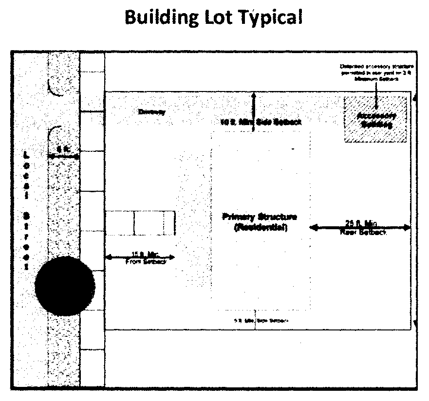
C.
Maximum building height for single-family residential detached and two-family dwellings the building height shall not exceed 35 feet. All other uses may exceed 35 feet with the approval of the local fire department.
D.
Restrictive covenants and/or property owner's association by-laws shall be required for all projects, residential and commercial, approved as a TCPD.
4.11.8.4 Streets and access. All streets within the TCPD shall be designed and constructed in accordance with the requirements of the Town of Angier approved thoroughfare plan, construction manual, or the latest NCDOT Construction Manual depending on whichever is applicable.
4.11.8.5 Sidewalks and curb and gutter. All streets within a TCPD shall provide sidewalks, curb and gutter in accordance with the Town of Angier approved construction manual. Alternatives may be approved as part of the TCPD.
4.11.8.6 Architectural and site design. The purpose of this section is to ensure architectural compatibility, permanence, and style, and the establishment and preservation of architectural character throughout the town. The developer shall provide standards that address the following characteristics for the proposed TCPD. These standards shall be addressed in the restrictive covenants.

A.
Building materials, colors, textures and architecture style.
B.
Building variation.
C.
Building orientation.
D.
Master sign plan.
E.
Lighting.
F.
Fencing—Shall be required for all residential projects.
1.
Graphic illustration shall be required for fence type and construction.
Fences, including walls and hedges, shall not exceed the maximum heights shown in the following table:
2.
Corner lot fencing may be placed within the required side yard setback, but shall be no less than three feet from the back of the sidewalk and positioned out of the public right-of-way.
3.
No fence shall obstruct the sight distance triangle as prescribed by NCDOT or the Town of Angier.
4.
When the fence abuts a public or private street the finished side shall face the street or access.
4.11.8.7 Accessory structures. The developer shall provide standards that address accessory structure for the proposed TCPD, this includes the following, but is not limited to. These standards shall be addressed in the restrictive covenants.
A.
Dog enclosures.
B.
Swimming pools.
C.
Storage buildings.
4.11.8.8 Landscaping, buffers and screening for nonresidential and multifamily projects. Landscaping, buffering, and screening will be required for all projects. An alternative landscape, buffer, and screening plan may be submitted as part of the development plan. This plan shall meet the intent of the requirements within the UDO.
4.11.10.9 Review and approval procedures.
A.
A master plan including building lot typical shall be submitted in accordance with the requirements for planned developments set forth in chapter 11. In addition procedures for all subdivisions shall be followed in accordance with the UDO.
B.
A written notice of the proposed master plan shall be sent by first class mail to all contiguous property owners and posting a public notice sign at the subject property at least ten days prior to the planning board meeting.
C.
The TRC shall review the master plan and restrictive covenants for completeness and compliance with this section and applicable provisions of this ordinance prior to review of the special use permit or planning board.
D.
Modifications—Minor modifications in the TCPD may be approved by the TRC.
(Ord. No. 2012.02, 10-2-2012; Ord. of 5-7-2013(2); Ord. of 1-5-2021(1); Ord. of 6-1-2021; Ord. of 5-7-2024(1); Ord. of 6-18-2024(1))
Section 4.12. - Conditional zoning.
Conditional Zoning—Conditions for Specific Uses. One special type of zoning text and map amendment is Conditional Zoning approval whereby a specific site plan and written conditions are reviewed and approved by the Town Board. As provided in the Table of Principal Permitted Uses (Section 3.3), some land uses are of such a nature or scale that they have significant impacts on both the immediately surrounding area and/or the entire community that cannot be predetermined and controlled by general district standards and thus are only permitted with Conditional Zoning approval. Additionally, there may be instances where a general zoning district designation is clearly inappropriate for a certain property, but a specific use permitted under that district and subject to restrictive conditions would be consistent with the spirit and objectives of this Ordinance and applicable land plans. Both of these circumstances are reasonably addressed through a Conditional Zoning process.
Some uses listed in the Table of Principal Permitted Uses, Section 3.3, requiring Conditional Zoning approval have pre-set, initial conditions set forth herein. Accordingly, all uses listed in the Table of Principal Permitted Uses, Section 3.3, as being in the Conditional Zoning type and appear in this Section and have pre-set, initial conditions, shall comply with the following regulations, in addition to any and all general requirements set forth in Chapter 2 and elsewhere in this UDO and all applicable local, County and State requirements.
4.12.1 Supplementary use regulations for multifamily residential.
A.
Dimensional requirements for multifamily residential developments shall be as follows:
B.
All structures shall be a minimum of ten feet from all internal parking areas, and drive-isles.
C.
Project perimeter setback areas shall be free of any structures, excluding access ways and signs.
D.
Amenities and accessory structures shall be permitted as an accessory use to the primary use.
E.
Developments of 50 units or more shall provide two means of ingress and egress.
4.12.2 Supplementary use regulations for planned developments.
4.12.2.1 Intent. Planned developments are intended to provide for the creation of well-planned environments through the application of flexible and diversified land development standards. A planned development is intended to encourage the application of new techniques and technology to residential, commercial, office, and light industrial uses which will result in a more comprehensive development arrangement with lasting function and appeal. It is further intended to achieve broader goals such as economic land development, consideration of environmental conditions, efficient street systems and utility networks, usable attractive open spaces, and the general well-being of the town's inhabitants.
4.12.2.2 General provisions. When applicable, the provisions for the underlying zoning district shall apply. In order to qualify for a planned development, the following criteria shall be met:
A.
The areas proposed shall be in single ownership or if in several ownerships, the application for the conditional zoning shall be filed jointly by all of the owners of the properties in the plan.
B.
A suitable master plan which will include a site layout shall be submitted by the developer(s) for review by the Town Board as part of the conditional zoning application.
4.12.2.3 Uses. All planned developments shall contain a mix of uses, or densities, and/or residential housing types. Examples include, but are not limited to a mix of: commercial and office, multifamily and single-family detached products, commercial and residential, or office and residential uses. In no case shall a planned development contain only one type of use, density, or housing product.
4.12.2.4 Density and dimensional requirements.
A.
The site(s) for a planned development must contain a minimum of three acres.
B.
Both residential and nonresidential uses may be proposed in a planned development. The maximum overall density for single-family detached units is five dwelling units per acre; and for multifamily is nine dwelling units per acre.
C.
All dimensional standards will be stipulated by the master plan upon approval of the Town Board on a case by case basis. Dimensional standards proposed in the master plan shall include all of the following elements, in addition to the master plan requirements set forth in chapter 11:
1.
Maximum building height.
a.
Maximum building height may exceed 35 feet only in cases where sprinklers are installed in all structures.
2.
Perimeter and internal buffers.
3.
Minimum lot size.
4.
Minimum lot width.
5.
Minimum front yard setback.
6.
Minimum rear yard setback.
7.
Side yard setback.
8.
Corner side yard setback.
9.
Phase delineation.
10.
Architectural standards.
D.
Restrictive covenants and/or homeowners association by-laws shall be submitted as part of the special use permit application. All items listed in section C above shall be referenced within said restrictive covenants and/or homeowners association by-laws.
4.12.2.5 Open space requirements.
A.
Open space shall meet the requirements of chapter 6.
B.
Due to the size and scale of a planned development, payment in lieu of dedication, as regulated in chapter 6, shall not be permitted.
4.12.2.6 Approval procedures.
A.
Any request pertaining to the establishment of a planned development shall be considered as a conditional zoning application.
B.
For planned developments the applicant may elect to develop the site in successive phases in a manner indicated in the required master plan. However, the infrastructure improvements of each stage shall be a minimum of 75 percent completed before the commencement of development of the next phase.
C.
The administrator may require that development be done in phases if public facilities are not available to serve the entire facility initially.
4.12.2.7 Master plan required.
A.
The initial master plan, shall be prepared and submitted, containing elements and according to the requirements set forth in chapter 12.
B.
The technical review committee shall review the master plan for completeness and compliance with this section and applicable provisions of this ordinance. Approval of the conditional zoning herein is for the overall concept of the planned development, those items specifically listed in "Density and Dimensional Requirements" of this section, and those items specifically listed in "Changes and Modifications" of this section.
4.12.2.8 Changes and modifications.
A.
Major changes in an approved planned development shall be treated as amendments to the master plan for that planned development. Any major changes require review and approval of the Town Board. Major changes include, but are not limited to:
1.
Increase in overall density;
2.
Changes in boundary lines;
3.
Changes in land use, location, or amount of land devoted to specific land uses including recreation and open space;
4.
Changes in the number, except in cases of a decrease, or mix of dwelling units;
5.
Alterations to street design;
6.
Changes in infrastructure;
7.
Alternate materials or other changes that significantly alter the exterior appearance of structures.
B.
Minor modifications in the planned development may be approved by the TRC. Minor modifications include, but are not limited to minor shifting of the:
1.
Location of buildings;
2.
Proposed streets;
3.
Public or private rights-of-way;
4.
Utility easements;
5.
Parks;
6.
Other public spaces;
7.
Other features of the plan.