
Archer Lodge City Zoning Code
ARTICLE 11
- APPENDIX.
DIVISION 1. - ZONING MAP.
The map included here is provided for informational purposes, and may or may not be an accurate depiction of the Town's official zoning map. Landowners, applicants, or other interested individuals should contact Archer Lodge Town Hall in order to view or obtain a copy of the Town's Official Zoning Map.
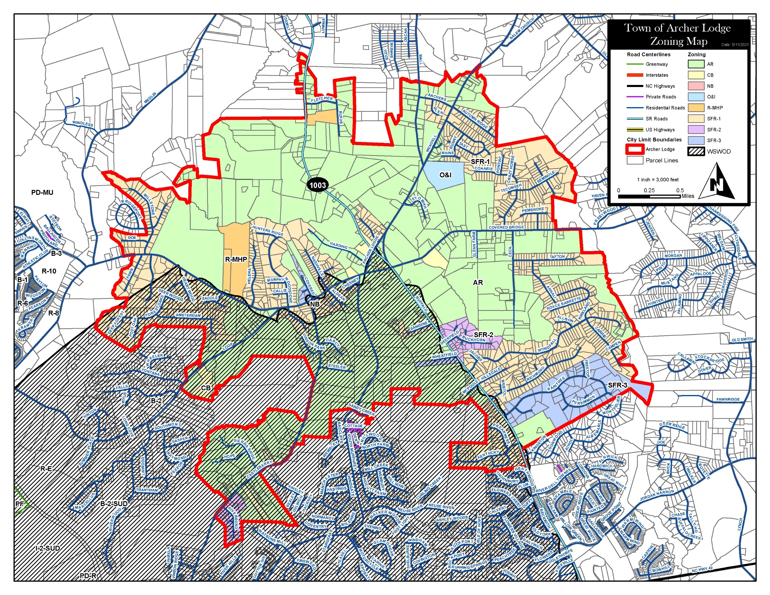
(Ord. No. AL2021-06-1, § 1, 6-7-2021)
DIVISION 2. - RECOMMENDED PLANTS LIST.
(Ord. No. AL2021-06-1, § 1, 6-7-2021)
DIVISION 3. - PLAT CERTIFICATES.
(a)
Certificates and endorsements on final plat. The certificates and endorsements in the following table, where applicable, must be shown on plats of subdivisions. See Article 11, Division 3 for examples of the certificates:
(1)
Certificate of Survey and Accuracy:
I, ___________, certify that this plat was drawn under my supervision from an actual survey made under my supervision (deed description recorded in Book _____, page _____, etc.) (other); that the boundaries not surveyed are clearly indicated as drawn from information found in Book _____, page _____; that the ratio of precision or positional accuracy as calculated is _______; that this plat was prepared in accordance with § 47-30 of the North Carolina General Statutes as amended. Witness my original signature, license number and seal this _______ day of _______, A.D., ___.
Seal or Stamp
___________
Professional Land Surveyor
License Number #_____
(2)
Professional Land Surveyor's Certification:
As denoted by an "X" below, I, ___________, certify as to the following:
a.
That the survey creates a subdivision of land within the area of a county or municipality that has an ordinance that regulates parcels of land.
b.
That the survey is in a portion of a county or municipality that is unregulated as to an ordinance that regulates parcels of land.
c.
Any one of the following:
(1)
That the survey is of an existing parcel or parcels of land or one or more existing easements and does not create a new street or change an existing street. For the purposes of this subsection, an "existing parcel" or "existing easement" is an area of land described in a single, legal description or legally recorded subdivision that has been or may be legally conveyed to a new owner by deed in its existing configuration.
(2)
That the survey is of an existing feature, such as a building or other structure, or natural feature, such as a watercourse.
(3)
That the survey is a control survey. For the purposes of this subsection, a "control survey" is a survey that provides horizontal or vertical position data for support or control of other surveys or for mapping. A control survey, by itself, cannot be used to define or convey rights or ownership.
(4)
That the survey is of a proposed easement for a public utility as defined in § 62-3.
d.
That the survey is of another category, such as the recombination of existing parcels, a court- ordered survey, or other exemption or exception to the definition of subdivision.
e.
That the information available to the surveyor is such that the surveyor is unable to determine to the best of the surveyor's professional ability as to provisions contained in (a) through (d) above.
(3)
Certificate of Floodway Information:
Property shown hereon _______ is/is not located in a FEMA designated flood zone. FEMA Flood Hazard Panel: _____; Effective Date: _______.
___________
Professional Land Surveyor
License Number #_____
(4)
Certificate of Ownership, Maintenance and Dedication:
I hereby certify that I am the owner (or corporate officer) of the property shown and described hereon, which is located in the zoning and subdivision jurisdiction of Archer Lodge and that I hereby adopt this subdivision plan with my free consent, establish minimum setback lines, and dedicate all streets, alleys, parks and other sites and easements to the public or private as noted. I understand that I am responsible for maintenance of public property shown hereon until it is accepted by the appropriate government entity.
________ ___________
Date Owner/Officer or Corporation
(5)
Certificate of Wastewater Disposal:
I hereby certify that all lots are provisionally approved for subsurface wastewater disposal systems, except as noted on the plat, subject to issuance of improvement permits by the Johnston County Health Department, and, to the North Carolina Administrative Code.
OR
On _______ (date), lot(s) ___________, were found to be unsuitable for installation of a subsurface wastewater disposal system, in accordance with North Carolina Administrative Code.
OR
Lot(s) ___________ has an existing sewage disposal system that complies with all applicable requirements of the Johnston County Code of Ordinances.
THIS THE DAY OF _______, 20___.
COUNTY OF JOHNSTON
By: ___________
___________
Designated Johnston County Official
(6)
Certificate of Approval by Public Utilities:
The Director of Public Utilities for County of Johnston, North Carolina, hereby certifies that this plat meets all Johnston County standards and requirements for public utilities required by the Johnston County ordinances. Upon recordation of this plat, Johnston County accepts the owner's offer of dedication for public water and/or sanitary sewer purposes all easements, common areas, and/or rights-of-way shown and delineated on this plat as dedicated for public utility purposes. No structures or fences shall be placed within the public utility easements. Access to the dedicated areas shall not be blocked or obstructed by any fence or structures unless pre-approved access is provided with a 12' minimum opening gate. The County shall have the right to clear and/or remove any vegetation within the public utility easements. Furthermore, the County will not replace any landscaping (other than grass, which will be replaced with seed) within the public utility easement area disturbed for maintenance of the utilities.
THIS THE _____ DAY OF _______, 20___.
COUNTY OF JOHNSTON
By:___________
Director of Public Utilities
(7)
North Carolina Department of Transportation Division of Highways Certification:
Proposed Subdivision Road Construction Standards Certification
Approved: ________ ___________
Date District Engineer
Note: Only North Carolina Department of Transportation approved structures are to be constructed on public right-of-way.
Note: Site triangle takes precedent over any sign easement.
Note: Owner, developer, or contractor shall set the centerline of the existing roadway ditch back to a minimum of 12 feet from the existing/proposed edge of pavement along all road front lots.
Note: All drainage easements shall be dedicated as public, and it shall be the responsibility of the property owners to maintain the drainage easements and any drainage structures there in, so as to maintain the integrity of the drainage system and ensure positive drainage.
Note: All lots shall be served by the internal street system.
(8)
Road Maintenance Statement of Understanding:
I, ___________ am responsible for the construction, maintenance and required road improvements of the subdivision streets on this plat until the earlier of the follow occurs:
(a)
Approved and accepted for permanent maintenance by the North Carolina Department of Transportation as public roads; or
(b)
Approved and taken over by the Homeowners Association for private roads permanent maintenance; or
(c)
Private road maintenance agreement is signed and recorded by owners of each lot.
___________
Name of Corporation or Owner
________ ___________
Date Developer/Owner/Officer of Corporation
(9)
Town Planner 's Certification:
Certificate of Approval for Recording—Subdivision Plat
I hereby certify that the subdivision plat shown hereon has been found to comply with the Subdivision Regulations of the Town of Archer Lodge, North Carolina, and that this plat has been approved for recording in the Office of the Register of Deeds of Johnston County. This plat is null and void if not recorded at the Johnston County Deed Registry within 60 days of the date written below.
________ ___________
Date Town Planner
Certificate of Approval for Recording—Exempt Plat
I hereby certify that this plat is exempt from the Subdivision Regulations with the Town of Archer Lodge, North Carolina, and that this plat has been approved for recording in the Office of the Register of Deeds of Johnston County.
________ ___________
Date Town Planner
(10)
Review Officer's Certification:
State of North Carolina
County of _______
I, ___________, Review Officer of _______ County, certify that the map or plat to which this certification is affixed meets all statutory requirements for recording.
________ ___________
Date Review Officer
(11)
Acceptance of Offer of Dedication:
NOTE: To be used only if Town Council accepts an offer of dedication.
I hereby certify that all parks and greenways as shown on this plat were accepted, as specified, by the Town Council by a resolution adopted at the meeting held on _______, 2___.
________ ___________
Date Town Clerk
(12)
Subdivision Road Disclosure Statement:
Developers are required to give lot purchases a subdivision street disclosure statement pursuant to § 136-102.6(F) of the North Carolina General Statutes.
(13)
Additional Certifications, Statements, or Notations necessary.
Notations:
1.
Maximum Impervious Surface Per Lot.
2.
Designate whether lot is within a protected watershed.
(14)
Electronic Signatures.
Verifiable digital or electronic signatures ("e-signatures" such as those provided by Adobe Sign software) may be substituted for a handwritten signature on any of the above certification statements included on a subdivision plat.
(Ord. No. AL2021-06-1, § 1, 6-7-2021; Ord. No. AL2022-03-1 (UDO-TA-1-22), § 1, 3-7-2022; Ord. No. AL2022-08-2 (UDO-TA-3-22), § 1, 8-1-2022)
DIVISION 4. - MODEL LANGUAGE FOR DECLARATION OF RESTRICTIVE COVENANTS.
THIS DECLARATION AND AGREEMENT is entered into this the _____ day of _______, 20___, between (Developer) (hereinafter "Declarant") and all parties hereafter acquiring any of the described property.
WITNESSETH:
WHEREAS, Declarant is the owner and developer of all lots within a subdivision of the Town of Archer Lodge, Johnston County, NC, known as _______ and being that certain tract or parcel more particularly described by map and survey in Plat Book _____, Page _____, of the Johnston County Registry; and
WHEREAS, it is in the best interest of the Declarant and to the benefit, interest, and advantage of every party hereinafter acquiring any of the described property that certain covenants, conditions, easements, assessments, liens, and restrictions governing and regulating the use of the property be established; and
WHEREAS, Declarant desires to provide for the continued ownership, maintenance, and repair of all streets, roads, sidewalks, and greenways together with the associated stormwater drainage infrastructure located in the above-named subdivision; and
WHEREAS, Declarant has caused or will cause to be incorporated under the laws of the State of North Carolina, a non-profit corporation known as "_______" (hereinafter referred to as "Association") for the purpose of exercising the functions aforesaid, and which are hereinafter fully set forth.
NOW, THEREFORE, in consideration of the premises, the Declarant agrees with all parties hereafter acquiring any of the property herein described, that it shall be and is hereby subject to the following restrictions, covenants, conditions, easements, assessments, and liens relating to the use thereof, which shall be construed as covenants running with the land, which shall be binding on all parties acquiring any right, title, or interest in any of the properties and which shall inure to the benefit of each owner thereof.
(1)
MEMBERSHIP: Every person who is a record owner of a fee or undivided fee interest in any lot which is subject to assessment by the Association, including contract sellers, but excluding persons who hold an interest merely as security for the performance of any obligations, shall be a member of the Association. Ownership of such interest shall be the sole qualification for such membership. Membership shall be appurtenant to and may not be separated from ownership of any lot which is subject to assessment. Membership in the Association is mandatory and may not be waived by the Association for any such owner.
(2)
OWNERSHIP OF STREETS, ROADS, SIDEWALKS, AND GREENWAYS: The Declarant shall own and maintain the streets, roads, sidewalks, and greenways together with the associated stormwater drainage infrastructure of the subdivision until such a time that the ownership interest in the above shall be transferred to the Association or to NCDOT.
(3)
MAINTENANCE, REPAIR, AND UPKEEP OF STREETS AND ROADS: Until such a time that the ownership interest in the streets and roads of the subdivision shall be transferred to the Association or NCDOT, the Declarant shall maintain, and repair said streets and roads in the subdivision at a minimum of NCDOT standards as set forth in the most current edition of the "Subdivision Roads Minimum Construction Standards." In the event that, and after such a time that, the ownership interest in the streets and roads of the subdivision has been transferred to the Association, the Association shall maintain, and repair said streets and roads in the subdivision at a minimum of NCDOT standards as set forth in the most current edition of the "Subdivision Roads Minimum Construction Standards."
(4)
ASSESSMENTS FOR MAINTENANCE, REPAIR, AND UPKEEP OF STREETS, ROADS, SIDEWALKS, AND GREENWAYS: Each member of the Association shall be required to pay an annual assessment for their pro rata share of the costs of maintenance, repair, and upkeep of the streets, roads, sidewalks, and greenways together with associated stormwater drainage infrastructure of the subdivision, with a minimum annual payment of $_______.
(5)
MAINTENANCE ACCOUNT: The Association shall deposit all assessments for the purpose of maintenance, repair, and upkeep of the streets, roads, sidewalks, and greenways together with associated stormwater drainage infrastructure of the subdivision into a separate account with an accredited, FDIC backed banking institution in the name of the Association. The Association shall file with the Town, by the first day of the calendar year, an annual accounting of said maintenance account.
(6)
CONTINUED STREET, ROAD, SIDEWALK, AND GREENWAY MAINTENANCE: Either the Declarant or the Association, whichever shall possess the ownership interest in the streets, roads, sidewalks, and greenways together with associated stormwater drainage infrastructure, shall either (i) Petition the NCDOT to assume ownership and maintenance of the streets, roads, sidewalks, and greenways together with associated stormwater drainage infrastructure of the subdivision and the rights-of-way thereto, or (ii) Provide that the streets, roads, sidewalks, and greenways together with associated stormwater drainage infrastructure of the subdivision and the rights-of-way thereto shall be privately owned and maintained to NCDOT standards as set forth in the most current edition of the "Subdivision Roads Minimum Construction Standards" by the Association, its successors or assigns, in perpetuity.
(7)
TRANSFER OF OWNERSHIP INTEREST UPON DISSOLUTION OF ASSOCIATION: To the extent permitted by law, in the event that the streets, roads, sidewalks, and greenways together with associated stormwater drainage infrastructure of the subdivision and the rights-of-way thereto have not been previously dedicated to the NCDOT, in the event the Association should dissolve, the Association shall transfer any and all ownership interest in the streets, roads, sidewalks, and greenways together with associated stormwater drainage infrastructure of the subdivision and the rights-of-way thereto, as well as the associated Maintenance Account as described in Paragraph (5) above, to another legal entity for the purpose of maintenance, repair, and upkeep.
(8)
FIREARMS: The discharge of firearms of any kind is strictly prohibited anywhere in the subdivision or on any adjoining land owned by the Association, a member of the Association, or the Declarant. Discharging of air guns, air pistols, and air rifles, not to exceed a caliber of 0.177, is permitted, as they are not considered firearms within the meaning of this section.
(Ord. No. AL2021-06-1, § 1, 6-7-2021)
DIVISION 5. - INFORMATION REQUIRED WITH SITE PLANS AND SUBDIVISIONS.
All site plans and subdivision plats shall be prepared by a North Carolina registered engineer, architect or professional land surveyor, signed and be sealed by the same, and shall include the following information:
(a)
Information required for both site plans and subdivision plats.
(1)
Site plans shall include a location map that shows the location of the project in the broad context of the Town or planning jurisdiction.
(2)
Development site plans shall be drawn to scale, using such a scale that all features required to be shown on the plans are readily discernible. Large developments may require that plans show the development in sections. The objective may be accomplished by using different plans or plans drawn to different scales to illustrate different features. Also, an applicant may use a narrative or master plan to describe and define those site plan elements that cannot be readily depicted in a graphic format.
(3)
Development site plans shall show on the first page the following information:
a.
Name of applicant.
b.
Name of development (if any).
c.
North arrow.
d.
Legend.
e.
Scale.
(4)
Existing natural, man-made and legal features:
a.
Tree line of wooded areas.
b.
Streams, ponds, drainage ditches, swamps, boundaries of flood ways and flood plains.
c.
Existing storm drainage patterns.
(5)
Existing man-made features:
a.
Public streets, sidewalks and other walkways, all designated by the type of surface material.
b.
Curbs and gutters, curb inlets and curb cuts and drainage grates.
c.
Stormwater and drainage facilities.
d.
Underground utility lines, including water, sewer, electric, telephone, gas and cable.
e.
Above-ground utility lines and other utility facilities.
f.
Fire hydrants.
g.
Buildings, structures (including dimensions).
h.
The location of any areas previously used for landfill or other waste disposal purposes that are known or reasonably should be known to the applicant.
(6)
Existing legal features:
a.
Zoning of the subject property and surrounding properties.
b.
Property lines of the tract to be developed (with dimensions identified).
c.
Street right-of-way lines.
d.
Utility or other easement lines.
e.
Deed book and page reference demonstrating ownership of property. If the applicant does not yet own the property, the applicant shall include a written statement describing the applicant's legal authority to make application for the requested permit or conditional zoning.
(7)
Show all proposed changes in existing natural, man-made and legal features, including, but not limited to, the following:
a.
Lot dimensions.
b.
The location, dimensions, and footprints of all buildings on the property, including the distances of all buildings from property lines, streets or street right-of-way lines; (subdivisions may show building setback lines).
c.
The location and dimensions of all recreational areas.
d.
The location and dimensions of all areas intended to remain as usable open space. The plans shall clearly indicate whether such open space areas are intended to be offered for dedication to public use or to remain privately owned.
e.
Street names (labeled by classification) showing linear feet, street paving widths and typical street cross-sections.
f.
Curbs and gutters (constructed using the same specifications as used by the North Carolina Department of Transportation), curb cuts and drainage grates as required by Town policy.
g.
If required, a stormwater management plan, as approved by the State of North Carolina, or Town in the Water Supply Watershed Protection Overlay District and drainage facilities.
h.
All new proposed storm drainage patterns.
i.
Sidewalks and walkways, showing widths and surface material.
j.
Bridges.
k.
Underground utility lines or easement areas for said lines, including water, sewer, electric, telephone, gas, and cable.
l.
Above-ground utility lines and other facilities.
m.
Fire hydrants.
n.
Vehicle accommodation areas including parking areas, loading areas and circulation areas, all designated by the type of surface material and dimensions of proposed parking spaces. The total number of parking spaces and the total number of parking spaces for disabled persons (i.e. handicapped spaces) shall be indicated;
o.
For properties in the Water Supply Watershed Protection Overlay District provide the proposed total impervious surface area and the calculations showing how the impervious surface area was found.
p.
The location and description of all yards, buffers, screening, landscaping and plantings or devices (i.e. fences, berms, etc.) proposed for compliance. Plans shall label trees and shrubbery by common or scientific name, show the distance between plants and indicate the height at the time of planting and expected mature height and width.
q.
Proposed phasing, if any. Phasing plans shall provide a description of the facilities to be built in each phase.
r.
Documentation confirming that the applicant has a legally sufficient interest in the property proposed for development to use it in the manner requested or is the duly appointed agent of such a person, such as a deed book and page reference demonstrating ownership of property. If the applicant does not yet own the property, the applicant shall include a written statement describing the applicant's legal authority to make application for the requested permit.
s.
Certifications from the appropriate agencies that all necessary easements have been provided; and
t.
If any street or driveway is proposed to intersect with a state-maintained road, a copy of the application for driveway approval as required by the Department of Transportation, Division of Highways Manual on Driveways Regulation.
(b)
Additional information required for site plans.
(1)
Existing topography at ten foot or other appropriate contour intervals, as approved by the Town Planner.
(2)
Individual trees eight inches in diameter or more, identified by common or scientific name.
(3)
Other individual trees the applicants intend to preserve.
(4)
Location of exterior light fixtures, with type and intensity of lighting fixtures sufficiently identified.
(5)
The proposed use or uses of all land within the subject property.
(6)
The scale of buildings relative to abutting property.
(7)
The total number of residential units and the total square footage of any nonresidential development.
(8)
Building elevations for all accessory structures, except for accessory structures to single family residences, duplexes and townhouses approved under the North Carolina Single Family Building Code.
(9)
All refuse facilities (including dumpsters and their screens), mechanical equipment and utility equipment.
(10)
Vehicle accommodation areas including parking areas, loading areas and circulation areas, all designated by the type of surface material and dimensions of proposed parking spaces. The total number of parking spaces and the total number of parking spaces for disabled persons (i.e. handicapped spaces) shall be indicated. Site and subdivisions in the Water Supply Watershed Protection Overlay District.
(11)
Building elevations for typical units of new buildings or exterior remodeling of existing buildings showing building heights, widths and materials (except single family, duplex or townhouse buildings approved under the NC Residential Building Code for One- and Two-Family Dwellings).
(12)
The location and dimensions, including height, of all signs, including the distances of all signs from property lines, streets or street right-of-way lines. If applicable, this information may be included as part of a sign plan.
(13)
Any other facilities to be constructed or otherwise provided as part of the development.
(c)
Additional information required only for subdivision plats. The number of square feet in every lot created by a new subdivision and the total number of lots created.
(d)
Number of copies of plans and documents.
(1)
With respect to all site plans submitted pursuant to this appendix, the applicant shall submit a minimum of two copies of full size plans (i.e. 24 inches by 36 inches) and two copies of plans drawn on ledger size paper (11 inches by 17 inches). Other documents required by this appendix shall be submitted on letter size paper (eight and one-half inches by 11 inches) or legal size paper (eight and one-half inches by 14 inches).
(2)
The applicant shall submit a minimum of two copies of all other documents required by this appendix.
(3)
The applicant shall submit all documents in Adobe format or other software approved by the town planner.
(Ord. No. AL2021-06-1, § 1, 6-7-2021)
DIVISION 6. - SUBDIVISION REQUIREMENTS BY TYPE OF SUBDIVISION
The Subdivision Requirements Table below specifies the characteristics and requirements for each type of subdivision required by this Ordinance. In the event of conflict between the table below and the text of this Ordinance, the text shall control.
(Ord. No. AL2022-03-1 (UDO-TA-1-22), § 1, 3-7-2022)