
Astoria City Zoning Code
ARTICLE 14
(Article 14 added by Ordinance 98-04, 5-4-98)
14.001 DEFINITIONS
As used in Article 14, unless the context requires otherwise, the following word shall have the meaning indicated:
ADJACENT: Any lot abutting the subject parcel (including all tax lots included as part of the subject parcel development) excluding rights-of-way. (Section 14.001 added by Ord 15-09, 12-7-2015)
HEIGHT, TOP OF BANK: For over-water / shoreline construction, top of bank shall be measured from the existing lowest point along the top of the shoreline adjacent to the subject property prior to any grading and/or fill. Features such as railings, balustrades, dolphins, bumper pilings, mooring pilings, and water navigational fixtures are exempt from the maximum “top of bank” height restriction as “water-dependent” features. (Added by Ord 19-14, 10-21-2019)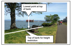
RIVER TRAIL: The entire width of the railbanked former railroad right-of-way property and/or easements, including the improved portions of the trail along the Columbia River, not just the improved portions of the Trail. The former railroad right-of-way property is generally 50’ wide in most areas but may include larger areas. The portion of the River Trail between 6th Street and 17th Street is also referred to as the River Walk. (Added by Ord 19-06, 7-1-2019)
SHOULD: A requirement, unless it can be shown that to comply with the requirement would be unreasonable, impractical, or unfeasible. Economic hardship alone shall not be justification for noncompliance with the requirement, but may be considered in conjunction with other reasons for noncompliance. (Section 14.001 added by Ord 15-09, 12-7-2015)
VIEW CORRIDOR: The unobstructed line of site of an observer looking toward an object of significance to the community such as the River, historic site, ridgeline, etc. A view corridor shall be free of structural encroachments. Parking within a view corridor is allowed unless otherwise specified. (Added by Ord 19-14, 10-21-2019)
(Section 14.001 added by Ord 15-09, 12-7-2015)
14.002 RESOLVING CONFLICTS WITHIN THE CODE
This article shall control in the event of a conflict with other sections of the Astoria Development Code.
- The more stringent provision shall control in the event of a conflict between Article 14 and any overlay zone.
- When applying design review guidelines, the following rules apply:
- The terms building and structure may be used interchangeably in the Riverfront overlay zones (Gateway Overlay, Bridge Vista Overlay, Neighborhood Greenway Overlay, Civic Greenway Overlay, and Urban Core Overlay).
- The following guidelines apply when reviewing visual impact to a historic building/structure:
- The relationship to historic buildings is more important than the relationship to historic structures, sites, or objects.
- The visual impact upon an historic structure, site, or object shall be considered rather than a simple comparison of the relative mass, scale and/or size.
- The proposed construction should respect both the existing and/or the original historic spatial relationship between buildings.
- The proposed construction should be appropriately located and scaled with respect to an historic building/structure, site, or object to maintain the historic character of the site and setting.
- New construction should be located so that it will not negatively impact the character of an historic building, site, or setting.
- The design and materials of any proposed construction should include elements that relate favorably to, but do not need to replicate, the design and materials of the historic structure.
14.003 APPLICABILITY
The provisions of the Gateway and Riverfront Vision Overlay Zones shall apply to all new construction or major renovation as noted in the specific code Sections, unless otherwise specified by the provisions in the Sections and as follows:
- Landscaping standards in Article 14 and in Section 3.120 and 3.125 of this code shall apply to all new development and to the entire site when major renovations are proposed.
- In the case of major renovation, only the proposed work shall be required to comply with standards of this Article not related to landscaping. Existing structural features not proposed to be altered are not required to be brought into compliance with non-landscaping standards at that time.
23-08
22-01
23-05
14.005 PURPOSE
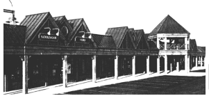
The purpose of the Gateway Overlay Zone is to implement the concepts and guidelines of the Astoria Gateway Master Plan, dated April 1997. The Gateway Overlay Zone is intended to be an intensively developed, mixed-use area which complements Downtown Astoria and the community as a whole.
14.010
(Section 14.010 renumbered to 14.001 by Ord 15-09, 12-7-2015)
14.015 GENERAL PROVISIONS
- Zones. In addition to conformance with the specific uses and standards of the individual zones, the following zones shall conform to the general regulations of the Gateway Overlay Zone in Sections 14.005 through 14.030.
- Maritime Heritage (MH)
- Family Activities (FA)
- Attached Housing/Health Care (AH-HC)
- Health Care (HC), except Health Care Uses within this zone.
- Education/Research/Health Care Campus (CA)
- Hospitality/Recreation (HR)
- Local Service (LS)
- Attached Housing (Mill Pond) (AH-MP)
- Civic Greenway Overlay Zone (CGO) (Section 14.015.A.9 added by Ord 13-09, 10-6-14)
- Compact Residential Zone (CR) (Section 14.015.A.10 added by Ord 13-09, 10-6-14)
- Design Review. Each public or private development proposal within the Gateway Overlay Zone will be reviewed for conistency with the Design Review Guidelines in Sections 14.020 through 14.030 unless specified otherwise.
- Historic Design Review. When a development proposal is required to be reviewed by the Historic Landmarks Commission due to its proximity adjacent to a designated historic building, structure, site, or object, the Historic Landmarks Commission shall include review of the Gateway Overlay sections relative to historic compatibility. If the proposed development is not adjacent to a historic property (as defined in Section 1.400) and not subject to review by the Historic Landmarks Commission, then the historic review of the Gateway Overlay Zone shall be completed by the Design Review Commission. (Section 15.015.C added by Ord 19-06, 7-1-2019)
Amended by Ord. 23-08 on 12/4/2023
14.020 APPLICABILITY OF DESIGN REVIEW GUIDELINES
The Design Review Guidelines shall apply to all new construction or major renovation. For the purposes of this Code Section, "major renovation" is defined as construction valued at 33% or more of the assessed value of the existing structure. The guidelines are intended to provide fundamental principles that will assist in the review of the propsed development. The principles identify both "encouraged" and "discouraged" architectural elements. They are broad design objectives and are not to be construed as prescriptive standards.
Due to the critical regional importance of Columbia Memorial Hospital, current understanding of the implications of the Cascadia seismic and tsunami events, and updated seismic and resiliency requirements, Health Care related uses in the Health Care zone are exempt from the Design Review and Use standards of the Gateway Overlay zone.
Amended by Ord. 22-01 on 11/7/2022
Amended by Ord. 23-08 on 12/4/2023
14.025 DESIGN REVIEW GUIDELINES
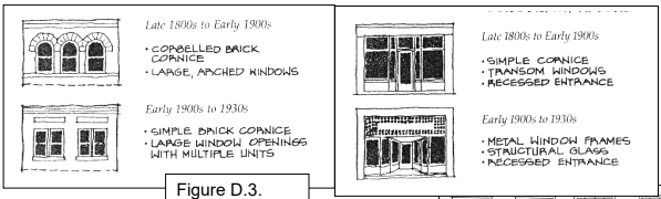
- Purpose. These guidelines promote architectural elements that unify the Gateway Area by encouraging styles characteristic of Astoria. The historic architecture of Astoria is represented by a variety of styles. Differences in details may be seen from one neighborhood to the next. These guidelines advocate the simplicity of design which is characteristic of Uppertown and the working waterfront. Building styles and details not inspired by Astoria’s past will be discouraged. Monotony of design should be avoided. Variety of detail, form, and siting should be used to provide visual interest.
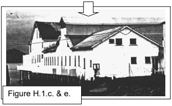
The Gateway Plan encourages new construction to reflect historic building types found in the Uppertown area. Three historic building types commonly found in the area include waterfront industrial, commercial, and residential. These building types may be used as models for contemporary building design, but do not restrict or define their function.
The Guidelines make reference to, but do not require the use of, historic materials. Contemporary substitutions (i.e. composite materials), will not be discouraged if their texture, profile, and proportions are similar to those materials with historic precedent.
Figures included in Section 14.015 through 14.030 are included for illustrative purposes only and are not intended to be regulatory in and of themselves. If there is an inconsistency between the Figure and the Development Code text, the text shall prevail. - Building Forms Encouraged.
- All Building Types.
- Simple designs without extraneous details.
- Rectangular in plan.
- Square in plan.
- Waterfront Industrial.
- Low in form.
- Cubic in form.
- Commercial.
- Low in form.
(Building Forms Encouraged)
- Low in form.
- Residential.
- Vertical in form.
- Cubic in form.
- Full front porch or front porch large enough to accommodate several seated persons.
- All Building Types.
- Building Forms Discouraged.
- All Building Types.
- Complex building footprints.
- Sprawling structures.
- All Building Types.
- Windows Encouraged.
- All Building Types.
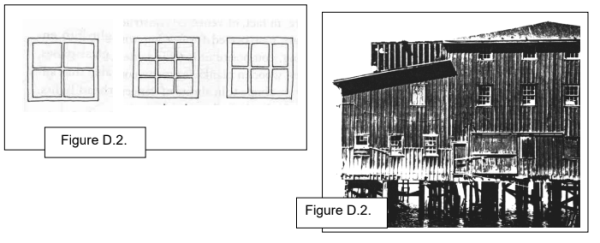
- True-divided, multiple-light windows.
- Single-light windows.
- Applied muntins with profile facing window exterior.
- Rectangular windows with vertical proportions.
- Fixed windows.
- Double or single-hung windows.
(Windows Encouraged) - Casement windows.
- Windows should be spaced and sized so that wall area is not exceeded by window area, with the exception of commercial storefronts.
- True-divided, multiple-light windows.
- Waterfront Industrial.
- Square or rectangular windows with multiple lights.
- Square or rectangular windows with multiple lights.
- Commercial.
- Storefronts.
- Plate glass windows with multiple-light transom windows above.
- Recessed entries.
- Window to wall surface proportions may be exceeded.
- Upper Stories.
- Window area should not exceed wall area.
- Window area should not exceed wall area.
- Storefronts.
- Residential.
- Vertical rectangle or square windows.
- Combination of single and multiple-light windows.
- Single windows, paired windows, or windows grouped in threes.
- Bay windows.
(Windows Encouraged) - Arched or decorative shaped windows used sparingly.
- Windows should use casings and crown moldings.
- All Building Types.
- Windows Discouraged.
- All Building Types.
- Applied muntins which have no profile.
- Smoked glass.
- Mirrored glass.
- Horizontal sliding windows.
- Walls predominated by large expanses of glass, except in commercial storefronts.
- Windowless walls. Large expanses of blank walls should only be located in areas which are not visible to the public.
- Aluminum frame windows, except in commercial storefronts.
- All Building Types.
- Exterior Wall Treatments Encouraged.
- All Building Types.
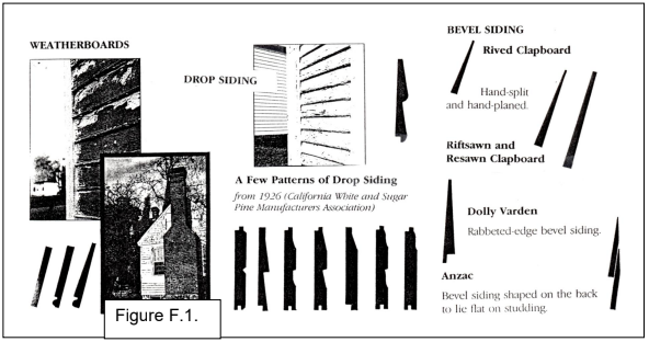
- Drop siding.
- Weatherboard siding.
- Horizontal siding with six inches or less exposure.
- Waterfront Industrial.
- Board and batten style.
- Galvanized corrugated metal.
(Exterior Wall Treatments Encouraged)
- Commercial.
- Finished concrete.
- Brick veneer.
- Residential.
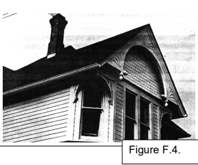
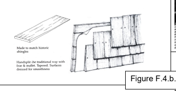
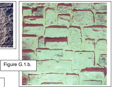
- Clapboard (see Figure F.1.)
- Wood shingle (rectangular).
- Decorative wood shingle.
- All Building Types.
- Exterior Wall Treatments Discouraged.
- All Building Types.
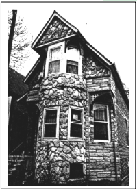
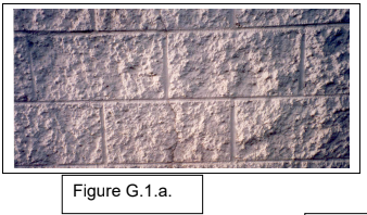
- Exposed textured, concrete block.
- Flagstone or other applied stone products.
- Precast concrete or decorative concrete panels.
- Wood shakes.
- Plywood paneling.
- All Building Types.
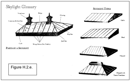
- Roof Elements Encouraged.
- Waterfront Industrial.
- Single gable with low pitch.
- Repetitive gable with steep pitch.
- Shallow eaves.
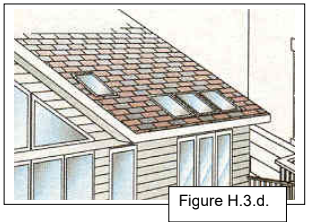
- Small shed roof dormers.
- Monitor roof on ridge line.
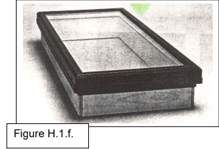
- Flat panel skylights or roof window.
- Commercial.
- Single gable with low pitch.
- Repetitive gable with steep pitch.
- Shallow eaves behind parapet wall.
- Flat or gable roof behind parapet wall.
- Structural skylights.
(Roof Elements Encouraged)
(Roof Elements Encouraged)
- Residential.
- Steep gable with broad eaves.
- Steep hip with broad eaves.
- Dormers with gable, hip, or shed roofs.
- Flat panel skylights or roof window on secondary elevations.
- Turrets or large projecting window bays used sparingly.
- Waterfront Industrial.
- Roof Elements Discouraged.
- All Building Types.
- False mansard or other applied forms.
- Dome skylights.
- All Building Types.
- Roofing Materials Encouraged.
- All Building Types.
- Cedar shingle.
- Composition roofing.
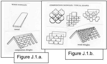
- Roofing material in gray, brown, black, deep red, or other subdued colors.
- Waterfront Industrial.
- Galvanized corrugated metal.
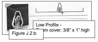
- Low profile standing seam, metal roof.
- Roll down.
- Commercial.
- Built-up.
- All Building Types.
- Roofing Materials Discouraged.
- All Building Types.
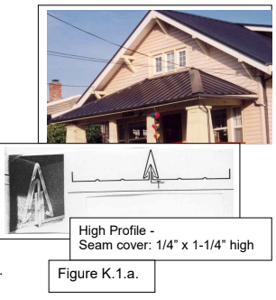
- High profile standing seam, metal roof.
- Brightly colored roofing material.
- High profile standing seam, metal roof.
- All Building Types.
- Signs Encouraged.
- All Building Types.
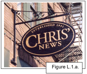
- Hanging blade signs.
- Signs painted on building facade.
- Signs applied to building facade.
- Front lit.
- Graphics historic in character.
- Hanging blade signs.
- Commercial.
- Exterior neon.
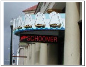
- Exterior neon.
- All Building Types.
- Signs Discouraged.
- All Building Types.
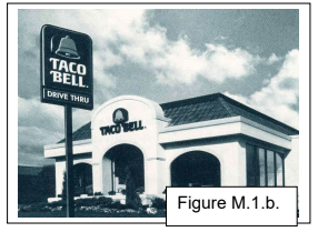
- Pole mounted freestanding signs.
- Plastic or internal and back lit plastic.
- All Building Types.
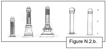
- Exterior Lighting Encouraged.
- All Building Types.
- Decorative lighting integrated with architecture.
- Metal halide or incandescent.
(Exterior Lighting Encouraged) - Pedestrian and traffic signals combined with street lamps.
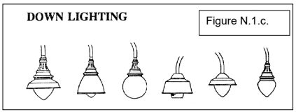
- Light fixtures that direct light downward and eliminate glare.
- Waterfront Industrial.
- Industrial pan light with goose neck.
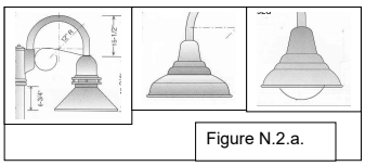
- Low bollard lighting.
- Industrial pan light with goose neck.
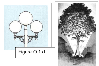
- Commercial.
- Historic street lamps along walks and parking lots.
- All Building Types.
- Exterior Lighting Discouraged.
- All Building Types.
- Sodium vapor (amber).
- Fluorescent tube.
- Cobra head street lamps or other contemporary fixtures.
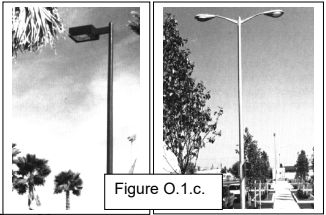
(Exterior Lighting Discouraged) - Fixtures with undiffused, undirected light that do not focus the light to the ground and that will potentially destroy the night sky view.
- All Building Types.
- Other Design Elements Encouraged.
- Commercial.
- Canvas awnings or fixed canopies for rain protection.
- Canvas awnings or fixed canopies for rain protection.
- Commercial.
- Other Design Elements Discouraged.
- Commercial.
- Vinyl awnings.
- Back lit awnings.
- Commercial.
14.030 OTHER APPLICABLE USE STANDARDS.
The following standards are applicable to all uses within the Gateway Overlay Zone except as noted in Section 14.030.F below. (Section 14.030 amended by Ord 19-06, 7-1-2019)
- Building Orientation.
- Development projects should form visually continuous, pedestrian-oriented street fronts with no vehicle use area between building faces and the street.
- Exceptions to this requirement may be allowed to form an outdoor space such as a plaza, courtyard, patio, or garden between a building and a sidewalk. Such a larger front yard area should have landscaping, low walls, fencing, railings, a tree canopy, or other site improvements.
- New uses should be sited to take advantage of the Columbia River and hillside views.
- If the proposed project is large or situated so as to become an entrance or major focus of the City, the design should recognize the project’s prominence and should be both compatible with its surroundings and complementary to the City as a whole.
- Development projects should form visually continuous, pedestrian-oriented street fronts with no vehicle use area between building faces and the street.
- Building Massing.
- Buildings should have a floor area ratio on their lots of at least 1:1 (One square foot of building area for one square foot of lot area), in order to maximize use of the land.
- Buildings should be a minimum of 24 feet in height from grade to highest point of the structure, excluding those features exempt from building height as identified in Development Code Section 3.075.
- The height, mass, and scale of buildings should be compatible with the site and adjacent buildings. Use of materials should promote harmony with surrounding historic structures and the character of the waterfront.
- Access and Parking Design.
- All uses which are served by an alley, local street, or collector street should have alley or street vehicular access and egress. Curb openings onto Marine Drive or Exchange Streets are discouraged. Parking lots should be on the interiors of blocks or behind buildings, and should be designed to be as unobtrusive as possible.
- Building facades and entries should face the adjacent street. Main entrances should face a connecting walkway with a direct pedestrian connection to the street without requiring pedestrians to walk through parking lots or across driveways.
- Parking areas should be shared among various uses where a development or block is planned as a whole. On-street parking on internal streets may be counted towards the off-street parking requirements with the approval of the Community Development Director.
- Landscaping.
- Street trees should be planted within the right-of-way along both sides of the streets within the Gateway Overlay Zone.
- Spacing should be 30 feet on center, depending on species and branching habit.
- Minimum size of deciduous trees should be 2" caliper, with an upright form.
- Mature branching height should be a minimum of 15'.
- Durable tree grates and trunk protectors should be installed.
- Areas between trees should be landscaped with a variety of shrubs and perennials, with an emphasis on flowering species.
- Street trees should be planted within the right-of-way along both sides of the streets within the Gateway Overlay Zone.
- Underground Utilities. This provision shall apply only to utility lines to be installed for new construction. Utility lines, including, but not limited to, electricity, communications, street lighting and cable television, shall be required to be placed underground. Appurtenances and associated equipment such as surface-mounted transformers, pedestal-mounted terminal boxes and meter cabinets may be placed above the ground, and shall be screened by sight obscuring fences and/or dense landscape buffers. The Design Review Committee may waive the requirements of this section if topographical, soil, or other conditions make such underground installations or screening of above ground equipment unreasonable or impractical. The applicant shall make all necessary arrangements with the serving utility or agency for underground installations provided hereunder; all such installations shall be made in accordance with the tariff provisions of the utility, as prescribed by the State Public Utilities Commissioner.
- Exceptions to Other Applicable Use Standards.
- Sections 14.030.A to 14.030.D, Other Applicable Use Standards of the Gateway Overlay Zones (MH, FA, CA, HC, AH-HC, HR, LS, AH-MP) do not apply to over-water development in the Civic Greenway Overlay Zone. Section 14.030, Underground Utilities, do apply. (Section 14.030.F added by Ord 19-06, 7-1-2019)
- Design Standards.
- Exterior lighting. Exterior lighting shall comply with the standards in Section 3.128.
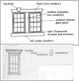
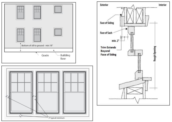
- Window detailing. Windows shall have casings/trim, sills, and crown moldings. Window detailing shall meet the following requirements.
- Casings/trim shall have minimum dimensions of 5/4 inch x 4 inch and shall extend beyond the facade siding. Exceptions may be granted for waterfront industrial style windows.
- Windows shall be recessed a minimum distance of two (2) inches from the trim surface to ensure a shadow line/effect.
- The bottom of the sill shall be a minimum of 18 inches above the ground or floor elevation.
- Windows shall be clear and not tinted or reflective.
- Vinyl shutters are prohibited.
- Exterior Wall Treatments / Siding.
- Fiber cement siding shall be smooth and not textured.
- Solid waste disposal area and mechanical equipment enclosures should be sided to match the main structures. (Section 14.030.G added by Ord 19-06, 7-1-2019)
14.035 PURPOSE
The purpose of the Civic Greenway Overlay Zone is to implement the land use principles of the Astoria Riverfront Vision Plan, dated December 2009, as they pertain to the Civic Greenway Plan Area. The Civic Greenway Overlay (CGO) Zone is intended to protect views of and access to the Columbia River, provide for an enhance open space and landscaping, support water-dependent uses consistent with Astoria’s working waterfront, and encourage modest scale housing in areas recommended for residential use. The CGO Zone extends from approximately 16th Street to 41st Street and between Marine Drive and the Columbia River as depicted on the City’s Zoning Map.
Amended by Ord. 22-01 on 11/7/2022
14.040 APPLICABILITY AND REVIEW PROCEDURES
The provisions of the Civic Greenway Overlay Zone shall apply to all new construction or major renovation, where “major renovation” is defined as construction valued at 33% or more of the assessed value of the existing structure, unless otherwise specified by the provisions in this Section.
Review of applications in the Civic Greenway Overlay Zone is subject to the administrative procedures and approval of the Community Development Director established in Article 9.
- Residential Development. Applications may be reviewed administratively subject to the Design Review Standards in Section 14.065 or through the public design review process subject to the Design Review Guidelines in Section 14.025. Any deviation from the standards in Section 14.065 would require the complete application to be reviewed through the public design review process.
- Non-Residential and Mixed-Use Development. Applications shall be reviewed through the public design review process subject to the Design Review Guidelines in Section 14.025.
- Historic Design Review. When a development proposal is required to be reviewed by the Historic Landmarks Commission due to its proximity adjacent to a designated historic building, structure, site, or object, or is an identified Historic Landmark, the Historic Landmarks Commission shall include review of the Civic Greenway Overlay sections..
Amended by Ord. 22-01 on 11/7/2022
14.045 USES PERMITTED OUTRIGHT FOR OVERWATER DEVELOPMENT
The following uses and activities and their accessory uses and activities are permitted in the Civic Greenway Overlay Zone, if permitted outright in the base zone for the site, and subject to the other appropriate development provisions of this Section.
- Small boat building and repair.
- Water-dependent facilities including dock, moorage, pier, terminal (excluding fossil fuel and petroleum product terminals and facilities), transfer facility and marina for commercial and recreational marine craft, for passengers, or for waterborne commerce.
- Public pier.
- Public use associated with a maritime use.
- Navigational structure.
- Shoreline stabilization.
- Flowlane disposal of dredged material.
- Pipeline, cable, and utility crossing.
- Storm water and treated wastewater outfall.
- Communication facility.
- Temporary dike for emergency flood protection limited to 60 days subject to State and Federal requirements.
- New dike construction.
- Maintenance and repair of existing structure or facility.
- Dredging and filling, pursuant to the applicable standards in Section 4.050 and 4.070, for any of the permitted uses 1 through 10 listed above.
- The following water-related commercial and industrial uses:
- Boat and/or marine equipment sales;
- Fish or shellfish retail or wholesale outlet;
- Charter fishing office;
- Sports fish cleaning, smoking, or canning establishment;
- Retail trade facility for the sale of products such as ice, bait, tackle, gasoline or other products incidental to or used in conjunction with a water-dependent use;
- Cold storage and/or ice-processing facility independent of seafood processing facility.
- Navigation aid.
- Piling and pile supported structure as necessary for any of the permitted uses 1 through 16 listed above, or as necessary for any use permitted in the adjacent shoreland.
(Section 14.045 added by Ord 13-09, 10-6-14)
14.050 CONDITIONAL USES PERMITTED FOR OVERWATER DEVELOPMENT
The following uses and activities and their accessory uses and activities are permitted in the Civic Greenway Overlay Zone as Conditional Uses, if permitted as a Conditional Use in the base zone for the site, and when authorized in accordance with Article 11, Conditional Uses. These uses and activities are also subject to the other appropriate development provisions of this Section. It must also be shown that these uses and activities are consistent with the purpose of the Civic Greenway Overlay Zone.
- Active restoration.
- Bridge crossing and bridge crossing support structure.
- Water-dependent or water-related recreational use not listed elsewhere in this zone.
- A use for which an exception to the Estuarine Resources Goal has been adopted as an amendment to the Astoria Comprehensive Plan.
- Fill in conjunction with any of the conditional uses 1 through 4 listed above pursuant to the applicable standards in Section 4.050.
- Dredging and filling, pursuant to the applicable standards in Section 4.050 and 4.070, for any of the conditional uses 1 through 5 listed above.
- Dredged material disposal at sites designated for dredged material disposal in the Comprehensive Plan.
- Dredged material disposal at sites not designated for dredged material disposal in the Comprehensive Plan, provided the dredged material is utilized as a source of fill material for an approved fill project.
- Water-related commercial or industrial use other than those listed under Section 14.045(15) of this zone (excluding fossil fuel and petroleum product terminals and facilities).
- Piling as necessary for any of the conditional uses 1 through 9 listed above.
- Temporary use meeting the requirements of Section 3.240
- Non-water dependent and non-water related uses may be located in existing, under-utilized buildings existing prior to 2013 provided the use does not preclude future water-dependent or water-related uses.
(Section 14.050 added by Ord 13-09, 10-6-14)
14.055 STANDARDS FOR OVERWATER DEVELOPMENT
The following development standards apply to overwater development in the Civic Greenway Overlay Zone. The Overwater Development standards shall also apply to on-land development north of the River Trail between 19th and 41st Streets.
Maintenance, repair, or restoration of buildings existing prior to 2013 shall be exempt from the standards of this Section 14.055. Additions and/or new construction on these buildings shall be subject to these standards.
(Section 14.055 amended by Ord 19-06, 7-1-2019)
- Height.
- Maximum building height, except hand rails, shall be the top of the existing adjacent riverbank. No variance may be granted for an exception to this height limitation, including the area within 500’ of the shoreline between 35th and 41st Streets.
Figure 14.055-1: Maximum Building Height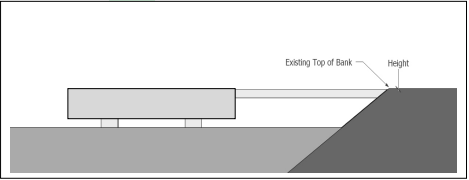
- 35th to 41st Street Exception.
- For buildings located greater than 500’ from the shoreline, the maximum height shall be 28’ from the top of the existing adjacent riverbank. No variance may be granted for an exception to this height limitation.
- There shall be a minimum 75’ wide, unobstructed view corridor separation between buildings.
- Maximum building height, except hand rails, shall be the top of the existing adjacent riverbank. No variance may be granted for an exception to this height limitation, including the area within 500’ of the shoreline between 35th and 41st Streets.
- Size.
- The maximum gross floor area of enclosed structures is 4,000 square feet.
- 35th to 41st Street Exception.
There shall be no maximum gross floor area for buildings located greater than 500’ from the shoreline.
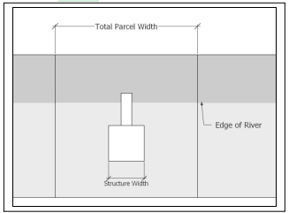
- Width.
- The maximum width of an overwater building is 25% of the total parcel width (measured along the parcel frontage adjacent to the Columbia River) or 50 feet, whichever is greater. In cases where total parcel width is 100 feet or less, the building width may be up to 25 feet.
- 35th to 41st Street Exception.
- The maximum width of an individual overwater building located greater than 500’ from the shoreline shall be a maximum 50% of the total parcel width (measured along the parcel frontage adjacent to the Columbia River shoreline) or 150’, whichever is less.
- The maximum width of all overwater buildings located greater than 500’ from the shoreline and located on a contiguous set of parcels under the same ownership shall be a maximum of 50% of the total width of the combined parcels (measured along the parcel frontage adjacent to the Columbia River shoreline).
- The maximum width of an individual overwater building located greater than 500’ from the shoreline shall be a maximum 50% of the total parcel width (measured along the parcel frontage adjacent to the Columbia River shoreline) or 150’, whichever is less.
- Access to the Columbia River. Access to the River shall be provided using piers and/or walkways as part of new construction and major renovations to structures constructed after the year 2013, where major renovation is defined as construction and alterations only to building exteriors valued at 75% or more of the assessed value of the existing structure.
Piers and walkways shall be constructed in accordance with Access Design A, Access Design B, or Access Design C, as shown and described below.- Access Design A - “Mid-Site Access”. This access design shall be provided in a public access easement provided through the middle of the development or structure.
Figure 14.055-3: Access Design A
- Access Design B - “Viewpoints”. This access design shall be provided through either existing right-of-way, right-of-way that is created and dedicated to the City, or a public access easement.
Figure 14.055-4: Access Design B
- Access Design C – “Trail Extension”. This access design serves as an extension of the River Trail and shall be provided through either existing right-of-way, right-of-way that is created and dedicated to the City, or easements for the piers on the east and west sides of the development. The boardwalk along the north side of the development shall be provided in a public access easement. [Note: Two possible scenarios are illustrated in the following figures for this option.]
Figure 14. 055-5: Access Design C.1
Figure 14.055-6: Access Design C.2
- Pier and Walkway Width. Minimum pier and walkway width is 10 feet if one side of the pier or walkway is developed with overwater structures. Minimum pier and walkway width is 14 feet if both sides of the pier or walkway are developed with overwater structures.
- Pier and Walkway Length. Piers and walkways shall extend beyond the north face of the overwater development a minimum length of 10 feet to ensure that the river is visible beyond the adjacent structure(s).
- Hours of Access. Access on overwater piers and walkways may be restricted during hours specified in City Code Section 5.926 to 5.928.
- Maintenance Responsibility. Responsibility for maintenance of the piers and walkway shall be established through a recorded maintenance agreement acceptable to the City.
- Access Design A - “Mid-Site Access”. This access design shall be provided in a public access easement provided through the middle of the development or structure.
- Other Development Standards. The Other Applicable Use Standards of the Gateway Overlay Zones (MH, FA, CA, HC, AH-HC, HR, LS, AH-MP) do not apply to overwater development in the Civic Greenway Overlay Zone.
(Section 14.055 added by Ord 13-09, 10-6-14)
Amended by Ord. 22-01 on 11/7/2022
14.060 STANDARDS FOR ON-LAND DEVELOPMENT
The following development standards apply to on-land development in the Civic Greenway Overlay Zone south of the River Trail. The Overwater Development standards shall apply to on-land development north of the River Trail / 50’ wide railroad line property. (Section 14.060 amended by Ord 19-06, 7-1-2019)
- Height.
- Maximum building height is 28 feet.
- Building height up to 35 feet is permitted when building stories above 28 feet are stepped back at least 10 feet in accordance with Section 14.060(C)(2).
- Exceptions to building height restrictions may be granted through provisions in Section 3.075.
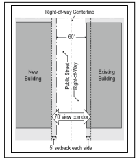
- Setbacks. A minimum view corridor width of 70 feet, centered on the right-of-way centerline, shall be provided on north-south rights-of-way between Marine Drive/Lief Erikson Drive and the Columbia River. Buildings shall be set back in order to achieve the 70-foot view corridor. If existing development on one side of the right-of-way does not meet the setback, the new development on the other side of the right-of-way is only required to provide its half of the view corridor width. (Section 14.060.B amended by Ord 19-06, 7-1-2019)
Figure 14.060-1: Setbacks
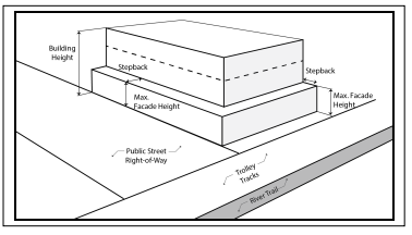
- Stepbacks.
- Purpose. The purpose of a stepback is to allow for less obstructed views from above the building and to create a less imposing building scale as viewed from the street or parallel/adjacent trail. A stepback is also designed to allow more light down to the adjacent or fronting street, sidewalk, or trail.
- Additional Building Height. Where the height of a building or building addition is proposed to exceed 28 feet, at least that portion of the building exceeding 28 feet, shall provide a stepback of at least 10 feet from the front plane of the proposed building or building addition that faces the right-of-way or the River Trail. Balconies and/or fixed awnings shall not encroach into the required 10-foot stepback area; buildings must be stepped back further in order to accommodate balconies and/or fixed awnings. (Section 14.060.C.2 amended by Ord 19-06, 7-1-2019)
Figure 14.060-2: Building Stepbacks
- Exceptions to Standard for On-Land Development.
- Section 14.060.A to Section 14.060.C, Standards for On-Land Development of the Civic Greenway Overlay Zone do not apply to on-land or overwater Mill Pond single-family and/or two-family and/or Accessory Dwelling Unit residential development in the AH-MP Zone (Attached Housing-Mill Pond). (Section 14.060.D.1 amended by Ordinance 21-02, 2-16-21; Section 14.060.D added by Ord 19-06, 7-1-2019)
(Section 14.060 added by Ord 13-09, 10-6-14)
14.061 EAST BASIN PLAN DISTRICT
The property situated approximately between 35th Street to the west, 41st Street to the east, the pierhead line to the north, and Marine Drive/Lief Erikson Drive to the south, shall constitute a subarea within the Civic Greenway Overlay Zone. The purpose of this subarea is to permit adoption of development standards, known as a Plan District, not applicable to other properties in the Civic Greenway Overlay Zone. If approved under the criteria of section 14.061(A) the plan district shall be known as the East Basin Plan District.
- Plan District Adoption Criteria. A Plan District may be established if all the following adoption criteria are met:
- The area proposed for the Plan District has special characteristics or problems of a natural, economic, historic, public facility, or transitional land use or development nature which are not common to other areas of the Civic Greenway Area;
- Existing base and overlay zone provisions are inadequate to achieve a desired public benefit as identified by the City Council, and/or to address identified needs or problems in the area;
- The proposed Plan District and regulations result from a Plan documenting the special characteristics or problems of the area and explain how a Plan District will best address relevant issues; and
- The regulations of the Plan District conform with the Comprehensive Plan and do not prohibit or limit uses or development allowed by the base zone without clear justification.
- Review. After adoption of East Basin Plan District regulations, the Planning Commission shall periodically review the East Basin Plan District and its regulations to determine the impacts on development, the usefulness and usability of the regulations, and the public need for any amendments to the regulations.
- Mapping. The boundaries of the East Basin Plan District are illustrated on a map referenced below and generally are described as the land and water area north of Lief Erikson Drive between 35th and 39th Street and the water area between 39th and 41st Street. The boundaries may be refined as part of the Plan District adoption or amendment.
- Standards. The standards within the East Basin Plan District may expressly change and vary from those applicable under the Civic Greenway Overlay Zone and those of the base zone. Such changes may include:
- Adding uses, such as retail uses;
- Changes to building height limits;
- Setback or view corridor modifications;
- Building size and permissible footprint.
- Application Procedure.
- An application to establish the East Basin Plan District shall be processed through the following procedures:
- The City or Port of Astoria may apply to establish development regulations that affect one or more properties within the East Basin Plan District.
- An application to establish regulations that would govern development within the East Basin Plan District is a legislative text amendment processed in accordance with the procedures established in Section 14.061 and in Development Code Articles 9 and 10.
- An application to establish the boundaries of the East Basin Plan District Overlay area is a legislative map amendment processed in accordance with the procedures established in Section 14.061 and in Development Code Articles 9 and 10 and may be processed concurrently with applications under subsection E.1.a.
- The City or Port of Astoria may apply to establish development regulations that affect one or more properties within the East Basin Plan District.
- An application to apply the East Basin Plan District regulations to a specific project shall be processed through the following procedures:
- The Port of Astoria as a public entity shall be the applicant or co-applicant on all applications.
- An application shall be processed as a quasi-judicial permit in accordance with the procedures established with the Plan District adoption and in accordance with the Development Code as applicable.
- An application to establish the East Basin Plan District shall be processed through the following procedures:
(Section 14.061 added by Ord 13-09, 10-6-14)
14.063 To 14.064 EAST BASIN PLAN DISTRICT REGULATIONS
(Reserved for codifying future Plan District regulations.)
(Section 14.063 to 14.064 added by Ord 13-09, 10-6-14)
14.065 RESIDENTIAL DESIGN STANDARDS
- Residential Design. Residential development proposed in the Civic Greenway Overlay Zone may be reviewed in accordance with one of two review options: (1) pursuant to design review procedures and the design review guidelines applicable to all building types established in Article 14; or (2) pursuant to procedures for administrative review by the Community Development Director established in Article 9 and the following design review standards for residential development.
The following design standards apply to the administrative review of residential development and apply to all dwelling unit types (single-family, two-family, Accessory Dwelling Unit, and multi-family dwelling unit buildings), unless specified otherwise. (Section 14-065.A amended by Ordinance 21-02, 2-16-21)- Building Forms.
- All dwelling unit buildings shall be based on a rectangular or square form.
- Single-family and two-family dwelling units must have a front porch, at least six (6) feet deep and 60 square feet in area.
Figure 14.065-1: Residential Building Form
- Window Design. The following design standards apply to all façades for all dwelling unit types.
- Windows required. All facades facing a right-of-way, River Trail, or common open space shall have windows.
- Window area. Window area shall cover a minimum of 30% of all facade areas visible from a right-of-way or River Trail and shall not exceed 50% of the facade areas visible from a right-of-way or River Trail. Windows in garage doors may count toward facade window area. (Section 14.065.A.2.b amended by Ord 19-06, 7-1-2019)
Figure 14.065-2: Window Area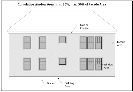
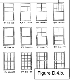
- Window lites. Window lite design shall be one of the following:
- Single-lite windows; or
- Multiple-lite true-divided windows; or
- Combination of single and multiple-lite true-divided windows; or
- Applied muntins with profile facing window exterior.
Figure 14.065-3: Window Lites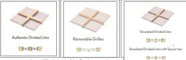
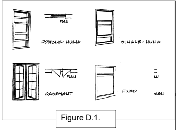
- Windows shall be fixed or open in one of the following configurations:
- Fixed window; or
- Single-hung windows; or
- Double-hung windows; or
- Awning or hopper windows; or
- Casement windows.
Figure 14.065-4: Fixed and Opening Windows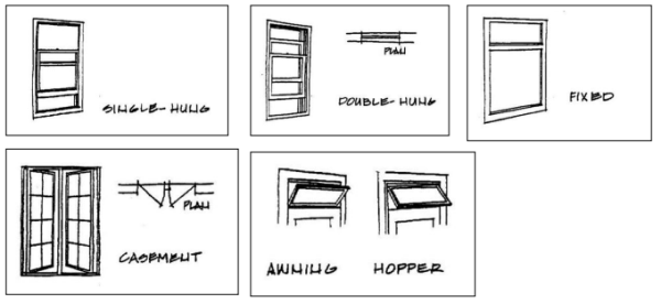
- Window shape. Window shape shall be one of the following:
- Vertical rectangle; or
- Square.
- Arched or decorative windows are permitted but should not exceed more than 30% of the total window coverage on all facades of the building.
Figure 14.065-5: Window Shapes
Vertical rectangular window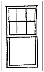
Examples of arched or decorative windows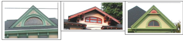
- Window detailing. Windows shall have casings/trim, sills, and crown moldings. Window detailing shall meet the following requirements.
- Casings/trim shall have minimum dimensions of 5/4 inch x 4 inch and shall extend beyond the facade siding.
- Windows shall be recessed a minimum distance of two (2) inches from the trim surface to ensure a shadow line/effect.
- The bottom of the sill shall be a minimum of 18 inches above the ground or floor elevation.
Figure 14.065-6: Window Detailing – Trim and casement location and dimensions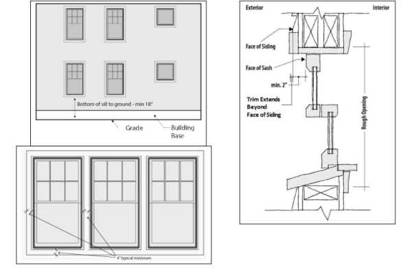
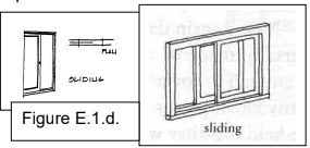
- Window design prohibited. The follow window design features are prohibited.
- Applied muntins that have no profile.
- Smoked, tinted, or frosted glass, except for bathroom windows not on the street-facing facade.
- Mirrored glass.
- Horizontal sliding windows.
- Aluminum frame windows.
Figure 14.065-7: Window Design Prohibited
Horizontal sliding window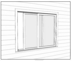
Muntins with no profile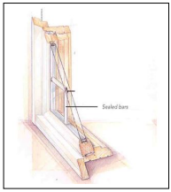
- Exterior Wall Treatments and Materials. The following design standards apply to all dwelling unit types.
- A minimum of 80% of exterior walls shall be constructed of one or more of the following sets of treatments and materials.
- Drop siding; or
- Weatherboard siding; or
- Clapboard; or
- Rectangular wood shingle; or
- Decorative wood shingle; or
- Board and batten.
- Horizontal siding shall have six inches or less exposure.
- Vertical board and batten shall have true battens.
Figure 14.065-8: Exterior Walls – Permitted Materials
- Paneled material shall be applied in a manner which avoids the occurrence of seams along the wall plane. Where seams cannot be avoided, they shall be located in a manner that relates logically to windows and other architectural features of the façade. Horizontal seams shall be covered by a trim board or cornice piece.
Figure 14.065-9: Exterior Walls – Seam Treatment
Figure 14.065-10: Exterior Walls – Horizontal Seam Treatment
- Exterior wall treatments and materials prohibited. The following types of treatments and materials are prohibited.
- Exposed textured concrete block.
- Flagstone or other applied stone products.
- Precast concrete or decorative concrete panels.
- Wood shakes.
- Plywood paneling.
Figure 14.065-11: Exterior Wall Treatments and Materials Prohibited
Applied stone
Textured concrete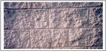
- A minimum of 80% of exterior walls shall be constructed of one or more of the following sets of treatments and materials.
- Roof Elements. The following design standards apply to all dwelling unit types.
- Roof design shall be one of the following:
- Steep (minimum 5:12 pitch) gable with broad (minimum 1 foot) eaves;
- Steep (minimum 5:12 pitch) hip with broad (minimum 1 foot) eaves; or
- An “Italianate” style hip, gable, or cube roof with a minimum roof pitch of 4:12 and broad (minimum 1 foot) eaves.
Figure 14.065-12: Roof Design Permitted
Steep pitched hip roof with broad eaves and dormer elements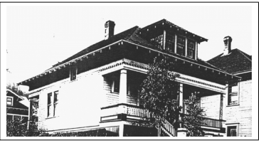
Italianate Roof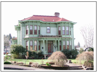
- A roof may consist of sections of flat roof for up to 75% of the roof area.
- Roof elements permitted. The following roof design elements are permitted.
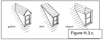
- Dormers with gable, hip, or shed roofs.
- Flat panel skylights or roof windows on secondary elevations.
Figure 14.065-13: Roof Elements Permitted
Gabled, shed, and hipped dormers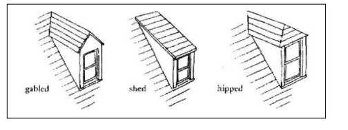
Flat panel skylights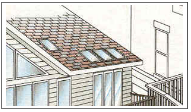
- Roof elements prohibited. The following roof design elements are prohibited.
- False mansard or other applied forms.
- Dome skylights.
Figure 14.065-14: Roof Elements Prohibited
False mansard roof
- Roof design shall be one of the following:
- Roofing Materials. The following design standards apply to all dwelling unit types.
- Roofing material. Roofing shall be one of the following materials:
- Wood shingle; or
- Composition roofing; or
- Metal with no-profile seams or low-profile seams (less than 1/4 inch x 1 1/4 inch).
Figure 14.065-15: Roofing Material Permitted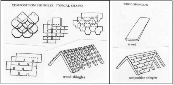
- Roofing material color. Roofing material shall be gray, brown, dark green, black, or deep red. Other subdued colors may be approved by the Community Development Director.
- Roofing materials prohibited. The following roofing materials are prohibited.
- High profile standing seam (1/4 inch x 1 1/4 inch or greater) metal roof.
- Brightly colored roofing material, as determined by the Community Development Director.
Figure 14.065-16: Roofing Material Prohibited
High profile metal seam roof
- Roofing material. Roofing shall be one of the following materials:
- Signs. Signs are subject to the sign provisions in Section 8.040 and 8.160.
- Doors. The following design standards apply to all dwelling unit types.
- Doors shall have at least one light (glass) panel.
- Sliding doors are not permitted on the ground floor of the front facade.
- All materials are permitted.
- Metal or metal-clad doors shall be painted.
- Garage Doors. The following design standards apply to attached and detached garages:
- Each garage door shall be a maximum of ten (10) feet in width and seven (7) feet in height.
- A minimum of 10% of each garage door shall be window panels, raised trim, or other architectural details.
Figure 14.065-17: Garage Doors Permitted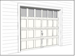
- Building Forms.
(Section 14.065 added by Ord 13-09, 10-6-14)
14.070 OTHER DEVELOPMENT STANDARDS
- The following development standards are applicable within the Civic Greenway Overlay Zone.
- Floor area ratios. Floor area ratio and height standards in Section 14.030.B.1 and Section 14.030.B.2, Other Applicable Use Standards of the Gateway Overlay Zone do not apply to on-land development in the Civic Greenway Overlay Zone. Other standards in Section 14.030, Other Applicable Use Standards of the Gateway Overlay Zone do apply. (Section 14.070.A.1 amended by Ord 19-06, 7-1-2019)
- Exterior lighting. All uses shall comply with applicable lighting standards in Section 3.128. (Section 14.070.A.2 amended by Ord 19-05, 6-17-2019)
- Fences. Fences located between the River Trail and the Columbia River shall not exceed a height of three (3) feet.
(Section 14.070 added by Ord 13-09, 10-6-14)
14.075 LANDSCAPING
- Landscaping is required in the Civic Greenway Overlay Zone in accordance with the provisions in this Section and those in Sections 3.120 to 3.125. The provisions in this Section apply to new construction or exterior renovations with a value of at least 33% of the assessed value of the structure.
- River side and/or riparian standards. The following standards apply to landscaping on the river side of the River Trail and to riparian areas to the south of the River Trail, which is defined as the landward limit of Columbia River aquatic vegetation or, where aquatic vegetation is absent, the Mean Higher High Water.
- Height and spacing.
- Maximum shrub height is 30 inches.
- Maximum width of clusters of trees is 50 feet.
- Clusters of trees shall have a minimum of 50 feet clear between branches at maturity.
- Trees are not permitted to be planted on the river side of the River Trail within the extended public right-of-way or view corridor extending from it for a distance of 70’ centered on the right-of-way centerline.
- Trees shall not exceed 35 feet in height at maturity
- Maximum height of fences is three (3) feet.
Figure 14.075-1: River Side Landscaping
- Native plants. See Section 3.125 concerning use of native plants and list of recommended native plants.
- Height and spacing.
- Land side or upland standards. The following standards apply to landscaping along the frontage of parcels abutting the River Trail to the south except where riparian areas are located to the south of the River Trail. Riparian areas are subject to the standards of Section 14.075.A.1.
- Height and spacing.
- Maximum spacing of trees is 20 feet on center.
- Maximum spacing of shrubs is five (5) feet on center.
- Ground cover landscaping is required in between shrubs and trees.
- Trees shall not exceed 35 feet in height at maturity
Figure 14.075-2: Land Side Landscaping
- Parking area landscaping. Landscaping required between parking areas, streets, and sidewalks in accordance with Section 3.120(A.7) shall also be required between parking areas and the River Trail.
- Landscaping credits for non-vegetation features.
- The Community Development Director may approve non-vegetative features to account for up to 10% of required landscaping.
- The Community Development Director may approve installation of non-vegetative features within the public right-of-way and/or River Trail to account for up to 25% of required landscaping when the non-vegetative features include at least one of the following amenities meeting the City approved design:
- bike rack
- bench
- table
- drinking fountain
- directional or interpretive/information signage
- trash or recycling container
- lighting
- restroom
- An application proposing more than 25% of required landscaping be credited by non-vegetative features is subject to approval in accordance with procedures in Article 9 and Article 12.
- Non-vegetative features allowed in the public right-of-way and/or on the River Trail in lieu of required landscaping shall be maintained by the applicant. There shall be a maintenance agreement or other City approved agreement. Failure to maintain or loss of the non-vegetative feature will result in the requirement for installation of the landscaping in accordance with the Code at the time of the loss.
- Height and spacing.
- Street Trees. Street trees are required to be planted within the right-of-way along both sides of the street in the Civic Greenway Overlay Zone in accordance with the provisions in this Section and those in Section 14.030(D).
- Maximum height for street trees along north-south streets between Marine Drive and the Columbia River is 35 feet. (Section 14.075.A.3.a amended by Ord 19-06, 7-1-2019)
- Street trees along north-south streets between Marine Drive and the Columbia River shall have narrow profiles and/or be pruned to a maximum width of 15 feet.
- Street trees along north-south streets between Marine Drive and the Columbia River shall be one of the columnar species listed in Section 3.125, unless otherwise approved by the Community Development Director. (Section 14.075.A.3.c amended by Ord.15-03, 6-15-15)
- Required street trees shall be maintained by the adjacent property owner and/or other identified entity. There shall be a maintenance agreement or other City approved agreement.
- River side and/or riparian standards. The following standards apply to landscaping on the river side of the River Trail and to riparian areas to the south of the River Trail, which is defined as the landward limit of Columbia River aquatic vegetation or, where aquatic vegetation is absent, the Mean Higher High Water.
(Ord 13-09, 10-6-14; Ord.15-03, 6-15-15
)
Amended by Ord. 22-01 on 11/7/2022
14.085 PURPOSE
The purpose of the Bridge Vista Overlay Zone is to implement the land use principles of the Astoria Riverfront Vision Plan, dated December 2009, as they pertain to the Bridge Vista Area. The Bridge Vista Overlay (BVO) Zone is intended to serve objectives including supporting water-dependent and water-related uses and new uses consistent with Astoria’s working waterfront; encouraging design that is compatible with the area’s historic and working waterfront character; protecting views of and access to the Columbia River; enhancing open space and landscaping, particularly adjacent to the River Trail; strengthening the pedestrian orientation and gateway characteristics of the area; and allowing for commercial and residential uses that complement the Downtown core and support other planning objectives for the area. The BVO Zone extends from approximately the West Mooring Basin to 2nd Street and between West Marine Drive / Marine Drive and the northern edge of overwater parcels on the Columbia River, as shown in the City’s Zoning Map.
(Section 14.085 added by Ord 15-03, 6-15-15)
14.090 APPLICABILITY AND REVIEW PROCEDURES
The provisions in Sections 14.085 to 14.125 apply all uses in all areas of the Bridge Vista Overlay Zone unless indicated otherwise in Table 14.090-1 and in the individual sections.
Table 14.090-1: Applicability of Bridge Vista Overlay Zone Code Sections
| Code Section | Applicability |
| Section 14.095 Uses
Prohibited for Overwater Development | • Aquatic Zones
• Shoreland Zones |
| Section 14.100
Standards for Overwater Development | Limitation Areas (Figure 14.100-1) – overwater and land north of the River Trail / 50’ wide railroad line property |
| Section 14.105 Uses
Permitted for On-Land Development | • Pedestrian-Oriented District (Figure 14.105-2)
• C-3 Zone |
| Section 14.110 Uses
Prohibited for On-Land Development | • Pedestrian-Oriented District (Figure 14.105-2)
• C-3 Zone |
| Section 14.113 Standards for On-Land Development | Minimum Setbacks
• North/south Rights-of-way between West Marine Drive / Marine Drive and Columbia River
• Adjacent to River Trail • Adjacent to West Marine Drive / Marine Drive and Other Rights-of-Way Parallel to West Marine Drive / Marine Drive (except River Trail) Maximum Setbacks • Adjacent to West Marine Drive / Marine Drive and Parallel Rights-of-Way Stepbacks • All Overlay Zone Adjacent to Rights-of-Way Size |
| Section 14.115 Design Guidelines and
Standards | Building Style and Form
• Standards for Projecting Wall-Mounted Mechanical Units Visible from Public Right-of-Way or River Trail
• Guidelines for All Uses, All Overlay Zone Adjacent to Rights-of-Way (except West Marine Drive / Marine Drive)
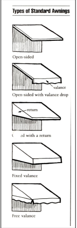
Roof Form and Materials • Form Standards for All Uses • Materials Standards for All Uses • Form Standards for Non-Industrial Uses • Form Standards and Guidelines for Industrial Uses Doors • Standards for All Uses • Guidelines for All Uses • Standards for Non-Industrial Uses • Guidelines for Non-Industrial Uses Windows • Coverage Standards for All Uses • Design Standards for All Uses • Design Guidelines for All Uses • Coverage Standards for Non-Industrial Uses in Pedestrian-Oriented District • Coverage Standards for Non-Industrial Uses Outside Pedestrian-Oriented District • Coverage Standards for Industrial Uses Siding and Wall Treatment • Standards for All Uses • Guidelines for All Uses Awnings • Standards for Types of Awnings/Treatments for All Uses • Guidelines for Types of Awnings/Treatments for All Uses • Standards Along River Trail and North/South Rights-of-Way Lighting • Standards for All Uses • Guidelines for All Uses Signs • Standards for All Uses in Pedestrian-Oriented District |
| Section 14.120 Landscaping | River Side/Riparian
Land Side/Upland
Street Trees
• All Street Trees
• North-South Rights-of-Way Between West Marine Drive / Marine Drive and Columbia River |
| Section 14.125 Off-Street Parking | In Pedestrian-Oriented District
• Small Floor Area
• Buildings Covering Site
• Small Building Expansions |
Figure 14.090-1: Limitation Area
Figure 14.090-2, Pedestrian-Oriented District
(Figure 14.090-2 amended by Ord 19-06, 7-1-2019)
The provisions of the Bridge Vista Overlay Zone shall apply to all new construction or major renovation, where “major renovation” is defined as construction valued at 33% or more of the assessed value of the existing structure, unless otherwise specified by the provisions in this Section. Applications in the Bridge Vista Overlay Zone shall be reviewed in a public design review process subject to the standards and guidelines in Sections 14.095 to 14.125.
- Historic Design Review. Historic Design Review. When a development proposal is required to be reviewed by the Historic Landmarks Commission due to its proximity adjacent to a designated historic building, structure, site, or object, or is an identified Historic Landmark, the Historic Landmarks Commission shall include review of the Bridge Vista Overlay sections.
(Section 14.090 added by Ord 15-03, 6-15-15)
Amended by Ord. 22-01 on 11/7/2022
14.095 USES PROHIBITED FOR OVERWATER AND SHORELAND AREA DEVELOPMENT
(Section 14.095 title amended by Ord 19-06, 7-1-2019)
- Aquatic Zones. The following uses and activities and their accessory uses and activities are prohibited in Aquatic Zones in the Bridge Vista Overlay Zone. Permitted uses are identified in the base zones in Article 2.
- Fossil fuel and petroleum product terminals.
- Auto sales and gas stations.
- Wood processing.
- Eating and drinking establishments.
- Retail uses.
- Professional, medical offices.
- Indoor entertainment.
- Hotels/motels. Facilities existing prior to 2013 may be repaired, replaced, and/or redeveloped with new hotels/motels.
- Conference center
- Residential uses, including manufactured dwellings.
- Shoreland Zones. The following uses and activities and their accessory uses and activities are prohibited in Shoreland Zones in the Bridge Vista Overlay Zone. Permitted uses are identified in the base zones in Article 2.
- Fossil fuel and petroleum product terminals.
- Auto sales and gas stations.
- Wood processing.
- Professional, medical offices.
- Indoor entertainment.
- Hotels/motels. Facilities existing prior to 2013 may be repaired, replaced, and/or redeveloped with hotels/motels.
- Conference center. Except if located south of the River Trail property.
- Residential uses, including manufactured dwellings.
(Section 14.095 added by Ord 15-03, 6-15-15)
14.100 STANDARDS FOR OVERWATER DEVELOPMENT
- Applicability. The following development standards apply to overwater development and to on-land development north of the River Trail in the Bridge Vista Overlay Zone in areas shown in Figure 14-090-1. These Limitation Areas are located approximately 200 Feet from Shoreline or 300 Feet from the north edge of the River Trail right-of-way as shown in Figure 14-090-1. (Section 14.100.A amended by Ord 19-06, 7-1-2019)
- Exemption. Maintenance, repair, or restoration of buildings existing prior to 2013 shall be exempt from the standards of this Section 14.100. Additions valued at 33% or more of the assessed value of the structure and/or new construction on these buildings shall be subject to these standards.
- Distance from Shore and Height.
- Structures within Designated Limitation Areas (Figure 14.090-1). Maximum building height, except hand rails, shall be the top of the existing adjacent riverbank. No variance may be granted for an exception to this height limitation.
Figure 14.100-1: Maximum Building Height within Overwater Development Limitation Areas
- Structures Within Overwater Development Non-Limitation Areas (Figure -14.090-1). The maximum height shall be the top of the existing adjacent riverbank. No variance may be granted for an exception to this height limitation except as follows:
- Water-dependent uses over water may construct water-dependent facilities up to 35’ without a variance. The added feature is subject to all other design and/or location standards of the Code. (Section 14.100.C.2 amended by Ord 19-14, 10-21-2019)
Figure 14.100-2: Maximum Building Height Within Overwater Development Non-Limitation Areas
(Section 14.100.C, Figure 14.100-2 amended by Ord 19-14, 10-21-2019)
- Water-dependent uses over water may construct water-dependent facilities up to 35’ without a variance. The added feature is subject to all other design and/or location standards of the Code. (Section 14.100.C.2 amended by Ord 19-14, 10-21-2019)
- Structures within Designated Limitation Areas (Figure 14.090-1). Maximum building height, except hand rails, shall be the top of the existing adjacent riverbank. No variance may be granted for an exception to this height limitation.
- Size.
- Structures within overwater development Limitation Area (Figure 14.090-1). The maximum gross floor area of enclosed structures is 4,000 square feet.
- Structures within the overwater development Non-Limitation Areas (Figure 14.090-1). There shall be no maximum gross floor area for buildings located in these areas. (Section 14.100.D.2 amended by Ord 19-14, 10-21-2019)
- Width and Spacing.
- The maximum width of an individual overwater building shall be a maximum of 60% of the total parcel width (measured along the parcel frontage adjacent to the Columbia River shoreline) or 150 feet, whichever is less.
- The maximum combined width of all overwater buildings located on a contiguous set of parcels under the same ownership shall be a maximum of 60% of the total width of the combined parcels (measured along the parcel frontage adjacent to the Columbia River shoreline) with no individual building exceeding 150 feet in width.
- There shall be a minimum 40 feet wide, unobstructed view corridor separation between individual buildings.
Figure 14.100-3: Maximum Building Width (200’+ from Shoreline or 300’+ from North Edge of River Trail Right-of-Way)
- Access to the Columbia River. Access to the River shall be provided using piers and/or walkways as part of new construction and major renovations to structures constructed after the year 2013, where major renovation is defined as construction and alterations only to building exteriors valued at 75% or more of the assessed value of the existing structure.
Piers and walkways shall be constructed in accordance with Access Design A, Access Design B, or Access Design C, as shown and described below.
This access design shall be provided in a public access easement provided through the middle of the development or structure.
Figure 14.100-4: Access Design A
- Access Design B - “Viewpoints”. This access design shall be provided through either existing right-of-way, right-of-way that is created and dedicated to the City, or a public access easement.
Figure 14.100-5: Access Design B
- Access Design C – “Trail Extension”. This access design serves as an extension of the River Trail and shall be provided through either existing right-of-way, right-of-way that is created and dedicated to the City, or easements for the piers on the east and west sides of the development. The boardwalk along the north side of the development shall be provided in a public access easement. (Note: Two possible scenarios are illustrated in the following figures for this option.)
Figure 14.100-6: Access Design C.1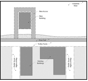
Figure 14.100-7: Access Design C.2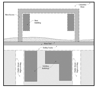
- Pier and Walkway Width. Minimum pier and walkway width is 10 feet if one side of the pier or walkway is developed with overwater structures. Minimum pier and walkway width is 14 feet if both sides of the pier or walkway are developed with overwater structures.
- Pier and Walkway Length. Piers and walkways shall extend beyond the north face of the overwater development a minimum length of 10 feet to ensure that the river is visible beyond the adjacent structure(s).
- Hours of Access. Access on overwater piers and walkways may be restricted during hours specified in City Code Section 5.926 to 5.928.
- Maintenance Responsibility. Responsibility for maintenance of the piers and walkway shall be established through a recorded maintenance agreement acceptable to the City.
- Access Design B - “Viewpoints”. This access design shall be provided through either existing right-of-way, right-of-way that is created and dedicated to the City, or a public access easement.
(Section 14.100 added by Ord 15-03, 6-15-15)
Amended by Ord. 22-01 on 11/7/2022
14.105 USES PERMITTED FOR ON-LAND DEVELOPMENT
- Pedestrian-Oriented District. The following uses and activities and their accessory uses and activities are permitted outright in the Pedestrian-Oriented District (Figure 14.090-2) in the Bridge Vista Overlay Zone, in addition to uses permitted outright in the base zone identified in Article 2, and are subject to the other appropriate development provisions of this Section.
- Manufacturing or light industrial with a retail component.
- Motel, hotel, bed and breakfast, inn or other tourist lodging facility and associated uses when parking is located at the rear or interior of the site, screened by the building.
- Existing motels and their expansion and reconstruction if destroyed.
- Dwellings in a new or existing structure above the first floor that has commercial or mixed uses.
- Commercial Zone. The following uses and activities and their accessory uses and activities are permitted outright in Commercial Zones in the Bridge Vista Overlay Zone, in addition to uses permitted outright in the base zone identified in Article 2, and subject to the other appropriate development provisions of this Section.
- Manufacturing or light industrial with a retail component.
- Dwellings in a new or existing structure above the first floor that has commercial or mixed uses.
(Section 14.105 added by Ord 15-03, 6-15-15)
14.110 USES PROHIBITED FOR ON-LAND DEVELOPMENT
- Pedestrian-Oriented District. The following uses and activities and their accessory uses and activities are prohibited in the Pedestrian-Oriented District (Figure 14-090.2) in the Bridge Vista Overlay Zone. Permitted uses are identified in the base zones in Article 2 and in Section 14.105.A of this ordinance.
- Animal hospital or kennel
- Auto sales and services.
- Commercial or public off-street parking lot.
- Conference center.
- Construction service establishment.
- Drive-through facilities.
- Gasoline services stations.
- Hospital
- Manufacturing or light industrial without a retail component.
- Repair service establishment not allowed as an Outright Use.
- Transportation service establishment.
- Wholesale trade or warehouse establishment.
- Commercial Zone. The following uses and activities and their accessory uses and activities are prohibited in the Commercial Zone in the Bridge Vista Overlay Zone. Permitted uses are identified in the base zones in Article 2 and in Section 14.105.B of this ordinance.
- Auto sales and services.
- Gasoline services stations.
- Manufacturing or light industrial without a retail component.
- Single-family dwelling.
- Two-family dwelling.
- Accessory Dwelling Unit. (Section 14.110.B.6 added by Ordinance 21-02, 2-16-21)
- Shoreland Zones. The following uses and activities and their accessory uses and activities are prohibited in Shoreland Zones in the Bridge Vista Overlay Zone. Permitted uses are identified in the base zones in Article 2.
- Fossil fuel and petroleum product terminals.
- Auto sales and gas stations.
- Wood processing.
- Professional offices, medical offices.
- Indoor entertainment.
- Hotels/motels. Facilities existing prior to 2013 may be repaired, replaced, and/or redeveloped with hotels/motels.
- Conference center. Except if located south of the River Trail property.
- Residential uses, including manufactured dwellings. (Section 14.110.C added by Ord 19-06, 7-1-2019)
(Section 14.110 added by Ord 15-03, 6-15-15)
14.113 STANDARDS FOR ON-LAND DEVELOPMENT
The following development standards apply to on-land development in the Bridge Vista Overlay Zone south of the River Trail. The Overwater Development standards shall apply to on-land development north of the River Trail. (Section 14.113 amended by Ord 19-06, 7-1-2019; amended by Ord 19-14, 10-21-2019)
- Height.
- Maximum building height is 28 feet except as noted in subsection A.2 of this section. No variance may be granted for an exception to this height limitation. (Section 14.113.A.1 amended by Ord 19-14, 10-21-2019)
- Building height up to 35 feet, is permitted in accordance with all of the following:
- Public Access.
- buildings shall be located to provide a 60’ wide unobstructed view corridor with physical public access area from West Marine Drive that connects to the Riverfront via a public right-of-way and/or a recorded easement across another private property; and
- the public access area and view corridor shall be provided in a public access easement provided through the development site; and
- the access area shall be open to the public but may be restricted during hours specified in City Code Section 5.926 to 5.928; and
- walkways shall be installed and shall be at least 14 feet in width; and
- provide some public amenities such as benches, interpretive signage, or other features approved by the Community Development Director; and
- responsibility for maintenance of the public access / view corridor, walkway, and/or other public amenities shall be the responsibility of the property owner. If any portion of the public access is on City-owned property and/or public right-of-way, private responsibility shall be established through a recorded maintenance agreement acceptable to the City.
- Stepback. Stories above 15 feet or one story shall be stepped back at least 10 feet for the facade facing a right-of-way or the River Trail in accordance with Section 14.113.C. (Section 14.113.A.2 amended by Ord 19-14, 10-21-2019) (Section 14.113.A.3 deleted by Ord 19-14, 10-21-2019)
- Public Access.
- Setbacks.
- Minimum Setbacks.
- North-South Rights-of-Way between West Marine Drive / Marine Drive and the Columbia River. A minimum view corridor width of 70 feet, centered on the right-of-way centerline, shall be provided on north-south rights-of-way between West Marine Drive / Marine Drive and the Columbia River. Buildings shall be set back in order to achieve the 70-foot view corridor. If existing development on one side of the right-of-way does not meet the setback, the new development on the other side of the right-of-way is only required to provide its half of the view corridor width.
Figure 14.113-1: Minimum Setbacks
(Section 14.113.B.1.a amended by Ord 19-06, 7-1-2019) - Adjacent to the River Trail.
- The minimum setback adjacent to the River Trail shall be 10 feet on the south side of the trail and 20 feet on the north side of the trail.
- The setback area shall be landscaped or shall include a combination of landscaping and pedestrian-oriented amenities such as walkways, seating, and plaza space.
- Adjacent to West Marine Drive / Marine Drive and Other Rights-of-Way Parallel to West Marine Drive (except River Trail). The minimum setback for yards fronting West Marine Drive / Marine Drive and other public rights-of-way parallel to West Marine Drive / Marine Drive in the Bridge Vista Overlay Zone, with the exception of the River Trail, shall be zero (0) feet.(Section 14.113.B.1.d, Figure 14.113-2 added by Ord 19-14, 10-21-2019)
- North-South Rights-of-Way between West Marine Drive / Marine Drive and the Columbia River. A minimum view corridor width of 70 feet, centered on the right-of-way centerline, shall be provided on north-south rights-of-way between West Marine Drive / Marine Drive and the Columbia River. Buildings shall be set back in order to achieve the 70-foot view corridor. If existing development on one side of the right-of-way does not meet the setback, the new development on the other side of the right-of-way is only required to provide its half of the view corridor width.
- Maximum Setbacks.
- Adjacent to West Marine Drive / Marine Drive and Parallel Rights-of-Way. The maximum setback for yards fronting West Marine Drive / Marine Drive and all parallel rights-of-way in the Bridge Vista Overlay Zone, with the exception of the River Trail, shall be five (5) feet.
- Allowed Extensions of Maximum Setbacks. The maximum setback for yards fronting a public right-of-way in the Bridge Vista Overlay Zone may be extended to 20 feet for up to 50% of the building facade if the setback is used for a walkway, plaza, courtyard, or other pedestrian-oriented amenity or public gathering space.
- Adjacent to West Marine Drive / Marine Drive and Parallel Rights-of-Way. The maximum setback for yards fronting West Marine Drive / Marine Drive and all parallel rights-of-way in the Bridge Vista Overlay Zone, with the exception of the River Trail, shall be five (5) feet.
- Setback Between Buildings on Same Lot. There shall be a minimum 60-foot-wide, north-south orientation, unobstructed view corridor separation between individual buildings on the same lot / building site, except within the Pedestrian-Oriented Overlay Zone. No structures or portions of structures shall encroach into the view corridor. Vehicle parking may be allowed in a view corridor area. (Section 14.113.B.3 added by Ord 19-14, 10-21-2019)
- Side Yard Setback. A minimum 10’ wide side yard setback shall be provided on one side of a development except as provided in Section 14.113.B.3. (Section 14.113.B.4 added by Ord 19-14, 10-21-2019)
- Minimum Setbacks.
- Stepbacks.
- Purpose. The purpose of a stepback is to allow for less obstructed views from above the building and to create a less imposing building scale as viewed from the street or parallel/adjacent trail. A stepback is also designed to allow more light down to the adjacent or fronting street, sidewalk, or trail.
- Additional Building Height. Where the height of a building or building addition is proposed to exceed 15 feet, at least that portion of the building exceeding 15 feet or one story, whichever is less, shall provide a stepback of at least 10 feet from the front plane of the proposed building or building addition that faces the right-of-way and/or the River Trail.
- Balconies and fixed awnings shall not encroach into the required 10-foot stepback area; buildings must be stepped back further in order to accommodate balconies and/or fixed awnings.
- Balcony railings constructed to a maximum height of 15’ are not encroachments when the building facade above the top of rail is stepbacked 10’. (Section 14.113.C.2 amended by Ord 19-14, 10-21-2019)
Figure 14.113-3: Building Stepbacks
 (Section 14.113.C.2, Figure 14.113-3 amended by Ord 19-14, 10-21-2019)
- Balconies and fixed awnings shall not encroach into the required 10-foot stepback area; buildings must be stepped back further in order to accommodate balconies and/or fixed awnings.
- Size.
- Gross Floor Area. The gross floor area of on-land development uses in the Bridge Vista Overlay Zone shall be a maximum of 30,000 square feet for each building (See definition of “Gross Floor Area”) except as noted below:
- See Astoria Warehousing Plan District Section 14.127 to 14.129.
- See Port of Astoria West Mooring Basing Plan District Section 14.124 to 14.126. (Section 14.113.D amended by Ord 19-14, 10-21-2019)
- Gross Floor Area. The gross floor area of on-land development uses in the Bridge Vista Overlay Zone shall be a maximum of 30,000 square feet for each building (See definition of “Gross Floor Area”) except as noted below:
- Building Orientation. Buildings shall have a north-south orientation (i.e. the width of the building parallel to West Marine Drive shall be narrower than the depth of the building) to allow for more unobstructed view corridors between buildings to the River. (Section 14.113.E added by Ord 19-14, 10-21-2019)
- Lot Coverage. Buildings shall not cover more than 50 percent of the lot area of the “buildable lot” or combined lots of a single development. (Section 14.113.F added by Ord 19-14, 10-21-2019)
(Section 14.113 added by Ord 15-03, 6-15-15)
Amended by Ord. 23-05 on 10/2/2023
14.114 RESIDENTIAL DESIGN STANDARDS
- Applicability. The following design standards apply to all new construction or major renovation of residential development, where major renovation is defined as construction valued at 33% or more of the assessed value of the existing structure.
- Residential Design. Residential development proposed in the Bridge Vista Overlay Zone may be reviewed in accordance with one of two review options: (1) pursuant to design review procedures and the design review guidelines applicable to all building types established in Section 14.115; or (2) pursuant to procedures for administrative review by the Community Development Director established in Article 9 and the following design review standards for residential development. Any deviation from the following design standards in Section 14.114 would require the complete application to be reviewed through the public design review process as noted in Option 1.
The following design standards apply to the administrative review of residential development and apply to all dwelling unit types (single-family, Accessory Dwelling Unit, two-family, and multi-family dwelling unit buildings), unless specified otherwise. All other standards of the Bridge Vista Overlay Zone shall be applicable. (Section 14.114.B amended by Ordinance 21-02, 2-16-21)- Building Forms.
- All dwelling unit buildings shall be based on a rectangular or square form.
- Single-family and two-family dwelling units must have a front porch, at least six (6) feet deep and 60 square feet in area.
Figure 14.114-1: Residential Building Form
- Window Design. The following design standards apply to all facades for all dwelling unit types.
- Windows required. All facades facing a right-of-way, River Trail, or common open space shall have windows.
- Window area. Window area shall cover a minimum of 30% of all facade areas facing a right-of-way, River Trail, or common open space, and shall not exceed 50% of facade areas facing a right-of-way.
Figure 14.114-2: Window Area
- Window lites. Window lite design shall be one of the following:
- Single-lite windows; or
- Multiple-lite true-divided windows; or
- Combination of single and multiple-lite true-divided windows; or
- Applied muntins with profile facing window exterior to create exterior shadow lines.
Figure 14.114-3: Window Lites
- Windows shall be fixed or open in one of the following configurations:
- Fixed window; or
- Single-hung windows; or
- Double-hung windows; or
- Awning or hopper windows; or
- Casement windows.
Figure 14.114-4: Fixed and Opening Windows
- Window shape. Window shape shall be one of the following:
- Vertical rectangle; or
- Square.
- Arched or decorative windows are permitted but should not exceed more than 30% of the total window coverage on all facades of the building.
Figure 14.114-5: Window Shapes
Vertical rectangular window
Examples of arched or decorative windows
- Window detailing. Windows shall have casings/trim, sills, and crown moldings. Window detailing shall meet the following requirements.
- Casings/trim shall have minimum dimensions of 5/4 inch x 4 inch and shall extend beyond the facade siding.
- Windows shall be recessed a minimum distance of two (2) inches from the trim surface to ensure a shadow line/effect.
- The bottom of the sill shall be a minimum of 18 inches above the ground or floor elevation.
Figure 14.114-6: Window Detailing – Trim and casement location and dimensions
- Window design prohibited. The following window design features are prohibited.
- Applied muntins that have no profile.
- Smoked, tinted, or frosted glass, except for bathroom windows not on the facade facing a right-of-way.
- Mirrored glass.
- Horizontal sliding windows.
- Aluminum frame windows.
- Vinyl windows.
- Blocked-out windows.
- Windows that extend beyond the plane of the building facade.
Figure 14.114-7: Window Design Prohibited
Horizontal sliding window
Muntins with no profile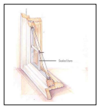
- Exterior Wall Treatments and Materials. The following design standards apply to all dwelling unit types.
- A minimum of 80% of exterior walls shall be constructed of one or more of the following sets of treatments and materials.
- Drop siding; or
- Weatherboard siding; or
- Clapboard; or
- Rectangular wood shingle; or
- Decorative wood shingle; or
- Board and batten.
- Horizontal siding shall have six inches or less exposure.
- Vertical board and batten shall have true battens.
- Fiber cement siding shall be smooth, not textured.
Figure 14.114-8: Exterior Walls – Permitted Materials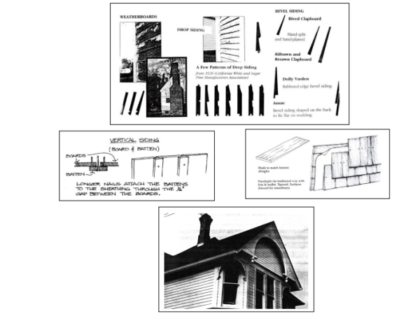
- Paneled material shall be applied in a manner which avoids the occurrence of seams along the wall plane. Where seams cannot be avoided, they shall be located in a manner that relates logically to windows and other architectural features of the facade. Horizontal seams shall be covered by a trim board or cornice piece.
Figure 14.114-9: Exterior Walls – Seam Treatment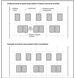
Figure 14.114-10: Exterior Walls – Horizontal Seam Treatment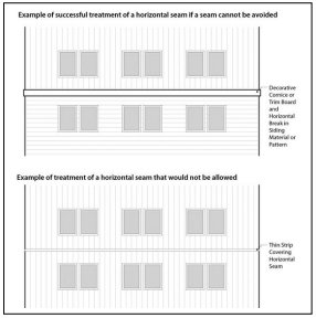
- Exterior wall treatments and materials prohibited. The following types of treatments and materials are prohibited.
- Exposed textured concrete block;
- Flagstone or other applied stone products;
- Precast concrete or decorative concrete panels;
- Wood shakes;
- Plywood paneling;
- Cladding materials such as corrugated metal panels or spandrel glass;
- Neon or other fluorescent colors;
- Bright or primary wall colors for the entire wall surface;
- Painted brick; and
- Non-durable materials such as synthetic stucco or shingles at the ground floor.
Figure 14.114-11: Exterior Wall Treatments and Materials Prohibited
Applied stone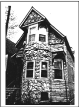
Textured concrete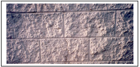
- A minimum of 80% of exterior walls shall be constructed of one or more of the following sets of treatments and materials.
- Roof Elements. The following design standards apply to all dwelling unit types.
- Roof design shall be one of the following:
- Steep (minimum 5:12 pitch) gable with broad (minimum 1 foot) eaves;
- Steep (minimum 5:12 pitch) hip with broad (minimum 1 foot) eaves; or
- An Italianate style hip, gable, or cube roof with a minimum roof pitch of 4:12 and broad (minimum 1 foot) eaves.
Figure 14.114-12: Roof Design Permitted
Steep pitched hip roof with broad eaves and dormer elements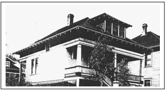
Italianate Roof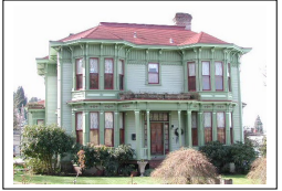
- A roof may consist of sections of flat roof for up to 75% of the roof area.
- Roof elements permitted. The following roof design elements are permitted.
- Dormers with gable, hip, or shed roofs.
- Flat panel skylights or roof windows on secondary elevations.
Figure 14.114-13: Roof Elements Permitted
Gabled, shed, and hipped dormers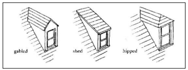
Flat panel skylights
- Roof elements prohibited. The following roof design elements are prohibited.
- False mansard or other applied forms.
- Dome skylights.
Figure 14.114-14: Roof Elements Prohibited
False mansard roof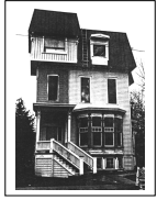
- Roof design shall be one of the following:
- Roofing Materials. The following design standards apply to all dwelling unit types.
- Roofing material. Roofing shall be one of the following materials:
- Wood shingle; or
- Composition roofing; or
- Metal with no-profile seams or low-profile seams (less than 1/4 inch x 1 1/4 inch).
Figure 14.114-15: Roofing Material Permitted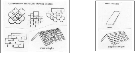
- Roofing material color. Roofing material shall be gray, brown, dark green, black, or deep red. Other subdued colors may be approved by the Community Development Director.
- Roofing materials prohibited. The following roofing materials are prohibited.
- High profile standing seam (1/4 inch x 1 1/4 inch or greater) metal roof.
- Brightly colored roofing material, as determined by the Community Development Director.
Figure 14.114-16: Roofing Material Prohibited
High profile metal seam roof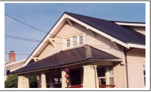
- Roofing material. Roofing shall be one of the following materials:
- Signs. Signs are subject to the sign provisions in Section 8.040 and 8.160.
- Doors. The following design standards apply to all dwelling unit types.
- Doors shall have at least one light (glass) panel.
- Sliding doors are not permitted on the ground floor of the front facade.
- All materials are permitted.
- Metal or metal-clad doors shall be painted.
- Garage Doors. The following design standards apply to attached and detached garages:
- Each garage door shall be a maximum of ten (10) feet in width and seven (7) feet in height.
- A minimum of 10% of each garage door shall be window panels, raised trim, or other architectural details.
Figure 14.114-17: Garage Doors Permitted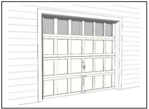
- Building Forms.
(Ord 19-06, 7-1-2019; Ord.15-03, 6-15-15)
Amended by Ord. 22-01 on 11/7/2022
14.115 DESIGN STANDARDS AND GUIDELINES
- Applicability and Review. The following design standards and guidelines apply to all new construction or major renovation, where “major renovation” is defined as construction valued at 33% or more of the assessed value of the existing structure. Applications in the Bridge Vista Overlay Zone shall be reviewed in a public design review process subject to the standards and guidelines in Sections 14.095 to 14.125.
Some of the following design standards and guidelines apply to all uses. Other standards and guidelines are differentiated by non-industrial uses and industrial uses. For the purposes of these Sections, industrial uses include the following as further defined in Section 1.400 of the Development Code:- Water-dependent or water-related commercial or industrial use.
- Communication facility.
- Communication service establishment.
- Utility.
- Cold storage and/or ice-processing facility independent of seafood processing facility.
- Water-dependent facilities including terminals and transfer facilities.
- Seafood receiving and processing.
- Ship and boat building and repair.
- Aquaculture and water-dependent portions of aquaculture facility.
- Wholesale trade, warehouse, and/or distribution establishment (including trucking terminal).
- Research and development laboratory.
- Wood processing.
- Manufacturing.
- Light manufacturing.
- Petroleum receiving, dispensing and storage for marine use.
- Transportation services
- Building Style and Form. (Section 14.115.B amended by Ord 19-06, 7-1-2019)
- Standards for All Uses.
- Projecting wall-mounted mechanical units are prohibited where they are visible from a public right-of-way or the River Trail. Projecting wall-mounted mechanical units are allowed where they are not visible from a public right-of-way or River Trail.
- Solid waste disposal, outdoor storage, and utility and mechanical equipment shall be enclosed and screened from view (14.115-1). A cover shall be required if screened items can be viewed from above. Rooftop equipment shall be screened from view by a parapet wall, a screen made of a primary exterior finish building material used elsewhere on the building, or by a setback such that it is not visible from adjacent properties and rights-of-way up to approximately 100 feet away. Also see Section 3.215, Outdoor Storage Areas and Enclosures.
Figure 14.115-1: Screening Waste Disposal, Outdoor Storage, and Utility/Mechanical Equipment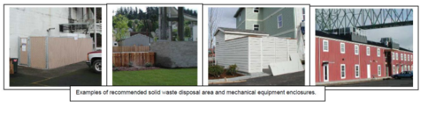
- Guidelines for All New Construction.
- The design should respect significant original characteristics, scale, and massing of adjacent structures that are visible from the public right-of-way within three blocks of the development site. Buildings should be designed so that they are not substantially different in character from adjacent structures in terms of size, mass, or architectural form. Also see Section 14.002.C, Resolving Conflicts within the Code.
- New Construction should respect significant characteristics of composition and material of adjacent structures that are visible from the public right-of-way within three blocks of the development site. Also see Section 14.002.C, Resolving Conflict within the Code.
- Building forms should be simple single geometric shapes, e.g. square, rectangular, triangular (14.115-2).
Figure 14.115-2: Geometric Building Form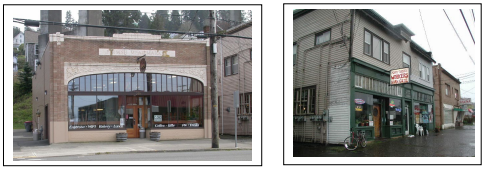
- Guidelines for All Existing Buildings.
- Distinctive stylistic features or examples of skilled craftsmanship of existing buildings and/or structures proposed for renovation, alteration, and/or additions should be treated with sensitivity. All buildings should be respected and recognized as products of their time.
- Renovations, alterations, and/or additions to existing buildings should respect significant original characteristics of adjacent structure scale and massing for the entire structure, and should be designed so that they are not substantially different in terms of size, mass, or architectural form. Also see Section 14.002.C, Resolving Conflicts within the Code.
- Renovations, alterations, and/or additions should retain and/or respect significant original characteristics of the existing structure composition and material, for the entire structure. Also see Section 14.002.C, Resolving Conflicts within the Code.
- Building forms should be simple single geometric shapes, e.g. square, rectangular, triangular (14.115-2).
- Mid-century slip covers which are not part of the original historic design should be removed when possible.
- Incompatible additions or building alterations using contemporary materials, forms, or colors on building facades are discouraged.
- Standards for Non-Industrial Uses.
- Facade Variation. All non-industrial buildings shall incorporate design features such as offsets, balconies, projections, window reveals, or other similar elements to preclude large expanses of uninterrupted building surfaces in areas which are visible to the public. Design features shall occur at a minimum of every thirty (30) feet for all building facades visible from a public right-of-way or River Trail.
The facade shall contain at least two (2) of the following features:- Recess (e.g., deck, patio, courtyard, entrance, or similar feature) that has a minimum depth of six (6) feet;
- Extension (e.g., floor area, deck, patio, entrance, or similar feature) that projects a minimum of two (2) feet and runs horizontally for a minimum length of four (4) feet;
- Offsets or breaks in roof elevation of two (2) feet or greater in height;
- Outdoor seating area, plaza, or other interactive landscaped area adjacent to the building that is specifically identified and/or covered, and approved by the review authority; and/or
- Other similar facade variations approved by the review authority.
Figure 14.115-2.a: Facade Variation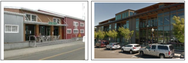
- Base, Middle, and Top of Building. All non-industrial buildings shall have a clear and distinct base, middle and top to break up vertical mass (Figure 14.115-2.b). All facades visible from a right-of-way or River Trail shall utilize horizontal bands and/or changes in color, material, form and/or pattern to differentiate the base, middle, and top of the building, subject to the following requirements:
- Horizontal bands or other changes in pattern or material shall be a minimum of 8 inches high (the length of a standard brick) and shall project a minimum of one inch from the building face.
- Changes in building massing and form may also be used to differentiate a building’s base, middle, and top. This may include architectural setbacks or projections, measuring a minimum of 3 inches.
Figure 14.115-2.b: Base, Middle, Top of Building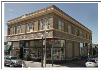
- Facade Variation. All non-industrial buildings shall incorporate design features such as offsets, balconies, projections, window reveals, or other similar elements to preclude large expanses of uninterrupted building surfaces in areas which are visible to the public. Design features shall occur at a minimum of every thirty (30) feet for all building facades visible from a public right-of-way or River Trail.
- Guidelines for Non-Industrial Uses.
- The massing, scale, and configuration of non-industrial buildings should be similar to historic structures that are visible from the public right-of-way within three blocks of the development site.
- Non-Industrial buildings should be compatible with the vertical proportions of historic facades and the simple vertical massing of historic structures that are visible from the public right-of-way within three blocks the development site.
- The location, size, and design of windows and doors in non-industrial buildings should be compatible with historic structures that are visible from the public right-of-way within three blocks of the development site.
- Development should be designed so that structures are not substantially different in character from adjacent buildings in terms of size, mass, or architectural form. (Section 14.115.B amended by Ord 19-06, 7-1-2019)
- Standards for All Uses.
- Roof Form and Materials.
- Roof Form Standards for All Uses. The following roof forms are prohibited:
- False mansard or other applied forms; and
- Dome skylights.
- Roof Materials Standards for All Uses.
- Buildings shall be constructed or reconstructed with one of the following roofing materials.
- Cedar shingle (Figure 14.115-3);
- Composition roofing (Figure 14.115-3); or
- Materials cited in Section 14.115.C.4 or Section 14.115.C.6.
Figure 14.115-3: Roofing Materials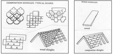
- The following roofing materials are prohibited for all types of buildings:
- High profile standing seam metal roof (Figure 14.115-4); and
- Brightly colored roofing material.
Figure 14.115-4: Low (3/8” x 1”) and High (1/4” x 1-1/4”) Roof Seams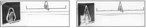
- Roofing materials shall be gray, brown, black, deep red, or another subdued color.
- Buildings shall be constructed or reconstructed with one of the following roofing materials.
- Roof Form Standards for Non-Industrial Uses. Buildings for non-industrial uses shall include one of the following roof forms:
- Single gable with low pitch; or
- Repetitive gable with steep pitch; or
- Flat or gable roof behind parapet wall (Figure 14.115-5).
Figure 14.115-5: Non-Industrial Building, Flat Roof Behind Parapet Wall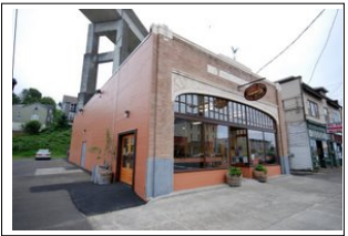
- Roof Materials Standards for Non-Industrial Uses. Buildings for non-industrial uses shall be constructed or reconstructed with one of the following roofing materials:
- Materials cited in Section 14.115.C.2; or
- Built-up roofing materials.
- Roof Form Standards for Industrial Uses. Buildings for industrial uses shall include the following roof forms:
- Single gable with low pitch; or
- Repetitive gable with steep pitch (Figure 14.115-6 and Figure 14.115-7); and
- Shallow eaves (Figure 14.115-7).
Figure 14.115-6: Roof Pitches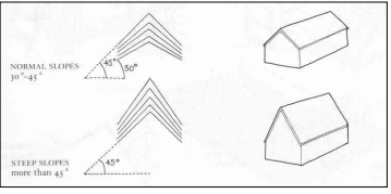
Figure 14.115-7: Industrial Building, Multiple Gables, Monitor Roof, and Shallow Eaves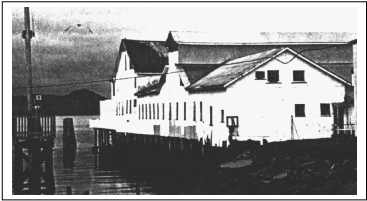
- Roof Materials Standards for Industrial Uses. Buildings shall be constructed or reconstructed with one of the following roofing materials:
- Materials cited in Section 14.115.C.2; or
- Galvanized corrugated metal; or
- Low profile standing seam, metal roof (Figure 14.115-4); or
- Roll down.
- Roof Form Guidelines for Non-Industrial Uses. Buildings for non-industrial uses may also include the following roof forms or features:
- Structural skylights
- Shallow eaves behind parapet wall
- Roof Form Guidelines for Industrial Uses. Buildings for industrial uses may also include one or more of the following roof forms or features:
- Small shed roof dormers
- Monitor roof on ridge line (Figure 14.115-7)
- Flat panel skylights or roof window
- Roof Form Standards for All Uses. The following roof forms are prohibited:
- Doors.
- Standards for All Uses. The following types of doors and door treatments are prohibited:
- Automatic sliding doors;
- Primary entry doors raised more than three feet above sidewalk level;
- Doors flush with building facade;
- Clear anodized aluminum frames; and
- Reflective, opaque, or tinted glazing.
- Guideline for All Uses. Building lighting should emphasize entrances.
- Standards for Non-Industrial Uses.
- Solid metal or wood doors with small or no windows are prohibited.
- Doors with a minimum of 50% of the door area that is glass are required.
- Guidelines for Non-Industrial Uses.
- Doors should be recessed when feasible (Figures 14.115-8 and 14.115-9).
- Large cafe or restaurant doors that open the street to the interior by pivoting, sliding, or rolling up overhead are encouraged (Figure 14.115-8).
- Well-detailed or ornate door hardware is encouraged (Figure 14.115-9). Contemporary hardware should be compatible with the design of the door.
- Transom, side lites, or other door/window combinations are encouraged (Figure 14.115-9).
- Doors combined with special architectural detailing are encouraged.
- Double or multiple door entries are encouraged (Figure 14.115-9).
Figure 14.115-8: Roll-Up Doors and Recessed Doors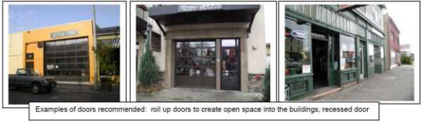
Figure 14.115-9: Recessed Doors, Contemporary Door Hardware, Single/Double Doors, Side Lites, and Transom Windows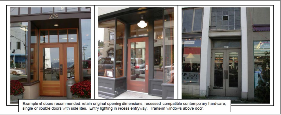
- Standards for All Uses. The following types of doors and door treatments are prohibited:
- Windows.
- Coverage Standards for All Uses. All building facades visible from a public right-of-way and/or the River Trail shall have windows or other openings in the facade. Blank walls on any facades visible from the right-of-way and/or River Trail for any type of use are prohibited.
- Design Standards for All Uses.
- Window detailing. Windows shall have casings/trim, sills, and crown moldings. Window detailing shall meet the following requirements.
- Casings/trim shall have minimum dimensions of 5/4 inch x 4 inch and shall extend beyond the facade siding.
- Windows shall be recessed a minimum distance of two (2) inches from the trim surface to ensure a shadow line/effect.
- The bottom of the sill shall be a minimum of 18 inches above the ground or floor elevation.
Figure 14.115-10: Window Detailing – Trim and casement location and dimensions
- Casings/trim shall have minimum dimensions of 5/4 inch x 4 inch and shall extend beyond the facade siding.
- The following types of windows or window treatments are prohibited:
- Residential-styled window bays;
- Half-round windows;
- Tinted and/or reflective glass;
- Sliding windows;
- Vinyl windows; and
- Blocked-out windows; and
- Windows that extend beyond the plane of the building facade.
- Window detailing. Windows shall have casings/trim, sills, and crown moldings. Window detailing shall meet the following requirements.
- Design Guidelines for All Uses.
- Windows, including transoms on existing buildings, should retain their original size and location as part of renovation activities.
- Windows that open by pivoting, casement, single hung, or other shuttering are encouraged.
- Painted wood or stucco panels or tile clad panels below windows are encouraged (Figure 14.115-11).
- Clear glass is encouraged.
- True divided lites are encouraged (Figure 14.115-11). Simulated divided lites shall have exterior muntins to create exterior shadow lines.
- Boldly articulated window and storefront trim are encouraged.
Figure 14.115-11: Transom Windows, Panels Below Windows, and True Divided Lites
- Coverage Standards for Non-Industrial Uses.
- In the Pedestrian-Oriented District. In the Pedestrian-Oriented District (Figure 14-090.2) and adjacent to the River Trail, at least 50% of the ground-floor street-facing facades of non-industrial uses shall be covered by windows and at least 30% of the upper-floor street-facing facades should be covered by windows.
- Outside Pedestrian-Oriented District. Outside the Pedestrian-Oriented District, at least 40% of the ground-floor facing facades of non-industrial uses visible from a right-of-way or River Trail shall be covered by windows and at least 30% of the upper-floor facades visible from a right-of-way should be covered by windows, except as follows:
- At least 20% of the ground-floor facades and 10% of the upper-floor facades of non-industrial uses north of River Trail visible from the Columbia River shall be covered by windows.
- An exception to the window coverage standard may be allowed for a portion of a building facade with the inclusion of architectural detail / design features in amounts equal to the minimum window coverage requirement. Such architectural details shall include but not be limited to a change in material, horizontal projections, engaged columns or pilasters, belt course, moldings, clock, or other similar features. (Section 14.115.E.4.b amended by Ord 19-06, 7-1-2019)
- Coverage Standards for Industrial Uses.
- All building facades of buildings for industrial uses in the Bridge Vista Overlay Zone that are visible from a public right-of-way and/or River Trail shall have windows. However, buildings for industrial uses are not subject to minimum window area requirements.
- Buildings for industrial uses are not required to have ground floor windows but shall have, at the least, clear story or transom windows on the upper story facades or above a height of 14 feet.
- Siding and Wall Treatment.
- Standards for All Uses. The following types of siding and wall materials and treatments are prohibited:
- Cladding materials such as corrugated metal panels or spandrel glass;
- Panels that are poorly detailed or do not have detailing;
- Neon or other fluorescent colors;
- Bright or primary wall colors for the entire wall surface;
- Flagstone, simulated river rock, or other similar veneer cladding;
- Painted brick; and
- Non-durable materials such as synthetic stucco or shingles at the ground floor.
- Guidelines for All Uses.
- Variations in wall cladding materials and patterns consistent with historic patterns are encouraged (Figure 14.115-12).
- Natural or subdued building colors are encouraged (Figure 14.115-12).
- Bright colors may be used for accent trim in limited amounts.
- Durable materials such as brick, stucco, granite, pre-cast concrete, board and batten, or horizontal wood siding should be used (Figure 14.115-12). These materials include galvanized corrugated metal on buildings for industrial uses.
- Architectural wall features such as belt courses, pilasters, and medallions are encouraged.
Figure 14.115-12: Siding Variety and Compatible Materials and Colors
- Variations in wall cladding materials and patterns consistent with historic patterns are encouraged (Figure 14.115-12).
- Standards for All Uses. The following types of siding and wall materials and treatments are prohibited:
- Awnings.
- Standards for Types of Awnings and Treatments. The following types of awnings and awning treatments are prohibited:
- Fixed “bubble shaped” awnings (Figure 14.115-13); and
- Awnings lit internally.
- Awnings improperly sized for the building/entry/window (Figure 14.115-13).
- Guidelines for Types of Awnings and Treatments. The following types of awnings and awning treatments are discouraged:
- Vinyl or other non-compatible material awnings (Figure 14.115-13).
Figure 14.115-13: Prohibited and Discouraged Awning Types and Treatments
- Vinyl or other non-compatible material awnings (Figure 14.115-13).
- Standards for Awning Locations Along River Trail and North/South Rights-of-Way. Awnings are generally discouraged and shall not project into the setback and/or stepback areas. (Section 14.115.G.3 amended by Ord 19-06, 7-1-2019)
- Standards for Types of Awnings and Treatments. The following types of awnings and awning treatments are prohibited:
- Lighting.
- Standards for Lighting Types and Treatments for All Uses. The following lighting types or treatments are prohibited:
- Neon silhouette accent lighting;
- Fluorescent tube lighting;
- Security spotlight;
- Signs lit by lights containing exposed electrical conduit, junction boxes, or other electrical infrastructure; and
- Up-lighting that shines into the sky or light that shines into other properties or traffic.
- Standards Regarding Glare for All Uses. All uses shall comply with applicable lighting standards in Section 3.128. (Section 14.115.H.2 amended by Ord 19-05, 6-17-2019)
- Guidelines Regarding Wall-Washing Light. Wall-washing lighting fixtures should be concealed and integrated into the design of buildings or landscape walls and stairways (Figure 14.115-14).
Figure 14.115-14: Downward and Diffused Lighting, Wall-Washing Lighting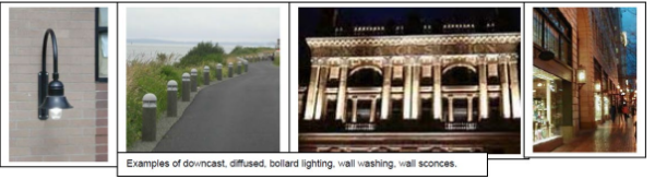
- Standards for Lighting Types and Treatments for All Uses. The following lighting types or treatments are prohibited:
- Signs. Signs in the Bridge Vista Overlay Zone are subject to the requirements in Article 8 (Sign Regulations) of the Astoria Development Code. The following additional standards apply to signs in the Pedestrian-Oriented District. (Section 14.115.I amended by Ord 19-06, 7-1-2019)
- Monument signs (Figure 14.115-15) are allowed up to a maximum of 32 square feet.
- Monument signs shall be a maximum of five (5) feet tall.
- Monument signs shall be constructed from materials that are consistent with the historic character of the area, including wood, brick, stone, and metal.
- Freestanding pole-mounted signs are prohibited (Figure 14.115-15).
Figure 14.115-15: Monument Signs and Freestanding Pole-Mounted Signs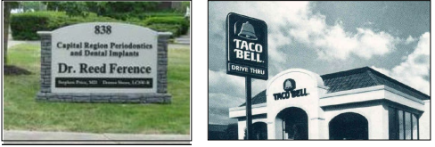
(Section 14.115 added by Ord 15-03, 6-15-15)
Amended by Ord. 22-01 on 11/7/2022
14.120 LANDSCAPING
Landscaping is required in the Bridge Vista Overlay Zone in accordance with the provisions in this Section and those in Section 3.120 to 3.125. The provisions in this Section apply to new construction or exterior renovations with a value of at least 33% of the assessed value of the structure,.
- River Side and/or Riparian Standards. The following standards apply to landscaping on the river side of the River Trail and to riparian areas to the south of the River Trail. Riparian area is defined as the landward limit of Columbia River aquatic vegetation or, where aquatic vegetation is absent, the Mean Higher High Water. (Section 14.120.A amended by Ord 19-06, 7-1-2019)
- Height and Spacing.
- Maximum shrub height is 30 inches.
- Maximum width of clusters of trees is 30 feet.
- Clusters of trees shall have a minimum of 50 feet clear between branches at maturity.
- Trees are not permitted to be planted on the river side of the River Trail within the extended public right-of-way or view corridor extending from it for a distance of 70 feet centered on the right-of-way centerline.
- Trees shall not exceed 25 feet in height at maturity
- Maximum height of fences is three (3) feet.
Figure 14.120-1: River Side/Riparian Landscaping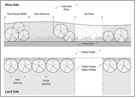
- Native Plants. See Section 3.125 concerning use of native plants and list of recommended native plants.
- Landscaping Credits for Non-Vegetation Features.
- The Community Development Director may approve non-vegetative features to account for up to 40% of required landscaping when the features consist of hardscaped pedestrian-oriented areas (e.g., courtyards, plazas). Permeable paving and other stormwater management techniques are encouraged in the design of these areas.
- An application proposing more than 40% of required landscaping be credited by non-vegetative features is subject to approval in accordance with procedures in Article 9 and Article 12.
- Non-vegetative features allowed in the public right-of-way and/or on the River Trail in lieu of required landscaping shall be maintained by the applicant. There shall be a maintenance agreement or other City approved agreement. Failure to maintain or loss of the non-vegetative feature will result in the requirement for installation of the landscaping in accordance with the Code at the time of the loss.
- Height and Spacing.
- Land Side or Upland Standards. The following standards apply to landscaping along the frontage of parcels abutting the River Trail to the south except where riparian areas are located to the south of the River Trail. Riparian areas are subject to the standards of Section 14.120.A. (Section 14.120.B amended by Ord 19-06, 7-1-2019)
- Height and Spacing.
- Maximum spacing of trees.
- 20 feet on center for non-industrial uses
- 15 feet on center for industrial uses
- Maximum spacing of shrubs
- Five (5) feet on center for non-industrial uses
- Three (3) feet on center for industrial uses
- Ground cover landscaping is required in between shrubs and trees.
- Trees shall not exceed 35 feet in height at maturity
Figure 14.120-2: Land Side Landscaping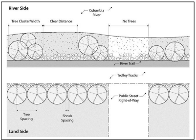
- Maximum spacing of trees.
- Parking Area Landscaping.
- Landscaping required between parking areas, streets, and sidewalks in accordance with Section 3.120.A.7 shall also be required between parking areas and the River Trail.
- Landscaping shall minimize pedestrian exposure to parking lots with a hedge or a decorative fence that is 36” to 42” high.
- Maximum tree height and width in parking areas shall be 15 feet at maturity.
- Landscaping required between parking areas, streets, and sidewalks in accordance with Section 3.120.A.7 shall also be required between parking areas and the River Trail.
- Landscaping Credits for Non-Vegetation Features.
- The Community Development Director may approve non-vegetative features to account for up to 25% of required landscaping when the features consist of the following:
- Hardscaped pedestrian-oriented areas (e.g., courtyards, plazas); and/or
- At least one of the following amenities meeting the City approved design within the public right-of-way and/or River Trail right-of-way:
- bike rack
- bench
- table
- drinking fountain
- directional or interpretive/information signage
- trash or recycling container
- lighting
- restroom
- An application proposing more than 25% of required landscaping be credited by non-vegetative features is subject to approval in accordance with procedures in Article 9 and Article 12.
- Non-vegetative features allowed in the public right-of-way and/or on the River Trail in lieu of required landscaping shall be maintained by the applicant. There shall be a maintenance agreement or other City approved agreement. Failure to maintain or loss of the non-vegetative feature will result in the requirement for installation of the landscaping in accordance with the Code at the time of the loss.
- The Community Development Director may approve non-vegetative features to account for up to 25% of required landscaping when the features consist of the following:
- Height and Spacing.
- Street Trees. Street trees shall be planted within the right-of-way along both sides of the street in the Bridge Vista Overlay Zone in accordance with the provisions in this Section.
- Spacing should be 30 feet on center, depending on species and branching habit.
- Minimum size of deciduous trees should be 2" caliper, with an upright form.
- Mature branching height should be a minimum of 15 feet.
- Maximum height for street trees along north-south streets between West Marine Drive / Marine Drive and the Columbia River is 35 feet. (Section 14.120.C.4 amended by Ord 19-06, 7-1-2019)
- Street trees along north-south streets between West Marine Drive / Marine Drive and the Columbia River shall have narrow profiles and/or be pruned to a maximum width of 15 feet.
- Street trees along north-south streets between West Marine Drive / Marine Drive and the Columbia River shall be one of the columnar species listed in Section 3.125.B.1, unless otherwise approved by the Community Development Director.
- Durable tree grates and trunk protectors should be installed.
- Areas between trees should be landscaped with a variety of shrubs and perennials, with an emphasis on flowering species.
- Required street trees shall be maintained by the adjacent property owner and/or other identified entity. There shall be a maintenance agreement or other City approved agreement.
(Section 14.120 added by Ord 15-03, 6-15-15)
Amended by Ord. 22-01 on 11/7/2022
14.122 OFF-STREET PARKING
In the Pedestrian-Oriented District in the Bridge Vista Overlay Zone (Figure 14.090-2), the following provisions apply to parking requirements established in Article 7 of this Code.
(Section 14.122 renumbered from 14.125 by Ord 19-14, 10-21-2019)
- Reductions. Minimum parking space requirements in Section 7.100 may be reduced by 50% for uses with less than 5,000 square feet of gross floor area.
- Exemptions. Exemptions from minimum parking space requirements in Section 7.100 are permitted under the following conditions:
- Existing buildings that cover the maximum area of the site allowable
- Building expansions of 10% or less.
14.125 PORT OF ASTORIA WEST MOORING BASIN PLAN DISTRICT
A. Purpose
The West Mooring Basin Plan District provides for a unique level of mixed-use development including commercial, employment, institutional, and recreational uses. The purpose of the plan district is to implement the principles and enable the framework shown in the "Port of Astoria Waterfront Master Plan" (2022). Objectives of the plan district include encouraging on-land development appropriate for the riverfront setting and preserving unique resources. Where they conflict, allowances and limitations of the plan district take precedence over those of the base and overlay zones.
B. Plan District Boundary
The Property situated approximately between Portway Avenue to the west, Bay Street to the east, pierhead line to the north, and West Marine Drive to the south, shall constitute a subarea within the Bridge Vista Overlay Zone. This area is known as the Port of Astoria West Mooring Basin Plan District.
The over-water area within the Plan District shall not be subject to
Figure 14.125-1: West Mooring Basin Plan District Boundaries
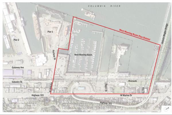
changes from the approved Bridge Vista Overlay uses, standards, and/or requirements. The boundaries of the Port of Astoria West Mooring Basin Plan District are illustrated on a map referenced below.
C. Applicability
The following development standards apply to all new construction or major renovation, where "major renovation" is defined as construction valued at 25% or more of the assessed value of the existing structure. The Bridge Vista Overlay standards and requirements shall be applicable unless otherwise noted in the Plan District standards.
D. Procedures
An application for a specific project within the Plan District is processed as a Type III review as described in Section 9.010 and in accordance with the Development Code.
E. Uses
The following uses and activities and their accessory uses and activities are permitted or conditional for on-land development in any zone within the West Mooring Basin Plan District unless noted. These uses are in addition to those permitted uses in the base zone, as identified in Article 2, and subject to the other appropriate development provisions of this Section. Prohibitions described in Section 14.095.B and 14.110 apply.
- Uses Permitted Outright
- Retail Sales Establishment
- Eating and Drinking Establishment (without drive through)
- Business Service Establishment
- Professional Service Establishment
- Personal Service Establishment
- Manufacturing or light industrial, except within the Pedestrian-Oriented District
- Replacement hotel referenced in Sections 14.095.B.6 and 14.110.C.6
F. Development Standards
The following development standards apply to on-land development in the West Mooring Basin Plan District. Unless otherwise noted, all other standards and guidelines of the base zone and/or Bridge Vista Overlay Zone are applicable.
1. Building Height
- Maximum 40 feet allowed for all development within the Plan District
- Maximum 28 feet in the "Fishing Village" subarea of the Plan District. See Section 14.125.F.6.
- Maximum 60 feet for replacement of a hotel. A replacement hotel is a hotel facility that existed prior to 2013, as allowed by Sections 14.095.B.6 and 14.110.C.6.
2. Building Size
Notwithstanding the provisions of Section 14.113.D there is no limit on the square footage of a proposed building so long as it meets dimensional standards for height and setbacks, except within the Fishing Village subarea,
3. Building Orientation
Notwithstanding the provisions of Section 14.113.E there are no restrictions on the orientation of buildings.
4. Building Separation
Notwithstanding the provisions of Section 14.113.B.3 buildings on the same lot shall have no minimum required setbacks between building, except within the Fishing Village subarea. River Trai setbacks still apply.
5. Lot coverage
Notwithstanding the provisions of Section 14.113.F, there is no restriction on lot coverage.
6. View Corridors
a. Fishing Village View Corridors
Additional development restrictions apply to the "Fishing Village" area of the Plan District, as described in Section 14.125. This subarea is situated among the south end of the West Mooring Basin approximately between Port of Astoria "E" Dock to the west, Port of Astoria "A" Dock to east, the southern edge of the West Mooring Basin Boat Docks to the north, and Industry Street to the south, shown in Figure 14.125-2. This property shall constitute a subarea within the West Mooring Basin Plan District called the Fishing Village. The east-west width of the Fishing Village is approximately 530 feet.
Figure 14.125-2: Fishing Village Boundaries
Additional restrictions in the "Fishing Village" are intended to create view corridors from the River Trail toward the marina and Columbia River, and allow smaller-scale development consistent with the Port of Astoria Waterfront Master Plan, Within this sub-area the following standards apply.
A minimum of 200 feet of unobstructed view corridor shall be preserved along the east-west dimension of the Fishing Village area. The cumulative width of structures along the east-west dimension in the Fishing Village area shall not exceed 330 feet. The precise location of view corridors between buildings may vary, as long as a cumulative minimum of 200 feet of open views is maintained toward the marina and River.
b. Bay Street View Corridor
A minimum view corridor width of 50 feet shall be established, centered on the Bay Street right of way, between West Marine Drive and the Columba River pierhead. This corridor shall be free of structural encroachments, per the definition in Section 14.001.
Figure 14.125-3: Bay Street View Corridor
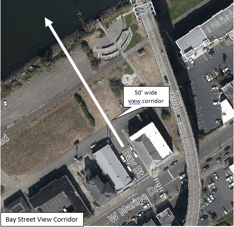
(Section 14.125 added by Ord 19-14, 10-21-2019)
Amended by Ord. 23-05 on 10/2/2023
14.127 ASTORIA WAREHOUSING PLAN DISTRICT
The property situated approximately between Columbia Avenue to the west, 1st Street to the east, the top of bank to the north, and West Marine Drive to the south, shall constitute a subarea within the Bridge Vista Overlay Zone. The purpose of this subarea is to permit adoption of development standards, known as a Plan District, not applicable to other properties in the Bridge Vista Overlay Zone. If approved under the criteria of Section 14.127.A, the Plan District shall be known as the Astoria Warehouse Plan District.
- Plan District Adoption Criteria. A Plan District may be established if all the following adoption criteria are met:
- The area proposed for the Plan District has special characteristics or problems of a natural, economic, historic, public facility, or transitional land use or development nature which are not common to other areas of the Bridge Vista Area. Economic viability of a project alone shall not be deemed as justification for the proposed modifications;
- Existing base and overlay zone provisions limited to those identified in Section 14.127.D are inadequate to achieve a desired public benefit as identified by the City Council, and/or to address identified needs or problems in the area;
- The proposed Plan District and regulations result from a Plan documenting the special characteristics or problems of the area and explain how a Plan District will best address relevant issues; and
- The regulations of the Plan District conform with the Comprehensive Plan and do not prohibit, or limit uses or development allowed by the base zone without clear justification.
- Review.
- Sunset Clause. Application to establish the Astoria Warehousing Plan District shall occur no later than January 1, 2025. If an application is not received by that date, the Planning Commission shall re-evaluate the appropriateness and/or need for a Plan District as noted in Sections 14.127. Any changes and/or the elimination of this section shall be processed as a legislative text amendment in accordance with Development Code Articles 9 and 10.
- After Adoption of District. After adoption of Astoria Warehousing Plan District regulations, the Planning Commission shall review the Astoria Warehousing Plan District and its regulations every five years to determine the impacts on development, the usefulness and usability of the regulations, and the public need for any amendments to the regulations.
- Mapping. The boundaries of the Astoria Warehousing Plan District are illustrated on a map referenced below and generally are described as the land area north of West Marine Drive between Columbia Avenue and 1st Street. The over-water area within the Plan District shall not be subject to changes from the approved Bridge Vista Overlay uses, standards, and/or requirements. The boundaries may be refined as part of the Plan District adoption or amendment.
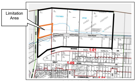
Figure 14.090-1: Limitation Area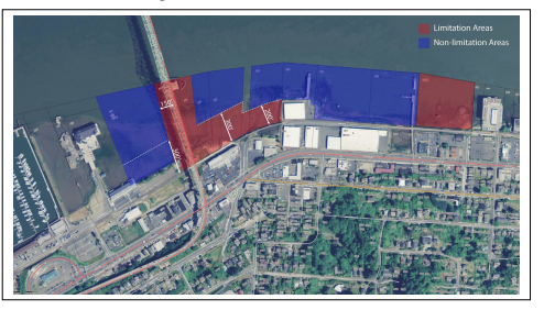
- Standards. The standards for the on-land area within the Astoria Warehousing Plan District may expressly change and vary from those applicable under the Bridge Vista Overlay Zone and those of the base zone. The over-water area within the Plan District shall not be subject to changes from the approved Bridge Vista Overlay uses, standards, and/or requirements. Such on-land changes may include:
- Adding or deleting uses;
- Changes to building height limits / stepbacks up to a maximum of 35’ high;
- Setback modifications. No reduction in view corridors shall be allowed;
- Building size and permissible footprint.
- “Limitation Areas” shall remain as “Limitation Areas” with the existing standards.
- Application Procedure.
- An application to establish the Astoria Warehousing Plan District shall be processed through the following procedures:
- The City or property owner/owners within the Plan District may apply to establish development regulations that affect one or more properties within the Astoria Warehousing Plan District.
- An application to establish regulations that would govern development within the Astoria Warehousing Plan District is a legislative text amendment processed in accordance with the procedures established in Section 14.127 and in Development Code Articles 9 and 10.
- An application to establish the boundaries of the Astoria Warehousing Plan District Overlay area is a legislative map amendment processed in accordance with the procedures established in Section 14.127 and in Development Code Articles 9 and 10 and may be processed concurrently with applications under subsection E.1.a.
- The application shall include a master plan for the site along with written justification for the need to establish the Plan District and the specific proposed code modifications. Economic viability of a project alone shall not be deemed as justification for the proposed modifications.
- An application to apply the Astoria Warehousing Plan District regulations to a specific project shall be processed through the following procedures:
- The property owner shall be the applicant or co-applicant on all applications.
- An application shall be processed as a quasi-judicial permit in accordance with the procedures established with the Plan District adoption and in accordance with the Development Code as applicable.
- An application to establish the Astoria Warehousing Plan District shall be processed through the following procedures:
(Section 14.127 added by Ord 19-14, 10-21-2019)
14.128 To 14.129 ASTORIA WAREHOUSING PLAN DISTRICT REGULATIONS (RESERVED)
(Reserved for codifying future Plan District regulations.)
(Section 14.128 and 14.129 added by Ord 19-14, 10-21-2019)
14.130 PURPOSE
The purpose of the Neighborhood Greenway Overlay Zone is to implement the land use principles of the Astoria Riverfront Vision Plan, dated December 2009, as they pertain to the Neighborhood Greenway Plan Area. The Neighborhood Greenway Overlay (NGO) Zone is intended to protect views of and access to the Columbia River, provide for an enhance open space and landscaping, support limited water-dependent uses consistent with Astoria’s working waterfront. The NGO Zone extends from approximately 41st Street to the east side of Alderbrook neighborhood at approximately 54th Street and between Lief Erikson Drive and the pier head line of the Columbia River as depicted on the City’s Zoning Map.
(Section 14.130 added by Ordinance 15-09, 12-7-2015)
14.131 APPLICABILITY AND REVIEW PROCEDURES
The provisions of the Neighborhood Greenway Overlay Zone shall apply to all new construction or major renovation, where “major renovation” is defined as construction valued at 33% or more of the assessed value of the existing structure, unless otherwise specified by the provisions in this Ordinance.
Review of applications in the Neighborhood Greenway Overlay Zone is subject to the administrative procedures and approval of the Community Development Director established in Article 9.
- Residential Development Exception. These standards shall not apply to single-family, two-family dwellings, and Accessory Dwelling Units. (Section 14.131.A amended by Ordinance 21-02, 2-16-21)
- Residential Development. Applications for multi-family dwellings may be reviewed administratively subject to the Design Review Standards in Section 14.134 or through the public design review process subject to the Design Review Guidelines in Section 14.135. Any deviation from the standards in Section 14.065 require the complete application to be reviewed through the public design review process. (Section 14.131.B amended by Ord 19-06, 7-1-2019)
- Non-Residential and Mixed-Use Development. Applications shall be reviewed through the public design review process subject to the Design Review Guidelines in Section 14.135.
- Historic Design Review. When a development proposal is required to be reviewed by the Historic Landmarks Commission due to its proximity adjacent to a designated historic building, structure, site, or object, or is an identified Historic Landmark, the Historic Landmarks Commission shall include review of the Civic Greenway Overlay sections.
Amended by Ord. 22-01 on 11/7/2022
14.132 ALLOWABLE USES FOR OVERWATER DEVELOPMENT
Outright and Conditional uses within the Neighborhood Greenway Overlay Zone shall be limited to allowable uses in the A-4 Zone (Aquatic Natural) with the following exceptions:
- In pile supported buildings existing prior to October 1, 2002, non-water-dependent or non-water-related uses as follows are allowed as a conditional use:
- Arts and crafts studios.
- Bed and breakfast, home stay lodging (which satisfies requirements in City Code Sections 8.750 to 8.800), or inn. (Section 14.132.A.2 amended by Ord 19-07, 7-1-2019)
- Home occupation.
- Professional and business office, personal service establishment limited to beauty and barber services and garment alterations.
- Residential home.
- Single-family dwelling.
- Two-family dwelling.
- Multi-family dwelling.
- Off-street parking requirements for the above uses may be located in the upland zone adjacent to the use. The Planning Commission may impose additional landscape buffering to protect the adjacent residential uses.
- Accessory Dwelling Unit. (Section 14.132.1.j added by Ordinance 21-02, 2-16-21)
(Section 14.132 added by Ordinance 15-09, 12-7-2015)
14.133 STANDARDS FOR OVERWATER DEVELOPMENT
The following development standards apply to overwater development in the Neighborhood Greenway Overlay Zone. The Overwater Development standards shall also apply to on-land development north of the River Trail between 41st Street and approximately 54th Street.
Maintenance, repair, or restoration of buildings existing prior to 2002 (See Section 2.585.N and 14.132.1) shall be exempt from the standards of this Section. Additions and/or new construction on these buildings shall be subject to these standards. (Section 14.133 amended by Ord 19-06, 7-1-2019)
- Height.
- Maximum building height, except hand rails, shall be the top of the existing adjacent riverbank. No variance may be granted for an exception to this height limitation.
Figure 14.133-1: Maximum Building Height
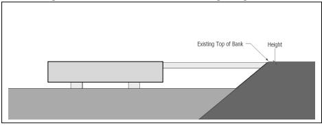
- Maximum building height, except hand rails, shall be the top of the existing adjacent riverbank. No variance may be granted for an exception to this height limitation.
- Width. The maximum width of an overwater structure is 25% of the total parcel width (measured along the parcel frontage adjacent to the Columbia River) or 50 feet, whichever is smaller. In cases where total parcel width is 100 feet or less, the structure width may be up to 25 feet.
Figure 14.133-2: Maximum Building Width
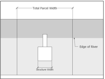
(Section 14.133 added by Ordinance 15-09, 12-7-2015)
14.134 RESIDENTIAL DEVELOPMENT DESIGN STANDARDS
- Applicability.
- Residential.
- Single-family, two-family dwellings, and Accessory Dwelling Units are not subject to the design standards. (Section 14.134.A.1.a amended by Ordinance 21-02, 2-16-21)
- Multi-family dwellings proposed in the Neighborhood Greenway Overlay Zone may be reviewed in accordance with one of two review options:
- Applications in compliance with Multi-Family Development Design Standards of Section 14.134 shall be reviewed pursuant to procedures for administrative review by the Community Development Director established in Article 9 unless the applicant requests review through the City’s Design Review Committee pursuant to design review guidelines in Section 14.135; or
- If a multi-family development applicant requests review through the City’s Design Review Committee process, applications shall be reviewed in accordance with the Residential Development Design Guidelines of Section 14.135 and shall be reviewed pursuant to design review procedures in Article 9 and 14.
- Non-Residential. Non-residential uses may be reviewed pursuant to procedures for administrative review by the Community Development Director established in Article 9; or they may be reviewed pursuant to the Residential Development Design Guidelines of Section 14.135 and design review procedures in Article 9 and 14. The applicant shall have the option to choose between these two options.
- Figures. Figures included in Section 14.133 through 14.135 are included for illustrative purposes only and are not intended to be regulatory in and of themselves. If there is an inconsistency between the Figure and the Development Code text, the text shall prevail.
- Residential.
- Design Standards.
- Building Forms.
- All buildings shall be based on a rectangular or square form.
- All multi-family dwelling unit buildings shall have a front porch, at least six (6) feet deep and 60 square feet in area.
- Window Design. The following design standards apply to all facades.
- Windows required. All facades facing a right-of-way, River Trail, or common open space shall have windows.
- Window area. Window area shall cover a minimum of 30% of all street-facing facade areas and shall not exceed 50% of street-facing facade areas.
Figure 14.134-1: Window Area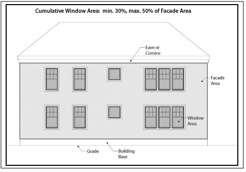
- Window lites. Window lite design shall be one of the following:
- Single-lite windows; or
- Multiple-lite true-divided windows; or
- Combination of single and multiple-lite true-divided windows; or
- Applied muntins with profile facing window exterior.
Figure 14.134-2: Window Lites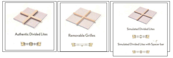
- Windows shall be fixed or open in one of the following configurations:
- Fixed window; or
- Single-hung windows; or
- Double-hung windows; or
- Awning or hopper windows; or
- Casement windows.
Figure 14.134-3: Fixed and Opening Windows
- Window shape. Window shape shall be one of the following:
- Vertical rectangle; or
- Square.
- Arched or decorative windows are permitted but should not exceed more than 30% of the total window coverage on all facades of the building.
Figure 14.134-4: Window Shapes
Vertical rectangular window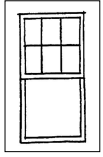
Examples of arched or decorative windows
- Window detailing. Windows shall have casings/trim, sills, and crown moldings. Window detailing shall meet the following requirements.
- Casings/trim shall have minimum dimensions of 5/4 inch x 4 inch and shall extend beyond the facade siding.
- Windows shall be recessed a minimum distance of two (2) inches from the trim surface to ensure a shadow line/effect.
Figure 14.134-5: Window Detailing – Trim and casement location and dimensions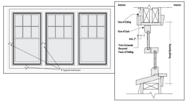
- Window design prohibited. The following window design features are prohibited.
- Applied muntins that have no profile.
- Smoked, tinted, or frosted glass, except for bathroom windows not on the street-facing facade.
- Mirrored glass.
Figure 14.134-6: Window Design Prohibited
Muntins with no profile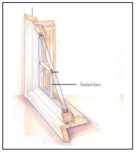
- Exterior Wall Treatments and Materials.
- A minimum of 80% of exterior walls shall be constructed of one or more of the following sets of treatments and materials.
- Drop siding; or
- Weatherboard siding; or
- Clapboard; or
- Rectangular wood shingle or shake; or
- Decorative wood shingle or shake; or
- Board and batten.
- Horizontal siding shall have six inches or less exposure.
- Vertical board and batten shall have true battens.
Figure 14.134-7: Exterior Walls – Permitted Materials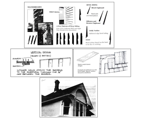
- Paneled material shall be applied in a manner which avoids the occurrence of seams along the wall plane. Where seams cannot be avoided, they shall be located in a manner that relates logically to windows and other architectural features of the facade. Horizontal seams shall be covered by a trim board or cornice piece.
Figure 14.134-8: Exterior Walls – Seam Treatment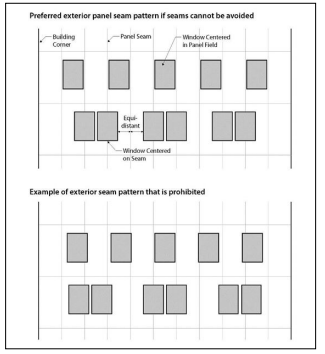
Figure 14.134-9: Exterior Walls – Horizontal Seam Treatment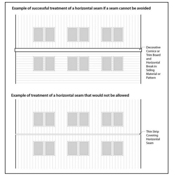
- Exterior wall treatments and materials prohibited. The following types of treatments and materials are prohibited.
- Exposed textured concrete block.
- Flagstone or other applied stone products.
- Precast concrete or decorative concrete panels.
- Plywood paneling.
Figure 14.134-10: Exterior Wall Treatments and Materials Prohibited
Textured concrete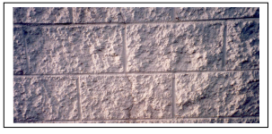
Applied stone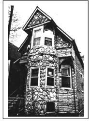
- A minimum of 80% of exterior walls shall be constructed of one or more of the following sets of treatments and materials.
- Roof Elements.
- Roof elements permitted. The following roof design elements are permitted.
- Dormers with gable, hip, or shed roofs.
- Flat panel skylights or roof windows on secondary elevations.
Figure 14.134-11: Roof Elements Permitted
Gabled, shed, and hipped dormers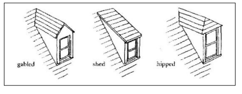
Flat panel skylights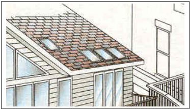
- Roof elements prohibited. The following roof design elements are prohibited.
- False mansard or other applied forms.
- Dome skylights.
Figure 14.134-12: Roof Elements Prohibited
False mansard roof
- Roof elements permitted. The following roof design elements are permitted.
- Signs. Signs are subject to the sign provisions in Section 8.040 and 8.160.
- Doors.
- Doors shall have at least one lite (glass) panel.
- Sliding doors are not permitted on the ground floor of the front facade.
- All materials are permitted.
- Metal or metal-clad doors shall be painted.
- Doors shall have at least one lite (glass) panel.
- Garage Doors. The following design standards apply to attached and detached garages:
- A minimum of 10% of each garage door shall be window panels, raised trim, or other architectural details.
Figure 14.134-13: Garage Doors Permitted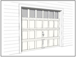
- A minimum of 10% of each garage door shall be window panels, raised trim, or other architectural details.
- Building Forms.
(Section 14.134 added by Ordinance 15-09, 12-7-2015)
14.135 DESIGN GUIDELINES
- Purpose. These guidelines promote architectural elements that unify the Neighborhood Greenway Area by encouraging styles characteristic of Astoria. The historic architecture of Astoria is represented by a variety of styles. Differences in details may be seen from one neighborhood to the next. These guidelines advocate the simplicity of design which is characteristic of Alderbrook and the working man’s neighborhood. Building styles and details not inspired by Astoria’s past will be discouraged but not prohibited. Monotony of design should be avoided. Variety of detail, form, and siting should be used to provide visual interest.
The Guidelines make reference to, but do not require the use of, historic materials. Contemporary substitutions (i.e. composite materials), will not be discouraged if their texture, profile, and proportions are similar to those materials with historic precedent.
As guidelines, the code provisions shall encourage or allow for design features or approaches that provide flexibility and discretion for the appropriate review body to interpret and apply the guidelines. - Design Review Process. All uses proposed in the Neighborhood Greenway Overlay Zone other than residential single-family, two-family dwellings, and Accessory Dwelling Units, or public utilities that are not located within an enclosed structure shall be reviewed in accordance with the design review guidelines of Section 14.135 pursuant to the design review procedures in Article 14. (Section 14.135.B amended by Ordinance 21-02, 2-16-21)
- Design Guidelines. The following design guidelines shall apply to multi-family dwelling development that does not comply with the design standards of Section 14.134 and/or all non-residential development except public utilities that are not located within an enclosed structure.
- Building Forms.
- All buildings should be based on a rectangular or square form.
- All multi-family dwelling unit buildings should have a front porch, at least six (6) feet deep and 60 square feet in area.
- Window Design. The following design guidelines apply to all facades.
- Windows required. All facades facing a right-of-way, River Trail, or common open space should have windows.
- Window area. Window area should be included on each level or story of the facade.
- Window lites. Window lite design should be one of the following:
- Single-lite windows; or
- Multiple-lite true-divided windows; or
- Combination of single and multiple-lite true-divided windows; or
- Applied muntins with profile facing window exterior.
Figure 14.135-1: Window Lites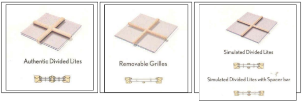
- Windows should be fixed or open in one of the following configurations:
- Fixed window; or
- Single-hung windows; or
- Double-hung windows; or
- Awning or hopper windows; or
- Casement windows.
- Sliding windows may be used on non-residential structures in commercially zoned properties.
Figure 14.135-2: Fixed and Opening Windows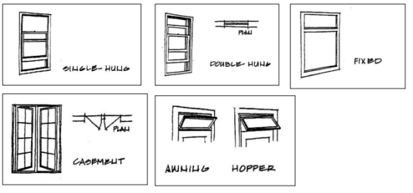
- Window shape. Window shape should be one of the following:
- Vertical rectangle; or
- Square.
- Arched or decorative windows are permitted but should make up a relatively small percentage of all windows in the structure.
Figure 14.135-3: Window Shapes
Vertical rectangular window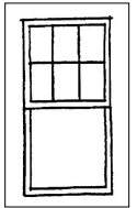
Examples of arched or decorative windows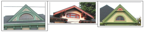
- Window detailing. Windows should have casings/trim, sills, and crown moldings. Casings and sills shall create a clear visible distinction and change in depth between the windows and surrounding facade.
- Window design discouraged. The following window design features are discouraged.
- Applied muntins that have no profile.
- Smoked, tinted, or frosted glass, except for bathroom windows not on the street-facing facade.
- Mirrored glass.
Figure 14.135-4: Window Design Discouraged
Muntins with no profile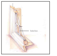
- Exterior Wall Treatments and Materials.
- Exterior walls should be constructed of one or more of the following sets of treatments and materials.
- Drop siding; or
- Weatherboard siding; or
- Clapboard; or
- Rectangular wood shingle or shake; or
- Decorative wood shingle or shake; or
- Board and batten.
- Fiber cement siding in the treatments noted above may be used but shall have a smooth, not textured, finish.
- Stucco may be used on non-residential structures in commercially zoned properties.
- Precast concrete or decorative concrete panels may be used on non-residential structures in commercially zoned properties.
- Horizontal siding should have six inches or less exposure.
- Vertical board and batten should have true battens.
Figure 14.135-5: Exterior Walls – Encouraged Materials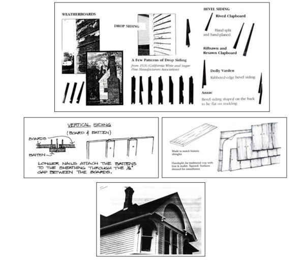
- Exterior wall treatments and materials discouraged. The following types of treatments and materials are discouraged.
- Exposed textured concrete block.
- Flagstone or other applied stone products.
- Precast concrete or decorative concrete panels, except on non-residential structures in commercially zoned properties.
- Plywood paneling.
Figure 14.135-6: Exterior Wall Treatments and Materials Discouraged
Textured concrete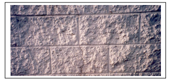
Applied stone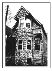
- Exterior walls should be constructed of one or more of the following sets of treatments and materials.
- Roof Elements.
- Roof elements encouraged. The following roof design elements are encouraged.
- Dormers with gable, hip, or shed roofs.
- Flat panel skylights or roof windows on secondary elevations.
Figure 14.135-7: Roof Elements Encouraged
Gabled, shed, and hipped dormers
Flat panel skylights
- Roof elements discouraged. The following roof design elements are discouraged.
- False mansard or other applied forms.
- Dome skylights.
Figure 14.135-8: Roof Elements Discouraged
False mansard roof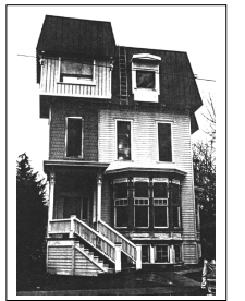
- Roof elements encouraged. The following roof design elements are encouraged.
- Signs. Signs are subject to the sign provisions in Development Code Article 8.
- Doors.
- Doors should have at least one lite (glass) panel except on non-residential structures in commercially zoned properties.
- Sliding doors are discouraged on the ground floor of the front facade except on non-residential structures in commercially zoned properties.
- All materials are permitted.
- Metal or metal-clad doors should be painted.
- Building Forms.
(Section 14.135 added by Ordinance 15-09, 12-7-2015)
14.137 OTHER DEVELOPMENT STANDARDS
- The following development standards are applicable within the Neighborhood Greenway Overlay Zone.
- Exterior lighting. All uses shall comply with applicable lighting standards in Section 3.128. (Section 14.137.A.1 amended by Ord 19-05, 6-17-2019)
- Fences. Fences located between the River Trail and the Columbia River shall not exceed a height of three (3) feet.
(Section 14.137 added by Ordinance 15-09, 12-7-2015)
14.138 LANDSCAPING
Landscaping is required in the Neighborhood Greenway Overlay Zone in accordance with the provisions in this Section and those in Section 3.120 to 3.125. The provisions in this Section apply to new construction or exterior renovations with a value of at least 33% of the assessed value of the structure..
- River Side and/or Riparian Standards. The following standards apply to landscaping on the river side of the River Trail and to riparian areas to the south of the River Trail. Riparian area is defined as the landward limit of Columbia River aquatic vegetation or, where aquatic vegetation is absent, the Mean Higher High Water.
- Height and Spacing.
- Maximum shrub height is 30 inches.
- Maximum width of clusters of trees is 30 feet.
- Clusters of trees shall have a minimum of 50 feet clear between branches at maturity.
- Trees are not permitted to be planted on the river side of the River Trail within the extended public right-of-way or view corridor extending from it for a distance of 70 feet centered on the right-of-way centerline.
- Trees shall not exceed 25 feet in height at maturity
- Maximum height of fences is three (3) feet.
Figure 14.138-1: River Side/Riparian Landscaping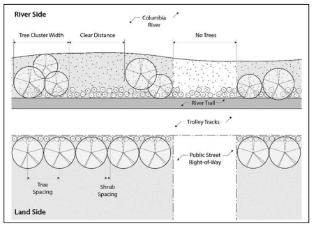
- Native Plants. See Section 3.125 concerning use of native plants and list of recommended native plants.
- Landscaping Credits for Non-Vegetation Features.
- The Community Development Director may approve non-vegetative features to account for up to 40% of required landscaping when the features consist of hardscaped pedestrian-oriented areas (e.g., courtyards, plazas). Permeable paving and other stormwater management techniques are encouraged in the design of these areas.
- An application proposing more than 40% of required landscaping be credited by non-vegetative features is subject to approval in accordance with procedures in Article 9 and Article 12.
- Non-vegetative features allowed in the public right-of-way and/or on the River Trail in lieu of required landscaping shall be maintained by the applicant. There shall be a maintenance agreement or other City approved agreement. Failure to maintain or loss of the non-vegetative feature will result in the requirement for installation of the landscaping in accordance with the Code at the time of the loss.
- Height and Spacing.
- Land Side or Upland Standards. The following standards apply to landscaping along the frontage of parcels abutting the River Trail to the south except where riparian areas are located to the south of the River Trail. Riparian areas are subject to the standards of Section 14.138.A.
- Height and Spacing.
- Maximum spacing of trees.
- Twenty (20) feet on center for non-industrial uses
- Fifteen (15) feet on center for industrial uses
- Maximum spacing of shrubs
- Five (5) feet on center for non-industrial uses
- Three (3) feet on center for industrial uses
- Ground cover landscaping is required in between shrubs and trees.
- Trees shall not exceed 35 feet in height at maturity
Figure 14.138-2: Land Side Landscaping
(Section 14.138.B.1 added by Ord 19-06, 7-1-2019)
- Maximum spacing of trees.
- Parking Area Landscaping.
- Landscaping required between parking areas, streets, and sidewalks in accordance with Section 3.120.A.7 shall also be required between parking areas and the River Trail.
- Landscaping shall minimize pedestrian exposure to parking lots with a hedge or a decorative fence that is 36” to 42” high.
- Maximum tree height and width in parking areas shall be 15 feet at maturity.
- Landscaping Credits for Non-Vegetation Features.
- The Community Development Director may approve non-vegetative features to account for up to 25% of required landscaping when the features consist of the following:
- Hardscaped pedestrian-oriented areas (e.g., courtyards, plazas); and/or
- At least one of the following amenities meeting the City approved design within the public right-of-way and/or River Trail right-of-way:
- bike rack
- bench
- table
- drinking fountain
- directional or interpretive/information signage
- trash or recycling container
- lighting
- restroom
- An application proposing more than 25% of required landscaping be credited by non-vegetative features is subject to approval in accordance with procedures in Article 9 and Article 12.
- Non-vegetative features allowed in the public right-of-way and/or on the River Trail in lieu of required landscaping shall be maintained by the applicant. There shall be a maintenance agreement or other City approved agreement. Failure to maintain or loss of the non-vegetative feature will result in the requirement for installation of the landscaping in accordance with the Code at the time of the loss.
- The Community Development Director may approve non-vegetative features to account for up to 25% of required landscaping when the features consist of the following:
- Street Trees. Street trees planted within the right-of-way along either side of the street in the Neighborhood Greenway Overlay Zone shall be planted in accordance with the provisions in this Section.
This Section shall apply to all street trees planted including those for single-family, two-family dwellings, and Accessory Dwelling Units. (Section 14.138.C amended by Ordinance 21-02, 2-16-21)- Spacing should be 30 feet on center, depending on species and branching habit.
- Minimum size of deciduous trees should be 2" caliper, with an upright form.
- Mature branching height should be a minimum of 15 feet.
- Required street trees shall be maintained by the adjacent property owner and/or other identified entity. There shall be a maintenance agreement or other City approved agreement.
- Height and Spacing.
(Section 14.138 added by Ordinance 15-09, 12-7-2015)
Amended by Ord. 22-01 on 11/7/2022
14.145 PURPOSE
The purpose of the Uniontown Overlay Zone is to implement the land use principles of the Astoria Uniontown Reborn Master Plan, dated [plan adoption date] and address policy direction from the Astoria Planning Commission and City Council for this area. The Uniontown Overlay (UTO) Zone is intended to meet and balance multiple objectives, including creating an attractive western gateway into the City; developing a pedestrian-friendly commercial district; expanding the tree canopy and enhancing site landscaping; encouraging design of new or rehabilitated buildings that respects the character of the City and the Uniontown-Alameda National Register Historic District; and allowing a mix of uses that support a vibrant commercial corridor, new investment, and employment opportunities. The boundaries of the UTO Zone are depicted on the City’s Zoning Map.
(Section 14.145 added by Ord 19-11, 10-7-2019)
14.147 APPLICABILITY AND REVIEW PROCEDURES
- Applicability. The provisions in Sections 14.145 to 14.163 apply to all uses in all areas of the Uniontown Overlay Zone unless indicated otherwise in the code.
Figure 14.147-1: Overlay Zone Boundaries and Subareas
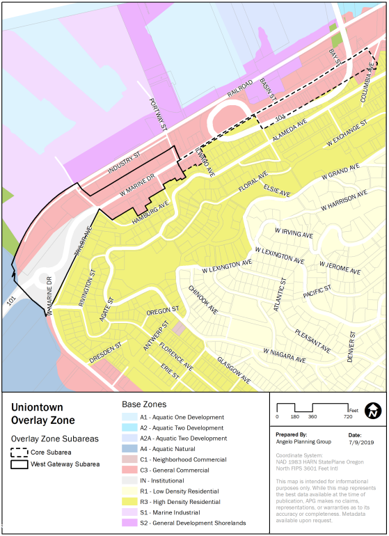
The provisions of the Uniontown Overlay Zone shall apply to all new construction or major renovation, where “major renovation” is defined as construction valued at 33% or more of the assessed value of the existing structure, unless otherwise specified by the provisions in this Section. Applications in the Uniontown Overlay Zone shall be reviewed in a public design review process subject to the standards and guidelines in Sections 14.145 to 14.163. - Historic Design Review. When a development proposal is required to be reviewed by the Historic Landmarks Commission due to its proximity adjacent to a designated historic building, structure, site, or object, or is an identified Historic Landmark, the Historic Landmarks Commission shall include review of the Uniontown Overlay sections.
.
Amended by Ord. 22-01 on 11/7/2022
14.149 PERMITTED USES
The following uses and activities and their accessory uses and activities are permitted outright in the Uniontown Overlay Zone, in addition to uses permitted outright in the base zone identified in Article 2, and subject to the other appropriate development provisions of this Section.
- Existing motels and their expansion and reconstruction if destroyed.
- Dwellings in a new or existing structure:
- Located above or below the first floor with commercial facilities on the first floor of the structure.
- Located in the rear of the first floor with commercial facilities in the front portion of the structure.
- Light manufacturing with a retail component.
- Facilities of maximum 2,000 square feet shall have a retail component of minimum 60 square feet;
- Facilities greater than 2,000 square feet shall have a retail component of minimum 144 square feet.
- Facilities of maximum 2,000 square feet shall have a retail component of minimum 60 square feet;
- Residential Home.
- Residential Facility.
(Section 14.149 added by Ord 19-11, 10-7-2019)
14.150 USES PROHIBITED
- West Gateway Subarea. The following uses and activities and their accessory uses and activities are prohibited in the West Gateway Subarea (Figure 14.147-1) in the Uniontown Overlay Zone. Permitted uses are identified in the base zones in Article 2 and inSection 14.105.A of this ordinance.
- Light manufacturing without a retail component.
- Communication service establishment.
- Construction service establishment.
- Transportation service establishment.
- Recycling establishment.
- Wholesale trade or warehouse establishment.
- Motel, hotel, bed and breakfast, inn or other tourist lodging facility and associated uses.
- Automotive sales.
- Core Subarea. The following uses and activities and their accessory uses and activities are prohibited in the Core Subarea (Figure 14.147-1) in the Uniontown Overlay Zone. Permitted uses are identified in the base zones in Article 2 and in Section 14.105.A of this ordinance.
- Automotive sales and services.
- Drive-through facilities.
- Gasoline services stations.
- Repair service establishment not allowed as an Outright Use.
- Light manufacturing without a retail component.
- Construction service establishment.
- Communication service establishment.
- Transportation service establishment.
- Recycling establishment.
- Wholesale trade or warehouse establishment.
- Motel, hotel, bed and breakfast, inn or other tourist lodging facility and associated uses.
(Section 14.150 added by Ord 19-11, 10-7-2019)
14.152 DEVELOPMENT STANDARDS
The following development standards apply to development in the Uniontown Overlay Zone.
- Height.
- Maximum building height is 35 feet except as noted in subsection A.2 of this section.
- Building height up to 45 feet is permitted when building stories above 28 feet are stepped back at least 10 feet in accordance with Section 14.152.C.
- Exceptions to building height restrictions may be granted through provisions in Section 3.075.
- Setbacks. Setback standards apply only to new development approved as of January 1, 2020 or additions to existing buildings.
- West Gateway Subarea.
- No minimum or maximum front setback standards apply to developments in the West Gateway Subarea.
- Where buildings are set back from the street more than 5 feet, the setback area:
- Shall be landscaped according to the standards of Section 14.160; and/or
- Shall include a pedestrian walkway, plaza, courtyard, or other pedestrian-oriented amenity or public gathering space.
- Adjacent to the River Trail.
- The minimum setback adjacent to the River Trail shall be 10 feet on the south side of the trail.
- The setback area shall be landscaped according to the standards of Section 14.160; and/or shall include a pedestrian walkway, plaza, courtyard, or other pedestrian-oriented amenity or public gathering space.
Figure 14.152-1: Building Setbacks in the West Gateway Subarea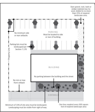
- The maximum setback for yards fronting W Marine Drive in the Uniontown Overlay Zone shall be five (5) feet (see Figure 14.152-2).
- Allowed Extensions of Maximum Setbacks. The maximum setback for yards fronting a public right-of-way in the Uniontown Overlay Zone may be extended to 20 feet for up to 50% of the building facade if the setback is used for a walkway, plaza, courtyard, or other pedestrian-oriented amenity or public gathering space.
Figure 14.152-2: Building Setbacks in the Core Subarea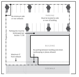
- West Gateway Subarea.
- Stepbacks.
- Purpose. The purpose of a stepback is to allow for less obstructed views from above the building and to create a less imposing building scale as viewed from the right-of-way or parallel/adjacent trail. A stepback is also designed to allow more light down to the adjacent or fronting right-of-way, sidewalk, or trail.
- Additional Building Height. Where the height of a building or building addition is proposed to exceed 35 feet, at least that portion of the building exceeding 28 feet or two stories, whichever is less, shall provide a stepback of at least 10 feet from the plane of the proposed building or building addition that faces the right-of-way or River Trail (see Figure 14.152.-3).
Balcony railings constructed to a maximum height of 28’ are not encroachments when the building facade above the top of rail is stepbacked 10’.
For construction adjacent to the River Trail, balconies and/or fixed awnings shall not encroach into the required 10-foot stepback area; buildings shall be stepped back further in order to accommodate balconies and/or fixed awnings.
Figure 14.152-3: Building Stepbacks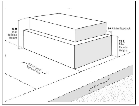
Amended by Ord. 22-01 on 11/7/2022
14.155 UNDERGROUND UTILITIES
This provision shall apply only to utility lines to be installed for new construction. Utility lines, including, but not limited to, electricity, communications, street lighting and cable television, shall be required to be placed underground. Appurtenances and associated equipment such as surface-mounted transformers, pedestal-mounted terminal boxes and meter cabinets may be placed above the ground, and shall be screened by sight obscuring fences and/or dense landscape buffers. The Design Review Committee may waive the requirements of this section if topographical, soil, or other conditions make such underground installations or screening of above ground equipment unreasonable or impractical. The applicant shall make all necessary arrangements with the serving utility or agency for underground installations provided hereunder; all such installations shall be made in accordance with the tariff provisions of the utility, as prescribed by the State Public Utilities Commission.
(Section 14.155 added by Ord 19-11, 10-7-2019)
14.158 DESIGN STANDARDS AND GUIDELINES
- Applicability and Review. The following design standards and guidelines apply to all new construction or major renovation, where “major renovation” is defined as construction valued at 33% or more of the assessed value of the existing structure. Applications in the Uniontown Overlay Zone shall be reviewed in a public design review process subject to the standards and guidelines in Sections 14.145 to 14.163.
Some of the following design standards and guidelines apply to all uses. Other standards and guidelines are differentiated by non-industrial uses and industrial uses. For the purposes of these Sections, industrial uses include the following as further defined in Section 1.400 of the Development Code:- Light manufacturing with a retail component.
- Building Style and Form.
- Standards for All Uses.
- Projecting wall-mounted mechanical units are prohibited where they are visible from a public right-of-way or the River Trail. Projecting wall-mounted mechanical units are allowed where they are not visible from a public right-of-way or River Trail.
- Solid waste disposal, outdoor storage, and utility and mechanical equipment shall be enclosed and screened from view (Figure 14.158-1). A cover shall be required if screened items can be viewed from above. Rooftop equipment shall be screened from view by a parapet wall, a screen made of a primary exterior finish building material used elsewhere on the building, or by a setback such that it is not visible from adjacent properties and rights-of-way up to approximately 100 feet away. Also see Section 3.215, Outdoor Storage Areas and Enclosures.
Figure 14.158-1: Screening Waste Disposal, Outdoor Storage, and Utility/Mechanical Equipment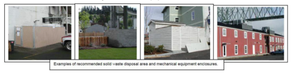
- Guidelines for All New Construction.
- The design of new construction should respect significant original characteristics, scale and massing of adjacent structures that are visible from the public right-of-way within three blocks of the development site. Buildings should be designed so that they are not substantially different in character from adjacent structures, in terms of size, mass, or architectural form. Also see Section 14.002.C, Resolving Conflicts within the Code.
- New construction should respect significant characteristics of composition and material of adjacent structures that are visible from the public right-of-way within three blocks of the development site. Also see Section 14.002.C, Resolving Conflicts within the Code.
- Building forms should be simple single geometric shapes, e.g. square, rectangular, triangular (Figure 14.158-2).
Figure 14.158-2: Geometric Building Form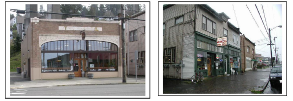
- Guidelines for All Existing Buildings.
- Distinctive stylistic features or examples of skilled craftsmanship of existing buildings and/or structures proposed for renovation, alteration, and/or additions should be treated with sensitivity. All buildings should be respected and recognized as products of their time.
- Renovations, alterations, and/or additions to existing buildings should respect significant original characteristics of adjacent structure scale and massing for the entire structure, and should be designed so that they are not substantially different in terms of size, mass, or architectural form. Also see Section 14.002.C, Resolving Conflicts within the Code.
- Renovations, alterations, and/or additions should retain and/or respect significant original characteristics of the existing structure composition and material, for the entire structure. Also see Section 14.002.C, Resolving Conflicts within the Code.
- Building forms should be simple single geometric shapes, e.g. square, rectangular, triangular (Figure 14.158-2).
- Mid-century “slip covers” which are not part of the original historic design should be removed when possible.
- Incompatible additions or building alterations using contemporary materials, forms, or colors on building facades are discouraged.
- Standards for Non-Industrial Uses.
- Facade Variation. All non-industrial buildings shall incorporate design features such as offsets, balconies, projections, window reveals, or other similar elements to preclude large expanses of uninterrupted building surfaces in areas which are visible to the public. Design features shall occur at a minimum of every 30 feet for all building facades visible from a public right-of-way or River Trail. (Figure 14.158-3)
The facade shall contain at least two (2) of the following features:- Recess (e.g., deck, patio, courtyard, entrance, or similar feature) that has a minimum depth of six (6) feet;
- Extension (e.g., floor area, deck, patio, entrance, or similar feature) that projects a minimum of two (2) feet and runs horizontally for a minimum length of four (4) feet;
- Offsets or breaks in roof elevation of two (2) feet or greater in height;
- Outdoor seating area, plaza, or other interactive landscaped area adjacent to the building that is specifically identified and/or covered, and approved by the review authority; and/or
- Other similar facade variations approved by the review authority.
Figure 14.158-3: Facade Variation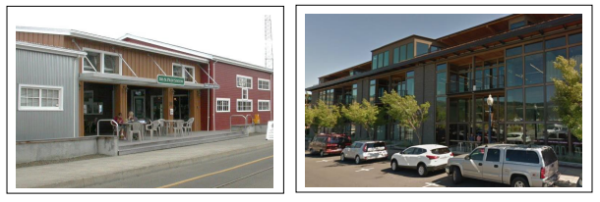
- Recess (e.g., deck, patio, courtyard, entrance, or similar feature) that has a minimum depth of six (6) feet;
- Base, Middle, and Top of Building. All non-industrial buildings shall have a clear and distinct base, middle and top to break up vertical mass (Figure 14.158-4). All facades visible from a right-of-way or River Trail shall utilize horizontal bands and/or changes in color, material, form and/or pattern to differentiate the base, middle, and top of the building, subject to the following requirements:
- Horizontal bands or other changes in pattern or material shall be a minimum of 8 inches high (the length of a standard brick) and shall project a minimum of one (1) inch from the building face.
- Changes in building massing and form may also be used to differentiate a building’s base, middle, and top. This may include architectural setbacks or projections, measuring a minimum of three (3) inches.
Figure 14.158-4: Base, Middle & Top of Building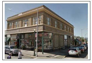
- Parking Location. Parking and vehicle maneuvering areas shall not be located between the front building facade and the front property line, or between a building facade facing the River Trail and the property line adjacent to the River Trail.
Parking shall be permitted between a building and an interior lot line that is not a rear lot line, provided the following standards are met:- Where surface parking or maneuvering areas are located adjacent to a right-of-way or the River Trail, a minimum 5-foot-wide landscaped strip shall be provided between the parking and maneuvering area and the right-of-way or River Trail. The landscaped strip shall be planted with trees spaced not more than 30 feet on center and with a mix of shrubs and ground cover. Additional standards for landscaping in parking areas are found in Section 3.120, 7.170, and 14.120.B.
- Parking and maneuvering areas, including accessways and driveways, must not exceed 40 percent of a lot frontage.
- Facade Variation. All non-industrial buildings shall incorporate design features such as offsets, balconies, projections, window reveals, or other similar elements to preclude large expanses of uninterrupted building surfaces in areas which are visible to the public. Design features shall occur at a minimum of every 30 feet for all building facades visible from a public right-of-way or River Trail. (Figure 14.158-3)
- Guidelines for Non-Industrial Uses
- Compatibility with Historic Buildings.
- The massing, scale, and configuration of non-industrial buildings should be similar to historic structures that are visible from the public right-of-way within three blocks of the development site.
- Non-Industrial buildings should be compatible with the vertical proportions of historic facades and the simple vertical massing of historic structures that are visible from the public right-of-way within three blocks of the development site.
- The location, size, and design of windows and doors in non-industrial buildings should be compatible with historic structures visible from the public right-of-way within three blocks of the development site.
- Development should be designed so that structures are not substantially different in character from adjacent buildings, in terms of size, mass, or architectural form.
- Compatibility with Historic Buildings.
- Standards for All Uses.
- Roof Form and Materials.
- Roof Form Standards for All Uses. The following roof forms are prohibited:
- False mansard or other applied forms; and
- Dome skylights.
- Roof Materials Standards for All Uses.
- Buildings shall be constructed or reconstructed with one of the following roofing materials:
- Cedar shingle (Figure 14.158-5);
- Composition roofing (Figure 14.158-5); or
- Materials cited in Section 14.158.C.4 or Section 14.158.C.6.
Figure 14.158-5: Roofing Materials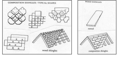
- The following roofing materials are prohibited for all types of buildings:
- High profile standing seam metal roof (Figure 14.158-6); and
- Brightly colored roofing material.
Figure 14.158-6: Low (3/8” x 1”) and High (1/4” x 1-1/4”) Roof Seams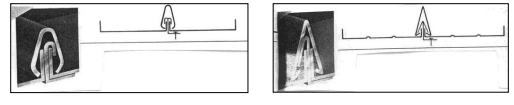
- Roofing materials shall be gray, brown, black, deep red, or another subdued color.
- Buildings shall be constructed or reconstructed with one of the following roofing materials:
- Roof Form Standards for Non-Industrial Uses. Buildings for non-industrial uses shall include one of the following roof forms:
- Single gable with low pitch; or
- Repetitive gable with steep pitch; or
- Flat or gable roof behind parapet wall (Figure 14.158-7).
Figure 14.158-7: Non-Industrial Building, Flat Roof Behind Parapet Wall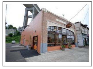
- Roof Materials Standards for Non-Industrial Uses. Buildings for non-industrial uses shall be constructed or reconstructed with one of the following roofing materials:
- Materials cited in Section 14.158.C.2; or
- Built-up roofing materials.
- Roof Form Standards for Industrial Uses. Buildings for industrial uses shall include the following roof forms:
- Single gable with low pitch; or
- Repetitive gable with steep pitch (Figure 14.158-8 and Figure 14.158-9); and
- Shallow eaves (Figure 14.158-9).
Figure 14.158-8: Roof Pitches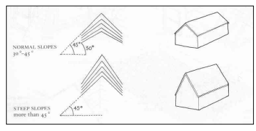
Figure 14.158-9: Industrial Building, Multiple Gables, Monitor Roof, and Shallow Eaves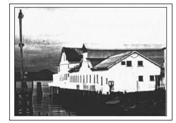
- Roof Materials Standards for Industrial Uses. Buildings shall be constructed or reconstructed with one of the following roofing materials:
- Materials cited in Section 14.158.C.2; or
- Galvanized corrugated metal; or
- Low profile standing seam, metal roof (Figure 14.158-6); or
- Roll down.
- Roof Form Guidelines for Non-Industrial Uses. Buildings for non-industrial uses may also include the following roof forms or features:
- Structural skylights
- Shallow eaves behind parapet wall
- Roof Form Guidelines for Industrial Uses. Buildings for industrial uses may also include one or more of the following roof forms or features:
- Small shed roof dormers
- Monitor roof on ridge line (Figure 14.158-9)
- Flat panel skylights or roof window
- Roof Form Standards for All Uses. The following roof forms are prohibited:
- Doors.
- Standards for All Uses. The following types of doors and door treatments are prohibited:
- Automatic sliding doors;
- Primary entry doors raised more than three feet above sidewalk level;
- Doors flush with building facade;
- Clear anodized aluminum frames; and
- Reflective, opaque, or tinted glazing.
- Guideline for All Uses. Building lighting should emphasize entrances.
- Standards for Non-Industrial Uses.
- Solid metal or wood doors with small or no windows are prohibited.
- Doors with a minimum of 50% of the door area that is glass are required.
- Solid metal or wood doors with small or no windows are prohibited.
- Guidelines for Non-Industrial Uses.
- Doors should be recessed (Figures 14.158-10 and 14.158-11).
- Large cafe or restaurant doors that open the street to the interior by pivoting, sliding, or rolling up overhead are encouraged (Figure 14.158-10).
- Well-detailed or ornate door hardware is encouraged (Figure 14.158-11).
- Contemporary hardware should be compatible with the design of the door.
- Transom, side lites, or other door/window combinations are encouraged (Figure 14.158-11).
- Doors combined with special architectural detailing are encouraged.
- Double or multiple door entries are encouraged (Figure 14.158-11).
Figure 14.158-10: Roll-Up Doors and Recessed Doors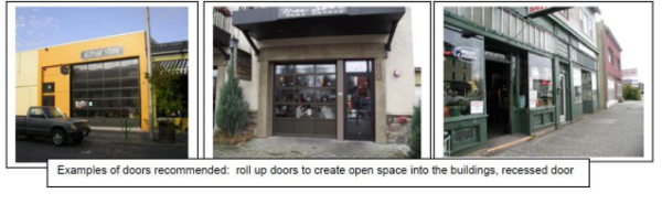
Figure 14.158-11: Recessed Doors, Contemporary Door Hardware, Single/Double Doors, Side Lites, and Transom Windows
- Standards for All Uses. The following types of doors and door treatments are prohibited:
- Windows.
- Coverage Standards for All Uses.
- All building facades visible from a public right-of-way or the River Trail shall have windows or other openings in the facade, except as noted in subsection E.1.b of this section. Blank walls on any facades visible from the right-of-way or River Trail for any type of use are prohibited.
- Exceptions. An exception to the window coverage percentage standard may be allowed for a portion of a building facade with the inclusion of architectural detail / design features in amounts equal to the minimum window coverage requirement. Such architectural details shall include but not be limited to a change in material, horizontal projections, engaged columns or pilasters, belt course, moldings, clock, or other similar features to avoid blank walls.
- Design Standards for All Uses.
- Window detailing. Windows shall have casings/trim, sills, and crown moldings. Window detailing shall meet the following requirements.
- Casings/trim shall have minimum dimensions of 5/4 inch x 4 inch and shall extend beyond the facade siding. Exceptions may be granted.
- Windows shall be recessed a minimum distance of two (2) inches from the facade siding surface to ensure a shadow line/effect.
- The bottom of the sill shall be a minimum of 18 inches above the ground or floor elevation.
Figure 14.158-12: Window Detailing – Trim and casement location and dimensions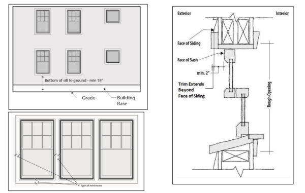
- Window types. Windows shall be one of the following types:
- Ground floor windows that provide a view into the use, whether fixed or operable;
- Upper story windows that open into the interior of the building;
- Transom windows, fixed or operable, located above doors or windows directly below them;
- The following types of windows or window treatments are prohibited:
- Residential-styled window bays;
- Half-round windows;
- Tinted and/or reflective glass;
- Sliding windows;
- Vinyl windows; and
- Blocked-out windows; and
- Windows that extend beyond the plane of the building facade.
- Window detailing. Windows shall have casings/trim, sills, and crown moldings. Window detailing shall meet the following requirements.
- Design Guidelines for All Uses.
- Windows, including transoms on existing buildings, should retain their original size and location as part of renovation activities.
- Windows that open by pivoting, casement, single hung, or other shuttering are encouraged.
- Painted wood or stucco panels or tile clad panels below windows are encouraged (Figure 14.158-13).
- Clear glass is encouraged.
- True divided lites are encouraged (Figure 14.158-13). Simulated divided lites shall have exterior muntins to create exterior shadow lines.
- Boldly articulated window and storefront trim are encouraged.
Figure 14.158-13: Transom Windows, Panels Below Windows, and True Divided Lites
- Coverage Standards for Non-Industrial Uses.
- West Gateway Subarea. At least 40% of the ground-floor facades of non-industrial uses visible from a right-of-way and/or River Trail shall be covered by windows. At least 30% of the upper-floor facades visible from a right-of-way and/or River Trail shall be covered by windows, except as noted in subsection E.4.c of this section.
- Core Subarea. At least 50% of the ground-floor facades of non-industrial uses visible from a right-of-way and/or River Trail shall be covered by windows. At least 30% of the upper-floor facades visible from a right-of-way and/or River Trail shall be covered by windows, except as noted in subsection E.4.c of this section.
- Exceptions. An exception to the window percentage may be allowed for the portion of a building facade with the inclusion of architectural detail / design features in amounts equal to the minimum window coverage requirement. Such architectural details shall include but not be limited to change in material, horizontal projections, engaged columns or pilasters, belt course, moldings, clock, or other similar features to avoid blank walls.
- Coverage Standards for Industrial Uses.
- All facades of buildings for industrial uses in the Uniontown Overlay Zone that are visible from a public right-of-way and/or River Trail, and/or the Columbia River shall have windows. However, buildings for industrial uses are not subject to minimum window area requirements.
- Buildings for industrial uses are not required to have ground floor windows but shall have, at the least, clerestory or transom windows on the upper story facades or above a height of 14 feet.
- Coverage Standards for All Uses.
- Siding and Wall Treatment.
- Standards for All Uses. The following types of siding and wall materials and treatments are prohibited:
- Cladding materials such as corrugated metal panels or spandrel glass;
- Panels that are poorly detailed or do not have detailing;
- Neon or other fluorescent colors;
- Bright or primary wall colors for the entire wall surface;
- Flagstone, simulated river rock, or other similar veneer cladding;
- Painted brick; and
- Non-durable materials such as synthetic stucco or shingles at the ground floor.
- Textured fiber cement siding. Smooth fiber cement siding is allowed.
- Guidelines for All Uses.
- Variations in wall cladding materials and patterns consistent with historic patterns are encouraged (Figure 14.158-14).
- Natural or subdued building colors are encouraged (Figure 14.158-14).
- Bright colors may be used for accent trim, not to exceed 15% of the area of any facade.
- Durable materials such as brick, stucco, granite, pre-cast concrete, board and batten, or horizontal wood siding should be used (Figure 14.158-14). These materials include galvanized corrugated metal on buildings for industrial uses.
- Architectural wall features such as belt courses, pilasters, and medallions are encouraged.
Figure 14.158-14: Siding Variety and Compatible Materials and Colors
- Standards for All Uses. The following types of siding and wall materials and treatments are prohibited:
- Awnings.
- Standards for Types of Awnings and Treatments.
- Awnings over building entries shall be a minimum of 5 feet deep. Awnings over windows shall be a minimum of 3 feet deep. The bottom of all awnings shall be 8 to 12 feet above grade.
- The following types of awnings and awning treatments are prohibited:
- Fixed “bubble shaped” awnings (Figure 14.158-15); and
- Awnings lit internally.
- Guidelines for Types of Awnings and Treatments.
- Vinyl or other non-compatible material awnings are discouraged (Figure 14.158-15).
Figure 14.158-15: Prohibited and Discouraged Awning Types and Treatments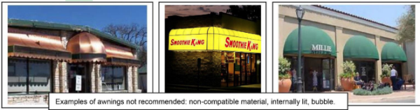
- Vinyl or other non-compatible material awnings are discouraged (Figure 14.158-15).
- Standards for Awning Locations Along River Trail and North/South Rights-of-Way. Awnings are generally discouraged and shall not project into the setback and/or stepback areas.
- Standards for Types of Awnings and Treatments.
- Lighting.
- Standards for Lighting Types and Treatments for All Uses. The following lighting types or treatments are prohibited:
- Neon silhouette accent lighting;
- Fluorescent tube lighting;
- Security spotlight;
- Signs lit by lights containing exposed electrical conduit, junction boxes, or other electrical infrastructure; and
- Up-lighting that shines into the sky or light that shines into other properties or rights-of-way.
- Standards Regarding Lighting Glare for All Uses. All uses shall comply with applicable lighting standards in Section 3.128.
- Guidelines Regarding Wall-Washing Light. Wall-washing lighting fixtures should be concealed and integrated into the design of buildings or landscape walls and stairways (Figure 14.158-16). Wall-washing lighting should be designed to minimize light directed upwards into the night sky.
- Guidelines for Lighting Types and Treatments for Non-Industrial Uses. The following lighting types or treatments are encouraged.
- Decorative lighting integrated with architecture.
- Historic street lamps along walks and parking lots.
- Guidelines for Lighting Types and Treatments for Industrial Uses. The following lighting types or treatments are encouraged.
- Industrial pan light with goose neck.
- Low bollard lighting.
Figure 14.158-16: Downward and Diffused Lighting, Wall-Washing Lighting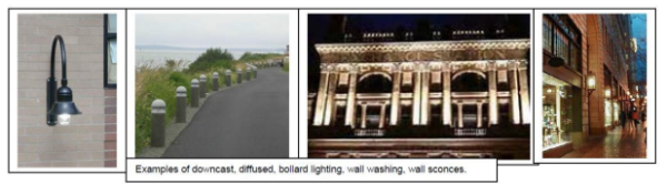
- Standards for Lighting Types and Treatments for All Uses. The following lighting types or treatments are prohibited:
- Signs. Signs in the Uniontown Overlay Zone are subject to the requirements in Article 8 (Sign Regulations) of the Astoria Development Code. The following additional standards and guidelines apply to signs in the Uniontown Overlay Zone.
- Sign Standards for All Uses.
- Monument signs (Figure 14.158-17) are allowed up to a maximum of 32 square feet.
- Monument signs shall be a maximum of five (5) feet tall.
- Monument signs shall be constructed from materials that are consistent with the historic character of the area, including wood, brick, stone, and metal.
- Freestanding signs are prohibited (Figure 14.158-17).
- Sign Guidelines for All Uses. The following sign types are encouraged.
- Hanging blade signs.
- Signs painted on building facade.
- Signs applied to building facade.
- Front lit.
- Graphics historic in character.
Figure 14.158-17: Monument Signs and Freestanding Signs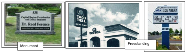
- Sign Standards for All Uses.
(Section 14.158 added by Ord 19-11, 10-7-2019)
Amended by Ord. 22-01 on 11/7/2022
14.160 LANDSCAPING
Landscaping is required in the Uniontown Overlay Zone in accordance with the provisions in this Section and those in Sections 3.120 to 3.125, and 7.170. The provisions in this Section apply to new construction or exterior renovations with a value of at least 33% of the assessed value of the structure, or in the event of installation of new parking areas.
- Minimum Landscaped Area.
- West Gateway Subarea.
- A minimum landscaped area of 15 percent of the total lot area shall be provided in the West Gateway Subarea in accordance with according to the standards of Section 14.160.B.
- Landscape areas must be visible from the public right-of-way and/or River Trail to count toward the minimum landscape area requirement.
- Core Subarea. No minimum landscaped area shall be required in the Core Subarea. Parking lots shall be landscaped in accordance with Section 7.170 and Section 3.105 through 3.120.
- West Gateway Subarea.
- Landscape Standards. Where landscaping is provided, the following minimum planting and coverage standards shall apply. These standards apply in addition to the landscaping standards of Section 3.105 and Section 3.125.
- One (1) tree shall be provided for every 600 square feet of required landscaped area.
- One (1) evergreen shrub having a minimum mature height of 48 inches shall be provided for every 400 square feet of required landscaped area.
- All landscape areas, whether required or not, that are not planted with trees and shrubs or covered with allowable non-plant material, shall have ground cover plants that are sized and spaced to achieve plant coverage of not less than 75 percent at maturity.
- Bark dust, chips, aggregate, or other non-plant ground covers may be used, but shall cover not more than 25 percent of any landscape area. Non-plant ground covers cannot be a substitute for required ground cover plants.
- Adjacent to the River Trail - Land Side or Upland Standards. The following standards apply to landscaping along the frontage of parcels abutting the River Trail to the south.
- Maximum spacing of trees.
- 20 feet on center for non-industrial uses
- 15 feet on center for industrial uses
- Maximum spacing of shrubs
- Five (5) feet on center for non-industrial uses
- Three (3) feet on center for industrial uses
- Ground cover landscaping is required in between shrubs and trees.
- Trees shall not exceed 35 feet in height at maturity
- Maximum spacing of trees.
- Landscaping Credits for Non-Vegetation Features.
- The Community Development Director may approve non-vegetative features to account for up to 25% of required landscaping when the features consist of the following:
- Hardscaped pedestrian-oriented areas (e.g., courtyards, plazas); and/or
- At least one of the following amenities meeting the City approved design within the public right-of-way:
- bike rack
- bench
- table
- drinking fountain
- directional or interpretive/information signage
- trash or recycling container
- lighting
- restroom
- An application proposing more than 25% of required landscaping be credited by non-vegetative features is subject to approval in accordance with procedures in Article 9 and Article 12.
- Non-vegetative features allowed in the public right-of-way in lieu of required landscaping shall be maintained by the applicant. There shall be a maintenance agreement or other City approved agreement. Failure to maintain or loss of the non-vegetative feature will result in the requirement for installation of the landscaping in accordance with the Code at the time of the loss.
- The Community Development Director may approve non-vegetative features to account for up to 25% of required landscaping when the features consist of the following:
- Street Trees. Street trees shall be planted within the right-of-way along both sides of the street on all streets in the Uniontown Overlay Zone in accordance with the provisions in this Section 14.160.C.
- Spacing should be 30 feet on center, depending on species and branching habit.
- Minimum size of deciduous trees should be 2" caliper, with an upright form.
- Mature branching height should be a minimum of 15 feet.
- Required street trees shall be maintained by the adjacent property owner and/or other identified entity. There shall be a maintenance agreement or other City approved agreement.
(Section 14.160 added by Ord 19-11, 10-7-2019)
Amended by Ord. 22-01 on 11/7/2022
14.163 OFF-STREET PARKING
In the Uniontown Overlay Zone, the following provisions apply to parking requirements established in Article 7 of this Code.
- Reductions. Minimum number of parking spaces required in Section 7.100 may be reduced by 50% or by 10 spaces, whichever is less, for uses with less than 5,000 square feet of gross floor area. Reductions meeting these requirements shall be processed as a Type I Administrative Permit.
- Exceptions. Exemptions from minimum number of parking spaces required in Section 7.100 are permitted under the following conditions:
- Existing buildings that cover the majority area of the site with insufficient open area for off-street parking spaces; and/or
- Building expansions of 10% or less which do not decrease available off-street parking spaces on the site; and
- Exemptions shall be processed as a Type I Administrative Permit. Exceptions from off-street parking that do not meet the above criteria shall be processed as a Variance in accordance with Article 12.
(Section 14.163 added by Ord 19-11, 10-7-2019)
14.175 PURPOSE
The purpose of the Urban Core Overlay Zone is to implement the land use principles of the Astoria Riverfront Vision Plan, dated December 2009, as they pertain to the Urban Core Area. The Urban Core Overlay (UCO) Zone is intended to meet and balance multiple objectives, including promoting the urban character of the area and allowing for dense development; encouraging design of new or rehabilitated buildings that respects Astoria’s character; protecting views of and access to the Columbia River; creating intimate open spaces and gathering places within new developments; maximizing existing open areas over the water; and allowing for a mix of commercial, residential, and water dependent uses that supports the downtown core. The UCO Zone extends from approximately 2nd Street to 16th Street, from the pierhead line to Marine Drive, and to Commercial Street between 8th and 16th Streets, as shown in the City’s Zoning Map.
(Section 14.175 added by Ord 20-02, 1-21-2020)
14.178 APPLICABILITY AND REVIEW PROCEDURES
- The provisions in Sections 14.175 to 14.200 apply to all uses in all areas of the Urban Core Overlay Zone unless indicated otherwise in Table 14.178-1T and in the individual sections.
- The provisions of the Urban Core Overlay Zone shall apply to all new construction or major renovation, where “major renovation” is defined as construction valued at 33% or more of the assessed value of the existing structure, unless otherwise specified by the provisions in this Section.
- Applications in the Urban Core Overlay Zone shall be reviewed in a public design review process subject to the standards and guidelines in Sections 14.175 to 14.200.
Table 14.178-1T: Applicability of Urban Core Overlay Zone Code SectionsCode Section Applicability Section 14.180 Uses Prohibited for Overwater Development • Aquatic Zones Section 14.183 Standards for Overwater Development Limitation Areas (Figure 14.178-1) – overwater and land north of the River Trail
Minimum Setbacks • North/south Rights-of-way between Marine Drive and Columbia River
• Adjacent to River TrailSection 14.185 Uses Permitted for On-Land Development • C-3 and C-4 Zones Section 14.188 Uses Prohibited for On-Land Development • C-3 and C-4 Zones Section 14.190 Standards for On-Land Development Minimum Setbacks • North/south Rights-of-way between Marine Drive / Commercial Street and Columbia River • Adjacent to River Trail • Adjacent to Marine Drive and Other Rights-of-Way Parallel to Marine Drive (except River Trail)
Maximum Setbacks • Adjacent to Marine Drive and Parallel Rights-of-Way Stepbacks • All Overlay Zone Adjacent to Rights-of-Way and River Trail Size • All Overlay ZoneSection 14.195 Design Guidelines and Standards Building Style and Form • Standards for Projecting Wall-Mounted Mechanical Units Visible from Public Right-of-Way or River Trail • Guidelines for All Uses, All Overlay Zone
Roof Form and Materials • Form Standards for All Uses • Materials Standards for All Uses • Form Standards for Non-Industrial Uses • Form Standards and Guidelines for Industrial Uses
Doors • Standards for All Uses • Guidelines for All Uses • Standards for Non-Industrial Uses • Guidelines for Non-Industrial Uses
Windows • Coverage Standards for All Uses • Design Standards for All Uses • Design Guidelines for All Uses • Coverage Standards for Non-Industrial Uses • Coverage Standards for Industrial Uses
Siding and Wall Treatment
• Standards for All Uses • Guidelines for All Uses
Awnings • Standards for Types of Awnings/Treatments for All Uses • Guidelines for Types of Awnings/Treatments for All Uses • Standards Along River Trail and North/South Rights-of-Way
Lighting • Standards for All Uses • Guidelines for All Uses
Signs • Standards for All UsesSection 14.200 Landscaping River Side/Riparian Land Side/Upland Street Trees • All Street Trees • North-South Rights-of-Way Between Marine Drive / Commercial Street and Columbia River
Figure 14.178-1: Limitation Areas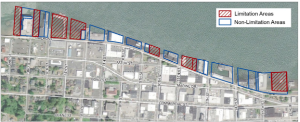
(Section 14.178 added by Ord 20-02, 1-21-2020)
Amended by Ord. 22-01 on 11/7/2022
14.180 USES PROHIBITED FOR OVERWATER DEVELOPMENT
- Aquatic Zones. The following uses and activities and their accessory uses and activities are prohibited in Aquatic Zones in the Urban Core Overlay Zone. Permitted uses are identified in the base zones in Article 2.
- Indoor entertainment. Except indoor family entertainment.
- Hotels/motels, except in buildings existing prior to January 1, 2020.
- Conference center.
- Fossil fuel and petroleum product terminals. Marine fueling station is not prohibited.
- Automotive sales and gas stations.
- Wood processing.
- Residential uses, except as follows:
- Residences existing prior to January 1, 2020 may be repaired, replaced, and/or redeveloped with new residences to the maximum number of units existing prior to January 1, 2020.
- Structures existing prior to January 1, 2020 are limited to a maximum of two new dwelling units above the first floor.
(Section 14.180 added by Ord 20-02, 1-21-2020)
14.183 STANDARDS FOR OVERWATER DEVELOPMENT
- Applicability. The following development standards apply to over-water development and to on-land development north of the River Trail in the Urban Core Overlay Zone in areas shown in Figure 14.178-1.
- Exemption
- Maintenance, repair, or restoration of buildings existing prior to January 1, 2020 shall be exempt from the standards of this Section 14.183, except as noted.
- Replacement of buildings existing prior to January 1, 2020 shall not be subject to the “Limitation Area” maximum height of Section 14.183.C.1 but shall be limited to the existing building square footage and height.
- Height.
- Structures within Designated Limitation Areas (Figure 14.178-1). Maximum building height, except hand rails, shall be the top of the existing adjacent riverbank. No variance may be granted for an exception to this height limitation.
Figure 14.183-1: Maximum Building Height within Overwater Development Limitation Areas
- Structures within Overwater Development Non-Limitation Areas (Figure 14.178-1).
- The maximum height shall be 28 feet from the top of the existing adjacent riverbank except as noted in subsections 14.183.C.2.b, 2.c, and 2.d of this Section.
- A maximum structure height of up to 35 feet is permitted when the following standards are met:
- The maximum width of an individual overwater building shall be a maximum 40% of the total parcel width (measured along the parcel frontage adjacent to the Columbia River shoreline) or 100 feet, whichever is less (Figure 14.183-3); and
- The maximum width of all overwater buildings located on a contiguous set of parcels under the same ownership shall be a maximum of 40% of the total width of the combined parcels (measured along the parcel frontage adjacent to the Columbia River shoreline); and
- There shall be a minimum 40 feet wide, unobstructed view corridor separation between buildings; or
- Water-dependent uses over water may construct water-dependent / water-related needed facilities up to 35 feet in height without a variance and are not subject to Sections 14.183.C.2.b. The added structures are subject to the maximum size allowed in Section 14.183.D and maximum width allowed in Section 14.183.E.
- Communication facilities existing prior to January 1, 2020 may be repaired, replaced, and/or redeveloped at the existing height.
Figure 14.183-2: Maximum Building Height within Overwater Development Non-Limitation Areas
Figure 14.183-3: Maximum Building Width Required for Added Structure Height
- Structures within Designated Limitation Areas (Figure 14.178-1). Maximum building height, except hand rails, shall be the top of the existing adjacent riverbank. No variance may be granted for an exception to this height limitation.
- Size.
- Structures within Overwater Development Limitation Areas (Figure 14.178-1). The maximum gross floor area of enclosed structures is 4,000 square feet.
- Structures within Overwater Development Non-Limitation Areas (Figure 14.178-1). There shall be no maximum gross floor area for buildings located in these areas.
- Width and Spacing.
- The following standards apply to all overwater development in the Urban Core Overlay Zone, except as provided in Section 14.183.C.2.b, which provides stricter width and spacing standards in exchange for allowing additional structure height.
- The maximum combined width of all overwater buildings located on a contiguous set of parcels under the same ownership shall be a maximum of 60% of the total width of the combined parcels (measured along the parcel frontage adjacent to the Columbia River shoreline) with no individual building exceeding 150 feet in width (Figure 14.183-4).
- There shall be a minimum 40 feet wide, unobstructed view corridor separation between individual buildings.
- Overwater buildings existing prior to January 1, 2020 may retain their existing width and construct infill additions to the structures to the same width as the existing buildings or as allowed in 14.183.E, whichever is larger (Figure 14.183-5). Infill construction is subject to all other code requirements.
Figure 14.183-4: Maximum Building Width
Figure 14.183-5: Building In-Fill Additions
- Access to the Columbia River. Access to the River shall be provided using piers and/or walkways as part of new construction and major renovations to structures constructed after the year 2013, where major renovation is defined as construction and alterations only to building exteriors valued at 75% or more of the assessed value of the existing structure.
Piers and walkways shall be constructed in accordance with Access Design A, Access Design B, or Access Design C, as shown and described below.
This access design shall be provided in a public access easement provided through the middle of the development or structure.
Figure 14.183-6: Access Design A
- Access Design B – “Viewpoints”. This access design shall be provided through either existing right-of-way, right-of-way that is created and dedicated to the City, or a public access easement.
Figure 14.183-7: Access Design B
- Access Design C – “Trail Extension”. This access design serves as an extension of the River Trail and shall be provided through either existing right-of-way, right-of-way that is created and dedicated to the City, or easements for the piers on the east and west sides of the development. The boardwalk along the north side of the development shall be provided in a public access easement. (Note: Two possible scenarios are illustrated in the following figures for this option.)
Figure 14.183-8: Access Design C.1
Figure 14.183-9: Access Design C.2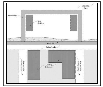
- Pier and Walkway Width. Minimum pier and walkway width shall be 10 feet if one side of the pier or walkway is developed with overwater structures. Minimum pier and walkway width shall be 14 feet if both sides of the pier or walkway are developed with overwater structures.
- Pier and Walkway Length. Piers and walkways shall extend beyond the north face of the overwater development a minimum length of 10 feet to ensure that the river is visible beyond the adjacent structure(s).
- Hours of Access. Access on overwater piers and walkways may be restricted during hours specified in City Code Section 5.926 to 5.928.
- Maintenance Responsibility. Responsibility for maintenance of the piers and walkway shall be established through a recorded maintenance agreement acceptable to the City.
- Access Design B – “Viewpoints”. This access design shall be provided through either existing right-of-way, right-of-way that is created and dedicated to the City, or a public access easement.
- Setbacks. Setback standards apply only to new development approved as of January 1, 2020 or additions to existing buildings.
- Minimum Setbacks Abutting North-South Rights-of-Way. A minimum unobstructed view corridor width of 70 feet, centered on the extended right-of-way centerline, shall be provided on extended rights-of-way north of the River Trail / Columbia River in the Urban Core Overlay Zone. Buildings shall be set back in order to achieve the 70-foot unobstructed view corridor. If existing development on one side of the extended right-of-way does not meet the setback, the new development on the other side of the extended right-of-way is only required to provide its half of the view corridor width.
Figure 14.183-10: Minimum Setbacks Over-Water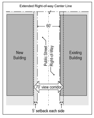
- Minimum Setbacks Adjacent to River Trail.
- The minimum setback adjacent to the River Trail shall be 10 feet on the south side of the Trail and 20 feet on the north side of the Trail. Structural encroachments are not allowed within the setback area.
- The setback area shall be landscaped or shall include a combination of landscaping and pedestrian-oriented amenities such as walkways, seating, and plaza space.
- Minimum Setbacks Abutting North-South Rights-of-Way. A minimum unobstructed view corridor width of 70 feet, centered on the extended right-of-way centerline, shall be provided on extended rights-of-way north of the River Trail / Columbia River in the Urban Core Overlay Zone. Buildings shall be set back in order to achieve the 70-foot unobstructed view corridor. If existing development on one side of the extended right-of-way does not meet the setback, the new development on the other side of the extended right-of-way is only required to provide its half of the view corridor width.
(Section 14.183 added by Ord 20-02, 1-21-2020)
Amended by Ord. 22-01 on 11/7/2022
14.185 USES PERMITTED OUTRIGHT AND CONDITIONAL USES FOR ON-LAND DEVELOPMENT
- Permitted Uses in Commercial Zones. The following uses and activities and their accessory uses and activities are permitted outright in Commercial Zones in the Urban Core Overlay Zone, in addition to uses permitted outright in the base zone identified in Article 2, and subject to the other appropriate development provisions of this Section.
- Manufacturing or light manufacturing with a retail component as follows:
- Facilities of maximum 2,000 square feet shall have a retail component of minimum 60 square feet;
- Facilities greater than 2,000 square feet shall have a retail component of minimum 144 square feet.
- Multi-family dwellings in a new or existing structure above, below, or behind the first floor that has commercial or mixed uses on the first floor.
- Park and museum.
- Shoreline stabilization.
- Small boat building and repair.
- Navigation aide.
- Seafood receiving and processing in C-3 Zone north of River Trail.
- Manufacturing or light manufacturing with a retail component as follows:
- Conditional Uses in Commercial Zones. The following uses and activities and their accessory uses and activities are permitted as conditional uses in Commercial Zones in the Urban Core Overlay Zone, in addition to uses permitted as conditional uses in the base zone identified in Article 2, and subject to the other appropriate development provisions of this Section.
- Motel, hotel, bed and breakfast, inn or other tourist lodging facility and associated uses when parking is located at the rear or interior of the site, screened by the building.
- Motel/hotel existing prior to January 1, 2020 and their expansion and reconstruction if destroyed, except as noted in Section B.1.
- Warehouse associated with an allowable use located within 300 feet of the primary use, where the allowable use was existing prior to January 1, 2020.
(Section 14.185 added by Ord 20-02, 1-21-2020)
14.188 USES PROHIBITED FOR ON-LAND DEVELOPMENT
- Commercial Zones. The following uses and activities and their accessory uses and activities are prohibited in Commercial Zones in the Urban Core Overlay Zone. Permitted uses are identified in the base zones in Article 2 and in Section 14.185 of this Article.
- Automotive sales and services.
- Gasoline services stations.
- Manufacturing or light manufacturing without a retail component.
- Single-family or two-family dwelling, except above, below, or in the rear of first-floor commercial.
- Animal hospital or kennel.
- Conference center.
- Construction service establishment.
- Drive-through facilities.
- Hospital.
- Repair service establishment not allowed as an Outright Use.
- Transportation service establishment.
- Wholesale trade or warehouse establishment, except as follows:
- Warehouse associated with an allowable use located within 300 feet of the primary use, where the allowable use was existing prior to January 1, 2020.
- Automotive sales and services.
(Section 14.188 added by Ord 20-02, 1-21-2020)
14.190 STANDARDS FOR ON-LAND DEVELOPMENT
The following development standards apply to on-land development in the Urban Core Overlay Zone.
- Height. Height standards apply to on-land development south of the River Trail.
- Maximum building height within 100 feet of the River Trail is 35 feet. Additional allowable height of subsections A.3 and A.4 of this Section is prohibited within 100 feet of the River Trail.
- Maximum building height in other areas is 45 feet.
- Exceptions to building height restrictions may be granted through provisions in Section 3.075.
- No variance to building height shall be allowed.
- Maximum building height within 100 feet of the River Trail is 35 feet. Additional allowable height of subsections A.3 and A.4 of this Section is prohibited within 100 feet of the River Trail.
- Setbacks. Setback standards apply only to new development approved as of January 1, 2020 or additions to existing buildings. Setback standards apply to on-land development south of the River Trail, as well as to property lines abutting and parallel to the north side of the River Trail.
- Minimum Setbacks.
- North-South Rights-of-Way between Marine Drive / Commercial Street and the Columbia River. A minimum unobstructed view corridor width of 70 feet, centered on the right-of-way centerline, shall be provided on north-south rights-of-way between Marine Drive / Commercial Street and the Columbia River in the Urban Core Overlay Zone. Buildings shall be set back in order to achieve the 70-foot unobstructed view corridor. If existing development on one side of the right-of-way does not meet the setback, the new development on the other side of the right-of-way is only required to provide its half of the view corridor width.
Figure 14.190-1: Minimum Setbacks On-Land
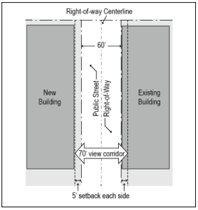
- Adjacent to the River Trail.
- The minimum setback adjacent to the River Trail shall be 10 feet on the south side of the Trail and 20 feet on the north side of the Trail. Structural encroachments are not allowed within the setback area.
- The setback area shall be landscaped or shall include a combination of landscaping and pedestrian-oriented amenities such as walkways, seating, and plaza space.
- Adjacent to Marine Drive and Other Rights-of-Way Parallel to Marine Drive (except River Trail). The minimum setback for yards fronting Marine Drive and other public rights-of-way parallel to Marine Drive in the Urban Core Overlay Zone, with the exception of the River Trail, shall be zero (0) feet.
- North-South Rights-of-Way between Marine Drive / Commercial Street and the Columbia River. A minimum unobstructed view corridor width of 70 feet, centered on the right-of-way centerline, shall be provided on north-south rights-of-way between Marine Drive / Commercial Street and the Columbia River in the Urban Core Overlay Zone. Buildings shall be set back in order to achieve the 70-foot unobstructed view corridor. If existing development on one side of the right-of-way does not meet the setback, the new development on the other side of the right-of-way is only required to provide its half of the view corridor width.
- Maximum Setbacks.
- Adjacent to Marine Drive and Parallel Rights-of-Way. The maximum setback for yards fronting Marine Drive and all parallel rights-of-way in the Urban Core Overlay Zone, with the exception of the River Trail, shall be five (5) feet.
- Allowed Extensions of Maximum Setbacks. The maximum setback for yards fronting a public right-of-way in the Urban Core Overlay Zone may be extended to 20 feet for up to 50% of the building facade if the setback is used for a walkway, plaza, courtyard, or other pedestrian-oriented amenity or public gathering space.
- Minimum Setbacks.
- Size. The gross floor area of on-land development in the Urban Core Overlay Zone shall be a maximum of 30,000 square feet for all buildings which are part of a single development regardless of tax lot lines and/or phased construction (see definition of “Gross Floor Area”), with the following exception:
- Public use existing prior to January 1, 2019 may exceed the 30,000 square foot maximum for additions or reconstruction but shall be subject to all other requirements of the Code such as height, setback, stepback, design, etc.
(Section 14.190 added by Ord 20-02, 1-21-2020)
14.195 DESIGN STANDARDS AND GUIDELINES
- Applicability and Review. The following design standards and guidelines apply to all new construction or major renovation, where “major renovation” is defined as construction valued at 33% or more of the assessed value of the existing structure. Applications in the Urban Core Overlay Zone shall be reviewed in a public design review process subject to the standards and guidelines in Sections 14.175 to 14.200.
Some of the following design standards and guidelines apply to all uses. Other standards and guidelines are differentiated by non-industrial uses and industrial uses. For the purposes of these Sections, industrial uses include the following as further defined in Section 1.400 of the Development Code:- Water-dependent or water-related commercial or industrial use.
- Communication facility.
- Communication service establishment.
- Utility.
- Cold storage and/or ice-processing facility independent of seafood processing facility.
- Water-dependent facilities including terminals and transfer facilities.
- Seafood receiving and processing.
- Ship and boat building and repair.
- Aquaculture and water-dependent portions of aquaculture facility.
- Wholesale trade, warehouse, and/or distribution establishment (including trucking terminal).
- Research and development laboratory.
- Wood processing.
- Manufacturing.
- Light manufacturing.
- Petroleum receiving, dispensing and storage for marine use.
- Transportation services.
- Building Style and Form.
- Standards for All Uses.
- Projecting wall-mounted mechanical units are prohibited where they are visible from a public right-of-way or the River Trail. Projecting wall-mounted mechanical units are allowed where they are not visible from a public right-of-way or River Trail.
- Solid waste disposal, outdoor storage, and utility and mechanical equipment shall be enclosed and screened from view (Figure 14.195-1). A cover shall be required if screened items can be viewed from above. Rooftop equipment shall be screened from view by a parapet wall, a screen made of a primary exterior finish building material used elsewhere on the building, or by a setback such that it is not visible from adjacent properties and rights-of-way up to approximately 100 feet away. Also see Section 3.215, Outdoor Storage Areas and Enclosures.
Figure 14.195-1: Screening Waste Disposal, Outdoor Storage, and Utility/Mechanical Equipment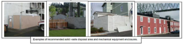
- Guidelines for All New Construction.
- The design of new construction should respect significant original characteristics, scale, and massing of adjacent structures that are visible from the public right-of-way or River Trail within three blocks of the development site. Buildings should be designed so that they are not substantially different in character from adjacent structures, in terms of size, mass, or architectural form. Also see Section 14.002.C, Resolving Conflicts within the Code.
- New construction should respect significant characteristics of composition and material of adjacent structures that are visible from the public right-of-way or River Trail within three blocks of the development site. Also see Section 14.002.C, Resolving Conflicts within the Code.
- Building forms should be simple single geometric shapes, e.g. square, rectangular, triangular (Figure 14.195-2).
Figure 14.195-2: Geometric Building Form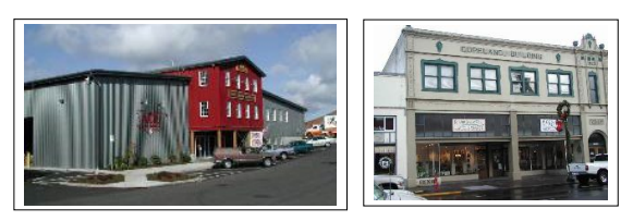
- Guidelines for All Existing Buildings.
- Distinctive stylistic features or examples of skilled craftsmanship of existing buildings and/or structures proposed for renovation, alteration, and/or additions should be treated with sensitivity. All buildings should be respected and recognized as products of their time.
- Renovations, alterations, and/or additions to existing buildings should respect significant existing original characteristics of adjacent structure scale and massing for the entire structure, and should be designed so that they are not substantially different in terms of size, mass, or architectural form. Also see Section 14.002.C, Resolving Conflicts within the Code.
- Renovations, alterations, and/or additions should retain and/or respect significant existing original characteristics of the existing structure composition and material, for the entire structure. Also see Section 14.002.C, Resolving Conflicts within the Code.
- Building forms should be simple single geometric shapes, e.g. square, rectangular, triangular (Figure 14.195-2).
- Mid-century “slip covers” which are not part of the original construction design should be removed when possible.
- Incompatible additions or building alterations using contemporary materials, forms, or colors on building facades are discouraged.
- Standards for Non-Industrial Uses.
- Facade Variation. All non-industrial buildings shall incorporate design features such as offsets, balconies, projections, window reveals, or other similar elements to preclude large expanses of uninterrupted building surfaces in areas which are visible to the public. Design features shall occur at a minimum of every 30 feet for all building facades visible from a public right-of-way or River Trail. (Figure 14.195-3)
The facade shall contain at least two (2) of the following features:- Recess (e.g., deck, patio, courtyard, entrance or similar feature) that has a minimum depth of six (6) feet;
- Extension (e.g., floor area, deck, patio, entrance, or similar feature) that projects a minimum of two (2) feet and runs horizontally for a minimum length of four (4) feet;
- Offsets or breaks in roof elevation of two (2) feet or greater in height;
- Outdoor seating area, plaza, or other interactive landscaped area adjacent to the building that is specifically identified and/or covered, and approved by the review authority; and/or
- Other similar facade variations approved by the review authority.
Figure 14.195-3: Facade Variation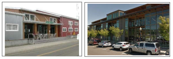
- Recess (e.g., deck, patio, courtyard, entrance or similar feature) that has a minimum depth of six (6) feet;
- Building Orientation and Entries. All non-industrial buildings shall have a prominent main entry oriented to and directly connected to the public sidewalk. Main entries shall be designed with prominent features that distinguish them from other building entries and must include at least two of the following features: (Figure 14.195-4)
- Recessed entry of at least 3 feet behind the front building plane
- Canopy or awning
- Transom/clerestory windows or flanking windows on either side of the door
- At least 2 ornamental light fixtures flanking the entry
- Pilasters or columns that frame the doorway
Figure 14.195-4: Prominent Main Entry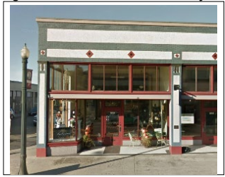
- Base, Middle, and Top of Building. All non-industrial buildings shall have a clear and distinct base, middle and top to break up vertical mass (Figure 14.195-5). All facades visible from a right-of-way or River Trail shall utilize horizontal bands and/or changes in color, material, form and/or pattern to differentiate the base, middle, and top of the building, subject to the following requirements:
- Horizontal bands or other changes in pattern or material shall be a minimum of 8 inches high (the length of a standard brick) and shall project a minimum of one (1) inch from the building face.
- Changes in building massing and form may also be used to differentiate a building’s base, middle, and top. This may include architectural setbacks or projections, measuring a minimum of 3 inches.
- Changes in color alone may not be used to differentiate a building’s base, middle, and top, but may be used in conjunction with the other features.
Figure 14.195-5: Base, Middle, & Top of Building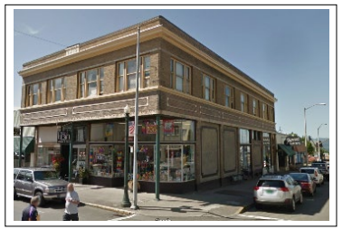
- Parking location. Parking and vehicle maneuvering areas shall not be located between the front building facade and the front property line, or between a building facade facing the River Trail and the property line adjacent to the River Trail.
Parking shall be permitted between a building and an interior lot line that is not a rear lot line, provided the following standards are met:- Where surface parking or maneuvering areas are located adjacent to a right-of-way or the River Trail, a minimum 5-foot wide landscaped strip shall be provided between the parking and maneuvering area and the right-of-way or River Trail. The landscaped strip shall be planted with trees spaced not more than 30 feet on center and with a mix of shrubs and ground cover. Additional standards for landscaping in parking areas are found in Section 3.120.A.15.
- Parking and maneuvering areas, including accessways and driveways, must not exceed 40 percent of a lot frontage.
- Facade Variation. All non-industrial buildings shall incorporate design features such as offsets, balconies, projections, window reveals, or other similar elements to preclude large expanses of uninterrupted building surfaces in areas which are visible to the public. Design features shall occur at a minimum of every 30 feet for all building facades visible from a public right-of-way or River Trail. (Figure 14.195-3)
- Guidelines for Non-Industrial Uses
- Compatibility with Historic Buildings.
- The massing, scale, and configuration of non-industrial buildings should be similar to historic structures that are visible from the public right-of-way or River Trail within three blocks of the development site.
- Non-Industrial buildings should be compatible with the vertical proportions of existing historic facades and the simple vertical massing of historic structures that are visible from the public right-of-way or River Trail within three blocks of the development site.
- The location, size, and design of windows and doors in non-industrial buildings should be compatible with existing historic structures that are visible from the public right-of-way or River Trail within three blocks of the development site.
- Development should be designed so that structures are not substantially different in character from adjacent buildings, in terms of size, mass, or architectural form.
- Corner Entrances and Features. Non-industrial buildings on corner lots are encouraged to have corner entrances. Where a corner entrance is not provided, the building design should provide an architectural element or detailing (e.g., tower, beveled/chamfered corner, art, special trim, etc.) that accentuates the corner location (Figure 14.195-6).
Figure 14.195-6: Corner Entrance and Features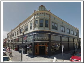
- Architectural Bays. Non-industrial buildings are encouraged to be divided into distinct street-facing architectural bays that reflect traditional storefront design (Figure 14.195-7). Architectural bays should feature at least two of the following elements:
- Engaged columns, pilasters, or piers
- Transom windows over doorways
- Storefront cornice or belt course
- Storefront frieze or sign band
- Bulkheads
Figure 14.195-7: Architectural Bays / Storefront Design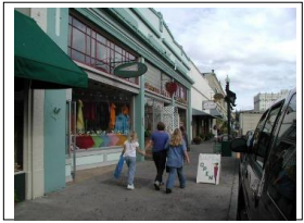
- Compatibility with Historic Buildings.
- Standards for All Uses.
- Roof Form and Materials.
- Roof Form Standards for All Uses. The following roof forms are prohibited:
- False mansard or other applied forms; and
- Dome skylights.
- Roof Materials Standards for All Uses.
- Buildings shall be constructed or reconstructed with one of the following roofing materials.
- Cedar shingle (Figure 14.195-8);
- Composition roofing (Figure 14.195-8); or
- Materials cited in Section 14.195.C.4 or Section 14.195.C.6.
Figure 14.195-8: Roofing Materials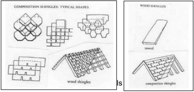
- The following roofing materials are prohibited for all types of buildings:
- High profile standing seam metal roof (Figure 14.195-9); and
- Brightly colored roofing material.
Figure 14.195-9: Low (3/8” x 1”) and High (1/4” x 1-1/4”) Roof Seams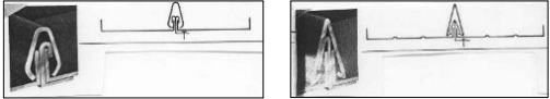
- Roofing materials shall be gray, brown, black, deep red, or another subdued color.
- Buildings shall be constructed or reconstructed with one of the following roofing materials.
- Roof Form Standards for Non-Industrial Uses. Buildings for non-industrial uses shall include one of the following roof forms:
- Single gable with low pitch; or
- Repetitive gable with steep pitch; or
- Flat or gable roof behind parapet wall (Figure 14.195-10).
Figure 14.195-10: Non-Industrial Building, Flat Roof Behind Parapet Wall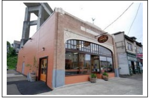
- Roof Materials Standards for Non-Industrial Uses. Buildings for non-industrial uses shall be constructed or reconstructed with one of the following roofing materials:
- Materials cited in Section 14.195.C.2; or
- Built-up roofing materials.
- Roof Form Standards for Industrial Uses. Buildings for industrial uses shall include the following roof forms:
- Single gable with low pitch; or
- Repetitive gable with steep pitch (Figure 14.195-11 and Figure 14.195-12); and
- Shallow eaves (Figure 14.195-12).
Figure 14.195-11: Roof Pitches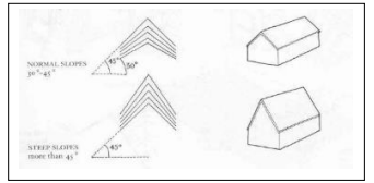
Figure 14.195-12: Industrial Building, Multiple Gables, Monitor Roof, and Shallow Eaves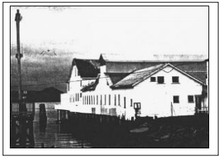
- Roof Materials Standards for Industrial Uses. Buildings shall be constructed or reconstructed with one of the following roofing materials:
- Materials cited in Section 14.195.C.2; or
- Galvanized corrugated metal; or
- Low profile standing seam, metal roof (Figure 14.195-9); or
- Roll down.
- Roof Form Guidelines for Non-Industrial Uses. Buildings for non-industrial uses may also include the following roof forms or features:
- Structural skylights
- Shallow eaves behind parapet wall
- Roof Form Guidelines for Industrial Uses. Buildings for industrial uses may also include one or more of the following roof forms or features:
- Small shed roof dormers
- Monitor roof on ridge line (Figure 14.195-12)
- Flat panel skylights or roof window
- Roof Form Standards for All Uses. The following roof forms are prohibited:
- Doors.
- Standards for All Uses. The following types of doors and door treatments are prohibited:
- Automatic sliding doors;
- Primary entry doors raised more than three feet above sidewalk level;
- Doors flush with building facade;
- Clear anodized aluminum frames; and
- Reflective, opaque, or tinted glazing.
- Guideline for All Uses. Building lighting should emphasize entrances.
- Standards for Non-Industrial Uses.
- Solid metal or wood doors with small or no windows are prohibited.
- Doors with a minimum of 50% of the door area that is glass are required.
- Guidelines for Non-Industrial Uses.
- Doors should be recessed (Figures 14.195-13 and 14.195-14).
- Large cafe or restaurant doors that open the street to the interior by pivoting, sliding, or rolling up overhead are encouraged (Figure 14.195-13).
- Well-detailed or ornate door hardware is encouraged (Figure 14.195-14). Contemporary hardware should be compatible with the design of the door.
- Transom, side lites, or other door/window combinations are encouraged (Figure 14.195-14).
- Doors combined with special architectural detailing are encouraged.
- Double or multiple door entries are encouraged (Figure 14.195-14).
Figure 14.195-13: Roll-Up Doors and Recessed Doors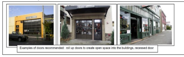
Figure 14.195-14: Recessed Doors, Contemporary Door Hardware, Single/Double Doors, Side Lites, and Transom Windows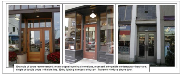
- Standards for All Uses. The following types of doors and door treatments are prohibited:
- Windows.
- Coverage Standards for All Uses.
- All building facades visible from a public right-of-way, the River Trail, and/or the Columbia River shall have windows or other openings in the facade, except as noted in subsection E.1.b of this section. Blank walls on any facades visible from the right-of-way, River Trail, and/or Columbia River for any type of use are prohibited.
- Exceptions. An exception to the window coverage standard may be allowed for a portion of a building facade with the inclusion of architectural detail / design features in amounts equal to the minimum window coverage requirement. Such architectural details shall include but not be limited to a change in material, horizontal projections, engaged columns or pilasters, belt course, moldings, clock, or other similar features. Non-industrial buildings may be allowed to reduce the minimum window percentage, per subsection 14.195.E.4.c.
- Design Standards for All Uses.
- Window detailing. Windows shall have casings/trim, sills, and crown moldings. Window detailing shall meet the following requirements.
- Casings/trim shall have minimum dimensions of 5/4 inch x 4 inch and shall extend beyond the facade siding. Exceptions may be granted for waterfront industrial style windows (Figure 14.195-16).
- Windows shall be recessed a minimum distance of two (2) inches from the face of the trim surface to the face of the sash to ensure a shadow line/effect.
- The bottom of the sill shall be a minimum of 18 inches above the ground or floor elevation.
Figure 14. 195-15: Window Detailing – Trim and casement location and dimensions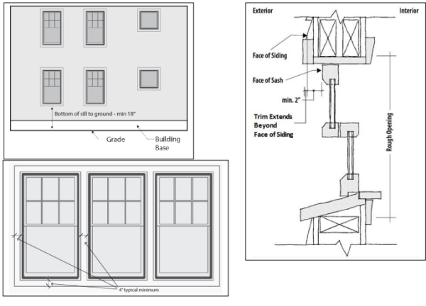
Figure 14. 195-16: Window Detailing – Industrial Style - no trim or casement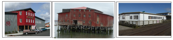
- The following types of windows or window treatments are prohibited:
- Residential-styled window bays;
- Half-round windows;
- Smoked, tinted, frosted, mirrored, and/or reflective glass, except for bathroom windows not on the facade facing a right-of-way or River Trail;
- Horizontal sliding windows;
- Vinyl windows; and
- Blocked-out windows; and
- Windows that extend beyond the plane of the building facade; and
- Applied muntins that have no profile.
- Window detailing. Windows shall have casings/trim, sills, and crown moldings. Window detailing shall meet the following requirements.
- Design Guidelines for All Uses.
- Windows, including transoms on existing buildings, should retain their original size and location as part of renovation activities.
- Windows that open by pivoting, casement, single hung, or other shuttering are encouraged.
- Painted wood or stucco panels or tile clad panels below windows are encouraged (Figure 14.195-17).
- Clear glass is encouraged.
- True divided lites are encouraged (Figure 14.195-17). Simulated divided lites shall have exterior muntins to create exterior shadow lines.
- Boldly articulated window and storefront trim are encouraged.
Figure 14.195-17: Transom Windows, Panels Below Windows, and True Divided Lites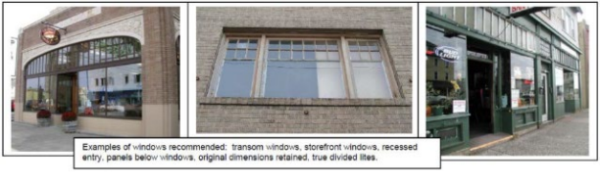
- Coverage Standards for Non-Industrial Uses.
- At least 50% of the ground-floor facades of non-industrial uses visible from a right-of-way and/or River Trail shall be covered by windows. At least 30% of the upper-floor facades visible from a right-of-way and/or River Trail shall be covered by windows, except as noted in subsection 4.c of this section.
- At least 20% of the ground-floor facades and 10% of the upper-floor facades of non-industrial uses visible only from the Columbia River shall be covered by windows, except as noted in subsection (c) of this section.
- Exception for elevator shafts. A reduction in the window percentage may be allowed for facades that include an elevator shaft, with the inclusion of architectural detail / design features in amounts equal to the minimum window coverage requirement. Such architectural details shall include but not be limited to a change in material, horizontal projections, engaged columns or pilasters, belt course, moldings, clock, or other similar features.
- Coverage Standards for Industrial Uses.
- All facades of buildings for industrial uses in the Urban Core Overlay Zone that are visible from a public right-of-way, the River Trail, and/or the Columbia River shall have windows. However, buildings for industrial uses are not subject to minimum window area requirements.
- Buildings for industrial uses are not required to have ground floor windows but shall have, at the least, clerestory or transom windows on the upper story facades or above a height of 14 feet.
- Coverage Standards for All Uses.
- Siding and Wall Treatment.
- Standards for All Uses. The following types of siding and wall materials and treatments are prohibited:
- Cladding materials such as corrugated metal panels or spandrel glass;
- Panels that are poorly detailed or do not have detailing;
- Neon or other fluorescent colors;
- Bright or primary wall colors for the entire wall surface;
- Flagstone, simulated river rock, or other similar veneer cladding;
- Painted brick; and
- Non-durable materials such as synthetic stucco or shingles at the ground floor.
- Textured fiber cement siding. Smooth fiber cement siding is allowed.
- Guidelines for All Uses.
- Variations in wall cladding materials and patterns consistent with historic patterns are encouraged (Figure 14.195-18).
- Natural or subdued building colors are encouraged (Figure 14.195-18).
- Bright neon or fluorescent style colors may be used for accent trim in limited amounts, not to exceed 15% of the area of any facade.
- Durable materials such as brick, stucco, granite, pre-cast concrete, board and batten, or horizontal wood siding should be used (Figure 14.195-18). These materials include galvanized corrugated metal on buildings for industrial uses.
- Architectural wall features such as belt courses, pilasters, and medallions are encouraged.
Figure 14.195-18: Siding Variety and Compatible Materials and Colors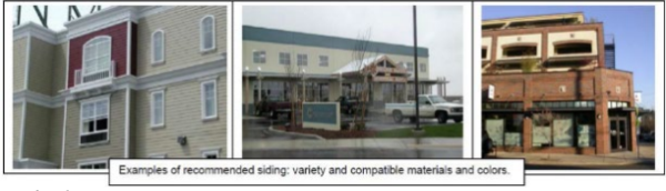
- Standards for All Uses. The following types of siding and wall materials and treatments are prohibited:
- Awnings.
- Standards for Types of Awnings and Treatments.
- Awnings over building entries shall be a minimum of 5 feet deep. Awnings over windows shall be a minimum of 3 feet deep. The bottom of all awnings shall be 8 to 12 feet above grade.
- Awnings shall extend the full width of the window and/or door area below the awning.
- The following types of awnings and awning treatments are prohibited:
- Fixed “bubble shaped” awnings (Figure 14.195-19); and
- Awnings lit internally.
- Signage and/or graphics are limited to the valance area only of awnings.
- Guidelines for Types of Awnings and Treatments. Vinyl or other non-compatible material awnings are discouraged (Figure 14.195-19).
Figure 14.195-19: Prohibited and Discouraged Awning Types and Treatments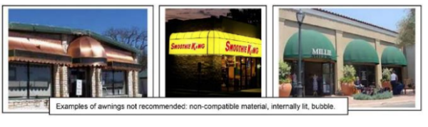
- Standards for Awning Locations Along River Trail and North/South Rights-of-Way. Awnings are generally discouraged and shall not project into the setback area.
- Standards for Types of Awnings and Treatments.
- Lighting.
- Standards for Lighting Types and Treatments for All Uses. The following lighting types or treatments are prohibited:
- Neon silhouette accent lighting;
- Fluorescent tube lighting;
- Security spotlight;
- Signs lit by lights containing exposed electrical conduit, junction boxes, or other electrical infrastructure; and
- Up-lighting that shines into the sky or light that shines into other properties or traffic.
- Standards Regarding Lighting Glare for All Uses. All uses shall comply with applicable lighting standards in Section 3.128.
- Guidelines Regarding Wall-Washing Light. Wall-washing lighting fixtures should be concealed and integrated into the design of buildings or landscape walls and stairways (Figure 14.195-20). Wall-washing lighting shall be designed to minimize light directed upwards into the night sky.
- Guidelines for Lighting Types and Treatments for Non-Industrial Uses. The following lighting types or treatments are encouraged.
- Decorative lighting integrated with architecture.
- Historic street lamps along walks and parking lots.
- Guidelines for Lighting Types and Treatments for Industrial Uses. The following lighting types or treatments are encouraged.
- Industrial pan light with goose neck.
- Low bollard lighting.
Figure 14.195-20: Downward and Diffused Lighting, Wall-Washing Lighting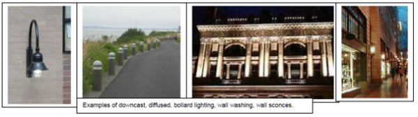
- Standards for Lighting Types and Treatments for All Uses. The following lighting types or treatments are prohibited:
- Signs. Signs in the Urban Core Overlay Zone are subject to the requirements in Article 8 (Sign Regulations) of the Astoria Development Code and to the standards and guidelines in this Section.
- Sign Standards for All Uses.
- Monument signs (Figure 14.195-21) are allowed up to a maximum of 32 square feet.
- Monument signs shall be a maximum of five (5) feet tall.
- Monument signs shall be constructed from materials that are consistent with the historic character of the area, including wood, brick, stone, and metal.
- Freestanding or ground signs are prohibited (Figure 14.195-21).
- Sign Guidelines for All Uses. The following sign types are encouraged.
- Hanging blade signs.
- Signs painted on building facade.
- Signs applied to building facade.
- Front lit.
- Graphics historic in character.
Figure 14.195-21: Monument Signs and Freestanding Signs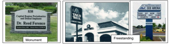
- Sign Standards for All Uses.
(Section 14.195 added by Ord 20-02, 1-21-2020)
Amended by Ord. 22-01 on 11/7/2022
14.200 LANDSCAPING
Landscaping is required in the Urban Core Overlay Zone in accordance with the provisions in this Section and those in Section 3.120 to 3.125. The provisions in this Section apply to new construction or exterior renovations with a value of at least 33% of the assessed value of the structure. Buildings existing prior to January 1, 2020 that cover more than 90% of a lot are exempt from meeting landscape requirements when making renovations.
- River Side and/or Riparian Standards. The following standards apply to landscaping on the river side of the River Trail and to riparian areas to the south of the River Trail, which is defined as the landward limit of Columbia River aquatic vegetation or, where aquatic vegetation is absent, the Mean Higher High Water.
- Height and Spacing.
- Maximum shrub height is 30 inches.
- Maximum width of clusters of trees is 30 feet.
- Clusters of trees shall have a minimum of 50 feet clear between branches at maturity.
- Trees are not permitted to be planted on the river side of the River Trail or riparian areas south of the River Trail within the extended public right-of-way or view corridor extending from it for a distance of 70 feet centered on the right-of-way centerline.
- Trees shall not exceed 25 feet in height at maturity.
- Maximum height of fences is three (3) feet.
Figure 14.200-1: River Side Landscaping
Figure 14.200-2: Riparian Landscaping
- Native Plants. See Section 3.125 concerning use of native plants and list of recommended native plants.
- Landscaping Credits for Non-Vegetation Features.
- The Community Development Director may approve non-vegetative features to account for up to 40% of required landscaping when the features consist of hardscaped pedestrian-oriented areas (e.g., courtyards, plazas). Permeable paving and other stormwater management techniques are encouraged in the design of these areas.
- An application proposing more than 40% of required landscaping be credited by non-vegetative features is subject to approval in accordance with variance procedures in Article 9 and Article 12.
- Non-vegetative features allowed in the public right-of-way and/or on the River Trail in lieu of required landscaping shall be maintained by the applicant. There shall be a maintenance agreement or other City approved agreement. Failure to maintain or loss of the non-vegetative feature will result in the requirement for installation of the landscaping in accordance with the Code at the time of the loss.
- Height and Spacing.
- Land Side or Upland Standards. The following standards apply to landscaping along the frontage of parcels abutting the River Trail to the south, except where riparian areas are located to the south of the River Trail. Riparian areas are subject to the standards of Section 14.200.A.
- Height and Spacing.
- Maximum spacing of trees.
- 20 feet on center for non-industrial uses
- 15 feet on center for industrial uses
- Maximum spacing of shrubs.
- Five (5) feet on center for non-industrial uses
- Three (3) feet on center for industrial uses
- Ground cover landscaping is required in between shrubs and trees.
- Trees shall not exceed 35 feet in height at maturity.
Figure 14.200-3: Land Side Landscaping
- Maximum spacing of trees.
- Parking Area Landscaping.
- Landscaping required between parking areas, streets, and sidewalks in accordance with Section 3.120.A.7 shall also be required between parking areas and the River Trail.
- Landscaping shall minimize pedestrian exposure to parking lots with a hedge or a decorative fence that is 36” to 42” high.
- Maximum tree height and width in parking areas shall be 15 feet at maturity.
- Landscaping Credits for Non-Vegetation Features.
- The Community Development Director may approve non-vegetative features to account for up to 25% of required landscaping when the features consist of the following:
- Hardscaped pedestrian-oriented areas (e.g., courtyards, plazas); and/or
- At least one of the following amenities meeting the City approved design within the public right-of-way and/or River Trail right-of-way:
- bike rack
- bench
- table
- drinking fountain
- directional or interpretive/information signage
- trash or recycling container
- lighting
- restroom
- An application proposing more than 25% of required landscaping be credited by non-vegetative features is subject to approval in accordance with variance procedures in Article 9 and Article 12.
- Non-vegetative features allowed in the public right-of-way and/or on the River Trail in lieu of required landscaping shall be maintained by the applicant. There shall be a maintenance agreement or other City approved agreement. Failure to maintain or loss of the non-vegetative feature will result in the requirement for installation of the landscaping in accordance with the Code at the time of the loss.
- The Community Development Director may approve non-vegetative features to account for up to 25% of required landscaping when the features consist of the following:
- Height and Spacing.
- Street Trees. Street trees shall be planted within the right-of-way along both sides of the street in the Urban Core Overlay Zone in accordance with the provisions in this Section.
- Standards for Street Trees on All Streets.
- Spacing should be 30 feet on center, depending on species and branching habit.
- Minimum size of deciduous trees should be 2" caliper, with an upright form.
- Mature branching height should be a minimum of 15 feet.
- Durable tree grates and trunk protectors should be installed.
- Areas between trees should be landscaped with a variety of shrubs and perennials, with an emphasis on flowering species.
- Required street trees shall be maintained by the adjacent property owner and/or other identified entity. There shall be a maintenance agreement or other City approved agreement.
- Location of street trees shall be reviewed and approved by the City Engineer. Due to the nature of the downtown hollow sidewalks, in-ground street trees may not be feasible. Alternative street landscaping with shrubs, groundcover, and/or raised planters may be approved.
- Standards for Street Trees on North-South Streets North of Marine Drive.
- Maximum height is 35 feet.
- Street trees shall have narrow profiles and/or be pruned to a maximum width of 15 feet.
- Street trees shall be one of the columnar species listed in Section 3.125.B.1, unless otherwise approved by the Community Development Director.
- Standards for Street Trees on All Streets.
(Section 14.200 added by Ord 20-02, 1-21-2020)
Amended by Ord. 22-01 on 11/7/2022
14.500 PURPOSE AND AREAS INCLUDED
This overlay district establishes additional requirements for shoreland areas adjacent to the Columbia River Estuary to assure that estuary shorelands are managed in a way that is compatible with adjacent estuarine aquatic areas. This district includes the following shoreland areas:
- Areas within 50 feet of the estuary shoreline;
- Adjacent area of geologic instability where the instability is related to or will impact the estuary;
- Riparian vegetation;
- Area of significant shoreland and wetland biological habitats where habitat quality is derived from or associated with the estuary;
- Areas in the S-1, S-2, S-2A, S-3 or S-4 Zones.
- Area of exceptional aesthetic or scenic quality, where the quality is primarily derived from or associated with the estuary;
(Section 14.500 renumbered by Ord 14-09, 10-16-14)
14.505 PERMITTED AND CONDITIONAL USES
- Use and activity listed in the underlying zone, subject to the procedure specified in the underlying zone.
- Accessory use and activity associated with development in adjacent Columbia River Estuary aquatic areas, subject to the procedure specified in the Aquatic Zone.
(Section 14.505 renumbered by Ord 14-09, 10-16-14)
14.510 DEVELOPMENT STANDARDS AND PROCEDURAL REQUIREMENTS
- All uses will satisfy applicable Columbia River Estuary Shoreland and Aquatic Area Use and Activity Standards in Article 4. Where a proposal involves several uses, the Standards applicable to each use shall be satisfied.
- Proposals involving a development that is only partially within this Overlay District shall be reviewed so that only the uses and activities actually within the Shorelands Boundary are subject to the requirements of this Overlay District.
- The Shorelands Boundary describes the landward limit of this Overlay District. The Shorelands Boundary is described in the Subarea Plans, Section CP.155 through CP.180 of the Comprehensive Plan.
- There shall be a 15’ landscaped buffer area maintained between outdoor storage areas, parking areas, and/or driving surfaces and the top of bank along the shoreline. Except as otherwise noted, parked vehicle bumpers may overhang a maximum of 2.5’ beyond a bumper guard into the landscaped area. (Section 14.510.D added by Ord 19-05, 6-17-2019)
(Section 14.500 renumbered by Ord 14-09, 10-16-14)
14.520 PURPOSE AND OBJECTIVES
- It is the purpose of this Flood Hazard Overlay Zone to regulate the use of those areas subject to periodic flooding, to promote the public health, safety and general welfare and to minimize public and private losses due to flood conditions. In advancing these principles and the general purposes of the City of Astoria Comprehensive Plan and Development Code, the specific objectives of this zone are:
- To combine with the present zoning requirements certain restrictions made necessary for the known flood hazard areas to promote the general health, welfare and safety of the City.
- To prevent the establishment of certain structures and land uses in areas unsuitable for human habitation because of the danger of flooding, unsanitary conditions or other hazards.
- To minimize the need for rescue and relief efforts associated with flooding.
- To help maintain a stable tax base by providing for sound use and development in flood-prone areas and to minimize prolonged business interruptions.
- To minimize damage to public facilities and utilities located in flood hazard areas.
- To ensure that potential home and business buyers are notified that property is in a flood area.
- To ensure that those who occupy the areas of special flood hazard assume responsibility for their actions.
(Section 14.520 renumbered by Ord 14-09, 10-16-14)
14.525 DEFINITIONS
Unless specifically defined below, words or phrases used in this Code shall be interpreted so as to give them the meaning they have in common usage, and to give this Code its most reasonable application. In addition, any words or phrases found in this section are applicable to only this section of the Code, unless otherwise stated.
AREA OF SHALLOW FLOODING: A designated AO or AH zone on the Flood Insurance Rate Map (FIRM). The base flood depth range is from one to three feet; a clearly defined channel does not exist; the path of flooding is unpredictable and indeterminate; and velocity flow may be evident. AO is characterized as sheet flow and AH indicates ponding.
AREA OF SPECIAL FLOOD HAZARD: The land in the flood plain subject to a one percent (1%) or greater chance of flooding in any given year. Designation on maps always include the letter A or V.
BASE FLOOD: A flood having a one percent (1%) chance of being equaled or exceeded in any given year (also referred to as a 100-year flood).
BASE FLOOD ELEVATION (BFE): The height of the base flood, usually in feet, in relation to the current FEMA Flood Insurance Rate Maps, or depth of the base flood, usually in feet, above the ground surface.
BASEMENT: Basement means any area of the building having its floor subgrade below ground level on all sides.
BELOW-GRADE CRAWLSPACE: An enclosed area below the base flood elevation in which the interior grade is not more than two feet below the lowest adjacent exterior grade and the height, measured from the interior grade of the crawlspace to the top of the crawlspace foundation, does not exceed 4 feet at any point.
CRITICAL FACILITY: A facility for which even a slight chance of flooding might be too great. Critical facilities include, but are not limited to schools, nursing homes, hospitals police, fire and emergency response installations, installations which produce, use or store hazardous materials or hazardous waste. Critical facilities exclude water, sanitary sewer, and storm water infrastructure, as well as assisted-living facilities.
DEVELOPMENT: Any man-made change to improved or unimproved real property, including but not limited to buildings or other structures, mining, dredging, filling, grading, paving, excavation or drilling operations or storage of equipment or materials.
ELEVATED STRUCTURE: A non-basement building which has its lowest elevated floor raised above ground level by foundation walls, shear walls, posts, piers, pilings, or columns.
FLOOD OR FLOODING: A general and temporary condition of partial or complete inundation of normally dry land areas from:
- The overflow of inland or tidal waters; and/or
- The unusual and rapid accumulation of runoff of surface waters from any source.
FLOOD INSURANCE RATE MAP (FIRM): The official map on which the Federal Insurance Administration has delineated both the areas of special flood hazards and the risk premium zones applicable to the community.
FLOOD INSURANCE STUDY: The official report provided by the Federal Insurance Administration that includes flood profiles, the Flood Boundary-Floodway Map, and the water surface elevation of the base flood.
LOWEST FLOOR: The lowest floor of the lowest enclosed area (including basement). An unfinished or flood resistant enclosure, usable solely for parking of vehicles, building access or storage, in an area other that a basement area, in not considered a building’s lowest floor, provided that such enclosure in not built so as to render the structure in violation of the applicable non-elevation design requirements of this Code in Section 14.545(A).
MEAN SEA LEVEL (MSL): The National Geodetic Vertical Datum (NGVD) of 1929 or other datum, to which base flood elevations shown on a community’s Flood Insurance Rate Map are referenced.
NEW CONSTRUCTION: Structures for which the “start of construction” commenced on or after January 21, 1988.
START OF CONSTRUCTION: The date the building permit was issued, provided the actual start of construction, repair, reconstruction, placement or other improvement was within 180 days of the permit date. The actual start means either the first placement of permanent construction of a structure on a site, such as the pouring of slab or footings, the installation of piles, the construction of columns, or any work beyond the stage of excavation; or the placement of a manufactured home on a foundation. For a substantial improvement, the actual start of construction means the first alteration of any wall, ceiling, floor, or other structural part of a building, whether or not that alteration affects the external dimensions of the building. Permanent construction does not include:
- Land preparation, such as clearing, grading and filling;
- Installation of streets and/or walkways;
- Excavation for basement, footings, piers, or foundation or the erection of temporary forms;
- Installation on the property of an accessory building, such as a garage or shed not occupied as a dwelling unit or not part of the main structure.
STRUCTURE: A walled, floored, and/or roofed building including a gas or liquid storage tank that is principally above ground, as well as a manufactured home.
SUBSTANTIAL DAMAGE: Is damage of any origin sustained by a structure whereby the cost of restoring the structure to its before damaged condition would equal or exceed 50 percent of the market value of the structure before the damage occurred as indicated on the records of the Clatsop County Assessor.
SUBSTANTIAL IMPROVEMENT: Any repair, reconstruction, or improvement of an existing structure, the cost of which equals or exceeds 50 percent of the market value of the structure either:
- Before the improvement or repair is started; or
- If the structure has been damaged and is being restored, before the damage occurred. For the purposes of this definition, “substantial improvement” is considered to occur when the first alteration of any wall, ceiling, floor, or other structural part of the building commences, whether or not that alteration affects the external dimensions of the structure.
- The terms do not, however, include either:
- Any project for improvement of a structure to correct existing violations of State or local health, sanitary, or safety code specifications which have been identified by the local code enforcement official and which are the minimum necessary to assure safe living conditions; or
- Any alteration of a structure listed on the National Register of Historic Places, Local Landmark, or on a State Inventory of Historic Places.
(Section 14.525 renumbered by Ord 14-09, 10-16-14; Ordinance 09-03, 8/3/09
)
Amended by Ord. 22-01 on 11/7/2022
14.530 GENERAL PROVISIONS
- Lands to Which This Code Applies. This Code shall apply to all areas of special flood hazards (Flood Hazard Overlay Zone) in combination with present zoning requirements within the jurisdiction of the City of Astoria.
- Basis for Establishing the Areas of Special Flood Hazard. The areas of special flood hazard identified by the Federal Insurance Administration through a scientific and engineering report entitled "The Flood Insurance Study for Clatsop County, Oregon and Incorporated Areas", dated September 17, 2010, with accompanying Flood Insurance Rate Maps and Flood Boundary Maps and any revision thereto, is hereby adopted by reference and declared to be a part of this Code. The Flood Insurance Study is on file at the City of Astoria City Hall, Community Development Department, 1095 Duane Street, Astoria. (Section 14.530.B formerly 2.810.B amended by Ordinance 09-03, 8/3/09; amended by Ordinance 10-09, 9-7-10)
- Compliance. No structure or land shall hereafter be located, extended, converted or altered without full compliance with the terms of this Code and other applicable regulations.
Compliance with the terms of this Code and other applicable regulations, and adherence to the submitted plans, as approved, is required. Any departure from the conditions of approval and approved plans, or any work not in compliance with the Code constitutes a violation of this Code. See Section 1.010 of the Astoria City Code concerning penalties. (Section 14.530.C formerly 2.810.C amended by Ordinance 09-03, 8/3/09) - Warning and Disclaimer of Liability. The degree of flood protection required by this Code is considered reasonable for regulatory purposes and is based on scientific and engineering considerations. Larger floods can and will occur on rare occasions. Flood heights may be increased by man-made or natural causes. This Code does not imply land outside the areas of special flood hazards or uses permitted within such areas will be free from flooding or flood damages. The Code shall not create liability on the part of the City of Astoria, or any officer or employee thereof, for any flood damages that result from reliance on this Code or any administrative decision lawfully made thereunder.
- Abrogation and Greater Restrictions. This ordinance is not intended to repeal, abrogate, or impair any existing easements, covenants, or deed restrictions. However, where this ordinance and another ordinance, state building code, easement, covenant, or deed restriction conflict or overlap, whichever imposes the more stringent restrictions shall prevail. (Section 14.530.E formerly 2.810.E added by Ordinance 09-03, 8/3/09)
- Interpretation. In the interpretation and application of this ordinance, all provisions shall be:
- Considered as minimum requirements;
- Liberally construed in favor of the governing body; and,
- Deemed neither to limit nor repeal any other powers granted under State statutes and rules including the state building code. (Section 14.530.F formerly 2.180.F added by Ordinance 09-03, 8/3/09)
- Flood Insurance Rates. Some construction techniques, including but not limited to below-grade crawl space, may affect flood insurance rates. The applicant and/or property owner are advised to obtain additional information on this subject from an insurance company, the Oregon Department of Land Conservation and Development or the Federal Emergency Management Administration. (Section 14.530.G formerly 2.810.G added by Ordinance 09-03, 8/3/09)
(Section 14.530 renumbered by Ord 14-09, 10-16-14)
14.535 ADMINISTRATION.
- Establishment of Development Permit. A development permit shall be obtained before construction or development begins within any area defined as an Area of Special Flood Hazard (see definition). The permit shall be for all structures including manufactured homes, set forth in the "definitions" and for all developments including fill and other activities, also as set forth in the "Definitions". Application for a development permit shall be made to the Community Development Director on forms furnished by the City, and shall specifically include the following information:
- Elevation in relation to mean sea level, of the lowest floor (including basement) of all structures.
- Elevation in relation to mean sea level to which any structure has been floodproofed.
- Certification by a registered professional engineer or architect that the floodproofing method for any non-residential structure meets the floodproofing criteria in Section 14.545(A.2).
- Description of the extent to which any watercourse will be altered or relocated as a result of proposed development.
- Duties and Responsibilities. The duties of the Community Development Director shall include, but not be limited to:
- Review of all development permits to determine that the permit requirements of this Code have been satisfied.
- Review all development permits to determine that all necessary permits have been obtained from those Federal, State or local governmental agencies from which prior approval is required.
- Review all development permits in the area of special flood hazard to determine if the proposed development adversely affects the flood carrying capacity of the area.
- Use of Other Base Flood Data. When base flood elevation data has not been provided in accordance with Section 14.530(B), Basis for Establishing the Area of Special Flood Hazard, the Community Development Director shall:
- Obtain, review and reasonably utilize any base flood elevation data available from a Federal, State or other source, in order to administer Section 14.545(A.1), Specific Standards, Residential Construction, and Section 14.545(A.2), Specific Standards, Non-residential Construction.
- Review proposed development to assure that all necessary permits have been received from those governmental agencies from which approval is required by Federal or State law, including section 404 of the Federal Water Pollution Control Act amendments of 1972, 33 U.S.C. 1334. (Section 14.535.C.2 formerly 2.815.C.2 added by Ordinance 09-03, 8/3/09)
- Information to Be Obtained and Maintained by Community Development Director. Where base flood elevation data is provided through the Flood Insurance Study or required as in Section 14.535(C), the Community Development Director shall:
- Verify and record actual elevation (in relation to Mean Sea Level) of the lowest floor (including basement) of all new or substantially improved structures and whether or not the structure contains a basement.
- For all new or substantially improved floodproofed structures:
- verify and record the actual elevation (in relation to Mean Sea Level); and
- maintain the floodproofing certifications required in Section 14.535(A.3).
- Maintain for public inspection all records pertaining to the provision of this ordinance. (Section14.535.D.3 formerly 2.815.D.3 added by Ordinance 09-03, 8/3/09)
- Alteration of Watercourses. The Community Development Director shall:
- Notify adjacent communities, the Oregon Department of Land Conservation and Development, Department of State Lands, the Oregon Water Resources Department, and other appropriate State and Federal agencies, prior to any alteration or relocation of a watercourse, and submit evidence of such notification to the Federal Insurance Administration. (Section 14.535.E.1 formerly 2.815.E.1 amended by Ordinance 09-03, 8/3/09)
- Require that maintenance is provided within the altered or relocated portion of said watercourse, so that the flood carrying capacity is not diminished.
- Interpretation of FIRM Boundaries. The Community Development Director shall make interpretations where needed, as to the exact location of the boundaries of the areas of special flood hazards (for example, where there appears to be a conflict between a mapped boundary and actual field conditions). The person contesting the location of the boundary shall be given a reasonable opportunity to appeal the interpretations as provided in Section 14.535(H).
- Variance Procedures.
- A variance shall be reviewed by the Community Development Director in accordance with Article 12. (Section 14.535.G.1 formerly 2.815.G.1 amended by Ordinance 09-03, 8/3/09)
- (Section 14.535.G.2 formerly 2.815.G.2 deleted by Ordinance 09-03, 8/3/09).
- (Section 14.535.H formerly 2.185.H deleted by Ordinance 09-03, 8/3/09).
(Section 14.535 renumbered by Ord 14-09, 10-16-14)
14.540 GENERAL PROVISIONS FOR FLOOD HAZARD REDUCTION
- General Standards. In the Flood Hazard Overlay Zone (FHO) the following provisions are required:
- Anchoring.
- All new construction and substantial improvement shall be anchored to prevent flotation, collapse or lateral movement of the structure.
- All manufactured homes must likewise be anchored to prevent flotation, collapse or lateral movement, and shall be installed using methods and practices that minimize flood damage. Anchoring methods may include, but are not limited to, use of over-the-top or frame ties to ground anchors (Refer to FEMA's "Manufactured Home Installation in Flood Hazard Areas" guidebook for additional techniques).
- Construction Materials and Methods.
- All new construction and substantial improvements shall be constructed with materials and utility equipment resistant to flood damage.
- All new construction or substantial improvements shall be constructed by methods and practices that minimize flood damage.
- Electrical, heating, ventilation, plumbing, and air conditioning equipment and other service facilities shall be designed and/or otherwise elevated or located so as to prevent water from entering or accumulating with the components during conditions of flooding.
- Utilities.
- All new and replacement water supply systems shall be designed to minimize or eliminate infiltration of flood waters into the system;
- New and replacement sanitary sewage systems shall be designed to minimize or eliminate infiltration of flood waters into the systems and discharges from the systems into flood waters; and
- On-site waste disposal systems shall be located to avoid impairment to them or contamination from them during flooding.
- Subdivision Proposals.
- All subdivision proposals shall be consistent with the need to minimize flood damage.
- All subdivision proposals shall have public utilities and facilities such as sewer, gas, electrical and water systems located and constructed to minimize flood damage.
- All subdivision proposals shall have adequate drainage provided to reduce exposure to flood damage.
- Where base flood elevation data has not been provided or is not available from another authoritative source, it shall be generated for subdivision proposals and other proposed developments which contain at least 50 lots or 5 acres (whichever is less).
- Review of Building Permits. Where elevation data is not available either through the Flood Insurance Study or from another administrative source (Section 14.535(C), applications for building permits shall be reviewed to assure that proposed construction will be reasonably safe from flooding. The test of reasonableness is a local judgment and includes use of historical data, high water marks, photographs of past flooding, etc., where available. Failure to elevate at least two feet above grade in these zones may result in higher insurance rates.
- Anchoring.
(Section 14.540 renumbered by Ord 14-09, 10-16-14)
14.545 SPECIFIC PROVISIONS FOR FLOOD HAZARD REDUCTION
- Specific Standards. In all areas of special flood hazards (FHO) where base flood elevation data has been provided as set forth in Section 14.530(B), Basis for Establishing the Areas of Special Flood Hazard, or Section 14.535(C), Use of Other Base Flood Data, the following provisions are required:
- Residential Construction. New construction and substantial improvement of any residential structure shall have the lowest floor, including basement, elevated to a minimum of one foot above the base flood elevation. Fully enclosed areas below the lowest floor that are subject to flooding are prohibited, or shall be designed to automatically equalize hydrostatic flood forces on exterior walls by allowing for the entry and exit of floodwaters. Designs for meeting this requirement must either be certified by a registered professional engineer or architect or must meet or exceed the following minimum criteria: (Section 14.545.A.1 formerly 2.825.A.1 amended by Ordinance 09-03, 8/3/09)
- A minimum of two openings having a total net area of not less than one square inch for every square foot of enclosed area subject to flooding shall be provided.
- The bottom of all openings shall be no higher than one foot above grade.
- Openings may be equipped with screens, louvers, valves, or other coverings or devices provided that they permit the automatic entry and exit of floodwaters. (Section 14.545.A.1.c formerly 2.825.A.1.c added by Ordinance 09-03, 8/3/09)
- For below-grade crawlspace. See Section 14.545(A.5). (Section 14.545.A.1.d formerly 2.825.A.1.d added by Ordinance 09-03, 8/3/09)
- Non-Residential Construction. New construction and substantial improvement of any commercial, industrial, or other non-residential structure shall either have the lowest floor, including basement, elevated to one foot above the base flood elevation, or, together with attendant utility and sanitary facilities, shall:
- Be floodproofed so that below the base flood level the structure is watertight with walls substantially impermeable to the passage of water;
- Have structural components capable of resisting hydrostatic and hydrodynamic loads and effects of buoyancy;
- Be certified by a registered professional engineer or architect that the design and methods of construction are in accordance with accepted standards of practice for meeting provisions of this Subsection based on their development and/or review of the structural design, specification and plans. Such certifications shall be provided to the official as set forth in Section 14.535(D.2.b);
- Non-residential structures that are elevated, not floodproofed, must meet the same standards for space below the lowest floor as described in Section 14.535(A);
- Applicants floodproofing non-residential buildings shall be notified that flood insurance premium will be based on rates that are one foot below the flood proofed level (e.g., a building constructed to the base flood level will be rated as one foot below that level).
- For below-grade crawlspace. See Section 14.545(A.5). (Section 14.545.A.2.f formerly 2.825.A.2.f added by Ordinance 09-03, 8/3/09)
- Manufactured Homes. All manufactured homes, both within or outside of manufactured dwellings parks, to be placed or substantially improved within Zones A1-30, AH and AE shall be elevated on a permanent foundation such that the lowest floor of the manufactured home is elevated to one foot above the base flood elevation and securely anchored to an adequately anchored foundation system in accordance with the provisions of Section 14.540(A.1.b). (Section 14.545.A.3 formerly 2.825.A.3 amended by Ordinance 09-03, 8/3/09)
- Recreational Vehicles. Recreational vehicles are prohibited from being located within Zones A1-30, AH and AE, or are being stored and are unoccupied in compliance with all other City codes and ordinances.
In addition to other City codes and ordinances, the recreational vehicle shall:- Be located on the site for fewer than 180 consecutive days; and
- Be fully licensed and ready for highway use, on its wheels or jacking system, is attached to the site only by quick disconnect type utilities and security devices, and has no permanently attached additions. (Section 14.545.A.4 formerly 2.825.A.4. added by Ordinance 09-03, 8/3/09)
- Below-Grade Crawlspace. Below-grade crawlspaces are allowed subject to the following standards as found in FEMA Technical Bulletin 11-01, Crawlspace Construction for Buildings Located in Special Flood Hazard Areas (See Figure 1 below):
- The building must be designed and adequately anchored to resist flotation, collapse, and lateral movement of the structure resulting from hydrodynamic and hydrostatic loads, including the effects of buoyancy. Hydrostatic loads and the effects of buoyancy can usually be addressed through the required openings stated in Section 14.545(A.5.b) below. Because of hydrodynamic loads, crawlspace construction is not allowed in areas with flood velocities greater than five (5) feet per second unless the design is reviewed by a qualified design professional, such as a registered architect or professional engineer. Other types of foundations are recommended for these areas.
- The crawlspace is an enclosed area below the base flood elevation (BFE) and, as such, must have openings that equalize hydrostatic pressures by allowing the automatic entry and exit of floodwaters. The bottom of each flood vent opening can be no more than one (1) foot above the lowest adjacent exterior grade.
- Portions of the building below the BFE must be constructed with materials resistant to flood damage. This includes not only the foundation walls of the crawlspace used to elevate the building, but also any joists, insulation, or other materials that extend below the BFE. The recommended construction practice is to elevate the bottom of joists and all insulation above BFE.
- Any building utility systems within the crawlspace must be elevated above BFE or designed so that floodwaters cannot enter or accumulate within the system components during flood conditions. Ductwork, in particular, must either be placed above the BFE or sealed from floodwaters.
- The interior grade of a crawlspace below the BFE must not be more than two (2) feet below the lowest adjacent exterior grade.
- The height of the below-grade crawlspace, measured from the interior grade of the crawlspace to the top of the crawlspace foundation wall must not exceed four (4) feet at any point. The height limitation is the maximum allowable unsupported wall height according to the engineering analyses and building code requirements for flood hazard areas.
- There must be an adequate drainage system that removes floodwaters from the interior area of the crawlspace. The enclosed area should be drained within a reasonable time after a flood event. The type of drainage system will vary because of the site gradient and other drainage characteristics, such as soil types. Possible options include natural drainage through porous, well-drained soils and drainage systems such as perforated pipes, drainage tiles or gravel or crushed stone drainage by gravity or mechanical means.
- The velocity of floodwaters at the site should not exceed five (5) feet per second for any crawlspace. For velocities in excess of five (5) feet per second, other foundation types should be used.
Figure 1. Requirements regarding below-grade crawlspace construction.
NOTE: In addition, the Oregon State Building Code requires residential structures to elevate 1 ft. above BFE.”
(Section 14.545.A.5 formerly 2.825.A.5. added by Ordinance 09-03, 8/3/09)
- Residential Construction. New construction and substantial improvement of any residential structure shall have the lowest floor, including basement, elevated to a minimum of one foot above the base flood elevation. Fully enclosed areas below the lowest floor that are subject to flooding are prohibited, or shall be designed to automatically equalize hydrostatic flood forces on exterior walls by allowing for the entry and exit of floodwaters. Designs for meeting this requirement must either be certified by a registered professional engineer or architect or must meet or exceed the following minimum criteria: (Section 14.545.A.1 formerly 2.825.A.1 amended by Ordinance 09-03, 8/3/09)
(Section 14.545 renumbered by Ord 14-09, 10-16-14)
14.560 PURPOSE
This zone is intended to provide for developments incorporating a single type or a variety of housing types and related uses which are planned and developed as a unit or in sequential phases. Such developments may consist of individual lots as part of a larger holding or as common building sites. Commonly owned land, which is an essential and major element of the plan, should be related to and preserve the natural features of the land and enhance the long-term value of the property. It is the intent of this zone to foster a more innovative approach to land development than is possible under the traditional lot by lot methods, and to provide a more desirable environment through the application of flexible and diversified land development standards following an overall comprehensive site development plan.
(Section 14.560 renumbered by Ord 14-09, 10-16-14)
14.565 PERMITTED BUILDINGS AND USES
- The following buildings and uses may be permitted as hereinafter provided when on sites of three acres or more. Buildings and uses may be permitted either singly or in combination provided the overall density of the planned development does not exceed the density of the parent zone as provided in this Code.
- Single-family dwelling including detached, attached, or semi-attached units, row houses, atrium or patio houses on individual lots or in cooperative or condominium ownership.
- Two-family dwelling.
- Multi-family dwelling.
- Manufactured home, mobile house, or modular home.
- Accessory building and uses.
- Commercial use only when support mainly by the planned development and only when economic feasibility can be shown.
- Building or use as an outright use, or conditional use in the parent zone on which the planned development is located.
- Transportation facilities. (Section 14.565.8 formerly 2.895.8 added by Ordinance 14-03, 4-21-14)
- Accessory Dwelling Unit. (Section 14.565.9 added by Ordinance 21-02, 2-16-21)
(Section 14.565 renumbered by Ord 14-09, 10-16-14)
14.570 DEVELOPMENT STANDARDS
- Minimum Site Size. Planned developments shall be established only on parcels of land which are suitable for the proposed development and are determined by the Planning Commission to be in keeping with the intent of this Code. A minimum area for such a zone shall be three (3) acres.
- Open Space. In all residential developments, or in combination residential commercial developments, fifty percent (50%) of the total area shall be devoted to open space. Open space may be in the form of yards, buffers, setbacks, common open areas, or recreational facilities. Of this area, twenty-five percent (25%) of said open space may be utilized privately by individual owners or users of the planned development; however, seventy-five percent (75%) of this area should be common or shared open space. The Planning Commission may increase or decrease the open space requirements depending on the particular site and the needs of the development.
- Density. The density of a planned development shall not exceed the density of the parent zone. Except that the density of housing development shall not be less than eight (8) units per acres. When calculating density, the gross area is used (total area including street dedications). Areas of common use may be included in calculating allowable density.
- Low and Moderate Income Housing. For housing developments which are subsidized through a State or Federal housing assistance program, or which can be certified by the developer to be affordable housing for low and moderate income persons or families, a minimum density of 12 units per acre shall be assigned to the project by the Planning Commission so long as a finding is made that the land is physically capable of supporting this level of development.
- Subdivision Lot Sizes. Minimum area, width, depth, and frontage requirements for subdivision lots in a planned development may be less than the minimums set forth elsewhere in City Codes, provided that the overall density is in conformance, and that lots conform to the approved preliminary development plan.
- Off-Street Parking. Parking spaces shall conform to all provisions of this Code, except that the Planning Commission may authorize exceptions where warranted by unusual circumstances. Common off-street parking areas may be provided, and the Planning Commission may allow street width reductions where this is done.
- Signs. All non-exempt signs within a planned development are subject to review and approval of the Planning Commission. They shall consider each sign on its merits based on its visual impact on the area, potential traffic hazards, potential violation of property and privacy rights of adjoining property owners, and need for said sign.
- Height. The same restrictions shall prevail as permitted outright in the zone in which such development occurs.
- Streets and Roads. Necessary streets and roads within the planned development will be dedicated to the public and constructed to standards determined by the Planning Commission based on the recommendation of the City Engineer. The Planning Commission may authorize the construction of narrower streets without curbs, sidewalks, and on-street parking areas where it has been determined that adequate off-street parking is provided, and where it is determined that standard street construction practices would have adverse impacts on slopes, or the character of the development.
- Dedication and Maintenance of Facilities. The Planning Commission, or on appeal, the City Council, may as a condition of approval for the planned development, require that portions of the tract or tracts under consideration be set aside, improved, conveyed or dedicated for the following uses:
- Recreation Facilities. The Planning Commission may require that suitable area for parks or playgrounds be set aside, improved, or permanently reserved for the owners, residents, employees or patrons of the planned development.
- Common Area. Whenever common area is provided, the Planning Commission or City Council may require that an association of owners or tenants be created into a non-profit corporation under the laws of the State of Oregon, which shall adopt such Articles of Incorporation and By-laws that are acceptable to the Planning Commission. Said association shall be formed and continued for the purpose of maintaining such common area. Such an association, if required, may undertake other functions. It will be created in such a manner that owners of property will automatically be members and will be subject to assessment levied to maintain said common areas for the purposes intended. The period of existence of such association will be not less than 20 years, and it will continue thereafter and until a majority vote of the members will terminate it.
- Easements. Easements necessary to the orderly extension of public utilities may be required as a condition of approval.
- Recreation Facilities. The Planning Commission may require that suitable area for parks or playgrounds be set aside, improved, or permanently reserved for the owners, residents, employees or patrons of the planned development.
- Underground Utilities. All electrical and telephone, cable TV, fire alarm, street light wiring, and similar facilities shall be placed underground by the developer.
- Approvals. The Community Development Department will submit the preliminary development plan to the City Departments and utilities which will serve the planned development and will consider their recommendations in regard to approval of the proposal.
(Section 14.570 renumbered by Ord 14-09, 10-16-14)
14.575 PROCEDURE - PRELIMINARY DEVELOPMENT PLAN
- Content of Preliminary Development Plan. The applicant will submit four (4) copies of the preliminary development plan to the Planning Commission prior to formal application for rezoning. This plan and any written statements will contain at least the following information:
- Contour map at two (2) foot contour intervals.
- A site investigation by a registered geologist showing feasible building site and known or potential geologic hazards.
- Proposed land use and densities.
- Location and approximate dimensions and heights of structures.
- Plan of open spaces or common spaces.
- Map showing existing natural features, including major stands of trees, streams, etc.
- Proposed method of utilities service and drainage.
- A grading plan showing all cuts and fills proposed.
- Relation of the proposed development to the surrounding area and the Comprehensive Plan.
- Proposed lot layout, road and circulation plan.
- A schedule, if it is proposed that the final development plan will be executed in stages.
- Planning Commission Review. The Planning Commission will consider the preliminary development plan at a public meeting, at which time they will determine whether the proposal conforms to City Codes. In addition, in considering the plan, the Planning Commission will seek to determine that:
- There are special physical conditions or objectives of development which the proposal will satisfy to warrant a departure from the standard Code requirements.
- Resulting development will not be inconsistent with the Comprehensive Plan provisions or zoning objectives of the area.
- The proposed development will be in substantial harmony with the surrounding area, including vegetation and topography and any important natural areas such as marshes or wildlife habitats.
- The plan can be completed within a reasonable period of time.
- Any proposed commercial development is intended to serve the neighborhood.
- The streets are adequate to support the anticipated traffic and the development will not overload the streets outside the planned area.
- Proposed utility and drainage facilities are adequate for the population densities and type of development proposed.
- Notification to Applicant. The Planning Commission will notify the applicant whether, in its opinion, the foregoing provisions have been satisfied and, if not, whether they can be satisfied with further plan revision.
- Application for Amendment. Following this preliminary meeting, the applicant may proceed with his request for approval of the planned development by filing an application for an amendment to this Code with the Community Development Department.
(Section 14.575 renumbered by Ord 14-09, 10-16-14)
14.580 PROCEDURE - FINAL APPROVAL
- Contents of Final Plan. Within one (1) year after concept approval or modified approval of a preliminary development plan, the applicant will file a final plan for the entire development or, when submission in stages has been authorized, for the first unit of the planned development, with the Planning Commission. The final plan will include all information included in the preliminary plan plus the following:
- The final plat of the subdivision, if property is to be subdivided, or the final lot lines of the development as surveyed.
- Location and dimensions of streets, roads, trails, common open space, recreation area and parks.
- Location, dimensions, and arrangement of off-street parking including width of aisles, spaces, and other design criteria.
- Planting and landscaping plan.
- Architectural plans and elevations of typical structures.
- The applicant will also submit drafts of appropriate deed restrictions or protective covenants to provide for the maintenance of common areas and to assure that the objectives of the planned development will be followed.
- Planning Commission Review. Upon receipt of the final development plan, the Planning Commission will examine such plan and determine whether it conforms to all applicable criteria and standards and whether it conforms in all substantial respects to the previously approved preliminary development plan, or require such changes in the proposed development or impose such conditions of approval as are, in its judgment, necessary to insure conformity to the applicable criteria and standards. In so doing, the Planning Commission may permit the applicant to revise the plan and resubmit it as a final development plan within 30 days.
- City Council Review. After final concept approval by the Planning Commission, the planned development application will be sent to the City Council for consideration for final approval and zone change.
(Section 14.580 renumbered by Ord 14-09, 10-16-14)
14.585 MAPPING
An approved planned development shall be identified on the zoning map with the letters "planned development" in addition to the abbreviated designation of the present zone.
(Section 14.585 renumbered by Ord 14-09, 10-16-14)
14.590 ADHERENCE TO APPROVED PLAN AND MODIFICATION THEREOF
- Building Permits. Building permits in a planned development will be issued only on the basis of the approved plan. Any changes in the approved plan will be submitted to the Planning Commission.
- Performance Bond. A performance bond may be required, in an amount to be determined by the Planning Commission, to insure that a development proposal is completed as approved and within the time limits agreed to.
(Section 14.590 renumbered by Ord 14-09, 10-16-14)
14.600 PURPOSE AND AREA INCLUDED
The purpose of this overlay zone is to establish additional requirements for habitat areas identified as critical for the Great Blue Heron, Northern Bald Eagle, Osprey, or other sensitive bird species to insure that the areas are protected from the effects of conflicting uses or activities.
The areas subject to the requirements of the Sensitive Bird Habitat Overlay Zone include nest trees, vegetative buffers, perching and fledgling trees, and other key habitat components associated with Bald Eagles, Osprey, and Great Blue Herons. When sensitive bird habitats are identified and a decision is made to protect an identified habitat under Statewide Planning Goal 5, then the Sensitive Bird Habitat Overlay shall be added to the Comprehensive Plan, mapped on the Astoria Land Use and Zoning Map, and become subject to the requirements of the Sensitive Bird Habitat Overlay Zone.
The requirements of the SBHO Zone will be implemented through a site specific management plan developed to insure that potential uses and activities will neither destroy nor result in the abandonment of sensitive bird habitat areas.
(Section 14.600 renumbered by Ord 14-09, 10-16-14; Section 14.600 formerly 2.930 added by Ordinance 94-11, 9-19-94)
14.605 GENERAL PROVISIONS
- Once a sensitive bird habitat has been identified, Oregon Department of Fish and Wildlife shall be consulted to determine that the area is an actively used habitat for a sensitive bird species.
- A site specific management plan shall be developed when the City of Astoria and Oregon Department of Fish and Wildlife identify a sensitive bird habitat area as described in Section 2.930.
- The management plan shall clearly map the sensitive habitat area, appropriate buffers, nests, and roosts. The management plan will consider measures to address critical nesting periods.
- Site specific management plans may need to be periodically reviewed and updated to address potential impacts not considered during the initial plan development.
(Section 14.605 renumbered by Ord 14-09, 10-16-14; Section 14.605 formerly 2.935 added by Ordinance 94-11, 9-19-94)
14.610 USES PERMITTED OUTRIGHT AND CONDITIONAL USES
- Uses and activities listed in the underlying zone are allowed subject to the procedures and requirements specified in the underlying zone and additionally to any Development Standards and Procedural Requirements which may be identified in the site specific management plan referred to in Section 14.605.
- The SBHO Zone does not regulate Forest Practices on forest lands outside the Urban Growth Boundary. Requirements of the Forest Practices Act will be applied to sensitive bird habitats located on forest lands outside the Urban Growth Boundary through the requirements of the Oregon Department of Forestry.
(Section 14.610 renumbered by Ord 14-09, 10-16-14; Section 14.610 formerly 2.940 added by Ordinance 94-11, 9-19-94)
14.620 DEFINITIONS
As used in Sections 14.600 through 114.630, unless the context requires otherwise, the following words and phrases shall mean:
PRIMARY NEST ZONE: The area encompassing the next trees of the Great Blue Heron Rookery. The primary nest zone is delineated by identifying the nest trees on the outer perimeter.
BUFFER ZONE: The buffer is an area extending 300 feet around the primary nest zone, measured from the nest trees on the perimeter of the primary nest zone.
(Section 14.620 renumbered by Ord 14-09, 10-16-14; Section 14.620 formerly 2.950 added by Ordinance 94-11, 9-19-94)
14.625 BACKGROUND SUMMARY
The Youngs Bay/Brown Creek Heron Rookery is located on the City’s South Slope in a drainage area commonly known as Brown Creek. The Rookery is approximately half within Astoria City limits and half within the unincorporated area of Clatsop County.
A May 1993 survey of the Heron Rookery, conducted by Oregon Department of Fish and Wildlife (ODFW), found 135 active nests and six inactive nests. The active nests were located in 31 trees. Oregon Department of Transportation (ODOT) and ODFW mapped the primary nesting area, identifying the nest trees on the outside perimeter of the nest zone (see attached map).
In accordance with ODFW's guidelines for heron rookeries, all trees within a primary nest zone (area encompassed by a boundary drawn to enclose all nest trees) will be protected, and a buffer zone 300 feet around the primary nest zone will be designated to provide alternate nest trees, allow colony growth, and minimize wind damage. Wind throw at the site is high. Activities that could result in major disturbances during the nesting season, February 1 through July 31, shall be avoided within this buffer zone unless reviewed and authorized by the City of Astoria.
The City of Astoria has determined, through the Goal 5 process (ESEE Analysis), that the benefits to the area gained from construction of the proposed Astoria By-Pass out-weigh the anticipated adverse impacts and support construction of the proposed Astoria By-Pass.
(Section 14.625 renumbered by Ord 14-09, 10-16-14; Section14.625 formerly 2.955 added by Ordinance 94-11, 9-19-94)
14.630 DEVELOPMENT STANDARDS AND PROCEDURAL REQUIREMENTS
- The standards listed below pertain to potential activities within the primary nest zone and buffer zone:
- Heavy construction activities requiring use of loud equipment shall not occur during the nesting season from February 1 through July 31, unless these activities and the potential for disturbance is reviewed and approved by the City of Astoria.
- Proposals involving development within 300 feet of the primary nest zone may be authorized providing the proponent can comply with the following:
- Provide evidence that the proposed use or activity can be accomplished without conflicting with or jeopardizing the sensitive bird habitat area.
- There is no alternative location for the use or activity.
- The City may attach additional conditions to a proposed use or activity to protect the primary nest zone on a project by project basis as a condition of approval.
(Section 14.630 renumbered by Ord 14-09, 10-16-14; Section14.630 formerly 2.960 added by Ordinance 94-11, 9-19-94)