
Astoria City Zoning Code
ARTICLE 3
ADDITIONAL USE AND DEVELOPMENT STANDARDS
3.005 ACCESS TO STREETS
Every lot shall abut a street, other than an alley, for at least 25 feet, except as follows:
- recorded easement of 25’ may be used to satisfy this requirement; or
- pre-existing platted lot fronting on an alley may use the alley for access to street if the alley is already developed or can be developed to comply with emergency vehicle access requirements to the site as approved by the City.
Amended by Ord. 22-01 on 11/7/2022
3.008 VEHICULAR ACCESS AND CIRCULATION
- Purpose and Intent. Section 3.008 implements the street access policies of the City of Astoria Transportation System Plan. It is intended to promote safe vehicle access and egress to properties, while maintaining traffic operations in conformance with adopted standards. “Safety,” for the purposes of this Section, extends to all modes of transportation.
- Applicability. Section 3.008 applies to new development and changes in land use involving a new or modified street connection. Except where the standards of a roadway authority other than the City supersede City standards, this section applies to all connections to a street, and to driveways and walkways. The Community Development Director may grant adjustments of 10% or less of the quantitative standard pursuant to Class 1 variance procedures in Article 12. The Planning Commission may grant adjustments of more than 10% of the standard pursuant to Class 2 variance procedures in Article 12. For transportation facility improvement requirements, refer to Section 3.015.
- Traffic Study Requirements. The City in reviewing a development proposal or an action requiring an approach permit may require a Traffic Impact Study, pursuant to Subsection 3.015.A.5, to determine compliance with this code.
- Approach and Driveway Development Standards. Approaches and driveways taking access on City streets shall conform to all of the following development standards:
- The number of approaches on higher classification streets (e.g., collector and arterial streets) shall be minimized; where practicable, access shall be taken first from a lower classification street. Access to single-family residential development, including Accessory Dwelling Units, should not be provided to an arterial or collector roadway.
- Approaches shall conform to the spacing standards of Subsections E and F below, and shall conform to minimum sight distance and channelization standards of the roadway authority.
- Driveways shall be paved and meet applicable construction standards in the Astoria Engineering Design Standards (Chapter 4 - Roadways).
- The City Engineer may limit the number or location of connections to a street, or limit directional travel at an approach to one-way, right-turn only, or other restrictions, where the roadway authority requires mitigation to alleviate safety or traffic operations concerns.
- Where the spacing standards of the roadway authority limit the number or location of connections to a street or highway, the Community Development Director, Planning Commission, or City Engineer as applicable may require a driveway extend to one or more edges of a parcel and be designed to allow for future extension and inter-parcel circulation as adjacent properties develop. The Community Development Director, Planning Commission, or City Engineer as applicable may also require the owner(s) of the subject site to record an access easement for future joint use of the approach and driveway as the adjacent properties develop.
Where a land division abuts or contains an existing or proposed arterial street, the Planning Commission may require marginal access streets, reverse frontage lots with suitable depth, screen planting contained in a non-access reservation along the rear or side property line, or other treatment necessary for adequate protection of residential properties and to afford separation of through and local traffic. - Where applicable codes require emergency vehicle access, approaches and driveways shall be designed and constructed to accommodate emergency vehicle apparatus and shall conform to applicable fire protection requirements. The City Engineer may restrict parking, require signage, or require other public safety improvements pursuant to the recommendations of an emergency service provider.
- As applicable, approaches and driveways shall be designed and constructed to accommodate truck/trailer-turning movements.
- Residential driveways shall have a minimum depth of 16 feet between the property line and any structure to accommodate on-site vehicular parking.
- Driveways shall be designed so that vehicle areas, including but not limited to drive-up and drive-through facilities and vehicle storage and service areas, do not obstruct any public right-of-way and do not result in vehicles stacking or backing up onto a street.
- Approaches and driveways shall not be wider than necessary to safely accommodate projected peak hour trips and turning movements, and shall be designed to minimize crossing distances for pedestrians.
- As it deems necessary for pedestrian safety, the City Engineer, in consultation with the roadway authority, as applicable, may require traffic-calming features (such as speed cushions and tables, textured driveway surfaces, curb extensions, signage or traffic control devices, or other features) be installed on or in the vicinity of a site as a condition of development approval.
- Construction of approaches along acceleration or deceleration lanes, and along tapered (reduced width) portions of a roadway, shall be avoided; except where no reasonable alternative exists and the approach does not create safety or traffic operations concern.
- Approaches and driveways shall be located and designed to allow for safe maneuvering in and around loading areas, while avoiding conflicts with pedestrians, parking, landscaping, and buildings.
- Where an accessible route is required pursuant to the Americans with Disabilities Act, approaches and driveways shall meet accessibility requirements.
- The City Engineer may require changes to the proposed configuration and design of an approach, including the number of drive aisles or lanes, surfacing, traffic-calming features, allowable turning movements, and other changes or mitigation, to ensure traffic safety and operations.
- Where a new approach onto a State highway or a change of use adjacent to a State highway requires ODOT approval, the applicant is responsible for obtaining ODOT approval. The Community Development Director or Planning Commission, as applicable, may approve a development conditionally, requiring the applicant first obtain required ODOT permit(s) before commencing development, in which case ODOT will work cooperatively with the applicant and the City to avoid unnecessary delays.
- Where an approach or driveway crosses a drainage ditch, canal, railroad, or other feature that is under the jurisdiction of another agency, the applicant is responsible for obtaining all required approvals and permits from that agency prior to commencing development.
- Where a proposed driveway crosses a culvert or drainage ditch, the City Engineer may require the developer to install a culvert extending under and beyond the edges of the driveway on both sides of it, pursuant to applicable Astoria Engineering Design Standards.
- Except as otherwise required by the applicable roadway authority or waived by the City Engineer, temporary driveways providing access to a construction site or staging area shall be paved or graveled to prevent tracking of mud onto adjacent paved streets.
- Approach Separation from Street Intersections. Except as provided by Section 3.008.G, approach, driveway, and intersection spacing shall comply with the minimum distance standards provided in Table 1 (Spacing Standards) of the Astoria Transportation System Plan.
- Vision Clearance. Refer to Section 6.100 (Vision Clearance Area) of the City code.
- Exceptions and Adjustments to Approach Separation from Street Intersections. The City decision body may approve adjustments to the spacing standards of Subsection E above, where an existing connection to a City street does not meet the standards of the roadway authority and the proposed development moves in the direction of code compliance. The City Engineer may also approve a deviation to the spacing standards on City streets where it finds that mitigation measures, such as consolidated access (removal of one access), joint use driveways (more than one property uses same access), directional limitations (e.g., one-way), turning restrictions (e.g., right in/out only), or other mitigation alleviate traffic operations and safety concerns, through an administrative review procedure with notice pursuant to Section 9.020.
- Joint Use Access Easement and Maintenance Agreement. Where the City approves a joint use driveway, the property owners shall record an easement with the deed allowing joint use or cross access between adjacent properties. The owners of the properties agreeing to joint use of the driveway shall record a joint maintenance agreement with the deed defining maintenance responsibilities of property owners. The applicant shall provide a fully executed copy of the agreement to the City for its records, but the City is not responsible for maintaining the driveway or resolving any dispute between property owners. This easement/agreement requirement shall also apply to separate properties under the same ownership.
Amended by Ord. 22-01 on 11/7/2022
3.010 ON-SITE PEDESTRIAN AND BICYCLE ACCESS AND CIRCULATION
- Purpose and Intent. Section 3.010 implements the pedestrian and bicycle access and connectivity policies of City of Astoria Transportation System Plan. It is intended to provide for safe, reasonably direct, and convenient pedestrian and bicycle access and circulation.
- Applicability. Section 3.010 applies to new development and changes in land use involving a new or modified street connection. Except where the standards of a roadway authority other than the City supersede City standards, this section applies to all connections to a street, and to driveways and walkways. The Community Development Director may grant adjustments of 10% or less of the quantitative standard pursuant to Class 1 variance procedures in Article 12. The Planning Commission may grant adjustments of more than 10% of the standard pursuant to Class 2 variance procedures in Article 12. For transportation facility improvement requirements, refer to Section 3.015.
- Standards. Applicable development shall conform to all of the following standards for pedestrian access and circulation:
- Continuous Walkway System. A walkway system shall extend throughout the development site and connect to adjacent sidewalks, if any, and to all future phases of the development, as applicable.
- Safe, Direct, and Convenient Walkways. Walkways within developments shall provide safe, reasonably direct, and convenient connections between primary building entrances and all adjacent parking areas, open spaces, recreational areas/playgrounds, and public rights-of-way based on all of the following criteria:
- The walkway is designed primarily for pedestrian and bicycle safety and convenience, meaning it is reasonably free from hazards and obstructions, and provides a reasonably smooth and consistent surface and direct route of travel between destinations. The Community Development Director or Planning Commission as applicable may require landscape buffering between access ways and adjacent parking lots or driveways to mitigate safety concerns.
- The walkway is reasonably direct. A walkway is reasonably direct when it follows a route that does not deviate unnecessarily from a straight line or it does not involve a significant amount of out-of-direction travel.
- The walkway network connects to primary building entrances and, where required, meets Americans With Disabilities Act requirements.
- Vehicle/Walkway Separation. Except as required for parking area and driveway crossings, per Subsection 4 below, where a walkway abuts a driveway it shall be raised six (6) inches and curbed along the edge of the driveway/street. Alternatively, the Community Development Director or Planning Commission may approve a walkway abutting a driveway at the same grade as the driveway if the walkway is physically separated from all vehicle-maneuvering areas; for example, a row of bollards designed for use in parking areas, with adequate minimum spacing between them to prevent vehicles from entering the walkway.
- Parking Area and Driveway Crossings. Where a walkway crosses a parking area or driveway, it shall be clearly marked with contrasting paving materials (e.g., pavers, light-color concrete inlay between asphalt, or similar contrast). The crossing may be part of a speed table to improve driver-visibility of pedestrians. Painted or thermo-plastic striping and other types of non-permanent applications are discouraged, but may be approved for lesser-used crossings not exceeding 24 feet in length.
- Walkway Width and Surface. Walkways shall be constructed of concrete, asphalt, brick/masonry pavers, or another durable surface, as approved by the City Engineer and meeting Americans With Disabilities Act requirements, with a surface not less than six (6) feet wide. The Community Development Director or Planning Commission as applicable may require a wider walkway where pedestrian traffic warrants.
- Mid-Block Walkways. Walkways through blocks for pedestrian and bicycle access shall be provided at least every 330 feet for blocks that exceed the spacing standards in Table 1 of the Transportation System Plan. Road crossings shall be similarly provided and these are addressed in the Transportation System Plan and the Astoria Engineering Design Standards for Roadways (Chapter 4).
- Shared-Use Pathways. Shared-use pathways, designed for use by bicyclists, pedestrians, and other non-motorized users, shall conform to the transportation standards of Section 3.015, and Figure 18 in the Astoria Transportation System Plan. Where approved, shared-use pathways shall be constructed of asphalt, concrete, or another durable surface, as approved by the City Engineer and meeting Americans With Disabilities Act requirements. The City may reduce the width of the paved shared-use path to a minimum of eight (8) feet in constrained areas located in steep, environmentally sensitive, rural, historic, or development-limited areas of the City.
Amended by Ord. 22-01 on 11/7/2022
3.015 TRANSPORTATION STANDARDS
- General Requirements.
- Except as provided by waiver, deferral, and variance provisions in Subsection 7 below, and the adopted Astoria Engineering Design Standards for In-fill Development, existing substandard streets and planned streets within or abutting a proposed development shall be improved pursuant to the standards of this Section as a condition of development approval. Proposed development shall include proposed land divisions, new buildings or structures that require building permits, or substantial changes to a site, use, or structure. For the purposes of this section, "substantial change" is defined as development activity that requires a building permit and involves one or more of the following:
- A new dwelling unit.
- An increase in gross floor area of [50%] or more.
- A projected increase in vehicle trips [as determined by the City Engineer].
- All street improvements, including the extension or widening of existing streets and public access ways, shall conform to this Section, and shall be constructed consistent with the Astoria Engineering Design Standards.
- All new streets should be contained within a public right-of-way; pedestrian and shared-use access ways may be contained within a right-of-way or a public access easement, subject to review and approval of the Community Development Director or Planning Commission (for land divisions) or the City Engineer (for existing plats).
The design and improvement of any street in a land division shall be subject to all requirements prescribed by this ordinance for public streets. The land divider shall provide for the permanent maintenance of any street required for access to property in a private street subdivision or a major partition. - Rough Proportionality. The rough proportionality requirements of this section apply to both frontage and non-frontage improvements. A proportionality analysis will be conducted by the City Engineer for any proposed development that triggers transportation facility improvements pursuant to Section 3.015. The City Engineer will take into consideration any benefits that are estimated to accrue to the development property as a result of any required transportation facility improvements. A proportionality determination can be appealed pursuant to Section 9.040. The following general provisions apply whenever a proportionality analysis is conducted.
- Mitigation of impacts due to increased demand for transportation facilities associated with the proposed development shall be provided in rough proportion to the transportation impacts of the proposed development. When applicable, anticipated impacts will be determined by the Traffic Impact Study (TIS) pursuant to Section 3.015.A.5. When no TIS is required, anticipated impacts will be determined by the City Engineer.
- The following shall be considered when determining proportional improvements:
- Condition and capacity of existing facilities within the impact area in relation to City standards. The impact area is generally defined as the area within a one-half (1/2) mile radius of the proposed development. If a Traffic Impact Study is required pursuant to Section 3.015.A.5, the impact area is the TIS study area.
- Existing vehicle, bicycle, pedestrian, and transit use within the impact area.
- The effect of increased demand on transportation facilities and other approved, but not yet constructed, development projects within the impact area that is associated with the proposed development.
- Applicable Transportation System Plan goals, policies, and plans.
- Whether any route affected by increased transportation demand within the impact area is listed in any City program including school trip safety, neighborhood traffic management, capital improvement, system development improvement, or others.
- Accident history within the impact area.
- Potential increased safety risks to transportation facility users, including pedestrians and cyclists.
- Potential benefit the development property will receive as a result of the construction of any required transportation facility improvements.
- Other considerations as may be identified in the review process.
- Traffic Impact Studies. In order to comply with and implement the State Transportation Planning Rule, the City shall adopt a process to coordinate the review of land use applications with roadway authorities and apply conditions to development proposals in order to minimize impacts and protect transportation facilities, which can be done by establishing requirements for Traffic Impact Studies.
- When a Traffic Impact Study is Required. The City or other road authority with jurisdiction may require a Traffic Impact Study (TIS) as part of an application for development, a change in use, or a change in access. Based on information provided by the applicant about the proposed development, the City will determine when a TIS is required and will consider the following when making that determination.
- Changes in zoning or a plan amendment designation;
- Changes in intensity of use;
- The road authority indicates in writing that the proposal may have operational or safety concerns along its facilities;
- An increase in site traffic volume generation by 400 Average Daily Trips (ADT) or more;
- Potential negative impact to residential or mixed-use areas;
- Potential impacts to key walking and biking routes, including, but not limited to school routes and multimodal street improvements identified in the Transportation System Plan;
- Location of existing or proposed driveways or access connections;
- An increase in peak hour volume of a particular movement to and from a street or highway by 20 percent or more;
- An increase in use of adjacent streets by vehicles exceeding the 20,000 pound gross vehicle weights by 10 vehicles or more per day;
- Potential degradation of intersection level of service (LOS);
- The location of an existing or proposed approach or access connection does not meet minimum spacing or sight distance requirements or is located where vehicles entering or leaving the property are restricted, or such vehicles are likely to queue or hesitate at an approach or access connection, creating a safety hazard;
- A change in internal traffic patterns may cause safety concerns; or
- A TIS is required by ODOT pursuant with OAR 734-051.
- It is the responsibility of the applicant to provide enough detailed information to the City Engineer for existing plats, or Community Development Director for proposed land divisions, to make a Traffic Impact Study determination.
- A determination for the need of a Traffic Impact Study is not a land use action and may not be appealed.
- Traffic Impact Study Preparation.
- A professional engineer registered in the State of Oregon, in accordance with the requirements of the road authority, shall prepare the Traffic Impact Study as provided for by the applicant.
- The City Engineer shall determine the study area, study intersections, trip rates, traffic distribution, and required content of the Traffic Impact Study based on information provided by the applicant about the proposed development.
- The study area will generally comprise an area within a one-half mile radius of the development site. If the City Engineer determines that development impacts may extend more than one-half mile from the development site, a larger study area may be required.
- If the study area includes State facilities, the City will coordinate with ODOT in preparing the Traffic Impact Study scope.
- A project-specific Traffic Impact Study (TIS) Checklist will be provided by the City once the City Engineer has determined the TIS scope. A TIS shall include all of the following elements, unless waived by the City Engineer.
- Introduction and Summary. This section should include existing and projected trip generation and a summary of transportation operations and proposed mitigation(s).
- Existing Conditions. This section should include a study area description, including existing study intersection level of service and review of crash histories in the study area.
- Impacts. This section should include the proposed site plan, evaluation of the proposed site plan, and a project-related trip analysis. Trip analysis will address mobility targets established in the Transportation System Plan. A figure showing the assumed future year roadway network (number and type of lanes at each intersection) should also be provided.
- Mitigation. This section should include proposed site and area-wide specific mitigation measures. Mitigation measures shall be roughly proportional to potential impacts pursuant to Subsection 3.015.A.4.
- Appendix. This section should include traffic counts, capacity calculations, warrant analysis, and any information necessary to convey a complete understanding of the technical adequacy of the Traffic Impact Study.
- Traffic Impact Study Mitigation.
- Transportation impacts shall be mitigated at the time of development when the Traffic Impact Study identifies an increase in demand for vehicular, pedestrian, bicycle, or transit transportation facilities within the study area.
- The following measures may be used to meet mitigation requirements. Other mitigation measures may be suggested by the applicant. The City Engineer, Community Development Director, or Planning Commission as applicable shall determine if the proposed mitigation measures are adequate.
- On- and off-site improvements beyond required frontage improvements.
- Development of a transportation demand management program.
- Payment of a fee in lieu of construction.
- Correction of off-site transportation deficiencies within the study area that are not substantially related to development impacts.
- Construction of on-site facilities or facilities located within the right-of-way adjoining the development site that exceed minimum required standards and that have a transportation benefit to the public.
- When a Traffic Impact Study is Required. The City or other road authority with jurisdiction may require a Traffic Impact Study (TIS) as part of an application for development, a change in use, or a change in access. Based on information provided by the applicant about the proposed development, the City will determine when a TIS is required and will consider the following when making that determination.
- The City may attach conditions of approval to land use decisions as needed to satisfy the transportation facility requirements of Section 3.015 and to mitigate transportation impacts identified in the Traffic Impact Study.
- Variances to standards in Section 3.015.A of 10% or less may be granted by administrative review. Variances of more than 10% of the standards in this Section may be granted by the Community Development Director pursuant to Class 1 variance procedures in Article 12.
The Community Development Director or Planning Commission, as applicable, may waive or defer improvements for land divisions and on-site improvements, and the City Engineer may waive or defer improvements for existing plats and off-site improvements. When the Community Development Director, Planning Commission, or City Engineer agrees to defer a street improvement, they shall do so only where the property owner agrees not to remonstrate against the formation of a local improvement district in the future.
Standard street improvements, including sidewalk, roadway, bicycle lane, undergrounding of utilities, and/or landscaping, as applicable, may be waived or deferral may be allowed where one or more of the following conditions are met:- The standard improvement conflicts with an adopted capital improvement plan;
- The standard improvement would create a safety hazard;
- It is unlikely due to the developed condition of adjacent property that the subject improvement would be extended in the foreseeable future, and the improvement under consideration does not by itself significantly improve transportation operations or safety;
- The improvement under consideration is part of an approved partition in a residential zone and the proposed partition does not create any new street.
- Except as provided by waiver, deferral, and variance provisions in Subsection 7 below, and the adopted Astoria Engineering Design Standards for In-fill Development, existing substandard streets and planned streets within or abutting a proposed development shall be improved pursuant to the standards of this Section as a condition of development approval. Proposed development shall include proposed land divisions, new buildings or structures that require building permits, or substantial changes to a site, use, or structure. For the purposes of this section, "substantial change" is defined as development activity that requires a building permit and involves one or more of the following:
- Street Location, Alignment, Extension, Grades, and Names.
- All new streets, to the extent practicable, shall connect to the existing street network and allow for the continuation of an interconnected street network, consistent with adopted public facility plans, including the Astoria Transportation System Plan (Figures 10-12), and pursuant to Subsection 3.015.D, Transportation Connectivity and Future Street Plans.
- Specific street locations and alignments shall be determined in relation to existing and planned streets, topographic conditions, public convenience and safety, and in appropriate relation to the proposed use of the land to be served by such streets. As far as is practical, streets shall be in alignment with existing streets by continuations of the center lines thereof. Staggered street alignment resulting in "T" intersections shall, wherever practical, leave a minimum distance of 200 feet between the center lines of streets having approximately the same direction, and in no case, shall be less than 150 feet.
- Grades of streets shall follow as closely as practicable to the original (pre-development) topography to minimize grading. Maximum grades and curves shall conform to the Astoria Engineering Design Standards for Roadways (Chapter 4). Where existing conditions, particularly topography, make it otherwise impracticable to provide buildable sites, steeper grades and sharper curves may be accepted by the Community Development Director or Planning Commission for land divisions, as applicable, or by the City Engineer for existing plats.
- Where the locations of planned streets are shown on a local street network plan, the development shall implement the street(s) shown on the plan.
- Where required local street connections are not shown on an adopted City street plan, or the adopted street plan does not designate future streets with sufficient specificity, the development shall provide for the reasonable continuation and connection of existing streets to adjacent potentially developable properties, conforming to the standards of this Code.
- Existing street-ends that abut a proposed development site shall be extended with the development, unless prevented by environmental or topographical constraints, existing development patterns, or compliance with other standards in this Code; in such situations, the applicant must provide evidence that the environmental or topographic constraint precludes reasonable street connection.
- Proposed streets and any street extensions required pursuant with this Section shall be located, designed and constructed to allow continuity in street alignments and to facilitate future development of vacant or redevelopable land.
- All street names shall be approved by the City Engineer for conformance with the established pattern and to avoid duplication and confusion.
- Street Design. The optimum street design criteria contained in the Transportation System Plan (Figures 17a to 17f) and Astoria Engineering Design Standards for Roadways (Chapter 4) are intended to provide for streets of suitable location, width, and design to accommodate expected vehicle, pedestrian and bicycle traffic; to afford satisfactory access to law enforcement, fire protection, sanitation, and road maintenance equipment; and to provide a convenient and accessible network of streets, avoiding undue hardships to adjoining properties. Where a range of street width or improvement options is indicated, the Community Development Director or Planning Commission for land divisions, as applicable, or the City Engineer for existing plats shall determine the requirement based on advice from a qualified professional and all of the following factors:
- Street classification, shown in the Transportation System Plan (Figure 15), and requirements of the roadway authority if different than the City.
- Existing and projected street operations relative to applicable standards.
- Safety of motorists, pedestrians, bicyclists, and transit users, including consideration of accident history.
- Convenience and comfort for pedestrians, bicyclists, and transit users.
- Provision of on-street parking.
- Placement of utilities.
- Street lighting.
- Slope stability and erosion control (minimize cuts and fills).
- Surface water management/storm drainage requirements.
- Emergency vehicles/apparatus and emergency access/egress, including evacuation needs.
- Transitions between varying street widths (i.e., existing streets and new streets).
- Other factors related to public health, safety, and welfare.
- Half streets shall be prohibited except they may be approved where essential to the reasonable development of subdivisions or partitions when in conformity with the other requirements of this Development Code, and when the Community Development Director or Planning Commission for land divisions, as applicable, or the City Engineer for existing plats, finds it will be practical to require the dedication of the other half when the adjoining property is divided. Whenever a half street is adjacent to a tract to be divided, the other half of the street shall be platted within the tract. Reserved strips may be required to preserve the objectives of half streets.
- Transportation Connectivity and Future Street Plans. The following standards apply to the creation of new streets:
- Intersections. Streets shall be located and designed to intersect as nearly as possible to a right angle. Street intersection angles shall conform to the Astoria Engineering Design Standards for Roadways (Chapter 4).
- Connectivity to Abutting Lands. The street system of a proposed development shall be designed to connect to existing, proposed, and planned streets adjacent to the proposed development. Wherever a proposed development abuts unplatted land or a future development phase of an existing development, street stubs shall be provided to allow access to future abutting subdivisions and to logically extend the street system into the surrounding area. Street ends shall contain turnarounds constructed to Uniform Fire Code standards, as the City deems applicable, and shall be designed to facilitate future extension in terms of grading, width, and temporary barricades.
Reserved strips including street plugs may be required to preserve the objectives of street extensions. Reserved strips controlling the access to public ways will be approved when necessary for the protection of the public welfare. The control and disposal of the land comprising the strips shall be placed within the jurisdiction of the City under conditions approved by the Planning Commission. - Street Connectivity and Formation of Blocks. In order to promote efficient vehicular and pedestrian circulation throughout the City, subdivisions and site developments shall be served by an interconnected street network, pursuant to Table 1 (Spacing Standards) in the Transportation System Plan.
- Cul-de-sac Street. A cul-de-sac street shall only be used where the Community Development Director, Planning Commission, or City Engineer, as applicable, determines that environmental or topographical constraints, existing development patterns, or compliance with other applicable City requirements preclude a street extension. Where the City determines that a cul-de-sac is allowed, all of the following standards shall be met:
- The cul-de-sac shall not exceed a length of 400 feet and serve building sites for not more than 18 dwelling units, except where the Community Development Director, Planning Commission, or City Engineer, as applicable, determines, through a Class 1 Variance pursuant to procedures in Article 9, that topographic or other physical constraints of the site require a longer cul-de-sac; the length of the cul-de-sac shall be measured along the centerline of the roadway from the near side of the intersecting street to the farthest point of the cul-de-sac.
- The cul-de-sac shall terminate with a circular or hammer-head turnaround meeting the Uniform Fire Code and the roadway standards in the Transportation System Plan and Astoria Engineering Design Standards for roadways.
- The cul-de-sac shall provide a pedestrian and bicycle access way between it and adjacent developable lands. Such access ways shall conform to Section 3.010.B.5.
- Access Ways. The Community Development Director or Planning Commission, as applicable, in approving a land use application with conditions, may require a developer to provide an access way where the creation of a cul-de-sac or dead-end street is unavoidable and the access way connects the end of the street to another street, a park, or a public access way. Where an access way is required, it shall be not less than ten (10) feet wide and shall consist of a minimum six (6) foot wide paved surface or other all-weather surface approved by the Community Development Director or Planning Commission. Access ways shall be contained within a public right-of-way or public access easement.
- Alleys. When any lots or parcels are proposed for commercial or industrial usage, alleys of at least 20 feet in width may be required at the rear thereof with adequate ingress and egress for truck traffic unless alternative commitments for off-street service truck facilities without alleys are approved. Intersecting alleys shall not be permitted.
- Future Street Plan. Where a subdivision is proposed adjacent to other developable land, a future street plan shall be filed by the applicant in conjunction with an application for a subdivision.
(Section 3.015 added by Ordinance 14-03, 4-21-14)
Amended by Ord. 22-01 on 11/7/2022
3.020 ACCESSORY DWELLING UNITS
- Purpose. The purpose of this Section is to provide more housing on an individual lot.
- Standards.
- Size.
- Any single-family dwelling may establish an Accessory Dwelling Unit, secondarily to the primary structure.
- Only one accessory dwelling unit per single-family lot is permitted. In instances where a development can meet the definition of a duplex and also meets the definition of a primary dwelling unit with an accessory dwelling unit (ADU), the applicant shall specify at the time of application review whether the development is considered a duplex or a primary dwelling unit with an ADU.
- Creation of the Unit.
- The Accessory Dwelling Unit may be created through an internal conversion of an existing living area, basement, attic, other existing attached accessory buildings, such as a garage, or areas over attached or detached garages. Construction of new units are also permitted and can be built over new detached or attached garages or as separate detached units.
- A detached Accessory Dwelling Unit may include:
- A Micro Housing Unit constructed to the Oregon Residential Specialty Code on a permanent foundation.
- A modular or pre-fab home constructed to the Oregon Residential Building Code on a permanent foundation.
- A manufactured home that complies with the design standards in Development Code Section 3.140 applicable to a manufactured home, with the exception of minimum size.
- No Accessory Dwelling Unit is allowed that is mobile, attached to wheels, built to RV standards, or as a Park Trailer, or Park Model.
- Locations in Which Permitted. Accessory Dwelling Units are permitted outright as an accessory use to any single-family dwelling in any zone. An Accessory Dwelling Unit is not permitted on the same lot as a two-family dwelling or multi-family dwelling unless the dwelling has been divided onto individual lots by a middle housing land division in accordance with Article 13 of this Development Code.
- Height. The height of new detached units shall not exceed 80% of the height of the primary dwelling. .
- Homestay Lodging. Home Stay Lodging, which satisfies requirements in City Code Sections 8.750 to 8.000, may be allowed on properties in conjunction with an Accessory Dwelling Unit as listed in the allowable uses within specific zones in compliance with Section 3.100.
- Size.
Amended by Ord. 22-01 on 11/7/2022
3.035 ACCESSORY STRUCTURES
- Fences, Walls, and Hedges.
- Except as provided in City Code Section 6.100 concerning Clear Vision Area, fences, walls, or mature hedges not over 48 inches in height may occupy the required front yard of any lot, or the required side yard along the flanking street of a corner lot.
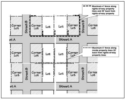
- Fences or hedges located back of the required front or flanking street side yard located on inside property lines shall not exceed a height of six (6) feet.
- Fence or hedges located back of the required front or flanking street side yard along an unimproved alley right-of-way shall be considered as an inside property line and shall not exceed a height of six (6) feet.
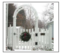
- Arbor and gateway entrances of fences or hedges may be 8’ tall but shall not exceed 5’ in width.
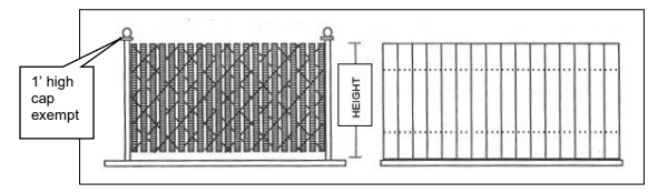
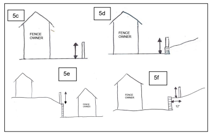
- Fence height shall be measured to the highest portion of the fence on the fence owner’s side as follows:
- Posts, caps, and/or lights not exceeding one foot above the maximum allowable fence height are excluded from maximum fence height;
- Arbors and gateways as noted in Section 3.035.A.4;
- Fence at grade level shall be measured from grade level on the fence owner’s side of the property;
- Fence on top of a retaining wall or other similar structure less than 3’ high shall be measured from grade level on the fence owner’s side of the property including the retaining wall and shall not exceed a combined maximum of six (6) feet from the lowest level, or a maximum of 42 from the top of the retaining wall or other similar structure to the top of the fence, whichever is greater;
- Fence on top of a retaining wall or other similar structure greater than 3’ high shall be measured from grade level at the top of the retaining wall;
- Fence set back 12 from the top of the retaining wall or other similar structure regardless of height shall be measured from grade level at the top of the retaining wall.
- Posts, caps, and/or lights not exceeding one foot above the maximum allowable fence height are excluded from maximum fence height;
- Trees and other intermittent landscaping are exempt from the height limitation except as noted in City Code Section 6.100 concerning Clear Vision Area.
- Fences or hedges located 20’ back of the required front yard, 15’ back of the required flanking street side yard, 5’ back of the required side yard, or back of the rear yard as required by the zone are exempt from the fence height limitation but are limited by the height of the zone.
- Buildings. Accessory buildings may be permitted in residential zones if they:
- Do not extend into required setbacks with exception to the rear yard. Accessory structures may be located in the rear yard setback no closer than five (5) feet from the rear property line;
- Do not exceed 80% of the height of the primary dwelling in
Amended by Ord. 22-01 on 11/7/2022
3.045 CLEAR-VISION AREA
Refer to Section 6.100 (Vision Clearance Area) of the City Code.
Amended by Ord. 22-01 on 11/7/2022
3.070 EXCEPTIONS TO YARDS
- Projections from Buildings. Cornices, eaves, canopies, gutters, chimneys, flues, and other similar architectural features shall not project more than 24 inches into a required yard.
- Front and Street Side Yard Exceptions. The following exceptions to the front and street side yard requirements are authorized for a lot in any zone:
- Lots with Development on Both Abutting Lots. If there are dwellings on both abutting lots with front and/or street side yards, as applicable, of less than the required depth for the zone, the front and/or street side yard of the lot may equal the average front and/or street side yard of the abutting lots. (Section 3.070.B.3 added by Ord 19-05, 6-17-2019)(Section 3.070.B.2 amended by Ord 19-05, 6-17-2019)(Section 3.070.B.1 amended by Ord 19-05, 6-17-2019)
- Lots with Development on only One Abutting Lot. If there is a dwelling on only one abutting lot and/or lot across the right-of-way as noted in Section B.3, with a front and/or street side yard of less depth than the required depth for the zone, the front and/or street side yard for the lot may equal a depth halfway between the depth of the abutting lot and/or lot across the right-of-way, and the required front and/or street side yard depth.
- Corner Lot. On a corner lot, if there is a dwelling on one abutting lot and the lot across the right-of-way on the same side of the street with a front and/or street side yard of less depth than the required depth for the zone, the front and/or street side yard for the lot may equal a depth halfway between the depth of the abutting lot and the lot across the right-of-way on the same side of the street.
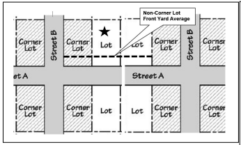
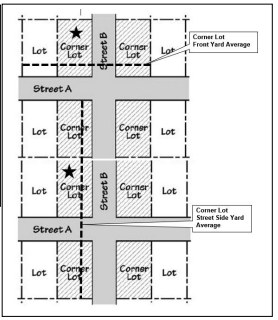
- Alley Setback. An alley is defined as a right-of-way and is considered as a street side yard resulting in corner lot setback requirements. The street side yard setback on an alley may be reduced to 5’ unless a smaller setback is allowed in the zone upon written approval by the City Engineer based on location of public utilities within the right-of-way and processed as an administrative Type I permit by the Planner.
- Structures Within Yards. The following structures may be located within the required yard setback area unless otherwise limited by compliance with other requirements such as Building Codes, Attached Housing-Mill Pond Zone construction restrictions, or other Code requirements.
- Decks, walkways, or uncovered porches, 12 inches or less in height above grade.
- Stairs of a maximum 3’ in width and required landings for the stairs to access existing building entrances. This does not include deck/porch areas not required per Building Codes for the stair construction.
- Ramp and/or other access required for handicap accessibility meeting American With Disabilities Act and Building Code requirements.
- Stairs of a maximum 3’ in width for new construction. This does not include landings, deck/porch areas, or stairs in excess of 3’ in width.
- Portable Accessory Structure or Object.
- Except as provided in Section 3.045 of this Code, portable accessory structures or objects may be located in a rear yard or street-side yard setback provided all of the following are met:
- Such structures or objects, with the exception of basketball hoops, shall be less than 10’ in height. Basketball hoops shall be less than 20’ in height; and
- Shall be located no closer than five (5) feet from the property line; and
- Shall have a footprint of less than 200 square feet.
- Except as provided in Section 3.045 of this Code, portable accessory structures or objects may be located in a rear yard or street-side yard setback provided all of the following are met:
- Existing Encroachments Beyond the Property Line. In order to reduce encroachments of existing structures constructed beyond the property line, a structure may be altered and/or moved to reduce the encroachment without the need to comply with the required setbacks along that property line nor the need for a variance if it meets the following requirements.
- The portion of the existing structure encroaching beyond the property line was constructed prior to 1976 as verified by aerial or other dated photograph, County Assessor records, and/or other document of verification acceptable to the City; or
- The encroachment was constructed by a previous owner; or
- The encroachment was due to an act of nature such as a landslide, and not including neglect or deferred maintenance; and
- It is not feasible or reasonable to comply with the full required setback such as other development on the lot, lot dimensions, geologic issues, topography, etc.
Amended by Ord. 22-01 on 11/7/2022
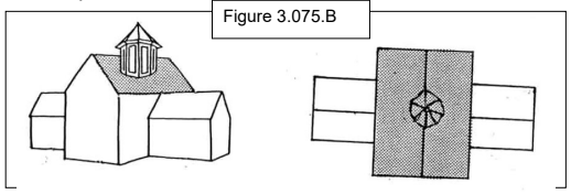
3.075 EXCEPTION TO BUILDING HEIGHT LIMITATIONS
- The features listed in this Section shall be exempt from the height limits established by the Code, provided the limitations indicated for each are observed.
- Mechanical equipment and appurtenances necessary to the operation or maintenance of the building or structure itself, including chimneys, ventilators, plumbing vent stack, cooling towers, water tanks, panel or devices for the collection of solar or wind energy, and the window-washing equipment, together with visual screening for any such features.
- The minimum height required for elevators, stairs, mechanical penthouses, fire towers, skylights, flag poles, aerials, and similar objects but not including storage space or other equipment. (Section 3.075.A.4 added by Ord 19-06, 7-1-2019)(Section 3.075(A.3) amended by Ordinance 98-04, 5-4-98)(Section 3.075.A.2 amended by Ord 19-06, 7-1-2019)
- Ornamental and symbolic features not exceeding 200 square feet in gross floor area including towers, spires, cupolas, belfries, and domes, where such features are not used for human occupancy.
- Exempt rooftop features shall not contain equipment, signage, and/or exterior attachments other than communication services equipment, to the exterior of any enclosure.
- The total area covered by these features shall not exceed 30% of the roof area on which they are located.
Amended by Ord. 22-01 on 11/7/2022
3.090 COTTAGE CLUSTER DEVELOPMENT STANDARDS
- Purpose. A cottage cluster development is a small cluster of dwelling units appropriately sized for smaller households and available as an alternative to the development of typical detached single-family and two-family homes on individual lots. Cottage cluster development is intended to address the changing composition of households, and the need for smaller, more diverse, and often, more affordable housing choices. Providing for a variety of housing types also encourages innovation and diversity in housing design and site development, while ensuring compatibility with surrounding single-family residential development.
- Development Standards
- Applicability. Cottage clusters must meet the standards of this Section (3.090).
- Minimum Lot Size and Dimensions. Cottage clusters must meet the minimum lot size, width, and depth standards that apply to detached single-family dwellings in the same zone.
- Maximum Density. A cottage cluster must have at least 4 detached dwelling units per acre. There is no maximum density limit for a cottage cluster development.
- Setbacks and Building Separation.
- Setbacks. In lieu of the setbacks listed in the underlying zone, a cottage cluster must meet the following setbacks:
- Front setback: 10 feet
- Side setbacks: 5 feet
- Rear setbacks: 10 feet
- Building Separation. Cottages must be separated by a minimum distance of 6 feet. The minimum distance between all other structures, including accessory structures, must be in accordance with building code requirements.
- Setbacks. In lieu of the setbacks listed in the underlying zone, a cottage cluster must meet the following setbacks:
- Unit Size. The maximum average floor area for a cottage cluster is 1,400 square feet per dwelling unit. Community buildings are included in the average floor area calculation for a cottage cluster. The footprint for each dwelling unit in a cottage cluster must not exceed 900 square feet.
- Building Height. the maximum building height for all structures is 25 feet or two stories, whichever is greater.
- Design Standards. Cottage clusters must meet the following design standards.:
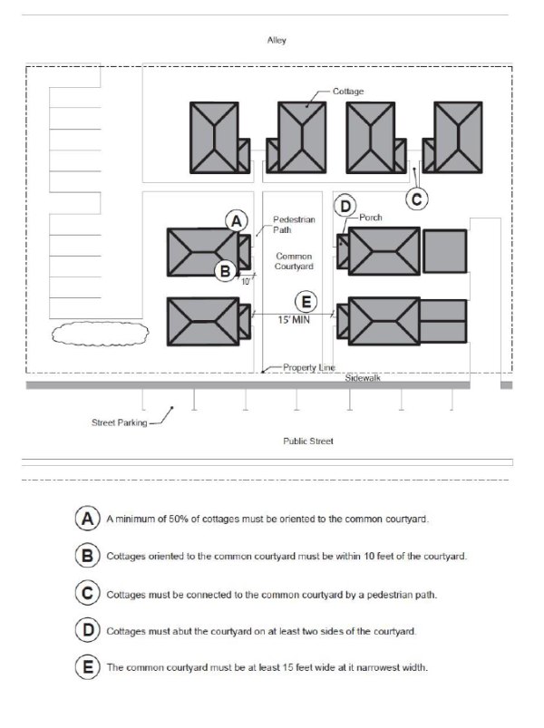
- Cottage Orientation. Cottages must be clustered around a common courtyard, meaning they abut the associated common courtyard or are directly connected to it by a pedestrian path, and must meet the following standards (see Figure 3.090(1)):
- Each cottage within a cluster must either abut the common courtyard or must be directly connected to it by a pedestrian path.
- A minimum of 50 percent of cottages within a cluster must be oriented to the common courtyard and must:
- Have a main entrance facing the common courtyard;
- Be within 10 feet from the common courtyard, measured from the façade of the cottage to the nearest edge of the common courtyard; and
- Be connected to the common courtyard by a pedestrian path.
- Have a main entrance facing the common courtyard;
- Cottages within 20 feet of a street property line may have their entrances facing the street.
- Cottages not facing the common courtyard or the street must have their main entrances facing a pedestrian path that is directly connected to the common courtyard.
- Each cottage within a cluster must either abut the common courtyard or must be directly connected to it by a pedestrian path.
- Common Courtyard Design Standards. Each cottage cluster must share a common courtyard in order to provide a sense of openness and community of residents. Common courtyards must meet the following standards (see Figure 3.090(1)):
- The common courtyard must be a single, contiguous piece.
- Cottages must abut the common courtyard on at least two sides of the courtyard.
- The common courtyard must contain a minimum of 150 square feet per cottage within the associated cluster (as defined in Section 1.400).
- The common courtyard must be a minimum of 15 feet wide at its narrowest dimension.
- The common courtyard must be developed with a mix of landscaping, lawn area, pedestrian paths, and/or paved courtyard area, and may also include recreational amenities. Impervious elements of the common courtyard must not exceed 75 percent of the total common courtyard area.
- Pedestrian paths must be included in a common courtyard. Paths that are contiguous to a courtyard count toward the courtyard’s minimum dimension and area. Parking areas, required setbacks, and driveways do not qualify as part of a common courtyard.
- A cottage cluster development with multiple cottage clusters must provide at least one common courtyard for each cottage cluster.
- The common courtyard must be a single, contiguous piece.
- Community Buildings. Cottage cluster developments may include community buildings for the shared use of residents that provide space for accessory uses such as community meeting rooms, guest housing, exercise rooms, day care, or community eating areas. Community buildings must meet the following standards:
- Each cottage cluster is permitted one community building, which counts towards the maximum average floor area.
- A community building that meets the development code’s definition of a dwelling unit must meet the maximum 900 square foot footprint limitation that applies to cottages, unless a covenant is recorded against the property stating that the structure is not a legal dwelling unit and will not be used as a primary dwelling.
- Each cottage cluster is permitted one community building, which counts towards the maximum average floor area.
- Pedestrian Access.
- An accessible pedestrian path must be provided that connects the main entrance of each cottage to the following:
- The common courtyard;
- Shared parking areas;
- Community buildings; and
- Sidewalks in public rights-of-way abutting the site or rights-of-way if there are no sidewalks.
- The common courtyard;
- The pedestrian path must be hard-surfaced and a minimum of four (4) feet wide.
- An accessible pedestrian path must be provided that connects the main entrance of each cottage to the following:
- Parking Design. In addition to the standards of Article 7, parking areas for cottage clusters must meet the following:
- Parking location and access.
- Off-street parking spaces and vehicle maneuvering areas may not be located:
- Within of 20 feet from any street property line, except alley property lines;
- Between a street property line and the front façade of cottages located closest to the street property line. This standard does not apply to alleys.
- Within of 20 feet from any street property line, except alley property lines;
- Off-street parking spaces may not be located within 10 feet of any other property line, except alley property lines. Driveways and drive aisles are permitted within 10 feet of other property lines.
- Off-street parking spaces and vehicle maneuvering areas may not be located:
- Screening. Landscaping, fencing, or walls at least three feet tall shall separate clustered parking areas and parking structures from common courtyards and public streets.
- Garages and carports.
- Garages and carports (whether shared or individual) must not abut common courtyards.
- Individual attached garages up to 200 square feet shall be exempted from the calculation of maximum average floor area calculation for cottages.
- Individual detached garages must not exceed 400 square feet in floor area.
- Garage doors for attached and detached individual garages must not exceed 20 feet in width.
- Garages and carports (whether shared or individual) must not abut common courtyards.
- Parking location and access.
- Accessory Structures. Accessory structures may not exceed 400 square feet in floor area, inclusive of all accessory structures in a cottage cluster development.
- Existing Structures. On a lot or parcel to be used for a cottage cluster development, an existing detached single family dwelling on the same lot at the time of proposed development of the cottage cluster may remain within the cottage cluster development area under the following conditions:
- The existing dwelling may be nonconforming with respect to the requirements of this code and must maintain compliance with Section 3.190.
- The existing dwelling may be expanded up to the maximum height allowed by this Section; however, existing dwellings that exceed the maximum height of this section may not be expanded.
- The floor area of the existing dwelling shall not count towards the maximum average floor area of a cottage cluster.
- The existing dwelling may be excluded from the calculation of orientation toward the common courtyard, per this Section.
- The existing dwelling may be nonconforming with respect to the requirements of this code and must maintain compliance with Section 3.190.
- Cottage Orientation. Cottages must be clustered around a common courtyard, meaning they abut the associated common courtyard or are directly connected to it by a pedestrian path, and must meet the following standards (see Figure 3.090(1)):
Figure 3.090(1)
Adopted by Ord. 22-01 on 11/7/2022
3.095 HOME OCCUPATIONS
Home occupations are permitted in residential zones in order to provide for low-impact businesses which the owners or residents can operate within the dwelling, or in an adjacent structure. The regulations are intended to ensure that the occupation will not be a detriment to the surrounding neighborhood and that it will be subordinate to the main use of the property.
- Class A. A Class A home occupation is one where the residents use their home as a place of work, with no non-resident persons associated with the business, and with only an occasional customer coming to the site a maximum of twice per week. Examples include artists, crafts people, writers, and consultants. Class A home occupations also provide an opportunity for a home to be used as a business address but not as a place of work. A Class A business is only conducted within the dwelling itself, and not in accessory structures. (Section 3.095.B.1 amended by Ord 19-05, 6-17-2019)(Section 3.095.A amended by Ord 19-05, 6-17-2019)
- Class B.
- A Class B home occupation is one where one of the following factors occur:
- Customers come to the home more than twice per week; or
- One non-resident associated with the business would come to the site; additional non-resident persons associated with the business may be allowed if they do not come to the site; or
- The home occupation is conducted in an adjacent structure.
- The Community Development Department shall notify property owners of record in accordance with 9.010 to 9.020 at least twenty (20) days prior to the issuance of a permit for a Class B Home Occupation. The notice shall set forth the standards required, the type of business and hours of operation, and the expected number of trips to be generated at the site on a daily basis.
- Permits for a Class B Home Occupation may be issued after the notice period by the Community Development Director where the Director has determined that the Home Occupation standards have been met.
- A decision of the Community Development Director may be appealed to the Planning Commission in accordance with 9.040.
- A Class B home occupation is one where one of the following factors occur:
- The following standards shall be applicable to both Class A and Class B Home Occupations:
- Clients or customers may visit the site only between the hours of 7:00 a.m. to 6:00 p.m.
- Retail sales of goods on site must be entirely accessory to any services provided on the site.
- On-site repair or assembly of vehicles or equipment with internal combustion engines (such as autos, chain saws, boat engines) or of large equipment (such as home appliances) is prohibited.
- Dispatch centers or headquarters where employees come to the site and are dispatched to other locations are prohibited.
- More than one Class B home occupation is not allowed in one residence.
- Signs shall be in accordance with Article 8.
- All activities must be indoors. Exterior storage or display of goods is prohibited.
- Outdoor storage of associated solid waste is limited to an area of 100 square feet and must be screened from view with fencing or vegetation.
- Noise, odor, vibration, lighting glare, dust and other nuisances shall be contained on site. Hazardous substances are prohibited, except at the consumer commodity level.
- No more than one truck, associated with the home occupation, may be parked at the site. Parking must be off-street. The maximum size of the truck allowed on site is a one-ton truck. Extended or prolonged idling of vehicles, or maintenance or repair of vehicles on adjacent streets is prohibited.
- Truck deliveries or pick-ups of supplies or products associated with business activities, are allowed at the home only between 7:00 a.m. and 6:00 p.m. Delivery vehicles are limited to 20,000 pounds gross vehicle weight.
- The dwelling and site must remain residential in appearance and character. Internal or external changes which will make the dwelling appear less residential in nature or function are prohibited. Examples of such prohibited alterations include construction of parking lots, paving of required setbacks, or adding commercial-like exterior lighting.
Amended by Ord. 22-01 on 11/7/2022
3.100 HOME STAY LODGING
- Purpose. The City’s purpose in regulating Home Stay Lodgings is to allow for economic use of underutilized bedrooms in dwellings; provide financial assistance to preserve both the housing stock and historic properties within the City; to ensure that Home Stay Lodging facilities are appropriately located; are compatible with surrounding allowed uses; are conducive to the public peace, health, safety, and welfare of the City; do not reduce the number of potential long-term housing units; and support tourism.
- Standards.
- Primary Residence. Every Home Stay Lodging shall be located in the owner’s primary residence.
- Occupancy. The Home Stay Lodging shall be owner occupied while occupied by transients.
- Location. Home Stay Lodgings may be allowable in conjunction with an Accessory Dwelling Unit based upon the underlying zone in Article 2.
- No Kitchen. Home Stay Lodgings may not contain a kitchen.
- Mobile vehicles. Home Stay Lodging shall not be located in motor homes, travel trailers, or other mobile vehicles.
Amended by Ord. 22-01 on 11/7/2022
3.105 LANDSCAPING
- Purpose. The purpose and intent of this section is to enhance the appearance of the City by requiring landscaping as part of commercial developments, including parking areas. These developments shall include all uses except those associated with single-family, two-family dwelling, and Accessory Dwelling Units.
Amended by Ord. 22-01 on 11/7/2022
3.110 LANDSCAPING REQUIRED
At the time a building permit is requested for new construction, or for remodeling with a value of at least 33% of the assessed value of the structure, the property shall come into compliance with the landscape requirements and a landscaping plan shall be submitted to the Community Development Director. Such landscaping plan may also be used as a site or plot plan for the development, provided all information necessary for the site or plot plan is provided. The plan shall be of sufficient scale to show existing and proposed features, proposed materials, contours (where appropriate) and other features.
Amended by Ord. 22-01 on 11/7/2022
3.115 REVIEW OF LANDSCAPING PLANS
The landscaping plan shall be reviewed by the Community Development Director to determine if it meets the quantitative requirements of the Code. Landscaping in conjunction with Uses Permitted Outright may be approved by the Community Development Director. Landscaping in conjunction with Conditional Uses shall be reviewed by the Planning Commission as part of the review under Section 11.010. In such cases, the Planning Commission may review schematic plans and the final plans may be reviewed by the Community Development Director. No Certificate of Occupancy or other final approval shall be issued by the building official or the City until the landscaping is installed as specified by the Planning Commission or Community Development Director. Minor changes in the landscape plan may be allowed by the Community Development Director, so long as they do not alter the overall character of the development.
3.120 LANDSCAPING REQUIREMENTS
- Specific requirements governing the placement and maintenance of landscape materials are as follows:
- Landscape plant materials shall be installed to insure health and survivability.
- Landscape plant materials will be properly guyed and staked so as to not interfere with vehicular or pedestrian traffic.
- Deciduous trees shall have a minimum caliper of one and one half (1.5) inches, and a minimum height of eight (8) feet at the time of planting, unless it is determined by the Community Development Director that a lesser caliper will provide the bulk and scale necessary to substantially cover the landscaped area.
- Evergreen trees shall be a minimum of six (6) feet in height, fully branched, at the time of planting.
- Shrubs shall be supplied in one (1) gallon containers minimum, or eight (8) inch burlap balls with a minimum spread of 12 inches.
- Ground cover plantings shall be planted on a maximum of 18 inches on center and 18 inches between rows. Rows of plantings shall be staggered for a more effective covering. Ground cover shall be supplied in a minimum four (4) inch size container or a two and one quarter (2.25) inch size if planted on 12 inch centers.
- Planting areas shall be designed to separate parking lots from the sidewalk and street and shall contain a mixture of trees and shrubs, except where the presence of chairwalls or public utilities makes the planting infeasible, as determined by the City Engineer, in which case concrete, stone, or other manufactured containers may be used.
- Parking areas with 20 spaces or more shall have a minimum of one landscaping divider per ten (10) parking spaces. Each ten (10) parking spaces shall be bordered by a landscaped area. Such area shall consist of a curbed planter of at least three (3) feet by 16 feet, or at least 48 square feet. Each planter shall contain at least one (1) tree, along with hedge or shrub material. An exception to allow a maximum of one row of parking spaces within a parking area to exceed the maximum ten spaces between landscaped planters by one or two spaces may be approved as an administrative Type I permit if the amount of overall required landscaping is not reduced.
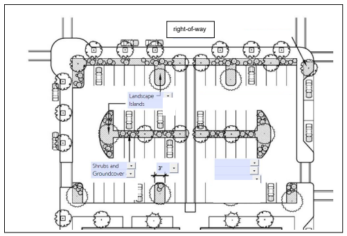
- For new construction, parking areas shall be separated from the exterior wall of a structure, exclusive of paved pedestrian entranceways or loading areas, by a strip of landscaping material. All planting areas shall be protected by the use of concrete bumper blocks affixed to the paving.
- Existing trees may be used as required landscaping. To the extent possible and practicable, required landscaping shall be within reasonable view from an improved City right-of-way.
- All landscaping shall be maintained and kept free from trash, noxious growth, and weeds. Unkempt landscaped areas shall be considered a nuisance and shall be enforced under the applicable City code.
- Seating areas and street furniture shall be considered part of the landscaping requirement, and shall be encouraged by the Community Development Department.
- Up to 50% of the landscaping requirement may be satisfied by the use of City right-of-ways for landscaping, as approved by the City Engineer. The property owner shall be responsible for the maintenance of such landscaping. (See City Code 2.350 through 2.353.)
- Public safety should be considered in landscape designs.
- There shall be a 15’ landscaped buffer area maintained between outdoor storage areas, parking areas, and/or driving surfaces and the top of bank along the shoreline. Except as otherwise noted, parked vehicle bumpers may overhang a maximum of 2.5’ beyond a bumper guard into the landscaped area.
- Landscape plant materials shall be installed to insure health and survivability.
Amended by Ord. 22-01 on 11/7/2022
3.125 NATIVE PLANTS
The following shall apply to landscaping within the Riverfront Vision Plan Overlay Area Zones.
- Use of Native Plants. Landscaping shall consist of native plants from the list of recommended native trees, shrubs, grasses and groundcover listed in Section 3.125(B), or that are otherwise determined to be native plants in documents such as the following: Flora of the Pacific Northwest (1973) by Hitchcock & Conquist; Gardening with Oregon Native Plants, West of the Cascades (2008) by Oregon State University Extension Service; or a comparable document recommended by the City staff will be the reference for determining other native plants.
The Community Development Director, or designee, may approve plants that are not native if it is determined that the plant better addresses environmental constraints, habitat value, transparency, height, resilience, and maintenance needs. - Recommended List of Native Plants. The following is a list of recommended native plants for use in the Astoria riverfront areas.
- Trees
- Native Trees
Acer circunatum - Vine Maple
Alnus rubra - Red Alder
Amelanchier grandiflora - Serviceberry
Malus fusca - Western Crabapple
Pinus contorta – Shore Pine
Rhamnus purshiana – Cascara - Street Trees - 15 feet diameter
Acer rubrum - Bowhall, R. Columnare
Fagus fastigiata - Dawyck Purple Beech - Trees for parking lots and other uses
Acer palmatum - Japanese maple varieties
Arbutus unedo - Strawberry Tree
Prunus serrulata - Kwanzan, Mt. Fuji, Shirofugen var.
Fraxinus pennsylvanica ‘Patmore’ - Raywood ash
- Native Trees
- Shrubs
- Native Shrubs
Arbutus menziesii - madrone
Cornus sericea ssp. sericea - Red–osier Dogwood
Gaultheria shallon - salal
Oemleria cerasiformis - Indian Plum
Malus fusca - Western Crabapple
Myrica pacifica – Wax myrtle
Physocarpus capitatus - Pacific Ninebark
Prunus virginiana - Common Chokecherry
Ribes lobbii - Pioneer Gooseberry
Ribes sanguineum - Red Currant
Rosa gymnocarpa - Baldhip Rose
Rosa nutkana - Nootka Rose
Salix fluviatilis - Columbia River Willow
Salix hookeriana – Hookers Willow
Salix sessilifolia - Soft–leafed Willow
Salix sitchensis - Sitka Willow
Sambucus cerulea - Blue Elderberry
Sambucus racemosa - Red Elderberry
Spiraea douglasii - Douglas’ Spirea
Symphoricarpos albus - Common Snowberry - Non-native shrubs – widely used ornamentals with many varietals in each of the following plant groups
Barberry
Ceanothus
Cistus
Chaenomeles (Flowering quince)
Escallonia
Euonymus
Fuschia (hardy)
Laurel – ‘Schipka’
Rhododendron
Rosa rugosa
Salix purpurea – Alaska blue willow
Syringa vulgaris - Lilac
Viburnum (Hydrangea, etc.)
- Native Shrubs
- Herbaceous Perennials, Grasses and Groundcover Plants
- Natives
Adiatum pedatum - Northern Maidenhair Fern
Alopecurus geniculatus - Water Foxtail
Aquilegia formosa - Red Columbine
Angelica arguta - Sharptooth Angelica
Arnica amplexicaulis var. piperi - Clasping Arnica
Aruncus sylvester - Goatsbeard
Aster Aruncus subspicatus - Douglas’ Aster
Athyrium filix–femina - Lady Fern
Blechnum spicant - Deer Fern
Boykinia occidentalis - Slender Boykinia
Cardamine oligosperma - Little Western Bittergrass
Carex deweyana ssp. leptopoda - Dewey’s Sedge
Carex unilateralis - One-sided Sedge
Chrysosplenium glechomaefolium - Pacific Water–carpet
Claytonia perfoliata or Montia perfoliata - Miner’s Lettuce
Corydalis scouleri - Western Corydalis
Cyperus aristatus - Awned flatsedge
Cyperus erythrorhizos - Red-Rooted flatsedge
Cyperus strigosus - Straw-colored flatsedge
Dicentra formosa - Pacific Bleedingheart
Dicentra formosa ssp. oregana - Oregon Bleeding Heart
Epilobium ciliatum spp. glandulosum - Common Willow–reed
Epilobium ciliatum spp. watsonii - Watson’s Willow–reed
Festuca occidentalis - Western Fescue–grass
Festuca subuliflora - Coast Range Fescue–grass
Festuca subulata - Bearded Fescue–grass
Fragaria vesca var. bracteata - Wood Strawberry
Fragaria vesca var. crinita - Wood Strawbery
Galium trifidum - Small Bedstraw
Gentianella amerella spp. acuta - Northern Gentian
Geum macrophyllum - Oregon Avens
Heracleum lanatum - Cow–parsnip
Heuchera glabra - Smooth Alumroot
Heuchera micrantha - Smallflowered Alumroot
Juncus ensifolius - Dagger–leaf Rush
Lupinus rivularis - Stream Lupine
Mertensia platyphylla - Western Bluebells
Mitella pentandra - Five–stamened Mitrewort
Montia sibirica - Candy Flower
Oxalis trilliifolia - Trillium–leaved Wood–sorrel
Polypodium glycrrhiza - Licorice Fern
Polystichum munitum - Sword Fern
Pteridium aquilinum - Bracken Fern
Pyrola asarifolia - Wintergreen
Scirpus cyperinus - Wooly Sedge
Streptopus amplexifolius - Clasping–leaved Twisted–stalk
Tellima grandiflora - Fringecup
Thalictrum occidentale - Western Meadowrue
Tiarella trifoliata - Laceflower Trillium
Vancouveria hexandra - White Inside-out Flower
Viola glabella - Stream Violet - Non-native ornamentals
Alchemilla mollis – Lady’s mantle
Aquilegia - Columbine
Ajuga
Cranesbill geraniums
Digitalis – foxglove
Helebore
Heuchera – coral bells
Hosta
Lavandula - Lavender
Rosmarinus officinalis - Rosemary
Sedums
Thalictrum – meadow rue
- Natives
- Trees
Amended by Ord. 22-01 on 11/7/2022
3.128 LIGHTING STANDARDS
Outdoor lighting shall be designed and placed so as not to cast glare into adjacent properties or rights-of-way. Light fixtures shall be designed to direct light downward and minimize the amount of light directed upward. The Community Development Director may require the shielding or removal of such lighting where it is determined that existing lighting is adversely affecting adjacent properties or contributing to light directed into the night sky.
Amended by Ord. 22-01 on 11/7/2022
3.130 MAINTENANCE OF PUBLIC ACCESS TO THE WATER
- Vacations. The Planning Commission shall review under ORS 271.080 through 271.230, proposals for the vacation of public easements or rights-of-way which provide access to or along estuarine waters.
- Sale, Exchange or Transfer of Ownership. The Planning Commission shall review under the provisions of ORS 271.300 through ORS 271.360, proposals for the sale, exchange or transfer of public ownership which provides access to estuarine waters.
- Existing Public Ownership. Existing public ownerships, rights-of-way and similar public easements which provide access to or along estuarine waters shall be retained or replaced if they are sold, exchanged or transferred. Rights-of-way may be vacated to permit redevelopment of existing developed shoreland areas provided public access across the affected site is retained.
- Applicability. Public access is used broadly to include direct physical access to estuary aquatic areas (boat ramps, for example), aesthetic access (viewing opportunities, for example), and other facilities that provide some degree of public access to Columbia River Estuary shorelands and aquatic areas.
Amended by Ord. 22-01 on 11/7/2022
3.140 MANUFACTURED HOME ON INDIVIDUAL LOT
- A manufactured home shall be permitted on individual lots in all residential zones, subject to the following standards:
- The manufactured home shall be a multi-sectional, no less than 28 feet in width and enclose a floor area of not less than 1,000 square feet.
- The manufactured home shall be placed on an excavated and backfilled foundation and enclosed at the perimeter such that the manufactured home is not more than 12 inches above grade. The perimeter of the foundation shall be skirted with concrete block or masonry.
- The manufactured home shall have a roof pitch of a minimum of three (3) feet in height for each 12 feet in width.
- The manufactured home shall have exterior siding and roofing which in color, material and appearance is similar to the exterior siding and roofing material commonly used on residential dwellings within the community or which is comparable to the predominant materials used on surrounding dwellings as determined by the Community Development Director.
- The manufactured home shall be certified by the manufacturer to have an exterior thermal envelope meeting the performance standards required of single-family dwelling construction under the State Building Code, as defined in ORS 455.010.
- The manufactured home shall have a garage or carport with minimum dimensions of 14' x 20'. The structure shall be sided and roofed to match the manufactured home. Carports shall be designed to include an enclosed, ground-level storage area of at least 56 square feet as an integral part of the structure. The garage or carport shall be constructed at the time of the manufactured home placement and shall be completed prior to occupancy of the dwelling. (Section 3.140.A.7 amended by Ord 19-05, 6-17-2019)(Section 3.140.A.6 amended by Ord 19-05, 6-17-2019)
- Manufactured homes shall be prohibited within, or adjacent to, or across a public right-of-way from a historic district, or adjacent to or across a public right-of-way from a historic landmark, or structure identified as Primary, Secondary, Eligible/Significant, or Eligible/Contributing.
Amended by Ord. 22-01 on 11/7/2022
3.150 MICROWAVE RECEIVING DISH/DEVICE
- The following standards shall be applicable to all microwave receiving dishes/devices.
- Residential Zones. All private microwave receiving dishes/devices in residential zones larger than 20 in diameter for conical dishes or 3 square feet if not conical, shall be located as follows:
- in the rear yard, no closer than five (5) feet from any rear or side lot line; and
- screened by sight obscuring fences and/or dense landscape buffers; and
- mounted as close to existing grade level as possible. In residential zones; and
- not mounted on the roofs of structures.
- All Other Zones or Devices. All microwave receiving dishes/devices except as noted in Section 3.150.A.1, shall be reviewed and approved by the Community Development Director and shall be located as follows:
- to ensure they have minimal visual impact; and
- screened by sight obscuring fences, dense landscape buffers, and/or location of dish/device so that it is not highly visible from adjacent properties or right-of-way.
- Permits. No microwave receiving dish/device shall be installed until a permit has been obtained from the Community Development Department.
- Residential Zones. All private microwave receiving dishes/devices in residential zones larger than 20 in diameter for conical dishes or 3 square feet if not conical, shall be located as follows:
- Historic Properties. A Microwave Receiving Dish/Device shall not be located on the front or street side facade of a structure designated as historic.
Amended by Ord. 22-01 on 11/7/2022
3.155 MULTI-FAMILY DWELLING
- Before a multi-family dwelling is approved as a conditional use, findings will be made that the use will comply with the following standards:
- Vehicular entrances and exits will be routed onto an existing or planned improved public street.
- Parking lots will be designed in such a manner that they are buffered from surrounding residences with landscaping, berms or fencing.
Amended by Ord. 22-01 on 11/7/2022
3.158 LEGAL LOT DETERMINATION
- Process. The Community Development Director or the Planner may determine whether a lot individually or in combination with contiguous property held in a single ownership has an area or dimension meeting the lot size requirements of the zone in which the property is located for a proposed use. Requests for a Legal Lot Determination shall be submitted in writing to the Community Development Department for review and approval. The Community Development Director or Planner may require a current title report or other evidence of ownership prior to making a determination. Conditions of any Determination shall include conditions as are necessary for the lot, individually or in combination with contiguous property, to be deemed as buildable in accordance with City regulations. The existence of a County Tax Lot designation is not considered as a determination of legal lot for zoning purposes. This determination may be used to review subsequent applications to the department.
- Combining of Lots. When a project will extend into adjacent lots, parcels, or tracts whether to meet lot size requirements, for the placement of structures or accessory uses, or to provide for requirements such as parking, the Community Development Director or Planner shall require that the properties be combined either through a Property Line Adjustment or by recording a deed or memorandum containing a covenant preventing the separate sale, transfer, or encumbrance of either property except in compliance with building codes, City of Astoria Development Code, and other applicable land use regulations.
Amended by Ord. 22-01 on 11/7/2022
3.160 NONCONFORMING LOTS, USES AND STRUCTURES
- Purpose. Within the zones established under this Code, there existing lots, structures and uses of land and structures which were lawful before this Code was passed or amended, but which no longer conform to the provisions of this Code. It is the intent of this Section to establish requirements that govern the future use of such nonconformities.
3.170 NONCONFORMING LOTS
If a lot or the aggregate of contiguous lots held in a single ownership, as recorded in the Office of the County Clerk prior to January 1, 1982, has an area or dimension which does not meet the lot size requirements of the zone in which the property is located, the lot or the aggregate of contiguous lots may be occupied by a use permitted in the zone, subject to the other requirements of the zone, provided that, if there is an area deficiency, residential use shall be limited to a single-family or two-family dwelling.
Amended by Ord. 22-01 on 11/7/2022
3.180 NONCONFORMING USES
- Expansion of a Nonconforming Use. The expansion of a nonconforming use to a portion of a structure that was provided for the nonconforming use shall be permitted. When the expansion is to a portion of a structure that was not provided for the nonconforming use, or when new construction is involved, expansion may be permitted as follows:
- The Community Development Director may permit up to a 10% expansion of a nonconforming use where it is determined that there will be minimal impact on adjacent uses, in accordance with the procedures in Article 9. If the Community Development Director believes that substantial issues are involved, the Director may schedule a public hearing before the Planning Commission in accordance with procedures in Article 12.
- The Planning Commission may permit an expansion of a nonconforming use in excess of 10%, in accordance with procedures in Article 12.
- Change of Nonconforming Use. A nonconforming use may be changed to a conforming use. However, after a nonconforming use is changed to a conforming use, it shall thereafter not be changed to a use that does not conform to the use zone in which it is located.
- Discontinuance of Nonconforming Use.
- If a nonconforming use involving a structure is discontinued for a period of one (1) year, further use of the property shall conform to this Code except as follows:
- When a residential structure has been used in the past for more units than allowed, the use may continue, even if ceased for one year, with the following conditions:
- Structure was not converted back to the lesser number of units (i.e. removal of kitchen, etc.); and
- Units were legal non-conforming units and not converted without necessary permits; and
- The number of units are allowed outright or conditionally in the zone (i.e., duplex or multi-family dwelling in R-2, etc.); and
- The number of units does not exceed the density for the zone (i.e., the lot square footage divided by 43,560 square feet (acre) x maximum density of zone = number of units allowed by density; and
- Provide required off-street parking spaces per unit, or obtain a variance; and
- If the structure is destroyed per Section 3.190.D, the new use shall comply with the zone requirements and/or Section 3.190.E.
- When a residential structure has been used in the past for more units than allowed, the use may continue, even if ceased for one year, with the following conditions:
- If a nonconforming use not involving a structure is discontinued for a period of six (6) months, further use of the property shall conform to this Code.
- If a nonconforming use involving a structure is discontinued for a period of one (1) year, further use of the property shall conform to this Code except as follows:
- Reestablishment of Existing Non-Conforming Uses in Overwater Buildings. Nonconforming uses in overwater buildings located between 16th and 41st Street within the Civic Greenway Overlay Area existing prior to 2013, and between 41st and approximately 54th Street within the Neighborhood Greenway Overlay Area existing prior to 2015 may be reestablished if the building housing the use is unintentionally destroyed by any means to an extent exceeding 80% of its fair market value as indicated in Section 3.190.D, provided the reconstruction of the building complies with the standards in Section 3.190.F and reestablishment of the use occurs within one year of the completion of construction. Completion of construction shall be determined by issuance of a temporary and/or final Certificate of Occupancy from the Building Official.
Amended by Ord. 22-01 on 11/7/2022
3.190 NONCONFORMING STRUCTURES
- Existing Nonconforming Structure. Where a lawful structure exists that could no longer be built under the terms of this Code by reason of restrictions or area, lot coverage, height, yards, its location on the lot, or other requirements concerning the structure, such structure may continue so long as it remains otherwise lawful.
- Expansion of a Nonconforming Structure.
- The Community Development Director may permit expansion of a nonconforming structure as follows:
- An expansion that fully complies with the Development Code may be permitted according to the processes and requirements that apply to new construction of the same type;
- An expansion that does not fully comply with the Development Code may be permitted up to the limits of nonconformity as of January 1, 2022 as a Type II application subject to the standards in Section 11.030 of this Code;
- If the Community Development Director believes that substantial issues are involved, they may upgrade the review to a Type III review before the Planning Commission.
- The Planning Commission may permit an expansion of a nonconforming structure beyond the limits of nonconformity as of January 1, 2022 as a Type III application subject to the standards in Section 11.030 of this Code.
- The Community Development Director may permit expansion of a nonconforming structure as follows:
- Destruction of Nonconforming Structures. If a nonconforming structure or nonconforming portion of a structure is destroyed by any means to an extent amounting to 80% of its fair market value as indicated by the records of the County Assessor, it shall not be reconstructed except in conformity with the provisions of this Code.
- Reconstruction of Nonconforming Dwellings. Existing nonconforming dwellings may be rebuilt in any zone if unintentionally destroyed by any means to an extent exceeding 80% of its fair market value as indicated in Section 3.190(D), provided the reconstruction of the dwellings complies with the following standards:
- The building shall be rebuilt on the same location on the lot, or in compliance with the setback standards for the underlying zone. This does not allow any construction beyond the property lines; and
- The square footage of the replacement structure does not exceed the square footage of the original structure by more than 10%; and
- The height of the building shall comply with the maximum height for the underlying zone; and
- If the property is within an area subject to design review or historic preservation standards, the design of the replacement structure shall comply with those standards; and
- Substantial construction of the building shall begin within two years of the date of destruction; and
- All other City and Building Codes relative to construction, including but not limited to, geologic concerns, stormwater management, grading, driveways, sidewalks, etc. shall apply.
- Reconstruction of Existing Non-Conforming Overwater Buildings. Nonconforming overwater buildings located between 16th and 41st Street within the Civic Greenway Overlay Area existing prior to 2013, and between 41st and approximately 54th Street in the Neighborhood Greenway Overlay Area existing prior to 2015 may be rebuilt if unintentionally destroyed by any means to an extent exceeding 80% of its fair market value as indicated in Section 3.190.D, provided the reconstruction of the building complies with the following standards:
- The building shall be rebuilt on the same location on the lot, or in compliance with the setback standards for the underlying zone. This does not allow any construction beyond the property lines; and
- The square footage of the replacement structure and/or replacement uses does not exceed the square footage of the original structure and use classifications by more than 10%; and
- The height of the building shall be the same or less than the existing building height prior to destruction; and
- If the property is within an area subject to design review or historic preservation standards, the design of the replacement structure shall comply with those standards; and
- Substantial construction of the building shall begin within two years of the date of destruction, unless an extension has been granted in accordance with Section 9.100; and
- All other City and Building Codes relative to construction, including but not limited to, geologic concerns, stormwater management, grading, driveways, sidewalks, etc. shall apply.
Amended by Ord. 22-01 on 11/7/2022
3.200 PRIOR APPROVAL OF NONCONFORMING LOTS, USES AND STRUCTURES
Nothing contained in this Code shall require any change in the plans, construction, alteration or designated use of a structure for which a legal permit has been issued by the City and construction has begun, provided the structure, if nonconforming, or intended for a nonconforming use, is completed and is used within two years from the time the permit was issued.
3.210 OFF-STREET SALES AND STORAGE LOTS
- Requirements.
- Permanent off-street sales and storage lots shall be paved with asphalt, concrete or other hard surface approved by the City Engineer.
- Proper drainage will be installed and proper ingress and egress established as specified by the City Engineer.
- When said lot is adjacent to a residential zone, a visual buffer consisting of a planting screen or fence shall be established and maintained to lessen the visual impact on the residential property.
- Security, display, or outdoor lighting shall comply with applicable lighting standards in Section 3.128. (Section 3.210.A.4 amended by Ord 19-05, 6-17-2019)
Amended by Ord. 22-01 on 11/7/2022
3.215 OUTDOOR STORAGE AREA ENCLOSURES
- Outdoor Storage Area Enclosure Required. Outdoor storage areas shall be enclosed to provide physical and/or visual buffers. Required enclosures shall be maintained in such condition as to not become so defective, unsightly, or in such condition of deterioration, disrepair, or unsanitary condition that the same causes potential depreciation of the values of surrounding properties or is materially detrimental to nearby properties and/or improvements.
- Applicability. The provisions of this Section shall apply to all new construction or major renovation of the existing structures, where major renovation is defined as construction valued at 33% or more of the assessed value of the existing structure, unless otherwise specified by the provisions in this Section. The provisions shall also apply to all new storage areas; relocation of an existing storage area; and/or expansion of an existing storage area.
- In addition to other Code requirements such as Historic and/or Design Review, enclosures shall be provided as follows:
- Outdoor storage areas shall be enclosed by appropriate vegetation, fencing, or walls, except for single-family, two-family residential use, and Accessory Dwelling Unit.
- Section 3.215 does not apply to outdoor retail sales areas.
- An enclosed storage area visible from directly adjacent properties and/or rights-of-way shall be required to include a cover to buffer the view from other properties and/or rights-of-way. The minimum clearance inside a covered enclosure shall be 7’6 with a 6’8 high entryway for pedestrian access.
- Enclosed storage areas greater than 7’ tall shall contain a pedestrian access door in addition to the main service doors.
- The design and location of any enclosed solid waste disposal storage area shall be reviewed and approved by the collection service company.
- Unless approved by the Planner, access to enclosed storage areas shall not be blocked by parking spaces.

- Outdoor storage areas shall be enclosed by appropriate vegetation, fencing, or walls, except for single-family, two-family residential use, and Accessory Dwelling Unit.
Amended by Ord. 22-01 on 11/7/2022
3.230 RESTAURANT AS AN ACCESSORY USE TO AN INN
Before a restaurant as an accessory use to an inn is approved as a conditional use, findings will be made that the use will comply with the following standards:
- Maximum Seating. The restaurant shall contain no more than 24 seats.
- Hours of Operation. The restaurant shall be open no more than five (5) nights per week, and shall not seat guests before 7:00 a.m. or after 9:00 p.m. (Section 3.230.B amended by Ord 19-05, 6-17-2019)
- Storage Areas. Storage of solid waste, oil and similar containers shall be well covered, screened and kept from view from adjacent residences.
- Additional Structure. The restaurant shall be an integral part of the inn. No freestanding structure or addition may be constructed in order to house the restaurant.
- Impacts. The restaurant shall have no adverse impacts on the surrounding neighborhood in terms of signage, impacts on views, or removal of landscaping integral to the character of the neighborhood.
- Associated Business Activities. Approved associated business activities within an inn are not subject to the requirements of (Section 3.230.F amended by Ord 19-05, 6-17-2019)Section 3.230.
Amended by Ord. 22-01 on 11/7/2022
3.240 TEMPORARY USE PROVISIONS
Temporary Uses are those which involve minimal capital investment, and which comply with the following standards:
- Duration of Permits.
- Time Limit. A temporary use permit shall expire one year from the date of Final Decision unless an extension has been granted.
- Permit Extensions. Prior to permit expiration, the applicant may request extensions in accordance with Section 9.100(B.2.a & b) and 9.100(B.3 & 4). A permit remains valid, if a timely request for extension has been filed, until an extension is granted or denied. (Section 3.240.A, amended by Ordinance 10-06, 4-19-10)
- Security. The Planning Commission may require that the applicant furnish the City with a performance bond or other negotiable instrument up to, and not to exceed, the value of the improvements or the cost of removal of the improvements, whichever is greater. This requirement may be made in order to assure that any conditions imposed are completed in accordance with the plans and specifications as approved by the Planning Commission, and the standards established in granting the use.(Section 3.240.C, deleted by Ordinance 10-06, 4-19-10)
Amended by Ord. 22-01 on 11/7/2022
22-01
25-05
3.300 REGULATION OF EROSION CONTROL AND STORMWATER MANAGEMENT
- Purpose. The purpose of this ordinance is to:
Minimize the erosion of land during clearing, excavation, grading, construction and post-construction activities,
- Prevent the transport of sediment and other soil borne pollutants into the Columbia River estuary and its tributaries, wetlands and riparian areas,
- Prevent the transport of sediment onto adjacent property and into City rights of way and storm systems,
- Prevent the unnecessary clearing, excavation, and stripping of land; and
- To reduce the amount of soil exposure during construction.
- Definitions. The following definitions shall apply for this ordinance:
CLEARING: Any activity that removes vegetative cover while leaving the root system intact.
EROSION: Movement of soil by water or wind.
EXCAVATION Removal of topsoil, gravel, sand, rock or any other type of soil material.
FILL: Placement of topsoil, gravel, sand, rock or any other type of soil material.
FILL, STRUCTURAL Fill that is intended to provide a stable foundation, support structures and create level surfaces.
GRADING: Any combination of excavation and/or fill activities.
REGULATED ACTIVITIES: The clearing, grading, excavation, filling, or stripping of land, and post construction activities.
SEDIMENTATION: Deposition of soil moved by water or wind from its site of origin.
STRIPPING: Removal of vegetation and roots.
TRACKING: Movement of soil from a disturbed area onto streets, sidewalks, or adjacent property by vehicle tracks or tires.
UNDEVELOPED SITE: A lot or parcel of land with no permanent structure such as a dwelling or commercial building or other permanent man made structure.
(Section 3.300 added by Ordinance 04-08, 10-4-04)
Amended by Ord. 22-01 on 11/7/2022
Amended by Ord. 25-05 on 4/7/2025
3.305 PERMITS
- Permit Required. Anyone proposing to commence any of the following activities must obtain a Permit: unless exempted elsewhere by this ordinance:
- Any regulated activity within within 100 feet of a river, bay, stream, watercourse or wetland; or
- Any regulated activity located more than one hundred feet from a river, bay, stream, watercourse or wetland that exceeds a volume of 10 cubic yards for a single permit or cumulatively within a 12 month period; or
- Any regulated activity within 100 feet of a known geologic hazard as indicated by the Astoria Landslides (Observed) on the most current version of the City of Astoria Geologic Hazard Map; or
- Any regulated activity if the disturbed area has a slope of 35% or greater; or
- Permits in Conjunction with Building Permits. A grading permit for regulated activities in conjunction with a structure requiring a building permit shall be reviewed and issued as part of the City’s building permit process using the standards herein.
- Permits in Conjunction with a Partition or Subdivision. A grading permit for regulated activities in conjunction with a partition or subdivision shall be reviewed and issued in conjunction with the partition or subdivision process using the standards herein. New subdivisions or housing developments should cause minimal earth disturbance and removal of trees.
- Exceptions. The following activities are exempted from the Permit requirements of this ordinance:
- Residential landscaping and gardening activities up to 1,000 square feet;
- Forest management activities in an area zoned Land Reserve (LR) for forest management.
- Utility construction by public or private utility agencies, involving less than 20 cubic yards of excavation or fill.
- Emergency repair work by a utility agency involving less than 20 cubic yards of excavations or fill.
- Fences and walls in accordance with Development Code Section 3.035.
- Walls four feet in height and under, in accordance with Development Code Section 3.035.
- Excavation for the purpose of installing a post or posts as part of a structure less than 200 square feet.
- Decks less than 30 inches above ground.
- Replacement or the repair of existing driveways provided the impervious area is not expanded and grades are not altered.
- Boring, potholing and other excavations for site investigations less than four cubic yards total for the site.
- Emergency repairs to private water, sewer or stormwater laterals provided that a plumbing permit and/or right-of-way permit is acquired within 48 hours of the start of repairs and does not exceed 20 cubic yards.
- Ground-mounted mechanical equipment serving single-family, two-family, accessory dwelling units or accessory structures on a residential lot with a footprint of less than 200 square feet.
- Permit Review and Approval. Permits shall be obtained from the Engineering Division. All permits shall be reviewed and approved by both the Engineering Division and Community Development Department for compliance with this Ordinance and other City codes and building codes.
- Permit Fees. Permit fees shall be established by City Resolution.
(Section 3.305 added by Ordinance 04-08, 10-4-04)
Amended by Ord. 22-01 on 11/7/2022
Amended by Ord. 25-05 on 4/7/2025
3.310 INFORMATION REQUIRED
The following information is required for permits:
- Site Plan. A site plan, drawn to an appropriate scale with sufficient dimensions, showing the property line locations, roads, areas where clearing, grading, excavating, stripping, or filling is to occur, the area where existing vegetative cover will be retained, the location of any springs, streams or wetland areas on or immediately adjacent to the property, the general direction of slopes with slope arrows showing direction of water flow on existing slopes and graded slopes, construction access, the location of the proposed development, and the location of soil stock piles, if any.
- Erosion Control Methods. The type and location of proposed erosion and sedimentation control measures, both short term and post construction.
- Stormwater Management Methods. The type and location of proposed stormwater management from roofs, parking and other impervious surfaces. Stormwater calculations prepared by a Registered Professional Engineer may be required by the City Engineer as part of the permit application.
- Grading Plan in Steep Areas. The City shall require a grading plan prepared by a Registered Professional Engineer and/or Registered Engineering Geologist where the disturbed area has an average slope of 35% or greater, the disturbed area is located in known geologic hazard area, or is part of a partition or subdivision. Such grading plan shall, at a minimum, include the following additional information:
- Existing and proposed contours of the property at two foot contour intervals;
- Location of existing structures and buildings, including those within 25 feet of the development site on adjacent property;
- Design details for proposed retaining walls;
- The direction of drainage flow and detailed plans and locations of all surface and subsurface drainage devices to be constructed.
- Sedimentation and Erosion Control Plan. The City shall require that the sedimentation and erosion control plan be prepared by a Registered Professional Engineer where the disturbed area is greater than 20,000 square feet, or the disturbed area has an average slope of 35% or greater.
- Development Plan. The City shall require a development plan for the site where the disturbed area is greater than 2,000 square feet to assure the least amount of earth disturbance as necessary, and to assure that the development is consistent with zoning and other City regulations. Such development plan shall, at a minimum, include the following additional information:
- Site plan as described above;
- Location of existing and proposed structures;
- Location of existing and proposed parking, access and egress;
- Location and square footage of proposed landscaped areas.
- Ground and Surface Water Diversion Plan. If property construction will result in alterations of natural hydrology such that damage to neighboring properties will occur, the City shall require that any known ground or surface water be diverted to an alternate natural path or to a man-made system to prevent any damage to other properties that may be affected by the water.
(Section 3.310 added by Ordinance 04-08, 10-4-04)
Amended by Ord. 22-01 on 11/7/2022
3.315 GRADING STANDARDS
- Cuts. The following Grading Standards shall be required for cuts:
- The slope of cut surfaces shall not be steeper than is necessary for the intended use and shall not be steeper than two horizontal to one vertical (2:1) unless an engineering geology report determines that a cut at a steeper slope will be reasonably stable and not create a hazard to public or private property.
- Cuts shall not remove the toe of any slope where a known potential or historic land slide exists as determined by the City Engineer, unless an engineering geology report, prepared in accordance with the current version of the Oregon State Board of Geologic Examiners' Guidelines for Preparing Engineering Geology Reports, determines that a cut at the toe of any slope will be stable and not create a hazard to public or private property.
- Cuts shall be set back a minimum of five (5) feet from property lines so as to minimize danger and disturbance to adjoining property.
- Retaining walls shall be constructed in accordance with the Structural Specialty Codes as adopted by the City.
- Fills. The following Grading Standards shall be required for fills:
- The slope of fill surfaces shall not be steeper than two horizontal to one vertical (2:1) unless an engineering geology report determines that a steeper slope will be reasonably stable and not create a hazard to public or private property. Fill slopes shall not be constructed on natural slopes steeper than two horizontal to one vertical.
- Fills shall be set back from property lines a minimum of five (5) feet so as to minimize impact on adjoining property. Retaining walls shall be required when height of wall exceeds four (4) feet or requiredEngineer deemsbyitengineeringnecessaryreport
- The ground surface shall be prepared to receive fill by removing vegetation, inappropriate fill, topsoil, and other unsuitable materials, and shall be scarified to provide a bond with the new fill.
- Any structural fill shall be designed by a Registered Professional Engineer, in accordance with standard engineering practices.
- Fill material shall be broken into pieces no larger than 12 inches to assure proper compaction.
- The following items are unsuitable materials and shall not be used for fill:
- Roofing material, fiberglass, metals, asphalt, or large slabs of concrete, and other man-made construction debris inappropriate for fill
- Stumps, organic materials, and other natural debris inappropriate for fill
- A compaction report shall be required for any area with fill prior to any construction on the site.
- Drainage. The following Grading Standards shall be required for drainage:
- Proposed grading, cuts or fills shall not alter drainage patterns so that additional stormwater is directed onto adjoining property.
- All cut and fill slopes shall be provided with subsurface drainage as necessary for stability.
- Streets. Refer to the current Astoria "Engineering Design "Standards” on file in the Engineering Division Office and on the's City website.
(Section 3.315 added by Ordinance 04-08, 10-4-04)
Amended by Ord. 22-01 on 11/7/2022
Amended by Ord. 25-05 on 4/7/2025
3.320 EROSION AND SEDIMENTATION CONTROL STANDARDS
- Authority. Review and approval of grading permits for regulated activities shall be based on the conformance of the development plans with the standards of this section. Conditions of approval may be imposed to assure that the development plan meets the standards. The City Engineer shall require modifications to the erosion and sedimentation control plan at any time if the plan is ineffective in preventing the discharge of sediment to City streets and storm drains, surface waters, wetlands, or adjacent property.
- Department of Environmental Quality (DEQ) Standards. The current DEQ "Construction Stormwater Best Management Practices Manual" document are incorporated as part of this document by reference.
- General Erosion and Sedimentation Control Standards.
- Natural vegetation shall be retained and protected wherever possible.
- Stream and wetland areas shall only be disturbed in accordance with US Army Corps of Engineers and Oregon Division of State Lands permits, as well as riparian preservation requirements in Astoria Development Code Article 4, “Columbia River Estuary and Shoreland Regional Standards”.
- Sedimentation barriers, as described in the DEQ “Best Management Practices for Stormwater Discharges Associated with Construction Activities” document shall be placed to control sedimentation from entering the river, bay, streams, wetlands, adjacent property or City streets and storm sewers. The barriers shall be installed prior to site clearance or grading activities.
- The City Engineer or Building Official may require areas to be temporarily stabilized with straw mulch, sod, mat or blanket in combination with seeding, or other acceptable sediment control method. Prior to the completion of construction, such areas shall be permanently stabilized by seeding or other vegetative ground cover.
- Stormwater catch basins, inlets or culverts shall be protected by sediment traps or filter barriers such as “bio bags”.
- Soil storage piles or fill shall be located so as to minimize the potential for sedimentation of streams, wetlands, adjacent property or City streets or storm sewers. The City Engineer or Building Official may require temporary stabilization of soil storage piles or fill.
- Temporary sedimentation control, not in conjunction with a structure, shall be required in any situation where the City Engineer or Building Official determine that sedimentation or erosion may affect streams, wetlands, adjacent property, City streets or storm sewers.
- Erosion and sedimentation control measures shall be continually maintained during the period of land disturbance and site development in a manner that ensures adequate performance. Soil that has been transported by any means to a street or any area where stormwater flows to a storm drain or surface water, shall be cleaned up to prevent transport to the drain or surface water. All temporary erosion and sedimentation control measures shall remain in place until the disturbed area is stabilized with permanent vegetation.
- The City shall require a graveled construction road or access of sufficient length, depth, width, and rock size to prevent sedimentation from being tracked onto City streets.
- Sediment trapped by sediment control methods shall be redistributed on-site, removed, or permanently stabilized to prevent further erosion and sedimentation.
- The City Engineer shall require the cleanup of any streets, catch basins or storm sewers affected by regulated activities on a site at the expense of the person responsible for those regulated activities. Measurable amounts of sediment that leave the site shall be cleaned up and placed back on the site or disposed of in an approved manner.
- Under no conditions shall soil on sidewalks, streets, or equipment be washed or hosed into storm sewers, drainage ways, streams or other water bodies.
- The City shall make periodic inspections to ascertain that erosion and sediment control measures as proposed have been implemented and are being effectively maintained. The City Engineer or the Building Official are authorized to place an immediate “stop work” order on any project that does not meet the standards imposed in this ordinance.
(Section 3.320 added by Ordinance 04-08, 10-4-04)
Amended by Ord. 22-01 on 11/7/2022
Amended by Ord. 25-05 on 4/7/2025
3.325 STORMWATER MANAGEMENT STANDARDS
Projects that are 40,000 square feet (land area) or larger shall install a stormwater management system as part of the landscaping requirements. Such a system shall be designed by a Registered Professional Engineer and/or Registered Landscape Architect and shall be capable of meeting the standards in the current version of the Oregon Department of Transportation Hydraulic Design Manual, or other guidelines acceptable to the City Engineer.
(Section 3.325 added by Ordinance 04-08, 10-4-04)
Amended by Ord. 22-01 on 11/7/2022
Amended by Ord. 25-05 on 4/7/2025
3.330 ENFORCEMENT
- Final Inspection. The City shall review all regulated activities one year after completion and/or installation of permanent vegetation to assure that any erosion control or regulated activity measures installed continue to meet the standard imposed in this ordinance. The applicant shall be responsible for continued maintenance until the City Engineer and Building Official has approved a final inspection on the project.
- Responsible Party and/or Change of Ownership. The applicant shall be responsible for the work to be performed in accordance with the approved plans and specifications in conformance with the provisions of this code. In the event of a change of ownership prior to the Final Inspection, the applicant shall enter into a Performance Agreement with the City and proposed new property owner. The Performance Agreement shall, at minimum, identify the party responsible for completion of the project until a Final Inspection has been approved by the City.
- Continued Maintenance. If an erosion control or regulated activity measure system fails due to lack of maintenance or breakage, and there are impacts to adjacent property owners, or downstream water quality or quantity as a result of the failure, the City shall perform the maintenance or repair and charge the current property owner for the required repairs.
- Penalties. In addition to any other method of enforcement available to the City, including City Code Section 1.010, the provisions of this ordinance may be enforced by the issuance of citations by duly appointed officers of the City pursuant to Astoria City Code Section 6.135.
- Additional Costs. Where the City Engineer, Community Development Director, or Building Official deem it necessary, in the interest of public health, safety, or welfare, to incur additional costs such as, but not limited to, the hiring of independent geotechnical experts or other technical expertise, or costs to complete or correct work not completed by the applicant during the course of the project, such costs shall be borne by the applicant. Such costs shall not exceed actual costs.
- Performance Bond. The City Engineer or Community Development Director may require that the applicant furnish to the City a performance bond up to, and not to exceed, the value of the cost of the required improvements in order to assure that the conditions imposed are completed in accordance with the plan and specifications as approved by the City Engineer or Community Development Director and that the standards established in granting the permit are observed.
- Time Limit on Permit. Authorization of a permit shall be void after 180 days unless substantial construction or use pursuant thereto has taken place. However, the City Engineer or Building Official may, at their discretion, extend authorization for an additional 180 day period upon written request by the applicant and a determination that the conditions of the project or permit application have not changed sufficient to warrant review of a new permit application.
(Section 3.330 added by Ordinance 04-08, 10-4-04)
Amended by Ord. 22-01 on 11/7/2022
Amended by Ord. 25-05 on 4/7/2025