
Avon City Zoning Code
CHAPTER 1
General Provisions
1.1 Title
This Ordinance is known as the “Town of Avon Unified Development Ordinance,” and may be cited and referred to as the “Zoning Ordinance,” “Subdivision Control Ordinance,” or “Unified Development Ordinance” (referred to here as this “Ordinance”).
1.2 Ordinance Format/Quick Links
Format: The structure of the text of this Ordinance is as follows: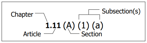
How to Use Hyper-Linked Cross-References.
• Certain aspects of the electronic format of this document allow the user to quickly navigate the document by clicking on hyperlinks and quick access chapter tabs.
• Chapter titles in the footers will direct the user to that chapter’s table of contents.
• Article headings in the table of will direct the user to that article within the chapter.
• Zoning District names within this document which are colored and emphasized in italics will direct the user to the zoning district’s standards in CHAPTER 2: ZONING DISTRICTS.
• In-line text cross-references to other articles within this document which are colored and emphasized will direct the user to the cross-referenced article.
• Cross-references to documents and websites outside of this document are provided for convenience only. The Town does not guarantee the accuracy of these links.
1.3 Authority And Purpose
- Authority: This Ordinance is adopted according to the authority of IC 36-7-4 et seq. If sections of Indiana Code or Indiana Administrative Code referenced in this Ordinance are amended or replaced, this Ordinance is amended to refer to the updated section of code.
- Scope: This Ordinance applies to all real property located within the corporate boundaries of the Town of Avon, Indiana and to real property in Hendricks County the Hendricks County Board of Commissioners has relinquished zoning jurisdiction to the Town. The use of land and structures must comply with all provisions of this Ordinance, including obtaining all required permits and certificates.
An improvement location permit issued prior to the effective date of this Ordinance may be completed and occupied according to the approved plans, provided the completion and occupation is consistent with IC 36-7-4-1109. The structure is subject thereafter to the provisions of 1.16 Nonconforming Structures. - Purpose: This Ordinance is intended to guide the growth and development of the community according to the Comprehensive Plan (consistent with IC 36-7-4-601(c) et seq.) in order to:
- Promote the public health, safety, and general welfare;
- Secure adequate light, air, convenience of access, and safety from fire, flood, and other danger;
- Restrict development in areas prone to flooding;
- Protect the historic and architectural heritage of the community;
- Conserve property values and minimize the conflicts between land uses;
- Assure adequate and efficient transportation, water, sewerage, schools, parks, drainage, and other public requirements and facilities;
- Promote the efficient and economical use of public funds while being sensitive to the surrounding environment and neighboring development; and
- Lessen or avoid congestion in public ways.
1.4 Interpretation And Application
- Severability: It is the declared intention of the Town Council that the provisions of this Ordinance are severable. If any provision or portion of this Ordinance is held invalid or unconstitutional by any court of competent jurisdiction, that decision does not affect the validity of any portion the Ordinance except the portion declared invalid.
- Minimum Requirements: The provisions of this Ordinance are the minimum requirements for the promotion of the public health, safety, and general welfare.
- If two or more provisions within this Ordinance conflict or are inconsistent with one another, then the most restrictive provision controls. Where graphics or illustrations within this Ordinance conflict with the text of the Ordinance, the text provision controls.
- This Ordinance is not intended to invalidate any easement, covenant or any other private agreement, provided that where the regulations of this Ordinance are more restrictive (or impose higher standards or requirements), the provisions of this Ordinance control.
- Defined Words: Words used in a special sense in this Ordinance are defined. All other words have the meaning inferred from their context in this Ordinance or their generally accepted definitions (see CHAPTER 10: DEFINITIONS)
1.5 Exclusion
This Ordinance does not restrict any unit of government from exercising the power of eminent domain or the use of property owned or occupied by the State of Indiana or its agencies.
1.6 Saving Provision
Except stated otherwise in this Ordinance, the adoption of this Ordinance does not:
- Reduce any pending action under any prior zoning ordinance (an action is considered pending if a complete application and required fee has been received by the Town before the effective date of this Ordinance);
- Modify any penalty accruing or about to accrue under any prior zoning ordinance;
- Affect the liability of any person, firm, or corporation under any prior zoning ordinance;
- Waive any right of the Town of Avon under any prior zoning ordinance; or
- Annul any rights obtained by lawful action of the Town of Avon under any prior zoning ordinance.
1.7 Repeal Of Prior Ordinance
After the effective date of this Ordinance, all provisions of the prior Zoning Ordinance or Subdivision Control Ordinance of Avon, Indiana are repealed.
1.8 Effective Date
- This Ordinance comprises a replacement ordinance for the jurisdiction of the Town of Avon, as described in IC 36-7-4-602(a). Accordingly, the prior Avon Zoning Ordinance and Avon Subdivision Control Ordinance are repealed on the effective date of this Ordinance.
- The effective date of this Ordinance is the latest of the following dates:
- The final day on which notice of the adoption of the penalty provisions of this Ordinance is published under IC 36-7-4-610(a).
- The day on which this Ordinance is filed with the Clerk-Treasurer’s office under IC 36-7-4-610(f).
- April 1, 2022.
- The final day on which notice of the adoption of the penalty provisions of this Ordinance is published under IC 36-7-4-610(a).
- This subsection applies to any application for a permit pending before the Planning Department on the effective date of this Ordinance. The Applicant may request the Administrator treat the application as an application filed according to this Ordinance instead of the prior Avon Zoning Ordinance or Avon Subdivision Control Ordinance. If the Administrator grants the request, the application is then approved or denied by the Planning Department, the BZA, the Plan Commission, or the Council according to the provisions of this Ordinance. The effective duration of these requests shall be consistent with IC 36-7-4-1109 and based upon the original application date of the request in question.
1.9 Public Utility Installations
Structures and land used for public utility installations are subject to the provisions of this Ordinance to the extent permitted under Indiana law. All structures for a public utility installation, including substations, must be effectively landscaped and must require approval of a development plan (see 8.10 Development Plan Review) and improvement location permit (see 8.11 Improvement Location Permit).
1.10 Zoning Map
- Official Zoning Map: The zoning map for the jurisdiction of the Plan Commission in effect on the date of adoption of this Ordinance is included as part of this Ordinance. The map may be known and referred to as the “Official Zoning Map” and as the “Zoning Map”.
The Official Zoning Map is located in the office of the Department and may be maintained as an electronic zoning map.
Copies of the Official Zoning Map must be labeled as copies and contain the last date of modification.
The Official Zoning Map should be revised annually or as the Plan Commission determines necessary. - Determination and Interpretation of District Boundaries: The following rules apply where uncertainty exists about the exact boundaries of any Zoning District as shown on the Zoning Map:
- Zoning District boundaries shown within or parallel to the lines of streets, easements, and rights-of-way are deemed to follow the centerline of the affected street, easement, or right-of-way. At the boundaries of the jurisdiction of the Plan Commission, district boundaries are deemed to include the full width of such streets, easements, and rights-of-way.
- Zoning District boundaries indicated as following or being parallel to section or fractional sectional lines, lot lines, or town corporation lines are interpreted as following or paralleling such lines.
- Zoning District boundaries indicated as approximately following the centerline of streams, rivers, or other bodies of water are interpreted to follow such centerlines.
- Zoning District boundaries indicated as approximately following the parcel lines as established by the Town are interpreted to follow such parcel lines.
- If the boundary line of a district divides a lot in a manner essentially perpendicular to a street, the district which applies to the larger part of the lot applies to the entire lot.
- In the case of uncertainty, the Administrator will interpret the intent of the Zoning Map and determine the location of the boundary in question. If the Administrator cannot definitively determine the location of a Zoning District boundary, the BZA may determine the location of the Zoning District boundary.
- Procedure Relating to Annexed or Vacated Areas: Unless changed by an amendment to the zoning maps, land annexed into the Town shall be classified for the purposes of zoning as provided in the annexation ordinance and the Zoning Administrator shall change the zoning maps upon the annexation ordinance becoming effective. Whenever any right-of-way or other similar area is vacated, the Zoning Districts adjoining each side of the right-of-way or the area automatically extend to the center of such vacation. All areas included in the vacation are then subject to all appropriate provisions of the extended Zoning District. In the event of a partial vacation, the adjoining Zoning District, or Zoning District nearest the portion vacated, extends automatically to include all the vacated area.
1.11 Nonconforming Regulations
Upon the adoption of this Ordinance, the Zoning Map, and potentially upon other government action (e.g. acquisition of right-of-way), some buildings, structures, lots and uses may no longer conform to the regulations of their Zoning District. This chapter provides the rules, policies, and regulations that apply to these buildings, structures, lots and uses.
- This article does not prevent restoring to a safe condition all or part of a structure declared unsafe by an official charged with protecting the public safety. This restoration cannot be used to enlarge the nonconforming structure nor be used as grounds for adding other structures or uses prohibited by this Ordinance.
- Any nonconforming use or structure for which a variance was previously granted, remains subject to the conditions imposed when the variance was granted.
- Any nonconforming use or structure granted a special exception permit remains subject to conditions imposed when the special exception permit was granted.
1.12 Exemption For Nonconformity Created By Public Acquisition
Any property, lot or structure rendered nonconforming solely by the action of a governmental agency modifying any street, is exempt from these nonconformance provisions.
1.13 Legal Nonconforming And Illegal Nonconforming
- Legal Nonconforming: Legal nonconformance is caused by an amendment to this Ordinance and not due to a change to the property, resulting in the property no longer conforming to the standards of the applicable Zoning District. When this situation occurs, the property is deemed legal nonconforming and is subject to the terms of this Ordinance.
- Illegal Nonconforming: A building, structure, sign, or lot constructed or used without an approved building permit, improvement location permit or approval from the BZA or Plan Commission is considered illegal nonconforming when it does not conform to this Ordinance. An illegal nonconforming property is subject to enforcement and penalties as set forth in CHAPTER 8: PROCESS AND PERMITS, and all other applicable state or municipal law. The illegal nonconforming property must be altered to conform with all applicable standards and regulations of this Ordinance.
- A structure being used by a legal nonconforming use may be expanded an aggregate of up to 10% of the gross floor area that existed on the passage date of this Ordinance. Expansions must conform to all applicable standards of this Ordinance.
1.14 Nonconforming Lots Of Record
- Single Nonconforming Lots of Record: In any district, a permitted use and its customary accessory uses may be erected on any single lot of record after the effective date of this Ordinance, despite limitation imposed by this Ordinance. This lot must be in separate ownership and not contain continuous frontage with other lots of the same ownership. This provision applies even though the lots fail to meet the requirements for area and / or width generally applicable in the district. The lots are required to meet all other lot development standards for their district.
- Lots in Combination: If 2 or more lots with continuous frontage and single ownership are of record on the effective date of this Ordinance, and if all or part of the unimproved lots do not meet the requirements established for lot width and area, the land involved is considered to be an undivided parcel to meet the minimum requirements of this Ordinance. No portion of the parcel can be used or sold, nor can the parcel be divided to create a lot, in a manner which diminishes compliance with lot width and area Ordinance requirements.
1.15 Nonconforming Uses
- A lawfully existing nonconforming use may be continued if the use adheres to the requirements of this Chapter and the use remains otherwise lawful.
- Normal maintenance and repair, including replacement, installation, or relocation of nonbearing walls, nonbearing partitions, fixtures, wiring or plumbing, may be performed on any structure devoted fully or partially to a legal nonconforming use.
- A structure devoted fully or partially to a legal nonconforming use must not be structurally altered unless the alteration conforms the use to the regulations of the zoning district in which it is located.
- A legal nonconforming use cannot be expanded or enlarged. However, a nonconforming use located in a structure intended for the use may be extended throughout the interior part of the structure. Such extension cannot occupy any land outside of the structure.
- A legal nonconforming use cannot be changed to any use not permitted in the zoning district in which the use is located. When a legal nonconforming use has been changed to a permitted use, it cannot be changed back to any nonconforming use.
- An agricultural use of land that is nonconforming may be changed to another agricultural use of land without losing its legal nonconforming status, if the nonconforming use has been maintained in accordance with IC 36-7-4-616. The Town may not restrict the nonconforming use or require the landowner to obtain a variance, special exception, special use contingent use or conditional use.
- Termination by Discontinuance or Abandonment:
- When a legal nonconforming use is discontinued or abandoned for a period of 12 months, the use cannot be reestablished or resumed. Subsequent use or occupancy of such land or structure must comply with the use regulations of the zoning district in which such land or structure is located.
- Where a period of discontinuance is caused by government action, strikes, material shortages, or acts of God, and without any contributing fault of the owner or occupant, the period will not be considered in calculating the length of discontinuance.
1.16 Nonconforming Structures
- A lawfully existing nonconforming structure may be continued if the structure adheres to the requirements of this Chapter and that the structure remains otherwise lawful.
- A legal nonconforming structure may be repaired, maintained, altered, or enlarged provided that no new nonconformity or increase the degree of the existing nonconformity is created.
- A legal nonconforming structure cannot be moved, unless the entire structure conforms to the regulations of the zoning district in which it is located.
- Except for single family dwellings, any legal nonconforming structure damaged or destroyed by more than 50% of the replacement cost cannot be restored unless the replacement structure conforms to the regulations of the zoning district in which it is located. This regulation does not authorize the creation of a new nonconformity or increase the degree of any nonconformity existing prior to such damage or destruction.
- The regulations pertaining to nonconforming signs are found in 6:15 Signage – Permits, Exemptions, and Enforcement.
- The regulations pertaining to nonconforming lighting are found in 6:10 Lighting Standards.