Belle Meade City Zoning Code
14-203 Zoning
Districts
- The zoning map is hereby adopted as the official zoning map of the City of Belle Meade.
- As shown on the zoning map the territory of the City of Belle Meade is divided into five (5) districts, namely: Estates A, Estates B, Residence A, Residence B and Residence C. The location and boundaries of each district are shown on the zoning map and are incorporated in this chapter by reference.
- Estates A. The purpose of this district is to maintain and preserve the large estate character in areas and provide greater setbacks and a more rural appearance.
- Estates B. The purpose of this district is to maintain and preserve the estate character for areas generally along and beyond Chickering Road corridor. This district is established to provide the desired estate character in terms of lot size and setbacks.
- Residence A. The purpose of this district is to maintain and preserve the smaller estate character for areas generally located to the south and along Belle Meade Boulevard. This district is established to provide the desired consistent character in terms of lot size and setbacks.
- Residence B. The purpose of this district is to provide a unifying design standard among varying lot sizes and architectural characteristics within the largest portion of the City.
- Residence C. The purpose of this district is to provide a more urban development pattern among some of the smallest lots within the City.
- The district bulk and setback regulations for all zoning districts are contained in Table 1 below.
- The zoning map shall also reflect any historic overlay districts created by the Board of Commissioners.
- Historic overlay district provisions are hereby established to preserve and protect the historical and/or architectural value of buildings, structures, or areas of significant importance; to regulate exterior design, arrangement, texture, and materials proposed to be used within the historic districts to ensure compatibility; to create an aesthetic appearance which complements the historic or other structures; to stabilize and improve property values; and to foster civic beauty.
- Historic overlay districts shall be of two (2) types: historic preservation and neighborhood conservation. These districts are both defined as geographic areas which possess a significant concentration, linkage or continuity of sites, buildings, or structures that are united by past events or aesthetically by plan or physical development, and that meet one (1) or more of the following criteria:
- The district is associated with an event that has made a significant contribution to local, state, or national history;
- It includes structures associated with the lives of persons significant in local, state, or national history;
- It contains structures or groups of structures that embody the distinctive characteristics of a type, period, or method of construction, or that represent a significant and distinguishable entity whose components may lack individual distinction;
- It has yielded or may be likely to yield archaeological information important m history or prehistory; or
- It is listed or is eligible for listing in the National Register of Historic Places.
- The permitted uses, bulk regulations, and any other regulations or procedures otherwise applicable for any district in which a historic overlay is enacted shall remain unchanged, to the extent not inconsistent with this part.
- The creation of historic overlay districts shall be only in accordance with recommendations of the historic zoning commission ("HZC') and consistent with the review guidelines established for the district by that body. The creation of historic overlay districts shall be by amendment to the Zoning Code and also in accordance with all procedures established under the code and state law for zoning ordinance amendments.
- Neighborhood conservation overlay is applied to all five (5) zoning districts in the city and within the boundaries of the entire city.
TABLE 1. District Bulk and Setback Regulations
| ZONING DISTRICT | LOT AREA | LOT WIDTH 5 | FRONT YARD SETBACK 3 | SIDE YARD & CORNER YARD SETBACK 6 | REAR YARD SETBACK 7 |
| Estate A | 200,000 SF | 125' | 800' | FOOTNOTE 4 | 100' 1 125' 2 |
| Estate B | 75,000 SF | 125' | 125' | FOOTNOTE 4 | 90' 1 100' 2 |
| Residence A | 70,000 SF | 125' | 75' | FOOTNOTE 4 | 70' 1 100' 2 |
| Residence B | 40,000 SF | 125' | 75' | FOOTNOTE 4 | 60' 1 85' 2 |
| Residence C | 20,000 SF | 120' | 65' | FOOTNOTE 4 | 40' |
FOOTNOTES:
1. There shall be a rear yard on every lot, which shall have a minimum depth stated above for those parts of any building which are twenty-five feet (25') in height or less.
2. There shall be a rear yard on every lot, which shall have a minimum depth stated above for those parts of any building which are in excess of twenty-five feet (25') in height.
3. No dwelling shall be constructed or altered so as to project beyond the front setback line that is established by calculating the average distance from the dwellings fronting on the same side of the street within one thousand feet (1,000') in each direction from the center of the dwelling being constructed. If there are no dwellings fronting on the same side of the street within one thousand feet (1,000') in both directions, the average must be taken of the available residences within that lesser distance. A front setback line as previously established and approved by the municipal planning commission shall remain in full force and effect. In cases of newly created lots where there are not dwellings fronting on the same side of the street because it is a newly created subdivision public road, the setback lines as listed in the table above shall apply.
4. The minimum width of any side yard shall be twenty percent (20%) of the lot width at the front setback line and that the sum of the widths of both side yards shall be at least fifty percent (50%) of the lot width at the front setback line. Example: Lot width = 200’. The combination of both side yard setbacks must equal 100’ (50% of 200’) and minimum of both side yard setbacks is 40’ (20% of 200’).
5. Minimum lot width is measured at the front property line and must maintain minimum width to at least the required front yard setback before reducing width proceeding further back into the lot.
6. For corner lots, the setback from both of the front lot lines shall follow the provision in Table 1 footnote 3. The rear lot line shall be the lot line parallel to the front lot line that the front entry door faces, and the remaining lot line shall be a side lot line for setback/yard purposes. On any corner lot, no fence, wall, hedge, or other planting or structure that will materially obstruct the sight visibility triangle between the height of two- and one-half feet (2.5’) and ten feet (10') above the centerline grades of the intersecting streets forming said corner.
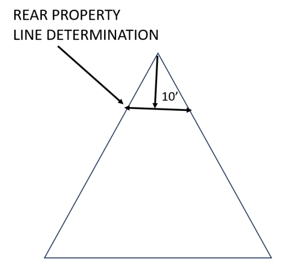
7. For triangular lots, the rear line for setback purposes shall be determined as a distance of 10’ from the further point of the where the side lot lines meet and said line being parallel to the front setback line. (Diagram below):