
Belvidere City Zoning Code
ARTICLE 0
INTRODUCTION AND DEFINITIONS
Sec. 150.001.- Title.
This chapter shall be known, cited and referred to as the "City of Belvidere Zoning Ordinance," except as referred to herein, where it shall be known as "this chapter."
(Ord. No. 801G, § 3, 3-6-06)
Sec. 150.002. - Authority.
This Chapter is enacted pursuant to the authority granted by the State of Illinois Statutes. Specific statutory references are provided within the body of this chapter solely as a means of assisting the reader. Such references are not to be considered as all inclusive and shall in no manner be construed so as to limit the application or interpretation of this chapter.
(Ord. No. 801G, § 3, 3-6-06)
Sec. 150.003. - Legislative intent and purpose.
In enacting this chapter, special attention has been given to ensuring a direct relationship of these regulations to the city's comprehensive plan. The general intent of this chapter is to implement certain goals and objectives of the comprehensive plan which are best addressed through zoning approaches, as enabled by state statutes.
(1)
This Chapter is designed to control and lessen congestion in the streets; to secure safety from fire, panic and other dangers; to promote health and the general welfare; to promote adequate light and air; to encourage the protection of groundwater resources; to prevent the overcrowding of land; to avoid undue concentration of population; to preserve, protect and promote property values; to facilitate the adequate provision of transportation, water, sewerage, schools, parks, and other public facilities; and to preserve burial sites.
(2)
Specifically, this chapter is adopted for the purpose of protecting the public health, safety, morals, comfort, convenience and general welfare by implementing certain goals and objectives of the comprehensive plan. Additional purposes of this chapter are specified throughout this chapter.
Rationale: In developing the specific regulations of this chapter, much effort has gone into balancing the goals and objectives of the comprehensive plan. The current status of this chapter and its components (including the official zoning map) represents the cohesive result of carefully considered plan implementation practices. Amendments to these provisions and/or the official zoning map shall seriously consider the effect of such changes on the interrelationships which exist within this chapter, and between this document, the comprehensive plan, and related long-range planning policies and programs (see §§ 150.902 and 150.903).
(Ord. No. 801G, § 3, 3-6-06)
Sec. 150.004. - Rationale and the appearance of ordinance text.
(a)
Rationale. Throughout this chapter, paragraphs labeled "Rationale" are included to ensure a complete understanding of the purpose and reasoning of the city in adopting that particular portion of this chapter. Each rationale is intended as an official statement of the legislative findings or purposes, and shall be treated in the same manner as other aspects of legislative history, and shall serve to guide the administrative and judicial interpretation of this chapter. The specific rationale expressed in each rationale section are not intended to be exhaustive, and other non-explicit rationale may also be applicable.
(b)
Appearance of ordinance text. The underlined, boldfaced, italicized, alternative point-sized, and/or capitalized typefaces used in this chapter are inserted only for convenience, and are in no way to be construed as part of the provisions of this chapter or as a limitation on the scope of the particular sections or subsections to which they refer.
(Ord. No. 801G, § 3, 3-6-06)
Sec. 150.005. - Separability and nonliability.
It is hereby declared to be the intention of the city council that the several provisions of this chapter are severable in accordance with the following:
(1)
If any court of competent jurisdiction shall adjudge any provision of this chapter to be invalid, such judgment shall not affect any other provisions of this chapter not specifically included in said judgment.
(2)
If any court of competent jurisdiction shall adjudge invalid the application of any portion of this chapter to a particular property, water, building, or structure, such judgment shall not affect the application of said provision to any other property, water, building, or structure not specifically included in said judgment.
(3)
If any requirement or limitation attached to an authorization given under this chapter is found invalid, it shall be presumed that the authorization would not have been granted without the requirement or limitation and, therefore, said authorization shall also be invalid.
(Ord. No. 801G, § 3, 3-6-06)
Sec. 150.006. - Rules of interpretation.
(a)
In their interpretation and application, the provisions of this chapter shall be held to be the minimum requirements for the promotion of the public health, safety, morals and welfare, and shall be liberally construed in favor of the city and shall not be construed to be a limitation or repeal of any other power now possessed by the city.
(b)
Where property is affected by the regulations imposed by any provision of this chapter and by other governmental regulations, the regulations which are more restrictive or which impose higher standards or requirements shall prevail. Regardless of any other provision of this chapter, no land shall be developed or used, and no structure erected or maintained in violation of any state or federal regulations.
(c)
No structure, land, water or air shall hereafter be used and no structure or part thereof shall hereafter be located, erected, moved, reconstructed, extended, enlarged, converted or structurally altered without full compliance with the provisions of this chapter and all other applicable local, county and state regulations.
(d)
Nothing herein contained shall require any changes in plans, construction, size or designated use of any building or part thereof, for which a zoning or building permit has been issued before the effective date of this chapter and the construction of which shall have been started within six months from the date of such permit. However, any such building or part thereof that is inconsistent with this chapter shall be deemed a nonconforming use and be subject to the provisions of § 150.801.
(e)
Except as provided in this chapter, under provisions for nonconforming uses (§ 150.801), nonconforming developments (§ 150.802), substandard lots (§ 150.803), and nonconforming structures and buildings (§ 150.804), no building, structure, development or premises shall be hereinafter used or occupied and no applicable permit granted, that does not conform to the requirements of this chapter.
(f)
In cases of mixed-occupancy or mixed-use buildings or parts thereof, the regulations for each land use shall apply to that portion of the structure or land so occupied or so used.
(g)
Except for outlots authorized under the city's subdivision regulations to contain permanently protected green space area, no yard or other open space shall be considered as providing a yard or open space for a building or structure on any other lot.
(Ord. No. 801G, § 3, 3-6-06)
Sec. 150.007. - Jurisdiction.
This chapter is applicable to all territory located within the corporate limits of the city and any additional extraterritorial territory as authorized by state statute.
(Ord. No. 801G, § 3, 3-6-06)
Sec. 150.008. - Re-enactment and repeal.
(a)
This chapter, in part, carries forward by re-enactment some of the provisions of the regulations governing zoning and related matters, being previously known collectively as the "zoning code," chapter 150 of the Belvidere Municipal Code, adopted prior to the effective date of this chapter. It is not the intention of this chapter to repeal, but rather to re-enact and continue in force such existing provisions so that all rights and liabilities that have accrued thereunder are preserved and may be enforced, unless explicitly surrendered by specific provisions of this chapter or altered by the official zoning map.
(b)
All provisions of chapter 150 of the Belvidere Municipal Code which are not re-enacted herein are hereby repealed.
(c)
The adoption of this chapter shall not adversely affect the city's right to prosecute any violation of the predecessor zoning ordinance provided the violation occurred while that chapter was in effect.
(Ord. No. 801G, § 3, 3-6-06)
Sec. 150.009. - Effective date.
All plans approved under previous zoning regulations shall be valid and may be used to obtain permits for a period of not more than one year after the effective date of this chapter, except where subject to developer's agreement provisions. However, any such building or part thereof resulting from these plans that is inconsistent with this chapter shall be deemed a nonconforming use and be subject to the provisions of § 150.801. This chapter shall become effective upon passage and posting according to law, following the date of repeal and re-enactment of the official zoning map.
(Ord. No. 801G, § 3, 3-6-06)
Sec. 150.010. - Introduction to word usage, abbreviations and definitions.
Sec. 150.011. - Word usage.
The interpretation of this chapter shall abide by the provisions and rules of this section, except where the context clearly requires otherwise, or where the result would clearly be inconsistent with the manifest intent of this chapter.
(1)
Words used or defined in one tense or form shall include other tenses and derivative forms.
(2)
Words in the singular number shall include the plural number, and words in the plural number shall include the single number.
(3)
The masculine gender shall include the feminine, and vice versa.
(4)
The words "shall," "must" and "will" are mandatory.
(5)
The words "may," "can," and "might" are permissive.
(6)
The word "person" includes individuals, firms, corporations, partnerships, associations, trusts, and any other legal entity.
(7)
The word "city" shall mean the City of Belvidere, Illinois.
(8)
The word "county" shall mean the County of Boone, Illinois.
(9)
The word "state" shall mean the State of Illinois.
(10)
The word "commission" shall mean the City of Belvidere Planning and Zoning Commission.
(11)
The words "council" and "city council" shall refer to the City of Belvidere City Council.
(12)
If there is any ambiguity between the text of this chapter and any caption, illustration, or table, the text shall control.
(Ord. No. 801G, § 3, 3-6-06)
Sec. 150.012. - Abbreviations.
The following abbreviations in this chapter are intended to have the following meanings:
(Ord. No. 801G, § 3, 3-6-06)
Sec. 150.013. - Definitions.
The following words, terms and phrases, wherever they occur in this chapter, shall have the meanings ascribed to them by this section. Definitions provided by this section include:
Abutting: Having a common border with, or being separated from such common border by an alley or easement.
Access: A means of vehicular or nonvehicular approach, i.e., entry to or exit from a property, street or highway.
Access, direct: A condition of immediate physical connection resulting from adjacency of a road or right-of-way abutting a property.
Access, secondary: A means of vehicular or non-vehicular approach, entry to, or exit from property from a source other than a public street or highway.
Access standards: See § 150.702.
Acre: 43,560 square feet.
Accessory use or structure: A land use, which is subordinate in purpose to the principle use served, which is customarily and traditionally incidental to the principle use, which is operated and maintained under the same single ownership or unified control as the principle use, and which is located on the same lot as the principle use. See § 150.202(A).
Active outdoor public recreational (land use): See § 150.204(A)(2).
Activity center: An area which is typified by a concentration of nonresidential and/or multi-family development.
Addition: Any walled or roofed expansion to the perimeter and/or height of a building in which the addition is connected by a common load-bearing wall. Any walled and roofed addition which is connected by a fire wall or is separated by independent perimeter load-bearing walls is new construction.
Adjacent: Abutting, or being located directly across a right-of-way from, a separate lot.
Adult-use cannabis business establishment: A cultivation center, craft grower, processing organization, dispensing organization, or transporting organization, per the Cannabis Regulation and Tax Act, (P.A.101-0027), as it may be amended from time-to-time, and regulations promulgated thereunder.
Adult-use cannabis craft grower: A facility operated by an organization or business that is licensed by the department of agriculture to cultivate, dry, cure, and package cannabis and perform other necessary activities to make cannabis available for sale at a dispensing organization or use at a processing organization. A craft grower may contain up to 5,000 square feet of canopy space on its premises for plants in the flowering state. The department of agriculture may authorize an increase or decrease of flowering stage cultivation space in increments of 3,000 square feet by rule based on market need, craft grower capacity, and the licensee's history of compliance or noncompliance, with a maximum space of 14,000 square feet for cultivating plants in the flowering stage, which must be cultivated in all stages of growth in an enclosed and secure area. A craft grower may share premises with a processing organization or a dispensing organization, or both, provided each licensee stores currency and cannabis or cannabis-infused products in a separate secured vault to which the other licensee does not have access or all licensees sharing a vault share more than 50 percent of the same ownership, per the Cannabis Regulation and Tax Act, (P.A.101-0027), as it may be amended from time-to-time, and regulations promulgated thereunder.
Adult-use cannabis cultivation center: A facility operated by an organization or business that is licensed by the department of agriculture to cultivate, process, transport (unless otherwise limited by the Act), and perform other necessary activities to provide cannabis and cannabis-infused products to cannabis business establishments, per the Cannabis Regulation and Tax Act, (P.A.101-0027), as it may be amended from time-to-time, and regulations promulgated thereunder.
Adult-use cannabis dispensing organization: A facility operated by an organization or business that is licensed by the department of financial and professional regulation to acquire cannabis from a cultivation center, craft grower, processing organization, or another dispensary for the purpose of selling or dispensing cannabis, cannabis-infused products, cannabis seeds, paraphernalia, or related supplies under the Act to purchasers or to qualified registered medical cannabis patients and caregivers. As used in the Act, dispensary organization shall include a registered medical cannabis organization as defined in the Compassionate Use of Medical Cannabis Pilot Program Act or its successor Act that has obtained an early approval adult, per the Cannabis Regulation and Tax Act, (P.A.101-0027), as it may be amended from time-to-time, and regulations promulgated thereunder.
Adult-use cannabis infuser organization or infuser: A facility operated by an organization or business that is licensed by the Illinois Department of Agriculture to directly incorporate cannabis or cannabis concentrate into a product formulation to produce a cannabis-infused product, per the Cannabis Regulation and Tax Act, (P.A.101-0027), as it may be amended from time-to-time, and regulations promulgated thereunder.
Adult-use cannabis processing organization or processor: A facility operated by an organization or business that is licensed by the department of agriculture to either extract constituent chemicals or compounds to produce cannabis concentrate or incorporate cannabis or cannabis concentrate into a product formulation to produce a cannabis product, per the Cannabis Regulation and Tax Act, (P.A.101-0027), as it may be amended from time-to-time, and regulations promulgated thereunder.
Adult-use cannabis transporting organization or transporter: An organization or business that is licensed by the department of agriculture to transport cannabis on behalf of a cannabis business establishment or a community college licensed under the Community College Cannabis Vocational Training Pilot Program, per the Cannabis Regulation and Tax Act, (P.A.101-0027), as it may be amended from time-to-time, and regulations promulgated thereunder.
Agricultural district(s): See § 150.102.
Agricultural land use(s): See § 150.204(B).
Agricultural services (land use): See § 150.204(B)(4).
Airport (land use): See § 150.204(F)(2).
Alley: A public right-of-way usually of reduced width which affords a secondary means of access to abutting property.
Amendment of zoning regulations: See § 150.902.
Amendment of official zoning map: See § 150.903.
Animal unit. A measure which represents a common denominator for the purpose of defining a husbandry or intensive agricultural land use. The animal unit measure relates to the carrying capacity of one acre of land and is related to the amount of feed various species consume, and the amount of waste they produce. The following table indicates the number of common farm species which comprise a single animal unit (pot belly pigs under 120 pounds are not considered livestock by this chapter, see § 150.204(H)(16), private residential kennel):
Table 150.013: Animal Unit Table
Source: The Stockman's Handbook
Apartment: See § 150.204(A)(1)G.
Appeal: A means for obtaining review of a decision, determination, order, or failure to act pursuant to the terms of this chapter as expressly authorized by the provisions of § 150.912.
Arterial street: See "Street, Arterial."
Artisan studio: See § 150.204(D)(20).
Average ground elevation: The average level of the finished surface of the ground adjacent to the exterior walls of a building or structure.
Base flood: The flood having a one percent chance of being equaled or exceeded in any given year. The 100-year flood.
Basement: A portion of a building located partly underground, but having one-half or more of its floor to ceiling height below the average grade of the adjoining ground.
Bed and breakfast establishment (land use): See § 150.204(D)(13).
Bedroom: A room in a residence marketed, designed, or otherwise likely to function primarily for sleeping.
Boarding house (land use): See § 150.204(D)(16).
Bufferyard: Any permitted combination of distance, vegetation, fencing and berming which results in a reduction of visual and other interaction with an adjoining property. See article 6.
Building: A structure built, maintained, or intended for use for the shelter or enclosure of persons, animals, or property of any kind. The term is inclusive of any part thereof. Where independent units with separate entrances are divided by shared walls, each unit is a building.
Building, accessory: A building which:
(1)
Is subordinate to and serves a principal structure or a principal use;
(2)
Is subordinate in area, extent, and purpose to the principal structure or use served;
(3)
Is located on the same lot as the principal structure or use served except as otherwise expressly authorized by provisions of this chapter; and
(4)
Is customarily incidental to the principal structure or use. Any portion of a principal building devoted or intended to be devoted to an accessory use is not an accessory structure.
Building coverage: The percentage of a lot covered by principal and accessory structures, including all structures with a roof.
Building front: That exterior wall of a building which faces the front lot line of the lot.
Building height: The vertical distance from:
(1)
The lowest elevation of the adjoining ground level; or
(2)
The established grade, whichever is lower to the top of the cornice of a flat roof, to the deck line of a mansard roof, to a point of the roof directly above the highest wall of a shed roof, to the uppermost point on a round or other arch type roof, or to the mean distance of the highest gable on a pitched or hip roof. Also applies to structures.
Building line: A line on a lot, generally parallel to a lot line or road right-of-way line, located a sufficient distance therefrom to provide the minimum yards required by this chapter. The building line determines the area in which buildings are permitted subject to all applicable provisions of this chapter. This is also referred to as a "setback."
Building envelope: A component of a group development which conforms to the lot lines of developments which are not group developments, in that required minimum setback distances are measured from the building envelope line. (Refer to § 150.205)
Building, principal: A building in which is conducted, or in which is intended to be conducted, the main or principal use of the lot on which it is located.
Building separation: The narrowest distance between two buildings. See "minimum building separation."
Building size: The total gross floor area of a building. See "maximum building size."
Bulk (of a building): The combination of building height, size, and location on a lot.
Cafeteria, company (land use): See § 150.204(H)(3).
Caliper: A measurement of the size of a tree equal to the diameter of its trunk measurement 0.5 foot above natural grade. Used for trees in a nursery setting.
Campground (land use): See § 150.204(D)(15).
Candlepower: The amount of light that will illuminate a surface one-foot distant from a light source to an intensity of one foot-candle. Maximum (peak) candlepower is the largest amount of candlepower emitted by any lamp, light source, or luminaire.
Caretaker's residence: A dwelling unit which is used exclusively by the owner, manager, or operator of a principal permitted use and which is located on the same parcel as the principal use. See § 150.204(H)(22).
Car Detailing Shop: See § 150.204(D)(19).
Carport (land use): An open sided, roofed vehicle shelter, usually formed by extension of the roof from the side of a building. See § 150.204(H)(2).
Cellar: That portion of the building having more than one-half of the floor-to-ceiling height below the average grade of the adjoining ground.
Central business (CB) district: See § 150.105(C)(6).
Clear cutting (land use): See § 150.204(B)(7).
Clerestory window: A window in which the lowest glassed area is a minimum of seven feet above the level of the floor located directly under the window.
Climax tree: A tree that would occupy the uppermost canopy of a forest in a natural ecological situation. These trees are often referred to as shade trees. Examples include hickory, oak, maple, etc. See § 150.608.
Collector street: See "street, collector."
Commercial animal boarding (land use): See § 150.204(D)(11).
Commercial apartment (land use): See § 150.204(H)(1).
Commercial district(s): See § 150.102.
Commercial indoor lodging (land use): See § 150.204(D)(12).
Commercial land use(s): See § 150.204(D).
Commercial vehicle: Any motor vehicle used for business or institutional purposes or having painted thereon or affixed thereto a sign identifying a business or institution or a principal product or service of a business or institution. Agricultural equipment used as part of a permitted agricultural principal use shall not be considered as a commercial vehicle.
Communication tower (land use): See § 150.204(G)(3).
Community character: The impression which an area makes in regard to the type, intensity, density, quality, appearance, and age of development.
Company provided on-site recreation (land use): See § 150.204(H)(4).
Composting operation (land use): See § 150.204(E)(6).
Comprehensive plan: The comprehensive plan of the City of Belvidere, Illinois, and as subsequently amended. The comprehensive plan is a policy guide, advising decisions regarding the physical development of the community. The comprehensive plan also encompasses the 1½-mile extraterritorial jurisdiction of the city as authorized by state statute. The three major elements of the comprehensive plan are land use, community facilities, and transportation/circulation. Historic preservation, overlay districts, special uses, utilities and other issues unique to the city are also addressed. The comprehensive plan is a guide and subject to change as warranted to address new situations.
Construction materials standards: See § 150.710.
Construction, start of: The installation of foundation footings and/or materials for road construction.
Contractor's on-site equipment storage (land use): See § 150.204(I)(4).
Contractor's project office (land use): See § 150.204(I)(3).
Conventional residential development: See § 150.204(A)(1).
Cultivation (land use): See § 150.204(B)(1).
Day care: See day care home, day care group home, or day care center.
Day care center (land use): See § 150.204(D)(14).
Day care group home (land use): See § 150.204(H)(12).
Day care home (land use): See § 150.204(H)(11).
Deck: A structure that has no roof or walls. Can be attached or detached to the principle structure. If attached, it is required to have main supports and continuous footings below grade by 42 inches and must be raised above grade and must comply with the principle setback requirements or as modified by § 150.405(C). If detached, shall be an accessory structure.
Dedication: The transfer of property interest from private to public ownership for a public purpose. The transfer may be of fee-simple interest or of a less than fee-simple interest, including an easement.
Density: A term used to describe the number of dwelling units per acre.
Developer: The legal or beneficial owner(s) of a lot or parcel of any land proposed for inclusion in a development, including an optionee or contract purchaser.
Development: The division of a parcel of land into two or more parcels; the construction, reconstruction, conversion, structural alteration, relocation, or enlargement of any buildings; any use or change in use of any buildings or land; any extension of any use of land; or any clearing, grading, or other movement of land, for which permission may be required pursuant to this chapter.
Development option(s): The type of residential or nonresidential development as categorized by the proportion of the site devoted to permanently protected green space.
Development pad: The area of a lot where site disruption will occur, including building areas, paved areas, yards and other areas on non-native vegetation, and areas devoted to septic systems.
Disposal land use(s): See § 150.204(E).
Distribution center (land use): See § 150.204(F)(4).
Drainage: The removal of surface water or groundwater from land by drains, grading, or other means. Drainage includes the control of runoff, to minimize erosion and sedimentation during and after development, and the means necessary for water supply preservation or prevention or alleviation of flooding.
Drainageway: See § 150.508.
Drainage structure (land use): See § 150.204(H)(18).
Dripline: Outer perimeter edge of a tree canopy as transferred perpendicularly to ground level.
Duplex: See § 150.204(A)(2)B.
Dwelling: A building or one or more portions thereof, containing one or more dwelling units, but not including habitations provided in nonresidential uses such as lodging uses and commercial campgrounds.
Dwelling, attached: A dwelling joined to another dwelling at one or more sides by a shared wall or walls.
Dwelling core dimension: The sum of the horizontal areas of a dwelling including interior balconies, mezzanines, and attached accessory structures, stairs, detached accessory structures utilized as dead storage, heating and utility rooms. Measurements shall be made from the inside of the exterior walls and to the center of interior walls.
Dwelling, detached: A dwelling entirely surrounded by open space on the same lot.
Dwelling unit: A room or group of rooms, providing or intended to provide permanent living quarters for not more than one family.
Dwelling unit separation: The narrowest distance between two dwelling units. See "minimum dwelling unit separation."
Easement: Written authorization, recorded in the register of deeds' office, from a landowner authorizing another party to use any designated part of the land owner's property for a specified purpose.
Elevated building: A non-basement building built to have its lowest floor elevated above the ground level by means of fill, solid foundation perimeter walls, pilings columns (post and piers), shear walls, or breakaway walls.
Environmental control facility: Any facility, temporary or permanent, which is reasonably expected to abate, reduce, or aid in the prevention, measurement, control or monitoring of noise, air, or water pollutants, solid waste or thermal pollution, radiation or other pollutants, including facilities installed principally to supplement or to replace existing property or equipment not meeting or allegedly not meeting acceptable pollution control standards or which are to be supplemented or replaced by other pollution control facilities.
Environs (of the city): The area in which the city exercises extraterritorial powers.
Erosion: The detachment and movement of soil or rock fragments by water, wind, ice, and/or gravity.
Essential services: Facilities that are:
(1)
Owned or maintained by public utility companies or public agencies, and;
(2)
Located in public ways or in easements provided for the purpose, or on a customer's premises and not requiring a private right-of-way, and;
(3)
Reasonably necessary for the furnishing of adequate water, sewer, gas, electric, communication, or similar services to adjacent customers, and;
(4)
Not including any cross-country line on towers.
Export of energy: The onsite generation of wholesale electricity that is delivered to the utility distribution network as allowed under the long term contract with a public electrical utility as defined by 220 ILCS 5/16-102.
Exterior communication devices (land use): See § 150.204(H)(19).
Exterior light fixture: An outdoor artificial illuminating device, either permanent or portable, used for illumination or advertisement of parking lots, architecture, signage, landscaping, entryways, or areas requiring security. See § 150.707 for exterior lighting standards.
Extraction use (land use): See § 150.204(G)(4).
Extraterritorial area: The area outside of the city limits in which the city may exercise extraterritorial powers of planning, land division, and/or zoning.
Family: An individual or two or more persons, each related by blood, marriage or adoption, living together as a single housekeeping unit; or a group of persons not so related, maintaining a common household in which bathrooms, kitchen facilities, and living quarters are shared. In no instance shall there be more than four unrelated persons in one housekeeping unit.
Fees: See § 150.913.
Fencing standards: See § 150.712.
Filling (land use): See § 150.204(H)(19).
First habitable floor: The top surface above an unfinished basement, cellar, or crawl space that is intended for living quarters.
Floor area: The sum of the gross horizontal areas of the several floors of a building including interior balconies, mezzanines, basements and attached accessory structures, fitting rooms, stairs, escalators, unenclosed porches, detached accessory structures utilized as dead storage, heating and utility rooms, inside off-street parking or loading space. Measurements shall be made from the inside of the exterior walls and to the center of interior walls.
Floor area ratio (FAR): The ratio calculated by dividing the total floor area of all buildings on a site by the gross site area. See "maximum floor area ratio."
Foot-candle: A unit of illumination produced on a surface, all points of which are one foot from a uniform point source of one candle.
Freight terminal (land use): See § 150.204(F)(3).
Garage (residential): A detached accessory structure or portion of the principal building, including a carport, which is used primarily for storing passenger vehicles, trailers or one truck of a rated capacity not in excess of 8,000 pounds. See § 150.204(H)(2).
Garage sales: See § 150.204(I)(8).
Gas station: See in-vehicle sales or service.
General business (GB) district: See § 150.105(C)(5).
General floor plans: A graphic representation of the anticipated utilization of the floor area within a building or structure, but not necessarily as detailed as construction plans.
General industrial (GI) district: See § 150.105(C)(8).
General temporary outdoor sales (land use): See § 150.204(I)(1).
Glare: The brightness of a light source which causes eye discomfort.
Green space ratio (GSR): The percentage of the gross site area which is preserved as permanently protected green space. Green space ratio is calculated by dividing the area of permanently protected green space by the gross site area. See Minimum green space ratio.
Gross density: The result of dividing the number of dwelling units located on a site by the gross site area. See "maximum gross density."
Gross floor area: The total floor area on all levels of a building.
Gross site area (GSA): The total area of a site available for inclusion in calculations of the maximum permitted density or intensity of development.
Group development: See § 150.205.
Habitable buildings: Any building, or portion thereof used for human habitation.
Hazardous materials standards: See § 150.711.
Heavy industrial (land use): See § 150.204(G)(2).
Heavy industrial (HI) district: See § 150.105(C)(9).
Height of structure: See "building height."
Heliport (land use): See § 150.204(F)(2).
Holding zone: A zoning district designed to limit development potential until adequate public services and infrastructure are provided.
Home occupation (land use): See § 150.204(H)(9).
Hotel: See "commercial indoor lodging."
Husbandry (land use): See § 150.204(B)(2).
Impervious surface: Areas designed and installed to prohibit infiltration of stormwater. Homes, buildings, and other structures, as well as concrete, brick, asphalt, and similar paved surfaces are considered impervious.
Areas with "landscaped pavers" that are 90 percent impervious, which are intended for vehicular traffic are considered to be impervious.
Indoor commercial entertainment (land use): See § 150.204(D)(9).
Indoor institutional (minor) (land use): See § 50.204(c)(3).
Indoor institutional (major) (land use): See § 50.204(c)(4).
Indoor maintenance service (land use): See § 150.204(D)(6).
Indoor sales (land use): See ;§ 150.204(D)(3).
Indoor sales accessory to light industrial use (land use): See § 150.204(H)(7).
Indoor service (land use): See § 150.204(D)(3).
Indoor storage (land use): See § 150.204(E)(1).
Indoor wholesaling (land use): See § 150.204(E)(1).
Industrial district(s): See § 150.102.
Industrial land use(s): See § 150.204(G).
In-family suite: A dwelling unit contained wholly within a single family dwelling, intended for family members needing an added degree of privacy. See § 150.204(H)(10).
Infill development: Development located in areas which are largely developed already.
Institutional district(s): See § 150.102.
Institutional land use(s): See § 150.204(C).
Institutional residential (land use): See § 150.204(C)(6).
Intensity: A term used to describe the amount of gross floor area or landscaped area, on a lot or site, compared to the gross area of the lot or site.
Intensive agricultural (land use): See § 150.204(B)(3).
Interpretation: See § 150.006 for rules of interpretation. See § 150.912 for appeals of interpretation.
In-vehicle sales (land use): See § 150.204(D)(8).
In-vehicle sales as accessory use (land use): See § 150.204(H)(6).
In-vehicle service (land use): See § 150.204(D)(8).
In-vehicle service as accessory use (land use): See § 150.204(H)(6).
Isolated wetland: See § 150.510.
Junkyard (land use): See § 150.204(E)(4).
Landscape point: See § 150.603.
Landscaped area: The area of a site which is planted and continually maintained in vegetation, including grasses, flowers, herbs, garden plants, native or introduced groundcovers, shrubs, bushes, and trees. "Landscaped area" includes the area located within planted and continually maintained landscaped planters.
Landscape surface area ratio (LSR): The percentage of the gross site area or lot area which is preserved as permanently protected landscaped area.
Land use: The type of development and/or activity occurring on a piece of property.
Large-scale developments: See § 150.204(D)(4).
Lawn care (land use): See § 150.204(H)(20).
Light industrial (land use): See § 150.204(G)(1).
Light industrial incidental to indoor sales: See § 150.204(H)(8).
Lighting standards: See § 150.707.
Loading standards: See § 150.705.
Local collector street: See "street, collector."
Local residential street: See "street, local residential."
Local street: See "street, local."
Lot: A parcel of land that:
(1)
Is undivided by any street or private road;
(2)
Is occupied by, or designated to be developed for, building or principal use; and
(3)
Contains the accessory structures or uses customarily incidental to such building, use, or development, including such open spaces and yards as designed and arranged or required by this chapter for such building, use, or development.
Lot area: The area contained within the property boundaries of a recorded lot.
Lot corner: A lot situated at the junction of and abutting on two or more intersection streets, or a lot at the point of deflection in alignment of a continuous street, the interior angle of which does not exceed 135 degrees.
Lot depth: The average distance between the front lot line and the rear lot line of a lot.
Lot frontage: Lot width measured at the street lot line. When a lot has more than one street lot line, lot width shall be measured, and the minimum lot width required by this chapter shall be provided at each such line.
Lot interior: A lot other than a corner lot.
Lot line: A lot line is the property line (including the vertical plane established by the line and the ground) bounding a lot except that where any portion of a lot extends into the public right-of-way or a proposed public right-of-way, the line of such public right-of-way shall be the lot line for applying this chapter.
Lot line, front: A lot line that abuts a public or private street right-of-way. In the case of a lot that has two of more street frontages, the lot line along the street from which the house is addressed shall be the front lot line.
Lot line, rear: In the case of rectangular or most trapezoidal shaped lots, that lot line which is parallel to and most distant from the front lot line of the lot. In the case of an irregular, triangular, or gore-shaped lot, a line 20 feet in length, entirely within the lot, parallel to and at the maximum possible distance from the front line shall be considered to be the rear lot line.
Lot line, side: Any boundary of a lot, which is not a front lot line, a street side lot line, or a rear lot line.
Lot line, street side: Any lot line that abuts a public or private street right-of-way which is not the front lot line.
Lot of record: A platted lot which has been approved by the city or by the county; and has been recorded in the office of the register of deeds.
Lot, through: A lot which abuts two parallel public streets, or abuts two public streets which do not intersect at the boundaries of the lot. The yard that abuts a public street and is considered its principal frontage shall be the front yard. The yard that abuts a public street and is not considered its principal frontage shall be the rear yard, with the exception that a front yard(s) has been established along the same public street block and on the same side of the street and has been enforced as a front yard(s). If a front yard(s) has been established along the same public street block and on the same side of the street and has been enforced as a front yard(s), then the yard that abuts a public street and not considered its principal frontage shall also be a front yard.
Lot width: The maximum horizontal distance between the side lot lines of a lot, measured at the building line. See "minimum lot width."
Lowest floor: The lowest enclosed floor (including basement). Any unfinished or flood resistant enclosure, usable solely for parking vehicles, building access or storage, in an area other than a basement area, is not considered a building's lowest floor, provided that such enclosed area is not built so as to render the structure in violation of the applicable non-elevation design requirements of this chapter.
Maintenance guarantee: A guarantee of facilities or work to either ensure the correction of any failures of any improvements required pursuant to this chapter or to maintain same.
Maximum accessory structure coverage: The largest permitted area of all accessory structures on a lot.
Maximum building coverage: The largest permitted area of all buildings on a lot.
Maximum building size (MBS): The largest permitted total gross floor area a building may contain. See "building size."
Maximum floor area ratio (FAR): The largest amount of floor area permitted on a lot. See floor area ratio.
Maximum gross density (MGD): The maximum number of dwelling units permitted per acre of gross site area. See "gross density."
Maximum height: The maximum height of the highest portion of any structure. See "height."
Migrant labor camp (land use): See § 150.204(H)(13).
Minimum building separation: The narrowest permitted building separation.
Minimum dwelling unit separation: The narrowest permitted dwelling unit separation.
Minimum floor elevation: The lowest elevation permissible for the construction, erection, or other placement of any floor, including a basement floor.
Minimum landscape surface ratio (LSR): The lowest permitted landscape surface ratio. See landscape surface ratio.
Minimum lot area (MLA): The minimum size lot permitted within the specified zoning district and development option.
Minimum lot width: The smallest permissible lot width for the applicable dwelling unit type or nonresidential development option.
Minimum setback: The narrowest distance permitted from a property line, public or private street, whichever is more restrictive, to a structure.
Minimum site area (MSA): The minimum gross site area in which the specified development option may occur. See "gross site area (GSA)."
Mini-warehouse: See § 150.204(E)(3). See "personal storage facility."
Mobile home (land use): See § 150.204(A)(2)H.
Mobile home park residential development: See § 150.204(A)(5).
Mobile home subdivision residential development: See § 150.204(A)(4).
Motel: See "commercial indoor lodging."
Motor court: See "commercial indoor lodging."
Multiplex: See § 150.204(A)(2)F.
Multi-family residential-8S (MR-8S) district: See § 150.105(B)(5).
Multi-family residential-8L (MR-8L) district: See § 150.105(B)(6).
Navigable water: All natural inland lakes and all rivers, streams, ponds, sloughs, flowages, and other waters within the territorial limits of this state. For the purposes of this chapter, rivers and streams will be presumed to be navigable if they are designated as either continuous or intermittent waterways on the United States Geological Survey quadrangle maps until such time that the state has made a determination that the waterway is not, in fact, navigable.
Neighborhood business (NB) district: See § 150.105(C)(1).
Neighborhood office (NO) district: See § 150.105(C)(1).
Net developable area (NDA): The area of a site that may be disturbed by development activity. "Net developable area" is the result of subtracting permanently protected natural resource area (PNRA) from the gross site area (GSA).
Noise standards: See § 150.709.
Nonconforming building or structure: Any building, or other structure, which was lawfully existing under ordinances or regulations preceding this chapter, but which would not conform to this chapter if the building or structure were to be erected under the provisions of this chapter. See § 150-804.
Nonconforming development: A lawful development approved under ordinances or regulations preceding the effective date of this chapter, but which would not conform to this chapter if the development were to be created under the current provisions of this chapter. See § 150.802.
Nonconforming use: An active and actual use of land, buildings or structures which was lawfully existing prior to this chapter, which has continued as the same use to the present, and which does not comply with all the applicable regulations of this chapter. See § 150.801.
Nonresidential district(s): See § 150.105(C).
Nonresidential land use(s): See § 150.204(B)-(G).
Noxious matter or materials: Material capable of causing injury to living organisms by chemical reaction, or is capable of causing detrimental effects on the physical or economic well-being of individuals.
Office (land use): See § 150.204(D)(1).
Office district: See § 150.102.
Official zoning map: The map adopted and designated by the city as being the "official zoning map." See §§ 150.103 and 150.104.
Off-site parking lot (land use): See § 150.204(F)(1).
On-site: Located on the lot in question, except in the context of on-site detention, when the term means within the boundaries of the development site as a whole.
On-site agricultural retail (land use): See § 150.204(B)(5).
On-site parking lot (land use): See § 150.204(H)(14).
On-site real estate sales office (land use): See § 150.204(I)(6).
Opacity: The degree to which vision is blocked by bufferyard. Opacity is the proportion of a bufferyard's vertical plane which obstructs views into an adjoining property.
Open sales lot: An unenclosed portion of a lot or lot of record where goods are displayed for sale, rent or trade.
Ordinary high water mark: The point on the bank or shore of a body of water up to which the presence and action of surface water is so continuous as to leave a distinctive mark such as by erosion, destruction or prevention of terrestrial vegetation, predominance of aquatic vegetation, or other easily recognized characteristics.
Other permanently protected green space: Permanently protected green space areas not constrained by one of the protected natural resources (wetlands, floodplains, steep slopes, lakeshores, drainageways, and woodlands). Examples include: portions of private lots, outlots, or parcels commonly held by a property owners' association which are deed restricted from site disruption.
Outdoor assembly (land use): See § 150.204(I)(2).
Outdoor commercial entertainment (land use): See § 150.204(D)(10).
Outdoor display (land use): See § 150.204(D)(5).
Outdoor display incidental to indoor sales (land use): See § 150.204(H)(5).
Outdoor institutional (land use): See § 150.204(C)(4).
Outdoor maintenance service (land use): See § 150.204(D)(7).
Outdoor sales of farm products (land use): See § 150.204(I)(7).
Outdoor storage (land use): See § 150.204(E)(2).
Outdoor wholesaling (land use): See § 150.204(E)(2).
Overlay zoning district: A zoning district which imposes uniform restrictions on all properties within its area which are in addition to the restrictions specific to the standard zoning districts described in § 150.102, as well as the general restrictions of this chapter. (See § 150.106)
Owner: The person, persons, or entity having the right of legal title to a lot or parcel of land.
Pad, development: See "development pad."
Parcel: The area within the boundary lines of a lot.
Parking area pod: An area of parking spaces within a parking lot substantially separated from other areas of the parking lot by landscaped islands or medians. See § 150.604(A)(3)C.
Parking standards: See § 150.704.
Parking lot design standards: See § 150.704(F)(8).
Parking requirements: See § 150.704(G).
Parking space design standards: See § 150.704(F)(7).
Particular hardship: The circumstance where special, non-economic conditions affecting a particular property, which were not self-created, have made strict conformity with restrictions governing areas, setbacks, frontage, height or density unnecessarily burdensome or unreasonable in light of the purposes of the ordinance.
Passenger vehicle parking lots: Off-street parking areas that are designed and maintained for the use of employee, commercial, or public parking of passenger vehicles. This classification applies to off-street parking lots in all zoning districts.
Passive outdoor public recreational (land use): See § 150.204(C)(1).
Penalty: See § 150.914.
Performance guarantee: A financial guarantee to ensure that all improvements, facilities, or work required by this chapter will be completed in compliance with the Chapter, regulations and the approved plans and specifications of a development.
Performance standard: Criterion established to control and limit the impacts generated by, or inherent in, uses of land or buildings. See article 7.
Peripheral setback: The distance between a structure and the boundary of a development option.
Permanently protected natural resource area: An area, such as steep slopes, woodlands, drainageways, wetlands, shorelands, floodplains, or isolated wetlands, in which site disruption and/or development is strictly limited. See § 150.204(J) and article 5.
Permitted by right, use: See § 150.202(A).
Personal service(s) (land use): See § 150.204(D)(2).
Personal storage facility (land use): See § 150.204(E)(3).
Planning and zoning commission: The planning and zoning commission of the city.
Planned business (PB) district: See § 150.105(C)(4).
Planned development (PD_-_) district: See § 150.105(E)(1).
Planned industrial (PI) district: See § 150.105(C)(7).
Planned office (PO) district: See § 150.105(C)(2).
Pod: See "parking area pod."
Principal building: See "building, principal."
Principal use: Any and all of the primary uses of a property, treated as a use permitted by right or as a conditional use (rather than as an accessory use or a temporary use) per § 150.204(A)—(G).
Private residential kennel (land use): See § 150.204(H)(16).
Private residential recreational facility (land use): See § 150.204(H)(15).
Private residential stable (land use): See § 150.204(H)(17).
Professional service(s) (land use): See § 150.204(D)(2).
Protected natural resources: Resources such as special flood hazard areas and wetlands, which are protected by the provisions of state and federal regulations. See § 150.304 and article 5.
Public improvement: Any improvement, facility, or service, together with customary improvements and appurtenances thereto, necessary to provide for public needs such as: streets, roads, alleys or pedestrian walks or paths, storm sewers, flood control improvements, water supply and distribution facilities, sanitary sewage disposal and treatment, public utility and energy services.
Public services and utilities (land use): See § 150.204(C)(5).
Public sewer: Includes the city sewer system and other forms of sewer systems approved by the state and maintained by an agency authorized to operate such systems.
Recorded lot: See "lot of record."
Recreational vehicle: See § 150.706(B)(1).
Relocatable building (land use): See § 150.204(I)(5).
Residential collector street: A collector street serving primarily residential land uses which primarily serves to connect local residential streets to collector or arterial streets.
Residential district(s): See § 150.102.
Residential land use(s): See § 150.204(A).
Residentially zoned: A property located in a residential district per § 150.102.
Restrictive, more (less): A regulation imposed by this chapter is more (less) restrictive than another if it prohibits or limits development to a greater (lesser) extent or by means of more (less) detailed specifications.
Restaurant: See "indoor sales or service."
Restaurant, fast food: See "in-vehicle sales and service."
Rural holding (RH) district: See § 150.105(A)(1).
Salvage yard (land use): See § 150.204(E)(4).
Scale (of development): A term used to describe the gross floor area, height, or volume of a single structure or group of structures.
Sedimentation: The deposition of soil that has been transported from its site of origin by water, ice, wind, gravity, or other natural means as a result of erosion.
Selective cutting (land use): See ;§ 150.204(B)(6).
Senior housing center: A housing development including market rate and non-market rate, multiple-unit developments intended to house elderly persons or elderly households, as defined by 55 years or older, in a higher density setting in areas containing adequate public utilities, public services and community facilities with the specific needs of the elderly in mind and which meets applicable federal and state regulations and qualifications.
Setback: The shortest distance between a building's or structure's exterior and the nearest point on the referenced lot line, public or private street, whichever is more restrictive. See "minimum setback."
Sexually-oriented use (land use): See § 150.204(D)(17).
Shielded light fixture: An outdoor lighting fixture which through design is shielded in such a manner that light rays emitted by the fixture, either directly from the lamp or indirectly from the fixture, are projected at least 15 degrees below a horizontal plane running through the lowest point on the fixture where light is emitted. Except for ground and sign mounted light fixtures, that horizontal plane shall be parallel to the surface of the ground. See §150.707 for exterior lighting standards.
Shooting Range: See §150.204(D)(20).
Shopping center: See "group development."
Shoreland: See § 150.509.
Shrub: A low-lying deciduous or evergreen plant. See § 150.608.
Sign: See city sign ordinance. See also § 150.106(C) for additional standards within the downtown design overlay zoning district.
Signal receiving antenna (satellite dishes) standards: See § 150.713.
Single-family detached dwelling unit: See § 150.204(A)(2)A.
Single-family residential-3 (SR-3) district: See § 150.105(B)(1).
Single-family residential-4 (SR-4) district: See § 150.105(B)(2).
Single-family residential-6 (SR-6) district: See § 150.105(B)(3).
Site area: See "gross site area."
Site plan: See § 150.906 for applicable procedures.
Skylight: A window or other paned area located on the ceiling or roof of a structure.
Small wireless facility: See 150.204(G)(6).
Solid fence: Any fence which cannot be seen through. Such fences include basketweave fences, stockade fences, plank fences, and similar fences.
Special use: A land use which requires a special use permit in order to develop. See § 150.202(B). See § 150.904 for applicable procedures.
Standard zoning districts: Zoning districts which primarily regulate the use of land and intensity or density of such use. See § 150.102.
Stable, commercial: See "commercial animal boarding."
Stable, private: See "private residential stable."
Standard industrial classification code (SIC): The numeric code for categorizing land uses developed by the US Department of Commerce. SIC codes in this chapter are based on the listing contained within the 1987 manual.
Standard pavement width: Required pavement width per the city subdivision ordinance, parking or as otherwise determined by the director of public works.
Steep slope: See § 150.506.
Storage land use(s): See § 150.204(E).
Storage standards: See § 150.706.
Story: That portion of a building included between the surface of any floor and the surface of the floor next above; or if there is no floor above, the space between the floor and the ceiling next above. Neither a basement nor a cellar shall be counted as a story.
Street: Unless specifically designated otherwise by the city, any public or private way that is dedicated or permanently open to pedestrian and/or vehicular use.
Street, arterial: a street which is anticipated to carry in excess of 3,500 vehicles per day in traffic volume, at desirable speeds ranging from 30 to 45 miles per hour, and which is used for travel between areas within and outside the city.
Street, collector: a street which is anticipated to carry from 2,500 to 5,000 vehicles per day in traffic volume, at desirable speeds ranging from 30 to 35 miles per hour, which serves a collecting function by distributing traffic between local streets and arterial streets.
Street, local: a street which is anticipated to carry less than 2,500 vehicles per day in traffic volume at desirable speeds up to 30 miles per hour, and which provides access to abutting property and primarily serves local traffic.
Street, local residential: A local street serving primarily to collect traffic originating directly from residential driveways and private residential courts and streets.
Street, residential collector: A collector street serving primarily residential land uses which primarily serves to connect local residential streets to collector or arterial streets.
Street line: See "lot line, front."
Strip development: A pattern of land uses typified by nonresidential and/or multi-family development located along one or both sides of a street which is generally only one lot deep and which is characterized by many curb cuts, low green space ratios, low landscape surface ratios, high floor area ratios, and/or low quantities of landscaping.
Substandard lot: A lot of record which lawfully existed prior to this chapter, which would not conform to the applicable regulations if the lot were to be created under the current provisions of this chapter. See § 150.803.
Substantial improvement: For building code issues, refer to the city building code. For purposes of this chapter, substantial improvement is defined as any structural repair, reconstruction, or improvement of a structure, the cost of which equals or exceeds 50 percent of the present equalized assessed value of the structure either before the improvement or repair is started, or if the structure has been damaged, and is being restored, before the damage occurred. The term does not, however, include either:
(1)
Any project to improve a structure to comply with existing state or local health, sanitary, or safety code specifications solely necessary to assure safe living conditions; and
(2)
Any alteration of a structure or site documented as deserving preservation by the state historic preservation agency, the city historic commission, or listed on the National Register of Historic Places.
Ordinary maintenance repairs are not considered structural repairs, modifications or additions. Such ordinary maintenance repairs include internal and external painting, decorating, paneling, and the replacement of doors, windows, and other nonstructural components. (For purposes of this definition, "substantial improvement" is considered to occur when the first alteration of any wall, ceiling, floor, or other structural part of the building commences, whether or not that alteration affects the external dimensions of the structure.)
Structure: Anything constructed or erected, the use of which requires a more or less permanent location on the ground, or attached to something having a permanent location on the ground, excepting public utility fixtures and appurtenances.
Swale: A linear depression in land running downhill or having a marked change in contour direction in which sheet runoff would collect and form a temporary watercourse.
Temporary use: A land use present on a property for a limited and specified period of time. See § 150.204(I). See also § 150.905 for applicable procedures.
Townhouse: See § 150.204(A)(2)E.
Transportation land use(s): See § 150.204(F).
Truck: For purposes of this chapter 150, "truck" shall mean any commercial motor vehicle, as defined in article V of chapter VI of the Illinois Vehicle Code (625 ILCS 5/6-500 et seq.) and including, but not limited to, all semitrailers and truck tractors as defined in the Illinois Vehicle Code (625 ILCS 5/1-100 et seq.).
Truck parking lots: Off-street parking areas that are designed and maintained for the use of any trailer or semi-trailer or vehicle with a trailer or semi-trailer attached. This classification only applies to off-street parking lots in the PI, Gl, HI, and I zoning districts.
Truck stop: See "in-vehicle sales and service."
Twin house: See § 150.204(A)(2)C.
Two-flat house: See § 150.204(A)(2)D.
Two-family residential-7 (TR-7) district: See § 150.105(B)(4).
Use: The purpose or activity for which land or any building thereon is designed, arranged, or intended, or for which it is occupied or maintained.
Use, Accessory: See "accessory use."
Use, conditional: See "conditional use."
Use, principal: See "principal use."
Utility shed (land use): See § 150.204(H)(2).
Utility vehicle: A vehicle designed and used primarily for the transport of equipment and/or materials.
Variance: Permission to depart from the literal requirements of this chapter granted pursuant to § 150.909.
Vibration standards: See § 150.708.
Violation: See § 150.914.
Visibility standards: See § 150.703.
Waste disposal facility (land use): See § 150.204(E)(5).
Waterfront: Waterfronts are the land margins of features which are identified as "lakes and other water bodies" as shown on USGS 7.5 minute topographic maps for the city and its environs.
Waterfronts are all areas within 100 feet of the ordinary high water mark of such features. Decorative water features shall not be considered "lakes and other water bodies" for the purposes of this section.
Wetland: Those areas where water is at, near or above the land surface long enough to support aquatic or hydrophytic vegetation and which have soils indicative of wet conditions. Wetlands that are adjacent to navigable waterways are regulated by the federal Clean Water Act administered by the U. S. Army Corps of Engineers (Corps). On USGS 7.5-minute quadrangle maps, navigable waterways are usually denoted by a solid blue line, whereas non-navigable waterways are denoted by a dashed blue line.
Wind energy systems standards: See § 150.714.
Wireless facility: Equipment at a fixed location that enables wireless communications between user equipment and a communications network, including: (i) equipment associated with wireless communications; and (ii) radio transceivers, antennas, coaxial or fiber-optic cable, regular and backup power supplies, and comparable equipment, regardless of technological configuration. Wireless facility includes small wireless facilities. Wireless facility does not include: (i) the structure or improvements on, under, or within which the equipment is collocated; or (ii) wireline backhaul facilities, coaxial or fiber optic cable that is between wireless support structures or utility poles or coaxial, or fiber optic cable that is otherwise not immediately adjacent to or directly associated with an antenna.
Wireless support structure: A freestanding structure, such as a monopole; tower, either guyed or self-supporting; billboard; or other existing or proposed structure designed to support or capable of supporting wireless facilities. Wireless support structure does not include a utility pole.
Woodland: See § 150.507.
Working days: Monday, Tuesday, Wednesday, Thursday or Friday; excluding holidays granted by the city to its department heads.
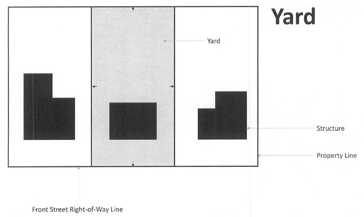
Yard: A required open space on a lot, which is unoccupied and unobstructed by a structure from its lowest ground level to the sky, except as expressly permitted in this chapter. A yard shall extend along a lot line, public or private street, whichever is more restrictive, and at right angles to such lot line, public or private street, to a depth or width specified in the yard regulations for the district in which such lot is located.
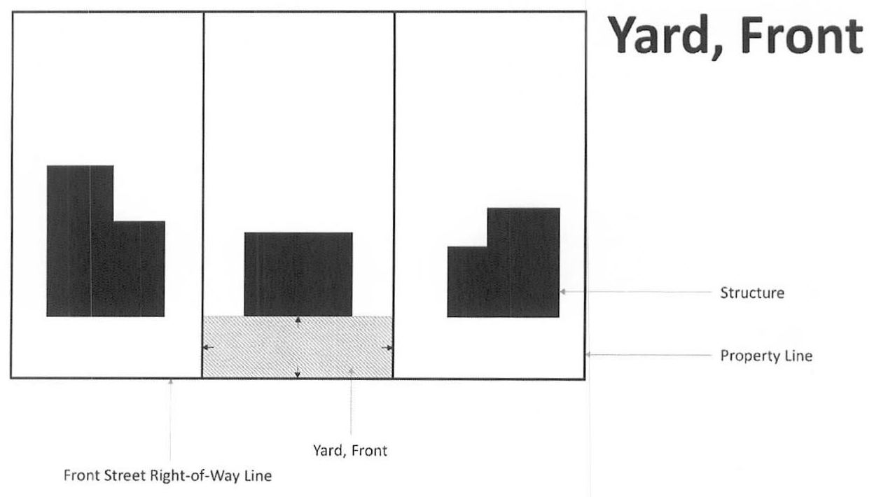
Yard, front: A yard extending along the full width of the front lot line extending from the abutting front street right-of-way line to a depth required in the yard regulations for the district in which such lot is located.
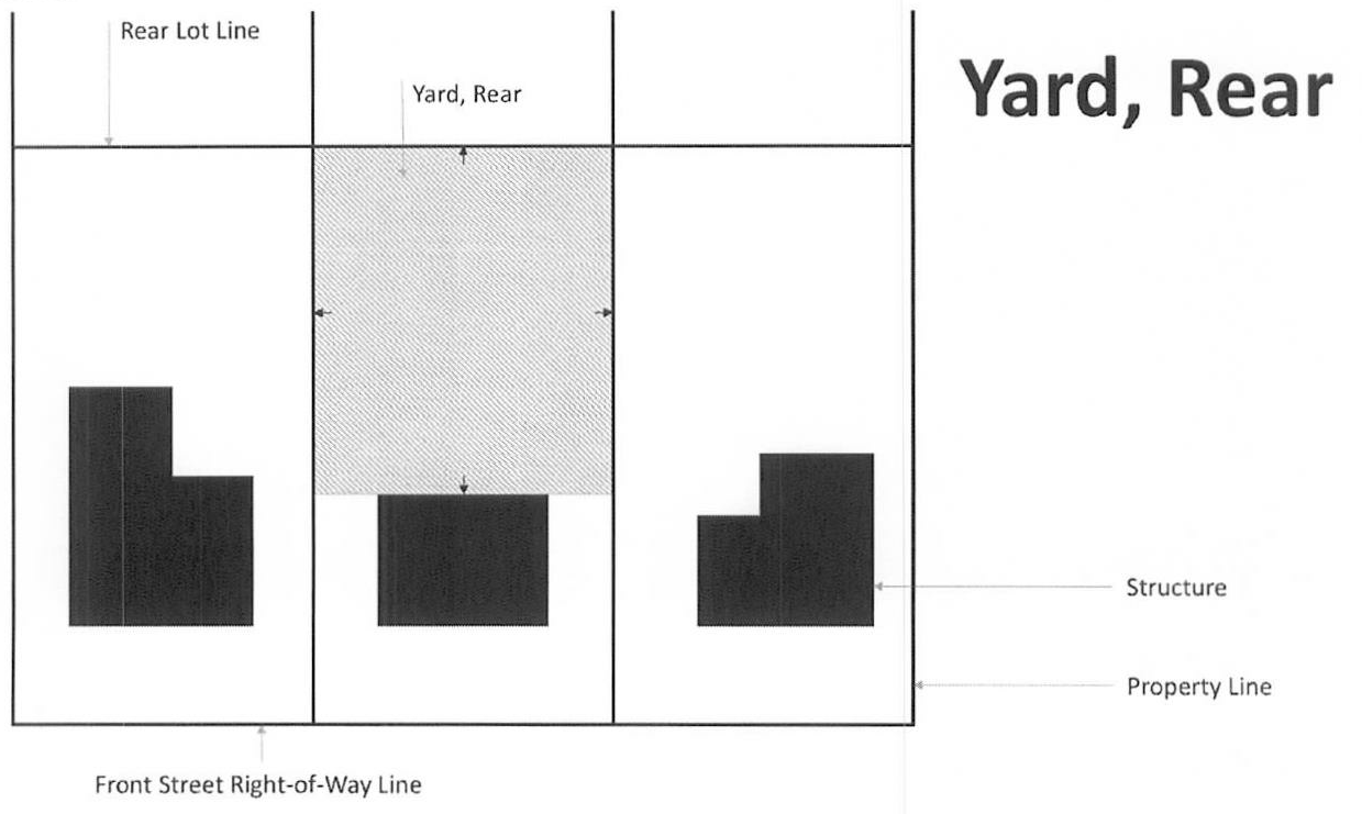
Yard, rear: A yard extending along the full width of the rear lot line extending toward the front lot line for a depth as specified in the yard regulations for the district in which such lot is located.
Yard, required: The open space area between a lot line and the buildable area in which no structure shall be located except as may otherwise be provided by this chapter.
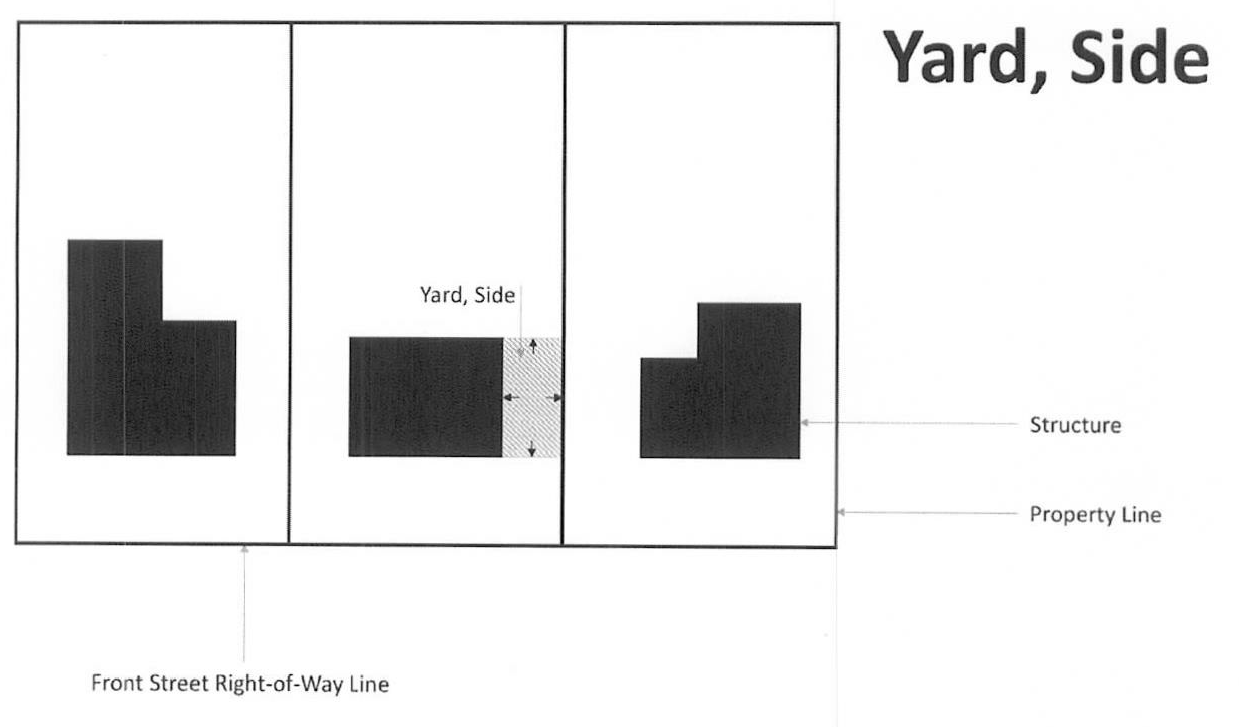
Yard, side: A yard extending along the side lot line between the front and rear yards, having a width as specified in the yard regulations for the district in which such lot is located.
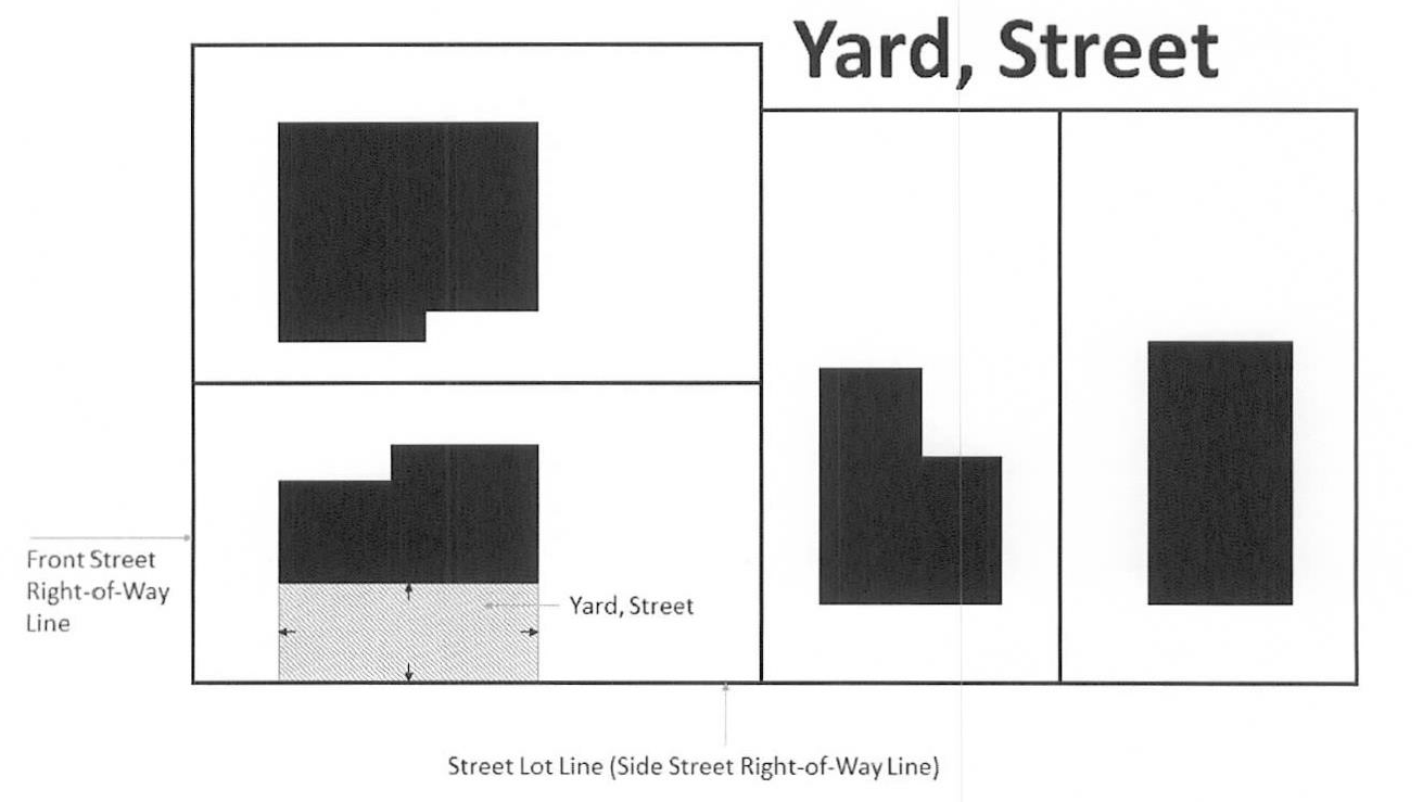
Yard, street: A yard extending along the side lot line between the front and rear yards, abutting a street right-of-way having a width as specified in the yard regulations for the district in which such lot is located. A street yard is an additional front yard for corner lots.
Zoning Administrator: The person authorized and charged by the city with the administration and enforcement of this chapter. See § 150.911(A).
Zoning district(s): See § 150.102.
Zoning enforcement officer: The person authorized and charged by the city with the enforcement of this chapter. See § 150.911(B).
Zoning map: See "official zoning map" above and see § 150.103.
(Ord. of 3-6-06; Ord. No. 848G, § 1, 9-5-06; Ord. No. 880G, § 1, 1-2-07; Ord. No. 2H, § 1, 1-5-09; Ord. No. 15H, § 1, 5-4-09; Ord. No. 141H, § 1, 2-20-12; Ord. No. 323H, § 1, 1-3-17; Ord. No. 341H, § 1, 4-3-17; Ord. No. 415H, § 1, 9-4-18; Ord. No. 425H, § 1, 10-1-18; Ord. No. 481H, § 1, 2-3-20; Ord. No. 587H, § 1, 7-5-22)