
Belvidere City Zoning Code
ARTICLE 1
- ESTABLISHMENT OF ZONING DISTRICTS
Sec. 150.101.- Purpose.
(A)
The area located within the jurisdiction of this chapter (see § 150.007) is hereby divided into zoning districts of such number and community character as are necessary to achieve compatibility of land uses within each district, to implement the officially adopted City of Belvidere Comprehensive Plan, and to achieve the other purposes of this chapter (see § 150.003).
(B)
Zoning of annexed property. All territories shall be annexed and zoned RH, rural holding district until otherwise properly rezoned by ordinance. Parcels of ten or more acres of land utilized for crop production are permitted in any zoning district pursuant to annexation.
(C)
Zoning of "pre-annexed" property. Pre-annexed territory means only territory subject to an annexation agreement within the city that is not within the corporate limits of the city. All territories shall be "pre-annexed" and zoned RH, rural holding district until otherwise properly rezoned by ordinance. Parcels of ten or more acres of land utilized for crop production are permitted in any zoning district pursuant to "pre-annexation."
(D)
All territories annexed and "pre-annexed" shall be subject to all city codes, ordinances, resolutions and policies, including, but not limited to the city's zoning ordinance.
(Ord. No. 801G, § 3, 3-6-06; Ord. No. 408H, § 1, 8-6-18; Ord. No. 701H, § 1, 11-4-24)
Sec. 150.102. - Standard zoning districts and standard zoning district categories.
For the purpose of this chapter, all areas within the jurisdiction of this chapter (see § 150.007) are hereby divided into the following standard zoning districts, and standard zoning district categories (listed in underlined text), which shall be designated as follows:
Agricultural district:
Rural holding (RH) district
Residential districts:
Single-family residential-3 (SR-3) district
Single-family residential-4 (SR-4) district
Single-family residential-6 (SR-6) district
Two-family residential-7 (TR-7) district
Multi-family residential-8S (MR-8S) district
Multi-family residential-8L (MR-8L) district
Office districts:
Neighborhood office (NO) district
Planned office (PO) district
Commercial districts:
Neighborhood business (NB) district
Planned business (PB) district
General business (GB) district
Central business (CB) district
Industrial districts:
Planned industrial (PI) district
General industrial (GI) district
Heavy industrial (HI) district
Institutional district:
Institutional (I) district
Planned development districts:
Planned development district (year-order of approval in that year) e.g.: (PD 2003-2)
(Ord. No. 801G, § 3, 3-6-06; Ord. No. 164H, § 1, 12-3-12; Ord. No. 701H, § 2, 11-4-24)
Sec. 150.103. - Map of standard zoning districts.
Standard zoning districts established by this chapter are shown on the official zoning map of the city, which together with all explanatory materials thereon, is hereby made part of this chapter.
(Ord. No. 801G, § 3, 3-6-06)
Sec. 150.104. - Interpretation of zoning district boundaries.
The following rules shall be used to determine the precise location of any zoning district boundary shown on the official zoning map of the city:
(A)
Zoning district boundaries shown as following or approximately following the limits of any city, village, town or county boundary shall be construed as following such limits.
(B)
Zoning district boundaries shown as following or approximately following streets or railroad lines shall be construed as following the centerline of such streets or railroad lines.
(C)
Zoning district boundary lines shown as following or approximately following platted lot lines or other property lines as shown on the city or county tax maps shall be construed as following such lines.
(D)
Zoning district boundaries shown as following or approximately following the centerlines of streams, rivers, or other continuously flowing watercourses shall be construed as following the channel centerlines of such watercourses, and, in the event of a natural change in the location of such streams, rivers, or other watercourses, the zoning district boundary shall be construed as moving with the channel centerline.
(E)
Zoning district boundaries shown as following or approximately following ridgelines or watershed boundaries shall be construed as following such lines.
(F)
Zoning district boundaries shown as separated from, any of the features listed in paragraphs 150.104(A) through (E), above, shall be construed to be at such distances therefrom as are shown on the official zoning map.
(G)
Where any uncertainty exists as to the exact location of a zoning district boundary line, as shown on the official zoning map, the location of the line shall be determined by the zoning administrator.
(Ord. No. 801G, § 3, 3-6-06)
Sec. 150.105. - Purpose and intent of standard zoning districts.
The following subsections specify the purpose and intent of the standard zoning districts established by this chapter.
(A)
Agricultural district.
(1)
Rural holding (RH) district.
A.
Description and purpose. This district is intended to permit development that is solely of a rural community character. The land use standards for this district permit very low-density single-family residential development at a density of one dwelling unit for every 40 gross acres, as well as a variety of agricultural and agricultural support land uses. Density and intensity standards for this district are designed to ensure that development that requires even a minimum of urban services does not occur until such services are available. As such, the rural holding (RH) district shall either serve as a designation which preserves and protects agricultural activities, or as a "holding zone" which provides for an interim land use (agriculture) that will easily permit further development (with rezoning to another district) at the appropriate time.
Rationale: This district is used to provide for the protection of agricultural activities, and a very low density residential area for those who want to live in a rural environment and who retain enough land with their residence to ensure that the rural environment is maintained as long as the rural holding (RH) district designation is retained. In this manner, even if all property were developed in a given area with the rural holding (RH) district designation, the rural community character of that area would still be maintained.
B.
List of allowable principal land uses (per article 2).
1.
Permitted by right.
Single-family—40-acre lot;
Cultivation;
On-site agricultural retail;
Selective cutting;
Passive outdoor public recreation;
Active outdoor public recreation;
Outdoor institutional;
Public services and utilities.
2.
Permitted as special use.
Husbandry;
Intensive agriculture;
Agricultural services;
Clear cutting;
Outdoor commercial entertainment;
Commercial animal boarding;
Bed and breakfast establishments;
Campground;
Waste disposal facility;
Composting operation;
Airport/heliport;
Extraction use;
Nonbuilding mounted solar installations for export of energy for use by a public utility.
C.
List of allowable accessory uses (per article 2).
1.
Permitted by right.
Private residential garage and/or shed;
Home occupation;
Day care group home;
Day care home w/occupation permit;
On-site parking lot;
Private residential recreational facility;
Private residential kennel;
Drainage structure;
Filling;
Lawn care;
Private residential stable;
Exterior communication devices.
2.
Permitted as special use.
Outdoor display incidental;
Migrant labor camp;
In-family suite;
Attached/detached garage in aggregate exceeding 900 square feet;
Wind energy systems;
Batch plant;
Private residential recreational facility over 900 square feet.
D.
List of allowable temporary uses (per article 2).
Outdoor assembly;
Contractor's project office;
Contractor's on-site equipment storage;
Relocatable building;
On-site real estate sales office;
Outdoor sales of farm products;
Garage sales.
E.
Regulations applicable to all uses.
1.
Landscaping regulations (see article 6);
2.
Performance standards (see article 7);
3.
Signage regulations (see article 10).
F.
Regulations applicable to residential uses.
1.
Residential density and intensity requirements:
A.
Minimum zoning district area: Two acres.
B.
Maximum gross density (MGD): 0.03 du/acre.
C.
Minimum landscape surface ratio (LSR): 85 percent.
2.
Residential bulk requirements:
A.
Minimum lot area: two acres.
B.
Minimum lot width: 250 feet.
C.
Minimum street frontage: 40 feet.
D.
Minimum setbacks:
Front or street side lot line to house: 35 feet.
Front or street side lot line to attached garage: 35 feet.
Side lot line to house or attached garage: 15 feet.
Total of both sides, lot lines to house/attached garage: 30 feet.
Rear lot line to house or attached garage: 35 feet.
Side lot line to accessory structure: 15 feet.
Rear lot line to accessory structure: 15 feet.
Paved surface setback: 3 feet from side or rear; 10 feet from street; (driveways established prior to adoption date of this ordinance are exempted).
E.
Minimum dwelling unit separation: 30 feet.
F.
Maximum height of dwelling unit: 35 feet.
G.
Maximum height of accessory structure: 20 feet
H.
Minimum number of off-street parking spaces required on the lot: See parking lot requirements per specific land use in §150.204.
I.
Minimum dwelling core dimensions: 960 square feet, measuring no less than 24 feet by 40 feet.
J.
Required buffer yard: See § 150.607 along zoning district boundary.
3.
A.
Only a bedroom shall serve as a regularly occupied sleeping area. Bedrooms shall not constitute the only means of access to other bedrooms or habitable spaces and shall not serve as the only means of egress from other habitable spaces. Every bedroom shall have access to at least one water closet and one lavatory without passing through another bedroom. Every bedroom in a dwelling unit shall have access to at least one water closet and lavatory located in the same story as the bedroom or an adjacent story. Kitchens and non-habitable spaces (e.g. utility rooms, storage spaces, closets, garages and bathrooms) shall not be used for sleeping purposes and shall not be deemed a bedroom.
B.
Every bedroom occupied by one person shall contain at least 70 square feet of floor area and every bedroom occupied by more than one person shall contain at least 50 square feet of floor area for each occupant thereof.
C.
In addition to the requirements of 3.B. above, every residential unit shall contain a minimum of 200 square feet of habitable space for each occupant.
D.
No dwelling unit shall be occupied by more persons than permitted under 3.B. or 3.C. above. The legal owner as well as each of the occupants shall be jointly and severally liable for a violation of this provision and shall be assessed a fine in accordance with the general fine provision of the Belvidere Municipal Code. Each day that a violation of this provision continues shall be deemed a separate offense. Additionally, the city may seek any other remedy available at law or in equity, including equitable relief requiring compliance with this provision.
G.
Regulations applicable to nonresidential uses:
1.
Nonresidential intensity requirements:
A.
Maximum number of floors (F): Two.
B.
Minimum landscape surface ratio (LSR): 90 percent.
C.
Maximum floor area ratio (FAR): 0.10.
D.
Maximum building size (MBS): na.
2.
Nonresidential bulk requirements:
A.
Minimum lot area: 40,000 sq. ft.; may be reduced to 20,000 sq. ft. with a special use permit.
B.
Minimum lot width: 100 feet; minimum street frontage: 40 feet.
C.
Minimum setbacks:
Building to front or street side lot line: 35 feet.
Building to residential side lot line: 15 feet.
Building to residential rear lot line: 35 feet.
Building to nonresidential side lot line: 15 feet
Building to nonresidential rear lot line: 35 feet
D.
Minimum building separation: 30 feet.
E.
Maximum building height: 50 feet.
F.
Minimum number of off-street parking spaces required on the lot: See parking lot requirements per specific land use in § 150.204.
(B)
Residential districts.
(1)
Single-family residential-3 (SR-3) district.
A.
Description and purpose. This district is intended to permit development that has a low-density, community character. Density and intensity standards for this district are designed to ensure that the single-family residential-3 (SR-3) district shall serve as a designation that preserves and protects the residential community character of its area. Residential development with a maximum gross density (MGD) of three dwelling units per gross acre is available within this district.
Rationale: This district is used to provide for the permanent protection of a moderate density residential area for those who want to live in a suburban residential environment and who retain enough land with their residence, or in their development, to ensure that the community character is maintained as long as the SR-3 district designation is retained, regardless of how much development occurs within that area.
B.
List of allowable principal land uses (per article 2).
1.
Permitted by right.
Single-family;
Modular dwelling;
Cultivation;
Selective cutting;
Passive outdoor public recreation;
Active outdoor public recreation;
Public services and utilities.
2.
Permitted as special use.
Clear cutting;
Bed and breakfast establishments.
C.
List of allowable accessory uses (per article 2).
1.
Permitted by right.
Private residential garage and/or shed;
Home occupation;
Day care home;
On-site parking lot;
Private residential recreational facility;
Drainage structure;
Filling;
Lawn care;
Day care group home;
Exterior communication devices.
2.
Permitted as special use.
Caretaker's residence;
Attached/detached garage in aggregate exceeding 900 square feet;
In-family suite;
Wind energy systems;
Private residential recreational facility over 900 square feet.
D.
List of allowable temporary uses (per article 2).
Contractor's project office;
Contractor's on-site equipment storage;
On-site real estate sales office;
Garage sales.
E.
Regulations applicable to all uses.
1.
Landscaping regulations (see article 6).
2.
Performance standards (see article 7).
3.
Signage regulations (see article 10).
F.
Regulations applicable to residential uses.
1.
Residential density and intensity requirements:
A.
Minimum zoning district area: 15,000 square feet.
B.
Maximum gross density (MGD): 2.9 du/acre.
C.
Minimum landscape surface ratio (LSR): 60 percent.
2.
Residential bulk requirements:
A.
Minimum lot area: 15,000 sf.
B.
Minimum lot width: 100 feet.
C.
Minimum street frontage: 40 feet.
D.
Minimum setbacks (see § 150.204, figure A):
Front or street side lot line to house: 35 feet.
Front or street side lot line to attached garage: 35 feet.
Side lot line to house or attached garage: 15 feet.
Total of both sides, lot lines to house/attached garage: 30 feet.
Rear lot line to house/attached garage: 35 feet.
Side lot line to accessory structure: Three feet from property line, five feet from alley.
Rear lot line to accessory structure: Three feet from property line, five feet from alley.
Right-of-way line to accessory structure located on a through lot in the yard that abuts a city dedicated street (not inclusive of Grandview Trail, east of Cloverdale Way for a distance of 2,470 feet) and is not considered its principal frontage: 20 feet.
Paved surface setback: Three feet from side or rear, ten feet from street (driveways established prior to adoption date of this ordinance are exempted).
E.
Minimum dwelling unit separation: 30 feet.
F.
Maximum height of dwelling unit: 35 feet - for buildings with a lower level exposure, the established average grade along the front facade of the building shall be utilized as the lowest elevation for the purpose of computing building height.
G.
Maximum height of accessory structure: 20 feet.
H.
Minimum number of off-street parking spaces required on the lot: See parking lot requirements per specific land use in § 150.204.
I.
Minimum dwelling core dimensions: 1200 square feet, measuring no less than 24 feet by 40 feet.
J.
Required bufferyard: See § 150.607 along zoning district boundary.
3.
A.
Only a bedroom shall serve as a regularly occupied sleeping area. Bedrooms shall not constitute the only means of access to other bedrooms or habitable spaces and shall not serve as the only means of egress from other habitable spaces. Every bedroom shall have access to at least one water closet and one lavatory without passing through another bedroom. Every bedroom in a dwelling unit shall have access to at least one water closet and lavatory located in the same story as the bedroom or an adjacent story. Kitchens and non-habitable spaces (e.g. utility rooms, storage spaces, closets, garages and bathrooms) shall not be used for sleeping purposes and shall not be deemed a bedroom.
B.
Every bedroom occupied by one person shall contain at least 70 square feet of floor area and every bedroom occupied by more than one person shall contain at least 50 square feet of floor area for each occupant thereof.
C.
In addition to the requirements of 3.B. above, every residential unit shall contain a minimum of 200 square feet of habitable space for each occupant.
D.
No dwelling unit shall be occupied by more persons than permitted under 3.B. or 3.C. above. The legal owner as well as each of the occupants shall be jointly and severally liable for a violation of this provision and shall be assessed a fine in accordance with the general fine provision of the Belvidere Municipal Code. Each day that a violation of this provision continues shall be deemed a separate offense. Additionally, the city may seek any other remedy available at law or in equity, including equitable relief requiring compliance with this provision.
G.
Regulations applicable to nonresidential uses.
1.
Nonresidential intensity requirements:
A.
Maximum number of floors (F): Two.
B.
Minimum landscape surface ratio (LSR): 60 percent.
C.
Maximum floor area ratio (FAR): 0.10.
D.
Maximum building size (MBS): na.
2.
Nonresidential bulk requirements:
A.
Minimum lot area: 15,000 sf. ft.
B.
Minimum lot width: 100 feet; minimum street frontage: 40 feet.
C.
Minimum setbacks:
Building to front or street side lot line: 35 feet.
Building to residential side lot line: 15 feet.
Building to residential rear lot line: 35 feet.
Building to nonresidential side lot line: 15 feet.
Building to nonresidential rear lot line: 35 feet.
Side lot line to accessory structure: Three feet from property line, five feet from alley.
Rear lot line to accessory structure: Three feet from property line, five feet from alley.
Right-of-way line to accessory structure located on a through lot in the yard that abuts a city dedicated street (not inclusive of Grandview Trail, east of Cloverdale Way for a distance of 2,470 feet) and is not considered its principal frontage: 20 feet.
Required bufferyard: See § 150.607 along zoning district boundary.
Paved surface setback: Five feet from side or rear; five feet from street; (driveways established prior to adoption date of this ordinance are exempted).
D.
Minimum building separation: 30 feet.
E.
Maximum building height: 35 feet.
F.
Minimum number of off-street parking spaces required on the lot: See parking lot requirements per specific land use in § 150.204.
(2)
Single-family residential-4 (SR-4) district.
A.
Description and purpose. This district is intended to permit development that has a moderate density, community character. Density and intensity standards for this district are designed to ensure that the single-family residential-4 (SR-4) district shall serve as a designation that preserves and protects the residential community character of its area. Residential development with a maximum gross density (MGD) of four dwelling units per gross acre is available within this district.
Rationale: This district is used to provide for the permanent protection of a moderate density residential area for those who want to live in a suburban residential environment and who retain enough land with their residence, or in their development, to ensure that the community character is maintained as long as the SR-4 district designation is retained, regardless of how much development occurs within that area.
B.
List of allowable principal land uses (per article 2).
1.
Permitted by right.
Single-family;
Modular dwelling;
Cultivation;
Selective cutting;
Passive outdoor public recreation;
Active outdoor public recreation;
Public services and utilities.
2.
Permitted as special use.
Clear cutting;
Bed and breakfast establishments.
C.
List of allowable accessory uses (per article 2).
1.
Permitted by right.
Private residential garage and/or shed;
Home occupation;
Day care home;
Day care group home;
On-site parking lot;
Private residential recreational facility;
Drainage structure;
Filling;
Lawn care;
Exterior communication devices.
2.
Permitted as special use.
Attached/detached garage in aggregate exceeding 900 square feet;
In-family suite;
Wind energy systems;
Private residential recreational facility over 900 square feet.
D.
List of allowable temporary uses (per article 2).
Contractor's project office;
Contractor's on-site equipment storage;
On-site real estate sales office;
Garage sales.
E.
Regulations applicable to all uses.
1.
Landscaping regulations (see article 6).
2.
Performance standards (see article 7).
3.
Signage regulations (see article 10).
F.
Regulations applicable to residential uses.
1.
Residential density and intensity requirements:
A.
Minimum zoning district area: 10,000 square feet.
B.
Maximum gross density (MGD): 4.4 du/acre.
C.
Minimum landscape surface ratio (LSR): 50 percent.
2.
Residential bulk requirements:
A.
Minimum lot area: 10,000 square feet.
B.
Minimum lot width: 80 feet.
C.
Minimum street frontage: 40 feet.
D.
Minimum setbacks (see § 150.204, figure A):
Front or street side lot line to house: 30 feet.
Front or street side lot line to attached garage: 30 feet.
Side lot line to house or attached garage: Ten feet.
Total of both sides, lot lines to house/attached garage: 20 feet.
Rear lot line to house or attached garage: 25 feet.
Side lot line to accessory structure: Three feet from property line, five feet from alley.
Rear lot line to accessory structure: Three feet from property line, five feet from alley.
Right-of-way line to accessory structure located on a through lot in the yard that abuts a city dedicated street (not inclusive of Grandview Trail, east of Cloverdale Way for a distance of 2,470 feet) and is not considered its principal frontage: 20 feet.
Paved surface setback: Three feet from side or rear; ten feet from street; (driveways established prior to adoption date of this ordinance are exempted).
E.
Minimum dwelling unit separation: 20 feet.
F.
Maximum height of dwelling unit: 35 feet.
G.
Maximum height of accessory structure: 20 feet.
H.
Minimum number of off-street parking spaces required on the lot: See parking lot requirements per specific land use in § 150.204.
I.
Minimum dwelling size: 1200 square feet, measuring no less than 24 feet by 40 feet.
J.
Required bufferyard: See § 150.607 along zoning district boundary.
3.
A.
Only a bedroom shall serve as a regularly occupied sleeping area. Bedrooms shall not constitute the only means of access to other bedrooms or habitable spaces and shall not serve as the only means of egress from other habitable spaces. Every bedroom shall have access to at least one water closet and one lavatory without passing through another bedroom. Every bedroom in a dwelling unit shall have access to at least one water closet and lavatory located in the same story as the bedroom or an adjacent story. Kitchens and non-habitable spaces (e.g. utility rooms, storage spaces, closets, garages and bathrooms) shall not be used for sleeping purposes and shall not be deemed a bedroom.
B.
Every bedroom occupied by one person shall contain at least 70 square feet of floor area and every bedroom occupied by more than one person shall contain at least 50 square feet of floor area for each occupant thereof.
C.
In addition to the requirements of 3.B. above, every residential unit shall contain a minimum of 200 square feet of habitable space for each occupant.
D.
No dwelling unit shall be occupied by more persons than permitted under 3.B. or 3.C. above. The legal Owner as well as each of the occupants shall be jointly and severally liable for a violation of this provision and shall be assessed a fine in accordance with the general fine provision of the Belvidere Municipal Code. Each day that a violation of this provision continues shall be deemed a separate offense. Additionally, the city may seek any other remedy available at law or in equity, including equitable relief requiring compliance with this provision.
G.
Regulations applicable to nonresidential uses.
1.
Nonresidential intensity requirements:
A.
Maximum number of floors (F): Two.
B.
Minimum landscape surface ratio (LSR): 50 percent.
C.
Maximum floor area ratio (FAR): 0.20.
D.
Maximum building size (MBS): na.
2.
Nonresidential bulk requirements:
A.
Minimum lot area: 10,000 sq. ft.
B.
Minimum lot width: 80 feet; minimum street frontage: 40 feet.
C.
Minimum setbacks:
Building to front or street side lot line: 30 feet.
Building to residential side lot line: Ten feet.
Building to residential rear lot line: 25 feet.
Building to nonresidential side lot line: Ten feet.
Building to nonresidential rear lot line: 25 feet.
Side lot line to accessory structure: Three feet from property line, five feet from alley.
Rear lot line to accessory structure: Three feet from property line, five feet from alley.
Right-of-way line to accessory structure located on a through lot in the yard that abuts a city dedicated street (not inclusive of Grandview Trail, east of Cloverdale Way for a distance of 2,470 feet) and is not considered its principal frontage: 20 feet.
Required bufferyard: See § 150.607 along zoning district boundary.
Paved surface setback: Five feet from side or rear; five feet from street; (driveways established prior to adoption date of this ordinance are exempted).
D.
Minimum building separation: 20 feet.
E.
Maximum building height: 35 feet.
F.
Minimum number of off-street parking spaces required on the lot: See parking lot requirements per specific land use in § 150.204.
(3)
Single-family residential-6 (SR-6) district.
A.
Description and purpose. This district is intended to permit development that has a moderate density, community character. Density and intensity standards for this district are designed to ensure that the single-family residential-6 (SR-6) district shall serve as a designation that preserves and protects the residential community character of its area. Residential development with a maximum gross density (MGD) of six dwelling units per gross acre is available within this district.
Rationale: This district is used to provide for the permanent protection of a moderate density residential area for those who want to live in a suburban residential environment and who retain enough land with their residence, or in their development, to ensure that the community character is maintained as long as the SR-6 district designation is retained, regardless of how much development occurs within that area.
B.
List of allowable principal land uses (per article 2).
1.
Permitted by right.
Single-family;
Modular dwelling;
Cultivation;
Selective cutting;
Passive outdoor public recreation;
Active outdoor public recreation;
Public services and utilities.
2.
Permitted as special use.
Clear cutting;
Bed and breakfast establishments;
Two-flat/duplex/twin house.
C.
List of allowable accessory uses (per article 2).
1.
Permitted by right.
Private residential garage and/or shed;
Home occupation;
Day care group home;
Day care home;
On-site parking lot;
Private residential recreational facility;
Drainage structure;
Filling;
Lawn care;
Exterior communication devices.
2.
Permitted as special use.
Attached/detached garage in aggregate exceeding 900 square feet;
In-family suite;
Wind energy systems;
Private residential recreational facility over 900 square feet.
D.
List of allowable temporary uses (per article 2).
Contractor's project office;
Contractor's on-site equipment storage;
On-site real estate sales office;
Garage sales.
E.
Regulations applicable to all uses.
1.
Landscaping regulations (see article 6).
2.
Performance standards (see article 7).
3.
Signage regulations (see article 10).
F.
Regulations applicable to residential uses.
1.
Residential density and intensity requirements:
A.
Minimum zoning district area: 7,000 square feet.
B.
Maximum gross density (MGD): 6.2 du/acre.
C.
Minimum landscape surface ratio (LSR): 50 percent.
2.
Residential bulk requirements:
A.
Minimum lot area: 7,000 square feet.
B.
Minimum lot width: 6five feet.
C.
Minimum street frontage: 40 feet.
D.
Minimum setbacks (see § 150.204, figure A):
Front or street side lot line to house: 20 feet.
Front or street side lot line to attached garage: 20 feet.
Side lot line to house or attached garage: 6 feet.
Total of both sides, lot lines to house/attached garage: 15 feet.
Rear lot line to house or attached garage: 20 feet.
Side lot line to accessory structure: Three feet from property line, five feet from alley.
Rear lot line to accessory structure: Three feet from property line, five feet from alley.
Rear lot line to accessory structure located on a double frontage lot in the yard that abuts a city dedicated street: 20 feet.
Minimum paved surface setback: Three feet from side or rear; ten feet from street; (driveways established prior to adoption date of this ordinance are exempted).
E.
Minimum dwelling unit separation: 12 feet.
F.
Maximum height of dwelling unit: 35 feet.
G.
Maximum height of accessory structure: 20 feet.
H.
Minimum number of off-street parking spaces required on the lot: See parking lot requirements per specific land use in § 150.204.
I.
Minimum dwelling size: 860 square feet, measuring no less than 24 feet by 40 feet.
J.
Required bufferyard: See § 150.607 along zoning district boundary.
3.
A.
Only a bedroom shall serve as a regularly occupied sleeping area. Bedrooms shall not constitute the only means of access to other bedrooms or habitable spaces and shall not serve as the only means of egress from other habitable spaces. Every bedroom shall have access to at least one water closet and one lavatory without passing through another bedroom. Every bedroom in a dwelling unit shall have access to at least one water closet and lavatory located in the same story as the bedroom or an adjacent story. Kitchens and non-habitable spaces (e.g. utility rooms, storage spaces, closets, garages and bathrooms) shall not be used for sleeping purposes and shall not be deemed a bedroom.
B.
Every bedroom occupied by one person shall contain at least 70 square feet of floor area and every bedroom occupied by more than one person shall contain at least 50 square feet of floor area for each occupant thereof.
C.
In addition to the requirements of 3.B. above, every residential unit shall contain a minimum of 200 square feet of habitable space for each occupant.
D.
No dwelling unit shall be occupied by more persons than permitted under 3.B. or 3.C. above. The legal owner as well as each of the occupants shall be jointly and severally liable for a violation of this provision and shall be assessed a fine in accordance with the general fine provision of the Belvidere Municipal Code. Each day that a violation of this provision continues shall be deemed a separate offense. Additionally, the city may seek any other remedy available at law or in equity, including equitable relief requiring compliance with this provision.
G.
Regulations applicable to nonresidential uses.
1.
Nonresidential intensity requirements:
Maximum number of floors (F): Two.
Minimum landscape surface ratio (LSR): 50 percent.
Maximum floor area ratio (FAR): 0.25.
Maximum building size (MBS): na.
2.
Nonresidential bulk requirements:
A.
Minimum lot area: 7,000 sq. ft.
B.
Minimum lot width: 100 feet; minimum street frontage: 40 feet.
C.
Minimum setbacks:
Building to front or street side lot line: 20 feet.
Building to residential side lot line: Six feet.
Building to residential rear lot line: 20 feet.
Building to nonresidential side lot line: Six feet.
Building to nonresidential rear lot line: 20 feet.
Side lot line to accessory structure: Three feet from property line, five feet from alley.
Rear lot line to accessory structure: Three feet from property line, five feet from alley.
Right-of-way line to accessory structure located on a through lot in the yard that abuts a city dedicated street (not inclusive of Grandview Trail, east of Cloverdale Way for a distance of 2,470 feet) and is not considered its principal frontage: 20 feet.
Required bufferyard: See § 150.607 along zoning district boundary.
Minimum paved surface setback: Five feet from side or rear; five feet from street; (driveways established prior to adoption date of this ordinance are exempted).
D.
Minimum building separation: 12 feet.
E.
Maximum building height: Thirty-five feet.
F.
Minimum number of off-street parking spaces required on the lot: See parking lot requirements per specific land use in § 150.204.
(4)
Two-family residential-7 (TR-7) district.
A.
Description and purpose. This district is intended to permit development that has a moderate density community character. The land use standards for this district permit both single-family detached residential development and twin house/duplexes permitted by right and two flat, mobile home parks, and mobile home subdivisions permitted as a special use. Density and intensity standards for this district are designed to ensure that the two-family residential-7 district shall serve as a designation that preserves and protects the moderate density residential community character of its area. Various residential development options are available in this district, with a maximum gross density (MGD) of seven dwelling units per gross acre.
Rationale: This district is used to provide for the permanent protection of an area for those who want to live in a moderate density residential environment and who retain enough land with their residence, or in their development, to ensure that the desired community character is maintained as long as the TR-7 district designation is retained, regardless of how much development occurs within that area. As such, this district is intended to provide the principal location for a wide range of single-family attached dwelling types, including single-family, duplexes, twin houses, and two flats.
B.
List of allowable principal land uses (per article 2).
1.
Permitted by right.
Single-family;
Modular dwelling;
Twin house/duplex;
Cultivation;
Selective cutting;
Passive outdoor public recreation;
Active outdoor public recreation;
Public services and utilities.
2.
Permitted as special use.
Two-flat;
Clear cutting;
Bed and breakfast establishments;
Day care center (3+ children);
Institutional residential;
Mobile home.
C.
List of allowable accessory uses (per article 2).
1.
Permitted by right.
Private residential garage and/or shed;
Home occupation;
Day care group home;
Day care home;
On-site parking lot;
Private residential recreational facility;
Drainage structure;
Filling;
Lawn care;
Exterior communication devices.
2.
Permitted as special use.
Attached/detached garage in aggregate exceeding 900 square feet for single-family and 1,200 square feet for two-family;
In-family suite;
Wind energy systems;
Private residential recreational facility over 900 square feet.
D.
List of allowable temporary uses (per article 2).
Contractor's project office;
Contractor's on-site equipment storage;
On-site real estate sales office;
Garage sales.
E.
Regulations applicable to all uses.
1.
Landscaping regulations (see article 6).
2.
Performance standards (see article 7).
3.
Signage regulations (see article 10).
F.
Regulations applicable to residential uses. For single-family dwellings, see the SR-6 district.
1.
Residential density and intensity requirements:
A.
Minimum zoning district area: 12,000 square feet.
B.
Maximum gross density (MGD): 7.3 du/acre.
C.
Minimum landscape surface ratio (LSR): 50 percent.
2.
Residential bulk requirements:
A.
Minimum lot area: 12,000 square feet (6,000 sf. ft. per du).
B.
Minimum lot width: 90 feet; 45 feet per unit.
C.
Minimum street frontage: 40 feet.
D.
Minimum setbacks (see § 150.204, figure B):
Front or street side lot line to house: 20 feet.
Front or street side lot line to attached garage: 20 feet.
Side lot line to house or attached garage: Six feet, or zero feet for zero lot line developments or shared party lots.
Total of both sides, lot lines to house/attached garage: 15 feet.
Rear lot line to house or attached garage: 20 feet.
Side lot line to accessory structure: Three feet from property line, five feet from alley.
Rear lot line to accessory structure: Three feet from property line, five feet from alley.
Rear lot line to accessory structure located on a double frontage lot in the yard that abuts a city dedicated street: 20 feet.
Minimum paved surface setback: Three feet from side or rear; ten feet from street; (driveways established prior to adoption date of this ordinance are exempted).
E.
Minimum dwelling unit separation: 12 feet or 0 feet along common wall.
F.
Maximum height of dwelling unit: 35 feet.
G.
Maximum height of accessory structure: 20 feet.
H.
Minimum number of off-street parking spaces required on the lot: See parking lot requirements per specific land use in § 150.204.
I.
Minimum dwelling size: 860 square feet.
J.
Required bufferyard: See § 150.607 along zoning district boundary.
3.
A.
Only a bedroom shall serve as a regularly occupied sleeping area. Bedrooms shall not constitute the only means of access to other bedrooms or habitable spaces and shall not serve as the only means of egress from other habitable spaces. Every bedroom shall have access to at least one water closet and one lavatory without passing through another bedroom. Every bedroom in a dwelling unit shall have access to at least one water closet and lavatory located in the same story as the bedroom or an adjacent story. Kitchens and non-habitable spaces (e.g. utility rooms, storage spaces, closets, garages and bathrooms) shall not be used for sleeping purposes and shall not be deemed a bedroom.
B.
Every bedroom occupied by one person shall contain at least 70 square feet of floor area and every bedroom occupied by more than one person shall contain at least 50 square feet of floor area for each occupant thereof.
C.
In addition to the requirements of 3.B. above, every residential unit shall contain a minimum of 200 square feet of habitable space for each occupant.
D.
No dwelling unit shall be occupied by more persons than permitted under 3.B. or 3.C. above. The legal owner as well as each of the occupants shall be jointly and severally liable for a violation of this provision and shall be assessed a fine in accordance with the general fine provision of the Belvidere Municipal Code. Each day that a violation of this provision continues shall be deemed a separate offense. Additionally, the city may seek any other remedy available at law or in equity, including equitable relief requiring compliance with this provision.
G.
Regulations applicable to nonresidential uses.
1.
Nonresidential intensity requirements:
Maximum number of floors (F): Two.
Minimum landscape surface ratio (LSR): 50 percent.
Maximum floor area ratio (FAR): 0.25.
Maximum building size (MBS): na.
2.
Nonresidential bulk requirements:
A.
Minimum lot area: 8,500 sq. ft.
B.
Minimum lot width: 100 feet; minimum street frontage: 40 feet.
C.
Minimum setbacks:
Building to front or street side lot line: 20 feet.
Building to residential side lot line: Six feet.
Building to residential rear lot line: 20 feet.
Building to nonresidential side lot line: Six feet.
Building to nonresidential rear lot line: 20 feet.
Side lot line to accessory structure: Three feet from property line, five feet from alley.
Rear lot line to accessory structure: Three feet from property line, five feet from alley.
Required bufferyard: See § 150.607 along zoning district boundary.
Minimum paved surface setback: five feet from side or rear; five feet from street; (driveways established prior to adoption date of this ordinance are exempted).
D.
Minimum building separation: 12 feet.
E.
Maximum building height: 35 feet.
F.
Minimum number of off-street parking spaces required on the lot: See parking lot requirements per specific land use in § 150.204.
(5)
Multi-family residential-8 small (MR-8S) district.
A.
Description and purpose. This district is intended to permit development that has a higher density community character. The land use standards for this district permit single-family detached, twin house/duplex, two flats, townhouses, and multiplexes permitted by right and related land uses. Density and intensity standards for this district are designed to ensure that the multi-family residential-8 small district shall serve as a designation that preserves and protects the community character of its area. A variety of residential development options are available in this district, with a maximum gross density (MGD) of eight dwelling units per gross acre.
Rationale: This district is used to provide for the permanent protection of an area for those who want to live in a higher density residential environment, with housing units that are smaller than those for MR-8L, and who retain enough land with their residence, or in their development, to ensure that the urban community character is maintained as long as the MR-8S district designation is retained, regardless of how much development occurs within that area. As such, it is intended to provide the principal location for mixed residential development.
B.
List of allowable principal land uses (per article 2).
1.
Permitted by right.
Single-family;
Twin house/duplex;
Townhouse (3 or 4 unit building);
Multiplex (3 or 4 unit building);
Modular dwelling;
Cultivation;
Selective cutting;
Passive outdoor public recreation;
Active outdoor public recreation;
Public services and utilities.
2.
Permitted as special use.
Two-flat;
Apartment (3 or 4 unit building);
Clear cutting;
Bed and breakfast establishments;
Day care center (9+ children);
Boarding house;
Institutional residential.
C.
List of allowable accessory uses (per article 2).
1.
Permitted by right.
Private residential garage and/or shed;
Home occupation;
Day care group home;
Day care home;
On-site parking lot;
Private residential recreational facility;
Drainage structure;
Filling;
Lawn care;
Exterior communication devices.
2.
Permitted as special use.
In-family suite;
Wind energy systems;
Private residential recreational facility over 900 square feet.
D.
List of allowable temporary uses (per article 2).
Contractor's project office;
Contractor's on-site equipment storage;
On-site real estate sales office;
Garage sales.
E.
Regulations applicable to all uses.
1.
Landscaping regulations (see article 6).
2.
Performance standards (see article 7).
3.
Signage regulations (see article 10).
F.
Regulations applicable to residential uses. For single-family dwellings, see the SR-6 district. For two-family dwellings, see the TR-7 district.
1.
Residential density and intensity requirements:
A.
Minimum zoning district area: 15,000 square feet, to require at least three units.
B.
Maximum gross density (MGD): 8.00 du/acre.
C.
Minimum landscape surface ratio (LSR): 50 percent.
D.
Maximum accessory structure size:
Detached garage: 288 square feet per dwelling unit.
Attached garage: 576 square feet per dwelling unit.
Accessory utility shed: 120 square feet.
2.
Residential bulk requirements:
A.
Minimum lot area: 5,000 square feet per dwelling unit.
B.
Minimum lot width: 75 feet; 20 feet for townhouse on interior of row, 30 feet for townhouse on end of row.
C.
Minimum street frontage: 40 feet; 20 feet for townhouse on interior of row, 30 feet for townhouse on end of row.
D.
Minimum setbacks:
Front or street side lot line to house: 30 feet.
Front or street side lot line to attached garage: 30 feet.
Side lot line to house or attached garage: Ten feet or zero feet along common wall.
Total of both sides, lot lines to house/attached garage: 20 feet or zero feet along common wall.
Rear lot line to house or attached garage: 25 feet.
Side lot line to accessory structure: Three feet from property line, five feet from alley.
Rear lot line to accessory structure: Three feet from property line, five feet from alley.
Required bufferyard: See § 150.607 along zoning district boundary.
Minimum paved surface setback: Three feet from side or rear; ten feet from street; (driveways established prior to adoption date of this ordinance are exempted).
E.
Minimum dwelling unit separation: 20 feet or zero feet along common wall.
F.
Maximum height of dwelling unit: 35 feet, greater with special use permit.
G.
Maximum height of accessory structure: 20 feet.
H.
Minimum number of off-street parking spaces required on the lot: See parking lot requirements per specific land use in § 150.204.
I.
Minimum dwelling core dimensions: 860 square feet.
3.
A.
Only a bedroom shall serve as a regularly occupied sleeping area. Bedrooms shall not constitute the only means of access to other bedrooms or habitable spaces and shall not serve as the only means of egress from other habitable spaces. Every bedroom shall have access to at least one water closet and one lavatory without passing through another bedroom. Every bedroom in a dwelling unit shall have access to at least one water closet and lavatory located in the same story as the bedroom or an adjacent story. Kitchens and non-habitable spaces (e.g. utility rooms, storage spaces, closets, garages and bathrooms) shall not be used for sleeping purposes and shall not be deemed a bedroom.
B.
Every bedroom occupied by one person shall contain at least 70 square feet of floor area and every bedroom occupied by more than one person shall contain at least 50 square feet of floor area for each occupant thereof.
C.
In addition to the requirements of 3.B. above, every residential unit shall contain a minimum of 200 square feet of habitable space for each occupant.
D.
No dwelling unit shall be occupied by more persons than permitted under 3.B. or 3.C. above. The legal owner as well as each of the occupants shall be jointly and severally liable for a violation of this provision and shall be assessed a fine in accordance with the general fine provision of the Belvidere Municipal Code. Each day that a violation of this provision continues shall be deemed a separate offense. Additionally, the city may seek any other remedy available at law or in equity, including equitable relief requiring compliance with this provision.
G.
Regulations applicable to nonresidential uses:
1.
Nonresidential intensity requirements:
Maximum number of floors (F): Two.
Minimum landscape surface ratio (LSR): 25 percent.
Maximum floor area ratio (FAR): 0.275.
Maximum building size (MBS): na.
2.
Nonresidential bulk requirements:
A.
Minimum lot area: 10,000 sq. ft.
B.
Minimum lot width: 75 feet; minimum street frontage: 40 feet.
C.
Minimum setbacks:
Building to front or street side lot line: 30 feet.
Building to residential side lot line: Ten feet.
Building to residential rear lot line: 25 feet.
Building to nonresidential side lot line: Ten feet.
Building to nonresidential rear lot line: 25 feet.
Side lot line to accessory structure: Three feet from property line, five feet from alley.
Rear lot line to accessory structure: Three feet from property line, five feet from alley.
Required bufferyard: See § 150.607 along zoning district boundary.
Minimum paved surface setback: five feet from side or rear; five feet from street; (driveways established prior to adoption date of this ordinance are exempted).
D.
Minimum building separation: 20 feet.
E.
Maximum building height: 35 feet, greater with special use permit.
F.
Minimum number of off-street parking spaces required on the lot: See parking lot requirements per specific land use in § 150.204.
(6)
Multi-family residential-8 large (MR-8L) district.
A.
Description and purpose. This district is intended to permit development that has a higher density community character. The land use standards for this district permit single-family detached, twin house/duplex, townhouses, multiplexes, and apartments permitted by right and related land uses. Density and intensity standards for this district are designed to ensure that the multi-family residential-8 large district shall serve as a designation that preserves and protects the community character of its area. A variety of residential development options are available in this district, with a maximum gross density (MGD) of eight dwelling units per gross acre, with housing units typically larger than those in the MR-8S.
Rationale: This district is used to provide for the permanent protection of an area for those who want to live in a higher density residential environment and who retain enough land with their residence, or in their development, to ensure that the urban community character is maintained as long as the MR-8L district designation is retained, regardless of how much development occurs within that area. As such, it is intended to provide the principal location for mixed residential development.
B.
List of allowable principal land uses (per article 2).
1.
Permitted by right.
Single-family;
Twin house/duplex;
Townhouse (3 or 4 unit building);
Multiplex (3 or 4 unit building);
Apartment (3 or 4 unit building);
Public services and utilities;
Modular dwelling;
Cultivation;
Selective cutting;
Passive outdoor public recreation;
Active outdoor public recreation.
2.
Permitted as special use.
Two-flat;
Apartment (5 to 8 unit building);
Mobile home subdivision or park;
Clear cutting;
Bed and breakfast establishments;
Day care center (3+ children);
Institutional residential;
Boarding house.
C.
List of allowable accessory uses (per article 2).
1.
Permitted by right.
Private residential garage and/or shed;
Home occupation;
Day care group home;
Day care home;
On-site parking lot;
Private residential recreational facility;
Drainage structure;
Filling;
Lawn care;
Exterior communication devices.
2.
Permitted as special use.
In-family suite;
Wind energy systems;
Private residential recreational facility over 900 square feet.
D.
List of allowable temporary uses (per article 2).
Contractor's project office;
Contractor's on-site equipment storage;
On-site real estate sales office;
Garage sales.
E.
Regulations applicable to all uses.
1.
Landscaping regulations (see article 6).
2.
Performance standards (see article 7).
3.
Signage regulations (see article 10).
F.
Regulations applicable to residential uses. For single-family dwellings, see the SR-6 district. For two-family dwellings, see the TR-7 district. For 3-4 unit multi-family buildings, see the MR-8S district.
1.
Residential density and intensity requirements:
A.
Minimum zoning district area: 15,000 square feet, to require at least three units.
B.
Maximum gross density (MGD): 8.00 du/acre.
C.
Minimum landscape surface ratio (LSR): 50 percent.
D.
Maximum accessory structure size:
Detached garage: 288 square feet per dwelling unit.
Attached garage: 576 square feet per dwelling unit.
Accessory utility shed: 120 square feet.
2.
Residential bulk requirements:
A.
Minimum lot area: 5,000 square feet per dwelling unit.
B.
Minimum lot width: 75 feet; 20 feet for townhouse on interior of row, 30 feet for townhouse on end of row.
C.
Minimum street frontage: 40 feet; 20 feet for townhouse on interior of row, 30 feet for townhouse on end of row.
D.
Minimum setbacks:
Front or street side lot line to house: 30 feet.
Front or street side lot line to attached garage: 30 feet.
Side lot line to house or attached garage: Ten feet or zero feet along common wall.
Total of both sides, lot lines to house/attached garage: 20 feet or zero feet along common wall.
Rear lot line to house or attached garage: 25 feet.
Side lot line to accessory structure: Three feet from property line, five feet from alley.
Rear lot line to accessory structure: Three feet from property line, five feet from alley.
Required bufferyard: See § 150.607 along zoning district boundary.
Minimum paved surface setback: Three feet from side or rear; ten feet from street; (driveways established prior to adoption date of this ordinance are exempted).
E.
Minimum dwelling unit separation: 20 feet or zero feet along common wall.
F.
Maximum height of dwelling unit: 35 feet, greater with special use permit.
G.
Maximum height of accessory structure: 20 feet.
H.
Minimum number of off-street parking spaces required on the lot: See parking lot requirements per specific land use in § 150.204.
I.
Minimum dwelling core dimensions: 860 square feet.
3.
A.
Only a bedroom shall serve as a regularly occupied sleeping area. Bedrooms shall not constitute the only means of access to other bedrooms or habitable spaces and shall not serve as the only means of egress from other habitable spaces. Every bedroom shall have access to at least one water closet and one lavatory without passing through another bedroom. Every bedroom in a dwelling unit shall have access to at least one water closet and lavatory located in the same story as the bedroom or an adjacent story. Kitchens and non-habitable spaces (e.g. utility rooms, storage spaces, closets, garages and bathrooms) shall not be used for sleeping purposes and shall not be deemed a bedroom.
B.
Every bedroom occupied by one person shall contain at least 70 square feet of floor area and every bedroom occupied by more than one person shall contain at least 50 square feet of floor area for each occupant thereof.
C.
In addition to the requirements of 3.B. above, every residential unit shall contain a minimum of 200 square feet of habitable space for each occupant.
D.
No dwelling unit shall be occupied by more persons than permitted under 3.B. or 3.C. above. The legal owner as well as each of the occupants shall be jointly and severally liable for a violation of this provision and shall be assessed a fine in accordance with the general fine provision of the Belvidere Municipal Code. Each day that a violation of this provision continues shall be deemed a separate offense. Additionally, the city may seek any other remedy available at law or in equity, including equitable relief requiring compliance with this provision.
G.
Regulations applicable to nonresidential uses:
1.
Nonresidential intensity requirements:
A.
Maximum number of floors (F): Two.
B.
Minimum landscape surface ratio (LSR): 25 percent.
C.
Maximum floor area ratio (FAR): 0.275.
D.
Maximum building size (MBS): na.
2.
Nonresidential bulk requirements:
A.
Minimum lot area: 10,000 sq. ft.
B.
Minimum lot width: 75 feet; minimum street frontage: 40 feet.
C.
Minimum setbacks:
Building to front or street side lot line: 30 feet.
Building to residential side lot line: Ten feet.
Building to residential rear lot line: 25 feet.
Building to nonresidential side lot line: Ten feet.
Building to nonresidential rear lot line: 25 feet.
Side lot line to accessory structure: Three feet from property line, five feet from alley.
Rear lot line to accessory structure: Three feet from property line, five feet from alley.
Required bufferyard: See § 150.607 along zoning district boundary.
Minimum paved surface setback: Three feet from side or rear; five feet from street; (driveways established prior to adoption date of this ordinance are exempted).
D.
Minimum building separation: 20 feet.
E.
Maximum building height: 35 feet, greater with special use permit.
F.
Minimum number of off-street parking spaces required on the lot: See parking lot requirements per specific land use in § 150.204.
G.
Minimum dwelling core dimensions: 960 square feet, measuring no less than 24 feet by 40 feet.
(C)
Nonresidential districts.
(1)
Neighborhood office (NO) district.
A.
Description and purpose. This district is intended to permit high-quality office land uses at an intensity compatible with the older portions of the city predominately developed with large homes which are desirable to maintain, where traffic volumes and adjacent land uses dictate the transition of these areas to certain nonresidential uses. The desired neighborhood character of the development is attained through landscape surface area ratio (LSR) requirements, and by restricting the maximum building size (MBS) of all buildings within each instance of this district to 5,000 square feet. A range of dwelling unit types may be allowed. Significant areas of landscaping are required in this district to ensure that this effect is achieved. In order to ensure a minimum of disruption to adjacent residential development, no development within this district shall take direct access to a local residential street or a residential collector street.
Rationale: This district is used to provide for the permanent protection of an area, which preserves the original residential appearance, yet permits office land uses, and which ensures that the neighborhood character is maintained as long as the NO district designation is retained, regardless of how much development occurs within that area.
1.
Neighborhood office architectural requirements.
A.
Maximum zoning district: Two acres.
B.
Minimum zoning district separation: 2,000 feet.
C.
Maximum building size: 5,000 sq. Ft. (one story); 10,000 sq. Ft. (two-story).
D.
No parking in front yard setbacks for principal buildings.
E.
Residential architectural and landscaping requirements include: foundation planting, pitched roof, 15 percent window covering, natural materials (brick, wood, stone).
F.
Minimum landscape surface ratio: 40 percent.
G.
Operating hours: No earlier than 6:00 a.m. or later than 11:00 p.m.
B.
List of allowable principal land uses (per article 2).
1.
Permitted by right.
Single-family
Cultivation
Selective cutting
Passive outdoor public recreation
Active outdoor public recreation
Public services and utilities
Office
Personal or professional services
Small wireless facility
2.
Permitted as special use.
Twin House/Duplex
Two-Flat
Townhouse (3 or 4 unit building)
Multiplex (3 or 4 unit building)
Apartment (3 or 4 unit building)
Institutional residential
Clear cutting
Indoor sales or service
Indoor commercial entertainment
Bed and breakfast establishments
Day care center (3+ children)
Boarding house
Artisan studio
C.
List of allowable accessory uses (per article 2).
1.
Permitted by right.
Private residential garage and/or shed;
Company cafeteria;
Company provided on-site recreation;
Home occupation;
Day care home;
Day care group home;
On-site parking lot;
Private residential recreational facility;
Drainage structure;
Filling;
Lawn care;
Exterior communication devices.
2.
Permitted as special use.
Wind energy systems;
Commercial apartment;
Animated sign.
D.
List of allowable temporary uses (per article 2).
Outdoor assembly;
Contractor's project office;
Contractor's on-site equipment storage;
Relocatable building;
On-site real estate sales office;
Garage sales.
E.
Regulations applicable to all uses.
1.
Landscaping regulations (see article 6).
2.
Performance standards (see article 7).
3.
Signage regulations (see article 10).
F.
Regulations applicable to residential uses. For single-family dwellings, see the SR-6 district. For two-family dwellings, see the TR-7 district. For three- to four-unit multi-family dwellings, see the MR-8S district.
G.
Regulations applicable to nonresidential uses:
1.
Nonresidential intensity requirements:
A.
Maximum number of floors (F): Two.
B.
Minimum landscape surface ratio (LSR): 40 percent.
C.
Maximum floor area ratio (FAR): 0.25.
D.
Minimum lot area (MLA): 10,000 square feet.
E.
Maximum building size (MBS): 5,000 sq. ft.
2.
Nonresidential bulk requirements:
A.
Minimum lot area: 10,000 square feet.
B.
Minimum lot width: 60 feet; minimum street frontage: 40 feet.
C.
Minimum setbacks:
Building to front or street side lot line: 25 feet.
Building to residential side lot line: 15 feet.
Building to residential rear lot line: 25 feet.
Building to nonresidential side lot line: 15 feet.
Building to nonresidential rear lot line: 25 feet.
Side lot line to accessory structure: Three feet from property line, five feet from alley.
Rear lot line to accessory structure: Three feet from property line, five feet from alley.
Required bufferyard: See § 150.607 along zoning district boundary.
Minimum paved surface setback: Five feet from side or rear; five feet from street; (driveways established prior to adoption date of this ordinance are exempted).
D.
Minimum building separation: 30 feet.
E.
Maximum building height: 35 feet.
F.
Minimum number of off-street parking spaces required on the lot: See parking lot requirements per specific land use in § 150.204.
(2)
Planned office (PO) district.
A.
Description and purpose. This district is intended to permit high-quality office land uses at an intensity compatible with the overall community character of the city. A relatively low maximum floor area ratio (FAR) and significant areas of landscaping are required in this district to ensure that this effect is achieved. In order to ensure a minimum of disruption to residential development, no development within this district shall take direct access to a local residential street or a residential collector street.
Rationale: This district is used to provide for the permanent protection of an area for those who desire a high quality office environment which maintains the attractiveness of the site and retains enough open land in their development to ensure that the community character is maintained as long as the PO district designation is retained, regardless of how much development occurs within that area.
B.
List of allowable principal land uses (per article 2).
1.
Permitted by right.
Cultivation
Selective cutting
Passive outdoor public recreation
Active outdoor public recreation
Public services and utilities
Office
Personal or professional services
Small wireless facility
2.
Permitted as special use.
Clear cutting
Indoor sales or service
Indoor commercial entertainment
Commercial indoor lodging
Day care center (3+ children)
Artisan studio
Airport/heliport
C.
List of allowable accessory uses (per article 2).
1.
Permitted by right.
Company cafeteria;
Company provided on-site recreation;
On-site parking lot;
Drainage structure;
Filling;
Lawn care;
Exterior communication devices.
2.
Permitted as special use.
In-vehicle sales and service;
Wind energy systems;
Animated sign.
D.
List of allowable temporary uses (per article 2).
Outdoor assembly;
Contractor's project office;
Contractor's on-site equipment storage;
Relocatable building;
On-site real estate sales office.
E.
Regulations applicable to all uses.
1.
Landscaping regulations (see article 6).
2.
Performance standards (see article 7).
3.
Signage regulations (see article 10).
F.
Regulations applicable to residential uses. Not applicable.
G.
Regulations applicable to nonresidential uses:
1.
Nonresidential intensity requirements:
A.
Maximum number of floors (F): Four.
B.
Minimum landscape surface ratio (LSR): 25 percent.
C.
Maximum floor area ratio (FAR): 0.30.
D.
Minimum lot area (MLA): 20,000 sf.
E.
Maximum building size (MBS): na.
2.
Nonresidential bulk requirements:
A.
Minimum lot area: 20,000 sf. ft.
B.
Minimum lot width: 130 feet; minimum street frontage: 40 feet.
C.
Minimum setbacks:
Building to front or street side lot line: 30 feet.
Building to residential side lot line: 20 feet.
Building to residential rear lot line: 20 feet.
Building to nonresidential side lot line: Ten feet.
Building to nonresidential rear lot line: Ten feet.
Side lot line to accessory structure: Three feet from property line, five feet from alley.
Rear lot line to accessory structure: Three feet from property line, five feet from alley.
Required bufferyard: See § 150.607 along zoning district boundary.
Minimum paved surface setback: five feet.
D.
Minimum building separation: 20 feet.
E.
Maximum building height: 45 feet, greater with special use permit.
F.
Minimum number of off-street parking spaces required on the lot: See parking lot requirements per specific land use in § 150.204.
(3)
Neighborhood business (NB) district.
A.
Description and purpose. This district is intended to permit small-scale commercial development, which is compatible with the desired overall neighborhood community character of the area in general and with adjacent residential development in particular. The desired neighborhood community character of the development is attained through landscape surface area ratio (LSR) requirements, and by restricting the maximum building size (MBS) of all buildings within each instance of this district to 5,000 square feet. Significant areas of landscaping are required in this district to ensure that this effect is achieved. In order to ensure a minimum of disruption to residential development, no development within this district shall take direct access to a local residential street or a residential collector street.
Rationale: This district is used to provide both convenience oriented goods and services and for the permanent protection of adjacent residential areas by permitting only a limited range of commercial activities. Together, these requirements ensure that the desired character is maintained as long as the NB district designation is retained, regardless of how much development occurs within that area.
1.
Neighborhood business architectural requirements.
A.
Maximum zoning district: Two acres.
B.
Minimum zoning district separation: 2,000 feet.
C.
Maximum building size: 5,000 sq. ft. (one story); 10,000 sq. ft. (two-story).
D.
No parking in required setbacks for principal buildings.
E.
Residential architectural and landscaping requirements include: foundation planting, pitched roof, 15 percent window covering, natural materials (brick, wood, stone).
F.
Minimum Landscape Surface Ratio: 40 percent.
G.
Operating hours: No earlier than 6:00 a.m. or later than 11:00 p.m.
B.
List of allowable principal land uses (per article 2).
1.
Permitted by right.
Single-family
Cultivation
Selective cutting
Passive outdoor public recreation
Active outdoor public recreation
Public Services and Utilities
Office
Personal or professional services
Indoor sales or service
Indoor maintenance service
Small wireless facility
2.
Permitted as special use.
Twin house/duplex
Two-Flat
Townhouse (3 or 4 unit building)
Multiplex (3 or 4 unit building)
Apartment (3 or 4 unit building)
Institutional residential
Clear cutting
In-vehicle sales or service
Indoor commercial entertainment
Bed and breakfast establishments
Day care center (3+ children)
Boarding house
Artisan studio
C.
List of allowable accessory uses (per article 2).
1.
Permitted by right.
Private residential garage and/or shed;
Home occupation;
On-site parking lot;
Private residential recreational facility;
Drainage structure;
Filling;
Lawn care;
Exterior communication devices.
2.
Permitted as special use.
Commercial apartment;
In-vehicle sales and service;
Light industrial incidental to indoor sales;
Wind energy systems;
Animated sign.
D.
List of allowable temporary uses (per article 2).
General temporary outdoor sales;
Outdoor assembly;
Contractor's project office;
Contractor's on-site equipment storage;
Relocatable building;
On-site real estate sales office;
Outdoor sales of farm products;
Garage sales.
E.
Regulations applicable to all uses.
1.
Landscaping regulations (see article 6).
2.
Performance standards (see article 7).
3.
Signage regulations (see article 10).
F.
Regulations applicable to residential uses. For single-family dwellings, see the SR-6 district. For two-family dwellings, see the TR-7 district. For 3-4 unit multi-family dwellings, see the MR-8S district.
G.
Regulations applicable to nonresidential uses:
1.
Nonresidential intensity requirements:
A.
Maximum number of floors (F): Two.
B.
Minimum landscape surface ratio (LSR): 40 percent.
C.
Maximum floor area ratio (FAR): 0.275.
D.
Minimum lot area (MLA): 10,000 square feet.
E.
Maximum building size (MBS): 5,000 square feet.
2.
Nonresidential bulk requirements:
A.
Minimum lot area: 10,000 square feet.
B.
Minimum lot width: 60 feet; minimum street frontage: 40 feet.
C.
Minimum setbacks:
Building to front or street side lot line: 25 feet, 40 feet for a lot adjacent to a street with an officially mapped right-of-way equal to or exceeding 100 feet.
Building to residential side lot line: 15 feet.
Building to residential rear lot line: 25 feet.
Building to nonresidential side lot line: 15 feet.
Building to nonresidential rear lot line: 25 feet.
Side lot line to accessory structure: Three feet from property line, five feet from alley.
Rear lot line to accessory structure: Three feet from property line, five feet from alley.
Required bufferyard: See § 150.607 along zoning district boundary.
Minimum paved surface setback: five feet from side or rear; five feet from street; (driveways established prior to adoption date of this ordinance are exempted).
D.
Minimum building separation: 30 feet.
E.
Maximum building height: 35 feet.
F.
Minimum number of off-street parking spaces required on the lot: See parking lot requirements per specific land use in § 150.204.
(4)
Planned business (PB) district.
A.
Description and purpose. This district is intended to permit large and small-scale commercial development that is compatible with the desired overall community character of the area in general. Significant areas of landscaping are required in this district to ensure that this effect is achieved. A wide range of office, retail, and lodging land uses are permitted within this district. In order to ensure a minimum of disruption to residential development, no development within this district shall take direct access to a local residential street or a residential collector street.
Rationale: This district is intended to provide the principal zoning district for commercial development that occurs after the adoption of this chapter. The standards of this district are designed to provide a clear distinction from the general business and central business districts in terms of permitted intensity of development, treatment of outdoor sales, and required green space areas. The desired suburban community character of the development is attained through the landscape surface area ratio (LSR) requirements. Together, these requirements ensure that the desired community character is maintained as long as the planned business district designation is retained, regardless of how much development occurs within that area.
B.
List of allowable principal land uses (per article 2).
1.
Permitted by right.
Cultivation
Selective cutting
Passive outdoor public recreation
Active outdoor public recreation
Public services and utilities
Office
Personal or professional services
Indoor sales or service
Indoor maintenance service
Small wireless facility
Car detailing
2.
Permitted as special use.
Clear cutting
Outdoor display
In-vehicle sales or service
Indoor commercial entertainment
Outdoor commercial entertainment
Commercial animal boarding
Commercial indoor lodging
Bed and breakfast establishments
Day care center (3+ children)
Vehicle repair and maintenance
Artisan studio/production shop
Large-scale development
Shooting range
Adult-use cannabis dispensing organization
Adult-use cannabis transporting organization or transporter
Adult-use cannabis infuser organization or infuser
C.
List of allowable accessory uses (per article 2).
1.
Permitted by right.
Company cafeteria;
On-site parking lot;
Drainage structure;
Filling;
Lawn care;
Exterior communication devices.
2.
Permitted as special use.
Commercial apartment;
Outdoor display incidental;
In-vehicle sales and service;
Light industrial incidental to indoor sales;
Wind energy systems;
Roof, above peak sign.
D.
List of allowable temporary uses (per article 2).
General temporary outdoor sales;
Outdoor assembly;
Contractor's project office;
Contractor's on-site equipment storage;
Relocatable building;
On-site real estate sales office;
Outdoor sales of farm products;
Construction dumpsters;
Outdoor seating and services.
E.
Regulations applicable to all uses.
1.
Landscaping regulations (see article 6).
2.
Performance standards (see article 7).
3.
Signage regulations (see article 10).
F.
Regulations applicable to residential uses. Not applicable.
G.
Regulations applicable to nonresidential uses:
1.
Nonresidential intensity requirements:
A.
Maximum number of floors (F): Four.
B.
Minimum landscape surface ratio (LSR): 25 percent.
C.
Maximum floor area ratio (FAR): 0.30.
D.
Minimum lot area (MLA): 20,000 square feet.
E.
Maximum building size (MBS): na.
2.
Nonresidential bulk requirements:
A.
Minimum lot area: 20,000 sf. ft.
B.
Minimum lot width: 100 feet; minimum street frontage: 40 feet.
C.
Minimum setbacks:
Building to front or street side lot line: 30 feet.
Building to residential side lot line: 20 feet.
Building to residential rear lot line: 20 feet.
Building to nonresidential side lot line: 20 feet or zero feet on zero lot line side.
Building to nonresidential rear lot line: 20 feet.
Side lot line to accessory structure: Three feet from property line, five feet from alley.
Rear lot line to accessory structure: Three feet from property line, five feet from alley.
Required bufferyard: See § 150.607 along zoning district boundary.
Minimum paved surface setback: five feet from side or rear; ten feet from street; (driveways established prior to adoption date of this ordinance are exempted).
D.
Minimum building separation: 40 feet or zero feet on zero lot line side.
E.
Maximum building height: 35 feet, greater with special use permit.
F.
Minimum number of off-street parking spaces required on the lot: See parking lot requirements per specific land use in § 150.204.
(5)
General business (GB) district.
A.
Description and purpose. This district is intended to permit both large and small-scale commercial development at intensities that provide significant incentives for infill development and the continued economic viability of existing development. To accomplish this effect, minimum required green space ratios (GSRs) are substantially lower than those required in the planned business district. A wide range of office, retail, and lodging land uses are permitted within this district. In order to ensure a minimum of disruption to residential development, no development within this district shall take direct access to a local residential street or a residential collector street.
Rationale: This district is intended to provide an alternative designation for commercial activity to the planned business district. Performance standards for the general business district are designed to ensure the long-term economic health of strip commercial development areas, existing as of the effective date of this chapter, by limiting the attraction of the planned business district to those uses which can afford the relatively higher development costs and rents associated with development in that district.
B.
List of allowable principal land uses (per article 2).
1.
Permitted by right.
Cultivation;
Selective cutting;
Passive outdoor public recreation;
Active outdoor public recreation;
Public services and utilities;
Office;
Personal or professional services;
Indoor sales or service;
Indoor maintenance service;
Off-site parking lot;
Small wireless facility;
Car detailing shop.
2.
Permitted as special use.
Artisan studio/production shop;
Boarding house;
Clear cutting;
Commercial animal boarding;
Outdoor display;
Personal storage facility;
Large-scale development;
In-vehicle sales or service;
Indoor commercial entertainment;
Outdoor commercial entertainment;
Commercial indoor lodging;
Bed and breakfast establishments;
Day care center (3+ children);
Vehicle repair and maintenance;
Shooting range;
Adult-use cannabis dispensing organization;
Adult-use cannabis transporting organization or transporter;
Adult-use cannabis infuser organization or infuser.
C.
List of allowable accessory uses (per article 2).
1.
Permitted by right.
Company cafeteria;
Company provided on-site recreation;
On-site parking lot;
Drainage structure;
Filling;
Lawn care;
Exterior communication devices;
Outdoor display incidental;
In-vehicle sales and service.
2.
Permitted as special use.
Commercial apartment;
Light industrial incidental to indoor sales;
Wind energy systems;
Roof, above peak sign.
D.
List of allowable temporary uses (per article 2).
General temporary outdoor sales;
Outdoor assembly;
Contractor's project office;
Contractor's on-site equipment storage;
Relocatable building;
On-site real estate sales office;
Outdoor sales of farm products;
Construction dumpsters;
Outdoor seating and services.
E.
Regulations applicable to all uses.
1.
Landscaping regulations (see article 6).
2.
Performance standards (see article 7).
3.
Signage regulations (see article 10).
F.
Regulations applicable to residential uses. Not applicable.
G.
Regulations applicable to nonresidential uses:
1.
Nonresidential intensity requirements:
A.
Maximum number of floors (F): Four.
B.
Minimum landscape surface ratio (LSR): 15 percent.
C.
Maximum floor area ratio (FAR): 0.40.
D.
Minimum lot area (MLA): 20,000 square feet.
E.
Maximum building size (MBS): na.
2.
Nonresidential bulk requirements:
A.
Minimum lot area: 20,000 square feet.
B.
Minimum lot width: 100 feet; minimum street frontage: 40 feet.
C.
Minimum setbacks:
Building to front or street side lot line: 20 feet.
Building to residential side lot line: 20 feet.
Building to residential rear lot line: 20 feet.
Building to nonresidential side lot line: Zero feet.
Building to nonresidential rear lot line: Zero feet.
Side lot line to accessory structure: Three feet from property line, five feet from alley.
Rear lot line to accessory structure: Three feet from property line, five feet from alley.
Required bufferyard: See § 150.607 along zoning district boundary.
Minimum paved surface setback: five feet from side or rear; five feet from street; (driveways established prior to adoption date of this ordinance are exempted).
D.
Minimum building separation: 40 feet or zero feet on zero lot line side.
E.
Maximum building height: 35 feet, greater with special use permit.
F.
Minimum number of off-street parking spaces required on the lot: See parking lot requirements per specific land use in § 150.204.
(6)
Central business (CB) district.
A.
Description and purpose. This district is intended to permit both large and small-scale "downtown" commercial development at an intensity that provides significant incentives for infill development, redevelopment, and the continued economic viability of existing development. To accomplish this effect, minimum landscape surface ratios (LSRs) permitted in this district are much lower than those allowed in the planned business and general business districts. A wide range of office, retail, and lodging land uses are permitted within this district. In order to ensure a minimum of disruption to residential development, no development within this district shall take direct access to a local residential street or a residential collector street. No requirements for on site landscaping or parking are required in this district. This district is strictly limited to the central city locations.
Rationale: This district is intended to provide an alternative, primarily infill development, designation for commercial activity to the planned business (PB) and general business (GB) districts are designed to assist in maintaining the long-term viability of the central city.
B.
List of allowable principal land uses (per article 2).
1.
Permitted by right.
Cultivation;
Selective cutting;
Passive outdoor public recreation;
Active outdoor public recreation;
Public services and utilities;
Office;
Personal or professional services;
Indoor sales or service;
Indoor maintenance service;
Off-site parking lot;
Residential units above the first floor;
Artisan studio/production shop;
Indoor institutional (minor);
Small wireless facility.
2.
Permitted as special use.
Clear cutting;
Indoor institutional (major);
Outdoor institutional;
Institutional residential;
In-vehicle sales or service;
Indoor commercial entertainment;
Outdoor commercial entertainment;
Commercial indoor lodging;
Bed and breakfast establishments;
Day care center (3+ children);
Boarding house;
Apartment (3 or 4 unit building);
Adult-use cannabis dispensing organization;
Adult-use cannabis infuser organization or infuser;
On-site parking garage (above & underground).
C.
List of allowable accessory uses (per article 2).
1.
Permitted by right.
Commercial apartment;
Outdoor display incidental;
Private residential garage and/or shed;
Company cafeteria;
Company provided on-site recreation;
Home occupation;
On-site parking lot;
Private residential recreational facility;
Drainage structure;
Filling;
Lawn care;
Exterior communication devices.
2.
Permitted as special use.
In-vehicle sales and service;
Light industrial incidental to indoor sales;
Wind energy systems.
D.
List of allowable temporary uses (per article 2).
General temporary outdoor sales;
Outdoor assembly;
Contractor's project office;
Contractor's on-site equipment storage;
Relocatable building;
On-site real estate sales office;
Outdoor sales of farm products;
Construction dumpsters;
Outdoor seating and services.
E.
Regulations applicable to all uses.
1.
Landscaping regulations (see article 6).
2.
Performance standards (see article 7).
3.
Signage regulations (see article 10).
F.
Regulations applicable to institutional residential uses.
1.
Institutional residential density and intensity requirements.
A.
Minimum zoning district area: 2,000 square feet.
B.
Maximum gross density (MGD): up to 50.00 du/acre per limits of the special use permit.
C.
Minimum landscape surface ratio (LSR): Zero percent.
D.
Maximum building coverage: 100 percent.
E.
Maximum accessory structure coverage: Ten percent.
2.
Institutional residential bulk requirements. See nonresidential bulk requirement.
G.
Regulations applicable to nonresidential uses.
1.
Nonresidential intensity requirements:
A.
Maximum number of floors (F): Four.
B.
Minimum landscape surface ratio (LSR): Zero percent.
C.
Maximum floor area ratio (FAR): 3.00.
D.
Minimum lot area (MLA): 2,000.
E.
Maximum building size (MBS): na.
2.
Nonresidential bulk requirements:
A.
Minimum lot area: 2,000 sf.
B.
Minimum lot width: Ten feet.
C.
Minimum setbacks:
Building to front or street side lot line: Zero feet.
Building to residential side lot line: Zero feet.
Building to residential rear lot line: Ten feet.
Building to nonresidential side lot line: Zero feet.
Building to nonresidential rear lot line: Zero feet.
Side lot line to accessory structure: Three feet from property line, five feet from alley.
Rear lot line to accessory structure: Three feet from property line, five feet from alley.
Required bufferyard: See § 150.607 along zoning district boundary.
Minimum paved surface setback: Zero feet.
D.
Maximum building setback: Five feet from right-of-way.
E.
Minimum building separation: Zero feet.
F.
Maximum building height: 50 feet, greater with special use permit. Minimum building height: 20 feet.
G.
Minimum number of off-street parking spaces required on the lot: On-site parking is not required within the central business zoning district, except as required through the special use or planned development approval process or by the zoning administrator (see § 150.704(7)(d)).
(7)
Planned industrial (PI) district.
A.
Description and purpose. This district is intended to permit both large and small scale industrial and office development at an intensity that is consistent with the overall desired suburban community character of the community. Beyond a relatively high minimum green space ratio (GSR), the primary distinguishing feature of this district is that it is geared to indoor industrial activities not typically associated with high levels of noise, soot, odors and other potential nuisances for adjoining properties. In order to ensure a minimum of disruption to residential development, no development within this district shall take direct access to a local residential street or a residential collector street.
Rationale: This district is intended to provide a location for suburban intensity light industrial land uses such as assembly operations, storage and warehousing facilities, offices, and light manufacturing which are protected from potential nuisances associated with certain development permitted within the general industrial (GI) district. In addition, land uses shall comply with the minimum performance standards presented in article 7.
B.
List of allowable principal land uses (per article 2).
1.
Permitted by right.
Cultivation;
Selective cutting;
Passive outdoor public recreation;
Active outdoor public recreation;
Public services and utilities;
Office;
Personal or professional services;
Indoor maintenance service;
Indoor storage or wholesaling;
Light industrial;
Small wireless facility.
2.
Permitted as special use.
Clear cutting;
Indoor commercial entertainment;
Indoor sales or service;
Day care center (3+ children);
Artisan studio/production shop;
Personal storage facility;
Airport/heliport;
Distribution center;
Communication tower;
Campground;
Off-site parking lot;
Vehicle repair and maintenance;
In-vehicle sales or service;
Nonbuilding mounted solar installations for export of energy for use by a public utility;
Adult-use cannabis dispensing organization;
Adult-use cannabis craft grower;
Adult-use cannabis cultivation center;
Adult-use cannabis infuser organization or infuser;
Adult-use cannabis processing organization or processor;
Adult-use cannabis transporting organization or transporter;
Shooting range;
On-site parking garage (above & underground).
C.
List of allowable accessory uses (per article 2).
1.
Permitted by right.
Company cafeteria;
Indoor sales incident to light industrial use;
On-site parking lot;
Drainage structure;
Filling;
Lawn care;
Company provided on-site recreation;
Exterior communication devices.
2.
Permitted as special use.
In-vehicle sales and service;
Wind energy systems;
Outdoor storage;
Roof, above peak sign.
D.
List of allowable temporary uses (per article 2).
Outdoor assembly;
Contractor's project office;
Contractor's on-site equipment storage;
Relocatable building;
On-site real estate sales office;
Outdoor sales of farm products;
Construction dumpsters;
Outdoor seating and services.
E.
Regulations applicable to all uses.
1.
Landscaping regulations (see article 6).
2.
Performance standards (see article 7).
3.
Signage regulations (see article 10).
F.
Regulations applicable to residential uses. Not applicable.
G.
Regulations applicable to nonresidential uses:
1.
Nonresidential intensity requirements:
A.
Maximum number of floors (F): Five.
B.
Minimum landscape surface ratio (LSR): 25 percent.
C.
Maximum floor area ratio (FAR): 0.60.
D.
Minimum zoning district area: 20,000 square feet.
E.
Maximum building size (MBS): na.
2.
Nonresidential bulk requirements:
A.
Minimum lot area: 20,000 sf. ft.
B.
Minimum lot width: 90 feet; minimum street frontage: 40 feet.
C.
Minimum setbacks:
Building to front or street side lot line: 30 feet.
Building to residential side lot line: 20 feet.
Building to residential rear lot line: 20 feet.
Building to nonresidential side lot line: 15 feet.
Building to nonresidential rear lot line: 20 feet.
Required bufferyard: See §150.607 along zoning district boundary.
Minimum paved surface setback: 5 feet from side or rear; 5 feet from street; (driveways established prior to adoption date of this ordinance are exempted).
(D)
Minimum building separation: 40 feet.
(E)
Maximum building height: 45 feet or greater with special use permit, except for buildings that house mechanical equipment that requires up to an additional 10 feet for clearance. This additional height cannot occupy more than 50 percent of the building.
(F)
Minimum number of off-street parking spaces required on the lot: See parking lot requirements per specific land use in §150.204.
(8)
General industrial (GI) district.
A.
Description and purpose. This district is intended to permit both large and small scale industrial and office development at an intensity that is consistent with existing transition and urban intensity development. Beyond a relatively high minimum green space ratio (GSR), the primary distinguishing feature of this district is that it is geared to indoor industrial activities not typically associated with high levels of noise, soot, odors and other potential nuisances for adjoining properties. To ensure a minimum of disruption to residential development, no development within this district shall take direct access to a local residential street or a residential collector street.
Rationale: This district is intended to provide a location for urban intensity light industrial land uses such as assembly operations, storage and warehousing facilities, offices, and light manufacturing which are protected from potential nuisances associated with certain development permitted within the heavy industrial (HI) district. In addition, uses shall comply with the minimum performance standards presented in article 7.
B.
List of allowable principal land uses (per article 2).
1.
Permitted by right.
Cultivation;
Selective cutting;
Passive outdoor public recreation;
Public services and utilities;
Office;
Indoor maintenance service;
Indoor storage or wholesaling;
Off-site parking lot;
Vehicle repair and maintenance;
Personal storage facility;
Light industrial;
Small wireless facility.
2.
Permitted as special use.
Clear cutting;
Day care center (3+ children);
Artisan studio/production shop;
Outdoor storage or wholesaling;
Airport/heliport;
Freight terminal;
Communication tower;
Campground;
Distribution center
Heavy industrial;
Shooting range;
Nonbuilding mounted solar installations for export of energy for use by a public utility;
Adult-use cannabis craft grower;
Adult-use cannabis cultivation center;
Adult-use cannabis infuser organization or infuser;
Adult-use cannabis processing organization or processor;
Adult-use cannabis transporting organization or transporter;
On-site parking garage (above & underground).
C.
List of allowable accessory uses (per article 2).
1.
Permitted by right.
Company cafeteria;
Company provided on-site recreation;
Indoor sales incidental to light industrial use;
On-site parking lot;
Drainage structure;
Filling;
Lawn care;
Exterior communication devices.
2.
Permitted as special use.
Wind energy systems;
Roof, above peak sign.
D.
List of allowable temporary uses (per article 2).
Outdoor assembly;
Contractor's project office;
Contractor's on-site equipment storage;
Relocatable building;
On-site real estate sales office;
Outdoor sales of farm products.
E.
Regulations applicable to all uses.
1.
Landscaping regulations (see article 6).
2.
Performance standards (see article 7).
3.
Signage regulations (see article 10).
F.
Regulations applicable to residential uses. Not applicable.
G.
Regulations applicable to nonresidential uses:
1.
Nonresidential intensity requirements:
A.
Maximum number of floors (F): Four.
B.
Minimum landscape surface ratio (LSR): 15 percent.
C.
Maximum floor area ratio (FAR): 1.00.
D.
Minimum lot area (MLA): 20,000 square feet.
E.
Maximum building size (MBS): na.
2.
Nonresidential bulk requirements:
A.
Minimum lot area: 20,000 square feet.
B.
Minimum lot width: 90 feet; minimum street frontage: 40 feet.
C.
Minimum setbacks:
Building to front or street side lot line: 45 feet.
Building to residential side lot line: 50 feet.
Building to residential rear lot line: 30 feet.
Building to nonresidential side lot line: 20 feet.
Building to nonresidential rear lot line: 20 feet.
Required bufferyard: See §150.607 along zoning district boundary.
Minimum paved surface setback: 5 feet from side or rear; 5 feet from street; (driveways established prior to adoption date of this ordinance are exempted).
(D)
Minimum building separation: 40 feet.
(E)
Maximum building height: 45 feet or greater with special use permit, except for buildings that house mechanical equipment that requires up to an additional 10 feet for clearance. This additional height cannot occupy more than 50 percent of the building.
(F)
Minimum number of off-street parking spaces required on the lot: See parking lot requirements per specific land use in §150.204.
(9)
Heavy industrial (HI) district.
A.
Description and purpose. This district is intended to permit both large and small scale industrial and office development at an intensity that provides ample incentive for infill development and redevelopment of industrial areas existing as of the effective date of this chapter. This district is designed to permit a very wide variety of industrial uses which may occur both indoors and outdoors, including certain land uses which are permitted in no other zoning district because of their potential to create nuisances for adjoining properties. In order to ensure a minimum of disruption to residential development, no development within this district shall take direct access to a local residential street or a residential collector street.
Rationale: This district is intended to provide a location for both light and heavy industrial uses in a zoning district in which the potential for nuisance complaints from nearby properties is minimized. It must be emphasized that this is not a district where virtually any land use is permitted, as all uses shall comply with the minimum performance standards presented in article 7. In addition, certain land uses such as extraction, junkyards and salvage operations, and freight terminals are permitted within this district only upon the granting of a special use permit.
B.
List of allowable principal land uses (per article 2).
1.
Permitted by right.
Cultivation;
Selective cutting;
Passive outdoor public recreation;
Public services and utilities;
Office;
Indoor maintenance service;
Indoor storage or wholesaling;
Outdoor storage or wholesaling;
Off-site parking lot;
Distribution center;
Light industrial;
Heavy industrial;
Vehicle repair and maintenance;
Small wireless facility.
2.
Permitted as special use.
Agricultural services;
Clear cutting;
Outdoor maintenance service;
Sexually oriented land use;
Junkyard or salvage yard;
Waste disposal facility;
Composting operation;
Airport/heliport;
Freight terminal;
Communication tower;
Extraction use;
Shooting range;
Nonbuilding mounted solar installations for export of energy for use by a public utility;
Adult-use cannabis craft grower;
Adult-use cannabis cultivation center;
Adult-use cannabis infuser organization or infuser;
Adult-use cannabis processing organization or processor;
Adult-use cannabis transporting organization or transporter;
On-site parking garage (above & underground).
C.
List of allowable accessory uses (per article 2).
1.
Permitted by right.
Company cafeteria;
Company provided on-site recreation;
Indoor sales incident to light industrial use;
On-site parking lot;
Drainage structure;
Filling;
Lawn care;
Exterior communication devices.
2.
Permitted as special use.
Migrant labor camp;
Wind energy systems;
Roof, above peak sign.
D.
List of allowable temporary uses (per article 2).
Outdoor assembly;
Contractor's project office;
Contractor's on-site equipment storage;
Relocatable building;
On-site real estate sales office.
E.
Regulations applicable to all uses.
1.
Landscaping regulations (see article 6).
2.
Performance standards (see article 7).
3.
Signage regulations (see article 10).
F.
Regulations applicable to residential uses. Not applicable.
G.
Regulations applicable to nonresidential uses:
1.
Nonresidential intensity requirements:
A.
Maximum number of floors (F): Two (or more with a special use permit).
B.
Minimum landscape surface ratio (LSR): 15 percent.
C.
Maximum floor area ratio (FAR): 1.00.
D.
Minimum lot area (MLA): 20,000 square feet.
E.
Maximum building size (MBS): na.
2.
Nonresidential bulk requirements:
A.
Minimum lot area: 20,000 square feet.
B.
Minimum lot width: 90 feet; minimum street frontage: 40 feet.
C.
Minimum setbacks:
Building to front or street side lot line: 45 feet.
Building to residential side lot line: 50 feet.
Building to residential rear lot line: 40 feet.
Building to nonresidential side lot line: 20 feet.
Building to nonresidential rear lot line: 20 feet.
Required bufferyard: See §150.607 along zoning district boundary.
Minimum paved surface setback: 5 feet from side or rear; 5 feet from street; (driveways established prior to adoption date of this ordinance are exempted).
(D)
Minimum building separation: 40 feet.
(E)
Maximum building height: 45 feet or greater with special use permit, except for buildings that house mechanical equipment that requires up to an additional 10 feet for clearance. This additional height cannot occupy more than 50 percent of the building.
(F)
Minimum number of off-street parking spaces required on the lot: See parking lot requirements per specific land use in §150.204.
(D)
Institutional district.
(1)
Institutional (I) district.
A.
Description and purpose. This district is intended to permit development that is institutional in nature (all government uses, all public and private schools, day care centers, religious institutions, institutional residential uses, parks, and similar uses). Density and intensity standards for this district are designed to ensure that the Institutional District shall serve as a designation that reflects and protects the community character of its surrounding area.
Rationale: This district is used to provide an appropriate mechanism for regulating institutional land uses to ensure that the development reflects and protects the community character of its surrounding area. This district is intended to be mapped either to provide clusters of institutional use (such as a campus) or to provide individual sites for institutional use (such as a neighborhood school or religious institution) within areas predominated by other zoning districts.
B.
List of allowable principal land uses (per article 2).
1.
Permitted by right.
Cultivation
Selective cutting
Passive outdoor public recreation
Active outdoor public recreation
Public services and utilities
Indoor institutional (minor)
Small wireless facility
2.
Permitted as special use.
Clear cutting
Day care center (3+ children)
Outdoor institutional
Institutional residential
Indoor institutional (major)
C.
List of allowable accessory uses (per article 2).
1.
Permitted by right.
Company cafeteria;
On-site parking lot;
Drainage structure;
Filling;
Lawn care;
Home occupation;
Exterior communication devices.
2.
Permitted as special use.
Wind energy systems.
D.
List of allowable temporary uses (per article 2).
Outdoor assembly;
Contractor's project office;
Contractor's on-site equipment storage;
On-site real estate sales office;
Relocatable building.
E.
Regulations applicable to all uses.
1.
Landscaping regulations (see article 6).
2.
Performance standards (see article 7).
3.
Signage regulations (see article 10).
F.
Regulations applicable to residential uses.
1.
Residential density and intensity requirements:
A.
Minimum zoning district area: 10,000 square feet.
B.
Maximum gross density (MGD): 4.00 du/acre.
C.
Minimum landscape surface ratio (LSR): 50 percent.
D.
Maximum accessory structure size:
Detached garage: 288 square feet per dwelling unit.
Attached garage: 576 square feet per dwelling unit.
Accessory utility shed: 120 square feet.
2.
Residential bulk requirements:
A.
Minimum lot area: 10,000 square feet.
B.
Minimum lot width: 80 feet.
C.
Maximum gross density (MGD): Up to 50 du/acre per limits of the special use permit.
D.
Minimum street frontage: 40 feet.
E.
Minimum setbacks:
Front or street side lot line to house: 30 feet.
Front or street side lot line to attached garage: 30 feet.
Side lot line to house or attached garage: ten feet.
Total of both sides, lot lines to house/attached garage: 20 feet.
Rear lot line to house or attached garage: 25 feet.
Setback to residential: See § 150.204(C).
Side lot line to accessory structure: Three feet from property line, five feet from alley.
Rear lot line to accessory structure: Three feet from property line, five feet from alley.
Required bufferyard: See § 150.607 along zoning district boundary.
Minimum paved surface setback: Three feet from side or rear; ten feet from street; (driveways established prior to adoption date of this ordinance are exempted).
F.
Minimum dwelling unit separation: 20 feet.
G.
Maximum height of dwelling unit: 35 feet, greater with a special use permit.
H.
Maximum height of accessory structure: 20 feet.
I.
Minimum number of off-street parking spaces required on the lot: See parking lot requirements per specific land use in § 150.204.
J.
Minimum dwelling size: 1,200 square feet, measuring no less than 24 feet by 40 feet.
G.
Regulations applicable to nonresidential uses.
1.
Nonresidential intensity requirements:
A.
Maximum number of floors (F): Two or greater with special use approval granted per the requirements of § 150.904.
B.
Minimum landscape surface ratio (LSR): 50 percent.
C.
Maximum floor area ratio (FAR): 0.20.
D.
Minimum lot area (MLA): 10,000 square feet.
E.
Maximum building size (MBS): na.
2.
Nonresidential bulk requirements:
A.
Minimum lot area: 10,000 square feet.
B.
Minimum lot width: 80 feet; minimum street frontage: 40 feet.
C.
Minimum setbacks:
Building to front or street side lot line: 30 feet.
Building to residential side lot line: 10 feet.
Building to residential rear lot line: 25 feet.
Building to nonresidential side lot line: Ten feet.
Building to nonresidential rear lot line: 25 feet.
Setback to residential: See § 150.204(C).
Side lot line to accessory structure: Three feet from property line, five feet from alley.
Rear lot line to accessory structure: Three feet from property line, five feet from alley.
Required bufferyard: See § 150.607 along zoning district boundary.
Minimum paved surface setback: Five feet from side or rear; five feet from street; (driveways established prior to adoption date of this ordinance are exempted).
D.
Minimum building separation: 20 feet.
E.
Maximum building height: 35 feet, greater with special use permit.
F.
Minimum number of off-street parking spaces required on the lot: See parking lot requirements per specific land use in § 150.204.
(E)
Reserved.
(F)
Planned development districts.
(1)
Planned development (PD) district.
A.
Description and purpose. This district is intended to provide more incentives for redevelopment in areas of the community, which are experiencing a lack of reinvestment or undeveloped areas of the community, which require flexible zoning treatment because of factors that are specific to the site. This district is designed to forward both aesthetic and economic objectives of the city by controlling the site design and the land use, appearance, density, or intensity of development within the district in a manner consistent with sound land use, urban design, and economic revitalization principles. The application of these standards will ensure long-term progress and broad participation toward these principles. Refer to § 150.907 for the procedures applicable to proposal review in this standard zoning district.
B.
Development standards. Development standards are flexible within this zoning district. Refer to § 150.907(B) for the range of development standards potentially available in this zoning district.
(Ord. of 3-6-06; Ord. No. 848G, § 1, 9-5-06; Ord. No. 880G, § 1, 1-2-07; Ord. No. 923G, § 1, 10-1-07; Ord. No. 24H, § 1, 9-8-09; Ord. No. 76H, § 1, 10-4-10; Ord. No. 110H, § 1, 4-18-11; Ord. No. 141H, § 2, 2-20-12; Ord. No. 164H, § 2, 12-3-12; Ord. No. 240H, §§ 1—5, 12-1-14; Ord. No. 303H, § 3, 8-1-16; Ord. No. 323H, § 3, 1-3-17; Ord. No. 336H, § 1, 3-6-17; Ord. No. 375H, § 1, 11-6-17; Ord. No. 415H, §§ 2—5, 9-4-18; Ord. No. 425H, §§ 2—16, 10-1-18; Ord. No. 453H, §§ 8—15, 5-6-19; Ord. No. 481H, §§ 2—7, 2-3-20; Ord. No. 537H, § 1, 6-21-21; Ord. No. 587H, §§ 2, 3, 7-5-22; Ord. No. 701H, §§ 3—14, 11-4-24)
Sec. 150.106. - Overlay districts.
(A)
Purpose. Overlay districts are created for the purpose of imposing special regulations in given designated areas of the city to accomplish stated purposes that are set forth for each overlay district. Overlay districts shall be in addition to, and shall overlap and overlay all other zoning districts within which lands placed in each district also lie, so that any parcel of land lying in an overlay district shall also lie in one or more of the other zoning districts provided for in this chapter.
(B)
Establishment. Overlay zoning districts and amendments thereto shall be established in the same fashion and by the same procedures set forth in § 150.902 and § 150.903 for other zoning districts provided for by this chapter unless these procedures are qualified by the provisions of a particular overlay district as set forth herein.
(C)
Downtown overlay district. This district is intended to implement the urban design recommendations of the comprehensive plan, by preserving and enhancing the historical quality of the downtown, and by attaining a consistent visually pleasing image for the downtown area. All buildings located on either side of the street along North State Street between West Madison Avenue and the Kishwaukee River; South State Street between the Kishwaukee River and West Second Street; and Logan Avenue between South State Street and South Main Street are included in the downtown overlay district, excluding the property located at the southeast corner of South State Street and Logan Avenue commonly known as 600 South State Street (Lots 1 through 5, Block 2 and Lots 1, 2 and 10 and the east 33 feet of Lot 6, Block 6, Cohoon and Allens Addition); and excluding the property commonly known as 620-624 South State Street (the west 132 feet of Lot 6, Block 6 of Cohoon and Allen Addition). These streets comprise the core downtown area.
As emphasized by the comprehensive plan, this district is designed to forward both aesthetic and economic objectives of the city by controlling the site design and appearance of development within the district in a manner that is consistent with sound land use, urban design, and economic revitalization principles. The application of these standards will ensure long-term progress and broad participation toward these principles. Refer to § 150.908 for the procedures applicable to proposal review in this overlay district.
(1)
Definitions.
A.
Architrave: Is a molded or ornamental band framing a rectangular opening.
B.
Cornice: The topmost projecting portion of the entablature, or top portion of a building. This term also refers to any "crowning" projection of a building.
C.
Facade: The front of the building or any face of a building given special architectural treatment.
D.
Frieze: A band or line located between the architrave and cornice of a building
E.
Header: A brick laid so that the end only appears on the face of the wall, as opposed to a stretcher, which is a brick laid so that the side only appears.
F.
Historical sign: any sign existing prior to 1956 and closely identified with a cultural or commercial entity or building that forms a part of the character or history of the community.
G.
Kickplate: A horizontal area on the facade of a building located between the sidewalk/entrance pavement and the lowest storefront windows.
H.
Lintel: A horizontal architectural member spanning and usually carrying the load above an opening
I.
Sign band: A horizontal area on the facade of a building located between the transom and the cornice, which is typically opaque and provides a location for signage indicating the name of the establishment.
J.
Sill: A horizontal, lower member or bottom of a door or window casing.
K.
Transom: A horizontal bar of stone, wood or glass across the opening of a door or window.
(2)
Urban design standards for the downtown design overlay zoning district overall design theme. The design theme for the downtown area is based on the historic character of the city's settlement period characterized in the buildings and storefronts along the core downtown streets.
A.
Nonresidential development. The design theme varies by location.
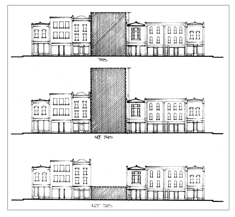
Nonresidential Development
1.
Street frontage. Along the core downtown streets, the nonresidential design theme is characterized by a variety of architectural styles popular at the time, including Italianate, Romanesque and Neoclassical, in a two-story format with office, storage or residential located over commercial. The facades of these buildings have a traditional main street storefront appearance, are relatively small in scale, have street-yard and side-yard setbacks of zero feet, have prominent horizontal and vertical patterns formed by regularly-spaced window and door openings, detailed cornice designs, rich detailing in masonry coursing, window detailing and ornamentation, and are predominantly of brick, stone or wood. Exterior building materials are of high-quality. Exterior appurtenances are minimal. Exterior colors are harmonious, simple and muted. Exterior signage blends, rather than contrasts with buildings in terms of coloring (complementary to building), location (on-building), size (small) and number (few).
2.
Remainder of downtown design overlay zoning district. In this area, the nonresidential design theme is characterized by a variety of architectural styles popular throughout the entire 20th century. Building styles, heights, setbacks and details vary significantly. In the desired theme, exterior building materials are of high-quality. Exterior appurtenances are minimal. Exterior colors are harmonious, simple and muted. Exterior signage blends, rather than contrasts with buildings in terms of coloring (complementary to building), location (on-building), size (small) and number (few).
3.
Residential development. This theme is characterized by a variety of architectural styles popular at the time, including Queen Anne, Gothic, High Victorian, Georgian, and Prairie. These homes have generous street-yard, side-yard and rear-yard setbacks, and are well-landscaped with a mixture of canopy and understory yard trees, and foundation shrubs and/or flower beds. For illustrative purposes, examples of architectural styles which tend to have elements incompatible with downtown historic styles include (with no attempt to be inclusive) Spanish Mission, Scandinavian Modern, Bavarian, and California Contemporary.
B.
Nonresidential construction.
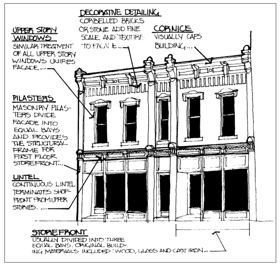
Nonresidential Construction
1.
General. Nonresidential construction, including new structures, building additions, building alterations, and restoration or rehabilitation shall correspond to the urban design guideline requirements for building setback; height; building mass; horizontal rhythms (created by the placement and design of facade openings and related elements such as piers, columns); vertical rhythms (created by the placement and design of facade details such as sills, transoms, cornices and sign bands); roof forms; exterior materials; exterior surface features and appurtenances; exterior colors; exterior signage; on-site landscaping; exterior lighting; parking and loading area design; and the use of screening.
2.
Determination. Design guideline requirements shall be determined by either the zoning administrator or the planning and zoning commission, as specified in §§ 150.908(D).
3.
Building setback. Throughout the district, the setback of buildings from street-yard and side-yard property lines shall be compatible with existing buildings in the immediate area which conform to the general design theme noted above.
4.
Building height. Throughout the district, the height of buildings shall be compatible with existing buildings in the immediate area which conform to the general design theme noted in §§ 150.106(D)(2)A., above. In no instance shall buildings be more than one story taller or shorter than the height of a building of similar use on one of the immediately adjoining properties, which conform to the general design theme above.
5.
Building mass. Throughout the district, the mass of buildings shall be compatible with existing buildings in the immediate area which conform to the general design theme noted above. The characteristic proportion (relationship between facade height and width) of the general design theme shall be maintained. Building mass for large structures (with a facade area exceeding 5,000 square feet) shall be disguised through the use of facade articulations, or through the use of exterior treatments which give the impression of directly adjoining individual buildings.
6.
Horizontal rhythms. Along the core downtown streets, the horizontal pattern of exterior building elements formed by patterns of building openings for windows and doors, and related elements such as piers and columns shall be spaced at regular intervals across all visible facades of the building, and shall be compatible with those of existing buildings in the immediate area which conform to the general design theme noted above.
7.
Vertical rhythms. Along the core downtown streets, the floor heights on main facades shall appear visually in proportion to those of adjoining buildings. The rhythm of the ground floor shall harmonize with the rhythm of upper floors. The vertical pattern of exterior building elements formed by patterns of building openings for windows and doors, and related elements such as sills, headers, transoms, cornices and sign bands shall be compatible in design and elevation with those of existing buildings in the immediate area which conform to the general design theme noted above.
8.
Roof forms. Along the core downtown streets, flat or gently sloping roofs which are not visible from the street shall be used. Mansards or other exotic roof shapes not characteristic of the general design theme noted above, shall not be used. Throughout the district, roof shapes not characteristic of the general design theme noted above, shall not be used.
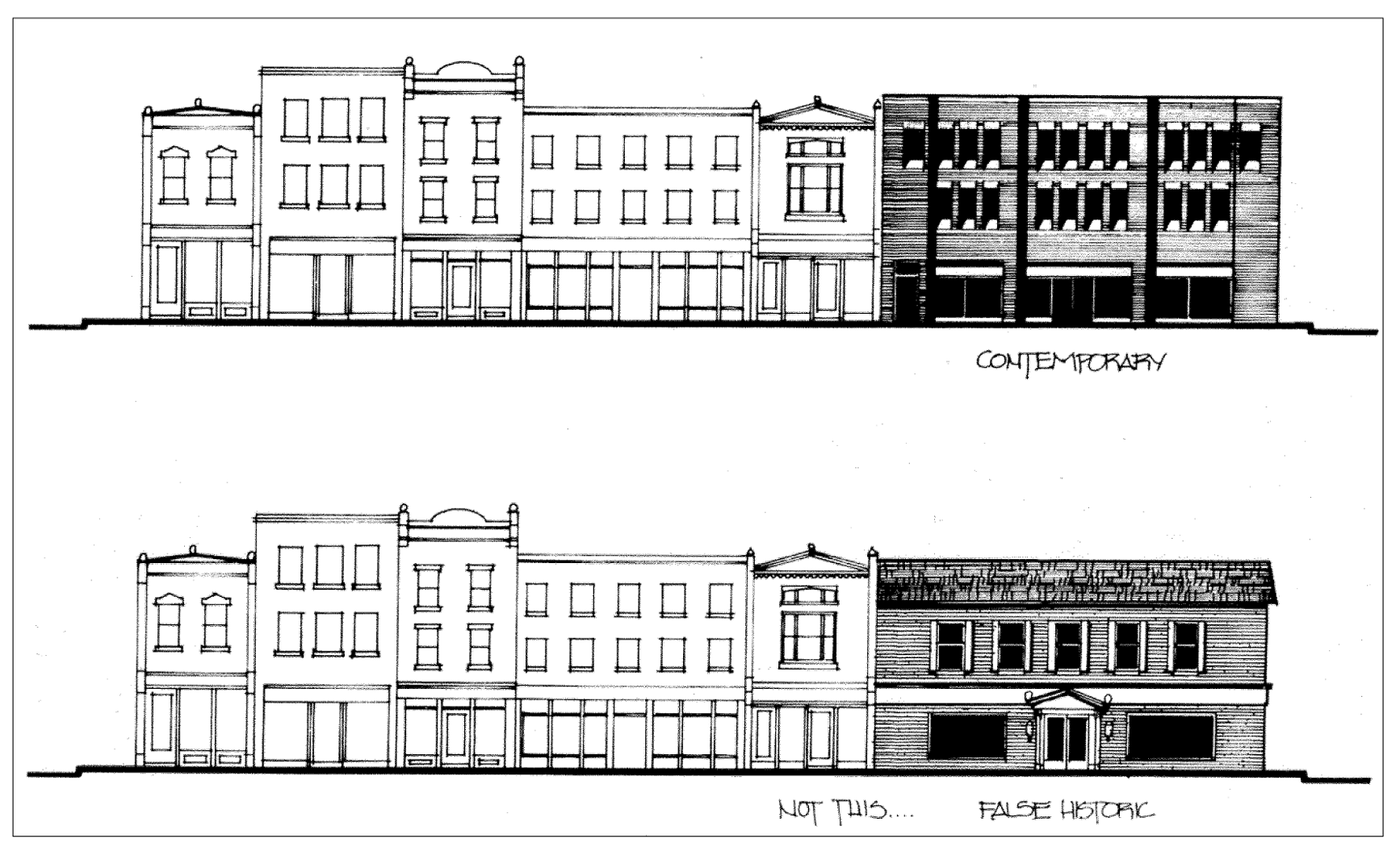
Roof Forms
9.
Exterior building materials. Selected building materials shall be compatible with those of existing buildings in the immediate area which conform to the general design theme noted above. In addition:
A.
Masonry. Along the core downtown streets, stone or brick facing should be of even coloration and consistent size. Cinder block, concrete block, concrete slab, or concrete panel shall not be permitted.
B.
Siding. Along the core downtown streets, wood or thin board textured vinyl or textured metal clapboard siding may be appropriate — particularly if the proposed non-masonry exterior was used on a building which conforms to the general design theme noted above. In certain instances clapboard, board and batten may be in keeping with the general design theme. Asphalt shingles shall not be permitted.
C.
Glazing. Along the core downtown streets, clear, or slightly tinted glass or related glazing material shall be used. Mirrored glass, smoked glass, or heavily tinted glass shall not be permitted.
10.
Exterior building colors. Selected exterior colors for structures and appurtenances including fixtures shall be compatible and harmonious with those of existing buildings in the immediate area which conform to the general design theme noted above. Specifically, throughout the district:
A.
Fluorescent, "day glow", and/or "neon" colors shall not be permitted. Earth tone colors are encouraged.
B.
High gloss paints, lacquers, varnishes or other "shiny" non-glazing surfaces shall not be used on the exterior of buildings.
C.
Color combination schemes shall not detract from the architectural features of a building and shall complement the existing natural materials on the building.
D.
Color schemes shall be used consistently throughout the property, including on both the upper and lower portions of buildings, and on all facades of a building or structure.
11.
Exterior surface appurtenances. Exterior surface appurtenances shall be compatible with those of existing buildings in the immediate area which conform to the general design theme noted above. In addition:
A.
Along the core downtown streets, the traditional storefront design theme (characterized by strong horizontal and vertical rhythms formed by building openings, storefront columns, storefront cornices, upper cornices, kickplates, signbands, large display windows, and transom windows) shall be employed for all new nonresidential buildings — including retail, office, professional service, personal service, maintenance, lodging, entertainment, and storage uses.
B.
Throughout the district, avoid cluttering building facades with brackets, wiring, meter boxes, antennae, gutters, downspouts and other appurtenances Where necessary, such features shall be colored so as to blend in, rather than contrast, with the immediately adjacent building exterior. Extraneous ornamentation which is inconsistent with the general design theme noted above, is also prohibited.
C.
Throughout the district, awning size, color and placement should complement the architectural character of the building. Soft, weather-treated canvas or vinyl materials, which allow for flexible or fixed installation, shall be used. Aluminum or suspended metal canopies shall be prohibited. Signage applied to awnings shall be simple and durable. Backlit awnings are prohibited.
12.
Exterior signage. The city council finds that having a cohesive sign ordinance is beneficial in advancing the revitalization of the city's downtown district. In order to better guide the redevelopment of the downtown overlay district so as not to lose the architectural uniqueness of the area, all signage which is located on the exterior of buildings or structures shall be compatible and harmonious with the general design theme noted throughout the downtown overlay district regulations. Signage located within this district shall be geared towards the pedestrian and less towards vehicle traffic. When wall mounted signage is used in combination with window signage, the reiteration of colors and design shall be used. In addition to signage that is compatible to each other, wall signs shall be harmonious in scale and proportion with the building they are mounted to and with the architectural elements of the building as outlined in the regulations. Signage shall not visually overpower architectural elements nor detract from the composition of the building.
In order to further the goals of the downtown overlay district, signage located in the district shall: be compatible with their surroundings and the zoning district; be appropriate to the type of activity they advertise; and be expressive of the identity of the individual proprietors. Signage shall foster high quality development and enhance the economic vitality of existing businesses by promoting the reasonable, orderly and effective display of street graphics; and encouraging better communication between an activity and the public it seeks with its message. The downtown overlay district signage shall protect the public investment in streets and highways by reducing the obstructions and distractions that could cause traffic accidents and promote the convenience, enjoyment and free flow of traffic within the city. Signage shall assist in preserving the value of private property by assuring the compatibility of signs with nearby land uses and protect the physical and mental well-being of the general public by recognizing and encouraging a sense of aesthetic appreciation for the visual environment.
Regulations found within article ten: Signs apply within the downtown overlay district. However, in the event of any inconsistencies, regulations found within this § [150.106] supercede those found within article ten: Signs. A signage photo book is available at the planning department to help illustrate the intent of the downtown overlay district regulations.
A.
Downtown overlay district permitted sign types-freestanding monument style, banner, canopy, projecting, suspended and wall signs are permitted.
B.
Bulk regulations.
1.
Freestanding monument style signs.
a.
Height—Shall not exceed ten feet.
b.
Size—One-half square foot per linear foot of frontage. Signage shall not exceed a maximum area of 100 square feet.
c.
Setback—Ten feet from property line
d.
Number—One freestanding sign shall be allowed per building street frontage, not to exceed maximum square footage allowed
e.
Base design—The base of a freestanding sign shall be monument style, equal in width to the sign and constructed of materials matching the building located on site.
2.
Building signs.
a.
Size—Two square feet per linear foot of wall area. Signage shall not exceed a maximum area of 100 square feet.
b.
No more than 25 percent of a canopy (excluding side panels) shall be covered with signage.
c.
Number—One sign per building establishment with separate exterior entrance, not to exceed maximum square footage allowed.
C.
Sign location. For wall signs, the architectural design of the building suggests the appropriate placement as described in the following guidelines. Signs shall be positioned to respect and to complement the design of the building, including the arrangement of bays, openings, and horizontal rhythms.
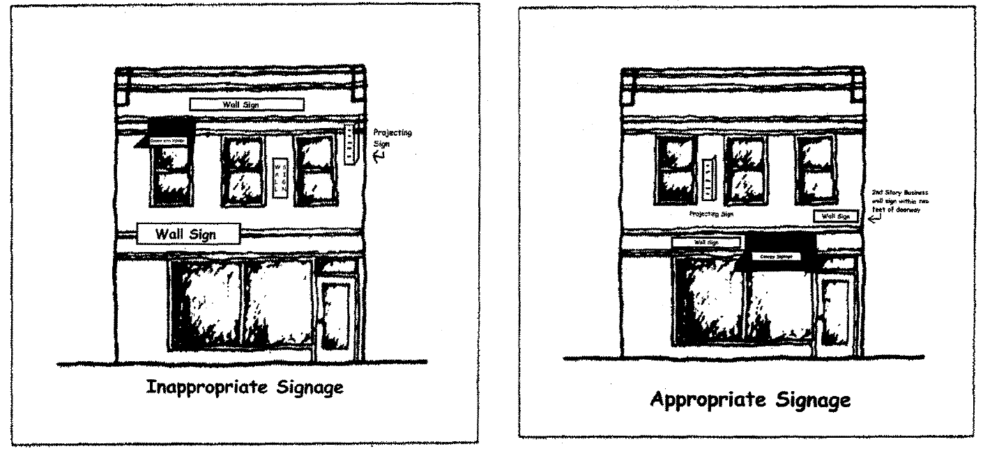
1.
Wall mounted signs on fascias above storefront windows shall be sized to fit within existing friezes, lintels, transoms, sign bands and other such features and not extend above, below or beyond them. No wall sign shall cover wholly or partially any wall opening or architectural feature, nor shall any wall sign project beyond the ends of the wall or beyond the top of the building to which it is affixed.
2.
Canopy signs may be located between the first and second floor windows, but shall not be located on any other portion of the upper stories.
3.
Wall signs shall be located below the bottom of the second floor window and shall not be located on any other portion of the upper stories unless they are in regards to a business occupying the second story
a.
If an upper story business establishment wishes to display a sign, the wall mounted signs shall be located over or within two feet of the first floor door access to the business.
4.
Projecting signs may be located on the second story of a building but in no instance shall they be installed above the top of the second story windows.
D.
Sign colors. fluorescent, "day glow", and "neon" are prohibited. Color schemes and lettering styles shall be used consistently on all signage for the same entity or business.
E.
Sign materials. Signs shall be constructed using high-quality and durable materials. All materials shall be properly sealed and treated in order to prevent deterioration.
1.
Natural materials historically used such as wood, metal, canvas, stone or glass are permitted.
2.
Plastic is not generally an acceptable material in the downtown overlay district. In order to further the goals of the overlay district and accommodate new technology, plastic is a permitted sign material only when being used for individual plastic lettering or graphics. In no instance shall plastic cabinet signs be allowed due to their incompatibility with the intent of the downtown overlay district and lack of durability.
F.
Sign illumination. Conduits and other electrical components shall be integrated into the design of the structure to the extent possible. The lighting element of such signs shall not be visible from public rights-of-way or adjoining properties.
1.
Illumination of exterior signage shall be limited to a shielded spotlight, individually backlit letters, graphics or punch-out signs utilizing halo lighting effect.
2.
Internally illuminated and/or flashing signs (including illuminated awnings, and neon signs) are not permitted.
G.
Removal of signs. Illegal signs, nonconforming signs, poorly maintained signs, and signs pertaining to a closed business, shall be removed (including all supports and hardware). The property owner shall be responsible for the immediate removal of such signs. Historical signs may be maintained but may not be modified, changed or expanded. A change in ownership will not require removal or destruction of a sign in the downtown overlay district. See also § 150.805, Nonconforming structures and building regulations.
H.
Maintenance of signs. All signs and canopies shall be maintained in good repair and be properly anchored so as to be kept in a sound condition. All exposed surfaces shall be protected from the elements and against decay. In the event any sign should suffer structural deterioration or damage, it shall be repaired or removed by the owner.
I.
Temporary signs. Temporary signs such as banners, cardboard window signs, etc (but excluding sidewalk A-frame signs which are regulated by Ordinance No. 664G) typically used to advertise grand openings, promoting specials or other events shall not exceed 32 square feet. Only one temporary sign shall be utilized at a time, with a combined total of no more than 60 days per calendar year and requires a permit by the appropriate department.
J.
Window signs. Temporary or permanently installed signage located within a building's display window shall not cover more than a combined total of 30 percent of the window area.
K.
Appeal process. Decisions on the enforcement of this section may be appealed as set forth in § 150.912 of the Belvidere Zoning Ordinance.
13.
On-site landscaping and screening. On-site landscaping is not required within portions of the downtown design overlay zoning district located along the core downtown streets, except to provide vegetated ground cover for pervious (non-paved/roofed) surfaces, and to provide screening and shading of on-site paved areas.
A.
Groundcover. All areas which are not covered by impervious paving or structures shall be covered with vegetative groundcover. Appropriate groundcover includes grasses, forbs, and shrubs.
B.
On-site paved areas. On-site landscaping shall also be provided for on-site paved areas used for outdoor seating, vehicular parking, or loading, except for pedestrian and vehicle walks and drives which connect such areas to public rights-of-way (such as driveways and walks to building entrances).
Required screening. On-site paved areas, including parking lots, loading areas, circulation drives, and patios shall be partially screened from the view of public rights-of-way and adjoining properties by, at minimum, a continuous vegetated hedge with a minimum width of five feet, and a height of between 40 and 60 inches. This hedge may be supplemented by trees and/or compatible iron, masonry, and/or wood fencing.
Required shading. In addition, one canopy tree (with a minimum installed breast height caliper of 2 ½ inches) shall be provided within, or within five feet of the edge of, on-site paved areas for every 2,000 square feet (or fraction thereof) of paved area.
C.
Exterior storage and utility areas. Trash storage areas, air conditioning units, and related storage and utility areas and components shall be fully screened from the view of adjoining properties, public rights-of-way, and customer areas.
D.
Additional landscaping standards are found in article 6.
14.
Exterior lighting. Throughout the district, on-site exterior lighting shall be compatible and harmonious with the general design theme noted above and city street lighting in the area. Specifically:
A.
Pedestrian lighting. The design, color, height, location and light quality of on-site pedestrian lighting shall be consistent with the pedestrian lighting fixtures.
B.
Vehicular circulation lighting. The design, color, height, location and light quality of on-site vehicular circulation lighting shall be consistent with the lighting fixtures recommended by the planning and zoning commission.
C.
Additional lighting standards are found in § 150.707.
15.
Rehabilitation and restoration. New projects, building additions, and new appurtenances and features shall comply with the provisions of §§ 150.106(C)(2)B.1-14, above. The following standards shall apply where existing construction is proposed for rehabilitation and/or restoration:
A.
Buildings shall be restored relying on physical evidence (such as photographs, original drawings, and existing architectural details) as much as possible, in keeping with the general design theme noted above.
B.
Exterior materials and surface features. Materials and features identical to the original shall be used. Where such knowledge is lacking, materials and features in common use at the time of building erection, shall be used. Significant architectural features, including cornices, moldings and coursings shall be preserved or replaced with identical features and materials where possible.
C.
Windows and doors. The size, proportion and rhythm of original windows and doors shall not be altered. Original window and door openings shall not be blocked, except with a dark opaque panel placed behind the window or door to preserve the appearance of the opening. Where now blocked in another manner, blocked window and doors shall be restored using said method. Window and door features, including lintels, sills, architraves, shutters, pediments, hoods and hardware, shall be preserved where possible, or replaced with identical features and materials. Dark frames (i.e. anodized bronze) shall be used to replace storefront and upper story windows. Clear aluminum finishes and mill finish aluminum storm windows are prohibited. Wood shutters and awnings shall be used if there is evidence that they were a component of the original building design. Vinyl and plastic shutters and awnings shall be prohibited.
D.
Shop fronts. Shop fronts should fit inside the original shop front in terms of all three dimensions (vertical, horizontal and front to back articulation);
E.
Display windows. Display windows should be restored to their original appearance.
F.
Entrances and porches. Original porches and steps shall be retained, except as required to meet accessibility standards. Porches, steps and related enclosures that do not comply with the architectural design theme, shall be removed.
G.
Roofs. The original roof shape and character of visible materials shall be retained. Original architectural features which give the roof its essential character, including dormer windows, cupolas, cornices, brackets, chimneys and weathervanes, shall be preserved if in keeping with the architectural design theme.
H.
Painting and color. See §§ 150.106(C)(2)B.11., above.
I.
Signage. All signage, existing upon the adoption date of this ordinance [Ord. No. 975G], which does not comply with the standards of §§ 150.106(C)(2)B.12., above, may be continued so long as well maintained. However, the maintenance of such legal nonconforming signs shall be limited to repair of the sign structural or lighting elements, and to the repainting or replacement of the sign face with identical new material, message, and original appearance. Should a change in material, message, or original appearance be desired, the legal nonconforming sign shall be removed.
J.
Cleaning. Structural components and exterior materials shall be cleaned when necessary, and with only the gentlest possible methods. Low pressure water and soft natural bristle brushes are acceptable. Sandblasting is never acceptable. Other methods shall be pre-approved by the planning and zoning commission.
C.
Residential construction. Proposed residential construction, located on properties having frontage on the core downtown streets, including new structures, building additions, building alterations, and restoration or rehabilitation shall be reviewed per § 150.908(D) by the planning and zoning commission. The building setback, height, mass, roof form, exterior materials, exterior surface appurtenances, exterior colors, landscaping and lighting shall be compatible and harmonious with the general design theme noted above.
D.
Designated historic structures. (Reserved.)
(Ord. No. 801G, § 3, 3-6-06; Ord. No. 957G, § 1, 4-7-08; Ord. No. 975G, § 1, 8-18-08; Ord. No. 278H, § 1, 1-4-16)