
Berkeley County Unincorporated
City Zoning Code
City Zoning Code
ARTICLE 2
- DEFINITIONS
2.1.- Intent.
For the purpose of interpreting this ordinance, certain words, concepts, and ideas are defined. Unless the context clearly indicates a different meaning, for the purposes of this ordinance, the following words and terms shall be defined as follows. All other words used in this ordinance shall have their everyday dictionary definition.
2.2. - Interpretation.
A.
Words used in the present tense include the future tense.
B.
Words used in the singular number include the plural, and words used in the plural number include the singular.
C.
The word "person" includes a firm, association, organization, partnership, corporation, trust, and company as well as an individual.
D.
The word "lot" includes the word "plot" or "parcel" or "tract."
E.
The word "may" is permissive.
F.
The word "shall" is always mandatory.
G.
The word "structure" shall include the word "building."
H.
The word "used" or "occupied" as applied to any land or building shall include the words "intended, arranged, or designed to be used or occupied."
I.
Any word denoting gender includes the female and the male.
(Ord. No. 02-12-58, 12-16-2002)
2.3. - Definitions.
2.3.1. Access. A way or means of approach to provide vehicular or pedestrian physical entrance to a property.
2.3.2. Access point. The location of the intersection of a highway or street or driveway with the highway.
2.3.3. Accessory apartment. See Guesthouse.
2.3.4. Accessory dwelling unit. An accessory dwelling unit with separate kitchen, bathing, and sleeping areas that is separate from and incidental and subordinate to the principal dwelling. Accessory dwelling units include garage apartment and guesthouse.
2.3.5. Accessory structure. An incidental and subordinate structure that is customarily associated with the principal structure of a lot. Unless otherwise stated within the district, the size of an accessory structure shall not exceed 65 percent of the principal use. Freight/cargo containers as defined by this article may be used as accessory structures when removed from any trailer or chassis on which the container was transported to the site with restrictions as specified within the allowable districts. At no time will freight/cargo containers be permitted to be used as legal signage.
2.3.6. Accessory use. An incidental and subordinate use that is customarily associated with the principal use of a lot or building located upon the same lot as the principal use.
2.3.7. Acre. A measure of land area containing 43,560 square feet.
2.3.8. Adult establishment. See Sexually oriented business.
2.3.9. Agricultural area. Future land use designation identified in the Berkeley County comprehensive plan and on the Berkeley County future land use map. These areas, used for agricultural, forestry, and agricultural/residential purposes, represent the Berkeley County's rural landscape and historic character.
2.3.10. Antenna. A device, dish, or array used to transmit or receive telecommunications signals.
2.3.11. Aquaculture. The business of cultivating marine or freshwater food fish or shellfish, such as oysters, clams, bass, and catfish, under controlled conditions.
2.3.12. Bar. Premises used primarily for the sale or dispensing of liquor by the drink for on-site consumption and where food may be available for consumption on the premises as accessory to the principal use.
2.3.13. Board of zoning appeals. A quasijudicial board appointed by the Berkeley County Council which hears and decides on variances to the zoning ordinance and land development ordinance of Berkeley County.
2.3.14. Boarding facility. (Agricultural) A structure or use designed for the feeding, housing, and exercising of animals, excluding domestic pets, not owned by the owner of the premises and for which the owner of the premises receives compensation. (Domestic) A structure or use designed for the feeding, housing, and exercising of dogs, cats and other common domesticated pets (excluding swine, bovine, equine and other typical agricultural animals) not owned by the owner of the premises and for which the owner of the premises receives compensation. For purposes of this zoning ordinance, where a zoning classification allows a "boarding facility" it is for "agricultural" purposes only. "Domestic boarding facilities" are specified as "domestic".
2.3.15. Bodies of water. (See also Watercourse.) Rivers, streams, creeks and other areas of flowing water, lakes, ponds and other areas of open water.
2.3.16. Bona fide residence. Any residence either owner or renter occupied.
2.3.17. Bonus density. The granting by the Berkeley County government of additional development capacity in exchange for the developer's provision of a public benefit or amenity.
2.3.18. Buffer. (See also Yard, buffer.) Open spaces, landscaped areas, fences, walls, berms, or any combination thereof used to physically separate or screen one use or property from another so as to visually shield or block noise, lights, or other nuisances.
2.3.19. Buildable area. The area of a lot remaining after the minimum yard, lot coverage, and buffer requirements of the zoning ordinance have been met.
2.3.20. Building. A structure which is completely enclosed by a roof and by solid exterior walls along whose outside faces can be traced an unbroken line for the complete circumference of the structure, which is permanently affixed to a lot or lots, and used or intended for the shelter, support or enclosure of persons, animals or property of any kind.
The connection of two buildings by means of an open porch, breezeway, passageway, carport or other such open structure, with or without a roof, shall not be deemed to make them one building.
2.3.21. Building height. Building height shall be the vertical distance between the average mean elevation of the finished grade at the front of the building and the highest part of the structure. Antennas, chimneys, flues, vents, church spires, bell towers, flagpoles, or other architectural features with nonhabitable spaces above the maximum height limit are exempt from the height regulations.
2.3.22. Building inspector. The individual designated by the appointing authority to enforce the provisions of the building code.
2.3.23. Building permit. A permit obtained from the county which sets the inspection schedule and construction techniques for a project.
2.3.24. Building, principal. A building in which is conducted the principal use of the lot on which said building is located.
2.3.25. Buildout. The stage of development where no additional structures are constructed or erected on a parcel; or past which additional structures are prohibited under this ordinance.
2.3.26. Cattery. (See also Kennel.) Any lot or premises, or portion thereof, which is used or designed for the commercial boarding, grooming, breeding, training, or sale of dogs, cats and/or other household domestic animals, but does not include pet shops.
2.3.27. Certificate of occupancy. A certificate allowing the occupancy of [or] use of a building and certifying that the structure or use has been constructed or will be used in compliance with this ordinance and all other applicable regulations.
2.3.28. Change in use. Substitution of one use for another, specially regarding use of land or use of a building.
2.3.29. Cluster subdivision. A form of residential subdivision that permits housing units to be grouped on sites or lots with dimensions, frontages, and setbacks reduced from conventional sizes, provided the density of the tract as a whole shall not be greater than the density allowed by the zoning district under existing regulations and the remaining land area is devoted to common open space.
2.3.30. Common open space. Land within or related to a cluster residential development, not individually owned, which is designed and intended for the common use or enjoyment of the residents of the development, or the public, which may contain such accessory structures and improvements as are necessary and appropriate for recreational purposes. A condition of the cluster residential development approval shall be that common open space may not be further subdivided.
2.3.31. Communication tower. A tower, pole, or similar structure that supports communication equipment, either broadcasting or receiving. This definition does not include television reception antennas and satellite dishes, amateur radio operators as licensed by the Federal Communications Commission, or towers under 150 feet in height used solely for educational communications purposes and located on property owned by a public or private school facility.
2.3.32. Comprehensive plan. A comprehensive, long range plan intended to guide the growth and development of a community or region that includes inventory and analytic sections leading to recommendations for the county's future economic development, population, housing, cultural resources, community facilities, natural resources, and land use.
2.3.33. Conditional use. A use permitted in a particular zoning district upon showing that such use in a specified location will comply with all the conditions and standards for the location or operation of the use as specified in the zoning ordinance and authorized by the Berkeley County government.
2.3.34. County. The areas under the legal authority of Berkeley County.
2.3.35. Day care center. A facility or dwelling unit that regularly (more than twice a week, for more than four hours, but less than 24 hours) provides child day care for seven or more children. This definition includes "child care centers" and "group day care homes," which are licensed by the South Carolina Department of Social Services (DSS).
2.3.36 Day care, family home. An occupied residence in which child day care is provided on more than two days a week for periods of less than 24 hours, but more than four hours, for no more than six children, including those children living in the home and children received for day care who are related to the resident caregiver. Family day care homes are licensed by the South Carolina Department of Social Services (DSS).
2.3.37. Reserved.
2.3.38. Density. Density is a measure of the number of dwelling units as expressed in dwelling units per net acre.
2.3.39. Depth of lot. The dimension measured from the front boundary of the lot to the extreme rear boundary of the lot. In case of irregularly shaped lots, the mean depth shall be taken.
2.3.40 Development/land development. The changing of land characteristics through redevelopment, construction, subdivision into parcels, condominium complexes, apartment complexes, commercial or industrial parks, shopping centers, mobile home parks, parking facilities, open storage, and other similar developments for sale, lease, or transfer to any combination of owner or renter including family/heirs property.
2.3.41. Developable land. The developable land area is that portion of the tract remaining after deducting the undevelopable land area (such as wetlands) from the total tract area.
2.3.42. District. A section, zone, or geographic area within the municipality [county] within which certain zoning or development regulations apply.
2.3.43. Dwelling unit. One or more rooms, designed, occupied, or intended for occupancy as a separate living quarter, with cooking, sleeping, and sanitary facilities provided within the dwelling unit for the exclusive use of a single family maintaining a household.
2.3.44. Easement. A grant of one or more of the property rights by the property owner to and/or for use by the public, a corporation, or another person or entity.
2.3.45. Existing use. The use of a lot or structure at the time of the enactment of a zoning ordinance or amendment thereof.
2.3.46. Facade. The exterior walls of a building exposed to public view or that wall viewed by persons not within the building.
2.3.47. Family homestead. An option for providing affordable housing for family members within the rural areas of the county. This option allows property owners a density bonus for "family dwelling units" that can be built either on the applicant's property or on property subdivided and conveyed by the applicant.
2.3.48. Fence. An artificially constructed barrier of any material or combination of materials erected to enclose, screen, or separate areas.
2.3.49. Flood hazard area. An area so designated by the Federal Emergency Management Agency, or any frequently flooded or floodprone area designated under section 14.6.
2.3.49(i). Freight/cargo container. A container that is a fully enclosed and securable unit with the primary use being a transportation-shipping container for air freight, seaward, and landward freight forwarding. (May also be referred to as shipping container, transport container or other similar term.)
2.3.50. Garage. A structure, either attached or detached, that is accessory to a residential building and that is used for the parking and storage of vehicles owned and operated by the residents thereof.
2.3.51. Garage apartment. An accessory dwelling unit with separate kitchen, bathing, and sleeping areas located above or within the garage of the principal dwelling unit that is no larger than 25 percent of the primary structure's heated square footage, up to a maximum of 850 square feet. Such dwelling unit shall be located on the same lot as the primary structure. In residential districts, a garage apartment shall be used only for the housing of individuals who do not pay any form of consideration in exchange for residing therein.
2.3.52. Grand tree. Any healthy non-pine species tree which has a DBH of 30 inches or greater, or a Live Oak species of DBH 18 inches or greater, or a tree which has status as a landmark within Berkeley County.
2.3.53. Grandfather clause. Land, buildings, and structures, and the uses of them that are lawful prior to enactment or amendment of zoning regulations may be continued although not in conformity with the current regulations or amendments. The land, building, structure, or use is considered a nonconformity. (See also Nonconforming lot, Nonconforming structure or building, and Nonconforming use.)
2.3.54. Gross acreage. The total area contained within the perimeter of a site. Gross acreage is used in determining the maximum area that can be covered by impervious surfaces.
2.3.55. Guesthouse. An accessory dwelling unit which is no larger than 25 percent of the primary structure's heated square footage, up to a maximum of 850 square feet. Such dwelling unit shall be located on the same lot as the primary dwelling. A guesthouse shall be used only for the housing of individuals who do not pay any form of consideration in exchange for residing therein. This definition specifically excludes dwelling units included within or attached to a detached garage or any other such structure.
2.3.56. Home occupation. Any activity carried out for gain by a resident and conducted as a customary, incidental, and accessory use in the resident's dwelling unit. See article 11, Conditional Uses for the regulations pertaining to home occupations where it states that uses must be carried out in the principal use, and that no person, not a resident on the premises, is employed specifically in connection with the activity, except that not more than one assistant may be employed by the following home occupations: lawyer, realtor, salesman, and other similar professional occupations. Provided further that no major mechanical equipment is installed or used for domestic or professional purpose, and that not over 25 percent of the total floorspace of any structure is used for home occupations.
2.3.57. Homeowners' association. A private nonprofit association that is organized by the developer in which individual owners share common interests in open space and/or facilities and are in charge of preserving, managing, and maintaining the common property, and enforces certain covenants and restrictions. The county does not have the authority to enforce covenants and restrictions provided in the homeowners' association agreement.
2.3.58. Impervious surface. Any material that prevents absorption of stormwater into the ground. All buildings, roofs, paved surfaces that do not use porous pavement, sidewalks, and surfaces covered by concrete or asphalt shall be considered impervious surfaces. In addition, other areas that meet the meaning of this definition will be categorized as impervious surfaces.
2.3.59. Industrial park. A tract of land that is planned, developed, and operated as an integrated facility for a number of individual industrial uses, with consideration to transportation facilities (rail and highway), circulation, parking, utility needs, aesthetics, and compatibility.
2.3.60. Kennel. (See also Cattery.) Any lot or premises, or portion thereof, which is used or designed for the commercial boarding, grooming, breeding, training, or sale of dogs, cats and/or other household domestic animals, but does not include pet shops.
2.3.61. Lakes and ponds. Natural or artificial bodies of water that retain water yearround. Artificial ponds may be created by dams, or may result from excavation. The shoreline of such bodies of water shall be measured from the maximum condition rather than permanent pool if there is any difference. Lakes are bodies of water two or more acres in extent. Ponds are any water body less than two acres in extent.
2.3.62. Land altering activity. Any change to land surfaces or vegetation that is intended to prepare for the construction, erection or alteration of any structure or use, including grading, filling, excavating, the cutting of trees and the removal of vegetation.
2.3.63. Lot. A lot is a parcel of land used, or set aside and available for use, as the site of one or more buildings and any buildings accessory thereto or for any other purpose, in one ownership and not divided by a street, nor including any land within the right-of-way of a public or private street upon which said lot abuts, even if the ownership to such right-of-way is in the owner of the lot.
2.3.64. Lot area. The area contained within the property lines of the individual parcels of land shown on a subdivision plan or required by this ordinance, excluding any area within an existing street right-of-way, or any area required as open space under this ordinance, and including the area of any easements.
2.3.65. Lot frontage. The length of the front lot line measured at the street right-of-way line.
2.3.66. Major roadway. As identified in the Berkeley County comprehensive plan, major road corridors are roads that provide important linkages for its citizens; between homes, jobs, and needed goods and services. Major roadways include but are not limited to I-26, I-526, US 52, US 17A, US 176, SC 33/41, and SC 98 from Road 33 to Hagan Ave. Major roadways do not include privately owned roadways, any unpaved roadways, interior residential/neighborhood roadways, interior commercial/industrial development roadways.
2.3.67. Manufactured housing (mobile home). A residential dwelling unit that is composed of one or more components, each of which was assembled in a manufacturing plant and designed to be transported to the home site on its own chassis and is constructed to standards and codes as promulgated by the United States Department of Housing and Urban Development.
2.3.68. Manufacturing. Establishments engaged in the mechanical or chemical transformation of materials or substances into new products, including the assembling of component parts, the creation of products, and the blending of materials, such as lubricating oils, plastics, resins, or liquors.
2.3.68.1. Mining. The breaking of the surface soil to facilitate or accomplish the extraction or removal of ores or mineral solids for sale or processing or consumption in the regular operation of a business; and/or the removal of overburden lying above natural deposits of ore or mineral solids and removal of the mineral deposits exposed, or by removal of ores or mineral solids from deposits lying exposed in their natural state.
Removal of overburden and the mining of limited amounts of ores or mineral solids are not considered mining when done only for the purpose of determining location, quantity, or quality of a natural deposit if no ores or mineral solids removed during exploratory excavation or mining are sold, processed for sale, or consumed in the regular operation of a business and if the affected land does not exceed two acres in area. Mining does not include plants engaged in processing minerals except as the plants are an integral on-site part of the removal of ores or mineral solids from natural deposits. Mining does not include excavation or grading when conducted solely in aid of on-site farming or of on-site construction. Mining does not include dredging operations where the operations are engaged in the harvesting of oysters, clams, or the removal of shells from coastal bottoms.
2.3.69. Mobile home park. A parcel of land that has been planned and improved for the placement of mobile homes for nontransient use and consisting of five or more mobile home sites intended for lease, or unit ownership (condominium).
2.3.70. Modular home. Any building of closed construction, regardless of type of construction or occupancy classification, other than a mobile or manufactured home, constructed off-site in accordance with the applicable state building codes, and transported to the point of use for installation or erection.
2.3.71. Modular building. Any structure composed on [of] components substantially assembled in a manufacturing plant in accordance with the applicable state building codes, and transported to the building site for final assembly on a permanent foundation.
2.3.72. Net acreage. The area of a parcel or site derived by subtracting the land devoted to streets, road and utility rights-of-way, existing streams and bodies of water, wetlands, and required parking areas (including driveways) from the total area of the parcel or site. Net acreage is used in determining the allowable density on a parcel or site.
2.3.73. Nonconforming lot. A lot, the area, dimensions, or location of which were lawful prior to the adoption, revision, or amendment of the zoning ordinance, but that fails by reason of such adoption, revision, or amendment to conform to the present requirements of the zoning district. (Described in S.C. Code 1976, § 6-29-730, Nonconformities.)
2.3.74. Nonconforming structure or building. A structure or building, the size, dimensions, or location of which lawfully existed prior to the adoption, revision, or amendment to the zoning ordinance, but that fails by reason of such adoption, revision, or amendment to conform to the present requirements of the zoning district. (Described in S.C. Code 1976, § 6-29-730, Nonconformities.)
2.3.75. Nonconforming use. A use or activity that was lawful prior to the adoption, revision or amendment of the zoning ordinance but that fails by reason of such adoption, revision, or amendment to conform to the present requirements of the zoning district. (Described in S.C. Code 1976, § 6-29-730, Nonconformities.)
2.3.76. Office. A use or location primarily used for conducting the affairs of a business, profession, service, industry, or government or like activity.
2.3.77. Open space. Open space is land left in a natural state or used for recreation, agriculture resource protection, amenity, or buffers. Open space does not include land occupied by nonrecreational buildings, roads, or road rights-of-way; nor does it include the yards or lots of structures or parking areas as required by the provisions of this ordinance.
2.3.78. Outdoor shooting range. See Shooting range, outdoor.
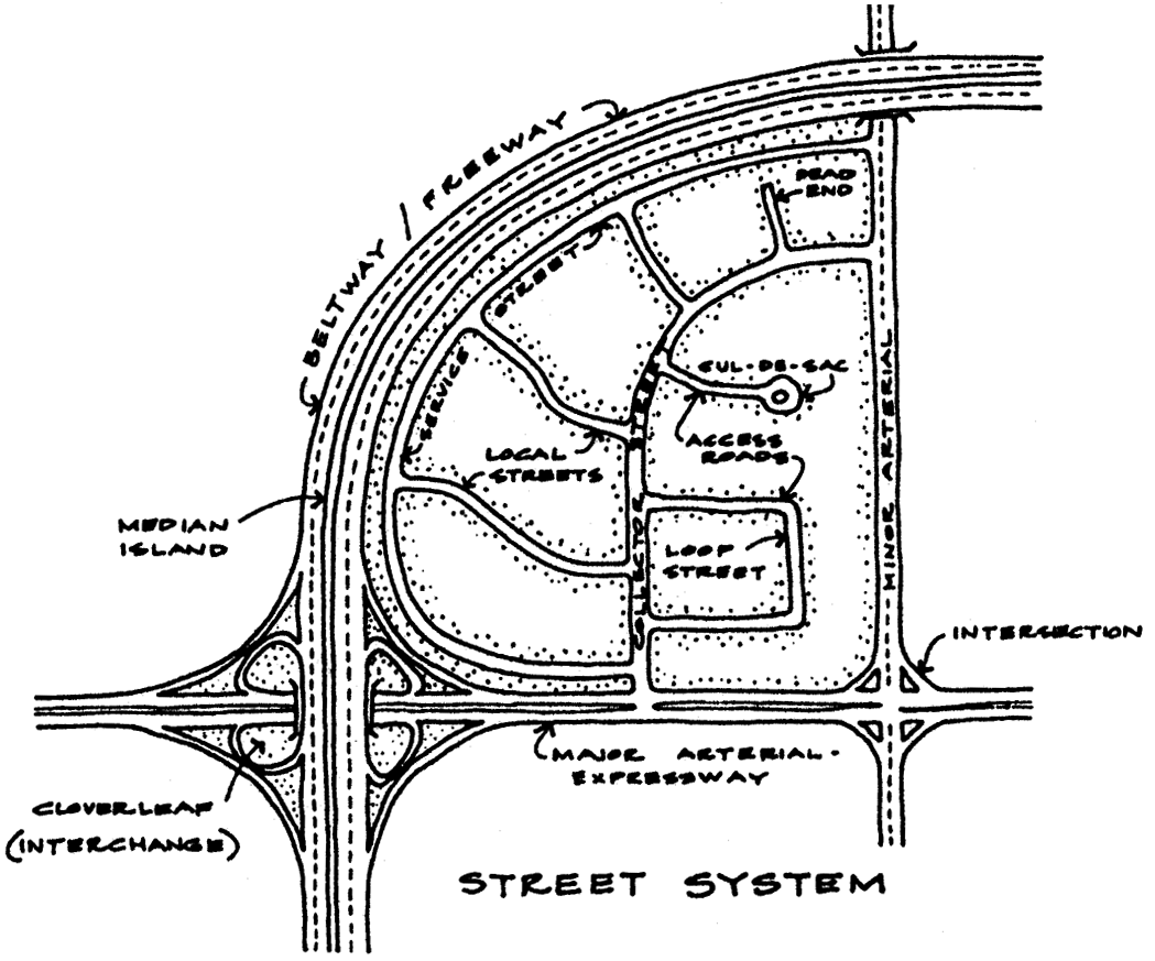
2.3.79. Outdoor storage. The keeping in an unenclosed area, of any goods, junk, material, merchandise, or vehicles in the same place for more than 24 hours.
2.3.80. Parcel. A contiguous lot or tract of land owned and recorded as the property of the same persons or controlled by a single entity.
2.3.81. Pedestrian-oriented development. Development that accommodates the needs of the pedestrian. Such development will have parking to the side or rear of a building, will mix uses and provide them in proximity to one another, will allow the pedestrian the option or choice of not having to use a car to travel between uses, and will provide a variety of interesting and detailed streetscapes which balance the needs of pedestrian and vehicular traffic equally.
2.3.82. Pedestrian scale. The proportional relationship between an individual and his or her environment. The relationship between the person and his or her environment, whether natural or created, is comfortable, intimate, and contributes to the individual's sense of accessibility.
2.3.83. Permitted use. Any use allowed in a zoning district and subject to the restrictions applicable to that zoning district.
2.3.84. Planned development. An area of a minimum contiguous size, as specified by ordinance, to be planned, developed, operated, and maintained according to a master plan as a single entity and containing one or more structures with appurtenant common areas.
2.3.85. Ponds. See Lakes and ponds.
2.3.86. Portable residential dwelling. A structure without permanent foundation that can be towed, hauled, or driven, and primarily designed as a temporary living accommodation for recreational, camping, and travel use and including, but not limited to, travel trailers, truck campers, camping trailers, and self-propelled motor homes.
2.3.87. Principal use/classification. The main building for the particular parcel. At such time as an accessory use exceeds the maximum size allowed for the zoning classification or more of the principal use, then it shall be considered the principal use and shall conform to the classification, as approved or such use must immediately cease.
2.3.88. Prohibited use. A use that is not permitted in a zoning district.
2.3.89. Public hearing. A meeting announced and advertised in advance and open to the public, with the public given an opportunity to talk and participate.
2.3.90. Public right-of-way. See Right-of-way.
2.3.91. Racetrack. A course where animals or machines are entered in competition against one another or against time, including but not limited to motorcar racetracks, dirt-bike tracks, and mud bogs.
2.3.92. Recreational vehicle. A vehicular-type portable structure without permanent foundation that can be towed, hauled, or driven, and is designed as a temporary living accommodation for recreational, camping, and travel use, and including, but not limited to, travel trailers, truck campers, camping trailers, and self-propelled motor homes. Recreational vehicles may be permitted to be set up as permanent dwellings units in any zoning classification that allows a manufactured home as a permitted use with the exception of the R1-MM zoning classification. A recreational vehicle shall not be occupied for commercial purposes. For a recreational vehicle to be allowed to be set up as a permanent dwelling unit, the owner of the vehicle and/or the owner of the land must obtain all required county, state and/or federal permits and/or documentation for a permanent dwelling (i.e., county moving permit, county setup permit, SCDHEC septic tank permit, county water/sewer availability letter, etc.). The recreational vehicle will also be taxed by the county as a dwelling unit. Recreational vehicles may be used as a temporary dwelling unit on properties other than campgrounds only upon the issuance of a temporary use permit as outlined in article 12 of this ordinance and shall be served with state approved sanitary facilities. A temporary electrical pole may be issued per the applicable building code in effect at the time of application, providing the planning and zoning department has issued a temporary use permit for the recreational vehicle (this excludes conforming and legal nonconforming campgrounds). With a temporary use permit, no more than one unit shall be allowed per parcel.
2.3.93. Residential growth area. Future land use designation identified in the Berkeley County comprehensive plan and on the Berkeley County future land use map. This area has been identified [as an] area for future urban and suburban growth patterns, which is characterized by higher development densities and mixtures of single-family, multifamily, commercial, and industrial developments.
2.3.94. Resource conservation area. Future land use designation identified in the Berkeley County comprehensive plan and on the Berkeley County future land use map. These areas contain important natural, scenic, and cultural resources within the county.
2.3.95. Right-of-way. A strip of land acquired by reservation, dedication, prescription, or condemnation, and intended to be occupied by a road, crosswalk, railroad, electric transmission lines, oil or gas pipeline, water line, sanitary storm sewer, and other similar uses. In no case shall a right-of-way be construed to mean an easement.
2.3.96. Rural settlement area. Future land use designation identified in the Berkeley County comprehensive plan and on the Berkeley County future land use map. Rural settlement areas have evolved as the county's agricultural area becomes more developed. These areas are often identifiable as a community, but residents obtain goods and services from incorporated towns or rural villages near them. Rural settlements provide opportunities for residents to live in single-family residences on smaller rural lots, within a non-walkable, but close proximity, to neighbors. They are transition areas between residential growth and agricultural areas of the county.
2.3.97. Rural village area. Future land use designation identified in the Berkeley County comprehensive plan and on the Berkeley County future land use map. Rural village areas represent the heritage of development in Berkeley County's rural landscape. These areas have not become incorporated towns, yet have sustained their identity due to a lack of growth pressures.
2.3.98. Scale. The relationship of a particular building, in terms of building mass, to other nearby and adjacent buildings.
2.3.99. Setback. The minimum distance by which any portion of any building or structure must be separated from the property line or easement line as specified within each zoning classification. No portion of any permanent structure may encroach into the setback area. Minimum setbacks for permitted structure for each zoning classification are found within the zoning classification articles of this ordinance.
2.3.100. Sexually oriented business. Sexually oriented businesses are defined in article 11 and include adult arcades, adult bookstores, adult retail stores, adult video stores, adult cabarets, adult health clubs, adult motion picture theaters, adult theaters, and other similar activities.
2.3.101. Shooting range, outdoor. The use of land for archery and/or the discharging of firearms for the purposes of target practice, skeet and trap shooting, mock war games. Excluded from this use type shall be general hunting and unstructured and nonrecurring discharging of firearms on private property with the property owner's permission.
2.3.102. Sign. See article 18: Sign Control, 18.2, Definitions.
2.3.102(i). Single-family detached. Only one dwelling unit, other than a manufactured housing unit as defined by this article, which is not attached to any other dwelling units.
2.3.103. Site. The site shall be defined as a parcel of land intended to have one or more buildings or intended to be subdivided into one or more lots.
2.3.104. Site area. All land within the site as defined in the deed. Area shall be from an actual site survey rather than from a deed description.
2.3.105. Special exception. An exception issued by the board of zoning appeals authorizing a particular use in a specified location within a zoning district, upon demonstrating that such use complied with all the conditions and standards specified by this ordinance.
2.3.106. Street. A vehicular way that: (1) is an existing federal or state designated roadway; or, (2) has been formally dedicated to the county and the county has formally accepted maintenance thereof.
2.3.107. Street, arterial. A major street for carrying a large volume of through traffic in the area; normally controlled by traffic signs and signals.
2.3.108. Street, collector. A street carrying traffic from local streets to the major system of arterial streets and highways.
2.3.109. Street, highway. A multilane street that serves as a major artery of the county circulation network and serves a high volume of traffic for both long and short trips.
2.3.110. Street, local. A street designed to provide vehicular access to abutting property and to discourage through traffic.
2.3.111. Structure. Anything constructed or erected, the use of which requires more or less permanent location on the ground or which is attached to something having more or less permanent location on the ground.
2.3.112. Subdivision. A grouping of residential structures, parcels or lots subject to the requirements of the county subdivision regulations.
2.3.113. Telecommunications. As defined in the Federal Telecommunications Act of 1996, the transmission, between or among points specified by the user, of information of the user's choosing, without change in the form or content of the information as sent and received.
2.3.114. Temporary use. A use established for a limited duration with the intent to discontinue such use upon the expiration of the time period.
2.3.115. Tract. An area, parcel, site, piece of land, or property that is the subject of a development proposal and applications.
2.3.116. Transportation. Ground establishments providing for the interchange of passenger and freight including but not limited to bus passenger and parking terminals, truck terminals, railroad passenger and freight terminals, railway express freight terminals, and taxicab stands and yards.
2.3.117. Variance. A modification of the strict terms of this ordinance granted pursuant to section 21.3, where such modification will not be contrary to the public interest and where, owing to conditions peculiar to the property and not as the result of action on the part of the property owner or developer, a literal enforcement of the ordinance would result in unnecessary and undue hardship.
2.3.118. Vector. A carrier that is capable of transmitting a pathogen from one organism to another including, but not limited to, flies and other insects, rodents, birds, and vermin.
2.3.119. Watercourses. (See also Bodies of water.) Rivers, streams, creeks and other areas of flowing water, lakes, ponds and other areas of open water.
2.3.120. Wetlands. Those areas that are inundated or saturated by surface or ground water at a frequency and duration sufficient to support, and that under normal circumstances do support, a prevalence of vegetation typically adapted for life in saturated soil conditions. Wetlands generally include swamps, marshes, bogs, and similar areas.
2.3.121. Yard. A space on the same lot with a principal building, open, unoccupied, and unobstructed by buildings or structures from ground to sky except where encroachments and accessory buildings are expressly permitted.
2.3.122. Yard, buffer. (See article 17.) (See also Buffer.) A yard containing materials used to provide sight and sound screening from adjoining properties and rights-of-way. The required height and width of the bufferyard and materials used in its construction vary according to use.
2.3.123. Yard, front. An open, unoccupied space on the same lot with a principal building, extending the full width of the lot, and situated between the street and the front line of the building, projected to the side lines of the lot.
2.3.124. Yard, rear. An open, unoccupied space on the same lot with a principal building, extending the full width of the lot and situated between the rear line of the lot and the rear line of the building projected to the side lines of the lot.
2.3.125. Yard, side. An open, unoccupied space on the same lot with a principal building, situated between the building and the side lot line and extending along the entire length of the lot. In zoning districts where development is allowed up to the lot line, the side yard requirement may be replaced by requirements for the acquisition of maintenance easements.
2.3.126. Zoning. The delineation of districts and the establishment of regulations governing the use, placement, spacing, and size of land and buildings.
2.3.127. Zoning administrator. The person designated by the county to be responsible for the administration of this ordinance.
2.3.128. Zoning district. A specifically delineated area or district in a municipality [in the county] within which uniform regulations and requirements govern the use, placement, spacing, and size of land and buildings.
2.3.129. Zoning map. A map or maps that are a part of this zoning code and that delineate the boundaries of all mapped zoning districts within the physical boundary of the county.
2.3.130. Zoning permit. Written permission issued by the county for the construction, or enlargement of a structure, including signs, or the grading or excavation of a site in preparation of construction or for the installation of underground utilities.
(Ord. No. 02-08-33, 8-26-2002; Ord. No. 02-12-58, 12-16-2002; Ord. No. 04-11-68, 11-23-2004; Ord. No. 05-08-58, 8-29-2005; Ord. No. 06-09-63, 9-25-2006; Ord. No. 09-04-16, 4-13-2009; Ord. No. 11-04-02, 4-25-2011; Ord. No. 14-03-03, 3-24-2014; Ord. No. 14-11-38, 11-24-2014; Ord. No. 21-01-02, 1-25-2021)