
Berkeley County Unincorporated
City Zoning Code
City Zoning Code
ARTICLE 8
- PLANNED DEVELOPMENT DISTRICTS
8.1.- General provisions.
8.1.1. Description. The planned development districts of this section are intended to encourage innovative land planning and site design that ensures natural resource and environmental protection, high-quality appearance, open space preservation, the provision of amenities and other county goals by:
A.
Reducing or eliminating the inflexibility that sometimes results from strict application of zoning standards;
B.
Allowing greater freedom in selection of means to provide access, light, open space, and design amenities; and
C.
Promoting quality design and environmentally sensitive development by allowing developers to take advantage of special site characteristics, locations, and land use arrangements.
8.1.2. Intent. The intent of the planned development districts is to achieve:
A.
Greater choice in the type of environment and living units available to the public;
B.
Increased flexibility for proposed development within the ordinance;
C.
Creation and retention of open space;
D.
A creative approach to the use of land and related physical development;
E.
An efficient use of land resulting in smaller networks of utilities and streets and thereby lower housing costs; and
F.
Implementation of the goals and policies outlined in the comprehensive plan.
(Ord. No. 23-04-15, Att., 4-24-2023)
8.2. - Available districts.
8.2.1. Regional commercial (PD-RC). This district is established to permit the development of large-scale commercial centers that provide a wide range of retail, office, and service uses, with one or more anchor stores, to the regional market. Transportation facilities, public services, and site design should be carefully planned so as to ensure regional centers promote and reinforce the identity of the community and commercial facilities in the surrounding area. A developer must show how a mixture of uses will be compatibly blended into the overall development.
A.
Intent. The following guidelines are intended to accomplish the following:
1.
Provide for the proper sizing and location of new regional commercial centers.
2.
Improve on- and off-site vehicular, pedestrian, and nonvehicular circulation and safety.
3.
Improve the compatibility and coordination of regional commercial centers with existing and proposed land uses in the surrounding area.
B.
The following guidelines are further intended to supplement the planning commission and the county council review process. The applicant will be expected to address these issues by:
1.
Complying with the guidelines for each section; or
2.
Proposing alternative solutions that specifically address the identified issues.
The application of these guidelines is intended to be flexible. The applicant is encouraged to propose innovative alternatives that accomplish the stated intent of the guidelines.
These guidelines will be used by staff in its initial discussions with the applicant to assist in the preparation of a development plan.
C.
Building arrangement guidelines. Proper arrangement of buildings on a site provides for efficient and viable long-term use.
1.
Storefronts should be visible from main traffic circulation aisles unless a "mall" or courtyard approach is used.
2.
Pad sites/outparcels, generally defined as freestanding structures of less than 5,000 square feet of floor area, should be limited to one per five acres of land area.
3.
Pad sites should not limit site accessibility, visibility, or viability of future expansion of the main commercial center.
4.
Buildings should be arranged to reduce visibility of service areas from streets, customer parking, and adjacent properties.
5.
Buildings should be in a configuration that does not impede the development's traffic flow from major thoroughfares.
6.
Signage located on the buildings and on the site should be consistent in size, location, and material.
D.
Access guidelines. Safe and efficient access to regional commercial centers minimizes potential vehicular and pedestrian conflicts.
1.
Each commercial center should provide a vehicular circulation plan that eliminates direct vehicular access to parking stalls from major roadways, and provides other on-site and off-site improvements to enhance pedestrian and vehicular circulation.
2.
Access points entering and exiting the center should typically be spaced a minimum of 100 feet from the intersections of major roadways.
3.
Primary access and through vehicular traffic impacting residential neighborhoods should be avoided.
4.
The ingress side of the main entrance drive should be the largest radius allowed for better access to the site.
5.
Main entrance drives should be located at median breaks providing left turn access to and from the site.
6.
Main entrance drives should connect to a "straightaway" aisle that does not dead-end or require an immediate turn to approach the main building.
7.
Aisles intersecting with entrance drives should be spaced a minimum of 20 feet from the property line to provide for smooth turning movements.
E.
Circulation and parking guidelines. Proper circulation and parking systems minimize confusion and facilitate safe and easy pedestrian and vehicular movement within the regional commercial center.
1.
Main drive aisles should generally be free of parking when adjacent to large anchor tenants of 30,000 square feet of floor area or more.
2.
The direction of traffic flow should be identified.
3.
Parking aisles should run perpendicular to the anchor stores to minimize the number of parking lanes crossed by pedestrians.
4.
Internal intersections should be 90-degree intersections with no more than two traffic lane crossings.
5.
Service vehicle circulation should be separated from customer circulation routes.
6.
All tenants/shops should be accessible by vehicular and pedestrian traffic from within the development.
7.
Each commercial center should provide a pedestrian circulation plan identifying improvements that accomplish the following:
a.
Minimizes conflict between pedestrians and moving motor vehicles.
b.
Channelizes pedestrian flows to crossing areas and delineates paths across major roadways and traffic aisles, such as striping and signage.
c.
Connects internal pedestrian walkways to existing walkways and/or makes provision for connecting to future site walkways.
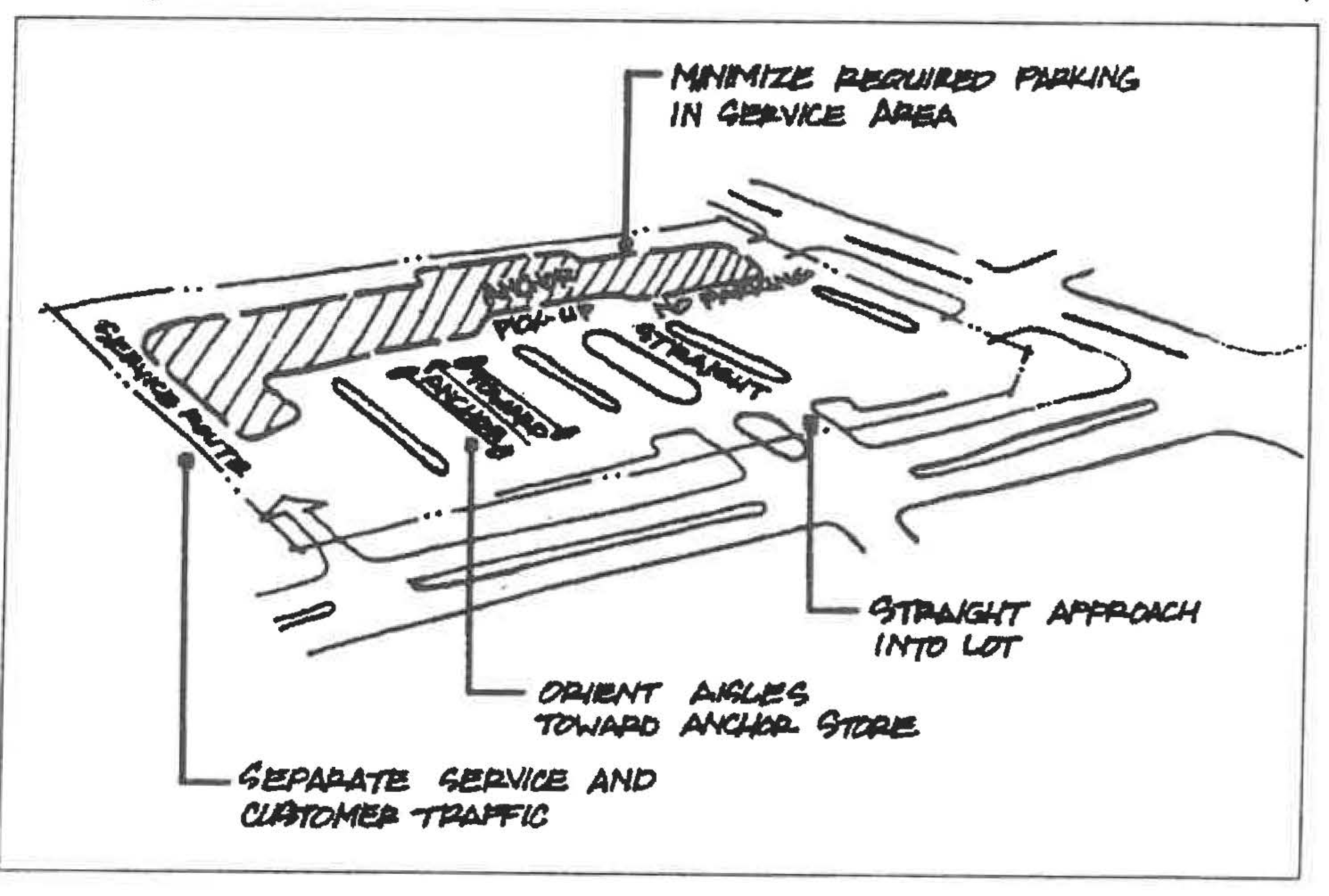
Circulation and Parking Guidelines
F.
Buffers guidelines. Proper use of buffers will mitigate potentially adverse differences between land uses and diminish the visual/sound impact of undesirable elements within the center and/or external to the center.
1.
Proposals for buffering between uses should follow the regulations found in article 17, Bufferyards.
8.2.2. Office or industrial park (PD-OP/IP). This district is established for office, light and heavy industrial uses, and necessary supporting accessory uses and facilities, designed with a park-like atmosphere to complement surrounding land uses by means of appropriate siting of buildings and service areas, attractive architecture, and effective landscape buffering. A mixture of residential and corporate uses may be permitted if the developer shows how the uses will be compatibly blended into the overall development.
A.
Intent. The following guidelines are intended to accomplish the following:
1.
Encourage the development of administrative, business, professional office complexes, and light and heavy industrial park facilities, along with necessary supporting accessory uses and facilities, in a campus-style or park-like environment.
2.
Foster the development of office and industrial parks of environmentally sensitive designs that accommodate and complement existing natural features, including extensive landscaping and buffering, low impervious surfaces, buildings of moderate height, and careful attention to such aesthetic considerations as location of buildings, lighting, parking, and service areas.
3.
Encourage the concentration of office and industrial uses where adequate community facilities and infrastructure exist or are planned.
B.
These guidelines are intended to supplement the county council review process. The applicant will be expected to address these issues by:
1.
Complying with the guidelines for each section; or
2.
Proposing alternative solutions that specifically address the identified issues.
The application of these guidelines is intended to be flexible. The applicant is encouraged to propose innovative alternatives that accomplish the stated intent of the guidelines.
These guidelines will be used by staff in its initial discussions with the applicant to assist in the preparation of a development plan.
C.
Building arrangement guidelines. Proper arrangement of buildings on a site provides for efficient and viable long-term use.
1.
Buildings should be in a configuration that does not impede the development's traffic flow, the accessibility or visibility from major thoroughfares.
2.
Buildings should be set back from major roadways to reduce the visual impact of the development.
3.
Warehousing, outdoor storage, areas for refuse or loading should not be closer than 100 feet to the right-of-way of any arterial road, 75 feet from any collector road, and 35 feet from any other roadway.
4.
All storage uses should meet the applicable regulations set forth in section 11.8: Use Conditions for Storage.
5.
Outdoor storage, loading areas, parking, areas for refuse should not be placed between the roadway and the main structures.
6.
Buildings should be arranged to reduce visibility of service areas from streets, parking, and adjacent properties.
7.
Building heights should not exceed the height that adequate fire protection can be provided either from the local fire department or through use of incorporated fire protection systems.
D.
Access guidelines. Safe and efficient access to office and industrial uses minimizes potential vehicular and pedestrian conflicts.
1.
Each office or industrial park should provide a vehicular circulation plan that minimizes direct vehicular access major roadways, and provides other on- and off-site improvements to enhance pedestrian and vehicular circulation.
2.
Principal vehicular access points should be designed to encourage smooth traffic flow with controlled turning movements and minimum hazards to vehicular or pedestrian traffic.
3.
Access points entering and exiting the development should typically be spaced a minimum of 100 feet from the intersections of major roadways.
4.
Primary access and through vehicular traffic impacting residential neighborhoods should be avoided.
5.
Main entrance drives should generally be located at median breaks providing left turn access to and from the site.
E.
Buffers guidelines. Proper use of buffers will mitigate potentially adverse differences between land uses and diminish the visual/sound impact of undesirable elements within the development and/or external to the development.
1.
Proposals for buffering between uses should follow the regulations found in article 17, Bufferyards.
F.
Outdoor storage guidelines.
1.
No storage of any kind should be permitted within any front yard without adequate screening and buffering, except for underground bulk storage of gasoline or petroleum products.
2.
Underground bulk storage of gasoline or petroleum products should not be permitted, except for automobile service stations or as incidental to manufacturing and research and development operations or the servicing of company owned or lease vehicles within enclosed areas defined in (3) below.
3.
Outdoor storage of new and reusable materials, equipment, and vehicles should be permitted only within enclosed areas which are composed of mixed wood, masonry walls, plantings, or other suitable barriers approved by the zoning administrator. Such areas must be buffered and screened on the periphery of the storage area.
4.
Waste materials must be stored in a closed container. The burning of waste materials is prohibited.
8.2.3. Mixed use development (PD-MU). This district is established to provide flexible development options for developers in a manner consistent with the Berkeley County Comprehensive Plan. Mixtures of uses may include a combination of commercial and residential uses, various types of residential uses, or mixtures of commercial and light industrial uses, as approved by Berkeley County Council. Proposals for this district should meet the following standards:
A.
Consistent with the locations identified in the comprehensive plan.
B.
In areas adequately served by roads, drainage, water, sewer, and other utilities, police, fire, emergency services, and schools.
C.
The area intended to be rezoned to PDMU for review and approval under this article shall be at least 15 acres in size.
D.
The minimum lot size that may be approved in a PDMU district shall be compatible in the existing land use and zoning context of the area concerned, aligned with the Berkeley County Comprehensive Plan, and integrated into the overall development plan.
E.
The maximum density allowed shall be determined by the Berkeley County Comprehensive Plan, the existing land use and zoning context of the area concerned, and the availability, adequacy, and capacity of roadways, drainage facilities, utilities, schools, fire, police, emergency services, and other public facilities and service providers to serve the intended development.
F.
Bonus density incentives may be written into the text of the PD-MU as necessary to facilitate the development of attainable or workforce housing, conservation or cluster development patterns, and/or as allowed in Article 13.
G.
PDMU developments should include a mix of residential and commercial (multifamily not included as commercial uses for purposes of this article) or light industrial uses whereby the commercial and/or light industrial uses should be of a type and size that can be supported by the development and/or the surrounding community.
(Ord. No. 04-11-68, 11-23-2004; Ord. No. 23-04-15, Att., 4-24-2023)
8.3. - Approval process.
8.3.1. Approval.
A.
To adequately engage and solicit input from surrounding communities, the applicant shall conduct one or more community meetings in a townhall format, provided, however, that the planning and zoning director or designee may authorize alternative measures deemed adequate and effective to engage and solicit input from surrounding communities. Opportunities for community engagement as well as attendance logs and feedback shall be provided to the planning and zoning department for archival.
B.
The draft PD shall be shared with applicable county departments, the Berkeley County School District, Fire, Police, EMS and other public service providers for comment. Review timelines shall be based upon project acreage and complexity as detailed in the below table:
1.
Mega developments, which for the purpose of this ordinance are defined as those consisting of 500+ acres, shall be assessed by affected departments and agencies within 30 days, after which time the county will, with the approval and consent of both the council land use committee chairman and the county supervisor, establish a reasonable timeline for review specific to the project being considered. In the event the land use chairman and the county supervisor do not agree, the project timeline will be established via a majority vote of council. Affected agencies shall be given the number of days indicated from date of submittal to review, provide input, and discuss the proposed PD. If no comments or objections are raised by an affected department or agency within the established timeline for review, it shall be deemed as a "finding of no objection" for the purpose of the rezoning application. All required approvals and permits of affected developments or agencies shall still be applicable and required.
C.
Approval of a planned development district constitutes a rezoning of a property and shall follow the procedures for zoning amendment found in article 22 of this regulation.
D.
The county council may, after fulfilling all applicable requirements of this section and all applicable requirements of article 22, act to either approve, approve with modification, or disapprove the application for a planned development.
E.
Following approval of a PD district, the official zoning map shall be amended to reflect such approval. Approval of planned development district shall constitute authority for the applicant to submit preliminary subdivision and single-site development plan(s) and plats, as applicable, for review and, upon demonstrated conformance, receive approval in accordance with chapter 59, The Land Development and Subdivision Regulations of Berkeley County, and section 8.3.4 of this article.
8.3.2. Preapplication conference. Prior to submitting a PD application, the applicant is encouraged to meet with the planning and zoning staff for a preapplication conference to avoid undue delay in the review process after the application is submitted.
8.3.3. Application requirements.
A.
Proposed development plan. The applicant shall submit the proposal for the planned development district and include the following in graphic and/or text form:
1.
A boundary survey with vicinity map, title block, scale, and north arrow.
2.
Total number of acres of overall site.
3.
Location of existing structures and their current uses.
4.
Location of existing roads, utilities and other infrastructure.
5.
Land use plan including location and number of acres of various areas by type of use (e.g., single-family detached, multifamily, recreation, office, commercial, etc.)
6.
Proposed maximum heights of the structures.
7.
Description of proposed site setbacks and minimum distances between structures.
8.
Number of units and density of various residential types, such number to represent the maximum number of units allowed for each residential type.
9.
Approximate square footage of nonresidential uses.
10.
Transportation plan identifying primary traffic circulation patterns, traffic calming measures, interconnectivity to neighboring developments or properties, inclusion of non-motorist and transit supportive facilities, major points of ingress and egress, proposed thoroughfares and arterial roadways, and improvements to transportation systems.
11.
Approximate number of parking spaces per use.
12.
Master drainage plan identifying drainage basins, receiving waters, existing drainage features, proposed collection system features, and stormwater management best management practices (BMPs).
13.
Natural and proposed vegetation and landscaping, streets, walkways, and easements to be reserved for public use and/or open space preservation.
14.
Location and general dimension of all impervious paved areas such as streets, walks, parking lots, tennis courts, plazas, etc.
15.
A traffic impact analysis (TIA) shall be prepared in accordance with chapter 59, The Land Development and Subdivision Regulations of Berkeley County.
16.
Demonstration that impacts to roads, intersections, schools, utilities, as well as police, fire, emergency and other public service providers and facilities are sufficiently mitigated.
17.
Demonstration of adequate bufferyards and/or other performance measures to mitigate adverse impacts to surrounding communities and ecologically, historically, culturally, and/or hydrologically sensitive areas.
18.
Consideration of future easements, rights-of-way and/or land setasides for future roadway, utility, or public facility needs.
19.
Any such information or descriptions as may be deemed reasonably appropriate for review.
B.
Development plan report. The applicant shall submit an adequate number of copies as requested by the planning and zoning department needed to provide to staff, the planning commission, county council and any other applicable department or agency for review of the report setting forth the characteristics of the proposed planned development including the following:
1.
An explanation of the objectives to be achieved by the PD district.
2.
A listing of critical natural resources and cultural resources found on or adjacent to the site.
3.
A statement setting forth the proposed development schedule.
4.
A statement of the public improvements both on- and off-site that are proposed for dedication and/or construction and an estimate of the timing for providing such improvements.
5.
A statement of impact on public facilities including water, sewer collection and treatment, fire protection, etc., and letters from the appropriate agencies or districts verifying that such facilities or services are available and adequate to serve the proposed planned development.
6.
A statement concerning the appearance, landscaping, and screening of proposed improvements.
7.
A statement concerning the maintenance of any proposed pond, lake, retention pond, or any other privately maintained infrastructure or facilities contained in the development.
8.
Any such information or descriptions as may be deemed reasonably appropriate for review.
9.
Copies of any special agreements, conveyances, restrictions, or covenants, which will govern the use, maintenance, and continued protection of the PD and any of its common areas.
10.
A description of the procedures of any proposed homeowners' association or other group maintenance agreement proposed.
8.3.4. Subdivision and single-site development plans and plats. Approval, by county council, of a development plan and development plan report, including revisions and conditions, shall constitute authority for the applicant to prepare and submit for review subdivision and single site development plans and plats, if applicable, in accordance with procedures and requirements set forth in chapter 59, The Land Development and Subdivision Regulations of Berkeley County. All plans and plats shall comply with the approved PD development plan.
8.3.5. Approved development plan. The final development plan shall consist of the proposed development plan and development plan report, as amended by revisions and conditions, initially approved by county council, and as may be subsequently modified and permitted in accordance with section 8.3.6. Recorded plats subdividing the property according to the design standards as outlined in the approved development plan and within the parameters of chapter 59, The Land Development and Subdivision Regulations of Berkeley County, shall become a part of the approved development plan.
8.3.6. Changes to planned development districts. Minor modifications to an approved planned development district may be authorized by the planning and zoning director upon finding that the requested minor modification does not alter the original intent or increase the intensity of the approved PD. If a requested modification is not deemed "minor," it shall be processed as a "major modification" and subject to the same process applicable to the original PD as outlined in section 8.3.1.
8.3.7. The planning and zoning director shall have the right to request for its review an update to the land use plan, and other accompanying exhibits, approved as part of the PD development plan if no development authorizations have been issued within a five-year timeframe. In such an event, no permits or development authorizations will be issued until a revised land use plan, and other accompanying exhibits, has been approved by the planning and zoning department; provided, however, the review of a revised land use plan shall be limited to an analysis of then applicable standards and ordinances and shall be completed within 45 days of submission. If the planning and zoning department and the landowner cannot agree upon a revised land use plan within said period, the proposed solution of the landowner shall be submitted to the county council for approval or denial. If the proposed solutions are denied, the solutions proposed by the planning and zoning department shall be binding.
(Ord. No. 04-11-68, 11-23-2004; Ord. No. 05-08-58, 8-29-2005; Ord. No. 23-04-15, Att., 4-24-2023)