
Bessemer City City Zoning Code
CHAPTER 4
INFRASTRUCTURE AND SUBDIVISION STANDARDS
4.2. - REQUIRED IMPROVEMENTS
The developer or applicant shall be required to do the following unless specified otherwise in this chapter:
1.
Dedicate any additional right-of-way necessary to achieve the width required by the city's comprehensive transportation plan and public utility plans for all streets adjoining the property;
2.
Reserve, but not dedicate, right-of-way for controlled access highways;
3.
Install curbs and gutters along all streets adjoining the property and to pave all streets adjoining the property, in accordance with section 4.4.
4.
Install street signs in accordance with section 4.4 below;
5.
Install sidewalks and pedestrian pathways in accordance with section 4.5;
6.
Install street lighting in accordance with section 4.7;
7.
Install public utilities in accordance with section 4.7; and
8.
Provide open space and recreational facilities in accordance with section 4.8.
4.3 - LOT DIMENSION STANDARDS
The size, shape, and orientation of lots shall be appropriate for the location of the proposed subdivision and for the type of development contemplated and shall conform to the following:
4.5 - SIDEWALKS
Sidewalks shall be installed along in accordance with the following standards:
4.6 - STREET TREES
Street trees shall be required for subdivisions located within the city's jurisdiction. The subdivider shall install street trees along all streets within a subdivision and along the abutting side of streets forming the perimeter of the subdivision. Planting requirements for street trees are found in section 3.5.D.
4.1.A. - Design.
All proposed subdivisions, including mixed-use developments, shall comply with this section, and shall be designed to promote beneficial development in the community, and shall be consistent with the overall city vision and comprehensive plan.
4.1.B. - Reasonable relationship.
All required improvements, easements, and rights-of-way (other than required reservations) shall substantially benefit the development or bear a reasonable relationship to the need for public facilities attributable to the new development.
4.1.C. - Off-site connections.
Unless otherwise approved, it is necessary to connect streets and/or utilities off-site to adjoining streets and/or utilities, said improvements may be required in accordance with city policy.
4.1.D. - Land suitability.
Land which has been determined, on the basis of an engineering assessment or other expert survey, to pose an ascertainable danger to life or property by reason of its unsuitability for the use proposed shall not be platted for that purpose until the subdivider has taken the necessary measures to correct said conditions and to eliminate said dangers. Areas that have been used for disposal of solid waste shall not be subdivided unless tests by the Gaston County Health Department, a structural engineer and a soils expert determine that the land is suitable for the purpose proposed.
4.1.E. - Placement of monuments.
The Standards of Practice for Land Surveying in North Carolina, as adopted by the North Carolina State Board of Registration for Professional Engineers and Land Surveyors, shall apply when installing permanent monuments.
4.1.F. - Sites for public use.
In subdividing property, due consideration shall be given by the subdivider to the reservation of suitable sites for schools and other public uses in accordance with NCGS 160D-804.
4.1.G. - Property owners' associations.
1.
An owners' association shall be established to fulfill requirements of the NC Condominium Act, NC Planned Community Act, or to accept conveyance and maintenance of all common elements (common areas) within a development. The owners' association shall be in legal existence prior to the conveyance, lease-option, or other long-term transfer of control of any unit or lot in the development.
2.
Where developments have common elements serving more than one dwelling unit, these areas shall be conveyed to the owners' association, in which all owners of lots in the development shall be members. All areas other than public street rights-of-way, other areas dedicated to the city, and lots shall be designated as common elements. In a condominium development the common elements shall be platted in accordance with the NC Condominium Act. In other developments, the fee-simple title shall be conveyed by the subdivider or developer to the owners' association prior to the sale of the first lot.
3.
Common elements shall not subsequently be subdivided or conveyed by the owners' association unless a revised preliminary plat and a revised final plat showing such subdivision or conveyance have been submitted and approved.
4.
Developments, whether including different land uses, different types of housing, or simply different sections, shall hold the number of owners' associations to a minimum. An association may establish different categories of membership, different budgets for the categories, and different rates of assessment when different kinds of services are provided to different categories. Smaller associations under an umbrella (master) association are permitted.
5.
A development involving only two units attached by a party wall (or two separate walls back-to-back) shall not be required to have common elements or an owners' association. Such developments without an owners' association shall establish a binding agreement between owners to govern any party walls and to ensure reciprocal easement rights needed for maintenance.
4.3.A. - Conformance with other regulations.
Every lot shall have sufficient area, dimensions, and street access to permit a principal building to be erected thereon in compliance with all zoning and other requirements of this chapter.
4.3.B. - Minimum building area.
Every lot shall have at least 40 percent of its total area, or 2,400 square feet, whichever is less, of contiguous buildable area of a shape sufficient to hold a principal building. Said area shall lie at or be filled to an elevation at least two feet above the 100-year flood elevation.
4.3.C. - Lot depth to width ratio.
No lot shall have a depth greater than four times the width at the minimum front street setback.
4.3.D. - Side lot line configuration.
Side lines of lots should be at or near right angles or radial to street lines.
4.3.E. - Lot lines and drainage.
Lot boundaries shall coincide with natural and pre-existing manmade drainageways to the extent practicable to avoid lots that can be built upon only by altering such drainageways.
4.3.F. - Lots on thoroughfares.
Major subdivisions shall not be approved that permit individual residential lots to directly access major and minor thoroughfares.
4.4.A. - Dedication of right-of-way.
Right-of-way for public streets shall be dedicated to the city pursuant to NCGS 160D and other applicable state laws. When dedication cannot be required, any future street right-of-way indicated on adopted thoroughfare plans or collector street plans shall be shown on the plat.
4.4.B. - Conformance with thoroughfare plans and collector street plans.
The location and design of streets shall be in conformance with applicable thoroughfare plans and collector street plans. Where conditions warrant, right-of-way widths and pavement widths in excess of the minimum street standards may be required to ensure conformance with these plans.
4.4.C. - Conformance with adjoining street systems.
The planned street layout of a proposed subdivision shall be compatible with existing or proposed streets and their classifications on adjoining or nearby tracts.
4.4.D. - Internal street network connectivity.
1.
A minimum street connectivity index, as determined by the method outlined in 4.4.D shall be established for all new residential subdivisions. Within the R district, the minimum index score shall be 1.2 and all other residential districts shall have a minimum index score shall be 1.4. Planned unit developments shall have a minimum index score of 1.5 for the entire street network serving the development. See Figure 4-1.
2.
The street connectivity index shall be calculated by dividing the number of "links" contained in the network by the number of "nodes" contained in the network. For the purpose of this calculation, a "node" is the intersection of two streets or the head of a cul-de-sac within the development. "Links" are lengths of street that connect the nodes. Street stubs shall be considered to be links, but alleys and temporary dead-end streets within the development are not counted as links. One link beyond each node that connects the internal street network to the external street network shall be included in this calculation.
3.
The minimum connectivity index score may be reduced if the developer demonstrates that it is impossible or impractical to achieve the required score due to topography, environmental conditions, natural features, or adjacent existing development patterns.
Figure 4-1 Internal Street Network Connectivity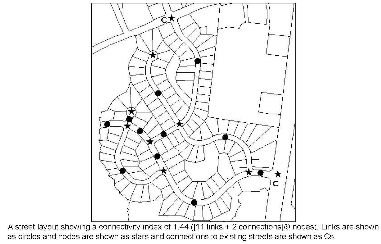
4.4.E. - Access to adjoining property.
Where, in the opinion of the approving body, it is necessary and in the public interest to provide for street access to adjoining property, proposed streets shall be extended to the boundary of such property.
4.4.F. - Minimum number of access points to external street network.
No fewer than two external street access points shall be provided for residential developments.
4.4.G. - Reserve strips.
Reserve strips adjoining street rights-of-way for the purpose of preventing access to adjacent property shall not be permitted under any condition.
4.4.H. - Street design criteria.
All streets shall be constructed in accordance with the standards contained in the most recent version of the NCDOT Roadway Design Manual or NCDOT Subdivision Roads Minimum Construction Standards as appropriate.
4.4.I. - Street intersections.
Streets shall be designed to intersect each other at angles as close to 90 degrees as possible. Property lines at street intersections shall be a tangent connecting points on each right-of-way line, which are located a minimum distance of 20 feet back from the intersection of the two right-of-way lines in residentially zoned areas and 50 feet in non-residentially zoned areas.
4.4.J. - Streets crossing natural areas.
All streets crossing natural areas, wetlands, or streams shall cross at or as near to 90 degrees as possible within topographic limits.
4.4.K. - Spacing between intersections.
A minimum spacing of 150 feet between intersections shall be maintained. In no case shall a pair of intersecting streets be approved with an offset that does not meet this minimum distance standard.
4.4.L. - Maximum length of culs-de-sac.
Culs-de-sac are permitted only where topographic conditions and/or exterior lot line configuration offer no practical alternatives for connection or through traffic. Culs-de-sac shall not exceed 250 feet in length from the nearest intersection with a street providing through access.
4.4.M. - Block length.
Streets shall have block lengths between 200 to 500 feet. Exceptions are permitted however, due to topography, environmental protection, preservation of existing buildings, and similar considerations.
4.4.N. - Curb and gutter.
Concrete curb and gutter shall be installed along all newly created streets within and adjoining subdivisions. Where improvements, such as widening or turn lanes are required on city maintained streets adjoining subdivisions, concrete curb and gutter shall be installed in conjunction with the related improvements.
4.4.O. - Temporary turnarounds.
Streets stubbed to adjoining property or to phase lines shall be required to have temporary turnarounds at the end of the street which are of a sufficient size to permit sanitation and emergency vehicles to turn around.
4.4.P. - Grades at intersections.
The grade on stop streets approaching an intersection shall not exceed five percent for a distance of 100 feet from the centerline of the intersection.
4.4.Q. - Street names.
Street names, prefixes, suffixes, and addresses shall conform to the guidelines and policies set forth by the Gaston County Street Naming and House Numbering Ordinance.
4.4.R. - Street and traffic controls signs.
1.
At each intersection, the developer shall be required to install street name signage in accordance with city standards for the design of such signage.
2.
The developer shall provide traffic control signs that meet the Manual on Uniform Traffic Control Devices (MUTCD) standards in locations designated by the city.
3.
Maintenance of signs on private streets or drives shall be the responsibility of the owner or owners' association, as appropriate.
4.4.S. - Sight triangles.
1.
On any corner lot, a sight triangle shall be established. The sight triangle shall be formed by extending lines from the intersections of two streets (measured from the edge of the right-of-way) to points 25 feet from the corner of the rights-of-way of the intersecting streets and then connecting the two points.
Figure 4-2 Corner Lot Clear Sight Triangle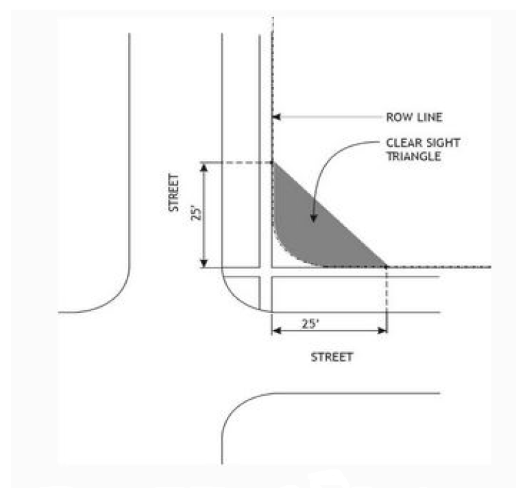
2.
For any driveway, a sight triangle measuring ten feet from the back of curb and extending 70 feet from the edge of each side of the driveway shall be required.
Figure 4-3 Driveway Clear Sight Triangle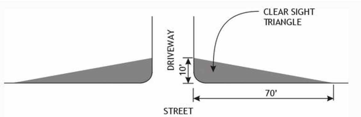
3.
Within the sight triangle, no materials which would impede traffic visibility shall be allowed. Structures, fences, and plant materials that extend into the sight triangle between two and one-half feet and eight feet in height, as measured from the grade of the street or drive, shall not be allowed.
4.5.A. - Required locations.
Sidewalks shall be installed along both sides of all streets located within the proposed subdivision and along all existing streets located within the proposed subdivision.
4.5.B. - Construction standards.
All sidewalks, whether required by this chapter or installed voluntarily, shall be constructed to the city's standard specification for sidewalks and have a minimum width of five feet and a minimum thickness of six inches of concrete.
4.7.A. - Public water and sewer construction requirements.
Water and sewer lines, connections, and equipment shall be constructed in accordance with the standard specifications for utility line construction as set forth by the utility provider for the proposed subdivision.
4.7.B. - Water and sewer connections.
1.
Subject to availability of public water and/or sanitary sewer service, if county or municipal water and/or sanitary sewer lines are located within ½ mile of a subdivision of 10—39 lots, or within one mile of a subdivision of 40 lots or more, where the distances are measured along the roadway to the nearest edge of the property, then the developer must connect to these lines to provide water service, fire protection, and sewer service for the subdivision.
2.
When water and sanitary sewer facilities are not available (as defined in the previous section), the subdivision shall comply with all rules and regulations prescribed for private and/or community water supply and waste disposal by the North Carolina State Board of Health and the Gaston County Health Department. This approval shall be obtained from the proper authorities prior to submission of the plat to the city for consideration.
4.7.C. - Utility easements.
1.
To provide for electric, telecommunication, cable television and gas service conduits, and water and sewer lines within a subdivision, adequately sized utility easements not to exceed 30 feet in width shall be provided. The location of such easements shall be reviewed and approved by the approving body, with advice from utility providers, before final plat approval.
2.
Utility easements shall be kept free and clear of any buildings or other improvements that would interfere with the proper maintenance or replacement of utilities. The city shall not be liable for damages to any improvement located within the utility easement area caused by maintenance or replacement of utilities located therein.
4.7.D. - Street lighting.
1.
Spacing of lighting should be approximately 200 feet (no less than 150 feet and no greater than 250 feet).
2.
Every intersection within the development shall be illuminated by street lighting.
3.
Uniformity in the type of lighting (if there is existing lighting in the area, any new lighting should match the existing lighting). If new lighting cannot match existing lighting, then new lighting should follow design standards according to section 3.7 Lighting of this Code.
4.
Avoidance of stormwater infrastructure conflicts.
5.
Light sources should be installed in the right-of-way on property lines.
6.
Minimum of 50W 3000K LED fixtures.
( Ord. of 5-8-2023 )
4.7.E. - Fire protection equipment.
Fire protection equipment shall be installed at locations determined by the City of Bessemer City Fire Department or other fire service agency which will have primary response responsibility within the proposed subdivision.
4.8.A. - General provisions.
1.
Every subdivider who proposes a subdivision of land for residential purposes shall dedicate a portion of land or pay a fee in lieu thereof, in accordance with this section, for public park, greenway, recreation, and open space sites to serve the recreational needs of the residents of the subdivision or development.
2.
The provisions of this section shall apply to all subdivisions of land. Notwithstanding, specific provisions pertaining to planned unit developments are found in section 4.8.F.
3.
Irrespective of the above, when a subdivision is located on a tract of land where a future greenway or greenway connection has been specifically identified on a locally adopted recreation plan, or greenway master plan, open space for such designated greenway shall be dedicated and the fee-in-lieu option shall not be used for such lands.
4.8.B. - Dedication of land.
1.
At least one thirty-fifth of an acre shall be dedicated for each dwelling unit planned or proposed in the subdivision plat or development. The minimum amount of land which shall be dedicated for a public park, recreation, or open space site shall be no less than two acres in size. When the area to be provided is less than two acres, the subdivider shall be required to make payment in lieu of the dedication to be used for the acquisition or development of recreation, park, or open space sites which would serve the needs of the residents of the subdivision.
2.
The proximity of existing publicly dedicated and publicly accessible open space (e.g., park, greenway) to the subdivision shall reduce the amount of open space required in the subdivision. If such open space is located no greater than one-quarter mile walking distance (such distance measured from the pedestrian access point of the existing open space to a perimeter public street or sidewalk within the development), the amount of required open space shall be reduced by up to 25 percent. If the existing public open space is located directly adjacent (either immediately abutting or directly across a public street) from the subdivision, the amount of required open space for the subdivision shall be reduced by up to 50 percent.
3.
The reduction in required open space for the subdivision shall be calculated based on the acreage contained in the existing public park. For instance, if a subdivision contained 200 lots, it would ordinarily be required to have 5.71 acres of open space. If a five acre public park were located one-tenth of a mile away from the subdivision, one-quarter of the acreage of the park, or 1.25 acres, could be used to offset the amount of open space required in the subdivision. The required amount of open space within the subdivision shall then be reduced to 4.56 acres.
4.8.C. - Nature of dedicated land.
Except as otherwise required by the planning board at the time of preliminary plat approval, all dedications of land shall meet the following criteria:
1.
The dedicated land shall form a single parcel of land, except where the planning board determines that two or more parcels would be in the best interest of the public, given the type and distribution of open spaces needed to adequately serve the proposed development. In such cases, the planning board, in approving the preliminary or final plat, may require that such parcels be connected by a dedicated strip of land at least 30 feet in width. Where practical, the strip shall be placed in the subdivision to enable persons to walk between the two open space areas.
2.
Two-thirds of the dedicated land shall be useable for active recreation. Furthermore, lakes and other bodies of water may not be included in computing any of the dedicated land area.
3.
The shape of the portion of dedicated land which is deemed suitable for active recreation shall be sufficiently square or round to be usable for any or all recreational facilities and activities, such as athletic fields and tennis courts, when a sufficient amount of land is dedicated to accommodating such facilities. Land dedicated only for greenways need not follow the requirements of this subsection.
4.
The dedicated land shall be located so as to reasonably serve the recreation and open space needs of residents of the subdivision.
5.
Access to the dedicated land shall be provided either by adjoining public street frontage or by a dedicated public easement, at least 30 feet wide, which connects the dedicated land to a public street or right-of-way. Gradients adjacent to existing and proposed streets shall allow for reasonable access to the dedicated land. Where the dedicated land is located adjacent to a street, the developer or subdivider shall remain responsible for the installation of utilities, sidewalks, and other improvements required along that street segment. Public access or dedicated walkways to greenway dedications only shall be at least 20 feet wide.
6.
The average slope of the portion of dedicated land deemed usable for active recreation shall not exceed the average slope of the entire subdivision to be developed. In no case shall a slope on the usable portion of dedicated land exceed 15 percent.
7.
Dedicated parks, recreation, and open space areas shall have a sufficient natural or manmade buffer or screen to minimize any negative impacts on adjacent residents.
4.8.D. - Fees in lieu.
1.
The payment of fees, in lieu of the dedication of land as required above, may occur at the request of the subdivider or developer. However, the decision to require the dedication of land for recreational purposes, or a payment of a fee in lieu, shall be made by the planning board after having received a recommendation from the TRC and having evaluated the proposed dedication and the relationship such dedication would have with the city's overall recreational needs. Payments of fees in lieu shall not be allowed for planned unit developments (PUDs).
2.
The fees in lieu of dedication shall be paid to the city by the subdivider prior to final plat approval.
3.
The administrator shall calculate the required payment amount using the following procedures:
a.
The administrator shall calculate the average per-acre value of land for the entire tract by dividing the assessed value of the entire unimproved tract of land by the total number of acres in the tract.
b.
The administrator shall then calculate the value of required open space at the date of most recent revaluation, which is the product of one thirty-fifth of the average per-acre value of land and the number of proposed residential lots in the subdivision.
4.8.E. - Greenways.
Greenways may be credited against the requirements of this section provided that such greenways are part of the city's greenway plan and dedicated to public use.
4.8.F. - Planned unit development open space.
1.
Planned unit developments shall provide ten percent of gross site acreage as open space.
2.
Open space shall be planned and improved so as to be accessible to resident and users of the development.
3.
Improved shall mean cleared of underbrush and debris and may contain one or more of the following improvements: walks and greenways, statues, utilities, irrigation fields, wet detention ponds, open fields, athletic fields, playground equipment, ponds, and lakes (that are located entirely within the development). Certain open space areas (e.g., plazas) may also be paved.
4.
Wet detention ponds may be counted towards meeting the open space requirement if (1) the facility is designed to hold water throughout the year, and (2) if the facility is surrounded by a path or walkway and contains benches or similar improvements for enjoyment by residents or users of the development.
5.
Required landscaped and screening areas (per chapter 3) shall not count towards this requirement.
6.
The shape of the portion of dedicated land which is deemed suitable for active recreation shall be sufficiently square or round to be usable for any or all recreational facilities and activities, such as athletic fields and tennis courts, when a sufficient amount of land is dedicated to accommodating such facilities.
7.
Two-thirds of the dedicated land shall be useable for active recreation. Furthermore, lakes and other bodies of water may not be included in computing any of the dedicated land area.
8.
For inclusion in the amount of dedicated open space, all common areas within 50 linear feet of the greenway (and not already computed in the open space requirements) shall be counted towards the minimum common open space requirement.
9.
If any of the types of open space areas listed below are counted towards the development's total open space requirement, then the following minimum lot size and improvement requirements shall be met:

