Bessemer City City Zoning Code
CHAPTER 7
DEVELOPMENT APPROVALS: PROCEDURES AND PLANS
7.1 - DEVELOPMENT APPROVAL PROCEDURES
In order to establish an orderly process to develop land within the jurisdiction of Bessemer City, consistent with standard development practices and terminology this section provides a clear and comprehensible development process that is fair and equitable to all interests including the applicants, affected neighbors, administrator, staff, and related agencies, and the city council.
7.2 - PLAN AND REPORT REQUIREMENTS
Required plan sheets submitted as a part of an application must have the necessary information for the administrator, boards, and council to make an adequate and informed decision on the proposed land development. However, the administrator, may waive or require additional information based on the type of application, site conditions, or the stage of development process in which the plan is being reviewed.
7.5 - PERFORMANCE GUARANTEES
To ensure compliance with the development regulation requirements of NCGS 160D and this Code, Bessemer City may require performance guarantees to assure successful completion of these required improvements.
7.6 - ADMINISTRATIVE MODIFICATIONS
Occasionally, unanticipated circumstances require changes to approved development plans and permits, including developer agreements and site-specific vesting plans. In accordance with NCGS 160D-403.(d), Bessemer City allows for minor modifications to be administratively approved, however, all major modifications require the same procedures to be followed as were completed for the original approval. This administrative flexibility reduces the need for a full approval process to accommodate a limited change to the plans for a project.
7.7 - VESTED RIGHTS AND PERMIT CHOICE
The zoning vested right is a right which is established pursuant to N.C.G.S.160D-108 to undertake and complete the development and use of property under the terms and conditions of an approved site-specific vesting plan. Obtaining development approval through the vested rights precludes any action by a local government that would change, alter, impair, prevent, diminish, or otherwise delay the development or use of the property allowed by the applicable land development regulation or regulations.
7.1.A. - General provisions.
1.
No construction to commence without permit. No land shall be used or occupied, and no structures shall be erected, moved, extended, or enlarged, nor shall any timbering, clearing and grubbing, or filling of any lot for the construction of any building be initiated until the administrator has issued an appropriate development approval which will certify that the proposed work is in conformity with the provisions of this Code.
2.
Development approvals run with the land. Unless provided otherwise by law, all rights, privileges, benefits, burdens, and obligations created by development approvals made pursuant to this chapter attach to and run with the land.
3.
Wireless telecommunications. Wireless telecommunications shall follow the development process outlined in Appendix D of this Code.
7.1.B. - Exempt subdivisions and expedited review.
The following divisions of land are either exempt or subject to different submittal and review processes. The final recorded plats shall meet the drafting requirements contained in chapter 7.2.B.6. and bear the appropriate certificates contained in Appendix B.
1.
The following shall be exempt and not subject to the subdivision or development regulations prescribed within this Code:
a.
The combination or recombination of portions of previously subdivided and recorded lots where the total number of lots is not increased and the resultant lots are equal to or exceed the standards of the city as shown in the LDC.
b.
The division of land into parcels greater than ten acres if no street right-of-way dedication is involved, and if the resultant lots are equal to or exceed the standards of the city as shown in its subdivision regulations and zoning codes.
c.
The public acquisition by purchase of strips of land for the widening or opening of streets.
d.
The division of a tract in single ownership whose entire area is no greater than two acres into not more than three lots, if no street right-of-way dedication is involved, and if the resultant lots are equal to or exceed the standards of the city as shown in its subdivision regulations and zoning code.
e.
Division of land ordered by a court of law, to include division of property in a divorce decree, in condemnation proceedings, or in the settlement of a decedent's estate.
2.
Expedited reviews. Only a plat for recordation (final plat) is required for the division of a tract or parcel of land in single ownership if all the following criteria are met:
a.
The tract or parcel to be divided is not exempted under section 7.1.B.1.
b.
No part of the tract or parcel to be divided has been divided under this subsection in the ten years prior to division.
c.
The entire area of the tract or parcel to be divided is greater than five acres.
d.
After division, no more than three lots result from the division.
e.
After division, all resultant lots comply with all of the following:
(1)
All lot dimension size requirements of the applicable land-use regulations, if any.
(2)
The use of the lots is in conformity with the applicable zoning requirements, if any.
(3)
A permanent means of ingress and egress is recorded for each lot.
3.
Administrative approval. The following plats shall be approved by the administrator without following the review procedures specified for major or minor subdivision plats:
a.
The division of an existing tract or parcel of land into not more than two lots within a two-year period, if said tract or parcel fronts on an existing municipal or state-maintained street and if no new right-of-way dedication is involved and the resultant lots are equal to or exceed the standards specified in this LDC.
b.
The division of a tract or parcel of land in a cemetery into grave sites.
4.
Fee in lieu. Fee in lieu of open space development, as required by chapter 4, shall be made prior to approval of any expedited subdivision review.
7.1.C. - Applications.
1.
Application required.
a.
Applications for development approvals may be made by the landowner, a lessee or person holding an option or contract to purchase or lease land, or an authorized agent of the landowner.
b.
All completed applications for development approval shall be submitted to the administrator, including their application fee, all appropriate documentation, and the plan sets in accordance with the requirements of this section and the fee schedule adopted by the city council.
2.
Completeness review.
a.
Completeness determination.
(1)
Applicants shall submit applications to the administrator in accordance with the applicable published schedule of submittal dates. Until an application is determined to be complete in accordance with the requirements of this Chapter, an application has not been submitted.
(2)
On receiving a development application, the administrator shall, within 15 business days, determine whether the application is complete or incomplete. A complete application is one that:
(a)
Contains all information and materials required by this land development code for submittal of the applicable type of application, and in sufficient detail, format, and readability for the City of Bessemer City Staff to evaluate the application for compliance with applicable review standards; and
(b)
Is accompanied by the fee established for the applicable type of application.
b.
Application incomplete.
(1)
On determining that the application is incomplete, the administrator shall, within 15 business days following submittal, provide the applicant written notice of the submittal deficiencies electronically. The applicant may correct the deficiencies and resubmit the application for a completeness review.
(2)
If the applicant fails to resubmit an application within 15 calendar days after being first notified of submittal deficiencies, the application submittal shall be considered abandoned. If an applicant submits a request in writing to the administrator within 15 calendar days of the application abandonment date, 50 percent of the application fee paid for the withdrawn application shall be refunded.
c.
Application complete. On determining that the application is complete, the administrator shall:
(1)
Accept the application as submitted in accordance with the procedures and standards of this Code in effect at the time of the submittal; and
(2)
Provide the applicant written notice of application submittal acceptance electronically.
7.1.D. - Development approval chart.
Admin = Administrator or Administrative
PB = Planning Board
TRC = Technical Review Committee
CC = City Council
BOA = Board of Adjustment
All Legislative and quasi-judicial processes require public hearings in accordance with the procedures contained within this chapter.
* In accordance with NCGS 160D-108(d), unless otherwise specified, development permits expire one year after issuance unless work authorized by the permit has substantially commenced.
( Ord. of 5-8-2023 )
7.1.E. - Review process.
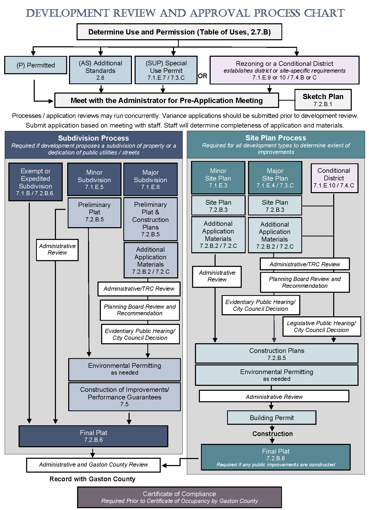
The following review process outline indicates the steps for submittals, reviews, and development approvals in accordance with the requirements of the Bessemer City Land Development Code. It should be noted that some applications may require additional information specific to the development approval being sought. Further, these processes may run concurrently, such as a special use permit and site plan approval or major subdivision and rezoning.
1.
Pre-Submittal/Sketch Plan
STEP 1: Application
Fees
Sketch plan
STEP 2: Administrative review
STEP 3: Applicant meeting. This meeting may be held in a virtual setting on a web-based platform, by phone, or other means acceptable to both the city and the applicant.
2.
Permitting process (Zoning, sign, temporary uses, home occupation, accessory use, building, fence, driveway).
STEP 1: Application
Fees
Sketch or site plan
Architectural drawings/sign details/building construction drawings, as applicable
STEP 2: Completeness review
STEP 3: Administrative review
Building permits subject to Gaston County Inspections Department review
STEP 4: Permit approved or denied
If denied, applicant may consider variance or appeal.
3.
Minor site plan. The minor site plan application process is applicable for developments where the proposed building area is less than 100,000 square feet.
STEP 1: Application
Fees
Existing conditions
Project description
Site plan
Landscape plan
Trip generation report and/or traffic impact analysis
STEP 2: Completeness review
STEP 3: Administrative review and approval
STEP 4: Site construction plans/preliminary plat
Environmental permits
STEP 5: Building permit
4.
Major site plan/master plan. The site plan/master plan process shall apply to all land development applications where the proposed building area is 100,000 square feet or greater or a development is occurring in phases and requires and overall master plan. Development of this nature shall be required to meet findings of fact and is subject to an evidentiary hearing to ensure the use, intensity, and character meets that of the surrounding area and that of the city.
STEP 1: Application
Fees
Existing conditions
Project description
Site/master plan
Landscape plan
Trip generation report and/or traffic impact analysis
STEP 2: Completeness review
STEP 3: Administrative review
STEP 4: TRC review
STEP 5: Planning board review and recommendation
STEP 6: Evidentiary hearing and city council decision
STEP 7: Site construction plans/preliminary plat
Environmental permits
STEP 8: Building permit
STEP 9: Construction
STEP 10: Final plat (required if any public infrastructure).
5.
Minor subdivision. Subdivision involving no new public or private streets or roads, or right-of-way dedication, no water or sewer system extension, the entire tract to be subdivided is less than ten acres in size, and where five or fewer lots result after the subdivision is completed.
STEP 1: Application
Fees
Preliminary plat
STEP 2: Completeness review
STEP 3: Administrative review
STEP 4: Gaston County review
STEP 5: Final plat/signatures
STEP 6: Recorded at Gaston County Register of Deeds
6.
Major subdivision.Major subdivision. All subdivisions not considered a minor subdivision, an exempted subdivision, or an expedited review. Major subdivisions shall be subject to a sketch plan and pre-submission meeting.
STEP 1: Application fees
Existing conditions
Project description
Site constructions plans/preliminary plat
Drainage calculations
Landscape plans
Trip generation report/traffic impact analysis
STEP 2: Completeness review
STEP 3: Administrative review
STEP 4: TRC review
STEP 5: Environmental permits
STEP 6: Construction of required improvements
STEP 7: Performance guarantees
STEP 8: Final plat/signatures
STEP 9: Recorded at Gaston County Register of Deeds
7.
Special use permit. A special use which shall only be permitted when meeting a prescribed set of standards in a quasi-judicial process to ensure the project meets the requirements of the Bessemer City Land Development Code as well as the protection of the health, safety, and welfare of the community.
STEP 1: Application
Fees
Existing conditions
Project description
Site/master plan
Landscape plan
Trip generation report/traffic impact analysis
STEP 2: Completeness review
STEP 3: Administrative review/public notice
STEP 4: TRC review
STEP 5: Planning board review and recommendation
STEP 6: Evidentiary hearing and city council consideration
8.
Variance. This process shall be followed when site conditions do not allow for the proposed land development to be constructed as outlined in this Code. A variance would allow for a deviation for the provisions of the LDC as long as it meets prescribed criteria.
STEP 1: Application
Fees
Site/master plan
Project description
STEP 2: Completeness review
STEP 3: Administrative review/public notice
STEP 4: Evidentiary hearing and board of adjustment consideration
9.
Amendments (Zoning map or text). Amendments to the zoning map or text of this Code allows for a change in use, zoning district, or development regulation.
STEP 1: Application
Fees
Proposed map of area (if map amendment)
Proposed text changes (if text change)
Project description
STEP 2: Completeness review
STEP 3: Administrative review/public notice
STEP 4: Planning board review and recommendation
STEP 5: Legislative hearing and city council consideration
10.
Conditional zoning. Conditional zoning is more fully described in chapter 2. A conditional district shall be adopted by city council, which allows a specific development with reasonable conditions. While the applicant for a conditional planning area must accept any conditions placed on the approval, all such conditions become binding with the land, and development of the site can only proceed in accordance with those conditions.
STEP 1: Application
Fees
Existing conditions
Project description
Site/master plan
Landscape plan
Trip generation report/traffic impact analysis
STEP 2: Completeness review
STEP 3: Administrative review/public notice
STEP 4: TRC review
STEP 5: Planning board review and recommendation
STEP 6: Legislative hearing and city council consideration
Developers Agreement may be considered as a portion of the approval.
11.
Zoning certificate of compliance. No building or structure hereafter erected or structurally altered or changed in use shall be used or occupied until the administrator has issued a zoning certificate of compliance. The zoning certificate of compliance shall state that the building or portion of a building or lot is in compliance with the zoning provisions of this Code, and with the information stated on the zoning permit. Once the administrator has issued a zoning certificate of compliance, the applicant can seek a certificate of occupancy from Gaston County.
( Ord. of 5-8-2023 )
7.2.A. - General.
Unless otherwise noted, plans required by this chapter, or any portion thereof, with the exception of sketch plans, shall be prepared:
1.
By an engineer, architect, landscape architect or land surveyor who is authorized by the State of North Carolina to practice as such;
2.
To a scale of one inch equal to 50 feet (1" = 50') or larger;
3.
In one or more sheets to show clearly the information required by this section and to facilitate the review and approval of the site plan;
4.
Showing all horizontal dimensions in feet;
5.
Indicating decimal fractions of a foot shall be rounded to the closest one hundredth of a foot (0.00); all bearings shall be in degrees, minutes, and seconds; and,
6.
Showing the name and address of the owner or developer, the north arrow, the date, the scale of the drawing, and the number of sheets. In addition, it shall reserve a blank space three inches in width by five inches in length for the use of the approving authority.
7.2.B. - Plans.
The following plan types are required to be submitted with applications for development approvals in Bessemer City in accordance with the procedures in 7.1.C.:
1.
Sketch plan. A sketch plan is drawn to approximate scale on the appropriate sheet or sheets of Gaston County's tax map series and shall denote: tentative street layout, approximate right -of-way widths, lot arrangements, drainage and utility easements, sites for schools, parks, churches, and other non- residential uses, existing structures, water courses, wooded areas, number of acres devoted to each use, total acreage, approximate number of lots, the name, address, and telephone number of the owner; the name, if any of the proposed subdivision; and existing zoning of the land to be subdivided and the land immediately adjacent to the proposed development. The sketch plans, when submitted or discussed as a portion of a pre-submittal meeting, shall not be a binding document nor shall its submission or review be construed as an approval.
2.
Existing conditions plan. The existing conditions plan is a necessary part of the application process as it highlights the conditions of the subject site and allows both the applicant and the city to take every effort to preserve environmental features prior to site design. The administrator or his/her designee may waive specific details or require additional information to be provided based on the specific location and details or features associated with the proposed development and site.
a.
Survey/existing development: The boundary, as determined by survey, of the area to be developed with all bearings and distances shown and the location within the area, or contiguous to it, of any existing streets, rights-of-way, bridges, culverts, railroad lines, water courses, cemeteries. easements, utilities, driveway sand curb cuts, sidewalks, parking, loading, brownfields or any known contaminated areas, any building restriction areas (i.e., flood hazard areas, stream buffers, watershed protection districts, and/or jurisdictional wetlands), or any other environmentally significant areas. Additionally, surveys must show the location of any historic or cultural resources.
b.
Scale: Denote the scale both graphically and numerically with north arrow and declination.
c.
Vicinity map: Include a vicinity map at a scale no smaller than one inch equals 1,200 feet showing the location of the development with respect to adjacent streets and properties.
d.
Significant vegetation: Provide a description and location of significant vegetation 12 inches in diameter at breast height (DBH) or greater. Include the average size and height of stands of homogenous trees. State the typical tree species, size, spacing, and general health and vigor of forest stands. Identify all free standing open grown or field-grown specimen trees located on the site.
e.
Natural features: Show all important natural features influencing site design such as the location of wetlands, upland areas, rock outcropping, site topography at two-foot intervals, slopes steeper than 20 percent, perennial streams, stream buffers, post-construction buffers water quality buffers, natural drainage ways, lakes and other water bodies, floodplains indicating both the flood fringe and the floodway, soil types (including prime agricultural soils), and historical or cultural features, as well as designated open space or conservation easements on adjoining properties. Identify connections to existing or future contiguous open space and additionally, provide a study of viewsheds related to the site.
3.
Site plan. The master plan/site plan shall show the basic but detailed form of the proposed layout of streets, lots, buildings other than detached house, public and private open spaces, and other features in relation to existing conditions. It shall also include the following information:
a.
Survey: The boundary, as determined by survey, of the area to be developed with all bearings and distances shown and the location within the area, or contiguous to it, of any existing streets, railroad lines, water courses, easements, or other significant features of the tract.
b.
Scale: Denote the scale both graphically and numerically with north arrow and declination.
c.
Vicinity map: Include a vicinity map at a scale no smaller than one inch equals 1,200 feet showing the location of the development with respect to adjacent streets and properties.
d.
Site design: Depict the location of proposed buildings, parking and loading areas, streets, alleys, greenway connections, easements, lots, parks or other open spaces, reservations (i.e., transit shelter), property lines and building setback lines with street dimensions, proposed lot dimensions, and the location of any building restriction area as described in the environmental inventory. Publicly accessible open space must show access points, trail locations, and any improvements proposed.
e.
Site calculations: Site calculations shall include total acreage of the tract, acreage in parks, public and private open space and other non-residential uses, total number and acreage of parcels, and total number of housing units, including the amount that will be affordable. All necessary pervious/impervious calculations required for compliance with the watershed overlay must be included.
f.
Site details: Provide street names, the owner's name and address, current on-site uses, the names and uses of adjoining property owners, the name of the county and state which the development is located, the date of plan preparation, and the zoning classification of the tract to be developed and adjoining properties.
g.
Street cross-sections: Provide typical cross-sections of proposed streets. Where a proposed street is an extension of an existing street, a cross-section of the existing street will be required. Where a proposed street abuts a tract of land that adjoins the development and may be expected to extend into the adjoining tract of land, the profile shall be extended to include 300 feet of the adjoining tract.
h.
Timetable: A timetable for estimated project completion for each phase proposed. Phases shall be shown on the proposed plans.
i.
Topography: Original contours at intervals not greater than five feet for the entire area to be subdivided. Contours are to extend into adjacent property for a distance of 300 feet at all points where street rights-of-way connect to the adjoining property, and 50 feet at all other points of common project boundaries. County digital topography may be used to satisfy this requirement.
j.
Illustrative renderings: Provide illustrative renderings of all proposed buildings, including views from the public rights-of-way, illustrating the character of the neighborhood.
k.
Restrictions: Describe any intended conservation easements, deed restrictions prohibiting further subdivision or development, or instruments reducing development rights.
l.
Landscape plan. See 7.2.B.4. for required information. In addition to the required information listed on the previous page, the following information may be required by the planning director on discretionary, site-specific bases if necessary:
m.
Environmental impact statement: If required by Chapter 130A (Pollution Control and the Environment) of North Carolina General Statutes.
n.
Watershed protection permit application: Permit application and supporting calculations and plans in accordance with Section 5.2 of the Bessemer City Land Development Code.
4.
Landscape plan. The landscape plan shall include, at a minimum, the following information at a scale no smaller than one inch equals 100 feet:
a.
Existing landscape: General location, type, and quantity of existing plant materials, including those areas to be left in a natural state.
b.
Proposed landscape: Locations, sizes, and labels for all proposed plants, including those in rights-of-way.
c.
Proposed hardscape improvements: Location of other hardscape improvements such as walls, paving, courtyards, and walks.
d.
Landscape protection: Methods and details for preserving the critical root zone (CRZ) of existing plant materials during construction.
e.
Plant lists: Plant lists with common name, botanical name, quantity, spacing, and size of all proposed landscape material at the time of planting.
f.
Proposed landscape improvements: Location, size, and labels for all proposed plants outside of rights-of-way. Include the location and description of other landscape improvements, such as earth berms, walls, fences, screens, sculptures, fountains, street lights and parking area lights, courtyards, walks, or paved areas.
g.
Installation data: Planting and installation details as necessary to ensure conformance with all required standards.
5.
Preliminary plat/site construction plans. The site construction documents constitute the complete submittal requirements for preliminary plats. The site construction documents shall be submitted at a scale no smaller than one inch equals 50 feet for preliminary plats. The following certifications are required on preliminary plats:
•
Certificate of Survey and Accuracy
•
County Review Officer approval
•
Bessemer City approval
Preliminary plats must be drawn to the following specifications and must contain or be accompanied by the applicable information listed below. No review of Site Construction Documents will proceed without all of the following information:
a.
Survey: The boundary, as determined by survey, of the area to be developed with all bearings and distances shown and the location within the area, or contiguous to it, of any existing streets, railroad lines, water courses, easements, or other significant features of the tract.
b.
Scale: Denote the scale both graphically and numerically with north arrow and declination.
c.
Vicinity map: Include a vicinity map at a scale no smaller than one inch equals 1,200 feet showing the location of the development with respect to adjacent streets and properties.
d.
Site calculations: Site calculations shall include total acreage of the tract, acreage in parks, public and private open space and other non-residential uses, total number and acreage of parcels, and total number of housing units, including the amount that will be affordable. All necessary pervious/impervious calculations required for compliance with the watershed overlay must be included.
e.
Site details: Provide street names, the owner's name and address, the name of the surveyor, the names and uses of adjoining property owners, the name of the county and state in which the development is located, the date of plan preparation, and the zoning classification of the tract to be developed and adjoining properties.
f.
Site design: Depict the location of proposed buildings, parking and loading areas, streets, alleys, greenway connections, easements, lots, parks or other open spaces, reservations (i.e., transit shelter), property lines and building setback lines with street dimensions, proposed lot dimensions, and the location of any building restriction area as described in the environmental inventory. Publicly accessible open space must show access points, trail locations, and any improvements proposed.
g.
Topography. Existing topography and finish grading with contours drawn at two-foot intervals. At the administrator's discretion, the use of county topographic data in five-foot intervals on a site-specific basis may be permitted. This requirement may be waived for developments smaller than one acre where the administrator determines that there is insufficient topographic change to warrant such information.
h.
Water and sewer: A statement from Bessemer City Public Works Director regarding the availability of adequate water and sewer capacity for the proposed development.
i.
Utility design: The plans for utility layouts, including sanitary sewer system, storm sewer system, water lines and hydrants, illustrating connections to existing systems. All water supply systems and sewer collection systems noted on construction documents shall conform to Gaston County Land Development Standards and Bessemer City Standards, as applicable. All storm drain systems shall also conform to these standards.
j.
Utility location: The location and size of all utility lines, easements, and rights-of-way including water, sanitary sewer, stormwater, natural gas, and electric.
k.
Easements: Easements shall be shown as follows:
(1)
Utility easements: Easements for underground or above-ground utilities shall be provided for and centered along rear or side lot lines. Easements for water lines, sanitary sewers, and storm drains shall be centered on the pipe and minimum widths determined by the Bessemer City Public Works Director.
(2)
Drainage easements: Where a development is traversed by a stream or drainageway, an easement shall be provided conforming with the lines of such stream and of sufficient width as shall be adequate to maintain the overall integrity of the drainage area and provide for its periodic maintenance.
(3)
Landscape easements: Landscape easements along streets should be designed in accordance with the provisions of section 3.6.
(4)
Public access easements: Public access easements shall be provided for sidewalks, trails, greenways, and other pedestrian and bicycle facilities that provide connections other than within public rights-of-way.
(5)
Existing conservation easements: Deed restrictions prohibiting further subdivision or development, or instruments reducing development rights should be noted on the plans.
l.
Landscape plan: See section 7.2.B.4 for required information.
m.
Parking: The location and dimensions of off-street parking and loading spaces, and walkways indicating the type of surfacing, size, angle of stalls, width of aisles, and a specific schedule showing the number of parking spaces provided.
n.
Signage: The location, type, size, height, and orientation of proposed signs.
o.
Open space: The location of proposed recreation areas, active and passive open space, and required amenities and improvements, including the calculated area of all required open space dedication in accordance with section 4.8.
p.
Streetscape improvements: The location and dimensions of any sidewalks, curbs, and gutters to be installed along public street frontages, and other required street improvements detailed in chapter 4, on the Bessemer City Land Use Plan, or on any other relevant transportation plan prepared by the city, county, or regional or state organization. Required right-of-way shall be shown on any official plan at the width specified in this Code.
q.
Street cross-sections: Typical cross-sections of proposed streets showing rights-of-way, pavements widths, grade, and design engineering data for all corners and curves. Where a proposed street is an extension of an existing street, a cross-section of the existing street will be required. Where a proposed street abuts a tract of land that adjoins the development and may be expected to extend into the adjoining tract of land, the profile shall be extended to include 300 feet of the adjoining tract.
r.
Landfills: The location of any existing or proposed demolition landfills on the site. Such locations shall not be used for building.
s.
Erosion control: A copy of full soil erosion and sedimentation permit application including forms, plans, and calculations to be submitted to Gaston County and a copy of the approval letter prior to site plan or preliminary plat approval.
t.
Building elevations: Final proposed elevations of all buildings proposed for construction as part of this site plan approval. Subsequent buildings within the development may be handled as separate site plans. Elevations shall include all façades visible from public streets.
In addition to the required information listed above, the following information may be required by the administrator, on discretionary, site-specific bases if necessary:
u.
Watershed protection permit application: Permit application and supporting calculations and plans in accordance with Section 5.2 of the Bessemer City Land Development Code.
v.
Floodplain permit application: Development permit and certification application with supporting documentation as required by the floodplain overlay.
6.
Final plat. The final plat shall be prepared by a registered land surveyor, licensed to practice in the State of North Carolina and must be drawn to a scale no smaller than one inch equals 100 feet, and shall meet the requirements of the County Register of Deeds office. The final plat shall constitute all portions of the preliminary plat site, which the applicant proposes to record at the time.
No final plat shall be approved unless and until the applicant has installed in the platted area all improvements required by this Code or has posted improvement guarantees in accordance with this chapter.
The final plat shall contain the following:
a.
Purpose: In the notes section, list the purpose of the plat as the first note. For example, the purpose should state: "The purpose of this plat is to…"
b.
Survey: The boundary, as determined by survey, of the area to be developed with all bearings and distances shown and the location within the area, or contiguous to it, of any existing streets, railroad lines, water courses, easements, buffers, or other significant features of the tract. The City of Bessemer City, unless located in the ETJ, and then the county name shall be listed, the name of the owner, the name, registration number, and seal of the registered surveyor under whose supervision the plat was prepared, and the date of the plat.
c.
Scale: Denote the scale both graphically and numerically with north arrow and declination.
d.
Vicinity map: Include a vicinity map at a scale no smaller than one inch equals 1,200 feet showing the location of the development with respect to adjacent streets and properties.
e.
As-built drawings: As-built drawings and plans of all water, sewer, and storm drainage system facilities, illustrating their layouts and connections to existing systems. Such plans shall show easements and rights-of-way, to demonstrate that facilities are properly placed, and the location of all fire hydrants, blowoff valves, manholes, pumps, force mains, and gate valves. This information shall not be placed on the final plat but must be submitted at the time of the request for final plat approval or release of any surety for required improvements, whichever comes later.
f.
Site design data: The accurate locations and descriptions of all monuments, markers, and control points. Sufficient data to readily determine and reproduce accurately on the ground the location, bearing, and length of every street, alley line, lot line, building line, easement line, and setback line. All dimensions shall be measured to the nearest one-hundredth of a foot and all angles to the nearest second.
g.
Site details: The lines and names of all streets, alley lines, lot lines, lot and block numbers, lot addresses, lots designated for affordable units, building setback lines, easements, designated tree save areas, reservations, on-site demolition landfills, and areas dedicated to public purpose with notes stating their purposes.
h.
Floodplain: All lots subject to flooding shall be noted with the following statement: "Any construction or use within the areas delineated as floodway is subject to the restrictions imposed by Section 5.1 of the Bessemer City Land Development Code.
i.
Restrictions: Any intended conservation easements, deed restrictions prohibiting further subdivision or development, or instruments reducing development rights.
j.
Certifications: All of the appropriate certifications must appear on the final plat
7.2.C. - Reports.
1.
Trip generation report. The trip generation report shall be required for all minor site plans, major site plan, master plan, or major subdivision plan. The trip generation report shall be produced by a qualified professional (i.e., transportation engineer, transportation planner, traffic engineer, etc.) using the most recent edition of the Institute of Transportation Engineers (ITE) Trip Generation Manual. The trip generation report shall contain:
a.
Peak hour trips: The number of trips generated during peak hours by the proposed use or uses.
b.
Daily trips: The number of trips generated daily by the proposed use or uses.
2.
Traffic impact analysis. The traffic impact analysis shall be required for any development that is expected to generate 100 or more peak hour vehicle trips as determined by the trip generation report. The traffic impact analysis shall be produced by a qualified professional (i.e., transportation engineer, transportation planner, traffic engineer, etc.) and contain the following:
a.
Introduction: An introductory description of the proposed project and a contextual explanation of transportation factors.
b.
Executive summary: A summary that explains the key findings and conclusions from the analysis.
c.
Site location and access: Figures depicting important site features.
(1)
Figure: Vicinity map
(2)
Figure: Site plan map
(3)
Figure: Existing lane geometry of study intersections (include current approach and departure lanes at each intersection, distances between intersections, speed limits, and full width storage for exclusive turn lanes)
d.
Existing analysis: Information pertaining to the existing peak hour traffic and level of service (LOS).
(1)
Figure: Existing AM and PM turning movement volumes
(2)
Table: Existing LOS results (Overall LOS indicated for signalized intersections and worst movement/approach for unsignalized intersections)
e.
Future no-build analysis: Information pertaining to the future peak hour traffic and level of service (LOS) assuming no development is conducted.
(1)
Figure: No-Build AM and PM Turning Movement Volumes
(2)
Table: No-build LOS results (Overall LOS indicated for signalized intersections and worst movement/approach for unsignalized intersections)
f.
Trip generation: The trip generation report.
(1)
Table: Trip generation rates (Land use and quantity, ITE Code, and resulting ADT volumes, AM and PM enter and exit volumes included)
g.
Trip distribution and assignment: Representation of trips.
(1)
Figure: Directional distribution percentages
(2)
Figure: Site generated trip assignment
h.
Future build analysis: Information pertaining to the future peak hour traffic and level of service (LOS) assuming development occurs.
(1)
Figure: Build AM and PM turning movement volumes
(2)
Table: Build LOS results (Overall LOS indicated for signalized intersections and worst movement/approach for unsignalized intersections)
i.
Future build improved analysis: (Not required if no improvements are necessary.) Information pertaining to the future peak hour traffic and level of service (LOS) assuming development with improvements occurs.
(1)
Figure: Build AM and PM turning movement volumes
(2)
Table: Build LOS results (Overall LOS indicated for signalized intersections and worst movement/approach for unsignalized intersections)
j.
Supplemental analysis: As determined needed during the analysis.
k.
Findings and conclusions: Conclusions from the analyses are provided.
(1)
Table: LOS comparison of all scenarios (Overall LOS indicated for signalized intersections and worst movement/approach for unsignalized intersections)
(2)
Figure: Roadway lane configurations (Existing, proposed, and committed improvements indicated, with accompanying identification of parties responsible for improvements)
l.
Appendix: Appendix items as produced during the report including, but not limited to, count data, trip generation, LOS analysis and output.
7.3.A. - Appeals of administrative decisions.
The following is established to provide an appeal process for parties aggrieved by an order, requirement, decision, or determination made by the administrator charged with enforcing the specific provision of the Code.
1.
Application procedure: An appeal of an administrative decision may be taken by any person who has standing under G.S. 160D-1402(c) or by the city, to the board of adjustment. Such an appeal shall be made within 30 days of the receipt of the written notice of decision from the administrator, or of the filing of the written notice with the city clerk. If notice is sent via first- class mail, it is deemed received on the third business day following deposit of the notice, for mailing with the United States Postal Service.
2.
Stay of proceedings: The filing of an appeal shall stay enforcement of the action appealed from and accrual of any fines assessed during the length time of the appeal to the board of adjustment and any subsequent appeal in accordance with G.S. 160D-1402 or during the length of time of any civil proceeding authorized by law or appeals therefrom unless the administrator certifies that, in his/her opinion, by reason of facts stated in the certification, such a stay would cause imminent peril to life and property. In such a case, proceedings shall not be stayed except by restraining order or preliminary injunction granted by the Superior Court of Gaston County in accordance with Rule 65 of the North Carolina Rules of Civil Procedure.
3.
Required appeal application information: Upon submission of an appeal application to the city, the application shall be deemed complete. Such relevant information as may reasonably allow the board of adjustment to understand the basis for the applicant's appeal shall be included. The administrator shall similarly prepare a report detailing the regulations and interpretation behind the matter being appealed and their reason for their decision.
4.
Review process:
a.
Upon receiving the application and being deemed complete, the administrator or designated staff for the board of adjustment shall conduct a public, evidentiary hearing on the appeal. The applicant, the local government, and any person who would have standing to appeal the decision under G.S. 160D-1402(c) shall have the right to participate as a party at the evidentiary hearing. Refer to section 7.3.E for hearing procedures.
b.
After conducting the public hearing, the board of adjustment shall adopt an order reversing or affirming, wholly or in part, or modifying the order requirements, decision, or determination in question. It shall take a simple majority vote of the board of adjustment to reverse or modify the contested action.
c.
The board of adjustment, in making its ruling, shall have all the powers of the administrator from whom the appeal is taken, and may issue or direct the issuance of a permit.
d.
The decision of the board of adjustment must be in writing and permanently filed in the minutes as a public record. All findings of fact and conclusions of law must be separately stated in final decisions or orders of the board of adjustment, which must be delivered to parties of interest by certified mail.
7.3.B. - Variances.
The variance process administered by the board of adjustment is intended to provide limited relief from the requirements of this Code in those cases where strict application of a particular requirement will create a practical difficulty or unnecessary hardship prohibiting the use of the land in a manner otherwise allowed under this Code. However, in no event shall the board of adjustment grant a variance which would conflict with any state code, would allow the establishment of a use which is not otherwise allowed in a particular zoning district, or which would change the zoning district classification or the district boundary of the property in question.
1.
Application procedure: An application for a variance may be filed by the owner of the property or by an agent specifically authorized by the owner to file such application. Staff shall review an application for a variance to determine if it is complete. If an application is complete, the administrator shall schedule the matter for consideration at a meeting of the board of adjustment. The administrator shall prepare a staff report regarding the submitted variance application.
2.
Review process:
a.
Upon receipt of the request for a variance from the administrator, the board of adjustment shall hold a public, evidentiary hearing on the request.
b.
After conducting the hearing and within days, the board of adjustment may: deny the application; conduct an additional public hearing on the application; approve the application; or approve the application with additional conditions. A concurring vote of four-fifths of the members of the board of adjustment shall be necessary to grant a variance.
c.
Conditions. In granting any variance, the board of adjustment may attach such conditions to the approval as it deems necessary and appropriate to satisfy the purposes and objectives of this Code. The board of adjustment may also attach conditions in order to reduce or minimize any injurious effect of such variance upon other property in the neighborhood and to ensure compliance with other terms of this Code. Such conditions and safeguards must be reasonably related to the condition or circumstance that gives rise to the need for a variance.
d.
Any approval or denial of the request shall be accompanied by written findings of fact supporting the conclusion that the variance meets or does not meet each of the standards set forth in section 7.3.B.3.
3.
Required findings. The board of adjustment shall not grant a variance unless and until it makes all of the following findings:
a.
Carrying out the strict letter of the Code would result in an unnecessary hardship. It shall not be necessary to demonstrate that, in the absence of the variance, no reasonable use can be made of the property.
b.
The hardship results from conditions that are peculiar to the property, such as location, size, or topography. Hardships resulting from personal circumstances, as well as hardships resulting from conditions that are common to the neighborhood or the general public, may not be the basis for granting a variance. A variance may be granted when necessary and appropriate to make a reasonable accommodation under the Federal Fair Housing Act for a person with a disability.
c.
The hardship did not result from actions taken by the applicant of the property owner. The act of purchasing property with knowledge that circumstances exist that may justify the granting of a variance shall not be regarded as a self-created hardship.
d.
The requested variance is consistent with the spirit, purpose, and intent of this Code, such that the public safety is secured, and substantial justice is achieved.
7.3.C. - Special use permit, major site plans.
Special uses permits, major site plans, are generally compatible with the land uses permitted by right in a zoning district, but which require individual review of their location, design, and configuration so as to evaluate the potential for adverse impacts on adjacent property and uses. This process ensures the appropriateness of the use at a particular location within a given zoning district.
1.
Application procedure. An application for a major site plan, or a special use permit may be filed by the owner of the property or by an agent specifically authorized by the owner to file such application. Each application for a special use permit shall contain legal descriptions, a site plan (section 7.2.B.3) and other information required by section 7.l.E. or necessary to show that the use or structure complies with the standards set forth in this Code shall also be provided. The administrator shall review the application to ensure that it is complete and if complete, prepare a report and recommendation on the application, and schedule the matter for review before the planning board and for a public hearing before the city council.
2.
Review process:
a.
Planning board review. The planning board shall review the application, conduct only an informal, preliminary discussion, and make a recommendation to the city council within 45 days of its first consideration on the matter. If no recommendation is received from the planning board within 45 days, the city council shall proceed without a recommendation from the planning board. The recommendation must not be used as a basis for the decision of the city council. The decision of the council must be based solely on the evidence presented at the evidentiary hearing.
b.
Board hearing and decision. The city council shall hold an evidentiary hearing. The applicant and other property owners likely to be materially affected by the application shall be given an opportunity to be heard. Upon reviewing all of the pertinent information, the city council may approve, deny or approve with conditions the special use permit, major subdivision, or major site plan, by a majority vote.
c.
Conditions. The city council may place conditions on the approval to assure that mitigation measures are associated with the use. The conditions shall become part of the special use permit, major subdivision, or site plan approval and shall be included in the final site plan application. However, the board must not impose conditions on special use permits or approvals that the city does not otherwise have the statutory authority to impose. Further, there must be written consent by the applicant to the related conditions.
d.
Findings of fact. In addition to determining that the application meets all other requirements of this Code, the city council must find the following in order to grant approval of a special use permit, or major site plan:
(1)
The proposed use, as designed, conforms to the character of the neighborhood, considering the location, type and height of buildings or structures and the type and extent of landscaping on the site.
(2)
The proposed use will not cause undue traffic congestion or create a traffic hazard.
(3)
Adequate utilities (water, sewer, drainage, electric, etc.) are available for the proposed use.
(4)
The proposed use shall not be noxious or offensive by reason of vibration, noise, odor, dust, smoke, or gas.
(5)
The establishment of the proposed use shall not impede the orderly development and improvement of surrounding property.
(6)
The establishment, maintenance or operation of the proposed use shall not be detrimental to or endanger the public health, safety, or general welfare.
(7)
The proposed use will not substantially injure the value of adjoining or abutting property.
(8)
The proposed use and its layout and design is consistent with the officially adopted plans and policies of the city.
e.
Permit validity. Special uses, and major site plans that have been granted approval must begin development within one year following approval or the approval becomes invalid.
f.
Permit extension. The city council may grant one extension of this time period of up to one year, upon submittal by the applicant of sufficient justification for the extension, prior to the actual expiration of the permit. Sufficient justification may include, but is not limited to, delays in other outside agency permits, financing institution delays, or other similar reasons beyond the control of the applicant.
( Ord. of 5-8-2023 )
7.3.D. - Evidentiary hearing notice.
All quasi-judicial processes are required to have an evidentiary hearing. Public notice of the meetings is required.
1.
Mailed notice. Notice of evidentiary hearings required to be held in accordance with this chapter shall be mailed to the applicant, the owner of the property (if not the applicant) and to the owners of all parcels of land abutting the subject property. The city may use county tax listing to determine owners of property entitled to mailed notice. The notice must be deposited in the mail at least ten days, but not more than 25 days, prior to the date of the hearing.
2.
Posted notice. The city shall also prominently post a notice of the hearing on the subject site that is the subject of the hearing or on an adjacent street or highway right-of-way no more than 25 days but no less than ten days prior to the hearing.
3.
Continuation of hearing with notice. The council or board may continue an evidentiary hearing that has been convened without further advertisement. If an evidentiary hearing is set for a given date and a quorum of the board is not then present, the hearing shall be continued until the next regular council/board meeting without further advertisement.
7.3.E. - Evidentiary hearing procedures.
Evidentiary hearings are required to gather competent, material, and substantial evidence. They are held by the body making the quasi-judicial decision, either board of adjustment or city council.
1.
Materials. The administrator or staff to the council/board shall transmit to the board all applications, reports, and written materials relevant to the matter being considered. The administrative materials shall become a part of the hearing record.
2.
Presentation of evidence. The applicant, the local government, and any person who would have standing to appeal the decision under G.S. 160D-1402(c) shall have the right to participate as a party at the evidentiary hearing. This includes presenting evidence, cross-examination of witnesses, objecting to evidence, and making legal arguments. Other witnesses may present competent, material, and substantial evidence that is not repetitive as allowed by the board. Further, the council/board may subpoena witnesses and compel the production of evidence.
3.
Objections. Objections regarding jurisdictional and evidentiary issues, including, but not limited to, the timeliness of an appeal or the standing of a party or the inclusion or exclusion of administrative materials, may be made to the council/board. The council or board chair shall rule on any objections, and the chair's rulings may be appealed to the full board. These rulings are also subject to judicial review pursuant to G.S. 160D-1402. Objections based on jurisdictional issues may be raised for the first time on judicial review.
4.
Administrator as witness. The official who made the decision or the person currently occupying that position, if the decision maker is no longer employed by the local government, shall be present at the evidentiary hearing as a witness.
5.
Oaths. The council or board chair or any member acting as chair and the clerk to the council/board are authorized to administer oaths to witnesses in any matter coming before the board. Any person who, while under oath during a proceeding before the board determining a quasi-judicial matter, willfully swears falsely is guilty of a Class 1 misdemeanor.
6.
Voting. A simple majority is needed for all quasi-judicial decisions with the exception of variances which require a concurring vote of four-fifths of the board/council. For the purposes of this subsection, vacant positions on the board and members who are disqualified from voting on a quasi-judicial matter under G.S. 160D-109(d) shall not be considered members of the board for calculation of the majority if there are no qualified alternates available to take the place of such members.
7.
Decisions. Every quasi-judicial decision shall be based upon competent, material, and substantial evidence in the record. Each quasi-judicial decision shall be in writing, reflect the board/council's determination of contested facts and their application to the applicable standards. Each decision approved by the board shall be signed by the chair.
8.
Effective date. A quasi-judicial decision is effective upon filing the written decision with the clerk to the council/board. The decision of the council/board shall be delivered within a reasonable time by personal delivery, electronic mail, or first-class mail to the applicant, landowner, and any person who has submitted a written request for a copy of the decision.
9.
Judicial review. Every quasi-judicial decision shall be subject to review by the superior court by proceedings in the nature of certiorari pursuant to G.S. 160D-1402.
7.3.F. - Appeals from quasi-judicial decisions.
An appeal from the decision of the board of adjustment or city council regarding a quasi-judicial decision may be made by an aggrieved party and shall be made to the Superior Court of Gaston County in the nature of certiorari. Any such petition shall be filed with the clerk of the superior court by the later of 30 days after the decision is effective or after a written copy thereof is given in accordance with G.S. 160D-406(j). When first-class mail is used to deliver notice, three days shall be added to the time to file the petition. The decision of the board/council may be delivered to the aggrieved party either by personal service or by registered mail or certified mail return receipt requested.
7.4.A. - Comprehensive plan approval and updates.
As a condition of adopting and applying zoning regulations, the city shall adopt and maintain a comprehensive plan or land use plan, adopted by the city council as a legislative process, with the advice and consultation of the planning board, in accordance with the requirements of section 1.10 of this Code and G.S. 160D-501. Adoption and amendment of a comprehensive plan is a legislative decision and shall follow the process mandated for zoning text amendments set by G.S. 160D- 601 and section 7.4.B of this Code.
7.4.B. - Zoning map and text amendments.
City council may from time to time amend any part of the text of this Code, the comprehensive plan/future land use plan, as mentioned in section 7.4.A, or amend the zoning map of the city. Any development regulation adopted subject to this Code shall be adopted by Code as a legislative procedure.
1.
Application procedure.
a.
An application, meeting the requirements of 7.4.B.1.b, shall be submitted to the city for completeness review. Upon being deemed complete, the administrator shall review, prepare a staff report, and schedule the matter before the planning board prior to scheduling a public hearing.
b.
Initiation. The city council, any city agency, or any resident or landowner within the land use jurisdiction of the city may initiate a rezoning, except that no amendment to a zoning regulation or a zoning map that down-zones property shall be initiated nor enforceable without the written consent of all property owners subject to the amendment, unless initiated by the city. For purposes of this section, "down-zoning" means a zoning code that affects an area of land in one of the following ways:
(1)
By decreasing the development density of the land to be less dense than was allowed under its previous usage.
(2)
By reducing the permitted uses of the land that are specified in a zoning code or land development regulation to fewer uses than were allowed under its previous usage."
2.
Citizen comment. If any resident or property owner in the city submits a written statement regarding a proposed amendment, modification, or repeal to a zoning regulation, including a text or map amendment that has been properly initiated as provided in 160D-601, to the clerk to the council at least two business days prior to the proposed vote on such change, the clerk to the council shall deliver such written statement to the city council.
3.
Planning board review.
a.
All proposed amendments to the zoning regulation or zoning map shall be submitted to the planning board for review and comment. If no written report is received from the planning board within 30 days of referral of the amendment to that board, the city council may act on the amendment without the planning board report. The city council is not bound by the recommendations, if any, of the planning board.
b.
Review of other codes. Any development regulation other than a zoning regulation that is proposed to be adopted pursuant to this chapter may be referred to the planning board for review and comment.
c.
Plan consistency. When conducting a review of proposed text or map amendments pursuant to this section, the planning board shall advise and comment on whether the proposed action is consistent with any comprehensive plan/future land use plan that has been adopted and any other officially adopted plan that is applicable. The planning board shall provide a written recommendation to the city council that addresses plan consistency.
(1)
A comment by the planning board that a proposed amendment is inconsistent with the comprehensive plan shall not preclude consideration or approval of the proposed amendment by the city council.
(2)
If a zoning map amendment qualifies as a "large-scale rezoning" under G.S. 160D-602(b), the planning board statement describing plan consistency may address the overall rezoning and describe how the analysis and policies in the relevant adopted plans were considered in the recommendation made.
d.
The review and comment required of the planning board by this section shall not be assigned to the city council and must always be performed by a separate board, even if the city council is acting on behalf of the planning board.
4.
City council statement.
a.
Plan consistency. When adopting or rejecting any zoning text or map amendment, the city council must approve a brief statement describing whether its action is consistent or inconsistent with the comprehensive plan. The requirement may also be met by a clear indication in the minutes of the city council that the city council was aware of and considered the planning board's recommendations and any relevant portions of the comprehensive plan.
(1)
If a zoning map amendment is adopted and the action was deemed inconsistent with the plan, the zoning amendment shall have the effect of also amending any future land-use map in the approved plan, and no additional request or application for a plan amendment shall be required.
(2)
A comprehensive plan amendment and a zoning amendment may be considered concurrently.
(3)
The comprehensive plan consistency statement is not subject to judicial review.
(4)
If a zoning map amendment qualifies as a "large-scale rezoning" under G.S. 160D-602(b), the commissioners' statement describing plan consistency may address the overall rezoning and describe how the analysis and policies in the relevant adopted plans were considered in the action taken.
b.
Additional reasonableness statement for rezonings. When adopting or rejecting any petition for a zoning map amendment, a statement analyzing the reasonableness of the proposed rezoning shall be approved by the city council. This statement of reasonableness may consider, among other factors:
(1)
The size, physical conditions, and other attributes of the area proposed to be rezoned,
(2)
The benefits and detriments to the landowners, the neighbors, and the surrounding community,
(3)
The relationship between the current actual and permissible development on the tract and adjoining areas and the development that would be permissible under the proposed amendment;
(4)
Why the action taken is in the public interest; and
(5)
Any changed conditions warranting the amendment.
(6)
If a zoning map amendment qualifies as a "large-scale rezoning" under G.S. 160D-602(b), the city council statement on reasonableness may address the overall rezoning.
c.
Single statement permissible. The statement of reasonableness and the plan consistency statement required by this section may be approved as a single statement.
7.4.C. - Conditional districts.
A conditional district is a zoning district in which site plans or individualized development conditions are imposed. Conditional districts are permitted by and in accordance with the requirements of G.S.160D-703. Chapter 2 of this Code contains regulations regarding its applicability.
1.
Conditional zoning is a legislative process.
2.
Property may be placed in a conditional district only in response to a petition or application by all the owners of the property to be included.
3.
Specific conditions may be proposed by the city, its agencies, or the applicant, but only those conditions approved by the city and consented to by the petitioner in writing, may be incorporated into the zoning regulations.
4.
The city may not require, enforce, or incorporate into the zoning regulations any condition or requirement not authorized by otherwise applicable law, unless consented to by the petitioner in writing.
5.
Modifications
a.
Minor modifications in conditional district standards that do not involve a change in uses permitted or the density of overall development permitted may be reviewed and approved administratively in accordance with section 7.6.B.
b.
Any other modification of the conditions and standards in a conditional district shall follow the same process for approval as are applicable to zoning map amendments.
c.
If multiple parcels of land are subject to a conditional zoning, the owners of individual parcels may apply for modification of the conditions so long as the modification would not result in other properties failing to meet the terms of the conditions. Any modifications approved apply only to those properties whose owners petition for the modification.
7.4.D. - Developer agreements.
1.
Authorization. As authorized by G.S. 160D-1001, the city may enter into development agreements with developers subject to the procedures of article 10 of that chapter and the established procedures and requirements included below.
2.
General.
a.
The city may not exercise any authority, make any commitment, or impose any tax or fee not authorized by law.
b.
A development agreement shall not exempt the property owner or developer from compliance with the state building code or state or local housing codes that are not part of the local government's development regulations.
c.
Development shall comply with all applicable laws, including all Codes, resolutions, regulations, permits, policies, and laws affecting the development of property, including permitted uses, density, intensity, design, and improvements.
3.
Hearing. A development agreement must be approved by the city council following a legislative hearing on the proposed agreement. Notice of the hearing shall be made in accordance with subsection 7.4.E of this chapter. The notice must specify the location of the property subject to the development agreement, the development uses proposed on the property, and must specify a place where a copy of the proposed development agreement can be obtained.
4.
Agreement incorporated into Code. Further, the development agreement may, by Code, be incorporated, in whole or in part, into any development regulation adopted by the city.
a.
A development agreement may be considered concurrently with a zoning map or text amendment affecting the property and development subject to the development agreement.
b.
A development agreement may be concurrently considered with and incorporated by reference with a plan or preliminary plat required under a subdivision or zoning regulation.
c.
If incorporated into a conditional district, the provisions of the development agreement shall be treated as a development regulation in the event of the developer's bankruptcy.
5.
Contents. A development agreement shall, at a minimum, include subsections a. though g. below. Items contained in subsections h. through j. below are at the discretion of the city council for the specific development:
a.
A description of the property subject to the agreement and the names of its legal and equitable property owners.
b.
The duration of the agreement. However, the parties may enter into subsequent development agreements that may extend the original duration period. Any action requiring an extension shall be requested prior to the actual expiration date to ensure there is no lapse in coverage.
c.
The development uses permitted on the property, including densities and building types, intensities, placement on the site, and design.
d.
A description of public facilities that will serve the development, including who provides the facilities, the date any new public facilities, if needed, will be constructed, and a schedule to assure public facilities are available concurrent with the impacts of the development. In the event that the development agreement provides that the town shall provide certain public facilities, the development agreement shall provide that the delivery date of such public facilities will be tied to successful performance by the developer in implementing the proposed development, such as meeting defined completion percentages or other performance standards.
e.
A description, where appropriate, of any reservation or dedication of land for public purposes and any provisions agreed to by the developer that exceed existing laws related to protection of environmentally sensitive property.
f.
A description, where appropriate, of any conditions, terms, restrictions, or other requirements for the protection of public health, safety, or welfare.
g.
A description, where appropriate, of any provisions for the preservation and restoration of historic structures.
h.
A development schedule, including start dates and interim completion dates at no greater than five year intervals. Modifications to dates may be requested by the developer.
i.
If another government entity is made party to the agreement, the agreement must specify which government body is responsible for the overall administration of the development agreement. A local or regional utility authority may also be made a party to the development agreement.
j.
Performance guarantees in accordance with G.S. 160D-804.1 and Section 7.5 of this Land Development Code.
7.4.E. - Notice and hearing procedures.
1.
Hearing notice for zoning map amendments, developer agreements.
a.
Mailed notice. The owners of affected parcels of land and the owners of all parcels of land abutting that parcel of land shall be mailed a notice of the hearing by first-class mail at the last addresses listed for such owners on the county tax abstracts. For the purpose of this section, properties are "abutting" even if separated by a street, railroad, or other transportation corridor. This notice must be deposited in the mail at least ten but not more than 25 days prior to the date of the hearing. If the hearing is for a development agreement the notice must specify the location of the property, the development uses proposed on the property, and must specify a place where a copy of the proposed development agreement can be obtained.
b.
Published notice for large-scale zoning map amendments. If the zoning map amendment proposes to change the zoning designation of more than 50 properties, owned by at least 50 different property owners, the city may opt instead of mailing notice as in subsection a., above, to provide an expanded published notice. A notice of the hearing shall be given once a week for two successive calendar weeks in a newspaper having general circulation in the area. The advertisement shall not be less than one-half of a page in size. The notice shall be published the first time not less than ten days nor more than 25 days before the date scheduled for the hearing. In computing such period, the day of publication is not to be included but the day of the hearing shall be included. Property owners who reside outside of the newspaper circulation area, shall be notified according to the provisions of subsection a. of this section.
c.
Posted notice. The city shall post a notice of the hearing on the site proposed for the amendment or on an adjacent public street or highway right-of-way. The notice shall be posted within the same time period specified for mailed notices of the hearing. When multiple parcels are a portion of the amendment or agreement, a posting on each individual parcel is not required but sufficient notices shall be posted to provide notice to interested persons.
2.
Hearing notice for text amendments. A notice of the hearing shall be given once a week for two successive calendar weeks in a newspaper having general circulation in the area. The notice shall be published the first time not less than ten days nor more than 25 days before the date scheduled for the hearing. In computing such period, the day of publication is not to be included but the day of the hearing shall be included.
3.
Voting. The city council shall permit adoption of a legislative decision for development regulations on the first reading by simple majority.
7.4.F. - Declaratory judgements.
Challenges of legislative decisions of the city council, including the validity or constitutionality of development regulations adopted pursuant to this chapter, may be brought pursuant to Article 26 of Chapter 1 of the General Statutes. The city council shall be named a party to the action.
7.5.A. - Type.
The type of the performance guarantee shall be at the election of the developer.
1.
Surety bond issued by any company authorized to do business in North Carolina.
2.
Letter of credit issued by any financial institution licensed to do business in North Carolina.
3.
Other form of guarantee that provides equivalent security to a surety bond or letter of credit.
7.5.B. - Duration.
The duration of the performance guarantee shall initially be one year, unless the developer determines that the scope of work for the required improvements necessitates a longer duration.
7.5.C. - Extension.
A developer shall demonstrate reasonable, good-faith progress toward completion of the required improvements. If the improvements are not completed to the specifications of the city, and the current performance guarantee is likely to expire prior to completion, the performance guarantee shall be extended, or a new performance guarantee issued, for an additional period. An extension under this subdivision shall only be for a duration necessary to complete the required improvements.
7.5.D. - Release.
The performance guarantee shall be returned or released, as appropriate, in a timely manner upon the acknowledgement by the city that the improvements for which the performance guarantee is being required are complete. This shall be as 25 percent, 50 percent, 75 percent and 100 percent of the project is completed; a corresponding percentage can be released, unless the city council and the developer agree to an alternative schedule at the time of approval.
7.5.E. - Amount.
The amount of the performance guarantee shall not exceed 110 percent of the reasonably estimated cost of completion at the time the performance guarantee is issued. The city may determine the amount of the performance guarantee or use a cost estimate determined by the developer. The reasonably estimated cost of completion shall include 100 percent of the costs for labor and materials necessary for completion of the required improvements. Where applicable, the costs shall be based on unit pricing. The additional ten percent allowed under this subdivision includes inflation and all costs of administration regardless of how such fees or charges are denominated. The amount of any extension of any performance guarantee shall be determined according to the procedures for determining the initial guarantee and shall not exceed 110 percent of the reasonably estimated cost of completion of the remaining incomplete improvements still outstanding at the time the extension is obtained.
7.5.F. - Timing.
The city requires the performance guarantee to be posted at the time the plat is recorded.
7.5.G. - Coverage.
The performance guarantee shall only be used for completion of the required improvements and not for repairs or maintenance after completion.
7.5.H. - Legal responsibilities.
No person shall have or may claim any rights under or to any performance guarantee provided pursuant to this subsection or in the proceeds of any such performance guarantee other than the following:
1.
Bessemer City to whom the performance guarantee is provided.
2.
The developer at whose request or for whose benefit the performance guarantee is given.
3.
The person or entity issuing or providing the performance guarantee at the request of or for the benefit of the developer.
7.5.I. - Multiple guarantees.
The developer shall have the option to post one type of a performance guarantee in lieu of multiple securities, for all development matters related to the same project requiring performance guarantees.
7.5.J. - Review and approval.
Performance guarantees and any renewal of performance guarantees shall be reviewed by the planning board and approved by the city council. All approved performance guarantees shall be noted on the final plat.
7.5.K. - Exclusion.
Performance guarantees associated with erosion control and stormwater control measures are not subject to the provisions of this section.
7.6.A. - Major modifications.
The following are considered major modifications and shall not be approved administratively. These changes must follow the same process as the original approval.
1.
Any change in land use.
2.
Any change in density.
3.
When there is introduction of a new vehicular access point to an existing street, road or thoroughfare not previously designated for access.
4.
When the total floor area of a commercial or industrial classification is increased more than ten percent beyond the total floor area last approved by city council.
5.
A change in the type of proposed dwelling unit (e.g., SF detached to townhouse)
6.
When the number of existing trees to be preserved in decreased more than ten percent beyond the number of trees shown on the approved plans.
7.
Any change that would increase traffic beyond the levels projected in the approved Transportation Impact Analysis (TIA)
8.
Any increase the stormwater impact beyond what was identified in the approved stormwater analysis for the project.
9.
Any change which alters the basic development concept of the approval.
10.
Any net reduction in the area of a buffer or a reduction in width of more than 25 percent of the approved width.
11.
For developer agreements, any change in deadlines or completion dates in excess of three months.
12.
Any minor modification beyond the permitted number of modifications for a specific approval.
7.6.B. - Minor modifications.
The administrator is authorized to review and approve administratively a minor modification to an approved special use permit, conditional zoning, major subdivision, site plan, or vesting plan, subject to the following limitations.
1.
General limitations. The minor modification shall meet the following:
a.
Does not involve a change in the uses permitted or the density of overall development permitted.
b.
Does not increase the impacts generated by the development on traffic, stormwater runoff, or similar impacts beyond what was projected for the original development approval; and
c.
In compliance all other Code requirements.
d.
Limited to two modifications per development approval for the life of the project.
2.
Site design. Site design minor modifications are limited adjustments to the terms or design of an approved development plan or plat, including a site plan attached as a condition to a conditional zoning or special use permit. In addition to the general limitations for minor modifications, a site design minor modification must:
a.
Comply with underlying zoning standards and other applicable conditions of the approval;
b.
Be limited to a minor change such as, without limitation, a minor adjustment to road configuration or internal circulation, a minor adjustment to building or internal driveway location, or a minor adjustment to utility alignment.
3.
Dimensional standards. Dimensional standard minor modifications are adjustments to the dimensional standards of the zoning code. Dimensional standards may only be modified upon a finding by the administrator, based on evidence from the permit holder, that the modification is needed to address a site characteristic or technical design consideration not known at the time of initial approval. In addition to the general limitations for minor modifications, dimensional standard minor modifications are limited to:
a.
An adjustment to parking requirements up to the greater of ten spaces or twenty percent.
b.
An adjustment to setback requirements up to greater of five feet or 25 percent of the standard setback.
c.
An adjustment to landscape standards up to 20 percent of required landscaping.
7.6.C. - Appeals and variances.
A decision on minor modification may be appealed to the board of adjustment as an administrative determination. An application for a minor modification does not preclude an applicant from seeking a variance from the board of adjustment.
7.6.D. - Individual parcels within a conditional zoning district.
For a conditional zoning district applicable to multiple parcels, the owners of individual parcels may apply for minor modification or major amendment so long as the change would not result in other properties failing to meet the terms of the conditions. Any approved changes shall only be applicable to those properties whose owners petitioned for the change.
7.7.A. - Site-specific vesting plans.
1.
The development approvals listed below are determined by Bessemer City to qualify as site-specific vesting plans.
a.
Preliminary plat.
b.
Minor subdivision.
c.
Major subdivision.
d.
Special use permit.
e.
Planned unit development.
f.
Conditional zoning.
2.
A vested right established pursuant to this Code shall run for a period of two years from the effective date of the approval of the underlying development application.
7.7.B. - Approval process for a site-specific vesting plan.
1.
Each site-specific vesting plan shall include the information required by the city council and outlined in section 7.2 for the underlying type of development plan.
2.
Each site-specific vesting plan shall provide the notice and hearing required for the underlying type of development plan.
3.
An approved site-specific vesting plan and its conditions may be amended with the approval of the owner and the local government in the same manner as required for the underlying type of development plan.
4.
Upon following the same process as required for the original approval, the city council or the administrator may extend the vesting of a site-specific vesting plan up to three years (with total length of vesting not to exceed five years) upon finding that:
a.
The permit has not yet expired;
b.
Conditions have not changed so substantially as to warrant a new application; and,
c.
The extension is warranted in light of all other relevant circumstances—including, but not limited to the size and phasing of development, the level of investment, the need for the development, economic cycles, and market conditions or other considerations.
7.7.C. - Multi-phased developments.
A multi-phased development is vested for the entire development with the land development regulations then in place at the time a site plan approval is granted for the initial phase of the multi-phased development. A right which has been vested as provided for in this subsection remains vested for a period of seven years from the time a site plan approval is granted for the initial phase of the multi-phased development.
7.7.D. - Limits of site-specific vesting plans.
1.
Nothing in this Code shall prohibit the revocation of the original approval or other remedies for failure to comply with applicable terms and conditions of the approval or the zoning code. The development remains subject to subsequent review and approvals to ensure compliance with the terms and conditions of the original approval as provided for in the original approval or by applicable regulations.
2.
The establishment of a vested right shall not preclude the application of overlay zoning that imposes additional requirements but does not affect the allowable type or intensity of use, or Codes or regulations that are general in nature and are applicable to all property subject to land use regulation by the city, including, but not limited to, building, fire, plumbing, electrical, and mechanical codes.
3.
New and amended zoning regulations that would be applicable to certain property but for the establishment of a vested right shall become effective upon the expiration or termination of the vested rights period provided for in this Code.
4.
Upon issuance of a building permit, the expiration provisions of G.S. § 160D-1111 and 160D- 1115 apply, except that a building permit shall not expire or be revoked because of the running of time while a zoning vested right under this section is outstanding.
5.
Any vested rights for a site-specific vesting plan are subject to the exceptions specified at G.S. § 160D-108.1.
7.7.E. - Permit choice.
An applicant for a development permit may choose which adopted version of the rule or Code will apply to the permit and use of the building, structure, or land indicated on the permit application if a land development regulation is amended between the time the application was submitted and the permit decision is made or if a land development regulation is amended after a development permit decision has been challenged and found to be wrongfully denied or illegal.
1.
When a development required multiple permits under the development regulations of this Code, the applicant may choose the regulations applicable to the project at the time of their initial permit application. The applicant must submit the subsequent applications within 18 months of approval of the initial permit in order to claim permit choice.
2.
If the development permit applicant chooses the version of the rule or Code applicable at the time of the permit application, the development permit applicant shall not be required to await the outcome of the amendment to the rule, map, or Code prior to acting on the development permit. The provisions contained in G.S. 143-755 apply.
3.
If a permit application is on hold for six or more consecutive months at the request of the applicant, then permit choice is waived and the rules in effect at the time of resuming consideration of the application apply.