
Big Bear Lake City Zoning Code
CHAPTER 17
09 - SLOPE DENSITY
17.09.010 - Purpose and intent.
These regulations are intended to:
A.
Recognize that the hillside areas of the city of Big Bear Lake form an integral part of the city's natural scenic beauty. The city's landforms are a nonrenewable resource and once destroyed may hinder the tourist industry upon which the city's economic health depends. Hillside protection measures provided for in this chapter will form a key measure in ensuring that development in hillside areas will support the continued aesthetic and economic well-being of the city of Big Bear Lake;
B.
Ensure that design and development of building sites protects public health and safety, and safeguards and enhances the quality of life, especially in those areas with a gradient greater than thirty percent (30%) and most vulnerable to wildfire hazard, landslides, and other life-threatening disasters;
C.
Prohibit all development in areas with steep gradients regardless of zoning unless measures for mitigating adverse environmental impacts can be found;
D.
Maximize the choice of environments available in the city for development and encourage a variety of developmental patterns in hillside areas;
E.
Encourage a full understanding of current practices in good mountain design, architecture, landscape architecture, and civil engineering to preserve, enhance, and promote the existing and future well-being and appearance of the hillside areas of the city;
F.
Encourage the preservation and enhancement of the city's natural scenery by retaining natural topographic features, such as drainage swales, streams, slopes, ridge lines, rock-outcroppings, vistas, natural plant formations, and trees;
G.
Discourage, insofar as is feasible and reasonable, the padding or terracing of building sites in hillside areas;
H.
Promote a safe means of ingress and egress for vehicular and pedestrian traffic to and within hillside areas while minimizing possible scarring effects of hillside street construction. Roads should follow the natural topography wherever possible to minimize cutting and grading.
(Ord. 2005-352 § 5 (Exh. 1 (part)), 2005: Ord. 2005-345 § 5 (Exh. 1 (part)), 2005)
17.09.020 - Development procedures and standards.
A.
General Provisions. The development procedures and standards provided in this chapter shall be applicable to all development within the city of Big Bear Lake, including the division of land.
B.
Slope Limitation. Development shall be prohibited in areas with an average slope of forty percent (40%) or greater. Any subdivision proposed under the Subdivision Map Act shall be designed so that no lots are unbuildable because of this limitation.
C.
Slope Analysis. A slope analysis shall be submitted with all development permit applications that will result in the construction of structures or the division of land.
1.
The adjusted average slope shall be calculated by the following method:
where:
"Adjusted average slope" means the average slope of a subject property excluding any areas with a slope of forty percent (40%) or greater.
2.
The slope analysis shall include:
a.
A topographic base map of the proposed project site which shows the natural grade at a scale of not less than one inch to two hundred (200) feet. The contour interval shall be five feet for slopes ten percent (10%) or greater and two feet for slopes less than ten percent (10%). Contour lines are to be obtained by aerial or field survey, done under the supervision of a land surveyor, registered engineer, or registered landscape architect;
b.
Computations for the adjusted average slope for the proposed project site using the method specified in subsection (C)(1) of this section;
c.
Indication on the topographic base map or an overlay of any areas of the proposed project site having a natural slope of forty percent (40%) or greater.
D.
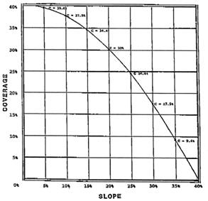
Land Coverage. The maximum allowable land coverage shall be calculated and submitted for all development that will result in the construction of structures or division of land.
1.
Maximum allowable land coverage shall be calculated by the following method:
where:
40% = maximum slope.
The following represents a graphic illustration of this formula for R-1 zones:
SLOPE/COVERAGE
2.
The entire parcel shall be taken into consideration when determining the allowable land coverage, including those areas of forty percent (40%) or greater gradient. The maximum allowable land coverage may be permitted for projects that the planning commission finds to represent outstanding and innovative design, site planning, and engineering techniques. However, a project which to some lesser extent meets the above-stated requirements may be limited to less than the maximum allowable coverage.
3.
All portions of the site occupied or covered by impermeable surfaces including buildings, pavement, and grading, except for recreation facilities and active recreation areas that can be utilized by all residents of a multi-unit development or the general public, shall be included in the maximum allowable land coverage.
E.
Preliminary Grading Plan. A preliminary grading plan shall be filed with the city engineer with all permit applications that will result in the construction of roads or structures or the division of land.
1.
The preliminary grading plan shall include the following:
a.
A topographic map of the proposed project area and all adjoining properties within one hundred fifty (150) feet as described in subsection (C)(2)(a) of this section;
b.
Contours of the finished slope shown at intervals similar to the topographic base map;
c.
Street grades, which shall not exceed a twelve percent (12%) gradient, driveway grades, which shall not exceed a fourteen percent (14%) gradient, pad elevations, maximum elevation of top and minimum elevation of toe of finished slopes over three feet in vertical height, the maximum heights of those slopes, and approximate total cubic yard of cut and fill;
d.
Compliance with the grading provisions contained in the latest edition of the California Building Code, as adopted by the city of Big Bear Lake.
2.
In the event no such grading is proposed, a statement to that effect shall be filed with a plan that delineates the boundary of the building pad and driveway for each parcel proposed, to be prepared on a topographic map described in subsection (C)(2)(a) of this section.
F.
Geologic Report. Unless otherwise waived in writing by the city engineer, a detailed geologic report shall be filed with the city engineer with all development permit applications where any part of the lot area to be developed contains slopes with a natural grade of thirty percent (30%) or greater and will result in the construction of roads or structures or the subdivision of land.
G.
Soil Erosion and Sediment Control Plan. Unless otherwise waived in writing by the city engineer, a detailed soil erosion and sediment control plan shall be filed with the city engineer with all development permit applications where any part of the lot area to be developed contains slopes with a natural grade of thirty percent (30%) or greater and will result in the construction of roads or structures or the subdivision or any other grading of land.
H.
Cuts and Fills.
1.
Maximum cuts and fills of up to ten (10) feet each in vertical height at up to 2:1 horizontal to vertical slope with provisions for slope and soil stability may be permitted by the city engineer, if the following findings can be made:
a.
All cuts and fills will be substantially landscaped to restore the aesthetic and scenic values of the site.
b.
Cuts and fills will be minimized to prevent scarring of the hillsides; graded contours will be matched and blended with the natural contours found onsite and finished in a manner to resemble natural topography that would normally occur.
c.
Exposed retaining walls shall not exceed a maximum height of eight feet.
2.
Development projects in all zones that propose to exceed the maximum cut and fill standards shall require a conditional use permit. Review of grading plans for such projects itemized in subsection (H)(1) of this section shall be conducted during the development review process by the community development department and approved by the planning commission.
I.
Single-Family Residential Uses on Existing Lots of Record.
1.
All single-family residential development proposed to be constructed on existing lots of record as of the effective date of the ordinance codified in this chapter where natural slopes on all parts of the lot to be developed are less than thirty percent (30%) shall be exempt from the provisions of this chapter and the maximum allowable land coverage shall be as set forth in Section 17.25.050 of the Development Code.
2.
Unless otherwise waived in writing by the city engineer, all single-family residential development proposed to be constructed on existing lots of record as of the effective date of the ordinance codified in this chapter where natural slopes on any part of the lot to be developed are at or exceed a thirty percent (30%) gradient shall be exempt from subsection C (slope analysis) and subsection D (maximum allowable land coverage) of this section and the maximum allowable land coverage shall be as set forth in Section 17.25.050 of the Development Code if the plans for the proposed project are prepared by a licensed architect or engineer.
3.
All single-family residential development proposed to be constructed on existing lots of record as of the effective date of the ordinance codified in this chapter shall be exempt from Section 17.09.030.C of this chapter (conditional use permit for encroachments into forty percent (40%) slope area). Notwithstanding this exemption, a conditional use permit shall be required for any grading not in compliance with the standards contained in subsection I.1 of this section. All single-family residential development proposed to be constructed on existing lots of record as of the effective date of the ordinance codified in this chapter shall be reviewed by the development review committee (DRC) if natural slopes on any part of the lot that will be developed are at or exceed a forty percent (40%) gradient and plans for the proposed project are prepared by a licensed architect or engineer. The applicant shall remit the appropriate fee as adopted by the city council, which may be amended from time to time.
(Ord. 2005-352 § 5 (Exh. 1 (part)), 2005: Ord. 2005-345 § 5 (Exh. 1 (part)), 2005)
17.09.030 - Conditional use permits.
A.
General Provisions. Requests to increase the amount of maximum allowable land coverage up to the percentage otherwise permitted by the Development Code or to encroach into areas of the proposed development site having a natural slope of forty percent (40%) or greater may be approved subject to the issuance of a conditional use permit through the public hearing process before the planning commission, according to the provisions set forth in Section 17.03.170 (Conditional use permits) of the Development Code.
B.
Increases to Maximum Allowable Land Coverage. The planning commission may approve an increase in the amount of maximum allowable land coverage if, in addition to the required findings for issuance of a conditional use permit, the planning commission finds that the project provides one or more of the following adjustment allowances:
1.
Cluster development;
2.
Improvements to the storm drainage system in excess of those required;
3.
Improvements that will increase access to the subject lot in excess of those required;
4.
Methods to minimize erosion and potential runoff in excess of those required;
5.
Methods to minimize fire hazard in excess of those required, such as installation of Class A roofing, one-hour exterior walls, and an early warning fire detection and notification system;
6.
Methods to minimize the need for revegetation;
7.
Revegetation in excess of the requirements;
8.
Preservation of unique topographic features in excess of requirements;
9.
Other proposed improvements that will increase safety and protect the environment in excess of the requirements.
The planning commission may award an increase of up to ten percent (10%) of the lot area for land coverage over and above the maximum allowable land coverage calculated in Section 17.09.020.D of this chapter for each adjustment. However, in no case shall land coverage exceed the maximum allowable land coverage otherwise permitted by the Development Code without an approved variance from Development Code standards.
C.
Encroachments into Forty Percent (40%) Slope Area. The planning commission may approve any requests for encroachments into areas of the proposed development site having a natural slope of forty percent (40%) or greater if, in addition to the required findings for a conditional use permit, the planning commission finds:
1.
That all proposed access provisions do not exceed a gradient of twelve percent (12%) for streets and fourteen percent (14%) for driveways and any landform or grading conforms to the grading provisions contained in the latest edition of the California Building Code, as adopted by the city of Big Bear Lake;
2.
That the project shall have no unmitigated environmental impacts regardless of zoning pursuant to the California Environmental Quality Act; and
3.
That the project exhibits exceptional design and engineering techniques.
D.
Variances. Requests for variances shall be processed in accordance with the provisions set forth in Section 17.03.180 (Variances and minor deviations) of the Development Code.
(Ord. 2005-352 § 5 (Exh. 1 (part)), 2005: Ord. 2005-345 § 5 (Exh. 1 (part)), 2005)